Latitude and Longitude. North. Latitude. South
|
|
|
- Mariah Greer
- 5 years ago
- Views:
Transcription
1

2 Latitude and Longitude North Latitude Longitude South 54

3 North America 55 Longitude Latitude

4 United States 56 Latitude

5 New York 72w 44n 42n 57
6 Site Location The site location is specified by a latitude l and a longitude L. Latitudes and longitudes may be found in any standard atlas or almanac. Chart shows the latitudes and longitudes of some North American cities. Conventions used in expressing latitudes are: Positive = northern hemisphere Negative = southern hemisphere Conventions used in expressing longitudes are: Latitude and Longitude of Some North American Cities Positive = west of prime meridian (Greenwich, United Kingdom) Negative = east of prime meridian 58

7 Solar Position The rotation of the earth about its axis, as well as its revolution about the sun, produces an apparent motion of the sun with respect to any point on the earth's surface. The position of the sun with respect to such a point is expressed in terms of two angles: the solar altitude, which is the vertical angle of the sun above the horizon, and solar azimuth, which is the horizontal angle of the sun from due south in the northern hemisphere. The sun's position in terms of solar altitude (a t ) and azimuth (a s ) with respect to the cardinal points of the compass. 59


8 Solar Position The position of the sun is specified by the solar altitude and solar azimuth and is a function of site latitude, solar time, and solar declination. Animation showing changing sun-path on the 21st day of each month for latitude
9 61
10 62


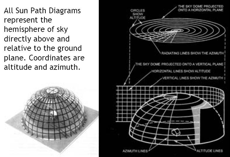
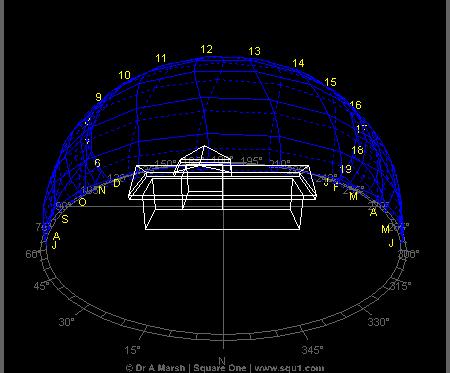
11 Sun Path Diagrams

12 Sun Angle Calculator 64

13 Sun Angle Calculator 65
14 Sun Angle Calculator 66

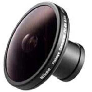
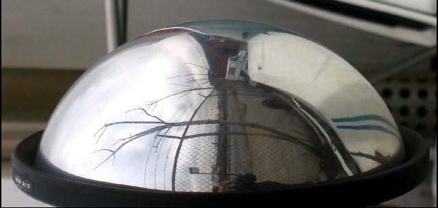
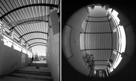
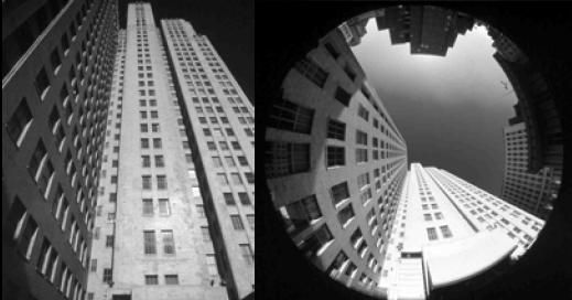
15 Fisheye Tool 67


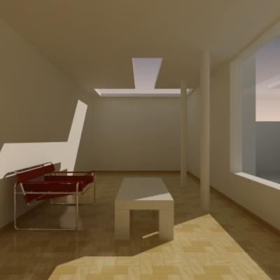
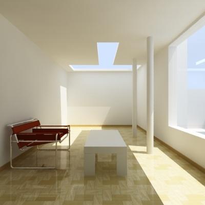
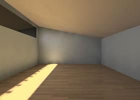
16 68

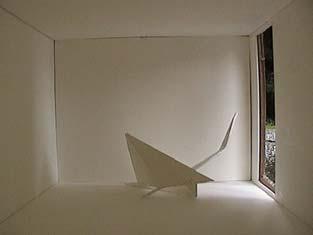
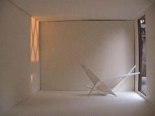
17 Computer Simulation 69

18 Autodesk: Ecotect 70

19 Ecotect: Solar Tool 71


20 Google Software: Sketch-up 72


21 Google Software: Sketch-up 73

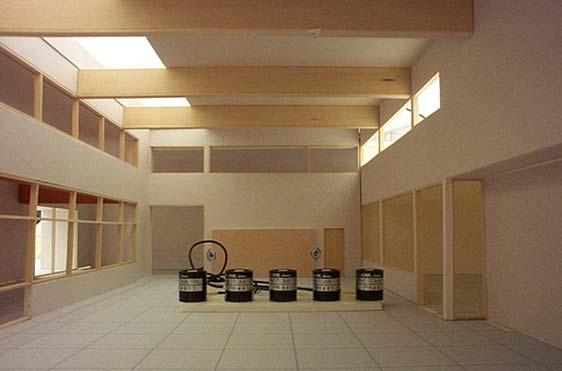
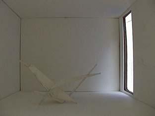
22 Google Software: Sketch-up 74
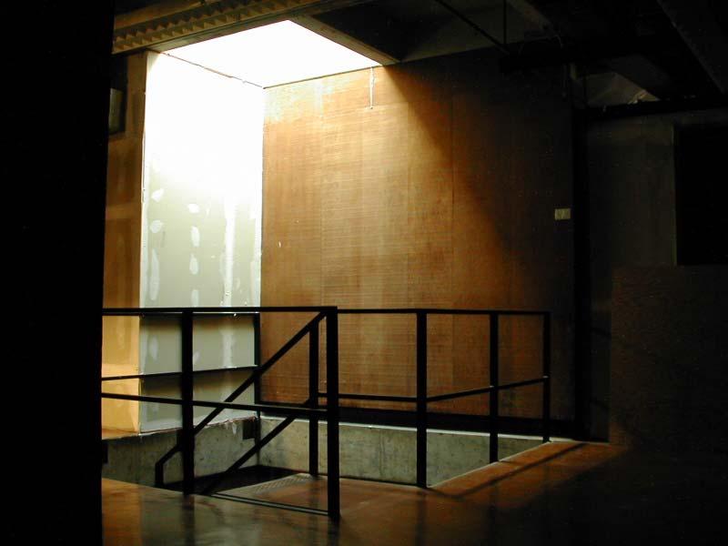
 a stationary 1000 watt theatrical light source (the sun).")

23 The Heliodon The heliodon is used to examine how the direct rays of the sun interact with an architect's building design. It is comprised of a tilting/rotating table (the earth) a stationary 1000 watt theatrical light source (the sun). The table can be adjusted to represent the latitude, tilted to simulate any month of the year, and rotated to analyze any time of day. Typically these studies seek to examine shading devices that eliminate direct sun from areas where visual tasks are critical. Direct sun can cause problems of heat gain and debilitating glare. The heliodon takes the guesswork out of complex sun-angle geometry and often will provide surprising results. 75

24 Interior Video 76

25 Exterior Video 77

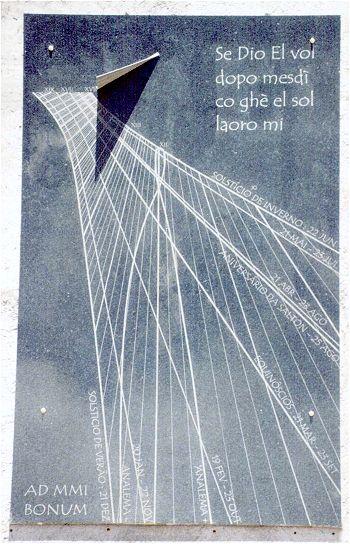


26 Sundials 78


27 79
28 Solar Position: Sundial 80


29 Building a Model 81

30 Tip 1 Do not use Foam Core the material glows and creates light leaks Use black paper on white board and cover or tape all light leaks Black Foam Core is expensive. 82

31 Tip 2 White Foam Core is reflective and shiny. Cover the insides with appropriate surface reflectance or color material. 83

32 Tip 3 Make a modular model with interchangeable parts. 84

33 Tip 4 Mirrors can enhance the depth of a model. Mirrors are useful in large space with respective plans. 85

34 Tip 5 Know true north and latitude. Draw north arrow on your model. 86

35 Tip 6 Include accessible large view ports. Large enough for use cameras or yield a good view of the interior. 87

36 Tip 7 Include people or objects for scale. 88

, and to ensure that a balanced luminous environment (from")
37 Sky Simulators the overcast sky simulator Testing for the overcast condition occurs in a mirror-box artificial sky. The mirror-box overcast sky simulates a dome of light that provides diffuse light equally from all sides. Note that a patch of overcast sky is up to 10 times brighter than a section of clear blue sky. Method of testing design decisions in the overcast sky is through photography. This allows us to examine the perceptual quality of a space, the feeling of brightness (diffuse light on vertical surfaces and ceilings), and to ensure that a balanced luminous environment (from perimeter to deep interior) is created. Photocells are used to measure the percentage of available daylight (Daylight Factor) entering a space.. Overcast sky light is ideal for providing gentle, diffuse daylight to building occupants. 89

38 Sky Simulators 90


39 91


40 Daylight Qualities: veiling reflection 92
41 Daylight Qualities: a magical sprite 93


42 Daylight Qualities: dynamic daylight 94

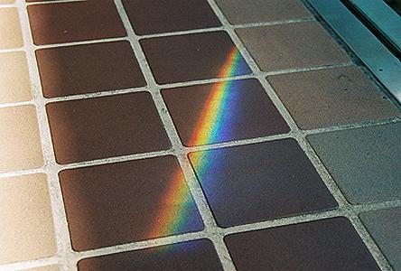


43 Daylight Qualities: daylight prismatically deconstructed 95


44 Daylight Qualities: leaking light 96


45 Daylight Qualities: texture revealed by daylight 97


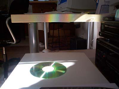
46 Daylight Qualities: camera lucida / color mapping daylight 98


47 Daylight Qualities: dappled light 99


48 Daylight Qualities: daylight gradient revealed 100


49 Daylight Qualities: varying penumbra 101


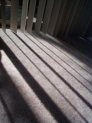
50 Daylight Qualities: carpet of shadow (pattern) 102

51 Daylight Qualities: rhythmic daylight 103


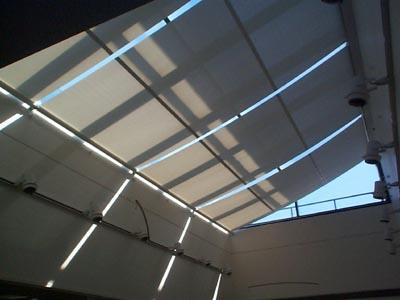
52 Daylight Qualities: a daylight fixture 104


53 Daylight Qualities: daylighting at the edge of the day 105
Mapping Earth s Surface Chapter 2 Section 3
 Mapping Earth s Surface Chapter 2 Section 3 Day 1 Objective I will understand maps can be used to find locations on Earth and to represent information about features on Earth s Surface I will understand
Chapter 1 Solar Radiation
 Chapter 1 Solar Radiation THE SUN The sun is a sphere of intensely hot gaseous matter with a diameter of 1.39 10 9 m It is, on the average, 1.5 10 11 m away from the earth. The sun rotates on its axis
Section 2. Locating Astronomical Objects in the Night Sky What Do You See? What Do You See? Think About It. Investigate.
 Section 2 Locating Astronomical Objects in the Night Sky Section 2 Locating Astronomical Objects in the Night Sky What Do You See? What Do You See? Learning Outcomes In this section, you will Construct
Complete the following: a. Lines of latitude are parallel to the equator. Name:
 Name: Date: Social Studies Introduction: Basic Geography Period: Latitude Latitude is defined as a measurement of distance in degrees north and south of the equator. The word latitude is derived from the
CA1 2.11: Designing an Equatorial Sundial Activity
 Purpose: To design an equatorial sundial and learn about motions of the sun and earth that have a bearing on its design. Materials: poster board, length of stiff wire or dowel rod, tape, protractor, ruler,
ME 476 Solar Energy UNIT THREE SOLAR RADIATION
 ME 476 Solar Energy UNIT THREE SOLAR RADIATION Unit Outline 2 What is the sun? Radiation from the sun Factors affecting solar radiation Atmospheric effects Solar radiation intensity Air mass Seasonal variations
SOLAR GEOMETRY (AND SOLAR RADIATION)
") SOLAR GEOMETRY (AND SOLAR RADIATION) Ball State Architecture ENVIRONMENTAL SYSTEMS 1 Grondzik 1 Solar Radiation Components glass will reflect some incoming radiation; absorb some; and transmit some SHGF
SOLAR GEOMETRY (AND SOLAR RADIATION) Ball State Architecture ENVIRONMENTAL SYSTEMS 1 Grondzik 1 Solar Radiation Components glass will reflect some incoming radiation; absorb some; and transmit some SHGF
announcements 5/1/08 L10 Analysis and Design Tools 5/1/08 Analysis and Design Tools
 Analysis and Design Tools ARCH 331/431 Spring 2008 Lecture 10 announcements 5/1/08 Information Meeting: INDIA program winter 2009 Friday May 2, 12:30, Gould 208P Assignment 4: Shading Model Studies Available
Latitude and Longitude Pre Test
 Name Date Latitude and Longitude Pre Test Multiple Choice Directions: For questions, 1 10 circle the answer that letter that best answers the question. Each question is worth 1 point each. 1. To locate
Earth s Time Zones. Time Zones In The United States
 Name: Mr. DeLeo Date: Period: Earth s Time Zones Goal: Students will understand why humans have developed time zones on Earth, and how to figure out time at different positions on Earth. Background: One
Practice Questions: Seasons #1
 1. Seasonal changes on Earth are primarily caused by the A) parallelism of the Sun's axis as the Sun revolves around Earth B) changes in distance between Earth and the Sun C) elliptical shape of Earth's
Geography Class 6 Chapters 3 and
 CHAPTER 3 MOTIONS OF THE EARTH The Earth is always travelling in Space. That makes each person on Earth, a Space Traveller. No one feels the movement of the Earth because humans are too tiny when compared
Earth s Orbit. Sun Earth Relationships Ridha Hamidi, Ph.D. ESCI-61 Introduction to Photovoltaic Technology
 1 ESCI-61 Introduction to Photovoltaic Technology Sun Earth Relationships Ridha Hamidi, Ph.D. Spring (sun aims directly at equator) Winter (northern hemisphere 23.5 tilts away from sun) 2 Solar radiation
Chapter 1: Discovering the Night Sky. The sky is divided into 88 unequal areas that we call constellations.
 Chapter 1: Discovering the Night Sky Constellations: Recognizable patterns of the brighter stars that have been derived from ancient legends. Different cultures have associated the patterns with their
Earth Science Seasons Test Name Per Date
 Name Per Date Page 1 1. The diagram below represents four positions of the Earth as it revolves around the Sun. 5. Base your answer to the following question on the diagram below, which shows the apparent
Daylighting Buildings Nexus November 12, 2009
 Daylighting Buildings Nexus November 12, 2009 Holly Wasilowski, Registered Architect, LEED AP Doctor of Design Student in Sustainable Design Harvard Graduate School of Design Agenda: Introduction Rules
LOCATING CELESTIAL OBJECTS: COORDINATES AND TIME. a. understand the basic concepts needed for any astronomical coordinate system.
 UNIT 2 UNIT 2 LOCATING CELESTIAL OBJECTS: COORDINATES AND TIME Goals After mastery of this unit, you should: a. understand the basic concepts needed for any astronomical coordinate system. b. understand
Chapter 6. Solar Geometry. Contents
 Chapter 6. Solar Geometry Contents 6.1 Introduction 6.2 The Sun 6.3 Elliptical Orbit 6.4 Tilt of the Earth s Axis 6.5 Consequences of the Altitude Angle 6.6 Winter 6.7 The Sun Revolves Around the Earth!
Motions of the Sun Model Exploration
 Name Date Bell Motions of the Sun Model Exploration 1. Go to the University of Nebraska-Lincoln Motions of the Sun Simulator: http://astro.unl.edu/naap/motion3/animations/sunmotions.swf 2. This is what
Which graph best shows the relationship between intensity of insolation and position on the Earth's surface? A) B) C) D)
 B) C) D)") 1. The hottest climates on Earth are located near the Equator because this region A) is usually closest to the Sun B) reflects the greatest amount of insolation C) receives the most hours of daylight D)
1. The hottest climates on Earth are located near the Equator because this region A) is usually closest to the Sun B) reflects the greatest amount of insolation C) receives the most hours of daylight D)
Calculating equation coefficients
 Solar Energy 1 Calculating equation coefficients Construction Conservation Equation Surface Conservation Equation Fluid Conservation Equation needs flow estimation needs radiation and convection estimation
APPENDIX F ACTIVITY #1 - CALCULATION OF THE TILT OF THE EARTH S AXIS AND THE OBSERVER S LATITUDE
 APPENDIX F ACTIVITY #1 - CALCULATION OF THE TILT OF THE EARTH S AXIS AND THE OBSERVER S LATITUDE The calculation of the Tilt of the Earth s Axis and the Observer s Latitude is essentially a reversal of
Local Coordinates. These are centered upon you, the observer.
 Astronomy 30, Observing #3 Name: Lab Partners: Date: Materials: This lab, with the star chart completed from the pre-lab. Some sheets of paper for sketches. A pencil with eraser. A small flashlight, ideally
Lecture #03. January 20, 2010, Wednesday
 Lecture #03 January 20, 2010, Wednesday Causes of Earth s Seasons Earth-Sun geometry Day length Solar angle (beam spread) Atmospheric beam depletion Shape and Size of the Earth North Pole E Geoid: not
UNIT 1: THE PLANET EARTH
 UNIT 1: THE PLANET EARTH How many planets are there in our Solar System? What is the Equator? Why does life exist in our planet? Does The Earth move? What is a map? 1. Planet Earth TOPICS 2. Movements
MiSP Astronomy - Seasons Worksheet #1 L2
 MiSP Astronomy - Seasons Worksheet #1 L2 Name Date Changing Hours of Daylight on Long Island (L 1, 2, 3) Introduction You sometimes hear people say, Days are longer in the summer and shorter in the winter.
Latitude and Longitude
 Latitude and Longitude Finding Your Location on a Sphere Coordinate Systems n When you are locating a point on a flat surface you can use Cartesian coordinates of x and y. n The point 2, 3 is plotted on
Meridian Circle through Zenith, North Celestial Pole, Zenith Direction Straight Up from Observer. South Celestial Pole
 Chapter 3 How Earth and Sky Work- Effects of Latitude In chapters 3 and 4we will learn why our view of the heavens depends on our position on the Earth, the time of day, and the day of the year. We will
SOLAR GEOMETRY (AND RADIATION)
") SOLAR GEOMETRY (AND RADIATION) Ball State Architecture ENVIRONMENTAL SYSTEMS 1 Grondzik 1 Solar Radiation Components glass will reflect some incoming radiation; absorb some; and transmit some SHGF (above)
SOLAR GEOMETRY (AND RADIATION) Ball State Architecture ENVIRONMENTAL SYSTEMS 1 Grondzik 1 Solar Radiation Components glass will reflect some incoming radiation; absorb some; and transmit some SHGF (above)
Fundamentals of Satellite technology
 Fundamentals of Satellite technology Prepared by A.Kaviyarasu Assistant Professor Department of Aerospace Engineering Madras Institute Of Technology Chromepet, Chennai Orbital Plane All of the planets,
Photovoltaic Systems Solar Radiation
 PowerPoint Presentation Photovoltaic Systems Solar Radiation The Sun Solar Radiation Sun- Earth Relationships Array Orientation Solar Radiation Data Sets Estimating Array Performance Arizona Solar Power
How to evaluate daylight. Initiated by the VELUX Group
 Initiated by the VELUX Group Daylight in buildings Daylight in buildings is composed of a mix direct sunlight, diffuse skylight, and light reflected from the ground and surrounding elements. Direct sunlight
Chapter 5. Daylighting
 Chapter 5. Daylighting 5.1. History of Daylighting The history of daylighting and the history of architecture were one. The major structural changes in buildings reflected the goal of increasing the amount
Appearance of the Sky Orientation Motion of sky Seasons Precession (?)
") Today Appearance of the Sky Orientation Motion of sky Seasons Precession (?) The Celestial Sphere Stars at different distances all appear to lie on the celestial sphere. The ecliptic is the Sun s apparent
Today Appearance of the Sky Orientation Motion of sky Seasons Precession (?) The Celestial Sphere Stars at different distances all appear to lie on the celestial sphere. The ecliptic is the Sun s apparent
Module 2: Mapping Topic 2 Content: Determining Latitude and Longitude Notes
 Introduction In order to more easily locate points on a globe or map, cartographers designed a system of imaginary vertical lines (also called parallels) and horizontal lines (also called meridians) that
Appearance of the Sky Orientation Motion of sky Seasons Precession (?)
") Today Appearance of the Sky Orientation Motion of sky Seasons Precession (?) The Celestial Sphere Stars at different distances all appear to lie on the celestial sphere. The ecliptic is the Sun s apparent
Today Appearance of the Sky Orientation Motion of sky Seasons Precession (?) The Celestial Sphere Stars at different distances all appear to lie on the celestial sphere. The ecliptic is the Sun s apparent
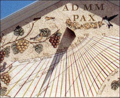
Making a Sundial. Build a sundial and discover how time can be measured. Space Awareness, Leiden Observatory. iau.org/astroedu
 Making a Sundial Build a sundial and discover how time can be measured. Space Awareness, Leiden Observatory Age 6-10 Supervised Unsupervised Core skills Asking questions, Developing and using models, Analysing
IDL Design Guide: Designing for Efficient Daylighting. idl. By: Amy Lindgren. Integrated Design Lab - Bozeman August 2007
 : Designing for Efficient Daylighting idl By: Amy Lindgren Integrated Design Lab - Bozeman August 2007 Tom Wood, Director Christopher Hancock, Lab Assistant Shelby Hinchliff, Lab Assistant Justina Hohmann,
Why does Earth rotate and what s the evidence? (besides watching it from space ships or satellites) Week 18 January 5, 2015
 Week 18 January 5, 2015") Why does Earth rotate and what s the evidence? (besides watching it from space ships or satellites) Week 18 January 5, 2015 The sun determines our solar time everywhere on earth as Earth rotates. Can you
Why does Earth rotate and what s the evidence? (besides watching it from space ships or satellites) Week 18 January 5, 2015 The sun determines our solar time everywhere on earth as Earth rotates. Can you
Which table correctly shows the dates on which the apparent paths of the Sun were observed? A) B) C) D)
 B) C) D)") 1. The diagram below represents the horizon and the Sun's apparent paths, A, B, and C, on three different dates, as viewed from the same location in New York State. Which table correctly shows the dates
1. The diagram below represents the horizon and the Sun's apparent paths, A, B, and C, on three different dates, as viewed from the same location in New York State. Which table correctly shows the dates
MiSP Astronomy Seasons Worksheet #1 L1
 MiSP Astronomy Seasons Worksheet #1 L1 Name Date CHANGING HOURS OF DAYLIGHT ON LONG ISLAND Introduction You sometimes hear people say, Days are longer in the summer and shorter in the winter. That is a
Section 1: Overhang. Sizing an Overhang
 Section 1: Overhang A horizontal overhang is a straightforward method for shading solar glazing in summer. Passive heating strategies call for major glazed areas (solar glazing) in a building to be oriented
Sunlight and its Properties Part I. EE 446/646 Y. Baghzouz
 Sunlight and its Properties Part I EE 446/646 Y. Baghzouz The Sun a Thermonuclear Furnace The sun is a hot sphere of gas whose internal temperatures reach over 20 million deg. K. Nuclear fusion reaction
Which Earth latitude receives the greatest intensity of insolation when Earth is at the position shown in the diagram? A) 0 B) 23 N C) 55 N D) 90 N
 0 B) 23 N C) 55 N D) 90 N") 1. In which list are the forms of electromagnetic energy arranged in order from longest to shortest wavelengths? A) gamma rays, x-rays, ultraviolet rays, visible light B) radio waves, infrared rays, visible
1. In which list are the forms of electromagnetic energy arranged in order from longest to shortest wavelengths? A) gamma rays, x-rays, ultraviolet rays, visible light B) radio waves, infrared rays, visible
ZW2000 and Your Vertical Sundial Carl Sabanski
 1 The Sundial Primer created by At this point I assume that you have downloaded and set up ZW2000 on your computer and have also read the overview document. If not please read Getting Started with ZW2000
1. Write down the term 2. Write down the book definition 3. Put the definition in your own words 4. Draw an image and/or put a Real Life Example
 Unit 1 Vocabulary 1. Write down the term 2. Write down the book definition 3. Put the definition in your own words 4. Draw an image and/or put a Real Life Example Absolute Location Where Is It EXACTLY?
Astronomy 101: 9/18/2008
 Astronomy 101: 9/18/2008 Announcements Pick up a golf ball at the front of the class or get one from Alex; you will need it for an in-class activity today. You will also need the question sheet from Alex.
Earth & Space Science, Interpreting Data DURATION Preparation: 5 minutes Activity: 40 minutes (total over one day)
") Objectives In this activity students will: 1. Observe how the position of the sun in the sky changes during the course of the day 2. Discover the cardinal directions by tracking the motion of the sun Materials
Objectives In this activity students will: 1. Observe how the position of the sun in the sky changes during the course of the day 2. Discover the cardinal directions by tracking the motion of the sun Materials
Time and Diurnal Motion
 Time and Diurnal Motion Time and Diurnal Motion A. Geography: mapping the earth 2 B. Equatorial Coordinates C. Local Horizon System Updated Sep 30, 2012 A. Geography: mapping the earth Geometry: measure
CHAPTER 2 Strand 1: Structure and Motion within the Solar System
 CHAPTER 2 Strand 1: Structure and Motion within the Solar System Chapter Outline 2.1 EARTH, MOON, AND SUN SYSTEM (6.1.1) 2.2 GRAVITY AND INERTIA (6.1.2) 2.3 SCALE OF SOLAR SYSTEM (6.1.3) 2.4 REFERENCES
What is a map? A Map is a two or three-dimensional model or representation of the Earth s surface. 2-Dimensional map
 What is a map? A Map is a two or three-dimensional model or representation of the Earth s surface. 2-Dimensional map What is a Map Projection? Planar Projection Projection A Projection is a mathematical
Academic Year Second Term. Science Revision Sheet. Grade
 Academic Year 2017-2018 Second Term Science Revision Sheet Grade 6 Name: Grade Date: Section: Part A. Science Practice. Circle the letter of your answer. 1. When the moon is waxing, its lighted part appears
Observing the Night Sky: Locating Objects
 Observing the Night Sky: Locating Objects As I left the house this morning, there was a bright bluish light above and to the left of my neighbors house (approximately East) and a big very bright object
Earth Motions Packet 14
 Earth Motions Packet 14 Your Name Group Members Score Minutes Standard 4 Key Idea 1 Performance Indicator 1.1 Explain complex phenomena, such as tides, variations in day length, solar insolation, apparent
Motion of the Sun. View Comments
 Login 2017 Survey to Improve Photovoltaic Education Christiana Honsberg and Stuart Bowden View Comments Instructions 1. Introduction 2. Properties of Sunlight 2.1. Basics of Light Properties of Light Energy
+ 35º 53ʹ 16ʺ 84º 09ʹ 35ʺ
 + 35º 53ʹ 16ʺ 84º 09ʹ 35ʺ 35º 53ʹ 16ʺ N 84º 09ʹ 35ʺ W (the precise location of Farragut High School!) Spherical Coordinates Mapping a Sphere The student will be able to: HW: 1 Utilize and convert SI units
Page 1. Name:
 Name: 1) What is the primary reason New York State is warmer in July than in February? A) The altitude of the noon Sun is greater in February. B) The insolation in New York is greater in July. C) The Earth
Time and Diurnal Motion
 Time and Diurnal Motion Time and Diurnal Motion A. Geography: mapping the earth 2 B. Equatorial Coordinates C. Local Horizon System Updated 2014Jan11 A. Geography: mapping the earth Geometry: measure the
COMPUTER PROGRAM FOR THE ANGLES DESCRIBING THE SUN S APPARENT MOVEMENT IN THE SKY
 COMPUTER PROGRAM FOR THE ANGLES DESCRIBING THE SUN S APPARENT MOVEMENT IN THE SKY B. BUTUC 1 Gh. MOLDOVEAN 1 Abstract: The paper presents software developed for the determination of the Sun-Earth geometry.
C) the seasonal changes in constellations viewed in the night sky D) The duration of insolation will increase and the temperature will increase.
 the seasonal changes in constellations viewed in the night sky D) The duration of insolation will increase and the temperature will increase.") 1. Which event is a direct result of Earth's revolution? A) the apparent deflection of winds B) the changing of the Moon phases C) the seasonal changes in constellations viewed in the night sky D) the
1. Which event is a direct result of Earth's revolution? A) the apparent deflection of winds B) the changing of the Moon phases C) the seasonal changes in constellations viewed in the night sky D) the
Astro 101 Lab #2. Start up the Stellarium program. If you do not remember how to use the user interface, please refer to Lab#1 or the user s guide.
 Name: Astro 101 Lab #2 Lab objectives 1) Learn about how the Sun s path, through the sky, changes with the changing seasons. 2) Learn about how the Sun s path changes while viewing it at different locations
ZW2000 and Your Sundial
 1 The Sundial Primer created by At this point I assume that you have downloaded and set up ZW2000 on your computer. If not please read Getting Started with ZW2000. Initiate the program ZW2000. Figure 1
Patterns of Change on Earth
 TEKS collect and analyze data to identify sequences and predict patterns of change in shadows, tides, seasons, and the observable appearance of the Moon over time Patterns of Change on Earth Patterns and
Chapter S1 Lecture. The Cosmic Perspective Seventh Edition. Celestial Timekeeping and Navigation Pearson Education, Inc.
 Chapter S1 Lecture The Cosmic Perspective Seventh Edition Celestial Timekeeping and Navigation 2014 Pearson Education, Inc. Celestial Timekeeping and Navigation 2014 Pearson Education, Inc. S1.1 Astronomical
Time, coordinates and how the Sun and Moon move in the sky
 Time, coordinates and how the Sun and Moon move in the sky Using the colors and magnitudes of quasars drawn from the SDSS Catalog Archive Server to distinguish quasars from stars using the light they emit
Map Skills Lesson 1. Materials: maps, pencils, Lesson 1 Worksheet, strips of paper, grid paper
 Map Skills Lesson 1 Use cardinal directions, map grids, scales, and titles to locate places on a map. Interpret a map using information from its title, compass rose, scale, and legend. Vocabulary: map,
Analysis of Energy Savings and Visual Comfort Produced by the Proper Use of Windows
 Analysis of Energy Savings and Visual Comfort Produced by the Proper Use of Windows I. Acosta, M. A. Campano, and J. F. Molina Abstract The aim of this research is to quantify the daylight autonomy and
Mid Term Prep-Latitude and Longitude
 1. What is the approximate altitude of Polaris at Syracuse, New York? A) 43 B) 47 C) 76 D) 90º 2. If an observer on Earth views Polaris on the horizon, the observer is located at the A) equator (0 ) B)
L.O: THE ANGLE OF INSOLATION ANGLE INSOLATION: THE ANGLE SUNLIGHT HITS THE EARTH
 L.O: THE ANGLE OF INSOLATION ANGLE INSOLATION: THE ANGLE SUNLIGHT HITS THE EARTH 1. The graph below shows air temperatures on a clear summer day from 7 a.m. to 12 noon at two locations, one in Florida
MIDTERM PRACTICE EXAM ANSWERS
 MIDTERM PRACTICE EXAM ANSWERS 1. (2) Location B shows that the altitude of the noon Sun increases between Dec 21. and June 21. Location B also shows that the Dec. 21 noon Sun is at an altitude of approximately
Cartesian Coordinates Need two dimensional system 2 number lines perpendicular to each other X-axis is horizontal Y-axis is vertical Position relative
 General Physical Science Chapter 15 Place and Time Space and Time Einstein Space and time related Single entity Time is the 4 th dimension! Cartesian Coordinates Need some system to tell us where something
Gnomon (a thin, round stick at least a foot long and capable of being put into the ground or stood up vertically)
") Name: Partner(s): Lab #3 Celestial Navigation Due 7/2 Objectives In this lab you will take measurements of the sun s motion around noon and the north star s position in the sky. You will use this data
Name: Partner(s): Lab #3 Celestial Navigation Due 7/2 Objectives In this lab you will take measurements of the sun s motion around noon and the north star s position in the sky. You will use this data
For most observers on Earth, the sun rises in the eastern
 632 CHAPTER 25: EARTH, SUN, AND SEASONS WHAT IS THE SUN S APPARENT PATH ACROSS THE SKY? For most observers on Earth, the sun rises in the eastern part of the sky. The sun reaches its greatest angular altitude
CHARTING THE HEAVENS USING A VIRTUAL PLANETARIUM
 Name Partner(s) Section Date CHARTING THE HEAVENS USING A VIRTUAL PLANETARIUM You have had the opportunity to look at two different tools to display the night sky, the celestial sphere and the star chart.
Student Exploration: Seasons: Earth, Moon, and Sun
 Name: Date: Student Exploration: Seasons: Earth, Moon, and Sun Vocabulary: altitude, axis, azimuth, equinox, horizon, latitude, revolution, rotation, solstice Prior Knowledge Questions (Do these BEFORE
Designing with the Pilkington Sun Angle Calculator
 Designing with the Pilkington Sun Angle Calculator In 1951, Libbey-Owens-Ford introduced the first Sun Angle Calculator, to provide a relatively simple method of determining solar geometry variables for
Astronomy Review. Use the following four pictures to answer questions 1-4.
 Astronomy Review Use the following four pictures to answer questions 1-4. 1. Put an X through the pictures that are NOT possible. 2. Circle the picture that could be a lunar eclipse. 3. Triangle the picture
The Rotating Sky Student Guide
 III. Horizon Coordinates The Rotating Sky Student Guide Don t write your answers on here! 1.) Complete the following table involving the horizon coordinate system. You should predict the answers and then
The Sun-Earth-Moon System
 Name The Sun-Earth-Moon System Section 28.3 The Sun-Earth-Moon System Date Main Idea Details Read the title of Section 3. List three things that might be discussed in this section. 1. 2. 3. Review Vocabulary
7 th Grade Science DO NOW. OBJECTIVES: By the end of today s lesson, you will be able to
 7 th Grade Science Unit: Earth, Sun, and Moon Lesson: ESM 4_Rotation and Revolution Name: Date: Monday, October 24, 2016 Homeroom: DO NOW SWBAT define and identify lines of latitude and longitude. SWBAT
ClassAction: Coordinates and Motions Module Instructor s Manual
 ClassAction: Coordinates and Motions Module Instructor s Manual Table of Contents Section 1: Warm-up Questions...3 The Sun s Path 1 4 Section 2: General Questions...5 Sledding or Going to the Beach...6
drinking straw, protractor, string, and rock. observer on Earth. Sun across the sky on March 21 as seen by an
 1. The diagram below represents some constellations and one position of Earth in its orbit around the Sun. These constellations are visible to an observer on Earth at different times of the year. When
Solar Schoolhouse Human Sundial Building a Sundial with the Online Calculator
 Solar Schoolhouse Solar Schoolhouse Human Sundial Building a Sundial with the Online Calculator Overview Analemmatic sundials are sundials which have a movable gnomon (the gnomon is the part that casts
L.O: EARTH'S 23.5 DEGREE TILT ON ITS AXIS GIVES EARTH ITS SEASONS March 21 (SPRING), June 21(SUMMER), Sept 22 (AUTUMN) & Dec 21(WINTER)
, June 21(SUMMER), Sept 22 (AUTUMN) & Dec 21(WINTER)") L.O: EARTH'S 23.5 DEGREE TILT ON ITS AXIS GIVES EARTH ITS SEASONS March 21 (SPRING), June 21(SUMMER), Sept 22 (AUTUMN) & Dec 21(WINTER) 1. The apparent daily path of the Sun changes with the seasons because
L.O: EARTH'S 23.5 DEGREE TILT ON ITS AXIS GIVES EARTH ITS SEASONS March 21 (SPRING), June 21(SUMMER), Sept 22 (AUTUMN) & Dec 21(WINTER) 1. The apparent daily path of the Sun changes with the seasons because
The position of the Sun on the celestial sphere at the solstices and the equinoxes.
 1 2 3 4 5 6 7 8 9 10 11 12 13 EARTH IN SPACE Tillery, Chapter 18 Artist's concept of the solar system. Shown are the orbits of the planets, Earth being the third planet from the Sun, and the other planets
THE SUN. LENGTH: Course of the semester
 ASTR 1030 Astronomy Lab 139 The Sun THE SUN SYNOPSIS: This exercise involves making measurements of the Sun every week throughout the semester, and then analyzing your results at semester s end. You ll
LAB 2: Earth Sun Relations
 LAB 2: Earth Sun Relations Name School The amount of solar energy striking the Earth s atmosphere is not uniform; distances, angles and seasons play a dominant role on this distribution of radiation. Needless
Celestial Sphere. Altitude [of a celestial object] Zenith. Meridian. Celestial Equator
![Celestial Sphere. Altitude [of a celestial object] Zenith. Meridian. Celestial Equator](/thumbs/83/88077665.jpg "Celestial Sphere. Altitude [of a celestial object] Zenith. Meridian. Celestial Equator") Earth Science Regents Interactive Path of the Sun University of Nebraska Resources Copyright 2011 by Z. Miller Name Period COMPANION WEBSITES: http://www.analemma.com/ http://www.stellarium.org/ INTRODUCTION:
Earth Science Regents Interactive Path of the Sun University of Nebraska Resources Copyright 2011 by Z. Miller Name Period COMPANION WEBSITES: http://www.analemma.com/ http://www.stellarium.org/ INTRODUCTION:
3. The Sun s Position
 3. The Sun s Position In order to understand how to collect energy from the sun, one must first be able to predict the location of the sun relative to the collection device. In this chapter we develop
Evaluating a Site s Solar Potential May, 2003
 Evaluating a Site s Solar Potential May, 2003 When evaluating a site s solar potential, there are several things to consider. Major points: 1. Area large enough to support in which to mount a solar system
6/17. Universe from Smallest to Largest:
 6/17 Universe from Smallest to Largest: 1. Quarks and Leptons fundamental building blocks of the universe size about 0 (?) importance: quarks combine together to form neutrons and protons. One of the leptons
The Rotating Sky Student Guide
 Name: The Rotating Sky Student Guide Horizon Coordinates Work through the explanatory material on the Observer, Two Systems Celestial, Horizon, Bands in the Sky, and the Paths of Stars. All of the concepts
Earth Moon Motions A B1
 Earth Moon Motions A B1 1. The Coriolis effect provides evidence that Earth (1) rotates on its axis (2) revolves around the Sun (3) undergoes cyclic tidal changes (4) has a slightly eccentric orbit 9.
Period: Name: Astronomy Part 3A. Earth s Rotation: Video Notes Sheets. Earth Science with Mr. Sammartano Hommocks Middle School, Team 8-3
 Name: Period: Astronomy Part 3A Earth s Rotation: Video Notes Sheets Earth Science with Mr. Sammartano Hommocks Middle School, Team 8-3 PROOF #1 What is the Shape of the Earth? How do we know the Earth
HOW TO TRAVEL ON EARTH WITHOUT GETTING LOST
 HOW TO TRAVEL ON EARTH WITHOUT GETTING LOST Using a globe to learn how a position on Earth can be described. Rui Dilão, Instituto Superior Técnico Curriculum topic latitude, longitude, coordinate system
b. So at 12:00 p.m., are the shadows pointing in the direction you predicted? If they are not, you must explain this observation.
 Astronomy 100 Name(s): Exercise 2: Timekeeping and astronomy The following exercise illustrates some basic ideas about time, and how our position in the solar system uniquely configures the measurement
CHAPTER 3. The sun and the seasons. Locating the position of the sun
 zenith 90 observer summer solstice 75 altitude angles equinox 52 winter solstice 29 Figure 3.1: Solar noon altitude angles for Melbourne SOUTH winter midday shadow WEST summer midday shadow summer EAST
Celestial Sphere Spectroscopy (Something interesting; e.g., advanced data analyses with IDL)
") AST326, 2010 Winter Semester Celestial Sphere Spectroscopy (Something interesting; e.g., advanced data analyses with IDL) Practical Assignment: analyses of Keck spectroscopic data from the instructor (can
AST326, 2010 Winter Semester Celestial Sphere Spectroscopy (Something interesting; e.g., advanced data analyses with IDL) Practical Assignment: analyses of Keck spectroscopic data from the instructor (can
astronomy A planet was viewed from Earth for several hours. The diagrams below represent the appearance of the planet at four different times.
 astronomy 2008 1. A planet was viewed from Earth for several hours. The diagrams below represent the appearance of the planet at four different times. 5. If the distance between the Earth and the Sun were
Chapter 2 Lecture. The Cosmic Perspective Seventh Edition. Discovering the Universe for Yourself
 Chapter 2 Lecture The Cosmic Perspective Seventh Edition Discovering the Universe for Yourself Discovering the Universe for Yourself 2.1 Patterns in the Night Sky Our goals for learning: What does the