Update of Terra and Aqua MODIS and S-NPP VIIRS On-orbit Calibration
|
|
|
- Felicity Murphy
- 6 years ago
- Views:
Transcription
, NASA S-NPP and JPSS VIIRS SDR")
1 Update of Terra and Aqua MODIS and S-NPP VIIRS On-orbit Calibration X. Xiong 1, C. Cao 2, A. Angal 3, K. Chiang 3, N. Lei 3, G. Lin 3, Z. Wang 3, and A Wu 3 1 NASA GSFC, MD 20771, USA; 2 NOAA NESDIS, MD 20740, USA 3 SSAI, MD 20706, USA Contributions: MODIS/VIIRS Characterization Support Team (MCST/VCST), NASA S-NPP and JPSS VIIRS SDR Calibration Team, NOAA CEOS WGCV-41, Tokyo, Japan (September 5-7, 2016) 1
2 Outline MODIS and VIIRS On-orbit Calibration Terra and Aqua MODIS Performance S-NPP Performance Challenging Issues and Future Work 2

 Regular SRCA operations (3 modes) Quarterly BB warm-up/cool-down Monthly lunar observations at")

3 MODIS and VIIRS On-orbit Calibration Terra, Aqua, S-NPP, and JPSS Missions Terra and Aqua: launched in 1999 and 2002 S-NPP: launched in 2011 JPSS-1 and -2: launch in 2017 and 2021 MODIS Regular SD/SDSM calibration (SD door opens only during SD/SDSM calibration for Aqua; Terra SD door fixed at open since mid-2003) Regular SRCA operations (3 modes) Quarterly BB warm-up/cool-down Monthly lunar observations at phase -55⁰ VIIRS (S-NPP) SD calibration performed every orbit (no SD door); SDSM operated on a regular basis Quarterly BB warm-up/cool-down Monthly lunar observations at phase -51⁰ (originally planned -55⁰) 3
4 On-orbit Instrument Performance (MODIS) Instrument and On-board Calibrators (OBC) Terra MODIS instrument and VIS/NIR FPA temperature increase: < 3.5 K; CFPA temperatures: very stable; BB temperature increase: < 30 mk; SD degradation: faster at shorter wavelengths Aqua MODIS instrument, VIS/NIR FPA temperature increase: < 2.0 K; CFPA temperatures: small variations in (improved control lately); BB temperatures: extremely stable; SD degradation: same wavelength dependence but slower rate than Terra MODIS Radiometric, Spatial, Spectral, and Geometric Spectral band responses: large at VIS and NIR; small at SWIR, MWIR, LWIR Band-to-band registration (BBR): very stable Center wavelengths: changes are within 0.5 nm for most VIS/NIR bands; relatively large changes for bands with broad bandwidths (bands 1 and 19) Geolocation accuracy: approximately within ±50 m (C6) 4
5 On-orbit Instrument Performance (VIIRS) Instrument and On-board Calibrators (OBC) Instrument and FPA temperatures: stable BB stability: extremely stable (similar to Aqua MODIS) Similar to Aqua MODIS SD degradation: larger at shorter wavelengths (similar to Terra MODIS) Radiometric, Spatial, Spectral, and Geometric Spectral band responses: large at NIR and SWIR; small at VIS, MWIR, LWIR Band-to-band registration (BBR): stable (tracked using lunar observations) Relative spectral response (RSR): modulated on-orbit (due to strong wavelength dependent optics degradation) Noticeable impact for DNB and small effect on M/I bands Geolocation: satisfactory but can be improved further 5


 and")
6 MODIS and VIIRS SD on-orbit Degradation Aqua SD door open/close Terra SD door fixed at open since 2003 No SD door for S-NPP Uncertainties at VIS (large correction) and SWIR (no direct monitoring) 6
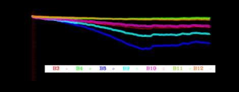
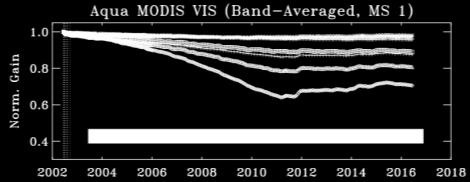
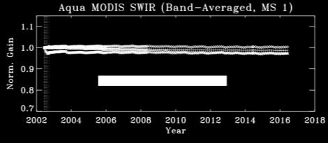
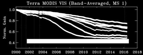
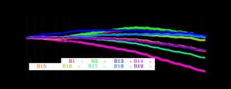
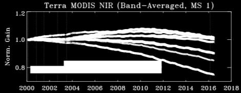
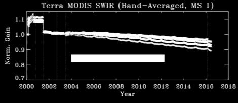
7 MODIS VIS/NIR/SWIR Spectral Band Responses (Gains) Spectral band responses: large in VIS and NIR; small in SWIR, MWIR, LWIR S/C safe mode 7


")
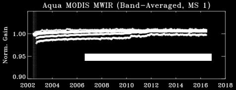
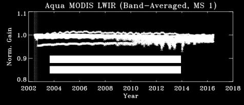
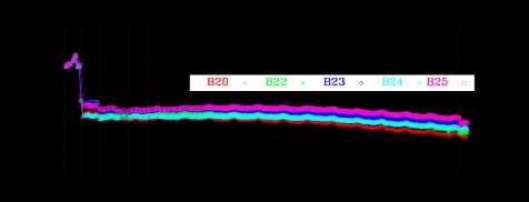
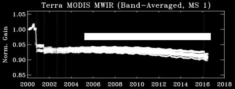
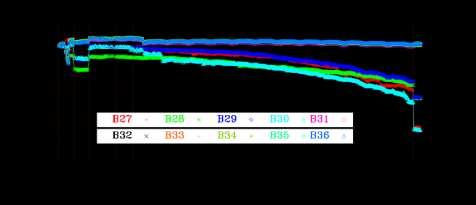
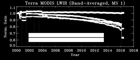
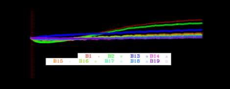
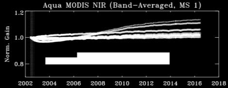
8 MODIS MWIR/LWIR Spectral Band Responses (Gains) Change of electronic configuration S/C safe mode Fluctuations in CFPA temp. led to small variations in LWIR detector responses 8


 Similar")
9 MODIS Spatial and Spectral Performance Band-to-Band Registration (BBR) in Along-scan Direction CFPA CFPA Similar Performance for BBR in Along-track Direction Changes in Spectral Band Center Wavelengths (CW) Similar Results for Changes in Bandwidths (BW) 9
 Track: 43 m Scan: 44 m Aqua MODIS RMSE (C6) Track: 46 m Scan: 53 m Lin and Wolfe Lin and Wolfe")
.")
10 MODIS Geolocation Performance Terra and Aqua MODIS Geolocation Performance Remains Satisfactory Terra MODIS RMSE (C6) Track: 43 m Scan: 44 m Aqua MODIS RMSE (C6) Track: 46 m Scan: 53 m Lin and Wolfe Lin and Wolfe Terra track direction jump - due to a delayed implementation/update of Geo LUTs (from 01/01/2013 to 08/10/2013). Aqua track direction jump at the end of 2011 (now it s back to normal ) - need to model it and update the LUT. 10

 Small changes in VIS, MWIR,")
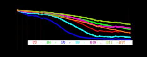
11 VIIRS Changes in Spectral Band Responses (Gains) Lunar: symbols; Solar: curves 1.0% 5.0% 10% 1.0% 10% Large changes in NIR and SWIR (due to mirror contamination) Small changes in VIS, MWIR, and LWIR 11
12 VIIRS Spatial and Spectral Performance Band-to-band registration (BBR) Modulated RSR DNB Improved methodology (originally developed for MODIS BBR using lunar observations and validated using on-board SRCA) On-orbit BBR is very stable in both scan and track directions DNB Large impact for DNB (up to 5%); small impact for M/I bands (< 1%) 12
 Track: 72 m Scan: 61 m Future improvements (via reprocessing) Terra MODIS RMSE (C6) Track: 43 m Scan: 44 m (Geometric")
13 VIIRS Geometric Performance Geolocation S-NPP VIIRS RMSE (C1.1) Track: 72 m Scan: 61 m Future improvements (via reprocessing) Terra MODIS RMSE (C6) Track: 43 m Scan: 44 m (Geometric Cal: Lin and Wolfe) Aqua MODIS RMSE (C6) Track: 46 m Scan: 53 m 13
14 Challenging Issues and Future Work Future work to address existing and new challenging issues and to continue improving sensor on-orbit calibration Changes in MODIS VIS/NIR response versus scan-angle (RVS) continuing effort Changes in Terra MODIS polarization sensitivity and impact on sensor s earth view response trending progress has been made in recent years Uncertainty due to large SD degradation and no SD degradation monitoring for SWIR bands mitigation strategies developed and applied Terra LWIR PV Xtalk impact correction algorithm testing and implementation Improved use of VIIRS SD and lunar calibration parameters impact of RSR Tracking potential changes in VIIRS RVS lessons from MODIS Special calibration and validation effort in support of VIIRS data reprocessing effort by both NASA and NOAA MODIS and VIIRS calibration consistency and impact on science products Extensive calibration and validation effort and science support Community effort and interagency collaboration 14
 SD Calibration")


15 MODIS Changes in Response Versus Scan-angle (RVS) SD Calibration Lunar Calibration RVS is wavelength, mirror-side, and AOI dependent MODIS SD and lunar calibrations performed at 2 different AOIs VIIRS SD and lunar calibrations performed at the same AOI (closely monitored using PICS) 15
16 On-orbit Changes in Terra MODIS Polarization Sensitivity Noticeable on-orbit changes in the polarization sensitivity, especially at short wavelengths (412 nm and 443 nm bands most impacted) Previous effort by NASA OBPG developed an approach to decouple the impacts of on-orbit changes in the RVS and polarization using L3 ocean products [Kwiatkowska et.al, in AO 2009] Current MCST effort provides an independent approach to track the onorbit polarization sensitivity using L1 reflectance over pseudo-invariant desert sites [Wu et.al, in SPIE 2015] On-orbit polarization correction based on the Mueller matrix [similar to OBPG approach]. Linear Stokes vector components modeled from 6SV 412 nm 443 nm uncorrected reflectance polarization corrected reflectance 16
17 MODIS and VIIRS Data Processing Continuous effort by NASA MCST to support MODIS data processing C5 and C6: currently running in parallel (C5 stops at end of 2016) Improvements, when necessary, have been made to C5 and/or C6 Continuous effort by NASA VCST to support VIIRS data processing C1.0 and C1.1: modified IDPS code (Mx#.#) with VCST LUTs V1.1.0: current production version; newly developed L1A and L1B software with VCST LUTs V2.0.0: released in July 2016 for software testing and products evaluation Preparation for NOAA IDPS VIIRS data reprocessing Extensive effort led by NOAA SDR Team to assess and validate VIIRS SDR quality Ongoing studies conducted in preparation for IDPS VIIRS SDR reprocessing NASA MODIS and VIIRS Science Team Meeting (June, 2016) NOAA JPSS Science Team Meeting (August, 2016) 17
18 Backup Slides 18
19 Status of VIIRS NASA Land SDR Support Land SIPS SDR reprocess based on IDPS Mx Code with VCST LUTs (C1.0 and C1.1) Independent validation for SDR code and improvements in LUTs derivation. Running Land s modified IDPS SDR/EDR codes Mx based version with LUTs input from VCST. 41 sets of LUTs for VISNIR/SWIR/DNB have been delivered to Land SIPS for data reprocessing and SDR/EDR assessments in Collections 1.0 and 1.1. C o lle ctio n C o d e B a s e # o f LU T s D e liv e ry T im e Im p ro v e m e n ts C 1.0 C 1.1 M x M x M x M x S m o o th e d f u n cti o n s f o r S D d e g ra d a ti o n H - f a cto r a n d ca l i b ra ti o n co e f f i ci e n ts F - f a cto r. U p d a te d S D / S D S M s cre e n tra n s m i s s i o n, S D B R D F, R T A m i rro rs d e g ra d a ti o n m o d e l, a n d m o d u l a te d R S R s. Im p ro v e d ti m e - d e p e n d e n t m o d u l a te d R S R, D N B s tra y l i g h t co rre cti o n, H & F f i tti n g f u n cti o n s. Im p ro v e d Q u a l i ty F l a g s, D N B g a i n ra ti o a n d LG S LU T s i n tro d u ce d, G E O s o l a r/ l u n a r v e cto rs f i x, a n d w i th R S B A u to C a l o p ti o n. 19
20 Status of VIIRS NASA SIPS L1B Support NASA SIPS L1B/LUTs for mission reprocess V1.1.0 (current production version) VIIRS L1A and L1B software, LUTs, and data design are developed under NASA EDOS/SIPS. First L1B software V1.1.0 was released in Jan L1B software generates 6-min granule VIIRS geolocation and radiometric products including OBC from L1A input, all in NetCDF4 format. V1.1.0 is based on IDPS SDR code Mx8.10 algorithms. The contents of L1B V1.1.0 and SDR Mx8.10/8.11 should match if the same calibration coefficients and parameters are used. NASA L1B LUTs are computed by using on-orbit SD/SDSM screen transmission & SD BRDF, modulated RSR, and consistent fitting methods throughout the mission. L1B Software V2.0.0 (currently under testing and evaluation) V2.0.0 was released to SIPS in July 2016 for software testing and products evaluation. Two types of data are required for L1B input L1A file and L1B calibration Look-Up-Table (LUT). Changes in V2.0.0 are described in next slide. C o lle ctio n C o d e B a s e # o f LU T s D e liv e ry T im e N o te V L1B V V L1B V R e d e s i g n e d L1B s o f tw a re, LU T s, a n d d a ta f o rm a t u s i n g L1A d a ta i n p u t. Im p ro v e d L1B s o f tw a re f u n cti o n s a n d a l g o ri th m s. L1B p ro d u cts a re u n d e r e v a l u a ti o n. 20
21 VIIRS L1B Software V2.0 Changes The major changes in V2.0 compared to V1.1: A. Functional changes Add fill values for specific data states requested by Land team. Partial line processing to support along-scan extracts. Add un-aggregated L1B product for dual gain bands. Add RSR tables in RSB LUT. Remove radiance tables from TEB LUT. Single resolution processing and output in geolocation. Add moon phase angle and moon illumination fraction in DNB geolocation. Add limit checks on attitude angles in geolocation. Add a new field for uncertainty index in L1B product under development. B. Algorithm changes Use solar irradiance at 1 AU to avoid computation of large number (in meters). Temperature dependent coefficients for RSB Cal. Apply time-dependent modulated RSR in RSB Cal. Apply running average of TEB F-factor in TEB Cal. BB thermistors weighting (selection) to decrease orbital variation in F-factor for TEB Cal. Alternative calibration when moon is in SV. Apply out of range limits based on dn. 21
22 Deep Convective Clouds (DCC) for Stability Assessments The reflectance of deep convective clouds (DCC) are known to be statistically stable over time Detecting VIIRS calibration drifts < 0.5% in selected bands over several years has been demonstrated A large number of data points can help reduce uncertainties VIIRS M7 stable Additional effort is required to use DCC for calibration inter-comparisons VIIRS M3 possible drift? Wang & Cao, Remote Sensing
23 Desert Sites for Stability Assessments CEOS Working Group on Cal/Val (WGCV) has identified and endorsed several pseudo invariant desert sites for calibration stability monitoring, such as Libya4 Caveats: sky is not always clear in the desert which reduces the number of useful data points; bi-directional reflection introduces uncertainties Desert observations have helped MODIS in correcting long-term drift Desert trend doesn t necessarily agree with the DCC trend 23
24 SNOs for Sensor Calibration Inter-comparisons Comparisons between VIIRS and MODIS have been routinely performed at the Simultaneous Nadir Overpass (SNOs) Caveats: this approach only provides relative bias between VIIRS and MODIS, using MODIS as the reference (14 years in orbit) Need to extend the intercomparisons with other satellite instruments at SNOs GSICS will help facilitate the comparisons Uprety & Cao, RSE
MODIS and VIIRS Reflective Solar Calibration Update
 MODIS and VIIRS Reflective Solar Calibration Update X. Xiong 1, C. Cao 2, A. Angal 3, S. Blonski 4, N. Lei 3, W. Wang 4, Z. Wang 3, and A. Wu 3 1 NASA GSFC, MD 20771, USA; 2 NOAA NESDIS, MD 20740, USA
MODIS and VIIRS Reflective Solar Bands Calibration, Performance, and Inter-comparison
 EOS MODIS and VIIRS Reflective Solar Bands Calibration, Performance, and Inter-comparison Jack Xiong 1, Aisheng Wu 1, and Changyong Cao 2 1. NASA/GSFC; 2. NOAA/STAR Other Contributors: NASA MCST and VCST
Status of VIIRS Reflective Solar Bands On-orbit Calibration and Performance
 EOS Status of VIIRS Reflective Solar Bands On-orbit Calibration and Performance X. Xiong 1, J. Fulbright 2, N. Lei 2, J. Sun 2, Z. Wang 2, and J. McIntire 2 1. NASA/GSFC, Greenbelt, MD 20771, USA 2. Sigma
Status of S-NPP VIIRS Solar and Lunar Calibration
 Status of S-NPP VIIRS Solar and Lunar Calibration X. Xiong 1, N. Lei 2, J. Fulbright 2, and Z. Wang 2 1 NASA Goddard Space Flight Center, Greenbelt, MD 20771, USA 2 Science Systems and Applications Inc.,
MODIS On-orbit Calibration Methodologies
 MODIS On-orbit Calibration Methodologies Jack Xiong and Bill Barnes NASA/GSFC, Greenbelt, MD 20771, USA University of Maryland, Baltimore County, Baltimore MD, 21250, USA (Support provided by entire MCST
VIIRS SDR Cal/Val: S-NPP Update and JPSS-1 Preparations
 VIIRS SDR Cal/Val: S-NPP Update and JPSS-1 Preparations VIIRS SDR Cal/Val Posters: Xi Shao Zhuo Wang Slawomir Blonski ESSIC/CICS, University of Maryland, College Park NOAA/NESDIS/STAR Affiliate Spectral
Inflight Radiometric Calibration: NASA Experience
 EOS Inflight Radiometric Calibration: NASA Experience Jack Xiong and Brian Markham Sciences and Exploration Directorate, NASA Goddard Space Flight Center Contributions: MODIS, VIIRS, and OLI Instrument
MODIS Reflective Solar Bands Calibration Algorithm and On-orbit Performance
 MODIS Reflective Solar Bands Calibration Algorithm and On-orbit Performance X. (Jack) Xiong* a, J. Sun a, J. Esposito a, B. Guenther b, and W. Barnes c a Science Systems and Applications, Inc., 10210 Greenbelt
Traceability to the GIRO and ROLO
 EOS Traceability to the GIRO and ROLO Jack Xiong (NASA) In collaboration with Tom Stone (USGS) Sébastien Wagner, Tim Hewison (EUMETSAT) Sophie Lachérade, Bertrand Fougnie (CNES) GSICS Lunar Calibration
VIIRS Radiometric Calibration for Reflective Solar Bands: Antarctic Dome C Site and Simultaneous Nadir Overpass Observations
 VIIRS Radiometric Calibration for Reflective Solar Bands: Antarctic Dome C Site and Simultaneous Nadir Overpass Observations Slawomir Blonski, * Changyong Cao, Sirish Uprety, ** and Xi Shao * NOAA NESDIS
Tracking On-orbit Radiometric Accuracy and Stability of Suomi NPP VIIRS using Extended Low Latitude SNOs
 Tracking On-orbit Radiometric Accuracy and Stability of Suomi NPP VIIRS using Extended Low Latitude SNOs Sirish Uprety a Changyong Cao b Slawomir Blonski c Xi Shao c Frank Padula d a CIRA, Colorado State
Suomi NPP VIIRS SDR postlaunch cal/val - Overview of progress and challenges
 Suomi NPP VIIRS SDR postlaunch cal/val - Overview of progress and challenges Changyong Cao 1, Jack Xiong 2, Fuzhong Weng 1, Bruce Guenther 1, and Jim Butler 2 1 NOAA, 2 NASA August 30, 2012 Sample VIIRS
MODIS on-orbit spatial characterization results using ground measurements
 MODIS on-orbit spatial characterization results using ground measurements Yong Xie 1, Xiaoxiong Xiong 2, John J Qu 1,2, Nianzeng Che 3, Lingli Wang 1 1 Center for Earth Observing and Space Research (CEOSR)
Development and Implementation of an Electronic Crosstalk Correction for Bands in Terra MODIS Collection 6
 remote sensing Article Development and Implementation of an Electronic Crosstalk Correction for Bands 27 3 in Terra MODIS Collection 6 Truman Wilson 1, *, Aisheng Wu 1, Ashish Shrestha 1, Xu Geng 1, Zhipeng
Suomi National Polar orbiting Partnership (NPP) VIIRS data product assessment
 VIIRS data product assessment") Suomi National Polar orbiting Partnership (NPP) VIIRS data product assessment K. Turpie Ocean Color Science PI VIIRS Ocean Science Team (VOST) Ocean Color Research Team Meeting 23 April 2012 Seattle, Washington
Suomi National Polar orbiting Partnership (NPP) VIIRS data product assessment K. Turpie Ocean Color Science PI VIIRS Ocean Science Team (VOST) Ocean Color Research Team Meeting 23 April 2012 Seattle, Washington
NOAA Cal/Val Progress Update
 NOAA Cal/Val Progress Update Xi Shao 1,2 and Changyong Cao 2 1. University of Maryland 2. NOAA/NESDIS/STAR With contributions from NOAA/NESDIS/STAR Scientists Presented at the WGCV-36, Shanghai, China,
Monitoring the NOAA Operational VIIRS RSB and DNB Calibration Stability Using Monthly and Semi-Monthly Deep Convective Clouds Time Series
 remote sensing Article Monitoring the NOAA Operational VIIRS RSB and DNB Calibration Stability Using Monthly and Semi-Monthly Deep Convective Clouds Time Series Wenhui Wang 1, * and Changyong Cao 2 Received:
PUBLICATIONS. Journal of Geophysical Research: Atmospheres. VIIRS on-orbit calibration methodology and performance
 PUBLICATIONS RESEARCH ARTICLE Special Section: Suomi NPP Calibration and Validation Scientific Results Key Points: VIIRS on-orbit calibration methodology VIIRS onboard calibrators and sensor operation
Ocean Colour: Calibration Approach. CEOS WGCV-39, May The International Ocean Colour Coordinating Group
 Ocean Colour: Calibration Approach CEOS WGCV-39, May 2015 The International Ocean Colour Coordinating Group Ocean Colour requires special calibration considerations Percentage of ocean signal in the total
Orbital Variation of Blackbody. VIIRS Thermal Emissive Band
 Orbital Variation of Blackbody Thermistor Temperature for S NPP VIIRS Thermal Emissive Band Calibration i Xi Shao 1, Changyong Cao 2, Slawomir Blonski 1, Quanhua (Mark) Liu 1 1. University of Maryland,
Adjusting Aqua MODIS TEB nonlinear calibration coefficients using iterative solution
 Adjusting Aqua MODIS TEB nonlinear calibration coefficients using iterative solution Aisheng Wu a, Zhipeng (Ben) Wang a, Yonghong Li a, Sriharsha Madhavan b, Brian N. Wenny a, Na Chen a, and Xiaoxiong
624 SNPP VIIRS Solar Diffuser BRDF Degradation Trend Changes in Early Evan Haas* and Frank De Luccia The Aerospace Corporation, El Segundo CA
 624 SNPP VIIRS Solar Diffuser BRDF Degradation Trend Changes in Early 2014 1. INTRODUCTION Evan Haas* and Frank De Luccia The Aerospace Corporation, El Segundo CA The Visible Infrared Imaging Radiometer
Cross-track Infrared Sounder (CrIS) Instrument In-flight Performance CALCON 2012 Vladimir Zavyalov, Gail Bingham, Mark Esplin, Mark Greenman, Deron
 Instrument In-flight Performance CALCON 2012 Vladimir Zavyalov, Gail Bingham, Mark Esplin, Mark Greenman, Deron") Cross-track Infrared Sounder (CrIS) Instrument In-flight Performance CALCON 2012 Vladimir Zavyalov, Gail Bingham, Mark Esplin, Mark Greenman, Deron Scott, Brandon Graham, Charles Major, and Lee Phillips
Cross-track Infrared Sounder (CrIS) Instrument In-flight Performance CALCON 2012 Vladimir Zavyalov, Gail Bingham, Mark Esplin, Mark Greenman, Deron Scott, Brandon Graham, Charles Major, and Lee Phillips
Suomi NPP VIIRS sensor data record verification, validation, and long-term performance monitoring
 JOURNAL OF GEOPHYSICAL RESEARCH: ATMOSPHERES, VOL. 118, 11,664 11,678, doi:10.1002/2013jd020418, 2013 Suomi NPP VIIRS sensor data record verification, validation, and long-term performance monitoring Changyong
GOSAT mission schedule
 GOSAT mission schedule 29 21 12 1 2 3 4 6 7 8 9 1 11 12 1 2 214 1 2 3 ~ Jan. 23 Launch Initial Checkout Initial function check Initial Cal. and Val. Mission life Normal observation operation Extra Operati
(A)ATSR and SLSTR VIS/SWIR Channels Calibration
ATSR and SLSTR VIS/SWIR Channels Calibration") (A)ATSR and SLSTR VIS/SWIR Channels Calibration Dave Smith & Mireya Etxaluze 2017 RAL Space 1 ATSR Series 1991-2000 ATSR-1 1995-2008 ATSR-2 2002-2012- AATSR 2 SLSTR Series 2016 Sentinel 3A 2018 Sentinel
(A)ATSR and SLSTR VIS/SWIR Channels Calibration Dave Smith & Mireya Etxaluze 2017 RAL Space 1 ATSR Series 1991-2000 ATSR-1 1995-2008 ATSR-2 2002-2012- AATSR 2 SLSTR Series 2016 Sentinel 3A 2018 Sentinel
The Ozone Mapping and Profiler Suite (OMPS): From SNPP to JPSS-1
: From SNPP to JPSS-1") The Ozone Mapping and Profiler Suite (OMPS): From SNPP to JPSS-1 *C. Pan 1 and F. Weng 2 Curtsey of BATC Aerosol Index * 1 ESSIC, University of Maryland, College Park, MD 20740; 2 NOAA NESDIS/STAR, College
The Ozone Mapping and Profiler Suite (OMPS): From SNPP to JPSS-1 *C. Pan 1 and F. Weng 2 Curtsey of BATC Aerosol Index * 1 ESSIC, University of Maryland, College Park, MD 20740; 2 NOAA NESDIS/STAR, College
Accuracy and Precision Requirements for Climate-Level Data Sets
 Accuracy and Precision Requirements for Climate-Level Data Sets K. Thome NASA/GSFC Libya-4 Workshop Paris, France October 4-5, 2012 Accuracy requirements Commercial imagers Precision and SNR drive calibration
Sumi-NPP OMPS Calibration and Characterization from Early Orbit Images
 Sumi-NPP OMPS Calibration and Characterization from Early Orbit Images *C. Pan 1, F. Weng 2, X. Wu 2, L. Flynn 2, G. Jaross 3 and S. Janz 4 * 1 ESSIC, University of Maryland, College Park, MD 20740 2 NOAA
Introduction to satellite sensor radiometric calibration a review of FY-3 ocean color applications
 //3 Introduction to satellite sensor radiometric calibration a review of FY-3 ocean color applications SUN Ling NSMC, CMA sunling@cma.gov.cn -- Calibration: The process of quantitatively defining system
Cross-calibration of Geostationary Satellite Visible-channel Imagers Using the Moon as a Common Reference
 Cross-calibration of Geostationary Satellite Visible-channel Imagers Using the Moon as a Common Reference Thomas C. Stone U.S. Geological Survey, Flagstaff AZ, USA 27 30 August, 2012 Motivation The archives
GSICS UV Sub-Group Activities
 GSICS UV Sub-Group Activities Rosemary Munro with contributions from NOAA, NASA and GRWG UV Subgroup Participants, in particular L. Flynn 1 CEOS Atmospheric Composition Virtual Constellation Meeting (AC-VC)
17th GSICS Executive Panel, Biot, 2-3 June 2016
 NOAA Agency Report 17th GSICS Executive Panel, Biot, 2-3 June 2016 Mitch Goldberg NOAA/NESDIS GSICS-EP-17, Biot, 2-3 June 2016 1 Contents Overall agency update Participation in EP, GDWG, GRWG Current and
Extending the Deep Blue aerosol record from SeaWiFS and MODIS to NPP-VIIRS
 Extending the Deep Blue aerosol record from SeaWiFS and MODIS to NPP-VIIRS Andrew M. Sayer, N. Christina Hsu (PI), Corey Bettenhausen, Jaehwa Lee Climate & Radiation Laboratory, NASA Goddard Space Flight
Status of CNES Cal/Val Activities
 GSICS Executive Panel Meeting 16-17th May 2014, Guangzhou, China Status of CNES Cal/Val Activities Patrice Henry CNES 1 Summary Overview of CNES Cal/Val Activities Summary Re-Calibration Activities POLDER(s)/PARASOL
GMES: calibration of remote sensing datasets
 GMES: calibration of remote sensing datasets Jeremy Morley Dept. Geomatic Engineering jmorley@ge.ucl.ac.uk December 2006 Outline Role of calibration & validation in remote sensing Types of calibration
*C. Pan 1, F. Weng 2, T. Beck 2 and S. Ding 3
 S NPP Ozone Mapping Profiler Suite Nadir Instrument Radiometric Calibration *C. Pan 1, F. Weng 2, T. Beck 2 and S. Ding 3 Curtsey of Ball Aerospace and Technologies Corp. * 1 ESSIC, University of Maryland,
MERIS, A-MODIS, SeaWiFS, AATSR and PARASOL over the Salar de Uyuni March 2006 MAVT 2006 Marc Bouvet, ESA/ESTEC
 MERIS, A-MODIS, SeaWiFS, AATSR and PARASOL over the Salar de Uyuni Plan of the presentation 1. Introduction : from absolute vicarious calibration to radiometric intercomparison 2. Intercomparison at TOA
Initial Stability Assessment of S-NPP VIIRS Reflective Solar Band Calibration Using Invariant Desert and Deep Convective Cloud Targets
 Remote Sens. 2014, 6, 2809-2826; doi:10.3390/rs6042809 Article OPEN ACCESS remote sensing ISSN 2072-4292 www.mdpi.com/journal/remotesensing Initial Stability Assessment of S-NPP VIIRS Reflective Solar
Vicarious calibration of S-NPP VIIRS reflective solar M-bands against MODIS Aqua over dark water scenes
 Atmos. Meas. Tech. Discuss., doi:.194/amt-16-238, 16 Vicarious calibration of S-NPP VIIRS reflective solar M-bands against MODIS Aqua over dark water scenes A. M. Sayer 1,2, N. C. Hsu 1, C. Bettenhausen
Overview of Post-launch CrIS SDR Calibration and Validation
 Overview of Post-launch CrIS SDR Calibration and Validation Yong Han NOAA/ Center for Satellite Applications & Research and CrIS SDR Team CALCON Technical Conference Aug. 27 Aug. 30, 2012 Logan, Utah 1
GCOM-C SGLI calibration and characterization. Hiroshi Murakami JAXA/EORC Satellite instrument pre- and post-launch calibration
 GCOM-C SGLI calibration and characterization Hiroshi Murakami JAXA/EORC Satellite instrument pre- and post-launch calibration 1 1. SGLI sensor system and onboard calibration system Target: Improvement
Outcome of the GSICS/CEOS-IVOS Lunar Calibration Workshop
 Outcome of the GSICS/CEOS-IVOS Lunar Calibration Workshop S. Wagner a, T. Hewison a, T. Stone b, S. Lachérade c, B. Fougnie c, X. Xiong d With the support of M. Takahashi JMA (1-year visiting scientist
Status of Aqua MODIS Spatial Characterization and Performance
 Status of Aqua MODIS Spatial Characterization and Performance Xiaoxiong. Xiong, Nianzeng Che, William Barnes, Yong Xie, Lingli Wang, and John Qu Sciences and Exploration Directorate, NASA/GSFC, Greenbelt,
CNES WGCV-36 Report Cal/Val Activities
 CEOS WGCV Meeting 13-17th May 2013, Shangai, China CNES WGCV-36 Report Cal/Val Activities Bertrand Fougnie, Sophie Lachérade, Denis Jouglet, Eric Péquignot, Aimé Meygret, Patrice Henry CNES 1 Summary Pleiades
Post-launch Radiometric and Spectral Calibration Assessment of NPP/CrIS by comparing CrIS with VIIRS, AIRS, and IASI
 Post-launch Radiometric and Spectral Calibration Assessment of NPP/CrIS by comparing CrIS with VIIRS, AIRS, and IASI Likun Wang 1, Yong Han 2, Denis Tremblay 3, Fuzhong Weng 2, and Mitch Goldberg 4 1.
Status report of JMA and calibration policy for AHI. Meteorological Satellite Center of JMA Arata OKUYAMA and Toshiyuki KURINO
 Status report of JMA and calibration policy for AHI Meteorological Satellite Center of JMA Arata OKUYAMA and Toshiyuki KURINO Contents Update of JMA GSICS members Progress of JMA GRWG activities Infrared
JPSS-1 VIIRS Radiometric Characterization and Calibration Based on Pre-Launch Testing
 remote sensing Article JPSS-1 VIIRS Radiometric Characterization Calibration Based on Pre-Launch Testing Hassan Oudrari 1, *, Jeff McIntire 1, Xiaoxiong Xiong 2, James Butler 2, Qiang Ji 1, Thomas Schwarting
McIDAS support of Suomi-NPP /JPSS and GOES-R L2
 McIDAS support of Suomi-NPP /JPSS and GOES-R L2 William Straka III 1 Tommy Jasmin 1, Bob Carp 1 1 Cooperative Institute for Meteorological Satellite Studies, Space Science and Engineering Center, University
EUMETSAT AGENCY REPORT 2014/15 INSTRUMENT CAL/VAL ACTIVITIES
 1 WGCV Plenary #39, Berlin, May 2015 EUMETSAT AGENCY REPORT 2014/15 INSTRUMENT CAL/VAL ACTIVITIES J. Ackermann, S. Elliott, T. Hewison, K. Holmlund, V. John, R. Munro, P. Miu, A. O Carroll, R. Roebeling,
Global Space-based Inter-Calibration System (GSICS) Infrared Reference Sensor Traceability and Uncertainty
 Infrared Reference Sensor Traceability and Uncertainty") Global Space-based Inter-Calibration System (GSICS) Infrared Reference Sensor Traceability and Uncertainty Tim Hewison (EUMETSAT) Thomas Pagano (NASA/JPL) Dave Tobin (NOAA/CIMSS) Masaya Takahashi (JMA)
Global Space-based Inter-Calibration System (GSICS) Infrared Reference Sensor Traceability and Uncertainty Tim Hewison (EUMETSAT) Thomas Pagano (NASA/JPL) Dave Tobin (NOAA/CIMSS) Masaya Takahashi (JMA)
Characterization of the VIIRS Blackbody Emittance
 Characterization of the VIIRS Blackbody Emittance Jeremy Kloepfer, Chris Taylor, and Vijay Murgai jeremiah_kloepfer@raytheon.com Conference on Characterization and Radiometric Calibration for Remote Sensing,
NASA Report to the GSICS Executive Panel
 NASA Report to the GSICS Executive Panel James J. Butler NASA Goddard Space Flight Center Greenbelt, MD USA Japan Meteorological Agency Tokyo, Japan July 15-16, 2013 1 Agenda Instrument Updates MODIS AIRS
Vicarious calibration of GLI by global datasets. Calibration 5th Group Hiroshi Murakami (JAXA EORC)
") Vicarious calibration of GLI by global datasets Calibration 5th Group Hiroshi Murakami (JAXA EORC) ADEOS-2 PI workshop March 2004 1 0. Contents 1. Background 2. Operation flow 3. Results 4. Temporal change
Vicarious calibration of GLI by global datasets Calibration 5th Group Hiroshi Murakami (JAXA EORC) ADEOS-2 PI workshop March 2004 1 0. Contents 1. Background 2. Operation flow 3. Results 4. Temporal change
Overview of Suomi National Polar-Orbiting Partnership Satellite Instrument Calibration and SDR Validation
 Overview of Suomi National Polar-Orbiting Partnership Satellite Instrument Calibration and SDR Validation Dr. Fuzhong Weng, Chief Satellite Meteorology and Climatology Division NOAA/NESDIS Center for Satellite
Calibration of Ocean Colour Sensors
 Dr. A. Neumann German Aerospace Centre DLR Remote Sensing Technology Institute Marine Remote Sensing What is Calibration, why do we need it? Sensor Components Definition of Terms Calibration Standards
Sentinel-3 Sea and Land Surface Temperature Radiometer (SLSTR) Mireya Etxaluze (STFC RAL Space)
 Mireya Etxaluze (STFC RAL Space)") Sentinel-3 Sea and Land Surface Temperature Radiometer (SLSTR) Mireya Etxaluze (STFC RAL Space) RAL Space Radiometry Group Dave Smith Mireya Etxaluze, Ed Polehampton, Caroline Cox, Tim Nightingale, Dan
Sentinel-3 Sea and Land Surface Temperature Radiometer (SLSTR) Mireya Etxaluze (STFC RAL Space) RAL Space Radiometry Group Dave Smith Mireya Etxaluze, Ed Polehampton, Caroline Cox, Tim Nightingale, Dan
Pre-Launch Radiometric Characterization of JPSS-1 VIIRS Thermal Emissive Bands
 Article Pre-Launch Radiometric Characterization of JPSS-1 VIIRS Thermal Emissive Bands Jeff McIntire 1, *, David Moyer 2, Hassan Oudrari 1 and Xiaoxiong Xiong 3 Received: 28 October 2015; Accepted: 25
NOAA MSU/AMSU Radiance FCDR. Methodology, Production, Validation, Application, and Operational Distribution. Cheng-Zhi Zou
 NOAA MSU/AMSU Radiance FCDR Methodology, Production, Validation, Application, and Operational Distribution Cheng-Zhi Zou NOAA/NESDIS/Center for Satellite Applications and Research GSICS Microwave Sub-Group
AIRS Level 1b. Tom Pagano AIRS Project Project Manager. Hartmut Aumann AIRS Project Scientist
 AIRS Level 1b Tom Pagano AIRS Project Project Manager Hartmut Aumann AIRS Project Scientist Jet Propulsion Laboratory California Institute of Technology and Ken Overoye AIRS Calibration System Engineer
EUMETSAT GPRC Report. Jo Schmetz Tim Hewison, Sebastien Wagner, Rob Roebeling, Peter Miu, Simon Elliot, Harald Rothfuss, Bartolomeo Viticchie EUMETSAT
 EUMETSAT GPRC Report Jo Schmetz Tim Hewison, Sebastien Wagner, Rob Roebeling, Peter Miu, Simon Elliot, Harald Rothfuss, Bartolomeo Viticchie EUMETSAT Slide: 1 Overview Satellite Status Calibration Support
GOSAT update. June Prepared by JAXA EORC Presented by David Crisp
 CEOS AC-VC GOSAT update June Prepared by JAXA EORC Presented by David Crisp GOSAT & GOSAT-2 Organization ORGANIZATION GOSAT is the joint project of JAXA, MOE (Ministry of the Environment) and NIES (National
Introducing VIIRS Aerosol Products
 1 Introducing VIIRS Aerosol Products Shobha Kondragunta NOAA/NESDIS Center for Satellite Applications and Research VIIRS Aerosol Cal/Val Team 2 Name Organization Major Task Kurt F. Brueske IIS/Raytheon
FY-2 On-orbit Operational Calibration Approach (CIBLE) and its Benefit to FY-2D/E AMV Products
 and its Benefit to FY-2D/E AMV Products") 12 th International Winds Workshop (IWW12) Calibration of Inner Blackbody corrected by Lunar Emission (CIBLE) FY-2 On-orbit Operational Calibration Approach (CIBLE) and its Benefit to FY-2D/E AMV Products
12 th International Winds Workshop (IWW12) Calibration of Inner Blackbody corrected by Lunar Emission (CIBLE) FY-2 On-orbit Operational Calibration Approach (CIBLE) and its Benefit to FY-2D/E AMV Products
Physical Model to Describe the PARASOL Radiometric Trending. Definition, Adjustment, and Validation
 Physical Model to Describe the PARASOL Radiometric Trending Definition, Adjustment, and Validation Bertrand Fougnie CNES CALCON 13 Summary The PARASOL instrument & mission Evidences a of radiometric drift
Update on GSICS Inter Calibration Product Development
 Special Issue of the IEEE TGRS on Inter-Calibration of Satellite Instruments : Update on GSICS Inter Calibration Product Development Tim Hewison (EUMETSAT) [GSICS Research Working Group Chair] Dave Doelling
GOME-2 COMMISSIONING RESULTS: GEOPHYSICAL VALIDATION OF LEVEL 1 PRODUCTS
 GOME-2 COMMISSIONING RESULTS: GEOPHYSICAL VALIDATION OF LEVEL 1 PRODUCTS Rosemary Munro (1), Rüdiger Lang (1), Yakov Livschitz (1), Michael Eisinger (2), Abelardo Pérez-Albiñana (1) (1) EUMETSAT, Darmstadt,
Some NOAA Products that Address PSTG Satellite Observing Requirements. Jeff Key NOAA/NESDIS Madison, Wisconsin USA
 Some NOAA Products that Address PSTG Satellite Observing Requirements Jeff Key NOAA/NESDIS Madison, Wisconsin USA WMO Polar Space Task Group, 4 th meeting, Greenbelt, 30 September 2014 Relevant Missions
Long-term global time series of MODIS and VIIRS SSTs
 Long-term global time series of MODIS and VIIRS SSTs Peter J. Minnett, Katherine Kilpatrick, Guillermo Podestá, Yang Liu, Elizabeth Williams, Susan Walsh, Goshka Szczodrak, and Miguel Angel Izaguirre Ocean
GOES R Calibration Working Group. Progress Update
 GOES-R Calibration Working Group Progress Update Changyong Cao With contributions from B. Iacovazzi, A. Pearlman, D. Pogorzala, X. Shao, Raju Datla, and S. Uprety NOAA/NESDIS/STAR GOES R Calibration Working
Landsat-8 Operational Land Imager (OLI) Initial On-Orbit Performance
 Initial On-Orbit Performance") Landsat-8 Operational Land Imager (OLI) Initial On-Orbit Performance Geir Kvaran, Ed Knight, Khurrum Ansari, Kenton Lee, Brent Canova, Brian Donley Ball Aerospace & Technologies Corp. Hugh Kieffer Celestial
Landsat-8 Operational Land Imager (OLI) Initial On-Orbit Performance Geir Kvaran, Ed Knight, Khurrum Ansari, Kenton Lee, Brent Canova, Brian Donley Ball Aerospace & Technologies Corp. Hugh Kieffer Celestial
Minutes of the First Meeting. of the IOCCG Working Group. L1 Requirements for Ocean-Colour Remote Sensing. April 20-21, 2010
 Minutes of the First Meeting of the IOCCG Working Group L1 Requirements for Ocean-Colour Remote Sensing April 20-21, 2010 Bethesda, Maryland (Washington, D.C.), USA Participants: - Charles R. McClain (chair,
A Time Series of Photo-synthetically Available Radiation at the Ocean Surface from SeaWiFS and MODIS Data
 A Time Series of Photo-synthetically Available Radiation at the Ocean Surface from SeaWiFS and MODIS Data Robert Frouin* a, John McPherson a, Kyozo Ueyoshi a, Bryan A. Franz b a Scripps Institution of
In-flight Calibration Techniques Using Natural Targets. CNES Activities on Calibration of Space Sensors
 In-flight Calibration Techniques Using Natural Targets CNES Activities on Calibration of Space Sensors Bertrand Fougnie, Patrice Henry (DCT/SI, CNES, Toulouse, France) In-flight Calibration using Natural
SBUV(/2) and SSBUV Solar Irradiance Measurements Matthew DeLand, Richard Cebula, Liang-Kang Huang Science Systems and Applications, Inc.
 and SSBUV Solar Irradiance Measurements Matthew DeLand, Richard Cebula, Liang-Kang Huang Science Systems and Applications, Inc.") SBUV(/2) and SSBUV Solar Irradiance Measurements Matthew DeLand, Richard Cebula, Liang-Kang Huang Science Systems and Applications, Inc. (SSAI) Solar Spectral Irradiance Variations Workshop NIST, Gaithersburg,
SBUV(/2) and SSBUV Solar Irradiance Measurements Matthew DeLand, Richard Cebula, Liang-Kang Huang Science Systems and Applications, Inc. (SSAI) Solar Spectral Irradiance Variations Workshop NIST, Gaithersburg,
Overview: Scope and Goals
 Overview: Scope and Goals Current operational NOAA instruments: AVHRR, HIRS, SBUV, GOES Imagers/Sounders; Non-NOAA satellites/sensors; Future: MetOP and NPP/NPOESS; GOES-R Assure Functionality of Current/Near-Future
First Lunar Results from the Moon & Earth Radiation Budget Experiment (MERBE)
") First Lunar Results from the Moon & Earth Radiation Budget Experiment (MERBE) Grant Matthews Accelerating certainty in climate change prediction GSICS Lunar cal meeting 6 th Dec 2016 Overview "The single
First Lunar Results from the Moon & Earth Radiation Budget Experiment (MERBE) Grant Matthews Accelerating certainty in climate change prediction GSICS Lunar cal meeting 6 th Dec 2016 Overview "The single
GSICS Traceability Statement for IASI and AIRS
 GSICS Traceability Statement for IASI and AIRS Doc.No. Issue : : EUM/MET/TEN/11/0157 v1a EUMETSAT Eumetsat-Allee 1, D-64295 Darmstadt, Germany Tel: +49 6151 807-7 Fax: +49 6151 807 555 Date : 6 October
Long-Term Time Series of Water Vapour Total Columns from GOME, SCIAMACHY and GOME-2
 Graphics: ESA Graphics: ESA Graphics: ESA Long-Term Time Series of Water Vapour Total Columns from GOME, SCIAMACHY and GOME-2 S. Noël, S. Mieruch, H. Bovensmann, J. P. Burrows Institute of Environmental
GSICS in CMA. Peng ZHANG, Xiuqing Hu, Ling Sun, Lin Chen, Na Xu, Yuan Li, Chengli Qi, Qiang Guo etc
 GSICS in CMA Peng ZHANG, Xiuqing Hu, Ling Sun, Lin Chen, Na Xu, Yuan Li, Chengli Qi, Qiang Guo etc National Satellite Meteorological Center, CMA July 15-16, Tokyo, Japan Outline GSICS history in CMA Current
Mission Objectives and Current Status of GOSAT (IBUKI) Japan Aerospace Exploration Agency Yasushi Horikawa
 Japan Aerospace Exploration Agency Yasushi Horikawa") Mission Objectives and Current Status of GOSAT (IBUKI) Japan Aerospace Exploration Agency Yasushi Horikawa 1 Background of the Launch of the GOSAT project 1997 Adoption of the Kyoto Protocol 2002 Ratification
Mission Objectives and Current Status of GOSAT (IBUKI) Japan Aerospace Exploration Agency Yasushi Horikawa 1 Background of the Launch of the GOSAT project 1997 Adoption of the Kyoto Protocol 2002 Ratification
Status of Land Surface Temperature Product Development for JPSS Mission
 Status of Land Surface Temperature Product Development for JPSS Mission Yuling Liu 1,2, Yunyue Yu 2, Peng Yu 1,2 and Heshun Wang 1,2 1 ESSIC at University of Maryland, College Park, MD USA 2 Center for
Advanced Radiance Transformation System (ARTS) For Space-borne Microwave Instruments
 For Space-borne Microwave Instruments") CICS Science Meeting, College Park, 2014 Advanced Radiance Transformation System (ARTS) For Space-borne Microwave Instruments Hu(Tiger) Yang 1, Fuzhong Weng 2, Ninghai Sun 2 Wanchun Chen 2, Lin Lin 2,
CICS Science Meeting, College Park, 2014 Advanced Radiance Transformation System (ARTS) For Space-borne Microwave Instruments Hu(Tiger) Yang 1, Fuzhong Weng 2, Ninghai Sun 2 Wanchun Chen 2, Lin Lin 2,
Overview of Hyperion On-Orbit Instrument Performance, Stability, and Artifacts
 Overview of Hyperion On-Orbit Instrument Performance, Stability, and Artifacts EO-1 Science Validation Team Meeting November 21, 2002 Debbie Beiso TRW Space and Electronics Redondo Beach, CA San Francisco
Sentinel-2 and Sentinel-3 absolute calibration monitoring. C. Desjardins & V. Lonjou CNES
 Sentinel-2 and Sentinel-3 absolute calibration monitoring C. Desjardins & V. Lonjou CNES Radiometric S2A Calibration RRQI, 28 January Workshop, 2016, 30-31/08/2017 CNES SUMMARY CALCON Aug 22-25 2017 VICARIOUS
EUMETSAT GPRC Report. Tim Hewison, Marianne Koenig, Sebastien Wagner, Rob Roebeling, Peter Miu, Jörg Schulz, Harald Rothfuss EUMETSAT
 EUMETSAT GPRC Report Tim Hewison, Marianne Koenig, Sebastien Wagner, Rob Roebeling, Peter Miu, Jörg Schulz, Harald Rothfuss EUMETSAT Slide: 1 Overview Satellite Status GEO LEO IR Products for current Meteosats
MONTHLY OPERATIONS REPORT
 LY OPERATIONS REPORT MOR#023 Reporting period from 6-Oct-205 to 5-Nov-205 Reference: PROBA-V_D5_MOR-023_205-_v.0 Author(s): Erwin Wolters, Dennis Clarijs, Sindy Sterckx, Alex Geboers Version:.0 Date: 8//205
The Moon & Earth Radiation Budget Experiment (MERBE)
") The Moon & Earth Radiation Budget Experiment (MERBE) Grant Matthews Animation credit Wikipedia Accelerating certainty in climate change prediction Overview New concept of MERBE, using existing data decades
The Moon & Earth Radiation Budget Experiment (MERBE) Grant Matthews Animation credit Wikipedia Accelerating certainty in climate change prediction Overview New concept of MERBE, using existing data decades
Estimation of ocean contribution at the MODIS near-infrared wavelengths along the east coast of the U.S.: Two case studies
 GEOPHYSICAL RESEARCH LETTERS, VOL. 32, L13606, doi:10.1029/2005gl022917, 2005 Estimation of ocean contribution at the MODIS near-infrared wavelengths along the east coast of the U.S.: Two case studies
S3-A OLCI Cyclic Performance Report. Cycle No Start date: 20/12/2017. End date: 16/01/2018
 PREPARATION AND OPERATIONS OF THE MISSION PERFORMANCE CENTRE (MPC) FOR THE COPERNICUS SENTINEL-3 MISSION Start date: 20/12/2017 End date: 16/01/2018 Contract: 4000111836/14/I-LG Customer: ESA Document
NOAA Report. Hal Bloom Mitch Goldberg NOAA/NESDIS
 NOAA Report Hal Bloom Mitch Goldberg NOAA/NESDIS Summary of Major Events at NESDIS (of interest to ITSC) NOAA/NASA addressing NPOESS Climate Sensors Letter of agreement signed with JAXA on GCOM interagency
Recent Update on MODIS C6 and VIIRS Deep Blue Aerosol Products
 Recent Update on MODIS C6 and VIIRS Deep Blue Aerosol Products N. Christina Hsu, Photo taken from Space Shuttle: Fierce dust front over Libya Corey Bettenhausen, Andrew M. Sayer, and Rick Hansell Laboratory
Algorithm for MERIS land surface BRDF/albedo retrieval and its validation using contemporaneous EO data products
 Algorithm for MERIS land surface BRDF/albedo retrieval and its validation using contemporaneous EO data products Jan-Peter Muller* (UCL) Carsten Brockmann, Marco Zühlke, Norman Fomferra (BC) Jürgen Fischer,
Overview of Intercalibration of Satellite Instruments
 University of Nebraska - Lincoln DigitalCommons@University of Nebraska - Lincoln USGS Staff -- Published Research US Geological Survey 2013 Overview of Intercalibration of Satellite Instruments G. Chander
Bldg., Corvallis, OR, USA USA 39529, USA. Arabia 1. INTRODUCTION ABSTRACT
 Evaluating VIIRS Ocean Color Products for West Coast and Hawaiian Waters Curtiss O. Davis a, Nicholas Tufillaro a, Jasmine Nahorniak a, Burton Jones b,d and Robert Arnone c a College of Earth, Ocean and
Status of Libya-4 Activities - RAL
 Status of Libya-4 Activities - RAL Dr David L Smith Preparation for reprocessing AATSR Long term drift correction LUT version 2.09 implemented in reprocessing V3.00 available based on revised BRF modelling
GOCI Radiometric Calibration
 GOCI Radiometric Calibration : On-ground characterization and in-orbit calibration status Seongick CHO Korea Ocean Satellite Center KIOST (Korea Institute of Ocean Science & Technology) GOCI : Overview
Radiometric Calibration Stability and Inter-calibration of Solar-band Instruments in Orbit Using the Moon
 Radiometric Calibration Stability and Inter-calibration of Solar-band Instruments in Orbit Using the Moon Thomas C. Stone a a U.S. Geological Survey, 2255 N. Gemini Drive, Flagstaff, AZ, 86001 ABSTRACT
S5P Mission Performance Centre Level 1b Readme
 S5P Mission Performance Centre Level 1b Readme document number issue 1.0.0 date 2018-07-10 product version status Prepared by Reviewed by Approved by V01.00.00 released N.C. Rozemeijer (KNMI), Q. Kleipool
The O 2 A-band Spectrometer on the NASA Orbiting Carbon Observatory-2 (OCO-2)
") Workshop on Remote sensing in the O 2 A-band The O 2 A-band Spectrometer on the NASA Orbiting Carbon Observatory-2 (OCO-2) David Crisp for the OCO-2 Science Team Jet Propulsion Laboratory, California Institute
Workshop on Remote sensing in the O 2 A-band The O 2 A-band Spectrometer on the NASA Orbiting Carbon Observatory-2 (OCO-2) David Crisp for the OCO-2 Science Team Jet Propulsion Laboratory, California Institute