Nonvolcanic deep tremor associated with subduction in Southwest Japan. Kazushige Obara (NIED)
|
|
|
- Junior Adams
- 5 years ago
- Views:
Transcription

1 Nonvolcanic deep tremor associated with subduction in Southwest Japan Kazushige Obara (NIED)
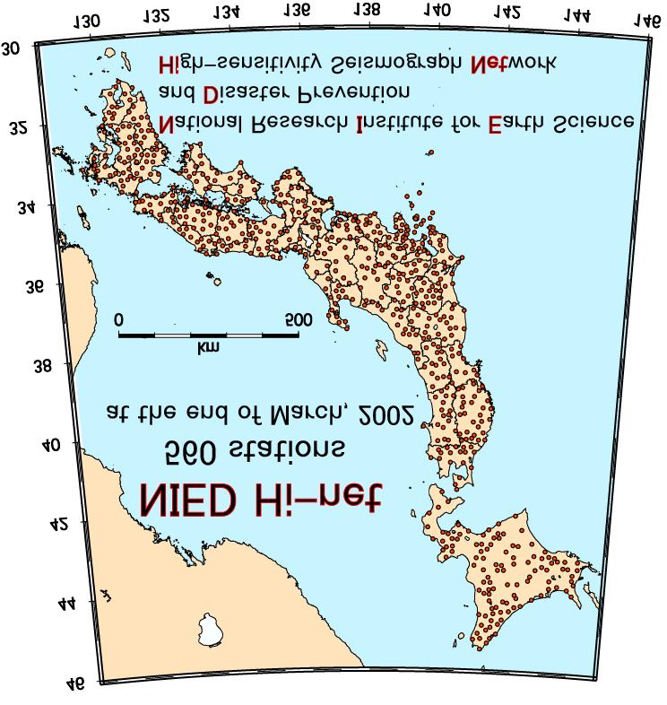
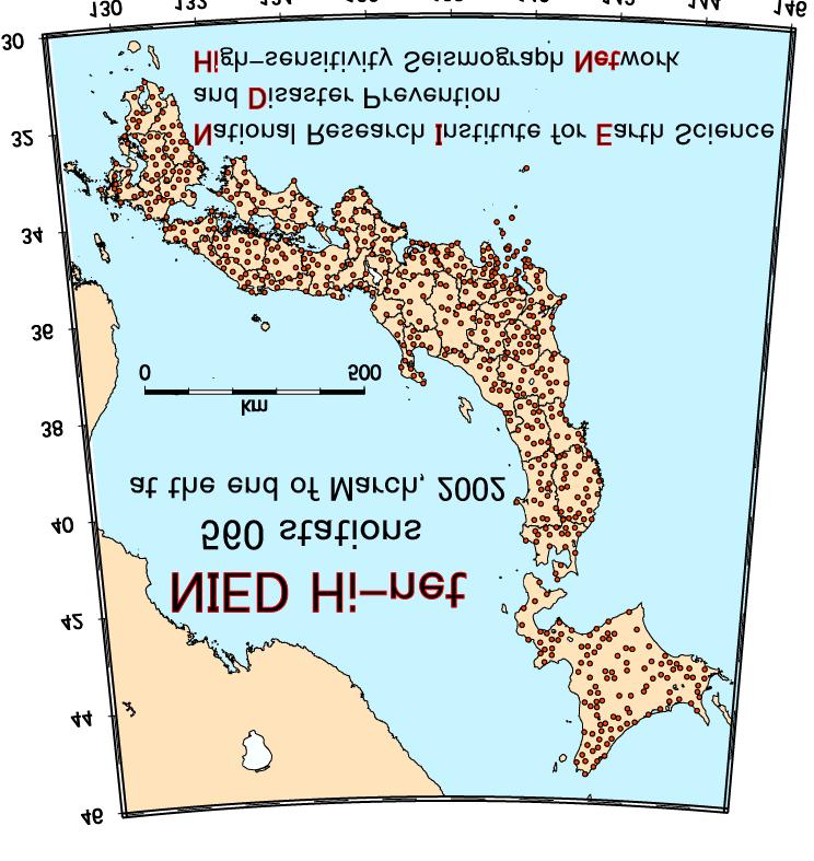
2 One-hour record chart at the station IKTH in Shikoku Island, Southwest Japan (2001/8/17 4 a.m.) Time (min) Time (s)

3 One-hour record chart at the station IKTH in Shikoku Island, Southwest Japan (2001/8/17 4 a.m.) Time (min) Time (s)
4 One-hour record chart at four stations in Shikoku Island (2001/8/17 4 a.m.) IKTH HIYH KWBH YNDH

5 One-hour record chart at four stations in Shikoku Island (2001/8/17 4 a.m.) IKTH HIYH KWBH YNDH
6

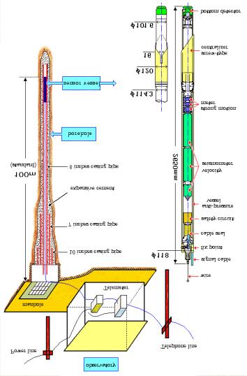
7 A scene of drilling
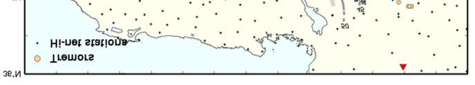
8 Discovery of tremor before Hi-net after Hi-net sparsely distributed seismic network It is impossible to discriminate between the tremor and cultural noises. densely distributed high-sensitivity seismic network The amplitude pattern is the same at some neighbor stations. natural phenomena
9 One-hour seismogram at IKTH U D N S E W Including an isolated pulse enable to locate as a low-frequency event U D N S E W Random wave train impossible to pick phases and locate the source
10 One-hour seismogram at IKTH U D N S E W Including an isolated pulse U D N S E W Random wave train Very enable difficult to locate to detect as and monitor impossible the tremor to pick activity phases a by low-frequency normal hypocentral event determination and locate method the source
11 One-hour seismogram at IKTH Normal event U D N S E W U D N S E W Low-frequency tremor Including an isolated pulse Random wave train The Very tremor enable difficult to is characterized locate to detect as and monitor by low-frequency impossible the tremor to pick components activity phases a by compared low-frequency normal with hypocentral event the same determination size microearthquakes and locate method the source
 Time")
12 Envelope seismogram at 8 stations in Shikoku (2001/8/17 4am) Time (min)

13 Three days envelope seismograms in Shikoku
14 Hypocentral determination with envelope correlation TBEH KWBH Time(min) Time difference = 3s TBEH KWBH Comparison of 2 envelopes Measurment of time difference
15 Hypocentral determination with envelope correlation TBEH KWBH Time(min) Time difference = 3s TBEH KWBH Comparison of 2 envelopes Measurment of time difference
16 Hypocentral determination with envelope correlation TBEH KWBH Time(min) Time difference = 3s TBEH KWBH Time Comparison difference of 2 measurment envelopes for every station pairs Measurment of time difference Spatial Smoothing
17 Hypocentral determination with envelope correlation TBEH KWBH Time(min) Time difference = 3s TBEH KWBH Time Comparison difference of 2 measurment envelopes Arrival for every time difference station pairs (s) hypocentral determination Measurment with S wave of velocity time difference Spatial Smoothing
18 Hypocentral determination with envelope correlation TBEH KWBH Time(min) Time difference = 3s TBEH KWBH Time Comparison difference of 2 measurment envelopes Arrival for every time difference station pairs (s) hypocentral determination Measurment with S wave of velocity time difference Spatial Smoothing
19 Hypocentral determination with envelope correlation TBEH KWBH Time(min) Time difference = 3s TBEH KWBH Time Comparison difference of 2 measurment envelopes Arrival for every time difference station pairs (s) hypocentral determination Measurment with S wave of velocity time difference Spatial Smoothing
20 Hypocentral determination with envelope correlation TBEH KWBH Time(min) Time difference = 3s TBEH KWBH Time Comparison difference of 2 measurment envelopes Arrival for every time difference station pairs (s) hypocentral determination Measurment with S wave of velocity time difference Spatial Smoothing


21 Hypocentral determination with envelope correlation TBEH KWBH Time(min) Continuous hypocentral determination Time difference = 3s TBEH KWBH Time Comparison difference of 2 measurment envelopes Arrival for every time difference station pairs (s) hypocentral determination Measurment with S wave of velocity time difference Spatial Smoothing
")
22 Distribution of tremors (2001/1/1-2001/12/31) 2001/12/31) Depth-distribution of normal earthquakes in the subducting Philippine sea plate (Nakamura, et.al., 1997)
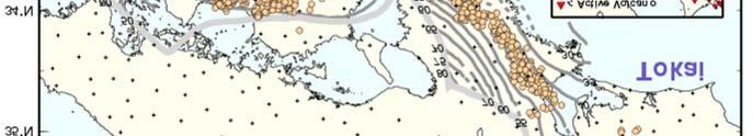
23 Distribution of tremors (2002/1/1-2002/10/25) 2002/10/25)
24 Cross sectional view of the low-frequency events Based on JMA catalog
 2001/12/31)")
25 Space-time plot of tremor (2001/1/1-2001/12/31) 2001/12/31) not analyzed
26 Time sequence of tremor (2000/9/1-2002/6/30) 2002/6/30) The frequency in units of 1-hour periods in which the tremor was recognized in each region is plotted.
27 Time sequence of tremor (2000/9/1-2002/6/30) 2002/6/30) The frequency in units of 1-hour periods in which the tremor was recognized in each region is plotted.

28 Time sequence of tremor (2000/9/1-2002/6/30) 2002/6/30) The frequency in units of 1-hour periods in which the tremor was recognized in each region is plotted.
29 Time sequence of tremor (2002/1/1-2002/10/27) 2002/10/27)
30 Envelope seismograms in Shikoku (2000/12/31 23: /1/1 2001/1/1 00:00) Time(min)
31 Envelope seismograms in Shikoku (2000/12/31 23: /1/1 2001/1/1 00:00) Normal event M3.6 depth=10km Time(min)
32 Envelope seismograms in Shikoku (2000/12/31 23: /1/1 2001/1/1 00:00) Normal event M3.6 depth=10km Triggered tremors Time(min)
33 Distribution of tremors in 2000/12/31 23pm Normal events(m3.6) based on the normal hypocentral determination method No.36 is the location of the normal event(m3.6) determined by the envelope correlation method
34 Distribution of tremors in 2000/12/31 23pm Normal events(m3.6) based on the normal hypocentral determination method No.36 is the location of the normal event(m3.6) determined by the envelope correlation method Triggered tremors
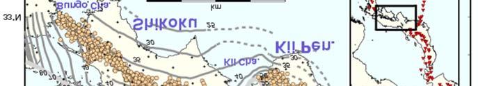
35 Location of tremor Length of the source area is about 600km. Non-volcanic area Along the strike of the subducting Philippine sea plate (corresponding to the seismic activity in the slab with the depth range from 35 to 45km) Depth of the tremor = 30km(+10km) Moho discontinuity? Lower crust? Upper boundary of the Philippine sea plab? There is no tremor around Kii Channel and E.Shikoku
36 Time sequence of tremor There are active periods and quiet periods. Active period ~ ~ a few weeks Quiet period ~ ~ a few months In an active period, active and quiet stages exist. Tremors are sometimes triggered by nearby major earthquakes The source area migrates with the velocity of 9 ~ 13km/day. A A tremor activity is related to shallow swarm.
37 Cause of tremor Long duration and mobility Consistency with slab geometry Fluid generated by slab dehydration Fluid A certain temperature/pressure condition Inhomogeneous structure Possible mechanisms 1. Chain-like fracture with supercritical fluid 2. Fuild flow 3..
38 Interseismic locked zone Philippine sea slab Low-frequency microearthquakes Tremor Moho slab dehydration microearthquakes in the slab stable sliding
39 Further Study Depth and focal mechanism of tremor Underground structure in southwest Japan subduction zone (Moho( Moho,, plate boundary,,,) Similarities and differences with other deep low- frequency events (near volcanoes, active faults) Other subduction zone?
Depth-dependent slip regime on the plate interface revealed from slow earthquake activities in the Nankai subduction zone
 2010/10/11-14 Earthscope Workshop Depth-dependent slip regime on the plate interface revealed from slow earthquake activities in the Nankai subduction zone Kazushige Obara, ERI, Univ. Tokyo Recurrence
Non-volcanic deep low-frequency tremors accompanying slow slips in the southwest Japan subduction zone
 Tectonophysics 417 (2006) 33 51 www.elsevier.com/locate/tecto Non-volcanic deep low-frequency tremors accompanying slow slips in the southwest Japan subduction zone Kazushige Obara *, Hitoshi Hirose National
An autocorrelation method to detect low frequency earthquakes within tremor
 GEOPHYSICAL RESEARCH LETTERS, VOL. 35, L16305, doi:10.1029/2008gl034560, 2008 An autocorrelation method to detect low frequency earthquakes within tremor Justin R. Brown, 1 Gregory C. Beroza, 1 and David
Dynamic Triggering Semi-Volcanic Tremor in Japanese Volcanic Region by The 2016 Mw 7.0 Kumamoto Earthquake
 Dynamic Triggering Semi-Volcanic Tremor in Japanese Volcanic Region by The 016 Mw 7.0 Kumamoto Earthquake Heng-Yi Su 1 *, Aitaro Kato 1 Department of Earth Sciences, National Central University, Taoyuan
Fracture induced shear wave splitting in a source area of triggered seismicity by the Tohoku-oki earthquake in northeastern Japan.
 Fracture induced shear wave splitting in a source area of triggered seismicity by the Tohoku-oki earthquake in northeastern Japan Masahiro Kosuga 1 1. Corresponding Author. Professor, Graduate School of
Scaling relationship between the duration and the amplitude of non-volcanic deep low-frequency tremors
 GEOPHYSICAL RESEARCH LETTERS, VOL. 34, L07305, doi:10.1029/2007gl029391, 2007 Scaling relationship between the duration and the amplitude of non-volcanic deep low-frequency tremors Tomoko Watanabe, 1 Yoshihiro
Along strike variations in short term slow slip events in the southwest Japan subduction zone
 JOURNAL OF GEOPHYSICAL RESEARCH, VOL. 115,, doi:10.1029/2008jb006059, 2010 Along strike variations in short term slow slip events in the southwest Japan subduction zone Shutaro Sekine, 1,2 Hitoshi Hirose,
Array-analysis of Tremors in Shikoku Triggered by the 2012 Sumatra Earthquake
 Array-analysis of Tremors in Shikoku Triggered by the 2012 Sumatra Earthquake Tianyi Li 1 Instructor: Prof. Kazushige Obara 2 1. Department of Geophysics, Peking University 2. Earthquake Research Institute,
The Non-volcanic tremor observation in Northern Cascadia. Hsieh Hsin Sung 3/22
 The Non-volcanic tremor observation in Northern Cascadia Hsieh Hsin Sung 3/22 Reference Kao, H., S. J. Shan, H. Dragert, and G. Rogers (2009), Northern Cascadia episodic tremor and slip: A decade of observations
MIGRATING SWARMS OF BRITTLE-FAILURE EARTHQUAKES IN THE LOWER CRUST BENEATH MAMMOTH MOUNTAIN, CALIFORNIA
 MIGRATING SWARMS OF BRITTLE-FAILURE EARTHQUAKES IN THE LOWER CRUST BENEATH MAMMOTH MOUNTAIN, CALIFORNIA David Shelly and David Hill GRL, October 2011 Contents Tectonic Setting Long Valley Caldera Mammoth
Detection and location of non-volcanic tremor beneath the Central Range in Taiwan
 Detection and location of non-volcanic tremor beneath the Central Range in Taiwan Aileen Zhang Advisor: Prof. Kazushige Obara Introduction Volcanic tremor is a long-duration episode of weak seismic motions
Very low frequency earthquakes excited by the 2004 off the Kii peninsula earthquakes: A dynamic deformation process in the large accretionary prism
 LETTER Earth Planets Space, 57, 321 326, 25 Very low frequency earthquakes excited by the 2 off the Kii peninsula earthquakes: A dynamic deformation process in the large accretionary prism Kazushige Obara
Non-volcanic tremor resulting from the combined effect of Earth tide and slow slip event
 1 Non-volcanic tremor resulting from the combined effect of Earth tide and slow slip event Ryoko Nakata 1, Naoki Suda 1 & Hiroshi Tsuruoka 2 1 Department of Earth and Planetary Systems Science, Hiroshima
High resolution receiver function imaging of the seismic velocity discontinuities in the crust and the uppermost mantle beneath southwest Japan
 LETTER Earth Planets Space, 55, 59 64, 2003 High resolution receiver function imaging of the seismic velocity discontinuities in the crust and the uppermost mantle beneath southwest Japan Makiko Yamauchi
Moho (Mohorovicic discontinuity) - boundary between crust and mantle
 - boundary between crust and mantle") Earth Layers Dynamic Crust Unit Notes Continental crust is thicker than oceanic crust Continental Crust Thicker Less Dense Made of Granite Oceanic Crust Thinner More Dense Made of Basalt Moho (Mohorovicic
Earth Layers Dynamic Crust Unit Notes Continental crust is thicker than oceanic crust Continental Crust Thicker Less Dense Made of Granite Oceanic Crust Thinner More Dense Made of Basalt Moho (Mohorovicic
Fluid related deep low-frequency earthquakes resonant with the Rayleigh waves from the 2004 Sumatra-Andaman earthquake
 JOURNAL OF GEOPHYSICAL RESEARCH, VOL.???, XXXX, DOI:10.1029/, 1 2 3 Fluid related deep low-frequency earthquakes resonant with the Rayleigh waves from the 2004 Sumatra-Andaman earthquake Masatoshi Miyazawa
LETTERS. Low-frequency earthquakes in Shikoku, Japan, and their relationship to episodic tremor and slip
 Vol 442 13 July 2006 doi:10.1038/nature04931 Low-frequency earthquakes in Shikoku, Japan, and their relationship to episodic tremor and slip David R. Shelly 1, Gregory C. Beroza 1, Satoshi Ide 2 & Sho
Aseismic slip and low-frequency earthquakes in the Bungo channel, southwestern Japan
 GEOPHYSICAL RESEARCH LETTERS, VOL. 31, L769, doi:1.19/3gl19381, Aseismic slip and low-frequency earthquakes in the Bungo channel, southwestern Japan Shinzaburo Ozawa, 1 Yuki Hatanaka, 1 Masaru Kaidzu,
Subduction of the Philippine Sea plate beneath southwestern Japan: Slab geometry and its relationship to arc magmatism
 JOURNAL OF GEOPHYSICAL RESEARCH, VOL. 112,, doi:10.1029/2006jb004770, 2007 Subduction of the Philippine Sea plate beneath southwestern Japan: Slab geometry and its relationship to arc magmatism Junichi
Deep Seismic Surveys in the Kinki District : Shingu- Maizuru Line
 Bull. Earthq. Res. Inst. Univ. Tokyo Vol. 2+,**0 pp.,-3,./ Deep Seismic Surveys in the Kinki District : Shingu- Maizuru Line Kiyoshi Ito +, Yasuhiro Umeda +, Hiroshi Sato,, Issei Hirose +, Naoshi Hirata,,
Convergent plate boundaries. Objective to be able to explain the formation and key features of these zones.
 Convergent plate boundaries Objective to be able to explain the formation and key features of these zones. Destructive plate margins When plates collide due to convection currents/slab pull in the asthenosphere
Scenario Earthquake Shaking Maps in Japan
 Scenario Earthquake Shaking Maps in Japan Nobuyuki Morikawa National Research Institute for Earth Science and Disaster Prevention (NIED), JAPAN Example of SESMs The Kego fault zone (south-east part) The
Segmentation in episodic tremor and slip all along Cascadia
 Segmentation in episodic tremor and slip all along Cascadia Michael R. Brudzinski and Richard M. Allen Geology 35 (10) 907-910, 2007, doi: 10.1130/G23740A.1 Data Repository: Methods for Automated Data
Repeating short- and long-term slow slip events with deep tremor activity around the Bungo channel region, southwest Japan
 Earth Planets Space, 57, 961 972, 5 Repeating short- and long-term slow slip events with deep tremor activity around the Bungo channel region, southwest Japan Hitoshi Hirose and Kazushige Obara National
Deep low-frequency tremor that correlates with passing surface waves
 1 2 Deep low-frequency tremor that correlates with passing surface waves Masatoshi Miyazawa 3 Disaster Prevention Research Institute, Kyoto University, Uji, Kyoto, Japan. Emily E. Brodsky 4 Department
Migration of low frequency tremors revealed from multiple array analyses in western
 Migration of low frequency tremors revealed from multiple array analyses in western Shikoku, Japan Tomotake Ueno, Takuto Maeda*, Kazushige Obara, Youichi Asano, and Tetsuya Takeda National Research Institute
Non-volcanic Tremor: A Window into the Roots of Fault Zones
 Non-volcanic Tremor: A Window into the Roots of Fault Zones Justin L. Rubinstein, David R. Shelly, and William L. Ellsworth Abstract The recent discovery of non-volcanic tremor in Japan and the coincidence
volcanic tremor and Low frequency earthquakes at mt. vesuvius M. La Rocca 1, D. Galluzzo 2 1
 volcanic tremor and Low frequency earthquakes at mt. vesuvius M. La Rocca 1, D. Galluzzo 2 1 Università della Calabria, Cosenza, Italy 2 Istituto Nazionale di Geofisica e Vulcanologia Osservatorio Vesuviano,
CHAPTER 2 NOTES -FOUNDATIONS OF GEOLOGY-
 CHAPTER 2 NOTES -FOUNDATIONS OF GEOLOGY- LESSON 2.1A: LAYERS OF THE EARTH GEOLOGY Geology- LAYERS OF THE EARTH Earth has 3 major layers based on their composition: o - the outer layer, made of solid rock.
Characterization of Induced Seismicity in a Petroleum Reservoir: A Case Study
 Characterization of Induced Seismicity in a Petroleum Reservoir: A Case Study Edmond Sze, M. Nafi Toksöz, and Daniel R. Burns Earth Resources Laboratory Dept. of Earth, Atmospheric and Planetary Sciences
Earth and Space Science Semester 2 Exam Review. Part 1. - Convection currents circulate in the Asthenosphere located in the Upper Mantle.
 Earth and Space Science 2015 Semester 2 Exam Review Part 1 Convection -A form of heat transfer. - Convection currents circulate in the Asthenosphere located in the Upper Mantle. - Source of heat is from
Evolution of seismic signals and slip patterns along subduction zones: insights from a friction lab scale experiment.
 Evolution of seismic signals and slip patterns along subduction zones: insights from a friction lab scale experiment. Christophe Voisin, Jean-Robert Grasso, Eric Larose, François Renard * Laboratoire de
Long-period Ground Motion Simulation in Kinki Area. Nobuyuki YAMADA* and Tomotaka IWATA
 Annuals of Disas. Prev. Res. Inst., Kyoto Univ., No. 47 C, 2004 Long-period Ground Motion Simulation in Kinki Area Nobuyuki YAMADA* and Tomotaka IWATA * COE Researcher, DPRI, Kyoto University Synopsis
Tremor patches in Cascadia revealed by seismic array analysis
 GEOPHYSICAL RESEARCH LETTERS, VOL. 36, L17316, doi:10.1029/2009gl039080, 2009 Tremor patches in Cascadia revealed by seismic array analysis Abhijit Ghosh, 1 John E. Vidale, 1 Justin R. Sweet, 1 Kenneth
Scenario Earthquake Shaking Maps in Japan
 1 Scenario Earthquake Shaking Maps in Japan Nobuyuki Morikawa National Research Institute for Earth Science and Disaster Prevention (NIED), JAPAN Scenario Earthquake Shaking Maps (SESMs) The shaking maps
A Brownian walk model for slow earthquakes
 GEOPHYSICAL RESEARCH LETTERS, VOL. 35, L17301, doi:10.1029/2008gl034821, 2008 A Brownian walk model for slow earthquakes Satoshi Ide 1 Received 29 May 2008; revised 10 July 2008; accepted 16 July 2008;
Deep low-frequency earthquakes near the downward extension of the seismogenic fault of the 2000 Western Tottori earthquake
 Earth lanets Space, 56, 1185 1189, 2004 Deep low-frequency earthquakes near the downward extension of the seismogenic fault of the 2000 Western Tottori earthquake Shiro Ohmi, Issei Hirose, and James J.
Real time Monitoring System for Earthquakes and Tsunamis (DONET)
") Real time Monitoring System for Earthquakes and Tsunamis (DONET) NankaiTrough Yoshiyuki Kaneda Japan Agency for Marine-Earth Science and Technology (JAMSTEC) POGO@Seoul Presentation 1 Earthquakes in the
Real time Monitoring System for Earthquakes and Tsunamis (DONET) NankaiTrough Yoshiyuki Kaneda Japan Agency for Marine-Earth Science and Technology (JAMSTEC) POGO@Seoul Presentation 1 Earthquakes in the
THE SEISMICITY OF THE EARTH
 OUTLINE THE SEISMICITY OF THE EARTH The earthquake source Types of earthquake: - from impacts and minor tremors to tectonic earthquakes, elastic rebound theory, deep earthquakes. Location of earthquakes:
Layer Composition Thickness State of Matter
 Unit 4.2 Test Review Earth and Its Layers 1. Label the layers of the earth. oceanic crust continental crust lithosphere asthenosphere mantle outer core inner core 2. Complete the Following Table about
LETTER Earth Planets Space, 57, , 2005
 LETTER Earth Planets Space, 57, 1115 1120, 2005 A tectonic interpretation of NW-SE strike-slip faulting during the 2004 off the Kii peninsula earthquakes, Japan: Probable tear of the Philippine Sea plate
Electrical Conductivity Structures around Seismically Locked Regions
 Electrical Conductivity Structures around Seismically Locked Regions Tada-nori Goto Program for Deep Sea Research, IFREE, Japan Agency for Marine-Earth Science and Technology 1. Introduction Existence
Module 7: Plate Tectonics and Earth's Structure Topic 4 Content : Earthquakes Presentation Notes. Earthquakes
 Earthquakes 1 Topic 4 Content: Earthquakes Presentation Notes Earthquakes are vibrations within the Earth produced by the rapid release of energy from rocks that break under extreme stress. Earthquakes
Earth s Tectonic Plates
 MASTER 49 6.2 3.7 5.4 Philippine Pacific 5.4 North American Juan de Fuca Caribbean Cocos 10.0 9.2 2.3 2.5 2.3 1.8 3.0 Indian-Australian 10.5 7.1 17.2 16.8 6.0 Nazca South American 11.1 10.3 7.3 3.7 7.5
What is an Earthquake?
 Earthquakes What is an Earthquake? Earthquake - sometimes violent shaking of ground caused by movement of Earth s tectonic plates; creates seismic waves Often followed by smaller earthquakes (aftershocks);
Warm-up #15. How does magma move throughout the mantle? What is another example of this movement in nature?
 Warm-up #15 How does magma move throughout the mantle? What is another example of this movement in nature? Earth s Structure Lithosphere = crust & upper mantle; tectonic plates Asthenosphere = lower mantle
Sendai Earthquake NE Japan March 11, Some explanatory slides Bob Stern, Dave Scholl, others updated March
 Sendai Earthquake NE Japan March 11, 2011 Some explanatory slides Bob Stern, Dave Scholl, others updated March 14 2011 Earth has 11 large plates and many more smaller ones. Plates are 100-200 km thick
THREE-DIMENSIONAL FINITE DIFFERENCE SIMULATION OF LONG-PERIOD GROUND MOTION IN THE KANTO PLAIN, JAPAN
 THREE-DIMENSIONAL FINITE DIFFERENCE SIMULATION OF LONG-PERIOD GROUND MOTION IN THE KANTO PLAIN, JAPAN Nobuyuki YAMADA 1 And Hiroaki YAMANAKA 2 SUMMARY This study tried to simulate the long-period earthquake
Along the center of the mid-ocean ridge is a rift valley that forms when the plates separate.
 Newly formed rock from rising magma rises above sea floor and forms mountain ranges known as midocean ridges. Along the center of the mid-ocean ridge is a rift valley that forms when the plates separate.
Earthquakes Modified
 Plate Tectonics Earthquakes Modified Recall that the earth s crust is broken into large pieces called. These slowly moving plates each other, each other, or from each other. This causes much on the rocks.
Announcements. Manganese nodule distribution
 Announcements Lithospheric plates not as brittle as previously thought ESCI 322 Meet in Env. Studies Bldg Rm 60 at 1 PM on Tuesday One week (Thursday): Quiz on Booth 1994 and discussion. (Lots of odd terms
Spatio-temporal variation in slip rate on the plate boundary off Sanriku, northeastern Japan, estimated from small repeating earthquakes
 Spatio-temporal variation in slip rate on the plate boundary off Sanriku, northeastern Japan, estimated from small repeating earthquakes T. Matsuzawa, N. Uchida, T. Igarashi *, N. Umino, and A. Hasegawa
Crustal structure across the coseismic rupture zone of the 1944 Tonankai earthquake, the central Nankai Trough seismogenic zone
 JOURNAL OF GEOPHYSICAL RESEARCH, VOL. 17, NO. B1, 7, 129/1JB424, 2 Crustal structure across the coseismic rupture zone of the 1944 Tonankai earthquake, the central Nankai Trough seismogenic zone Ayako
THE SEISMICITY OF THE CAMPANIAN PLAIN: PRELIMINARY RESULTS
 THE SEISMICITY OF THE CAMPANIAN PLAIN: PRELIMINARY RESULTS Girolamo Milano Osservatorio Vesuviano, Via Diocleziano 328, 80124 Napoli milano@osve.unina.it INTRODUCTION In areas affected by active volcanism,
Earthquakes = shaking of Earth because of a rapid release of energy
 There are more than 30,000 earthquakes worldwide each year! Earthquakes = shaking of Earth because of a rapid release of energy usually because of movement of tectonic plates Most earthquakes last for
Detection of seismic events triggered by P-waves from the 2011 Tohoku-Oki earthquake
 Earth Planets Space, 64, 1223 1229, 2012 Detection of seismic events triggered by P-waves from the 2011 Tohoku-Oki earthquake Masatoshi Miyazawa 1,2 1 Disaster Prevention Research Institute, Kyoto University,
JOURNAL OF GEOPHYSICAL RESEARCH, VOL. 109, B08306, doi: /2004jb002980, 2004
 JOURNAL OF GEOPHYSICAL RESEARCH, VOL. 109,, doi:10.1029/2004jb002980, 2004 Analysis of the 2001 Geiyo, Japan, earthquake using high-density strong ground motion data: Detailed rupture process of a slab
Earthquakes & Volcanoes
 Earthquakes & Volcanoes Geology - the study of solid Earth, the rocks of which it is composed, and the processes by which they change geo = Earth; ology = study of Earth s Layers Plate Tectonics - the
Plate Tectonics IDEA THAT EARTH S SURFACE IS BROKEN INTO PLATES THAT MOVE AROUND. Fault = fracture in the crust where the movement has occurred
 Warm-up #14 A mountain range found 100 meters above sea level is measured to be 1,000 meters high from its tallest peak. From the top, the first 500 meters are incredibly steep. After this point, the mountain
The Structure of the Earth and Plate Tectonics
 The Structure of the Earth and Plate Tectonics Agree or Disagree? 1. The Earth if made up of 4 different layers. 2. The crust (where we live) can be made of either less dense continental crust or the more
LETTERS. Non-volcanic tremor driven by large transient shear stresses
 Vol 448 2 August 27 doi:1.138/nature617 Non-volcanic tremor driven by large transient shear stresses LETTERS Justin L. Rubinstein 1, John E. Vidale 1, Joan Gomberg 2, Paul Bodin 1, Kenneth C. Creager 1
on the earthquake's strength. The Richter scale is a rating of an earthquake s magnitude based on the size of the
 Earthquakes and Seismic Waves An earthquake is the shaking and trembling that results from the movement of rock beneath Earth's surface. The point beneath Earth s surface where rock under stress breaks
Source Characteristics of Large Outer Rise Earthquakes in the Pacific Plate
 Source Characteristics of Large Outer Rise Earthquakes in the Pacific Plate T. Sasatani, N. Takai, M. Shigefuji, and Y. Miyahara Hokkaido University, Sapporo, Japan W. Kawabata Electric Power Development
Features of Tectonic Plates
 Features of Tectonic Plates PowerPoint 12.2 The Earth s Layers Crust Brittle Continental crust composed mainly of granite Oceanic crust composed mainly of basalt Mantle Denser than the crust Upper is molten
A) B) C) D) 4. Which diagram below best represents the pattern of magnetic orientation in the seafloor on the west (left) side of the ocean ridge?
 B) C) D) 4. Which diagram below best represents the pattern of magnetic orientation in the seafloor on the west (left) side of the ocean ridge?") 1. Crustal formation, which may cause the widening of an ocean, is most likely occurring at the boundary between the A) African Plate and the Eurasian Plate B) Pacific Plate and the Philippine Plate C)
1. Crustal formation, which may cause the widening of an ocean, is most likely occurring at the boundary between the A) African Plate and the Eurasian Plate B) Pacific Plate and the Philippine Plate C)
Hijiori HDR Reservoir Evaluation by Micro-Earthquake Observation
 GRC Transactions, Vol. 38, 2014 Hijiori HDR Reservoir Evaluation by Micro-Earthquake Observation Hideshi Kaieda Central Research Institute of Electric Power Industry, Abiko, Chiba, Japan Keywords HDR,
Variations in Tremor Activity and Implications for Lower Crustal Deformation Along the Central San Andreas Fault
 Variations in Tremor Activity and Implications for Lower Crustal Deformation Along the Central San Andreas Fault David R. Shelly USGS, Menlo Park Shelly and Hardebeck, GRL, 2010 Collaborators: Jeanne Hardebeck
Prentice Hall EARTH SCIENCE
 Prentice Hall EARTH SCIENCE Tarbuck Lutgens Chapter 8 Earthquakes and Earth s Interior 8.1 What Is an Earthquake? Earthquakes An earthquake is the vibration of Earth produced by the rapid release of energy
An Introduction to the Seafloor and Plate Tectonics 1
 An Introduction to the Seafloor and Plate Tectonics 1 Objectives 1) Investigate the components of the lithosphere and lithospheric plates. 2) Identify the associations among various seafloor features,
GEOPHYSICAL RESEARCH LETTERS, VOL. 35, L14308, doi: /2008gl034461, 2008
 Click Here for Full Article GEOPHYSICAL RESEARCH LETTERS, VOL. 35,, doi:10.1029/2008gl034461, 2008 Tomographic evidence for hydrated oceanic crust of the Pacific slab beneath northeastern Japan: Implications
Earthquakes and Earthquake Hazards Earth - Chapter 11 Stan Hatfield Southwestern Illinois College
 Earthquakes and Earthquake Hazards Earth - Chapter 11 Stan Hatfield Southwestern Illinois College What Is an Earthquake? An earthquake is the vibration of Earth, produced by the rapid release of energy.
Elastic Rebound Theory
 Earthquakes Elastic Rebound Theory Earthquakes occur when strain exceeds the strength of the rock and the rock fractures. The arrival of earthquakes waves is recorded by a seismograph. The amplitude of
What Forces Drive Plate Tectonics?
 What Forces Drive Plate Tectonics? The tectonic plates are moving, but with varying rates and directions. What hypotheses have been proposed to explain the plate motion? Convection Cells in the Mantle
Coseismic slip distribution of the 1946 Nankai earthquake and aseismic slips caused by the earthquake
 Earth Planets Space, 53, 235 241, 2001 Coseismic slip distribution of the 1946 Nankai earthquake and aseismic slips caused by the earthquake Yuichiro Tanioka 1 and Kenji Satake 2 1 Meteorological Research
Crustal deformation by the Southeast-off Kii Peninsula Earthquake
 Crustal deformation by the Southeast-off Kii Peninsula Earthquake 51 Crustal deformation by the Southeast-off Kii Peninsula Earthquake Tetsuro IMAKIIRE, Shinzaburo OZAWA, Hiroshi YARAI, Takuya NISHIMURA
Plates & Boundaries The earth's continents are constantly moving due to the motions of the tectonic plates.
 Plates & Boundaries The earth's continents are constantly moving due to the motions of the tectonic plates. As you can see, some of the plates contain continents and others are mostly under the ocean.
NAME HOMEWORK ASSIGNMENT #4 MATERIAL COVERS CHAPTERS 19, 20, 21, & 2
 NAME HOMEWORK ASSIGNMENT #4 MATERIAL COVERS CHAPTERS 19, 20, 21, & 2 Assignment is due the beginning of the class period on December 14, 2004. Mark answers on a scantron sheet, which will be provided.
Outcome C&D Study Guide
 Name: Class: Outcome C&D Study Guide Identify the layers of Earth s interior Lithosphere the upper most layer of the earth that includes the crust and the hard outer mantle. It is fractured into tectonic
Plate Tectonics. I. The Discovery of Plate Tectonics II. A Mosaic of Plates III. Types of Plate Boundaries IV. How Plates Move
 Plate Tectonics I. The Discovery of Plate Tectonics II. A Mosaic of Plates III. Types of Plate Boundaries IV. How Plates Move I. The Discovery of Plate Tectonics A. Continental Drift (Alfred Wegener) Proposed
Recent Progress of Seismic Observation Networks in Japan
 Journal of Physics: Conference Series Recent Progress of Seismic Observation Networks in Japan To cite this article: Y Okada 2013 J. Phys.: Conf. Ser. 433 012039 Related content - Physical applications
Earthquakes How and Where Earthquakes Occur
 Earthquakes How and Where Earthquakes Occur PPT Modified from Troy HS Is there such thing as earthquake weather? Absolutely NOT!!! Geologists believe that there is no connection between weather and earthquakes.
Seismic and geodetic constraints on Cascadia slow slip
 1 2 3 4 5 6 Seismic and geodetic constraints on Cascadia slow slip Aaron G. Wech 1, Kenneth C. Creager 1, & Timothy I. Melbourne 2 1 University of Washington, Department of Earth and Space Science, Box
1. A model of Earth's internal structure is shown below.
 1. A model of Earth's internal structure is shown below. Analysis of which type of data led to the development of this model? A) seismic waves B) depth of Earth's oceans C) electromagnetic radiation D)
On May 4, 2001, central Arkansas experienced an M=4.4 earthquake followed by a
 1. Introduction On May 4, 2001, central Arkansas experienced an M=4.4 earthquake followed by a surprisingly large number of small earthquakes. We recorded about 2500 above the ambient noise level on a
Geophysical Journal International
 Geophysical Journal International Geophys. J. Int. (2011) doi: 10.1111/j.1365-246X.2011.05261.x Remote triggering of non-volcanic tremor around Taiwan Kevin Chao, 1 Zhigang Peng, 1 Chunquan Wu, 1 Chi-Chia
Directed Reading. Section: The Theory of Plate Tectonics. to the development of plate tectonics, developed? HOW CONTINENTS MOVE
 Skills Worksheet Directed Reading Section: The Theory of Plate Tectonics 1. The theory that explains why and how continents move is called. 2. By what time period was evidence supporting continental drift,
Locating nonvolcanic tremors beneath the San Andreas Fault using a station pair double difference location method
 Click Here for Full Article GEOPHYSICAL RESEARCH LETTERS, VOL. 37,, doi:10.1029/2010gl043577, 2010 Locating nonvolcanic tremors beneath the San Andreas Fault using a station pair double difference location
Important information from Chapter 1
 Important information from Chapter 1 Distinguish between: Natural hazard // Disaster // Catastrophe What role does human population play in these categories? Know how to read a Hazard Map, such as Figure
Plate Tectonics. entirely rock both and rock
 Plate Tectonics I. Tectonics A. Tectonic Forces are forces generated from within Earth causing rock to become. B. 1. The study of the origin and arrangement of Earth surface including mountain belts, continents,
Earth overall average density = 5.5 g/cm 3 Temp increases with depth, the thermal gradient 30 0 C/km Pressure and the density also increase with
 Plate Tectonics Earth Earth overall average density = 5.5 g/cm 3 Temp increases with depth, the thermal gradient 30 0 C/km Pressure and the density also increase with depth Spheroid: with a longer major
Seismic Source Mechanism
 Seismic Source Mechanism Yuji Yagi (University of Tsukuba) Earthquake Earthquake is a term used to describe both failure process along a fault zone, and the resulting ground shaking and radiated seismic
We A10 12 Common Reflection Angle Migration Revealing the Complex Deformation Structure beneath Forearc Basin in the Nankai Trough
 We A10 12 Common Reflection Angle Migration Revealing the Complex Deformation Structure beneath Forearc Basin in the Nankai Trough K. Shiraishi* (JAMSTEC), M. Robb (Emerson Paradigm), K. Hosgood (Emerson
Earth s Interior HW Packet HW #1 Plate Tectonics (pages )
") Name Earth s Interior HW Packet HW #1 Plate Tectonics (pages 676 683) 1. Is the following sentence true or false? According to the theory of plate tectonics, Earth s plates move about quickly on top of
Name Earth s Interior HW Packet HW #1 Plate Tectonics (pages 676 683) 1. Is the following sentence true or false? According to the theory of plate tectonics, Earth s plates move about quickly on top of
ANOTHER MEXICAN EARTHQUAKE! Magnitude 7.1, Tuesday Sept. 19, 2017
 ANOTHER MEXICAN EARTHQUAKE! Magnitude 7.1, Tuesday Sept. 19, 2017 Why is there no oceanic crust older than 200 million years? SUBDUCTION If new oceanic crust is being continuously created along the earth
Migration of low frequency tremors revealed from multiple array analyses in western Shikoku, Japan
 JOURNAL OF GEOPHYSICAL RESEARCH, VOL. 115,, doi:10.1029/2008jb006051, 2010 Migration of low frequency tremors revealed from multiple array analyses in western Shikoku, Japan Tomotake Ueno, 1 Takuto Maeda,
Geophysical Journal International
 Geophysical Journal International Geophys. J. Int. (2014) Geophysical Journal International Advance Access published February 21, 2014 doi: 10.1093/gji/ggu031 Strong seismic wave scattering in the low-velocity
The Coso Geothermal Area: A Laboratory for Advanced MEQ Studies for Geothermal Monitoring
 The Coso Geothermal Area: A Laboratory for Advanced MEQ Studies for Geothermal Monitoring Bruce R. Julian U. S. Geological Survey, Menlo Park, CA 94025 USA julian@usgs.gov Gillian R. Foulger Dept. Earth
Complicated repeating earthquakes on the convergent plate boundary: Rupture processes of the 1978 and 2005 Miyagi-ken Oki earthquakes
 Complicated repeating earthquakes on the convergent plate boundary: Rupture processes of the 1978 and 2005 Miyagi-ken Oki earthquakes Changjiang Wu 1 and Kazuki Koketsu Earthquake Research Institute, University
Topic 5: The Dynamic Crust (workbook p ) Evidence that Earth s crust has shifted and changed in both the past and the present is shown by:
 Evidence that Earth s crust has shifted and changed in both the past and the present is shown by:") Topic 5: The Dynamic Crust (workbook p. 65-85) Evidence that Earth s crust has shifted and changed in both the past and the present is shown by: --sedimentary horizontal rock layers (strata) are found
Topic 5: The Dynamic Crust (workbook p. 65-85) Evidence that Earth s crust has shifted and changed in both the past and the present is shown by: --sedimentary horizontal rock layers (strata) are found
Long-period ground motion simulation in the Kinki area during the MJ 7.1 foreshock of the 2004 off the Kii peninsula earthquakes
 LETTER Earth Planets Space, 57, 197 202, 2005 Long-period ground motion simulation in the Kinki area during the MJ 7.1 foreshock of the 2004 off the Kii peninsula earthquakes Nobuyuki Yamada and Tomotaka