Tricks to Creating a Resource Block Model. St John s, Newfoundland and Labrador November 4, 2015
|
|
|
- Berniece Hutchinson
- 6 years ago
- Views:
Transcription

1 Tricks to Creating a Resource Block Model St John s, Newfoundland and Labrador November 4, 2015


2 Agenda 2 Domain Selection Top Cut (Grade Capping) Compositing Specific Gravity Variograms Block Size Search Ellipse Nearest Neighbour Inverse Distance Ordinary Kriging Validation Resource Classification Indicator Kriging

3 Fundamentals 3 GI GO Garbage In Garbage Out Black Box
4 Domain Selection 4 A domain is a spatial entity with common geological or geostatistical attributes


5 Domain Selection 5 Most domains are selected based on geological or grades Or a combination of both The definition of the boundaries between geological domains can be problematic due to several factors, including Defining geological domains relies on the geologist s interpretation Sample information is limited and therefore interpreted boundaries have a degree of uncertainty Domains have either a hard boundary or soft boundary


6 Domain Selection 6 Hard boundary Most common domain selection used by geologists Based strictly on geological or geochemical constrains All material inside Quartz Porphyry unit All material contained within the shear zone All material on the 2.5 g/t grade shell It is easy for the human eye to see the boundary and make the estimation process easier The samples are either inside the boundary or outside the boundary

7 Domain Selection 7 Hard boundary Solids or wireframes tend to have unrealistic shapes not geologically realistic particularly with grade shells due to snapping to the drillhole
8 Domain Selection 8 What do you do here? Folding Faulting
9 Domain Selection 9 What do you do here? Pinch and Swell Variable Dip

10 Domain Selection 10 Soft boundaries A soft boundary has a gradational zone between two adjacent domains, making it difficult to identify the exact boundary Porphyry deposits Disseminated sulphides Stringer or stockwork deposits Transition from oxide to sulphide The estimation process using soft boundaries is complex


11 Domain Selection 11 Soft boundaries Estimate the overlap with the data from both Domains A and B A A & B B
12 Domain Selection 12 Soft boundaries Estimate Domain A using data from Domain A, then estimate Domain B using data from Domains A and B Estimation of B might have a different capping strategy, variogram, and search ellipse Estimate using data with X metres of the boundary A B
13 Top Cut and Bottom Cut (Grade Capping) 13 Fix all errors in the data Do not blindly follow the advice in statistics books Do not blindly use all data; follow local customs Consider probability plots
 2. Conduct capping analysis on the composited data 3.")
14 Grade Capping: Before or After Compositing Data? 14 There are three schools of thought on this process 1. Conduct capping analysis on the raw data (before composites) 2. Conduct capping analysis on the composited data 3. No capping to be completed Which is correct?
15 Top Cut and Bottom Cut (Grade Capping) 15 Bottom cut Should be done with very large data sets that have a large population which would be deemed as background Removing bottom cut results in a the data shifting left
 or mixture model Normal or lognormal Iterative optimization with least squares objective function Provides population adjusted values for upper tail Plots metal at risk for")
16 Top Cut and Bottom Cut (Grade Capping) Probability plots Useful to identify populations and consider outlier treatment Updated program Fits arbitrary number of populations with lines (fitted non-parametric model) or mixture model Normal or lognormal Iterative optimization with least squares objective function Provides population adjusted values for upper tail Plots metal at risk for upper tail values


17 Top Cut and Bottom Cut (Grade Capping) Some probability plots Fitted non-parametric lines Mixture model curved where distributions overlap
18 Top Cut and Bottom Cut (Grade Capping) 18 Parrish Analysis (Decile Analysis) Paper in the Mining Engineering Journal (April 1997) Arrange the sample data into decile grouping (10%) If the top decile (90-100) has 40% or more of the metal content, than capping may be required If the top decile (90-100) has more than twice the metal content of the next decile (80-90), than capping may be required If the top percentile (99-100) has more than 10% of the metal content, than capping maybe required Before any capping, review the spatial distribution of the samples Might be a high-grade sub-domain
19 Top Cut and Bottom Cut (Grade Capping) 19 Example of a Parrish Analysis %Quantile No of Mean Minimum Maximum Metal % %Quantile No of Mean Minumum Maximum Metal % From To Samples Grade Grade Grade Content Metal From To Samples Grade Grade Grade Content Metal % % % % % % % % % % % % % % % % % % % %
20 Sample Compositing 20 Procedure of combining adjacent values into longer down-hole intervals These are usually weighted by length, and possibly by specific gravity and core recovery
21 Sample Compositing 21 Compositing leads to one of the following results Orebody intersections Lithological or metallurgical composites Regular length composites Bench composites or section composites High-grade composites Minimum length and grade composites Each of these types of composite are produced for different purposes and in different situations Regular length or bench composites are common in geostatistical analysis Geostatistical software assumes the data represent the same volume The length should be small enough to permit resolution of the final simulated grid spacing The length shall respect domain contacts

22 Sample Compositing 22 Factors to consider Mean sample length Median sample length Potential block size Potential mining width or height Composites should not be shorter than the median sample length Composites should be 1/3 to 1/2 the block size Composites should be 1/3 to 1/2 the mining width Most geostatisticians like longer composites (regardless of the geology)

23 Sample Compositing 23 Compositing procedure Top of hole Top of interval Bottom of interval Bench Watch for tails A small interval remaining after the composites are completed Tend to be at the end of the interval How to deal with tails Ignore Include Backstitch
24 Specific Gravity 24 The ratio between the density of a material and the density of water

25 Specific Gravity 25 In the metric system, specific gravity (SG) and density are the same value In the imperial system, SG and density are different values Not to be confused with tonnage factor Could be one of the more important numbers in a resource estimation Global SG Linear equation Polynomial equation There is a temperature correction The SG of water is 1 at 4 C

26 Specific Gravity 26 Polynomial equation based on measured values

27 Specific Gravity 27 Why is SG so important in a resource model? Assume a block model with 10 x 10 x 10 m blocks Each block has a volume of 1,000 m 3 Tonnage of the block is volume x SG SG = 2.75, then the tonnage is 2,750 t SG = 2.76, then the tonnage is 2,760 t Just added 10 tonnes per block by changing the SG by 0.01
 with")
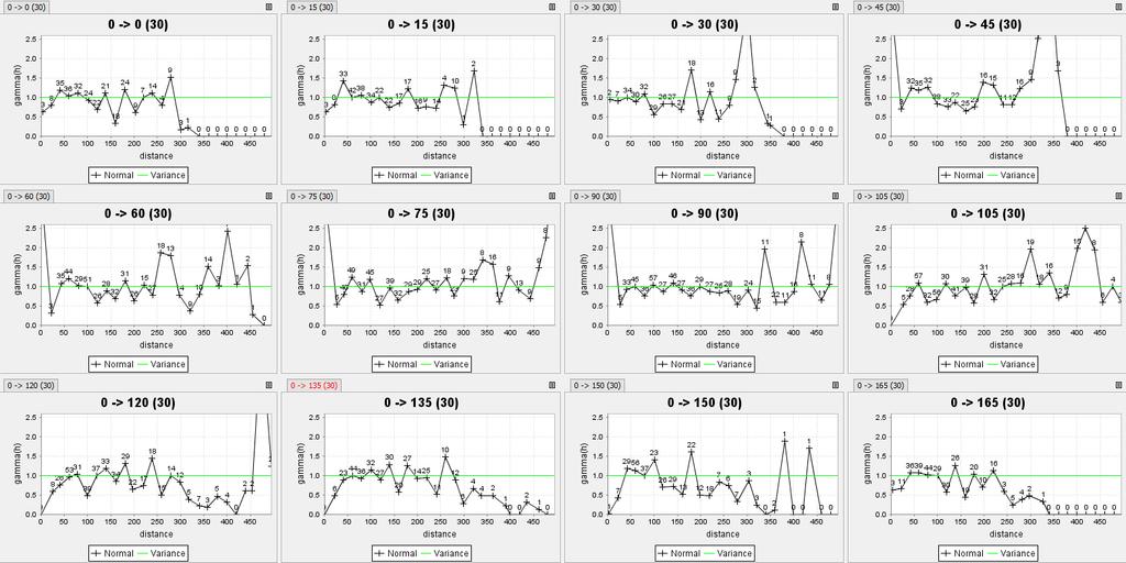
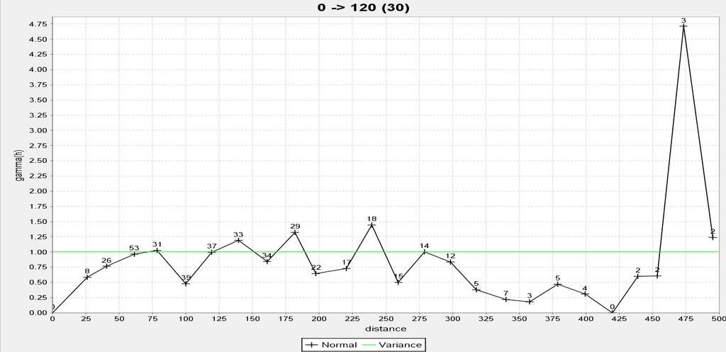
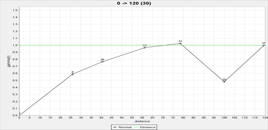
28 Variograms 28 The empirical variogram provides a description of how the data is related (correlated) with distance


29 Variograms 29 Components to make a variogram Azimuth: the horizontal direction the variogram searches Plunge: the vertical direction the variogram searches Lag: the distance between samples Maximum distance: how far out to search Spread: the cone angle to search Spread limit: the maximum radius of the spread Spread Spread Limit Search Line
30 Variograms 30 Components of a variogram Nugget: no spatial correlation from a the geological microstructures and measurement errors Sill: is the variance Range: is the distance at which the variogram reaches the sill
31 Variograms No spatial correlation; should be a small component of the overall variance Commonly encountered variogram shape Similar to spherical but rises more steeply and reaches the sill asymptotically Implies short scale continuity; parabolic behaviour at the origin, instead of linear For periodic variables For periodic variables, when the period is not regular
32 Variograms 32 To improve the variogram Increase lag distance Change rotation direction Open or narrow spread Allow overlap Hide pairs less than 50, 100, 1000 Variance Variance
33 Variograms 33
34 Variograms 34
35 Variograms 35
36 Variograms Ensure a positive definite model by Picking a single (lowest) isotropic nugget effect Choosing the same number of variogram structures for all directions based on most complex direction Ensuring that the same sill parameter is used for all variogram structures in all directions Allowing a different range parameter in each direction Modeling a zonal anisotropy by setting a very large range parameter in one or more of the principal directions Rotation direction of the variogram may not match geology The responsibility is yours, but most software helps Variogram modeling is one of the most important steps in the geostatistical study, however, do not spend days on it
37 Block Size 37
38 Block Size Selection 38 Some factors to consider The sample interval of the data; there's not a lot of point in being smaller than that What is the scale of your problem? If this is part of an exploration exercise and the model is really large, then you can safely and justifiably lose temporal resolution How much time have you got? Small samples means more compute time, more statistics, more fiddling with details 1/3 to 1/2 sample spacing is typical Smallest mining unit Blocks do not have to be cubes (2 x 2 x 2) or (5 x 5 x 2) Sub-block or sub-cell Be careful of the sub-block routine Smaller blocks does not mean more accuracy A block grade is the average of the estimation at the discretization points
39 Search Ellipse 39

40 Search Ellipse 40 Creation of search ellipse The dimension of the ellipse should be generated from variogram model Based on the ratio of the Major / Semi-major / Minor Axis Rotation angle should mimic the geology

41 Search Ellipse 41 Search ellipse Different search ellipse rotations would be required as the mineralization geometry changes (Dynamic Anisotropy)
42 Nearest Neighbour 42

43 Nearest Neighbour Provides the best global estimate Should not be used in a resource statement (if possible) Estimates the grade of the block from the closest data point Uses a single sample point Does not take into account the distance from the sample Does not take into account the relative direction of the sample
44 Inverse Distance 44
45 Inverse Distance Used for early estimations and validation Can use several samples in the estimation The distance of the sample is the weighting factor Relative direction is not accounted for in the estimation (Surpac might be different in this case) The variance is not accounted for in the estimation A power of 2 is the most common Power of 3 is acceptable Increasing power makes the estimate like a nearest neighbour estimate WW dd = 1 dd pp
46 Kriging 46
47 Ordinary Kriging Context The goal is to compute a best estimate at an un-sampled location Considers the data as differences from their mean values Statistical inference and a decision of stationarity provides the required information Weights could be positive or negative, depending on relationship between unsampled location and data Considering quadratic or higher order terms increases inference and does not lead to improved estimates Co-variances are calculated from the variogram model
48 Ordinary Kriging 48 Kriging will be similar to other estimation methods If the data locations are fairly dense and uniformly distributed throughout the study area, fairly good estimates regardless will be obtained, regardless of interpolation algorithm If the data locations fall in a few clusters with large gaps in between, unreliable estimates will be obtained, regardless of interpolation algorithm Almost all interpolation algorithms will underestimate the highs and overestimate the lows; this is inherent to averaging and if an interpolation algorithm did not average, it would not consider it reasonable
49 Ordinary Kriging 49 Some advantages of kriging Helps to compensate for the effects of data clustering, assigning individual points within a cluster less weight than isolated data points (or, treating clusters more like single points) Gives estimate of estimation error (kriging variance), along with estimate of the variable, Z, itself (but error map is basically a scaled version of a map of distance to nearest data point, so not that unique) Availability of estimation error provides basis for stochastic simulation of possible realizations of Z(u)
50 Ordinary Kriging 50 Parameters to adjust during estimation runs Minimum number of samples Too low will use only a single sample Too high might not find enough data points to complete the estimate Maximum number of samples Too low Too high results in an over-smoothed estimate Maximum number per drillhole Too low results in a single sample per hole and not enough samples to satisfy the minimum number of samples criteria Too high results in the entire holes being used in the estimate


51 Ordinary Kriging 51 KE=(BV-KV)/BV A number between 0 and 1

52 Ordinary Kriging 52
 - Min samples 4 to 5 - Max samples 15 to 20 - Max / hole 2 or 3 Pass 2 - Search ellipse (70% to 85% of variogram range) - Min samples 3 to 5 -")
53 Ordinary Kriging 53 Estimation strategies 3 or 4 estimation passes On each estimation pass the search ellipse is increased and the min/max criteria is adjusted There is not perfect fit Pass 1 - Smallest search ellipse (50% to 65% of variogram range) - Min samples 4 to 5 - Max samples 15 to 20 - Max / hole 2 or 3 Pass 2 - Search ellipse (70% to 85% of variogram range) - Min samples 3 to 5 - Max samples 15 to 20 - Max / hole 2 or 3 Pass 3 - Full search ellipse (100% of variogram range) - Min samples 2 to 5 - Max samples 15 to 20 - Max / hole 2 or 3 Pass 4 - Large search ellipse (125% to 200% of variogram range) - Min samples 2 or 3 - Max samples 15 to 20 - Max / hole 2 or 3
54 Block Model Validation 54 WHY CHECK?
55 Block Model Validation Resource model integrity Field procedures Starting from scratch ; checking related to - sampling - collar locations - topographic - down-the-hole surveys - drilling methods - sample collection and preparation - assaying, and sample quality control - quality assurance program Data handling and processing
56 Block Model Validation Resource model validation Geological model validation Cross-check between solid and block model proportions Statistical validation Statistical data (mean and variances) between dataset and block model Swath plots grade trends analysis between declustered composite grades and block model grades Contact analysis grade behaviour near contact zones Graphical validation Grade-tonnage curve Cross-sectional view, looking for spilling grades
57 Block Model Validation Resource model validation Statistical validation comparison between dataset and block model
58 Block Model Validation Resource Model Validation Statistical validation swath plots
59 Block Model Validation Resource model validation Statistical validation contact analysis

60 Block Model Validation 60

61 Block Model Validation 61

62 Block Model Validation 62
63 Resource Classification 63
64 Historical Approaches Expert assessment of geological continuity Distance from a sample(s) Sample density in the vicinity of a block Geometric configuration of data available to estimate a block Kriging variance or relative kriging variance
 r = 2 L 1 + L")
65 Geometric Measures Geometric measures such as drillhole spacing, drillhole density, and closeness to the nearest drillhole are direct measures of the amount of data available and d = L L They are related 1 2 L1 + L = 2 d L = L2 ( 2r) r = 2 L 1 + L 4 2 2
66 Calculating Geometric Measures Calculate the density of data per unit volume Choice of thresholds depend on Industry-standard practice in the country and geologic province Experience from similar deposit types Calibration with uncertainty quantified by geostatistical calculations Expert judgement of the Competent or Qualified Person d n = L = π d 2 r s 10000

67 Uncertainty Geometric methods for classification are understandable, but do not give an actual measure of uncertainty or risk Professionals in ore reserve estimation increasingly want to quantify the uncertainty / risk in their estimates
68 Classification of Resources and Reserves Three aspects of probabilistic classification 1. Volume 2. Measure of +/- uncertainty 3. Probability to be within the +/- measure of uncertainty Format for uncertainty reporting is clear and understandable, e.g.: Monthly production volumes where the true grade will be within 15% of the predicted grade 90% of the time are defined as measured Quarterly production volumes where the true grade will be within 15% of the predicted grade 90% of the time are defined as indicated Drillhole density and other geometric measures are understandable, but do not really tell us the uncertainty or risk associated with a prediction There are no established rules or guidelines to decide on these three parameters; that remains in the hands of the Qualified Person

69 Example of Probabilistic Classification Note the limited number of drillholes A reference histogram and variogram are used The probability to be within +/-50% of the estimated grade could be used for classification
 Different decision of stationarity New calculation of probabilities The probability to be in interval has")
70 More Drilling and a Change in Modeling More drillholes (190 vs. 21 before) Different decision of stationarity New calculation of probabilities The probability to be in interval has mostly increased, but 16% of the probabilities are lower!
71 Indicator Kriging 71
72 Indicator Kriging A variogram is needed for each threshold More difficult inference problem, however, there is great flexibility Too few insufficient resolution of the estimated distributions Too many insufficient data in the neighbourhood for reliable estimates Conventional practice consider 7 to 12 thresholds considering Regular spaced (probability) quantiles of the global distribution, say the nine deciles (z 0.1, z 0.2, z 0.9 ) plus a high value z 0.95 Resolution where needed may need less in the low grades Consider the economic cutoff Consider inflection points on the probability plot
73 Indicator Kriging Standardize all points and models to a unit variance p(1-p) Model the variograms with smoothly changing parameters for a consistent description Common origin imparts consistency Reduced order relations in IK/SIS Allows straightforward interpolation of models for new cutoffs
74 Indicator Variogram Models In this case Nugget is larger for the first and last cutoff Medium range exponential model with consistently increasing range, contribution, and anisotropy Long range spherical model with decreasing range, decreasing contribution, and increasing anisotropy
75 Conclusion
Contents 1 Introduction 2 Statistical Tools and Concepts
 1 Introduction... 1 1.1 Objectives and Approach... 1 1.2 Scope of Resource Modeling... 2 1.3 Critical Aspects... 2 1.3.1 Data Assembly and Data Quality... 2 1.3.2 Geologic Model and Definition of Estimation
A MultiGaussian Approach to Assess Block Grade Uncertainty
 A MultiGaussian Approach to Assess Block Grade Uncertainty Julián M. Ortiz 1, Oy Leuangthong 2, and Clayton V. Deutsch 2 1 Department of Mining Engineering, University of Chile 2 Department of Civil &
Carrapateena Mineral Resources Explanatory Notes April OZ Minerals Limited. Carrapateena Mineral Resources Statement April
 OZ Minerals Limited Carrapateena Mineral Resources Statement April 14 2011 CARRAPATEENA MINERAL RESOURCE STATEMENT April 14, 2011 The Carrapateena Resource Statement relates to an upgrading to an Inferred
Evaluation of Mineral Resource risk at a high grade underground gold mine
 Evaluation of Mineral Resource risk at a high grade underground gold mine Presented by: Aaron Meakin Manager Corporate Services CSA Global 21 August 2015 Project Background Beaconsfield Gold Mine, Tasmania
Sotkamo Silver Ag-Zn-Pb-Au Deposit: Mineral Resource Estimate Update
 Sotkamo Silver Ag-Zn-Pb-Au Deposit: Mineral Resource Estimate Update Jan 15. 2014 By Jyrki Parkkinen Ph.D. Eurogeologist (850) Parkkinen Geoconsulting Jyrki.parkkinen@elisanet.fi LinkedIn Parkkinen: Sotkamo
Lower Quartile Solutions
 Lower Quartile Solutions FINAL REPORT Salt River Base Mineral Project Estimation Model July 14 th, 2006 A report on the estimation of the mineral resource model within the Salt River Base Mineral Project
Practical interpretation of resource classification guidelines. Author: Vivienne Snowden
 Practical interpretation of resource classification guidelines Author: Vivienne Snowden AusIMM 1996 Annual Conference Diversity, the Key to Prosperity Contact: D V Snowden Snowden Associates Pty Ltd P
Practical application of drill hole spacing analysis in coal resource estimation
 Practical application of drill hole spacing analysis in coal resource estimation C.M.Williams 1, K.Henderson 2 and S.Summers 2 1. HDR mining consultants, Level 23, 12 Creek Street, Brisbane, Qld, 4000
Azerbaijan International Mining Company Limited
 Updated Mineral Resources Gedabek Mineral Deposit, Republic of Azerbaijan Azerbaijan International Mining Company Limited Prepared by CAE Mining CAE Mining 8585 Cote-de-Liesse Saint-Laurent Quebec H4T
When do the Benefits of using Geostatistics for Coal Resource Estimation outweigh the Costs? Brett Larkin GeoCheck Pty. Ltd.
 When do the Benefits of using Geostatistics for Coal Resource Estimation outweigh the Costs? Brett Larkin GeoCheck Pty. Ltd. brett@geocheck.com.au Statistical Truisms Garbage In / Garbage Out There is
PRODUCING PROBABILITY MAPS TO ASSESS RISK OF EXCEEDING CRITICAL THRESHOLD VALUE OF SOIL EC USING GEOSTATISTICAL APPROACH
 PRODUCING PROBABILITY MAPS TO ASSESS RISK OF EXCEEDING CRITICAL THRESHOLD VALUE OF SOIL EC USING GEOSTATISTICAL APPROACH SURESH TRIPATHI Geostatistical Society of India Assumptions and Geostatistical Variogram
TRUNCATED GAUSSIAN AND PLURIGAUSSIAN SIMULATIONS OF LITHOLOGICAL UNITS IN MANSA MINA DEPOSIT
 TRUNCATED GAUSSIAN AND PLURIGAUSSIAN SIMULATIONS OF LITHOLOGICAL UNITS IN MANSA MINA DEPOSIT RODRIGO RIQUELME T, GAËLLE LE LOC H 2 and PEDRO CARRASCO C. CODELCO, Santiago, Chile 2 Geostatistics team, Geosciences
Resource Estimation and Surpac
 MINERALS & ENERGY CONSULTANTS Resource Estimation and Surpac Noumea July 2013 June 2009 Level 4, 67 St Paul s Terrace, Spring Hill, QLD 4002, AUSTRALIA Phone: +61 (0)7 38319154 www.miningassociates.com.au
Quantifying Uncertainty in Mineral Resources with Classification Schemes and Conditional Simulations
 Quantifying Uncertainty in Mineral Resources with Classification Schemes and Conditional Simulations Xavier Emery 1, Julián M. Ortiz 1 and Juan J. Rodriguez 2 1 Department of Mining Engineering, University
Summary Report Mineral Resource and Ore Reserve Update. Laiva Gold Deposit
 Date: 8 th May 2012 Report No: R215.2012 Summary Report Mineral Resource and Ore Reserve Update NORDIC MINES AB Finland As at 8 th May 2012 By Maria O Connor BSc, MAusIMM, FGS Clayton Reeves BEng, MSAiMM
Conditional Distribution Fitting of High Dimensional Stationary Data
 Conditional Distribution Fitting of High Dimensional Stationary Data Miguel Cuba and Oy Leuangthong The second order stationary assumption implies the spatial variability defined by the variogram is constant
Formats for Expressing Acceptable Uncertainty
 Formats for Expressing Acceptable Uncertainty Brandon J. Wilde and Clayton V. Deutsch This short note aims to define a number of formats that could be used to express acceptable uncertainty. These formats
EXPLORATION SUCCESS AT COYOTE GOLD MINE
 19 November 2012 Jon Latto COMPANY SECRETARY Jane Bown EXECUTIVE ASSISTANT EXPLORATION SUCCESS AT COYOTE GOLD MINE COYOTE GOLD MINE HIGHLIGHTS Ongoing exploration drilling continues to return high grade
D N HARLEY MANAGING DIRECTOR Attachment: Amended Consultant Report on MG 14 Mineral Resource Estimation.
 ABN 32 090 603 642 ASX RELEASE 11 June 2013 AMENDED 2012 JORC REPORT TO ACCOMPANY 6 JUNE 2013 COMPANY UPDATE Following its review of the Company s announcement of 6 June 2013, ASX requested some modifications
What is Non-Linear Estimation?
 What is Non-Linear Estimation? You may have heard the terms Linear Estimation and Non-Linear Estimation used in relation to spatial estimation of a resource variable and perhaps wondered exactly what they
Manuscript of paper for APCOM 2003.
 1 Manuscript of paper for APCOM 2003. AN ANALYSIS OF THE PRACTICAL AND ECONOMIC IMPLICATIONS OF SYSTEMATIC UNDERGROUND DRILLING IN DEEP SOUTH AFRICAN GOLD MINES W. ASSIBEY-BONSU Consultant: Geostatistics
Mineral resource classification: a comparison of new and existing techniques
 Mineral resource classification: a comparison of new and existing techniques by D.S.F. Silva* and J. B. Boisvert* Synopsis A survey of 120 recent NI 43-101 technical reports was conducted to evaluate the
15 Mineral Resources (Item 19)
") Powertech Uranium Corp. 15-1 15 Mineral Resources (Item 19) Section 15 is extracted in-part from Powertech s Technical Report titled Updated Technical Report on the Centennial Uranium Project, Weld County,
Powertech Uranium Corp. 15-1 15 Mineral Resources (Item 19) Section 15 is extracted in-part from Powertech s Technical Report titled Updated Technical Report on the Centennial Uranium Project, Weld County,
Advances in Locally Varying Anisotropy With MDS
 Paper 102, CCG Annual Report 11, 2009 ( 2009) Advances in Locally Varying Anisotropy With MDS J.B. Boisvert and C. V. Deutsch Often, geology displays non-linear features such as veins, channels or folds/faults
Automatic Determination of Uncertainty versus Data Density
 Automatic Determination of Uncertainty versus Data Density Brandon Wilde and Clayton V. Deutsch It is useful to know how various measures of uncertainty respond to changes in data density. Calculating
Universal Resources Limited
 ABN 35 090 468 018 Ground Floor, 1 Altona Street, West Perth WA 6005 Telephone: +61 8 9485 2929 www.universalresources.com.au Universal Resources Limited (to be renamed Altona Mining Limited) NEWS RELEASE
ASX/Media Announcement
 ASX/Media Announcement 25 March 2013 MAIDEN HIGH-GRADE JUDY LODE RESOURCE INDICATES POTENTIAL TO INCREASE ANDY WELL MINE LIFE 106,000 ounce high-grade resource (Indicated & Inferred) Judy South (137,000t
Article: Report on gravity analysis
 Article: Report on gravity analysis Brownfields exploration using constrained gravity inversions By Chris Wijns (First Quantum Minerals Ltd) and Daniel Core (Fathom Geophysics LLC) Summary Gravity measurements
For personal use only
 FeOre Limited 62/F, Thee Center 99 Queens Road Central Hong Kong Tel: +8522 3960 6518 www.feore.com ASX ANNOUNCEMENT 14 th February 2013 UPDATED MINERAL RESOURCE ESTIMATE FeOre Limited (ASX: FEO) is pleased
MINERAL RESOURCE AND ORE RESERVE UPDATE PAMPALO GOLD MINE
 REPORT Pampalo Pekka Lovén, Markku Meriläinen 15.February. 2012 1 (14) MINERAL RESOURCE AND ORE RESERVE UPDATE PAMPALO GOLD MINE 31.12.2011 FOR ENDOMINES OY Outotec Oyj Riihitontuntie 7 C, PO Box 86 FI-02201
Mapping Precipitation in Switzerland with Ordinary and Indicator Kriging
 Journal of Geographic Information and Decision Analysis, vol. 2, no. 2, pp. 65-76, 1998 Mapping Precipitation in Switzerland with Ordinary and Indicator Kriging Peter M. Atkinson Department of Geography,
The value of imperfect borehole information in mineral resource evaluation
 The value of imperfect borehole information in mineral resource evaluation Steinar L. Ellefmo and Jo Eidsvik Abstract In mineral resource evaluation a careful analysis and assessments of the geology, assay
Comparison of Ordinary Kriging and Multiple Indicator Kriging Estimates of Asuadai Deposit at Adansi Gold Ghana Limited*
 Comparison of Ordinary Kriging and Multiple Indicator Kriging Estimates of Asuadai Deposit at Adansi Gold Ghana Limited* S. Al-Hassan, E. Boamah Al-Hassan, S. and Boamah, E. (2015), Comparison of Ordinary
MAJOR RESOURCE BOOST FOR QUEENSLAND NICKEL PROJECT
 ASX RELEASE January, MAJOR RESOURCE BOOST FOR QUEENSLAND NICKEL PROJECT First resource estimate for rd NORNICO deposit Total combined total resource % higher A maiden resource of. million tonnes has been
Data Company ,068.5 Ardala No Reasonable Anglo American Ardala Yes Reasonable YAMAS/Rio Tinto JV Goldfields JV 2011
 JORC Table 1* Ariana/Eldorado JV Salinbaş-Ardala Project The table below is a description of the assessment reporting criteria used in the Salinbaş-Ardala Project Mineral estimation that reflects those
Initial Gold Resource at Sissingue Tengrela Project (Ivory Coast)
") ASX/MEDIA RELEASE 27 November 2008 Highlights Initial Gold Resource at Sissingue Tengrela Project (Ivory Coast) Indicated and Inferred resources total 970,000 ounces at 1.9 using 1 cut-off (15.7 million
ASX/MEDIA RELEASE 27 November 2008 Highlights Initial Gold Resource at Sissingue Tengrela Project (Ivory Coast) Indicated and Inferred resources total 970,000 ounces at 1.9 using 1 cut-off (15.7 million
Khoemacau s Positive Exploration Drill Results and Inferred Maiden Mineral Resources at Zeta NE and the Newly Discovered Zone 5 North Deposits
 Khoemacau s Positive Exploration Drill Results and Inferred Maiden Mineral Resources at Zeta NE and the Newly Discovered Zone 5 North Deposits During the 2015 and 2016 exploration programs at the Khoemacau
P ROJ EC T UPDATE PANDA HILL NIOBIUM PROJ ECT
 2 September 2013 ASX Release ASX Code: CXX P ROJ EC T UPDATE PANDA HILL NIOBIUM PROJ ECT Highlights Project is on schedule, with completion of the preliminary economic assessment study on target for Quarter
McVicar Lake Gold Property Lang Lake Greenstone Belt Ontario. Argo Gold Inc. (ARQ)
") McVicar Lake Gold Property Lang Lake Greenstone Belt Ontario Argo Gold Inc. (ARQ) Forward Looking Statements This presentation may contain forward-looking statements that involve a number of risks and
McVicar Lake Gold Property Lang Lake Greenstone Belt Ontario Argo Gold Inc. (ARQ) Forward Looking Statements This presentation may contain forward-looking statements that involve a number of risks and
7 Geostatistics. Figure 7.1 Focus of geostatistics
 7 Geostatistics 7.1 Introduction Geostatistics is the part of statistics that is concerned with geo-referenced data, i.e. data that are linked to spatial coordinates. To describe the spatial variation
A Case for Geometric Criteria in Resources and Reserves Classification
 A Case for Geometric Criteria in Resources and Reserves Classification Clayton V. Deutsch 1, Oy Leuangthong 1 and Julián Ortiz C. 2 1 Centre for Computational Geostatistics (CCG) University of Alberta
Spatial Interpolation & Geostatistics
 (Z i Z j ) 2 / 2 Spatial Interpolation & Geostatistics Lag Lag Mean Distance between pairs of points 1 y Kriging Step 1 Describe spatial variation with Semivariogram (Z i Z j ) 2 / 2 Point cloud Map 3
New Drilling Program Commences at Mutiny s Deflector Deposit
 New Drilling Program Commences at Mutiny s Deflector Deposit Drilling Program Highlights 12,000 metre RC and diamond drilling program underway New drilling program targets strike extensions in the Northern
Orezone s Bomboré Gold Project Reaches World Class Size
 Orezone s Bomboré Project Reaches World Class Size Measured and Indicated Mineral Resources up 160% and grade up 27% August 27, 2012- Orezone Corporation ( ORE: TSX ) is pleased to announce that gold mineral
Introduction. Semivariogram Cloud
 Introduction Data: set of n attribute measurements {z(s i ), i = 1,, n}, available at n sample locations {s i, i = 1,, n} Objectives: Slide 1 quantify spatial auto-correlation, or attribute dissimilarity
MARCH 2010 QUARTERLY REPORT
 MARCH 2010 QUARTERLY REPORT ASX Release HIGHLIGHTS Friday 30 April 2010 SIGNATURE METALS LIMITED Level 1 / 33 Richardson Street WEST PERTH Australia Tel: +61 8 9481 0101 Fax: +61 8 9200 4469 Contact: Bill
11/8/2018. Spatial Interpolation & Geostatistics. Kriging Step 1
 (Z i Z j ) 2 / 2 (Z i Zj) 2 / 2 Semivariance y 11/8/2018 Spatial Interpolation & Geostatistics Kriging Step 1 Describe spatial variation with Semivariogram Lag Distance between pairs of points Lag Mean
Mining Seminar. Geology and Resource Estimation Andrew J Vigar. March F, Jaffe Rd, Wan Chai, Hong Kong SAR Phone:
 GLOBAL MINERALS ADVISERS Mining Seminar Geology and Resource Estimation Andrew J Vigar March 2014 26F, 414-424 Jaffe Rd, Wan Chai, Hong Kong SAR Phone: +852 8198 8451 www.miningassociates.com M&M HK 2013
Resource classification in coal
 Resource classification in coal It s time to stop going around in circles mdgeology.com.au Why do we classify resources? Required for reporting resources in accordance with the requirements of the JORC
Radial basis functions and kriging a gold case study
 Page Radial basis functions and kriging a gold case study D Kentwell, Principal Consultant, SRK Consulting This article was first published in The AusIMM Bulletin, December. Introduction Recent advances
For personal use only
 ASX ANNOUNCEMENT / MEDIA RELEASE ASX: ABU 21 st September 2015 Operational Update from the Old Pirate Gold Mine and the Coyote Processing Plant ABM Resources NL ( ABM or the Company ) is pleased to announce
Regression revisited (again)
") by I. Clark* Synopsis One of the seminal pioneering papers in reserve evaluation was published by Danie Krige in 1951. In that paper he introduced the concept of regression techniques in providing better
by I. Clark* Synopsis One of the seminal pioneering papers in reserve evaluation was published by Danie Krige in 1951. In that paper he introduced the concept of regression techniques in providing better
Geostatistical Determination of Production Uncertainty: Application to Pogo Gold Project
 Geostatistical Determination of Production Uncertainty: Application to Pogo Gold Project Jason A. McLennan 1, Clayton V. Deutsch 1, Jack DiMarchi 2 and Peter Rolley 2 1 University of Alberta 2 Teck Cominco
A robust statistically based approach to estimating the probability of contamination occurring between sampling locations
 A robust statistically based approach to estimating the probability of contamination occurring between sampling locations Peter Beck Principal Environmental Scientist Image placeholder Image placeholder
Estimation of direction of increase of gold mineralisation using pair-copulas
 22nd International Congress on Modelling and Simulation, Hobart, Tasmania, Australia, 3 to 8 December 2017 mssanz.org.au/modsim2017 Estimation of direction of increase of gold mineralisation using pair-copulas
60% upgrade of Flying Doctor Resource to 104,600 tonnes of contained zinc and lead.
 30 April 2008 60% upgrade of Flying Doctor Resource to 104,600 tonnes of contained zinc and lead. Perilya Limited (ASX: PEM) is pleased to announce a 60% increase in the mineral resource estimate for the
Acceptable Ergodic Fluctuations and Simulation of Skewed Distributions
 Acceptable Ergodic Fluctuations and Simulation of Skewed Distributions Oy Leuangthong, Jason McLennan and Clayton V. Deutsch Centre for Computational Geostatistics Department of Civil & Environmental Engineering
Regression Revisited (again) Isobel Clark Geostokos Limited, Scotland. Abstract
 Isobel Clark Geostokos Limited, Scotland. Abstract") Regression Revisited (again) Isobel Clark Geostokos Limited, Scotland Abstract One of the seminal pioneering papers in reserve evaluation was published by Danie Krige in 1951. In this paper he introduced
Regression Revisited (again) Isobel Clark Geostokos Limited, Scotland Abstract One of the seminal pioneering papers in reserve evaluation was published by Danie Krige in 1951. In this paper he introduced
JORC Code, 2012 Edition Table 1 report
 JORC Code, 2012 Edition Table 1 report Section 1 Sampling Techniques and Data Criteria JORC Code explanation Commentary Sampling Drilling Drill sample recovery Logging Nature and quality of sampling (eg
For personal use only
 UPDATE ON COCK-EYED BOB UNDERGROUND MINING INCREASING CONFIDENCE IN THE POTENTIAL FOR THREE LONG-LIFE UNDERGROUND MINES Integra Mining Limited (ASX:IGR, Integra) is pleased to report that the trial mining
For personal use only
 ASX/ MEDIA RELEASE 28/03/ 2012 Exciting developments for GBM Gold at its Wedderburn Resource Project Highlights of this announcement: Details Exciting results from recent Diamond drill programme at Gowks
For personal use only
 ASX/MEDIA ANNOUNCEMENT 16 NOVEMBER 2012 ASX Code: HOR Management Mr Jeremy Shervington Non Executive Chairman Mr Neil Marston Managing Director Mr Michael Fotios Non Executive Director Mr Stuart Hall Non
Brookfield Place Tel: (416) Bay Street, Suite 3630 Fax: (416) FOR IMMEDIATE RELEASE February 7, 2012
 Bay Street, Suite 3630 Fax: (416) FOR IMMEDIATE RELEASE February 7, 2012") FOR IMMEDIATE RELEASE Brookfield Place Tel: (416) 367-5500 181 Bay Street, Suite 3630 Fax: (416) 367-5505 Toronto, Ontario M5J 2T3 E: info@romarco.com NEWS RELEASE FOR IMMEDIATE RELEASE February 7, 2012
FOR IMMEDIATE RELEASE Brookfield Place Tel: (416) 367-5500 181 Bay Street, Suite 3630 Fax: (416) 367-5505 Toronto, Ontario M5J 2T3 E: info@romarco.com NEWS RELEASE FOR IMMEDIATE RELEASE February 7, 2012
For personal use only
 ASX ANNOUNCEMENT / MEDIA RELEASE ASX:ABU 19th October, 2012 Phase 4: Longitudinal Surface Vein Sampling Extends the Western Limb of Old Pirate with a further 71m strike length from surface vein sampling
Goldplay President and CEO Marcio Fonseca commented
 February 7, 2019 GOLDPLAY ANNOUNCES ITS MAIDEN MINERAL RESOURCE, CONTAINING 36 MILLION Oz AgEq (INDICATED) AND 11 MILLION Oz AgEq (INFERRED), AT THE SAN MARCIAL PROJECT Vancouver, BC - Goldplay Exploration
Annual General Meeting
 November 2012 Annual General Meeting ASX: TAM 1 Milestones 2011-12 Central Tanami Project Resource Growth Groundrush 203 koz to + 1.0 Moz @ 4.3g/t Au (1) 390% increase Ripcord - Maiden Resource - 89 koz
Dilution and ore loss A short practical guide
 Dilution and ore loss A short practical guide Following are a few helpful pointers when dealing with dilution and ore loss. Please refer to the suggested reading list that is at the bottom of this paper
High Grade Gold Intercepts at Bangaba
 20th March 2012 ASX Announcement High Grade Gold Intercepts at Bangaba Level 2, 9 Colin Street West Perth WA 6005 ABN 11 127 171 877 p (08) 9216 1000 f (08) 9481 7939 w www.predictivediscovery.com e info@predictivediscovery.com
Caravel commences major new drilling program at Calingiri copper-molybdenum project 8,500-9,000m of RC drilling planned across multiple targets
 FOR IMMEDIATE RELEASE: 14 JANUARY, 2015 CVV ASX Shares Outstanding: 727m Caravel commences major new drilling program at Calingiri copper-molybdenum project 8,500-9,000m of RC drilling planned across multiple
Deep Yellow Revises Resource Estimate at INCA Uranium Deposit in Namibia
 ASX Announcement ASX Code: DYL 29 October 2010 Deep Yellow Revises Resource Estimate at INCA Uranium Deposit in Namibia HIGHLIGHTS Deep Yellow received a Mineral Resource estimate for the INCA uranium
COAL EXPLORATION AND GEOSTATISTICS. Moving from the 2003 Guidelines to the 2014 Guidelines for the Estimation and Classification of Coal Resources
 COAL EXPLORATION AND GEOSTATISTICS Moving from the 2003 Guidelines to the 2014 Guidelines for the Estimation and Classification of Coal Resources Britmindo Australia Pty Ltd 35 Bottlebrush Street, Heathwood
News Release TSX:RMX NYSE AMEX:RBY November 29, 2010
 News Release TSX:RMX NYSE AMEX:RBY November 29, 2010 Rubicon Announces 4.0 Million Ounce Inferred Gold Resource Estimate Grading 20.1 g/t gold (0.59 oz/ton gold) at its Phoenix Gold Project, Red Lake,
The Snap lake diamond deposit - mineable resource.
 Title Page: Author: Designation: Affiliation: Address: Tel: Email: The Snap lake diamond deposit - mineable resource. Fanie Nel Senior Mineral Resource Analyst De Beers Consolidated Mines Mineral Resource
New High Grade Gold-Copper Extensions At Mutiny s Deflector Deposit Highlight Project s Significant Growth Potential
 ASX/Media Release P. (08) 9368 2722 F. (08) 9367 9043 E. mgl@mutinygold.com.au 18 March 2011 New High Grade Gold-Copper Extensions At Mutiny s Deflector Deposit Highlight Project s Significant Growth Potential
ASX announcement 16 May 2016
 ASX announcement 16 May 2016 Adelaide Resources Limited ABN: 75 061 503 375 Corporate details: ASX Code: ADN Cash: $0.701million (at 31 Mar 2016) Issued Capital: 357,922,352 ordinary shares 37,222,104
Identifying and Dealing With Outliers in Resource Estimation
 Identifying and Dealing With Outliers in Resource Estimation Ninth International Mine Geology Conference 2014 Chris De-Vitry Overview Aim What is an Outlier? What Causes an Outlier? Dealing with outliers
23 January, 2018 CSE: RFR For Immediate Release. Renforth extends Parbec Gold Deposit strike 60m with gold in all 7 drillholes
 Suite 200 65 Front St. East Toronto, ON M5E 1B5 www.renforthresources.com 23 January, 2018 CSE: RFR For Immediate Release Renforth extends Parbec Gold Deposit strike 60m with gold in all 7 drillholes Renforth
HOLE EFFECTS IN DIAMOND CORES FROM PALABORA
 HOLE EFFECTS IN DIAMOND CORES FROM PALABORA J.D.S.VIELER I.CLARK Rio Tinto Management Services, Sandton and Department of Mining Engineering, University of the Witwatersrand, Johannesburg 1 ABSTRACT. Palabora
The updated model of the MSU, coupled with the new intercepts from drill holes 14TK0211 and 14TK0213, has:
 News Release TSX:TLO TALON METALS ANNOUNCES 167% INCREASE IN TONNAGE FOR THE INFERRED MASSIVE SULPHIDE RESOURCE, AND AN INCREASE IN GRADE FROM 6.42% TO 7.26% NiEq IN THE MASSIVE SULPHIDE UNIT AT TAMARACK
Instituto De Ingenieros De Minas Del Peru
 The Continuity Challenge Dr. Wayne Barnett The Interpretation! Great geological continuity? Huge potential? The Reality Not what it might seem... Not what it might seem... Presentation Objective Highlight
Option agreement with Randgold set to commercialise Massigui Gold Project
 ASX Announcement 4 November 2016 Option agreement with Randgold set to commercialise Massigui Gold Project Option agreement with the Morila mine-operator provides potential low risk and low cost processing
Kumtor Q Au Grade * Thickness Vertical Longitudinal Section
 Kumtor Q2 2009 Au Grade * Thickness Vertical Longitudinal Section 2 2009 Kumtor Project Drilling Results Period April 1st to June 30th, 2009 Drill Hole Location Drill Hole Collar Location (Section Line)
The Proportional Effect of Spatial Variables
 The Proportional Effect of Spatial Variables J. G. Manchuk, O. Leuangthong and C. V. Deutsch Centre for Computational Geostatistics, Department of Civil and Environmental Engineering University of Alberta
CROCODILE GOLD CONTINUES POSITIVE EXPLORATION RESULTS INTERSECTS HIGH GRADE GOLD AT UNION REEFS PROJECT
 65 Queen Street West CROCODILE GOLD CONTINUES POSITIVE EXPLORATION RESULTS INTERSECTS HIGH GRADE GOLD AT UNION REEFS PROJECT July 6, 2011 Crocodile Gold Corp. (TSX:CRK) (OTCQX:CROCF) (Frankfurt:XGC) (
Xantho Extension and Cervantes Mineral Resource Statement as at March 31, 2008
 Xantho Extension and Cervantes Mineral Resource Statement as at March 31, 2008 Summary The Xantho Extensions Inferred Mineral Resource is estimated to be: Product Tonnes (Mt) Cu % Pb % Zn % Ag g/t Au g/t
For personal use only
 MEDUSA MINING LIMITED ABN: 60 099 377 849 Unit 7, 11 Preston Street Como WA 6152 PO Box 860 Canning Bridge WA 6153 Telephone: +618-9367 0601 Facsimile: +618-9367 0602 Email: admin@medusamining.com.au Internet:
Altynalmas Gold announces a 50% increase in Indicated Mineral Resources at the Kyzyl Gold Project in Kazakhstan
 February 22, 2011 Altynalmas Gold announces a 50% increase in Indicated Mineral Resources at the Kyzyl Gold Project in Kazakhstan Feasibility study proceeding on schedule VANCOUVER, CANADA Robert Friedland,
CIM DEFINITION STANDARDS. On Mineral Resources and Mineral Reserves. Prepared by the CIM Standing Committee on Reserve Definitions
 CIM DEFINITION STANDARDS On Mineral Resources and Mineral Reserves Prepared by the CIM Standing Committee on Reserve Definitions CIM DEFINITION STANDARDS - On Mineral Resources and Mineral Reserves Prepared
JORC Code, 2012 Edition Table 1 report
 JORC Code, 2012 Edition Table 1 report Section 1 Sampling Techniques and Data Criteria JORC Code explanation Commentary Sampling Drilling Drill sample recovery Logging Nature and quality of sampling (eg
Defining Geological Units by Grade Domaining
 Defining Geological Units by Grade Domaining Xavier Emery 1 and Julián M. Ortiz 1 1 Department of Mining Engineering, University of Chile Abstract Common practice in mineral resource estimation consists
Classification Tonnage (t) Grade Au (g/t) Grade Ag (g/t)
 Grade Au (g/t) Grade Ag (g/t)") Table 1: 2016 Kizilcukur JORC 2012 compliant Mineral Resource estimate, based on 17 diamond and 26 RC drill holes. Gold equivalent is the sum of the gold ounces and the gold equivalent ounces of silver
Table 1: 2016 Kizilcukur JORC 2012 compliant Mineral Resource estimate, based on 17 diamond and 26 RC drill holes. Gold equivalent is the sum of the gold ounces and the gold equivalent ounces of silver
DECEMBER QUARTERLY REPORT
 DECEMBER QUARTERLY REPORT Resource Mining Corporation Limited ( RMC ) For the period ended 31 st December 2011 HIGHLIGHTS: Resource Mining Corporation Limited ABN: 97 008 045 083 Updated Mineral Resource
Merger Presentation April 2009
 Chalice Gold Mines Limited Sub-Sahara Sahara Resources NL Merger Presentation April 2009 www.chalicegold.com www.subsahara.com.au Disclaimer The material used in this presentation is intended to be a summary
Spatial Data Mining. Regression and Classification Techniques
 Spatial Data Mining Regression and Classification Techniques 1 Spatial Regression and Classisfication Discrete class labels (left) vs. continues quantities (right) measured at locations (2D for geographic
New Deep Inferred Resources at Tara Mine
 New Deep Inferred Resources at Tara Mine Summary Deep drilling, over the period 2012-2016, on a seismic exploration target south of the Tara Mine, has intersected a new zone of Zn-Pb mineralisation with
PRESS RELEASE NEW MINERAL RESOURCE UPDATE AT PRAIRIE CREEK MINE. Measured + Indicated and Inferred Resource Tonnages Increased
 PRESS RELEASE CZN-TSX CZICF-OTCQB FOR IMMEDIATE RELEASE March 26, 2015 NEW MINERAL RESOURCE UPDATE AT PRAIRIE CREEK MINE Measured + Indicated and Inferred Resource Tonnages Increased Underground Exploration
MINERAL RESOURCE CLASSIFICATION IT S TIME TO SHOOT THE SPOTTED DOG!
 MINERAL RESOURCE CLASSIFICATION IT S TIME TO SHOOT THE SPOTTED DOG! P R Stephenson, A Allman, D P Carville, P T Stoker, P Mokos, J Tyrrell, T Burrows ABSTRACT Classification of mineral resource estimates
Use of Geostatistically-constrained Potential Field Inversion and Downhole Drilling to Predict Distribution of Sulphide and Uranium Mineralisation
 Use of Geostatistically-constrained Potential Field Inversion and Downhole Drilling to Predict Distribution of Sulphide and Uranium Mineralisation Matthew Zengerer Talk Outline Introduction Purpose and
Risby Deposit, Yukon. Technical Report Update
 Risby Deposit, Yukon Technical Report Update Pierre Desautels PEG Mining Consultants Inc. 5/29/2009 Contents 1 SUMMARY... 1 1 2 INTRODUCTION AND TERMS OF REFERENCE... 2 1 3 DATA VERIFICATION... 3 1 3.1
GOLD REACH (GRV) ANNOUNCES A 141% INCREASE IN INDICATED AND 91% INCREASE IN INFERRED RESOURCES AT SEEL
 ANNOUNCES A 141% INCREASE IN INDICATED AND 91% INCREASE IN INFERRED RESOURCES AT SEEL") GOLD REACH (GRV) ANNOUNCES A 141% INCREASE IN INDICATED AND 91% INCREASE IN INFERRED RESOURCES AT SEEL New Resource at Seel Contains 2.81 Billion lbs of Cu Eq Inferred Plus 0.58 Billion lbs of Cu Eq Indicated
GOLD REACH (GRV) ANNOUNCES A 141% INCREASE IN INDICATED AND 91% INCREASE IN INFERRED RESOURCES AT SEEL New Resource at Seel Contains 2.81 Billion lbs of Cu Eq Inferred Plus 0.58 Billion lbs of Cu Eq Indicated