Pillar 5 and its implementation in Europe
|
|
|
- Charla Pierce
- 6 years ago
- Views:
Transcription

1 Pillar 5 and its implementation in Europe
2 Chair: Rainer Baritz Asia: Hakki Erdogan, Kazumichi Fujii and Yusuke Takata Europe: Marco Nocita, Bernd Bussian and Niels Batjes, North America: Jon Hempel South West Pacific: Peter Wilson Secretary: Ronald Vargas
3
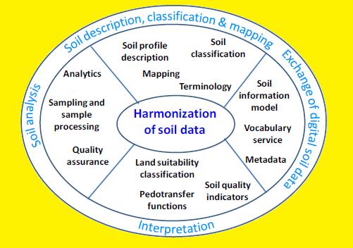
4 As a mechanism for improving the comparability of soil data, all GSP members should adapt the scope of harmonization which includes legacy data as well as newly collected data, and which focuses on soil description, classification and mapping, soil sampling and analysis, exchange of digital soil data, and interpretation.
5 The harmonization processes will follow the established principles for technical cooperation (commonality, inclusiveness, efficiency, multilinguality) and operations (interoperability, exten sibility, scalability).
6 The implementation of Pillar 5 will engage and be consistent with current standardization and harmonization activities, in particular those within the International Union of Soil Sciences (World Reference Base for Soil Resources, Universal Soil Classification, Soil Information Standards) and the International Standardization Organization (ISO TC 190 Soil Quality).
7 Develop an over arching soil description system designed to describe and explain soil features in a common and consistent manner to facilitate systematic application in all parts of the world.
8 If no other national guideline for soil description is available, the FAO (2006) Guidelines for Soil Description shall be used. The guideline should be reviewed with the aim to develop it further as a new generic field book. Agreement on basic definitions and codes is required.
9 The systems for soil classification and correlation at the international level will be either the World Reference Base for Soil Resources or USDA Soil Taxonomy until a new standard system is released. To this end, the GSP supports the development of the new Universal Soil Classification System.
10 Create a reference system for the integration of soil maps from different sources and ensure harmonized products meet the needs of users (e.g. for monitoring in Pillar 4).
11 Review existing practices for field sampling, sample preparation and measurement (including laboratory standardization and QA/QC) and prepare specifications and guidelines for harmonized approaches to the determination of the main functional properties of soils (i.e. chemical, physical and biological).
12 As a significant added value to the considerable investment embodied in existing soil data, the publishing of interoperable soil data via web services should be promoted in order to make soil data more readily accessible.
13 To enable the exchange of digital soil related data, agreement is reached on a global soil information model, vocabulary service and meta data standards. Implementation of this model driven architecture will be consistent with the aspirations of the global soil information infrastructure (GSP Pillar 4).
14 Support the development of indicators for monitoring the condition of soils and to assess the needs and effects of sustainable soil management.
15 Support the development of effective correlation procedures and evaluation functions.
16 Because of the similarity of institutions involved with Pillar 4 and 5, the global soil information management committee, as proposed by Pillar 4, shall be extended to Pillar 5. Close liaison with IUSS and ISO working groups shall be sought.
17 CEN Technical committee on Characterization of soils (CEN/TC 345) ISO Technical Committee on Soil Quality (ISO/TC 190) Main players in ISO/TC 190 (that join the meetings) are nowadays: From Europe: Germany, France, England, Netherlands, Czech Republic, Norway, Sweden, Finland, Denmark, Austria From non Europe: Australia, Japan, South Korea

18 THANK YOU FOR YOUR ATTENTION TO HARMONIZATION
Harmonization of methods and measurements (GSP Pillar 5) Rainer Baritz
 Rainer Baritz") Harmonization of methods and measurements (GSP Pillar 5) Rainer Baritz ESP, Rome, 17-18 March 2015 1 Pillar 5 writing team: Compiled after expert registration through GSP web site; 2 experts dropped out;
Harmonization of methods and measurements (GSP Pillar 5) Rainer Baritz ESP, Rome, 17-18 March 2015 1 Pillar 5 writing team: Compiled after expert registration through GSP web site; 2 experts dropped out;
Harmonization of methods and measurements. Rainer Baritz
 Harmonization of methods and measurements Rainer Baritz ESP, Ispra, 21-22 May 2014 1 Context National contributions with harmonized data to. Improve cross-border and continental represenation for various
GSDI Global Spatial Data Infrastructure. Convergences between Geo Spatial Communities: key decision for decision making
 GSDI Global Spatial Data Infrastructure Convergences between Geo Spatial Communities: key decision for decision making April 14 th 2010 Bas Kok GSDI Past-President Director of International Affairs, Dutch
COMMISSION 3 SPATIAL INFORMATION MANAGEMENT WORK PLAN
 Appendix to item 34.3 FIG Congress in Washington, 19-26 April 2002 COMMISSION 3 SPATIAL INFORMATION MANAGEMENT WORK PLAN 2002 2006 1. Title Spatial Information Management. 2. Terms of Reference - Management
This document is a preview generated by EVS
 EESTI STANDARD EVS-EN ISO 19119:2006 Geographic information - Services Geographic information - Services EESTI STANDARDIKESKUS EESTI STANDARDI EESSÕNA NATIONAL FOREWORD Käesolev Eesti standard EVS-EN ISO
Major Opportunities in Spatial Data Infrastructure Communities
 Major Opportunities in Spatial Data Infrastructure Communities Bas Kok President GSDI June 17 th 2008 FIG Working Week: Integrating Generations 14-19 June 2008 Stockholm, Sweden http://www.gsdi.org 1 GSDI
INSPIRing effort. Peter Parslow Ordnance Survey December Various European approaches to managing an SDI
 INSPIRing effort Peter Parslow Ordnance Survey December 2015 Various European approaches to managing an SDI WHAT IS INSPIRE? A European Union Directive A community effort: http://inspire.ec.europa.eu/
ISO INTERNATIONAL STANDARD. Thermal bridges in building construction Linear thermal transmittance Simplified methods and default values
 INTERNATIONAL STANDARD ISO 14683 First edition 1999-06-15 Thermal bridges in building construction Linear thermal transmittance Simplified methods and default values Points thermiques dans les bâtiments
Use of the ISO Quality standards at the NMCAs Results from questionnaires taken in 2004 and 2011
 Use of the ISO 19100 Quality standards at the NMCAs Results from questionnaires taken in 2004 and 2011 Eurogeographics Quality Knowledge Exchange Network Reference: History Version Author Date Comments
Sharing soil information with the help of INSPIRE, key challenges with soil data management
 Sharing soil information with the help of INSPIRE, key challenges with soil data management Katharina Feiden e-mail: gssoil@portalu.de GS Soil: project outline GS Soil: Assessment and strategic development
ORGANISATION FOR ECONOMIC CO-OPERATION AND DEVELOPMENT
 ORGANISATION FOR ECONOMIC CO-OPERATION AND DEVELOPMENT Pursuant to Article 1 of the Convention signed in Paris on 14th December 1960, and which came into force on 30th September 1961, the Organisation
International Standardization for Measurement and Characterization of Nanomaterials
 2012/SOM2/SCSC/CON/008 International Standardization for Measurement and Characterization of Nanomaterials Submitted by: Japan 9 th Conference on Standards and Conformance in the Field of Innovations and
ESBN. Working Group on INSPIRE
 ESBN Working Group on INSPIRE by Marc Van Liedekerke, Endre Dobos and Paul Smits behalf of the WG members WG participants Marc Van Liedekerke Panos Panagos Borut Vrščaj Ivana Kovacikova Erik Obersteiner
Spatially Enabled Society
 International Seminar on Land Administration Trends and Issues in Asia and the Pacific Region Spatially Enabled Society Abbas Rajabifard Vice Chair PCGIAP-WG3 Vice-President (President Elect), GSDI Association
ISO INTERNATIONAL STANDARD. Thermal performance of windows, doors and shutters Calculation of thermal transmittance Part 1: Simplified method
 INTERNATIONAL STANDARD ISO 10077-1 First edition 2000-07-15 Thermal performance of windows, doors and shutters Calculation of thermal transmittance Part 1: Simplified method Performance thermique des fenêtres,
This document is a preview generated by EVS
 TECHNICAL SPECIFICATION SPÉCIFICATION TECHNIQUE TECHNISCHE SPEZIFIKATION CEN ISO/TS 15883-5 November 2005 ICS 11.080.10 English Version Washer-disinfectors - Part 5: Test soils and methods for demonstrating
The future of SDIs. Ian Masser
 The future of SDIs Ian Masser Presentation Considers two questions relating to the future development of SDIs throughout the world Where have we got to now? Where should we go from here? Identifies four
Infrastructure for Spatial Information in Europe (INSPIRE) Steve Peedell
 Steve Peedell") Infrastructure for Spatial Information in Europe (INSPIRE) Steve Peedell European Commission DG Joint Research Centre Institute for Environment and Sustainability ESDI Action Overview JRC, European Commission
Infrastructure for Spatial Information in Europe (INSPIRE) Steve Peedell European Commission DG Joint Research Centre Institute for Environment and Sustainability ESDI Action Overview JRC, European Commission
EuroGeoSurveys An Introduction
 EGS -ASGMI Workshop, Madrid, 2015 EuroGeoSurveys An Introduction 40 Years Listening to the Beat of the Earth Click to edit Master title Albania style EuroGeoSurveys Austria Lithuania Luxembourg Belgium
Background Document: Report of the Regional Committee of United Nations Global Geospatial Information Management for Asia and the Pacific
 Background Document: Report of the Regional Committee of United Nations Global Geospatial Information Management for Asia and the Pacific 1. Summary 1. This report highlights the activities carried out
Roadmap to interoperability of geoinformation
 Roadmap to interoperability of geoinformation and services in Europe Paul Smits, Alessandro Annoni European Commission Joint Research Centre Institute for Environment and Sustainability paul.smits@jrc.it
This document is a preview generated by EVS
 TECHNICAL SPECIFICATION SPÉCIFICATION TECHNIQUE TECHNISCHE SPEZIFIKATION CEN ISO/TS 15530-3 December 2007 ICS 17.040.30 English Version Geometrical product specifications (GPS) - Coordinate measuring machines
This document is a preview generated by EVS
 TECHNICAL SPECIFICATION SPÉCIFICATION TECHNIQUE TECHNISCHE SPEZIFIKATION CEN/TS 17268 December 2018 ICS 35.240.60 English Version Intelligent transport systems - ITS spatial data - Data exchange on changes
Data Origin. Ron van Lammeren CGI-GIRS 0910
 Data Origin Ron van Lammeren CGI-GIRS 0910 How to obtain geodata? Geo data initiative Executive Order 12906, "Coordinating Geographic Data Acquisition and Access: The National Spatial Data Infrastructure,"
World Status of National Spatial Data Clearinghouses
 World Status of National Spatial Data Clearinghouses Joep Crompvoets and Arnold Bregt Abstract: In December 2001, a survey of the World Wide Web was carried out to assess systematically the state-of-the-art
Prof. Emmanuel Tsesmelis Deputy Head of International Relations CERN
 Welcome Hoşgeldiniz Prof. Emmanuel Tsesmelis Deputy Head of International Relations CERN Accelerating Science and Innovation The Mission of CERN Push back the frontiers of knowledge E.g. the secrets of
ISO/TC211 Outreach Seminar Wednesday 29 November Lecture Theatre 2 Rutherford House Pipitea Campus Victoria University of Wellington
 ISO/TC211 Outreach Seminar Wednesday 29 November 2017 Lecture Theatre 2 Rutherford House Pipitea Campus Victoria University of Wellington 1030 Morning tea/coffee (30 mins) Registration for non-tc211. 1100
Data Origin. How to obtain geodata? Ron van Lammeren CGI-GIRS 0910
 Data Origin How to obtain geodata? Ron van Lammeren CGI-GIRS 0910 Spatial Data interest Improvement of policy making. ± 90% of all information used by government has spatial characteristics SPATIAL INFORMATION
Think Local - Act Global a Nordic Perspective
 Think Local - Act Global a Nordic Perspective OGC Nordic Forum Jari Reini 20-21.5.2014 OGC Nordic Forum? OGC Nordic Forum addresses OGC outreach and education needs of government, academic, research and
ISO INTERNATIONAL STANDARD
 INTERNATIONAL STANDARD ISO 0077-2 First edition 2003-0-0 Thermal performance of windows, doors and shutters Calculation of thermal transmittance Part 2: Numerical method for frames Performance thermique
Proposal for a DIRECTIVE OF THE EUROPEAN PARLIAMENT AND OF THE COUNCIL. establishing an infrastructure for spatial information in the Community
 Proposal for a DIRECTIVE OF THE EUROPEAN PARLIAMENT AND OF THE COUNCIL establishing an infrastructure for spatial information in the Community INSPIRE http://inspire.jrc.it/ Alessandro Annoni 1 EU Commission
Geological information for Europe : Towards a pan-european Geological Data Infrastructure
 Geological information for Europe : Towards a pan-european Geological Data Infrastructure Integrating geoscientific information for EU competitiveness Co-funded by the European Union European societal
Project EuroGeoNames (EGN) Results of the econtentplus-funded period *
 Results of the econtentplus-funded period *") UNITED NATIONS Working Paper GROUP OF EXPERTS ON No. 33 GEOGRAPHICAL NAMES Twenty-fifth session Nairobi, 5 12 May 2009 Item 10 of the provisional agenda Activities relating to the Working Group on Toponymic
UNITED NATIONS Working Paper GROUP OF EXPERTS ON No. 33 GEOGRAPHICAL NAMES Twenty-fifth session Nairobi, 5 12 May 2009 Item 10 of the provisional agenda Activities relating to the Working Group on Toponymic
EuroGeoSurveys & ASGMI The Geological Surveys of Europe and IberoAmerica
 EuroGeoSurveys & ASGMI The Geological Surveys of Europe and IberoAmerica Geological Surveys, what role? Legal mandate for data & information: Research Collection Management Interpretation/transformation
Current Account Dynamics under Information Rigidity and Imperfect Capital Mobility
 Crawford School of Public Policy CAMA Centre for Applied Macroeconomic Analysis Current Account Dynamics under Information Rigidity and Imperfect Capital Mobility CAMA Working Paper 56/2018 November 2018
National Spatial Data Infrastructures (NSDIs): North American Experience
: North American Experience") National Spatial Data Infrastructures (NSDIs): North American Experience Henry Tom International Symposium on NSDI (National Spatial Data Infrastructure) Center for Spatial Information Science University
National Spatial Data Infrastructures (NSDIs): North American Experience Henry Tom International Symposium on NSDI (National Spatial Data Infrastructure) Center for Spatial Information Science University
Weather Company Energy and Power Products
 Service Weather Company Energy and Power Products This Service (SD) describes the Cloud Service IBM provides to Client. Client means the company and its authorized users and recipients of the Cloud Service.
Briefing. H.E. Mr. Gyan Chandra Acharya
 Briefing by H.E. Mr. Gyan Chandra Acharya Under-Secretary-General and High Representative for the Least Developed Countries, Landlocked Developing Countries and Small Island Developing States Briefing
HILIC Method Development in a Few Simple Steps
 HILIC Method Development in a Few Simple Steps Monica Dolci, Luisa Pereira, Dafydd Milton and Tony Edge Thermo Fisher Scientific, Runcorn, Cheshire, UK Overview This poster presents a systematic approach
Implementing the Sustainable Development Goals: The Role of Geospatial Technology and Innovation
 Fifth High Level Forum on UN Global Geospatial Information Management Implementing the Sustainable Development Goals: The Role of Geospatial Technology and Innovation 28-30 November 2017 Sheraton Maria
SDI-Challenges European perspective
 THE HIGH LEVEL FORUM ON GLOBAL GEOSPATIAL INFORMATION MANAGEMENT Seoul, Republic of Korea, 24-26 October 2011 Session 1: Challenges in geospatial policy formation and institutional arrangements SDI-Challenges
COMMISSION 3 SPATIAL INFORMATION MANAGEMENT WORK PLAN
 COMMISSION 3 SPATIAL INFORMATION MANAGEMENT WORK PLAN 2002 2006 1. Title Spatial Information Management (SIM). 2. Terms of Reference - Management of spatial information on land, property and hydrographical
Multimedia on Nuclear Reactor Physics In order to improve education and training quality, a Multimedia on Nuclear Reactor Physics has been developed.
 MULTIMEDIA ON NUCLEAR REACTOR PHYSICS Prof. PhD. Javier Dies, Doctor Engineer Professor Chair in Nuclear Engineering g Upc- Barcelona-Tech, Spain Nuclear Engineering Research Group (NERG), Departament
International Standard
 International Standard 300212 INTERNATIONAL ORGANIZATION FOR STANDARDIZATIONWvlE~YHAPO~HAR OPTAHM3AUMR l-l0 CTAH,QAPTM3A~blM.ORGANISATION INTERNATtONALE DE &ORMALISATION Basic quantities in cutting and
What is the PCGIAP? Overview on PCGIAP Activities and the Asia/Pacific Region. Membership. Background. Aims. Asia-Pacific SDI
 3rd FIG Regional Conference for Asia and the Pacific Jakarta, Indonesia, 3-7th October 2004 Overview on PCGIAP Activities and the Asia/Pacific Region What is the PCGIAP? Haji Matusin Matasan Surveyor General,
Report of the Working Group 2 Data Sharing and Integration for Disaster Management *
 UNITED NATIONS E/CONF.104/6 ECONOMIC AND SOCIAL COUNCIL Twentieth United Nations Regional Cartographic Conference for Asia and the Pacific Jeju, 6-9 October 2015 Item 5 of the provisional agenda Report
2012 OCEAN DRILLING CITATION REPORT
 2012 OCEAN DRILLING CITATION REPORT Covering Citations Related to the Deep Sea Drilling Project, Ocean Drilling Program, and Integrated Ocean Drilling Program from GeoRef Citations Indexed by the American
The International Association for the Properties of Water and Steam. Revised Release on Surface Tension of Ordinary Water Substance
 IAPWS R1-76(2014) The International Association for the Properties of Water and Steam Moscow, Russia June 2014 Revised Release on Surface Tension of Ordinary Water Substance 2014 International Association
TC 288 Execution of special geotechnical works Status of standards
 Dias 1 Grundlaget for fremtidens geoteknik CEN/TC 288 Execution of special geotechnical works ISO/TC 182-WG3: - Status Dias 2 TC 288 Execution of special geotechnical works Status of standards Reference
This document is a preview generated by EVS
 EESTI STANDARD EVS-EN ISO 19117:2006 Geographic information - Portrayal Geographic information - Portrayal EESTI STANDARDIKESKUS EESTI STANDARDI EESSÕNA NATIONAL FOREWORD Käesolev Eesti standard EVS-EN
INSPIRE - A Legal framework for environmental and land administration data in Europe
 INSPIRE - A Legal framework for environmental and land administration data in Europe Dr. Markus Seifert Bavarian Administration for Surveying and Cadastre Head of the SDI Office Bavaria Delegate of Germany
Drift Inflates Variance among Populations. Geographic Population Structure. Variance among groups increases across generations (Buri 1956)
") Geographic Population Structure Alan R Rogers December 4, 205 / 26 Drift Inflates Variance among Populations 2 / 26 Variance among groups increases across generations Buri 956) 3 / 26 Gene flow migration)
Geographic Population Structure Alan R Rogers December 4, 205 / 26 Drift Inflates Variance among Populations 2 / 26 Variance among groups increases across generations Buri 956) 3 / 26 Gene flow migration)
Arctic Spatial Data Infrastructure Enabling Access to Arctic Location-Based Information
 Arctic Spatial Data Infrastructure Enabling Access to Arctic Location-Based Information Arctic SDI Side Event Co-Chairs: Arvo Kokkonen Arctic SDI Board Chair & Director General, National Land Survey of
This document is a preview generated by EVS
 EESTI STANDARD EVS-EN ISO 14689-1:2004 Geotechnical investigation and testing - Identification and classification of rock - Part 1: Identification and description Geotechnical investigation and testing
Progress of UN-GGIM: Europe Working Group A on Core Data
 PolicyKEN Budapest 29 November 2016 Progress of UN-GGIM: Europe Working Group A on Core Data François Chirié, Dominique Laurent, IGNF Core data context Background and purpose Aim of Work Group A to propose
This document is a preview generated by EVS
 TECHNICAL REPORT RAPPORT TECHNIQUE TECHNISCHER BERICHT CEN/TR 15641 August 2007 ICS 67.050 English Version Food analysis - Determination of pesticide residues by LC- MS/MS - Tandem mass spectrometric parameters
UN GGIM and National SDI Strategy
 MSDI Open Forum on 26 th January 2016 Contributing to the successful delivery of MSDI UN GGIM and National SDI Strategy Hiroshi Murakami Deputy Administrator Geospatial Information Authority of Japan Geospatial
Tomas Mildorf New technologies for the information society University of west bohemia in pilsen, Czech republic
 Tomas Mildorf New technologies for the information society University of west bohemia in pilsen, Czech republic Karel Charvat Help Service Remote Sensing, Czech republic AIP-7 GEOSS, 20 MAY 2014 By 2015,
Refinement of the OECD regional typology: Economic Performance of Remote Rural Regions
 [Preliminary draft April 2010] Refinement of the OECD regional typology: Economic Performance of Remote Rural Regions by Lewis Dijkstra* and Vicente Ruiz** Abstract To account for differences among rural
PAN AMERICAN INSTITUTE OF GEOGRAPHY AND HISTORY Specialized Organization of the OAS
 PAN AMERICAN INSTITUTE OF GEOGRAPHY AND HISTORY Specialized Organization of the OAS 10 th UNRCC Americas United Nations, New York, 20 August 2013 PAIGH, SIRGAS, PC-IDEA and GeoSUR 2013-2015 Joint Action
GLOBAL NETWORK OF NATIONAL GEOPARKS. Patrick J Mc Keever
 Patrick J Mc Keever A GEOPARK is an area with. geological heritage of international significance but also with. a sustainable development strategy or plan involving local communities. IS A GEOPARK JUST
of mass spectrometry
 Thermo Scientific 253 Ultra High resolution isotope ratio MS Discover a new world of mass spectrometry Paleoclimatology Atmospheric science Biogeochemistry Petrology Discover the isotopic anatomy of molecules
8 th Arctic Regional Hydrographic Commission Meeting September 2018, Longyearbyen, Svalbard Norway
 8 th Arctic Regional Hydrographic Commission Meeting 11-13 September 2018, Longyearbyen, Svalbard Norway Status Report of the Arctic Regional Marine Spatial Data Infrastructures Working Group (ARMSDIWG)
The ISO/TC 211 Geographic information/geomatics
 Geographic information/geomatics The ISO/TC 211 Geographic information/geomatics building the foundation of the geospatial infrastructure, brick by brick... The goal of ISO/TC 211...... is to develop a
The Global Runoff Data Centre (GRDC) Report on selected GRDC activities during the inter-sessional period Ulrich Looser
 Report on selected GRDC activities during the inter-sessional period Ulrich Looser") The Global Runoff Data Centre (GRDC) Report on selected GRDC activities during the inter-sessional period 2008-2012 Ulrich Looser Koblenz 09/2012 1 1. Introduction This report summarises some of the activities
The Global Runoff Data Centre (GRDC) Report on selected GRDC activities during the inter-sessional period 2008-2012 Ulrich Looser Koblenz 09/2012 1 1. Introduction This report summarises some of the activities
The EuCheMS Division Chemistry and the Environment EuCheMS/DCE
 The EuCheMS Division Chemistry and the Environment EuCheMS/DCE EuCheMS Division on Chemistry and the Environment was formed as a FECS Working Party in 1977. Membership: 37 members from 34 countries. Countries
Final report for the Expert Group on the Integration of Statistical and Geospatial Information, May 2015
 Final report for the Expert Group on the Integration of Statistical and Geospatial Information, May 2015 Global geographic classification and geocoding practices Executive summary This final report was
ISO/TR TECHNICAL REPORT. Nanotechnologies Methodology for the classification and categorization of nanomaterials
 TECHNICAL REPORT ISO/TR 11360 First edition 2010-07-15 Nanotechnologies Methodology for the classification and categorization of nanomaterials Nanotechnologies Méthodologie de classification et catégorisation
Previous discussion. ECSA Data Tools & Technology WG ENVIP 2015
 Previous discussion ECSA Data Tools & Technology WG ENVIP 2015 Introduction Where we are and were do we want to go? Comparison: Computer Networks and Citizen Science Networks Topics to develop Conceptual
PLUTO The Transport Response to the National Planning Framework. Dr. Aoife O Grady Department of Transport, Tourism and Sport
 PLUTO 2040 The Transport Response to the National Planning Framework Dr. Aoife O Grady Department of Transport, Tourism and Sport Dublin Economics Workshop 15 th September 2018 The Story of Pluto National
Aerospace part number guide
 TRELLEBORG SEALING SOLUTIONS Aerospace part number guide YOUR PARTNER FOR SEALING TECHNOLOGY Your Partner for Sealing Technology Trelleborg Sealing Solutions is a major international sealing force, uniquely
*CETAF : DOI: /RG
 Consortium of European Taxonomic Facilities STRATEGY AND STRATEGIC DEVELOPMENT PLAN * Executive Summary Exploring and documenting diversity in nature *CETAF Strategy and Strategic Development Plan 2015-2025:
INSPIREd solutions for Air Quality problems Alexander Kotsev
 INSPIREd solutions for Air Quality problems Alexander Kotsev www.jrc.ec.europa.eu Serving society Stimulating innovation Supporting legislation The European data puzzle The European data puzzle 24 official
This document is a preview generated by EVS
 EESTI STANDARD EVS-EN 1159-2:2003 Advanced technical ceramics - Ceramic composites - Thermophysical properties - Part 2: Determination of thermal diffusivity Advanced technical ceramics - Ceramic composites
TECHNICAL REPORT ISO/TR Geographic information Functional standards. Information géographique Normes fonctionnelles. First edition
 TECHNICAL REPORT ISO/TR 19120 First edition 2001-07-01 Geographic information Functional standards Information géographique Normes fonctionnelles Reference number ISO 2001 Provläsningsexemplar / Preview
ISO and CEN Standardization work Trond Hovland NPRA. Norwegian Public Roads Administration
 ISO and CEN Standardization work Trond Hovland NPRA Agenda Short general information on NRDB ISO TC211 and TC204 CEN and domestic standards Status and Summing-Up Agenda Short general information on NRDB
EuroGeoSurveys. Minerals, metals and mining statistics: The role of Geological Surveys in building continental-scale official data sets
 EuroGeoSurveys Minerals, metals and mining statistics: The role of Geological Surveys in building continental-scale official data sets 40 Years Listening to the Beat of the Earth 1 EuroGeoSurveys 37 Geological
The Geospatial Information Management (GIM) INSPIRE Data Specification and COPERNICUS In situ data
 INSPIRE Data Specification and COPERNICUS In situ data") INSPIRE conference Barcelona 29 September 2016 INSPIRing a sustainable environment The Geospatial Information Management (GIM) INSPIRE Data Specification and COPERNICUS In situ data Antonio Arozarena,
INSPIRE conference Barcelona 29 September 2016 INSPIRing a sustainable environment The Geospatial Information Management (GIM) INSPIRE Data Specification and COPERNICUS In situ data Antonio Arozarena,
Biodiversity and Ecosystem services Thinking globally, acting locally
 Biodiversity and Ecosystem services Thinking globally, acting locally Anne-Gaelle Ausseil - Manaaki Whenua Landcare Research Geoff Hicks National Commission for UNESCO 1 8 / 1 0 / 2 0 1 8 M A N A A K I
Basic Act on the Advancement of Utilizing Geospatial Information
 Basic Act on the Advancement of Utilizing Geospatial Information (Act No. 63 of May 30, 2007) Table of Contents Chapter I General Provisions (Articles 1 to 8) Chapter II Basic Plan for the Advancement
WMO Update on Space Weather Activities. Jérôme Lafeuille (WMO Space Programme Office)
") WMO Update on Space Weather Activities Jérôme Lafeuille (WMO Space Programme Office) Terry Onsager (Co Chair WMO/ICTSW) WMO Inter-Programme Coordination Team on Space Weather (ICTSW) Established in May,
WMO Update on Space Weather Activities Jérôme Lafeuille (WMO Space Programme Office) Terry Onsager (Co Chair WMO/ICTSW) WMO Inter-Programme Coordination Team on Space Weather (ICTSW) Established in May,
2017 Source of Foreign Income Earned By Fund
 2017 Source of Foreign Income Earned By Fund Putnam Emerging Markets Equity Fund EIN: 26-2670607 FYE: 08/31/2017 Statement Pursuant to 1.853-4: The fund is hereby electing to apply code section 853 for
Sustainable and Harmonised Development for Smart Cities The Role of Geospatial Reference Data. Peter Creuzer
 Sustainable and Harmonised Development for Smart Cities The Role of Geospatial Reference Data Peter Creuzer 1. Introduction - Smart Cities and Geodata 2. Geodata in Germany 3. Examples 4. Data and Service
The Combination of Geospatial Data with Statistical Data for SDG Indicators
 Session 3: Sustainable Development Goals, SDG indicators The Combination of Geospatial Data with Statistical Data for SDG Indicators Pier-Giorgio Zaccheddu (with the assistance of Francisco Vala & Cátia
AEC 3 United Kingdom. Industry Foundation Classes. Norwegian IFG project Harmonisation IFC and gml3. Dr. Thomas Liebich, Jeffrey Wix AEC3 Ltd.
 Industry Foundation Classes AEC 3 United Kingdom Thatcham, Berkshire RG18 3ES Tel: +44-1635 86 4590 Fax: +44-1635 86 0673 email: jeffrey.wix@aec3.com Germany D-80636 München Tel: +49-89-1870 3223 Fax:
Global Data Catalog initiative Christophe Charpentier ArcGIS Content Product Manager
 Global Data Catalog initiative Christophe Charpentier ArcGIS Content Product Manager ccharpentier@esri.com We are in a global economy Global Economy Business and Operations are now global Strategic need
AD HOC DRAFTING GROUP ON TRANSNATIONAL ORGANISED CRIME (PC-GR-COT) STATUS OF RATIFICATIONS BY COUNCIL OF EUROPE MEMBER STATES
 STATUS OF RATIFICATIONS BY COUNCIL OF EUROPE MEMBER STATES") Strasbourg, 29 May 2015 PC-GR-COT (2013) 2 EN_Rev AD HOC DRAFTING GROUP ON TRANSNATIONAL ORGANISED CRIME (PC-GR-COT) STATUS OF RATIFICATIONS BY COUNCIL OF EUROPE MEMBER STATES TO THE UNITED NATIONS CONVENTION
Strasbourg, 29 May 2015 PC-GR-COT (2013) 2 EN_Rev AD HOC DRAFTING GROUP ON TRANSNATIONAL ORGANISED CRIME (PC-GR-COT) STATUS OF RATIFICATIONS BY COUNCIL OF EUROPE MEMBER STATES TO THE UNITED NATIONS CONVENTION
This document is a preview generated by EVS
 EESTI STANDARD EVS-EN ISO 13802:2006 Plastics - Verification of pendulum impacttesting machines - Charpy, Izod and tensile impact-testing Plastics - Verification of pendulum impact-testing machines - Charpy,
INTERNATIONAL STANDARD
 INTERNATIONAL STANDARD. 9711 INTERNATIONAL ORGANIZATION FOR STANDARDIZATION l MEXJ(YHAPOAHIUI OPl-AHM3ALWf HO CTAH~APTM3A~kili.ORGANISATION INTERNATIONALE DE NORMALISATION Measurement of water flow in
Quick Guide QUICK GUIDE. Activity 1: Determine the Reaction Rate in the Presence or Absence of an Enzyme
 Activity 1: Determine the Reaction Rate in the Presence or Absence of an 1. Find your 15 ml conical tubes labeled Stop Solution, 1.5 mm Substrate, and Buffer. Write your initials on each tube. 2. Label
INSPIRE Directive. Status June 2007
 INSPIRE Directive INfrastructure for SPatial InfoRmation in Europe Status June 2007 European Commission Directorate-General Environment Research, Science and Innovation Unit Rue de la Loi, 200 1049 Brussels
COR Safety Management Data system
 CER Position Paper Brussels, 21 December 2016 COR Safety Management Data system 1 CER aisbl - COMMUNITY OF EUROPEAN RAILWAY AND INFRASTRUCTURE COMPANIES Avenue des Arts, 53-1000 Bruxelles T: +32 (0)2 213
Keysight Technologies Instrumented Indentation Testing with the Keysight Nano Indenter G200. Application Note
 Keysight Technologies Instrumented Indentation Testing with the Keysight Nano Indenter G200 Application Note Introduction The scale of materials and machined components continues to decrease with advances
ESPON evidence on European cities and metropolitan areas
 BEST METROPOLISES Final Conference 18 April 2013, Warsaw ESPON evidence on European cities and metropolitan areas Michaela Gensheimer Structure of Intervention Content Part I: What is the ESPON 2013 Programme?
The Process of Spatial Data Harmonization in Italy. Geom. Paola Ronzino
 The Process of Spatial Data Harmonization in Italy Geom. Paola Ronzino ISSUES Geospatial Information in Europe: lack of data harmonization the lack of data duplication of data CHALLENGES Challenge of INSPIRE:
TIMSS 2011 The TIMSS 2011 Instruction to Engage Students in Learning Scale, Fourth Grade
 TIMSS 2011 The TIMSS 2011 Instruction to Engage Students in Learning Scale, Fourth Grade The Instruction to Engage Students in Learning (IES) scale was created based on teachers responses to how often
OGC and GSDI: A Partnership in Advancing SDI Best Practices
 OGC and GSDI: A Partnership in Advancing SDI Best Practices GSDI 11 Workshop 1.4 SDI Challenges 15 June 2009 Mark Reichardt President and CEO mreichardt@opengeospatial.org +1 301 840-1361 Copyright 2009,
Arctic Spatial Data Infrastructure (SDI) - Pan-Arctic Cooperation among Ten Mapping Agencies (Skedsmo, Palmer, Taylor, Gudmundsson)
 - Pan-Arctic Cooperation among Ten Mapping Agencies (Skedsmo, Palmer, Taylor, Gudmundsson)") Arctic Arctic Spatial Data Infrastructure () - Pan-Arctic Cooperation among Ten Mapping Agencies (Skedsmo, Palmer, Taylor, Gudmundsson) G 13 2012, Quebec, Canada May 14, 2012 www. arctic-sdi.org Owe Bengt
Arctic Arctic Spatial Data Infrastructure () - Pan-Arctic Cooperation among Ten Mapping Agencies (Skedsmo, Palmer, Taylor, Gudmundsson) G 13 2012, Quebec, Canada May 14, 2012 www. arctic-sdi.org Owe Bengt
WHAT IS SILMI? SILMI is a Research Networking Programme of the European Science Foundation ( ESF ) in the Physical and Engineering Sciences ( PESC ).
 in the Physical and Engineering Sciences ( PESC ).") THE SILMI PROGRAMME WHAT IS SILMI? SILMI is a Research Networking Programme of the European Science Foundation ( ESF ) in the Physical and Engineering Sciences ( PESC ). Full title: «Super-Intense Laser-Matter
THE SILMI PROGRAMME WHAT IS SILMI? SILMI is a Research Networking Programme of the European Science Foundation ( ESF ) in the Physical and Engineering Sciences ( PESC ). Full title: «Super-Intense Laser-Matter
LANDSLIDE MITIGATION IN CCOP
 "International Workshop on Landslide Risk Assessment and Management for ASEAN Member States 1-2 June 2017 Bangkok, Thailand LANDSLIDE MITIGATION IN CCOP Dr. Adichat Surinkum Director Email: adichat_s@ccop.or.th,