P PRELIMINARY ANALYSIS OF THE 10 JUNE 2010 SUPERCELLS INTERCEPTED BY VORTEX2 NEAR LAST CHANCE, COLORADO
|
|
|
- Willa Glenn
- 5 years ago
- Views:
Transcription

1 P PRELIMINARY ANALYSIS OF THE 10 JUNE 2010 SUPERCELLS INTERCEPTED BY VORTEX2 NEAR LAST CHANCE, COLORADO 1. INTRODUCTION An outstanding question in the field of severe storms research is why some supercell thunderstorms produce tornadoes and others do not (e.g., Markowski et al. 2011), even though both might have significant low-level rotation on the mesocyclone scale. A more thorough understanding of the distinguishing processes occurring in these storms could lead to more accurate forecasting of tornadogenesis, increased warning accuracy, and a decreased number of false alarms, potentially saving lives and property. The Second Verification of the Origins of Rotation in Tornadoes Experiment (VORTEX2) was designed to help answer such questions by collecting wind and thermodynamic observations within both tornadic and nontornadic supercells. The VORTEX2 armada included multiple radars to collect dual-doppler observations at both the storm- and meso-scale, and ultra-high-resolution single- Doppler observations at the tornado scale. In situ data were collected by mobile mesonets (Straka et al. 1996), StickNets (Weiss et al. 2008), and rawinsondes. Alicia Klees*, Yvette Richardson, and Paul Markowski Pennsylvania State University, University Park, PA Given that environments can vary substantially from case to case, it can be difficult to compare tornadic and nontornadic storms across different days. The optimal observational approach to address this question, therefore, may be to examine observations of a pair of supercells, one tornadic and one nontornadic, evolving in close proximity to one another. The VORTEX2 armada collected one such dataset on 10 June 2010, when it deployed on two supercells in northeastern Colorado. Throughout the day, lee cyclogenesis occurred east of the Rockies owing to the presence of an upper-level shortwave trough. This helped foster an environment conducive to severe thunderstorm development: the 0-6 km vector shear magnitude was at least 40 knots, and CAPE was above 2500 J/kg (Fig. 1). By 2300 UTC (hereafter, all times are UTC), a north-south line of supercells developed in northeastern Colorado. VORTEX2 first intercepted a nontornadic supercell near Hoyt, CO from 2345 to 0040 (June 11). After this period of coordinated data collection, a decision was made to establish a new deployment on the more impressive storm to the south, near Last Chance, CO, from 0100 to 0245 (June 11). The second supercell generated two tornadoes from 0108 to 0116 and 0122 to 0127, respectively. Coordinated observations continued after the tornadoes dissipated and the storm entered a long nontornadic phase. This case provides rare, detailed observations of nontornadic and tornadic storms occurring in close proximity. In this paper, we present a detailed account of the data collected, a *Corresponding Author Address: Alicia Klees, Department of Meteorology, The Pennsylvania State University, University Park, PA 16802; amk5375@psu.edu. FIG 1. Mobile (NSSL1) sounding from 10 June 2010, miles E of Woodrow, CO. Note the 40 kts of 0-6 km vector shear magnitude in this sounding. preliminary analysis of the mobile mesonet data collected for the first supercell, and a single-doppler view of the two tornadoes generated by the second supercell. Ultimately, we intend to examine differences in the environments and internal storm processes of the two supercells to determine why tornadogenesis failed in the first supercell and succeeded twice in the second supercell. 2. DATA VORTEX2 collected an extensive data set for this case. Highlights of the data collected include six mobile radar dual- Doppler deployments and substantial mobile mesonet coverage. Refer to Fig. 2 for a summary of the data collected by VORTEX2 for this case and Fig. 3 for the radar locations for dual-doppler deployments on the first and second supercells. Much future work will focus on the SMART- Radar 1 (SR1) and SMART-Radar 2 (SR2) (Biggerstaff et al. 2005) dual-doppler deployment on the first supercell from 0006 to 0036 on 11 June 2010 as well as later single- and dual-doppler deployments on the second supercell. Mobile mesonet data also are examined because differences in cold pool characteristics are thought to influence the potential for tornadogenesis (Markowski et al. 2002). The VORTEX2
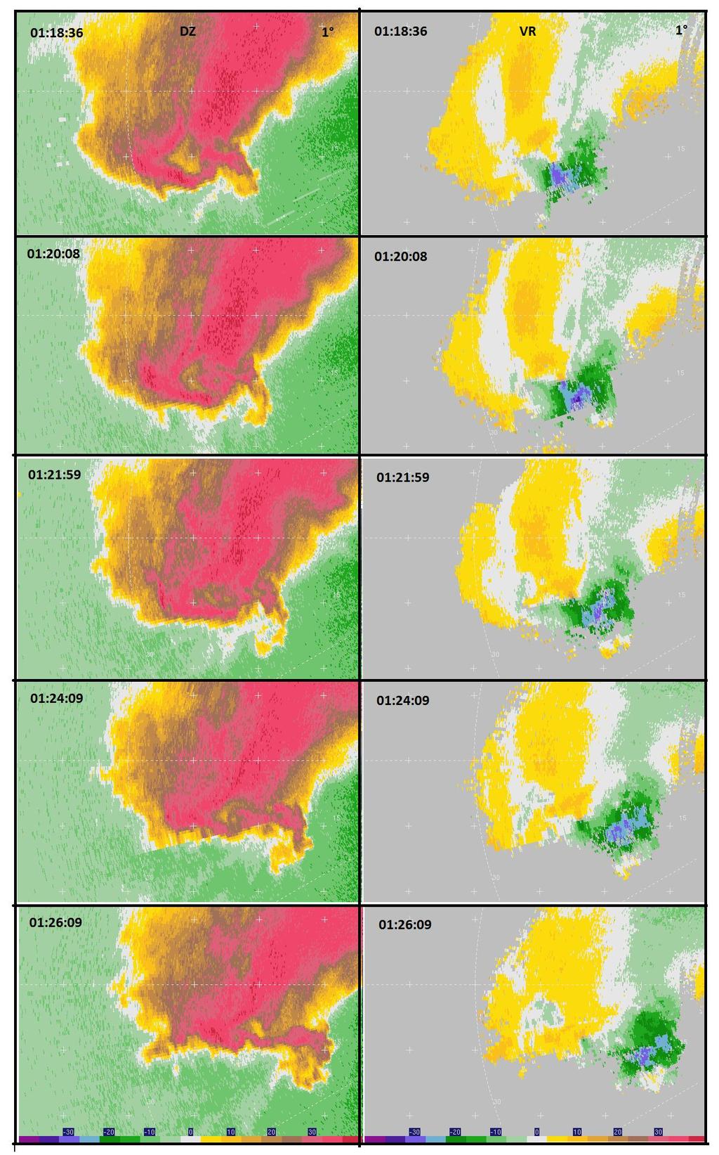
2 observations provide a rare opportunity to combine wind and thermodynamic fields. Five minutes of mobile mesonet data are used for each radar analysis time, with the mobile observation locations modified to correspond to the stormrelative location at the time of collection. 3. PRELIMINARY RESULTS In the first supercell, thermodynamic data and winds measured by the mobile mesonets at 0018 (Fig. 4) indicate a virtual potential temperature deficit across the cold pool of approximately 4.5 K, slightly cold compared to cold pool observations in significantly tornadic storms (e.g., Markowski et al. 2002). Overall, none of the analyses show a strong surface mesocyclone in this first supercell. Single-Doppler analyses of radial velocity and reflectivity from DOW7 are examined during the time period spanning the two tornadoes in the second supercell (Fig. 5). DOW7 was, at maximum, approximately 30 km from the first tornado (0108 to 0116) and only ~15 km from the second tornado (0122 to 0127) by the end of its lifecycle. The first tornado is apparent in the DOW7 sweeps at 0110:40. It tracks to the east throughout its lifetime and maintains a relatively constant intensity until 0113:45. By 0115:18, the tornado s velocity couplet is weakening and becoming increasingly asymmetric. By 0117:03, there is no suggestion of a tornadic circulation. The development of a second tornado, on the western edge of the mesocyclone, is evident by 0120:08. By 0121:59, the weakened second tornado has moved farther west of the core of the parent mesocyclone. It continues to do so throughout its life cycle. Overall, the second tornado appears to be weaker than the first tornado. The evolution of the first and second tornadoes does not seem to follow the classic model of cyclic mesocyclogenesis prior to the production of a new tornado. Rather, the same mesocyclone that produced the first tornado generates the second tornado minutes later. 6. REFERENCES Biggerstaff, M. I., and Coauthors, 2005: The Shared Mobile Atmospheric Research and Teaching radar: A collaboration to enhance research and teaching. Bull. Amer. Meteor. Soc., 86, Markowski, P.M., J.M. Straka, E.N. Rasmussen, 2002: Direct surface thermodynamic observations within the rearflank downdrafts of nontornadic and tornadic supercells. Mon. Wea. Rev., 130, , M. Majcen, Y. P. Richardson, J. Marquis, and J. Wurman, 2011: Characteristics of the wind field in three nontornadic low-level mesocyclones observed by the Doppler on Wheels radars. Electron. J. Severe Storms Meteor., 6, Straka, J. M., E. N. Rasmussen, and S. E. Fredrickson, 1996: A mobile mesonet for fine-scale meteorological observations. J. Atmos. Oceanic Technol., 13, Weiss, C. C., and J. L. Schroeder, 2008: StickNet: A new portable, rapidly deployable surface observation system. Bull. Amer. Meteor. Soc., 89, FUTURE WORK In order to further investigate why the first supercell did not produce a tornado but the second (nearby) supercell spawned two tornadoes, we will use dual-doppler wind syntheses from the six dual-doppler deployments, coupled with in situ thermodynamic measurements, to perform detailed analyses of cold pool characteristics and overall storm dynamics. We also will analyze mobile mesonet and other in situ observations to assess any differences in the mesoscale environment of the two storms that may have influenced the potential for tornado development. 5. ACKNOWLEDGMENTS This research was funded by NSF grants AGS and AGS The authors are grateful to all participants in VORTEX2 for collecting the data. In particular, we thank CSWR and the University of Oklahoma for providing radar data for this case study. We also thank Jim Marquis for support and insight.
3 FIG 2. Summary of data collected by VORTEX2 for this case. The colored boxes indicate a dual-doppler deployment. Mobile mesonet is abbreviated as MM.
 the first supercell (KFTG WSR-88D")

4 a) b) FIG. 3. Radar dual-doppler deployments map for a) the first supercell (KFTG WSR-88D logarithmic reflectivity factor at 0.5 at 0028). Times indicate dual-doppler coverage, and the SR1-SR2 dual-doppler lobe is shown. b) Second supercell (KFTG WSR-88D logarithmic reflectivity factor at 0.5 at 0114), with the DOW7 30-km range ring indicated.
")

 and storm-relative winds")
5 FIG 4. Objectively analyzed mobile radar (SR1) logarithmic reflectivity factor (dbz) at 1 km along with mobile mesonet surface observations of virtual potential temperature (K) and storm-relative winds (minimum observation separation of 1 km).
 and radial velocity (m/s, right column) showing the evolution of the first tornado (0108 to 0116) and second tornado (0122 to 0127)")
6 5 km FIG 5. DOW7 logarithmic reflectivity factor (dbz, left column) and radial velocity (m/s, right column) showing the evolution of the first tornado (0108 to 0116) and second tornado (0122 to 0127) at the indicated times. Tic mark interval is 5 km. The 30-km range ring and a few radials are highlighted in the bottom left panel to aid interpretation of the radial velocities.
7 FIG 5. (continued)
4.5 A WRF-DART study of the nontornadic and tornadic supercells intercepted by VORTEX2 on 10 June 2010
 4.5 A WRF-DART study of the nontornadic and tornadic supercells intercepted by VORTEX2 on 10 June 2010 ALICIA M. KLEES AND YVETTE P. RICHARDSON The Pennsylvania State University, University Park, Pennsylvania.
P13.1 MULTIPLE-DOPPLER RADAR OBSERVATIONS OF VERTICAL WIND PROFILE HETEROGENEITY IN CONVECTIVE BOUNDARY LAYERS
 P13.1 MULTIPLE-DOPPLER RADAR OBSERVATIONS OF VERTICAL WIND PROFILE HETEROGENEITY IN CONVECTIVE BOUNDARY LAYERS Paul Markowski and Yvette Richardson Department of Meteorology, Pennsylvania State University,
P8.27 SURFACE OBSERVATIONS OF THE REAR-FLANK DOWNDRAFT EVOLUTION ASSOCIATED WITH THE AURORA, NE TORNADO OF 17 JUNE 2009
 P8.27 SURFACE OBSERVATIONS OF THE REAR-FLANK DOWNDRAFT EVOLUTION ASSOCIATED WITH THE AURORA, NE TORNADO OF 17 JUNE 2009 Bruce D. Lee 1, Catherine A. Finley 1, Christopher D. Karstens 2, and Timothy M.
P12.7 MESOCYCLONE AND RFD INDUCED DAMAGING WINDS OBSERVED IN THE 27 MAY 2004 SOUTHWEST OHIO SUPERCELL
 P12.7 MESOCYCLONE AND RFD INDUCED DAMAGING WINDS OBSERVED IN THE 27 MAY 2004 SOUTHWEST OHIO SUPERCELL John T. DiStefano* National Weather Service Office, Wilmington, Ohio 1. INTRODUCTION During the early
Recent observations of tornadoes using a mobile, rapid-scan, polarimetric, X-band, Doppler radar
 Recent observations of tornadoes using a mobile, rapid-scan, polarimetric, X-band, Doppler radar Howard B. Bluestein 1, Jeffrey C. Snyder 2, Kyle J. Thiem 1, Zachary B. Wienhoff 1, Jana B. Houser 3, and
P3.13 THERMODYNAMIC AND KINEMATIC ANALYSIS NEAR AND WITHIN THE TIPTON, KS TORNADO ON MAY 29 DURING TWISTEX 2008
 P3.13 THERMODYNAMIC AND KINEMATIC ANALYSIS NEAR AND WITHIN THE TIPTON, KS TORNADO ON MAY 29 DURING TWISTEX 2008 Bruce D. Lee and Catherine A. Finley WindLogics, Inc. Grand Rapids, Minnesota Tim M. Samaras
P13A.7 Multi-pass objective analyses of radar data: Preliminary results
 P13A.7 Multi-pass objective analyses of radar data: Preliminary results MARIO MAJCEN, PAUL MARKOWSKI, AND YVETTE RICHARDSON Department of Meteorology, Pennsylvania State University, University Park, PA
David C. Dowell NOAA/ESRL, Boulder, Colorado. 1. Introduction
 13.5 Impact of Microphysical Parameterizations on Supercell Thunderstorm Cold Pools using WRF-DART Experiments Anthony E. Reinhart *, Christopher C. Weiss, Texas Tech University, Lubbock, Texas David C.
P10.1 TORNADOGENESIS IN A SIMULATED HP SUPERCELL
 Preprints, 21 st Conference on Severe Local Storms 12-16 August 2002, San Antonio, Texas P10.1 TORNADOGENESIS IN A SIMULATED HP SUPERCELL 1. INTRODUCTION Catherine A. Finley * Department of Earth Sciences
DOPPLER RADAR AND STORM ENVIRONMENT OBSERVATIONS OF A MARITIME TORNADIC SUPERCELL IN SYDNEY, AUSTRALIA
 155 DOPPLER RADAR AND STORM ENVIRONMENT OBSERVATIONS OF A MARITIME TORNADIC SUPERCELL IN SYDNEY, AUSTRALIA Harald Richter *, Alain Protat Research and Development Branch, Bureau of Meteorology, Melbourne,
Mobile, phased-array, X-band Doppler radar observations of tornadogenesis in the central U. S.
 Mobile, phased-array, X-band Doppler radar observations of tornadogenesis in the central U. S. Howard B. Bluestein 1, Michael M. French 2, Ivan PopStefanija 3 and Robert T. Bluth 4 Howard (Howie Cb ) B.
24 TH CONFERENCE ON SEVERE LOCAL STORMS, OCTOBER 2008, SAVANNAH, GEORGIA
 P9.13 SUPER-RESOLUTION POLARIMETRIC OBSERVATIONS OF A CYCLIC TORNADIC SUPERCELL MATTHEW R. KUMJIAN*, ALEXANDER V. RYZHKOV, AND VALERY M. MELNIKOV Cooperative Institute for Mesoscale Meteorological Studies,
THE DETECTABILITY OF TORNADIC SIGNATURES WITH DOPPLER RADAR: A RADAR EMULATOR STUDY
 P15R.1 THE DETECTABILITY OF TORNADIC SIGNATURES WITH DOPPLER RADAR: A RADAR EMULATOR STUDY Ryan M. May *, Michael I. Biggerstaff and Ming Xue University of Oklahoma, Norman, Oklahoma 1. INTRODUCTION The
P59 High-frequency Dual-Doppler Analysis of a Retrograding Dryline/Baroclinic Boundary Intersection
 P59 High-frequency Dual-Doppler Analysis of a Retrograding Dryline/Baroclinic Boundary Intersection Anthony E. Reinhart 1*, Christopher C. Weiss 1, and David C. Dowell 2 1 Atmospheric Science Group, Department
5B.1 OBSERVATIONS OF TORNADOGENESIS USING A MOBILE, PHASED-ARRAY, DOPPLER RADAR
 5B.1 OBSERVATIONS OF TORNADOGENESIS USING A MOBILE, PHASED-ARRAY, DOPPLER RADAR Howard B. Bluestein * and Michael French University of Oklahoma, Norman Ivan Popstefanija ProSensing, Inc., Amherst, Massachusetts
Tornado Probabilities Derived from Rapid Update Cycle Forecast Soundings
 Tornado Probabilities Derived from Rapid Update Cycle Forecast Soundings Zachary M. Byko National Weather Center Research Experiences for Undergraduates, and The Pennsylvania State University, University
Robin L. Tanamachi* Howard B. Bluestein School of Meteorology, University of Oklahoma, Norman, Oklahoma
 14.4a INFRARED THERMAL IMAGERY OF CLOUD BASE IN TORNADIC SUPERCELLS Robin L. Tanamachi* Howard B. Bluestein School of Meteorology, University of Oklahoma, Norman, Oklahoma Stephen S. Moore Intrinsic Energies
P8.10 AN EXAMINATION OF VARYING SUPERCELL ENVIRONMENTS OVER THE COMPLEX TERRAIN OF THE EASTERN TENNESSEE RIVER VALLEY
 P8.10 AN EXAMINATION OF VARYING SUPERCELL ENVIRONMENTS OVER THE COMPLEX TERRAIN OF THE EASTERN TENNESSEE RIVER VALLEY by David M. Gaffin* and David G. Hotz National Weather Service, Morristown TN 1. INTRODUCTION
P6.18 THE IMPACTS OF THUNDERSTORM GEOMETRY AND WSR-88D BEAM CHARACTERISTICS ON DIAGNOSING SUPERCELL TORNADOES
 P6.18 THE IMPACTS OF THUNDERSTORM GEOMETRY AND WSR-88D BEAM CHARACTERISTICS ON DIAGNOSING SUPERCELL TORNADOES Steven F. Piltz* National Weather Service, Tulsa, Oklahoma Donald W. Burgess Cooperative Institute
P3.17 THE DEVELOPMENT OF MULTIPLE LOW-LEVEL MESOCYCLONES WITHIN A SUPERCELL. Joshua M. Boustead *1 NOAA/NWS Weather Forecast Office, Topeka, KS
 P3.17 THE DEVELOPMENT OF MULTIPLE LOW-LEVEL MESOCYCLONES WITHIN A SUPERCELL Joshua M. Boustead *1 NOAA/NWS Weather Forecast Office, Topeka, KS Philip N. Schumacher NOAA/NWS Weather Forecaster Office, Sioux
P12.6 Multiple Modes of Convection in Moderate to High Wind Shear Environments
 P12.6 Multiple Modes of Convection in Moderate to High Wind Shear Environments Adam J. French and Matthew D. Parker North Carolina State University, Raleigh, North Carolina 1. INTRODUCTION A principle
9D.3 THE INFLUENCE OF VERTICAL WIND SHEAR ON DEEP CONVECTION IN THE TROPICS
 9D.3 THE INFLUENCE OF VERTICAL WIND SHEAR ON DEEP CONVECTION IN THE TROPICS Ulrike Wissmeier, Robert Goler University of Munich, Germany 1 Introduction One does not associate severe storms with the tropics
11A.2 Forecasting Short Term Convective Mode And Evolution For Severe Storms Initiated Along Synoptic Boundaries
 11A.2 Forecasting Short Term Convective Mode And Evolution For Severe Storms Initiated Along Synoptic Boundaries Greg L. Dial and Jonathan P. Racy Storm Prediction Center, Norman, Oklahoma 1. Introduction
8A.6 MESOCYCLONE AND RFD EVOLUTION IN SIMULATED SUPERCELL STORMS WITH VARYING WIND PROFILES
 8A.6 MESOCYCLONE AND RFD EVOLUTION IN SIMULATED SUPERCELL STORMS WITH VARYING WIND PROFILES Matthew S. Van Den Broeke Jerry M. Straka University of Oklahoma, Norman, Oklahoma Erik Rasmussen Rasmussen Systems,
Mid-Atlantic Derecho event of 29 June 2012
 Mid-Atlantic Derecho event of 29 June 2012 Richard H. Grumm Charles H. Ross And Elyse Colbert National Weather Service Office State College, PA 16803 1. Overview An area of convection developed over eastern
NOTES AND CORRESPONDENCE. An Example of the Use of Mobile, Doppler Radar Data for Tornado Verification
 884 W E A T H E R A N D F O R E C A S T I N G VOLUME 24 NOTES AND CORRESPONDENCE An Example of the Use of Mobile, Doppler Radar Data for Tornado Verification MICHAEL M. FRENCH AND HOWARD B. BLUESTEIN School
P10.4 EXAMINATION OF TORNADIC AND NON-TORNADIC SUPERCELLS IN SOUTHWEST VIRGINIA ON 28 APRIL 2002
 P10.4 EXAMINATION OF TORNADIC AND NON-TORNADIC SUPERCELLS IN SOUTHWEST VIRGINIA ON 28 APRIL 2002 Steve Keighton*, Kenneth Kostura, and Chris Liscinsky NOAA/National Weather Service Blacksburg, VA 1. INTRODUCTION
Deep Cyclone and rapid moving severe weather event of 5-6 June 2010 By Richard H. Grumm National Weather Service Office State College, PA 16803
 Deep Cyclone and rapid moving severe weather event of 5-6 June 2010 By Richard H. Grumm National Weather Service Office State College, PA 16803 1. INTRODUCTION A rapidly deepening surface cyclone raced
Severe Weather Event of 13 July 2014
 Severe Weather Event of 13 July 2014 By Richard H. Grumm and Elyse M. Colbert National Weather Service State College, PA 1. Overview Severe weather affected the eastern United States (Fig. 1) from northwestern
P15.13 DETECTION OF HAZARDOUS WEATHER PHENOMENA USING DATA ASSIMILATION TECHNIQUES
 P15.13 DETECTION OF HAZARDOUS WEATHER PHENOMENA USING DATA ASSIMILATION TECHNIQUES 1. INTRODUCTION Robert Fritchie*, Kelvin Droegemeier, Ming Xue, Mingjing Tong, Elaine Godfrey School of Meteorology and
David G. Biggar. National Weather Service Forecast Office, Jackson, Mississippi
 A CASE STUDY OF A POSITIVE STRIKE DOMINATED SUPERCELL THUNDERSTORM THAT PRODUCED AN F2 TORNADO AFTER UNDERGOING A SIGNIFICANT CLOUD-TO-GROUND LIGHTNING POLARITY SHIFT Abstract David G. Biggar National
165 HIGH-RESOLUTION PHASED ARRAY RADAR OBSERVATIONS OF AN OKLAHOMA HAILSTORM PRODUCING EXTREMELY-LARGE HAIL
 27TH CONFERENCE ON SEVERE LOCAL STORMS 165 HIGH-RESOLUTION PHASED ARRAY RADAR OBSERVATIONS OF AN OKLAHOMA HAILSTORM PRODUCING EXTREMELY-LARGE HAIL ARTHUR WITT NOAA/National Severe Storms Laboratory, Norman,
TORNADO AND TORNADOGENESIS EVENTS SEEN BY THE NOXP, X-BAND, DUAL- POLARIZATION RADAR DURING VORTEX2 2010
 5.2 TORNADO AND TORNADOGENESIS EVENTS SEEN BY THE NOXP, X-BAND, DUAL- POLARIZATION RADAR DURING VORTEX2 2010 Donald W. Burgess * Cooperative Institute for Mesoscale Meteorological Studies, The University
Radar Detection of Tornadogenesis
 Meteorology Senior Theses 12-2016 Radar Detection of Tornadogenesis Kristofer S. Tuftedal Iowa State University, tuftedal@iastate.edu Follow this and additional works at: http://lib.dr.iastate.edu/mteor_stheses
Investigating the Environment of the Indiana and Ohio Tornado Outbreak of 24 August 2016 Using a WRF Model Simulation 1.
 Investigating the Environment of the Indiana and Ohio Tornado Outbreak of 24 August 2016 Using a WRF Model Simulation Kevin Gray and Jeffrey Frame Department of Atmospheric Sciences, University of Illinois
POLARIMETRIC RADAR OBSERVATION OF A TORNADO AT C-BAND
 P2.21 POLARIMETRIC RADAR OBSERVATION OF A TORNADO AT C-BAND Raquel Evaristo, Teresa Bals-Elsholz, Adam Stepanek, Bart Wolf, Kevin Goebbert, Anthony Lyza, Travis Elless Valparaiso University, Valparaiso,
Mid-Atlantic Severe Event of 1 June 2012
 Mid-Atlantic Severe Event of 1 June 2012 1. Introduction An unseasonably deep midtropospheric ridge (Fig. 1) brought a strong cold front into the Mid-Atlantic region on 1 June 2012. A surge of warm moist
TWISTEX 2008: IN SITU AND MOBILE MESONET OBSERVATIONS OF TORNADOES
 P3.11 TWISTEX 2008: IN SITU AND MOBILE MESONET OBSERVATIONS OF TORNADOES Christopher D. Karstens 1 *, Timothy M. Samaras 2, Anthony Laubach 3, Bruce D. Lee 4 Catherine A. Finley 4, William A. Gallus, Jr.
P10.18 ORIGINS OF THE GRANITE FALLS, MN TORNADO, JULY 25, 2000 REVISITED
 P10.18 ORIGINS OF THE GRANITE FALLS, MN TORNADO, JULY 25, 2000 REVISITED Doug Dokken, Rich Naistat, Bill Togstad, and Kurt Scholz. Keenan Weise, John Nelson, Luke Edholm, and Pat Shanahan. 1. INTRODUCTION
End of heat-event severe event of 7 July 2012
 End of heat-event severe event of 7 July 2012 Richard H. Grumm And Elyse Colbert National Weather Service Office State College, PA 16803 1. Overview A widespread severe weather event affected Pennsylvania
J. Brad McGavock*, Robert B. Darby, Steven F. Piltz
 P1.9 Interactive Mesoscale Analysis Utilized in Assisting Local Decision Makers: A Review of the 24 March 2005 Supercell 1. INTRODUCTION J. Brad McGavock*, Robert B. Darby, Steven F. Piltz Severe weather
Comparison of Mobile-Radar Measurements of Tornado Intensity with Corresponding WSR-88D Measurements
 418 W E A T H E R A N D F O R E C A S T I N G VOLUME 28 Comparison of Mobile-Radar Measurements of Tornado Intensity with Corresponding Measurements M. TOTH AND R. J. TRAPP Department of Earth, Atmospheric,
Tornadogenesis in Supercells: The Three Main Ingredients. Ted Funk
 Tornadogenesis in Supercells: The Three Main Ingredients Ted Funk NWS Louisville, KY Spring 2002 Environmental Parameters Supercells occur within environments exhibiting several wellknown characteristics
6A.5 The Origins of Rotation within High-Shear, Low-CAPE Mesovortices and Mesocyclones
 6A.5 The Origins of Rotation within High-Shear, Low-CAPE Mesovortices and Mesocyclones Keith D. Sherburn* and Matthew D. Parker Department of Marine, Earth, and Atmospheric Sciences, North Carolina State
P3.36 An Evaluation of the Potential Impact of SAILS on the Warning Decision Making of the 31 May 2013 El Reno, OK Storm
 P3.36 An Evaluation of the Potential Impact of on the Warning Decision Making of the 31 May 2013 El Reno, OK Storm Michael A. Magsig 1 and Marcus D. Austin 2 1 Warning Decision Training Branch, 2 OUN National
Rear-Flank Outflow Dynamics and Thermodynamics in the 10 June 2010 Last Chance, Colorado Supercell
 University of Nebraska - Lincoln DigitalCommons@University of Nebraska - Lincoln Dissertations & Theses in Earth and Atmospheric Sciences Earth and Atmospheric Sciences, Department of Fall 12-2015 Rear-Flank
MET Lecture 26 Tornadoes I
 MET 4300 Lecture 26 Tornadoes I A Large Tornado approaches Lyndon, Kansas, on May 8, 2003 Outline Definition, life cycle Tornado formation within supercells Tornado formation within nonsupercell thunderstorms
13.5 DOPPLER RADAR ANALYSIS OF THE 28 APRIL 2002 LA PLATA, MD TORNADIC SUPERCELL
 13.5 DOPPLER RADAR ANALYSIS OF THE 28 APRIL 2002 LA PLATA, MD TORNADIC SUPERCELL David R. Manning* and Steven M. Zubrick NOAA/National Weather Service, Sterling, Virginia 1. Introduction A severe weather
NOTES AND CORRESPONDENCE. Aspects of a Tornadic Left-Moving Thunderstorm of 25 May 1999
 614 WEATHER AND FORECASTING NOTES AND CORRESPONDENCE Aspects of a Tornadic Left-Moving Thunderstorm of 25 May 1999 JOHN F. DOSTALEK Cooperative Institute for Research in the Atmosphere, Colorado State
11.B4 The influence of horizontal convective rolls on the morphology of low-level rotation in idealized simulations of supercell thunderstorms
 11.B4 The influence of horizontal convective rolls on the morphology of low-level rotation in idealized simulations of supercell thunderstorms CHRISTOPHER J. NOWOTARSKI, PAUL M. MARKOWSKI, AND YVETTE P.
SIMULATED EFFECTS OF AN ISOLATED SUPERCELL ON THE EVOLUTION OF A NEARBY SQUALL LINE
 5.55 SIMULATED EFFECTS OF AN ISOLATED SUPERCELL ON THE EVOLUTION OF A NEARBY SQUALL LINE Jacey Wipf* and Adam French South Dakota School of Mines and Technology 1. INTRODUCTION 2. METHODOLOGY Operational
11.3 Z DR COLUMNS AS A PREDICTIVE TOOL FOR HAIL GROWTH AND STORM EVOLUTION 1. INTRODUCTION
 11.3 Z DR COLUMNS AS A PREDICTIVE TOOL FOR HAIL GROWTH AND STORM EVOLUTION JOSEPH C. PICCA*, MATTHEW KUMJIAN, AND ALEXANDER V. RYZHKOV Cooperative Institute for Mesoscale Meteorological Studies, University
IMPACT OF DIFFERENT MICROPHYSICS SCHEMES AND ADDITIONAL SURFACE OBSERVATIONS ON NEWS-E FORECASTS
 IMPACT OF DIFFERENT MICROPHYSICS SCHEMES AND ADDITIONAL SURFACE OBSERVATIONS ON NEWS-E FORECASTS Francesca M. Lappin 1, Dustan M. Wheatley 2,3, Kent H. Knopfmeier 2,3, and Patrick S. Skinner 2,3 1 National
P12.7 THE ROLE OF A SURFACE BOUNDARY AND MULTIPLE CELL-MERGERS IN THE DEVELOPMENT OF THE 21 APRIL 2003 TORNADO IN UPSTATE SOUTH CAROLINA
 P12.7 THE ROLE OF A SURFACE BOUNDARY AND MULTIPLE CELL-MERGERS IN THE DEVELOPMENT OF THE 21 APRIL 2003 TORNADO IN UPSTATE SOUTH CAROLINA 1. INTRODUCTION Bryan McAvoy NOAA/National Weather Service Greer,
Tornado Frequency and its Large-Scale Environments Over Ontario, Canada
 256 The Open Atmospheric Science Journal, 2008, 2, 256-260 Open Access Tornado Frequency and its Large-Scale Environments Over Ontario, Canada Zuohao Cao *,1 and Huaqing Cai 2 1 Meteorological Service
Boundary layer Decoupling Affects on Tornadoes. Chris Karstens Meteorology 507 May 6, 2008
 Boundary layer Decoupling Affects on Tornadoes Chris Karstens Meteorology 507 May 6, 2008 Outline Background Motivation Methodology Results Conclusions References Questions Blackadar (1957). Background
P10.2 SUBTLE RADAR SIGNATURES IN THE WEST BROOKFIELD, MA TORNADO OF 23 JULY 2002
 P10.2 SUBTLE RADAR SIGNATURES IN THE WEST BROOKFIELD, MA TORNADO OF 23 JULY 2002 Glenn A. Field and David R. Vallee NOAA/National Weather Service Forecast Office, Taunton, MA 1. INTRODUCTION Tornadic storms
Storm-Relative Flow and its Relationship to Low-Level Vorticity in Simulated Storms
 TH CONF. ON SEVERE LOCAL STORMS, 15. 1 Storm-Relative Flow and its Relationship to Low-Level Vorticity in Simulated Storms Cody Kirkpatrick University of Alabama in Huntsville Eugene W. McCaul, Jr. Universities
16.4 SENSITIVITY OF TORNADOGENESIS IN VERY-HIGH RESOLUTION NUMERICAL SIMULATIONS TO VARIATIONS IN MODEL MICROPHYSICAL PARAMETERS
 1. SENSITIVITY OF TORNADOGENESIS IN VERY-HIGH RESOLUTION NUMERICAL SIMULATIONS TO VARIATIONS IN MODEL MICROPHYSICAL PARAMETERS Nathan A. Snook* and Ming Xue University of Oklahoma, Norman, Oklahoma 1.
A Comparison of Tornado Warning Lead Times with and without NEXRAD Doppler Radar
 MARCH 1996 B I E R I N G E R A N D R A Y 47 A Comparison of Tornado Warning Lead Times with and without NEXRAD Doppler Radar PAUL BIERINGER AND PETER S. RAY Department of Meteorology, The Florida State
WARM SECTOR TORNADOES WITHOUT DISCERNIBLE SURFACE BOUNDARIES AND WITH MINIMAL DEEP LAYER SHEA
 2.1 WARM SECTOR TORNADOES WITHOUT DISCERNIBLE SURFACE BOUNDARIES AND WITH MINIMAL DEEP LAYER SHEA * Joshua M. Boustead and Philip N. Schumacher National Weaer Service Sioux Falls, SD 1. INTRODUCTION On
Numerical Prediction of 8 May 2003 Oklahoma City Supercell Tornado with ARPS and Radar Data Assimilation
 1 2 3 4 5 6 7 8 9 10 11 12 13 14 15 16 17 18 19 20 21 22 23 24 25 26 27 28 29 30 31 32 33 34 35 36 37 38 39 Numerical Prediction of 8 May 2003 Oklahoma City Supercell Tornado with ARPS and Radar Data Assimilation
Tornado Structure and Risk. Center for Severe Weather Research. The DOW Perspective
 Photo by Herb Stein Tornado Structure and Risk Center for Severe Weather Research The DOW Perspective Photo by Herb Stein Stationary Radars are too far away to resolve tornado structure Blurry Image By
Spatiotemporal Variability of ZDR Column Areal and Altitudinal Extent in Tornadic and Nontornadic Supercells
 Spatiotemporal Variability of ZDR Column Areal and Altitudinal Extent in Tornadic and Nontornadic Supercells Background Assessment of microphysical distributions provides insight into processes that govern
RODGER A. BROWN NOAA/National Severe Storms Laboratory, Norman, OK
 Preprints, 25th Intern. Conf. on Interactive Information and Processing Systems, Phoenix, AZ, Amer. Meteor. Soc., January 2009 9B.3 Progress Report on the Evolutionary Characteristics of a Tornadic Supercell
The Severe Weather Event of 7 August 2013 By Richard H. Grumm and Bruce Budd National Weather Service State College, PA 1. INTRODUCTION and Overview
 The Severe Weather Event of 7 August 2013 By Richard H. Grumm and Bruce Budd National Weather Service State College, PA 1. INTRODUCTION and Overview A fast moving short-wave (Fig. 1) with -1σ 500 hpa height
Comparison of Estimated and Observed Storm Motions to Environmental Parameters
 Comparison of Estimated and Observed Storm Motions to Environmental Parameters Eric Beamesderfer 1, 2, 3, 4, Kiel Ortega 3, 4, Travis Smith 3, 4, and John Cintineo 4, 5 1 National Weather Center Research
4/18/2010. National Weather Service. Severe Weather Forecasting: A Western North Carolina Case Study
 National Weather Service Severe Weather Forecasting: A Western North Carolina Case Study Laurence G. Lee Science and Operations Officer National Weather Service Greer, SC Plus 13 River Forecast Centers
The LaGrange Tornado during VORTEX2. Part I: Photogrammetric Analysis of the Tornado Combined with Single-Doppler Radar Data
 JULY 2011 W A K I M O T O E T A L. 2233 The LaGrange Tornado during VORTEX2. Part I: Photogrammetric Analysis of the Tornado Combined with Single-Doppler Radar Data ROGER M. WAKIMOTO National Center for
High-Resolution RUC CAPE Values and Their Relationship to Right Turning Supercells
 High-Resolution RUC CAPE Values and Their Relationship to Right Turning Supercells ANDREW H. MAIR Meteorology Program, Iowa State University, Ames, IA Mentor: Dr. William A. Gallus Jr. Department of Geological
A COMPREHENSIVE 5-YEAR SEVERE STORM ENVIRONMENT CLIMATOLOGY FOR THE CONTINENTAL UNITED STATES 3. RESULTS
 16A.4 A COMPREHENSIVE 5-YEAR SEVERE STORM ENVIRONMENT CLIMATOLOGY FOR THE CONTINENTAL UNITED STATES Russell S. Schneider 1 and Andrew R. Dean 1,2 1 DOC/NOAA/NWS/NCEP Storm Prediction Center 2 OU-NOAA Cooperative
The Role of Topography on the 7 June 2012 Tornadic Supercell near Wheatland, WY
 The College at Brockport: State University of New York Digital Commons @Brockport Senior Honors Theses Master's Theses and Honors Projects 5-9-2013 The Role of Topography on the 7 June 2012 Tornadic Supercell
Ray Wolf * NOAA / National Weather Service Davenport (Quad Cities), Iowa 3. CASES
, Iowa 3. CASES") 8B.4 ANALYSIS OF CELL MERGERS LEADING TO TORNADOGENESIS USING 3D RENDERED RADAR IMAGERY Ray Wolf * NOAA / National Weather Service Davenport (Quad Cities), Iowa 1. INTRODUCTION Convective cell mergers
8B.4 ANALYSIS OF CELL MERGERS LEADING TO TORNADOGENESIS USING 3D RENDERED RADAR IMAGERY Ray Wolf * NOAA / National Weather Service Davenport (Quad Cities), Iowa 1. INTRODUCTION Convective cell mergers
Tornadoes in the Central United States and the Clash of Air Masses
 1 2 3 4 5 6 7 8 9 10 11 12 13 14 15 16 17 18 19 20 21 22 23 24 25 26 27 28 29 30 31 32 33 34 35 Tornadoes in the Central United States and the Clash of Air Masses DAVID M. SCHULTZ Centre for Atmospheric
Pennsylvania Severe Weather of September 2016
 Pennsylvania Severe Weather of September 2016 By Richard H. Grumm National Weather Service State College, PA 1. Overview September 2016 was a relatively quiet month for severe weather across most of the
P11.7 DUAL-POLARIZATION, MOBILE, X-BAND, DOPPLER-RADAR OBSERVATIONS OF HOOK ECHOES IN SUPERCELLS
 P11.7 DUAL-POLARIZATION, MOBILE, X-BAND, DOPPLER-RADAR OBSERVATIONS OF HOOK ECHOES IN SUPERCELLS Francesc Junyent Lopez 1, A. Pazmany 1, H. Bluestein 2, M. R. Kramar 2, M. French 2, C. Weiss 2 and S. Frasier
Radar Meteorology AOS 444 October 28, 2002 Laboratory 6: WATADS study of Oakfield tornado from KGRB
 Radar Meteorology AOS 444 October 28, 2002 Laboratory 6: WATADS study of Oakfield tornado from KGRB YOUR NAME: YOUR PARTNER S NAME: On July 18, 1996 the town of Oakfield, Wisconsin was all but destroyed
10.2 TORNADIC MINI-SUPERCELLS IN NORTHERN CANADA
 10.2 TORNADIC MINI-SUPERCELLS IN NORTHERN CANADA Patrick J. McCarthy*, Sandra Massey Prairie and Arctic Storm Prediction Centre Meteorological Service of Canada Dave Patrick Hydrometeorological and Arctic
P4.7 Investigation of a severe downburst storm near Phoenix, Arizona as seen by a. mobile Doppler radar and the KIWA WSR-88D
 P4.7 Investigation of a severe downburst storm near Phoenix, Arizona as seen by a mobile Doppler radar and the KIWA WSR-88D Steven Vasiloff and Kenneth Howard National Severe Storms Laboratory, Norman,
Storm-Relative Flow and its Relationship to Low-Level Vorticity in Simulated Storms
 TH CONF. ON SEVERE LOCAL STORMS, 15. 1 Storm-Relative Flow and its Relationship to Low-Level Vorticity in Simulated Storms Cody Kirkpatrick University of Alabama in Huntsville Eugene W. McCaul, Jr. Universities
Boundary-layer Decoupling Affects on Tornadoes
 Boundary-layer Decoupling Affects on Tornadoes Chris Karstens ABSTRACT The North American low-level jet is known to have substantial impacts on the climatology of central and eastern regions of the United
Test Form: A Key Final Exam: Spring 2011
 Test Form: A Key Final Exam: Spring 2011 Instructions: Write your name (last name and first name) on your bubble sheet. Write your student identification number on the bubble sheet, and carefully and completely
A COMPARISON OF ISNET DATA WITH RADAR DATA FOR TORNADIC AND POTENTIALLY TORNADIC STORMS IN NORTHEAST COLORADO
 1.2 A COMPARISON OF ISNET DATA WITH RADAR DATA FOR TORNADIC AND POTENTIALLY TORNADIC STORMS IN NORTHEAST COLORADO Edward J. Szoke* NOAA Research Forecast Systems Laboratory, Boulder, Colorado *in collaboration
P1.13 GROUND BASED REMOTELY SENSED HIGH TEMPORAL RESOLUTION STABILITY INDICES ASSOCIATED WITH SOUTHERN GREAT PLAINS TORNADO OUTBREAKS
 P1.13 GROUND BASED REMOTELY SENSED HIGH TEMPORAL RESOLUTION STABILITY INDICES ASSOCIATED WITH SOUTHERN GREAT PLAINS TORNADO OUTBREAKS Timothy J. Wagner*, Wayne F. Feltz, Ralph Petersen, Steven A. Ackerman
A Preliminary Climatology of Tornado Events with Closed Cold Core 500 mb Lows in the Central and Eastern United States
 7B.4 A Preliminary Climatology of Tornado Events with Closed Cold Core 500 mb Lows in the Central and Eastern United States Jonathan M. Davies* Private Meteorologist, Wichita, Kansas Jared L. Guyer Storm
Short-term Forecasts of Left-Moving Supercells from an Experimental Warn-on-Forecast System
 Jones, T. A., and C. Nixon, 2017: Short-term forecasts of left-moving supercells from an experimental Warn-on-Forecast system. J. Operational Meteor., 5 (13), 161-170, doi: https://doi.org/10.15191/nwajom.2017.0513
Variability of Storm-Relative Helicity during VORTEX
 2959 Variability of Storm-Relative Helicity during VORTEX PAUL M. MARKOWSKI AND JERRY M. STRAKA School of Meteorology, University of Oklahoma, Norman, Oklahoma ERIK N. RASMUSSEN AND DAVID O. BLANCHARD
Investigation of Supercells in China : Environmental and Storm Characteristics
 11A.6 Investigation of Supercells in China : Environmental and Storm Characteristics Xiaoding Yu Xiuming Wang Juan Zhao Haiyan Fei ( China Meteorological Administration Training Center) Abstract Based
1. INTRODUCTION GSP Dr, Greer, SC tropical cyclones. 1 This study did not include tornadoes associated with
 4.5 OBSERVATIONS OF A NON-SUPERCELL TORNADIC THUNDERSTORM FROM A TERMINAL DOPPLER WEATHER RADAR Justin D. Lane * and Patrick D. Moore NOAA/National Weather Service Greer, SC 1. INTRODUCTION Despite numerous
P2.7 A TECHINQUE FOR DEVELOPING THE RATIO OF SUPERCELL TO NON-SUPERCELL THUNDERSTORMS. Brian L. Barjenbruch and Adam L. Houston
 P2.7 A TECHINQUE FOR DEVELOPING THE RATIO OF SUPERCELL TO NON-SUPERCELL THUNDERSTORMS Brian L. Barjenbruch and Adam L. Houston Department of Geosciences University of Nebraska, Lincoln, Nebraska 1. INTRODUCTION
Using Wavelet Analysis to Detect Tornadoes from Doppler Radar Radial-Velocity Observations
 Using Wavelet Analysis to Detect Tornadoes from Doppler Radar Radial-Velocity Observations Shun Liu 1,3, Ming Xue 1,2 and Qin Xu 4 Center for Analysis and Prediction of Storms 1 and School of Meteorology
Daniel T. Dawson II* 1,2, Ming Xue 1,2, Jason A. Milbrandt 2, M. K. Yau 3, and Guifu Zhang 2
 Preprints, 22th Conf. on Weather Analysis and Forecasting and 18th Conf. on Numerical Weather Prediction Amer. Meteor. Soc., Park City, UT, 25-29 June 2007 10B.2 IMPACT OF MULTI-MOMENT MICROPHYSICS AND
EVALUATION OF THE VORTEX DETECTION AND CHARACTERIZATION (VDAC) TECHNIQUE USING MULTIPLE-DOPPLER OBSERVATIONS OF INTENSE VORTICES
 TECHNIQUE USING MULTIPLE-DOPPLER OBSERVATIONS OF INTENSE VORTICES") 9.1 Extended abstract 90 th Annual AMS Meeting 17-21 January 2010, Atlanta, GA EVALUATION OF THE VORTEX DETECTION AND CHARACTERIZATION (VDAC) TECHNIQUE USING MULTIPLE-DOPPLER OBSERVATIONS OF INTENSE VORTICES
9.1 Extended abstract 90 th Annual AMS Meeting 17-21 January 2010, Atlanta, GA EVALUATION OF THE VORTEX DETECTION AND CHARACTERIZATION (VDAC) TECHNIQUE USING MULTIPLE-DOPPLER OBSERVATIONS OF INTENSE VORTICES
5B.2 VARIABILITY IN THE KINEMATIC STRUCTURE OF SUPER TUESDAY STORMS
 5B.2 VARIABILITY IN THE KINEMATIC STRUCTURE OF SUPER TUESDAY STORMS Todd A. Murphy* & Kevin R. Knupp University of Alabama in Huntsville, Huntsville, Alabama 1. INTRODUCTION Since the advent of multiple
Supercells. Base lecture and Graphics created by The COMET Program May University Corporation for Atmospheric Research
 Supercells Base lecture and Graphics created by The COMET Program May 2002 University Corporation for Atmospheric Research Objective To be able to forecast and better recognize supercell storms in all
P8.14 CLASSIC AND HP MINI-SUPERCELLS IN SOUTHEAST OREGON AND SOUTHWEST IDAHO ON 3 MAY
 P8.14 CLASSIC AND HP MINI-SUPERCELLS IN SOUTHEAST OREGON AND SOUTHWEST IDAHO ON 3 MAY 2009 Stephen S. Parker* National Weather Service, Boise, ID 1. INTRODUCTION During the early afternoon hours of 3 May
P5.5 WSR-88D MANIFESTATIONS OF THE OWL HORN SIGNATURE. Matthew R. Kramar National Weather Service WFO Amarillo, TX
 P5.5 WSR-88D MANIFESTATIONS OF THE OWL HORN SIGNATURE Matthew R. Kramar National Weather Service WFO Amarillo, TX 1. INTRODUCTION In prior conference forums, the Owl Horn Signature (OHS) was presented
AN INVESTIGATION OF THE SIGNIFICANT TORNADO OUTBREAK IN SOUTHERN SOUTH CAROLINA AND NORTH COASTAL GEORGIA ON MARCH 15, 2008
 P3.6 AN INVESTIGATION OF THE SIGNIFICANT TORNADO OUTBREAK IN SOUTHERN SOUTH CAROLINA AND NORTH COASTAL GEORGIA ON MARCH 15, 2008 Frank W. Alsheimer*, Robert Bright, Jonathon Jelsema, Wendy Moen, John Quagliariello,
Request for the use of the Mobile Mesonet and Tornado Pods NSF Facility for Education Boundaries around Severe Storms (BASS) Project
 Project") Request for the use of the Mobile Mesonet and Tornado Pods NSF Facility for Education Boundaries around Severe Storms (BASS) Project Scott M. Steiger Department of Atmospheric and Geological Sciences The
Request for the use of the Mobile Mesonet and Tornado Pods NSF Facility for Education Boundaries around Severe Storms (BASS) Project Scott M. Steiger Department of Atmospheric and Geological Sciences The
OBSERVATIONS OF A SUPERCELL AND WEAK TORNADO MADE WITH A RAPID-SCAN, POLARIMETRIC, MOBILE RADAR
 OBSERVATIONS OF A SUPERCELL AND WEAK TORNADO MADE WITH A RAPID-SCAN, POLARIMETRIC, MOBILE RADAR Alex Lyakhov 1,2, David Bodine 3,4, and Robert Palmer 3,4 1 2011 National Weather Center Research Experience