Upper Missouri River Basin May 2018 Calendar Year Runoff Forecast May 4, 2018
|
|
|
- Linda Osborne
- 5 years ago
- Views:
Transcription
1 Calendar Year Runoff Forecast Explanation and Purpose of Forecast Upper Missouri River Basin May 2018 Calendar Year Runoff Forecast May 4, 2018 U.S. Army Corps of Engineers, Northwestern Division Missouri River Basin Water Management Omaha, NE The long-range runoff forecast is presented as the Calendar Year Runoff Forecast. The Calendar Year Runoff Forecast is available at This forecast is developed shortly after the beginning of each calendar year and is updated at the beginning of each month to show the actual runoff for historic months of that year and the updated forecast for the remaining months of the year. This forecast presents monthly inflows in million acre-feet (MAF) from five incremental drainage areas, as defined by the individual System projects, plus the incremental drainage area between Gavins Point Dam and Sioux City. Due to their close proximity, the Big Bend and Fort Randall drainage areas are combined. Summations are provided for the total Missouri River reach above Gavins Point Dam and for the total Missouri Basin above Sioux City (upper Basin). The Calendar Year Runoff Forecast is used in the Monthly Study simulation model to plan future system regulation in order to meet the authorized project purposes throughout the calendar year. Observed Runoff April runoff was 5.3 MAF, 182% of average in the upper Missouri Basin above Sioux City. Runoff was above average in all reaches except the Oahe reach. Most of the April runoff was due to plains snowmelt Calendar Year Forecast Synopsis The 2018 calendar year runoff forecast for the upper Missouri Basin above Sioux City, IA, updated on May 1, is 33.2 MAF (131% of average). The 2018 calendar year runoff forecast above Gavins Point Dam is 30.0 MAF (130% of average). Due to the amount of variability in precipitation and other hydrologic factors that can occur over the next 8 months, expected inflow could range from the 41.6 MAF upper basic forecast to the 25.9 MAF lower basic forecast. The upper and lower basic forecasts are used in long-term regulation planning models to bracket the range of expected runoff given much wetter or drier conditions, respectively. Given that 8 months are being forecast for this May 1 forecast (4 months observed/8 months forecast), the range of wetter-than-expected (upper basic) and drier- 1

2 than-expected (lower basic) conditions is attributed to all 6 reaches for the entire year. The result is a range or bracket for each reach, and thus, for the total runoff forecast. Current Conditions Drought Analysis The National Drought Mitigation Center s drought monitor for April 24, 2018 is shown in Figure 1. The drought monitor is available at The U.S. Drought Monitor shows drought conditions in all states of the Missouri Basin. Severe Drought (D2) conditions with Long-Term drought impacts are present in northeastern Montana, Kansas, and Wyoming. Moderate (D1) Drought conditions with Short-Term drought impacts are present in some areas of all states in the Basin. Extreme (D3) Drought conditions are present in Kansas and Colorado. The Seasonal Drought Outlook in Figure 2, which extends through the end of July, indicates drought conditions are expected to improve in most areas of the Basin. Drought is expected to remain, but improve, in areas of Kansas, Iowa, Missouri, and Colorado. Drought removal is likely in the Dakotas and most of Montana due to snowmelt and forecast precipitation. Figure 1. National Drought Mitigation Center U.S. Drought Monitor for April 24,

3 Precipitation Figure 2. National Drought Mitigation Center U.S. Drought Seasonal Drought Outlook. Monthly precipitation accumulations are shown using High Plains Regional Climate Center images available at The April precipitation accumulations are shown in Figure 3 as inches of precipitation (left) and percent of normal precipitation (right). Figure 3 shows that much of the lower Basin received less than 1.0 inch of precipitation, while areas in southwestern Montana, northwestern Wyoming, and central Colorado received greater than 4 inches of precipitation. As a percent of normal, precipitation was above average for most of Montana and in isolated areas of the other upper Basin states (right image of Figure 3). February-March-April precipitation accumulations are shown in Figure 4. The three-month accumulations reflect the ongoing above-normal precipitation pattern in the Rocky Mountains of Montana and Wyoming, extending into central and eastern Montana, northern Wyoming, the western Dakotas, and western Nebraska. Precipitation accumulations greater than 150% of normal have occurred over much of this area. In contrast, large areas of the lower Basin have received less than 50% of normal precipitation since February 1,


4 Figure 3. April 2018 Precipitation (inches) and Percent of Normal Precipitation. Source: High Plains Regional Climate Center, Figure 4. February-March-April 2018 Precipitation (inches) and Percent of Normal Precipitation. Source: High Plains Regional Climate Center, Temperature April temperature departures in degrees Fahrenheit (deg F) in the left image of Figure 5 indicate below-normal temperatures extending across most of the Basin, with the exception of western Wyoming and Colorado. February-March-April temperature departures, in the right image of Figure 5, reflect a colder-than-normal pattern over the majority of the Basin. Warmer-thannormal temperatures have only been present in southwestern Wyoming and Colorado. 4


5 Figure 5. April 2018 and February-March-April 2018 Departure from Normal Temperature (deg F). Source: High Plains Regional Climate Center, Soil Moisture Soil moisture is factored into the forecast as an indicator of wet or dry hydrologic basin conditions. Typically when soil moisture conditions are wet or greater than normal, rainfall and snowmelt runoff is greater than when soil moisture is dry or less than normal. Not only is soil moisture a physical parameter that influences runoff, it can be used as an indicator of future runoff. As the calendar year approaches winter, the soil moisture conditions will provide some insight into late winter and early spring runoff potential. The left image of Figure 6 shows the current NOAA NLDAS ensemble soil moisture anomaly and the right image of Figure 6 shows the soil moisture percentile on April 28, Soil Moisture Anomaly (mm) Soil Moisture Percentile Figure 6. NOAA NLDAS Soil Moisture Anomaly (mm) and Soil Moisture Percentile. Source: NOAA NLDAS Drought Monitor Soil Moisture. Soil moisture conditions have been a reflection of the precipitation patterns over the past three months. Soil moisture anomalies and percentiles are above normal in western and central Montana, Wyoming, eastern South Dakota and Nebraska. Spring runoff could continue to be 5

6 above normal under normal spring precipitation due to the above-normal soil moisture conditions in much of Montana, Wyoming, eastern South Dakota, and northern Nebraska. In contrast, soil moisture anomalies and percentiles are below normal in North Dakota, western South Dakota, southern Nebraska, Kansas, Missouri, and Iowa. Plains Snowpack Plains snowpack is an important parameter that influences the volume of runoff occurring in the basin during the months of March and April. A common misperception is that the March-April runoff is a result of plains snowmelt only. Historically, about 25% of annual runoff occurs in March and April, during the time when plains snow is melting, due to both melting snowpack and rainfall runoff. Runoff occurs in March and April whether or not there is any plains snow to melt. Determining exact rainfall amounts and locations are nearly impossible to predict more than a week in advance. Thus, the March-April runoff forecast is formulated based on existing plains snowpack and existing basin conditions and hydrologic forecasts, which includes longterm precipitation outlooks. The National Weather Service s National Operational Hydrologic Remote Sensing Center (NOHRSC), modeled snow assessment from May 1, is shown in Figure 7. No plains snow is remaining in the Basin. Based on the NOHRSC maps over time, it appears all snow in the Basin was melted by approximately April 26th. Figure 7. May 1, 2018 NOHRSC modeled plains snow water equivalent. Source: NOAA National Operational Hydrologic Remote Sensing Center. 6

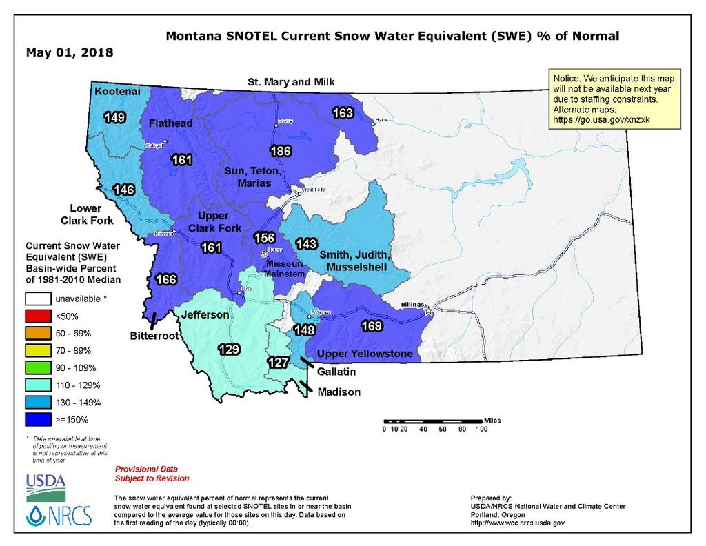
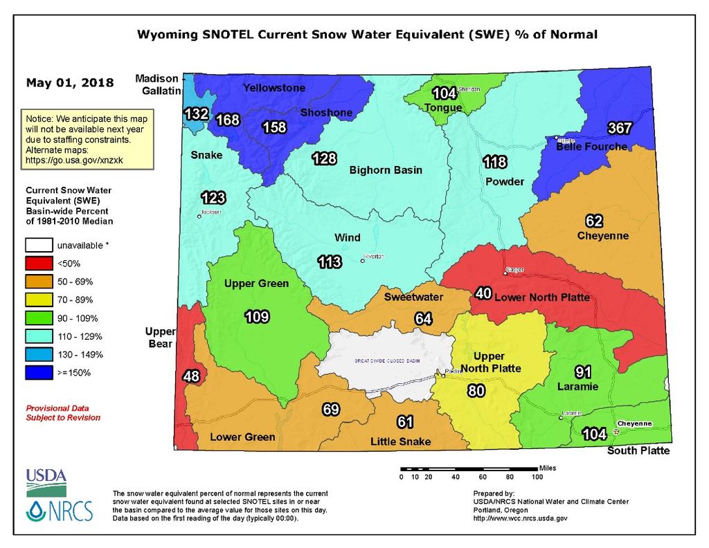
7 Plains snowpack appears to have peaked around March 7 th in most areas (Figure 8). Areas of Montana had up to 8 of SWE around March 7 th, and areas of North Dakota had up to 4 of SWE. The rest of the upper Basin had trace to 3 of SWE at that time. Figure 8. March 7, 2018 NOHRSC modeled plains snow water equivalent. Source: NOAA National Operational Hydrologic Remote Sensing Center. Mountain Snowpack Mountain snowpack is the primary factor used to predict May-July runoff volumes in the Fort Peck and Fort Peck to Garrison mainstem reservoir reaches. By May 1, mountain snowpack is a good indicator of the total May-June-July runoff. Mountain snowpack accumulation has peaked in both reaches: on April 19 th at 23.0 (141% of the normal April 15 peak) for the reach above Fort Peck Dam, and on April 15 th at 20.1 (137% of the normal April 15 peak) for the reach between Fort Peck and Garrison Dams. Figure 9 includes time series plots of the average mountain SWE beginning on October 1, 2017 based on the NRCS SNOTEL data for the headwater basin above Fort Peck and the incremental basin from Fort Peck to Garrison. The current average SWE values (shaded blue area) are plotted against the basin average SWE (bold red line), a recent low SWE year in 2001 (green line), and two historic high SWE years occurring in 1997 (purple) and 2011 (dark blue). 7

8 Figure 9. Mountain snowpack water content on May 1, 2018 compared to normal and historic conditions. Corps of Engineers - Missouri River Basin Water Management. On May 1, 2018, the Corps of Engineers computed an average mountain SWE in the Fort Peck reservoir reach of 20.2 inches (~3 less than the peak), which was 135% of average based on the average SWE for the Fort Peck reach. In the reservoir reach between Fort Peck Dam and Garrison Dam, the Corps computed an average mountain SWE of 17.7 inches (~2.5 less than the peak), which was 129% of average based on the average SWE for the Garrison reach. Based on the forecasted May precipitation and temperature for the northern Rocky Mountains over the next couple weeks, we expect mountain snowpack to continue melting at a fairly high rate in May. Climate Outlook MRBWM participates in the monthly North Central U.S. Climate/Drought Outlook Webinar coordinated through NOAA, the regional climate centers, and the American Association of State Climatologists (AASC). These webinars provide updates on near-term climate outlooks and impacts including the ENSO climate pattern and its implications on temperature and precipitation patterns in the Missouri Basin. 8

9 ENSO (El Niño Southern Oscillation) The latest ENSO Outlook indicates that La Niña conditions are present and likely to persist into the Northern Hemisphere spring. A transition from La Niña to ENSO-neutral conditions is forecasted for this spring and summer. ENSO-neutral conditions typically do not influence the chances for spring and early summer precipitation and temperatures. Temperature and Precipitation Outlooks The NOAA Climate Prediction Center (CPC) outlooks provide the forecasted probability (or chance) of occurrence of future weather conditions during periods ranging from 1 to 12 months into the future. The CPC outlooks are available at The CPC temperature outlook through May 16 in Figure 10 indicates increased chances for above-normal temperatures throughout the Basin. The precipitation outlook indicates equal chances for precipitation over the majority of the Basin. Figure 10. CPC 8-14 Day temperature and precipitation outlooks through April 16, The May CPC temperature outlook in Figure 11 indicates increased chances for above-normal temperatures over the entire Basin. With regard to precipitation, there are increased chances for above-normal precipitation extending from Wyoming into South Dakota, Nebraska, Kansas, Iowa, Missouri, and Colorado. There are equal chances for precipitation in Montana and North Dakota. 9

10 Figure 11. CPC May 2018 temperature and precipitation outlooks. During the June-July-August 2018 period in Figure 12, the CPC outlooks indicate equal chances for temperature and precipitation across most of the Missouri River Basin, with an increase in the chance for below-normal precipitation in Montana and Wyoming. Figure 12. CPC June-July-August 2018 temperature and precipitation outlooks. 10
11 Figure 13. CPC September-October-November 2018 temperature and precipitation outlooks. During the September-October-November period in Figure 13, CPC outlooks indicate increased chances for above-normal temperatures over the Basin. There are equal chances for abovenormal, normal and below-normal precipitation in the Missouri River Basin through November. During the December 2018-January 2019-February 2019 period in Figure 14, CPC outlooks indicate equal chances for temperature and precipitation over the entire Missouri River Basin. Figure 14. CPC December 2018-January 2019-February 2019 temperature and precipitation outlooks. 11
12 Summary In summary, the annual runoff forecast for the Missouri Basin above Sioux City, IA is 33.2 MAF, 131% of average. Looking short-term, we re expecting runoff in May to be above average for the Fort Peck and Garrison reaches about 150% -- due to the above-average mountain snowpack, wet soil moisture conditions, and temperature outlooks. For the lower four reaches - Oahe to Sioux City - we re forecasting near average runoff for the May July period, based on soil moisture conditions, precipitation outlooks and current runoff trends. Looking much further out September through December we re forecasting average runoff throughout the entire upper Basin. 12
13 Additional Figures 13
14 14
15 USDA NRCS National Water & Climate Center * - DATA CURRENT AS OF: May 03, :05:16 AM - Based on May 01, 2018 forecast values PRELIMINARY MISSOURI RIVER BASIN FORECASTS 50% % of max 30% 70% min 30-yr Forecast Point period (KAF) avg (KAF) (KAF) (KAF) (KAF) avg Lake Sherburne Inflow (2) MAY-JUL MAY-SEP St. Mary R at Intl Boundary (2) MAY-JUL MAY-SEP Lima Reservoir Inflow (2) MAY-JUL MAY-SEP Clark Canyon Reservoir Inflow (2) MAY-JUL MAY-SEP Jefferson R nr Three Forks (2) MAY-JUL MAY-SEP Hebgen Lake Inflow (2) MAY-JUL MAY-SEP Ennis Lake Inflow (2) MAY-JUL MAY-SEP Missouri R at Toston (2) MAY-JUL MAY-SEP Smith R bl Eagle Ck (2) MAY-JUL MAY-SEP Gibson Reservoir Inflow (2) MAY-JUL MAY-SEP Marias R nr Shelby (2) MAY-JUL MAY-SEP PRELIMINARY YELLOWSTONE RIVER BASIN FORECASTS 50% % of max 30% 70% min 30-yr Forecast Point period (KAF) avg (KAF) (KAF) (KAF) (KAF) avg West Rosebud Ck nr Roscoe (2) MAY-JUL MAY-SEP Wind R ab Bull Lake Ck MAY-JUL MAY-SEP Bull Lake Ck nr Lenore (2) MAY-JUL MAY-SEP Boysen Reservoir Inflow (2) MAY-JUL MAY-SEP Greybull R at Meeteetse MAY-JUL MAY-SEP Shell Ck nr Shell MAY-JUL MAY-SEP Bighorn R at Kane (2) MAY-JUL MAY-SEP NF Shoshone R at Wapiti MAY-JUL MAY-SEP SF Shoshone R nr Valley MAY-JUL MAY-SEP Buffalo Bill Reservoir Inflow MAY-JUL MAY-SEP Bighorn R nr St. Xavier (2) MAY-JUL MAY-SEP Little Bighorn R nr Hardin MAY-JUL MAY-SEP
16 Tongue R nr Dayton (2) MAY-JUL MAY-SEP Tongue River Reservoir Inflow (2) MAY-JUL MAY-SEP NF Powder R nr Hazelton MAY-JUL MAY-SEP Powder R at Moorhead MAY-JUL MAY-SEP Powder R nr Locate MAY-JUL MAY-SEP PRELIMINARY RAPID VALLEY UNIT FORECASTS 50% % of max 30% 70% min 30-yr Forecast Point period (KAF) avg (KAF) (KAF) (KAF) (KAF) avg Deerfield Reservoir Inflow (2) MAY-JUL Pactola Reservoir Inflow (2) MAY-JUL PRELIMINARY PLATTE RIVER BASIN FORECASTS 50% % of max 30% 70% min 30-yr Forecast Point period (KAF) avg (KAF) (KAF) (KAF) (KAF) avg North Platte R nr Northgate (2) MAY-JUL MAY-SEP Encampment R nr Encampment (2) MAY-JUL MAY-SEP Rock Ck ab King Canyon Cnl nr Arlington MAY-JUL MAY-SEP Seminoe Reservoir Inflow (2) MAY-JUL MAY-SEP Sweetwater R nr Alcova MAY-JUL MAY-SEP La Prele Ck nr Douglas MAY-JUL MAY-SEP North Platte R bl Glendo Reservoir (2) MAY-JUL MAY-SEP North Platte R bl Guernsey Reservoir (2) MAY-JUL MAY-SEP Laramie R and Pioneer Cnl nr Woods Lg (2) MAY-JUL MAY-SEP Little Laramie R nr Filmore MAY-JUL MAY-SEP Max (10%), 30%, 50%, 70% and Min (90%) chance that actual volume will exceed forecast. Averages are for the period. All volumes are in thousands of acre-feet. footnotes: 1) Max and Min are 5% and 95% chance that actual volume will exceed forecast 2) streamflow is adjusted for upstream storage 3) median value used in place of average 16
Upper Missouri River Basin January 2018 Calendar Year Runoff Forecast January 3, 2018
 Calendar Year Runoff Forecast Upper Missouri River Basin January 2018 Calendar Year Runoff Forecast January 3, 2018 Explanation and Purpose of Forecast U.S. Army Corps of Engineers, Northwestern Division
Upper Missouri River Basin February 2018 Calendar Year Runoff Forecast February 6, 2018
 Upper Missouri River Basin February 2018 Calendar Year Runoff Forecast February 6, 2018 Calendar Year Runoff Forecast Explanation and Purpose of Forecast U.S. Army Corps of Engineers, Northwestern Division
Upper Missouri River Basin December 2017 Calendar Year Runoff Forecast December 5, 2017
 Upper Missouri River Basin December 2017 Calendar Year Runoff Forecast December 5, 2017 Calendar Year Runoff Forecast Explanation and Purpose of Forecast U.S. Army Corps of Engineers, Northwestern Division
January 2011 Calendar Year Runoff Forecast
 January 2011 Calendar Year Runoff Forecast 2010 Runoff Year Calendar Year 2010 was the third highest year of runoff in the Missouri River Basin above Sioux City with 38.8 MAF, behind 1978 and 1997 which
Missouri River Basin Water Management
 Missouri River Basin Water Management US Army Corps of Engineers Missouri River Navigator s Meeting February 12, 2014 Bill Doan, P.E. Missouri River Basin Water Management US Army Corps of Engineers BUILDING
Missouri River Basin Climate Outlook 1 May Dr. Dennis Todey State Climatologist South Dakota State Univ.
 Missouri River Basin Climate Outlook 1 May 2014 Dr. Dennis Todey State Climatologist South Dakota State Univ. dennis.todey@sdstate.edu 605-688-5141 Photo taken Feb 19, 2013 General Information Providing
Missouri River Basin Water Management Monthly Update
 Missouri River Basin Water Management Monthly Update Participating Agencies 255 255 255 237 237 237 0 0 0 217 217 217 163 163 163 200 200 200 131 132 122 239 65 53 80 119 27 National Oceanic and Atmospheric
Missouri River Basin Water Management Monthly Update
 Missouri River Basin Water Management Monthly Update Participating Agencies 255 255 255 237 237 237 0 0 0 217 217 217 163 163 163 200 200 200 131 132 122 239 65 53 80 119 27 National Oceanic and Atmospheric
Midwest/Great Plains Climate-Drought Outlook September 20, 2018
 Midwest/Great Plains Climate-Drought Outlook September 20, 2018 Brian Fuchs National Drought Mitigation Center University of Nebraska-Lincoln School of Natural Resources September 20, 2018 General Information
Central Region Climate Outlook May 15, 2014
 Central Region Climate Outlook May 15, 2014 Dr. Jim Angel State Climatologist IL State Water Survey University of Illinois jimangel@illinois.edu 217-333-0729 Chicago-area flooding General Information Providing
Missouri River Basin Water Management Monthly Update
 Missouri River Basin Water Management Monthly Update Participating Agencies 255 255 255 237 237 237 0 0 0 217 217 217 163 163 163 200 200 200 131 132 122 239 65 53 80 119 27 National Oceanic and Atmospheric
Wyoming Basin & Water Supply Outlook Report March 1, 2019
 United States Department of Agriculture Natural Resources Conservation Service Wyoming Basin & Water Supply Outlook Report March 1, 2019 Forecasted stream flows for March 1 st, 2019 Basin Outlook Reports
Missouri River Basin Water Management Monthly Update
 Missouri River Basin Water Management Monthly Update Participating Agencies 255 255 255 237 237 237 0 0 0 217 217 217 163 163 163 200 200 200 131 132 122 239 65 53 80 119 27 National Oceanic and Atmospheric
Missouri River Flood Task Force River Management Working Group Improving Accuracy of Runoff Forecasts
 Missouri River Flood Task Force River Management Working Group Improving Accuracy of Runoff Forecasts Kevin Grode, P.E. Reservoir Regulation Team Lead Missouri River Basin Water Management Northwestern
Midwest and Great Plains Drought and Climate Summary 20 February 2014
 Midwest and Great Plains Drought and Climate Summary 20 February 2014 Wendy Ryan Assistant State Climatologist Colorado Climate Center Colorado State University wendy.ryan@colostate.edu 970-491-8506 General
Wyoming Basin Outlook Report Feb 1, 2019
 United States Department of Agriculture Natural Resources Conservation Service Wyoming Basin Outlook Report Feb 1, 2019 Forecasted stream flows as of Feb 1 st, 2019 Basin Outlook Reports And Federal -
Central Region Climate Outlook March20, 2014
 Central Region Climate Outlook March20, 2014 Dr. Jim Angel State Climatologist IL State Water Survey University of Illinois jimangel@illinois.edu 217-333-0729 Happy Spring Equinox! General Information
Missouri Basin Climate Outlook. 4 April 2014
 Missouri Basin Climate Outlook Dr. Dennis Todey South Dakota State Climatologist South Dakota State University 4 April, 2014 Dennis.todey@sdstate.edu 605-688-5141 4 April 2014 Gavins Point Dam July 2011
NIDIS Intermountain West Drought Early Warning System April 18, 2017
 1 of 11 4/18/2017 3:42 PM Precipitation NIDIS Intermountain West Drought Early Warning System April 18, 2017 The images above use daily precipitation statistics from NWS COOP, CoCoRaHS, and CoAgMet stations.
NIDIS Intermountain West Regional Drought Early Warning System February 7, 2017
 NIDIS Drought and Water Assessment NIDIS Intermountain West Regional Drought Early Warning System February 7, 2017 Precipitation The images above use daily precipitation statistics from NWS COOP, CoCoRaHS,
MISSOURI RIVER BASIN WATER MANAGEMENT SPRING 2019 PUBLIC MEETINGS
 MISSOURI RIVER BASIN WATER MANAGEMENT SPRING 2019 PUBLIC MEETINGS April 9 11:00 a.m. Fort Peck, MT April 9 6:00 p.m. Bismarck, ND April 10 10:00 a.m. Pierre, SD April 10 4:00 p.m. Sioux City, IA April
A Review of the 2007 Water Year in Colorado
 A Review of the 2007 Water Year in Colorado Nolan Doesken Colorado Climate Center, CSU Mike Gillespie Snow Survey Division, USDA, NRCS Presented at the 28 th Annual AGU Hydrology Days, March 26, 2008,
Oregon Water Conditions Report April 17, 2017
 Oregon Water Conditions Report April 17, 2017 Mountain snowpack continues to maintain significant levels for mid-april. By late March, statewide snowpack had declined to 118 percent of normal after starting
DK DM M EMORANDUM D ECEMBER 28, 2018 SUBJECT:
 TO: CC: FROM: SUBJECT: BOARD OF DIRECTORS M EMORANDUM D ECEMBER 28, 2018 ANDY MUELLER, GENERAL MANAGER DAVE DK KANZER, P.E. & DON MEYER, P.E. DK DM COLORADO RIVER BASIN WATER SUPPLY CONDITIONS UPDATE AND
Wyoming Basin Outlook Report June 1, 2014
 United States Department of Agriculture Natural Resources Conservation Service Wyoming Basin Outlook Report June 1, 2014 Gros Ventre Summit SNOTEL (Gros Ventre Range) Basin Outlook Reports And Federal
Great Plains and Midwest Climate Outlook February 18, 2016
 Great Plains and Midwest Climate Outlook February 18, 2016 Dr. Jim Angel State Climatologist Illinois State Water Survey University of Illinois jimangel@illinois.edu General Information Providing climate
Oregon Water Conditions Report May 1, 2017
 Oregon Water Conditions Report May 1, 2017 Mountain snowpack in the higher elevations has continued to increase over the last two weeks. Statewide, most low and mid elevation snow has melted so the basin
Wyoming Basin Outlook Report May 1, 2016
 United States Department of Agriculture Natural Resources Conservation Service Wyoming Basin Outlook Report May 1, 2016 Med Bow SNOTEL #1196 (Medicine Bow Forest above Saratoga, WY) ID O6H26S established
Midwest and Great Plains Climate and Drought Update
 Midwest and Great Plains Climate and Drought Update June 20,2013 Laura Edwards Climate Field Specialist Laura.edwards@sdstate.edu 605-626-2870 2012 Board of Regents, South Dakota State University General
Becky Bolinger Water Availability Task Force November 13, 2018
 Colorado Climate Center WATF Climate Update Becky Bolinger Water Availability Task Force November 13, 2018 COLORADO CLIMATE CENTER Water Year 2018 Colorado s Climate in Review COLORADO CLIMATE CENTER
Wind River Indian Reservation and Surrounding Area Climate and Drought Summary
 Northern Arapaho Tribe Wind River Indian Reservation and Surrounding Area Climate and Drought Summary Spring Events & Summer Outlook 2016 Wet Spring Leads To Flooding Spring was very wet across most of
Wind River Indian Reservation and Surrounding Area Climate and Drought Summary
 Northern Arapaho Tribe Wind River Indian Reservation and Surrounding Area Climate and Drought Summary Spring Events & Summer Outlook 2015 Spring Was Warm And Very Wet Across The Region The spring season
The following information is provided for your use in describing climate and water supply conditions in the West as of April 1, 2003.
 Natural Resources Conservation Service National Water and Climate Center 101 SW Main Street, Suite 1600 Portland, OR 97204-3224 Date: April 8, 2003 Subject: April 1, 2003 Western Snowpack Conditions and
Wind River Indian Reservation and Surrounding Area Climate and Drought Summary
 Northern Arapaho Tribe Wind River Indian Reservation and Surrounding Area Climate and Drought Summary Winter Events & Spring Outlook 2015-2016 Winter Was Warm And Dry Winter was warm and dry for the Wind
Weather and Climate Summary and Forecast March 2018 Report
 Weather and Climate Summary and Forecast March 2018 Report Gregory V. Jones Linfield College March 7, 2018 Summary: The ridge pattern that brought drier and warmer conditions from December through most
Montana Drought & Climate
 Montana Drought & Climate MARCH 219 MONITORING AND FORECASTING FOR AGRICULTURE PRODUCERS A SERVICE OF THE MONTANA CLIMATE OFFICE IN THIS ISSUE IN BRIEF PAGE 2 REFERENCE In a Word PAGE 3 REVIEW Winter 219:
Midwest and Great Plains Climate- Drought Outlook 17 April 2014
 Midwest and Great Plains Climate- Drought Outlook 17 April 2014 Dr. Dennis Todey State Climatologist South Dakota State Univ. dennis.todey@sdstate.edu 605-688-5141 Photo taken Feb 19, 2013 Tornado-Trenton,
Wind River Indian Reservation and Surrounding Area Climate and Drought Summary
 Northern Arapaho Tribe Wind River Indian Reservation and Surrounding Area Climate and Drought Summary Summer Events & Fall Outlook 2015 Summer Was Near, Precipitation Was Highly Variable Across The Region
March 1, 2003 Western Snowpack Conditions and Water Supply Forecasts
 Natural Resources Conservation Service National Water and Climate Center 101 SW Main Street, Suite 1600 Portland, OR 97204-3224 Date: March 17, 2003 Subject: March 1, 2003 Western Snowpack Conditions and
Weather and Climate Summary and Forecast February 2018 Report
 Weather and Climate Summary and Forecast February 2018 Report Gregory V. Jones Linfield College February 5, 2018 Summary: For the majority of the month of January the persistent ridge of high pressure
NIDIS Intermountain West Drought Early Warning System February 12, 2019
 NIDIS Intermountain West Drought Early Warning System February 12, 2019 Precipitation The images above use daily precipitation statistics from NWS COOP, CoCoRaHS, and CoAgMet stations. From top to bottom,
NIDIS Drought and Water Assessment
 NIDIS Drought and Water Assessment PRECIPITATION The images above use daily precipitation statistics from NWS COOP, CoCoRaHS, and CoAgMet stations. From top to bottom, and left to right: most recent 7-days
Midwest and Great Plains Climate- Drought Outlook 16 April 2015
 Midwest and Great Plains Climate- Drought Outlook 16 April 2015 Dr. Dennis Todey State Climatologist South Dakota State Univ. dennis.todey@sdstate.edu 605-688-5141 Photo taken Feb 19, 2013 Wildfire Wind
Webinar and Weekly Summary February 15th, 2011
 Webinar and Weekly Summary February 15th, 2011 -Assessment of current water conditions - Precipitation Forecast - Recommendations for Drought Monitor Upper Colorado Normal Precipitation Upper Colorado
Weather and Climate Summary and Forecast Winter
 Weather and Climate Summary and Forecast Winter 2016-17 Gregory V. Jones Southern Oregon University February 7, 2017 What a difference from last year at this time. Temperatures in January and February
Weather and Climate Summary and Forecast December 2017 Report
 Weather and Climate Summary and Forecast December 2017 Report Gregory V. Jones Linfield College December 5, 2017 Summary: November was relatively cool and wet from central California throughout most of
Doug Kluck NOAA Kansas City, MO National Center for Environmental Information (NCEI) National Integrated Drought Information System (NIDIS)
 National Integrated Drought Information System (NIDIS)") National Integrated Drought Information System (NIDIS) for the Missouri River Basin Drought Early Warning Information System (DEWS) & Runoff Trends in the Missouri Basin & Latest Flood Outlook Doug Kluck
National Integrated Drought Information System (NIDIS) for the Missouri River Basin Drought Early Warning Information System (DEWS) & Runoff Trends in the Missouri Basin & Latest Flood Outlook Doug Kluck
Highlights of the 2006 Water Year in Colorado
 Highlights of the 2006 Water Year in Colorado Nolan Doesken, State Climatologist Atmospheric Science Department Colorado State University http://ccc.atmos.colostate.edu Presented to 61 st Annual Meeting
NIDIS Intermountain West Drought Early Warning System January 15, 2019
 NIDIS Drought and Water Assessment NIDIS Intermountain West Drought Early Warning System January 15, 2019 Precipitation The images above use daily precipitation statistics from NWS COOP, CoCoRaHS, and
Colorado s 2003 Moisture Outlook
 Colorado s 2003 Moisture Outlook Nolan Doesken and Roger Pielke, Sr. Colorado Climate Center Prepared by Tara Green and Odie Bliss http://climate.atmos.colostate.edu How we got into this drought! Fort
NIDIS Intermountain West Drought Early Warning System February 6, 2018
 NIDIS Intermountain West Drought Early Warning System February 6, 2018 Precipitation The images above use daily precipitation statistics from NWS COOP, CoCoRaHS, and CoAgMet stations. From top to bottom,
Great Plains and Midwest Drought Impacts and Outlook May 16, 2013
 Great Plains and Midwest Drought Impacts and Outlook May 16, 2013 Dr. Martha Shulski Director, High Plains Regional Climate Center University of Nebraska - Lincoln mshulski3@unl.edu 402-472-6711 May snow
2003 Moisture Outlook
 2003 Moisture Outlook Nolan Doesken and Roger Pielke, Sr. Colorado Climate Center Prepared by Tara Green and Odie Bliss http://climate.atmos.colostate.edu Through 1999 Through 1999 Fort Collins Total Water
INVISIBLE WATER COSTS
 Every Drop Every Counts... Drop Counts... INVISIBLE WATER COSTS Corn - 108.1 gallons per pound How much water it takes to produce... Apple - 18.5 gallons to grow Beef - 1,581 gallons per pound Oats - 122.7
Wind River Indian Reservation and Surrounding Area Climate and Drought Summary
 Northern Arapaho Tribe Wind River Indian Reservation and Surrounding Area Climate and Drought Summary Fall Events & Winter Outlook 2016-2017 Warm And Wet Fall The fall season was warm and very wet throughout
National Wildland Significant Fire Potential Outlook
 National Wildland Significant Fire Potential Outlook National Interagency Fire Center Predictive Services Issued: September, 2007 Wildland Fire Outlook September through December 2007 Significant fire
Summary of Actual Operations
 Missouri River Region US Army Corps of Engineers Since 1953 Reservoir Control Center Northwestern Division Missouri River Region Reservoir Control Center Missouri River Basin Fort Peck Montana Garrison
Modeling of peak inflow dates for a snowmelt dominated basin Evan Heisman. CVEN 6833: Advanced Data Analysis Fall 2012 Prof. Balaji Rajagopalan
 Modeling of peak inflow dates for a snowmelt dominated basin Evan Heisman CVEN 6833: Advanced Data Analysis Fall 2012 Prof. Balaji Rajagopalan The Dworshak reservoir, a project operated by the Army Corps
NIDIS Intermountain West Drought Early Warning System December 11, 2018
 NIDIS Drought and Water Assessment NIDIS Intermountain West Drought Early Warning System December 11, 2018 Precipitation The images above use daily precipitation statistics from NWS COOP, CoCoRaHS, and
Flood Risk Assessment
 Flood Risk Assessment February 14, 2008 Larry Schick Army Corps of Engineers Seattle District Meteorologist General Assessment As promised, La Nina caused an active winter with above to much above normal
Weather and Climate Summary and Forecast January 2018 Report
 Weather and Climate Summary and Forecast January 2018 Report Gregory V. Jones Linfield College January 5, 2018 Summary: A persistent ridge of high pressure over the west in December produced strong inversions
Drought and Future Water for Southern New Mexico
 Drought and Future Water for Southern New Mexico David S. Gutzler University of New Mexico gutzler@unm.edu * The big drought of 2018 * Longer term challenges for water supply * Forecasting streamflow Elephant
Water Supply Conditions and Outlook October 1, 2018
 Water Supply Conditions and Outlook October 1, 2018 Flow Forecasting & Operations Planning Water Security Agency Overview Water supply conditions across Saskatchewan remain near normal, with most reservoirs
Wyoming Basin Outlook Report March 1, 2014
 United States Department of Agriculture Natural Resources Conservation Service Wyoming Basin Outlook Report March 1, 2014 Sandstone RS SNOTEL (Sierra Madre Range) Basin Outlook Reports And Federal - State
NIDIS Intermountain West Drought Early Warning System November 21, 2017
 NIDIS Drought and Water Assessment NIDIS Intermountain West Drought Early Warning System November 21, 2017 Precipitation The images above use daily precipitation statistics from NWS COOP, CoCoRaHS, and
Precipitation. Standardized Precipitation Index. NIDIS Intermountain West Regional Drought Early Warning System January 3, 2017
 1/3/2017 NIDIS Drought and Water Assessment NIDIS Intermountain West Regional Drought Early Warning System January 3, 2017 Precipitation The images above use daily precipitation statistics from NWS COOP,
Summary of Actual 2010 Regulation
 US Army Corps of Engineers Northwestern Division Missouri River Mainstem Reservoir System Summary of Actual 2010 Regulation Missouri River Basin Fort Peck Garrison Oahe Big Bend Gavins Point Fort Randall
NIDIS Intermountain West Drought Early Warning System April 16, 2019
 NIDIS Intermountain West Drought Early Warning System April 16, 2019 Precipitation The images above use daily precipitation statistics from NWS COOP, CoCoRaHS, and CoAgMet stations. From top to bottom,
Sierra Weather and Climate Update
 Sierra Weather and Climate Update 2014-15 Kelly Redmond Western Regional Climate Center Desert Research Institute Reno Nevada Yosemite Hydroclimate Workshop Yosemite Valley, 2015 October 8-9 Percent of
Monthly Long Range Weather Commentary Issued: APRIL 1, 2015 Steven A. Root, CCM, President/CEO
 Monthly Long Range Weather Commentary Issued: APRIL 1, 2015 Steven A. Root, CCM, President/CEO sroot@weatherbank.com FEBRUARY 2015 Climate Highlights The Month in Review The February contiguous U.S. temperature
Drought in Southeast Colorado
 Drought in Southeast Colorado Nolan Doesken and Roger Pielke, Sr. Colorado Climate Center Prepared by Tara Green and Odie Bliss http://climate.atmos.colostate.edu 1 Historical Perspective on Drought Tourism
Weather and Climate Summary and Forecast Winter
 Weather and Climate Summary and Forecast Winter 2016-17 Gregory V. Jones Southern Oregon University December 5, 2016 Well after an October that felt more like November, we just finished a November that
North Central U.S. Climate Summary & Outlook May 19, 2016
 North Central U.S. Climate Summary & Outlook May 19, 2016 Golf course Lincoln, NE Image courtesy Terry Sohl Hailstones Lincoln, NE Image courtesy Andrew Ozaki EF1 tornado Lincoln, NE May 9 Photo by Bill
NIDIS Intermountain West Drought Early Warning System May 23, 2017
 NIDIS Drought and Water Assessment NIDIS Intermountain West Drought Early Warning System May 23, 2017 Precipitation The images above use daily precipitation statistics from NWS COOP, CoCoRaHS, and CoAgMet
Climate Outlook through 2100 South Florida Ecological Services Office Vero Beach, FL September 9, 2014
 Climate Outlook through 2100 South Florida Ecological Services Office Vero Beach, FL September 9, 2014 Short Term Drought Map: Short-term (
Reservoir Control Center U. S Army Corps of Engineers Northwestern Division - Missouri River Basin Omaha, Nebraska
 US Army Corps of Engineers Fort Peck Garrison Oahe Big Bend Gavins Point Ft. Randall Reservoir Control Center U. S Army Corps of Engineers Northwestern Division - Missouri River Basin Omaha, Nebraska April
What does the El Niño have in store for the Upper Colorado Basin?
 What does the 2015-16 El Niño have in store for the Upper Colorado Basin? Klaus Wolter NOAA-Earth System Research Lab & University of Colorado at Boulder-CIRES klaus.wolter@noaa.gov El Niño: Current situation
-Assessment of current water conditions. - Precipitation Forecast. - Recommendations for Drought Monitor
 April 27, 2010 -Assessment of current water conditions - Precipitation Forecast - Recommendations for Drought Monitor 7 Day Precipitation 19-25 April 2010 Month-to-Date Precipitation 1-25 April 2010
Wind River Indian Reservation and Surrounding Area Climate and Drought Summary
 Northern Arapaho Tribe Wind River Indian Reservation and Surrounding Area Climate and Drought Summary Winter Events & Spring Outlook 2016-2017 Cool Temperatures and Record-Breaking Wetness During Winter
PRECIPITATION. Last Week Precipitation:
 12/3/2014 NIDIS Drought and Water Assessment PRECIPITATION The images above use daily precipitation statistics from NWS COOP, CoCoRaHS, and CoAgMet stations. From top to bottom, and left to right: most
Midwest and Great Plains Climate & Drought Outlook 16 November 2017
 Midwest and Great Plains Climate & Drought Outlook 16 November 2017 Jim Angel IL State Climatologist University of Illinois Champaign, IL jimangel@illinois.edu 217-333-0729 Harvest underway in Illinois
Great Lakes Update. Volume 193: 2015 January through June Summary. Vol. 193 Great Lakes Update August 2015
 Great Lakes Update Volume 193: 2015 January through June Summary The U.S. Army Corps of Engineers (USACE) monitors the water levels of each of the Great Lakes. This report provides a summary of the Great
Midwest and Great Plains Climate- Drought Outlook 19 November 2015
 Midwest and Great Plains Climate- Drought Outlook 19 November 2015 Dr. Dennis Todey State Climatologist South Dakota State Univ. dennis.todey@sdstate.edu 605-688-5678 Photo taken Feb 19, 2013 SDSU Campus
Preliminary Runoff Outlook February 2018
 Preliminary Runoff Outlook February 2018 Prepared by: Flow Forecasting & Operations Planning Water Security Agency General Overview The Water Security Agency (WSA) is preparing for 2018 spring runoff including
Midwest/Great Plains Climate-Drought Outlook August 17, 2017
 Midwest/Great Plains Climate-Drought Outlook August 17, 2017 Brian Fuchs National Drought Mitigation Center University of Nebraska-Lincoln School of Natural Resources General Information Providing climate
NIDIS Intermountain West Drought Early Warning System February 19, 2019
 NIDIS Intermountain West Drought Early Warning System February 19, 2019 Precipitation The images above use daily precipitation statistics from NWS COOP, CoCoRaHS, and CoAgMet stations. From top to bottom,
Monthly Long Range Weather Commentary Issued: February 15, 2015 Steven A. Root, CCM, President/CEO
 Monthly Long Range Weather Commentary Issued: February 15, 2015 Steven A. Root, CCM, President/CEO sroot@weatherbank.com JANUARY 2015 Climate Highlights The Month in Review During January, the average
Seasonal Outlook through September 2007
 Seasonal Outlook through September 2007 Klaus Wolter (15may) University of Colorado, CIRES & NOAA-ESRL Climate Analysis Branch klaus.wolter@noaa.gov http://www.cdc.noaa.gov/people/klaus.wolter/swcasts/
Kootenai Basin Water Supply Update and Sturgeon Flow Augmentation Kootenai Valley Resource Initiative
 Kootenai Basin Water Supply Update and Sturgeon Flow Augmentation Kootenai Valley Resource Initiative Greg Hoffman Fishery Biologist / Kootenai River Basin Flood Engineer Libby Dam 15 May 2017 US Army
NIDIS Intermountain West Drought Early Warning System January 16, 2018
 NIDIS Drought and Water Assessment NIDIS Intermountain West Drought Early Warning System January 16, 2018 Precipitation The images above use daily precipitation statistics from NWS COOP, CoCoRaHS, and
Midwest and Great Plains Climate- Drought Outlook 21 August 2014
 Midwest and Great Plains Climate- Drought Outlook 21 August 2014 Dr. Jeff Andresen State Climatologist Michigan State University andresen@msu.edu 517-432-4756 Flooding along I-696 in Warren, MI 11 AUG
Great Plains and Midwest Climate Outlook 18 December 2014
 Great Plains and Midwest Climate Outlook 18 December 2014 Wendy Ryan Assistant State Climatologist Colorado State University wendy.ryan@colostate.edu 30 Nov 2014 Looking down at the Yampa Valley near Steamboat
NIDIS Intermountain West Drought Early Warning System November 14, 2017
 NIDIS Intermountain West Drought Early Warning System November 14, 2017 Precipitation The images above use daily precipitation statistics from NWS COOP, CoCoRaHS, and CoAgMet stations. From top to bottom,
A Review of the 2003 Water Year in Colorado
 Hydrology Days 24 A Review of the 23 Water Year in Colorado Nolan J. Doesken 1 Colorado Climate Center, Atmospheric Science Department, Colorado State University, Fort Collins, Colorado Michael A. Gillespie
NIDIS Intermountain West Drought Early Warning System December 18, 2018
 NIDIS Intermountain West Drought Early Warning System December 18, 2018 Precipitation The images above use daily precipitation statistics from NWS COOP, CoCoRaHS, and CoAgMet stations. From top to bottom,
Weather and Climate Summary and Forecast November 2017 Report
 Weather and Climate Summary and Forecast November 2017 Report Gregory V. Jones Linfield College November 7, 2017 Summary: October was relatively cool and wet north, while warm and very dry south. Dry conditions
MDA WEATHER SERVICES AG WEATHER OUTLOOK. Kyle Tapley-Senior Agricultural Meteorologist May 22, 2014 Chicago, IL
 MDA WEATHER SERVICES AG WEATHER OUTLOOK Kyle Tapley-Senior Agricultural Meteorologist May 22, 2014 Chicago, IL GLOBAL GRAIN NORTH AMERICA 2014 Agenda Spring Recap North America Forecast El Niño Discussion
National Wildland Significant Fire Potential Outlook
 National Wildland Significant Fire Potential Outlook National Interagency Fire Center Predictive Services Issued: April 1, 2008 Next Issue: May 1, 2008 Wildland Fire Outlook April 2008 through July 2008
Weather and Climate Summary and Forecast Summer into Harvest 2016
 Weather and Climate Summary and Forecast Summer into Harvest 2016 Gregory V. Jones Southern Oregon University September 3, 2016 With school and football season starting a hint of fall is right on time
NIDIS Intermountain West Drought Early Warning System January 22, 2019
 NIDIS Drought and Water Assessment NIDIS Intermountain West Drought Early Warning System January 22, 2019 Precipitation The images above use daily precipitation statistics from NWS COOP, CoCoRaHS, and