Winter of was an exceptionally mild winter over most of the country because of the super powerful El Nino event. The month of December 2016
|
|
|
- Stewart Woods
- 5 years ago
- Views:
Transcription

1 This Winter forecast has already undergone some significant changes. When I initially began the Winter outlook during the middle of October, I was significantly more "bullish" on the overall winter than I am now. The appearance and persistent position of the Polar Vortex (PV) in Siberia and the enhanced Pacific jet stream over the past few weeks are somewhat troubling signs. That being said I am not bearish or fading (to use trading terms) the winter of especially over the central and eastern CONUS. But the appearance of these two important factors in November along with some strange behavior by the QB0, do have me somewhat concerned with respect to WHEN the winter pattern is going to setup and how severe it may or may not be. What you will not see in this winter forecast are predictions for snow fall amounts. In dealing with seasonal forecast it is hard enough to figure things out without having a guess about snowfall amounts for particular cities / regions. I know a lot of TVmets do this sort of thing as do some private forecasters, but here at WxRisk.com,we do not BS. If you want to skip all the science (I dont know WHY anyone would want to do such a thing but there are some freaks out) use the other link, or scroll down to the end of this report. However, it is our view that doing the science and going through the steps is as important as coming up with the right answer. A lot of people don't understand this as the emphasis in our culture is on getting the right answer. For example If I forecast the winter pattern based upon the number of socks in my dresser draw and the forecast turns out to be correct it doesn't mean my technique was scientifically based and/ or it can be used in the future.


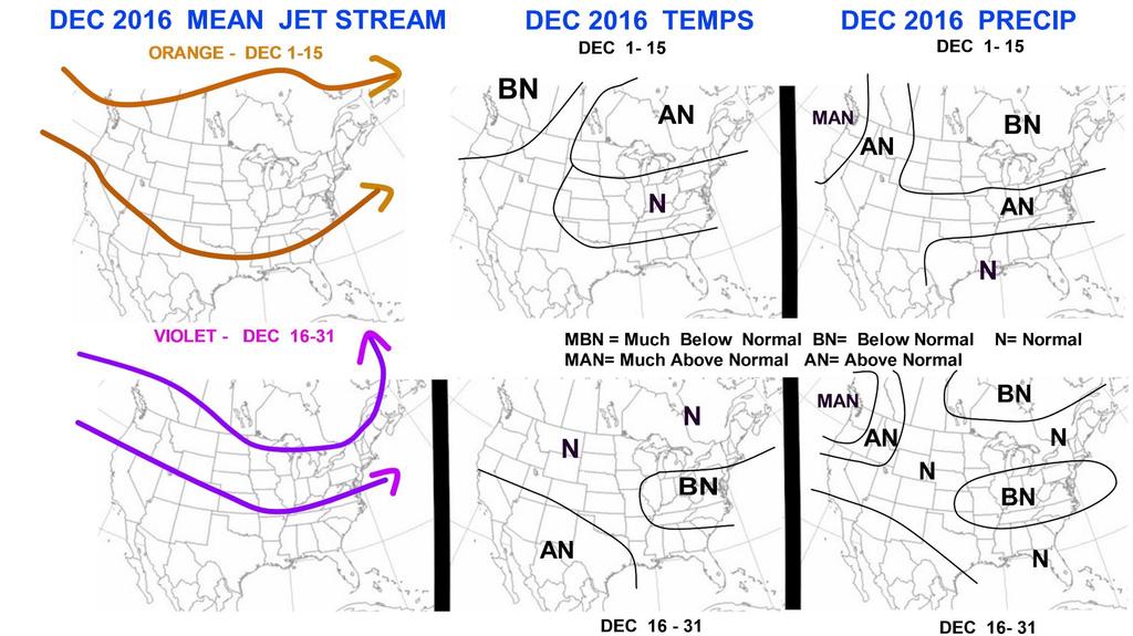
2 Winter of was an exceptionally mild winter over most of the country because of the super powerful El Nino event. The month of December 2016 may have been one of the warmest Decembers on records especially east of Mississippi River. The super El Nino event has faded but there is still some residual warmth left in the atmosphere. Even though there was a massive snowstorm on the East Coast at the end of January 2016, most of the country saw below normal snowfall as well.
3 The main issue for this winter will be a weak La Nina event but even that presents a lot of uncertainty as to whether not it is going to continue through the Winter or fade to neutral conditions as we begin the heart of the Winter. Perhaps the biggest dilemma of the winter -especially for the first half - is the appearance / position of the polar vortex (PV) centered not in western hemisphere but over in Siberia on the Russian side of the Arctic circle. Having the PV in that location is a very bad sign for those hoping for an early start of the winter over any portion of North America. KEY FEATURES The weak La Nina event - generally a neutral or favorable factor over the central and eastern U.S. with regard to running either an average or above normal and temperatures running either average or below normal The near record snowpack over Siberia in October 2016 which is spread rapidly westward into central and Western Russia over the past two weeks. - a favorable factor over the central and eastern U.S. with regard to running either an average or above normal and temperatures running either average or below normal The strong indications for high latitude blocking patterns - a favorable factor over the central and eastern U.S. with regard to running either an average or above normal and temperatures running either Below Normal or much below normal The weakening and decreasing amount of solar activity - generally a neutral or favorable factor over the central and eastern U.S. with regard to running either an average or above normal and temperatures running either average or below normal The development of a large pool of warm ocean water temperature anomalies in the northern Pacific. - favorable factor over the central and eastern U.S. with regard to running either an average or above normal and temperatures running either average or below normal
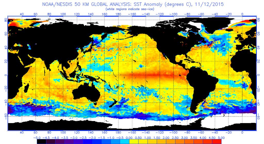
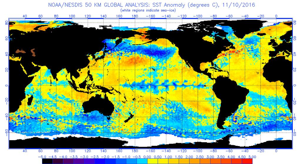
4 NEGATIVE FACTORS The early season development of a the POLAR VORTEX (PV) overnorthern Siberia and locking into that position. This can be considered to be a unfavorable, if not hostile factor, with regard to seeing either average or above normal snowfall. Temperatures will likely run either average or Above normal for the central and eastern U.S as long as the PV stays in Siberia. This is considered to be a positive factor however for the western third of the CONUS with respect to Above Normal precipitation and Below normal temps. That being said it needs to be kept in mind that it is still mid November and the odds significantly favor the PV shifting from its current position in northern Siberia. The very strong enhanced Pacific jet which is dominating the northern hemisphere pattern - this can be considered to be a unfavorable if not hostile factor with regard to seeing either average or above normal snowfall for the central and eastern U.S.. Temperatures will likely run either average or Above normal for the central and eastern U.S as long as Pacific jet continues to be enhanced. In the weather biz, this is often call the Pacific Jet firehose. This is considered to be a positive factor however for the western third of the CONUS with respect to Above Normal precipitation and Below normal temps. But again it is still early and the odds significantly favor strong Pacific jet stream breaking down and allowing for a significant change in the pattern at some point during the winter season. DETAILED DISCUSSION The weak La Nina event These two images show comparison between the global sea surface temperature anomalies (SSTA) from DEC 2015 and early November The most important feature of course is along the equatorial Pacific or the large area of above normal sea surface temperature anomalies can be clearly seen. The contrast with the area of below Normal Sea surface temperatures in the current November 2016 map is quite striking.
5

6 This image shows a comparison of the subsurface conditions along the equatorial Pacific across the various ENSO regions. The cold water is fairly deep underneath the surface but it is not particularly intense and is rather indicative of a weak La Nina event. This next image shows the current plots of the various ENSO regions along the equatorial Pacific. Notice that over the past 30 days only the region known as ENSO 3.4 has been close to the minimum threshold for weak La Nina conditions.
7 So the question now becomes what happens to this weak La Nina event as we move into the winter months.? Most of Model data suggests that the current weak La Nina is going to break down and dissipate early in the winter and that most of the winter will see near neutral conditions. Other data suggests that the weak La Nina will hold on for most of the winter only dissipating in February So let's consider the two possibilities.

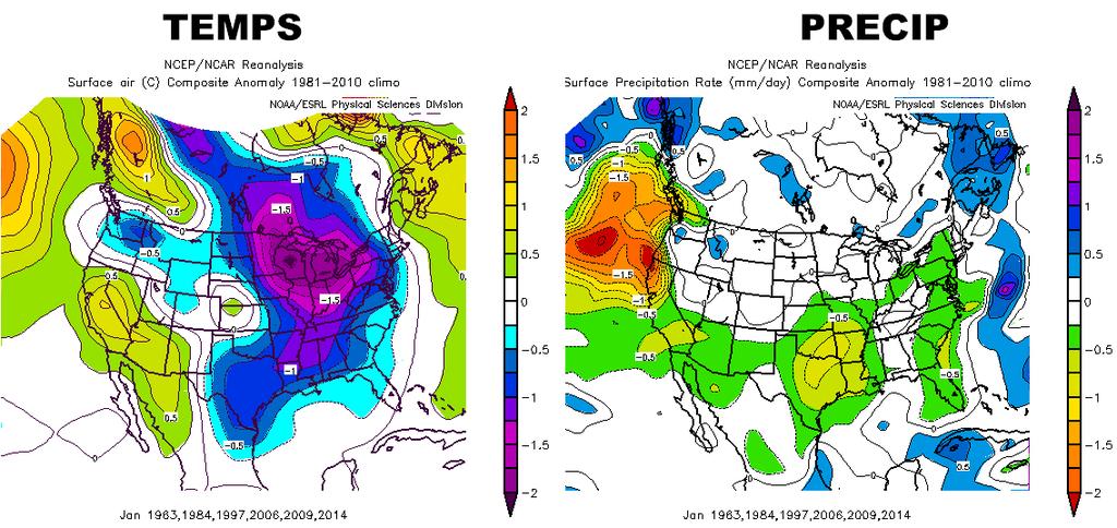
8 LA NINA DISSIPATES IN DECEMBER 2016 If we take a look at all the seasons where there has ben a weak La Nina in the Autumn which dissipated during the Winter months we come up the following analog years The first map shows the overall pattern for those winter analogs and we can see a persistent deep trough covering most of the central and eastern CONSU that favors a cold and potentially stormy winter pattern. In addition most of western and central Europe also appears to be quite cold and stormy. This sort of pattern supports strong blocking across the arctic regions, especially over Greenland and Scandinavia as well as the Bering Sea. If we break this down month by month, we see that the Jet stream patterns remain quite impressive with a massive deep longwave trough over the central and eastern portions of the CONUS as well as western/ central Europe. The analog of Winters that featured weak La Nina in Autumn that dissipated in the Winter suggests that the Month of February could be particularly cold and stormy for the eastern half of the CONUS. This map shows temperatures and precipitation for the selected analog years. Notice that the lower Plains look to be fairly dry. However temperatures are quite cold relative to normal over all the Midwest and the interior portions of the East Coast.


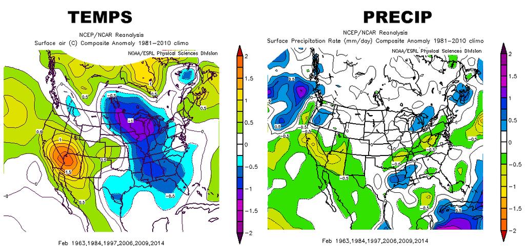
9 Taking a look at the temperatures and precipitation for December, January and February it appears that December is particularly cold and wet especially along the East Coast and quite cold over the upper Midwest and much of Canada. According to this analog, January features large areas of below normal temperatures across all the Midwest and most of the East Coast with near normal or slightly below normal precipitation. Over the lower Plains and the Delta region, it appears to be somewhat drier than normal. February appears to show the large area of cold temperatures diminishing and much of the lower Midwest and portions of the East Coast turning somewhat drier than normal.
10

11 WEAK LA NINA LASTS THROUGH THE WINTER Now let's take a look at what happens if the weak La Nina event stays on through the heart of the winter. The analog years are the winter of This image shows the overall large scale pattern over the northern hemisphere for those analog years. As you can see the pattern features a deep and persistent trough over Western Canada into the Rockies and the upper Plains. The RIDGE position is not on the West Coast, but over eastern Pacific Ocean which is not favorable for winter weather lovers over the eastern U.S. In addition, notice that there is some sort of Ridge over far southern Greenland and central north Atlantic. This is often mistaken as a Greenland block or a negative phase of the NAO. However to call this feature a Greenland block or -NAO would be a serious mistake. This kind of positive Height anomaly supports a North Atlantic THUMB Ridge which is not the classic / Greenland block -NAO. In the overall sense this sort of pattern would support a favorable winter pattern for the Rockies Upper Plains and Midwest but not the East Coast. It is not a terrible pattern for winter weather lovers over the eastern US --just not ideal. As you can see temperatures run below Normal over the northern 25% of the country with temperature actually above normal over the Deep South. Precipitation is near normal everywhere.


12 That being said the weak La Nina analog years , , , , is a pretty mixed collection of very different types the winters. If we take a look at these weak La Nina Winters with a little more focus, we notice that many of these years were actually winters which featured prolonged La Nina events that had been going on for over year and some of these analogs La Nina events were are actually much stronger at one point in the cycle. So not all of these weak La Nina analog years are good matches to the current situation. If we keep in mind that we have come out of a fairly strong El Nino event from last winter,which finally ended in the Spring of 2016, with near neutral conditions for the Summer of 2016,.which have now developed into weak La Nina conditions in the Autumn, we find three close analog matches.: The winters of , , and This image shows the overall large scale hemispheric pattern for those three analog winters. It is similar to the previous analog which featured all the winters that had weak La Nina events but with one major change. The north Atlantic thumb ridge appears to be much stronger and much larger and could now be considered a legitimate Greenland block /-NAO feature.
13 The temperature patterns show much colder conditions across the Great Lakes and the Northeast U.S. While the lower Plains and the Southwestern states stay fairly mild. Precipitation appears to be above normal over the Middle Atlantic region and the Pacific Northwest.

14 The near record snowpack over Siberia in October 2016 The data from October 2016 shows that the Siberian snow cover was extensive and near record. In fact it came in as the third greatest snow cover for the month of October over Siberia on record. The reason why this is important is because the expansion of the snow cover especially south of 60 N latitude in the month of October, seems to have some sort of correlation to development of blocking patterns in the Jet stream over the Arctic region. This in turn ends up impacting the weather patterns over all of North America especially in the second half of the Winter into early Spring. The technical name for this phenomenon is called the Siberian Advance Index or SAI.


15 There are of course exceptions to this. Last winter for example we have the raging super El Nino so even though the snow cover was fairly extensive for the month of October 2015 over Siberia, the SAI had little impact. In addition the extensive or geographical size of the snow cover in Siberia was also extreme during the month of October This aspect of the snow cover in Siberia is known as the Snow Cover Extent or SCE. It does not get as much attention as the SAI but the SCE in out view is quite important. One can have what would seems to have a favorable overall hemispheric pattern which appears deliver cold air and winter storms for the central and eastern portions of the CONUS. But if the supply of cold air coming from Siberia is weak, the cross polar flow from Siberia across the Arctic region into Canada can become problem for setting up the classic winter storms (which require a large supply of Polar or Arctic air).
16 So in summary both the SAI and SCE numbers and correlations are very strong positive with respect to the potential for this winter over the central and eastern U.S.. The strong indications for high latitude blocking patterns AO/ Arctic Oscillation The Arctic Oscillation is a climate index or major weather pattern (atmospheric circulation ) that plays a huge role in weather pattern over the entire northern Hemisphere. The AO's impact is especially significant from October to April. The AO has so-called positive and negative phases. When the Arctic Oscillation is in the negative phase, cold Arctic air masses tend to plunge southward and into the U.S., spawning snowstorms and leading to colder than average conditions. This is because a Negative AO will a weaker PV (Polar Vortex) OR several mid size PV OR a PV that is strong but displaced well to the south. A positive phase for Arctic Oscillation, by contrast, tends to mean warmer than average weather with less snow for the eastern U.S. This is because a Positive AO means large strong PV over the Arctic regions / and or Greenland which locks up he cold to the north and prevents the northern jet stream from merging with the southern jet stream (it is this phasing or merging of the 2 Jet streams that create big winters storms). Research has long established that the phase of the Arctic Oscillation during the month of October is often a indicator of what phase the AO is more likely to average during the course of the winter months of DJF. There is some uncertainty as to why this is the case but the data is pretty strong that there seems to be some sort a correlation. Assuming this is correct, if we take a look of the Arctic Oscillation over the past 5 months, we see a very strong and noticeable dip in the AO into the Negative phase during the month of October. The Arctic Oscillation can vary considerably on short timescales, such as within a single month or from one month to the next, and the causes of its variability aren t entirely known. It was largely positive during the winter of

17 2007-8, which followed the previous sea ice record low, and then turned record negative during the winter of , during which the infamous Snowmageddon blizzard occurred along the East Coast. It was then largely negative during the winter of , and positive to weakly negative last winter, which was the mildest winter on record for the U.S. The weakening and decreasing amount of solar activity Research and actual observations have shown that weak or low solar activity tends to be correlated with frequent blocking pattern in the Jet stream at the high-latitudes. Currently the Sun is now experiencing one of the weakest solar cycles (#24) in more than a century. Moreover as you can see from this image the already weak solar cycle is headed rapidly towards the next solar Min - usually the least active time in a given cycle. If we take a closer look at this sun cycle chart will see something quite significant. Notice that the solar / Sun minimum occurred in or all winters which featured extreme cold and some serious snow storms across portions of the Midwest and the East Coast. In particular the winters of and the winter of featured major East Coast and Midwest snow storms that set records for seasonal snowfall and many areas. This also has some significance for the future winters as it looks like the Sun will be reaching a strong negative solar minimum in the winter of

18 The development of a large pool of warm ocean water temperature anomalies in the northern Pacific. Besides the weak La Nina there is another important feature in the Northern Pacific Ocean that deserves considerable attention. The severe historic winter of was totally and completely under forecasted by CPC (Climate Prediction Center) and by most if not all private forecasters. The driving factor in that surprisingly severe and cold winter was a development of a large pool of warm sea surface temperature anomalies (SSTAs) in the Gulf of Alaska and the northeast Pacific Ocean. This feature helped to bring about a somewhat rare and not well known weather pattern in the jet stream known as the +TNH or positive phase of the Tropical Northern Hemisphere pattern. This pattern is frequently confused with the much better known jet stream pattern known as +PNA. This image shows the development of a large pool of extremely warm SSTAs in the northeastern Pacific that appear in October This feature persisted right through the winter... and into most of Indeed this feature what actually contributed to the colder than normal and fairly stormy winter of All that being said let's focus on what is going on in the northern Pacific in October and November This map from beginning of October 2016 showed that another large pool of exceptionally warm SSTAs had developed over the Northeast Pacific Ocean in and around the Gulf of Alaska. This is very similar to we saw in the Autumn of This has led to some speculation from some forecasters that the pattern may be a repeat of the severe winter of That assumption has some validity to it but that assumes that the large pool of warm SSTAs in the northeast Pacific does not fade and that it last into the winter months.


19 The problem is that because of the overall pattern across the Pacific Ocean over the last 30 days, the large pool of warm sea surface temperatures in the northeast Pacific weakened considerably. The strong Pacific jet stream and a series of major systems moving across the northern Pacific Ocean has caused "upwelling" which is turns has severely weakened this large pool of warm sea surface temperatures. These two images show that changes over the last 30days - from mid October to mid November. Over the last 30 days we can see that the warm waters over the northeast Pacific have almost completely diminished.

20 If the overall pattern begins to change across the northern Pacific over the next two or three weeks, it is still possible that the pool of warm SSTAs will hang on and even Re-intensify as we move into the heart of the winter. If this were to happen it would greatly enhance the probability of a colder than normal and snowier than normal winter for portions of the central and eastern U.S.. Obviously this variable is going to be very important to watch over the next few weeks. The early season development of a the POLAR VORTEX (PV) over northern Siberia and locking into that position - The very strong enhanced Pacific jet which is dominating the northern hemisphere pattern It is hard to overstate how critically important the position of the PV being located over Siberia is with respect to the overall winter pattern to the northern hemisphere pattern in general and the western hemisphere pattern specifically. For those looking for an early start to the winter having the PV situated in eastern Siberia is thee kiss of death. Here is why 1. First it pulls all the arctic air out of the northern regions of Canada and the arctic region itself. The numerous stories which have appeared in the media recently about the exceptional warmth relative to normal over the

21 arctic region is in part attributable to the unusual position of the Polar Vortex that is currently located in Siberia. 2. Having the PV in eastern Siberia ensures that the Pacific jet that leaves China and Japan will streak across the Northern Pacific Ocean with enhanced with velocities and intensity. This image shows the impact of the deep PV over in Siberia is having on the Pacific jet stream. This image shows that the civic jet stream has been running at 200 knots or 250+ mph. It is Extremely difficult to get the overall pattern to shift / change when the jet stream is that zonal and that fast. Indeed the enhanced and powerful Pacific jet slamming into the West coast of North America is the primary reason why the area from British Columbia to central California have seen a barrage of powerful weather systems that have brought much above and extreme much above precipitation to that area over the past 45 days. 3. The enhanced zonal Pacific jet stream overwhelms Southern Canada with mild air as well as most of the U.S.. Temperatures consistently run above normal and the snow cover over the southern half of Canada can be greatly diminished. In fact last week most of the snow cover over southern Canada had completely disappeared because of the extreme warm (relative to normal). And without the early season snow cover in southern Canada,even cold air outbreaks when they do occur, have a lot less staying power over the CONUS. 4. The zonal and enhance Pacific jet stream means that it is impossible to get any sort of RIDGE to form over the West coast of Canada. And without that RIDGE...there is no mechanism to deliver cold air into the central and eastern portions of the CONUS
22 All that being said, we believe that the Polar Vortex will eventually move from its current location in eastern Siberia back into the arctic region. In doing so it will lead to a chain of events that will bring in a more typical winter like pattern for the western hemisphere. However, this could be a fairly long process. First, if and when the PV leaves eastern Siberia and moves back into the Arctic region... the depleted sea ice will have to regenerate. Next, the cold air over Northern Canada will have to move southward establishing snow cover over South central Canada. 3 rd, the pattern will have to shift so that the Pacific jet breaks down but and a RIDGE becomes established over western Canada. Only when all three of these items have developed, will the pattern turn back to a seasonal early winter pattern.
23
24
25
Here s what a weak El Nino usually brings to the nation with temperatures:
 Time again for my annual Winter Weather Outlook. Here's just a small part of the items I considered this year and how I think they will play out with our winter of 2018-2019. El Nino / La Nina: When looking
Winter. Here s what a weak La Nina usually brings to the nation with tempseraures:
 2017-2018 Winter Time again for my annual Winter Weather Outlook. Here's just a small part of the items I considered this year and how I think they will play out with our winter of 2017-2018. El Nino /
Pacific Decadal Oscillation ( PDO ):
:") Time again for my annual Winter Weather Outlook. Here's just a small part of the items I considered this year and how I think they will play out with our winter of 2015-2016. El Nino / La Nina: When looking
Time again for my annual Winter Weather Outlook. Here's just a small part of the items I considered this year and how I think they will play out with our winter of 2015-2016. El Nino / La Nina: When looking
Weather and Climate Summary and Forecast December 2017 Report
 Weather and Climate Summary and Forecast December 2017 Report Gregory V. Jones Linfield College December 5, 2017 Summary: November was relatively cool and wet from central California throughout most of
WINTER FORECAST NY Metro
 2015-2016 WINTER FORECAST NY Metro Weather @NY_WX DISCLAIMER: Seasonal forecasting is difficult and this is my first attempt at a Winter Forecast. I ve looked at all factors and put them together to create
Weather and Climate Summary and Forecast January 2018 Report
 Weather and Climate Summary and Forecast January 2018 Report Gregory V. Jones Linfield College January 5, 2018 Summary: A persistent ridge of high pressure over the west in December produced strong inversions
Weather and Climate Summary and Forecast March 2019 Report
 Weather and Climate Summary and Forecast March 2019 Report Gregory V. Jones Linfield College March 2, 2019 Summary: Dramatic flip from a mild winter to a top five coldest February on record in many locations
Weather and Climate Summary and Forecast March 2018 Report
 Weather and Climate Summary and Forecast March 2018 Report Gregory V. Jones Linfield College March 7, 2018 Summary: The ridge pattern that brought drier and warmer conditions from December through most
Weather and Climate Summary and Forecast February 2018 Report
 Weather and Climate Summary and Forecast February 2018 Report Gregory V. Jones Linfield College February 5, 2018 Summary: For the majority of the month of January the persistent ridge of high pressure
Weather and Climate Summary and Forecast Winter
 Weather and Climate Summary and Forecast Winter 2016-17 Gregory V. Jones Southern Oregon University February 7, 2017 What a difference from last year at this time. Temperatures in January and February
Weather and Climate Summary and Forecast April 2018 Report
 Weather and Climate Summary and Forecast April 2018 Report Gregory V. Jones Linfield College April 4, 2018 Summary: A near Miracle March played out bringing cooler and wetter conditions to the majority
Weather and Climate Summary and Forecast October 2018 Report
 Weather and Climate Summary and Forecast October 2018 Report Gregory V. Jones Linfield College October 4, 2018 Summary: Much of Washington, Oregon, coastal California and the Bay Area and delta region
Weather and Climate Summary and Forecast January 2019 Report
 Weather and Climate Summary and Forecast January 2019 Report Gregory V. Jones Linfield College January 4, 2019 Summary: December was mild and dry over much of the west, while the east was much warmer than
Winter Forecast. Allan Huffman RaleighWx
 Winter 2015-16 Forecast Allan Huffman RaleighWx Disclaimer Seasonal forecasting is difficult and you are always learning. I attempt to look at all factors I understand and have seen correlate in the past
PRELIMINARY WINTER OUTLOOK 2017/18 Joseph D Aleo, WeatherBell Analytics Seasonal forecasting is challenge for many reasons. There are many drivers
 PRELIMINARY WINTER OUTLOOK 2017/18 Joseph D Aleo, WeatherBell Analytics Seasonal forecasting is challenge for many reasons. There are many drivers that influence winters. When they synchronize, forecasters
Weather and Climate Summary and Forecast Winter
 Weather and Climate Summary and Forecast Winter 2016-17 Gregory V. Jones Southern Oregon University December 5, 2016 Well after an October that felt more like November, we just finished a November that
Winter Forecast. Allan Huffman RaleighWx
 Winter 2014-15 Forecast Allan Huffman RaleighWx Winter 2014-15 Combination of weak/moderate El Nino/+PDO/-QBO and well above average snow cover and snow cover increase this Fall in Siberia point to a winter
An ENSO-Neutral Winter
 An ENSO-Neutral Winter This issue of the Blue Water Outlook newsletter is devoted towards my thoughts on the long range outlook for winter. You will see that I take a comprehensive approach to this outlook
RaysWeather.Com Winter Fearless Forecast
 Author: Dr. Ray Russell Founder and President of RaysWeather.Com Date: October 19, 2017 RaysWeather.Com 2018-2019 Winter Fearless Forecast Background Unseasonably warm weather continues this fall no frost
Weather and Climate Summary and Forecast October 2017 Report
 Weather and Climate Summary and Forecast October 2017 Report Gregory V. Jones Linfield College October 4, 2017 Summary: Typical variability in September temperatures with the onset of fall conditions evident
Weather and Climate Summary and Forecast Fall/Winter 2016
 Weather and Climate Summary and Forecast Fall/Winter 2016 Gregory V. Jones Southern Oregon University November 5, 2016 After a year where we were seemingly off by a month in terms of temperatures (March
Weather and Climate Summary and Forecast November 2017 Report
 Weather and Climate Summary and Forecast November 2017 Report Gregory V. Jones Linfield College November 7, 2017 Summary: October was relatively cool and wet north, while warm and very dry south. Dry conditions
California 120 Day Precipitation Outlook Issued Tom Dunklee Global Climate Center
 California 120 Day Precipitation Outlook Issued 11-01-2008 Tom Dunklee Global Climate Center This is my second updated outlook for precipitation patterns and amounts for the next 4 s of the current rainy
Special blog on winter 2016/2017 retrospective can be found here -
 March 4, 2019 Special blog on winter 2016/2017 retrospective can be found here - http://www.aer.com/winter2017 Special blog on winter 2015/2016 retrospective can be found here - http://www.aer.com/winter2016
Weather Outlook 2016: Cycles and Patterns Influencing Our Growing Season
 Weather Outlook 2016: Cycles and Patterns Influencing Our Growing Season Leon F. Osborne Chester Fritz Distinguished Professor of Atmospheric Sciences University of North Dakota Cycle of El Niño Events
Weather and Climate Summary and Forecast Summer into Harvest 2016
 Weather and Climate Summary and Forecast Summer into Harvest 2016 Gregory V. Jones Southern Oregon University September 3, 2016 With school and football season starting a hint of fall is right on time
Weather and Climate Summary and Forecast August 2018 Report
 Weather and Climate Summary and Forecast August 2018 Report Gregory V. Jones Linfield College August 5, 2018 Summary: July 2018 will likely go down as one of the top five warmest July s on record for many
Analysis of Fall Transition Season (Sept-Early Dec) Why has the weather been so violent?
 Why has the weather been so violent?") WEATHER TOPICS Analysis of Fall Transition Season (Sept-Early Dec) 2009 Why has the weather been so violent? As can be seen by the following forecast map, the Fall Transition and early Winter Season of
WEATHER TOPICS Analysis of Fall Transition Season (Sept-Early Dec) 2009 Why has the weather been so violent? As can be seen by the following forecast map, the Fall Transition and early Winter Season of
2015: A YEAR IN REVIEW F.S. ANSLOW
 2015: A YEAR IN REVIEW F.S. ANSLOW 1 INTRODUCTION Recently, three of the major centres for global climate monitoring determined with high confidence that 2015 was the warmest year on record, globally.
Weather and Climate Summary and Forecast Summer 2017
 Weather and Climate Summary and Forecast Summer 2017 Gregory V. Jones Southern Oregon University August 4, 2017 July largely held true to forecast, although it ended with the start of one of the most extreme
Impacts of Climate on the Corn Belt
 Impacts of Climate on the Corn Belt Great Lakes Crop Summit 2015 2015 Evelyn Browning Garriss Conclusions Climate change is not linear. It ebbs and flows. Recent polar volcano eruptions created a cool
The Pennsylvania Observer
 The Pennsylvania Observer April 2, 2010 March 2010 Pennsylvania Weather Recap Prepared by: Katelyn Johnson March did come in as a lion cub this year. The 1 st proved to be a calm day; however most of Pennsylvania
JEFF JOHNSON S Winter Weather Outlook
 JEFF JOHNSON S 2017-2018 Winter Weather Outlook TABLE OF CONTENTS ABOUT THE AUTHOR Components of the seasonal outlook... 2 ENSO state/ocean temperatures... 3 Sub-seasonal outlooks... 4 Forecast models...
2011 Year in Review TORNADOES
 2011 Year in Review The year 2011 had weather events that will be remembered for a long time. Two significant tornado outbreaks in April, widespread damage and power outages from Hurricane Irene in August
ENSO Cycle: Recent Evolution, Current Status and Predictions. Update prepared by Climate Prediction Center / NCEP 25 February 2013
 ENSO Cycle: Recent Evolution, Current Status and Predictions Update prepared by Climate Prediction Center / NCEP 25 February 2013 Outline Overview Recent Evolution and Current Conditions Oceanic Niño Index
Colorado CoCoRaHS. Colorado CoCoRaHS. Because Every Drop Counts! November 2014 Volume 2, Issue 11
 U.S. PRECIPITATION (% OF AVERAGE) LOOKING BACK AT OCTOBER 2014 October was a fairly dry month for much of the nation with the exception of the Pacific Northwest, portions of New England and the Tennessee
The Planetary Circulation System
 12 The Planetary Circulation System Learning Goals After studying this chapter, students should be able to: 1. describe and account for the global patterns of pressure, wind patterns and ocean currents
MDA WEATHER SERVICES AG WEATHER OUTLOOK. Kyle Tapley-Senior Agricultural Meteorologist May 22, 2014 Chicago, IL
 MDA WEATHER SERVICES AG WEATHER OUTLOOK Kyle Tapley-Senior Agricultural Meteorologist May 22, 2014 Chicago, IL GLOBAL GRAIN NORTH AMERICA 2014 Agenda Spring Recap North America Forecast El Niño Discussion
ENSO Cycle: Recent Evolution, Current Status and Predictions. Update prepared by Climate Prediction Center / NCEP 11 November 2013
 ENSO Cycle: Recent Evolution, Current Status and Predictions Update prepared by Climate Prediction Center / NCEP 11 November 2013 Outline Overview Recent Evolution and Current Conditions Oceanic Niño Index
Satellites, Weather and Climate Module??: Polar Vortex
 Satellites, Weather and Climate Module??: Polar Vortex SWAC Jan 2014 AKA Circumpolar Vortex Science or Hype? Will there be one this year? Today s objectives Pre and Post exams What is the Polar Vortex
Weather Outlook: 2015 Growing Season
 Weather Outlook: 2015 Growing Season Leon F. Osborne Chester Fritz Distinguished Professor Regional Weather Information Center University of North Dakota Grand Forks, North Dakota Why Should We Be Concerned?
Winter Forecast. Allan Huffman RaleighWx
 Winter 2017-18 Forecast Allan Huffman RaleighWx Disclaimer Seasonal forecasting is difficult and you are always learning. I attempt to look at all factors I understand and have seen correlate in the past
Global Atmospheric Circulation
 Global Atmospheric Circulation Polar Climatology & Climate Variability Lecture 11 Nov. 22, 2010 Global Atmospheric Circulation Global Atmospheric Circulation Global Atmospheric Circulation The Polar Vortex
ENSO: Recent Evolution, Current Status and Predictions. Update prepared by: Climate Prediction Center / NCEP 30 October 2017
 ENSO: Recent Evolution, Current Status and Predictions Update prepared by: Climate Prediction Center / NCEP 30 October 2017 Outline Summary Recent Evolution and Current Conditions Oceanic Niño Index (ONI)
Climate Variability and El Niño
 Climate Variability and El Niño David F. Zierden Florida State Climatologist Center for Ocean Atmospheric Prediction Studies The Florida State University UF IFAS Extenstion IST January 17, 2017 The El
Weather and Climate Summary and Forecast Summer 2016
 Weather and Climate Summary and Forecast Summer 2016 Gregory V. Jones Southern Oregon University August 5, 2016 The month of July saw the continued flip, flop of the western US temperatures. It was warm
INVISIBLE WATER COSTS
 Every Drop Every Counts... Drop Counts... INVISIBLE WATER COSTS Corn - 108.1 gallons per pound How much water it takes to produce... Apple - 18.5 gallons to grow Beef - 1,581 gallons per pound Oats - 122.7
Verification Of January HDD Forecasts
 Verification Of January HDD Forecasts W2020 / Average HDD stands for Heating Degree Day. A Heating Degree Day is zero if the average temperature is 65 degrees. An HDD of -30 would mean an average temperature
Winter Forecast
 2016-2017 Winter Forecast Inside This Forecast Winter Outlook Overview La Niña/ENSO and a Word on the PDO What Winter Influencers are left? Winter Outlook: October - November Winter Outlook: December -
The U. S. Winter Outlook
 The 2018-2019 U. S. Winter Outlook Michael Halpert Deputy Director Climate Prediction Center Mike.Halpert@noaa.gov http://www.cpc.ncep.noaa.gov Outline About the Seasonal Outlook Review of 2017-18 U. S.
Eurasian Snow Cover Variability and Links with Stratosphere-Troposphere Coupling and Their Potential Use in Seasonal to Decadal Climate Predictions
 US National Oceanic and Atmospheric Administration Climate Test Bed Joint Seminar Series NCEP, Camp Springs, Maryland, 22 June 2011 Eurasian Snow Cover Variability and Links with Stratosphere-Troposphere
North Pacific Climate Overview N. Bond (UW/JISAO), J. Overland (NOAA/PMEL) Contact: Last updated: September 2008
, J. Overland (NOAA/PMEL) Contact: Last updated: September 2008") North Pacific Climate Overview N. Bond (UW/JISAO), J. Overland (NOAA/PMEL) Contact: Nicholas.Bond@noaa.gov Last updated: September 2008 Summary. The North Pacific atmosphere-ocean system from fall 2007
North Pacific Climate Overview N. Bond (UW/JISAO), J. Overland (NOAA/PMEL) Contact: Nicholas.Bond@noaa.gov Last updated: September 2008 Summary. The North Pacific atmosphere-ocean system from fall 2007
ENSO UPDATE By Joseph D Aleo, CCM
 ENSO UPDATE By Joseph D Aleo, CCM El Nino is still hanging on but likely not for very long. Warmer than normal water can still be seen along the equator in the tropical Pacific. It is even warmer in the
Climate versus Weather
 Climate versus Weather What is climate? Climate is the average weather usually taken over a 30-year time period for a particular region and time period. Climate is not the same as weather, but rather,
THE ATMOSPHERE IN MOTION
 Funding provided by NOAA Sectoral Applications Research Project THE ATMOSPHERE IN MOTION Basic Climatology Oklahoma Climatological Survey Factor 1: Our Energy Source Hi, I m the Sun! I provide 99.9999+
Facebook: /nymetrowx Winter Forecast
 Facebook: /nymetrowx Twitter: @nymetrowx Email: nymetroweather@gmail.com Winter Forecast 2015-2016 Primary Methodologies and Variables of Examination El Nino Southern Oscillation (ENSO) Arctic Oscillation
New Zealand Climate Update No 223, January 2018 Current climate December 2017
 New Zealand Climate Update No 223, January 2018 Current climate December 2017 December 2017 was characterised by higher than normal sea level pressure over New Zealand and the surrounding seas. This pressure
ENSO Cycle: Recent Evolution, Current Status and Predictions. Update prepared by Climate Prediction Center / NCEP 5 August 2013
 ENSO Cycle: Recent Evolution, Current Status and Predictions Update prepared by Climate Prediction Center / NCEP 5 August 2013 Outline Overview Recent Evolution and Current Conditions Oceanic Niño Index
CHAPTER 9 ATMOSPHERE S PLANETARY CIRCULATION MULTIPLE CHOICE QUESTIONS
 CHAPTER 9 ATMOSPHERE S PLANETARY CIRCULATION MULTIPLE CHOICE QUESTIONS 1. Viewed from above in the Northern Hemisphere, surface winds about a subtropical high blow a. clockwise and inward. b. counterclockwise.
ENSO Cycle: Recent Evolution, Current Status and Predictions. Update prepared by Climate Prediction Center / NCEP 23 April 2012
 ENSO Cycle: Recent Evolution, Current Status and Predictions Update prepared by Climate Prediction Center / NCEP 23 April 2012 Outline Overview Recent Evolution and Current Conditions Oceanic Niño Index
ENSO Cycle: Recent Evolution, Current Status and Predictions. Update prepared by Climate Prediction Center / NCEP 15 July 2013
 ENSO Cycle: Recent Evolution, Current Status and Predictions Update prepared by Climate Prediction Center / NCEP 15 July 2013 Outline Overview Recent Evolution and Current Conditions Oceanic Niño Index
Weather and Climate Risks and Effects on Agriculture
 Weather and Climate Risks and Effects on Agriculture Dr. Eric Snodgrass Official Journal of the Fluid Fertilizer Foundation Vol. 26, No. 2, Issue #100 DOWNLOAD Summary: So, what do we need to watch for?
Weather and Climate Summary and Forecast Summer 2016
 Weather and Climate Summary and Forecast Summer 2016 Gregory V. Jones Southern Oregon University June 6, 2016 May 2016 continued the warm trend for portions of the west, while providing some relief for
ENSO, AO, and climate in Japan. 15 November 2016 Yoshinori Oikawa, Tokyo Climate Center, Japan Meteorological Agency
 ENSO, AO, and climate in Japan 15 November 2016 Yoshinori Oikawa, Tokyo Climate Center, Japan Meteorological Agency Aims of this lecture At the end of the yesterday s lecture, Hare-run said, - In the exercise
Highlight: Support for a dry climate increasing.
 Scott A. Yuknis High impact weather forecasts, climate assessment and prediction. 14 Boatwright s Loop Plymouth, MA 02360 Phone/Fax 508.927.4610 Cell: 508.813.3499 ClimateImpact@comcast.net Climate Impact
El Niño / Southern Oscillation
 El Niño / Southern Oscillation Student Packet 2 Use contents of this packet as you feel appropriate. You are free to copy and use any of the material in this lesson plan. Packet Contents Introduction on
Wind: Global Systems Chapter 10
 Wind: Global Systems Chapter 10 General Circulation of the Atmosphere General circulation of the atmosphere describes average wind patterns and is useful for understanding climate Over the earth, incoming
Impacts of the April 2013 Mean trough over central North America
 Impacts of the April 2013 Mean trough over central North America By Richard H. Grumm National Weather Service State College, PA Abstract: The mean 500 hpa flow over North America featured a trough over
but 2012 was dry Most farmers pulled in a crop
 After a winter that wasn t, conditions late in the year pointed to a return to normal snow and cold conditions Most farmers pulled in a crop but 2012 was dry b y M i k e Wr o b l e w s k i, w e a t h e
1 What Is Climate? TAKE A LOOK 2. Explain Why do areas near the equator tend to have high temperatures?
 CHAPTER 17 1 What Is Climate? SECTION Climate BEFORE YOU READ After you read this section, you should be able to answer these questions: What is climate? What factors affect climate? How do climates differ
Name Date Class. growth rings of trees, fossilized pollen, and ocean. in the northern hemisphere.
 Lesson Outline LESSON 2 A. Long-Term Cycles 1. A(n) climate cycle takes much longer than a lifetime to complete. a. To learn about long-term climate cycles, scientists study natural records, such as growth
North Pacific Climate Overview N. Bond (UW/JISAO), J. Overland (NOAA/PMEL) Contact: Last updated: August 2009
, J. Overland (NOAA/PMEL) Contact: Last updated: August 2009") North Pacific Climate Overview N. Bond (UW/JISAO), J. Overland (NOAA/PMEL) Contact: Nicholas.Bond@noaa.gov Last updated: August 2009 Summary. The North Pacific atmosphere-ocean system from fall 2008 through
North Pacific Climate Overview N. Bond (UW/JISAO), J. Overland (NOAA/PMEL) Contact: Nicholas.Bond@noaa.gov Last updated: August 2009 Summary. The North Pacific atmosphere-ocean system from fall 2008 through
Special blog on winter 2016/2017 retrospective can be found here -
 January 28, 2019 Special blog on winter 2016/2017 retrospective can be found here - http://www.aer.com/winter2017 Special blog on winter 2015/2016 retrospective can be found here - http://www.aer.com/winter2016
At it s most extreme very low pressure off Indonesia, every high off SA, ~8 o C difference over the Pacific and ½ m water level differential) ENSO is
 ENSO is") This summer : El Niño (ENSO) and the NAO (Ocean/Atmosphere coupling teleconnections) A teleconnection (as used in the atmospheric sciences) refers to climate anomalies that are related across very large
This summer : El Niño (ENSO) and the NAO (Ocean/Atmosphere coupling teleconnections) A teleconnection (as used in the atmospheric sciences) refers to climate anomalies that are related across very large
ENSO: Recent Evolution, Current Status and Predictions. Update prepared by: Climate Prediction Center / NCEP 9 November 2015
 ENSO: Recent Evolution, Current Status and Predictions Update prepared by: Climate Prediction Center / NCEP 9 November 2015 Outline Summary Recent Evolution and Current Conditions Oceanic Niño Index (ONI)
2. Can you describe how temperature and dissolved solids changes the density of water?
 Unit 4: Oceanography LT 4.1 Density: I can explain the role density plays to help form some currents. #1 Yes I can: 1. Can you explain what density is and how you calculate it? 2. Can you describe how
Northwest Outlook October 2016
 Northwest Outlook October 2016 Rainfall Opportunities and Challenges Rainfall over the month of September presented some challenges for the fall harvest while other producers benefitted. Figure 1a shows
1 What Is Climate? TAKE A LOOK 2. Explain Why do areas near the equator tend to have high temperatures?
 CHAPTER 17 1 What Is Climate? SECTION Climate BEFORE YOU READ After you read this section, you should be able to answer these questions: What is climate? What factors affect climate? How do climates differ
THEME: Seasonal forecast: Climate Service for better management of risks and opportunities
 CENTRE AFRICAIN POUR LES APPLICATIONS DE LA METEOROLOGIE AU DEVELOPPEMENT AFRICAN CENTRE OF METEOROLOGICAL APPLICATIONS FOR DEVELOPMENT Institution Africaine parrainée par la CEA et l OMM African Institution
THE INFLUENCE OF CLIMATE TELECONNECTIONS ON WINTER TEMPERATURES IN WESTERN NEW YORK INTRODUCTION
 Middle States Geographer, 2014, 47: 60-67 THE INFLUENCE OF CLIMATE TELECONNECTIONS ON WINTER TEMPERATURES IN WESTERN NEW YORK Frederick J. Bloom and Stephen J. Vermette Department of Geography and Planning
2015 Summer Forecast
 2015 Summer Forecast Inside This Forecast Summer 2014 Recap 2 Implications of El Niño and the PDO on the Upcoming Summer Summary of Global Indices & Oscillations Analog Year: The Midwest a battleground
Colorado CoCoRaHS. Colorado CoCoRaHS. Because Every Drop Counts! October 2014 Volume 2, Issue 10
 U.S. PRECIPITATION (% OF AVERAGE) LOOKING BACK AT SEPTEMBER 2014 September was dry for much of the nation with a few exceptions; one of those being the central Rockies. In Colorado, it was wetter-than-average
Seasonal Climate Watch January to May 2016
 Seasonal Climate Watch January to May 2016 Date: Dec 17, 2015 1. Advisory Most models are showing the continuation of a strong El-Niño episode towards the latesummer season with the expectation to start
Special blog on winter 2016/2017 retrospective can be found here -
 February 11, 2019 Special blog on winter 2016/2017 retrospective can be found here - http://www.aer.com/winter2017 Special blog on winter 2015/2016 retrospective can be found here - http://www.aer.com/winter2016
2013 ATLANTIC HURRICANE SEASON OUTLOOK. June RMS Cat Response
 2013 ATLANTIC HURRICANE SEASON OUTLOOK June 2013 - RMS Cat Response Season Outlook At the start of the 2013 Atlantic hurricane season, which officially runs from June 1 to November 30, seasonal forecasts
Climate Outlook for December 2015 May 2016
 The APEC CLIMATE CENTER Climate Outlook for December 2015 May 2016 BUSAN, 25 November 2015 Synthesis of the latest model forecasts for December 2015 to May 2016 (DJFMAM) at the APEC Climate Center (APCC),
Warming after a cold winter will disappear quickly as it did in 2007 By Joseph D Aleo
 Warming after a cold winter will disappear quickly as it did in 2007 By Joseph D Aleo The pop in global temperatures, even the satellite, the last few months seems surprising to some in the Northern Hemisphere
MET Lecture 18 Cold Waves (CH14)
") MET 4300 Lecture 18 Cold Waves (CH14) Cold Waves, or Polar Outbreaks Influx of unusually cold air into middle and lower latitudes Generally cover larger areas than blizzards or ice storms On average claim
MET 4300 Lecture 18 Cold Waves (CH14) Cold Waves, or Polar Outbreaks Influx of unusually cold air into middle and lower latitudes Generally cover larger areas than blizzards or ice storms On average claim
Monitoring and Prediction of Climate Extremes
 Monitoring and Prediction of Climate Extremes Stephen Baxter Meteorologist, Climate Prediction Center NOAA/NWS/NCEP Deicing and Stormwater Management Conference ACI-NA/A4A Arlington, VA May 19, 2017 What
Global Climate Patterns and Their Impacts on North American Weather
 Global Climate Patterns and Their Impacts on North American Weather By Julie Malmberg and Jessica Lowrey, Western Water Assessment Introduction This article provides a broad overview of various climate
Tropical Moist Rainforest
 Tropical or Lowlatitude Climates: Controlled by equatorial tropical air masses Tropical Moist Rainforest Rainfall is heavy in all months - more than 250 cm. (100 in.). Common temperatures of 27 C (80 F)
The New Normal or Was It?
 The New Normal or Was It? by Chuck Coffey The recent drought has caused many to reflect upon the past and wonder what is in store for the future. Just a couple of years ago, few agricultural producers
Chapter outline. Reference 12/13/2016
 Chapter 2. observation CC EST 5103 Climate Change Science Rezaul Karim Environmental Science & Technology Jessore University of science & Technology Chapter outline Temperature in the instrumental record
What a Hurricane Needs to Develop
 Weather Weather is the current atmospheric conditions, such as air temperature, wind speed, wind direction, cloud cover, precipitation, relative humidity, air pressure, etc. 8.10B: global patterns of atmospheric
Northeast River Forecast Center s
 Northeast River Forecast Center s Apr 13 th Spring Outlook Brought to you by: Edward Capone Service Coordination Hydrologist Overview to Include: Potential flood outlook convective/synoptic conditions
The Pennsylvania Observer
 The Pennsylvania Observer January 5, 2016 December 2015 - Pennsylvania Weather Recap By: Arthur Person December is the first of the three coldest months of the year. Sometimes it can be naughty, and sometimes
ENSO Cycle: Recent Evolution, Current Status and Predictions. Update prepared by Climate Prediction Center / NCEP 24 September 2012
 ENSO Cycle: Recent Evolution, Current Status and Predictions Update prepared by Climate Prediction Center / NCEP 24 September 2012 Outline Overview Recent Evolution and Current Conditions Oceanic Niño
Special blog on winter 2016/2017 retrospective can be found here -
 January 21, 2019 Special blog on winter 2016/2017 retrospective can be found here - http://www.aer.com/winter2017 Special blog on winter 2015/2016 retrospective can be found here - http://www.aer.com/winter2016
Name: Date: Hour: Comparing the Effects of El Nino & La Nina on the Midwest (E4.2c)
") Purpose: Comparing the Effects of El Nino & La Nina on the Midwest (E4.2c) To compare the effects of El Nino and La Nina on the Midwest United States. Background Knowledge: The El Nino-Southern Oscillation
Purpose: Comparing the Effects of El Nino & La Nina on the Midwest (E4.2c) To compare the effects of El Nino and La Nina on the Midwest United States. Background Knowledge: The El Nino-Southern Oscillation
Winter 2010, Play That Tune One More Time. By Art Horn, Meteorologist
 Winter 2010, Play That Tune One More Time. By Art Horn, Meteorologist On October 21 st the Associated Press came out with a story entitled Sea Ice Melting as Arctic Temperatures Rise. The gulp in my throat