ILM Business Park Airport Blvd., Suite 12 Wilmington, NC
|
|
|
- Kory Wells
- 5 years ago
- Views:
Transcription
 202-9390 Email:")
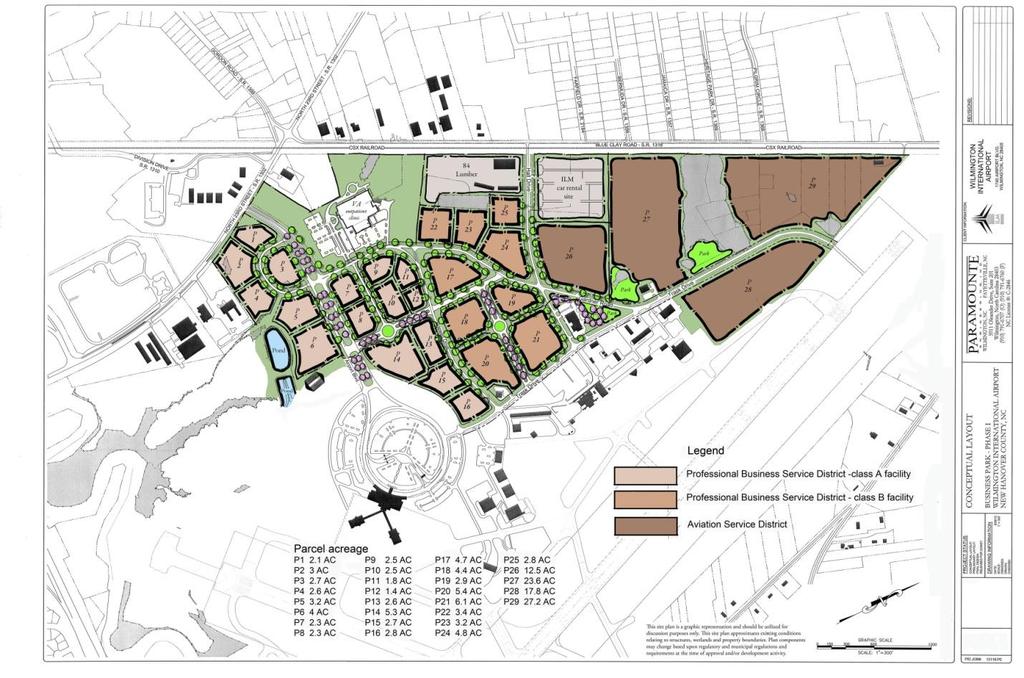
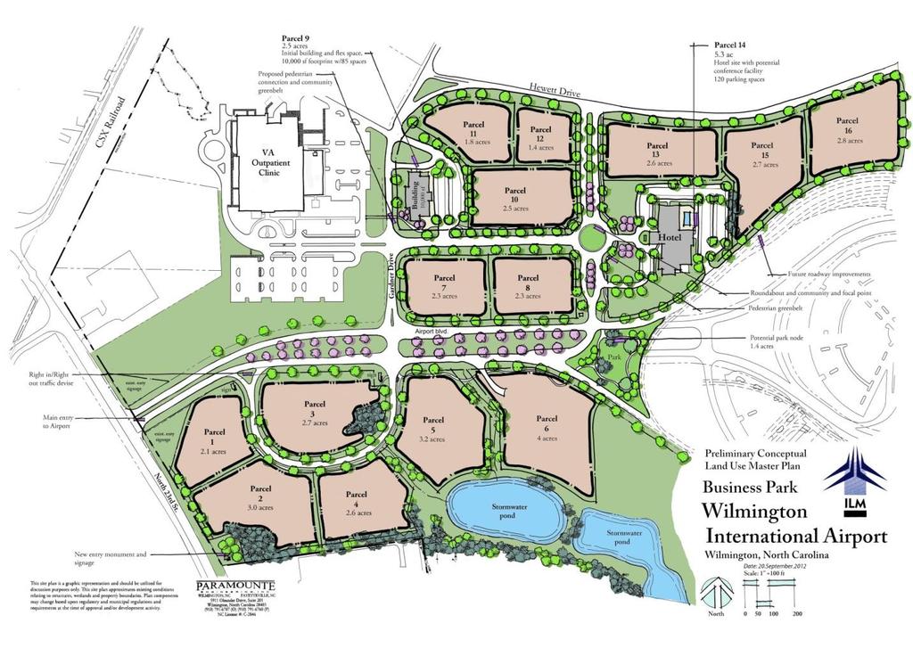
1 ILM Business Park 1740 Airport Blvd., Suite 12 Wilmington, NC Contact: Carol LeTellier, Business Development Director Phone: (910)

2 ILM Business Park Wilmington International Airport (ILM) Wilmington, NC Quick Data Sheet Size & Location: Access & Transportation: Parcel Sizes: Parcel Type: Zoning & Designations: Utilities: Taxes: Contact: 140 acres located at the Wilmington International Airport in Southeastern North Carolina Easy access to air, rail, and major interstates. I-40 (4 miles), I-95 (North 98 miles & South 83 miles) & Hwy 74-76, 421 and 17 Rail on site (CSX) Airport with taxiway access (ILM) US Customs (ILM and NC State seaport) Wilmington Deep-Water Seaport (7 miles) Parcel dimensions are flexible (See attached drawing) Long-term lease Airport Industrial (A-I) Foreign Trade Zone #214 FTZ Magnet Site status Duke Energy provides power, Cape Fear Public Utility Authority provides water/sewer (225,000 gdp new sewer flow available), Piedmont Natural Gas provides gas (limited sites) New Hanover County Property Tax No City Taxes (Land excluded from all taxes) Carol LeTellier Business Development Director Direct:
3 Property Location: ILM Business Park is located in Southeastern NC, centered on the U.S. East Coast between New York and Miami. The property has easy access to major roads like I-40, Hwy 74-76, Hwy 421 and Hwy 17. The ILM Business Park is conveniently situated approximately 4 miles from downtown Wilmington and 8 miles from Wrightsville Beach. The deep-water Seaport of Wilmington is located approximately 7 miles from the ILM Business Park by road. Wilmington International Airport (ILM) with two airline carriers is located on-site, making domestic and international travel extremely convenient. Property Description: ILM Business Park is situated on the campus of Wilmington International Airport (ILM) and composed of approximately 140 acres of land with available power, water and sewer, with some sites having additional access to natural gas. Several sites have the ability to drain storm water off-site to a dry retention pond allowing greater land development. Many acres have access to an active railroad operated by CSX. All parcels are zoned Airport Industrial (A-I) and have the flexibility to be resized in order to accommodate your particular project. ILM Business Park can accommodate most business types, to include Class A office buildings, warehousing, distribution and light industrial. Sites are available for taxiway access for airfreight or aerospace industries. Please see the attached layout for a general idea of parcel sizes, sewer, water, natural gas, railroad, taxiway, runways and road locations. Financial: Sites within the ILM Business Park are offered as a lease arrangement, allowing flexible term lengths. Under the leasing arrangement existing clients have experienced successful financing through banks and other financial institutions. Leasing offers clients an advantage of a smaller financial outlay annually for land lease, compared to an initial very large financial commitment to purchase land. Leasing also eliminates the annual property tax burden on the land. Locating your business within the ILM Business Park allows close proximity to downtown and convenience to surrounding business districts without the financial burden of Wilmington City taxes.
4 Current Clients: 84 Lumber, Veterans Administration (VA) Outpatient Clinic, National Weather Service, Battle House, Toshiba Business Solutions, KBT of Keller Williams, Scratch on 23rd cafe, and Wilmington Business Development. Quality of Life: Wilmington is located on the Southeastern coast of North Carolina between the Atlantic Ocean and the Cape Fear River and offers an extremely high quality of life. Within an hour s drive, you will find 50 high quality golf courses, 30 marinas and miles of pristine beaches. Families will spend time in the historic downtown area, strolling along the river walk or taking in a show at one of the many theater houses. In the Wilmington area, you will find everything from boating, sailing, surfing, fishing, hunting, paddle boarding and competitive sports, to a flourishing arts community or a simple walk on the beach. Wilmington provides impressive educational opportunities for continued education or work force training from such schools as Cape Fear Community College and University of North Carolina-Wilmington. New Hanover Regional Medical Center offers premier state of the art healthcare to the region. Next time you are looking to relocate to the southeastern part of the United States, consider ILM Business Park in Wilmington, NC for shovel-ready sites with easy access and an excellent quality of life.
5
6
7
APPENDIX I - AREA PLANS
 ROUTE 37 WEST LAND USE PLAN ROUTE 37 WEST LAND USE PLAN Recent land use decisions and development trends have drawn attention to the land within the Route 37 western by-pass area between Route 50 and
SPOTLIGHT ON WILMINGTON
 SPOTLIGHT ON WILMINGTON WELCOME TO WILMINGTON, DELAWARE Wilmington is the county seat of Cuyahoga County, the most populous county in Ohio. The city is located on the southern shore of Lake Erie, approximately
NEW WATERFRONT METROPARK. P u b l i c O p e n H o u s e, J u n e 2 1,
 NEW WATERFRONT METROPARK P u b l i c O p e n H o u s e, J u n e 2 1, 2 0 1 7 U N D E R S T A N D I N G YO U R P E R S P E C T I V E PUBLIC OPEN HOUSE Welcome/Introductions Project Presentation Project
River Realty Services Commercial
 1 4 6 N O R T H U S 9 W, C O N G E R S, N Y 1 0 9 2 0 TA B L E O F C O N T E N T S E X E C U T I V E S U M M A RY 03 Z O N I N G 09 R EG I S T R AT I O N S 04 S U B J EC T P H OTO S 10 M A P V I E W 05
St. Mary s County Comprehensive Zoning Ordinance. Article 5. REGULATION OF USES. Schedule 50.4 Use Classifications. Legend
 St. Mary s County Comprehensive Zoning Ordinance Article 5. REGULATION OF USES Schedule 50.4 Use Classifications Legend P Use is permitted in accordance with Chapter 51 General Standards L Use is permitted
Port Cities Conference: How Regional Planning can Help Support a Competitive Port. Christina DeMarco Metro Vancouver
 Port Cities Conference: How Regional Planning can Help Support a Competitive Port Christina DeMarco Metro Vancouver June 12. 2008 Metro Vancouver Regional Growth Management Three ways to help support the
Factors Affecting Human Settlement
 Factors Affecting Human Settlement Physical Factors One of the most basic factors affecting settlement patterns is the physical geography of the land. Climate is key, because if a place is too dry, too
FOR SALE +/- 419 ACRES ¼ Mile South of Alliance Airport
 FOR SALE +/- 419 ACRES ¼ Mile South of Alliance Airport Alliance Airport Subject property +/- 419 AC Pat McDowell +1 817 334 8106 pat.mcdowell@am.jll.com JLL 201 Main Street, Suite 1440 Fort Worth, TX
Major Hurricane Earl
 Major Hurricane Earl Advisory 32 North Carolina Threat Assessment Prepared at: 8 AM Thursday September 2, 2010 Hurricane and Tropical Storm Warnings in effect for the North Carolina Coast and Sounds. NWS
Cincinnati Industrial listing summary
 AERIAL MARCH 2014 L OREAL 75 GSI COMMERCE LOGISTICS BLVD. 71 BUILDING H 631,448 SF CUMMINS BUILDING A 754,800 SF BUILDING B 1,197,000 SF TRANSPORT DRIVE.75 mile DIXIE HWY. 25 2101-2301 E. KEMPER ROAD ::
The Emerging Southeast MegaRegion
 The Emerging Southeast MegaRegion Catherine L. Ross, Ph.D. Director, Center for Quality Growth and Regional Development presented at the Think Global, Act Regional Symposium January 30, 2006 Case Study:
Hurricane Matthew. Life Threatening Flash Flooding Likely. National Weather Service Wilmington NC. Josh Weiss, Meteorologist
 Hurricane Matthew Life Threatening Flash Flooding Likely Threat Assessment for northeast South Carolina & southeast North Carolina National Weather Service Wilmington NC 630 PM EDT Friday October 7, 2016
Home Owners. Age Male/Female. Snow removal for his/her driveway or private property
 Buyer Personas Home Owners Home Owners Age 25-55 Male/Female Snow removal for his/her driveway or private property Uses and Preferences Products: Small to mid-size truck plows, UTV/ATV plows to keep driveways
Tropical Storm Ana. Created 615 AM Sat May 9, 2015 Reid Hawkins, Science Officer
 Tropical Storm Ana Threat Assessment for northeast South Carolina & southeast North Carolina Created 615 AM Sat May 9, 2015 Reid Hawkins, Science Officer National Weather Service Wilmington, NC 1 New Information
GIS Monroe Geographic Information System March 14, 2018
 GIS Monroe Geographic Information System March 14, 2018 Goals Maintain Enterprise/County-wide geo-database Increase spatial accuracy of data Build and acquire more data layers Increase use of GIS; as another
Nurture Nature Center Receives Grant From National Oceanic and Atmospheric Administration To Study Flood Forecast and Warning Tools
 Nurture Nature Center Receives Grant From National Oceanic and Atmospheric Administration To Study Flood Forecast and Warning Tools One of four national awards by National Weather Service to advance weather
THE TRINITY RIVER VISION/ GATEWAY PARK / PANTHER ISLAND
 Quarterly Project Status Report May 2018 THE TRINITY RIVER VISION/ GATEWAY PARK / PANTHER ISLAND Flood Control Project Update Construction of North Main Street Bridge by TxDOT s bridge contractor, Texas
Government of Canada Designation of Vancouver Island as a Foreign Trade Zone Point
 2017 Government of Canada Designation of Vancouver Island as a Foreign Trade Zone Point Preface This position paper developed by VIEA working with a working group of Island industry and transportation
THE TRINITY RIVER VISION/ GATEWAY PARK / PANTHER ISLAND Flood Control Project Update
 Quarterly Project Status Report September 2018 THE TRINITY RIVER VISION/ GATEWAY PARK / PANTHER ISLAND Flood Control Project Update TxDot s contractor has nearly completed the superstructure false work
GRB QUICK REFERENCE: Contact Information.
 1 GEORGE R. BROWN C O N V E N T I O N C E N T E R WITH A VIBRANT DOWNTOWN, a walkable convention district and one of the largest convention facilities in America, there has never been a better time to
Estimation Results of Aspatial Models. A Supplementary Note to "A Spatial Multivariate Count Model for Firm Location Decisions"
 Estimation Results of Aspatial Models A Supplementary Note to "A Spatial Multivariate Count Model for Firm Location Decisions" by Chandra R. Bhat* The University of Texas at Austin Dept of Civil, Architectural
Hurricane Matthew Life Threatening Flash Flooding Likely
 Hurricane Matthew Life Threatening Flash Flooding Likely Threat Assessment for northeast South Carolina & southeast North Carolina National Weather Service Wilmington NC 12 AM EDT Saturday October 8, 2016
5 BUILDINGS ON 15 ACRES AVAILABLE
 INDUSTRIAL 5 BUILDINGS ON 15 ACRES AVAILABLE FOR SALE 1717 W. Park Drive, Huntington, IN 46750 Former Carter Lumber Approximately 38,000 sq. ft. in 5 buildings 15.06 acres with industrial zoning Property
Crow River Plaza - Retail Development South Diamond Lake Rd. Rogers, MN FOR LEASE 1,024 SF Retail Space. Lease Rate: $16.
 FEATURES: - Available in Rogers, MN Lease Rate: $16.00 / psf NNN - Excellent location with freeway signage on I-94! - Near large retailers such as Target, Kohls, & Applebees. Taxes $3.65 / psf Cam $3.20
Portland s regional economy is integrated
 Periodic Atlas of the Regional Connections 2: Economy by Jeremy Young, Sheila Martin, and Meg Merrick; Cartography by Robert Smith, Jeremy Young, and Meg Merrick s regional economy is integrated across
Business Preparedness and Hurricane Risk
 Business Preparedness and Hurricane Risk Hurricanes are one of the more predictable natural disasters compared to events such as earthquakes, wildfires and tornadoes. Meteorologists gather data to predict
Information Paper. Kansas City District. Missouri River Fish and Wildlife Mitigation Project Jim and Olivia Hare Wildlife Area, MO
 City District Information Paper River Fish and Wildlife Mitigation Project Jim and Olivia Hare Wildlife Area, MO Riverine habitat created in 2004/2005 by modifying existing river structures along the banks,
Geography is the study of the earth, it s land, it s people and it s environments. When you study geography, you should be looking at five distinct
 I.N pg. 9 Geography is the study of the earth, it s land, it s people and it s environments. When you study geography, you should be looking at five distinct themes. LOCATION PLACE REGION MOVEMENT HUMANENVIRONMENTAL
APPENDIX I: Traffic Forecasting Model and Assumptions
 APPENDIX I: Traffic Forecasting Model and Assumptions Appendix I reports on the assumptions and traffic model specifications that were developed to support the Reaffirmation of the 2040 Long Range Plan.
BOARD OF COUNTY COMMISSIONERS AGENDA ITEM SUMMARY
 7H BOARD OF COUNTY COMMISSIONERS AGENDA ITEM SUMMARY PLACEMENT: REQUESTS AND PRESENTATIONS PRESET: TITLE: PARKS FY 2012 CAPITAL IMPROVEMENT PLAN (CIP) AGENDA ITEM DATES: MEETING DATE: 4/26/2011 COMPLETED
National Register of Historic Places Inventory Nomination Form. 1. Name '' ; 2. Location jf J M COMMERCIAL BUILDINGS IN STILLWATER
 NPS Form 10-900 (3-82) 0MB No. 1024-0018 Exp. 10-31-84 United States Department off the Interior National Park Service National Register of Historic Places Inventory Nomination Form See instructions in
NCTCOG GIS File Locations
 Boundaries Area Codes k:\bnd\region\area_codes.shp Area Type k:\bnd\region\areatype.shp Ciry Centroids (World) k:\bnd\usa_world\cities.shp City Centroids (NCTCOG Region) k:\bnd\region\city_point.shp vector.vector.bnd_city_point
Country Club Plaza Country Club Plaza Saint Charles, Missouri 63303
 Country Club Plaza 1566 Country Club Plaza Saint Charles, Missouri 63303 Jeff Eisenberg P: (314) 721-5611 C: (314) 640-8510 jeff@jeisenberg.com www.jeisenberg.com FORFOR LEASE SALE/LEASE COUNTRY Russell
Economic Geography of the Long Island Region
 Geography of Data Economic Geography of the Long Island Region Copyright 2011 AFG 1 The geography of economic activity requires: - the gathering of spatial data - the location of data geographically -
Community Erosion Assessment Napakiak, Alaska 15 January 2008
 1. Community: Napakiak, Alaska Community Erosion Assessment Napakiak, Alaska 15 January 2008 Figure 1: Napakiak Location & Vicinity Map 2. Community Profile Summary: Napakiak is a 2 nd class city of 378
Crow River Plaza - Retail Development South Diamond Lake Rd. Rogers, MN FOR LEASE 2,066 SF Retail Space. Lease Rate: $16.
 FEATURES: - 2,066 SF End Cap Retail Space Available in Rogers, MN - Excellent location with freeway signage on I-94! - Near large retailers such as Target, Kohls, & Applebees. - Convenient location off
DOWNLOAD OR READ : NORTH CAROLINA WEATHER AND CLIMATE PDF EBOOK EPUB MOBI
 DOWNLOAD OR READ : NORTH CAROLINA WEATHER AND CLIMATE PDF EBOOK EPUB MOBI Page 1 Page 2 north carolina weather and climate north carolina weather and pdf north carolina weather and climate North Carolina's
Improving Data Quality and. Productivity in Public Works Mobile GIS: Do you GO! Sync? Robert E. Thomas, GISP GIS Specialist City of Woodland
 Improving Data Quality and Increasing Field Crew Productivity in Public Works Mobile GIS: Do you GO! Sync? Robert E. Thomas, GISP GIS Specialist City of Woodland Overview-City of Woodland Woodland is the
Sky Park Business Center
 Suite Size Available Rate 9210 Sky Park Court Suite 220 4,738 SF Now $1.95 + Util. 9265 Sky Park Court Suite 250 6,085 SF Now $1.95 + Util. * Suite 250 is divisible Project FEATURES: Newly remodeled common
The Dance Hall Goes in What School District?
 The Dance Hall Goes in What School District? Vern C. Svatos Jarrod S. Doucette Abstract This paper presents the results of a GIS mapping effort created for the Delaware State Department of Education using
An online data and consulting resource of THE UNIVERSITY OF TOLEDO THE JACK FORD URBAN AFFAIRS CENTER
 An online data and consulting resource of THE JACK FORD URBAN AFFAIRS CENTER THE CENTER FOR GEOGRAPHIC INFORMATION SCIENCE AND APPLIED GEOGRAPHICS DEPARTMENT OF GEOGRAPHY AND PLANNING THE UNIVERSITY OF
MACo Briefing General Assembly of Maryland
 MACo Briefing General Assembly of Maryland House Environment & Transportation Committee 1/22/2019 Introduction to Maryland Counties Maryland has 23 counties plus Baltimore City (which is legally both a
1. Major streets, Central Business District (CBD) and school bus routes. 2. Local streets 3. Downtown parking lots
 and school bus routes. 2. Local streets 3. Downtown parking lots") City of Mt. Pleasant Administrative Memo #1-85 Issued: January 1, 1985 SUBJECT: Snow and Ice Control Policy SUMMARY: The intent of this policy is to construct a basic guideline to effectively and efficiently
City of Mt. Pleasant Administrative Memo #1-85 Issued: January 1, 1985 SUBJECT: Snow and Ice Control Policy SUMMARY: The intent of this policy is to construct a basic guideline to effectively and efficiently
CITY OF FLORENCE, SC Monthly Financial Report August 2013
 CITY OF FLORENCE, SC Monthly Financial Report City of Florence Finance Department City of Florence, SC Monthly Financial Report Table of Contents For the Month Ended August 31, 2013 General Fund 2 Water
where vibrancy and value INTERSECT
 W O R K A T T H E C E N T E R O F I T A L L C H A R L O T T E, N C where vibrancy and value INTERSECT BB&T is at the very heart of Uptown Charlotte, NC, part of a vibrant cityscape that abounds with business
Sky Park Business Center
 Lic. Lic. Suite Size Asking Rate Available 9210 Sky Park Court Suite 150 8,091 SF $2.05 + E AVAILABLE NOW 9265 Sky Park Court 100% Leased PROJECT FEATURES: Newly remodeled common areas and upgraded mechanical
Cook and Peach Road. Ridgeway, South Carolina. Site. For Sale ±30.12 AC Commercial Land. Tom Milliken
 For Sale ±30.12 AC Commercial Land Site Exit 32 Peach Rd Cook and Peach Road Ridgeway, South Carolina CONTACT BROKERS FOR MORE INFORMATION: Tombo Milliken +1 803 744 9852 tombo.milliken@naiavant.com Tom
If you aren t familiar with Geographical Information Systems (GIS), you. GIS, when combined with a database that stores response information,
, you. GIS, when combined with a database that stores response information,") Geographical Information Systems in EMS By William E. Ott If you aren t familiar with Geographical Information Systems (GIS), you should take a look at what GIS can offer you as an EMS manager. GIS, when
Geographical Information Systems in EMS By William E. Ott If you aren t familiar with Geographical Information Systems (GIS), you should take a look at what GIS can offer you as an EMS manager. GIS, when
E N G L E W O O D C L I F F S, N J
 ENGLEWOOD CLIFFS, NJ A HIGHER STANDARD 800 Sylvan Avenue is being redeveloped into a premier workplace in an ideal corporate headquarters location. The newly redesigned 270,450 square foot Class A office
Subtropical Storm Ana
 Subtropical Storm Ana Threat Assessment for northeast South Carolina & southeast North Carolina Created 745 AM Fri May 8, 2015 Reid Hawkins, Science Officer National Weather Service Wilmington, NC 1 New
EIGHT POINTS RETAIL DEVELOPMENT
 EIGHT POINTS RETAIL DEVELOPMENT FOR LEASE NEC HWY 67 & OAK GROVE RD NEW RETAIL DEVELOPMENT ANCHORED BY MENARDS AND WALMART NEIGHBORHOOD MARKET IN THE HEART OF POPLAR BLUFF RETAIL CORRIDOR. MARKET OVERVIEW
January 04, resilience360.com
 January 04, 2018 resilience360.com resilience360@dhl.com 2 DHL RESILIENCE360 SPECIAL BRIEF On Wednesday, January 3, a powerful winter storm made landfall on the US East Coast, covering southeastern states
Six (6) Unit Apartment Building Along Garfield Boulevard - Bank Owned WEST GARFIELD BOULEVARD CHICAGO, IL DETAILS PROPERTY OVERVIEW
 Unit Apartment Building Along Garfield Boulevard - Bank Owned WEST GARFIELD BOULEVARD CHICAGO, IL DETAILS PROPERTY OVERVIEW") 907-909 WEST GARFIELD BOULEVARD CHICAGO, IL 60621 DETAILS Sale Price $370,000 Lot Size 7,500 SF Building Size 8,538 SF Taxes (2016) $6,021.31 Zoning R-1, Low Density Residential Market South Chicago Cross
907-909 WEST GARFIELD BOULEVARD CHICAGO, IL 60621 DETAILS Sale Price $370,000 Lot Size 7,500 SF Building Size 8,538 SF Taxes (2016) $6,021.31 Zoning R-1, Low Density Residential Market South Chicago Cross
FOR LEASE ±1,800 SF OUTPARCEL NEW CONSTRUCTION, SINGLE TENANT
 FOR LEASE ±1,800 SF OUTPARCEL NEW CONSTRUCTION, SINGLE TENANT DEERFIELD BEACH FL 33441 ROXANNE REGISTER Vice President of Leasing & Sales RoxanneRegister@dkatz.com (561) 869-4346 HIGHLIGHTS Retail only
Identifying Megaregions in the US: Implications for Infrastructure Investment
 7. 10. 2 0 08 Identifying Megaregions in the US: Implications for Infrastructure Investment Dr. Myungje Woo Dr. Catherine L. Ross Jason Barringer Harry West Jessica Lynn Harbour Doyle Center for Quality
INDIANAMAP VIEWING APPLICATION
 INDIANAMAP VIEWING APPLICATION (VERSION 1.0 ) Based on the 2005 Developed for the Indiana Department of Homeland Security by: IndianaMap Viewing Application Introduction The IndianaMap Viewing Application
City Center West. Twice the flexibility. Two ±106,000 SF Five-Story Class A Buildings A PROJECT BY: 7201 & 7251 WEST LAKE MEAD BOULEVARD FOR LEASE
 A PROJECT BY: Two ±106,000 SF Five-Story Class A Buildings FOR LEASE 7201 & 7251 WEST LAKE MEAD BOULEVARD Twice the flexibility www.citycenterwestlv.com 7201 & 7251 WEST LAKE MEAD BOULEVARD 7201 & 7251
INTERNATIONAL WORKSHOP ON LEGAL AND POLICY FRAMEWORKS FOR GEOSPATIAL INFORMATION MANAGEMENT Licensing of Geospatial Information.
 INTERNATIONAL WORKSHOP ON LEGAL AND POLICY FRAMEWORKS FOR GEOSPATIAL INFORMATION MANAGEMENT Licensing of Geospatial Information 7-9 November 2017 Tianjin, China Information Note Organized by United Nations
KENTUCKY HAZARD MITIGATION PLAN RISK ASSESSMENT
 KENTUCKY HAZARD MITIGATION PLAN RISK ASSESSMENT Presentation Outline Development of the 2013 State Hazard Mitigation Plan Risk Assessment Determining risk assessment scale Census Data Aggregation Levels
INCLEMENT WEATHER CLOSING CODES
 INCLEMENT WEATHER CLOSING CODES Code 0 Code 1 Code 2 Code 3 Code 4 Code 5 Code 6 ALL operations are closed and no employees should report to work. Transportation personnel, maintenance personnel, ALL custodial
SECTION DESCRIPTION PAGE I. BUDGET INTRODUCTION... 1 II. FISCAL YEAR 2017 BUDGET ANALYSIS... 2 III. FINAL OPERATING BUDGET... 3
 2018 SECTION DESCRIPTION PAGE I. BUDGET INTRODUCTION... 1 II. FISCAL YEAR 2017 BUDGET ANALYSIS... 2 III. FINAL OPERATING BUDGET... 3 IV. GENERAL FUND 001 DESCRIPTIONS... 4 Background Information The Four
A More Comprehensive Vulnerability Assessment: Flood Damage in Virginia Beach
 A More Comprehensive Vulnerability Assessment: Flood Damage in Virginia Beach By Raj Shah GIS in Water Resources Fall 2017 Introduction One of the most obvious effects of flooding events is death. Humans
Reserve Forecast Details
 10-26th St South of Maryland Reserve (1552) Opening Balance 158,947 158,947 0 0 0 0 0 0 0 0 1058 - Street Construction 0 (158,947) 0 0 0 0 0 0 0 0 Total 0 (158,947) 0 0 0 0 0 0 0 0 Closing Balance 158,947
E-Community Check Request Checklist
 E-Community Check Request Checklist The E-Community must complete the following information on each business approved for a loan or grant in order for the Kansas Center of Entrepreneurship (KCFE) to disburse
Analyzing Suitability of Land for Affordable Housing
 Analyzing Suitability of Land for Affordable Housing Vern C. Svatos Jarrod S. Doucette Abstract: This paper explains the use of a geographic information system (GIS) to distinguish areas that might have
Convergent Validity of Revealed and Stated Recreation Behavior with Quality Change: A Comparison of Multiple and Single Site Demands
 Convergent Validity of Revealed and Stated Recreation Behavior with Quality Change: A Comparison of Multiple and Single Site Demands John Whitehead, ASU; Dan Phaneuf, NCSU; Chris Dumas, UNCW; Jim Herstine,
Town of Davie B-2 (Community Business) Zoning:
 Zoning:") Town of Davie B-2 (Community Business) Zoning: Commercial Conservation Districts: These districts are intended to preserve the character of existing nonresidential or commercial areas, neighborhoods and
Town of Davie B-2 (Community Business) Zoning: Commercial Conservation Districts: These districts are intended to preserve the character of existing nonresidential or commercial areas, neighborhoods and
Hillsborough County MPO Transit Study. Technical Team August 23, 2007
 Hillsborough County MPO Transit Study Technical Team August 23, 2007 Meeting Agenda Technology Choices Needs and Opportunities Transit Concepts Comparative Land Use Analysis Measures of Effectiveness System
Understanding Land Use and Walk Behavior in Utah
 Understanding Land Use and Walk Behavior in Utah 15 th TRB National Transportation Planning Applications Conference Callie New GIS Analyst + Planner STUDY AREA STUDY AREA 11 statistical areas (2010 census)
SECTION DESCRIPTION PAGE I. BUDGET INTRODUCTION... 1 II. FISCAL YEAR 2017 BUDGET ANALYSIS... 2 III. PROPOSED OPERATING BUDGET... 4
 2018 SECTION DESCRIPTION PAGE I. BUDGET INTRODUCTION... 1 II. FISCAL YEAR 2017 BUDGET ANALYSIS... 2 III. PROPOSED OPERATING BUDGET... 4 IV. GENERAL FUND 001 DESCRIPTIONS... 6 V. DEBT SERVICE FUNDS... 9
PIONEERING A NEW FRONTIER IN PEACHTREE CORNERS
 PIONEERING A NEW FRONTIER IN PEACHTREE CORNERS Project Snapshot R ER S TR C H and Scipio Ventures, 3550 Engineering Drive is a 4-story, W Y R 3550 Engineering is poised for companies who place high IN
Social Studies Grade 2 - Building a Society
 Social Studies Grade 2 - Building a Society Description The second grade curriculum provides students with a broad view of the political units around them, specifically their town, state, and country.
Hurricane Florence: Rain this heavy comes along once every 1,000 years
 Hurricane Florence: Rain this heavy comes along once every 1,000 years By Associated Press, adapted by Newsela staff on 09.17.18 Word Count 786 Level 810L Image 1. This satellite image provided by the
Robert s Village. The Shops at Aubert Avenue Saint Louis, Missouri 63113
 The Shops at Robert s Village 1330 Aubert Avenue Saint Louis, Missouri 63113 Jeff Eisenberg P: (314) 721-5611 C: (314) 640-8510 jeff@jeisenberg.com www.jeisenberg.com FOR LEASE Roberts Village Shopping
CLAREMONT MASTER PLAN 2017: LAND USE COMMUNITY INPUT
 Planning and Development Department 14 North Street Claremont, New Hampshire 03743 Ph: (603) 542-7008 Fax: (603) 542-7033 Email: cityplanner@claremontnh.com www.claremontnh.com CLAREMONT MASTER PLAN 2017:
TULANE EMERGENCY PREPAREDNESS & RESPONSE HURRICANE RESPONSE
 TULANE EMERGENCY PREPAREDNESS & RESPONSE HURRICANE RESPONSE 2018-2019 TULANE EMERGENCY PREPAREDNESS & RESPONSE SEVERE WEATHER HURRICANE PREPAREDNESS MISSION STATEMENT Providing Tulane University a solid
4 th Grade Virginia Studies SOL Review Packet Geography of Virginia. 1. The Algonquian language group of Indians lived in what region of Virginia?
 4 th Grade Virginia Studies SOL Review Packet Geography of Virginia 1. The Algonquian language group of Indians lived in what region of Virginia? A. Allegheny B. Piedmont C. Ridge and Valley D. Tidewater
GIS Geographical Information Systems. GIS Management
 GIS Geographical Information Systems GIS Management Difficulties on establishing a GIS Funding GIS Determining Project Standards Data Gathering Map Development Recruiting GIS Professionals Educating Staff
WATER RESOURCES (CONTROLLED WATER AREAS) (NDIRANDE MUDI DAM CONTROLLED WATER AREA) ORDER
 (NDIRANDE MUDI DAM CONTROLLED WATER AREA) ORDER") WATER RESOURCES (CONTROLLED WATER AREAS) (NDIRANDE MUDI DAM CONTROLLED WATER AREA) ORDER under s. 22 G.N. 10/2008 1. Citation This Order may be cited as the Water Resources (Controlled Water Areas) (Ndirande-Mudi
WATER RESOURCES (CONTROLLED WATER AREAS) (NDIRANDE MUDI DAM CONTROLLED WATER AREA) ORDER under s. 22 G.N. 10/2008 1. Citation This Order may be cited as the Water Resources (Controlled Water Areas) (Ndirande-Mudi
Approved by: A. Cherrie Epps, Ph.D., President and Chief Executive Officer
 Page 1 of 5 Retired: Revised: Approved by: A. Cherrie Epps, Ph.D., President and Chief Executive Officer Subject: Office of General Counsel/Compliance - Inclement Weather and Emergency Closing Policy PURPOSE:
WELCOME & INTRODUCTIONS
 GIS Monroe Geographic Information System January 31, 2018 WELCOME & INTRODUCTIONS Chip Thomas, Ritter GIS Sarah Schrader, Acct. Mgr., ESRI Chris Beyett, Solutions Engineer, ESRI Colleen Hinzmann, IT Director,
River Flood Assessment for northeast SC and southeast NC Sunday October 8, :15 AM EDT
 River Flood Assessment for northeast SC and southeast NC Sunday October 8, 2016 11:15 AM EDT National Weather Service Wilmington NC http://weather.gov/ilm Prepared By: Rick Neuherz, Service Hydrologist
A Unique Building For the Discerning Client P O S T ROA D E A S T W E S T P O R T, C O N N E C T I C U T
 A Unique Building For the Discerning Client 1 0 3 2 P O S T ROA D E A S T W E S T P O R T, C O N N E C T I C U T 1032 Post Road East Westport represents a unique opportunity to acquire or lease a brand
TABLE OF USE REGULATIONS
 TABLE OF USE REGULATONS Y - Permitted as of right N - Prohibited BA - Special Permit/Board of Appeals PB - Special Permit/Planning Board SB - Special Permit/Selectboard PRNCPAL USE SR GR B CB L L A. Residential
Welcome Jeff Orrock Warning Coordination Meteorologist National Weather Service Raleigh
 Welcome Jeff Orrock Warning Coordination Meteorologist National Weather Service Raleigh Jeff.orrock@noaa.gov Sources: Operational Significant Event Imagery and the Environmental Applications Team (EAT)
PIONEERING A NEW FRONTIER IN PEACHTREE CORNERS 3550ENGINEERING.COM
 PIONEERING A NEW FRONTIER IN PEACHTREE CORNERS Project Snapshot Recently acquired by Icarus Alternative Investments and Scipio Ventures, 3550 Engineering Drive is a 4-story, 101,809 square foot suburban
VISITORS GUIDE. 108 Progressive Court, Greenville, South Carolina VACUUM HEAT TREATING BRAZING CARBURIZING NITRIDING
 VISITORS GUIDE 108 Progressive Court, Greenville, South Carolina VACUUM HEAT TREATING BRAZING CARBURIZING NITRIDING YOUR THERMAL PROCESSING ADVANTAGE CONTENTS Directions 2 Company History 3 Policies and
Mainor Ülemiste AS. Interim Report July September
 Mainor Ülemiste AS Interim Report July September 2018 http://mainorulemiste.ee/opiku/ Main Events in the 3Q 2018 Mainor Ülemiste s subsidiary concluded a loan agreement in amount of 10,7 million euros
PW Parkway ES Prince William County, Virginia WSSI #
 PW Parkway ES Prince William County, Virginia WSSI #15.3 Cultural Resources Site Assessment November 15 Prepared for: Prince William County Public Schools P.O. Box 39 Manassas, Virginia 1 Prepared by:
GUIDED READING CHAPTER 1: THE LAY OF THE LAND (Page 1)
") CHAPTER 1: THE LAY OF THE LAND (Page 1) Section 1 The Tidewater Region Directions: Use the information from pages 6-11 to complete the following statements. 1. In the southern part of the coast, the Tidewater
CHAPTER 1: THE LAY OF THE LAND (Page 1) Section 1 The Tidewater Region Directions: Use the information from pages 6-11 to complete the following statements. 1. In the southern part of the coast, the Tidewater
Wessinger Road, Hilton Area Chapin, South Carolina
 779' For Sale 191' 182' 171'! A! B 858' 4.84 ± Acres 788' 4.25 ± Acres 60' 241' 321' Wessinger Road, Hilton Area Chapin, South Carolina 357' 115' 51' 294'! C! D 6.51 ± Acres 902' 8.35 ± Acres 246' 60'
Monday, September 24, :30 a.m. EDT
 Monday, September 24, 2018 8:30 a.m. EDT Significant Activity Sep 21-24 Significant Events: Hurricane Florence response Tropical Activity: Atlantic Subtropical Storm Leslie; Tropical Disturbance Kirk;
Temporary College Closure Due to Inclement Weather or Other Adverse Conditions.
 OTHER TOPICS Index No. X-1 PROCEDURES MEMORANDUM TO: FROM: SUBJECT: MCC Students and Staff Office of the President Temporary College Closure Due to Inclement Weather or Other Adverse Conditions. DATE:
Bay of Plenty Regional Economic Profile
 CASE STUDY Bay of Plenty Regional Economic Profile COMVITA Comvita is well on track to becoming a company with $100 million dollar annual turnover, from its roots as a pioneer cottage healthcare businesses,
Remote Sensing the Urban Landscape
 Remote Sensing the Urban Landscape Urban landscape are composed of a diverse assemblage of materials (concrete, asphalt, metal, plastic, shingles, glass, water, grass, shrubbery, trees, and soil) arranged
Rural Louisiana. A quarterly publication of the Louisiana Tech Rural Development Center
 Rural Louisiana A quarterly publication of the Louisiana Tech Rural Development Center Volume 4, No. 1, Fall 2009 Editor: Aaron K. Lusby Director, Asst. Professor Newsletter design: Stephanie Tidwell Student
STARKE MINES. by MICHELLE ROGERS ~MMITCHEL/HON399/MICHELLE.HTM ORIGINALLY PUBLISHED IN
 STARKE MINES by MICHELLE ROGERS ORIGINALLY PUBLISHED IN HTTP://WWW.VALDOSTA.EDU/ ~MMITCHEL/HON399/MICHELLE.HTM ORIGINALLY PUBLISHED IN HTTP://WWW.VALDOSTA.EDU/ ~MMITCHEL/HON399/MICHELLE.HTM STARKE MINES
Jason Bentley Ashe Prelim_Research_Notebook_Data MDS_I Fall_2007
 Jason Bentley Ashe Prelim_Research_Notebook_Data MDS_I Fall_2007 Theory Section: This section will be coming very soon, due to the change in my project. Quotes: Explanation: Application to your Thesis
GIS Needs Assessment. for. The City of East Lansing
 GIS Needs Assessment for The City of East Lansing Prepared by: Jessica Moy and Richard Groop Center for Remote Sensing and GIS, Michigan State University February 24, 2000 Executive Summary At the request