Seasonal and Hazards Calendar
|
|
|
- Leo Peters
- 6 years ago
- Views:
Transcription


1 Seasonal and Hazards Calendar Emergency Preparedness and Response Branch Emergency Preparedness and Response Branch
2 Foreword Whether you work in the field or at WFP headquarters, whether your job is to plan and prepare for emergencies, to respond to them, or to design the most appropriate programmes possible there is now a new tool to help you. The new Seasonal and Hazards Calendar combines the most authoritative information on major seasonal hazards like floods, droughts, cyclones and the prevalence of pests such as locusts, alongside crop growing cycles and s. The Calendar covers each of the 79 countries where WFP has a presence and has proved successful and popular where it was tried out during its development. In Haiti it was the basis for preparedness plans ahead of the 2010 hurricane season seen at the time as the country s biggest threat. When the earthquake struck, the calendar was instead first put to use identify disruption to the agricultural cycle. Programme designers are also already using the Calendar it fits like a glove in our approach to programme design said one with wide experience in Prevention and Recovery Programmes. It has also been welcomed enthusiastically by one of WFP s biggest donors, which has brought it into its preparedness and planning process for allocating funding and resources. This is really, really impressive said the donor when seeing the Calendar. The Seasonal and Hazards Calendar has been developed using a strong Back to Basics approach to information and with the question How appealing and easy to use is it? being continually asked. The first step was to clear out all existing sources, only allowing back into the Calendar ones whose accuracy, reliability and usefulness had been rigorously analysed and confirmed. The second step was to search for new sources, especially ones which allowed the cross-checking of information. Conflicting information even from impeccable sources had been a serious problem for the previous Calendar. Primary sources can be found on the next page. Design was also very important; a very visual coloured text box is the first step to easily accessing the information needed. If you want to look at one particular region of a country which has had, for example, a cyclone, it takes seconds to go deeper into the Calendar to where people and crops have been affected in the past. You can then get on with planning your emergency or programme response, taking wisely informed decisions. For Food for Work and Food for Assets programming in particular, the most appropriate time possible for intervention can be clearly seen. Programmes can then be launched at the time of most difficulty for communities, while ensuring there is no disruption to ongoing local livelihoods and economies. As a senior programme designer commented this is a great help to build the rationale on linking programmes to shocks, and we and the Regional Bureaux and Country Offices, can take a lot of this information as a starting point for discussions with partners and for more in-depth work. The new Seasonal and Hazards Calendar has stayed true to its roots. It came about as the result of feedback from WFP s field operations, when staff asked for a more useful and user-friendly tool than the one they had. WFP s Regional Bureaux and Country Offices have been kept in mind throughout the creation process, with the views of staff on the ground being regularly sought and their ideas incorporated. Large countries like Sudan - or ones like Ghana with wide variations in climate and agricultural cycles, were divided into several specific zones to make their entries in the Calendar as useful as possible after feedback from the West Africa Regional Bureau. The Calendar will remain this way expanding and changing as it needs to. The Regional Bureaux have already compiled 20 key oversight countries which are to be added to the Calendar next. The Calendar has also just gone live on-line with the completion of a platform on the Emergency Preparedness and Response Web (EPweb) and is available for use by other agencies and partners on the HEWSWEB site. Every effort will be made, however, to remember the reason why the Seasonal and Hazards Calendar was created, keeping the balance between adding important information and analysis without making it too cumbersome. Contact us: HQ.Situation.Room@wfp.org


 - FAOSTAT (http://faostat.fao.org/ DesktopDefault.aspx? PageID=339&lang=en&country=115) Thank you also to: FEWSNET Famine Early warning Systems Network (http://www.fews.net/pages/default.")
3 Primary Sources WFP s Emergency Preparedness and Response Branch would like to thank WFP colleagues whose work on (among other things) Executive Briefs, Country Pages, the Food Security Atlas, Early Warning- Food Security and EPweb has contributed greatly to this Seasonal and Hazards Calendar. We would also like to thank our colleagues at other UN Agencies for their Reports, Flash Appeals, Press Releases, Briefs and so on. We are indebted to our sister agency FAO for the Country Briefs and Profiles, the Crop Prospects and the Food Situation. The following websites were invaluable - GlEWS - Gobal Information and Early Warning System( - Locust Watch ( ag/locusts/en/info/info/index.html) - FAOSTAT ( DesktopDefault.aspx? PageID=339&lang=en&country=115) Thank you also to: FEWSNET Famine Early warning Systems Network ( GLIDE Number ( glide/public/search/search.jsp) EM-DAT ( Center for International Disaster Information CIDI ( Climate Prediction Center, NOAA ( The International Research Institute for Climate and Society IRI ( portal.iri.columbia.edu/portal/server.pt? open=512&objid=944&pageid=7868&mode =2) Country Studies ( Britannica ( International and local media NASA Earth Observatory ( earthobservatory.nasa.gov/) RSOE EDIS ( Prevention Web ( english/) Earth Trends ( country_profiles/index.php?theme=8) ReliefWeb ( doc110?openform) USDA Foreign Agricultural Service (


4 Seasonal and Hazards Calendar Regional Bureau Asia, Bangkok Afghanistan, Bangladesh, Bhutan, Cambodia, DPR Korea, India, Indonesia, Laos, Myanmar, Nepal, Pakistan, Philippines, Sri Lanka, Timor Leste Regional Bureau Middle East, Central Asia and Eastern Europe, Cairo Algeria, Armenia, Azerbaijan, Egypt, Georgia, Iran, Iraq, Jordan, Kyrgyzstan, Occupied Palestinian Territories, Syria, Tajikistan, Yemen Regional Bureau West Africa, Dakar Benin, Burkina Faso, Cameroon, Cape Verde, Central African Republic, Chad, Cote d'ivoire, Ghana, Guinea, Guinea-Bissau, Liberia, Mali, Mauritania, Niger, Sao Tome and Principe, Senegal, Sierra Leone, The Gambia, Togo Regional Bureau Latin America and the Caribbean, Panama Bolivia, Colombia, Cuba, Dominican Republic, Ecuador, El Salvador, Guatemala, Haiti, Honduras, Nicaragua, Panama, Peru Regional Bureau Southern, Eastern and Central Africa, Johannesburg Burundi, Democratic Republic of Congo, Djibouti, Eritrea, Ethiopia, Kenya, Lesotho, Madagascar, Malawi, Mozambique, Namibia, Republic of Congo, Rwanda, Somalia, Swaziland, Tanzania, Uganda, Zambia, Zimbabwe Sudan

5 Asia Regional Bureau, Bangkok Available countries Afghanistan, Bangladesh, Bhutan, Cambodia, DPR Korea, India, Indonesia, Laos, Myanmar, Nepal, Pakistan, Philippines, Sri Lanka, Timor Leste
6 Regional Bureau Bangkok - OD_B AFGHANISTAN JAN FEB MAR APR MAY JUN JUL AUG SEP OCT NOV DEC rainy/snow season rainy/snow season flood/landslide risk storm snowmelt and flood + winter storms drought events wheat, rice, maize, barley, pulses spring wheat planting poppy rice, maize planting winter wheat spring wheat, maize winter wheat planting rice locust 2002/01, 2002, 2008 January February March April May June July August November COLD WAVE with AFFECTED AREAS FF in Hazrat Sultan district, Samangan Province, northern Afghanistan; Samangan province; northern Afghan provinces of Baghlan and Faryab due to heavy rains and snowmelt; Doshi, Khost-o-Fereng, Nahrin districts (Baghlan province), Panjshir valley (Takhar province), Khanabad (Kunduz province) Kunduz and Baghlan provinces; unusual FF in several provinces; northern parts; Badakshan and North provinces 2007; Central Highlands and Northern Afghanistan FF in Jalalabad - east; southeastern provinces of Paktika, Ghazni and Paktia; Khost eastern Alingar District, Laghman Province; killed FF in six districts in the western Afghanistan provinces of Herat and Badghis and in Behsoud district of Nangarhar, in eastern Afghanistan in January cold wave in northeastern province of Badakhshan; since Jan; extreme cold temperature hit Provinces of Badakhshan, Daikundi, Ghazni, Paktika, Ghor, Zabul, Uruzgan and Wardak; cold wave in Kunduz in November LATEST DROUGHT EVENTS with AFFECTED AREAS Climate: arid to semiarid; cold winters and hot summers. Winter snows are frequent at the higher elevations and there are permanent snowfields in the Hindu Kush. Summers are dry and severely hot; however, intrusions of moist, southerly monsoon air occasionally bring rain, increased humidity, and cloudiness to the extreme eastern portions. Terrain: mostly rugged mountains, plains in north and southwest; desert conditions prevailing in the southwestern and northern plains. Rainy Season April; in the highlands snow falls from December to March, while in the lowlands it rains intermittently from December to April or May; in eastern parts rains peak between mid Feb and early May; in western parts peak in late Jan-early Apr. In the mountains the annual mean precipitation increases from west to east and it avaraged about 16 inches (400 mm), but in the arid region of Farah just 3 inches (75 mm) per year ,684 affected; since Feb, Uruzgan Province badly hit 2007 (March-April) - FF and snow avalanches with central province of Ghor, western province of Badghis and Uruzgan province badly affected; Balkh, Kunduz provinces 2009 (Apr-May) - floods in north, northeast and west; among worst affected Mazar city and Chemtal district of Balkh province; Baghraan, Kajaki, Sokhtray districts (Helmand province); Qamla-I-Naw, Ab Kamari districts (Badghis province) + Deh Miran, Qal'a-I-Turdi, Ghulbian, Bilchiragh city + Yulmarab village (Mazar-e-Sharif) drought affected rural areas where 80 percent of rain-fed agriculture failed due to lack of rain in 2008; joint Government/UN drought appeal; 1,900,000 reportedly affected, mainly in northern provinces of Balkh, Saripul and Faryab and north-eastern province of Badakshan; drought conditions existed during the critical Spring and early Summer months in Western, Southern, Eastern and Central highlands; Bonavash (Abdullah Gan region); May; Kandahar, Helmand, Nimroz, Zabul, Urozgan provinces (south-west), Heart, Farah, Badghis provinces (west), Paktia, Khost, Ghazni (south), Baghlan, Kunduz, Takhar, Badakhshan (north-east) for a total 2,5 milliion people affected LOCUST with AFFECTED AREAS northwestern province of Badghis; locusts successfully laid eggs only in remote desert areas; nine provinces in northern Afghanistan; 2001/ vast explosion
7 Regional Bureau Bangkok - OD_B BANGLADESH JAN FEB MAR APR MAY JUN JUL AUG SEP OCT NOV DEC cold wave heat wave monsoon season cold wave flood/ flash tropical storm season drought events rice, wheat, potato boro rice aus rice aman rice wheat, boro rice, potato boro rice, wheat, potatoes aus rice aman rice rats (locust, ecc) 2008 Monga Monga March/April May June July August TROPICAL STORM and AFFECTED AREAS March April May June July November LATEST DROUGHT EVENTS with AFFECTED AREAS Climate: typical monsoon climate characterized by rain-bearing winds, moderately warm temperatures, high humidity and heavy rainfall; except for some parts in the west, it generally exceeds 60 inches (1,500 mm) annually. Large areas of the south, southeast, north, and northeast typically receive from 80 to 100 inches (2,000 to 2,500 mm), and the northern and northwestern parts of the Sylhet area usually receive from 150 to 200 inches (3,800 to 5,000 mm). Storms of very high intensity often occur early in the summer (in April/May) and late in the monsoon season (/, and sometimes November). Terrain: mostly flat alluvial plain; hilly in southeast Early flash flood (Mar-April) in the Northeast haor basin districts of Sunamganj, Sylhet and Moulvibazar Flash Flood in Northwestern districts of Dinajpur, Rangpur, Nilphamari, Lalmonirhat, Naogaon, Kurigram, Gaibandha Low to moderate level flood in the Northeast districts of Sylhet, Sunamganj and Moulavibazar. Landslide and flood triggered by heavy rains in mid June killed at least 100 people in Southeast coastal Cox's Bazar district; Moderate level flood in 22 districts; Flash Flood in Lalmonirhat, Netrakona, Sunamganj, Habiganj, Mouvlibazar, Floods and Landslides in Chittagong; Flash Flood; Severe flooding affected 39 out of 64 districts, 38% land area inundated, affecting 36 million (25% of total population) people where around 800 died; Khagrachari, Chittagong, Bhola, Feni, Sylhet, Sunamganj, Moulvi bazar, Habiganj, Netrakona, Cox's Bazar, Jamalpur, Lakshimpur, Comilla affected; Sylhet, Hobigonj, Sunamgonj, Muolovibazar, Nilphamari, Brahamanbaria districts; Chittagong, Cox's Bazar, Morzapool, Katalganj, Rahmatganj, Chaktai, Halishabr, Bakalia, Chandgaon, Pahartoli, Hathazari, Patiya, Satkania, Keranirhat areas Heavy rains in Dhaka flooded and waterloging; landlide in the south-east: Severe flood started in late July and affected almost 39 districts; districts of northern Sirajganj and Gaibandha, and northwestern Nilphamari and Noagoan as the major Brahmaputra-Jamuna, Ganges-Padma, and Meghna river systems all registered a rise in levels; Mymensingh, Sunamganj, Netrokona, Rangpur, Noakhali, Nilphamari, Kurigram, Ghaibanda, Sherpur, Jessore, Satkhira, Rajshahi, Barguna, Laximpur, Bhola, Barisal, Patuakhali, Cox Bazar districts Moderate flooding occured in Southeastern parts of the country; Chittagong and Cox's Bazar; Jessore, Khulna and Satkhira in south-west; Sunamgonj, Sylhet, Chapai-Nawabgonj, Rajshati, Kusthia districts affected; Meherpur, Kushtia, Chuadanga, Jhenaidah, Rajshahi Low level flood affected 200 villages in three sub districts of the Khulna district; Severe late flood (2nd wave in 2007) started in mid Sept and affected almost 22 districts Northwestern and northern districts of Dinajpur, Nilphamari, Kurigram, Joypurhat, Rangpur, Gaibandha, Naogaon, Bogra and Gaibandha districts affected in north and northeastern parts; villages of Bagerhat District in southern part affected by a strong tornado; TS/tornado in districts of Gaibandha and Rangpur; severe storm in southern parts; tornado in Natore district (North-Western) storm lashed Dhaka; Cyclone; TS hit Gaibandha, Lalmonirat, Bogra, Nilphamari, Netrokona, Rangpur, Kishorgonj, Kurigram, Sirajgong districts; severe storm in Sirajgang, Pabna, Sylhet + another storm in Patuakhali district, Satkhira district, Kuakata coast; severe storm, Moulvibazar, Netrokona and Rangpur district Cyclone Aila hit southwestern coastal areas; severe storm affected Mymenshing, Netrokona, Tangail, Naogaon, Moulovi Bazar, Chuadanga, Jhinaidah, Gaibandha, Patuakhali, Meherpur Gopalgonj, Noakhali districts; severe storm in Chittagong, Dhaka, Cox's Bazar, Comilla, Mymenshingh, Tangail, Chandpur, Kishoreganj districts tornado hit 4 unions of Nilphamari district; severe storm in southern coast; tornado in Ullapara, Gournadi districts severe storm affected Rajshahi district low atmospheric depression generated storms and tornados TS Reshmi hit Khulna-Barisal coast (southern parts); Lalmonirhat, Nilphamari, Gaibandha, Rangpur districts hit by a tornado; Cyclone hit Barisal, Barguna, Jhalkahti, Bhola, Khulna, Pirojpur, Noakhali, Luxmipur, Cox's Bazar, Dhaka, Mymensingh, Chandpur, Shariatpur districts (coastal and central) Cyclone Sidr; severe strom From 1900 to 2009, 6 drought events recorded; worst in 1943 and No rain during first half of Monsoon (June-July), northern parts affected; prolonged dry spell in Northwest; insufficient rain, -25% less than normal nationwide and -55% less in Northwest during the Monsoon season; the worst drought in years
8 Regional Bureau Bangkok - OD_B BHUTAN JAN FEB MAR APR MAY JUN JUL AUG SEP OCT NOV DEC monsoo season storm May August drought rice, maize, wheat, buckwheat, barley, potato, roots wheat, barley maize, roots rice Climate: tropical in southern plains, cool winters and hot summers in central valleys (temperate), severe winters and cool summers in Himalayas; monsoons bring between 60 and 90 percent of the region's rainfall. Annual precipitation ranges widely: In the north, there is only about 40 mm of annual precipitation-primarily snow, in the temperate central regions, a yearly average of around 1,000 mm and 7,800 mm registered at some locations in the south; Thimphu experiences dry winter months (Dec/Feb) and almost no precipitation until March, to reach the peak in August, with a total annual rainfall of nearly 650 mm; spring is normally dry with some pre-monsoon rains from mid Apr to June. Terrain: mostly mountainous with some fertile valleys. Physically, Bhutan may be divided into three regions from south to north with 3 different climates: the hot, humid, subtropical tract of the Duars Plain and its adjacent foothills; the cooler region of the Lesser Himalayas; and the alpine tundra region of the Great Himalayas a severe storm killed 17 and affected 65, Pasakha, Phuentsholing, Chukha killing 200 people; southern parts worst affected
9 Regional Bureau Bangkok - OD_B CAMBODIA JAN FEB MAR APR MAY JUN JUL AUG SEP OCT NOV DEC Monsoon tropical storm season drought events rice, cassava, maize rice (dry season) main rice & late rice rice (dry season) maize, rice main rice (wet farming) maize and early rice rice (dry season) main rice July August TROPICAL STORM and AFFECTED AREAS Climate: very hot an humid. Terrain: central lowlands rising to a plateau on the east and northeast frontier and mountains on the west, southwest and north. The total annual rainfall average is between 100 and 150 cm, and the heaviest amounts fall in the southeast; rainfall from April to in the Tonle Sap Basin-Mekong Lowlands area averages 130 to 190 cm and increases with elevation-it is heaviest in the mountains along the coast in the southwest Stung Treng, Kratie, Koh Kong, Kompong Cham, Pursat, Kompong Thom, Takeo, Siem Reap, Odtar Mean Chey, Kampot, Svay Rieng, Kandal, Phnom Penh, Prey Veng, Kampong Chhnang, Rattanakiri, Preah Vihear, Battambang, Banthey Mean Chey, Kampong Som, Kampong Speu provinces; killed lower Mekong basin near Phnom Pehn and Kandal, Koh Kong, Kampot, Kampong Speu, Kampong Thom, Battambang, Pursat, Rattanakiri; Kandal, Stung Treng, Takeo, Kampong Chhnang, Banteay Mean Chey, Svay Rieng, Kampong Speu, Kratie, Pursat, Kampot; the worst hit province being Prey Veng; Stung Treng, Kratie, Kampong Champ provinces along the the Mekong River Basin region; Sihanoukville, Koh Dong, Kam Pot Provinces 2000 since mid July - worst floods in years with 3 million affected in 11 provinces out of 19 provinces; killed Takeo, Kandal, Kampong Speu, Phnom Penh Municipality, Pursat; international assistance requested due to sever floods in central and southern provinces Normal typhoon season in North-West Pacif from June to Nov with peak in August (late )- Typhoon Ketsana hit in Kampong Thom province in central Cambodia and caused widespread damage to households, infrastructure and agricultural fields in 11 provinces: Kampong Thom, Siem Reap, Preah Vihear, Ratanak Kiri, Kampong Cham, Kratie, Steung Treng, Odtar Meanchey, Battambang, Banteay Meanchey and Mondul Kiri. 43 people are known to have been killed LATEST DROUGHT EVENTS with AFFECTED AREAS thousands of hectares of rice paddies across the country affected and at least eight provinces out of the country's total 24 provinces affected; ,000 affected; 2001/ eight drought stricken Cambodian provinces of Kampong Speu, Takeo, Kampot, Kandal, Kampong Cham, Svay rieng, Odor Meanchey, Pursat and Battambang; million affected
10 Regional Bureau Bangkok - OD_B DPR KOREA JAN FEB MAR APR MAY JUN JUL AUG SEP OCT NOV DEC tropical storm season drought events rice, maize, potato, wheat, barley, millet, sorghum (sweet) potato rice, maize, sorghum millet wheat, barley, potato (early crop) main wheat, barley Climate: temperate. Terrain: mainly hills and mountains separated by deep, narrow valleys; wide coastal plains in west June July August TROPICAL STORM and AFFECTED AREAS August killed heavy rains in Pyongyang and the provinces of South Phyongan and South Hamgyong; South Pyongan, North Hwanghe, Kangwon provinces and South Hamgyong (floods and landslides); South Pyongan Province; greatest impact on the southern provinces, including the Pyongyang & key agricultural production regions. Flood affected provinces include Kangwon, North Hwanghae, South Hwanghae, South Hamgyong and South Phyongan and low-lying areas in the centre of Pyongyang; South Pyongan (towns of Kaechon, Tokchon, Anju and the counties of Nyongwon, Unsan, Mundok and Sukchon), South Hwanghae provinces (the rice bowl); Phyonggang (Kangwon province), Paechon (Hwanghae province); more than 5 million affected and 68 killed torrential rains on the east coast from late August; counties of Kowan, Jongpyong, Riwon and Sinhung in the South Hamgyong province. The towns of Sinhung and Riwon have been particularly hit four counties and two cities of eastern Kangwon province; eastern coast and especially Kangwon province TS Rusa hit Kangwon province, especially Tongchon, Anbyon, Kosong districts; typhoon Prapiroon hit Kangwon, North Hamgyong, South Hamgyong, Ryanggang, North Pyongan, North Hwanghae provinces, Kaesong city Typhoon Wipha LATEST DROUGHT EVENTS with AFFECTED AREAS dry spell since March hit Pyongyang, Haeju, Sariwon, Kaesong, Kangwon, Hwanghae provinces
11 Regional Bureau Bangkok - OD_B INDIA JAN FEB MAR APR MAY JUN JUL AUG SEP OCT NOV DEC cold wave cold wave Monsoon season flood/ landslide risk avalanche tropical storm season drought events heat wave heat wave rice, wheat, potatoes, millet, soybean, maize, pulses RABI rice, sorghum, winter wheat, groundnut, rapessed main sowing - KHARIF RABI rice, sorghum, winter wheat, rapessed, groundnut maize, millet, KHARIF rice, sorghum, groundnut, soybean locust June July August May June November December TROPICAL STORM and AFFECTED AREAS LATEST DROUGHT EVENTS with AFFECTED AREAS LATEST LOCUST EVENTS with AFFECTED AREAS Climate: six major climatic subtypes, ranging from desert in the west, to alpine tundra and glaciers in the north, to humid tropical regions supporting rainforests in the southwest and the island territories. Terrain: mountains in the north, vast Indogangetic plain with desert area in the west. Parallel ranges run from the Arabian Sea coast, to their south, the remaining peninsular landmass, the Deccan Plateau, is flanked on the left and right by the coastal ranges. NOthern India prone to cold waves, mainly in Jan and Feb whiel Orissa often experiences heat waves between Apr and May flooding and storm-related damage in the southern Indian states of Andhra Pradesh, Kerala and Karnataka; Orissa state; Bihar and Uttar Pradesh; flooding and inundation in low-lying areas affecting Gujarat, Madhya Pradesh and Rajasthan in west part and Orissa in east part; Assam and Arunachal Pradesh; hardest hit Assam and Bihar River Ghagra and other streams in Bahraich district of Uttar Pradesh; Bihar State; Assam, Bihar, Orissa and West Bengal landslide in Mumbai; Ropar district of India's northern Punjab state; Assam and New Delhi; Bihar, 2 million affected caused by the overflowing Kosi River State of Karnataka Bijapur, State of Andhra Pradesh; Tamil Nadu state; heavy rains and floods due to a depression developed over southwestern Bay of Bengal and intensified into a TD affected southern States of Tamil Nadu, Karnataka, West Bengal and Orissa Storm Aila hit eastern areas - West Bengal; Kolkata; severe storm started from the western state of Rajasthan and hit the national capital, Delhi and Uttar Pradesh TS in southern Andhra Pradesh state TC hit Tamil Nadu and Puducherry; TC on the eastern coasts; late Dec Worst droughts recorded in 1943 and 1965-more than 1 million people killed % deficient monsoon in the region that includes Punjab, Haryana and west Uttar Pradesh; some districts of eastern Jharkhand and Neastern Manipur declared drought-hit; more than half of Assam state declared drought hit; total number of drought-hit districts in Uttar Pradesh has risen to 47; Andhra Pradesh also affected; Bundelkhand region declared drought-affected; 2002; 2000 Locust infestation prone states are Rajasthan, Gujarat, Punjab, Haryana, Andhra Pradesh, Karnataka and Maharashtra; substantial damage caused during the period 1926 to 1940, 1941 to 1946, 1949 to 1955 and 1955 to In recent years India experienced large- scale locust invasion in Again, during July 1993, the country experienced unprecedented level of locust invasion warming issued for summer breeding areas in the west and small locusts present in the Kutch region of Gujarat; Sindh and Indo-Pakistan border at risk; invasion of locusts across the border into the desert state of Rajasthan
12 Regional Bureau Bangkok - OD_B INDONESIA JAN FEB MAR APR MAY JUN JUL AUG SEP OCT NOV DEC /NE Monsoon SW monsoon flood/landslide risk tropical storm season storm drought events 1997/ rice, cassava, maize, sweet potatoes 2nd maize rice, 1st maize 2nd maize cassava rice, maize, cassava sowing rice sowing maize 1st 2nd sowing 2nd 1st sowing cassava sowing January February March April June July November December LATEST DROUGHT EVENTS with AFFECTED AREAS Climate/Rainy Season: almost entirely tropical, with monsoons usually blowing in from the southeast in June through and from the northwest in December through March. Most of Indonesia receives heavy rainfall throughout the year; however there is a dry season (June/Sep-Oct), influenced by the Australian continental air masses, when the islands of Timor and Sumba receive little rain, and a (Dec/Mar) that is the result of mainland Asia and Pacific Ocean air masses. Local wind patterns, however, can greatly modify these general wind patterns, especially in the islands of central Maluku-Seram, Ambon, and Buru; In general, western and northern parts of Indonesia experience the most precipitation (highest amount of precipitation occurs in the mountainous regions of Sumatra, Kalimantan, Celebes, and Papua-more than 120 inches/3,000 mm annually), since the north- and westward-moving monsoon clouds are heavy with moisture. Terrain: mostly coastal lowlands; larger islands have interior mountains landslide in Papua; Cilacap district (Central Java); ,750 affected overflowing of the Bengawan Solo river; two districts in East Java, Jakarta; Java and Nusa Tenggara Timur islands; storms and tornados in Yogyakarta Province; Jakarta, Bekasi and Tangerang, Banten, Jabodetabek areas; overflow of Rano Wangko River causing flash flooding and landslides in Manado City, the capital city of North Sulawesi Province; ,000 affected dam burst near Jakarta after heavy rains; landslide in eastern Indonesian island of Flores; Flash Floods and landslides East Nusa Tenggara Province Riau Province; Flash Floods and landslides Trenggalek District - East Java Province flash floods and landslides in South Sulawesi Province since May 10 sub-districts in Sulawesi island; most seriously affected have been the sub-districts of North Bungku, Maosalato, Soyo Jaya and Petisia landslide in Pesisir Selatan regency, West Sumatra Province; landslide in Lumajang, East Java; FF in North Sumatra, Madina District landslide, Province of Palawan; FF in Sulawesi, Tuweley subdistrict; Gorontalo province Jakarta, West Java and Banten provinces Central Java, East Java; Aceh, landslides and flooding in West Sumatra and West Nusa Tenggara; Langkat District in Indonesia's North Sumatra Province Severe drought conditions reported in 1966 (8.000 killed) and 1972 (3.5 million affected); from 1900 to events of drought recorded with a total 9 thousands killed and more than 4.8 million affected drought conditions since April due to El Nino related poor rains; five month long Drought affected almost 94,870 hectares of rice fields; 1997/98 - a severe El Nino brought drought conditions; most affected was Jayawijaya in the central part of Irian Jaya on the western side of the island of Papua; more than 1 million reported affected
13 Regional Bureau Bangkok - OD_B LAO JAN FEB MAR APR MAY JUN JUL AUG SEP OCT NOV DEC early rains Monsoon season (FF) tropical storm season drought events 1977, 1983, 1988, rice (80%), maize, cassava: planting upland lowland rice: upland lowland August TROPICAL STORM and AFFECTED AREAS Sebangfai, Nongbok, and Mahaxay districts of Khammoune Province; FF in northern Bountai District; along Mekong River, Vientiane; Borikhamsay, Savannakhet, Vientane, Khammouane, Udomsay, Luang, Prabang provinces; Khammouane, Savannakhet, Champassak, Attapeu provinces; North areas along the Sebangfai river located downstream of Nam Theun II hydropower dam in Yommalat, Mahaxay and Nongbok districts, as well as Xaybouly in Savannakhet province; widespread flooding in 3 Provinces of Southern parts due to TS Ketsana, with about 12 districts affected; Louang Namtha, Bolikhamxay, Kham Muane, Savannakhet, Champassak, Saravan, Vientiane July storm affected 268,877 people; August million affected; TS Ketsana; TC Lekima LATEST DROUGHT EVENTS Climate: tropical climate dominated by the south-west monsoon that brings high rainfall, high humidity and high temperatures between mid-april and mid-. Early rains in April prevents farmers to properly burn the vegetation and are unable to prepare cultivation fields. Thus the planting will be delayed and the rice cycle shortened leading to a bad. Terrain: mostly rugged mountains and heavily forested; alluvial plains and terraces of the Mekong and its tributaries cover about 20% of the land area. The overall arable land is estimated severe drought recorded in 1977 and ; people at risk of drought; 1991; ,000 affected; 2005
14 Regional Bureau Bangkok - OD_B MYANMAR JAN FEB MAR APR MAY JUN JUL AUG SEP OCT NOV DEC Monsoon season flood/landslide risk tropical storm season drought events rice, maize, potato, wheat, pulses potato sowing main rice sowing maize, wheat, 2nd rice sowing maize starts wheat, 2nd rice potato, monsoon maize monsoon rice - main, pulses May June July August TROPICAL STORM and AFFECTED AREAS Climate: Tropical monsoon with hot, cloudy, humid, rainy summers and cooler, less humid winters with scant rainfall from November to April. Terrain: Central lowland ringed by rugged highlands. Tropical Storm Season: May to Nov with normal peak month in but worst storms recorded in May in the main commercial city Rakhine State landslide in northern Kachin State; localised flooding along the Ayeyarwady River particularly affected have been the northern state of Kachin, central Mandalay Division and southern Ayeyarwady Division; ,976 affected floods in in western Rakhine state; northern and southern parts: nine of Myanmar's fourteen States and Divisions affected, with Mon State, and Bago and Ayeyarwaddy Divisions being worst hit east of Nay Pyi Taw (Pyinmana), Myanmar's new capital; nothern, central and south-western parts ; souther coast, Thanintaryi division, affecting the townships of Palow, Kyun Su and Myeik FF and landslide TS NARGIS; FS on the southwest coast, close to Bangladesh, with severe damage in Pauktaw
15 Regional Bureau Bangkok - OD_B NEPAL JAN FEB MAR APR MAY JUN JUL AUG SEP OCT NOV DEC cold wave Monsoon season flood/landslide risk drought events rice, maize, wheat, millet maize rice, millet wheat (barley) and barley (main winter crops), potatoes wheat (barley) maize millet rice? June July August Climate: cool summers and harsh winters in the north, sub-tropical summers and mild winters in the south. Spring, from March to May, is warm and dusty with rain showers; rainfall is ample year fall at Mahendranagar) Terrain: Flat river (Ganges) plain in the south, hilly central area, mountainous north 2003; 2000 LATEST DROUGHT EVENTS with AFFECTED AREAS floods on Kamala river in southern Nepal & in the east; flood and landslide in three districts in western Nepal til August; Siraha and Dadeldhura districts among others; monsoon triggered flood and landslide in 27 Districts affecting 640,706 people; 2005; ,015 affected in Uttar Pradesh triggered by heavy rains and the release of a huge amount of water from barrages; district of Jhapa in eastern part; districts of Bardiya and Banke are particularly affected; Koshi floods in Sunsari and Saptari; 2007; mid and far western regions; the districts of Bardiya and Banke are particularly affected while the remote district of Achham has had one of the worst ever landslides; thousand killed landslip in eastern Khotang district; Mid and Far Western regions affected, floods and landslides in Bardiya, Banke, Dang, Dadeldhura, Kailali, Kanchanpur, Doti and Salyan Districts landslide in five districts in western Nepal (Dadeldhura District, Mastamandu village) & FF in Nepal's plains, known as Terai People exposed to drought 1,140,530; severe drought events recorded in 1979 and / winter drought in hill (nine hill districts of far western and mid-western) and mountain districts
16 Regional Bureau Bangkok - OD_B PAKISTAN JAN FEB MAR APR MAY JUN JUL AUG SEP OCT NOV DEC /SW monsoon retreating monsoon period Snow fall snow storms snow/ rains flood/landslide risk tropical storm season drought events 2000, 2006 heat wave Sowing (wheat, rice, maize, millet, sorghum, barley) Harvesting potato maize, rice sowing winter wheat/barley sowing wheat, barley, potato maize, rice locust cereal Climate: cold winters and hot summers in the north and a mild climate in the south, moderated by the influence of the ocean. The central area has a continental climate. Four seasons: a cool, dry winter from December through February; a hot, dry spring from March through May; the summer, or southwest monsoon period, from June through ; and the retreating monsoon period of and November. The onset and duration of these seasons vary somewhat according to location. Terrain: plains in the South, mountains in the North, to the West of the Indus river are the dry, hilly deserts of Balochistan; to the East the rolling sand dunes of the Thar Desert (eastern Sindh province and the southeastern portion of Punjab) February March June July August TROPICAL STORM and AFFECTED AREAS LATEST DROUGHT EVENTS with AFFECTED AREAS a massive landslide-snow avalanche hit a remote village in mountainous northern areas; Heavy rain and snow affected 7,000,450 peoeple; torrential rains and flash floods in most part of the country landslide in Kashmiri village; ,000 people killed Sindh and Balochistan provinces in southern Pakistan, till July; Karachi due to monsoon storm; Karachi and Thatha; Punjab province, northern and central parts + lanslide in Kashmir, in the Chela Bandi district of the capital Muzaffarabad; Northern Areas, North West Frontier Province (NWFP), Punjab and Sindh villages in central Pakistan; FF in NorthWestern province, Swabi and Mardan district; ate July-early Aug particularly affecting the Peshawar District in the North West Frontier Province (NWFP) and Rajanpur District in Punjab Province; border with India; North West Frontier Province and Sindh; Punjab and Balochistan provinces; ,300,000 affected Karachi; Karachi; ,334 people killed and 6 million affected Tropical season typical of the Arabian Sea is from May to Nov with peak in June. June Cyclone Yemyin, Balochistan and Sindh worst affected; May southern towns; storm in Nov killed People at risk of drought estimated to be about 11,872, Moderate drought conditions developed in Balochistan and lower Sindh; Pishin district in Balochistan; Balochistan province, 1.2 million people affected; since Nov ,200,000 people affected
17 Regional Bureau Bangkok - OD_B PHILIPPINES JAN FEB MAR APR MAY JUN JUL AUG SEP OCT NOV DEC Monsoon season flood/landslide risk tropical storm season TD TD drought events rice, maize, cassava, (sweet) potatoes 2nd rice 2nd maize main rice & maize, potatoes main maize main rice, potatoes 2nd rice & maize January February March May June July November December Climate: mostly tropical. Annual rainfall measures as much as 5,000 mm in the mountainous east coast section of the country, but less than 1,000 mm in some of the sheltered valleys. There are two seasons, both directly governed by the monsoon. From June to November, the Habagat blows, the summery southwest monsoon which meets the Philippines in its path and being laden with moisture, consequently produces the. From December to May, the northeast monsoon called Amihan, brings rather dry cool temperatures, but March onwards, the second part of the dry season and it becomes really hot. Terrain: mostly mountains with narrow to extensive coastal lowlands eastern and southern Luzon; landslide in Burgy Diit de Suba, Silvino Lobos, Nothern Samar Mindanao LATEST DROUGHT EVENTS with AFFECTED AREAS unseasonable rains over Mindanao caused slides and flooding, probably due to La Nina FF and landslides due to Typhoon Kujira centered off the coast of the southeastern province of Catanduanes in Luzon island,tthe central province of Albay, about 550 km from the capital Manila, declared a state of calamity; Landslides in Southern Mindanao due to TS Fengshen; central and northern parts after TS Soudelor Floods and landslides triggered by a TD in northern provinces; heavy rains in Province of Laguna due to Typhoon Nando; Metro Manila; Mindanao lloilo, Surigao del Norte caused by TS Qiunta-Maysak mudslides; Quezon, Camarines Norte and Mindoro Oriental provinces; landslides in Leyte province TROPICAL STORM and AFFECTED AREAS Storm Season: June/Nov with peak month August; dangerous storms from July through November, especially hazardous for northern and eastern Luzon and the Bicol and Eastern Visayas regions, but Manila gets devastated periodically as well. January: TD Auring; March: winter TD Caloy; May: Typhoon Chan-Hom in eastern and northen parts; Typhoon Nida; June: Typhoon Fengshen/Frank affected 4 million people; Tropical Storm Nangka; July: 2009 TS Jolina; double cyclones; August: typhoon Aere and super-typhoon Chaba; : TD Maring; TC Hagupit; more than 3 million affected; : TS Ondoy (KETSANA); almost 4 million people affected; November: Typhoon Durian; Hagabis and Mitag; ,619 killid; ,399 killed; ,956 killed From 1900 to 2009 a total of 8 drought events recorded affecting about 6 million people dry spell; dry spell since June affected 68% of the country, especially in Mindanao-due to El Nino
18 Regional Bureau Bangkok - OD_B SRI LANKA JAN FEB MAR APR MAY JUN JUL AUG SEP OCT NOV DEC NE Monsoon SW Monsoon flood/landslide risk tropical storm season drought events , 2009 rice, maize, cassava, pulses main rice & maize MAHA 2nd rice & maize YALA 2nd rice & maize YALA main rice & maize MAHA January February March April May June August November December TROPICAL STORM and AFFECTED AREAS Climate: tropical, moderated by the ocean. The rainfall pattern is influenced by the monsoon winds of the Indian Ocean and Bay of Bengal and is marked by four seasons: mid-may to is the SW Monsoon period with heavy rainfall on the mountain slopes and the southwestern sector of the island; in and November, the intermonsoonal months, periodic squalls occur and sometimes tropical cyclones bring overcast skies and rains to the southwest, northeast, and eastern parts of the island; from December to March, monsoon winds come from the NE, bringing moisture from the Bay of Bengal and the northeastern slopes of the mountains may be inundated with up to 125 cm of rain; another intermonsoonal period occurs from March until mid-may, with light, variable winds and evening thundershowers. Terrain: flat-to-rolling coastal plains, with mountains rising only in the south-central part. The mountains and the southwestern part of the country, known as the "wet zone," receive ample rainfall (annual average of 250 cm); most of the southeast, east, and northern parts of the country comprise the "dry zone, which receives between 120 and 190 cm of rain annually, with much of the rain falling from to January; the arid northwest and southeast coasts receive the least amount of rain-60 to 120 cm per year- concentrated within the short period of the winter monsoon flash flood in south and central Matale district some districts of the eastern, northern Sabaragamuwa Western and Uva parts; northwestern Mannar District Colombo, Kalutara, Ratnapura, Puttalam, Nuwara-Eliya, Galle, Gampaha and Kegalle Tropical Cyclone 01B brought heavy rains and floods; southern Ratnapura, Matara, Galle, Hambantota, Kulatara, Nuwara, Eliya districts Western districts of Colombo, Gampaha and Kaluthara, the southern districts of Galle and Mathara, and the Gem mining district of Rathnapura; ,000 affected flash flood in Vavuniya, Ratnapura and Kalutara districts till Sept Menik Farm; Galle, Matara districts flash flood; result of the inter-monsoon rains combined with storms; Colombo, Gampaha, Kalutara, Galle, Matara, Puttlam, Ratnapura, Badulla, Kegalle and Kurunegala of which Gampaha district is the most affected FF in Colombo and suburbs FF in eastern parts; a depression over the Bay of Bengal increased monsoon rains; 2007-eastern parts and Batticaloa; Heavy rain experienced in Hambantota District resulting over flowing of Lunugamvehera Reservoir in the Southern slopes ; TSUNAMI; Heavy monsoon rains across north-central and eastern Storm Season: May/Nov with peak month in but severe storms have been recorded in November and December too. May: Tropical Cyclone 01B; November: 2008; Decemeber: late Dec, Ampara, Batticaloa, Trinacomalee, Mannar, Polonaruwa districts affected LATEST DROUGHT EVENTS with AFFECTED AREAS Periods of drought are common during the summer months. Serious drought events recorded in and Ampara, Batticoloa and Moneragala districts; nearly 65,000 families in Moneragala districted were affected; three million people throughout 14 of the 25 districts affected; Hambantota, Ratnapura, Moneragalda districts; Hambantota, Kurunegala, Puttalam, Ratnapura, Moneragala, Badulla, Ampara districts with 1 million people affected
19 Regional Bureau Bangkok - OD_B TIMOR-LESTE JAN FEB MAR APR MAY JUN JUL AUG SEP OCT NOV DEC NE monsoon season tropical storm season drought events maize, rice, cassava, sweet potatoes, beans main rice maize rice and maize off season main rice rice and maixe off season main maize January February June December TROPICAL STORM LATEST DROUGHT EVENTS Climate: very hot and humid with erratic rainfall influenced by monsoon. Terrain: mainly hills and mountains separated by deep, narrow valleys; open plains limited to coastal strips started in late Dec with strong winds, floods, landslides in eleven of the thirteen districts heavy rains brought by TC Daryl affecting maily Ainaro, Bobnaro, Baucau & Viqueque 2007; unseasonal rains in southwest-cova Lima, Manufahi, Viqueque, Ainaro, Manatuto, Baucau (Timor Est), West Timor; Los Palos, Lliomar, Leoro, Mehara (Lautern district) Meligo, Atudara (Cailaco) Storm Season: /April with peak month in Februrary TS Daryl ongoing drought conditions in several parts of the country; a severe drought for the past two years has devastated crops across a large swathe of the country, leaving up to one in six people on the edge of starvation

20 Middle East, Central Asia and Eastern Europe Regional Bureau, Cairo Available countries Algeria, Armenia, Azerbaijan, Egypt, Georgia, Iran, Iraq, Jordan, Kyrgyzstan, Occupied Palestinian Territories, Syria, Tajikistan, Yemen
21 Regional Bureau Cairo - OD_C ALGERIA JAN FEB MAR APR MAY JUN JUL AUG SEP OCT NOV DEC drought events wheat, barley, potato wheat, barley (winter crops ) wheat, barley locust February April August November LATEST DROUGHT EVENTS 2008, 2000 LATEST LOCUST EVENTS with AFFECTED AREAS Climate: coastal areas have a mild climate, hot in the summer and cool and rainy (Nov-Apr); on the highland plateaus farther inland, summers are hot and dry, and winter rains (which are less heavy) begin in ; the Sahara is almost always hot and dry. Precipitation in the low-lying regions is considerably lower than that in the mountainous terrains and is heaviest in the northern part of eastern Algeria. Terrain: may be divided into 2 distinct regions. The northern one generally known as the Tell, is subject to the moderating influences of the Mediterranean and consists largely of the Atlas Mountains, which separate the coastal plains from the second region in the south. The southern region, almost entirely desert, forms Western Algeria's Tindouf region Tizi Ouzou, B?ja?a, (Kabylie), Annaba, Blida, Constantine Eastern parts-mila, Guelma, Batna, Aures regions among others; Bordj Bou-Arr?ridj, Oum El-Bouaghi regions till Batna, Biskra; Ain T?mouchent, Naama, Tlemcen, Sid Bel Abbas, Relizane, El Bayadh, Tissemsilt, Tiaret, Mostaganem Several areas of Northern and Western and especially Algiers small scale invasion in Ghardaïa; Summer breeding startes and small clusters reported in central Algeria; since Dec 2003 widespread laying, hatching and band formation are in progress in the spring breeding areas south of the Atlas Mountains (Morocco and Algeria); Numbers of adults persisted in southern Algeria
22 Regional Bureau Cairo - OD_C ARMENIA JAN FEB MAR APR MAY JUN JUL AUG SEP OCT NOV DEC frost risk drought events 2000 wheat, barley, potato grains wheat wheat grains Climate: dry and continental. Terrain: mountainous characterized by a great variety of scenery but no lowlands. Despite the harshness of winter in most parts, the fertility of the plateau's volcanic soil made Armenia one of the world's earliest sites of agricultural activity. A total average precipitation of 550 mm (21.6 inches). Ararat Valley receives the least amount of precipitation, mm (7.9 to 10 inches). The most amount of precipitation occurs in the upper regions, and during Spring and early Summer, with a second in and November March May June Goris, Sisian districts, southern parts bourdering Azerbaijan; 7,000 affected LATEST DROUGHT EVENTS with AFFECTED AREAS Worst affected regions in the north of the country are Shirak, Lori, Tavush, Aragatsotn and Gegharkunik. The areas with the highest losses are mainly in mountainous zones which rely heavily on livestock as their main source of subsistence and modest cash income
23 Regional Bureau Cairo - OD_C AZERBAIJAN JAN FEB MAR APR MAY JUN JUL AUG SEP OCT NOV DEC drought events 2000 wheat, potato, pulses, barley, maize potato, grains winter crops potato, grains winter wheat summer crops grains April May June LATEST DROUGHT EVENTS lasting the all summer Climate: nine types of climate in areas that range from hilly tundra to desert; the heaviest precipitation occurs in the highest elevations of the Caucasus and in the Lenkoran' Lowlands in the far southeast, where the yearly average exceeds 1,000 millimeters. The level of precipitation gradually increases from the Caspian Sea shore to the west, from plains to mountains. Terrain: mostly lowlands with the main axis of the Greater Caucasus mountain range in the north South, Salyan and Ali-Bayramly. Lankaran and Astara Districts. Lankarancay, Alcivarcay, Naxcivan. Sabirabad, Salayan, Neftchala. North - Balakan and Saki Districts Ismayilli, Gobustan, Siyezen, Shamakhi, Neftchala, Salyan, Sabirabad, Imishli, Zardab, Kurdamir, Ali Bayramli regions Tovuz, Khanlar, Sheki, Kakh, Belokan, Zakatali, Goranboy, Qakh, Ismailly, Kuradamir, Saibadad districts; hail storms and melting snow affected 33 districts + a storm surge along the Caspian Sea caused flooding in the southern part Central parts, Hajigabul district most affected and people involved affected people
24 Regional Bureau Cairo - OD_C EGYPT JAN FEB MAR APR MAY JUN JUL AUG SEP OCT NOV DEC storm storm drought events wheat, maize, rice, barley, millet, beans maize, millet, rice barley wheat millet wheat maize, rice barley January March November December Climate: desert; hot, dry summers with moderate winters and modest amounts of rainfall, mainly along Mediterranean coast. Terrain: vast desert plateau interrupted by Nile valley and delta; fewer than 80 mm of precipitation annually in most areas; most rain along the coast, but even the wettest area, around Alexandria, receives only about 200 millimeters of precipitation per year; moving southward, the amount of precipitation decreases suddenly; Cairo receives a little more than 1 cm of precipitation each year; The areas south of Cairo receive only traces of rainfall with some areas going years without rain and then experiencing sudden downpours that result in flash floods. Sinai receives somewhat more rainfall (about 12 cm annually in the north) than the other desert areas Qualioub, Charqueya, Fayoum regions affected Hourgada region; ,000 affected In the eastern Duwayqa area ,000 affected and 50 killed killed and 160,660 affected; A?n, Ayatt regions
25 Regional Bureau Cairo - OD_C GEORGIA JAN FEB MAR APR MAY JUN JUL AUG SEP OCT NOV DEC pick spring rains in the east pick autumn rains in the west storm drought events maize, wheat, potato, barley maize sowing wheat maize wheat sowing locust Climate: eastern Georgia from continental to semi-desert; in the west, from subtropical to moderate; humid-temperate cold to humid Alpine in the North. Georgia's climate is affected by subtropical influences from the west and mediterranean influences from the east. The Greater Caucasus range moderates local climate by serving as a barrier against cold air from the north. Warm, moist air from the Black Sea moves easily into the coastal lowlands from the west. Climatic zones are determined by distance from the Black Sea and by altitude; Alpine and highland regions in the east and west, as well as a semiarid region on the Iori Plateau to the southeast, have distinct microclimates. Western Georgia has heavy rainfall throughout the year, totaling 40 to 100 inches (1,000 to 2,500 mm) and reaching a maximum in autumn and winter; in eastern parts precipitation decreases with distance from the sea, reaching 16 to 28 inches in the plains and foothills but increasing to double this amount in the mountains. The southeastern regions are the driest areas, and winter is the driest season; the rainfall maximum occurs at the end of spring. In eastern Georgia, precipitation decreases with distance from the sea, reaching 16 to 28 inches in the plains and foothills but increasing to double this amount in the mountains. The southeastern regions are the driest areas, and winter is the driest season; the rainfall maximum occurs at the end of spring. Terrain: mostly mountainous, with the Great Caucasus Mountains in the north; the Lesser Caucasus Mountains in the south; the Kolkhida Lowland along the Black Sea in the west; the Mtkvari River Basin in the east. January February April May July LATEST DROUGHT EVENTS with AFFECTED AREAS South eastern parts are at risk due to erratic rainfall and cold stress risk Imeriti region; Eastern parts: Kakheti, Mtskheta Mtianeti, Kvemo Kartli, Shida Kartli, Samtskhe-Javakheti and Imereti most hit. A total 696,000 people affected LOCUST storm in Kazbegi, Gudauri, 900 affected affected; Racha-Lechkhumi region (Oni, Ambrolauri, Tsageri), the Svaneti region (Mestia, Lentekhi), and the Imereti region (Khoni, Tskaltubo, including Kutaisi city) most hit; 2,500 people affected since April in several parts 1995; 2004 Georgia is not affected by the Desert Locust but by other locust species, mainly the Italian Locust
26 Regional Bureau Cairo - OD_C IRAN JAN FEB MAR APR MAY JUN JUL AUG SEP OCT NOV DEC cold wave drought events wheat, potato, rice, barley barley rice wheat wheat rice potato locust January February March April May June July August LATEST DROUGHT EVENTS with AFFECTED AREAS Climate: mostly arid or semiarid; subtropical along Caspian coast. Rainy Season: concentrated between late and early April. Terrain: rugged mountain ranges separate various basins or plateaux from one another, plains along the coast (WFP); most of the relatively scant precipitation falls from through April. In most of the country, yearly precipitation averages 25 cm or less, except. in the higher mountain valleys of the Zagros and the Caspian coastal plain, where precipitation averages at least 50 cm annually. In the western part of the Caspian, rainfall exceeds 100 cm annually and is distributed relatively evenly throughout the year; some basins of the Central Plateau receive 10 cm or less heavy snow and avalanches. Rainy season concentrated between late an dearly April South, Flash floods in Fars and Bushehr Provinces; Bushehr, Fars, Khouzistan, Kerman provinces; severe storm in Guilan Province ,728 affected Isfahan province Bandar-Abbas, Yazd provinces; rivers of Kharkha, Karun and Jarahi in Khuzistan have inundated areas around the cities of Ahwas, Shushtar, Shadgan, Dasht Azadegan, Khoramshahr, Mahshahr, Ramhormoz, Behbahan, Izch, Dezful and Shush affecting 160 village villages in northern parts of Khorasan province, especially Bojnourd region, in northeastern Iran southern coastal provinces (Hormorzgan and Sistan Baluchestan) Meshkinshahr (Ardabil province), Siahcheshmeh (West Azarbayjan); heavy rains in Sari (Provincial capital), Behshahr and Neka, and in 42 villages in Mayandaran Province in northern Iran; Mozandaran, Golestan and Khorasan Provinces Flash Floods urban and rural areas in Golestan, Khorasan and Semnan provinces in north-eastern Iran; Golestan, Khorassan, SEmnan provinces; Khorasan province Ggonbad-e Kavous Mazandaran, Guilan provinces; landslide in Gilan, Mazandaran provinces Since in big part of middle east; Sistan & Baluchestan, Khrasan, Kerman, Fars, Hormozgan, Kohkilouyeh, Boyerahmad, houzistan, Ilam, Isfahan, Semnan, Yazd, Boushehr; Since July 1999, 18 out of Iran's 28 provinces affected, located mostly in south, east and central Iran with Sistan-Baluchestan, Yazd, Fars, Kohkiluyeh Boyer-Ahmad, Bushehr, Hormuzgan, Kerman, and Khuzestan as the worst affected areas
27 Regional Bureau Cairo - OD_C IRAQ JAN FEB MAR APR MAY JUN JUL AUG SEP OCT NOV DEC drought events wheat, barley, rice, potato, maize, dates, sorghum, millet potato millet, sorghum, maize rice maize wheat, barley barley wheat maize, potato sorghum, millet rice maize locust 2004 January February March May November LOCUST with AFFECTED AREAS Climate: 2 climatic provinces, the hot and arid lowlands, including the alluvial plains and the deserts; and the damper northeast, where the higher elevation produces cooler temperatures. Terrain: mainly desert with mountains in the northern part. Two rivers make fertile the central area between them. Except in the north and northeast, mean annual rainfall ranges between cm. Rainy Season: most of rainfall in the winter months from December through Marc Southern city of Safwan; ,000 affected Bagdad and Tikrit and Mosul in northern Iraq; Erbil, Sallahaddin, Kirkuk, Dyiala and Missan; winter rains and possibly melting snow from Iran's Zagros Mountains have begun to fill the marshes and shallow lakes of Southern and Eastern Along the Tigris river LATEST DROUGHT EVENTS with AFFECTED AREAS Southern and Eastern parts tipically flooded in Apr-May due to melting snow from Iran affected and 4 killed Erbil and Dahuk Governorates, mountainous districts of Mergasur, Rawanduz, Choman, Zhakho, Sumel, Aqra affected by flash flooding since late ; 3,000 people affected; killed and 18,020 affected; Two main events from 1900 to 2009; worst one in ,000 people affected. Prone areas mainly eastern parts-borders with Iran (Diyala Governorate), mountainous North-borders with Turkey, Southern Najaf. Drought affected the growing season and continued into 2009 in northern Iraq; ; 2001 Northern Iraq is considered a locust area together with SE Turkey and northern Syria swarns reported but under control after prompt intervention
28 Regional Bureau Cairo - OD_C JORDAN JAN FEB MAR APR MAY JUN JUL AUG SEP OCT NOV DEC heat wave flood/storm risk storm drought events potato, wheat, barley, sorghum, vegetables and fruit potato sorghum barley wheat potato sorghum wheat, barley locust LATEST FLOODS EVENTS January March April LATEST DROUGHT EVENTS Climate: mostly arid desert. Rainy Season: in the West Nov-Apr with peaking in March. Terrain: mostly desert plateau in east, highland area in west; Great Rift Valley separates East and West Banks of the Jordan River. Most of the East Bank receives less than 12 cm of rain a year-classified as a dry desert or steppe region. Where the ground rises to form the highlands east of the Jordan Valley, precipitation increases to around 30 cm in the south and 50 or more centimeters in the north. The Jordan Valley forms a narrow climatic zone that annually receives up to 30 cm of rain in the northern reaches storm; storm; ,000 people affected; events recorded from 1900 to 2010, with a total 330,000 people affected ,000; ,000
29 Regional Bureau Cairo - OD_C KYRGYZSTAN JAN FEB MAR APR MAY JUN JUL AUG SEP OCT NOV DEC heavy snow drought events potato, wheat, maize, barley, pulses (vegatables, fruits) vegetables wheat, barley, maize, potato, grains, cereals fruits & vegetables vegetables (South) wheat, potato, other grains, cereals locust February April May June Climate: in some regions it is sharply continental, in others close to marine due to the existence of large lake Issyk-Kul and mountainous landscape. The largest part of Kyrgyzstan has a temperate climate, while in the South it is sub-tropical. In warm seasons precipitation falls more than in a cold ones, heavy snowfall during winter. Precipitation varies from 2,000 millimeters per year in the mountains above the Fergana Valley to less than 100 millimeters per year on the west bank of Ysyk-Köl (Jan-Feb) heavy snow in the regions of Osh and Jalalabat in the south Mudslides southern region; landslide in the Alay district of Osh province, Tulku-Say area not far from the southern town of Mailuu-Suu; Kara-Taryk village in the Uzgen District landslide in Alai, Zhangi-Sava; Jalal-Abad and Osh Oblasts Mudlside and flood in Jalalabat, Batken and Osh since late April-May
30 Regional Bureau Cairo - OD_C OPT JAN FEB MAR APR MAY JUN JUL AUG SEP OCT NOV DEC drought events wheat, potato, beans (olives, fruits and vegatables) locust wheat, barley sowing barley wheat olive, dates fall January March November December LATEST DROUGHT EVENTS with AFFECTED AREAS Climate north of Jerusalem and the Judaean Hills south of Jerusalem) descending eastwardly to the low-lying Great Rift Valley of the Jordan River and the Dead Sea. Annual rainfall of more than 27 inches (685 mm) occurs in the most highly elevated areas in the northwest and declines in the southwest and southeast, along the Dead Sea, to less than 4 inches (100 mm); Gaza Strip is situated on a relatively flat coastal plain receinving an average of about 12 inches (300 mm) of precipitation annually. early rains in Nov-Dec, Winter rains from mid Dec to mid March and the latter rains till lare April-early May people killed and state of emergency declared due to damage resported in the in the Gaza Valley village of Umm al-naser in northern Gaza torrential rains hit the Gaza Strip Gaza and the West Bank town of Tulkarem regions of Khan Yunis and Jabalia in northern Gaza Drought-stricken southern West Bank villages are facing one of their worst years ever; West Bank
31 Regional Bureau Cairo - OD_C RUSSIAN FEDERATION JAN FEB MAR APR MAY JUN JUL AUG SEP OCT NOV DEC cold wave cold wave cold wave flood/lanslide risk severe storm severe storm severe storm drought events , 2009 wheat, barley, potato, coarse grain summer crops spring whaet winter winter season spring grain locust Climate: largely continental; Russia's mountain ranges, predominantly to the south and the east, block moderating temperatures from the Indian and Pacific oceans, but European Russia and northern Siberia lack such topographic protection from the Arctic and North Atlantic oceans. Highest precipitation falls in the northwest, with amounts decreasing towards southeast across European Russia and the wettest areas are the small, lush subtropical region adjacent to the Caucasus and along the Pacific coast. Terrain: broad plain with low hills west of Urals; vast coniferous forest and tundra in Siberia; uplands and mountains along southern border regions January February March April May June July August November LATEST DROUGHT EVENTS with AFFECTED AREAS LATEST COLD WAVE EVENTS with AFFECTED AREAS Krasnodar, Temryuk, Anapa, Slavyank; between Georgia and Ossetia Russia, 88,000 affected severe storm hit Artyom, Ussuriisk, Vladivostok (Promorye territory) and SakhalinIsl Siberia (Kemerovo, Altay, and Tomsk oblasts) and South-Ural region Siberian region of Irkutsk and the Far East Region of Yakutia, Kyzyl, Lensk, Shoshino, Yakutsk; severe storm in Stavropol region; Sibria landslide in far eastern Kamchatka Peninsula-Valley of Geysers; Nine regions within the Southern Federal District of the Russian Federation, with Stavropol Krai,Karachaevo-Cherkessia, Krasnodarsky Krai, North Ossetia, and Kabardino-Balkaria most affected; Moscow; eastern Republic of Sakha (Yakutia) due to Lena and Aldan rivers overflooded after spring snow melt Primoriye, Khabarovosk regions; landslide in Tymauz (Kabardino-Balkaria region, Caucasus) overflowing of the Zei reservoir, several settlements were flooded in Amur Oblast in the Far Eastern Okrug of the Russian Federation; North Caucasus region of southern Russia-Nine republics or regions affected; mid Aug settlements, including the 3 large cities of Novorossijsk, Krymsk and Anapa and their suburbs-krasnodar region; Vladivostock region; Bolshoi, Dalnegorsk (Promorye region); Eastern Maritime region Mudslide in village Karmadon in the southern Russian Republic of North Ossetia-Alania resulting from a large part of the glacier 'Kolka' broke off and crashed down a mountainside; Primorye, Sakhalin, Koryak Sakhaline Isl.(Typhoon) fierce storm struck both the Black Sea and the Sea of Azov Southern Siberia east of the Ural Mountains, Parts of Russia, Belarus and Ukraine; state of emergency declared in southern Rostov Region; ,000,000 affected; European part, with lower reaches of the Volga, the North Caucasus among worst hit Moscow; Siberia; Bratsk, Ust-Ilim, Taishet, Novosibirsk, Irkutsk, Poligus; Moscou, Saint-Petersbourg; Moscow, Volga Region, North Caucasus, Central region, central Chernozyom region; Moscow LOCUST with AFFECTED AREAS since the end of May in southern Astrakhan region; mainly in the Southern Federal District, in Chita and Orenburg regions and Buryatiya; southern republic of Dagestan; central Russia, including areas in and around Novosibirsk and Samara, coming from Kazakhstan
32 Regional Bureau Cairo - OD_C SYRIA JAN FEB MAR APR MAY JUN JUL AUG SEP OCT NOV DEC flood/lanslide risk storm drought events wheat, barley, potato potato, rice barley, wheat, potato rice wheat, barley locust February storm; Storm affected Deir Ezzor, Daraa March ,000 affected April ,000 affected June the Zeyzoun Dam, located near the town of Hamah, on the Orontes River-350 km north of Damascus, collapsed flooding at least three neighbouring villages 2006; Landslide in Aleppo killed 80 LATEST DROUGHT EVENTS with AFFECTED AREAS Drought events are observed mainly in Agro-Ecological Zones 5, 4 and 3 and to very little extent in zones 2 and 1. Winter , eastern parts worst affected; a three-year drought has decimated agricultural sector (Hassake Governorate among others). Around 1,3 million people are affected, specifically in Al Hassakeh, Raqqa, Hama and Deir ez-zor. Crops have been damaged, forcing the affected population to migrate to big cities; ,300,000 affected; 2000; ,000 affected LOCUST with AFFECTED AREAS Climate: Mediterranean, with rainy winter and hot summer and two transitional seasons (Dec/Jan coldest temperature, July/Aug hottest temperature). The coast and the western mountains have a Mediterranean climate with a long dry season from May to. In the extreme northwest there is some light summer rain. Precipitation is variable from year to year, particularly in the spring and autumn months; snow may occur in winter away from the coast, and frosts are common. Peak of flooding observed mainly after the snow melt when temperature rises up i.e. from March to June. Terrain: narrow coastal zone separated from a large eastern plateau by two forested mountain ranges. The plateau is mostly barren desert, except for the region northeast of the Euphrates river, al-jazeera region, which is particularly fertile. Northern provinces at risk of infestation by Moroccan Locust coastal areas between Latakia and Tartous
33 Regional Bureau Cairo - OD_C TAJIKISTAN JAN FEB MAR APR MAY JUN JUL AUG SEP OCT NOV DEC flood/landslide risk harsh winter cold wave drought events wheat, rice, potato potato grains wheat wheat, potato grains locust Climate: midlatitude continental with hot summers and mild winters; semiarid to polar in Pamir Mountains. The average annual precipitation ranges between 700 and 1,600 mm, with the heaviest precipitation at the Fedchenko Glacier and the lightest in the eastern Pamirs, which average less than 100 mm per year. Most precipitation occurs in the winter and spring.terrain: Pamir and Alay Mountains dominate landscape; western Fergana Valley in north, Kofarnihon and Vakhsh Valleys in southwest January February March April May June July August LATEST DROUGHT EVENTS with AFFECTED AREAS 2 consecutive years of relative drought in 1999/00 and 2000/01, with precipitation significantly below the long-term seasonal mean of 447 mm; most affected Sughd, Gorno Badakhshan Autonomous Oblast in 2001 and Kabodiyon, Shartuz, Jilikul, Gozimalik, Kumsangir, Pyanj, , especially strong in south, eastern regions, in Syr-Darya basin; the town of Taboshar in the northern Tajik province of Soghd without water LOCUST with AFFECTED AREAS Snow avalanche in Jirgital Distric Avalanches and mudflows in eastern and southern parts, maily in seven villages (Darai Nushor, Polezak, Sari Nai, Shurobad, Mir Azien, Darai; snow avalanche in Degdonak village of Mujikharf Jamoat, Nurobod District, Rasht Valley landslide in village of Ghorvodor, Khatlon province; Pitomnic, Chorbog, Zamburodod, Kuchabo (Kulyab region) Ismoily Somony district of the capital city Dushanbe; Shahrinau district of the Directly Ruled Districts, 47 kilometres south-east from Dushanbe; and Tursunzade district of DRD, 75 km southeast from Dushanbe. The districts of Khuroson, Pyanj, Qumsangir, Shahrinav, Rasht, Nurobod of Khatlon province and Districts under Direct Republic Rule (DDR) are the worst affected; FF in eastern parts-rudaky, Tursun-zade, Varzob and Vahdat districts (RRS); snow avalanche after earthquake; Ragun, Ainy, Old Mastchoh, Shahrinav, Muminabad, Penjikent, Kuliyab Central, Vose, Dushanbe,Tursen-zade, Varzob, Farhor, Baljuvon, Tursunzade, Leninski, Gissar, Kanibadam, Sharristan, Kurgantube, Kafarnikhon, Khovaling Mud Slide affected Khuroson district, jamoat Ayni, 18th Hizb village in Khatlon province, Kurgantube region; damaged in a number of districts of Khatlon Oblast (Muminobod, Shurobod, Danghara, Temurmalik, Jomi and Yovon), 1 casualty is reported in Khorasan District of Khatlon Oblast; Rudaky, Murgab, Ganchy, Istaravshan and Bobojon Gafurov districts; Mudslides and flooding resulting from heavy rains and hailstorms; Lesapitomnik, Navobod, Angurboh, Kashar, Mechnatobod, Kurbonshaid- Vosse district, Khatloon region; landslide in Varzob region Panjakent district (Sughd Oblast) with six villages (Shing, Dahani Ob, Bodgoh, Vagashton, Gijdavra and Panjrood) heavily affected; Sughd Oblast; Dushanbe, Rvat, Sogliiskoi; severe storm in Ghozimalik district (Khatlon province) Flooding and mudslides in the (R)Asht district of Sughd oblast; 2005; heavy winds and landslides resulted in localized flooding in the Varzob rayon-river; Ashd & Aini Districts (Leninabad Region), Gharm District, Jirgatal (Karategin Valley) & Darvaz District (Gorno-Badakhstan) Dacht, Langar (Roshtkala district, Gorno-Badakhshan); Strafshon, Gonchi, Nov districts infestation started on 14 March in the south, in areas bordering Afghanistan - in 12 districts due to unusually warm spring weather; related to 2 years drought conditions-five central districts with southern Khatlon Oblast being the most affected area, parts of the northern Soghd province and Rudaki district; negative consequence of the good rains has been the build-up of locust populations in parts of Khatlon, RRS and Sughd from breeding grounds in Afghanistan, Kyrgyzstan and Uzbekistan
34 Regional Bureau Cairo - OD_C YEMEN JAN FEB MAR APR MAY JUN JUL AUG SEP OCT NOV DEC Gilal NE winter monsoon main / Gu spring transition period Hagai SW summer monsoon / rainy season Der fall transition period flood storm heat wave drought events sorghum, millet, wheat - fruits(dates), vegetables land preparation winter early sowing planting starts winter planting locust Climate/Rainy Season February March April May June August December LOCUST with AFFECTED AREAS Climate: mostly desert; hot and humid along west coast; temperate in western mountains affected by seasonal monsoon; extraordinarily hot, dry, harsh desert in east. Terrain: narrow coastal plain backed by flat-topped hills and rugged desert plains in center slope into the desert interior of the Arabian Peninsula southwest areas, Thamar and Lahj governorates rain storm LATEST DROUGHT EVENTS with AFFECTED AREAS Hodeidah and Hajjah Governorates Hodeidah Governorate, al Zuhrah District in (heat wave) Hadramout, Shabwa, Al-Mahara, Al-Jawf, Sa'ada and Mareb in storm with lightning storm in three mountainous provinces in northwestern southern province of Taiz storm with lightning in northern Saada province and the central province of Raima Hadramaut and al-mahra governorates, southeastern Yemen; TD in Soqotra landslide in a village of al-dhafir Northeastern areas such as Hadramout, Al-Mahrah and Marib are affected by desertification, with sand dunes exceeding 100 meters high. These areas also have suffered erosion of water, particularly in 1996 when such erosion spread across the Empty Quarter Severe drought in Khawlan District, 70km east of the capital sicne mid-2007; severe drought caused by the delay of rain season forced thousands of citizens in rural areas to move to major cities in search of water, especially in the governorates of Dhamar, Al-Mahwit, Haja, Taiz, Lahej and Dhala; southern governorate of Abyan; mountainos villages in al-mahwit Governorate; west of the capital, Haraz Mountains; western, eastern and middle part of Soqotra Island; areas of the governorates of Lahj and Dhalie 2009: small-scale breeding along the central part of southern coast, small groups laid egg, small hopper bands stretch of coast SW of Mukalla (Feb); swarms formed on the coast moved to interior desert-good rains and egg laying, one swarm reached central highlands (March); small immature swarms migrated into the interior of Shabwah reaching Marib and Al Abr, immature and mature swarms from west to eastern villages in Wadi Hadhramaut (April); hatching underway in the interior along the edge of Ramlat Sabatayn, small bands in Wadi Markha and in W. Hadhramaut, by mid-month, hoppers had reached third instar, scattered adults and mature gregarious adults near Thamud (May); in the interior substantial breeding because of unusually heavy rains in a large and remote area-southern edge of the Empty Quarter. A second generation of egg-laying in progress and hatching already started in a few places. More hatching will occur and hopper bands will form in the coming weeks. Additional infestations in some remote areas in the Hadhramaut region. Breeding in progress in Shabwah governorate; fledging continue, small swarm to form and if no rains swarms to move into crops in W. Hadhramaut and cemtral highlands and perhaps to southern coasts then NE towards Oman. Risk of small swarms from Northern Somalia to southern coasts between Aden and Sayhut (June); August is the time of year when locusts appear in the summer breeding areas in the interior of Yemen; Widespread egg-laying and hatching in progress between Marib and Thamud. Most of the infestations concentrated between Al Abr and Thamud and also on the edge of the Empty Quarter and spread into Ramlat Sabatyn and Shabwah areas; in swarms of locusts both south and north; many of the hopper infestations have fledged and the young immature adults are forming groups and small swarms. Some of the swarms are moving into crops, groups of hoppers and adults are present in remote wadis of the interior of Al-Mahara region; hopper bands formed on the northern Red Sea coast near Suq Abs, local breeding in progress and groups of adults continue to lay eggs in many areas (); scattered adults on the Red Sea coast but in November breeding in progress on the Gulf of Aden coast in SW; Scattered adults present on the Red Sea coast (December)

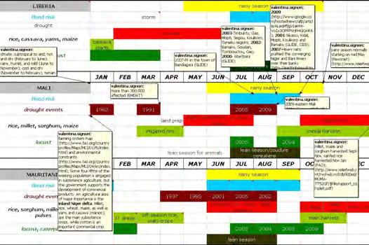
35 West Africa Regional Bureau, Dakar Available countries Benin, Burkina Faso, Cameroon, Cape Verde, Central African Republic, Chad, Cote d'ivoire, Ghana, Guinea, Guinea-Bissau, Liberia, Mali, Mauritania, Niger,
36 Regional Bureau Dakar - OD_D BENIN JAN FEB MAR APR MAY JUN JUL AUG SEP OCT NOV DEC severe storm drought events cassava, maize, sorghum, millet, rice, yams, beans cassava, 2nd maize yams maize rice cassava, millet, sorghum, irrigated rice yams 2nd maize main maize, rice millet, sorghum, irrigated rice cassava, 2nd maize locust 2004 Climate: tropical; hot, humid in south; semiarid in north. Rainy Season: normally from mid June to mid.terrain: mostly flat to undulating plain; some hills and low mountains June July August December flooding occurred in two principal towns in Benin, Cotonou in the Department of Atlantic and Porto-Novo in the Department of Oueme + Mono in Mono Dept. due to 2 weeks of heavy rains state of emergency declared, out of 77 communes, 43 were affected with southern parts and Couonou worst hit (more than 60,230 in only June); ,000 affected Cotonou and neighbouring areas since late July, 150,000 people affected; Northern Depts ofatacora and Borgou, 420,000 affected river started gradually over-spilling its banks in July when the season's first storms hit; 57,000 people in the Oueme river valley community of Adjohoun, 60km east of Cotonou, are threatened with malnutrition and water-born diseases because of river flooding, which has wiped out more than 25,000 hectares of crop land, killed about 30,000 animals, flooded 18,000 homes, and has displaced about 2,000 people; 2007; overflowing of Oueme River and Sre Lake, floods occurred in most of the provinces in southern oarts, particurarly in the towns of Oiunhi, Zagnanado and, at lesser extent, Cove; 148,000 affected since late, affected and 42 dead, 34 communes affected out of 77 with Dangbo, Ouinhi, Bonou, Zagnanado Sémé et Podji worst hit; ,000 affected and 61 killed
37 Regional Bureau Dakar - OD_C BURKINA FASO JAN FEB MAR APR MAY JUN JUL AUG SEP OCT NOV DEC drought events dust storm , 1995 rice, sorghum, millet, maize land preparation sowing weeding second rice, sorghum main land preparation rice sowing locust 2005, 2004 May July August for animals / North Climate: tropical; warm and dry winters; hot and wet summers; dry season from Nov to April. Rainy Season: can start in mid May and end in mid. Terrain: mostly flat to dissected, undulating plains; hills in west and southeast Ouagadougou LATEST DROUGHT EVENTS with AFFECTED AREAS killed 33 people (and continued through ); city of Gorom-Gorom in northeastern region worst-affected areas is the north province of Loroum; Kadiogo, Sanmatenga, Boulgou, Yatenga, Nayala, Kenedougou, Bazega, Bam, Seno, Noumbiel, Comoe, Loroum, Nahouri, Sebba in and around Ouagadougou, 151,000 affected ,000 estimated homeless due to heavy rains and floods since Aug-Sept and a total 121,000 affected 2005; Plateau Central; ,590 affected; ,600,000 affected; ,250,000 peole affected; ,000 affected
38 Regional Bureau Dakar - OD_D CAMEROON JAN FEB MAR APR MAY JUN JUL AUG SEP OCT NOV DEC /coast / north /coast / western highlands short / centre / central plateau drought events cassava, maize, sorghum, rice, millet, beans, yams Land preparation yams maize cassava, sorghum, millet, rice land preparation main maize, yams 2nd maize sorghum, millet, rice, 2nd maize, cassava locust, elephants, granivourousbirds G B locust / 2005 elephants / 2005 April June July August Climate: tropical along coast, semiarid and hot in north. Precipitation decreases from south to north. Along the coast, the lasts from April to November, and the relatively dry season from December to March; a transition period from March to April is marked by violent winds. In the central plateau region, precipitation decreases and there are 4 season-a light from May to June, a short dry season from July to, a heavy from to November, and a long dry season from December to May. The north has a dry season only from to May and an average annual precipitation level of about 30 inches (750 mm). The wettest part of the country lies in the western highlands-annual precipitation level of more than 400 inches (10,000 mm) most of which falls from May to. Terrain: coastal plain in southwest, dissected plateau in center, mountains in west, plains in north Nkolbisson, a neighbourhood located on the outskirts of Yaounde South-West province LATEST DROUGHT EVENTS with AFFECTED AREAS 2008; 25,000 affected; landslide in the southern part, particularlly in the district of Wabane, department of Lebialem Mokolo area; more than 10,000 affected; Douala, Bonaberi, B?panda, Nylon districts The far north is the most densely populated province is prone to intense heat, poor rains and drought conditions ,900 affected; about 400,000 affected; northern districts of Cameroon in Mayo Kani, Mayo Danaï, Logone and Chari; North
39 Regional Bureau Dakar - OD_D CAPE VERDE JAN FEB MAR APR MAY JUN JUL AUG SEP OCT NOV DEC storm risk drought events /05 maize, beans, sweet potatoes dry planting sowing locust July LATEST FLOOD/STORM EVENTS TS Berta LATEST DROUGHT EVENTS with AFFECTED AREAS Climate: temperate, characterized by stable temperatures with extreme aridity; warm, dry summer; precipitation meager and very erratic. The "other" is between December and June, when the north-easterly Trade Winds are prevalent: during this season, only altitudes above about 600m tend to receive regular rain. The North-eastern slopes of these high mountains often receive several times the amount of rain that south-westerly slopes lying in rain shadow receive. Terrain: steep, rugged, rocky, volcanic severe storm killed 29 and affected 5,500 people; more than 2,000 affected, 3 people dead Severe and recurrent droughts; from 1900 to 2010, 10 event recorded, with a total 40,000 affected; ,000 affected; ,000 affected; south-western islands Fogo and Brava affected
40 Regional Bureau Dakar - OD_D CAR JAN FEB MAR APR MAY JUN JUL AUG SEP OCT NOV DEC drought severe storm severe storm severe storm cassava, maize, sorghum, millet, rice, yams, pulses yams maize cassava, millet, rice, sorghum 2nd maize main maize, yams millet, sorghum, rice, cassava locust July August Climate: tropical; hot, dry winters; mild to hot, wet summers. Rainy Season: June to Sept in the north; dry season normally starts in Oct and ends in Feb/March. Peak of rains in Aug-Oct. Terrain: flat to rolling monotonous plateau; scattered hills in northeast and southwest since June heavy rains and floods in Bangui with 11,000 affected; till August 7,812 people affected Mambere Kadei Prefecture; south-western parts, damage to all areas of the capital city, Bangui, and severe flooding and destruction to four districts of the city, Malimaka, Ngaraba-Bangouma, Being and Petevo, along the southern banks of the Ubangui River; 23,800 affected; ,000 affected flooding along Ouham and Gribingui Rivers In North and Oubangui River In South; heavy damage, particularly in Batangafo & Kaga Bandoro In North, Kouango in South and a total 7 killed and 17,500 affected through almost 13,000 affected; Bangui, Nola, Batangafo, Begoua, Lobaye, Bimbo, Mpoko-Bac, Sibut, Paoua, Damara, Bouca; 33,919 affected; ,200 affected
41 Regional Bureau Dakar - OD_D CHAD JAN FEB MAR APR MAY JUN JUL AUG SEP OCT NOV DEC dry season dry s. drought events , 1993 sorghum, millet, maize, cassava, rice, yams land prep sowing 2nd sowing land prep second locust pastoral agricultural August LATEST DROUGHT EVENTS with AFFECTED AREAS LATEST CATERPILLAR/LOCUST EVENTS with AFFECTED AREAS Climate: tropical in south, desert in north. The dry season starts on Dec till mid May (from December to February everywhere in the country). Terrain: broad, arid plains in center, desert in north, mountains in northwest, lowlands in south ,000 people resulted affected by heavy rains and floods since late July in more than half of the country's regions, leaving nearly 70,000 homeless; Habile 3 IDPs site as well as Koukou town and the surroundings affected due to the Bahr-Azoum River bursting its banks southern areas and N'djamena; east and west as a result of heavy rains and storms in Aug and Sep, a number of areas in eastern and western Chad experienced serious flooding, with over 30,000 people affected. The main affected regions were those of ,763 affected; heavy rains since late July caused flooding in 11 out of the 14 provinces; Continuous overflowing of the rivers Batha and Bahr Azoum have created a particularly serious situation in Batha, Biltine, Chari-Baguirmi, Guera, Kanem, Lac, Mayo-Kebbi and Moyen-Chari; ,686 affected two heavy torrential rains poured down in the capital N'Djamena leading to the flooding of almost half of the town, with most affected areas Walia, Kamda, Toukra, Habena, Chagoua, and Moursal; beginning of Sept western Chad in general and in the area of Mayo Kebbi in eastern Chad in particular affected; Eastern parts, worst hit area is Koukou. Lake Fitri and Batha River; South west region of Mayo Kebbi, Tandjile region in the south, Salamat in the east, Lac in the west, and Hadjer Lamis in the north central region; major rivers Logone (South), Chari (Center-West) and Batha (Center-East) burst their banks. In total, 129,500 people were affected; most adversely affected areas are the Dpts of Tandjilé East and West, Bahr Koh, Dar Sila, Logone Occidental, Logone Oriental, Chari-Banguirmi Salamat, Batha East and West, Mayo Dalla, Mayo Bonoye and Kabia 2009/ about 2 million affected; Low and erratic rainfall during the cropping season, following below-average rainfall in 2008, has severely affected cereal production and negatively impacted the availability of pasture for livestock, mainly ijn the Sahel belt (regions of Kanem, Bahr-el-Ghaza, Guera, Batha, Lac, Hadjer Lamis, Ouddai, Wad Fira and Sila among most insecure); Gura, Biltine, Ouadda, Assoungha, Batha-Est, Bathaouest provinces with 800,000 affected; ,000 affected. Other important drought events reported in 1969, with 900,000 affected and in 1997, with 356,000 affected few individual mature adults were seen in Kanem; km from the Sudan border and Another swarm is reported near Lake Chad
42 Regional Bureau Dakar - OD_D COTE D'IVOIRE JAN FEB MAR APR MAY JUN JUL AUG SEP OCT NOV DEC rains in coastal parts and centre in northern savana rains in coastal parts and centre drought events 2007 cassava, yams, rice, millet, maize, sorghum 2nd maize cassava starts maize, yams and cassava millet, sorghum and rice 2nd maize yams starts maize main millet, sorghum, rice 2nd maize Caterpillar/locust June July August/ LATEST DROUGHT EVENTS Heavy rains and storms in Abidjan, significant damage has been recorded; Series of mudslides caused by torrential rains Heavy rains in Abidjan Abidjan; Agboville, 2,00 people severly affected southwestern region of Duekoué due to a dry spell since Dec; the southwest is where much of the country's rice, yams and manioc are produced. city of Korhogo experienced asevere drought in early 2000 which culminated in 2005 with the draining of the dam, main source of potable water supply. This has resulted in insufficient water for household and agriculture used, hence the disruption of agricultural cycles and reduced s and incomes LATEST CATERPILLAR/LOCUST EVENTS with AFFECTED AREAS Climate: tropical along coast, semiarid in far north; the southern savanna type of climate occurs, characterized by the parching wind known as the harmattan, which blows from the northeast beginning in December and ending in February;.The northern region is drier than the rest of the country and, because of the elevation, somewhat cooler. Terrain: mostly flat to undulating plains; mountains in northwest caterpilar invasion from Liberia; in the northern town of Tengrela, near the border with Mali
43 Regional Bureau Dakar - OD_D GAMBIA JAN FEB MAR APR MAY JUN JUL AUG SEP OCT NOV DEC drought events millet, maize, sorghum, rice maize rice, sorghum, millet, groundnuts maize rice, sorghum, millet, groundnuts June July August LATEST DROUGHT EVENTS Climate: subtropical predominantly. Terrain: the Gambia river divides the country into 4 major landscapes: floodplains, colluvial slopes, lower and higher plateaux severe storm in an area around Darsilameh village in the Western Region; STORM in Upper River Division; people affected 32,000; people dead and 32,000 affected in Central River & Upper River divisions storm in the area of River Region; FF in Sinchu Balia ; Kachikally, Farokono areas - Bakau more than 21,000 affected; Upper River Division following a severe storm, more than 8,000 affected; state of emergency declared after prolonged and heavy rainfall between June to August mainly in Central River and Upper River Divisions; ,000 people affected ,000 affected Latest drought events reported in 2002, ,000 affected; ,000 affected and ,000 affected
44 Regional Bureau Dakar - OD_D GHANA JAN FEB MAR APR MAY JUN JUL AUG SEP OCT NOV DEC harmattan season major (North) harmattan season drought events yams cassava millet, sorghum cassava, yams, maize, sorghum, rice, millet cassava starts main maize-s rice-south main maize- N rice-north maize, yams 2nd maize sorghum, millet, rice 2nd maize April June July August Accra region LATEST DROUGHT EVENTS with AFEECTED AREAS northern region; affected 12,500,000 people; 1968 Climate: tropical; warm and comparatively dry along southeast coast; hot and humid in southwest; hot and dry in north. Terrain: mostly low plains with dissected plateau in south-central area. The Kwahu Plateau marks the northernmost extent of the forest area and also serves as an important climatic divide; to its north 2 distint seasons: the harmattan season, dry and relatively cool from November to late March or April, and the wet period, which reaches its peak in late August or ; to the south and SW 4 seasons: heavy rains from April to late July, dry spell in August and another in Sept-Nov ,602 people were affected; heavy downpour caused flooding in some low lying areas within the Accra Metropolis; Accra, Kumasi region massive destruction in most communities in the western parts of Accra, Eastern, Volta, Central, Western and Ashanti Regions; 2001, since June -coastal areas, Accra with southern districts of the capital such as Nsawam, Adoagyir, Zongo and the Odaw channel particurarly affected for a total 144,025 people involved; victims and 700,000 affected; since July 58,000 affected, mainly in northern areas about 140,000 people were affected; from late August in northeast and Upper East Region affected 332,600 people; especially northern regions: Upper West, Upper East, Northern Regions, Parts of Brongahafo & Volta Regions; 325,000 people affected
45 Regional Bureau Dakar - OD_D GUINEA JAN FEB MAR APR MAY JUN JUL AUG SEP OCT NOV DEC drought events rice, cassava, maize, millet, sweet potatoes, sorghum, yams cassava yams, cassava palm nuts maize, millet, sorghum, rice rice, maize yams maize, rice, sorghum, millet locust 2005 July August Climate: generally hot and humid; monsoon-type and dry season Dec/May. Rainy season: peak in Jul-Aug especially for coastal areas, where there is a 6-month long rainy season with heavy precipitations; in central areas the r.s. could last 5 moth with lower rains; in higher part normally 3 months of rains and in pluvial forest very humid climate with no dry season. Terrain: generally flat coastal plain, hilly to mountainous interior affecting about 7,000 peole; ,200 affected till Sept, 40,000 affected; Prefecture of Boké, wester parts close to the GB borders ; ,000 affected; ; in Kindia; since Aug in eastern part (Haute Guinee, Kankan region) after the main river Niger and its tributaries Sankarani, Fie, Milo and Djon overflowed; most affected Mandiana, Kouroussa, Kankan, Siguiri, Kerouane prefectures (Kankan region); since Sept 20,685 affected, manily eastern and central part
46 Regional Bureau Dakar - OD_D GUINEA-BISSAU JAN FEB MAR APR MAY JUN JUL AUG SEP OCT NOV DEC storm drought events dust storm 2002, 2006 dust storm rice, millet, maize, sorghum, cassava, tubers maize, millet, sorghum rice sowing maize, millet, sorghum rice locust 2005 Climate: tropical; generally hot and humid; monsoonal-type. Rainy Season: can last til Nov; the coast receives some 60 to 120 inches (1,500 to 3,000 mm) of precipitation, whereas the interior is influenced by the tropical savanna climate, with greater variation in precipitation and temperature. Terrain: mostly low coastal plain rising to savanna in east August ,792 people affected; southern areas 2004 LATEST DROUGHT EVENTS Drought in upland areas and drought and flash flood in rainfed lowland as the main concern for rice production ,000 people affected; ,000 affected
47 Regional Bureau Dakar - OD_D LIBERIA JAN FEB MAR APR MAY JUN JUL AUG SEP OCT NOV DEC storm landslide drought sowing rice, cassava, yams, maize cassava starts yams starts rice starts caterpillar/locust 2009 June July Climate: tropical, hot and humid; dry winters, wet, cloudy summers with frequent heavy showers. Climate, especially on the coast, is warm and humid year-round; The dusty and dry harmattan (desert winds) blow from the Sahara to the coast in December. Rainy Season: rainfall is irregular, and the varies in intensity and begins earlier at the coast than in the interior. The greatest amount of rainfall, 205 inches (5,200 mm), occurs at Cape Mount and diminishes inland to about 70 inches (1,800 mm) on the central plateau. Terrain: mostly flat to rolling coastal plains rising to rolling plateau and low mountains in northeast. Deforestation and drought in the Sahel have affected the climate, lengthening the dry season by almost a month in some areas more than 15,000 affected capital Monrovia August Red Hill, Caldwell, Doe, St. Paul Bridge, and Gardnersville communities near the St. Paul River in Greater Monrovia and in the western part of the capital; a total people affected Monrovia areas; ,000 affected
48 Regional Bureau Dakar - OD_D MALI JAN FEB MAR APR MAY JUN JUL AUG SEP OCT NOV DEC drought events , , 2006 land prep millet, rainfed rice, sorghum, maize irigated rice rice, millet, sorghum, maize rainfed rice irrigated rice cereal rainfed rice locust for animals for cereals July August LATEST DROUGHT EVENTS till 2010 worst drought in 26 years, combined with soaring temperatures; worst affected eastern Mali; 600,000 affected; about 25,000 affected; million people affected; more than affected; ,500,000 affected LATEST LOCUST EVENTS with AFFECTED AREAS Clmate: subtropical to arid; hot and dry (February to June); rainy, humid, and mild (June to November); cool and dry (November to February). The dry season, which lasts from November to June, is marked by low humidity and high temperatures and is influenced by the alize and harmattan winds. The alize blows from the northeast from November to January and causes a relatively cool spell; from March to June the harmattan, a dry, hot wind that blows from the east out of the Sahara with hot temperatures. Terrain: landlocked; divided into three natural zones: the southern, mainly cultivated Sudanese; the central, semi-arid Sahelian; and the northern, arid Saharan FF in the town of Bandiagara, 47,255 affected Timbuktu, Gao, Mopti, Segou, Koulikoro, Teneku regions; since July, Bamako, Goudan, Tombouctou, Gao and 22,519 affected; Abe?bara; ,635 affected 2009; Heavy rains pushed the converging Niger and Bani Rivers over their banks; Sikasso, Kidal, Mopti, Koulikoro and Bamako on border area with CI; from neighbouring Mauritania and are breeding across a vast swathe of central Mali
49 Regional Bureau Dakar - OD_D MAURITANIA JAN FEB MAR APR MAY JUN JUL AUG SEP OCT NOV DEC drought events rice, sorghum, millet, maize, pulses, maraichage Maraichage /riz low lying areas off s, rice off-season rice, walo crops irrigated rice, maize, millet, sorghum low lying areas Walo crops main (rainfed and winter irrigated areas) off-season rice locust, caterpillar June July August LATEST DROUGHT EVENTS storm in Brakna region, South-eastern part of Nouakchott more than 3,500 people home;ess in southwest; Assaba, Gorgol, Brakna, Adrar regions + Guidimakha Region due to severe storms and heavy rains; Akjoujt southwestern areas since August; thousands affected in the south eastern town of Tintane; more than 23,000 affected Recurrent droughts affect the country ,000 affected; 2005; Aftout, Senegal River Valley, Hodh el Gharbi, Ho dh el Chargui, Ad rar, Tiris Zemour, Nouakchott, Nouadhibou, Zouerate; govt declared state of emergency-southern enclave of Aftout, which hassuffered six successive poor s, 2003; Assaba, Brakna, Gorgol, Tagant, Nouackchott, Inchiri, Adrar region; 1997; ,507 affected; ,6 million affected LATEST LOCUST EVENTS with AFFECTED AREAS Climate: desert with limited and occasional rainfalls along the Senegal river. Rainy Season: could end in mid Aug but varies form far south (June -Oct) to northern part (July-Sept). The duration of the, as well as the total annual amount of precipitation, diminishes progressively from south to north; because of opposition between the wet southwesterlies and the harmattan, precipitation often takes the form of stormy showers or squalls. Nouâdhibou (formerly Port-Étienne) receives between 1 and 2 inches (between 25 and 50 mm), usually between and November. Terrain: vast, arid plains broken by occasional ridges and clifflike outcroppings 2009; summer breeding started in early August; 2005; due to wet winter and spring
50 Regional Bureau Dakar - OD_D NIGER JAN FEB MAR APR MAY JUN JUL AUG SEP OCT NOV DEC dry season drought events millet (fonio), sorghum, rice, maize, cassava (tapioca), Cowpeas (intercrop) second sowing season second land preparation sowing season second sowing season maize, millet, sorghum locust July August /November LATEST DROUGHT EVENTS with AFFECTED AREAS From 1900 to 2010 a total 12 event recorded and 20,655,000 people affected failed rains and consequent failed resulted in 7,900,000 people affected mainly in the Sahelian belt; million affected; Ayerou, Balleyara, Hamdallaye, Loga, Kieche, Doungou, Tessaoua; Ibanka, Sahara I, Sahara II, Rouafi I, Rouafi II, Chinagamane, Ayawa, Kabefo, Dinkihmi villages; 3.6 million and half people affected; ,630,000; million affected; ,5 million affected LATEST LOCUST EVENTS with AFFECTED AREAS Climate: desert; mostly hot, dry, dusty; tropical in extreme south. Rainy Season: especially in southern areas; the rains last from one to four months, according to the latitude. August is the rainy month everywhere except in the far north, where the rainfall is unpredictable. Terrain: predominately desert plains and sand dunes; flat to rolling plains in south; hills in north ,659 personnes touchées dans les cinq villages de la commune de Madaoua (Tahoua); Moa village in southeast region of Zinder; Regions of Niamey, Agadez,, Maradi, Tahoua, Tillaberi, Zinder, Diffa; hundreds of people affected by flooding in the southeast region of Zinder and Dosso; Tillaberi; Dosso, Maradi departments Dosso, Tahouna, Tillaberi, Zinder regions; severe storm in Agadez, 210,000 affected til ; ,000 affected; ,000 affected ,500,200 affected since August; Agadez, Zinder, Tahoua, Dosso and Tillaberi; ,000 affected; ,000 affected Diffa department; ,000 affected 2005; swarms were reported to be moving in the Irhazer, Aïr and Tamesna as well as in the north of the regions of Tahoua, Tillabéri, and Zinder. Hopper bands were also seen in the regions of Tahoua and Maradi
51 Regional Bureau Dakar - OD_D S. TOME AND PRINCIPE JAN FEB MAR APR MAY JUN JUL AUG SEP OCT NOV DEC erratic rains dry season storm storm drought events banana, maize, manioc, sweet potato, pulses (cacao, maraîchage and taro) maize second sowing season second maize sowing season cacao (80 to 90%) FLOOD RISK Climat/Rainy Season: tropical and humid with 2 main seasons, 1 lasting 9 months (mid Sept - mid May) and 1 dry season between June and Sept which coincide with the lean period. Annual rainfall amounts could vary from 2000 to 3000 mm with regional differences: normally around 2000 mm in North-West areas and 7000 mm in South-West. Strong winds between Mar/Apr and Oct/Nov generallu cause damage to crops. Terrain: volcanic, mountainous The risk of trong winds and flooding associated with storms is high between March and April and between and November
52 Regional Bureau Dakar - OD_D SENEGAL JAN FEB MAR APR MAY JUN JUL AUG SEP OCT NOV DEC drought events rice (staple), millet, maize, sorghum, cassava rice, maize, millet, sorghum maize, millet, sorghum rice locust 2004 July August LATEST DROUGHT EVENTS with AFFECTED AREAS Climate: tropical; hot and humid. Rainy Season: could start in May end end in November and has strong southeast winds; dry season (December to April) dominated by hot, dry, harmattan wind. In the Sahelian climate (an area bounded to the north by the Sénégal River and to the south by a line running from Thiès-Cape Verde to Kayes-Mali) the r.s. starts in July; in the Sudanic zone, the southern parts of the contry, annual precipitation varies from north to south. Terrain: sandy plains of the western Sahel which rise to foothills in the southeast (WFP); The dry winds, sometimes called the dry monsoon, consist of the northeast trade winds. In winter and spring, when they are strongest, they are known as the harmattan. They bring no precipitation apart from a very light rain Linguere region; ,000 people affected till Sept in the capital Dakar and its suburbs as well as towns such as western Mbour and Kaffrine in the centre; 264,000 affected; centre and north as well as in southern Senegal in Ziguinchor and in the capital, Dakar till Sept; ,000 affected; Kanel, Nioro, Kafrine, Matam, Wahound?, Ahour?, Kaolack, Tamcacounda, Kolda; severe storms Dakar; Thi?s, Diourbel, Saint Louis and Kaolack Severe droughts in over 3.5 million affected; ,4 million people; million affected; ,000 affected south eastern areas; over Senegal's Groundnut Basin
53 Regional Bureau Dakar - OD_D SIERRA LEONE JAN FEB MAR APR MAY JUN JUL AUG SEP OCT NOV DEC drought rice, cassava, pulses, maize, millet, yams, sorghum (north) locust cassava yams cassava rice, sorghum, maize, millet yams rice, millet, maize, sorghum June July Augusr Climate: tropical along the coast, dry savannah in the north. Rainy Season: peak in Jul/Aug; precipitation is greater on the coast than inland. The Peninsula Mountains receive more than 200 inches (5,000 mm) annually, while the northeast receives about 80 inches (2,000 mm) a year. Terrain; Tropical forest for 70% of the country and dry savannah lowlands in the north severe storm affected 10,000 people ,000 affected; severe storm killed 60 people landslide in Freetown; about 4,500 affected; Pujehun district mainly, 2 rivers, south-east of the capital, burst their banks, 15,000 affected Freetown, 6 villages in the Kambia District, sicne August, affected 4,500 people
54 Regional Bureau Dakar - OD_D TOGO JAN FEB MAR APR MAY JUN JUL AUG SEP OCT NOV DEC (SOUTH) (NORTH) r. s. (SOUTH) drought events 1989, 1971 cassava, maize, yams, millet, sorghum, rice 2nd maize yams main maize cassava, millet, sorghum, rice yams 2nd maize main maize millet, sorghum, rice cassava locust July Augusr LATEST DROUGHT EVENTS ,000 people affected; ,000 people hit Climate; tropical; hot, humid in south; semiarid in north. Terrain: rolling savanna in north; central hills; southern plateau; low coastal plain with extensive lagoons and marshes. Rainy Season: the coastal region has two s, one peaking in May or June, the other in, but in the north there is a single starting in May or June to the end of - as in Ghana. Precipitation in the North averages about 45 inches (1,150 mm); during the rest of the year the warm, dry harmattan (a dust-laden wind) predominates The narrow coastal zone, which receives about 35 inches (890 mm) of precipitation annually, is the driest region Southern Plateaux and Maritime Region; 45,000 affected; ,000 affected Lomee area; ,000 affected Neastern areas; Kpendjal, Oti, Tone and Tandjouare; since August 41 resulted killed and 141,331 affected; affected 65,000 people Savanes, Kara, Plateaux & Maritime; ,405 affected
55 Latin America and the Caribbean Regional Bureau, Panama Available countries Bolivia, Colombia, Cuba, Dominican Republic, Ecuador, El Salvador, Guatemala, Haiti, Honduras, Nicaragua, Panama, Peru
56 Latin America & Carribean - OD Panama BOLIVIA JAN FEB MAR APR MAY JUN JUL AUG SEP OCT NOV DEC frost period flood/landslide risk January February March November December drought events , maize, rice, sorghum, (sweet and not) potatoes, wheat LATEST DROUGHT EVENTS with AFFECTED AREAS wheat, barley winter sowing hail storm, Tarija province, 1,331 families affected potatoes, maize sowing main first barley wheat /East plains La Nina 2007/08 barley, rice, wheat, soybean, sweet potatoes sowing Terrain: Rugged Andes Mountains with a highland plateau (Altiplano), hills, lowland plains of the Amazon Basin. Climate: Varies with altitude; tropical humid in the Northern lowlands, tropical wet and dry in Central lowland areas, polar and semiarid in the highest parts of the Andes. In most locations rainfall is heaviest during the Southern Hemisphere summer, and yearly amounts tend to decrease from north to south; the Chaco has a semitropical, semiarid climate, whith the northeast trade winds that bring rain and hot humid conditions only from January through March, and the Altiplano, which also is swept by strong, cold winds, has an arid, chilly climate, with sharp differences in daily temperature and decreasing amounts of rainfall from north to south. Rainy Season: /March with floods peak in January and February since November in 8 depts at least 9000 families affected and more than 6000 hectars of crop damaged, with Cochabamba, Chuquisaca, Oruro, Potosí, Santa Cruz, Tarija and La Paz worst affected; La Nina caused dameges in communities living in bordering areas of the main rivers in lowlands and valleys, namely Cochabamba, Santa Cruz, Chuquisaca, La Paz, Potosi, Pando, Tarija, Beni and Oruro; heavy rains all over the country with overflowing of major rivers such as Rio Grande, Pilcomayo, San Juan del Oro, Bermejo among others that affected several communities in at least seven out of the nine departments; landslides in Los Yungas and San Borja, La Paz and Beni depts due to overflowing of important rivers such as Rio Grande, Guanay, Tipuani, Mapiri, Challana among others with 126,096 affected; mainly in Santa Cruz region; ,250 affected districts of the city of Santa Cruz were flooded; heavy rains and floods left 50 dead and affected families, with Trinidad in Beni dept, worst hit; severe floods especially along Amazon areas; continuous serious floods triggered by heavy rains since January affected several departments, with Santa Cruz, La Paz and Beni worst affected. State of emergency at the beginning of February and appealed for international assistance; 2002 La Paz with 76 killed western parts; Trinidad; landslide in Chima, Larecaja province, La Paz dept heavy rains and floods in La Paz, Cochabamba, Santa Cruz, Beni, Potosi y Chuquisaca since November killed 75 people; South-East of La Paz capital, on the Chapare River, with 68 victims 8 events of drought recorded in the period 1900/2009 for a total 3,491,209 people affected Department of Chuquisaca in the Chaco region; national emergency because of prolonged drought in four provinces in the departments of Santa Cruz, Tarija and Chuquisaca. In the central altiplano region til mid January 2009; savannas and wetlands of central part; international appeal launched in Nov by WFP, especially for seven municipalities of El Chaco; Int appeal in the depts of ORURO, POTOSI, COCHABAMBA and TARIJA. 1.6 million people in need of emergency assistance
57 Latin America & Carribean - OD Panama COLOMBIA JAN FEB MAR APR MAY JUN JUL AUG SEP OCT NOV DEC 1st /Andes and mainly west /tropical savanna and Plain 2nd r.s. cold wave flood/landslide risk tropical storm season February March April May June July November December June drought events rice, potatoes, maize, sorghum, wheat, barley TROPICAL STORM SEASON soybean LATEST DROUGHT EVENTS with AFFECTED AREAS Climate: tropical along coast and eastern plains; precipitation is moderate to heavy in most parts of the country and the heavier rainfall occurs in the low-lying hot zone. Rainy seasons: April/June and /December. Terrain: four geographic regions: the Andean highlands, consisting of the three Andean ranges and intervening valley lowlands; the Caribbean lowlands coastal region; the Pacific lowlands coastal region, separated from the Caribbean lowlands by the Isthmus of Panama; and eastern part, the great plain that lies to the east of the Andes Mountains. Colombians describe their country in terms of the climatic zones: the area under 900 meters in elevation is called the hot zone (tierra caliente), elevations between 900 and 1,980 meters are the temperate zone (tierra templada or tierra del café ), and elevations from 1,980 meters to about 3,500 meters constitute the cold zone (tierra fría). soybean sowing Narino dept. due to overflooding of Mira river Dpts of Santander, Norte de Santander and Tolima; Tolima (centre), Santander (nord-est), Valle (sud-ouest) Landslide municipality of Sochoa; flood affected more than 7,000 families 2006 Depts of Choco, Valle del Cauca, Cauca, Narino, Antioquia, Caldas, Risaralda, Quindio, Tolima, Arauca, Santander, Norte de Santander, Cundinamarca, Boyaca, Casanare y Meta. Between January and 31 March 2006, 63 landslides, 39 floods events, and 4 avalanches have affected 88 municipalities of 16 departments out of 32; North and West, Sibundoy Valley region (Putu mayo state) East and central especially Cundinamarca, Tolima and Antioquia; Provinces of Antioquia, with Taraza and Valdivia hardest hit; floods and mudslides in the SW and NE parts Caused by an overflow of the Suramita River in rural Nóvita-Choco; Caqueta department; Bogota area Arauca province Cordoba Dept due to overflow of San Jorge and Sinu rivers Heavy rains in northern depts of Cordoba, Bolivar, Atlantico, Magdalena, Cesar, Guarija, Sucre and Norte of Santander; Ayapel (Cordoba department), San Benito Abad (Sucre department) Most affected zones have been northern and central Colombia, particularly Atlantico, Bolivar, Sucre, Cordoba, Huila, Tolima, Valle, Cauca and Choco. The emergency has also included Santander, Vichada, Caqueta, Putumayo, Guaviare and the Archipielago of San Andres and Providencia; Tierra Alta municipality, Cordoba province Magdalena province; Floods and landslide since especially in NE parts with Choco, Bolivar, Sucre, Cordoba and Magdalena worst affected A tornado hit Barranquilla, Soledad in Atlantico province Hurricane Omar maize, rice, sorghum, wheat, barley sowing Cali region in Valle del Cauce Dept; a four-month drought in a southern reservoir sorghum, barley, wheat rice, maize
58 Latin America & Carribean - OD Panama CUBA JAN FEB MAR APR MAY JUN JUL AUG SEP OCT NOV DEC flood/landslide risk tropical storm season June November December July August November drought events rice, (sweet and not) potatoes, maize, cassava TROPICAL STORM SEASON Old Havana, Central Havana main rice sowing 2nd maize & rice, potatoes Hurricane Dennis affected 2,500,000 people Hurricane Charley LATEST DROUGHT EVENTS with AFFECTED AREAS TS Ernesto; Hurricane Isidore; Hurricane Rita Fay, Gustav, Hanna, Ike; Isidore, Lili TS Paloma; Hurricane Michelle affected 5 million people main maize, sweet potatoes sowing main rice 2nd maize & rice, potatoes sowing main maize, sweet potatoes Climate: tropical, moderated by trade winds. Rainy season: May to -November while dry season from November to April. Tropical Storm season: peak in Aug-Oct. Terrain: mostly flat to rolling plains, with rugged hills and mountains in the southeast Sancti Spiritus, Villa Clara, Cienfuegos provinces Severe flooding in the areas of Holguin and Granma provinces; ,000 affected and 34 killed from 1900 to 2009, 6 events of drought recorded for a total 820,000 people affected. 2004/ the worst drought in 7 decades; Guantanamo, Santiago, Tunas, Camaguey provinces; Guantanamo; Guantanamo, Las Tuna, Holguin, Santiago de Cuba, Granma, Matanzas Provinces; ,000 people affected
59 Latin America & Carribean - OD Panama DOMINICAN REPUBLIC JAN FEB MAR APR MAY JUN JUL AUG SEP OCT NOV DEC flood/landslide risk tropical storm season January April May June November July August December drought events rice, maize, sorghum, beans TROPICAL STORM SEASON LATEST DROUGHT EVENTS main rice, 3rd maize & sorghum sowing 2nd maize & sorghum & rice Hurricane Dennsi main maize & sorghum sowing Tropical Storm Gustav, TS Fay; TS Ernesto TS JEANNE; storm that killed 347 people; ,000 people affected TS NOEL, 129 people killed and 79,728 affected TS OLGA Southwest and northwest; ,000 people resulted affected by drought conditions 3rd maize & sorghum 2nd rice sowing main rice, maize & sorghum 2nd maize & sorghum sowing Climate: moderate, relatively mild tropical climate, with heaviest precipitation in the mountainous northeast; the average annual rainfall is more than 100 inches (2,540 mm); the far western and southwestern valleys, along the Haitian border, remain relatively dry, with less than 30 inches (760 mm) of annual precipitation; northwestern and southeastern extremes of the country are also arid. Rainy season: normally May/Nov but along the northern coast rains from Nov through Jan. Tropical Storm season: June to Nov-Dec with peak in Aug-Oct. Terrain: major mountain ranges and elongated, fertile valleys mainly extend from northwest to southeast Widespread flooding in the provinces of Puerto Plata and Espaillat Maria Trinidad Sanchez province ,000 displaced; killed and 20,000 affected; Jimani worst hit, along a river system that drains the north flank of the Massif de la Salle San Pedro de Macoris region Eastern and Southern parts; Ramon Santana (east) Central part as result of strong storm Duarte, Montecristi, Santiago, Valverde provinces, with Bajo Yaque and Bajo Yuna districts worst affected (flood waters of the Yaque River from Santiago to Monte Cristy while its tributaries Anima, Mao, Guayubín, Gurabo and Cana rivers flooded an area of 8,000 Km2 in the provinces of Mao, Monte Cristy and Dajabón; 65,003 people resulted affected
60 Latin America & Carribean - OD Panama ECUADOR JAN FEB MAR APR MAY JUN JUL AUG SEP OCT NOV DEC /sierra dry season/sierra /sierra /Amazon /sierra dry season/costa and inland region flood/landslide risk drought events rice, maize, barley, wheat rice, barley, wheat sowing barley, rice, wheat, maize maize, rice, barley sowing January February March May June August LATEST DROUGHT EVENTS : tropical climate in the Coastal plain (costa) with rainfall decreasing from north to south and vegetation changing from tropical rainforest in the north to tropical savannah and desert in the south; the Costa Internal has a hot and humid climate and rain is constant during the winter months of December through May, with the heaviest rainfall occurring in February and March. The inter-andean central highlands (sierra) have climate divided into levels based on altitude (tropical, sub-tropical and temperate) but normally winter, or the, lasts from January through June (most rain falls in April); there also is a short rainy period in early caused by moisture penetrating the Sierra from the Oriente; the flat to rolling eastern jungle and lowlands (oriente) experience an equatorial climate with abundanr rains. The Amazon region has rainfall throughout the year and it is the wettest region. Galapagos Islands's climate follows a pattern more like that of the Sierra than the Costa. At sea level, the land is desertlike with no precipitation during the 8 summer months, whereas the winter months of January through April have some fog and drizzle. Above sea level to an altitude of 450 meters, the islands have a mixture of tropical, subtropical, and temperate climates. The inter-andean or sierra region has a starting from to May with maximum rainfall in and April and dry weather June/Sep. The Amazon region has rainfall throughout the year Los Rios western part due to La Nina - 11 provinces or 50% of the territory affected especially in especially in Nuevo Yaguachi, Puerta Inca, and Guayaquil Heavy rains since early February west of the Andes caused the water level of the Guayas Basin and several rivers to rise, provoking flooding and landslides in 35 cantons of the 5 coastal provinces of El Oro, Esmeraldas, Guayas, Los Rios, and Manabi; Esmeraldas, El Oro, Guayas, Los Rios, Manabi and Pichincha in the coastal region; Huequillas and in coastal provinces of Guayas, Los Rios and Manabi; Manabi province; Esmeraldas, Manabi, Guayas, El Oro, Azuay, Ca?ar, Cotopaxi, Pichincha, Morona Santiago, Zamora, Chinchipe provinces Carchi, Imbabura province Cuenca City, Azuay Province (South of the Andean Mountains) due to overfloding of Yanuncay River; state of emergency for the provinces of Morona-Santiago, Napo, Pastaza, and Zamora-Chinchipe ,000 affected Guayas and Los Rios, El Oro, Manabi, Esmeraldas provinces, 218 kileld rice and maize crop affected mainly in Palenque; southwest especially affecting Celica, Macara, Puyango, Pindal, Sozoranga, Zapotillo counties (Loja province), Arenillas, Las Lajas, Huaquillas counties (El Oro province); ,000 affected
61 Latin America & Carribean - OD Panama EL SALVADOR JAN FEB MAR APR MAY JUN JUL AUG SEP OCT NOV DEC flood/landslide risk tropical storm season drought events maize, sorghum, beans, rice June July August May TROPICAL STORM SEASON 2nd rice sowing sorghum, maize, main rice LATEST DROUGHT EVENTS with AFFECTED AREAS 2nd rice main beans & maize & rice, sorghum sowing From 1900 to 2009, 4 drought events recorded for a total 400,000 people affected Usultan, San Miguel, Morazan, La Union; nd beans sowing 2nd maize sowing main maize & beans 3rd maize sowing main rice, 2nd beans, sorghum Climate: tropical on coast; temperate in uplands. Terrain: mostly mountains with narrow coastal belt and central plateau. Rainy Season: May/. Tropical Storm Season: June/November with peak normally expected from August to ,000 affected End Sep/early Oct, coastal areas affected and the regions south and west of the capital San Salvador; central and eastern parts; red alert in Rancho Grande, Traura ,141 affected maily in coastal areas; heavy rain and flood associated with Hurricane Keith; a severe storm killed 475 people unsual Hurricane Adrian Hurricane Felix; Hurricane Isidore affected southern coast and especially Ahuachapan province ,141 affected; Hurricane Keith; 1998 a severe storm killed 475 people
62 Latin America & Carribean - OD Panama GUATEMALA JAN FEB MAR APR MAY JUN JUL AUG SEP OCT NOV DEC flood/landslide risk frost period landslide heatwave/ca 1st 2nd frost period nicula tropical storm season drought events maize, rice, beans, sorghum, potatoes, soybeans Main Grain Harvest in North 1st grain planting late planting maize, potatoes, rice, sorghum, wheat, beans 2nd maize, sorghum, beans, main in high plains January February May June July TROPICAL STORM SEASON May Landslide mudslide in San Antonio Senahu, northeast of the capital Department of Escuintla; landslide in a rural community in eastern Zacapa province; Guatemala City areas in southeast; Teleman ,000 affected; Escuintla, Jutiapa, Santa Rosa, Suchitepequez, San Marcos, Quezaltenango, Huehuetenango, Solola, Totonicapan, Retalhuleu and El Quiche unsual Hurricane Adrian LATEST DROUGHT EVENTS with AFFECTED AREAS Climate: tropical. Terrain: mostly mountains with narrow coastal plains and rolling limestone plateau; southern part dominated by a sting of 27 volcanos with a fertile plain in between; neardesert conditions prevail in the middle section of the Motagua River valley, whereas precipitation in excess of 150 inches (3,800 mm) occurs at higher elevations of the Pacific-facing volcanic row and on the north and east facing slopes of the sierras. Rainy Season: May to with a period of heat from mid June to mid July. In general, a dry season prevails between November and April; however, trade winds from the Caribbean can bring moisture and rainfall throughout the year. An average of 40 to 80 inches (1,000 to 2,000 mm) of precipitation is received in southern and eastern Guatemala, but this is doubled in areas located nearer the Caribbean shoreline ,740 affected by floods til June Guatemala City, Alta Verapaz, Huehuetenango, Escuintla, Jalapa,Quich, Totonicapan y Zacapa regions due to rivers Achiguate and Motagua that overflowed an hurricane hit Coyolote, Guacalate, Nahuatan, Samala, Ses river bassins Hurricane IRIS caused damages to the South of Petén department, specifically in the municipalities of Poptún, San Luis and Sayaxche irregular rains during May and June; Chiquimula, Zacapa, El Progresso, Santa Rosa, Jalapa, Jutiapa, Baja Verapaz departments; July 1994
63 Latin America & Carribean - OD Panama HAITI JAN FEB MAR APR MAY JUN JUL AUG SEP OCT NOV DEC 1st dry spell 2nd flood/landslide risk tropical storm season drought events , , cassava, yams, maize, sorghum, rice, millet, bean, sweet potatoes main rice & beans, maize sowing sorghum, 2nd rice, 2nd beans fall crops spring crops beans and rice 3rd beans fall crops March May June August November December TROPICAL STORM SEASON July August FF in Port-au-Prince's Carrefour slum; South, West and Artibonite Departments Grande Anse, Nippes at Nord-Ouest; Cap Haitien, Bahon, Parois, Limonade - Nord and border with Nord-Est Depts Cap-Haitien (Nord), Port-De-Paix (Nord-Ouest), 150,000 affected; Abricots region (Grand'Anse department) Hurricane Dennis LATEST DROUGHT EVENTS with AFFECTED AREAS Climate: tropical; semiarid where mountains in east cut off trade winds. Terrain: three-quarters of the country covered by mountains interspersed with small coastal plains and river valleys. 30% of the total land area is suitable for agriculture. Rainy season: generally the first starts in April and ends in mid June but first rains could happen in March or even earlier; the dry spell could vary from June to July. The second is in August to but could continue till Nov. Some regions have 2 s, April to June and August to, whereas other regions experience rainfall from May to November. The more humid districts are found on the northern and eastern slopes of the mountains. Some portions of the island receive less than 28 inches (700 mm) of rainfall per year. The northwestern peninsula and Gonâve Island are particularly dry. Port-au-Prince normally experiences a dry season from November to March all the country has been affected by heavy rains since mid March, being the south-western and the north-eastern the two most affected regions Camp Perrin, Maniche, Cayes, Chardonnières in SOUTH Dept, Beaumont in GRANDE-ANSE, in St Michel, Ennery and Bas Artibonite in ARTIBONITE, Baradères in NIPPES, Leogane in WEST, Carcol in NORTH,Cerca Carvajal and Cerca La Source in CENTRE Depts; surroundings of the city of Mapou in the South-East Department, close to the border with the Dominican Republic, and the city of Fond-Verrettes in the West Department (2,665 killed); most affected areas the departments of Grand'Anse and Sud: Azile, Grand'Anse, Les Cayes, Port Salut, Chantal, Cap Tiburon, Department of Sud; Petion-Ville, Nord, Artibonite, Grand'Anse torrential rain on the commune of Cotes-de-Fer in the South-East Department heavy rains brought by Tropical Storm Fay; heavy rains in late July led to extensive flooding in the Bas Artibonite area of Saint-Marc Commune heavy rainfall and mudslides-department of l'ouest; late Sept and Oct- the entire country affected by heavy rains with major impact in the South, West and Artibonite Departments; at the end of, related to TS Jeanne TS Fay; 2008, late August, Hurricane Gustav affected southern parts; TS Ernesto TS Jeanne hit the northern departments of Artibonite and North-West; strongly hit the city of Gonaïves in the Artibonite Dept and the Vallée des Trois Rivières in the North-West Dept living 2,754 dead; Hurricane Lili TS Noel caused a red alert in Sud-Est, Sud, Grand Anse, Nippes, Ouest, Centre and Artibonie and an orange one for Nord-Est, Nord and Nord-Ouest departments; TS Alpha from South-West to North-West; 2008, late August, Hurricane Gustav affected southern parts period of dryness in the Nord-Ouest part; Ouanaminthe, Trou, Cape Haitian, Fort Liberte, Captillo and other towns near the Dominican border; July drier conditions reported in Artibonite and central areas of NWest Depts, crops affected; drought conditions reported in southern parts and NW dept; from Nov 1996 to May especially in nord-ouest; million reportedly affected, in the Nort-West more than 300,000 affected; in the Nort-West more than 300,000 affected, up to 450,000 in 1977; ,000 affected; about 210,217 people affected
64 Latin America & Carribean - OD Panama HONDURAS JAN FEB MAR APR MAY JUN JUL AUG SEP OCT NOV DEC flood/landslide risk tropical storm season drought events rats, caterpillar infestation 2006 maize, beans, sorghum, rice June November main TROPICAL STORM SEASON LATEST DROUGHT EVENTS with AFFECTED AREAS maize, beans and sorghum sowing first /primera main sowing/postrera main Climate: tropical in the lowlands, temperate in the mountains. Central and southern regions are relatively hotter and less humid than northern coast. Terrain: territory consists mainly of mountains (81%), but there are narrow plains along the coasts, a large undeveloped lowland jungle. In the northern and eastern coastal and alluvial plains and on adjacent mountains, mean annual precipitation ranges from 70 to 110 inches (1,800 to 2,800 mm) or more, with a less from March to June; Pacific plains and mountain slopes get 60 to 80 inches (1,500 to 2,000 mm) of rain annually but from December to April receive little or no rain. Interior sheltered mountain basins and valleys receive 40 to 70 inches (1,000 to 1,800 mm) annually; Tegucigalpa receives rains from May to mid Nov. Rainy Season: normally runs from May to -early Nov since May most affected areas are Choluteca, El Paraiso, Francisco Morazan, Olancho, Santa Barbara, Yoro, Tegucigalpa, Dali, Valle provinces Cortes, Copan provinces; Depts of Olancho, Progreso, Tela, Cortez, Copan, El Paraiso, Yoro and the capital Tegucigalpa departments of Choluteca and Valle; overflow of the Tocoa River in the dept of Colon and floods in agricultural-farm areas of the dept of Atlantida (municipalities of Arizona, Esparta and La Masica). The department of Valle was affected by the rise in the Choluteca River. Moreover, the Ulua River overflowed and flooded the municipalities of Pimienta, Potrerillos and Progreso in Yoro TD 16; Hurricane Wilma; Hurricane Michelle affected Colon, Atlantida, Yoro, Cortes, Gracias a Dios, Islas de la Bahia; Mitch hit Tegucigalpa, Choluteca and other affecting 2,112,000 people TS Gamma, departments of Atlantida, Colon, Cortes, Gracias a Dios and Yoro had the worst impact due to El Nino; more than 250,000 people are affected by drought since July and 59,400 hectares of crops have been lost in 23 municipalities in the provinces of Francisco Morazan, Choluteca, Valle and El Paraiso; Liure, Soledad (El Paraiso province), Orocuina, El Corpus (Choculeta province); Choluteca, Valle, Francisco Morazan, El Paraiso, La Paz, Comayagua, Intibuca, Yoro, Lempira Sur departments with 195,000 affected (a state of emergency declared in eight provinces); Montana de la Flor; Southern Region of Honduras, in particular the Departments of Choluteca, Valle, Francisco Morazan, El Paraiso and Comayagua
65 Latin America & Carribean - OD Panama NICARAGUA JAN FEB MAR APR MAY JUN JUL AUG SEP OCT NOV DEC Indian summer flood/landslide risk tropical storm season drought events rats, caterpillar infestation 2005 maize beans rice sorghum 3rd season main season / irrigated land 3rd 3rd main sowing season main havest / irrigated land main sowing season sowing / highlands main sowing season main main 2nd season / irrigated land 2nd season 2nd season 2nd 3rd season 2nd season 2nd 3rd season main / highlands 2nd 2nd May June July November TROPICAL STORM SEASON May Climate: tropical, slightly cooler and much wetter in the east than in the west; prevailing winds are from the northeast and are cool on the high plateau and warm and humid in the lowlands. Terrain: 3 distinct geographical regions: the Pacific Lowlands, the North-Central Mountains or highlands and the Atlantic Lowlands. Rainy Season: the Pacific side has a from May to November with annual precipitation averages 75 inches (1,905 mm); on the Caribbean side the lasts for about 9 months and a dry season extends from March through May. The dry spell with possible canicula normally occurs from the second half of July till the first half of August, it's called Indian summer Departments of Leon, Esteli, Managua, Masaya, rivas and Boaco; heavy rains combined with Hurricane Alma, Managua worst hit; ,000 affected landslides around of the area of the Volcano Concepcion in the municipality of Moyogalpa, island of Ometepe; three tropical storm systems in the Pacific area caused extensive flooding and severe damage to infrastructure, mainly in the municipality of Managua and, to a lesser extent, in municipalities in the north and west parts; El Rama (East) Along Bambana River; tonado in Nagarote; heavy rains and mudslides with Department of Matagalpa worst hit, "State of Disaster" in the country's north-central region and two autonomous Atlantic Regions Province of Chinandega, Managua, Carazo & Rivas, West and North West Regions with 107,105 affected Pacific Western Region, 177 communities in the departments of Esteli, Madriz, Chinandega, Leon, Managua, Masaya, Granada, Carazo, Rivas, Jinotega and Matagalpa; provinces affected along the Pacific coast overflowing of San Juan, Boca de San Carlos y Sarapiki rivers in the department of San Juan TS Alma LATEST DROUGHT EVENTS with AFFECTED AREAS Hurricane Felix hit the Northern Atlantic Autonomous Region, mainly communities of the southern and northern coastline of the town of Bilwi (municipality of Puerto abezas), the communities of Lower Rio Coco (municipality of Waspam) and the so-called Mining Triangle Municipalities of Siuna, Bonanza and Rosita). Jinotega and Nueva Segovia Depts also affected by intense rainfall and mudslides Hurricane Michelle affected Sandy Bay Norte, Lidaukura, Raytl Pura, Ninayaris, Tasbaraya, Prahya, Tawasaky (Region Autonoma del Atlantico Norte); Hurricane Beta hit Caribbean coast in Karabal and Sandy Bay; Hurriane Stan and TS 46 and 47 affcetd municipality of San Sebastian de Yali, in the north department of Matagalpa and 14 communities of the departments of Leon and Chinandega; west of the country have also been affected; tornado in El Viejo; Hurricane Keith affecting Leon, Chinandega, Managua, Granada and Rivas; storm killed 3,000 and affected 360,000 95,000 people exposed to drought and 4 events from 1900 to Nueva Segovia, Madriz, Esteli, Leon, Chinandega, Carazo, Boaco, Jinotega, Matagalpa provinces with 188,000 affected; ,000 affected
66 Latin America & Carribean - OD Panama PANAMA JAN FEB MAR APR MAY JUN JUL AUG SEP OCT NOV DEC flood/landslide risk tropical storm season drought events rice, yams, maize, potatoes maize rice sowing maize, rice May June July August November TROPICAL STORM SEASON LATEST DROUGHT EVENTS Climate Pacific side there is more seasonal variation; toward the Colombian border both sides of the isthmus have year-round rainfall. Terrain: tropical rainforests are typical on Caribbean slopes, whereas savannas (tropical grasslands) are more common southward in the dry areas between the Tabasará Mountains and the Pacific shoreline; central spine of mountain extending almost the entire length. Rainy Season: Almost all of the rain during the, usually Apr-Dec, but varies in length from seven to nine months capital city; provincias de Panama y Colon; area of Chepo; severe storm caused floods, landslide in some areas of Panama City, especially in the communities of San Felipe and El Chorrillo and in areas of San Miguelito, especially in the communities of Torrijos Carter and Maanitas; Bocas del Toro, Veraguas, Chiriqui provinces of Panama and Darien, La Chorrera capital city, Panamá Este and islands on the Gulf of Panama ,000 affected province of Chiriqui due to the overflowed rivers of Fonseca and Boca de Soloy; mudslide in Panama city killed 16 people Panama East, Panama West and Chiriqui; Pacora, Tocumen and Cabra rivers burst their banks affecting several neighbourhoods in Panama City province of Bocas del Toro, Chiriqui, and Colon, Pacific province of Darien has been placed on high alert as rivers there are reaching critical levels; provinces of Cocle and Colon-major flooding in the west of Panama Province, the west of Columbus Province and across Cocle Province; progressive flooding in the following rivers: Tuqueza, Membrillo, Chico, Tupiza, Urganti and Chucunaque; Bocas del Toro, Colon, Veraguas, Cocle, Kuna Yala, Panama west, Costa Abajo, Panama Oeste TS Beta due to El Nino effects on the water level of Panama Canal; ,000 people affected
67 Latin America & Carribean - OD Panama PERU JAN FEB MAR APR MAY JUN JUL AUG SEP OCT NOV DEC frost period cold wave/frost period flood/landslide risk landslide drought events locust infestation rice, potatoes, maize, barley, sorghum, pulses, soybeans, wheat, cassava barley, rice, wheat sowing potatoes, sorghum sowing barley, rice, soybean, wheat potatoes, sorghum barley, soybean, wheat, rice sowing January February March April November December LATEST DROUGHT EVENTS with AFFECTED AREAS Climate: varies from tropical in east to dry desert in west and temperate to frigid in Andes. Terrain: western coastal plain (costa), high and rugged Andes in center (sierra), eastern lowland jungle of Amazon Basin (selva-amazonia). Rainy Season in the north and along the eastern flanks of the Andes. Despite its dryness, some parts of the costa receive sufficient moisture from winter fogs (locally known as garúa) to support some vegetation. Hot humid conditions characterize the Amazonia climate, with high rainfall (averages more than 90 inches - 2,200 mm annually) throughout the year but heavier from Dec to March Landslide in a northwestern Department of Cajamarca; on 5 rivers (Inambari, Puquir, Colorado, Manu, Tambopata) in the department of Madre de Dios in the south-east emergency declared in 4 districts in the interior and on Peru's northern coast; Tumbes, Cajamarca, Lima, Junin La Merced, Huanuco, Cuzco, Huancavelica, Arequipa, Moquegua, Puno, Apurimac, Madre de Dios, San Martin departments landslide in a village of Carabaya province; provincias de Morropón y Ayabaca (Piura); Lambayeque and Ucayali; northern area; 2001-El Collao, Chucuito, San Roman, Puno, Huancane provinces (Puno Department), Lima, Ica, Arequipa, Moquegua, Tacna departments; Hipre (Uraya, Angaraes Province) Junin Strong hurricane-like winds, along with an unusually heavy rain in Tarapoto, San Martin region; landslide in Jachahuanca since, 11 depts affected; Near Satipo (Peru's Amazon jungle) Departments of San Martin and Huanuco in the North East; El Dorado, Lamas, Picota, Moyobamaba, Bellavista, Sans Martin (San Martin), Cusco, Apurimac, Huancane, Lampa, Azangaro, San Juan de Putina, Collao, San Roman (Puno), Madre Dios, Huanuco departments; 2001 Padre Abad province a storm killed 518 and affected 580, Lambayeque Dept; ,100,000 people affected; dry spell since Sept 1989 resulted in more than 2 million people affected

68 Southern, Eastern and Central Africa Regional Bureau, Johannesburg Available countries Burundi, Democratic Republic of Congo, Djibouti, Eritrea, Ethiopia, Kenya, Lesotho, Madagascar, Malawi, Mozambique, Namibia, Republic of Congo, Rwanda, Somalia, Swaziland, Tanzania, Uganda, Zambia, Zimbabwe
1. Impacts of Natural Disasters by Region, 2008
 1. Impacts of Natural Disasters by Region, 2008 Among all regions across the world in 2008, Asia not only ranks first but also dominates in all natural disaster s impact categories occurrence, killed,
El Nino 2015: The Story So Far and What To Expect Next
 El Nino 2015: The Story So Far and What To Expect Next The El Nino Event of 2015-2016 The 2015/16 El Nino Event Officially declared in March 2015 Now approaching peak intensity Expected to last through
El Nino 2015: The Story So Far and What To Expect Next
 El Nino 2015: The Story So Far and What To Expect Next The El Nino Event of 2015-2016 The 2015/16 El Nino Event Officially declared in March 2015 Now approaching peak intensity Expected to last through
GINA Children. II Global Index for humanitarian Needs Assessment (GINA 2004) Sheet N V V VI VIII IX X XI XII XII HDR2003 HDR 2003 UNDP
 Sheet N V V VI VIII IX X XI XII XII HDR2003 HDR 2003 UNDP") Human UNICEF Index Index Natural 2003 GDP per Total as % of Total Rate HDI HPI Disasters Conflicts capita Population population 5 1 Congo, Democratic Republic of the 2,80000 3 3 1 3 3 3 3 3 3 3 2 Burundi
Human UNICEF Index Index Natural 2003 GDP per Total as % of Total Rate HDI HPI Disasters Conflicts capita Population population 5 1 Congo, Democratic Republic of the 2,80000 3 3 1 3 3 3 3 3 3 3 2 Burundi
JOINT BRIEFING TO THE MEMBERS. El Niño 2018/19 Likelihood and potential impact
 JOINT BRIEFING TO THE MEMBERS El Niño 2018/19 Likelihood and potential impact CURRENT EL NIÑO OUTLOOK (SEPTEMBER 2018) CPC/IRI ENSO Forecast from September. Red bars denote probability of an El Nino developing
El Nino: Outlook VAM-WFP HQ September 2018
 El Nino: Outlook 2018 VAM-WFP HQ September 2018 El Nino Outlook September 2018 2015-16 El Nino Peak Possible evolution of an El Nino indicator (Pacific sea surface temperature anomaly) generated by a diverse
Tropical Moist Rainforest
 Tropical or Lowlatitude Climates: Controlled by equatorial tropical air masses Tropical Moist Rainforest Rainfall is heavy in all months - more than 250 cm. (100 in.). Common temperatures of 27 C (80 F)
UPDATE OF REGIONAL WEATHER AND SMOKE HAZE December 2016
 UPDATE OF REGIONAL WEATHER AND SMOKE HAZE December 2016 1. Review of Regional Weather Conditions in November 2016 1.1 Inter monsoon conditions prevailed in the first half of November 2016. During this
2018 REVIEW OF DISASTER EVENTS
 2018 REVIEW OF DISASTER EVENTS Supplementary Information* BRUSSELS, 24 January, 2019 In 2018, there were 281 climate-related and geophysical events recorded in the EM-DAT (International Disaster Database)
UNIT 11 SOUTH ASIA SG 1 - PHYSICAL GEOGRAPHY & THE ENVIRONMENT
 UNIT 11 SOUTH ASIA SG 1 - PHYSICAL GEOGRAPHY & THE ENVIRONMENT I. PHYSICAL GEOGRAPHY TAKE OUT YOUR PHYSICAL MAP OF SOUTH ASIA A. The Himalayan Mountains form the northern boundary of the region (color
UPDATE OF REGIONAL WEATHER AND SMOKE HAZE November 2016
 UPDATE OF REGIONAL WEATHER AND SMOKE HAZE November 2016 1. Review of Regional Weather Conditions in November 2016 1.1 Southwest Monsoon conditions prevailed on most days in October 2016 and the winds were
South, Southeast, and East Asia. Physical Geography
 South, Southeast, and East Asia Physical Geography Mountains v Mountains are important in Asia because they influence: A. Population patterns B. Movement of people and goods C. Climate Mountains v The
UPDATE OF REGIONAL WEATHER AND SMOKE HAZE (December 2017)
") UPDATE OF REGIONAL WEATHER AND SMOKE HAZE (December 2017) 1. Review of Regional Weather Conditions for November 2017 1.1 In November 2017, Southeast Asia experienced inter-monsoon conditions in the first
UPDATE OF REGIONAL WEATHER AND SMOKE HAZE (December 2017) 1. Review of Regional Weather Conditions for November 2017 1.1 In November 2017, Southeast Asia experienced inter-monsoon conditions in the first
COUNTRY PRESENTATION ON MR JAYNAL ABEDIN JOINT SECRETARY ( WORKS & DEVELOPMENT ) MINISTRY OF DEFENCE
 MINISTRY OF DEFENCE") COUNTRY PRESENTATION ON By MR JAYNAL ABEDIN JOINT SECRETARY ( WORKS & DEVELOPMENT ) MINISTRY OF DEFENCE Bangladesh Geographical Location of Bangladesh Bangladesh Country at a Glance Physical Features 1,230
COUNTRY PRESENTATION ON By MR JAYNAL ABEDIN JOINT SECRETARY ( WORKS & DEVELOPMENT ) MINISTRY OF DEFENCE Bangladesh Geographical Location of Bangladesh Bangladesh Country at a Glance Physical Features 1,230
3. HYDROMETEROLOGY. 3.1 Introduction. 3.2 Hydro-meteorological Aspect. 3.3 Rain Gauge Stations
 3. HYDROMETEROLOGY 3.1 Introduction Hydrometeorology is a branch of meteorology and hydrology that studies the transfer of water and energy between the land surface and the lower atmosphere. Detailed hydrological
West Africa: The 2015 Season
 HIGHLIGHTS The West Africa 2015 growing season developed under an evolving El Nino event that will peak in late 2015. This region tends to have seasonal rainfall deficits in the more marginal areas during
Chapter 21 Southwest Asia: Harsh & Arid Lands
 Name Hour Chapter 21 Southwest Asia: Harsh & Arid Lands Essential Question: How has the physical geography of Asia influenced the development of these regions (i.e. history, population distribution, &
El Nino: Outlook 2018
 El Nino: Outlook 2018 VAM-WFP HQ December 2018 WFP VAM Food Security Analysis El Nino Outlook December 2018 2015-16 El Nino Peak Possible evolution of an El Nino indicator (Pacific sea surface temperature
Natural Resource Management Indicators for the Least Developed Countries
 Natural Resource Management Indicators for the Least Developed Countries Alex de Sherbinin CIESIN, Columbia University 24 June 2005 Millennium Challenge Corporation workshop Brookings Institution Washington,
UPDATE OF REGIONAL WEATHER AND SMOKE HAZE (February 2018)
") UPDATE OF REGIONAL WEATHER AND SMOKE HAZE (February 2018) 1. Review of Regional Weather Conditions for January 2018 1.1 The prevailing Northeast monsoon conditions over Southeast Asia strengthened in January
UPDATE OF REGIONAL WEATHER AND SMOKE HAZE (February 2018) 1. Review of Regional Weather Conditions for January 2018 1.1 The prevailing Northeast monsoon conditions over Southeast Asia strengthened in January
1. CLIMATIC AND ENVIRONMENTAL CONDITIONS OVER AFRICA. 1.1 Inter-Tropical Discontinuity (ITD)
") African Centre of Meteorological Application for Development Centre Africain pour les Applications de la Météorologie au Développement OCTOBER 2011 HIGHLIGHT: Cholera, Acute Water Diarrhoea, Yellow fever,
African Centre of Meteorological Application for Development Centre Africain pour les Applications de la Météorologie au Développement OCTOBER 2011 HIGHLIGHT: Cholera, Acute Water Diarrhoea, Yellow fever,
Most Recent Periodic Report Initial State Report. Next Periodic Accession/Ratification. Report Publication Publication. Report Due
 Country Signature Most Recent Periodic Report Initial State Report Next Periodic Accession/Ratification Report Publication Publication Report Due Number Date Afghanistan 4 Feb 1985 1 Apr 1987 25 Jun 1992
Supplementary Appendix for. Version: February 3, 2014
 Supplementary Appendix for When Do Governments Resort to Election Violence? Version: February 3, 2014 This appendix provides supplementary information not included in the published draft. Supplementary
Natural Disasters in Member Countries (2002 Summary)
") 4.2 Member Countries and their Disaster Characteristics: Table 5: Natural Disasters in Member Countries (2002 Summary) (Country/Disaster Type/Disaster Characteristics) Data Country DisType Count of TotAff
4.2 Member Countries and their Disaster Characteristics: Table 5: Natural Disasters in Member Countries (2002 Summary) (Country/Disaster Type/Disaster Characteristics) Data Country DisType Count of TotAff
Chapter-3 GEOGRAPHICAL LOCATION, CLIMATE AND SOIL CHARACTERISTICS OF THE STUDY SITE
 Chapter-3 GEOGRAPHICAL LOCATION, CLIMATE AND SOIL CHARACTERISTICS OF THE STUDY SITE Chapter-3 GEOGRAPHICAL LOCATION, CLIMATE AND SOIL CHARACTERISTICS OF THE STUDY SITE Assam, the eastern most state of
DISASTER INFORMATION MANAGEMENT SYSTEM Sri Lanka
 DISASTER INFORMATION MANAGEMENT SYSTEM Sri Lanka 15 March 2016 - Partnership Meeting Global Centre for Disaster Statistics SRIMAL SAMANSIRI ASSISTANT DIRECTOR R&D DISASTER MANAGEMENT CENTRE Overview Country
I C P A C. IGAD Climate Prediction and Applications Centre Monthly Climate Bulletin, Climate Review for September 2017
 Bulletin Issue October 2017 I C P A C IGAD Climate Prediction and Applications Centre Monthly Climate Bulletin, Climate Review for September 2017 1. INTRODUCTION This bulletin reviews the September 2017
El Nino 2015 in South Sudan: Impacts and Perspectives. Raul Cumba
 El Nino 2015 in South Sudan: Impacts and Perspectives Raul Cumba El Nino 2015-2016 The El Nino Event of 2015-2016 The 2015/16 El Nino Event Officially declared in March 2015 Now approaching peak intensity
GLOBAL CLIMATES FOCUS
 which you will learn more about in Chapter 6. Refer to the climate map and chart on pages 28-29 as you read the rest of this chapter. FOCUS GLOBAL CLIMATES What are the major influences on climate? Where
EXECUTIVE BRIEF: El Niño and Food Security in Southern Africa October 2009
 El Niño is a phenomenon which occurs in the Pacific Ocean, but affects climate globally. This document summarizes the known historic impacts of El Niño in southern Africa. The impact of El Niño in the
Geographical location and climatic condition of the
 Geographical location and climatic condition of the study sites North eastern region of India is comprised of eight states namely; Arunachal Pradesh, Assam, Manipur, Meghalaya, Mizoram, Nagaland, Sikkim
I C P A C IGAD Climate Prediction & Applications centre
 s` I C P A C IGAD Climate Prediction & Applications centre Bulletin Issue July 2017 Issue Number: ICPAC/02/303 IGAD Climate Prediction and Applications Centre Monthly Climate Bulletin, June 2017 1. INTRODUCTION
Disaster Management and Spatial Data An Experience of Sri Lanka for Joint project team meeting 2012
 Disaster Management and Spatial Data An Experience of Sri Lanka for Joint project team meeting 2012 1 by Padma Kumara Withana Provincial Surveyor General Uva Province 2 Out line ü Introduction ü Natural
UPDATE OF REGIONAL WEATHER AND SMOKE HAZE (May 2017)
") UPDATE OF REGIONAL WEATHER AND SMOKE HAZE (May 2017) 1. Review of Regional Weather Conditions in April 2017 1.1 Inter monsoon conditions, characterised by afternoon showers and winds that are generally
UPDATE OF REGIONAL WEATHER AND SMOKE HAZE (May 2017) 1. Review of Regional Weather Conditions in April 2017 1.1 Inter monsoon conditions, characterised by afternoon showers and winds that are generally
West and East Africa The 2014 Rainfall Season
 West and East Africa The 2014 Rainfall Season Highlights SAHEL The pronounced dryness that dominated the earlier stages of the season was alleviated by good rains in August. In September, rainfall was
Analytical Report. Drought in Sri Lanka January2017 ERCC Analytical Team and JRC Drought Team 26 January Map
 1. Map 2. Situation analysis Sri Lanka 1 is currently experiencing a severe drought. This drought situation has been caused by a severe lack of rainfall during the last second Inter-monsoon season (IM2)
COMPARISON OF CLIMATIC VARIABLES AMONG DIFFERENT CLIMATIC SUB-REGIONS OF BANGLADESH. Md. Younus Mia*, Md. Ramjan Ali and Shimul Roy
 Bangladesh J. Sci. Res. 29(1): 63-71, 2016 (June) COMPARISON OF CLIMATIC VARIABLES AMONG DIFFERENT CLIMATIC SUB-REGIONS OF BANGLADESH Md. Younus Mia*, Md. Ramjan Ali and Shimul Roy Department of Environmental
El Nino: Implications and Scenarios for 2015
 El Nino: Implications and Scenarios for 2015 El Nino: Regional Highlights for 2015-2016 Red=Negative; Orange=Watch; Green=Positive The current El Nino will last through 2015 and extend into early 2016.
I C P A C. IGAD Climate Prediction and Applications Centre Monthly Climate Bulletin, Climate Review for April 2018
 No. ICPAC/02/312 Bulletin Issue May 2018 I C P A C IGAD Climate Prediction and Applications Centre Monthly Climate Bulletin, Climate Review for April 2018 1. INTRODUCTION This bulletin reviews the April
EL NIÑO : HISTORICAL IMPACT ANALYSIS
 D E L I V E R E D T H R O U G H T H E E X P E R T A D V I S O R Y C A LL- D O W N S E R V I C E ( E A C D S ) L O T B : STRENGTHENING RESILI ENCE AND RESPONSE TO CRISES EL NIÑO 2018-19: HISTORICAL IMPACT
UPDATE OF REGIONAL WEATHER AND SMOKE HAZE February 2016
 UPDATE OF REGIONAL WEATHER AND SMOKE HAZE February 2016 1. Review of Regional Weather Conditions in January 2016 1.1 The Northeast Monsoon conditions prevailed in the region in January 2016. With the monsoon
The Chemical Weapons Convention, Biological and Toxin Weapons Convention, Geneva Protocol
 The Chemical Weapons Convention, Biological and Toxin Weapons Convention, Geneva Afghanistan 14 Jan 93 24 Sep 03 6 Mar 75 (R) 09 Dec 86 Albania 14 Jan 93 11 May 94 03 Jun 92 20 Dec 89 Algeria 13 Jan 93
Southern Africa Growing Season : Recovery Hampered by Floods and Drought?
 Southern Africa Growing Season 2016-2017: Recovery Hampered by Floods and Drought? HIGHLIGHTS Good performance of the current growing season (October 2016 - April 2017) is badly needed for Southern Africa
ICPAC. IGAD Climate Prediction and Applications Centre Monthly Bulletin, May 2017
 s` ICPAC Bulletin Issue June 2017 Issue Number: ICPAC/02/302 IGAD Climate Prediction and Applications Centre Monthly Bulletin, May 2017 For referencing within this bulletin, the Greater Horn of Africa
West and East Africa The 2014 Rainfall Season
 West and East Africa The 2014 Rainfall Season HIGHLIGHTS SAHEL The pronounced dryness that dominated the earlier stages of the season until July was alleviated by good August rainfall. In September, rainfall
Average temperature ( F) World Climate Zones. very cold all year with permanent ice and snow. very cold winters, cold summers, and little rain or snow
 World Climate Zones. very cold all year with permanent ice and snow. very cold winters, cold summers, and little rain or snow") P r e v i e w Look carefully at the climagraph of Mumbai, India. What is the wettest month (or months) in Mumbai? What is the driest month (or months) in Mumbai? What effects might this city s climate
P r e v i e w Look carefully at the climagraph of Mumbai, India. What is the wettest month (or months) in Mumbai? What is the driest month (or months) in Mumbai? What effects might this city s climate
Analysis of Historical Pattern of Rainfall in the Western Region of Bangladesh
 24 25 April 214, Asian University for Women, Bangladesh Analysis of Historical Pattern of Rainfall in the Western Region of Bangladesh Md. Tanvir Alam 1*, Tanni Sarker 2 1,2 Department of Civil Engineering,
Verification of the Seasonal Forecast for the 2005/06 Winter
 Verification of the Seasonal Forecast for the 2005/06 Winter Shingo Yamada Tokyo Climate Center Japan Meteorological Agency 2006/11/02 7 th Joint Meeting on EAWM Contents 1. Verification of the Seasonal
Situation on the death penalty in the world. UNGA Vote 2012 Resolutio n 67/176. UNGA Vote 2010 Resolutio n 65/206. UNGA Vote 2008 Resolutio n 63/168
 Situation on the death penalty in the world Prepared by the International Commission against the Death Penalty (ICDP), as of 8 June 2014. Based on Amnesty International and Death Penalty Worldwide. Country
FAO DESERT LOCUST BULLETIN No. 139 GENERAL SITUATION DURING MARCH 1990 FORECAST UNTIL MID MAY 1990
 1 FAO DESERT LOCUST BULLETIN No. 139 GENERAL SITUATION DURING MARCH 1990 FORECAST UNTIL MID MAY 1990 The current recession continues with very few reports of Desert Locusts received during March and no
Summary and Conclusions
 241 Chapter 10 Summary and Conclusions Kerala is situated in the southern tip of India between 8 15 N and 12 50 N latitude and 74 50 E and 77 30 E longitude. It is popularly known as Gods own country.
Chapter 1 Climate in 2016
 Chapter 1 Climate in 2016 1.1 Global climate summary Extremely high temperatures were frequently observed in many regions of the world, and in particular continued for most of the year in various places
10 emergency observation requests were successfully processed during the period
 ISRO s Inputs for the Sentinel Asia DPN and JPT meeting being held during 13-16, 16, November 2012 November 2012 Sentinel Asia Activity Spectrum - A dedicated Sentinel Asia server established at NRSC,
Making a Mental Map of the Region
 Africa Preview Making a Mental Map of the Region Draw an outline map of Africa on the next page or on a separate sheet of paper. Add a compass rose to your map, showing where north, south, east, and west
Africa RiskView MONTHLY BULLETIN JANUARY Highlights: Rainfall
 The Africa RiskView Bulletin is a monthly publication by the African Risk Capacity (ARC). ARC is a Specialised Agency of the African Union designed to improve the capacity of AU Member States to manage
MODELLING FROST RISK IN APPLE TREE, IRAN. Mohammad Rahimi
 WMO Regional Seminar on strategic Capacity Development of National Meteorological and Hydrological Services in RA II (Opportunity and Challenges in 21th century) Tashkent, Uzbekistan, 3-4 December 2008
National Wildland Significant Fire Potential Outlook
 National Wildland Significant Fire Potential Outlook National Interagency Fire Center Predictive Services Issued: September, 2007 Wildland Fire Outlook September through December 2007 Significant fire
How strong does wind have to be to topple a garbage can?
 How strong does wind have to be to topple a garbage can? Imagine winds powerful enough to pick up a truck and toss it the length of a football field. Winds of this extreme sometimes happen in a tornado.
The weather in Iceland 2012
 The Icelandic Meteorological Office Climate summary 2012 published 9.1.2013 The weather in Iceland 2012 Climate summary Sunset in Reykjavík 24th April 2012 at 21:42. View towards west from the balcony
SOIL FERTILITY STATUS OF DIFFERENT AGRO-ECOLOGICAL ZONES
 SOIL FERTILITY STATUS OF DIFFERENT AGRO-ECOLOGICAL ZONES Bangladesh has a wide range of environmental conditions. Environmental diversity occurs not only at national and regional levels, it also occurs
Study of Hydrometeorology in a Hard Rock Terrain, Kadirischist Belt Area, Anantapur District, Andhra Pradesh
 Open Journal of Geology, 2012, 2, 294-300 http://dx.doi.org/10.4236/ojg.2012.24028 Published Online October 2012 (http://www.scirp.org/journal/ojg) Study of Hydrometeorology in a Hard Rock Terrain, Kadirischist
Minnesota s Climatic Conditions, Outlook, and Impacts on Agriculture. Today. 1. The weather and climate of 2017 to date
 Minnesota s Climatic Conditions, Outlook, and Impacts on Agriculture Kenny Blumenfeld, State Climatology Office Crop Insurance Conference, Sep 13, 2017 Today 1. The weather and climate of 2017 to date
Long Range Forecast Update for 2014 Southwest Monsoon Rainfall
 Earth System Science Organization (ESSO) Ministry of Earth Sciences (MoES) India Meteorological Department PRESS RELEASE New Delhi, 9 June 2014 Long Update for 2014 Southwest Monsoon Rainfall HIGHLIGHTS
Weather Atmospheric condition in one place during a limited period of time Climate Weather patterns that an area typically experiences over a long
 Weather Atmospheric condition in one place during a limited period of time Climate Weather patterns that an area typically experiences over a long period of time Many factors influence weather & climate
Theme 4. Disaster Mitigation and Risk Management
 Theme 4 Disaster Mitigation and Risk Management World Flood Map in 2002 Released by WMO as of August 29 Over 17 million were affected (in more than 80 countries) 3,000 were killed Total damage of over
Key Finding: Long Term Trend During 2014: Rain in Indian Tradition Measuring Rain
 Chapter 34 RAINFALL Key Finding: Long Term Trend Despite of theories suggesting increase in rainfall in Asian Region due to global warming, no significant trend has been observed at all India level (confirmed
WHAT CAN MAPS TELL US ABOUT THE GEOGRAPHY OF ANCIENT GREECE? MAP TYPE 1: CLIMATE MAPS
 WHAT CAN MAPS TELL US ABOUT THE GEOGRAPHY OF ANCIENT GREECE? MAP TYPE 1: CLIMATE MAPS MAP TYPE 2: PHYSICAL AND/OR TOPOGRAPHICAL MAPS MAP TYPE 3: POLITICAL MAPS TYPE 4: RESOURCE & TRADE MAPS Descriptions
Warm Up Vocabulary Check
 Warm Up Vocabulary Check Surface current Coriolis Effect global winds upwelling Gulf Stream deep current climate El Nino convection current continental deflection 1.The apparent curving of the path of
El Niño: Implications and Scenarios for 2015/16. December 2015
 El Niño: Implications and Scenarios for 2015/16 December 2015 El Niño: Summary Highlights for 2015-2016 Red=Negative; Orange=Watch; Green=Positive Region Current Status Outcomes / Outlook Impacts Central
Weather Atmospheric condition in one place during a limited period of time Climate Weather patterns that an area typically experiences over a long
 Weather Atmospheric condition in one place during a limited period of time Climate Weather patterns that an area typically experiences over a long period of time Many factors influence weather & climate
1. INTRODUCTION 2. HIGHLIGHTS
 Bulletin Issue January 2017 Issue Number: ICPAC/03/44 IGAD Climate Prediction and Applications Centre Seasonal Bulletin, Review for October to December (OND) Season 2016 For referencing within this bulletin,
World Geography Chapter 3
 World Geography Chapter 3 Section 1 A. Introduction a. Weather b. Climate c. Both weather and climate are influenced by i. direct sunlight. ii. iii. iv. the features of the earth s surface. B. The Greenhouse
UPDATE OF REGIONAL WEATHER AND SMOKE HAZE (September 2017)
") UPDATE OF REGIONAL WEATHER AND SMOKE HAZE (September 2017) 1. Review of Regional Weather Conditions in August 2017 1.1 Southwest Monsoon conditions continued to prevail in the region in August 2017. The
UPDATE OF REGIONAL WEATHER AND SMOKE HAZE (September 2017) 1. Review of Regional Weather Conditions in August 2017 1.1 Southwest Monsoon conditions continued to prevail in the region in August 2017. The
Monthly overview. Rainfall
 Monthly overview 1 to 10 April 2018 Widespread rainfall continued to fall over most parts of the summer rainfall region during this period. Unseasonably good rain fell over the eastern half of the Northern
SEASONAL CLIMATE OUTLOOK VALID FOR JULY-AUGUST- SEPTEMBER 2013 IN WEST AFRICA, CHAD AND CAMEROON
 SEASONAL CLIMATE OUTLOOK VALID FOR JULY-AUGUST- SEPTEMBER 2013 IN WEST AFRICA, CHAD AND CAMEROON May 29, 2013 ABUJA-Federal Republic of Nigeria 1 EXECUTIVE SUMMARY Given the current Sea Surface and sub-surface
Seasonal Climate Outlook for South Asia (June to September) Issued in May 2014
 Issued in May 2014") Ministry of Earth Sciences Earth System Science Organization India Meteorological Department WMO Regional Climate Centre (Demonstration Phase) Pune, India Seasonal Climate Outlook for South Asia (June
Ministry of Earth Sciences Earth System Science Organization India Meteorological Department WMO Regional Climate Centre (Demonstration Phase) Pune, India Seasonal Climate Outlook for South Asia (June
PROPOSED BUDGET FOR THE PROGRAMME OF WORK OF THE CONVENTION ON BIOLOGICAL DIVERSITY FOR THE BIENNIUM Corrigendum
 CBD Distr. GENERAL UNEP/CBD/COP/11/10/Corr.1 6 October ORIGINAL: ENGLISH CONFERENCE OF THE PARTIES TO THE CONVENTION ON BIOLOGICAL DIVERSITY Eleventh meeting Hyderabad, India, 8-19 October Item 14.2 of
CHAPTER 12 NATURAL DISASTERS
 CHAPTER 12 NATURAL DISASTERS In this chapter, you learn about the following: Natural calamities cyclones causes, effects and preventive measures Floods causes, affected areas, effects and control Land
KUALA LUMPUR MONSOON ACTIVITY CENT
 T KUALA LUMPUR MONSOON ACTIVITY CENT 2 ALAYSIAN METEOROLOGICAL http://www.met.gov.my DEPARTMENT MINISTRY OF SCIENCE. TECHNOLOGY AND INNOVATIO Introduction Atmospheric and oceanic conditions over the tropical
Bell Work. REVIEW: Our Planet Earth Page 29 Document A & B Questions
 9.12.16 Bell Work REVIEW: Our Planet Earth Page 29 Document A & B Questions Intro to Climate & Weather https://www.youtube.com/watch?v=vhgyoa70q7y Weather vs. Climate Video Climate & Weather 3.1 Weather
 Page 1 of 5 Home research global climate enso effects Research Effects of El Niño on world weather Precipitation Temperature Tropical Cyclones El Niño affects the weather in large parts of the world. The
Food Security Monitoring Bulletin. INDONESIA Special Focus: Estimating Impact of Disasters on Market Access
 Food Security Monitoring Bulletin INDONESIA Special Focus: Estimating Impact of Disasters on Market Access Volume 10, May 2018 CLIMATE AND FOOD SECURITY January - April 2018 More floods and landslides
IGAD CLIMATE PREDICTION AND APPLICATIONS CENTRE (ICPAC) UPDATE OF THE ICPAC CLIMATE WATCH REF: ICPAC/CW/NO. 24, AUGUST 2011
 UPDATE OF THE ICPAC CLIMATE WATCH REF: ICPAC/CW/NO. 24, AUGUST 2011") IGAD CLIMATE PREDICTION AND APPLICATIONS CENTRE (ICPAC) UPDATE OF THE ICPAC CLIMATE WATCH REF: ICPAC/CW/NO. 24, AUGUST 2011 SUMMARY Drought conditions have persisted over some parts of the Arid and semi-arid
IGAD CLIMATE PREDICTION AND APPLICATIONS CENTRE (ICPAC) UPDATE OF THE ICPAC CLIMATE WATCH REF: ICPAC/CW/NO. 24, AUGUST 2011 SUMMARY Drought conditions have persisted over some parts of the Arid and semi-arid
ENSO UPDATE By Joseph D Aleo, CCM
 ENSO UPDATE By Joseph D Aleo, CCM El Nino is still hanging on but likely not for very long. Warmer than normal water can still be seen along the equator in the tropical Pacific. It is even warmer in the
Appendices. Please note that Internet resources are of a time-sensitive nature and URL addresses may often change or be deleted.
 Appendices Appendix A Table of Treaties Appendix B State Trademark Registration Provisions Appendix C Resources Appendix D Forms Appendix Appendix E Selected Statutes Please note that Internet resources
Physical Features of Monsoon Asia. 192 Unit 7 Teachers Curriculum Institute 60 N 130 E 140 E 150 E 60 E 50 N 160 E 40 N 30 N 150 E.
 50 N 60 E 70 E 80 E 90 E 100 E 60 N 110 E 120 E 130 E 140 E 150 E 50 N 160 E 40 N 40 N 30 N 60 E 30 N 150 E Tropic of Cancer 20 N Tropic of Cancer 20 N 10 N 10 N 0 Equator 0 Equator 10 S 10 S 0 500 1,000
MEMBER REPORT. ESCAP/WMO Typhoon Committee 8 th Integrated Workshop/2 nd TRCG Forum (CAMBODIA)
") MEMBER REPORT ESCAP/WMO Typhoon Committee 8 th Integrated Workshop/2 nd TRCG Forum (CAMBODIA) Macao, China 2-6 December 2013 CONTENTS I. Overview of tropical cyclones which have affected/impacted Member
MEMBER REPORT ESCAP/WMO Typhoon Committee 8 th Integrated Workshop/2 nd TRCG Forum (CAMBODIA) Macao, China 2-6 December 2013 CONTENTS I. Overview of tropical cyclones which have affected/impacted Member
Mexico, Central America and the Caribbean South America
 Objective: This assignment is a way to prepare you for many different aspects of AP Human Geography. You will be held accountable for this assignment; it will be the first grade of the quarter. Failure
I C P A C. IGAD Climate Prediction and Applications Centre Monthly Climate Bulletin, Climate Review for March 2018
 No. ICPAC/02/311 Bulletin Issue April 2018 I C P A C IGAD Climate Prediction and Applications Centre Monthly Climate Bulletin, Climate Review for March 2018 1. INTRODUCTION This bulletin reviews the March
Mekong River Commission
 Mekong River Commission Regional Flood Management and Mitigation Centre Weekly Flood Situation Report for the Mekong River Basin Prepared on: 5//9, covering the week from the th of September to the 5 th
THE STUDY OF NUMBERS AND INTENSITY OF TROPICAL CYCLONE MOVING TOWARD THE UPPER PART OF THAILAND
 THE STUDY OF NUMBERS AND INTENSITY OF TROPICAL CYCLONE MOVING TOWARD THE UPPER PART OF THAILAND Aphantree Yuttaphan 1, Sombat Chuenchooklin 2 and Somchai Baimoung 3 ABSTRACT The upper part of Thailand
Chiang Rai Province CC Threat overview AAS1109 Mekong ARCC
 Chiang Rai Province CC Threat overview AAS1109 Mekong ARCC This threat overview relies on projections of future climate change in the Mekong Basin for the period 2045-2069 compared to a baseline of 1980-2005.
UPDATE OF REGIONAL WEATHER AND SMOKE HAZE April 2016
 UPDATE OF REGIONAL WEATHER AND SMOKE HAZE April 2016 1. Review of Regional Weather Conditions in March 2016 1.1 Weak Northeast Monsoon conditions prevailed in March 2016 with winds that were. Light and
Unit 2 Text Worksheet # 2
 Unit 2 Text Worksheet # 2 Read Pages 74-77 1. Using fig. 5.1 on page 75 identify: Climatic Region the most widespread climatic region in the low latitudes two climatic subregions with dry conditions for
L.O Students will learn about factors that influences the environment
 Name L.O Students will learn about factors that influences the environment Date 1. At the present time, glaciers occur mostly in areas of A) high latitude or high altitude B) low latitude or low altitude
SAHEL WEATHER AND CROP SITUATION 1998
 SAHEL WEATHER AND CROP SITUATION 1998 Report No 1-10 June 1998 THE RAINY SEASON HAS STARTED UNDER GENERALLY FAVOURABLE CONDITIONS IN CENTRAL AND EASTERN SAHEL SUMMARY Rains started in early April in Burkina
Weather and Climate Summary and Forecast Winter
 Weather and Climate Summary and Forecast Winter 2016-17 Gregory V. Jones Southern Oregon University February 7, 2017 What a difference from last year at this time. Temperatures in January and February
Water Resource & Management Strategies
 Water Resource & Management Strategies National Conference on Integrated Water Resource Management for enhancing Farmers' Income March 22, 2017, Hotel Park, New Delhi Nalin Rawal Chief Business head Agribusiness
Funding provided by NOAA Sectoral Applications Research Project CLIMATE. Basic Climatology Colorado Climate Center
 Funding provided by NOAA Sectoral Applications Research Project CLIMATE Basic Climatology Colorado Climate Center Remember These? Factor 1: Our Energy Source Factor 2: Revolution & Tilt Factor 3: Rotation!
COUNTRY REPORT. Jakarta. July, th National Directorate of Meteorology and Geophysics of Timor-Leste (DNMG)
") The Southeastern Asia-Oceania Flash Flood COUNTRY REPORT Jakarta. July, 10-12 th 2017 National Directorate of Meteorology and Geophysics of Timor-Leste (DNMG) Carla Feritas and Crisostimo Lobato Democratic
The Southeastern Asia-Oceania Flash Flood COUNTRY REPORT Jakarta. July, 10-12 th 2017 National Directorate of Meteorology and Geophysics of Timor-Leste (DNMG) Carla Feritas and Crisostimo Lobato Democratic