Targeted Observations of Tropical Cyclones Based on the
|
|
|
- Vincent Booth
- 5 years ago
- Views:
Transcription
1 Targeted Observations of Tropical Cyclones Based on the Adjoint-Derived Sensitivity Steering Vector Chun-Chieh Wu, Po-Hsiung Lin, Jan-Huey Chen, and Kun-Hsuan Chou Department of Atmospheric Sciences, National Taiwan University, Taipei, Taiwan Submitted to Geophysical Research Letters, May 2005 Chun-Chieh Wu, Department of Atmospheric Sciences, National Taiwan University, No. 1, Sec. 4, Roosevelt Rd., Taipei 106, Taiwan. Po-Hsiung Lin, Department of Atmospheric Sciences, National Taiwan University, Taiwan. Jan-Huey Chen, Department of Atmospheric Sciences, National Taiwan University, Taiwan. Kun-Hsuan Chou, Department of Atmospheric Sciences, National Taiwan University, Taiwan.
2 Abstract A new way to identify the sensitive area for the targeted observations of tropical cyclones based on the adjoint model has been proposed in this paper. By appropriately defining the response functions to represent the steering flow at the verifying time, a simple vector, the Adjoint-Derived Sensitivity Steering Vector (ADSSV) has been designed to clearly demonstrate the sensitivity locations at the observing time. The ADSSV will be implemented and examined in the field project, Dropwindsonde Observations for Typhoon Surveillance near the Taiwan Region (DOTSTAR), as well as the hurricane surveillance program of Hurricane Research Division on the Atlantic in 2005.
3 1. Introduction Since 2003, a field program has been conducted under the name of Dropwindsonde Observations for Typhoon Surveillance near the Taiwan Region (DOTSTAR) (Wu et al. 2005a). For DOTSTAR, the targeted observation is one of the most critical objectives. The important basis to design the observing strategy is to identify the sensitive areas, which would have the critical impact on the numerical forecast results or the fast growth of the forecast error. Up to the present, three sensitivity products have been used to decide the observing strategy in DOTSTAR. These products are derived from three different techniques. First, the Deep-Layer Mean (DLM) winds variance which is the variance of the deep-layer steering flow based on the NCEP (National Centers for Environmental Predictions) GFS (Global Ensemble Forecasting System) (Aberson et al. 2003), where areas with the largest forecast deep-layer-mean wind bred vectors indicates the sensitive region at the observing time. Second, the Ensemble-Transform Kalman-filter (ETKF) which is the error covariance based on 40 ensemble members of the NCEP GFS (Bishop and Majumdar 2001), which predicts the reduction in forecast error variance for all feasible deployments of targeted observations. Third, Singular Vector (SV) technique which is derived from the norm, generally defined as the total energy from the Navy Operational Global Atmospheric Prediction System (NOPAGS) (Palmer et al. 1998), to identify sensitive regions. The above ETKF and SV products are derived from the norm, generally defined as the total
4 energy, which does not necessarily represent the steering flow. For the DLM wind variance, there is a tendency that high sensitivity would appear around the storm region where strong cyclonic wind is present. Therefore, the relevance of the sensitivity products from the above methods to the steering flow has not yet proved. Note that theoretical work on the determination of the targeted observation strategy for improving the typhoon track prediction has been lacking in literatures. Along with the progress in DOTSTAR, we propose a new method to determine the sensitive area for targeted observation based on the adjoint sensitivity (Zou et al. 1997; Kleist and Morgan 2005; Wu et al. 2005b) to verify the sensitive areas with respect to the typhoon steering flow. A suitable response function is designed to represent the steering flow at the verifying time, and to assess the adjoint sensitivity with respect to such response functions. A simple parameter is also proposed to interpret the sensitivity with clear physical meanings. 2. Methodology and experiment design Adjoint models are powerful tools for many studies that require an estimate of sensitivity of model output with respect to input (Errico 1997). This study utilizes a component of the MM5 (the fifth generation mesoscale model, Pennsylvania State University/National Center for Atmospheric Research) Adjoint Modeling System (Zou et al. 1997), which was used by Kleist and Morgan (2005) to investigate a snowstorm with a poor forecast, and by Wu et al. (2005b) to study the initialization
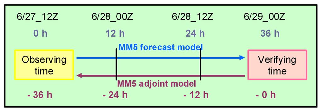
5 and simulation of tropical cyclones. This system includes the nonlinear MM5, its tangent linear model, and corresponding adjoint model. The domain for the nonlinear and adjoint model is a 60-km, horizontal grid, with 20 sigma levels in the vertical. The initial and boundary conditions are from the NCEP/GFS global analysis (1 1 ) interpolated to the MM5 grids. Typhoon Mindulle in 2004, one that was observed in DOTSTAR, is chosen as a test case to examine the proposed new method for targeted observations based on the adjoint sensitivity. Note that Mindulle is the sole case out of the ten DOTSTAR cases in 2004 where dropsonde data assimilated into the NCEP GFS model did not improve the track forecasts (figures not shown, coming up in a separate paper). The study is based on a 36-h MM5 forecast initialized at 1200 UTC 27 June The forward and backward integrations were executed by the MM5 forecast model and the adjoint model, respectively, as indicated in Fig. 1. The negative sign in front of the time indicates the backward integration associated with the adjoint model. Figure 2 shows that the model storm moves along (but slightly faster than) the best track from the Central Weather Bureau (CWB) of Taiwan. The purpose of the work is to identify the sensitive areas at the observing time (1200 UTC 27 June), which will affect the steering flow of Typhoon Mindulle at the verifying time (0000 UTC 29 June). Therefore, we define the response function(s) as the deep-layer mean wind within the verifying area (a square of 600 km by 600 km, centered around the storm location; see Fig. 3) at the
6 verifying time. Two responses functions are then defined: R 1, the hPa deep-layer average of zonal component (u), and R 2, the average of meridional component (v) of the wind vector, i.e., 300hPa 850 A u dxdydp hpa R1, and 300hPa dxdydp 850hPa A 300hPa 850 hpa R 300 A 2. hpa 850hPa v A dxdydp dxdydp In other words, the vector of (R 1, R 2 ) represents the steering flow at the verifying time. In order to interpret the sensitivity with clear physical meanings, we design a unique new parameter, Adjoint-Derived Sensitivity Steering Vector (ADSSV), to identify the sensitive areas at the observing time to the steering flow at the verifying time. The ADSSV with respect to the vorticity field (ς ) can be shown as R R2 ADSSV 1,, (1) ς ς where the magnitude of ADSSV indicates the extent of the sensitivity, and the direction represents the response of the steering direction with respect to the vorticity increment. 3. Results As expected, the sensitivity (i.e., gradient) of R 1 to u (R 1 /u) at 0 h (the initial time of adjoint model) shows a response uniformly distributed over the verifying area (Fig. 3a), while there is no sensitivity of R 1 to v (R 1 /v) (Fig. 3b). To show a general sensitivity to the wind field, we combine the sensitivity of R 1 to u and the sensitivity of R 1 to v to obtain the sensitivity of R 1 to the vorticity field [ R 1 ς ] (see the derivation in Kleist and Morgan 2005). Again, as expected, a dipolar
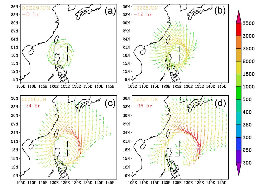
7 pattern at 0 h (Fig. 3c) is found, i.e., a positive (negative) vorticity perturbation to the north (south) of the verifying area will induce a cyclonic (anticyclonic) circulation and thus lead to an increase in R 1 (the zonal component of the mean steering flow). Meanwhile, the sensitivity of R 2 to u, v, and the vorticity field (Figs. 3d, e, and f) also reveal comparable information. In all, Figs. 3c and 3f can succinctly show the sensitivity of R 1 and R 2 to the flow field with clear physical meaning. The evolutions of the sensitivity of R 1 and R 2 to the vorticity field are shown in Figs. 4 and 5. The sensitive areas spread from the margin of the verifying area to outer region as the adjoint model is integrated backward in time. At 36 h (the observing time, 1200 UTC 27 June), the maximum gradient areas are located in the east and north of the verifying area, and sensitivity is found higher in R 2 than in R 1. This means that vorticity perturbations in those sensitive areas at 1200 UTC 27 June will affect the steering flow of Typhoon Mindulle at 0000 UTC 29 June, particularly the meridional component of the steering flow. As shown in Equation (1), we can combine the result of Figs. 4 and 5 to obtain the evolution of ADSSV with respect to the vorticity field (Fig. 6). Fig. 6 clearly shows that the vectors rotate around the verifying area at 0 h. As the adjoint model integrates backward in time, these vectors evolve and expand outward, with longer vectors (i.e., higher sensitivity) mostly extending at about km from the north to the east of the center of verifying area. To highlight the results at -36 h, the ADSSV with respect to the vorticity field is plotted in Fig. 7, superposed with the
8 geopotential height field at 700 hpa and the deployed locations of the dropsondes in DOTSTAR. Again, Fig. 7 shows that the vectors in regions of large ADSSV are mainly pointing southward, indicating that when the vorticity in those sensitive areas is increased (decreased), the southward (northward) component of steering flow will strengthen. Physically, these vectors are located at the edge of the subtropical high, where, if the subtropical high strengthens (i.e., with decreased vorticity), the northward steering will increase. The results also show that the extent of the subtropical high is critical in determining Mindulle s northward turn as observed at the verifying time (figures not shown). Besides the ADSSV with respect to the vorticity field, we also calculate the ADSSV with respect to the divergence field, which is R R 1 2,, D D where D represents the divergence of the wind field. The ADSSV with respect to the divergence field at -36 h (figures not shown) shows that the locations of the sensitive areas are still around the northeast of the verifying area, but closer to the forecasted typhoon center than those associated with the ADSSV with respect to the vorticity field. Nevertheless, as compared with Fig. 6d, the sensitivity to the divergence field is one order of magnitude smaller than that to the vorticity field. The above result indicates that the steering flow bears much larger sensitivity to the vorticity field than to the divergence field.
9 Interestingly, the deployed locations of DOTSTAR s dropsondes are not in the region of high sensitivity in the ADSSV plot in Fig. 7. Meanwhile, the sensitive regions in Fig. 7 are quite different from those indicated by three other independent sensitivity products (Fig. 8) currently used for the planning of the targeted observations for DOTSTAR (Wu et al. 2005a) in real time. In other words, the DLM wind variance (Fig. 8a) (Aberson et al. 2003) shows that the areas with larger variance basically surround the forecasted typhoon, while the ETKF sensitivity (Fig. 8b) (Bishop and Majumdar 2001) shows that the forecast error covariance spreads to the north of the forecasted typhoon, and the results of NOGAPS Singular Vector (Palmer et al., 1998; Carolyn Reynolds, personal communication, 2004) are located from south to the northeast of the forecasted typhoon. Compared with Fig. 7, the sensitive areas of two latter products are closer to the forecasted typhoon center than the ADSSV. The above inconsistency among all four different sensitivity products might be the reasons why dropsonde data assimilated into the NCEP GFS model did not improve Mindulle s track forecasts (figures not shown). Further research is needed to obtain the physical insights into this problem. 4. Summary and prospects In addition to various sensitivity products we have adopted in DOTSTAR, a new sensitivity measurement has been proposed based on the adjoint model. In short, by appropriately defining the response functions to represent the mean steering flow at the verifying time, we can derived its
10 sensitivity to the flow field at the observing time to help formulate the observing strategy. In particular, a simple vector, the ADSSV with respect to the vorticity field, is proposed to clearly demonstrate the sensitivity to the storm motion. We think that ADSSV can be used in many aspects of academic research and can be tested in the field project to help improve the typhoon track prediction. More work is ongoing to consolidate this study, and will be presented in other papers. (1) Linearity test The adjoint model is designed based on TLM, which is a linear assumptive model. In order to validate this assumption, perturbations that evolve linearly via the TLM need to be compared with difference fields obtained from two nonlinear model forecasts to show the validity of the linear assumption. (2) Impact study In order to validate the sensitivity derived from the adjoint modeling system, we will perturb the wind/temperature fields in the initial time (such as those in the area with large magnitude of ADSSV), and investigate the response of the simulated typhoon track. (3) Other case studies A thorough investigation of other DOTSTAR cases, such as Conson, Meari and Nock-Ten, is ongoing to examine the factors affecting the motion of these storms, and to validate the proposed
11 method on ADSSV. In particular, the ADSSV can be used to show the critical weather system affecting the storm motion, such as the impact from the approaching trough and the other storm (i.e., binary interaction). In this paper, we have only demonstrated the sensitivity at one single verifying time. Work is ongoing to evaluate the ADSSV for different verifying times along the storm track, thus the impact of the targeted observations to the entire TC track can be better assessed. Indeed some encouraging results have been identified on this issue (to be presented in the future paper). (4) Operation in the field program While the above work continues, we are in the process of implementing the currently designed method (using ADSSV) for real-time use in DOTSTAR, as well as for Atlantic hurricanes (in collaboration with Sim Aberson), in This would demand a longer model integration time because the surveillance operation in DOTSTAR would require an at least lead time of 48 h. The preliminary test is showing consistent results when we run the model for up to 84 h, thus indicating the feasibility of the current system used in the DOTSTAR operation. We believe that the use of the method of ADSSV in DOTSTAR will shed new light on the targeted observations for tropical cyclones. Acknowledgments. The work is supported through the National Science Council of Taiwan by Grants NSC M AP1 and NSC M AP1. The authors wish to
12 thank Sim Aberson, Frank Marks, Sharan Majumdar, Michael Morgan, Melinda Peng and Carolyn Reynolds for their helpful suggestions and research collaborations. References Aberson, S. D., Targeted observations to improve operational tropical cyclone track forecast guidance, Mon. Wea. Rev., 131, , Baker, N. L. and R. Daley, Observation and background adjoint sensitivity in the adaptive observation-targeting problem, Q. J. R. Meteorol. Soc., 126, , Errico, R. M., What is an adjoint model? Bulletin of Amer. Meteor. Soc., 78, , Kleist, D. T. and M. C. Morgan, Interpretation of the structure and evolution of adjoint-derived forecast sensitivity gradients, Mon. Wea. Rev., 133, , Majumdar, S. J., C. H. Bishop, R. Buizza and R. Gelaro, A comparison of ensemble-transform Kalman-filter targeting guidance with ECMWF and NRL total-energy singular-vector guidance, Q. J. R. Meteorol. Soc., 128, , Palmer, T. N., R. Gelaro, J. Barkmeijer, and R. Buizza, Singular vectors, metrics, and adaptive observations, J. Atmos. Sci., 55, , Pu, Z., and E. Kalnay, Targeting observations with the quasi-inverse linear and adjoint NCEP global models: Performance during FASTEX, Q. J. R. Meteorol. Soc., 125, , Wu, C.-C., P.-H. Lin, T.-C. Yeh, S. D. Aberson, S. Majumdar, and C. Retnolds, Targeted observation
13 strategies in DOTSTAR. Proc., First THORPEX International Science Symposium, World Meteorological Organization, 5-10 Dec., Montreal, Quebec, Canada, Wu, C.-C., P.-H. Lin, S. D. Aberson, T.-C. Yeh, W.-P. Huang, J.-S. Hong, G..-C. Lu, K.-C. Hsu, I-I Lin, K.-H. Chou, P.-L. Lin, and C.-H. Liu, Dropwindsonde Observations for Typhoon Surveillance near the Taiwan Region (DOTSTAR): An Overview, Bulletin of Amer. Meteor. Soc., 2005a (in press). Wu, C.-C., K.-H. Chou., Y. Wang, and Y.-H. Kuo, Tropical cyclone initialization and prediction based on four-dimensional variational data assimilation, J. Atmos. Sci., 2005b. (submitted). Zou, X., F. Vandenberghe, M. Pondeca, and Y.-H. Kuo, Introduction to adjoint techniques and the MM5 adjoint modeling system. NCAR Technical Note, NCAR/TN-435+STR, 110pp. [Available from NCAR, P.O. Box 3000, Boulder, CO ], 1997.
14 Figure captions Figure 1. The design of forward and backward model integrations. Figure 2. Tracks of Typhoon Mindulle from 1200 UTC 27 June to 1200 UTC 29 June from the MM5 forecast and the best-track analysis of CWB. Figure 3. Sensitivity (Gradient) of R 1 to (a) u, (b) v, and (c) vorticity, and of R 2 to (d) u, (e) v, and (f) vorticity on the 700 hpa at 0 h. The magnitude of (c) and (f) is represented in the color bar to the right, and the warm (cold) color represents positive (negative) value. Figure 4. The evolution of sensitivity of R 1 with respect to the vorticity field at 700 hpa (magnitude in the color bar to the right). Figure 5. The evolution of sensitivity of R 2 with respect to the vorticity field at 700 hpa (magnitude in the color bar to the right). Figure 6. The evolution of ADSSV (magnitude of the vector in the color bar to the right) with respect to the vorticity field at 700 hpa. Figure 7. ADSSV (magnitude of the vector as in Fig. 6) with respect to the vorticity field at 700 hpa at 36 h, superposed with the geopotential height field (magnitude in the color bar to the right) at 700 hpa and the deployed locations of the dropsondes in DOTSTAR (brown dots). The 36-h model-predicted track of Typhoon Mindulle is indicated with the red typhoon symbols for every 12 h.
15 Figure 8. Sensitivity products used for DOTSTAR at 1200 UTC 27 June. (a) NCEP GFS s DLM wind variance, (b) NCEP GFS s ETKF signal variance (shaded), and (c) NOGAPS s singular vector product.
16
17
18

19

20
21

22

23
Department of Atmospheric Sciences, National Taiwan University, Taipei, Taiwan. (Manuscript received 6 March 2008, in final form 30 June 2008)
") 852 M O N T H L Y W E A T H E R R E V I E W VOLUME 137 Interaction of Typhoon Shanshan (2006) with the Midlatitude Trough from both Adjoint-Derived Sensitivity Steering Vector and Potential Vorticity Perspectives
852 M O N T H L Y W E A T H E R R E V I E W VOLUME 137 Interaction of Typhoon Shanshan (2006) with the Midlatitude Trough from both Adjoint-Derived Sensitivity Steering Vector and Potential Vorticity Perspectives
Observation System Experiments for Typhoon Nida (2004) Using the CNOP Method and DOTSTAR Data
 Using the CNOP Method and DOTSTAR Data") ATMOSPHERIC AND OCEANIC SCIENCE LETTERS, 2011, VOL. 4, NO. 2, 118 123 Observation System Experiments for Typhoon Nida (2004) Using the CNOP Method and DOTSTAR Data CHEN Bo-Yu 1,2 1 State Laboratory of
ATMOSPHERIC AND OCEANIC SCIENCE LETTERS, 2011, VOL. 4, NO. 2, 118 123 Observation System Experiments for Typhoon Nida (2004) Using the CNOP Method and DOTSTAR Data CHEN Bo-Yu 1,2 1 State Laboratory of
11A.3 THE IMPACT OF DROPSONDE DATA FROM DOTSTAR ON TROPICAL CYCLONE TRACK FORECASTING
 11A.3 THE IMPACT OF DROPSONDE DATA FROM DOTSTAR ON TROPICAL CYCLONE TRACK FORECASTING Kun-Hsuan Chou 1, Chun-Chieh Wu 1, * and Po-Hsiung Lin 1, Sim Aberson 2, Melinda Peng 3, Tetsuo Nakazawa 4 1 Dept.
Observing System Experiments using a singular vector method for 2004 DOTSTAR cases
 Observing System Experiments using a singular vector method for 2004 DOTSTAR cases Korea-Japan-China Second Joint Conference on Meteorology 11 OCT. 2006 Munehiko YAMAGUCHI 1 Takeshi IRIGUCHI 1 Tetsuo NAKAZAWA
Adjoint-based forecast sensitivities of Typhoon Rusa
 GEOPHYSICAL RESEARCH LETTERS, VOL. 33, L21813, doi:10.1029/2006gl027289, 2006 Adjoint-based forecast sensitivities of Typhoon Rusa Hyun Mee Kim 1 and Byoung-Joo Jung 1 Received 20 June 2006; revised 13
SIXTH INTERNATIONAL WORKSHOP on TROPICAL CYCLONES. Topic 3.3 : Targeted observation and data assimilation in track prediction
 WMO/CAS/WWW SIXTH INTERNATIONAL WORKSHOP on TROPICAL CYCLONES Topic 3.3 : Targeted observation and data assimilation in track prediction Rapporteur: Chun-Chieh Wu PSA Email : cwu@typhoon.as.ntu.edu.tw
Typhoon Relocation in CWB WRF
 Typhoon Relocation in CWB WRF L.-F. Hsiao 1, C.-S. Liou 2, Y.-R. Guo 3, D.-S. Chen 1, T.-C. Yeh 1, K.-N. Huang 1, and C. -T. Terng 1 1 Central Weather Bureau, Taiwan 2 Naval Research Laboratory, Monterey,
Singular Vector Structure and Evolution of a Recurving Tropical Cyclone
 VOLUME 137 M O N T H L Y W E A T H E R R E V I E W FEBRUARY 2009 Singular Vector Structure and Evolution of a Recurving Tropical Cyclone HYUN MEE KIM AND BYOUNG-JOO JUNG Atmospheric Predictability and
Seventh International Workshop on Tropical Cyclones (IWTC VII) Special Focus Sessions 1a: Targeted observations for TC track forecasting
 Special Focus Sessions 1a: Targeted observations for TC track forecasting") Seventh International Workshop on Tropical Cyclones (IWTC VII) Special Focus Sessions 1a: Targeted observations for TC track forecasting Chun Chieh Wu 1 and Sharanya J. Majumdar 2 1 Department of Atmospheric
Seventh International Workshop on Tropical Cyclones (IWTC VII) Special Focus Sessions 1a: Targeted observations for TC track forecasting Chun Chieh Wu 1 and Sharanya J. Majumdar 2 1 Department of Atmospheric
Interpreting Adjoint and Ensemble Sensitivity toward the Development of Optimal Observation Targeting Strategies
 Interpreting Adjoint and Ensemble Sensitivity toward the Development of Optimal Observation Targeting Strategies Brian C. Ancell 1, and Gregory J Hakim University of Washington, Seattle, WA Submitted to
The impact of assimilation of microwave radiance in HWRF on the forecast over the western Pacific Ocean
 The impact of assimilation of microwave radiance in HWRF on the forecast over the western Pacific Ocean Chun-Chieh Chao, 1 Chien-Ben Chou 2 and Huei-Ping Huang 3 1Meteorological Informatics Business Division,
Using NOGAPS Singular Vectors to Diagnose Large-scale Influences on Tropical Cyclogenesis
 DISTRIBUTION STATEMENT A. Approved for public release; distribution is unlimited. Using NOGAPS Singular Vectors to Diagnose Large-scale Influences on Tropical Cyclogenesis PI: Prof. Sharanya J. Majumdar
Total Energy Singular Vector Guidance Developed at JMA for T-PARC
 Total Energy Singular Vector Guidance Developed at JMA for T-PARC Takuya Komori Numerical Prediction Division, Japan Meteorological Agency Ryota Sakai River Office, Osaka Prefectural Government Hitoshi
H. LIU AND X. ZOU AUGUST 2001 LIU AND ZOU. The Florida State University, Tallahassee, Florida
 AUGUST 2001 LIU AND ZOU 1987 The Impact of NORPEX Targeted Dropsondes on the Analysis and 2 3-Day Forecasts of a Landfalling Pacific Winter Storm Using NCEP 3DVAR and 4DVAR Systems H. LIU AND X. ZOU The
Tropical cyclone track forecasts using JMA model with ECMWF and JMA initial conditions
 Tropical cyclone track forecasts using JMA model with ECMWF and JMA initial conditions The Fourth THORPEX Asian Science Workshop Kunming, China 2 Nov 2012 (Fri) Munehiko Yamaguchi 1, Tetsuo Nakazawa 1,2
Characteristics of Ensemble Transform Kalman Filter adaptive sampling guidance for tropical cyclones
 Quarterly Journal of the Royal Meteorological Society Q. J. R. Meteorol. Soc. 137: 503 520, January 2011 B Characteristics of Ensemble Transform Kalman Filter adaptive sampling guidance for tropical cyclones
Interpretation of Tropical Cyclone Forecast Sensitivity from the Singular Vector Perspective
 NOVEMBER 2009 C H E N E T A L. 3383 Interpretation of Tropical Cyclone Forecast Sensitivity from the Singular Vector Perspective JAN-HUEY CHEN Department of Atmospheric Sciences, National Taiwan University,
Observing Strategy and Observation Targeting for Tropical Cyclones Using Ensemble-Based Sensitivity Analysis and Data Assimilation
 MAY 2013 X I E E T A L. 1437 Observing Strategy and Observation Targeting for Tropical Cyclones Using Ensemble-Based Sensitivity Analysis and Data Assimilation BAOGUO XIE Laboratory for Climate and Ocean
3A.6 HURRICANES IVAN, JEANNE, KARL (2004) AND MID-LATITUDE TROUGH INTERACTIONS
 AND MID-LATITUDE TROUGH INTERACTIONS") 27 th Conference on Hurricanes and Tropical Meteorology 24-28 April 2006, Monterey, CA 3A.6 HURRICANES IVAN, JEANNE, KARL (2004) AND MID-LATITUDE TROUGH INTERACTIONS Ryan N. Maue *, Melinda S. Peng, Carolyn
27 th Conference on Hurricanes and Tropical Meteorology 24-28 April 2006, Monterey, CA 3A.6 HURRICANES IVAN, JEANNE, KARL (2004) AND MID-LATITUDE TROUGH INTERACTIONS Ryan N. Maue *, Melinda S. Peng, Carolyn
A New Typhoon Bogus Data Assimilation and its Sampling Method: A Case Study
 ATMOSPHERIC AND OCEANIC SCIENCE LETTERS, 2011, VOL. 4, NO. 5, 276 280 A New Typhoon Bogus Data Assimilation and its Sampling Method: A Case Study WANG Shu-Dong 1,2, LIU Juan-Juan 2, and WANG Bin 2 1 Meteorological
Observation System Experiments for Typhoon Jangmi (200815) Observed During T-PARC
 Observed During T-PARC") Asia-Pacific J. Atmos. Sci, 46(3), 305-316, 2010 DOI:10.1007/s13143-010-1007-y Observation System Experiments for Typhoon Jangmi (200815) Observed During T-PARC Byoung-Joo Jung 1, Hyun Mee Kim 1, Yeon-Hee
Asia-Pacific J. Atmos. Sci, 46(3), 305-316, 2010 DOI:10.1007/s13143-010-1007-y Observation System Experiments for Typhoon Jangmi (200815) Observed During T-PARC Byoung-Joo Jung 1, Hyun Mee Kim 1, Yeon-Hee
Uncertainty Analysis Using the WRF Maximum Likelihood Ensemble Filter System and Comparison with Dropwindsonde Observations in Typhoon Sinlaku (2008)
") Asia-Pacific J. Atmos. Sci., 46(3), 317-325, 2010 DOI:10.1007/s13143-010-1004-1 Uncertainty Analysis Using the WRF Maximum Likelihood Ensemble Filter System and Comparison with Dropwindsonde Observations
Asia-Pacific J. Atmos. Sci., 46(3), 317-325, 2010 DOI:10.1007/s13143-010-1004-1 Uncertainty Analysis Using the WRF Maximum Likelihood Ensemble Filter System and Comparison with Dropwindsonde Observations
Influence of Moist Physics and Norms on Singular Vectors for a Tropical Cyclone
 FEBRUARY 2009 K I M A N D J U N G 525 Influence of Moist Physics and Norms on Singular Vectors for a Tropical Cyclone HYUN MEE KIM AND BYOUNG-JOO JUNG Atmospheric Predictability and Data Assimilation Laboratory,
THE IMPACT OF SATELLITE-DERIVED WINDS ON GFDL HURRICANE MODEL FORECASTS
 THE IMPACT OF SATELLITE-DERIVED WINDS ON GFDL HURRICANE MODEL FORECASTS Brian J. Soden 1 and Christopher S. Velden 2 1) Geophysical Fluid Dynamics Laboratory National Oceanic and Atmospheric Administration
The Structure of Background-error Covariance in a Four-dimensional Variational Data Assimilation System: Single-point Experiment
 ADVANCES IN ATMOSPHERIC SCIENCES, VOL. 27, NO. 6, 2010, 1303 1310 The Structure of Background-error Covariance in a Four-dimensional Variational Data Assimilation System: Single-point Experiment LIU Juanjuan
T PARC: Impact of dropsonde (and other) aircraft data
 aircraft data") T PARC: Impact of dropsonde (and other) aircraft data Sharanya J. Majumdar (RSMAS/U. Miami) Martin, Florian Harnisch, Chun Chieh Wu, Tetsuo Nakazawa, Sim Aberson, Hyun Mee Kim, Munehiko Yamaguchi Session
T PARC: Impact of dropsonde (and other) aircraft data Sharanya J. Majumdar (RSMAS/U. Miami) Martin, Florian Harnisch, Chun Chieh Wu, Tetsuo Nakazawa, Sim Aberson, Hyun Mee Kim, Munehiko Yamaguchi Session
ADJONT-BASED ANALYSIS OF OBSERVATION IMPACT ON TROPICAL CYCLONE INTENSITY FORECASTS
 7A.3 ADJONT-BASED ANALYSIS OF OBSERVATION IMPACT ON TROPICAL CYCLONE INTENSITY FORECASTS Brett T. Hoover* and Chris S. Velden Cooperative Institute for Meteorological Satellite Studies, Space Science and
Impact of Stochastic Convection on Ensemble Forecasts of Tropical Cyclone Development
 620 M O N T H L Y W E A T H E R R E V I E W VOLUME 139 Impact of Stochastic Convection on Ensemble Forecasts of Tropical Cyclone Development ANDREW SNYDER AND ZHAOXIA PU Department of Atmospheric Sciences,
Precipitation Structure and Processes of Typhoon Nari (2001): A Modeling Propsective
: A Modeling Propsective") Precipitation Structure and Processes of Typhoon Nari (2001): A Modeling Propsective Ming-Jen Yang Institute of Hydrological Sciences, National Central University 1. Introduction Typhoon Nari (2001) struck
Precipitation Structure and Processes of Typhoon Nari (2001): A Modeling Propsective Ming-Jen Yang Institute of Hydrological Sciences, National Central University 1. Introduction Typhoon Nari (2001) struck
Optimal metric and control variables for improved forecast associated with the tropical cyclones
 Seminar at the Weather-Chaos group meeting Maryland University, Maryland 2012/02/27 Optimal metric and control variables for improved forecast associated with the tropical cyclones Kosuke Ito Department
The Development of Real-time Airborne and Dropwindsonde Data Acquisition System on Laptops
 The Development of Real-time Airborne and Dropwindsonde Data Acquisition System on Laptops Po-Hsiung Lin, Ying-Hao Chen, Chun-Chieh Wu National Taiwan University Abstract A framework for real-time monitoring
P3.11 A COMPARISON OF AN ENSEMBLE OF POSITIVE/NEGATIVE PAIRS AND A CENTERED SPHERICAL SIMPLEX ENSEMBLE
 P3.11 A COMPARISON OF AN ENSEMBLE OF POSITIVE/NEGATIVE PAIRS AND A CENTERED SPHERICAL SIMPLEX ENSEMBLE 1 INTRODUCTION Xuguang Wang* The Pennsylvania State University, University Park, PA Craig H. Bishop
Typhoon-Ocean Interaction: The Ocean Response to Typhoons, and Its Feedback to Typhoon Intensity Synergy of Observations and Model Simulations
 DISTRIBUTION STATEMENT A. Approved for public release; distribution is unlimited. Typhoon-Ocean Interaction: The Ocean Response to Typhoons, and Its Feedback to Typhoon Intensity Synergy of Observations
Upgrade of JMA s Typhoon Ensemble Prediction System
 Upgrade of JMA s Typhoon Ensemble Prediction System Masayuki Kyouda Numerical Prediction Division, Japan Meteorological Agency and Masakazu Higaki Office of Marine Prediction, Japan Meteorological Agency
Tropical Cyclone Data Impact Studies: Influence of Model Bias and Synthetic Observations
 Tropical Cyclone Data Impact Studies: Influence of Model Bias and Synthetic Observations C. Reynolds, R. Langland and P. Pauley, Naval Research Laboratory, Marine Meteorology Division, Monterey, CA C.
Ensemble 4DVAR for the NCEP hybrid GSI EnKF data assimilation system and observation impact study with the hybrid system
 Ensemble 4DVAR for the NCEP hybrid GSI EnKF data assimilation system and observation impact study with the hybrid system Xuguang Wang School of Meteorology University of Oklahoma, Norman, OK OU: Ting Lei,
2D.4 THE STRUCTURE AND SENSITIVITY OF SINGULAR VECTORS ASSOCIATED WITH EXTRATROPICAL TRANSITION OF TROPICAL CYCLONES
 2D.4 THE STRUCTURE AND SENSITIVITY OF SINGULAR VECTORS ASSOCIATED WITH EXTRATROPICAL TRANSITION OF TROPICAL CYCLONES Simon T. Lang Karlsruhe Institute of Technology. INTRODUCTION During the extratropical
Initialization of Tropical Cyclone Structure for Operational Application
 DISTRIBUTION STATEMENT A. Approved for public release; distribution is unlimited. Initialization of Tropical Cyclone Structure for Operational Application PI: Tim Li IPRC/SOEST, University of Hawaii at
NOTES AND CORRESPONDENCE. On Ensemble Prediction Using Singular Vectors Started from Forecasts
 3038 M O N T H L Y W E A T H E R R E V I E W VOLUME 133 NOTES AND CORRESPONDENCE On Ensemble Prediction Using Singular Vectors Started from Forecasts MARTIN LEUTBECHER European Centre for Medium-Range
The Properties of Convective Clouds Over the Western Pacific and Their Relationship to the Environment of Tropical Cyclones
 The Properties of Convective Clouds Over the Western Pacific and Their Relationship to the Environment of Tropical Cyclones Principal Investigator: Dr. Zhaoxia Pu Department of Meteorology, University
Use of the breeding technique to estimate the structure of the analysis errors of the day
 Nonlinear Processes in Geophysics (2003) 10: 1 11 Nonlinear Processes in Geophysics c European Geosciences Union 2003 Use of the breeding technique to estimate the structure of the analysis errors of the
Tropical Cyclone Formation/Structure/Motion Studies
 Tropical Cyclone Formation/Structure/Motion Studies Patrick A. Harr Department of Meteorology Naval Postgraduate School Monterey, CA 93943-5114 phone: (831) 656-3787 fax: (831) 656-3061 email: paharr@nps.edu
TARGETED OBSERVATIONS FOR IMPROVING NUMERICAL WEATHER PREDICTION: AN OVERVIEW
 Commission for Atmospheric Sciences TARGETED OBSERVATIONS FOR IMPROVING NUMERICAL WEATHER PREDICTION: AN OVERVIEW THORPEX International Programme Office Atmospheric Research and Environment Branch World
Dynamic Sensitivity Analysis of Tropical Cyclone Track and Extratropical Transition
 Dynamic Sensitivity Analysis of Tropical Cyclone Track and Extratropical Transition Michael C. Morgan Nicholas Bassill (July 2006 - present) Brett Hoover (September 2006 - present) Dianna Nelson (May 2008
Simple Doppler Wind Lidar adaptive observation experiments with 3D-Var. and an ensemble Kalman filter in a global primitive equations model
 1 2 3 4 Simple Doppler Wind Lidar adaptive observation experiments with 3D-Var and an ensemble Kalman filter in a global primitive equations model 5 6 7 8 9 10 11 12 Junjie Liu and Eugenia Kalnay Dept.
Diagnosis of Large Prediction Errors on Recurvature of Typhoon Fengshen (2008) in the NCEP-GFS Model
 in the NCEP-GFS Model") Journal April 2018 of the Meteorological Society of Japan, Vol. C.-C. 96, No. YANG 2, pp. et 85 96, al. 2018 85 DOI:10.2151/jmsj.2018-009 Diagnosis of Large Prediction Errors on Recurvature of Typhoon
Journal April 2018 of the Meteorological Society of Japan, Vol. C.-C. 96, No. YANG 2, pp. et 85 96, al. 2018 85 DOI:10.2151/jmsj.2018-009 Diagnosis of Large Prediction Errors on Recurvature of Typhoon
P 1.86 A COMPARISON OF THE HYBRID ENSEMBLE TRANSFORM KALMAN FILTER (ETKF)- 3DVAR AND THE PURE ENSEMBLE SQUARE ROOT FILTER (EnSRF) ANALYSIS SCHEMES
- 3DVAR AND THE PURE ENSEMBLE SQUARE ROOT FILTER (EnSRF) ANALYSIS SCHEMES") P 1.86 A COMPARISON OF THE HYBRID ENSEMBLE TRANSFORM KALMAN FILTER (ETKF)- 3DVAR AND THE PURE ENSEMBLE SQUARE ROOT FILTER (EnSRF) ANALYSIS SCHEMES Xuguang Wang*, Thomas M. Hamill, Jeffrey S. Whitaker NOAA/CIRES
P 1.86 A COMPARISON OF THE HYBRID ENSEMBLE TRANSFORM KALMAN FILTER (ETKF)- 3DVAR AND THE PURE ENSEMBLE SQUARE ROOT FILTER (EnSRF) ANALYSIS SCHEMES Xuguang Wang*, Thomas M. Hamill, Jeffrey S. Whitaker NOAA/CIRES
Ting Lei, Xuguang Wang University of Oklahoma, Norman, OK, USA. Wang and Lei, MWR, Daryl Kleist (NCEP): dual resolution 4DEnsVar
: dual resolution 4DEnsVar") GSI-based four dimensional ensemble-variational (4DEnsVar) data assimilation: formulation and single resolution experiments with real data for NCEP GFS Ting Lei, Xuguang Wang University of Oklahoma, Norman,
GSI-based four dimensional ensemble-variational (4DEnsVar) data assimilation: formulation and single resolution experiments with real data for NCEP GFS Ting Lei, Xuguang Wang University of Oklahoma, Norman,
Victor Homar * and David J. Stensrud NOAA/NSSL, Norman, Oklahoma
 3.5 SENSITIVITIES OF AN INTENSE CYCLONE OVER THE WESTERN MEDITERRANEAN Victor Homar * and David J. Stensrud NOAA/NSSL, Norman, Oklahoma 1. INTRODUCTION The Mediterranean region is a very active cyclogenetic
EARLY ONLINE RELEASE
 EARLY ONLINE RELEASE This is a PDF of a manuscript that has been peer-reviewed and accepted for publication. As the article has not yet been formatted, copy edited or proofread, the final published version
Evolution of Analysis Error and Adjoint-Based Sensitivities: Implications for Adaptive Observations
 1APRIL 2004 KIM ET AL. 795 Evolution of Analysis Error and Adjoint-Based Sensitivities: Implications for Adaptive Observations HYUN MEE KIM Marine Meteorology and Earthquake Research Laboratory, Meteorological
Statistical Characteristic of Heavy Rainfall Associated with Typhoons near Taiwan Based on the High-Density Automatic Rain Gauge Data
 1 2 Statistical Characteristic of Heavy Rainfall Associated with Typhoons near Taiwan Based on the High-Density Automatic Rain Gauge Data 3 4 Chun-Chieh Wu 1, Tzu-Hsiung Yen 1, Yi-Hsuan Huang 1, Cheng-Ku
7C.7 AN OVERVIEW OF THE THORPEX-PACIFIC ASIAN REGIONAL CAMPAIGN (T-PARC) DURING AUGUST-SEPTEMBER 2008
 DURING AUGUST-SEPTEMBER 2008") 7C.7 AN OVERVIEW OF THE THORPEX-PACIFIC ASIAN REGIONAL CAMPAIGN (T-PARC) DURING AUGUST-SEPTEMBER 2008 David Parsons 1, Patrick Harr 2, Tetsuo Nakazawa 3, Sarah Jones 4, Martin Weissmann 5 1 World Meteorological
7C.7 AN OVERVIEW OF THE THORPEX-PACIFIC ASIAN REGIONAL CAMPAIGN (T-PARC) DURING AUGUST-SEPTEMBER 2008 David Parsons 1, Patrick Harr 2, Tetsuo Nakazawa 3, Sarah Jones 4, Martin Weissmann 5 1 World Meteorological
The Interdecadal Variation of the Western Pacific Subtropical High as Measured by 500 hpa Eddy Geopotential Height
 ATMOSPHERIC AND OCEANIC SCIENCE LETTERS, 2015, VOL. 8, NO. 6, 371 375 The Interdecadal Variation of the Western Pacific Subtropical High as Measured by 500 hpa Eddy Geopotential Height HUANG Yan-Yan and
Will it rain? Predictability, risk assessment and the need for ensemble forecasts
 Will it rain? Predictability, risk assessment and the need for ensemble forecasts David Richardson European Centre for Medium-Range Weather Forecasts Shinfield Park, Reading, RG2 9AX, UK Tel. +44 118 949
Ensemble Prediction Systems
 Ensemble Prediction Systems Eric Blake National Hurricane Center 7 March 2017 Acknowledgements to Michael Brennan 1 Question 1 What are some current advantages of using single-model ensembles? A. Estimates
6.5 Operational ensemble forecasting methods
 6.5 Operational ensemble forecasting methods Ensemble forecasting methods differ mostly by the way the initial perturbations are generated, and can be classified into essentially two classes. In the first
Sensitivities and Singular Vectors with Moist Norms
 Sensitivities and Singular Vectors with Moist Norms T. Jung, J. Barkmeijer, M.M. Coutinho 2, and C. Mazeran 3 ECWMF, Shinfield Park, Reading RG2 9AX, United Kingdom thomas.jung@ecmwf.int 2 Department of
Xuguang Wang and Ting Lei. School of Meteorology, University of Oklahoma and Center for Analysis and Prediction of Storms, Norman, OK.
 1 2 3 GSI-based four dimensional ensemble-variational (4DEnsVar) data assimilation: formulation and single resolution experiments with real data for NCEP Global Forecast System 4 5 6 7 8 9 10 11 12 13
Coupled Global-Regional Data Assimilation Using Joint States
 DISTRIBUTION STATEMENT A. Approved for public release; distribution is unlimited. Coupled Global-Regional Data Assimilation Using Joint States Istvan Szunyogh Texas A&M University, Department of Atmospheric
DISTRIBUTION STATEMENT A. Approved for public release; distribution is unlimited.
 DISTRIBUTION STATEMENT A. Approved for public release; distribution is unlimited. Understanding Impacts of Outflow on Tropical Cyclone Formation and Rapid Intensity and Structure Changes with Data Assimilation
Extratropical transition of North Atlantic tropical cyclones in variable-resolution CAM5
 Extratropical transition of North Atlantic tropical cyclones in variable-resolution CAM5 Diana Thatcher, Christiane Jablonowski University of Michigan Colin Zarzycki National Center for Atmospheric Research
Department of Atmospheric Sciences, National Taiwan University, Taipei, Taiwan
 10A.4 TROPICAL CYCLONE FORMATIONS IN THE SOUTH CHINA SEA CHENG-SHANG LEE 1 AND YUNG-LAN LIN* 1, 2 1 Department of Atmospheric Sciences, National Taiwan University, Taipei, Taiwan 2 Taipei Aeronautic Meteorological
SIM D. ABERSON. NOAA/AOML/Hurricane Research Division, Miami, Florida. (Manuscript received 21 September 2010, in final form 24 January 2011)
") VOLUME 139 M O N T H L Y W E A T H E R R E V I E W SEPTEMBER 2011 The Impact of Dropwindsonde Data from the THORPEX Pacific Area Regional Campaign and the NOAA Hurricane Field Program on Tropical Cyclone
VOLUME 139 M O N T H L Y W E A T H E R R E V I E W SEPTEMBER 2011 The Impact of Dropwindsonde Data from the THORPEX Pacific Area Regional Campaign and the NOAA Hurricane Field Program on Tropical Cyclone
Initial Uncertainties in the EPS: Singular Vector Perturbations
 Initial Uncertainties in the EPS: Singular Vector Perturbations Training Course 2013 Initial Uncertainties in the EPS (I) Training Course 2013 1 / 48 An evolving EPS EPS 1992 2010: initial perturbations
Effect of targeted dropsonde observations and best track data on the track forecasts of Typhoon Sinlaku (2008) using an ensemble Kalman filter
 using an ensemble Kalman filter") PUBLISHED BY THE INTERNATIONAL METEOROLOGICAL INSTITUTE IN STOCKHOLM SERIES A DYNAMIC METEOROLOGY AND OCEANOGRAPHY Effect of targeted dropsonde observations and best track data on the track forecasts of
PUBLISHED BY THE INTERNATIONAL METEOROLOGICAL INSTITUTE IN STOCKHOLM SERIES A DYNAMIC METEOROLOGY AND OCEANOGRAPHY Effect of targeted dropsonde observations and best track data on the track forecasts of
Impact of airborne Doppler wind lidar profiles on numerical simulations of a tropical cyclone
 Click Here for Full Article GEOPHYSICAL RESEARCH LETTERS, VOL. 37,, doi:10.1029/2009gl041765, 2010 Impact of airborne Doppler wind lidar profiles on numerical simulations of a tropical cyclone Zhaoxia
Mesoscale predictability under various synoptic regimes
 Nonlinear Processes in Geophysics (2001) 8: 429 438 Nonlinear Processes in Geophysics c European Geophysical Society 2001 Mesoscale predictability under various synoptic regimes W. A. Nuss and D. K. Miller
Motivation & Goal. We investigate a way to generate PDFs from a single deterministic run
 Motivation & Goal Numerical weather prediction is limited by errors in initial conditions, model imperfections, and nonlinearity. Ensembles of an NWP model provide forecast probability density functions
Binary Interaction between Typhoons Fengshen (2002) and Fungwong (2002) Based on the Potential Vorticity Diagnosis
 and Fungwong (2002) Based on the Potential Vorticity Diagnosis") DECEMBER 2008 Y A N G E T A L. 4593 Binary Interaction between Typhoons Fengshen (2002) and Fungwong (2002) Based on the Potential Vorticity Diagnosis CHUNG-CHUAN YANG, CHUN-CHIEH WU, KUN-HSUAN CHOU, AND
DECEMBER 2008 Y A N G E T A L. 4593 Binary Interaction between Typhoons Fengshen (2002) and Fungwong (2002) Based on the Potential Vorticity Diagnosis CHUNG-CHUAN YANG, CHUN-CHIEH WU, KUN-HSUAN CHOU, AND
DISTRIBUTION STATEMENT A: Distribution approved for public release; distribution is unlimited.
 DISTRIBUTION STATEMENT A: Distribution approved for public release; distribution is unlimited. INITIALIZATION OF TROPICAL CYCLONE STRUCTURE FOR OPERTAIONAL APPLICATION PI: Tim Li IPRC/SOEST, University
Sensitivity of Forecast Errors to Initial Conditions with a Quasi-Inverse Linear Method
 2479 Sensitivity of Forecast Errors to Initial Conditions with a Quasi-Inverse Linear Method ZHAO-XIA PU Lanzhou University, Lanzhon, People s Republic of China, and UCAR Visiting Scientist, National Centers
Development and Application of Adjoint Models and Ensemble Techniques
 Development and Application of Adjoint Models and Ensemble Techniques Ronald M. Errico Global Modeling and Assimilation Office Code 900.3, Goddard Space Flight Center Greenbelt, MD 20771 phone: (301) 614-6402
Pre-Christmas Warm-up December 2013-Draft
 Pre-Christmas Warm-up 21-23 December 2013-Draft By Richard H. Grumm National Weather Service State College, PA 1. Overview A large ridge over the west-central Atlantic (Fig.1) and trough moving into eastern
Multi-scale Predictability Aspects of a Severe European Winter Storm
 1 Multi-scale Predictability Aspects of a Severe European Winter Storm NASA MODIS James D. Doyle, C. Amerault, P. A. Reinecke, C. Reynolds Naval Research Laboratory, Monterey, CA Mesoscale Predictability
Hybrid Variational Ensemble Data Assimilation for Tropical Cyclone
 Hybrid Variational Ensemble Data Assimilation for Tropical Cyclone Forecasts Xuguang Wang School of Meteorology University of Oklahoma, Norman, OK Acknowledgement: OU: Ting Lei, Yongzuo Li, Kefeng Zhu,
DISTRIBUTION STATEMENT A: Approved for public release; distribution is unlimited.
 DISTRIBUTION STATEMENT A: Approved for public release; distribution is unlimited. Prediction and Predictability of Tropical Cyclones over Oceanic and Coastal Regions and Advanced Assimilation of Radar
TESTING GEOMETRIC BRED VECTORS WITH A MESOSCALE SHORT-RANGE ENSEMBLE PREDICTION SYSTEM OVER THE WESTERN MEDITERRANEAN
 TESTING GEOMETRIC BRED VECTORS WITH A MESOSCALE SHORT-RANGE ENSEMBLE PREDICTION SYSTEM OVER THE WESTERN MEDITERRANEAN Martín, A. (1, V. Homar (1, L. Fita (1, C. Primo (2, M. A. Rodríguez (2 and J. M. Gutiérrez
THE EXTRATROPICAL TRANSITION OF TYPHOON WINNIE (1997): SELF-AMPLIFICATION AFTER LANDFALL
: SELF-AMPLIFICATION AFTER LANDFALL") THE EXTRATROPICAL TRANSITION OF TYPHOON WINNIE (1997): SELF-AMPLIFICATION AFTER LANDFALL Chih-Shin Liu *1,2 and George Tai-Jen Chen 2 1 Weather Forecast Center, Central Weather Bureau, 2 Department of
THE EXTRATROPICAL TRANSITION OF TYPHOON WINNIE (1997): SELF-AMPLIFICATION AFTER LANDFALL Chih-Shin Liu *1,2 and George Tai-Jen Chen 2 1 Weather Forecast Center, Central Weather Bureau, 2 Department of
11A.3 The Impact on Tropical Cyclone Predictions of a Major Upgrade to the Met Office Global Model
 11A.3 The Impact on Tropical Cyclone Predictions of a Major Upgrade to the Met Office Global Model Julian T. Heming * Met Office, Exeter, UK 1. BACKGROUND TO MODEL UPGRADE The last major upgrade to the
The Impact of Background Error on Incomplete Observations for 4D-Var Data Assimilation with the FSU GSM
 The Impact of Background Error on Incomplete Observations for 4D-Var Data Assimilation with the FSU GSM I. Michael Navon 1, Dacian N. Daescu 2, and Zhuo Liu 1 1 School of Computational Science and Information
On African easterly waves that impacted two tropical cyclones in 2004
 GEOPHYSICAL RESEARCH LETTERS, VOL. 33,, doi:10.1029/2006gl026038, 2006 On African easterly waves that impacted two tropical cyclones in 2004 Melinda S. Peng, 1 Bing Fu, 2 Timothy F. Hogan, 1 and Tim Li
WRF-LETKF The Present and Beyond
 November 12, 2012, Weather-Chaos meeting WRF-LETKF The Present and Beyond Takemasa Miyoshi and Masaru Kunii University of Maryland, College Park miyoshi@atmos.umd.edu Co-investigators and Collaborators:
New Zealand Heavy Rainfall and Floods
 New Zealand Heavy Rainfall and Floods 1. Introduction Three days of heavy rainfall associated with a deep upper-level low (Fig. 1) brought flooding to portions of New Zealand (Fig. 2). The flooding was
Application of Radio Occultation Data in Analyses and Forecasts of Tropical Cyclones Using an Ensemble Assimilation System
 Application of Radio Occultation Data in Analyses and Forecasts of Tropical Cyclones Using an Assimilation System Hui Liu, Jeff Anderson, and Bill Kuo NCAR Acknowledgment: C. Snyder, Y. Chen, T. Hoar,
T-PARC and TCS08 (Submitted by Pat Harr, Russell Elsberry and Tetsuo Nakazawa)
") WORLD METEOROLOGICAL ORGANIZATION COMMISSION FOR ATMOSPHERIC SCIENCES INTERNATIONAL CORE STEERING COMMITTEE FOR THORPEX Eighth Session DWD, Offenbach (2 4 November 2009) CAS/ICSC-8/DOC4.1 (3 X.2009) Item:
WORLD METEOROLOGICAL ORGANIZATION COMMISSION FOR ATMOSPHERIC SCIENCES INTERNATIONAL CORE STEERING COMMITTEE FOR THORPEX Eighth Session DWD, Offenbach (2 4 November 2009) CAS/ICSC-8/DOC4.1 (3 X.2009) Item:
Cloud-Resolving Simulations of West Pacific Tropical Cyclones
 Cloud-Resolving Simulations of West Pacific Tropical Cyclones Da-Lin Zhang Department of Atmospheric and Oceanic Science, University of Maryland College Park, MD 20742-2425 Phone: (301) 405-2018; Fax:
Vertical Structure of Midlatitude Analysis and Forecast Errors
 MARCH 2005 H A K I M 567 Vertical Structure of Midlatitude Analysis and Forecast Errors GREGORY J. HAKIM University of Washington, Seattle, Washington (Manuscript received 3 February 2004, in final form
The GNSS-RO Data Impact on the Typhoon Predictions by MPAS-GSI Model
 The GNSS-RO Data Impact on the Typhoon Predictions by MPAS-GSI Model 1 Shu-Ya Chen, 1,2 Cheng-Peng Shih, 2,3 Ching-Yuang Huang, 2 Wen-Hsin Teng, and 1 Yang-Cheng Huang 1 GPS Science and Application Research
Effects of Convective Heating on Movement and Vertical Coupling of Tropical Cyclones: A Numerical Study*
 3639 Effects of Convective Heating on Movement and Vertical Coupling of Tropical Cyclones: A Numerical Study* LIGUANG WU ANDBIN WANG Department of Meteorology, School of Ocean and Earth Science and Technology,
Impacts of Turbulence on Hurricane Intensity
 Impacts of Turbulence on Hurricane Intensity Yongsheng Chen Department of Earth and Space Science and Engineering York University, 4700 Keele Street, Toronto, Ontario, M3J 1P3 Phone: (416) 736-2100 ext.40124
Impact of Resolution and Design on the U.S. Navy Global Ensemble Performance in the Tropics
 JULY 2011 R E Y N O L D S E T A L. 2145 Impact of Resolution and Design on the U.S. Navy Global Ensemble Performance in the Tropics CAROLYN A. REYNOLDS, JUSTIN G. MCLAY, AND JAMES S. GOERSS Naval Research
Tropical Storm Hermine: Heavy rainfall in western Gulf By Richard H. Grumm National Weather Service Office State College, PA 16803
 Tropical Storm Hermine: Heavy rainfall in western Gulf By Richard H. Grumm National Weather Service Office State College, PA 16803 1. INTRODUCTION Tropical storm Hermine, the eighth named tropical system
J8.2 INITIAL CONDITION SENSITIVITY ANALYSIS OF A MESOSCALE FORECAST USING VERY LARGE ENSEMBLES. University of Oklahoma Norman, Oklahoma 73019
 J8.2 INITIAL CONDITION SENSITIVITY ANALYSIS OF A MESOSCALE FORECAST USING VERY LARGE ENSEMBLES William J. Martin 1, * and Ming Xue 1,2 1 Center for Analysis and Prediction of Storms and 2 School of Meteorology
Synoptic Meteorology II: Frontogenesis Examples Figure 1
 Synoptic Meteorology II: Frontogenesis Examples The below images, taken from the 1200 UTC 17 January 2019 GFS forecast run, provide examples of the contributions of deformation and divergence to frontogenesis.
Report Documentation Page
 Improved Techniques for Targeting Additional Observations to Improve Forecast Skill T. N. Palmer, M. Leutbecher, K. Puri, J. Barkmeijer European Centre for Medium-Range Weather F orecasts Shineld Park,
10B.2 THE ROLE OF THE OCCLUSION PROCESS IN THE EXTRATROPICAL-TO-TROPICAL TRANSITION OF ATLANTIC HURRICANE KAREN
 10B.2 THE ROLE OF THE OCCLUSION PROCESS IN THE EXTRATROPICAL-TO-TROPICAL TRANSITION OF ATLANTIC HURRICANE KAREN Andrew L. Hulme* and Jonathan E. Martin University of Wisconsin-Madison, Madison, Wisconsin
Impact of GPS RO Data on the Prediction of Tropical Cyclones
 Impact of GPS RO Data on the Prediction of Tropical Cyclones Ying-Hwa Kuo, Hui Liu, UCAR Ching-Yuang Huang, Shu-Ya Chen, NCU Ling-Feng Hsiao, Ming-En Shieh, Yu-Chun Chen, TTFRI Outline Tropical cyclone
A study on terrain-induced tropical cyclone looping in East Taiwan: case study of Typhoon Haitang in 2005
 Nat Hazards (2012) 63:1497 1514 DOI 10.1007/s11069-011-9876-7 ORIGINAL PAPER A study on terrain-induced tropical cyclone looping in East Taiwan: case study of Typhoon Haitang in 2005 Tien-Chiang Yeh Ling-Feng
1. INTRODUCTION. designed. The primary focus of this strategy was the extratropical transition (ET) of tropical cyclones based on the poleward
 of tropical cyclones based on the poleward") P1.98 THE THORPEX PACIFIC ASIAN REGIONAL CAMPAIGN (T-PARC) OBJECTIVE ON THE EXTRATROPICAL TRANSITION OF TROPICAL CYCLONES: OBSERVED CASES, THEIR STRUCTURE AND DOWNSTREAM IMPACTS P. A. Harr 1, S. C. Jones
P1.98 THE THORPEX PACIFIC ASIAN REGIONAL CAMPAIGN (T-PARC) OBJECTIVE ON THE EXTRATROPICAL TRANSITION OF TROPICAL CYCLONES: OBSERVED CASES, THEIR STRUCTURE AND DOWNSTREAM IMPACTS P. A. Harr 1, S. C. Jones