Earth s Time Zones. Time Zones In The United States
|
|
|
- Winfred Harper
- 5 years ago
- Views:
Transcription

 will only occur at one longitude at one time.")
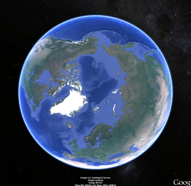
1 Name: Mr. DeLeo Date: Period: Earth s Time Zones Goal: Students will understand why humans have developed time zones on Earth, and how to figure out time at different positions on Earth. Background: One of the first things people noticed when they traveled across Earth s surface was that the positioning of the Sun would change as a person traveled east or west. This caused the time of sunrise, sunset, and solar noon to change as a person traveled east or west. Today, we know this happens because the Earth has a spherical shape, and 12 PM (noon) will only occur at one longitude at one time. For this reason, humans created time zones in order to ensure each location experienced solar noon (sun at its highest point in the sky) at roughly 12 PM (noon). In the United States, we know that if it is 12 PM (noon) in New York (Eastern Standard Time), it is only 9 AM in California (Pacific Standard Time), and various other times around the world. In total, there are 24 time zones, each with a width of 15 degrees, because Earth rotates on its axis 15 degrees per hour. Time Zones In The United States Time Zones On Earth Directions: On the following page is an image provided by Google Earth, showing a top down view of the Earth, with the North Pole at the center. The Prime Meridian is drawn, and as we know has a longitude of 0 degrees. Using a protractor and your knowledge of time zones, accurately create all the time zones around the Earth. Remember, each time zone should be 15 degrees wide, with a total of 24 time zones on Earth. 1
2 2
3 Questions: Use the maps in your Earth Science Reference Table to answer the following questions. Show all work. 1. The time is 5 PM in New York ( 75 W). What time is it in Greenwich, England (0 )? 2. The time is 3 AM in Alaska (150 W). What time is it in New York (75 W)? 3. The time is 10 PM in Australia (150 E). What time is it in New York (75 W)? 4. If the time in one location is 1 PM, and the time in another location is 9 AM, how many degrees longitude are in between these two locations? 5. If it is 12 PM (noon) in New York, what longitude would be experiencing 12 AM (midnight)? 3
4 Practice Regents Questions 1. Base your answer to the following question on passage and time zones map shown below. Time Zones In 1883, Earth was divided into 24 time zones. The United States (excluding Alaska and Hawaii) has four time zones, which are indicated by different shadings on the map.each zone is roughly centered on lines of longitude that are 15 apart. These lines are shown as dashed lines on the map. Most locations within a time zone have the same time.this time is called standard time. As you move to the west, the time in each zone is one hour earlier than the previous time zone When it is 1 a.m. in New York City, what time is it in Denver?
5 2. Base your answer to the following question on the map below which represents a view of the Earth looking down from above the North Pole (N.P.), showing the Earth's 24 standard time zones. The Sun's rays are striking the Earth from the right. Points A, B, C, and D are locations on the Earth's surface. 4. Base your answer to the following question on The diagram below represents the direction of Earth s rotation as it appears from above the North Pole. Point X is a location on Earth s surface. The time at point X is closest to A) 6 a.m. B) 12 noon C) 6 p.m. D) 12 midnight Areas within a time zone generally keep the same standard clock time. In degrees of longitude, approximately how wide is one standard time zone? A) 7 º B) 15º C) 23 º D) 30º 3. The time required for one Earth rotation is about A) one hour B) one day C) one month D) one year
6 5. Base your answer to the following question on the United States time zone map shown below. The dashed lines represent meridians (lines of longitude). The basis for the time difference between adjoining time zones is Earth's A) 1 per hour rate of revolution B) 1 per hour rate of rotation C) 15 per hour rate of revolution D) 15 per hour rate of rotation

7 6. Base your answer to the following question on Letters A, B, C, D, and X on the map below represent locations on Earth. The map shows the latitude-longitude grid. Solar time is based on the position of the Sun. If the solar time is 1 p.m. at location X, at which location is the solar time 5 p.m.? A) A B) B C) C D) D
 6 a.m. B) 8 a.m. C) 12 noon D) 4 p.")
8 7. Base your answer to the following question on the map below. Letters A through F are locations on Earth s surface. When solar time at location E is 12 noon, solar time at location A is closest to A) 6 a.m. B) 8 a.m. C) 12 noon D) 4 p.m.
Stamp Area. Earth Science - Note Packet #7. The shape of the Earth. The Earth is shaped like a ball or a. To go completely around the Earth,.
 Name: Earth Science - Note Packet #7 Mr. LaFranca s - Period Aim: What are time zones and why are they important? Date: Stamp Area Do Now: Why do you think East Coast football games start at 1:00 and West
Earth Moon Motions A B1
 Earth Moon Motions A B1 1. The Coriolis effect provides evidence that Earth (1) rotates on its axis (2) revolves around the Sun (3) undergoes cyclic tidal changes (4) has a slightly eccentric orbit 9.
Time Zones. Doug Fischer Geog 106 LRS
 Time Zones Doug Fischer Geog 106 LRS Learning goals Students should be able to Explain time zones as a function of longitude Calculate time differences between different locations Demonstrate corrections
Practice Questions: Seasons #1
 1. Seasonal changes on Earth are primarily caused by the A) parallelism of the Sun's axis as the Sun revolves around Earth B) changes in distance between Earth and the Sun C) elliptical shape of Earth's
Midterm Review #4 -FR
 Base your answers to questions 1 through 3 on the diagram below, which represents a north polar view of Earth on a specific day of the year. Solar times at selected longitude lines are shown. Letter A
Period: Name: Astronomy Part 3A. Earth s Rotation: Video Notes Sheets. Earth Science with Mr. Sammartano Hommocks Middle School, Team 8-3
 Name: Period: Astronomy Part 3A Earth s Rotation: Video Notes Sheets Earth Science with Mr. Sammartano Hommocks Middle School, Team 8-3 PROOF #1 What is the Shape of the Earth? How do we know the Earth
C) the seasonal changes in constellations viewed in the night sky D) The duration of insolation will increase and the temperature will increase.
 the seasonal changes in constellations viewed in the night sky D) The duration of insolation will increase and the temperature will increase.") 1. Which event is a direct result of Earth's revolution? A) the apparent deflection of winds B) the changing of the Moon phases C) the seasonal changes in constellations viewed in the night sky D) the
1. Which event is a direct result of Earth's revolution? A) the apparent deflection of winds B) the changing of the Moon phases C) the seasonal changes in constellations viewed in the night sky D) the
Practice Questions: Shape of the Earth
 Practice Questions: Shape of the Earth 1. The Earth is slightly flattened from a perfect spherical shape because of A) its rotation B) the pull of the sun and moon C) storms on the sun's surface D) its
Measuring Planet Earth Regents Review. 2. State the altitude of Polaris as seen by an observer at the North Pole.
 Name Measuring Planet Earth Regents Review ase your answers to questions 1 through 3 on the diagram below, which represents a north polar view of Earth on a specific day of the year. Solar times at selected
Mid Term Prep-Shape of the Earth
 1. The Earth is slightly flattened from a perfect spherical shape because of A) its rotation B) the pull of the sun and moon C) storms on the sun's surface D) its molten core 2. The diagrams below represent
TIME. Astronomical time Time is defined by astronomical cycles. The day is the average time from noon to noon (the solar day).
.") ASTRONOMY READER TIME 2.1 TIME Astronomical time Time is defined by astronomical cycles. The day is the average time from noon to noon (the solar day). The month was originally based on the average time
ASTRONOMY READER TIME 2.1 TIME Astronomical time Time is defined by astronomical cycles. The day is the average time from noon to noon (the solar day). The month was originally based on the average time
L.O: EARTH'S 23.5 DEGREE TILT ON ITS AXIS GIVES EARTH ITS SEASONS March 21 (SPRING), June 21(SUMMER), Sept 22 (AUTUMN) & Dec 21(WINTER)
, June 21(SUMMER), Sept 22 (AUTUMN) & Dec 21(WINTER)") L.O: EARTH'S 23.5 DEGREE TILT ON ITS AXIS GIVES EARTH ITS SEASONS March 21 (SPRING), June 21(SUMMER), Sept 22 (AUTUMN) & Dec 21(WINTER) 1. The apparent daily path of the Sun changes with the seasons because
L.O: EARTH'S 23.5 DEGREE TILT ON ITS AXIS GIVES EARTH ITS SEASONS March 21 (SPRING), June 21(SUMMER), Sept 22 (AUTUMN) & Dec 21(WINTER) 1. The apparent daily path of the Sun changes with the seasons because
Latitude and Longitude
 Latitude and Longitude Finding Your Location on a Sphere Coordinate Systems n When you are locating a point on a flat surface you can use Cartesian coordinates of x and y. n The point 2, 3 is plotted on
CHAPTER 2 SKILL SHEET 2: CELESTIAL NAVIGATION
 CHAPTER 2 SKILL SHEET 2: CELESTIAL NAVIGATION Before the invention of GPS technology, how were people on ships far at sea, out of the sight of land, able to tell where they were? For thousands of years
Aileen A. O Donoghue Priest Associate Professor of Physics
 SOAR: The Sky in Motion Life on the Tilted Teacup Ride Celestial Coordinates and the Day Aileen A. O Donoghue Priest Associate Professor of Physics Reference Points Poles Equator Prime Meridian Greenwich,
Mid Term Prep-Latitude and Longitude
 1. What is the approximate altitude of Polaris at Syracuse, New York? A) 43 B) 47 C) 76 D) 90º 2. If an observer on Earth views Polaris on the horizon, the observer is located at the A) equator (0 ) B)
Lesson 20: The Earth in its Orbit
 291 Lesson 20: The Earth in its Orbit Recall that the Earth s orbit around the un is an ellipse which is almost a perfect circle. The average distance from the un to the Earth is 152,100,000 km (to the
Earth Science Seasons Test Name Per Date
 Name Per Date Page 1 1. The diagram below represents four positions of the Earth as it revolves around the Sun. 5. Base your answer to the following question on the diagram below, which shows the apparent
Complete the following: a. Lines of latitude are parallel to the equator. Name:
 Name: Date: Social Studies Introduction: Basic Geography Period: Latitude Latitude is defined as a measurement of distance in degrees north and south of the equator. The word latitude is derived from the
1. Identify the Earth motion that provides the basis for our system of local time and time zones.
 Base your answers to questions 1 through 4 on the map below and on your knowledge of Earth science. The map shows the four time zones and some latitude and longitude lines across the continental United
GEOGRAPHY STD.9 LATITUDE & LONGITUDE
 GEOGRAPHY STD.9 LATITUDE & LONGITUDE 1. What is the Earth Grid? A. The complete network of meridians & parallels is called the earth Grid. 2. What is Latitude? A. The latitude of a place is the distance
Background Information on Times Zones
 Background Information on Times Zones A day is the time it takes the Earth to spin around once on its axis. An hour is one twenty-fourth a day, so the Earth is divided into 24 standard time zones, each
World Time-Day Calculator Lab
 Background: Time zones around the Earth are bounded by imaginary lines called lines of longitude, or meridians. On a globe or map of the world, they are the lines that are perpendicular to the equator.
UNIT 1: THE PLANET EARTH
 UNIT 1: THE PLANET EARTH How many planets are there in our Solar System? What is the Equator? Why does life exist in our planet? Does The Earth move? What is a map? 1. Planet Earth TOPICS 2. Movements
Which graph best shows the relationship between intensity of insolation and position on the Earth's surface? A) B) C) D)
 B) C) D)") 1. The hottest climates on Earth are located near the Equator because this region A) is usually closest to the Sun B) reflects the greatest amount of insolation C) receives the most hours of daylight D)
1. The hottest climates on Earth are located near the Equator because this region A) is usually closest to the Sun B) reflects the greatest amount of insolation C) receives the most hours of daylight D)
1. Which graph best represents the altitude of Polaris observed at northern latitude positions on the Earth's surface?
 1. Which graph best represents the altitude of Polaris observed at northern latitude positions on the Earth's surface? A) 4. The diagram below shows an observer measuring the altitude of Polaris. B) C)
Aerial Photograhy. Brief history of aerial photography
 MAPWORK TOPIC ONE Why do we use maps? Maps are very important tools for geographers because they enable them to record, display and analyse information about people and the environment around them. Maps
Sunlight and its Properties II. EE 446/646 Y. Baghzouz
 Sunlight and its Properties II EE 446/646 Y. Baghzouz Solar Time (ST) and Civil (clock) Time (CT) There are two adjustments that need to be made in order to convert ST to CT: The first is the Longitude
Stamp Area. Earth Science - Note Packet #6. The shape of the Earth. The Earth is in shape.
 Name: Earth Science - Note Packet #6 Mr. LaFranca s - Period Date: Aim: What are Latitude and Longitude? Do Now: Using the map, where is this location? Stamp Area X The shape of the Earth The Earth is
drinking straw, protractor, string, and rock. observer on Earth. Sun across the sky on March 21 as seen by an
 1. The diagram below represents some constellations and one position of Earth in its orbit around the Sun. These constellations are visible to an observer on Earth at different times of the year. When
A) greatest in diameter at the Equator B) 44 05' N 73 55' W B) Albany D) Polaris B) 8 h
 greatest in diameter at the Equator B) 44 05' N 73 55' W B) Albany D) Polaris B) 8 h") 1. Measurements taken from space show the Earth to be A) greatest in diameter at the Equator B) greatest in diameter at the poles C) a perfect sphere D) pear shaped 2. New York State's highest peak, Mt.
1. Measurements taken from space show the Earth to be A) greatest in diameter at the Equator B) greatest in diameter at the poles C) a perfect sphere D) pear shaped 2. New York State's highest peak, Mt.
Phys Lab #1: The Sun and the Constellations
 Phys 10293 Lab #1: The Sun and the Constellations Introduction Astronomers use a coordinate system that is fixed to Earth s latitude and longitude. This way, the coordinates of a star or planet are the
1. The diagram below represents Earth and the Moon as viewed from above the North Pole. Points A, B, C, and D are locations on Earth's surface.
 1. The diagram below represents Earth and the Moon as viewed from above the North Pole. Points A, B, C, and D are locations on Earth's surface. 2. The graph below shows the change in tide heights of the
C) D) 2. The model below shows the apparent path of the Sun as seen by an observer in New York State on the first day of one of the four seasons.
 D) 2. The model below shows the apparent path of the Sun as seen by an observer in New York State on the first day of one of the four seasons.") 1. Which diagram best represents the regions of Earth in sunlight on June 21 and December 21? [NP indicates the North Pole and the shading represents Earth's night side. Diagrams are not drawn to scale.]
1. Which diagram best represents the regions of Earth in sunlight on June 21 and December 21? [NP indicates the North Pole and the shading represents Earth's night side. Diagrams are not drawn to scale.]
Which phase of the Moon will be seen from the Earth at position 5? A) B) C) D)
 B) C) D)") Name Date 1. Which motion causes the Moon to show phases when viewed from the Earth? A) the rotation of the Moon on its axis B) the revolution of the Moon around the Earth C) the rotation of the Sun on
Name Date 1. Which motion causes the Moon to show phases when viewed from the Earth? A) the rotation of the Moon on its axis B) the revolution of the Moon around the Earth C) the rotation of the Sun on
Seasonal Path of the Sun and Latitude
 Seasonal Path of the Sun and Latitude Overview This lesson is a modification of what Dave Hess and I, Stan Skotnicki, use in our Earth Science classes at Cheektowaga Central High School. It is an extension
Module 2: Mapping Topic 2 Content: Determining Latitude and Longitude Notes
 Introduction In order to more easily locate points on a globe or map, cartographers designed a system of imaginary vertical lines (also called parallels) and horizontal lines (also called meridians) that
Geographic Grid. Locations Feature 1 Feature 2 Feature 3
 Geographic Grid Name The geographic grid refers to the internationally-recognized system of latitude and longitude used to location positions on Earth's surface. Accurate use of this coordinate system
Practice Seasons Moon Quiz
 1. Which diagram represents the tilt of Earth's axis relative to the Sun's rays on December 15? A) B) C) D) 2. The diagram below represents Earth in space on the first day of a season. 5. Base your answer
Latitude and Longitude Pre Test
 Name Date Latitude and Longitude Pre Test Multiple Choice Directions: For questions, 1 10 circle the answer that letter that best answers the question. Each question is worth 1 point each. 1. To locate
 What Is a Time Zone? Nature doesn t have a clock; a clock is a human invention. Instead animals, plants and humans respond to the length of the day from sunrise until sunset. This is known as a natural
Time, coordinates and how the Sun and Moon move in the sky
 Time, coordinates and how the Sun and Moon move in the sky Using the colors and magnitudes of quasars drawn from the SDSS Catalog Archive Server to distinguish quasars from stars using the light they emit
March 21. Observer located at 42 N. Horizon
 March 21 Sun Observer located at 42 N Horizon 48 June 21 March 21 A 48 90 S 23.5 S 0 23.5 N 42 N 90 N Equator (June 21) C (March 21) B A 71.5 48 Horizon 24.5 Observer Sun 40 Observer Sun 22 Observer Sun
Appearance of the Sky Orientation Motion of sky Seasons Precession (?)
") Today Appearance of the Sky Orientation Motion of sky Seasons Precession (?) The Celestial Sphere Stars at different distances all appear to lie on the celestial sphere. The ecliptic is the Sun s apparent
Today Appearance of the Sky Orientation Motion of sky Seasons Precession (?) The Celestial Sphere Stars at different distances all appear to lie on the celestial sphere. The ecliptic is the Sun s apparent
Geography Class 6 Chapters 3 and
 CHAPTER 3 MOTIONS OF THE EARTH The Earth is always travelling in Space. That makes each person on Earth, a Space Traveller. No one feels the movement of the Earth because humans are too tiny when compared
Student Exploration: Seasons: Earth, Moon, and Sun
 Name: Date: Student Exploration: Seasons: Earth, Moon, and Sun Vocabulary: altitude, axis, azimuth, equinox, horizon, latitude, revolution, rotation, solstice Prior Knowledge Questions (Do these BEFORE
EARTHS SHAPE AND POLARIS PRACTICE 2017
 1. In the diagram below, letters A through D represent the locations of four observers on the Earth's surface. Each observer has the same mass. 3. Which diagram most accurately shows the cross-sectional
Earth Motions Packet 14
 Earth Motions Packet 14 Your Name Group Members Score Minutes Standard 4 Key Idea 1 Performance Indicator 1.1 Explain complex phenomena, such as tides, variations in day length, solar insolation, apparent
Celestial Sphere Spectroscopy (Something interesting; e.g., advanced data analyses with IDL)
") AST326, 2010 Winter Semester Celestial Sphere Spectroscopy (Something interesting; e.g., advanced data analyses with IDL) Practical Assignment: analyses of Keck spectroscopic data from the instructor (can
AST326, 2010 Winter Semester Celestial Sphere Spectroscopy (Something interesting; e.g., advanced data analyses with IDL) Practical Assignment: analyses of Keck spectroscopic data from the instructor (can
Appearance of the Sky Orientation Motion of sky Seasons Precession (?)
") Today Appearance of the Sky Orientation Motion of sky Seasons Precession (?) The Celestial Sphere Stars at different distances all appear to lie on the celestial sphere. The ecliptic is the Sun s apparent
Today Appearance of the Sky Orientation Motion of sky Seasons Precession (?) The Celestial Sphere Stars at different distances all appear to lie on the celestial sphere. The ecliptic is the Sun s apparent
(1) Over the course of a day, the sun angle at any particular place varies. Why?
 Over the course of a day, the sun angle at any particular place varies. Why?") (1) Over the course of a day, the sun angle at any particular place varies. Why? (Note: Although all responses below are true statements, only one of them actually explains the observation!) (A)The sun
(1) Over the course of a day, the sun angle at any particular place varies. Why? (Note: Although all responses below are true statements, only one of them actually explains the observation!) (A)The sun
Astronomy 101 Lab Manual. Victor Andersen Community College of Aurora
 Astronomy 101 Lab Manual Victor Andersen Community College of Aurora victor.andersen@ccaurora.edu January 8, 2013 2 Contents 1 Angular Measures 5 1.1 Introduction............................ 5 1.1.1 Degrees,
GLOBE : LATITUDES AND LONGITUDES
 2 Figure 2.1 : Globe Let s Do Take a big round potato or a ball. Pierce a knitting needle through it. The needle resembles the axis shown in a globe. You can now move the potato or the ball around this
LAB: What Events Mark the Beginning of Each Season?
 Name: Date: LAB: What Events Mark the Beginning of Each Season? The relationship between the Sun and Earth have been used since antiquity to measure time. The day is measured by the passage of the Sun
Geographic Grid -Latitudes and Longitudes
 GEOGRAPHY STD 9 Geographic Grid -Latitudes and Longitudes 2018-2019 Q1. Define Geographic Grid. The network of latitudes and longitudes are known as Geographic Grid. They help us to locate places on the
The World of Geography Pre-Test/Study Guide Chapter 1 Test
 Read each statement or question. On the lines below write the letter of the best answer. 1. Geographers look at the Earth 5. What are the two specific A. by studying cities first. measurements of Earth
The Spinning Earth Key Stage 2
 The Spinning Earth Key Stage 2 Topics covered: Earth, Sun, day and night, time, angles, fractions Teacher s Notes In this activity pupils are introduced to the rotating Earth and the concept of longitude.
C) D) 3. Which pie graph correctly shows the percentage of elements by volume in Earth s troposphere? A)
 D) 3. Which pie graph correctly shows the percentage of elements by volume in Earth s troposphere? A)") 1. Precise measurements of the Earth indicate that its polar diameter is A) shorter than its equatorial diameter B) longer than its equatorial diameter C) the same length as its equatorial diameter 2.
1. Precise measurements of the Earth indicate that its polar diameter is A) shorter than its equatorial diameter B) longer than its equatorial diameter C) the same length as its equatorial diameter 2.
Name Regents Review Packet #2 Date
 Name Regents Review Packet #2 Date Base your answers to questions 1 through 5 on diagram below, which represents the Sun s apparent paths and the solar noon positions for an observer at 42 N latitude on
Background Information
 Oceanography LAB #1: Marine Charts and Navigation Background Information Latitude and Longitude A coordinate is an address a means of designating location. Most coordinate systems involve a network of
THE EARTH. MERIDIANS AND PARALLELS
 THE EARTH. MERIDIANS AND PARALLELS 1=Circle of latitude 2=Meridian (geography) A circle of latitude, on the Earth, is an imaginary east-west circle connecting all locations (not taking into account elevation)
Cartesian Coordinates Need two dimensional system 2 number lines perpendicular to each other X-axis is horizontal Y-axis is vertical Position relative
 General Physical Science Chapter 15 Place and Time Space and Time Einstein Space and time related Single entity Time is the 4 th dimension! Cartesian Coordinates Need some system to tell us where something
ME 476 Solar Energy UNIT THREE SOLAR RADIATION
 ME 476 Solar Energy UNIT THREE SOLAR RADIATION Unit Outline 2 What is the sun? Radiation from the sun Factors affecting solar radiation Atmospheric effects Solar radiation intensity Air mass Seasonal variations
C) wavelength C) eastern horizon B) the angle of insolation is high B) increases, only D) thermosphere D) receive low-angle insolation
 wavelength C) eastern horizon B) the angle of insolation is high B) increases, only D) thermosphere D) receive low-angle insolation") 1. What is the basic difference between ultraviolet, visible, and infrared radiation? A) half-life B) temperature C) wavelength D) wave velocity 2. In New York State, the risk of sunburn is greatest between
1. What is the basic difference between ultraviolet, visible, and infrared radiation? A) half-life B) temperature C) wavelength D) wave velocity 2. In New York State, the risk of sunburn is greatest between
Page 1. Name:
 Name: 1) What is the primary reason New York State is warmer in July than in February? A) The altitude of the noon Sun is greater in February. B) The insolation in New York is greater in July. C) The Earth
Moon Phases LCROSS. Group Activity1: Identification of the Phases of the Moon K 4; 5 8
 Moon Phases LCROSS Group Activity1: Identification of the Phases of the Moon K 4; 5 8 Procedure: In the following activity, you will read the brief description of the phases of the Moon and then identify
Downloaded from
 Geo Globe : Latitudes and Longitudes 1.Suppose the time at 30 east is 2 p.m. then what is the time at Greenwich? (A) 2 p.m. (B) 12 p.m. (C) 1 p.m. (D) Cannot find 2.What does the term 'Grid' mean
Midterm Review #2-2018
 1. Which arrangement of the Sun, the Moon, and Earth results in the highest high tides, and the lowest low tides on Earth? (Diagrams are not drawn to scale.) A) B) C) D) Base your answers to questions
Maps and Globes. By Kennedy s Korner
 Maps and Globes By Kennedy s Korner Map Key or Symbols Maps use symbols to show places and things on Earth. Symbols are drawings that stand for something real. A map key tells you what each symbol stands
5. In which diagram is the observer experiencing the greatest intensity of insolation? A) B)
 B)") 1. Which factor has the greatest influence on the number of daylight hours that a particular Earth surface location receives? A) longitude B) latitude C) diameter of Earth D) distance from the Sun 2. In
1. Which factor has the greatest influence on the number of daylight hours that a particular Earth surface location receives? A) longitude B) latitude C) diameter of Earth D) distance from the Sun 2. In
Astro 101 Lab #2. Start up the Stellarium program. If you do not remember how to use the user interface, please refer to Lab#1 or the user s guide.
 Name: Astro 101 Lab #2 Lab objectives 1) Learn about how the Sun s path, through the sky, changes with the changing seasons. 2) Learn about how the Sun s path changes while viewing it at different locations
Maps. 3. Which altitude of Polaris could be observed in New York State?
 Name: Date: 1. For an observer in New York State, the altitude of Polaris is 43 above the northern horizon. This observer s latitude is closest to the latitude of A. New York City B. Utica 3. Which altitude
Meridian Circle through Zenith, North Celestial Pole, Zenith Direction Straight Up from Observer. South Celestial Pole
 Chapter 3 How Earth and Sky Work- Effects of Latitude In chapters 3 and 4we will learn why our view of the heavens depends on our position on the Earth, the time of day, and the day of the year. We will
Which Earth latitude receives the greatest intensity of insolation when Earth is at the position shown in the diagram? A) 0 B) 23 N C) 55 N D) 90 N
 0 B) 23 N C) 55 N D) 90 N") 1. In which list are the forms of electromagnetic energy arranged in order from longest to shortest wavelengths? A) gamma rays, x-rays, ultraviolet rays, visible light B) radio waves, infrared rays, visible
1. In which list are the forms of electromagnetic energy arranged in order from longest to shortest wavelengths? A) gamma rays, x-rays, ultraviolet rays, visible light B) radio waves, infrared rays, visible
A Sky Full of Stars - II.
 A Sky Full of Stars - II. Learning Objectives! What is the latitude of the Equator and of the Earth s North and South Poles? What is the declination of the Celestial Equator and of the Celestial Poles?!
Latitude and Longitude. Finding your location throughout the world!
 Latitude and Longitude Finding your location throughout the world! What is Latitude? Latitude is defined as a measurement of distance in degrees north and south of the equator The word latitude is derived
Practice Questions: Seasons #2
 1. How many degrees does the Sun appear to move across the sky in four hours? A) 60 B) 45 C) 15 D) 4 Practice Questions: Seasons #2 2. Base your answer to the following question on the diagram below, which
Written as per the latest syllabus prescribed by the Maharashtra State Bureau of Textbook Production and Curriculum Research, Pune.
 Written as per the latest syllabus prescribed by the Maharashtra State Bureau of Textbook Production and Curriculum Research, Pune. STD. VIII Geography Salient Features Written as per the new textbook.
L.O: THE ANGLE OF INSOLATION ANGLE INSOLATION: THE ANGLE SUNLIGHT HITS THE EARTH
 L.O: THE ANGLE OF INSOLATION ANGLE INSOLATION: THE ANGLE SUNLIGHT HITS THE EARTH 1. The graph below shows air temperatures on a clear summer day from 7 a.m. to 12 noon at two locations, one in Florida
Map Skills Lesson 1. Materials: maps, pencils, Lesson 1 Worksheet, strips of paper, grid paper
 Map Skills Lesson 1 Use cardinal directions, map grids, scales, and titles to locate places on a map. Interpret a map using information from its title, compass rose, scale, and legend. Vocabulary: map,
Rotation and Revolution
 Lesson 2 Rotation and Revolution Earth has circled around the Sun for about 4.6 billion years. What has kept Earth in its path around the Sun for so long? 422 ENGAGE ESS.41 Explain why the Moon, Sun, and
Time and Diurnal Motion
 Time and Diurnal Motion Time and Diurnal Motion A. Geography: mapping the earth 2 B. Equatorial Coordinates C. Local Horizon System Updated Sep 30, 2012 A. Geography: mapping the earth Geometry: measure
Coordinates on the Sphere
 Survey Observations Coordinates on the Sphere Any position on the surface of a sphere (such as the Earth or the night sky) can be expressed in terms of the angular coordinates latitude and longitude Latitude
Celestial Navigation. 6. Time Objective Greenwich Mean Time
 6. Time Celestial Navigation 6.1. Objective By the end of this section you will know more about time than you thought possible. In particular you will learn how time and longitude are related, understand
THE EARTH AND ITS REPRESENTATION
 UNIT 7 THE EARTH AND ITS REPRESENTATION TABLE OF CONTENTS 1 THE EARTH AND THE SOLAR SYSTEM... 2 2 THE EARTH S MOVEMENTS... 2 2.1 Rotation.... 2 2.2 The revolution of the Earth: seasons of the year....
A. Spatial Sense (Working with Maps, Globes, and Other Geographic Tools)
") A. Spatial Sense (Working with Maps, Globes, and Other Geographic Tools) Measuring Distance Using Map Scale All maps are drawn to scale; that is, they are smaller than the things they represent. Scale
A. Spatial Sense (Working with Maps, Globes, and Other Geographic Tools) Measuring Distance Using Map Scale All maps are drawn to scale; that is, they are smaller than the things they represent. Scale
CELESTIAL COORDINATES
 ASTR 1030 Astronomy Lab 27 Celestial Coordinates CELESTIAL COORDINATES GEOGRAPHIC COORDINATES The Earth's geographic coordinate system is familiar to everyone - the north and south poles are defined by
Time and Diurnal Motion
 Time and Diurnal Motion Time and Diurnal Motion A. Geography: mapping the earth 2 B. Equatorial Coordinates C. Local Horizon System Updated 2014Jan11 A. Geography: mapping the earth Geometry: measure the
A Warm Up Exercise. The Motion of the Sun. A Warm Up Exercise. A Warm Up Exercise. A Warm Up Exercise
 A Warm Up Exercise The Motion of the Sun Which of the following is NOT true of a circumpolar star? a) It rises and sets from my latitude b) Its direction can be far North c) Its direction can be far South
Academic Year Second Term. Science Revision Sheet. Grade
 Academic Year 2017-2018 Second Term Science Revision Sheet Grade 6 Name: Grade Date: Section: Part A. Science Practice. Circle the letter of your answer. 1. When the moon is waxing, its lighted part appears
For most observers on Earth, the sun rises in the eastern
 632 CHAPTER 25: EARTH, SUN, AND SEASONS WHAT IS THE SUN S APPARENT PATH ACROSS THE SKY? For most observers on Earth, the sun rises in the eastern part of the sky. The sun reaches its greatest angular altitude
PHYSICAL GEOGRAPHY. By Brett Lucas
 PHYSICAL GEOGRAPHY By Brett Lucas INTRODUCTION Introduction to Earth Geography as a Field of Learning Geography is from two Greek words, Geo Earth, and Graphien to write. Elements/Branches of Geography
Oberth: Energy vs. Momentum
 1 2 The Oberth Effect 3 Oberth: Energy vs. Momentum 4 The Celestial Sphere From our perspective on Earth the stars appear embedded on a distant 2-dimensional surface the Celestial Sphere. 5 The Celestial
Key Issue #1. How do geographers describe where things are? 2014 Pearson Education, Inc.
 Key Issue #1 How do geographers describe where things are? Learning Outcomes 1.1.1: Explain differences between early maps and contemporary maps. 1.1.2: Describe the role of map scale and projections and
Map Making. Chapter 2 Section 1
 Map Making Chapter 2 Section 1 Latitude and Longitude Objectives Compare and contrast latitude and longitude. Describe how time zones vary. Vocabulary cartography equator latitude longitude prime meridian
page - 1 Laboratory Exercise #1 - Introduction to Latitude and Longitude Northern Hemisphere Southern Hemisphere
 page - 1 Laboratory Exercise #1 - Introduction to Latitude and Longitude A. Introduction There are many methods that can be used to locate ones position on the surface of the earth. A common method for
Astronomy. Unit 2. The Moon
 Astronomy Unit 2 The Moon 1 Traveling on Spaceship Earth Although we imagine ourselves to be at rest, the Earth takes part in the motions outlined below. The Earth spins about its N-S axis, with a period
Time and Diurnal Motion. 1a. The Earth Is Flat. 1c. Aristotle ( BC) 1b. The Earth Is Round. Time and Diurnal Motion
 1b. The Earth Is Round. Time and Diurnal Motion") Time and Diurnal Motion Time and Diurnal Motion A. Geography: mapping the earth 2 B. Equatorial Coordinates C. Local Horizon System A. Geography: mapping the earth Geometry: measure the earth! 1) The earth
Time and Diurnal Motion Time and Diurnal Motion A. Geography: mapping the earth 2 B. Equatorial Coordinates C. Local Horizon System A. Geography: mapping the earth Geometry: measure the earth! 1) The earth
Computer Activity #3 SUNRISE AND SUNSET: THE SEASONS
 NAME(S)!!!!!!!!!!!!!!!!!!!!!!!!!!!!!!!!!! ASTRONOMY 25 Computer Activity #3 SUNRISE AND SUNSET: THE SEASONS SECTION DAY/TIME S. V. LLOYD Overview The seasonal variation in temperature is due to two changes
Local Coordinates. These are centered upon you, the observer.
 Astronomy 30, Observing #3 Name: Lab Partners: Date: Materials: This lab, with the star chart completed from the pre-lab. Some sheets of paper for sketches. A pencil with eraser. A small flashlight, ideally