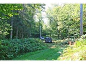
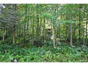
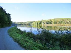
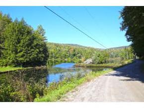
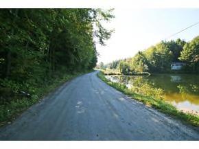
159 Marsh Road, Woodbury, VT
|
|
|
- Roy Daniels
- 5 years ago
- Views:
Transcription
1 159 Marsh Road, Woodbury, VT Curtis Trousdale, Owner, Broker, Realtor Cell: Williston Road, South Burlington VT Phone: (802) Fax: (802)
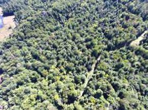
2
3

4
5

6

7

8
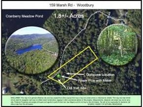
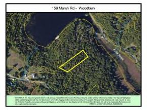
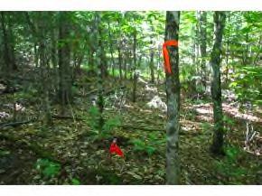
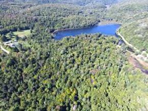
9 159 Marsh Rd - Woodbury Cranberry Meadow Pond 1.8+/- Acres30 Old Yurt Site Outhouse Location Power Pole with Meter D IS C L A IM E R : T h is m a p is fo r g e n e ra l re fe re n c e o n ly a n d w a s c re a te d fro m o th e r s o u rc e s th a t m a y o r m a y n o t c o n ta in e rro rs o r o th e rw is e b e re lia b le. T h is m a p a n d d a ta s h o u ld n o t b e u s e d fo r n a v ig a tio n a n d m a y n o t re fle c t re c e n t c o n s tru c tio n, lo g g in g o r o th e r c o m m e rc ia l a c tiv ity o n th e p ro p e rty. M e a s u re m e n ts, d is ta n c e s a n d a re a s m a y n o t b e a c c u - ra te. P re fe rre d P ro p e rtie s e n c o u ra g e s a ll b u y e rs a n d a g e n ts to p e rfo rm th e ir o w n d u e d ilig e n c e a n d to n o t re ly o n th is in fo rm a tio n. W e w ill n o t b e re s p o n s ib le fo r d e c is io n s a n d o ffe rs m a d e fro m th is in fo rm a tio n. S O U R C E : A G E N C Y O F N A T U R A L R E S O U R C E S
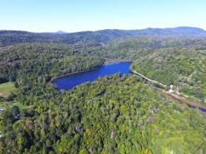
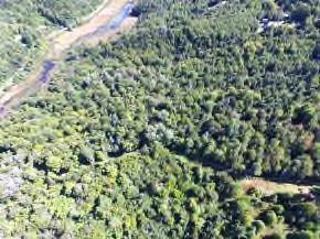
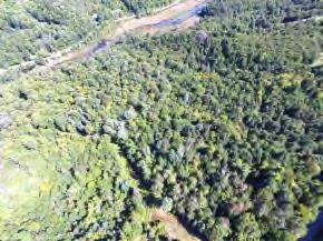
10 159 Marsh Rd - Woodbury D IS C L A IM E R : T h is m a p is fo r g e n e ra l re fe re n c e o n ly a n d w a s c re a te d fro m o th e r s o u rc e s th a t m a y o r m a y n o t c o n ta in e rro rs o r o th e rw is e b e re lia b le. T h is m a p a n d d a ta s h o u ld n o t b e u s e d fo r n a v ig a tio n a n d m a y n o t re fle c t re c e n t c o n s tru c tio n, lo g g in g o r o th e r c o m m e rc ia l a c tiv ity o n th e p ro p e rty. M e a s u re m e n ts, d is ta n c e s a n d a re a s m a y n o t b e a c c u - ra te. P re fe rre d P ro p e rtie s e n c o u ra g e s a ll b u y e rs a n d a g e n ts to p e rfo rm th e ir o w n d u e d ilig e n c e a n d to n o t re ly o n th is in fo rm a tio n. W e w ill n o t b e re s p o n s ib le fo r d e c is io n s a n d o ffe rs m a d e fro m th is in fo rm a tio n. S O U R C E : T O W N O F W O O D B U R Y


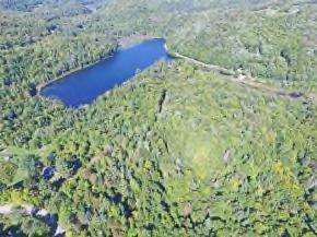
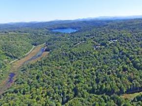
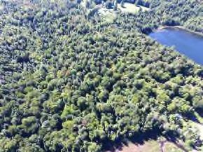
11 159 Marsh Rd - Woodbury D IS C L A IM E R : T h is m a p is fo r g e n e ra l re fe re n c e o n ly a n d w a s c re a te d fro m o th e r s o u rc e s th a t m a y o r m a y n o t c o n ta in e rro rs o r o th e rw is e b e re lia b le. T h is m a p a n d d a ta s h o u ld n o t b e u s e d fo r n a v ig a tio n a n d m a y n o t re fle c t re c e n t c o n s tru c tio n, lo g g in g o r o th e r c o m m e rc ia l a c tiv ity o n th e p ro p e rty. M e a s u re m e n ts, d is ta n c e s a n d a re a s m a y n o t b e a c c u - ra te. P re fe rre d P ro p e rtie s e n c o u ra g e s a ll b u y e rs a n d a g e n ts to p e rfo rm th e ir o w n d u e d ilig e n c e a n d to n o t re ly o n th is in fo rm a tio n. W e w ill n o t b e re s p o n s ib le fo r d e c is io n s a n d o ffe rs m a d e fro m th is in fo rm a tio n. S O U R C E : A G E N C Y O F N A T U R A L R E S O U R C E S
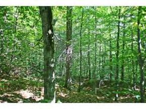
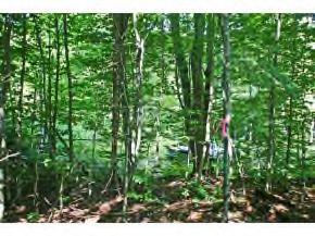
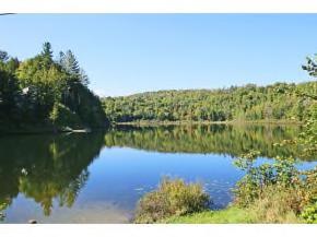
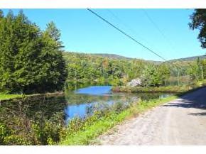
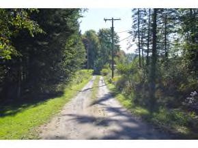
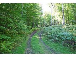
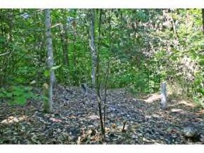
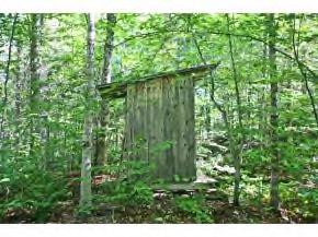
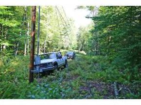
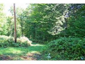
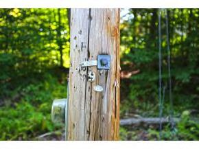
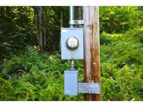
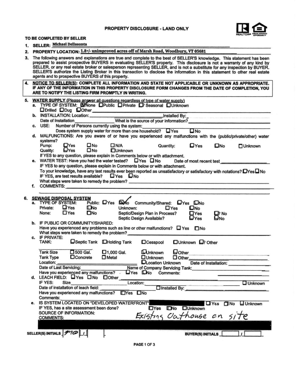
12 Utility & Property Info: Taxes: Town of Woodbury $ (2016 Non-homestead rate). Power: Power poles run up Marsh Rd and continue along the trail servicing the property. Pole number 9 is physically on the property. The seller currently pays $26 twice a year to keep a power meter hooked up, as this was once used for a Yurt that is no longer on the property. The service provider is Hardwick Electric. Septic: Water: Zoning: No soil tests have been completed at this time. Currently, a wood enclosed outhouse structure is on the property. This will convey with the property. There is no formal drinking water source on the property. Property is within the Agriculture-Rural Residential and the Shoreland zoning districts of the Woodbury Zoning Regulations. Please see attached for partial information. Please direct specific inquiries to the Woodbury Zoning Official: Jennifer Harman Boundaries: All corner pins found and boundaries are marked reasonable accurately by seller with orange and red flagging. Services: Road: Address: Additional Property Information 159 Marsh Rd, Woodbury, VT Fairpoint offers phone, high speed DSL internet, and satellite TV through their affiliate DirecTV in the area. The town describes the access to this property as,...private camp road to Class 4 to trail The eastern portion of the road services three seasonal camps, which is likely maintained by the property owners. The road then becomes a class 4 road and eventually a town trail approaching the property and beyond. Plowing is done privately, if performed at all, as the camps on lower Marsh road are most likely only used during the warm months. You can drive all the way to the property and there is small cleared area that serves the owner as a parking area and turn around. It is very likely that an RV, camper and/or 5th-wheel could be driven to the property. The properties address has been created for GPS purposes only. Foundation: Three out of four concrete pillars remain on the property. These were the foundation for a Yurt previously located on the property. With lack of use, the sellers burned the structure as a way to remove it.
13 Area Information Nearby Cities: Montpelier, VT 34 Minutes Burlington, VT 1 Hour, 13 Minutes Montreal, QC, Can 2 Hours, 33 Minutes Boston, MA 3 Hours, 15 Minutes Albany, NY 3 Hours, 41 Minutes New York, NY 5 Hours, 36 Minutes Nearby Airports and Trains: About The Town Burlington International Airport: 1 Hour, 11 Minutes Regional hub serviced by major airlines, connecting to airports across the country. Lebanon Municipal Airport - NH 1 Hour, 21 Minutes A regional, towercontrolled airport located in western New Hampshire, on the border of Vermont. Daily commercial service connects passengers to Boston and White Plains, New York. Woodbury, VT As a township, its territory is decidedly rough and mountainous. A mountain range extends entirely across the western part. Located on its base on the western slope are many fertile farms, the most productive area of the township. The balance of arable land is mainly in the southern half of the town where a large portion containing the Rutland State Airport: 2 Hours Located just five miles south of Vermont s second largest city, Southern Vermont Regional Airport is a modern convenience nestled in the heart of the beautiful Green Mountains. Logan International Airport: 3 Hours, 14 Minutes Boston Logan International Airport is New England s largest transportation center and generates $7 billion in economic activity each year. It is a city within a city on a mountain region is unfit for cultivation. From the fact that the water flows towards every point of the compass, from Woodbury, and that none flows into it, there can be no large streams in this township, yet it is well watered by numerous streams and twenty-three natural ponds - the greatest number in any town in Vermont. 1,700 acre footprint of land. Albany, NY International Airport : 3 Hours, 35 Minutes The Albany International Airport offers a wide-range of facilities and services. A recently completed multi-million dollar capital redevelopment project included a new 230,000 square foot terminal, parking garage, Air Traffic Control Tower, and cargo facility. Nearby State Parks & Forests Elmore State Park 30 Minutes Lake Elmore is 219 acres, and lies northwest of the village and empties into the Lamoille River through Pond Brook. Elmore Mountain is in the "Hogback Range" and its timber is mostly hardwood. The mountain has an elevation of 2,608 feet. Today, with more than 700 acres, Elmore State Park has become a popular, developed recreation facility. Link: Elmore State Park Stillwater State Park 39 Minutes- Groton State Forest, with over 26,000 acres, is the second largest land block administered by the Department of Forests, Parks and Recreation. The forest contains over 17 miles of hiking trails and over 20 miles of gravel roads and multi-use trails suitable for mountain biking and horseback riding. Link: Camel s Hump Camel s Hump State Park 1 Hour, 6 Minutes The Park came about as an original gift of 1000 acres including the summit from Colonel Joseph Battell, who originally bought Camel's Hump to preserve the wooded mountainous view from his home. In 1911, care of the mountain was entrusted to the State Forester who managed with the aim to keep it in a primitive state according to Battell's wish. Primitive camping is allowed only in the lower elevations and away from trails, roads, and water, in accordance with the state primitive camping guidelines. Link: Camel s Hump
14 Area Information Page 2 Rivers and Lakes Lake Elmore Lake Elmore is 219 acres, and lies northwest of the village and empties into the Lamoille River through Pond Brook. Common fish species are Yellow Perch, Northern Pike, Smallmouth Bass, Bullhead, and Panfish Waterbury Reservoir The Reservoir is the ninth largest body of water in the state of Vermont and was created in the 1930's by the CCC as a flood control project to protect towns and villages along the Winooski River Valley. From late spring to early fall, the Reservoir is maintained to a surface area of 850 acres and has a maximum depth of 100 feet. To prepare for normal spring snow melt and runoff, the surface area is reduced to between acres throughout the winter. The designed flood control capacity of Waterbury Reservoir is approximately 9,000,000,000 gallons. Buck Lake Park of the Buck Lake Wildlife Management Area which is owned by the State and run by the Vermont Fish & Wildlife Department. The fishing is restricted to walk-in and car-top carry-in boats or canoes. Common fish are smallmouth bass, yellow perch, brown bullhead and brook trout. Skiing, Snowmobiling, Snowshoeing Stowe 53 Minutes In a place where the history, community and landscape are legendary for hospitality and adventure, Stowe Mountain Resort in Stowe, Vermont has reinforced its internationally respected brand with world-class improvements both on and off the mountain. Link: Stowe Bolton Valley 1 Hour, 3 Minutes Bolton Valley sits high in the Green Mountains of Vermont. It is a unique, high mountain alpine village surrounded by over 5,000 pristine acres. At Bolton Valley, the recreational opportunities are as numerous as the views are spectacular. Link: Bolton Valley Sugarbush 1 Hour, 11 Minutes Six distinct peaks of unleashed potential. Two uncrowded mountain areas. 2,000 acres of backcountry in the Slide Brook Basin. It s no surprise Sugarbush was recently named Best Ski Town in the East by Outside Magazine. Link: Sugarbush East Montpelier Trail System 25 Minutes Permanent trail that is part of a proposed 17 mile trail loop. Open for hiking, biking, snowshoeing, and crosscountry skiing. Link: Trail Map VAST Corridior 14 is easily accessed off VT-14 north of the property.
15
16
17
18
19
20
21
22
23
24
600 Billy Smith Road, Athens, VT
 600 Billy Smith Road, Athens, VT Curtis Trousdale, Owner, Broker, Realtor Cell: 802-233-5589 curtis@preferredpropertiesvt.com 2004 Williston Road, South Burlington VT 05403 www.preferredpropertiesvt.com
2480 Cavendish Gulf Road, Cavendish, VT
 2480 Cavendish Gulf Road, Cavendish, VT Curtis Trousdale, Owner, Broker, Realtor Cell: 802-233-5589 curtis@preferredpropertiesvt.com 2004 Williston Road, South Burlington VT 05403 www.preferredpropertiesvt.com
Five Themes of Geography Project Ms. Kiesel, Per 5. The United States of America
 Five Themes of Geography Project Ms. Kiesel, Per 5 The United States of America Location Absolute Location : The USA is located in the continent of North America in the northern and western hemispheres.
MEDIA RELEASE FOR IMMEDIATE RELEASE March 17, 2014 Preparing for the Spring Thaw
 BRACEBRIDGE, ONT Springtime is fast approaching and flooding in low lying areas of the Town is a potential risk due to melting snow and spring rain fall. Flooding can also be experienced during extreme
Class Diagrams. CSC 440/540: Software Engineering Slide #1
 Class Diagrams CSC 440/540: Software Engineering Slide # Topics. Design class diagrams (DCDs) 2. DCD development process 3. Associations and Attributes 4. Dependencies 5. Composition and Constraints 6.
MAPS AND THEIR CLASSIFICATION
 MAPPING MAPS AND THEIR CLASSIFICATION WHAT IS A MAP? A map is representation of the Earth's surface, showing how things are related to each other by distance, direction, and size. Maps are a way of showing
April snowmelt and record rainfall resulted in flooding across portions of Vermont
 Vermont State Climate Office Climate Impacts Summary April 2011 Dr. Lesley-Ann Dupigny-Giroux Stephen Hogan April snowmelt and record rainfall resulted in flooding across portions of Vermont During the
CLAREMONT MASTER PLAN 2017: LAND USE COMMUNITY INPUT
 Planning and Development Department 14 North Street Claremont, New Hampshire 03743 Ph: (603) 542-7008 Fax: (603) 542-7033 Email: cityplanner@claremontnh.com www.claremontnh.com CLAREMONT MASTER PLAN 2017:
River Realty Services Commercial
 1 4 6 N O R T H U S 9 W, C O N G E R S, N Y 1 0 9 2 0 TA B L E O F C O N T E N T S E X E C U T I V E S U M M A RY 03 Z O N I N G 09 R EG I S T R AT I O N S 04 S U B J EC T P H OTO S 10 M A P V I E W 05
Bishkek City Development Agency. Urban Planning Bishkek
 Bishkek City Development Agency Urban Planning Bishkek Bishkek City Development Agency Official name City budget Population Area GRP Import value Export value External trade turnover Foreign direct investments
Vermont State Climate Office Climate Impacts Summary December Dr. Lesley-Ann Dupigny-Giroux Stephen Hogan
 Vermont State Climate Office Climate Impacts Summary December 2010 Dr. Lesley-Ann Dupigny-Giroux Stephen Hogan December 2010 was marked by a number of severe events including wind damage, large snowfalls
5th social studies geography (5thsocstud_geography)
") Name: Date: 1. Many of the Native Americans who lived on the Great Plains were nomadic people. Why did they move from place to place? A. They were finding new areas to mine. B. They were looking for fertile
Name: Date: 1. Many of the Native Americans who lived on the Great Plains were nomadic people. Why did they move from place to place? A. They were finding new areas to mine. B. They were looking for fertile
Planning & Zoning Commission
 Request Applicant Owner Zoning Location Attachments Subdivision of 50.03 acres of previously unplatted property to create one lot for the construction of a K-6 th Grade Education Village for Dickinson
Climate change in the U.S. Northeast
 Climate change in the U.S. Northeast By U.S. Environmental Protection Agency, adapted by Newsela staff on 04.10.17 Word Count 1,109 Killington Ski Resort is located in Vermont. As temperatures increase
RE: End of Field Letter for the Proposed Milton Mears Farm Road Solar Project, Milton, Chittenden County, Vermont
 October 10, 2017 Kirk Shields Green Mountain Power 163 Acorn Lane Colchester, VT 05446 RE: End of Field Letter for the Proposed Milton Mears Farm Road Solar Project, Milton, Chittenden County, Vermont
Natural Texas. Regions and Climates
 Natural Texas Regions and Climates Two Kinds: Physical geography Climate, vegetation, rivers, lakes, oceans, plateaus, plains, and mountain ranges Human geography Economic activities How we earn a living
U.S. ARMY CORPS OF ENGINEERS
 CORPS FACTS Regulating Mississippi River Navigation Pools U.S. ARMY CORPS OF ENGINEERS BUILDING STRONG Historical Background Federal improvements in the interest of navigation on the Mississippi River
NIDIS Intermountain West Regional Drought Early Warning System February 7, 2017
 NIDIS Drought and Water Assessment NIDIS Intermountain West Regional Drought Early Warning System February 7, 2017 Precipitation The images above use daily precipitation statistics from NWS COOP, CoCoRaHS,
MAPS REGENTS REVIEW PRACTICE
 Base your answers to questions 1 and 2 on the topographic map and on your knowledge of Earth science. Points A and B represent locations on Earth's surface. Elevations are shown in feet. The 50-ft and
***When doing the lab report write-up, be sure to follow the guidelines.***
 Topographic Maps Lab Vocabulary: topography - study of the shapes and features of the earth's surface elevation - height above sea level bench mark - a point that has been accurately measured for its position
What is the largest country in the world? Russia
 What is the largest country in the world? #1 Russia CSCOPE 2007 2 Russia Dimensions #2-3 Spans 11 Time Zones From East to West: Gulf of Finland to Alaska From North to South: Above the Arctic Circle to
About places and/or important events Landmarks Maps How the land is, hills or flat or mountain range Connected to maps World Different countries
 What do you think you know about geography? About places and/or important events Landmarks Maps How the land is, hills or flat or mountain range Connected to maps World Different countries What do you
Elementary Social Studies Content Area Assessment Task. Winter 2010 EDUC 203
 1 Elementary Social Studies Content Area Assessment Task Winter 2010 EDUC 203 Students: Fourth grade class in Watsonville, CA. Approximately 90% Latino, primarily of Mexicandescent. About 80% participate
Waterbury Dam Disturbance Mike Fitzgerald Devin Rowland
 Waterbury Dam Disturbance Mike Fitzgerald Devin Rowland Abstract The Waterbury Dam was completed in October 1938 as a method of flood control in the Winooski Valley. The construction began in April1935
Arizona Recreation Map By Benchmark Maps READ ONLINE
 Arizona Recreation Map By Benchmark Maps READ ONLINE Families can come and see what the Sierra Montana Recreation Center has to offer. The center has a game room with Xbox 360s on high definition TV's,
The following information is provided for your use in describing climate and water supply conditions in the West as of April 1, 2003.
 Natural Resources Conservation Service National Water and Climate Center 101 SW Main Street, Suite 1600 Portland, OR 97204-3224 Date: April 8, 2003 Subject: April 1, 2003 Western Snowpack Conditions and
1.Introduction 2.Relocation Information 3.Tourism 4.Population & Demographics 5.Education 6.Employment & Income 7.City Fees & Taxes 8.
 1.Introduction 2.Relocation Information 3.Tourism 4.Population & Demographics 5.Education 6.Employment & Income 7.City Fees & Taxes 8.Recreation & Activities 9.Climate Data 10.Economic Development History
The Geology of Sebago Lake State Park
 Maine Geologic Facts and Localities September, 2002 43 55 17.46 N, 70 34 13.07 W Text by Robert Johnston, Department of Agriculture, Conservation & Forestry 1 Map by Robert Johnston Introduction Sebago
Over the course of this unit, you have learned about different
 70 People and Weather TA L K I N G I T O V E R Over the course of this unit, you have learned about different aspects of earth s weather and atmosphere. Atmospheric scientists, climatologists, hydrologists,
Flash flood disaster in Bayangol district, Ulaanbaatar
 Flash flood disaster in Bayangol district, Ulaanbaatar Advanced Training Workshop on Reservoir Sedimentation Management 10-16 October 2007. IRTCES, Beijing China Janchivdorj.L, Institute of Geoecology,MAS
Changes in Texas Ecoregions
 Comment On Lesson Changes in Texas Ecoregions The state of Texas can be divided into 10 distinct areas based on unique combinations of vegetation, topography, landforms, wildlife, soil, rock, climate,
Monmouth County Adam Nassr (Partner: Brian Berkowitz, Ocean County)
") Monmouth County Adam Nassr (Partner: Brian Berkowitz, Ocean County) 1. County Summary Monmouth County, founded in 1675, is the northernmost county along the Jersey Shore in the state of New Jersey. It
Monmouth County Adam Nassr (Partner: Brian Berkowitz, Ocean County) 1. County Summary Monmouth County, founded in 1675, is the northernmost county along the Jersey Shore in the state of New Jersey. It
Preliminary Runoff Outlook February 2018
 Preliminary Runoff Outlook February 2018 Prepared by: Flow Forecasting & Operations Planning Water Security Agency General Overview The Water Security Agency (WSA) is preparing for 2018 spring runoff including
Alamito Creek Preserve Ranches for Sale Marfa, Presidio County, Texas
 Alamito Creek Preserve Ranches for Sale Marfa, Presidio County, Texas James King, Agent Office 432 426.2024 Cell 432 386.2821 James@KingLandWater.com Alamito Creek Preserve Various size Ranch Properties,
Monthly Long Range Weather Commentary Issued: APRIL 18, 2017 Steven A. Root, CCM, Chief Analytics Officer, Sr. VP,
 Monthly Long Range Weather Commentary Issued: APRIL 18, 2017 Steven A. Root, CCM, Chief Analytics Officer, Sr. VP, sroot@weatherbank.com MARCH 2017 Climate Highlights The Month in Review The average contiguous
APPENDIX 1 LITTLE EGYPT FROM THE AIR
 APPENDIX 1 LITTLE EGYPT FROM THE AIR FIGURE 1. In this 1930 City of Dallas aerial photo, the land surrounding Little Egypt is seen as cultivated fields and agricultural structures. The Hill property is
U.S. Forest Service GEOLOGIST JOB IN MONTANA! OUTREACH NOTICE
 U.S. Forest Service GEOLOGIST JOB IN MONTANA! OUTREACH NOTICE Region One, Lewis and Clark National Forest Title, GS-Series-Grade: Geologist GS-1350-05/07/09 Physical Scientist GS-1301-05/07/09 District/Unit:
Cripps Ranch 76+/- Acres Orchard Development Opportunity Dixon, CA. Presented By:
 Cripps Ranch 76+/- Acres Orchard Development Opportunity Dixon, CA Presented By: Cripps Ranch 76+/- Acres Orchard Development Opportunity Dixon, CA Location: This property is located at 5663 Dally Road
Illinois State Water Survey Division
 Illinois State Water Survey Division SURFACE WATER SECTION SWS Contract Report 413 AT THE UNIVERSITY OF ILLINOIS SEDIMENTATION SURVEY OF DAWSON LAKE, MORAINE VIEW STATE PARK, MC LEAN COUNTY, ILLINOIS by
c. What is the average rate of change of f on the interval [, ]? Answer: d. What is a local minimum value of f? Answer: 5 e. On what interval(s) is f
![c. What is the average rate of change of f on the interval [, ]? Answer: d. What is a local minimum value of f? Answer: 5 e. On what interval(s) is f](/thumbs/87/95703678.jpg "c. What is the average rate of change of f on the interval [, ]? Answer: d. What is a local minimum value of f? Answer: 5 e. On what interval(s) is f") Essential Skills Chapter f ( x + h) f ( x ). Simplifying the difference quotient Section. h f ( x + h) f ( x ) Example: For f ( x) = 4x 4 x, find and simplify completely. h Answer: 4 8x 4 h. Finding the
Essential Skills Chapter f ( x + h) f ( x ). Simplifying the difference quotient Section. h f ( x + h) f ( x ) Example: For f ( x) = 4x 4 x, find and simplify completely. h Answer: 4 8x 4 h. Finding the
Simple Solutions Social Studies Level 2. Level 2. Social Studies. Help Pages
 Level 2 Social Studies 147 148 adobe houses with bricks made of clay and straw ancestor a family member who lived before us appoint choose; leaders can appoint others barter trading one thing for another
NATIONAL WEATHER SERVICE
 January 2016 February 9, 2016 This was a dry month across the HSA despite one large and several smaller snowfalls. Most locations ended up 1-2 inches below normal for the month. The driest locations at
Topographic Maps. Take Notes as you view the slides
 Topographic Maps Take Notes as you view the slides Lesson Objectives Define a topographic map and state its uses. Describe how contour lines show the elevations, shape, and slope of the land. Identify
Different types of maps and how to read them.
 Different types of maps and how to read them. A map is a picture or representation of the Earth's surface, showing how things are related to each other by distance, direction, and size. Maps have been
Weather History on the Bishop Paiute Reservation
 Weather History on the Bishop Paiute Reservation -211 For additional information contact Toni Richards, Air Quality Specialist 76 873 784 toni.richards@bishoppaiute.org Updated 2//214 3:14 PM Weather History
Chapter 1 Data Collection
 Chapter 1 Data Collection 1. Climate of Brunei Darussalam and Temburong District Situated at around four degrees north of the Equator, Brunei Darussalam enjoys an equatorial climate with an abundance of
FOR SALE +/- 419 ACRES ¼ Mile South of Alliance Airport
 FOR SALE +/- 419 ACRES ¼ Mile South of Alliance Airport Alliance Airport Subject property +/- 419 AC Pat McDowell +1 817 334 8106 pat.mcdowell@am.jll.com JLL 201 Main Street, Suite 1440 Fort Worth, TX
Data Dictionary Hudson River Features: Estuary shoreline Flood scenario Emergency Services: Police stations Fire stations EMS
 Data Dictionary Hudson River Features: Estuary shoreline This data layer represents the border of the Hudson River in our study area. New York State Department of Environmental Conservation. 2009. Hudson
TREASURE COAST REGIONAL PLANNING COUNCIL M E M O R A N D U M. To: Council Members AGENDA ITEM 4B10
 TREASURE COAST REGIONAL PLANNING COUNCIL M E M O R A N D U M To: Council Members AGENDA ITEM 4B10 From: Date: Subject: Staff December 14, 2018 Council Meeting Local Government Comprehensive Plan Review
Adventure Racing Navigation Supplies. Table Top Adventure Race & Navigation Challenge. Preview
 Adventure Racing Navigation Supplies Table Top Adventure Race & Navigation Challenge 12 Navigation Challenges for Map and Compass Navigation Volume 1. June 2009 Presented by AR Navigation Supplies, Inc.
Most people used to live like this
 Urbanization Most people used to live like this Increasingly people live like this. For the first time in history, there are now more urban residents than rural residents. Land Cover & Land Use Land cover
Highland Lake Bathymetric Survey
 Highland Lake Bathymetric Survey Final Report, Prepared For: The Town of Highland Lake 612 Lakeshore Drive Oneonta, AL 35121 Prepared By: Tetra Tech 2110 Powers Ferry Road SE Suite 202 Atlanta, GA 30339
Explain the impact of location, climate, natural resources, and population distribution on Europe. a. Compare how the location, climate, and natural
 SS6G10 Explain the impact of location, climate, natural resources, and population distribution on Europe. a. Compare how the location, climate, and natural resources of Germany, the United Kingdom and
GIS in Community & Regional Planning
 GIS in Community & Regional Planning The The role role of of GIS GIS in in Re-writing the the Zoning Bylaw for for the the City City of of Vernon LandInfo Technologies Presentation Overview The GIS Initiative
Sedimentation Rate Change in the Winooski River Delta
 Sedimentation Rate Change in the Winooski River Delta Chris Ricker and Brian Connelly Abstract Historical air photographs, from 1937 show the Winooski River Delta extended much farther into Lake Champlain
ORBX KTVL Lake Tahoe Airport for FSX and P3D By Thomas Jones Flightsimglobal.com
 ORBX KTVL Lake Tahoe Airport for FSX and P3D By Thomas Jones Flightsimglobal.com i7-2600k turboboost to 4.6ghz Nvidia ASUS GTX580 1.5gb 16gb 1600mhz RAM 2x 1TB HDD Windows 7 64 bit Intro: South Lake Tahoe
Colorado CoCoRaHS. Colorado CoCoRaHS. Because Every Drop Counts! November 2014 Volume 2, Issue 11
 U.S. PRECIPITATION (% OF AVERAGE) LOOKING BACK AT OCTOBER 2014 October was a fairly dry month for much of the nation with the exception of the Pacific Northwest, portions of New England and the Tennessee
CHAPTER 1: EXPLORING GEOGRAPHY
 CHAPTER 1: EXPLORING GEOGRAPHY Please Do Now: In your PDN section of your binder answer the following with one or two sentences: What is Geography? What is Geography? The study of where people, places,
Geoheritage and History of Gold Digging in Ivalojoki River Valley, Northern Finland
 Geoheritage and History of Gold Digging in Ivalojoki River Valley, Northern Finland 4.9.2013 Peter Johansson, Geological Survey of Finland and Venla Karkola, Inari Municipal Business & Development Nordica.
AS 410 Land Navigation. Chpt 4-1
 AS 410 Land Navigation Chpt 4-1 Overview Types of Maps Map Legends / Scales Latitude and Longitude Orienteering Why? Why important to learn how to read a compass and map? No cell phone coverage Mountain
Lake Sedimentation Survey of Siloam Springs State Park Lake, Adams County, Illinois
 Contract Report 567 Lake Sedimentation Survey of Siloam Springs State Park Lake, Adams County, Illinois by Richard L. Allgire Office of Sediment & Wetland Studies Prepared for the Illinois Department of
1927 Flood: Then and Now Elizabeth Stanley Mann Meghan Kirsch
 1927 Flood: Then and Now Elizabeth Stanley Mann Meghan Kirsch Abstract: This study surveys the 1927 flood effects in Bethel, Cambridge, Montpelier, and Winooski, Vermont. This was done through re-photographing
LAKE WHATCOM WATER AND SEWER DISTRICT COMPREHENSIVE SEWER PLAN UPDATE EXHIBIT N. STUDY AREA CHARACTERISTICS
 LAKE WHATCOM WATER AND SEWER DISTRICT COMPREHENSIVE SEWER PLAN - 2014 UPDATE EXHIBIT N. STUDY AREA CHARACTERISTICS EXHIBIT N - STUDY AREA CHARACTERISTICS A. Sudden Valley Sudden Valley is a planned community
Dolores Public Lands Office Highway 184 Dolores, CO Ph (970) Fax (970)
 Fax (970)") USDA Forest Service San Juan National Forest Mancos/Dolores Ranger District http://www.fs.fed.us/r2/sanjuan Dolores Public Lands Office 29211 Highway 184 Dolores, CO 81323 Ph (970) 882-7296 Fax (970) 882-6841
USDA Forest Service San Juan National Forest Mancos/Dolores Ranger District http://www.fs.fed.us/r2/sanjuan Dolores Public Lands Office 29211 Highway 184 Dolores, CO 81323 Ph (970) 882-7296 Fax (970) 882-6841
ASTROLab. parc national du Mont-Mégantic SCHOOL GROUPS
 parc national du Mont-Mégantic 2017-2018 SCHOOL GROUPS DAYTIME ASTRONOMY Guided Tour Located right at the foot of the mountain, the is an astronomy activity centre offering an observation area, a high
Maps and Cartography. Mapping the Woods: Maps and Cartography. Visit for thousands of books and materials.
 Mapping the Woods: Maps and Cartography A Reading A Z Level W Quick Reader Word Count: 2,069 Mapping Q U I C K R E A D E R W the Woods: Maps and Cartography Written by Rachel Lawson Illustrated by Paula
ALBERTA NATURE WINTER
 ALBERTA NATURE WINTER Take your nature-loving clients on a seven-day tour of Alberta s natural treasures. Your clients will skate under a million twinkling stars in Jasper s dark sky preserve, explore
U.S. Forest Service GEOLOGIST JOB IN MONTANA! OUTREACH NOTICE
 U.S. Forest Service GEOLOGIST JOB IN MONTANA! OUTREACH NOTICE Region One, Lewis and Clark National Forest Title, GS-Series-Grade: Geologist GS-1350-05/07/09 Physical Scientist GS-1301-05/07/09 District/Unit:
1. Identify the Earth motion that provides the basis for our system of local time and time zones.
 Base your answers to questions 1 through 4 on the map below and on your knowledge of Earth science. The map shows the four time zones and some latitude and longitude lines across the continental United
Factors Affecting Human Settlement
 Factors Affecting Human Settlement Physical Factors One of the most basic factors affecting settlement patterns is the physical geography of the land. Climate is key, because if a place is too dry, too
Case Study 2: Twenty-mile Creek Rock Fords
 Case Study : Twenty-mile Creek Rock Fords Location Crossing Description Washington. Okanagan National Forest. Methow Valley Ranger District. Chewuch river basin, East Chewuch Road. The Twenty-mile Creek
Topographic Recreational Map Of New Mexico: Detailed Travel Map By GTR Mapping
 Topographic Recreational Map Of New Mexico: Detailed Travel Map By GTR Mapping Biological Assessment for Proposed Reconstruction of New Mexico Forest Highway 12. Cuba and Jemez Recreation Opportunity Spectrum
V E R M E J O P A R K R A N C H
 V E R M E J O P A R K R A N C H ABOUT TED TURNER EXPEDITIONS Ted Turner Expeditions is rooted in two million acres of wild, private North American landscape acquired by Ted Turner as a pioneering investment
Objectives. Understand the different physical & human characteristics of each region
 TEXAS REGIONS Objectives Know the 4 regions of Texas Understand the different physical & human characteristics of each region Understand how physical differences affect human characteristics (way of life)
Local Flood Hazards. Click here for Real-time River Information
 Local Flood Hazards Floods of the White River and Killbuck Creek are caused by runoff from general, and/or intense rainfall. Other areas of flooding concern are from the Boland Ditch and Pittsford Ditch.
Winning Farm of Winchester
 Winning Farm of Winchester Planning Board Presentation Winning Farm of Winchester 12.9 acres of undeveloped forest on the former Winning Farm site Located north of Thornberry Road in the northwestern corner
The Governance of Land Use
 The planning system Levels of government and their responsibilities The Governance of Land Use COUNTRY FACT SHEET NORWAY Norway is a unitary state with three levels of government; the national level, 19
Unit 7.2 W.E.D. & Topography Test
 Name: Score: Unit 7.2 W.E.D. & Topography Test 1. 2. 3. 4. 5. 6. 7. 8. 9. 10. 11. 12. 13. 14. 15. 16. 17. 18. 19. 20. 21. 22. 23. 24. 25. 1. The formation of mountains is due mainly to while the destruction
Observations on Surface Water in the Seminary Fen in Spring, Prepared 6/4/13 by Sam Wetterlin; updated 7/28/13
 Observations on Surface Water in the Seminary Fen in Spring, 2013 Prepared 6/4/13 by Sam Wetterlin; updated 7/28/13 Ordinarily, a calcareous fen is primarily dependent on upwelling mineral-rich, oxygen-poor
Cranford Park CE Primary School. Subject Overview for Geography. Autumn 1 Autumn 2 Spring 1 Spring 2 Summer 1 Summer 2 Title of unit.
 Autumn 1 Autumn 2 Spring 1 Spring 2 Summer 1 Summer 2 Main Objectives /Skills Main Objectives /Skills Main Objectives /Skills Main Objectives /Skills Main Objectives /Skills Main Objectives /Skills Foundation
(Hint: You must always back up map work questions with evidence from the map e.g. grid references.)
") Map Work Revision Notes (Hint: You must always back up map work questions with evidence from the map e.g. grid references.) Scale Scale is the ratio between a distance on a map and the corresponding distance
Map Work Revision Notes (Hint: You must always back up map work questions with evidence from the map e.g. grid references.) Scale Scale is the ratio between a distance on a map and the corresponding distance
The Five Themes of Geography Identification Slide Show. Developed by Joseph Naumann
 The Five Themes of Geography Identification Slide Show Developed by Joseph Naumann 1 5 Themes & Geographic Questions PLACE LOCATION HUMAN ENVIRONMENT/ INTERACTION REGION MOVEMENT 2 Location determining
A. My name is Watsun Randolph and my business address is 45 Horner Street Warrenton
 DIRECT TESTIMONY OF WATSUN RANDOLPH ON BEHALF OF PIEDMONT ENVIRONMENTAL COUNCIL BEFORE THE STATE CORPORATION COMMISSION OF VIRGINIA CASE NOS. PUE-00-000 AND PUE-00-000 0 Q. PLEASE STATE YOUR NAME AND BUSINESS
Hydrogeological Assessment for Part of Lots 2 and 3, Concession 5, Township of Thurlow, County of Hastings 1.0 INTRODUCTION. 1.
 February 10,2017 25506400 Ontario Ltd. Foxboro, ON Attention: Brad Newbatt Re: Hydrogeological Assessment for Part of Lots 2 and 3, Concession 5, Township of Thurlow, County of Hastings 1.0 INTRODUCTION
Upper Owyhee Watershed Assessment
 * Owyhee Watershed Council and Scientific Ecological Services The upper Owyhee subbasin is located in parts of three states: the southeastern corner of Oregon, the southwestern corner of Idaho, and north
Name three countries in Europe.
 Name three countries in Europe. I will be able to identify the 5 themes of geography for Europe and locate the countries and capitals of Europe and the major physical features. People: Past: Through the
Extra Credit Assignment (Chapters 4, 5, 6, and 10)
") GEOLOGY 306 Laboratory Instructor: TERRY J. BOROUGHS NAME: Extra Credit Assignment (Chapters 4, 5, 6, and 10) For this assignment you will require: a calculator and metric ruler. Chapter 4 Objectives:
GEOLOGY 306 Laboratory Instructor: TERRY J. BOROUGHS NAME: Extra Credit Assignment (Chapters 4, 5, 6, and 10) For this assignment you will require: a calculator and metric ruler. Chapter 4 Objectives:
Hydrology and Hydraulics Design Report. Background Summary
 To: National Park Services Montezuma Castle National Monument Richard Goepfrich, Facility Manager From: Multicultural Technical Engineers Date: Tuesday - February 13, 2018 Subject: 30% Hydrology and Hydraulics
INTRODUCTION. Climate
 INTRODUCTION Climate Landslides are serious natural disasters in many parts of the world. Since the past 30 years, rainfall triggered landslides and debris flows had been one of the natural disasters of
TOWNSHIP OF SCHUYUULL COUNTY OF SCRUYLMLL RESOLUTIONS ADOPTED 7.9 RESOLUTION
 TOWNSHIP OF SCHUYUULL COUNTY OF SCRUYLMLL RESOLUTIONS ADOPTED 7.9, 1999 RESOLUTION C/9.3, DECLARING ThE INTENT OF THE TOWNSHIP OF SCHUYLKILL THAT THE PORTION OF UMON STREET ADJACENT TO THE PROPERTY OF
Quick Response Report #126 Hurricane Floyd Flood Mapping Integrating Landsat 7 TM Satellite Imagery and DEM Data
 Quick Response Report #126 Hurricane Floyd Flood Mapping Integrating Landsat 7 TM Satellite Imagery and DEM Data Jeffrey D. Colby Yong Wang Karen Mulcahy Department of Geography East Carolina University
APPENDIX I - AREA PLANS
 ROUTE 37 WEST LAND USE PLAN ROUTE 37 WEST LAND USE PLAN Recent land use decisions and development trends have drawn attention to the land within the Route 37 western by-pass area between Route 50 and
Huron Creek Watershed 2005 Land Use Map
 Huron Creek Watershed 2005 Land Use Map Created By: Linda Kersten, 12/20/06 Created For: MTU Introduction to GIS Class (FW 5550) The Huron Creek Watershed Advisory Committee Michigan Technological University,
Burwash Maine. [Image] In The Land of remembered Vacations. For Educational Use Only Copyright 2012
![Burwash Maine. [Image] In The Land of remembered Vacations. For Educational Use Only Copyright 2012](/thumbs/72/67577224.jpg "Burwash Maine. [Image] In The Land of remembered Vacations. For Educational Use Only Copyright 2012") For Educational Use Only www.mainememory.net Copyright 2012 Burwash Maine [Image] In The Land of remembered Vacations Contributed to Maine Memory Network by Lubec Historical Society MMN # 78682 Date: ca.
For Educational Use Only www.mainememory.net Copyright 2012 Burwash Maine [Image] In The Land of remembered Vacations Contributed to Maine Memory Network by Lubec Historical Society MMN # 78682 Date: ca.
Urban Planning Word Search Level 1
 Urban Planning Word Search Level 1 B C P U E C O S Y S T E M P A R E U O E U R B A N P L A N N E R T N S T D H E C O U N T Y G E R E R D W R E N I C I T Y C O U N C I L A A A S U G G C I L A G P R I R
PENNSYLVANIA DEPARTMENT OF TRANSPORTATION ENGINEERING DISTRICT 3-0
 PENNSYLVANIA DEPARTMENT OF TRANSPORTATION ENGINEERING DISTRICT 3-0 LYCOMING COUNTY S.R.15, SECTION C41 FINAL HYDROLOGIC AND HYDRAULIC REPORT STEAM VALLEY RUN STREAM RELOCATION DATE: June, 2006 REVISED:
Name: Date: Class: Louisiana: Our History, Our Home Chapter 1: Louisiana s Geography - Section 2: Natural Regions Guided Reading
 Instructions: Read the section and complete each item with words from the passages in this section. 1. The diversity of Louisiana s can surprise residents and visitors alike. 2. Physical geography is concerned
Cherry County, Nebraska
 Cherry County, Nebraska Co-Listed with Maddux Landbanc Realty, LLC Offered Exclusively By: NORTH PLATTE OFFICE P.O. Box 1166 I-80 & US Hwy 83 North Platte, NE 69103 www.agriaffiliates.com (308) 534-9240
Alamito Waters Ranch 80 acres, Presidio County, Texas James King, Agent Office Cell
 Alamito Waters Ranch 80 acres, Presidio County, Texas James King, Agent Office 432-426-2024 Cell 432-386-2821 James@KingLandWater.com King Land & Water LLC P.O. Box 109, 600 State Street, Fort Davis, TX
THE CANADIAN CENTRE FOR CLIMATE MODELLING AND ANALYSIS
 THE CANADIAN CENTRE FOR CLIMATE MODELLING AND ANALYSIS As Canada s climate changes, and weather patterns shift, Canadian climate models provide guidance in an uncertain future. CANADA S CLIMATE IS CHANGING