STRATEGIC ACTION PROGRAM for the BERMEJO RIVER BINATIONAL BASIN Argentina - Bolivia
|
|
|
- Gavin Whitehead
- 5 years ago
- Views:
Transcription

")

1 STRATEGIC ACTION PROGRAM for the BERMEJO RIVER BINATIONAL BASIN Argentina - Bolivia SALVADOR BAHIA (JUNE 2005) Presented by Jorge O Connor d Arlach National Director -PEA Bermejo
2


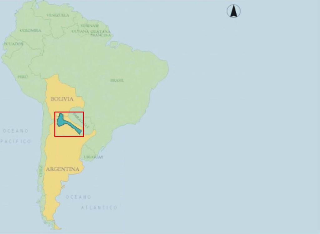
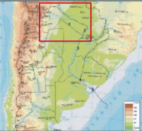
3 BINATIONAL BASIN OF THE BERMEJO RIVER Area: Total: Km2 In Bolivia: 10 % In Argentina: 90 % Length of the main course of the river: km Population: inhabitants
4 ENVIRONMENTAL PROBLEM IDENTIFIED IN THE TRANSBOUNDARY DIAGNOSTIC ANALYSIS Soil degradation, intense erosion and desertification processes, and water quality deterioration TRANSBOUNDARY MANIFESTATION Erosion and sediment transport and deposition, influencing fluviomorphological dynamics and with impact in the use of water resources, in the processes of formation of the Delta of the Paraná river and in the ship canals of the Plata river.
5 BERMEJO RIVER Sediment Discharge Upper Bermejo : 10 % (5.086 Km 2 ) Pescado River: 6 % (1.800 Km 2 ) BOLIVIA Grande de Tarija River: 15 % ( Km 2 ) Iruya River: 42 % (3.002 Km 2 ) Blanco River: 7 % (1.930 Km 2 ) ARGENTINA San Francisco River: 20 % ( Km 2 ) Bermejo River: t/year ( Km 2 ) (Approximately 80 % of sediments in the Paraná Plata system.) Sediment loading 8 kg/m3 20

6 AREAS WITH INTENSE EROSION PROCESSES Iruya River Basin, Argentina Km2; Deep, sedimentary soils, mostly silt- clay Central Valley, Tarija, Bolivia Fluviolacustrine flatland, 1600 square kilometers Deep, sedimentary soils, mostly silt- clay Huasamayo River Basin, Argentina 150 Km2, Fine soils, mostly clay.

.")
7 Central Valley, Tarija, Bolivia Erosion, in ditches (Bad Lands). Fluviolacustrine flatland


8 Erosion in Huasamayo river tributaries River beds filed up with sediment (Junction of Huasamayo and Grande rivers. Town of Tilcara)


9 FALL OF MUD IN THE RIVER MILMAHUASI IRUYA MUD FLOWING IN THE BED OF A TRIBUTARY OF THE RIVER COLANZULÍ
10 CAUSES OF THE ENVIROMENTAL PROBLEM Causes of Natural Origin Adverse natural conditions (soil, topography, geology, climate). PROBLEM SOIL DEGRADATION, EROSION, DESERTIFICATION, &WATER QUALITY DETERIORATION Basic Causes Deficient political, legal, and institutional framework. Deficient financial and support mechanisms. Causes of Human Origin Destruction of vegetative cover by deforestation and overgrazing. Elimination of natural vegetation for agricultural use.
11 LONG TERM MITIGATION STRATEGY INSTITUTIONAL DEVELOPMENT AND STRENGTHENING Institutional strengthening Development of an Environmental Information System for the Basin. Development of economic instruments and financial mechanisms. SUSTAINABLE DEVELOPMENT OF NATURAL RESOURCES PROBLEM SOIL DEGRADATION, EROSION AND DESERTIFICATION & WATER QUALITY DETERIORATION ENVIROMENTAL PROTECTION AND REHABILITATION Prevention and control of erosion and sedimentation Biodiversity protection. Strengthening and consolidation of the system of protected areas. PUBLIC AWARNESS AND PARTICIPATION Implementation of integrated management plans for the basin. Appropriate technologies, management practices and production methods. Sustainable water resources development and utilization projects. Research for natural resources development and management. Strengthening of public participation. Environmental education. Dissemination of sustainable technologies for production. Access to and public dissemination of information to support decision making
12 SHORT TERM STRATEGY Implementation of catalytic strategic projects Formulation of complementary studies Actions to catalyze long-term projects and programs


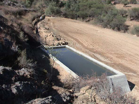
13 IMPLEMENTED CATALYTIC STRATEGIC PROJECTS LA TABLADA and MENA BASINS Small dams for sediment retention and consolidation of water beds with benefits to local communities


14 AGRO FORESTRY PRACTICES BENEFICIARIES PARTICIPATION IS ESSENTIAL FOR SUCCES RÍO MENA BASIN Contour borders Barriers with vegetation Fruit tree plantations Enclosures Forestry Plantations
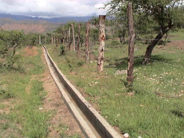
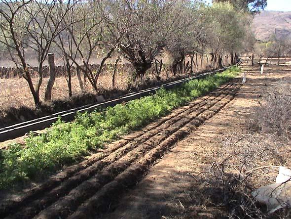
15 IRRIGATION CANNALS- RIVER MENA BASIN
16 SEDIMENT CONTROL CATALYTIC STRATEGIC PROJECT IN THE MENA RIVER BASIN Twelve dams for sediment retention, with m3 of total reservoir capacity with an useful life of 12 to 15 years. The cost of retained sediment is 0,8 $us/m3, lower than the of value of benefits (0,95 $us) of 1 m3 of reservoir of the project San Jacinto. The Project has a capacity of retention of sediments of m3/year; representing 5% of the sediments that enter to the reservoir of San Jacinto ( m3/year) These dams were complemented with small irrigation systems and agro forestry practices, designed and implemented with beneficiaries participation. These projects are transferred to beneficiaries for operation and maintenance.


17 Control works in the Huasamayo and Iruya rivers Defensive works at Iruya
18 Iruya and Huasamayo Catalytic Strategic Projects The initial objective of erosion mitigation was enlarged to incorporate local cultural particularities. In the Huasamayo river sub basin were incorporated: Risk reduction to people and its goods, Local population training, Territorial classification, and Promotion of sustainable development.
19 IRUYA RIVER MANAGEMENT CATALYTIC STRATEGIC PROJECT Control dams: 6 with m3. Defensive dams, 150 m in the Milmahuasi river Rainfall drainage canals in Iruya. Sediment retention of m3 was estimated, once the enlargements of dams are completed.
20 CATALYTIC STRATEGIC MANAGEMENT OF HUASAMAYO SUB-BASIN 64 small sediment retention and protection dams. Cleaning of river bed from Tilcara to the union with the río Grande Non structural messeaures: Nursery of native plants Training and environmental awareness. Environmental zoning and land use regulation.
21 LESSONS LEARNED It is fundamental that sediment control projects secure strong long-term local benefits, such as irrigation and water for human and animal consumption, to guaranty global impact and benefits at the Plata basin level. Protection enclosures and tree plantations, have good results when made in individual property. In communal lands it is difficult to guaranty sustainability. Small dams are an effective way to control sediment transport and to prolong useful life of down stream dams. Once filled up, the small reservoirs stabilize the river bed, diminish the collapse of its sides and provide stabilized areas with good soil for cultivation. These small reservoirs, should be located in basins that produce grater quantity of sediments per unit of area. Peasant's permanent orientation for the operation and maintenance of the projects, must be provided.
22 SELECTED PRACTICES FOR LONG-TERM SUSTAINABILITY Construction of small dams associated with irrigation and silvopastoril practices. Construction of contour borders for control of erosion ditches. Plantation of draw tolerant species. Enclosure of areas with depleted vegetation. Important public participation. Human resources qualification.
23 LOCAL BENEFITS Decrease of soil degradation and sediment production and transport. Increase of reservoirs useful life Safety improvement in river margins. Vegetation cover recuperation, water supply for human and animal consumption and irrigation. Protection of headwaters, water quality & quantity. Public participation increase. Increase environmental awareness and education.
24 GLOBAL BENEFITS AND ITS LINKAGE TO THE PLATA BASIN The Study of Sediments of the Bermejo Basin and their Impact in the Plata Basin made at request of the Inter-Governmental Committee of the Plata basin (CIC) will provide up to date information on the generation, transport and discharge of sediments, representing a real contribution from SAP Bermejo to the Plata basin. The above mentioned study will contribute to the knowledge base for the construction of the Cambarí dam in the Tarija River, which will be implemented by Argentina and Bolivia trough the Bermejo Bi National Commission and will retain an estimated 8 million tons per year of sediment representing around 6 % of the total annual sediments discharged in the Plata basin, according to current estimates. The retention of sediments will improve the functioning of the Plata basin, diminishing sediment deposits, the amount of drainage needed in the navigation canals of the Buenos Aires port (with an estimated total cost of 30 million dollars per year) and diminishing
25 GLOBAL BENEFITS AND ITS LINKAGE TO THE PLATA BASIN The implementation of a Hydro meteorological Network in the bi national basin that will include sediment monitoring is a contribution to the permanent up dating and analysis of the transport of sediments in the Plata basin. Generation of information useful for replication at the Plata Basin level and other basins (pilot project results, thematic charts, water course classification, carbon sequestration, biodiversity studies, and others) The sediment control demonstrative projects implemented in the two countries could be replicated in larger scales in the Bermejo, the Plata and other basins with similar conditions. A replication example of the demonstrative projects of the basins of Tablada (13 km2) and Mena (65 km2) is the Study for the Control of Sediments in the Tolomosa basin (432 km2) currently under way. Availability of projects for replication in La Plata river basin and other basins whose lessons learned and selected practices are already been used in the design of a Master Plan for the development of the Pilcomayo basin shared by Argentina, Bolivia and Paraguay.
26 GLOBAL BENEFITS AND ITS LINKAGE TO THE PLATA BASIN The consolidation of protected areas (Sama, Tariquía, Baritú Calilegua), the implementation of an environmental corridor among the last three, and a biosphere reservation, will diminish the degradation of soils and production of sediment and contribute to the maintenance of the headwaters in the upper Plata basin & protect biodiversity in the Yungas ecosystem. The establishment and functioning of a Regional Coordinating Committee with representatives of provincial administrations of Argentina and the Prefecture and Municipalities of Tarija; and the Regional Advisory Committee, with representatives of NGOs, academic institutions, scientific and technical organizations, the private sector, citizens and corporations, builds confidence among stakeholders and countries and allow scaling up to the Plata basin.
27 GLOBAL BENEFITS AND ITS LINKAGE TO THE PLATA BASIN Incorporation of SAP Bermejo projects in the planning of regional institutions and establishment of agreements with public and academic institutions. The methodological focuses, outputs, learned lessons, arisen recommendations and experiences of the Bermejo basin have been presented in the preparatory meetings of the Inter- Governmental Committee of the Plata basin (CIC) for the preparation of the Frame Program of the Plata basin, and they have served as basis for their formulation. The signing of a Collaboration Agreement between the Bermejo Binational Commission and the Committee of the Plata basin (CIC), with specific reference to de SAP Bermejo, establishes a permanent coordination and collaboration among the SAP Bermejo and the Plata Basin.
28 COMPREHENSIVE STRATEGY In addition to the catalytic strategic projects explained, others, for which there is no time to inform, have been implemented in different areas such as: Institutional Strengthening Public awareness and participation Environmental education. Strengthening of national parks and establishment of corridors between them. Carbon sequestration. Biodiversity protection and conservation. Information about these projects is shown in the PEA Bermejo stand.
Sedimentation in the Nile River
 Advanced Training Workshop on Reservoir Sedimentation Sedimentation in the Nile River Prof. Dr. Abdalla Abdelsalam Ahmed 10-16 Oct. 2007, IRTCES, Beijing, China CWR,Sudan 1 Water is essential for mankind
16540/14 EE/cm 1 DG E 1A
 Council of the European Union Brussels, 5 December 2014 (OR. en) 16540/14 ENV 965 CULT 139 NOTE From: To: Subject: General Secretariat of the Council Delegations Charter of Rome on Natural and Cultural
THE SEVILLE STRATEGY ON BIOSPHERE RESERVES
 THE SEVILLE STRATEGY ON BIOSPHERE RESERVES 1 VISION FOR BIOSPHERE RESERVES IN THE 21 ST CENTURY The international Seville Conference on Biosphere Reserves, organised by UNESCO, adopted a two-pronged approach,
RANGE AND ANIMAL SCIENCES AND RESOURCES MANAGEMENT - Vol. II - Catchment Management A Framework for Managing Rangelands - Hugh Milner
 CATCHMENT MANAGEMENT A FRAMEWORK FOR MANAGING RANGELANDS Hugh Milner International Water Management Consultant, Australia Keywords: Rangeland management; catchments and watersheds; catchment management
National Hydrology committee of Afghanistan (NHCA) Sedimentation in Reservoire
 Sedimentation in Reservoire") National Hydrology committee of Afghanistan (NHCA) Sedimentation in Reservoire OCt.2007 Prof. Mohammad Qasem Seddeqy KPU بسم االله الرحمن الرحيم وجعلنامن الماءکل شي ء حی 30 واز ا ب هر چيزی رازنده گردانيدیم
National Hydrology committee of Afghanistan (NHCA) Sedimentation in Reservoire OCt.2007 Prof. Mohammad Qasem Seddeqy KPU بسم االله الرحمن الرحيم وجعلنامن الماءکل شي ء حی 30 واز ا ب هر چيزی رازنده گردانيدیم
2018 Geography Mock Examination
 2018 Geography Mock Examination Your Geography mock examination will test your understanding of Paper 1 (Living with the physical environment) and Section B (Fieldwork) from Paper 2. Attached are the necessary
EUSAIR on sea topics from Slovenian perspective
 MINISTRY OF FOREIGN AFFAIRS REPUBLIC OF SLOVENIA EUSAIR on sea topics from Slovenian perspective Mag. Andreja Jerina National Coordinator 4 EU MRS: 270 millions of population 19 MS 12 non MS Sea basin
Building the Climate Change Resilience in the Lake Kivu and Rusizi River Catchments: CRAGs II project
 Building the Climate Change Resilience in the Lake Kivu and Rusizi River Catchments: CRAGs II project Project countries: Rwanda and Burundi Project Area: Sebeya and Ruhwa River Systems (Rwanda), Muhira
CONFERENCE STATEMENT
 CONFERENCE STATEMENT We, the elected representatives from Canada, Denmark/Greenland, Finland, Iceland, Norway, Russia, Sweden and the United States of America; In collaboration with the indigenous peoples
Strengthening the cooperation in the region: Carpathian, Tisa,, Danube and Black Sea areas
 Strengthening the cooperation in the region: Carpathian, Tisa,, Danube and Black Sea areas 14th October 2009 SEE Annual Conference Advancing development through transnational cooperation in South East
RETA 6422: Mainstreaming Environment for Poverty Reduction Category 2 Subproject
 RETA 6422: Mainstreaming Environment for Poverty Reduction Category 2 Subproject A. Basic Data 1. Subproject Title: Poverty-Environment Mapping to Support Decision Making 2. Country Director: Adrian Ruthenberg
THE SEVILLE STRATEGY FOR BIOSPHERE RESERVES BIOSPHERE RESERVES: THE FIRST TWENTY YEARS
 THE SEVILLE STRATEGY FOR BIOSPHERE RESERVES BIOSPHERE RESERVES: THE FIRST TWENTY YEARS Biosphere reserves are designed to deal with one of the most important questions the World faces today: How can we
Summary. Recommendations on the Fifth Policy Document on Spatial Planning September 2001
 Summary Recommendations on the Fifth Policy Document on Spatial Planning September 2001 2 Introduction In December 2000 the Dutch Cabinet issued Part 1 of the Fifth National Policy Document on Spatial
The international patterns of spatial planning system and choice of China. Cai yumei China land use planning and surveying institute (China, beijing)
") FIG Working Week, Rome, Italy 6 10 May 2012 The international patterns of spatial system and choice of China Cai yumei China land use and surveying institute (China, beijing) Outline Background Problem
FIG Working Week, Rome, Italy 6 10 May 2012 The international patterns of spatial system and choice of China Cai yumei China land use and surveying institute (China, beijing) Outline Background Problem
SDI Development in Georgia. Mari Khardziani Head of International Relations Unit National Agency of Public Registry
 SDI Development in Georgia Mari Khardziani Head of International Relations Unit National Agency of Public Registry Kehl, Germany September 5, 2017 2 National Agency of Public Registry Legal Entity of Public
Chapter 14 The technical role of government authorities in watershed management
 Chapter 14 The technical role of government authorities in watershed management 14.1 Objectives and procedural outline 1) Purpose of this chapter as related to participatory watershed management The participatory
ACTION PLAN FOR WORLD HERITAGE IN LATIN AMERICA AND THE CARIBBEAN ( )
") Annex ACTION PLAN FOR WORLD HERITAGE IN LATIN AMERICA AND THE CARIBBEAN (2014-2024) The current Regional Action Plan for Latin America and the Caribbean for 2014-2024 has been elaborated by the State Parties
Annex ACTION PLAN FOR WORLD HERITAGE IN LATIN AMERICA AND THE CARIBBEAN (2014-2024) The current Regional Action Plan for Latin America and the Caribbean for 2014-2024 has been elaborated by the State Parties
National Perspectives - Portugal. Margarida Almodovar
 National Perspectives - Portugal Margarida Almodovar margarida.almodovar@mam.gov.pt from base line to the external limit of the continental shelf behind 200 miles and according to UNCLOS definitions Economic
Measurement of the Urban-Housing Deficit:
 Measurement of the Urban-Housing Deficit: Strategies, tools and sources of information The International Network for Urban and Regional Statistics Standing Committee of the International Association for
Urbanization and Sustainable Development of Cities: A Ready Engine to Promote Economic Growth and Cooperation
 Urbanization and Sustainable Development of Cities: A Ready Engine to Promote Economic Growth and Cooperation Wan Portia Hamzah Institute of Strategic and International Studies (ISIS) Malaysia 10 September
ACTION PLAN FOR WORLD HERITAGE IN LATIN AMERICA AND THE CARIBBEAN
 Final version-to send to the ACTION PLAN FOR WORLD HERITAGE IN LATIN AMERICA AND THE CARIBBEAN 2014-2024 The current Regional Action Plan for Latin America and the Caribbean has been elaborated by the
Application of SWAT Model to Estimate the Runoff and Sediment Load from the Right Bank Valleys of Mosul Dam Reservoir
 Application of SWAT Model to Estimate the Runoff and Sediment Load from the Right Bank Valleys of Mosul Dam Reservoir Dr Mohammad Ezeel Deen Prof. Nadhir Al-Ansari Prof Sven Knutsson Figure 1.Map of Iraq
Realizing benefits of Spatial Data Infrastructure A user s perspective from Environment Agency - Abu Dhabi
 Realizing benefits of Spatial Data Infrastructure A user s perspective from Environment Agency - Abu Dhabi Anil Kumar Director, Environment Information Management 26 April 2012 Geospatial World Forum,
Jordan's Strategic Research Agenda in cultural heritage
 Jordan's Strategic Research Agenda in cultural heritage Analysis of main results Alessandra Gandini Amman, Jordan 3 rd November 2013 Main objectives The work performed had the main objective of giving
IMA s ROLE IN COASTAL AND OCEAN GOVERNANCE IN TRINIDAD AND TOBAGO
 IMA s ROLE IN COASTAL AND OCEAN GOVERNANCE IN TRINIDAD AND TOBAGO Presented by Rahanna Juman, Deputy Director (Ag.) About the Institute of Marine Affairs Institute of Marine Affairs (IMA) was established,
STUDY GUIDE FOR CONTENT MASTERY. Surface Water Movement
 Surface Water SECTION 9.1 Surface Water Movement In your textbook, read about surface water and the way in which it moves sediment. Complete each statement. 1. An excessive amount of water flowing downslope
Integrated approaches to the implementation of the Convention on Biological Diversity
 Integrated approaches to the implementation of the Convention on Biological Diversity Actions on ABS in the context of UNESCO Biosphere Reserves Vibeke Jensen, Director UNESCO Liaison Office in New York
The Contested Cultural Landscape of a Lebanese Border Town: MARJA AYOUN
 The Contested Cultural Landscape of a Lebanese Border Town: MARJA AYOUN IBD 2013 FNAS MAY 2013 Dr. Christine Mady, City & Regional Planning NDU -FAAD In this Presentation A PLANNING PERSPECTIVE INTRODUCING
CONFERENCE STATEMENT
 Final draft CONFERENCE STATEMENT We, the elected representatives of Canada, Denmark/Greenland, the European Parliament, Finland, Iceland, Norway, Russia, Sweden and the United States of America; In collaboration
Chapter 32. Australia & New Zealand
 Chapter 32 Australia & New Zealand Lesson 1: Physical Geography of Australia & New Zealand Landforms Australia lies between the Pacific and Indian Oceans in the Southern Hemisphere. Although an island,
Flash flood disaster in Bayangol district, Ulaanbaatar
 Flash flood disaster in Bayangol district, Ulaanbaatar Advanced Training Workshop on Reservoir Sedimentation Management 10-16 October 2007. IRTCES, Beijing China Janchivdorj.L, Institute of Geoecology,MAS
Subcommittee on Sedimentation Draft Sediment Analysis Guidelines for Dam Removal
 Subcommittee on Sedimentation Draft Sediment Analysis Guidelines for Dam Removal August 4, 2011 Jennifer Bountry, M.S., P.E. Tim Randle, M.S., P.E., D.WRE. Blair Greimann, Ph.D., P.E. Sedimentation and
Geospatial Enabling Resilient Development. Latin America Geospatial Forum Río de Janeiro September 2013
 Geospatial Enabling Resilient Development Latin America Geospatial Forum Río de Janeiro September 2013 Presentation Index INEGI /SNIEG Geostatistical Frame - Georeferenciation Issues Legal Framework Mexican
T he O utlet: Almirante
 T he O utlet: Almirante For me, the sea is life. This understanding also holds true with our rivers. Each are alive, and carry life with them as they reach the sea. Our rivers, are born up high in the
Suspended sediment yields of rivers in Turkey
 Erosion and Sediment Yield: Global and Regional Perspectives (Proceedings of the Exeter Symposium, July 1996). IAHS Publ. no. 236, 1996. 65 Suspended sediment yields of rivers in Turkey FAZLI OZTURK Department
Cities and Climate Change (P123201)
") Public Disclosure Authorized AFRICA Mozambique Social, Urban, Rural and Resilience Global Practice Global Practice IBRD/IDA Investment Project Financing FY 2012 Seq No: 14 ARCHIVED on 04-Nov-2018 ISR33750
Public Disclosure Authorized AFRICA Mozambique Social, Urban, Rural and Resilience Global Practice Global Practice IBRD/IDA Investment Project Financing FY 2012 Seq No: 14 ARCHIVED on 04-Nov-2018 ISR33750
By Lillian Ntshwarisang Department of Meteorological Services Phone:
 By Lillian Ntshwarisang Department of Meteorological Services Phone: +267 3612200 Email: lntshwarisang@gov.bw/ lntshwarisang@gmail.com Introduction Mandate of DMS Function of the Department Services to
ICZM and MSP in the Black Sea Region
 ICZM and MSP in the Black Sea Region Drd. Claudia Coman, Environmental engineer AG ICZM Focal Point, Romania Black Sea Commission Black Sea Commission on the Protection of the Black Sea against Pollution
Chapter 32. Australia & New Zealand
 Chapter 32 Australia & New Zealand Lesson 1: Physical Geography of Australia & New Zealand Landforms Australia lies between the Pacific and Indian Oceans in the Southern Hemisphere. Although an island,
THE SEVILLE STRATEGY FOR BIOSPHERE RESERVES
 THE SEVILLE STRATEGY FOR BIOSPHERE RESERVES BIOSPHERE RESERVES: THE FIRST TWENTY YEARS Biosphere reserves are designed to deal with one of the most important questions the World faces today: How can we
Public Disclosure Copy. Implementation Status & Results Report Ghana FIP - Enhancing Natural Forest and Agroforest Landscapes Project (P148183)
") Public Disclosure Authorized AFRICA Ghana Environment & Natural Resources Global Practice Recipient Executed Activities Investment Project Financing FY 2015 Seq No: 6 ARCHIVED on 19-Dec-2017 ISR30434 Implementing
Public Disclosure Authorized AFRICA Ghana Environment & Natural Resources Global Practice Recipient Executed Activities Investment Project Financing FY 2015 Seq No: 6 ARCHIVED on 19-Dec-2017 ISR30434 Implementing
Mekong Sediment from the Mekong River Commission Study
 Short Technical Note Mekong Sediment from the Mekong River Commission Study Summary The Mekong River flows through China, Myanmar, Lao PDR, Thailand, Cambodia and Viet Nam. The assessment of various water
COSTA RICA Limon City-Port Project
 photos by Stefania Abakerli COSTA RICA Limon City-Port Project 2008 2013 Cecilia Corvalan William Reuben Stefania Abakerli Background Request from GoCR following Caldera-Port Concession Reform Since the
INDONESIA S S UPDATE: GEOSPATIAL INFORMATION FOR SUSTAINABLE DEVELOPMENT RELATED TO INA SDI Dr. Asep Karsidi, M.Sc
 INDONESIA S S UPDATE: GEOSPATIAL INFORMATION FOR SUSTAINABLE DEVELOPMENT RELATED TO INA SDI Dr. Asep Karsidi, M.Sc GEOSPATIAL INFORMATION AGENCY 08 August, 2012 OUTLINE 1. Transformation Bakosurtanal into
Influence of the Major Drainages to the Mississippi River and Implications for System Level Management
 Influence of the Major Drainages to the Mississippi River and Implications for System Level Management Brian M. Vosburg Geologist Louisiana Coastal Protection and Restoration Authority brian.vosburg@la.gov
Other effective area based conservation. The case of Colombia
 Other effective area based conservation measures (OECM): The case of Colombia Working group on Complementary Conservation Strategies Clara L. Matallana Humboldt Institute How is Colombia regarding Aichi
Term Knowledge Using and applying Grade Criteria Autumn 1 Assessment window October Natural hazards pose major risks to people and property.
 Assessment Schedule Year 9 2015/6 Term Knowledge Using and applying Grade Criteria Autumn 1 Assessment window October 2015 3.1.1.2 Tectonic Natural hazards pose major risks to people and property. Definition
The World Bank Cities and Climate Change (P123201)
") Public Disclosure Authorized AFRICA Mozambique Social, Urban, Rural and Resilience Global Practice Global Practice IBRD/IDA Investment Project Financing FY 2012 Seq No: 13 ARCHIVED on 17-May-2018 ISR31517
Public Disclosure Authorized AFRICA Mozambique Social, Urban, Rural and Resilience Global Practice Global Practice IBRD/IDA Investment Project Financing FY 2012 Seq No: 13 ARCHIVED on 17-May-2018 ISR31517
The inland water related tourism in South Africa by 2030 in the light of global change
 The inland water related tourism in South Africa by 2030 in the light of global change KSA 2 Water-Linked Ecosystems T4: Green economy and sustainable (green) innovations K5/2620 How can natural capital
KENYA NATIONAL BUREAU OF STATISTICS Workshop on
 KENYA NATIONAL BUREAU OF STATISTICS Workshop on Capacity Building in Environment Statistics: the Framework for the Development of Environment Statistics (FDES 2013) Coordination with Sector Ministries
Address NATIONAL PLANNING DEPARTMENT-FUNDACION PRO SIERRA NEVADA
 Public Disclosure Authorized Project Name Region Sector Project ID Report No. PID8895 Colombia-Sierra Nevada Sustainable (@) Development Latin America and Caribbean Region Other Agriculture; Natural Resources
Figure 1. Which part of the river is labelled in Figure 1? a) Mouth b) Source c) Lower course d) channel
 Mouth b) Source c) Lower course d) channel") Rivers 1. Study Figure 1 showing the long profile of a river Figure 1 A Which part of the river is labelled in Figure 1? a) Mouth b) Source c) Lower course d) channel (1 mark) 2. Complete the sentences
Rivers 1. Study Figure 1 showing the long profile of a river Figure 1 A Which part of the river is labelled in Figure 1? a) Mouth b) Source c) Lower course d) channel (1 mark) 2. Complete the sentences
What is Spatial Planning?
 Spatial Planning in the context of the Responsible Governance of Tenure What is Spatial Planning? Text-only version This course is funded by the European Union through the EU-FAO Improved Global Governance
International Guidelines on Access to Basic Services for All
 International Guidelines on Access to Basic Services for All Presentation and initials lessons from implementation Accessibility to services in regions and cities : measures and policies, OECD 18 June
Sediment management in the Danube River Basin. Igor Liška ICPDR
 Sediment management in the Danube River Basin Igor Liška ICPDR Danube River Protection Convention 29 June 1994, Sofia (Bulgaria) Protection of water & ecological resources Sustainable use of water Reduce
Carpathians Unite mechanism of consultation and cooperation for implementation of the Carpathian Convention
 Carpathians Unite mechanism of consultation and cooperation for implementation of the Carpathian Convention Zbigniew Niewiadomski, UNEP/GRID-Warsaw Centre First Joint Meeting of the Carpathian Convention
SDI in Lombardia (Italy(
 SDI in Lombardia (Italy( Italy) Andrea Piccin European SDI Best Practice Awards 2009 - Learning from Best Practices Turin, 26th and 27th November 2009 Lombardia, in Italy, is 4 th Region for territorial
SEEA Experimental Ecosystem Accounting
 SEEA Experimental Ecosystem Accounting Sokol Vako United Nations Statistics Division Training for the worldwide implementation of the System of Environmental Economic Accounting 2012 - Central Framework
Surface Processes Focus on Mass Wasting (Chapter 10)
") Surface Processes Focus on Mass Wasting (Chapter 10) 1. What is the distinction between weathering, mass wasting, and erosion? 2. What is the controlling force in mass wasting? What force provides resistance?
Surface Processes Focus on Mass Wasting (Chapter 10) 1. What is the distinction between weathering, mass wasting, and erosion? 2. What is the controlling force in mass wasting? What force provides resistance?
Progress Report. Flood Hazard Mapping in Thailand
 Progress Report Flood Hazard Mapping in Thailand Prepared By: Mr. PAITOON NAKTAE Chief of Safety Standard sub-beuro Disaster Prevention beuro Department of Disaster Prevention and Mitigation THAILAND E-mail:
Mediteranean sea issues in the view of ESPON ESaTDOR project and Marine Spatial Planning in Slovenia
 DIREKTORAT ZA PROSTOR, GRADITEV IN STANOVANJA Mediteranean sea issues in the view of ESPON ESaTDOR project and Marine Spatial Planning in Slovenia BlueMed meeting of stakeholders on a micro-regional level
Spatially enabling e-government through geo-services
 Spatially enabling e-government through geo-services Mauro Salvemini EUROGI PRESIDENT Professor at Sapienza Università di Roma (IT) 1 About the presentation Few information about Eurogi ; Some essential
Scenario development for reaching urban and environmental planning integration in the context of climate change*.
 Scenario development for reaching urban and environmental planning integration in the context of climate change*. PhD (cand) Verónica Zagare (TUDelft, ) Dr. Diego Sepúlveda Carmona (TUDelft) September
 Red River Flooding June 2015 Caddo and Bossier Parishes Presented by: Flood Technical Committee Where the Rain Falls Matters I-30 versus I-20 I-20 Backwater and Tributary Floods (Localized) 2016 Flood
SPLAN-Natura Towards an integrated spatial planning approach for Natura th January, 2017 Brussels. Commissioned by DG Environment
 SPLAN-Natura 2000 Towards an integrated spatial planning approach for Natura 2000 Commissioned by DG Environment 17 th January, 2017 Brussels V. Simeonova (Ph.D.) Drivers towards integrating Biodiversity
Tarbela Dam in Pakistan. Case study of reservoir sedimentation
 Tarbela Dam in Pakistan. HR Wallingford, Wallingford, UK Published in the proceedings of River Flow 2012, 5-7 September 2012 Abstract Reservoir sedimentation is a main concern in the Tarbela reservoir
Biodiversity Blueprint Overview
 Biodiversity Blueprint Overview Climate Variability Climate projections for the Glenelg Hopkins Regions suggest that the weather will be hotter and drier in the coming years which will impact on land use,
Navigable maritime and river waterways in the seaside - Danube Delta area and the connected rural development
 SUMMARY OF Ph-D Thesis, with title RESEARCH STUDIES ON MANAGEMENT IMPROVEMENT OF MARITIME AND RIVER TRANSPORT ACTIVITY IN THE COASTAL AND DANUBE DELTA AREA FROM AN ENVIROMENTAL, ECONOMIC AND SOCIAL PERSPECTIVE
INSPIRATION results and benefits for the Agency for Real Estate Cadastre
 JOINT RESEARCH CENTER - E&I WORKSHOP INSPIRATION results and benefits for the Agency for Real Estate Cadastre Sonja Dimova, state advisor AGENCY FOR REAL ESTATE CADASTRE REPUBLIC OF MACEDONIA Wednesday,
Pirai river (Bolivia)
") Pirai river (Bolivia) Confluent of the Amazon river which average discharge is only 6 m3/s, but with peak discharge over 5000 m3/s, a challenge for river basin management and for flood control HYDROEUROPE
Pirai river (Bolivia) Confluent of the Amazon river which average discharge is only 6 m3/s, but with peak discharge over 5000 m3/s, a challenge for river basin management and for flood control HYDROEUROPE
Statutory framework of the world network of biosphere reserves UNESCO General Conference 1996
 Statutory framework of the world network of biosphere reserves UNESCO General Conference 1996 Keywords: conservation, protected areas, biosphere reserves, policies, strategies. For the Mountain Forum's
How Do Human Impacts and Geomorphological Responses Vary with Spatial Scale in the Streams and Rivers of the Illinois Basin?
 How Do Human Impacts and Geomorphological Responses Vary with Spatial Scale in the Streams and Rivers of the Illinois Basin? Bruce Rhoads Department of Geography University of Illinois at Urbana-Champaign
United States Multi-Hazard Early Warning System
 United States Multi-Hazard Early Warning System Saving Lives Through Partnership Lynn Maximuk National Weather Service Director, Central Region Kansas City, Missouri America s s Weather Enterprise: Protecting
The UN-GGIM: Europe core data initiative to encourage Geographic information supporting Sustainable Development Goals Dominique Laurent, France
 INSPIRE conference Strasbourg 6 September 2017 The UN-GGIM: Europe core data initiative to encourage Geographic information supporting Sustainable Development Goals Dominique Laurent, France Introduction
The Governance of Land Use
 The planning system Levels of government and their responsibilities The Governance of Land Use COUNTRY FACT SHEET NORWAY Norway is a unitary state with three levels of government; the national level, 19
WORLD DAY TO COMBAT DESERTIFICATION 2018 IN MONGOLIA
 WORLD DAY TO COMBAT DESERTIFICATION 2018 IN MONGOLIA This year the WDCD slogan was Land has true value. Invest in it to address the importance of sustainable land use, land degradation prevention and its
Prepared by: Precious Annie Lopez & Nolwenn Boucher
 Recognizing the ancestral land and biodiversity conservation efforts of indigenous people in Quinchao municipality using GIS- and participatory 3Dmapping tool Prepared by: Precious Annie Lopez & Nolwenn
Louis-François Guerre, Planet Action Coordinator Copenhagen, December Spot Image 2007
 Louis-François Guerre, Planet Action Coordinator Copenhagen, December 2009 1 Spot Image 2007 Spot Image, Earth Observation and geo-information services Satellite operator, imagery distributor SPOT4 SPOT5
PAN AMERICAN INSTITUTE OF GEOGRAPHY AND HISTORY Specialized Organization of the OAS
 PAN AMERICAN INSTITUTE OF GEOGRAPHY AND HISTORY Specialized Organization of the OAS 10 th UNRCC Americas United Nations, New York, 20 August 2013 PAIGH, SIRGAS, PC-IDEA and GeoSUR 2013-2015 Joint Action
APPROACH TO THE SPANISH WATER ORGANISATION IMPROVING FLOOD HAZARD MAPPING, LAWS AND AUTHORITIES COORDINATION
 "Workshop On Land Use Planning And Water Management, With Focus On Flood Risk Management Oslo, Norway. Wednesday 31 January and Thursday 1 February 2007 APPROACH TO THE SPANISH WATER ORGANISATION IMPROVING
Livingston American School 4 th Quarter Curriculum Map
 Livingston American School 4 th Quarter Curriculum Map Week 1 Week 2 Week 3 Week 4 Concept / Topic To Teach: 1) India 1) Population Explosion 1) Territorial dispute 1) East Asia 2) Pakistan and Bangladesh
2018/1 The integration of statistical and geospatial information. The Regional Committee of UN-GGIM: Americas:
 The following are the conclusions and recommendations of the Regional Committee of the United Nations on Global Geospatial Information Management for the Americas, during its Fifth Session, Thursday 8
Science EOG Review: Landforms
 Mathematician Science EOG Review: Landforms Vocabulary Definition Term canyon deep, large, V- shaped valley formed by a river over millions of years of erosion; sometimes called gorges (example: Linville
Management of Sediment Quality and Quantity in the Danube River Basin
 Management of Sediment Quality and Quantity in the Danube River Basin 5 th SedNet Conference 27-29 May 2008 Oslo (N) Igor Liska ICPDR igor.liska@unvienna.org CONTENT ICPDR & EU WFD implementation Sediment
The World Bank Integrated Disaster and Land Management Project (P123922)
") Public Disclosure Authorized Public Disclosure Copy AFRICA Togo Environment & Natural Resources Global Practice Recipient Executed Activities Specific Investment Loan FY 2012 Seq No: 10 ARCHIVED on 28-Jun-2017
Public Disclosure Authorized Public Disclosure Copy AFRICA Togo Environment & Natural Resources Global Practice Recipient Executed Activities Specific Investment Loan FY 2012 Seq No: 10 ARCHIVED on 28-Jun-2017
Morphological Changes of Reach Two of the Nile River
 ICHE 2014, Hamburg - Lehfeldt & Kopmann (eds) - 2014 Bundesanstalt für Wasserbau ISBN 978-3-939230-32-8 Morphological Changes of Reach Two of the Nile River E. Said Egyptian Environmental Affairs Agency,
The Infrastructure for Spatial Information in the European Community vs. regional SDI: the shortest way for reaching economic and social development
 The Infrastructure for Spatial Information in the European Community vs. regional SDI: the shortest way for reaching economic and social development Mauro Salvemini EUROGI PRESIDENT Professor at Sapienza
Land Use in the context of sustainable, smart and inclusive growth
 Land Use in the context of sustainable, smart and inclusive growth François Salgé Ministry of sustainable development France facilitator EUROGI vice president AFIGéO board member 1 Introduction e-content+
Improvement of navigation conditions on the Danube (Calarasi-Braila and Lower Danube) - Ecological concerns?
 - Ecological concerns?") Improvement of navigation conditions on the Danube (Calarasi-Braila and Lower Danube) - Ecological concerns? Georg Rast, Christine Bratrich, Orieta Hulea WWF Germany/DCPO Topics of the presentation Major
Improvement of navigation conditions on the Danube (Calarasi-Braila and Lower Danube) - Ecological concerns? Georg Rast, Christine Bratrich, Orieta Hulea WWF Germany/DCPO Topics of the presentation Major
CLLD Cooperation OFFER
 Title of the proposed project (English) CLLD Cooperation OFFER PARKS PROTECTION III - Management, Protection and Economic Development in Protected Areas Type of project (select as many as you want) Cooperation
PACIFIC ISLANDS REGIONAL OCEAN POLICY. A healthy Ocean that sustains the livelihoods and aspirations of Pacific Island communities.
 PACIFIC ISLANDS REGIONAL OCEAN POLICY VISION A healthy Ocean that sustains the livelihoods and aspirations of Pacific Island communities. THIS IS OUR OCEAN 1. The care of the ocean is the responsibility
Watershed Classification with GIS as an Instrument of Conflict Management in Tropical Highlands of the Lower Mekong Basin
 Page 1 of 8 Watershed Classification with GIS as an Instrument of Conflict Management in Tropical Highlands of the Lower Mekong Basin Project Abstract The University of Giessen is actually planning a research
Mapping and Assessment of Ecosystems and their Services
 Mapping and Assessment of Ecosystems and their Services ALTER-Net Conference 2013: Science underpinning the EU 2020 Biodiversity Strategy. April 2013 Gent Joachim MAES 1 This presentation is based on the
COSTA RICA Limon City-Port Project
 COSTA RICA Limon City-Port Project 2008 2013 photos by Stefania Abakerli Stefania Abakerli Cecilia Corvalan Context Costa Rica Well-known tourist destination in CA (8.4% GDP) Long tradition of political
Possibilities for applying ES assessment results in spatial planning in Latvia
 Possibilities for applying ES assessment results in spatial planning in Latvia Inga Hoņavko LIFE EcosystemServices project manager LIFE Viva Grass seminar, Sigulda, 17.05.2018 Projekts LIFE EcosystemServices,
Land Accounts - The Canadian Experience
 Land Accounts - The Canadian Experience Development of a Geospatial database to measure the effect of human activity on the environment Who is doing Land Accounts Statistics Canada (national) Component
Atlas on spatial structures and processes in the Alps
 Atlas on spatial structures and processes in the Alps Third project meeting in Grenoble on 25 th -27 th of January 2007 Content Overall goals / Addressed persons Basic conditions (financial and time conditions,
Integrated Strategies in regional development
 Inspire policy making by territorial evidence ESPON Seminar Territories Acting for Economic Growth: Using territorial evidence to meet challenges towards 2020 Integrated Strategies in regional development
ENVIRONMENTAL CONSIDERATIONS IN CLUP
 ENVIRONMENTAL CONSIDERATIONS IN CLUP Ricardo M. Sandalo Assistant Professor DCERP, College of Human Ecology University of the Philippines Los Baños April 9-10, 2016 CHE Multi Purpose Hall 1 Twin Objectives
and the Myanmar economy World Water Day, 2018
 and the Myanmar economy World Water Day, 2018 Hannah.baleta@panda.org Three key messages Myanmar is growing economically and developing socially with a large dependency on natural resources such as the