The Subsurface Soil Effects Study Using the Short and Long Predominant Periods From H/V Spectrum In Yogyakarta City
|
|
|
- Bethany Hood
- 5 years ago
- Views:
Transcription
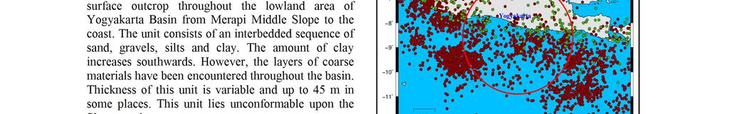
1 Paper ID 90 The Subsurface Soil Effects Study Using the Short and Long Predominant Periods From H/V Spectrum In Yogyakarta City Z.L. Kyaw 1,2*, S. Pramumijoyo 2, S. Husein 2, T.F. Fathani 3, J. Kiyono 4 and R.R. Putra 5 1,2 Geology Department, Yangon University, Myanmar 2 Geological Engineering Department, Gadjah Mada University, Indonesia 3 Civil and Environmental Engineering Department, Gadjah Mada University, Indonesia 4,5 Department of Urban Management, Kyoto University, Japan *Corresponding zlkyaw.geol@gmail.com ABSTRACT Yogyakarta has been seriously damaged by Yogyakarta earthquake which was an Mw 6.3 event. The single observations of microtremors were densely performed at 274 sites. The predominant periods due to horizontal-vertical ratio are in the range of 0.15 to 4.00 sec. The distribution of the short and long predominant periods which reflect the information of relatively shallow and deep sedimentary structure as well as the sediment thickness. We investigated relationship between the shape of H/V spectrum for microtremor and underground structure. In the results of this study, it obviously noted that the characteristics of microtremor are dependent on the type of soil deposits. KEY WORDS: Shallow and deep soil structure; H/V spectral ratio; Microtremor observations; Boreholes; Yogyakarta City 1. INTRODUCTION The Yogyakarta city, the capital of Yogyakarta Special Province, is situated at the southern part of the volcanic arc island of Java. The eastern part of Yogyakarta city is located in the so-called Yogyakarta Depression area, which is only about 30 km from the Merapi volcano which reaches the elevation of 2911 m above sea level; it is the most active volcano in Indonesia, and about 40 km from the coast of the Indian Ocean. The eastern part of Yogyakarta City is situated at the center of the province, in the middle part of Yogyakarta basin. An earthquake with the magnitude M w 6.3 occurred near the city of Yogyakarta, on May 27 th, 2006 at 5:54 am local time. The earthquake directly affected the provinces of Yogyakarta and Central Java Island. This earthquake caused nearly 6,500 casualties and above 36,000 injured. More than 135,000 houses were damaged, and 600,000 people were homeless. The prediction and mitigation of the damage due to natural disasters especially seismic shaking are the urgent demand of human being society. When looking into the damage, we often notice that the conditions of the landform and the soil are strongly associated with it. The Basin response depends on the site geometry, impedance contrast, soil properties and constitutive model, and on the complexity and strength of the input solicitation. This fact indicates that it is essential to know the shallow and deep soil structures when considering the natural disaster mitigation as well as planning to construct any facilities. The shallow and deep soil structures of the site represent the local site condition and can help to estimate the site response. They are the key factors in assessing seismic hazard and understanding ground motion characteristics. The subsurface geology and soil properties have significant influences on the intensity of earthquake ground motion. Understanding site conditions are of great importance in site effect evaluation. 2. GEOLOGICAL SETTING The geology of the around of Yogyakarta City is controlled by active plate tectonic phenomena such as the active volcano and active subduction of Indian-Australia oceanic plate below the Eurasia continental plate. To the west, highly faulted the dome of andesitic breccia and lava flows occurred. Meanwhile at the eastern part of the Yogyakarta City, steep mountains of carbonaceous-volcanic rocks as well as limestone with karst landscape are exposed. The major structure is the north-eastern trending normal fault, well-known Opak fault and defines the eastern limit of a trough extending from Yogyakarta to the coast. There are two kinds of Successions around the research area which are the Yogyakarta Tertiary and the Quaternary Successions. The Yogyakarta Tertiary Succession is included Old Andesite Formation, Jonggrangan Formation, Kebo-Butak Formation, Semilir Formaiton, Nglanggran Formation, Sambipitu Formation, Sentolo Formation Wonosari Formation and Kepek Formation. Meanwhile, the Quaternary Geology, Geophysics and Geotechnique 26


2 Geology, Geophysics and Geotechnique 27


3 Geology, Geophysics and Geotechnique 28


4 Geology, Geophysics and Geotechnique 29


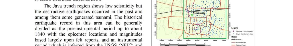
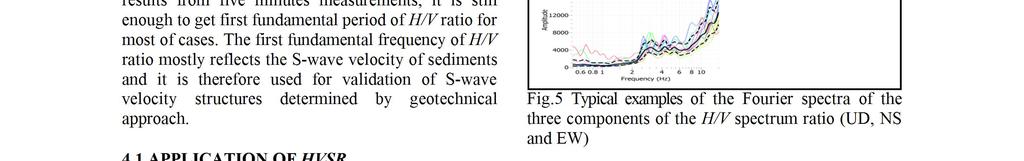
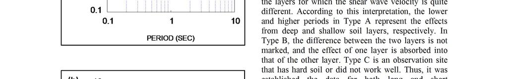
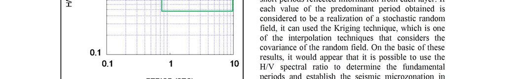
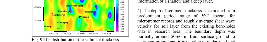
5 From the single microtremor observations, the short predominant periods, T s, is obtained from 0.1 to 1.00 sec as shown in Fig. 7. The target area is less than 1.00 sec of the short predominant periods which reflects the information of the shallow soil layer. In this study area it is clearly verified that the shallow soil structure are generally the north-south alignment because it is assumed that the young volcanic soft sediment are derived from the Merapi volcano from the north of the research area. It is understood that the relatively shallow soil structures can be detected from H/V spectrum of short period microtremor when the clear layer boundary with high impedance ratio is existed. Fig. 8 Spatial distribution of the long predominant period, T d Fig. 7 Spatial distribution of the short predominant period, T s As shown in Fig. 8, the long predominant period in the eastern part of Yogyakarta City is ranging from 0.15 to 4.00 sec. Form the long predominant periods, T d, which expresses the information of relatively deep sedimentary layer, a deep layer with a period of greater than 1.8 sec is observed in studied area. The highest predominant period (>1.8 sec) is observed at Gondokusuman, Terban, Kricak, Sindaudi, north part of Catur Tunggal, east of Depok, South-East of Muja Muju and Bataretno. The lowest predominant period (0.15 to 1.4 sec) is observed at Yogyakarta, Rejowwinangun, Umbulharjo, Mantrijeron, Giwangan, Sewon, Prengan and east of Baturetno. It is obviously observed that the area where thicker sediments show higher predominant periods. Fig. 7 and 8 are showing the distribution of the site predominant periods especially short and long predominant periods were developed for the seismic microzonation purpose. 6. DETERMINATION OF LAYER THICKNESS It has been well-documented that the effect of local on ground shaking is an important factor in earthquake engineering. Particularly, soft sedimentary cover could strongly amplify the seismic motion. The peak period of the H/V spectrum plot shows the predominant period of the site. The H/V spectra were obtained for all the observation sites and the predominant periods of ground motion for all the sites were identified. The peak in the short and long periods (T s and T d ) of the observed H/V spectrum could be explained by the estimated subsurface soil. An investigation of the sediment thickness and a seismic zones in addition to use of the H/V spectrum by microtremor to enables the ground amplification properties to be understood. The first order peak seen in H/V spectrum is considered to be an accurate indication of the natural period of the ground. There is a good correlation between the sediment thickness and period. This allows the distribution of the sediment thickness in the Yogyakarta basin to be determined accurately with high density observations. Several studies show the relationship between the velocity structure beneath the recording site and the dominant frequency obtained from HVSR analysis [5]. As a first-order approximation, it can be applied a simple formula that release the fundamental frequency to the thickness and seismic velocity of a medium composed of a single layer over a half-space: f 0 = V s /4H (2) where V s is the average S-wave velocity and H is the thickness of the layer. When the sites are located over the same structure as Yogyakarta City Area, it can be assumed that the S-wave velocity is approximately constant from site to site. This is usually the case in most sedimentary basins like as Yogyakarta basin. Geology, Geophysics and Geotechnique 30


6 Geology, Geophysics and Geotechnique 31
7 special thanks to Dr. Salahuddin Husein who edited all my publication papers and to Dr. Rusnardi Rahamat Putra who helped me for the laboratory works especially some important software during study in Kyoto University. REFERENCES [1] Ibs-Von Seht, M. and Wohlenberg, J. 1999, Microtremor Measurements Used to Map Thickness of Soft Sediments, Bull. Seismol. Soc. Am. 89, [2] Kiyono, J., Ono, Y., Sato, A., Noguchi, T., and Rusnardi., R., 2011, Estimation of Subsurface structure Based On Microtremor Observations at Padang, Indonesia, Division III, Civil Engineering, Environmental Engineering and Geological Engineering. ASEAN Engineering Journal,Volume 1, Number 3, October. AUN/SEED-Net JICA. pp [3] Nakamura, Y., 1989, A Method for dynamic characteristics estimation of surface layers using microtremor on the surface, RTRI Report 4, [4] Nakamura, Y., 2000, Clear identification of fundamental idea of Nakamura s technique and its applications, Proc. of the 12 th World Congresss on Earthquake Engineering, Aucklland, New Zealand. [5] Navarro, M., Enomoto, T., Sanchez, F., Matsuda, I., Iwatate, T., Posadas, A., Luzon, F., vidal, F., and Seo, K., 2001, Surface Soil Effects Study Using Short-period Microtremor in Almeria City, Southern Spain, Pure Appl. Geophys. 158, [6] Tokimatsu, K. Nakajo, Y. & Tamura, S Horizontal to vertical amplitude ratio of short period microtremors and its relation to site characteristics. Journal of Structure and Construction Engineering, Architectural Institute of Japan, 475, (in Japanese). [7] USGS 2013, United States Geological Survey, Historical Earthquakes in the World. al.php Geology, Geophysics and Geotechnique 32
Seismic Behaviors Estimation of the Shallow and Deep Soil Layers Using Microtremor Recording and EGF Technique in Yogyakarta City, Central Java Island
 Available online at www.sciencedirect.com ScienceDirect Procedia Earth and Planetary Science 2 ( 205 ) 3 46 ISEDM 203 3 rd International Symposium on Earthquake and Disaster Mitigation Seismic Behaviors
FOCAL MECHANISMS OF SUBDUCTION ZONE EARTHQUAKES ALONG THE JAVA TRENCH: PRELIMINARY STUDY FOR THE PSHA FOR YOGYAKARTA REGION, INDONESIA
 FOCAL MECHANISMS OF SUBDUCTION ZONE EARTHQUAKES ALONG THE JAVA TRENCH: PRELIMINARY STUDY FOR THE PSHA FOR YOGYAKARTA REGION, INDONESIA Myo Thant 1, Hiroshi Kawase 2, Subagyo Pramumijoyo 3, Heru Hendrayana
ESTIMATION OF SEDIMENT THICKNESS BY USING MICROTREMOR OBSERVATIONS AT PALU CITY, INDONESIA. Pyi Soe Thein. 11 November 2013
 ESTIMATION OF SEDIMENT THICKNESS BY USING MICROTREMOR OBSERVATIONS AT PALU CITY, INDONESIA By Pyi Soe Thein 11 November 2013 Outlines Introduction Research objectives Research analyses Microtremor Single
Strong Ground Motion Based on Microtremor and Empirical Stochastic Green s Function Computing at Palu City, Central Sulawesi Province, Indonesia
 2014 3 rd International Conference on Geological and Environmental Sciences IPCBEE vol. 73 (2014) (2014) IACSIT Press, Singapore DOI: 10.7763/IPCBEE. 2014. V73. 11 Strong Ground Motion Based on Microtremor
PROCEEDINGS PIT IAGI YOGYAKARTA 2012 The 41 st IAGI Annual Convention and Exhibition
 EG-25 COMPARING QUALITATIVE AND QUANTITATIVE METHOD TO DETERMINE EARTHQUAKE SUSCEPTIBILITY LEVEL AT KULON PROGO, YOGYAKARTA by: Deasy Rimanda Cahyaningtyas (1), Prof. Dr. Kirbani Sri Brotopuspito (2) Salahuddin
STUDY ON MICROTREMOR CHARACTERISTICS BASED ON SIMULTANEOUS MEASUREMENTS BETWEEN BASEMENT AND SURFACE USING BOREHOLE
 STUDY ON MICROTREMOR CHARACTERISTICS BASED ON SIMULTANEOUS MEASUREMENTS BETWEEN BASEMENT AND SURFACE USING BOREHOLE Takahisa ENOMOTO 1, Toshio KURIYAMA 2, Norio ABEKI 3, Takahiro IWATATE 4, Manuel NAVARRO
DETERMINATION OF BEDROCK STRUCTURE OF TOTTORI PLAIN USING SEISMIC EXPLOSION, MICROTREMOR AND GRAVITY SURVEY
 13 th World Conference on Earthquake Engineering Vancouver, B.C., Canada August 1-6, 2004 Paper No. 1760 DETERMINATION OF BEDROCK STRUCTURE OF TOTTORI PLAIN USING SEISMIC EXPLOSION, MICROTREMOR AND GRAVITY
On the Horizontal-to-Vertical Spectral Ratio in Sedimentary Basins
 Bulletin of the Seismological Society of America, 90, 4, pp. 1101 1106, August 2000 On the Horizontal-to-Vertical Spectral Ratio in Sedimentary Basins by Zakaria Al Yuncha and Francisco Luzón Abstract
ANOTHER MEXICAN EARTHQUAKE! Magnitude 7.1, Tuesday Sept. 19, 2017
 ANOTHER MEXICAN EARTHQUAKE! Magnitude 7.1, Tuesday Sept. 19, 2017 Why is there no oceanic crust older than 200 million years? SUBDUCTION If new oceanic crust is being continuously created along the earth
Estimation of Seismic Ground Motion Induced by the 23 January, 2005 Earthquake in Palu Region, Central Sulawesi, Indonesia
 Journal of Geological Resource and Engineering 4 (2014) 200-207 doi:10.17265/2328-2193/2014.04.002 D DAVID PUBLISHING Estimation of Seismic Ground Motion Induced by the 23 January, 2005 Earthquake in Palu
Effects of Surface Geology on Seismic Motion
 4 th IASPEI / IAEE International Symposium: Effects of Surface Geology on Seismic Motion August 23 26, 2011 University of California Santa Barbara A STUDY ON THE ESTIMATION METHOD FOR UNDERGROUND STRUCTURE
Liquefaction Potential Post-Earthquake in Yogyakarta
 The 17 th Southeast Asian Geotechnical Conference Taipei, Taiwan, May 10~13, 2010 Liquefaction Potential Post-Earthquake in Yogyakarta AGUS SETYO MUNTOHAR 1 and S.P.R. WARDANI 2 1 Department of Civil Engineering,
Scenario Earthquake Shaking Maps in Japan
 1 Scenario Earthquake Shaking Maps in Japan Nobuyuki Morikawa National Research Institute for Earth Science and Disaster Prevention (NIED), JAPAN Scenario Earthquake Shaking Maps (SESMs) The shaking maps
THREE-DIMENSIONAL FINITE DIFFERENCE SIMULATION OF LONG-PERIOD GROUND MOTION IN THE KANTO PLAIN, JAPAN
 THREE-DIMENSIONAL FINITE DIFFERENCE SIMULATION OF LONG-PERIOD GROUND MOTION IN THE KANTO PLAIN, JAPAN Nobuyuki YAMADA 1 And Hiroaki YAMANAKA 2 SUMMARY This study tried to simulate the long-period earthquake
MULTI-DIMENSIONAL VS-PROFILING WITH MICROTREMOR H/V AND ARRAY TECHNIQUES
 13 th World Conference on Earthquake Engineering Vancouver, B.C., Canada August 1-6, 2004 Paper No. 1348 MULTI-DIMENSIONAL VS-PROFILING WITH MICROTREMOR H/V AND ARRAY TECHNIQUES Kohji TOKIMATSU 1, Hiroshi
RECIPE FOR PREDICTING STRONG GROUND MOTIONS FROM FUTURE LARGE INTRASLAB EARTHQUAKES
 RECIPE FOR PREDICTING STRONG GROUND MOTIONS FROM FUTURE LARGE INTRASLAB EARTHQUAKES T. Sasatani 1, S. Noguchi, T. Maeda 3, and N. Morikawa 4 1 Professor, Graduate School of Engineering, Hokkaido University,
The Site Response and Strong Ground Motion Estimation of the 2006/05/27 Yogjakarta, Indonesia Earthquake
 The Site Response and Strong Ground Motion Estimation of the 2006/05/27 Yogjakarta, Indonesia Earthquake Tao-Ming Chang National Center for Earthquake Engineering Research, Taipei, Taiwan Jer-Ming Lin
Microtremors HVSR Correlation with Sub Surface Geology and Ground Shear Strain at Palu City, Central Sulawesi Province, Indonesia
 Microtremors HVSR Correlation with Sub Surface Geology and Ground Shear Strain at Palu City, Central Sulawesi Province, Indonesia PyiSoe Thein, Subagyo Pramumijoyo, Kirbani Sri Brotopuspito, Junji Kiyono,
Plate Tectonics Tutoiral. Questions. Teacher: Mrs. Zimmerman. Plate Tectonics and Mountains Practice Test
 Teacher: Mrs. Zimmerman Print Close Plate Tectonics and Mountains Practice Test Plate Tectonics Tutoiral URL: http://www.hartrao.ac.za/geodesy/tectonics.html Questions 1. Fossils of organisms that lived
RISKY HIGH-RISE BUILDINGS RESONATING WITH THE LONG-PERIOD STRONG GROUND MOTIONS IN THE OSAKA BASIN, JAPAN
 RISKY HIGH-RISE BUILDINGS RESONATING WITH THE LONG-PERIOD STRONG GROUND MOTIONS IN THE OSAKA BASIN, JAPAN K. Miyakoshi 1 and M. Horike 2 ABSTRACT : 1 Earthquake Engineering Group, Geo-Research Institute,
Chapter 3. Geology & Tectonics
 Chapter 3 Geology & Tectonics 3.1 Geology The general geological features of Indonesia are shown in Figure 3.1. The basement formation is metamorphic and it is intruded with plutonic formations. They are
Soil Profile Confirmation through Microtremor Observation
 Proceedings Third UJNR Workshop on Soil-Structure Interaction, March 29-3, 24, Menlo Park, California, USA. Soil Profile Confirmation through Microtremor Observation Yuzuru Yasui a) and Tatsuya Noguchi
Analysis Of Earthquake Records of Istanbul Earthquake Rapid Response System Stations Related to the Determination of Site Fundamental Frequency
 Analysis Of Earthquake Records of Istanbul Earthquake Rapid Response System Stations Related to the Determination of Site Fundamental Frequency A. C. Zulfikar, H. Alcik & E. Cakti Bogazici University,Kandilli
Date: / Page # Version A Page 1
 Name: Plate Tectonics Quiz 1. Which best describes a major characteristic of both volcanoes and earthquakes? (1) They are centered at the poles. (2) They are located in the same geographic areas. (3) They
Magnitude 7.0 PAPUA, INDONESIA
 A 7.0 magnitude earthquake struck eastern Indonesia's mountainous West Papua province on Saturday but there were no immediate reports of casualties or damage. The region is sparsely populated. According
Effects of Surface Geology on Seismic Motion
 4 th IASPEI / IAEE International Symposium: Effects of Surface Geology on Seismic Motion August 23 26, 2011! University of California Santa Barbara MICROZONATION OF MONTREAL, VARIABILITY IN SOIL CLASSIFICATION
DETERMINATION OF SUBSURFACE STRUCTURE OF IZUMO PLAIN, SOUTHWEST JAPAN USING MICROTREMORS AND GRAVITY ANOMALIES
 DETERMINATION OF SUBSURFACE STRUCTURE OF IZUMO PLAIN, SOUTHWEST JAPAN USING MICROTREMORS AND GRAVITY ANOMALIES Masao Adachi 1 Tatsuya Noguchi 2 Ryohei Nishida 2 Itaru Ohata 2 Tsuyoshi Yamashita 2 Kohei
Learning from Bengkulu Earthquake : Preliminary observation on Impacts of the September 12, 2007 Earthquake in Bengkulu, West Sumatra, Indonesia
 Learning from Bengkulu Earthquake : Preliminary observation on Impacts of the September 12, 2007 Earthquake in Bengkulu, West Sumatra, Indonesia Introduction By Dwikorita Karnawati 1), Iman Satyarno 2)
Earth s Continents and Seafloors. GEOL100 Physical Geology Ray Rector - Instructor
 Earth s Continents and Seafloors GEOL100 Physical Geology Ray Rector - Instructor OCEAN BASINS and CONTINENTAL PLATFORMS Key Concepts I. Earth s rocky surface covered by of two types of crust Dense, thin,
ESTIMATION OF MAXIMUM EARTHQUAKE MAGNITUDE OF EARTHQUAKE POTENTIALS FOR YOGYAKARTA DEPRESSION AREA, INDONESIA
 J. SE Asian Appl. Geol., Jan Apr 2010, Vol. 2(1), pp. 28 34 ESTIMATION OF MAXIMUM EARTHQUAKE MAGNITUDE OF EARTHQUAKE POTENTIALS FOR YOGYAKARTA DEPRESSION AREA, INDONESIA Myo Thant 1, Subagyo Pramumijoyo
Effects of Surface Geology on Seismic Motion
 4 th IASPEI / IAEE International Symposium: Effects of Surface Geology on Seismic Motion August 23 26, 2011 University of California Santa Barbara PERIOD-DEPENDENT SITE AMPLIFICATION FOR THE 2008 IWATE-MIYAGI
STRONG MOTION OBSERVATION IN METRO MANILA, PHILIPPINES
 STRONG MOTION OBSERVATION IN METRO MANILA, PHILIPPINES KATSUMI KURITA 1, HIROAKI YAMANAKA 1, TATSUO OHMACHI 2, KAZUOH SEO 2, YOSHIHIRO KINUGASA 1, SABUROH MIDORIKAWA 2, TAKUMI TOSHINAWA 2, KAZUO FUJIMOTO
Plate Tectonics. entirely rock both and rock
 Plate Tectonics I. Tectonics A. Tectonic Forces are forces generated from within Earth causing rock to become. B. 1. The study of the origin and arrangement of Earth surface including mountain belts, continents,
CORRELATION OF GEOPHYSICAL AND GEOTECHNICAL INVESTIGATIONS FOR SEISMIC HAZARD ASSESSMENT IN DHAKA CITY, BANGLADESH
 G.J.B.B., VOL. () 13: 139-144 ISSN 78 913 CORRELATION OF GEOPHYSICAL AND GEOTECHNICAL INVESTIGATIONS FOR SEISMIC HAZARD ASSESSMENT IN DHAKA CITY, BANGLADESH Md. Shakhawat Hossain1, B.M. Rabby Hossain,
Before Plate Tectonics: Theory of Continental Drift
 Before Plate Tectonics: Theory of Continental Drift Predecessor to modern plate tectonics Shape and fit of the continents was the initial evidence Snider-Pelligrini (1858) Taylor (1908) Wegner (1915) Fig.
ACCOUNTING FOR SITE EFFECTS IN PROBABILISTIC SEISMIC HAZARD ANALYSIS: OVERVIEW OF THE SCEC PHASE III REPORT
 ACCOUNTING FOR SITE EFFECTS IN PROBABILISTIC SEISMIC HAZARD ANALYSIS: OVERVIEW OF THE SCEC PHASE III REPORT Edward H FIELD 1 And SCEC PHASE III WORKING GROUP 2 SUMMARY Probabilistic seismic hazard analysis
ASSESSMENT OF A POTENTIAL HYDROCARBON RESERVOIR IN A YOGYAKARTA BASIN USING BROADBAND-NOISE ANALYSIS
 ISSN: 2186-2982 (P), 2186-2990 (O), Japan, DOI: https://doi.org/10.21660/2018.49.ijcst59 Special Issue on Science, Engineering & Environment ASSESSMENT OF A POTENTIAL HYDROCARBON RESERVOIR IN A YOGYAKARTA
24. Ocean Basins p
 24. Ocean Basins p. 350-372 Background The majority of the planet is covered by ocean- about %. So the majority of the Earth s crust is. This crust is hidden from view beneath the water so it is not as
GROUND MOTION CHARACTERISTIC IN THE KAOHSIUNG & PINGTUNG AREA, TAIWAN
 GROUND MOTION CHARACTERISTIC IN THE KAOHSIUNG & PINGTUNG AREA, TAIWAN Hsien-Jen Chiang 1, Kuo-Liang Wen 1, Tao-Ming Chang 2 1.Institute of Geophysics, National Central University,ROC 2.Department of Information
Gravity Data Analysis and Modelling for Basin Sedimen of Eastern Java Blocks
 Journal of Physics: Conference Series PAPER OPEN ACCESS Gravity Data Analysis and Modelling for Basin Sedimen of Eastern Java Blocks To cite this article: Luthfia Khoirunnia 2016 J. Phys.: Conf. Ser. 776
Earthquakes down under: a rare but real hazard
 University of Wollongong Research Online Faculty of Science, Medicine and Health - Papers Faculty of Science, Medicine and Health 2015 Earthquakes down under: a rare but real hazard Solomon Buckman University
Long-period Ground Motion Characteristics of the Osaka Sedimentary Basin during the 2011 Great Tohoku Earthquake
 Long-period Ground Motion Characteristics of the Osaka Sedimentary Basin during the 2011 Great Tohoku Earthquake K. Sato, K. Asano & T. Iwata Disaster Prevention Research Institute, Kyoto University, Japan
Chapter 2: Plate Tectonics: A Unifying Theory
 Chapter 2: Plate Tectonics: A Unifying Theory Chapter Outline 2.1 Introduction 2.2 Early Ideas About Continental Drift 2.3 What Is the Evidence for Continental Drift? 2.4 Features of the Seafloor 2.5 Earth
Seismic properties of surface layers in Shimizu by microtremor observations
 Seismic properties of surface layers in Shimizu by microtremor observations K. Kita Tokai University, Japan SUMMARY Microtremor observations were conducted to investigate seismic properties of shallow
Effects of Surface Geology on Seismic Motion
 4 th IASPEI / IAEE International Symposium: Effects of Surface Geology on Seismic Motion August 23 26, 2011 University of California Santa Barbara VELOCITY STRUCTURE INVERSIONS FROM HORIZONTAL TO VERTICAL
Y. Shioi 1, Y. Hashizume 2 and H. Fukada 3
 Y. Shioi 1, Y. Hashizume 2 and H. Fukada 3 1 Emeritus Professor, Hachinohe Institute of Technology, Hachinohe, Japan 2 Chief Engineer, Izumo, Misawa, Aomori, Japan 3 Profesr, Geo-Technical Division, Fudo
A STUDY ON THE GROUND MOTION CHARACTERISTICS OF TAIPEI BASIN, TAIWAN, BASED ON OBSERVED STRONG MOTIONS AND MEASURED MICROTREMORS
 A STUDY ON THE GROUND MOTION CHARACTERISTICS OF TAIPEI BASIN, TAIWAN, BASED ON OBSERVED STRONG MOTIONS AND MEASURED MICROTREMORS Ying Liu 1, Kentaro Motoki 2 and Kazuo Seo 2 1 Eartquake Engineer Group,
NUMERICAL SIMULATION OF STRONG GROUND MOTION ON ADAPAZARI BASIN DURING THE 1999 KOCAELI, TURKEY, EARTHQUAKE
 13 th World Conference on Earthquake Engineering Vancouver, B.C., Canada August 1-6, 2004 Paper No. 720 NUMERICAL SIMULATION OF STRONG GROUND MOTION ON ADAPAZARI BASIN DURING THE 1999 KOCAELI, TURKEY,
PROBABILISTIC SEISMIC HAZARD MAPS AT GROUND SURFACE IN JAPAN BASED ON SITE EFFECTS ESTIMATED FROM OBSERVED STRONG-MOTION RECORDS
 13 th World Conference on Earthquake Engineering Vancouver, B.C., Canada August 1-6, 2004 Paper No. 3488 PROBABILISTIC SEISMIC HAZARD MAPS AT GROUND SURFACE IN JAPAN BASED ON SITE EFFECTS ESTIMATED FROM
Effects of Surface Geology on Seismic Motion
 4 th IASPEI / IAEE International Symposium: Effects of Surface Geology on Seismic Motion August 23 26, 2011 University of California Santa Barbara LONG-PERIOD (3 TO 10 S) GROUND MOTIONS IN AND AROUND THE
Marine Science and Oceanography
 Marine Science and Oceanography Marine geology- study of the ocean floor Physical oceanography- study of waves, currents, and tides Marine biology study of nature and distribution of marine organisms Chemical
Report on the evaluation of geophysical data and seismic site effects in the Maltese archipelago in relation to the calculation of seismic risk
 Project Acronym: SIMIT Project Name: Sistema Integrato di Protezione CivileTransfrontalieroItalo-Maltese Project Code: B1-2.19/11 Start Date: March 2013 End Date: September 2015 Work Package 2: Identification
How the earthquakes and landslides affect Quito, my place. Ecuador is located on the Northwestern part of the South-American plate which is being
 How the earthquakes and landslides affect Quito, my place. Ecuador is located on the Northwestern part of the South-American plate which is being subducted by the Nazca plate. Due to this subduction a
USU 1360 TECTONICS / PROCESSES
 USU 1360 TECTONICS / PROCESSES Observe the world map and each enlargement Pacific Northwest Tibet South America Japan 03.00.a1 South Atlantic Arabian Peninsula Observe features near the Pacific Northwest
Proposed Approach to CENA Site Amplification
 Proposed Approach to CENA Site Amplification Gail Atkinson with acknowledgement to many co-authors, especially Ghofrani, Hassani, Assatourians, and Braganza. The model is a team effort reflecting their
(c) (a) (b) EFFECTS OF LOCAL SITE AMPLIFICATION ON DAMAGE TO WOODEN HOUSES
 (a) (b) EFFECTS OF LOCAL SITE AMPLIFICATION ON DAMAGE TO WOODEN HOUSES") EFFECTS OF LOCAL SITE AMPLIFICATION ON DAMAGE TO WOODEN HOUSES IN NEAR-SOURCE REGION FOR THE 2007 NOTO HANTO EARTHQUAKE Hiroshi Arai 1), Takeshi Morii 2), Masumi Yamada 3), Hidemaru Shimizu 1), and Yasuhiro
EFFECTS OF LOCAL SITE AMPLIFICATION ON DAMAGE TO WOODEN HOUSES IN NEAR-SOURCE REGION FOR THE 2007 NOTO HANTO EARTHQUAKE Hiroshi Arai 1), Takeshi Morii 2), Masumi Yamada 3), Hidemaru Shimizu 1), and Yasuhiro
Late 20 th Century Tests of the Continental Drift Hypothesis
 Late 20 th Century Tests of the Continental Drift Hypothesis 5 Characteristics of the Ocean Trenches Unless otherwise noted the artwork and photographs in this slide show are original and by Burt Carter.
Earthquake Hazards. Tsunami
 Earthquake Hazards Tsunami Measuring Earthquakes Two measurements that describe the power or strength of an earthquake are: Intensity a measure of the degree of earthquake shaking at a given locale based
Analysis of Microtremor Data Using Horizontal to Vertical Spectral Ratio (HVSR) Method of Makassar, South Sulawesi
 Method of Makassar, South Sulawesi") Analysis of Microtremor Data Using Horizontal to Vertical Spectral Ratio (HVSR) Method of Makassar, South Sulawesi 1* R. Jamroni, 2 A.M. Imran,, 2 B. Azikin 1 Master Student of Geology Department, Hasanuddin
Analysis of Microtremor Data Using Horizontal to Vertical Spectral Ratio (HVSR) Method of Makassar, South Sulawesi 1* R. Jamroni, 2 A.M. Imran,, 2 B. Azikin 1 Master Student of Geology Department, Hasanuddin
Effects of Surface Geology on Seismic Motion
 4 th IASPEI / IAEE International Symposium: Effects of Surface Geology on Seismic Motion August 23 26, 2011 University of California Santa Barbara TUNING THE DEEP VELOCITY STRUCTURE MODEL OF THE TOKYO
UNIT 3 GEOLOGY VOCABULARY FLASHCARDS THESE KEY VOCABULARY WORDS AND PHRASES APPEAR ON THE UNIT 3 CBA
 UNIT 3 GEOLOGY VOCABULARY FLASHCARDS THESE KEY VOCABULARY WORDS AND PHRASES APPEAR ON THE UNIT 3 CBA A map that shows Earth s Topographic Map surface topography, which is Earth s shape and features Contour
Indian Ocean Tsunami Warning System: Example from the 12 th September 2007 Tsunami
 Indian Ocean Tsunami Warning System: Example from the 12 th September 2007 Tsunami Charitha Pattiaratchi 1 Professor of Coastal Oceanography, The University of Western Australia Email: chari.pattiaratchi@uwa.edu.au
Chapter 02 The Sea Floor
 Chapter 02 The Sea Floor Multiple Choice Questions 1. One of the following is not one of the world's major ocean basins: A. Atlantic Ocean B. Arctic Ocean C. Indian Ocean D. Antarctic Ocean E. Pacific
Estimation of Deep Shear-Wave Velocity Profiles in Lima, Peru, Using Seismometers Arrays
 Calderon, D. et al. Paper: Estimation of Deep Shear-Wave Velocity Profiles in Lima, Peru, Diana Calderon, Zenon Aguilar, Fernando Lazares, Toru Sekiguchi, and Shoichi Nakai Faculty of Civil Engineering,
Dynamic Crust Practice
 1. Base your answer to the following question on the cross section below and on your knowledge of Earth science. The cross section represents the distance and age of ocean-floor bedrock found on both sides
Topic 5: The Dynamic Crust (workbook p ) Evidence that Earth s crust has shifted and changed in both the past and the present is shown by:
 Evidence that Earth s crust has shifted and changed in both the past and the present is shown by:") Topic 5: The Dynamic Crust (workbook p. 65-85) Evidence that Earth s crust has shifted and changed in both the past and the present is shown by: --sedimentary horizontal rock layers (strata) are found
Topic 5: The Dynamic Crust (workbook p. 65-85) Evidence that Earth s crust has shifted and changed in both the past and the present is shown by: --sedimentary horizontal rock layers (strata) are found
Earth Science, (Tarbuck/Lutgens) Chapter 10: Mountain Building
 Chapter 10: Mountain Building") Earth Science, (Tarbuck/Lutgens) Chapter 10: Mountain Building 1) A(n) fault has little or no vertical movements of the two blocks. A) stick slip B) oblique slip C) strike slip D) dip slip 2) In a(n) fault,
Earth Science, (Tarbuck/Lutgens) Chapter 10: Mountain Building 1) A(n) fault has little or no vertical movements of the two blocks. A) stick slip B) oblique slip C) strike slip D) dip slip 2) In a(n) fault,
Shaking Characteristic of Padang City, Indonesia
 Badmi Shaking Characteristic of Padang City, Indonesia Rusnardi Rahmat Putra & Kiyono J Graduate School of Engineering, Kyoto University, Japan Ono Y Department of Urban Social System and Civil Engineering,
Long-period ground motion characterization by cross wavelet transform
 Long-period ground motion characterization by cross wavelet transform *Tsoggerel Tsamba 1) and Masato Motosaka 2) 1), 2) International Research Institute of Disaster Science, Tohoku University, Sendai980-8579,Japan
PREDICTION OF AVERAGE SHEAR-WAVE VELOCITY FOR GROUND SHAKING MAPPING USING THE DIGITAL NATIONAL LAND INFORMATION OF JAPAN
 th World Conference on Earthquake Engineering Vancouver, B.C., Canada August -6, 00 Paper No. 07 PREDICTION OF AVERAGE SHEAR-WAVE VELOCITY FOR GROUND SHAKING MAPPING USING THE DIGITAL NATIONAL LAND INFORMATION
Grand Unifying Theory of everything... for the Geosciences, at least!
 Plate Tectonics: Grand Unifying Theory of everything... for the Geosciences, at least! The Earth s lithosphere, composed of Oceanic and continental crust, is broken up into pieces that move and interact
Plates & Boundaries The earth's continents are constantly moving due to the motions of the tectonic plates.
 Plates & Boundaries The earth's continents are constantly moving due to the motions of the tectonic plates. As you can see, some of the plates contain continents and others are mostly under the ocean.
PHYSICAL GEOLOGY AND THE ENVIRONMENT (2 ND CANADIAN EDITION)
") Chapter 2: Plate Tectonics Chapter Summary: Plate tectonics is a theory that suggests Earth's surface is divided into several large plates that change position and size. Intense geologic activity occurs
Chapter 2: Plate Tectonics Chapter Summary: Plate tectonics is a theory that suggests Earth's surface is divided into several large plates that change position and size. Intense geologic activity occurs
ANALYTICAL STUDY ON RELIABILITY OF SEISMIC SITE-SPECIFIC CHARACTERISTICS ESTIMATED FROM MICROTREMOR MEASUREMENTS
 ANALYTICAL STUDY ON RELIABILITY OF SEISMIC SITE-SPECIFIC CHARACTERISTICS ESTIMATED FROM MICROTREMOR MEASUREMENTS Boming ZHAO 1, Masanori HORIKE 2 And Yoshihiro TAKEUCHI 3 SUMMARY We have examined the site
SEISMIC HAZARD ASSESSMENT WITH MICROTREMOR ARRAY OBSERVATION AND COMPUTATIONAL SIMULATION IN THE METROPOLITAN BEIJING AREA
 SEISMIC HAZARD ASSESSMENT WITH MICROTREMOR ARRAY OBSERVATION AND COMPUTATIONAL SIMULATION IN THE METROPOLITAN BEIJING AREA Qi-fu Chen 1, Lanbo Liu 2,1, Weijun Wang 1, and Kuang He 3 1 Institute of Earthquake
A. rift valley B. deep trench C. volcanic cone D. uplifted mountain. A. a volcanic island arc B. a large watershed area
 DC Practice Test Dynamic Crust PRCTICE TEST Zimm's Earth Science 2013 1. Which feature would most likely be forming at converging continental tectonic plate boundaries?. rift valley. deep trench C.
Questions and Topics
 Plate Tectonics and Continental Drift Questions and Topics 1. What are the theories of Plate Tectonics and Continental Drift? 2. What is the evidence that Continents move? 3. What are the forces that
LOCAL GEOLOGY CONDITION OF BENGKULU CITY BASED ON SEISMIC VULNERABILITY INDEX (Kg)
") LOCAL GEOLOGY CONDITION OF BENGKULU CITY BASED ON SEISMIC VULNERABILITY INDEX (Kg) Nanang Sugianto 1, Muhammad Farid 1 and Wiwit Suryanto 2 1 Department of Physics, Faculty of Mathematics and Natural Sciences,
LOCAL GEOLOGY CONDITION OF BENGKULU CITY BASED ON SEISMIC VULNERABILITY INDEX (Kg) Nanang Sugianto 1, Muhammad Farid 1 and Wiwit Suryanto 2 1 Department of Physics, Faculty of Mathematics and Natural Sciences,
Earth s Tectonic Plates
 MASTER 49 6.2 3.7 5.4 Philippine Pacific 5.4 North American Juan de Fuca Caribbean Cocos 10.0 9.2 2.3 2.5 2.3 1.8 3.0 Indian-Australian 10.5 7.1 17.2 16.8 6.0 Nazca South American 11.1 10.3 7.3 3.7 7.5
Earthquake Hazards. Tsunami
 Earthquake Hazards Tsunami Review: What is an earthquake? Earthquake is the vibration (shaking) and/or displacement of the ground produced by the sudden release of energy. The point inside the Earth where
Full file at
 Chapter 2 PLATE TECTONICS AND PHYSICAL HAZARDS MULTIPLE-CHOICE QUESTIONS 1. What direction is the Pacific Plate currently moving, based on the chain of Hawaiian Islands with only the easternmost island
60% water. Big Bang: 14,000 millions years ago The Earth originated about 4,500 millions years ago its orbit allows water to exist in a liquid state!
 Ch2. The Sea Floor #1 Why geology of the oceans? Marine habitats are directly shaped by geological processes The form of the coastlines The depth of the water Type of bottom (muddy, sandy, rocky) #2 Geological
Earth s Geological Cycle
 Earth s Geological Cycle What Are the Earth s Major Geological Processes? Main Processes: 1. Plate Tectonics 2. Rock Cycle 3. Soil Formation LITHOSPHERE The Earth s Structure Earth s Interior Core (Nickel
PALEOGEOGRAPHY of NYS. Definitions GEOLOGIC PROCESSES. Faulting. Folding 9/6/2012. TOPOGRAPHIC RELIEF MAP of NYS GRADATIONAL TECTONIC
 TOPOGRAPHIC RELIEF MAP of NYS PALEOGEOGRAPHY of NYS Prof. Anthony Grande AFG 2012 Definitions GEOLOGIC PROCESSES Geography: study of people living on the surface of the earth. Geology: the scientific study
DEVELOPMENT OF EMPIRICAL CORRELATION BETWEEN SHEAR WAVE VELOCITY AND STANDARD PENETRATION RESISTANCE IN SOILS OF CHENNAI CITY
 DEVELOPMENT OF EMPIRICAL CORRELATION BETWEEN SHEAR WAVE VELOCITY AND STANDARD PENETRATION RESISTANCE IN SOILS OF CHENNAI CITY Uma Maheswari R 1, Boominathan A 2 and Dodagoudar G.R 3 1 Research Scholar,
2. Explain why there are these two predominate elevations. (Hint: think about isostasy and the type of materials we used to demonstrate buoyancy).
.") IDS 102 Plate Tectonics Questions Part I: Observations- Four maps of world are positioned around the room. Answer the questions associated with each map and record your general observations about the maps.
IDS 102 Plate Tectonics Questions Part I: Observations- Four maps of world are positioned around the room. Answer the questions associated with each map and record your general observations about the maps.
Estimation of Earthquake Ground Motion in Padang, Indonesia
 Int. J. of GEOMAT, Oct. 2011, Vol. 1, No. 1 (Sl. No. 1), pp.71-77 Int. J. of GEOMAT, Oct. 2011, Vol. 1, No. 1 (Sl. No. 1), pp., 71-77 Geotec., Const. Mat. and Env., ISSN: 2186-2982(p), 2186-2990(O), Japan
Our Dynamic Earth Unit Unit 5
 EARTH SCIENCE REGENTS - SOTO Our Dynamic Earth Unit Unit 5 Mr. Soto - Key 1/1/2013 Our Dynamic Earth Vocabulary List 1 Directions: Define each vocabulary word provided below. You may have to use your Earth
Earthquakes & Volcanoes
 Earthquakes & Volcanoes Geology - the study of solid Earth, the rocks of which it is composed, and the processes by which they change geo = Earth; ology = study of Earth s Layers Plate Tectonics - the
New Design Spectral Acceleration of Soft and Deep Deposits in Bangkok
 New Design Spectral Acceleration of Soft and Deep Deposits in Bangkok N. Poovarodom & A. Jirasakjamroonsri Department of Civil Engineering, Faculty of Engineering, Thammasat University, Thailand pnakhorn@engr.tu.ac.th
4 Associate Professor, DPRI, Kyoto University, Uji, Japan
 Proceedings of the International Symposium on Engineering Lessons Learned from the 2 Great East Japan Earthquake, March -4, 22, Tokyo, Japan STRONG MOTION ESTIMATION AT THE ELEVATED BRIDGES OF THE TOHOKU
Earthquakes in Canada
 Earthquakes in Canada Maurice Lamontagne, Ph.D., ing. Geological Survey of Canada Natural Resources Canada 1 What is an Earthquake? P S P S P PS 2 2 Movement on a fault plane causes vibrations The larger
SUBSURFACE STRUCTURE OF LIJIANG BASIN, YUNNAN CHINA AS RELATED TO DAMAGE DISTRIBUTION CAUSED BY THE M7.0 LIJIANG EARTHQUAKE OF FEBRUARY 3, 1996
 SUBSURFACE STRUCTURE OF LIJIANG BASIN, YUNNAN CHINA AS RELATED TO DAMAGE DISTRIBUTION CAUSED BY THE M7.0 LIJIANG EARTHQUAKE OF FEBRUARY 3, 1996 0322 J AKAMATSU 1, K NISHIMURA 2, M NAKAMURA 3, M KOMAZAWA
Chapter Two. Figure 02_02. Geography of the Ocean Basins. The Sea Floor
 Chapter Two The Sea Floor Geography of the Ocean Basins Figure 02_02 The world ocean is the predominant feature on the Earth in total area. In the Northern Hemisphere, 61% of the total area is ocean. In
Plate Tectonics. Goal 2.1
 Plate Tectonics Goal 2.1 Lesson 1 Plate Tectonics: An Overview Think About It Look at the map below. Which two continents look like they d fit together? Focus Question How do Earth s tectonic plates cause
Scenario Earthquake Shaking Maps in Japan
 Scenario Earthquake Shaking Maps in Japan Nobuyuki Morikawa National Research Institute for Earth Science and Disaster Prevention (NIED), JAPAN Example of SESMs The Kego fault zone (south-east part) The
COMPARISON OF SITE RESPONSE DETERMININATION TECHNIQUES IN THE WELLINGTON REGION, NEW ZEALAND
 COMPARISON OF SITE RESPONSE DETERMININATION TECHNIQUES IN THE WELLINGTON REGION, NEW ZEALAND J J TABER 1 SUMMARY Microseismic data from short-period and broadband seismographs have been used to compare
SITE EFFECTS IN HIROSHIMA PREFECTURE, JAPAN DURING THE 2001 GEIYO EARTHQUAKE OF MARCH 24, 2001
 13 th World Conference on Earthquake Engineering Vancouver, B.C., Canada August 1-6, 2004 Paper No. 382 SITE EFFECTS IN HIROSHIMA PREFECTURE, JAPAN DURING THE 2001 GEIYO EARTHQUAKE OF MARCH 24, 2001 Tatsuo
Name Date Class. Directions: Use the diagram below to answer question Florida Progress Monitoring and Benchmark Assessments
 b e n c h m a r k t e s t : e a r t h a n d s p a c e s c i e n c e Multiple Choice 1. Geologists obtain indirect evidence about Earth s interior by A measuring pressure differences at Earth s surface.
TEST NAME:Geology part 1 TEST ID: GRADE:06 - Sixth Grade SUBJECT:Life and Physical Sciences TEST CATEGORY: My Classroom
 TEST NAME:Geology part 1 TEST ID:1542715 GRADE:06 - Sixth Grade SUBJECT:Life and Physical Sciences TEST CATEGORY: My Classroom Geology part 1 Page 1 of 6 Student: Class: Date: 1. The picture below shows