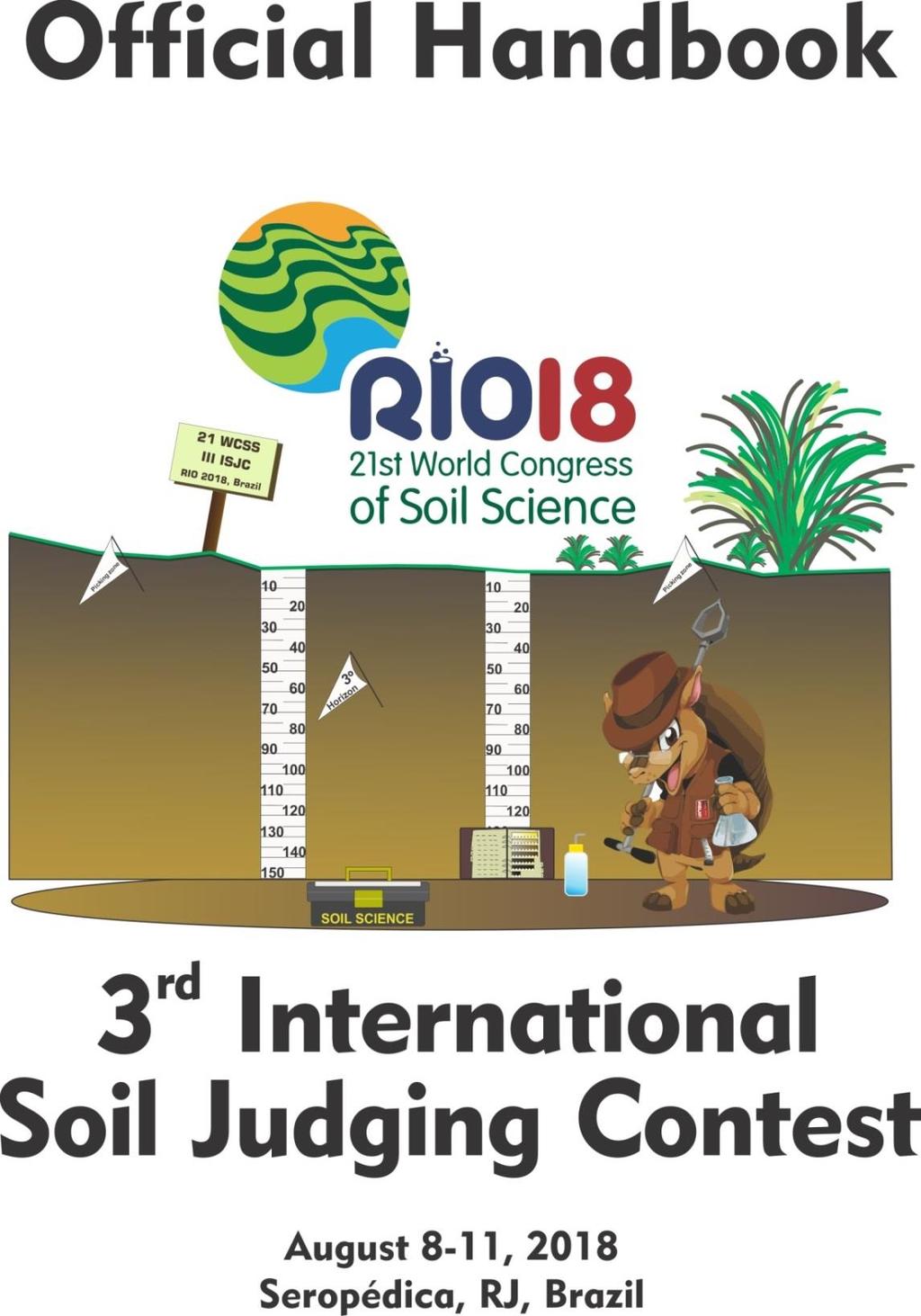
Official Handbook of the 3 rd International Soil Judging Contest
|
|
|
- Ethan Stone
- 5 years ago
- Views:
Transcription


1
2 Official Handbook of the 3 rd International Soil Judging Contest August, 8-11, 2018 Seropédica, RJ, Brazil This handbook was compiled by the 3 rd International Soil Judging Contest organization team, based in the handbooks of the 1 st and 2 nd International Soil Judging Contests, carried out in South Korea and Hungary, and considering the necessary adaptations for the Brazilian event. 2
3 Table of contents GENERAL INFORMATION 5 Training (3 days) 5 The Contest (1 day) 6 Equipment and reference materials 6 Conduct of the training 7 Conduct of the individual contest 7 Conduct of the team contest 8 I. SITE CHARACTERISTICS 9 Land use 9 Slope position 9 Slope % 10 Parent material 11 Erosion 11 Surface coarse fragments 12 II. SOIL DESCRIPTION 13 Horizon designations 13 Horizon boundary 15 Soil color 16 Texture 17 Rock fragments and artefacts (R.F./AF) 18 Structure 19 Redoximorphic features 21 Coatings 22 III. SOIL PROFILE CHARACTERISTICS 23 Hydraulic conductivity 23 Effective soil depth and type restrictive layer 23 Available Water-Holding Capacity (AWC) 24 Soil Wetness class 26 IV. INTERPRETATIONS 27 Vegetable production 27 3
4 Silvopastoral production 28 Local roads and streets for community planning 29 V. DIAGNOSTICS AND SOIL CLASSIFICATION 30 World Reference Base for Soil Resources (2015) 30 Soil Taxonomy (2014) 30 REFERENCES 31 SCORING INFORMATION 32 4
5 GENERAL INFORMATION As part of the celebrations of the International Decade of Soils and the 21 st World Congress of Soil Science, the 3 rd International Soil Judging Contest has been organized for August 8-11, 2018 in Seropédica, RJ, Brazil. The occasion is a great opportunity for students, researchers and people interested in soils from around the world to interact and experience some of the landscapes and tropical soils of Brazil. The scope of the International Soil Judging Contest (ISJC) is for participants to use their knowledge and practical skills to describe, understand and interpret soil characteristics in the field. Participants (in the form of teams and individuals) will describe a series of contest profiles and landscapes using basic field tools, selected standards and guidelines. The winners will be selected on their ability to correctly describe and classify each soil profile and landscape, and interpret their capacity to perform under different uses and management practices. Based on those activities, the aims of this event are: to encourage the wider adoption of the discipline of soil judging around the world, to give motivated students an opportunity to assess soil in a different part of the world, to give students an opportunity to develop networks in the soil science community, and to demonstrate the career opportunities that soil science offers. The 3 rd ISJC will consist of three days of practice on soil and landscape description, classification and interpretation, followed by a contest day. During the practice days, expert soil scientists will give short information sessions on different aspects of the soil, geology and geomorphology of the region. Each team will have an accompanying academic coach, who will assist participants in the field during the training days, but not during the contest day. The contest day will consist of description, classification and interpretation of two soil profiles and landscapes performed by team and two soil profiles and landscapes performed individually. Training (3 days) An international team of soil experts will give an overview of the site, profile description guidelines and soil classification standards. Local soil experts will introduce the landscape and soil conditions of Rio de Janeiro, Brazil, with a focus on the area of the contest. Short classroom sessions will be followed by practical training of field procedures and techniques. Standard samples will be provided for training of texture type, clay and sand percentage estimation. The soils in question will cover a diverse geographical area with a range of topographic, parent material and soil moisture regime conditions. The soils most commonly found in the Seropédica region are Leptosols, Gleysols, Ferralsols, Planosols, Acrisols, Histosols and Cambisols according to the World Reference Base of Soil Resources (WRB) and Entisols, Inceptisols, Alfisols, Ultisols, Oxisols and Histosols according to Soil Taxonomy (ST). 5
6 The Contest (1 day) Participants (teams or individuals) will describe and classify the contest profiles and landscapes, based on the available field tools and selected standards and guidelines. Interpretation of the capacity of the soil to perform under different land uses and management practices will be also scored. The four contest soil profiles will be of the same type of the soil profiles used for training. Equipment and reference materials The following equipment will be available with the pit monitor, but in a limited number, so we encourage each team to bring their own. Soil knife Hand lens Water bottle Container for soil samples Clinometer Munsell Soil Color Chart 2 mm sieve The teams are requested to bring their own Munsell Soil Color Chart books, as only very limited number can be supplied by the organizers. The soil knife provided will be very small and simple, so we suggest the competitor to bring their own. All the participants are encouraged to bring their own sunscreen, insect repellent, raincoat, boots, cap and any other important personal material, cause none of them will be provided by the organizing team. The list of the supplied materials will be available for the participants before the event. Besides this printed handbook, the following reference materials will be permitted during the contest (but not provided by the organizing team): World Reference Base for Soil Resources (IUSS Working Group WRB, 2015) Keys to Soil Taxonomy Twelfth Edition (Soil Survey Staff, 2014) The official USDA published Illustrated Keys to Soil Taxonomy Guidelines for Soil Description (FAO, 2006) Field Book for Describing and Sampling Soils (Schoeneberger et al., 2012) 6
7 Conduct of the Training On the 1 st day there will be classroom presentations on the soils of Brazil as well as an introduction to important interpretations of soils in the region. After lunch there will be a field training. The 2 nd training day will take place focusing on the soils of Seropédica region, in a field trip during the whole day. On the 3 rd day there will be a field training focusing on the contest soils. Four profiles will be investigated (two in the morning and two in the afternoon). A typical section will be selected in each pit and clearly designated as the control section by the contest officials. The control section will be used for measurement of horizon depths and boundaries; it will constitute the officially scored profile and must remain undisturbed and unblocked. All measurements should be made within the designated area. A measuring tape will be placed in the control section at all pits and will be maintained by pit monitors. Several horizons will be described within 150 cm or bedrock depth. A nail will be placed at the bottom of the third horizon from the top of the profile. A card at each site will give the profile depth to be considered, the number of horizons to be identified and described, and chemical or physical data that may be required for classification. Every participant will get 1 scoresheet per pit (all the scoresheets will be provided by the organizing team a sample of the scoresheet may be found at the end of this handbook). The scoresheets are to be filled considering the laboratory information and the instructions of this handbook. Teams will be randomly assigned a team color and name at registration. Individual competitors will be assigned a team name and a letter that will be used to identify their scoresheet and the training rotation schedule. The team coaches will receive a schedule of the training, the full laboratory dataset and the already filled practice pit scoresheets that can be used for guidance. Conduct of the Individual Contest Sixty minutes will be allowed for evaluating each soil and site for individual judging. The competitors will be randomly divided into two groups. At the first site, Group 1 will follow this schedule: minutes in the pit, minutes out, minutes in, minutes out, and minutes free-for-all. Group 2 will follow the opposite in-and-out schedule. At the second site, the groups will switch the in-and-out schedule, with Group 2 in the pit first. Competitors may obtain a sample from the surface horizon while out of the pit, as long as they do not enter the pit or disturb those already in the pit. These procedures may be altered prior to the contest to meet unanticipated difficulties at the site. 7
8 General rules of the individual contest: Competitors must use official abbreviations (codes) found in this handbook; Competitors are not allowed to speak to each other; Competitors are not allowed to use mobile phones, tablets, PDA-s or any communication device but may have them on hand in case of health emergency; Competitors may have health-related items with them during the contest (such as inhalers or allergy medicine); Competitors are allowed to use the equipment provided on site, and the allowed standards. Each student will describe two soil pits. The final result will be the average of the two individual-judged pits. No scores are dropped. Conduct of the Team Contest Sixty minutes will be allowed for teams to evaluate each of the two team-judged sites. The time will be divided into 10-minute segments similar to the individual contest. Teams that start in at the first pit will start out at the next pit. All competitors on each team may participate in the team contest. The starting time(s) of the team contest will be announced at the coaches meeting. General rules of the team contest are the same as the individual contest, with these exceptions: Team members are allowed to speak to other team members (only within the team), as long as their conversation is not loud enough to be heard by other teams; A maximum of four and a minimum of three students may compete per team in the team judging contest. Each team will describe two soil pits. The final result will be the average of the two team-judged pits. No scores are dropped. For the overall score only the best three scores at each individually-judged pit will be considered to the team final score. Both team-judged pit scores will count. The final score will consist of the top six individual scores plus the two team scores. 8

9 I. SITE CHARACTERISTICS Land Use Task on the scoresheet: Determine the land use class according to Table 1. Table 1. Land use classification (FAO, 2006) Code A M H F P S Y O U Class Crop agriculture (annual and perennial field cropping) Mixed farming (agroforestry and agropastoralism) Animal husbandry Forestry Nature protection Settlement, industry (excavation or disposal sites, recreational use, industrial use, residential use) Military area Other land uses Not used and not managed Slope Position Task on the scoresheet: Determine the slope position according to Figure 1 and Figure 2. Use the class codes indicated in Table 2. Slope stakes are placed on the same landscape position as the pit. Figure 1. Slope positions in undulating and mountainous terrain (adapted from FAO, 2006) 9
10 Figure 2. Slope positions in flat/almost flat terrain Table 2. Slope positions and codes in undulating/mountainous terrain and flat/almost flat terrain Position in undulating/mountainous terrain Position in flat/almost flat terrain Code Landform Code Landform CR Crest (summit) HI Higher part (rise) UP Upper slope (shoulder) IN Intermediate (talf) MS Middle slope (backslope) LO Lower part (dip) LS Lower slope (footslope) TS Toeslope BO Bottom (flat terrace or floodplain) Slope % Task on the scoresheet: Determine the slope gradient as a percentage according to the Table 3. Table 3. Slope gradient class codes (adapted from FAO, 2006) Code Class Slope gradient (%) 01 Level 0 - <2 02 Gently sloping 2 - <5 03 Sloping 5 - <10 04 Strongly Sloping 10 - <15 05 Moderately steep 15 - <30 06 Steep 30 - <60 07 Very steep >60 10
11 Parent Material Task on the scoresheet: Determine the parent material according to Table 4. Table 4. Types of possible parent materials to be indicated (adapted from FAO, 2006) Code I M S UR UF UL UC UE Lithology Consolidated Igneous Consolidated Metamorphic Consolidated sedimentary Unconsolidated (uncemented weathered bedrock or saprolite) material Unconsolidated sedimentary (Fluvial) Unconsolidated sedimentary (Lacustrine) Unconsolidated sedimentary (Colluvial) Unconsolidated sedimentary (Aeolian) Erosion Task on the scoresheet: Determine the dominant erosion category using Table 5 and degree of erosion using the Table 6. An off-limits area will be marked for evaluating erosion. If the classification of erosion is N the degree of the erosion must be. Table 5. Classification of erosion, by category (FAO, 2006) Code Class N No evidence of erosion WS Water erosion (Sheet erosion) WR Water erosion (Rill erosion) WG Water erosion (Gully erosion) WT Water erosion (Tunnel erosion) WA Water and wind erosion or deposition (Water and wind erosion) M Mass movement (landslides and similar phenomena) AD Wind (aeolian) deposition (Wind deposition) 11
12 Table 6. Classification of erosion, by degree (FAO, 2006) Code Class Description - Not applicable S Slight Some evidence of damage to surface horizons. M Moderate Clear evidence of removal of surface horizons. V Severe Surface horizons completely removed and subsurface horizons exposed. E Extreme Substantial removal of deeper subsurface horizons. Coarse Surface Fragments Task on the scoresheet: Estimate the abundance of coarse fragments (> 2 mm) over the surface by volume according to the Table 7. You suppose to use the charts available on figure 5, page 18, to estimate the % of coarse fragments. Table 7. Abundance of coarse fragments by volume (adapted from FAO, 2006) Code Class % N None 0 F Few >0-5 C Common >5-15 M Many >15-40 A Abundant >40-80 D Dominant > 80 12
13 II. SOIL DESCRIPTION Horizon Designations Task on the scoresheet: Indicate the horizon designation including a numeric prefix (Prefix), a capitalized alphabetic master designation (Master), a lower case alphabetic subordinate designation (Sub) and if applicable, a numerical subdivision (No.). Horizon Master Letter (Master horizons and layers) Horizon designations to be used are indicated in Table 8. Table 8. The master horizons (FAO, 2006) Code Description Mineral horizons Surface or near-surface mineral horizon with some organic A accumulation, usually a darker colour than underlying horizons and/or smaller clay content than underlying horizons. A near-surface mineral horizon characterized by a loss of clay, iron, E aluminum, or some combination of these; usually lighter in color (higher value and/or lower chroma) than the overlying A and underlying B. A mineral horizon characterized by one or more of the following: a concentration of clay, iron, aluminum, organic material or several of B these; a structure and/or consistence unlike the horizons above and below; stronger colours (higher chroma and/or redder hue) than the horizons above and below. Consolidated or unconsolidated material, usually partly chemically C weathered, otherwise little affected by pedogenic processes. Includes weakly-moderately cemented bedrock. R Hard, strongly cemented bedrock that cannot be cut with a spade. Organic horizons Horizons dominated by organic materials that have accumulated on the O surface of either mineral or organic soils. O horizons are not saturated with water for prolonged periods. These horizons dominated by organic material formed from accumulations of undecomposed or partially decomposed organic H material. All H horizons are saturated with water for prolonged periods, or were once saturated but are now drained artificially. Transitional Horizons There are two kinds of transitional horizons: those with properties of two horizons superimposed; and those with the two properties separate. For horizons dominated by properties of one master horizon but having subordinate properties of another, two capital letter symbols are used, such as AB, EB, BE and BC. The 13
14 master horizon symbol that is given first designates the kind of horizon whose properties dominate the transitional horizon. Horizons in which distinct parts have recognizable properties of two kinds of master horizons are indicated as above, but the two capital letters are separated by a slash (/), such as A/C, B/E, B/C, etc. Horizon Master Prefix (Discontinuities) In mineral soils, Arabic numerals are used as prefixes to indicate that a soil has not formed entirely in one kind of material, which is referred to as a lithologic discontinuity. Wherever needed, the numerals precede the master or transitional horizon designation. A discontinuity is recognized by a significant change in particle-size distribution or mineral suite that typically indicates the horizons formed in different parent materials (Table 4). Stratification common to soils formed in alluvium is not designated as a discontinuity, unless particle-size distribution differs markedly from layer to layer (is strongly contrasting), even if genetic horizons have formed in the contrasting layers. When a discontinuity is identified, prefix numbering starts in the material underlying the surficial deposit and is designated by adding a prefix of 2 to all horizons and layers that formed in the material underlying the discontinuity (note the 1 is implied and not actually added to the surface deposit). If a surficial deposit of differing parent material is found, the material must extend below the A horizon in order to be identified as a separate deposit. There is no minimum number of horizons and layers needed in materials that underlie the surficial deposit to be marked as a separate deposit. If another discontinuity is found below material with prefix 2, the horizons and layers formed in the third material are designated by the prefix 3. For example, Ap, E, Bt1, 2Bt2, 2Bt3, 3BC. The number suffixes designating subdivisions of the Bt horizon continue in consecutive order across the discontinuity. A discontinuity prefix is not used to distinguish material of buried (b) horizons that formed in material similar to that of the overlying deposit (no discontinuity). For example, A, Bw, C, Ab, Bwb1, Bwb2, C. If there is no discontinuity present, place a dash ( ) in the prefix box for each horizon. Horizon Suffix (Subordinate characteristics within master horizons and layers) Designations of subordinate distinctions and features within the master horizons and layers are based on profile characteristics observable in the field and are applied during the description of the soil at the site. Lower case letters are used as suffixes to designate specific kinds of master horizons and layers, and other features. Subordinate characteristics that may be used are found in Table 9. Subordinates can be used with any master or transitional horizon if needed. For example: Ap, BA, Bt1, Bt2, BCt, C. 14
15 Table 9. The suffixes to be used (FAO, 2006) Suffix Description Used for b Buried genetic horizon mineral horizons c Concretions or nodules mineral horizons g Stagnic conditions/strong gley mineral horizons l Capillary fringe mottling (gleying) no restriction p Ploughing or other human disturbance surficial horizon r Strong reduction no restriction t Illuvial accumulation of clay mineral horizons v Plinthite mineral horizons w Development of colour or structure B horizons Horizon Number (No) (Vertical subdivisions) Horizons or layers designated by a single combination of letter symbols can be subdivided using Arabic numerals, which follow all the letters. These conventions apply whatever the purpose of subdivision. A horizon identified by a single letter symbol may be subdivided on the basis of evident morphological features, such as structure, colour or texture. These subdivisions are numbered consecutively. Horizon Boundary Task on the scoresheet: Determine the depth (cm) from the mineral soil surface to lower boundary of each horizon except the last horizon. Determine the distinctness of the horizon boundaries and the topography of the horizon boundary according to the Table 10 and Figure 3. No boundary is described for the lowest horizon. Table 10. Classification of horizon boundaries by distinctness and topography (FAO, 2006) Distinctness Topography Code Class cm Code Class Description A Abrupt 0-2 S Smooth Nearly plane surface C Clear >2-5 W Wavy Pockets less deep than wide G Gradual >5-15 I Irregular Pockets more deep than wide D Diffuse >15 B Broken Discontinuous 15

16 Figure 3. The categories of horizon topography (Schoeneberger et al., 2011) Soil color Task on the scoresheet: Use the Munsell naming system to determine the moist color of each horizon described. Colors must be designated by Hue, Value and Chroma. For routine descriptions, soil colours should be determined out of direct sunlight and by matching a broken ped with the colour chip of the Munsell soil color charts. For special purposes, such as for soil classification, additional colours from crushed or rubbed material may be required. 16
17 Texture Task on the scoresheet: Estimate the clay, silt, and sand content for each horizon. Determine the textural class using the USDA Textural Classification chart (Figure 4) and use the coding indicated in Table 11. Table 11. The coding of texture classes (FAO, 2006) Code Class General category S Sand Sand LS Loamy sand SL Sandy loam SCL Sandy clay loam SiL Silt loam Loam SiCL Silty clay loam CL Clay loam L Loam Si Silt Silt SC Sandy clay SiC Silty clay Clay C Clay Figure 4. Relation of constituents of fine earth by size, defining textural classes (FAO, 2006) 17

18 In addition to the textural class, a field estimate of the percentage of clay and sand are given. This estimate is useful for indicating increases or decreases in clay and/or sand content within textural classes, and for comparing field estimates with analytical results. Rock Fragments and Artefacts (R.F./AF) Task on the scoresheet: Estimate the abundance of rock fragments or artefacts into the profile horizons (> 2 mm) by volume according to the Table 12. Use the figure 5 to estimate the % of the fragments. Table 12. Abundance of internal fragments by volume (adapted from FAO, 2006) Code Abundance % N None 0 F Few >0-5 C Common >5-15 M Many >15-40 A Abundant >40-80 D Dominant > 80 S Stone line Any content, but concentrated at a distinct depth within a horizon Figure 5. Charts for estimating proportions of coarse fragments (FAO, 2006) 18

19 Structure Task on the scoresheet: Record the dominant structure type for each horizon using Figure 6 and Table 13. Record the dominant structure grade for each horizon using the codes indicated in Table 14. If the structure type is SGR or MA the structure grade must be. Figure 6. Examples of soil structure types (Schoeneberger et al., 2011) 19
20 Table 13. Classification of soil structure (Schoeneberger et al., 2011) Code Type Description NATURAL SOIL STRUCTURAL UNITS (pedogenic structure) GR Granular Small polyhedrals with curved or very irregular faces. AB Angular blocky Polyhedrals with faces that intersect at sharp angles (planes). SB Subangular blocky Polyhedrals with subrounded and planar faces lacking sharp angles. PL Platy Flat and platelike units. WG Wedge Elliptical, interlocking lenses that terminate in acute angles, bounded by slickensides; not limited to vertic materials. PR Prismatic Vertically elongated units; flat tops. CO Columnar Vertically elongated units with rounded tops that commonly are bleached. STRUCTURELESS SG Single grain No structural units; entirely noncoherent; e.g. loose sand. MA Massive No structural units; material is a coherent mass (not necessarily cemented). ARTIFICIAL EARTHY FRAGMENTS OR CLODS (nonpedogenic structure) Irregular blocks created by artificial disturbance; e.g., tillage or CD Cloddy compaction. Table 14. Classification of structure grade of pedal soil materials (FAO, 2006) Code Class Description WE Weak Aggregates are barely observable in place and there is only a weak arrangement of natural surfaces of weakness. When gently disturbed, the soil material breaks into a mixture of few entire aggregates, many broken aggregates, and much material without aggregate faces. MO ST Moderate Strong Aggregates are observable in place and there is a distinct arrangement of natural surfaces of weakness. When disturbed, the soil material breaks into a mixture of many entire aggregates, some broken aggregates, and little material without aggregates faces. Aggregates are clearly observable in place and there is a prominent arrangement of natural surfaces of weakness. When disturbed, the soil material separates mainly into entire aggregates. 20
21 Redoximorphic Features Task on the scoresheet: Indicate the type of redox concentrations or depletions (Table 15). Redoximorphic (RMF) features are soil morphological features caused by alternating reduction/oxidation processes. The reduction/oxidation of iron (Fe) and, to a lesser extent, manganese (Mn), minerals result in most RMF features. Iron is a major pigment that influences soil color. The loss, accrual, and valence/mineral state of Fe are major determinants of color patterns within or across soil horizons. Fe or Mn reduction occurs when free oxygen is limited or excluded from a soil volume or horizon by water saturation for extended time. Reduced iron (Fe 2+ ) is comparatively much more soluble and mobile than oxidized iron (Fe 3+ ), and moves with water flow and by diffusion gradients. When soil is reduced, Fe and Mn in local zones can be removed, leaving uncoated mineral grains (depletions) of lighter color. Reduced Fe is oxidized and precipitates when water drains from soil (re-entry of free oxygen), or where oxygen is present in, or along, soil pores, including root channels, or along roots. The re-oxidized Fe or Mn may form crystals, soft masses, or hard concretions or nodules (concentrations). Oxidized Fe will generally have a redder or yellower color than adjacent soil particles, while Mn often will have a darker color than adjacent soil particles. Redox concentrations are defined as zones of Fe-Mn accumulation from: Nodules and concentrations concentrations have internal rings and nodules do not. Masses are non-cemented concentrations within ped interiors. Pore linings may be either coatings on pore surfaces or impregnations from the matrix adjacent to pores. Redox depletions are defined as zones with chromas less than 2. They may be identified as: Iron depletions zones that contain lesser amounts of Fe and Mn oxides but have clay content similar to that of the adjacent matrix. Clay depletions zones that contain lesser amounts of Fe, Mn, and clay compared to the adjacent matrix. Concentrations and depletions are present compared to the described, dominant soil matrix color in the hue, value, and chroma columns. If the dominant soil color is described as a depleted matrix (with a value of 2 or less) and concentrations are present, depletions should not be indicated in the (Conc/Dep) column and a g should be used as the Master horizon suffix (e.g. Btg) instead. Table 15. Types of redoximorphic features to be indicated on the scoresheet Class Types Redoximorphic features absent CONC Nodules and Concentrations, Masses, or Pore linings DEP Iron depletions with value 4 and chroma 2, or Clay depletions CONC/DEP Concentrations and depletions with value 4 and chroma 2 21
22 Coatings Task on the scoresheet: Determine the nature of the coatings using Table 16. Table 16. Classification of coatings (FAO, 2006) Code C H CC S Nature Clay Humus Calcium Carbonate Salt coatings 22
23 III. SOIL PROFILE CHARACTERISTICS For each of the four characteristics to be assessed, competitors are to place an X in one box only. Hydraulic conductivity Task on the scoresheet: Determine the hydraulic conductivity of the surface and the most limiting horizon. Critical for agronomic soil functions and partitioning of rainfall, we will estimate the saturated hydraulic conductivity of the surface horizon (Surface) and the most limiting horizon (Restrictive layer) within the depth specified on the scoresheet. If a lithic or paralithic contact occurs at or above the specified depth, it should be considered in evaluating conductivity. Three general hydraulic conductivity classes are used: High (H) includes sand and loamy sand texture classes. Sandy loam, sandy clay loam, silt loam and loam texture grades that are especially loose because of very high organic matter content (>5% organic carbon) also fall into this category. Horizons containing >60% of coarse fragments with insufficient fines to fill voids between fragments are also considered to have high hydraulic conductivity. Moderate (M) this includes those materials excluded from low and high classes. Low (L) low hydraulic conductivity is indicated with any of the following: Clays, silty clays or sandy clays having structure grade of MO or WE; or structureless and massive. Silty clay loams and clay loams that have a structure grade of WE; or structureless and massive. Bedrock layers (Saprolite or Rock) where the horizon directly above contains redoximorphic depletions or a depleted matrix due to prolonged wetness (value 4 with Chroma 2). Effective Soil Depth and Type of Restrictive Layer Task on the scoresheet: Determine the effective soil depth category. Soil depth classes are defined as the depth from the soil surface to the upper boundary of a root restricting layer. Restrictive layers include: bedrock (lithic or paralithic materials); SiC, C or SC texture grades that are structureless and massive; B horizon with SiC, C or SC texture grades and a textural gradient B/A > 2; Excessive presence of gravel (above 30% by volume); 23
24 Excessive presence of plinthite/iron concretions (above 30% by volume). If the lower depth of judging is less than 150 cm, and there is no restricting layer within or at the judging depth, the horizon encountered at the bottom of the judged profile may be assumed to continue to at least 150 cm and very deep should be selected. Available Water-Holding Capacity (AWC) Task on the scoresheet: Determine the available water-holding capacity of the soil. Critical to agronomic interpretations for crop growth, the available water-holding capacity is approximately the water held between field capacity and permanent wilting point. The approximate amount of moisture stored in the soil is calculated for the top 150 cm of the soil profile or to a root-limiting layer if on is shallower than 150 cm. This soil thickness may or may not be the same as that designated for the purposes of profile descriptions. The total water is calculated by summing the amount of water held in each horizon or portion of horizon, if the horizon extends beyond 150 cm. If a horizon or layer is unfavourable for roots (as defined under effective soil depth), this and all horizons below should be excluded in calculating the available moisture. For available water calculations, the properties of the lowest horizon designated for description can be assumed to extend to 150 cm, if no restrictive layer is present. If a restrictive layer is present between the lowest described horizon and the 150 cm depth, the depth to the restrictive layer should be considered for available water estimations. Four retention classes listed in the Table 17 will be used: Table 17. Water retention classes Code Class Description VL Very low 7.5 cm L Low 7.6 to 15.0 cm MO Moderate 15.1 to 22.5 cm H High >22.5 cm The relationship between available water retained per centimeter of soil and the textures is given in the Table 18. Coarse fragments are considered to have negligible (assume zero) moisture retention, and estimates must be adjusted to reflect the coarse fragment content. If a soil contains coarse fragments, the volume occupied by the rock fragments must be estimated and the available water holding capacity corrected accordingly. 24
25 For example, if a silt loam A horizon is 25 cm thick and contains rock fragments which occupy 10% of its volume, the available water-holding capacity of the horizon would be 25 cm 0.20 cm/cm [(100-10)/100] = 4.50 cm of water. Calculate the available water for each horizon to the nearest hundredth, sum all horizons, then round the grand total to the nearest tenth. For example, would round to 14.9 in the low class; would round to 15.2 in the moderate class. Texture is an important factor influencing available water holding capacity, and the following estimated relationships are used: Table 18. Water retention capacity classes Available Water Capacity (cm water per cm soil) Texture classes 0.05 sand, loamy sand 0.10 sandy loam 0.15 sandy clay loam, sandy clay, clay, silty clay, loam, clay loam 0.20 silt loam, silt, silty clay loam 25
26 Soil Wetness Class Task on the scoresheet: Determine the soil wetness class Critical for understanding the effects of critical soil function of flooding, partitioning of water, drainage, habitat, water purification, and construction, soil wetness is a reflection of the rate at which water is removed from the soil by both runoff and percolation. Landscape position, slope gradient, infiltration rate, surface runoff, and permeability, are significant factors influencing the soil wetness class. Redoximorphic features, including concentrations, depletions and depleted matrix, are the common indicators of prolonged soil saturation and reduction (wet state), and are used to assess soil wetness class. The following determines the depth of the wet state : (1) The top of an A horizon with: a. Matrix chroma 2, and b. Redoximorphic depletions with value 4 and chroma 2; or redoximorphic concentrations as soft masses or pore linings, and c. Redoximorphic depletions with value 4 and chroma 2; or a depleted matrix with value 4 and chroma 2 due to prolonged saturation and reduction in the horizon directly below the A horizon, or (2) The shallowest observed depth of value 4 with chroma 2 redoximorphic depletions or depleted matrix due to prolonged saturation and reduction. The wetness classes utilized in this contest are those which define a depth to the wet state (Table 19). Table 19. Wetness classes Class Description 1 Not wet at 150 cm depth or above. 2 Wet in some part between 101 and 150 cm. 3 Wet in some part between 51 and 100 cm. 4 Wet in some part between 26 and 50 cm. 5 Wet at 25 cm or shallower. Notes: If no evidence of wetness exists within the specified depth for judging and that depth is less than 150 cm, then assume Class 1: not wet at 150 cm or above. Do not evaluate the soil for wetness below the depth to be described. 26
27 For most rapid analysis of limitations: IV. INTERPRETATIONS 1. Start in the right column of the tables. 2. Read down the column, checking the criteria. 3. If one factor is met in the right-hand column, place a mark in the Class 3 box on the scoresheet. 4. If no factors are met in the right-hand columns, check the middle column. If one factor is met in the middle column, place a mark in the Class 2 box on the scoresheet. 5. If none are met in either the right-hand or middle column, place a mark in the Class 1 box on the scoresheet. Vegetable Production Task on the scoresheet: Use the following table to assess the suitability of the soil and site for vegetable production, with the most limiting factor of any of the six soil attributes to allocate a soil to a suitability class. Use a X to select on suitability class. Factors 1. Texture class in thickest horizon with upper boundary < 20 cm Class 1 Optimal S, LS, SL, L Suitability Class 2 Suitable SiL, Si, CL, SiCL, SCL Class 3 Unsuitable SC, SiC, C 2. Slope (%) < >15 3. ph in the upper 20 cm of soil 4. Hydraulic conductivity of most limiting layer in profile 5. Depth to root restriction or abrupt textural change (cm) <5.0 and >7.0 High Moderate Low > <20 6. Erosion degree None (Ɵ) or (S) slight Moderate (M); Severe (V) or Extreme (E) 27
28 Silvopastoral Production Task on the scoresheet: Assess the suitability of silvopastoral production by assessing a range of soil and land features with the most limiting factor of any of the six soil attributes used to allocate a soil to a suitability class. Factor Class 1 Optimal Suitability Class 2 Suitable Class 3 Unsuitable 1. Effective soil depth (cm) > <50 2. Erosion degree None (Ɵ) Slight degree (S) All other erosion type and degree 3. Slope (%) <5 5 <20 20 or more 4. Available Water- Holding capacity(awc) class High Low or Moderate Very low 5. Wetness Class Class 1 or 2 Class 3 Class 4 or 5 6. Rock Fragment (%) in the upper 20 cm < >35 28
29 Local Roads and Streets for Community Planning Task on the scoresheet: Assess the suitability of building local roads and streets by assessing a range of soil and land features with the most limiting factor of any of the six soil attributes used to allocate a soil to a suitability class. Limitations Factor Class 1 Optimal Class 2 Suitable Class 3 Unsuitable 1. Flooding None Not a choice Flooding occurs 2. Slope (%) <5 5 <20 20 or more 3. Rock Fragment (%) in the upper 20 cm >50 <50 Not a choice 4. Shrink swell potential anywhere in the upper 100 cm when soil is dry No slickensides present Not a choice Slickensides present 5. Wetness Class Class 1, 2, or 3 Class 4 Class 5 6. Effective soil depth (cm) >50 <50 Not a choice 29
30 V. DIAGNOSTICS AND SOIL CLASSIFICATION The team and individual competitors can choose between the Soil Taxonomy (Twelfth Edition, 2014) and the World Reference Base for Soil Resources (2015). For each contest profile, the maximum possible points obtainable from the Soil Classification part will be the same for both the Soil Taxonomy and WRB parts. Chemical data necessary for the classification will be provided at each pit on a pit card. World Reference Base for Soil Resources (2015) Diagnostic horizons/properties/materials Task on the scoresheet: Use a cross (X) to select as many diagnostic horizons/properties/materials that apply to the profile within the specified judging depth. For detailed information on the horizons/properties/materials see the WRB Credit for each correct answer. Only excess answers are incorrect. For example, if two choices are needed and the student puts three, the excess one is incorrect automatically. Reference soil group Task on the scoresheet: Use a cross (X) to select one Reference Soil Group (RSG) only. Use the key to the RSG of the WRB. Principal qualifiers Task on the scoresheet: Use a cross (X) to select only the first two principal qualifiers that applies to the profile within the specified judging depth. For detailed information on the principal qualifiers see the WRB Epipedon Soil Taxonomy (2014) Task on the scoresheet: Use a cross (X) to select one epipedon that applies to the profile. For detailed information on the epipedon definitions see the Keys to Soil Taxonomy, 12th Edition. Subsurface horizons Task on the scoresheet: Use a cross (X) to select as many of the subsurface horizons to the profile within the specified judging depth. For detailed information on the subsurface horizon definitions see the Keys to Soil Taxonomy, 12th Edition. Diagnostic characteristics Task on the scoresheet: Use a cross (X) to select as many of the diagnostic characteristics to the profile within the specified judging depth. For detailed information on the diagnostic characteristic definitions see the Keys to Soil Taxonomy, 12th Edition Order Task on the scoresheet: Use a cross (X) to select only one soil order. See the Key to Soil Orders in the keys to Soil Taxonomy, 12th Edition. Suborder Task on the scoresheet: Use a cross (X) to select only one soil suborder. 30
31 Great group Task on the scoresheet: Use a cross (X) to select only one soil great group. REFERENCES FAO (2006): Guidelines for Soil Description. Food and Agriculture Organization of the United Nations, Rome. IUSS Working Group (2015): World Reference Base for Soil Resources. World Soil Resources Report 106. Food and Agriculture Organization of the United Nations, Rome. Official Handbook of the Inaugural International Soil Judging Contest, June 5-7, 2014, Jeju, Korea Official Handbook of the International Year of Soils (IYS) 2015 Field Course and Soil Judging Contest, September 1-5, 2015, Gödöllő, Hungary. Schoeneberger, P. J., Wysocky D. A., Benham, E. C., Soil Survey Staff (2012): Field Book for describing and sampling soils, Version 3.0., National Resources Conservation Service, National Soil Survey Center, Lincoln, NE. Soil Survey Staff (2014): Keys to Soil Taxonomy. United States Department of Agriculture National Resources Conservation Service. Twelfth Edition p2_
32 SCORING INFORMATION SITE CHARACTERISTICS /EROSION/SURFACE CHARACTERISTICS Land use type Slope position Slope % Parent material Erosion category Erosion degree Only one answer for each is correct. If the correct answer is given, Crack width 1 point will be awarded. If incorrect answer is given 0 point will be awarded. Crack depth Crack distance Salt characteristics (cover %) Salt characteristics (thickness) SOIL DESCRIPTION Master prefix Master horizon letter If the correct answer is given, 1 point will be awarded. If incorrect answer is given 0 point will be awarded. If the correct answer is given, 2 points will be awarded. If incorrect answer is given 0 point will be awarded. Multiple suffixes might be correct. The maximum number of indicated suffixes is three. If all of the required suffixes are indicated 3 points will be awarded. The following examples illustrate the case when incorrect answer is given or suffix/suffixes is/are missing. Suffix No. Boundary lower depth Boundary distinctness Boundary topography Correct Competitor Calculation Net Point(s) answer answer Bk Bk Bk Bl Bhs Bs Btnh Bt Btnh Btsg If the correct answer is given, 2 points will be awarded. If incorrect answer is given 0 points will be awarded. The threshold of correct lower depth readings will depend on the distinctness of the boundary. Abrupt/Clear: ± 5 cm, Gradual/Diffuse: ± 10 cm. If the answer is correct 2 points will be awarded. If the answer is incorrect 0 point will be awarded. If the correct answer is given, 2 points will be awarded. If incorrect answer is given 0 points will be awarded. If the correct answer is given, 2 points will be awarded. If incorrect answer is given 0 points will be awarded. 32
33 Soil Color HUE Soil color value Soil color chroma Texture clay % If the correct answer is given 1 point will be awarded. If incorrect answer is given 0 points will be awarded. If the correct answer is given 2 points will be awarded. If the answer is lower or higher than the correct one by 1 value category 1 points will be awarded. If the answer is lower or higher than the correct one by 2 value category 0 point will be awarded. If the correct answer is given 2 points will be awarded. If the answer is lower or higher than the correct one by 1 chroma category 1 points will be awarded. If the answer is lower or higher than the correct one by 2 chroma category 0 point will be awarded. A range of correct answers from the lab data ± 5% are accepted for full credit. Outside of this range gets 0 points. Texture sand % Texture class Rock fragments and artefacts Structure grade Structure type Redox features Coatings nature A range of correct answers from the lab data ± 5% are accepted for full credit. Outside of this range gets 0 points. If the correct answer is given, 2 points will be awarded. If incorrect answer is given 0 points will be awarded. If the correct answer is given, 2 points will be awarded. If incorrect answer is given 0 points will be awarded. If the correct answer is given, 2 points will be awarded. If incorrect answer is given 0 points will be awarded. If the correct answer is given, 2 points will be awarded. If incorrect answer is given 0 points will be awarded. If the correct answer is given, 2 points will be awarded. If incorrect answer is given 0 points will be awarded. If the correct answer is given, 2 points will be awarded. If incorrect answer is given 0 points will be awarded. SOIL PROFILE CHARACTERISTICS/INTERPRETATIONS Hydraulic conductivity/ Effective soil depth/ Type of the restrictive layer/ AWHC/Soil Wetness class/ Potato production/ Irrigated Corn Production/ Local Roads for comm. planning If the correct answer is given, 3 points will be awarded. If incorrect answer is given 0 points will be awarded. DIAGNOSTICS AND SOIL CLASSIFICATION - WRB Multiple answers might be correct. If correct horizons are marked 10 points will be awarded for each one. If incorrect horizons are Horizons marked -10 points will be awarded. The overall score cannot be lower than 0. Multiple answers might be correct. If correct properties are Properties marked 5 points will be awarded for each one. If incorrect 33
34 properties are marked -5 points will be awarded. The overall score cannot be lower than 0. Multiple answers might be correct. If correct materials are marked 5 points will be awarded for each one. If incorrect Material materials are marked -5 points will be awarded. The overall score cannot be lower than 0. Only one answer is correct. If the correct RSG is marked 15 points RSG will be awarded. If incorrect RSG is marked 0 points will be awarded. Multiple answers might be correct. If correct qualifiers are marked 5 points will be awarded for each one. If incorrect prefix Principal qualifiers qualifiers are marked -5 points will be awarded. The overall score cannot be lower than 0. DIAGNOSTICS AND SOIL CLASSIFICATION - SOIL TAXONOMY Only one answer is correct. If the correct RSG is marked 10 points Epipedon will be awarded. If incorrect RSG is marked 0 points will be awarded. Multiple answers might be correct. If correct materials are marked 5 points will be awarded for each one. If incorrect Subsurface horizon materials are marked -5 points will be awarded. The overall score cannot be lower than 0. Multiple answers might be correct. If correct materials are marked 5 points will be awarded for each one. If incorrect Diagnostic characteristics materials are marked -5 points will be awarded. The overall score cannot be lower than 0. Only one answer is correct. If the correct RSG is marked 10 points Order will be awarded. If incorrect RSG is marked 0 points will be awarded. Only one answer is correct. If the correct RSG is marked 5 points Suborder will be awarded. If incorrect RSG is marked 0 points will be awarded. Only one answer is correct. If the correct RSG is marked 5 points Great Group will be awarded. If incorrect RSG is marked 0 points will be awarded. 34
Guidelines 2018 REGION IV SOILS CONTEST. October 22-26, 2018 Stillwater, OK. Oklahoma State University
 Guidelines 2018 REGION IV SOILS CONTEST October 22-26, 2018 Stillwater, OK Hosted by: Oklahoma State University CONTEST RULES Team Composition A team is composed of three or four undergraduate students
LAB 3 FIELD STUDY OF SOIL: EXAMINING AND DESCRIBING SOIL PROFILE
 LAB 3 FIELD STUDY OF SOIL: EXAMINING AND DESCRIBING SOIL PROFILE Learning outcomes The student is able to: 1. understand and identify the soil horizons 2. describe some properties of soil horizon Introduction
Introduction to Soil Science and Wetlands Kids at Wilderness Camp
 Introduction to Soil Science and Wetlands Kids at Wilderness Camp Presented by: Mr. Brian Oram, PG, PASEO B.F. Environmental Consultants http://www.bfenvironmental.com and Keystone Clean Water Team http://www.pacleanwater.org
Master Horizons. O horizon A horizon E horizon B horizon C horizon R horizon W horizon O A E
 Soil Horizons Master Horizons O horizon A horizon E horizon B horizon C horizon R horizon W horizon O A E B C R W Master Horizons O horizon predominantly organic matter (litter and humus) A horizon zone
2017 NACTA Contest FAQs for 2-Year and 4-Year Universities
 2017 NACTA Contest FAQs for 2-Year and 4-Year Universities 1. Have you determined how many practice days there will be? a. We plan on having 10 practice sites. They will be open on Tuesday, Wednesday,
Contest Guidelines. Region IV Soil Judging Contest September 25-26, Kingsville, Texas. Texas A&M UniversityKingsville
 Contest Guidelines Region IV Soil Judging Contest September 25-26, 2014 Texas A&M UniversityKingsville Department of Agriculture, Agribusiness and Environmental Science United States Department of Agriculture
Region IV Soils Contest Oct. 3-7, 2016 Texas Tech University Ruidoso, NM
 Region IV Soils Contest Oct. 3-7, 2016 Texas Tech University Ruidoso, NM David C. Weindorf Texas Tech University Box 42122 Lubbock, TX 79409 David.weindorf@ttu.edu 806.834.5287 office 225.223.2911 cell
Soil Surveys. What are the most important properties to consider in a taxonomic system used for making a soil survey?
 Soil Surveys What are the most important properties to consider in a taxonomic system used for making a soil survey? What is a Soil Survey? Inventory of soil resources Delineation of spatial distribution
Monitoring and modelling hydrological fluxes in support of nutrient cycling studies in Amazonian rain forest ecosystems Tobon-Marin, C.
 UvA-DARE (Digital Academic Repository) Monitoring and modelling hydrological fluxes in support of nutrient cycling studies in Amazonian rain forest ecosystems Tobon-Marin, C. Link to publication Citation
HANDBOOK FOR COLLEGIATE SOILS CONTEST
 HANDBOOK FOR COLLEGIATE SOILS CONTEST Southeastern Region (Last updated 9 August 2016) Edited by A.D. Karathanasis, J.M. Galbraith, J.N. Shaw, and J.A. Thompson 1,2 Southeast Region Website: https://sites.google.com/a/vt.edu/se_region_soil_judging/
2017 NACTA Contest FAQs for 4-Year Universities
 2017 NACTA Contest FAQs for 4-Year Universities 2-6-17 1. Do you recognize Cd horizons in the contest area? a. We have Permian mudstones and shales in the contest area that have traditionally been described
Maggie Payne Jim Turenne
 Maggie Payne Jim Turenne USDA-NRCS 60 Quaker Lane, Suite 46 Warwick, RI. 02886 401-822-8832 maggie.payne@ri.usda.gov U.S. Department of Agriculture 1935: Soil Conservation Service (SCS) Natural Resources
Earth: An Introduction to Physical Geology Weathering and Soil
 Chapter 6 Lecture Earth: An Introduction to Physical Geology Eleventh Edition Weathering and Soil Tarbuck and Lutgens Weathering Weathering involves the physical breakdown and chemical alteration of rock
Jim Turenne. Soils on Social Media
 Jim Turenne USDA-NRCS 60 Quaker Lane, Suite 46 Warwick, RI. 02886 401-822-8832 Jim.turenne@ri.usda.gov Soils on Social Media www.twitter.com/soilsne www.fb.com/soilsne www.nesoil.com U.S. Department of
Circle the correct (best) terms inside the brackets:
 terms inside the brackets:") 1 Circle the correct (best) terms inside the brackets: 1) Soils are [consolidated / unconsolidated] [natural / artificial] bodies at the earth s surface. Soils contain mineral and organic material, which
1 Circle the correct (best) terms inside the brackets: 1) Soils are [consolidated / unconsolidated] [natural / artificial] bodies at the earth s surface. Soils contain mineral and organic material, which
Lecture 6: Soil Profiles: Diagnostic Horizons
 Lecture 6: Soil Profiles: Diagnostic Horizons Complexity in Soil Profiles Soil Horizons Soils display distinct layering O Horizon: Partially decomposed organic matter (OM) A Horizon: Near surface, mineral
The physical breakdown and chemical alteration of rocks and minerals at or near Earth s surface.
 The physical breakdown and chemical alteration of rocks and minerals at or near Earth s surface. The material that is chemically and mechanically weathered to yield sediment and soil. Regolith consisting
Chemical Weathering and Soils
 Chemical Weathering and Soils Fresh rocks and minerals that once occupied the outermost position reached their present condition of decay through a complex of interacting physical, chemical, and biological
NACTA 2013 Soils Judging-2 Year Division
 Department of Animal and Food Sciences NACTA 2013 Soils Judging-2 Year Division Date: April 5, 2013 Contact: Dr. Richard Zartman richard.zartman@ttu.edu Rules: 1.Each team will consist of four (4) members
HYDRIC SOILS. Background
 Background HYDRIC SOILS Soils consist of natural bodies that occur on a landform within a landscape and have properties that result from the integrated effects of climate and living organisms, acting on
National Soil Judging Contest Handbook Kansas State University April 3-8, 2016
 National Soil Judging Contest Handbook Kansas State University April 3-8, 2016 Modified from previous versions prepared by the Soil Judging Coaches and Official Judges of Region 5 This version prepared
Figure DR3. Constraints on the depth of the hiatus surface based on 10 Be concentration of middle core sample.
 GSA Data Repository Item 2018099 Del Vecchio, J., DiBiase, R.A., Denn, A.R., Bierman, P.R., Caffee, M.W., and Zimmerman, S.R., 2018, Record of coupled hillslope and channel response to Pleistocene erosion
Soil Judging Contest (4-Year Division) April 8, :00 P.M. Location: TBA. Superintendent: Scott Wiesbrook
 April 8, :00 P.M. Location: TBA. Superintendent: Scott Wiesbrook") Soil Judging Contest (4-Year Division) April 8, 2015 1:00 P.M. Location: TBA Superintendent: Scott Wiesbrook Email: swiesbro@illinois.edu Phone: (217) 265-0368 Contact Person: Andrew Larson Email: larsonan@bhc.eud
Soil Judging Contest (4-Year Division) April 8, 2015 1:00 P.M. Location: TBA Superintendent: Scott Wiesbrook Email: swiesbro@illinois.edu Phone: (217) 265-0368 Contact Person: Andrew Larson Email: larsonan@bhc.eud
Essentials of Geology, 11e
 Essentials of Geology, 11e and s Chapter 5 Instructor Jennifer Barson Spokane Falls Community College Geology 101 Stanley Hatfield Southwestern Illinois College Jennifer Cole Northeastern University Earth
NACTA. 2-Year Soils Contest Official Rules. Contest Directors: Dr. Brian Parr (270)
") NACTA Judging Conference 2019 2-Year Soils Contest Official Rules Friday, April 12 th Location and Time to Be Determined Contest Directors: Dr. Brian Parr (270) 809-2966 bparr@murraystate.edu Dr. Michelle
NACTA Judging Conference 2019 2-Year Soils Contest Official Rules Friday, April 12 th Location and Time to Be Determined Contest Directors: Dr. Brian Parr (270) 809-2966 bparr@murraystate.edu Dr. Michelle
4-Year Soils Contest Official Rules. Friday, April 12 th Location and Time to Be Determined. Contest Directors:
 NACTA Judging Conference 2019 4-Year Soils Contest Official Rules Friday, April 12 th Location and Time to Be Determined Contest Directors: Dr. Brian Parr (270) 809-2966 bparr@murraystate.edu Dr. Michelle
NACTA COLLEGIATE SOILS CONTEST FOUR YEAR DIVISION OFFICIAL RULES AND PROCEDURES
 NACTA COLLEGIATE SOILS CONTEST FOUR YEAR DIVISION OFFICIAL RULES AND PROCEDURES 2012 Table of Contents Contest Rules. 3 Soil Morphology Horizons..... 4 Texture... 7 Color. 8 Structure 8 Consistence...
Standards and Procedures for Site Specific Soil Mapping in Rhode Island. Pg 1
 Standards and Procedures for Site Specific Soil Mapping in Rhode Island Pg 1 The Task Take This and Create This The Task Take This and Create This and a Report Pg 2 How is this different than the RI Soil
Lecture 7: Introduction to Soil Formation and Classification
 Lecture 7: Introduction to Soil Formation and Classification Soil Texture and Color Analysis Lab Results Soil A: Topsoil from Prof. Catalano s backyard Soil B: Soil above beach at Castlewood State Park
Guidelines for Using the NTCHS Indicators of Hydric Soils. 1.NTCHS Indicators of Hydric Soils (p1)
") Guidelines for Using the NTCHS Indicators of Hydric Soils Outline: 1. Glossary of Terms and Guides Used with Soil Descriptions 2. Soil Plug Extraction Procedure 3. Caveats for Using the Indicators Ref:
Guidelines for Using the NTCHS Indicators of Hydric Soils Outline: 1. Glossary of Terms and Guides Used with Soil Descriptions 2. Soil Plug Extraction Procedure 3. Caveats for Using the Indicators Ref:
MAFF Ministry of IfiriLE Agriculture Fisheries and Food
 MAFF Ministry of IfiriLE Agriculture Fisheries and Food STATEMENT OF PHYSICAL CHARACTERISTICS AND AGRICULTURAL LAND CLASSIFICATION UPSLAND, KIRKLINGTON NORTH YORKSHIRE EXTRACTION OF SAND AND GRAVEL MARCH
THE CROW CANYON ARCHAEOLOGICAL CENTER
 THE CROW CANYON ARCHAEOLOGICAL CENTER STRATIGRAPHIC DESCRIPTION FORM INSTRUCTIONS Revised 2/2001 Please fill out a separate Stratigraphic Description Form for each stratum in a stratigraphic profile. Number
4. Soils and soil conditions
 4. Soils and soil conditions 4.1 General characteristics 4.1.1 Soil-forming processes Most soils of the Bardenas area show no distinct characteristics of soil development. Except in the ancient alluvium
G470/570 Regional Landscapes of Oregon Basics of Soils and Rock Weathering
 G470/570 Regional Landscapes of Oregon Basics of Soils and Rock Weathering I. SOIL BASICS A. Soils Defined 1. Soils represent the weathered mantle of unconsolidated surficial material that covers land
Weathering, Soil, and Mass Movements
 Tarbuck Lutgens Weathering, Soil, and Mass Movements 5.1 Weathering Mechanical Weathering Mechanical weathering occurs when physical forces break rock into smaller and smaller pieces without changing the
NACTA COLLEGIATE SOILS CONTEST RULES FOUR YEAR DIVISION
 NACTA 2010 NACTA COLLEGIATE SOILS CONTEST RULES FOUR YEAR DIVISION Date: April 17, 2010 Time: 7:00 a.m. Location: Meet at Redlands main Campus Back Parking Lot and travel to pit site Faculty Contact: Sam
PHYSICAL GEOGRAPHY. By Brett Lucas
 PHYSICAL GEOGRAPHY By Brett Lucas SOILS Soils Soil and Regolith Soil-Forming Factors Soil Components Soil Properties Soil Chemistry Soil Profiles Pedogenic Regimes Global Distribution of Soils Distribution
Custom Soil Resource Report for Forrest County, Mississippi
 United States Department of Agriculture Natural Resources Conservation Service A product of the National Cooperative Soil Survey, a joint effort of the United States Department of Agriculture and other
On-Site Soils Investigation. Buttermilk Way Storm water Treatment Project Buzzards Bay. MA. February 28 th, 2012
 1 On-Site Soils Investigation Buttermilk Way Storm water Treatment Project Buzzards Bay. MA February 28 th, 2012 Glenn Stanisewski, Resource Soil Scientist, USDA-NRCS, West Wareham, MA Introduction: The
SOIL MECHANICS SAB1713 DR. HETTY
 SOIL MECHANICS SAB1713 DR. HETTY INTRODUCTION SOIL MECHANICS -Concerned solely with soils -Concerned with the deformation and strength of bodies of soils -Concerned with the interaction of structures with
NACTA Soil Judging. 2-Year Division Handbook. Note: This handbook has been provided for your use and is indented to work as a guide.
 NACTA Soil Judging 2-Year Division Handbook Note: This handbook has been provided for your use and is indented to work as a guide. Please include the NACTA logo and web address to the booklet. www.nactateachers.org
Soil Mechanics. Chapter # 1. Prepared By Mr. Ashok Kumar Lecturer in Civil Engineering Gpes Meham Rohtak INTRODUCTION TO SOIL MECHANICS AND ITS TYPES
 Soil Mechanics Chapter # 1 INTRODUCTION TO SOIL MECHANICS AND ITS TYPES Prepared By Mr. Ashok Kumar Lecturer in Civil Engineering Gpes Meham Rohtak Chapter Outlines Introduction to Soil Mechanics, Soil
STRUCTURE OF MINERAL SOILS
 TITLE 5 SOIL EVALUATOR CERTIFICATION TRAINING SOIL STRUCTURE Prepared for: Commonwealth of Massachusetts Department of Environmental Protection By L.A. Spokas, PhD, Stockbridge School of Agriculture University
Soil Development. Soils Sustain Life
 Soil Development Soils Sustain Life Right off the Bat!! A soil is not a geologic deposit, it is a product of in situ weathering. Engineers, archaeologists, and others have learned that anything that is
Soil Evaluator Day 2, Presentation 4-3/27/2018
 TITLE 5 SOIL EVALUATOR CERTIFICATION TRAINING SOIL STRUCTURE Prepared for: Commonwealth of Massachusetts Department of Environmental Protection By L.A. Spokas, PhD, Stockbridge School of Agriculture University
Engineering Geology ECIV 3302
 Engineering Geology ECIV 3302 Instructor : Dr. Jehad Hamad 2019-2018 Chapter (5) Weathering & Soil Chapter 5: Weathering, Soil, and Mass Wasting External processes include : (1) Weathering (2) Mass wasting
Monday, Oct Field trip A1 & A2 signups: make sure you are where you think you should be
 Monday, Oct. 4 1. Field trip A1 & A2 signups: make sure you are where you think you should be 2. 5 credit people, field trip introduction in lab today 1. If you are unable to attend THIS SATURDAY, let
Weathering, Erosion and Deposition
 Weathering, Erosion and Deposition Shaping the Earth s Surface Weathering the process of breaking down rocks into smaller fragments Erosion the transport of rock fragments from one location to another
Custom Soil Resource Report Soil Map
 77 35' 22'' W Custom Soil Resource Report Soil Map 77 35' 0'' W 282170 282220 282270 282320 282370 282420 282470 282520 282570 282620 40 59' 2'' N 40 58' 52'' N 4539900 4539950 4540000 4540050 4540100
2016 Region V Collegiate Soil Judging Contest Guidebook Host: University of Nebraska Lincoln October 9 14 th, 2016 Lincoln, NE
 2016 Region V Collegiate Soil Judging Contest Guidebook Host: University of Nebraska Lincoln October 9 14 th, 2016 Lincoln, NE PREFACE The University of Nebraska-Lincoln is proud to host the 2016 Region
Mechanical Weathering
 Weathering is the disintegration and decomposition of material at or near the surface. Erosion is the incorporation and transportation of material by a mobile agent, usually water, wind, or ice. Geologists
Soil structure Classification
 Soil structure Classification Soil conditions and characteristics such as water movement, heat transfer, aeration, and porosity are much influenced by structure. In fact, the important physical changes
Soils of the GLBRC Marginal Land Experiment (MLE) Sites
 Sites") KBS LTER Special Publication Soils of the GLBR Marginal Land Experiment (MLE) Sites. S. Kasmerchak and R. Schaetzl Department of Geography, Environmental, and Spatial Sciences Michigan State University
KBS LTER Special Publication Soils of the GLBR Marginal Land Experiment (MLE) Sites. S. Kasmerchak and R. Schaetzl Department of Geography, Environmental, and Spatial Sciences Michigan State University
The first step is accomplished by weathering (disintegration & decomposition) The second step is associated with the action of Soil Forming Factors
 The second step is associated with the action of Soil Forming Factors") Soil formation factors The soil formation is the process of two consecutive stages. 1. The weathering of rock (R) into Regolith 2. The formation of true soil from Regolith The evolution of true soil from
Soil formation factors The soil formation is the process of two consecutive stages. 1. The weathering of rock (R) into Regolith 2. The formation of true soil from Regolith The evolution of true soil from
Ecoregions Glossary. 7.8B: Changes To Texas Land Earth and Space
 Ecoregions Glossary Ecoregions The term ecoregions was developed by combining the terms ecology and region. Ecology is the study of the interrelationship of organisms and their environments. The term,
Surface Processes on the Earth. Rocks, Weathering, Erosion and Soil
 Surface Processes on the Earth Rocks, Weathering, Erosion and Soil ROCKS AND ROCK CYCLE Rock types Three main types of rock Igneous Metamorphic Sedimentary Igneous Form when magma or lava cools and hardens
Rocks and Weathering
 Rocks and Weathering The Effects of Weathering The process of mountain building thrusts rock up to Earth s surface. Weathering is the process that breaks down rock and other substances at Earth s surface.
Overview. Rock weathering Functions of soil Soil forming factors Soil properties
 UN-FAO A. Healthy soils are the basis for healthy food production. B. A tablespoon of normal topsoil has more microorganisms than the entire human population on Earth. C. It can take up to 1,000 years
Clay Robinson, PhD, CPSS, PG copyright 2009
 Engineering: What's soil got to do with it? Clay Robinson, PhD, CPSS, PG crobinson@wtamu.edu, http://www.wtamu.edu/~crobinson, copyright 2009 Merriam-Webster Online Dictionary soil, noun 1 : firm land
Earth Science, 10e. Edward J. Tarbuck & Frederick K. Lutgens
 Earth Science, 10e Edward J. Tarbuck & Frederick K. Lutgens Weathering, Soil, and Mass Wasting Chapter 3 Earth Science, 10e Stan Hatfield and Ken Pinzke Southwestern Illinois College Earth's external processes
Lab Exercise 3: Geology, Soils and Archaeological Site Settings of Rift Valleys
 Name: Lab Exercise 3: Geology, Soils and Archaeological Site Settings of Rift Valleys Objectives: Grading The objectives of this lab are to: 1. To reinforce through exercises the sedimentary and stratigraphic
Field Identification of Andic Soil Properties for Soils of North-central Idaho
 Field Identification of Andic Soil Properties for Soils of North-central Idaho Brian Gardner In: Page-Dumroese, Deborah; Miller, Richard; Mital, Jim; McDaniel, Paul; Miller, Dan, tech. eds. 2007. Volcanic-Ash-Derived
Biosphere. All living things, plants, animals, (even you!) are part of the zone of the earth called the biosphere.
 are part of the zone of the earth called the biosphere.") Unit 1 Study Guide Earth s Spheres Biosphere All living things, plants, animals, (even you!) are part of the zone of the earth called the biosphere. Hydrosphere Water covers ¾ of the earth, made up mostly
Unit 1 Study Guide Earth s Spheres Biosphere All living things, plants, animals, (even you!) are part of the zone of the earth called the biosphere. Hydrosphere Water covers ¾ of the earth, made up mostly
 UNIT DESCRIPTIONS: Artificial Fill, Undocumented (Afu): Locally derived sandy silt and silty sand, locally with clay and varying amounts of gravel and man-made debris. Abundant concrete rubble, in places
SOIL AND AGGREGATE FUNDAMENTALS STUDENT GUIDE AMRC April, 2006 AREA MANAGER ROADS CERTIFICATION PROGRAM FOR EDUCATIONAL PURPOSES ONLY
 AREA MANAGER ROADS CERTIFICATION PROGRAM AMRC 2011 SOIL AND AGGREGATE FUNDAMENTALS STUDENT GUIDE FOR EDUCATIONAL PURPOSES ONLY April, 2006 WPC #28013 07/09 2009 by British Columbia Institute of Technology
LAB 4 FIELD STUDY OF SOIL: DESCRIBING SOIL HORIZON WITH SOIL PROPERTIES
 LAB 4 FIELD STUDY OF SOIL: DESCRIBING SOIL HORIZON WITH SOIL PROPERTIES Learning outcomes The student is able to: 1. describe the soil properties of soil horizons 2. describe the full description of a
Soil Map Boulder County Area, Colorado (Planet Blue Grass) Web Soil Survey National Cooperative Soil Survey
 Web Soil Survey National Cooperative Soil Survey") 475910 476000 476090 476180 476270 476360 105 16' 21'' W 476450 476540 476630 476720 476810 4453350 4453440 4453260 4453350 4453170 4453260 4453080 4453170 4453080 475820 475910 4452990 476000 476090 476180
475910 476000 476090 476180 476270 476360 105 16' 21'' W 476450 476540 476630 476720 476810 4453350 4453440 4453260 4453350 4453170 4453260 4453080 4453170 4453080 475820 475910 4452990 476000 476090 476180
Geology and New England Landscapes
 Geology and New England Landscapes Jim Turenne, CPSS USDA-NRCS Warwick, RI. http://nesoil.com Why Geology? Provides the big picture of site conditions. Major part of soil formation (parent material and
Geotechnical Engineering I CE 341
 Geotechnical Engineering I CE 341 What do we learn in this course? Introduction to Geotechnical Engineering (1) Formation, Soil Composition, Type and Identification of Soils (2) Soil Structure and Fabric
Four Soil Orders on a Vermont mountaintop One-third of the world s soil orders in a 2500 square meter research plot
 Four Soil Orders on a Vermont mountaintop One-third of the world s soil orders in a 2500 square meter research plot Thomas R. Villars, Scott W. Bailey, Donald S. Ross 38% of world s soils are in these
GEOLOGICAL PROCESSES AND MATERIALS SGM210
 University of Pretoria GEOLOGICAL PROCESSES AND MATERIALS SGM210 23 April 2014 1 SOIL PROFILING According to Jennings, Brink & Williams (1973) Very important part of a geotechnical site investigation.
UNIT 4 SEDIMENTARY ROCKS
 UNIT 4 SEDIMENTARY ROCKS WHAT ARE SEDIMENTS Sediments are loose Earth materials (unconsolidated materials) such as sand which are transported by the action of water, wind, glacial ice and gravity. These
Lecture 2: Soil Properties and Groundwater Flow
 ENGI 7718 Environmental Geotechniques ENGI 9621 Soil Remediation Engineering Lecture 2: Soil Properties and Groundwater Flow Spring 2011 Faculty of Engineering & Applied Science 1 2.1 Soil properties 2.1.1
Weathering The effects of the physical and chemical environment on the decomposition of rocks
 Weathering The effects of the physical and chemical environment on the decomposition of rocks - Igneous rocks form at high temperatures and the constituent minerals reflect the conditions of formation.
Appendix I SOIL RATING CHART. (Storie soil Index Rating = factor A* factor B* factor C* factor X) FACTOR A- Rating on character of Physical Profile
 FACTOR A- Rating on character of Physical Profile") Appendix I SOIL RATING CHART (Storie soil Index Rating = factor A* factor B* factor C* factor X) FACTOR A- Rating on character of Physical Profile Sr. No Particulars Percentage I Soil on recent alluvial
Appendix I SOIL RATING CHART (Storie soil Index Rating = factor A* factor B* factor C* factor X) FACTOR A- Rating on character of Physical Profile Sr. No Particulars Percentage I Soil on recent alluvial
Chapter 6 Sedimentary and Metamorphic Rock
 Chapter 6 Sedimentary and Metamorphic Rock Weathering and Erosion Wherever rock is exposed at Earth s surface, it is continuously being broken down by weathering a set of physical and chemical processes
Understanding Earth Fifth Edition
 Understanding Earth Fifth Edition Grotzinger Jordan Press Siever Chapter 16: WEATHERING, EROSION, AND MASS WASTING Interface Between Climate and Tectonics Lecturer: H Mohammadzadeh Assistant professors,
GEOL Lab #11 Information (Guidelines for Student Soil Presentations on April 8)
") GEOL 333 - Lab #11 Information (Guidelines for Student Soil Presentations on April 8) Assignment During Lab on April 8, you will give an oral presentation about one of the 12 soil orders (categories).
GEOL 333 - Lab #11 Information (Guidelines for Student Soil Presentations on April 8) Assignment During Lab on April 8, you will give an oral presentation about one of the 12 soil orders (categories).
A. V T = 1 B. Ms = 1 C. Vs = 1 D. Vv = 1
 Geology and Soil Mechanics 55401 /1A (2002-2003) Mark the best answer on the multiple choice answer sheet. 1. Soil mechanics is the application of hydraulics, geology and mechanics to problems relating
Geology and Soil Mechanics /1A ( ) Mark the best answer on the multiple choice answer sheet.
 Mark the best answer on the multiple choice answer sheet.") Geology and Soil Mechanics 55401 /1A (2003-2004) Mark the best answer on the multiple choice answer sheet. 1. Soil mechanics is the application of hydraulics, geology and mechanics to problems relating
Geology and Soil Mechanics 55401 /1A (2003-2004) Mark the best answer on the multiple choice answer sheet. 1. Soil mechanics is the application of hydraulics, geology and mechanics to problems relating
Soil Taxonomy Classification Osage County, Kansas. Web Soil Survey National Cooperative Soil Survey
 95 45' 5'' W Soil Taxonomy Classification Osage County, Kansas 95 44' 3'' W 260300 260400 260500 260600 260700 260800 260900 261000 261100 261200 261300 261400 261500 261600 261700 38 33' 4'' N 38 32'
Soil Mechanics/Geotechnical Engineering I Prof. Dilip Kumar Baidya Department of Civil Engineering Indian Institute of Technology, Kharagpur
 Soil Mechanics/Geotechnical Engineering I Prof. Dilip Kumar Baidya Department of Civil Engineering Indian Institute of Technology, Kharagpur Lecture - 01 Rock Cycle Good morning. I welcome you to this
STUDENT SOIL PRESENTATIONS
 STUDENT SOIL PRESENTATIONS Soil Order (and informal name) Student Name(s) Alfisol = deciduous forest soil Andisol = formed on volcanic ash Aridisol = desert soil Entisol = alluvium soil Gelisol = tundra
LAB 2 IDENTIFYING MATERIALS FOR MAKING SOILS: ROCK AND PARENT MATERIALS
 LAB 2 IDENTIFYING MATERIALS FOR MAKING SOILS: ROCK AND PARENT MATERIALS Learning outcomes The student is able to: 1. understand and identify rocks 2. understand and identify parent materials 3. recognize
Primary Structures in Sedimentary Rocks. Engr. Sultan A. Khoso
 Primary Structures in Sedimentary Rocks Engr. Sultan A. Khoso Sedimentary rocks Sedimentary rocks are those rocks which are formed by the weathered sediments of pre existing rocks (igneous or metamorphic
Temperature and Precipitation. Next stage will depend on climate and parent materials
 Next stage will depend on climate and parent materials Rainfall and temperature will determine nature of vegetation Resistance of parent material to weathering will determine rate and type of clay formation,
Lecture # 02 DEPARTMENT OF CIVIL ENGINEERING SWEDISH COLLEGE OF ENGINEERING & TECHNOLOGY, WAH CANTT. 14th December,
 Lecture # 02 DEPARTMENT OF CIVIL ENGINEERING SWEDISH COLLEGE OF ENGINEERING & TECHNOLOGY, WAH CANTT Instructor: Date: Engr. Imran Mehmood 14th December, 2011 1 SEDIMENTARY ROCKS SEDIMENTARY ROCKS The rocks
Soil Morphology and Stratigraphy on an Erosional Footslope: Dickinson Experiment Station in Western North Dakota
 Soil Morphology and Stratigraphy on an Erosional Footslope: Dickinson Experiment Station in Western North Dakota By D. Claypool, D. G. Hopkins, and J. L. Richardson ABSTRACT A first order soil survey of
ARCH 1250 APPLIED ENVIRONMENTAL STUDIES
 John Seitz, RA, LEED AP Assistant Adjunct Professor Professor Paul C. King, RA, AIA, ARA Assistant Professor Geology Geology is the scientific study of the structure and composition of the earth s surface
Soil Profiles (West, Ch. 8)
") Geology 229 Engineering Geology Lecture 24 Soil Profiles (West, Ch. 8) We have just finished the discussion of rock weathering. One direct consequence of weathering is the formation of the soil profile.
Geology 229 Engineering Geology Lecture 24 Soil Profiles (West, Ch. 8) We have just finished the discussion of rock weathering. One direct consequence of weathering is the formation of the soil profile.
Custom Soil Resource Report Soil Map
 121 3' 56'' W Custom Soil Resource Report Soil Map 121 2' 49'' W 45 16' 39'' N 5013800 5014000 5014200 5014400 5014600 5014800 5015000 5015200 5015400 5015600 651800 652000 652200 652400 652600 652800
EARTH SCIENCE KESSEL
 EARTH SCIENCE KESSEL Bell Ringer Explain the concept of matter.? s to answer that might help you in your explanation: 1. What is it? 2. What is it made of? 3. Does it have a shape? 4. How would you know
ENVIRONMENTAL SCIENCE
 Advanced Placement ENVIRONMENTAL SCIENCE Geologic Processes & Soil Student 2014 Geologic Processes and Soil Geologic Processes The age of Earth is best measured by the geologic time scale. The idea that
Physical Geology, 15/e
 Lecture Outlines Physical Geology, 15/e Plummer, Carlson & Hammersley Weathering and Soil Physical Geology 15/e, Chapter 5 Weathering, Erosion and Transportation Rocks exposed at Earth s surface are constantly
Introduction to Soil Mechanics Geotechnical Engineering-II
 Introduction to Soil Mechanics Geotechnical Engineering-II ground SIVA Dr. Attaullah Shah 1 Soil Formation Soil derives from Latin word Solum having same meanings as our modern world. From Geologist point
 SOIL CLASSIFICATION CHART COARSE-GRAINED SOILS MORE THAN 50% RETAINED ON NO.200 SIEVE FINE-GRAINED SOILS 50% OR MORE PASSES THE NO.200 SIEVE PRIMARY DIVISIONS GRAVELS MORE THAN 50% OF COARSE FRACTION RETAINED
STATEMENT OF PHYSICAL CHARACTERISTICS REPORT FOR WELLINGTON, HEREFORD AND WORCESTER MINERALS LOCAL PLAN
 STATEMENT OF PHYSICAL CHARACTERISTICS REPORT FOR WELLINGTON, HEREFORD AND WORCESTER MINERALS LOCAL PLAN M J Wood ADAS Ref: 25/RPT/0039 Resource Planning Team Job No: 164/94 ADAS Statutory Group MAFF Ref:
residuum resulting from weathering over an extended period of time has vertical layers called soil profile from surface down to fresh parent material
 Soil residuum resulting from weathering over an extended period of time has vertical layers called soil profile from surface down to fresh parent material time to develop soil profile varies with intensity
Your teacher will show you a sample or diagram of each, and show you a settling column. Draw these, and label your diagrams (8 pts) Ungraded:
 Ungraded:") From Sand to Stone: How do we recognize and interpret sedimentary rocks in the rock record? (Based closely on the University of Washington ESS 101 Lab 5: Sedimentary Rocks) Introduction: This lab consists
From Sand to Stone: How do we recognize and interpret sedimentary rocks in the rock record? (Based closely on the University of Washington ESS 101 Lab 5: Sedimentary Rocks) Introduction: This lab consists
MINERALOGICAL ALTERATIONS OF SOIL IRRIGATED WITH ACIDIC MINE WATER IN THE ALAMOSA RIVER BASIN
 MINERALOGICAL ALTERATIONS OF SOIL IRRIGATED WITH ACIDIC MINE WATER IN THE ALAMOSA RIVER BASIN by Stephanie J. Connolly Steve W. Blecker Grant E. Cardon Eugene Kelly Colorado State University, Department