NAME: Log onto YouTube and search for jocrisci channel. Weathering, Erosion, and Deposition 1
|
|
|
- Louisa Owen
- 5 years ago
- Views:
Transcription


1 NAME: Log onto YouTube and search for jocrisci channel. WEATHERING (Videos 4.1 & 4.2) 1. Why are streets and highways damaged so much more in the winter months than in the summer months in most of the United States? 2. Sandstones cemented by calcite usually weather much more rapidly than those cemented by quartz. Why? 3. With specific reference to weathering, explain why Egypt is a good location for a monument such as Cleopatra s Needle, and why New York City is a poor location. 4. The Earth is 4.6 billion years old. For most of its history, the forces of weathering and erosion have been attacking its surface. Why then do mountains still exist? Shouldn t the continents have been worn down flat by now? 5. On the diagram to the right, which layer is most resistant to weathering? How can you tell? The least? 6. What are the two major materials of which soil is composed? EROSION (Video 4.3, 4.4, 4.5, 4.6, 4.7 ESRT 6c) 1. How are landscapes eroded by a glacier different from the landscapes eroded by a stream? 2. Why does one gram of finely ground up salt dissolve quicker than one gram of coarsely ground salt? 3. What two factors does the velocity of a stream depend on? 4. Given the diagram of a meandering stream to the right, you should be able to identify the points of maximum and minimum velocity, where erosion and deposition are greatest, and how the water depth varies at different points across the stream. 5. What effect does stream velocity have on the size of the sediments that can be transported? (As ) 6. You should be able to use the reference tables [page 1 (ruler) & 6 (graph)] to determine if a particle is a cobble, boulder, etc. DEPOSITION (Video 4.8) 1. How are sediments deposited by a glacier different from the sediments deposited by a stream? (Two differences) 2. What effect does particle size have on settling time? (As..) 3. What effect does particle shape have on settling time? (As.) 4. How will unsorted sediments look after being deposited in water? Weathering, Erosion, and Deposition 1
2 Videos 4.1 & 4.2 Videos ESRT 6c Video Physical weathering is the / breaking down of rocks into smaller pieces (sediments) 2. Frost action occurs as / water seeps in crack, freezes and expands 3. Abrasion occurs when / rocks rub and become smaller and rounder in a stream or wind 4. Chemical weathering / changes the chemical composition of the rock, best example is rust also cave formation and acid rain 5. Moist and warm climates favor / chemical weathering 6. Moist and cold climates favor / physical weathering (good for frost action) 7. As particle size decreases / surface area increases and the rate of weathering increases 8. Resistant layers of rock / stick out and forms cliffs or escarpments 9. Soils develop as a result of / weathering and biological activity 10. Erosion is the / movement of sediment 11. The five agents of erosion are / water, glaciers, wave action, wind, and mass movements 12. The primary force that drives the agents of erosion is / gravity 13. The primary agent of erosion is / water 14. Streams valleys are / V-shaped 15. Stream velocity depends on / gradient (steepness or slope) and volume (amount) of water 16. The outside of a meander bend is / fast and erodes (elbow) 17. The inside of a meander bend is / slow and deposits (dent) 18. The size of the particles that can be transported / increases as stream velocity increases 19. Evidence of gravity erosion is / unsorted and angular (sharp) rocks at base of cliff. 20. Longshore drift moves / sand along the beach in the direction of the ocean current 21. Glacial landscapes show / U-shaped valleys, erratics (large boulders), kettle lakes, moraines drumlins, & scratched bedrock (striations) 22. Outwash plains form as / a glacier melts and rivers carry small sediments (sorted) away from the glacier 23. Glaciers advance from the / north, they formed Long Island, left sand and gravel (moraines) 24. Wind erosion creates / sand dunes, the windward side of a sand dune has a gentle slope 25. Deposition / is the dropping or stopping of sediments after erosion 26. Water and wind deposits are / sorted by size and layered 27. Gravity and glacial deposits are / unsorted and not layered 28. When a river enters the ocean / it slows down, deposits & called a delta (horizontal sorting) 29. The particles that settle out first are / larger, most dense, and roundest 30. Watershed is a / geographic area where all the rainwater flows into a river Weathering, Erosion, and Deposition 2
3 Weather ring, Erosion and Deposition Weathering: The Types of Weathering: Phy and i Physical Weathering Types of Physical Weathering: Frost Wedging - o Root Action Abrasion bumpin Exfoliation ther Weath Weathering, Erosion, and Deposition 3


4 Chemical Weathering Types of Chemical Weathering g: Oxidation Carbonation acid in rain Beloved Earth Science Teacher of New York State Hydration - water Composition of the Rocks 122 ESworkbooks 2008cdunbar Weathering, Erosion, and Deposition 4
5 Factors that Effect Weathering Factor Climate Physical Weathering Chemical Weathering Exposure Composition 1. In which type of climate would the rate of chemical weathering be the greatest? (1) warm and dry (2) cold and dry (3) warm and moist (4) cold and moist 2. In which climate does physical weathering by frost action most easily occur? (1) dry and hot (2) dry and cold (3) moist and hot (4) moist and cold 3. Chemical weathering will occur most rapidly when rocks are exposed to the (1) hydrosphere and lithosphere (3) hydrosphere and atmosphere (2) mesosphere and thermosphere (4) lithosphere and atmospheree 4. The diagram below represents a geologic cross section. resistant to weathering? Which rock layer is least (1) (3) (2) (4) 5. Why will a rock weather more rapidly if it is broken into smaller particles? (1) the mineral structure of the rock has changed (2) the smaller particles are less dense (3) the total mass of the rock and the particles is reduced (4) there is more surface area exposed Weathering, Erosion, Deposition and Landscapes 123 Weathering, Erosion, and Deposition 5

6 Soil Residual Soil Transported Soil 1. Particles of soil often differ greatly from the underlying bedrock in color, mineral composition, and organic content. Which conclusion about these soil particles is best made from this evidence? A. They are residual sediments. B. They are transported sediments. C. They are uniformly large-grained. D. They are soluble in water. 2. Which factors most directly control the development of soils? A. soil particle sizes and method of deposition B. bedrock composition and climate characteristics C. direction of prevailing winds and storm tracks D. earthquake intensity and volcanic activity 3. The diagram to the right shows a soil profile formed in an area of granite bedrock. Four different soil horizons, A, B, C, and D, are shown. Which soil horizon contains the greatest amount of material formed by biological material? A. A B. B C. C D. D 4. The formation of soil is primarily the result of A. stream erosion and mass movement B. stream deposition and runoff C. precipitation and wind erosion D. weathering and biological activity 5. Soil that contains large quantities of calcium was most likely formed by the weathering of A. rock salt B. quartzite C. coal D. limestone Weathering, Erosion, and Deposition 6
7 Erosion Erosion: - the transportation of weathered rock materials Agents of Erosion Streams (running water), glaciers (moving ice), wave action, wind, mass movement (gravity) Force of Erosion: - the dropping out of weathered rock materials 1. The composition of sediments on Earth s surface usually is quite different from the composition of the underlying bedrock. This observation suggests that most (1) bedrock is formed from sediments (3) bedrock is resistant to weathering (2) sediments are residual (4) sediments have been transported 2. On Earth s surface, transported materials are more common than residual materials. This condition is mainly the result of (1) recrystallization (2) erosion (3) folding (4) subduction 3. Most of the surface materials in New York State can be classified as (1) igneous rock (3) metamorphic rocks (2) coastal plain deposits (4) transported soils 4. Granite pebbles are found on the surface in a certain area where only sandstone bedrock is exposed. Which is the most likely explanation for the presence of these pebbles? (1) The granite pebbles were transported to the area from a different region. (2) Some of the sandstone has been changed into granite. (3) The granite pebbles were formed by weathering of the exposed sandstone bedrock. (4) Ground water tends to form granite pebbles within layers of sandstone rock. 5. By which processes are rocks broken up and moved to different locations? (1) evaporation and condensation (3) burial and cementation (2) weathering and erosion (4) compaction and transportation 6. Transported rock materials are more common than residual rock materials in the soils of New York State. Which statement best explains this observation? (1) Solid rock must be transported to break. (2) Weathering changes transported rock materials more easily than residual rock materials. (3) Most rock materials are moved by some agent of erosion at some time in their history. (4) Residual rock materials form only from bedrock that is difficult to change into soil. 128 ESworkbooks 2008cdunbar Weathering, Erosion, and Deposition 7
8 Water Erosion - gravity causes water to flow downhill - sediments are weathered by abrasion and become smaller, rounder and smoother - the faster the water moves, the larger the particles it can transport - as the water slows down, the larger, rounder, more dense particles settle out first - sediments carried in a stream move slower than the water Streams Stream: Includes: any body of water with a current brooks, creeks, tributaries and rivers Velocity of a stream is influence by the following: (1) Gradient : Slope the steeper the slope, the faster the water flows (2) Volume: The greater the volume of water, the faster it flows - discharge The volume of water flowing past a fixed point in a given period of time Oxbow Lake: Water moves quickest through a straight smooth stream Meander a curve in a stream takes place there - water flows slowest on the inside of a meander and deposition occurs there Weathering, Erosion, and Deposition 8


9 Shape of a Stream A A B B C C Life of a Stream Weathering, Erosion, and Deposition 9


10 1. Based on what you just learned about stream shape and age draw in the shape of the stream from X to Y then Y to Z in the diagram below. 2. The map below shows a meandering river. A A is the location of a cross section. The arrows show the direction of the river flow. Which cross section best represents the shape of the river bottom at A A? A. C. B. D. 3. The map below shows the bend of a large meandering stream. The arrows show the direction of stream flow. Letters A, B, and Care positions on the streambed where erosion and deposition data were collected. Place a check mark in each of the correct the locations where erosion and deposition are dominant and where equilibrium exists between the two processes. A B C Erosion Equilibrium Deposition Weathering, Erosion, and Deposition 10


11 4. Which graph best represents the relationship between the discharge of a stream and the velocity of stream flow? A. B. C. D. 5. Deposition within a meandering stream usually occurs on the inside of the curves because the A. water velocity decreases B. stream gradient increases C. water is deeper D. stream is narrower 6. The map below shows a meandering stream as it enters a lake. The arrow shows the direction of stream flow. Points A through D represent locations on the surface of the stream. The greatest stream velocities are found closest to points A. A and B B. B and C C. C and D D. D and A 7. The block diagram below shows part of a meandering stream. Line XY shows the location of a stream cross section. Which cross section best represents the shape of the stream channel at line XY? A. C. B. D. Weathering, Erosion, and Deposition 11
12 Stream Velocity Questions (ESRT Page 6) 1. Which graph best represents the relationship between the slope of a river and the particle size that can be transported by that river? A. B. C. D. 2. Which statement best describes the general relationship between stream velocity and the size of the sediment particles transported by the stream? A. As the stream velocity decreases, the diameter of the sediments transported increases. B. As the stream velocity decreases, the diameter of the sediments transported remains the same. C. As the stream velocity increases, the diameter of the sediments being transported decreases D. As the stream velocity increases, the diameter of the sediments being transported increases. 3. Heavy spring rains cause the velocity of a stream to increase from 10 cm/s to 100cm/s. As a result of the increase in runoff, the largest diameters of the sediment particles being transported could increase from A. 0.1 cm to 10 cm B. 0.2 cm to 2.3 cm C. 1.0 cm to 6.4 cm D. 6.4 cm to 25.6 cm 4. Which of the following particle diameters best represents largest particles that a stream flowing with a water velocity equal to 0.2 cm/s can transport? A cm B cm C. 0.1 cm D. 1.3 cm 5. As the velocity of a stream transporting pebbles, sand, silt, and clay decreases from 30 cm/s to 0.1 cm/sec, some sediment deposition will occur. Which choice below best describes the sediments that will be deposited as a result of the decrease in stream velocity? A. pebbles, sand and some silt B. clay and some silt C. pebble, sand, silt, and most of the clay D. only some sand and clay 6. What is the minimum velocity that a stream must have in order to transport particles with diameters equal to 0.04 cm? A. 0.5 cm/s B. 1.0 cm/s C. 1.5 cm/s D. 2.0 cm/s 7. If the greatest velocity of a river was 10 centimeters per second, what was the approximate diameter of the largest particles that the river could have carried? A. 1.0 cm B. 2.0 cm C cm D. 0.2 cm Weathering, Erosion, and Deposition 12


13 Drainage Patterns Drainage patterns- determined by the topography of the surface and the underlying bedrock Dendritic: - most common stream pattern - tributaries seem to flow in the same direction, creating a larger stream - looks like branches on a tree - usually on undisturbed, horizontal rock layers Radial: - occurs when the streams flow away from a high point - looks like spokes on a wheel - develops over a smooth dome or volcanic cone Annular: - occurs on an eroded dome - appears to be a circular pattern with small tributaries going into each circle Rectangular: - occurs where drainage flows along folds and faults - looks like parallel lines with tributaries going into each path Weathering, Erosion, Deposition and Landscapes 157 Weathering, Erosion, and Deposition 13


14 1. Which stream-drainage pattern most likely developed on the surface of a newly formed volcanic mountain? A. B. C. D. 2. The topographic map below shows a particular landscape. Which map best represents the stream drainage pattern for this landscape? A. B. C. D. 3. The block diagram below represents a deeply eroded dome. Which map shows the stream drainage pattern that would most likely develop on this deeply eroded dome? A. B. C. D. Weathering, Erosion, and Deposition 14


15 4. The block diagram below shows a region that has undergone faulting. Which map shows the stream drainage pattern that would most likely develop on the surface of this region? A. B. C. D. 5. The maps below labeled A, B, and C show three different stream drainage patterns. Which factor is primarily responsible for causing these three different drainage patterns? A. amount of precipitation B. bedrock structure C. stream discharge D. prevailing winds 6. The block diagram below shows a volcano. Which map shows the stream drainage pattern that most likely formed on the surface of this volcano? A. C. B. D. Weathering, Erosion, and Deposition 15


16 1. For which movement of earth materials is gravity not the main force? A. sediments flowing in a river B. boulders carried by a glacier C. snow tumbling in an avalanche D. moisture evaporating from an ocean 2. The block diagram below shows a displacement of rock layers. Which process describes the downward sliding of the rock material? A. tidal changes B. glacial erosion C. mass movement D. lava flow 3. The diagrams below represent four different examples of one process that transports sediments. Which process is shown in these diagrams? A. chemical weathering B. wind action C. mass movement D. rock abrasion 4. The diagram below shows the surface features of a landscape. Based on the features shown, which erosional agent had the greatest effect on tree growth and the structures that humans have built on this landscape? A. running water B. moving ice C. prevailing wind D. mass movement 5. A landslide is an example of A. river deposition B. glacial scouring C. mass movement D. chemical weathering Weathering, Erosion, and Deposition 16

17 Wave Erosion - wave action rounds sediments as a result of abrasion - shores are proteced by sand dunes and barrier islands Creates beaches - Formed from weathering and erosion of continental and oceanic rocks Barrier island- A ridge of sand, formed along a shore by the action of waves and currents - they protect barrier islands from erosion Longshore Current - A long narrow island, running parallel to the main land, made o - built up by the actions of waves, currents and wind that distribute the sand - protect the coast from erosion Jetties and groins - within the zone of breaking waves Surf and tides move sand parallel to the shore 1. The map shows Rockaway Peninsula, part of Long Island, New York's south shore. Toward which direction is sand being transported along the shoreline within the zone of breaking waves? A. northeast B. south C. southeast D. west Weathering, Erosion, and Deposition 17


18 2. The diagram represents a shoreline along which several general features have been labeled. What is the most likely source of the waves approaching this coastline? A. variations in water temperature B. density differences within the water C. the rotation of Earth D. surface winds 3. Refer to the diagram above. Which statement best describes the longshore current that is modifying this coastline? A. The current is flowing northward at a right angle to the shoreline. B. The current is flowing southward at a right angle away from the shoreline. C. The current is flowing eastward parallel to the shoreline. D. The current is flowing westward parallel to the shoreline. 4. The long, sandy islands along the south shore of Long Island are composed mostly of sand and rounded pebbles arranged in sorted layers. The agent of erosion that most likely shaped and sorted the sand and pebbles while transporting them to their island location was A. glaciers B. landslides C. wind D. ocean waves 5. The map below shows barrier islands in the ocean along the coast of Texas. Which agent of erosion most likely formed these barrier islands? A. mass movement B. wave action C. streams D. glaciers Weathering, Erosion, and Deposition 18
 on the")
19 Glacial Erosion - large, very slow moving ice - form in high latitudes and high elevations - form when more snow falls in the winter than can melt in the summer - gravity causes glaciers to flow down a valley or spread out over a Continent - push, drag and carry sediments - can carry any size sediment, including boulders - deposition is unsorted - features include striations (scratches) on the rock and parallel groves in the bedrock - rocks may be partially rounded Continental Glacier Features Esker Long narrow ridge of coarse gravel deposited by a stream flowing in a narrow ice tunnel under the glacier 144 ESworkbooks 2008cdunbar Weathering, Erosion, and Deposition 19
20 Till Unsorted sediment deposited by a glacier Erratic Rocks that do not match the size and type of other rocks in the same area - size can range from pebbles to boulders Moraine - A large deposit of glacial till that forms when the glacier has stalled or retreated (melted) Terminal Moraine - Large ridge of glacial till marking the farthest advancement of the glacier Recessional moraine - Mixture of sand, gravel and rock that is deposited as the ice front melts Outwash plain - Horizontal layers of sorted glacial material in front of the glacier - formed by the meltwater of the glacier Drumlins - Glacial hills that are shaped like the back of a spoon by the ice - indicates the direction of glacial movement (toward the gentle slope) Kames - Irregularly shaped hills composed of sorted sand and gravel. - directly formed from the melt water of the glacier Kettle Lake - Occurs when a large piece of a glacier drops off the front and becomes partially buried - if the hole fills with water it is a kettle lake Weathering, Erosion, Deposition and Landscapes 145 Weathering, Erosion, and Deposition 20


21 The diagrams below represent three sediment samples labeled X, Y, and Z. These samples were collected from the three numbered locations marked on the map C. 1. Which choice correctly indicates the location from which each sample was most likely collected? A. 1 = Z, 2 = Y, 3 = X B. 1 = X, 2 = Z, 3 = Y C. 1 = Y, 2 = X, 3 = Z D. 1 = Y, 2 = Z, 3 = X 2. The cross section below represents the sediments beneath the land surface along one of the reference lines shown on the map. Along which reference line was the cross section taken? A. AB B. CD C. EF D. GH 3. A major difference between sediments in the outwash and sediments in the moraines is that the sediments deposited in the outwash are A. larger B. sorted C. more angular D. older Weathering, Erosion, and Deposition 21

22 Base your answer to the question on the diagram below, which shows the edge of a continental glacier that is receding. R indicates elongated hills. The ridge of sediments from X to Y represents a landscape feature. 4. The elongated hills labeled R are most useful in determining the A. age of the glacier B. direction the glacier has moved C. thickness of the glacier D. rate at which the glacier is melting 5. Which feature will most likely form when the partially buried ice block melts? A. drumlin B. moraine C. kettle lake D. finger lake 6. The ridge of sediments from X to Y can best be described as A. sorted and deposited by ice B. sorted and deposited by melt water C. unsorted and deposited by ice D. unsorted and deposited by melt water 7. On this diagram, draw a line beginning at X and ending at Y to show the shape of this valley after it was eroded by glacial ice that flowed down the valley. Weathering, Erosion, and Deposition 22


23 Wind Erosion - common in deserts and on beaches - the faster the wind blows, the larger the sediment it can carry - usually can not move large sediments - larger particles settle out first - weathering by abrasion - features may be pitted flat faces and straight edges - surface features include dunes and sand blasted bedrock - gravity causes winds - cold air is more dense than warm air and is pulled down toward D Earth s surface What direction was this agent moving? 1. The particles in a sand dune deposit are small and very well-sorted and have surface pits that give them a frosted appearance. This deposit most likely was transported by A. ocean currents B. glacial ice C. gravit D. wind 2. The picture below shows a geological feature in the Kalahari Desert of southwestern Africa. Which process most likely produced the present appearance of this feature? A. wind erosion B. volcanic eruption C. earthquake vibrations D. plate tectonics Weathering, Erosion, and Deposition 23


24 3. The cross section below shows the movement of wind-driven sand particles that strike a partly exposed basalt cobble located at the surface of a windy desert. Which cross section best represents the appearance of this cobble after many years of exposure to the wind-driven sand? A. B. C. D. The diagram below shows sand particles being moved by wind. 4. At which Earth surface locations is this process most likely to be observed as a major type of erosion? A. deserts and beaches B. deltas and floodplains C. glaciers and moraines D. mountain peaks and escarpments 5. The photograph below shows farm buildings partially buried in silt. Which erosional agent most likely piled the silt against these buildings? A. glacial ice B. ocean waves C. wind D. mass movement Weathering, Erosion, and Deposition 24
25 Factors that Affect Deposition Deposition - As the transporting medium slows down, sediments begin to settle out Shape Size Density - rounder particles settle faster than flatter particles - larger settle faster than smaller particles - most dense particles settle faster than less dense Sorting of Sediments - Sorted - when larger, more dense, rounder particles settle out first - Unsorted When sediments are dropped out in no particular order (all mixed up) Horizontal sorting: - occurs when a stream enters a large body of water - velocity of stream slows down - large particles settle out first Vertical sorting (Graded Bedding): - sorting of sediments from bottom to top - largest, roundest, most dense particles settle out first and are on the bottom - can occur after a major event Ex. volcanic eruption, earthquakes, hurricanes Describe the relationship between settling rate and shape a series of depositional events that o different times - you can count the events by counting the beds Weathering, Erosion, Deposition and Landscapes 129 Weathering, Erosion, and Deposition 25

26 1. The profile below shows the average diameter of sediment that was sorted and deposited in specific areas A, B, C,and D by a stream entering an ocean. As compaction and cementation of these sediments eventually occur, which area will become siltstone? A. A B. B C. C D. D 2. Explain why in the diagram above, the particles are deposited in size order after the stream enters the lake. 3. Which statement best describes sediments deposited by glaciers and rivers? A. Glacial deposits and river deposits are both sorted. B. Glacial deposits are sorted, and river deposits are unsorted. C. Glacial deposits are unsorted, and river deposits are sorted. D. Glacial deposits and river deposits are both unsorted. 4. When the velocity of a stream suddenly decreases, the sediment being transported undergoes an increase in A. particle density B. erosion C. deposition D. mass movement 5. Which change at a particular location in a stream usually causes more sediment to be deposited at that location? A. decrease in stream velocity B. decrease in stream width C. increase in stream slope D. increase in stream discharge Weathering, Erosion, and Deposition 26


27 6. Base your answer to the question on the diagram, which shows a clear plastic tube containing water and a beaker containing a mixture of rounded quartz grains of different sizes. When the rounded quartz grains are poured all at once into the tube, the grains will settle to the bottom of the tube. Which cross section below best shows the approximate grain sizes and pattern of arrangement of the rounded quartz grains at the bottom of the tube? A. B. C. 7. The pattern of sediment size shown indicates that these sediments were most likely deposited within a A. landslide B. drumlin C. moraine D. delta 8. Each of the rock particles below has the same density and volume. Which particle will most likely settle at the fastest rate in moving water? 9. The map below shows an overhead view of sediments that have accumulated at the bottom of a lake. Points Athrough D represent locations on the shoreline of the lake. A river most likely flows into the lake nearest to location A. A B. B C. C D. D Weathering, Erosion, and Deposition 27
 that feeds a river A creek or stream that flows into a larger body of water New York State Stream Drainage Using Page 3")
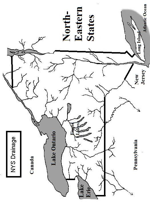
28 Formation of Deltas Drainage basin - the area where water from precipitation drains downhill into a body of water. Included streams and land areas. Watershed - Tributary - an area where water flows from - surface water (runoff) that feeds a river A creek or stream that flows into a larger body of water New York State Stream Drainage Using Page 3 of ESRT and Map 2 Directions: 1. On the accompanying NYS river system map and using your ESRT page 3, find and label the following rivers/bodies of water Hudson River Susquehanna River Lake Ontario St. Lawrence River Delaware River Mohawk River Lake Champlain Lake Erie Genesse River Finger Lakes 2. Use a blue pencil to trace the Hudson River and all of the tributaries to it. 3. Use green color to trace all the rivers and tributaries that ultimately flow into the Great Lakes system (that is, Lake Erie, Lake Ontario, and the St. Lawrence). Using that same color, lightly shade in the area of the 2 Great Lakes 4. Use a purple color to trace the streams that drain into Lake Champlain. Using that same color, lightly shade in the area of Lake Champlain. 5. Finally, use a yellow color to trace the streams of the Delaware and Susquehanna system 6. Use a RED pencil to draw in the approximate position of the divide of the major drainage systems in NYS. (Hint: Trace the line between all the rivers which flow north versus the ones that flow south!) 7. With a black pencil place an X where you think a delta would form on the map of NYS. Explain why you chose to put it where you did. Weathering, Erosion, and Deposition 28
29 29
30 Water Wind Waves Gravity Glaciers Sorting Sediments Appearance Erosional Landscape Features Depositional Features Weathering, Erosion, and Deposition 30


31 Weathering Erosion Review Use the diagram below to answer questions What climate conditions will cause the top layer to become thicker? 2. What is the name given to the top layer of soil? Use the diagram below to answer questions Which locations is the water moving the fastest? 4. Which locations will have the most deposition? 5. Label with a large arrow to show the fastest water. 6. Label with a small arrow the slowest water. Use the diagram below to answer questions Label the area with the highest amount of organic material. 8. Label the area with the least amount of organic material. 31


32 Use the following diagram to answer questions What causes this separation to occur? 10. What rock would form in zone C? 11. What zone would you find conglomerate rocks? 12. State at least two processes that formed this picture. Use the diagrams below to answer questions Which samples were deposited by water? 14. Which sample was deposited by three separate river flooding events? 15. Which samples was deposited by a glacier? 16. Which sample will water travel through the slowest? 17. Which sample would create shale? 18. Which sample could form conglomerate rock? 32

33 Use the picture below to answer questions What process is occurring in this series of pictures? 20. What sedimentary rock could be formed by the pile of clay minerals formed? 21. How does the surface area of the feldspar piece compare to the surface area of the pile of clay minerals? Use the picture below to answer questions The diagrams below show three stages of a river delta forming. 22. Which process is increasing between stage 1 and stage 3? 23. How does the size of the sediment change as you move from the shore line to the edge of the delta? 24. Why is the sand bar located in that position in the curve? Weathering, Erosion, and Deposition 33


34 Use the following picture to answer questions What characteristic of this valley Indicates it was formed by a glacier? 26. Describe two additional pieces of evidence that would be present in this valley to support your answer. 27. If this valley was in New York State, Which general direction would it run? 28. This structure is in the desert, what type of erosion could have formed this structure? 29. This structure is a deposit of sand, silt and clay. What type of deposition is this and where would it be found? Weathering, Erosion, and Deposition 34


35 30. How does the speed of the river at location A compare to the speed at location B? 31. What will happen to the shape of this boulder over time under these conditions? 32. What will happen to the calcite cement holding the sandstone together if acidic rainwater infiltrates? Weathering, Erosion, and Deposition 35
36 Read the following paragraph and answer questions 33 and Describe the arrangement of the sediment left behind by the glacier. 34. Where are glaciers usually found? 35. Some glaciers are found near the equator. What landform must be present for glaciers to occur? Read the following paragraph and answer question Name one test you could use to determine if the walls of the cavern are limestone. Weathering, Erosion, and Deposition 36
Weathering, Erosion, Deposition
 Weathering, Erosion, Deposition The breakdown of rocks at or near the Earth s Surface. Physical Chemical - The breakdown of rock into smaller pieces without chemical change. - Dominant in moist /cold conditions
Name: Which rock layers appear to be most resistant to weathering? A) A, C, and E B) B and D
 A, C, and E B) B and D") Name: 1) The formation of soil is primarily the result of A) stream deposition and runoff B) precipitation and wind erosion C) stream erosion and mass movement D) weathering and biological activity 2)
Name: 1) The formation of soil is primarily the result of A) stream deposition and runoff B) precipitation and wind erosion C) stream erosion and mass movement D) weathering and biological activity 2)
Unit 3 Review - Surface Processes
 Unit 3 Review - Surface Processes 1. Why is the surface of Mercury covered with meteor impact craters, while Earth s surface has relatively few craters? A) Mercury is larger than Earth, so it gets hit
What are the different ways rocks can be weathered?
 Romano - 223 What are the different ways rocks can be weathered? Weathering - the breakdown of rocks and minerals at the Earth s surface 1. 2. PHYSICAL WEATHERING Rock is broken into smaller pieces with
Name. 4. The diagram below shows a soil profile formed in an area of granite bedrock. Four different soil horizons, A, B, C, and D, are shown.
 Name 1. In the cross section of the hill shown below, which rock units are probably most resistant to weathering? 4. The diagram below shows a soil profile formed in an area of granite bedrock. Four different
Topic 6: Weathering, Erosion and Erosional-Deposition Systems (workbook p ) Workbook Chapter 4, 5 WEATHERING
 Workbook Chapter 4, 5 WEATHERING") Topic 6: Weathering, Erosion and Erosional-Deposition Systems (workbook p. 95-125) Workbook Chapter 4, 5 THE BIG PICTURE: Weathering, erosion and deposition are processes that cause changes to rock material
Topic 6: Weathering, Erosion and Erosional-Deposition Systems (workbook p. 95-125) Workbook Chapter 4, 5 THE BIG PICTURE: Weathering, erosion and deposition are processes that cause changes to rock material
Pratice Surface Processes Test
 1. The cross section below shows the movement of wind-driven sand particles that strike a partly exposed basalt cobble located at the surface of a windy desert. Which cross section best represents the
 Page 1 of 9 Name: Base your answer to the question on the diagram below. The arrows show the direction in which sediment is being transported along the shoreline. A barrier beach has formed, creating a
4. The map below shows a meandering stream. Points A, B, C, and D represent locations along the stream bottom.
 1. Sediment is deposited as a river enters a lake because the A) velocity of the river decreases B) force of gravity decreases C) volume of water increases D) slope of the river increases 2. Which diagram
Figure 1 The map shows the top view of a meandering stream as it enters a lake. At which points along the stream are erosion and deposition dominant?
 1. In which type of climate does chemical weathering usually occur most rapidly? 1. hot and dry 3. cold and dry 2. hot and wet 4. cold and wet 2. Figure 1 The map shows the top view of a meandering stream
Page 1. Name:
 Name: 1) Which event is the best example of erosion? dissolving of rock particles on a limestone gravestone by acid rain breaking apart of shale as a result of water freezing in a crack rolling of a pebble
1. The map below shows a meandering river. A A' is the location of a cross section. The arrows show the direction of the river flow.
 1. The map below shows a meandering river. A A' is the location of a cross section. The arrows show the direction of the river flow. Which cross section best represents the shape of the river bottom at
1. The diagram below shows the stump of a tree whose root grew into a small crack in bedrock and split the rock apart.
 1. The diagram below shows the stump of a tree whose root grew into a small crack in bedrock and split the rock apart. 4. Which process involves either a physical or chemical breakdown of earth materials?
1. Which type of climate has the greatest amount of rock weathering caused by frost action? A) a wet climate in which temperatures remain below
 a wet climate in which temperatures remain below") 1. Which type of climate has the greatest amount of rock weathering caused by frost action? A) a wet climate in which temperatures remain below freezing B) a wet climate in which temperatures alternate
1. Which type of climate has the greatest amount of rock weathering caused by frost action? A) a wet climate in which temperatures remain below freezing B) a wet climate in which temperatures alternate
Unit 4: Landscapes Practice Problems
 Name: Date: 1. Soil with the greatest porosity has particles that are A. poorly sorted and densely packed B. poorly sorted and loosely packed C. well sorted and densely packed D. well sorted and loosely
The boulder was most likely moved to this location by A) glacial ice B) prevailing wind C) streamfiow D) volcanic action
 glacial ice B) prevailing wind C) streamfiow D) volcanic action") 1. Which rock material was most likely transported to its present location by a glacier? A) rounded sand grains found in a river delta B) rounded grains found in a sand dune C) residual soil found on a
1. Which rock material was most likely transported to its present location by a glacier? A) rounded sand grains found in a river delta B) rounded grains found in a sand dune C) residual soil found on a
1. Any process that causes rock to crack or break into pieces is called physical weathering. Initial product = final product
 Weathering 1. Any process that causes rock to crack or break into pieces is called physical weathering. Initial product = final product End Result of physical weathering is increased surface area. 2. Physical
WEATHERING, EROSION & DEPOSITION STUDY GUIDE
 WEATHERING, EROSION & DEPOSITION STUDY GUIDE Weathering: The difference between mechanical & chemical weathering is: Sort terms as being mechanical/physical or chemical weathering: acid rain, root splitting
Page 1. Name:
 Name: 1) Which property would best distinguish sediment deposited by a river from sediment deposited by a glacier? thickness of sediment layers age of fossils found in the sediment mineral composition
Name: Mid-Year Review #2 SAR
 Name: Mid-Year Review #2 SAR Base your answers to questions 1 through 3 on on the diagram below, which shows laboratory materials used for an investigation of the effects of sediment size on permeability,
Weathering, Erosion, Deposition, and Landscape Development
 Weathering, Erosion, Deposition, and Landscape Development I. Weathering - the breakdown of rocks into smaller particles, also called sediments, by natural processes. Weathering is further divided into
unit 6 Review sheet 4. The photograph below shows a sandstone butte in an arid region. A. U-shaped valley B. V-shaped valley C. cliff D.
 Name: ate: 1. The large waterfall at Niagara Falls, New York, was originally located at the Niagara Escarpment. Which term best describes an escarpment? 4. The photograph below shows a sandstone butte
Class Notes: Surface Processes
 Name: Date: Period: Surface Processes The Physical Setting: Earth Science Class Notes: Surface Processes I. Weathering and Soils Weathering -! Sediments -! Weathering occurs when rocks are exposed to:
L.O: SLOWING STREAMS DEPOSIT (SORT) SEDIMENT HORIZONTALLY BY SIZE.
 SEDIMENT HORIZONTALLY BY SIZE.") L.O: SLOWING STREAMS DEPOSIT (SORT) SEDIMENT HORIZONTALLY BY SIZE. 1. Base your answer to the following question on the profile shown below, which shows the pattern of horizontal sorting produced at a
L.O: SLOWING STREAMS DEPOSIT (SORT) SEDIMENT HORIZONTALLY BY SIZE. 1. Base your answer to the following question on the profile shown below, which shows the pattern of horizontal sorting produced at a
Landscape. Review Note Cards
 Landscape Review Note Cards Last Ice Age Pleistocene Epoch that occurred about 22,000 Years ago Glacier A large, long lasting mass of ice which forms on land and moves downhill because of gravity. Continental
Which process is represented by letter F? A) capillarity B) infiltration C) condensation D) vaporization
 capillarity B) infiltration C) condensation D) vaporization") 1. Water's covalent bond is due to A) water's ability to stick to stick to other materials B) a slight negative charge of O and positive charge of H C) an uneven sharing of electrons D) both B and C 2.
1. Water's covalent bond is due to A) water's ability to stick to stick to other materials B) a slight negative charge of O and positive charge of H C) an uneven sharing of electrons D) both B and C 2.
Which landscape best represents the shape of the valleys occupied by glaciers? A) B) C) D)
 B) C) D)") 1. Glaciers often form parallel scratches and grooves in bedrock because glaciers A) deposit sediment in unsorted piles B) deposit rounded sand in V-shaped valleys C) continually melt and refreeze D) drag
1. Glaciers often form parallel scratches and grooves in bedrock because glaciers A) deposit sediment in unsorted piles B) deposit rounded sand in V-shaped valleys C) continually melt and refreeze D) drag
Ch 10 Deposition Practice Questions
 1. Base your answer to the following question on the data table below. Six identical cylinders, A through F, were filled with equal volumes of sorted spherical particles. The data table shows the particle
RR#6 - Multiple Choice
 1. Which agent of erosion is most likely responsible for the deposition of sandbars along ocean shorelines? 1) glaciers 2) mass movement 3) wave action 4) wind action 2. Why is the surface of Mercury covered
What is weathering and how does it change Earth s surface? Answer the question using
 7 th Grade Lesson What is weathering and how does it change Earth s surface? Answer the question using the sentence frame. You have 4 minutes. Weathering is. This changes the Earth s surface because. 1
Chapter 2. Wearing Down Landforms: Rivers and Ice. Physical Weathering
 Chapter 2 Wearing Down Landforms: Rivers and Ice Physical Weathering Weathering vs. Erosion Weathering is the breakdown of rock and minerals. Erosion is a two fold process that starts with 1) breakdown
HW #2 Landscape Travel from A to B 12,
 HW #2 Landscape 2016 Section: Name: ate: 1. ase your answer(s) to the following question(s) on the map below, which represents two bridges that cross the Green River. Letters,, and represent locations
Page Chemical weathering occurs most rapidly in climates which are (1) moist and warm (3) dry and cold (2) moist and cold (4) dry and warm
 moist and warm (3) dry and cold (2) moist and cold (4) dry and warm") 1. Chemical weathering occurs most rapidly in climates which are (1) moist and warm (3) dry and cold (2) moist and cold (4) dry and warm 2. At high elevations in New York State, which is the most common
1. Chemical weathering occurs most rapidly in climates which are (1) moist and warm (3) dry and cold (2) moist and cold (4) dry and warm 2. At high elevations in New York State, which is the most common
Erosion and deposition
 Name: ate: 1. ase your answer(s) to the following question(s) on the Earth Science Reference Tables, the diagram below, and your knowledge of Earth science. The diagram shows a cross section of the bedrock
Name Roy G Biv Page 1
 Name Roy G Biv Base your answers to questions 1 through 3 on the diagram below. The arrows show the direction in which sediment is being transported along the shoreline. A barrier beach has formed, creating
1. Base your answer to the following question on the map below, which shows the generalized bedrock of a part of western New York State.
 1. Base your answer to the following question on the map below, which shows the generalized bedrock of a part of western New York State. 3. The table below describes the deposits that an observer saw while
Weathering, Erosion and Deposition
 Weathering, Erosion and Deposition Shaping the Earth s Surface Weathering the process of breaking down rocks into smaller fragments Erosion the transport of rock fragments from one location to another
Name: KEY OBJECTIVES HYDROLOGY:
 Name: KEY OBJECTIVES Correctly define: abrasion, capillarity, deposition, discharge, erosion, evapotranspiration, hydrology, impermeable, infiltration, meander, permeable, porosity, water table, weathering,
Chapter 3 Erosion and Deposition. The Big Question:
 Chapter 3 Erosion and Deposition The Big Question: 1 Design a way to represent and describe the 4 types of mass movement. You may use pictures, diagrams, list, web, chart, etc 2 Chapter 3: Erosion and
Chapter 10. Running Water aka Rivers. BFRB Pages
 Chapter 10 Running Water aka Rivers BFRB Pages 101-116 Stream Erosion and Transportation Running water is all precipitation (rain, snow, etc) that falls on Earth and is pulled downhill by gravity. Running
Glaciers. 1. The photograph below shows the results of a landslide.
 Name: Date: 1. The photograph below shows the results of a landslide. This landslide is an example of A) wind abrasion B) glacial deposition C) wave action D) mass movement 2. Which agent of erosion is
Practice 3rd Quarter Exam Page 1
 Name 1. Which characteristic would most likely remain constant when a limestone cobble is subjected to extensive abrasion? A) shape B) mass C) volume D) composition 2. Which activity demonstrates chemical
Which particle of quartz shows evidence of being transported the farthest distance by the stream? A) B) C) D)
 B) C) D)") 1. Base your answer to the following question on the block diagram below, which represents the landscape features associated with a meandering stream. WX is the location of a cross section. Location A
1. Base your answer to the following question on the block diagram below, which represents the landscape features associated with a meandering stream. WX is the location of a cross section. Location A
SAMPLE Earth science BOOSTERS CARDS. Copyright Regents Boosters 2013 EARTH SCIENCE BOOSTERS 1
 SAMPLE Earth science BOOSTERS CARDS Copyright Regents Boosters 2013 EARTH SCIENCE BOOSTERS 1 Here is a selection from Earth Science Boosters on Deposition. Copyright Regents Boosters 2013 EARTH SCIENCE
EARTH S CHANGING SURFACE
 EARTH S CHANGING SURFACE Weathering Together, weathering and erosion work continuously to wear down the material on Earth s surface. weathering process that breaks down rock and other substances of Earth
Weathering, Erosion, and Deposition Guided Notes
 1. Weathering, Erosion, and Deposition 2. Outline Section 1: Weathering Section 2: Erosion Section 3: Deposition Section 4: Case Study Weathering, Erosion, and Deposition Guided Notes 3. Section 1: Weathering
Guided Notes Surface Processes. Erosion & Deposition By: Glaciers
 Guided Notes Surface Processes Erosion & Deposition By: Glaciers K. Coder 2015 26) How does moving ice erode and deposit sediments? Glaciers (Movement of Ice): a naturally formed mass of ice and snow that
Page 1. Weathering & Erosion by Mass Wasting Pre-Test. Name:
 Weathering & Erosion by Mass Wasting Pre-Test 3048-1 - Page 1 Name: 1) As a particle of sediment in a stream breaks into several smaller pieces, the rate of weathering of the sediment will A) increase
Midterm Review. Nata/Lee
 Name: 1. Which statement best supports the theory that all the continents were once a single landmass? (1) Rocks of the ocean ridges are older than those of the adjacent sea floor. (2) Rock and fossil
Surface Events & Landforms. Mrs. Green
 Surface Events & Landforms Mrs. Green Bell Work 1) Which event MOST likely causes the slowest change to the surface of Earth? a) Earthquake b) Landslide c) Volcano d) Wind 2) When cold weather freezes
EROSION AND DEPOSITION
 CHAPTER 8 EROSION AND DEPOSITION SECTION 8 1 Changing Earth s Surface (pages 252-255) This section explains how sediment is carried away and deposited elsewhere to wear down and build up Earth s surface.
Erosion and Deposition
 Erosion and Deposition Erosion Sediment natural forces move rock/soil from one place to another. gravity, water, wind, glaciers, waves are causes material moved by erosion Deposition when erosion lays
Erosion and Deposition
 CHAPTER 3 LESSON 2 Erosion and Deposition Landforms Shaped by Water and Wind Key Concepts What are the stages of stream development? How do water erosion and deposition change Earth s surface? How do wind
water erosion lithosphere Describe the process of erosion and deposition. chemical weathering Dissolving limestone is an example of.
 At one time, there was one large island off the coast of Mississippi and now it is two separate islands. What caused the island to be split into two? water erosion The crust and the top part of the upper
Pre-mid Year Review Please Don't write on the review packet
 1. Base your answer to the following question on the diagrams below, which represent two different solid, uniform materials cut into cubes A and B. 5. The data table below shows the mass and volume of
1/6/ th Grade Earth s Surface. Chapter 3: Erosion and Deposition. Lesson 1 (Mass Movement)
") Lesson 1 (Mass Movement) 7 th Grade Earth s Surface Chapter 3: Erosion and Deposition Weathering the chemical and physical processes that break down rock at Earth s surface Mechanical weathering when rock
Lesson 1 (Mass Movement) 7 th Grade Earth s Surface Chapter 3: Erosion and Deposition Weathering the chemical and physical processes that break down rock at Earth s surface Mechanical weathering when rock
1. Erosion by Running Water Most powerful cause of erosion
 I. Destructive Forces Notes: Destructive force: a process in which land is destroyed or changed such as weathering and erosion. All landforms are a result of a combination of constructive and destructive
Weathering of Rocks. Weathering - Breakdown of rocks into pieces (sediment) 2 main types of weathering to rocks
 2 main types of weathering to rocks") Weathering of Rocks Weathering - Breakdown of rocks into pieces (sediment) 2 main types of weathering to rocks Mechanical weathering requires physical forces to break rocks into smaller pieces. Chemical
Weathering of Rocks Weathering - Breakdown of rocks into pieces (sediment) 2 main types of weathering to rocks Mechanical weathering requires physical forces to break rocks into smaller pieces. Chemical
Section I: Multiple Choice Select the best answer to each question. Mark your final answer on the answer sheet. (1 pt each)
") Sedimentary Rocks & Surface Processes Quest Name: Earth Science 2013 Block: Date: Section I: Multiple Choice Select the best answer to each question. Mark your final answer on the answer sheet. (1 pt each)
Sedimentary Rocks & Surface Processes Quest Name: Earth Science 2013 Block: Date: Section I: Multiple Choice Select the best answer to each question. Mark your final answer on the answer sheet. (1 pt each)
MASS MOVEMENTS, WIND, AND GLACIERS
 Date Period Name MASS MOVEMENTS, WIND, AND GLACIERS SECTION.1 Mass Movements In your textbook, read about mass movements. Use each of the terms below just once to complete the passage. avalanche creep
Mass Movements, Wind, and Glaciers
 Mass Movements,, and Glaciers SECTION 8.1 Mass Movement at Earth s Surface In your textbook, read about mass movement. Use each of the terms below just once to complete the passage. avalanche creep landslide
Name Regents Review #6 Date
 Name Regents Review #6 Date 1. Which profile best shows the general depositional pattern that occurs when water from a stream enters the ocean? 2. Which long-term atmospheric changes would increase the
TEACHER BACKGROUND KNOWLEDGE. Surface Processes: Weathering and Erosion
 TEACHER BACKGROUND KNOWLEDGE Surface Processes: Weathering and Erosion Core Concepts Precipitation (caused by the water cycle) and wind cause rocks to be broken into smaller pieces in the process called
Read Across America. Listen as I read for facts about Volcanoes. In the Shadow of the Volcano
 Read Across America Listen as I read for facts about Volcanoes. In the Shadow of the Volcano Constructive & Destructive Processes Earth s surface is always changing. Blowing wind and flowing water causes
Changing Earth s Surface
 Name Date Class Changing Earth s Surface What processes wear down and build up Earth s surface? What causes the different types of mass movement? Erosion is the process by which natural forces move weathered
Name: Answer Key Date: Period:
 Name: Answer Key Date: Period: Earth Science Final Exam Study Guide Ch 1: Mapping 1. On the global grid, the equator is at 0 degrees. Is the equator a line of longitude or latitude? Latitude 2. What type
Chapter 2. Denudation: Rivers and Ice
 Chapter 2. Denudation: Rivers and Ice DENUDATION: process that lowers level of land - caused by rivers, glaciers, waves & wind - involves processes of WEATHERING & EROSION Weathering Def: breakdown of
3 Erosion and Deposition by Ice
 CHAPTER 12 3 Erosion and Deposition by Ice SECTION Agents of Erosion and Deposition BEFORE YOU READ After you read this section, you should be able to answer these questions: What are glaciers? How do
Earth s Dynamic Surface
 Earth s Dynamic Surface Key Concepts What is the difference between physical and chemical weathering? How do water, ice, and wind change Earth s surface? Changing Earth s Surface What do you think? Read
TAKE HOME EXAM 8R - Geology
 Name Period Date TAKE HOME EXAM 8R - Geology PART 1 - Multiple Choice 1. A volcanic cone made up of alternating layers of lava and rock particles is a cone. a. cinder b. lava c. shield d. composite 2.
Sediment and sedimentary rocks Sediment
 Sediment and sedimentary rocks Sediment From sediments to sedimentary rocks (transportation, deposition, preservation and lithification) Types of sedimentary rocks (clastic, chemical and organic) Sedimentary
Name HW - Landscapes
 Name HW - Landscapes 1. New York s Tug Hill landscape region is classified as a plateau because this region has a A) high elevation with distorted bedrock B) high elevation with nearly horizontal layers
Which map shows the stream drainage pattern that most likely formed on the surface of this volcano? A) B)
 B)") 1. When snow cover on the land melts, the water will most likely become surface runoff if the land surface is A) frozen B) porous C) grass covered D) unconsolidated gravel Base your answers to questions
1. When snow cover on the land melts, the water will most likely become surface runoff if the land surface is A) frozen B) porous C) grass covered D) unconsolidated gravel Base your answers to questions
1 Shoreline Erosion and Deposition
 CHAPTER 12 1 Shoreline Erosion and Deposition SECTION Agents of Erosion and Deposition BEFORE YOU READ After you read this section, you should be able to answer these questions: What is a shoreline? How
Streams. Water. Hydrologic Cycle. Geol 104: Streams
 Streams Why study streams? Running water is the most important geologic agent in erosion, transportation and deposition of sediments. Water The unique physical and chemical properties of water make it
Weathering and Erosion
 Have you ever looked at the land around you and wondered how it was shaped? The geologic features that help define the world are still being shaped by the natural processes of weathering, erosion, and
Surface Processes. Water Cycle. Evaporation Transpiration Condenstation Precipitation Infiltration Runoff
 s e s s roce S P e c urfa s e s s e c o r P e s c d r a a f C r Su iew Note v e R Water Cycle Evaporation Transpiration Condenstation Precipitation Infiltration Runoff Runoff The moving of water along
10/27/2014. Surface Processes. Surface Processes. Surface Processes. Surface Processes. Surface Processes
 Hewitt/Lyons/Suchocki/Yeh Conceptual Integrated Science Chapter 25 Surface or surficial processes originate at Earth's surface and reshape its contours. Surface processes include: Weathering Erosion Deposition
Grade 5 Hands on Science Weathering, Erosion and Deposition
 Grade 5 Hands on Science Weathering, Erosion and Deposition Objective: To demonstrate and investigate the effect of weathering, water and wind erosion and the subsequent deposition into landforms. Background:
Erosion and Deposition
 Erosion and Deposition The Erosion-Deposition Process What do you think? Read the two statements below and decide whether you agree or disagree with them. Place an A in the Before column if you agree with
C) use of nuclear power D) number of volcanic eruptions
 use of nuclear power D) number of volcanic eruptions") 3121-1 - Page 1 Name: 1) The graph below shows the change in carbon dioxide concentration in parts per million (ppm) in Earth's atmosphere from 1960 to 1990. The most likely cause of the overall change
3121-1 - Page 1 Name: 1) The graph below shows the change in carbon dioxide concentration in parts per million (ppm) in Earth's atmosphere from 1960 to 1990. The most likely cause of the overall change
Weathering Notes. When the mineral composition of the rock is changed
 Weathering Notes Weathering Weathering is the breaking down on rocks into smaller pieces Two types of weathering o Physical (mechanical) When the mineral composition of the rock isn t changed Ex: Smashing
Erosion Surface Water. moving, transporting, and depositing sediment.
 + Erosion Surface Water moving, transporting, and depositing sediment. + Surface Water 2 Water from rainfall can hit Earth s surface and do a number of things: Slowly soak into the ground: Infiltration
3. The map below shows an eastern portion of North America. Points A and B represent locations on the eastern shoreline.
 1. Most tornadoes in the Northern Hemisphere are best described as violently rotating columns of air surrounded by A) clockwise surface winds moving toward the columns B) clockwise surface winds moving
Glacial Erosion Polished on front side Glacial striations (scratches) on top
 on top") St Mary s Cemetery Glacial Erosion Polished on front side Glacial striations (scratches) on top Weathering Water channel in the rock mechanical weathering Some rocks eroding faster than others mechanical
St Mary s Cemetery Glacial Erosion Polished on front side Glacial striations (scratches) on top Weathering Water channel in the rock mechanical weathering Some rocks eroding faster than others mechanical
Prentice Hall EARTH SCIENCE
 Prentice Hall EARTH SCIENCE Tarbuck Lutgens Chapter 7 Glaciers, Desert, and Wind 7.1 Glaciers Types of Glaciers A glacier is a thick ice mass that forms above the snowline over hundreds or thousands of
Tips for Success on a Test
 Number of Incorrect: Final Grade: Parent Signature: Top Tips for Success on a Test 1. Read the following statements at least two times. 2. Circle the key words in each question/ or statement. (*Remember
Science EOG Review: Landforms
 Mathematician Science EOG Review: Landforms Vocabulary Definition Term canyon deep, large, V- shaped valley formed by a river over millions of years of erosion; sometimes called gorges (example: Linville
As compaction and cementation of these sediments eventually occur, which area will become siltstone? A) A B) B C) C D) D
 A B) B C) C D) D") 1. A student obtains a cup of quartz sand from a beach. A saltwater solution is poured into the sand and allowed to evaporate. The mineral residue from the saltwater solution cements the sand grains together,
1. A student obtains a cup of quartz sand from a beach. A saltwater solution is poured into the sand and allowed to evaporate. The mineral residue from the saltwater solution cements the sand grains together,
Lecture Outline Wednesday - Friday February 14-16, 2018
 Lecture Outline Wednesday - Friday February 14-16, 2018 Quiz 2 scheduled for Friday Feb 23 (Interlude B, Chapters 6,7) Questions? Chapter 6 Pages of the Past: Sedimentary Rocks Key Points for today Be
Potential short answer questions: What is Pangea? Describe at least 4 pieces of evidence that led Wegener to suggest the theory of Continental Drift.
 6th Grade Earth Science Fall Semester Mid-Term Study Guide The mid-term may include: 4 short answer questions,1-2 sketches to draw and/or label, 4 partially filled charts which you should complete, 30
A physical feature of the Earth s surface
 Earth s Landforms A physical feature of the Earth s surface A physical feature of the Earth s surface LANDFORM Highest of Earth s physical features Highest of Earth s physical features MOUNTAIN Low area
Weather. Weathering: Physical. and. of the rock. - roots grow. into and. Root Action. rocks - roots pry. freezing and
 Weather ring, Erosion and Deposition Weathering: The breakdown of rocks into smaller particles Types of Weathering: Physical and Chemical Physical Weathering - Does not change the composition of the rock
B) color B) Sediment must be compacted and cemented before it can change to sedimentary rock. D) igneous, metamorphic, and sedimentary rocks
 color B) Sediment must be compacted and cemented before it can change to sedimentary rock. D) igneous, metamorphic, and sedimentary rocks") 1. Which characteristic of nonsedimentary rocks would provide the least evidence about the environment in which the rocks were formed? A) structure B) color C) crystal size D) mineral composition 2. Which
1. Which characteristic of nonsedimentary rocks would provide the least evidence about the environment in which the rocks were formed? A) structure B) color C) crystal size D) mineral composition 2. Which
The Marine Environment
 The Marine Environment SECTION 16.1 Shoreline Features In your textbook, read about erosional landforms, beaches, estuaries, longshore currents, and rip currents. For each statement below, write or. 1.
Sediment and Sedimentary rock
 Sediment and Sedimentary rock Sediment: An accumulation of loose mineral grains, such as boulders, pebbles, sand, silt or mud, which are not cemented together. Mechanical and chemical weathering produces
Lab 7: Sedimentary Structures
 Name: Lab 7: Sedimentary Structures Sedimentary rocks account for a negligibly small fraction of Earth s mass, yet they are commonly encountered because the processes that form them are ubiquitous in the
UNIT 4: Earth Science Chapter 21: Earth s Changing Surface (pages )
") CORNELL NOTES Directions: You must create a minimum of 5 questions in this column per page (average). Use these to study your notes and prepare for tests and quizzes. Notes will be turned in to your teacher
CORNELL NOTES Directions: You must create a minimum of 5 questions in this column per page (average). Use these to study your notes and prepare for tests and quizzes. Notes will be turned in to your teacher
Glaciers form wherever snow and ice can accumulate High latitudes High mountains at low latitudes Ice temperatures vary among glaciers Warm
 The Cryosphere Glaciers form wherever snow and ice can accumulate High latitudes High mountains at low latitudes Ice temperatures vary among glaciers Warm (temperate) glaciers: at pressure melting point,
8UNIT. External dynamics of the Earth. What do you remember? Key language. Content objectives
 8UNIT External dynamics of the Earth What do you remember? Can you name the solids in the photograph? nd the liquid? Is the liquid moving? How does it move? What is the name of this formation of water?