Real time Monitoring System for Earthquakes and Tsunamis (DONET)
|
|
|
- Kelley Walters
- 6 years ago
- Views:
Transcription
 POGO@Seoul")
1 Real time Monitoring System for Earthquakes and Tsunamis (DONET) NankaiTrough Yoshiyuki Kaneda Japan Agency for Marine-Earth Science and Technology (JAMSTEC) Presentation 1


2 Earthquakes in the Nankai Trough Tokyo Osaka Nagoya Tokai Hyuga nada Nankai 5-6cm/y Tonankai 2-3cm/y 4-5cm/y DONET target area Seismogenic Zone Philippine Sea Plate M8+ class earthquakes occur every years. 2 2
3 The historical EQs. around the Nankai trough Complex recurrence patterns! 1707 CD(TONANKAI) + E(TOKAI) + AB(NANKAI) 1854 CD(TONANKAI) + E(TOKAI) 32hours AB(NANKAI) 1944 CD(TONANKAI) 2years AB(NANKAI) 1946 M8 class EQs. are occurring with the interval of years 3
")
4 Simulation of Earthquake Occurrence in the Nankai Trough Relative velocity along to the plate boundary Earthquake Nankai Tonankai Tokai Coupled (Non Earthquake) 4

5 Simulation of Earthquake Occurrence in the Nankai Trough Variations of recurrence patterns are simulated qualitatively. First ruptures are starting from the Tonankai seismogenic zone. These results are consistent with past two earthquakes 1944/1946 and1854 EQs. The Tonankai seismogenic zone is very important field to understand the recurrence system of mega thrust earthquakes around the Nankai trough. 5
6 Dense Ocean floor Network System for Earthquakes and Tsunamis DONET Real time monitoring system for Seismogenic zone 6

7 Concept of DONET Osaka Tokyo Number of Science Node : 5 Nodes Number of User Interface : 8 ports / Node Power Distribution : 30 W / Port Data Transmission : 50 Mbit / s / Port Precise Timing Control : < 1μsec 7

 Micro earthquake: 0.")

8 Ground Motion Sensing System Observation Target : Broad Band Phenomena Long period seismic wave: Hz; m/s 2 - (at 0.05Hz) Micro earthquake: Hz; m/s 2 (at10hz) Large earthquake: Hz; m/s 2 (at 10Hz) Strong motion accelerometer Gimbals Mechanism Broadband seismometer


9 Pressure Sensing System and Peripherals Observation Target : Broad Band Phenomena Crustal Deformation: 1day sec; >1 Pa Tsunami: sec; >1 Pa Long period seismic wave: Hz; >1 Pa Micro earthquake: Hz; >1 Pa Large earthquake: Hz; >3MPa differential pressure gauge quartz pressure gauge hydrophone precision thermometer for sensor calibration
10 Dense network array Concept of DONET Multi kinds of seismometers and pressure sensors Redundancy: Equipping redundant configuration on backbone cable and node Expandability: Branching unit enables wide-spread distribution of observation points. Node plays the role of hub that connects underwater instruments to the backbone cable system. Replaceable function: Replacing observation unit at the seafloor by using underwater removable connector Maintainability: Operation on the seafloor by using Remotely Operated Vehicle (ROV) 10

11 Data transfer system (DONET)


12 Landing Station Node Branching Unit 1900m Backbone Cable 4300m Ground Motion Sensing System Pressure Sensing System and Peripherals Extension Cable Remotely operated vehicle 12


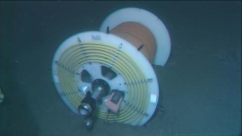
13 Installation of Science Node Japanese research ROV Hyper Dolphin Installed Termination Equipment N, E,Depth:2009m Construction of Installation hole for seismometer Port Installation hole Installation of sensors N, E Installed Science Node(A010) N, E,Depth:2009m

14 Movie of DONET deployment 14


15 Installation of DONET(2011 Jan.) 8 Observatories are working 5 Nodes are deployed Construction of Installation hole for seismometer Installation of seismometer Deployment of extension cable Installation of sensors

16 Choosing appropriate sensors for target phenomena DONET sensor chooses seismometers and pressure gauges suitable to observe very small to large earthquakes, Tsunamis, and slow ground deformation. We need set of sensors of very broad frequency range and wide dynamic range. Tsunamis Slow ground deformation Long period Seismic waves Earthquakes Slow ground deformation Long period Seismic waves Earthquakes

17 Earthquake early warning 4sec 2sec 4sec 2sec 4sec 2sec The red parts show the DONET detects earthquakes earlier than land stations. 17

18 Tsunami early warning 0.1=6min 0.1=6min 0.2=12min 0.2=12min The red parts show the DONET detects tsunamis earlier than land stations. 18


19 2010/08/13 21:19 (UTC) Mariana (M=6.9) Location:12.5N, 141.5E Depth:10km (USGS) Broadband seismometer DONET Strong motion accelero meter Seismic wave Pressure gauge Observed Tsunami sec Pressure gauge 19
 The seismic signals recorded by the DONET installed in the Kumano-nada reached 5 to 10 seconds earlier than land stations.")
20 2010/10/16 16:59(JST) Kumano-nada (M=2.3) DONET data (Sea bottom) NanTro SEIZE area :Earthquake Epicenter Location:33.3N, 136.9E Depth:47.3km (JMA) The seismic signals recorded by the DONET installed in the Kumano-nada reached 5 to 10 seconds earlier than land stations. 10sec Hi-NET data (Land station) 20


21 Tsunami observation by the ocean-bottom pressure gauges of DONET: An earthquake off Marianas on 13, August, 2010 JMA OWASE DONET KMA03 21:19 August 13, 2010 (UTC) Epicenter : off Marianas Depth :12 km Mw : 6.9 Position of DONET observation point and JMA Normal fault with some strike slip compornent 21
22 Comparison of the observed tsunami between the offshore and costal stations DONET KMA03 JMA OWASE Original seismic wave 1 cm Tsunami 10 cm Tsunami Band-pass filtered ( sec) noise level 0.5 cm noise level 5 cm Earthquake occurrence time DONET Data The tsunami signal is very clear in comparison with the background noise. The seismic wave is also recorded at the data. Non-linearity of tsunami propagation could not be required because of open sea observations 22
23 DONET 2 23


24 DONET 2 Concept A similar seafloor network system (DONET2) is needed for region off Kii Peninsula and Shikoku to decrease disasters caused by the seduction zone earthquakes in the Nankai Trough. Achievement of early detection of earthquake and tsunami in a wider area Advancement of earthquake occurrence simulation Development of Most Advanced and Leading Technologies DONET2 24
25 DONET2 High Voltage System After DONET completion, move on to DONET2 with High Voltage System, then observational area expand to the Nankai seismogenic zone Middle voltage system 3000V High voltage system 10KV Cable length 300km + DONET type NODE 5 (40 ocean floor sites) Cable length1000km + DONET type NODE over 10 (100 ocean floor sites) DONET1 DONET2 25
26 Improvement of Simulation Models -Data assimilation- Observation data Predict 2 Predict (n) Optimization Time range for data assimilation Long term predict using predict (n) time Improvement Simulation model Without improvement Improvement time 26
")
27 Expected slip velocity on the plate interface before the Tonankai earthquake Fast (rupture) Slip acceleration before Tonankai earthquake Red:DONET1 Blue and Green:DONET2 Slow (locked) 27


28 Expected seafloor crustal deformation before the Tonankai earthquake Slip acceleration before Tonankai earthquake DONET1(Node E) Vertical displacement Tonankai Earthquake Subsidence Uplift 1cm Years before Tonankai Earthquake 28
29 Expected slip velocity on the plate interface after the Tonankai earthquake Fast (rupture) After slip of Tonankai earthquake propagates westward and triggers nucleation of Nankai earthquake starts Slow (locked) 29

30 Expected seafloor crustal deformation after the Tonankai earthquake Simulation of Nankai earthquake After slip of Tonankai earthquake Slip acceleration following after slip Tonankai Vertical displacement Nankai Tonankai Vertical displacement Subsidence Uplift Nankai Days after Tonankai earthquake Days after Tonankai earthquake Days after Tonankai earthquake Vertical displacement Tonankai Nankai 30 30


31 DONET, DONET2, and DONET3 Tokyo Osaka Nagoya DONET DONET2 DONET3 Extended Part 31

32 Collaboration and Integration Further, we have to develop more network systems ESONET DONET: JAPAN MACHO: TAIWAN Korea:? NEPTUNE CANADA/US Seoul Tokyo INDIAN OCEAN SOUTH AMERICA Map: Wikipedia The international collaboration is very important 32

 of DONET.")
33 Connection of NantroSEIZE borehole observatories These observatories will be connected to DONET to assure long-term monitoring. Riser ~ 2.5km hole Riser less ~ 1km hole below sediment layer. Riser less ~ 500m hole penetrating shallow splay fault Location of the borehole observatories are planned within the reach (10km or 20km) of DONET. Connection of the borehole observatories will be funded as a part of JAMSTEC s borehole observatory project (not by DONET). 33
 thermometer Sensor career (clinometer, seismometer) Packer")

34 Appearance of Installation of Long-term borehole measuring device broadband seismometer m depth Seafloor surface hole entrance device Screen (The hole to measure for Stratum Temperature/pressure ) thermometer Sensor career (clinometer, seismometer) Packer (Blockage of inside of casing) Casing (about 24.4cm in diameter) 888m Strain indicator (Depth of casing) Head_Landing_5times.avi on desktop cement [photo] descent to moat grinding borehole of the appearance of installation of long-term The photograph of appearance of work for seafloor at an unmanned probe on Dec. 8th, 2011 Video (five times faster) Head_Landing_5times.avi on desktop 34 seawater 987m (moat grinding depth) Reference : CDEX/JAMSTEC


35 Advanced estimation of the earthquake and Tsunami Evaluate of Seismic Linkage around the Nankai trough Ocean floor network system Seismogenic zone drilling Simulation Precise survey DONET CHIKYU Super Computer R/V KAIREI Prevention and mitigation It s important to collaborate with many countries 35

36 Thank you for your attention 36
Dense Ocean floor Network System for Earthquakes and Tsunamis DONET
 Dense Ocean floor Network System for Earthquakes and Tsunamis DONET Yoshiyuki Kaneda Japan Agency for Marine-Earth Science and Technology (JAMSTEC) ION 1 Earthquakes in the Nankai Trough Tokai Nankai Hyuga
Real Time Monitoring System for Megathrust Earthquakes and Tsunamis - Cabled Network System and Buoy System in Japan -
 Real Time Monitoring System for Megathrust Earthquakes and Tsunamis - Cabled Network System and Buoy System in Japan - 1 Subduction zones around the world Haiti Italy Turkey Tohoku Sichuan Taiwan Sumatra
Japan Agency for Marine-Earth Science and Technology (JAMSTEC), 2-15 Natsushima-cho, Yokosuka JAPAN
, 2-15 Natsushima-cho, Yokosuka JAPAN") Dense Ocean floor Network System for Mega Thrust Earthquakes & Tsunamis(DONET) -Towards Understanding Mega Thrust Earthquakes, the Geohazard & Disaster Mitigation- Yoshiyuki KANEDA, Katsuyoshi KAWAGUCHI,
Dense Ocean floor Network System for Mega Thrust Earthquakes & Tsunamis(DONET) -Towards Understanding Mega Thrust Earthquakes, the Geohazard & Disaster Mitigation- Yoshiyuki KANEDA, Katsuyoshi KAWAGUCHI,
JAMSTEC Marine Geophysical Projects for Researches on Subduction Cycles and Deformation
 JAMSTEC Marine Geophysical Projects for Researches on Subduction Cycles and Deformation Shuichi Kodaira Research Center for Earthquake and Tsunami JAMSTEC JAMSTEC Marine Geophysical Projects Motivation:
Depth-dependent slip regime on the plate interface revealed from slow earthquake activities in the Nankai subduction zone
 2010/10/11-14 Earthscope Workshop Depth-dependent slip regime on the plate interface revealed from slow earthquake activities in the Nankai subduction zone Kazushige Obara, ERI, Univ. Tokyo Recurrence
Seismic Activity and Crustal Deformation after the 2011 Off the Pacific Coast of Tohoku Earthquake
 J-RAPID Symposium March 6-7, 2013 Seismic Activity and Crustal Deformation after the 2011 Off the Pacific Coast of Tohoku Earthquake Y. Honkura Tokyo Institute of Technology Japan Science and Technology
Submarine Cabled Real-time Seafloor Observatory and Subsea Engineering ROV for Observatory Construction
 Submarine Cabled Real-time Seafloor Observatory and Subsea Engineering ROV for Observatory Construction Katsuyoshi KAWAGUCHI, Sho Kaneko (Japan Agency for Marine-earth Science and Technology), Takato Nishida
NT10-09 Cruise Report KUMANO-NADA DONET Node Installation & Observatory Construction
 NT10-09 Cruise Report KUMANO-NADA DONET Node Installation & Observatory Construction June 2010 Table of Contents 1. Overview 2. Schedule 3. Dive Summary 4. Concluding Remarks 1. Overview DONET is a program
Cruise report of KY11-06 Leg1
 Cruise report of KY11-06 Leg1 Cruise : KY11-06 /Leg1 / R/V Kaiyo Research subject: Construction of Seafloor observation Network for Earthquakes and Tsunamis Research Proposal by: Yoshiyuki KANEDA/JAMSTEC
Crustal deformation by the Southeast-off Kii Peninsula Earthquake
 Crustal deformation by the Southeast-off Kii Peninsula Earthquake 51 Crustal deformation by the Southeast-off Kii Peninsula Earthquake Tetsuro IMAKIIRE, Shinzaburo OZAWA, Hiroshi YARAI, Takuya NISHIMURA
Japan Agency for Marine-Earth Science and Technology (JAMSTEC), 2-15 Natsushima-cho, Yokosuka, Kanagawa, , JAPAN
, 2-15 Natsushima-cho, Yokosuka, Kanagawa, , JAPAN") LARGE EARTHQUAKE AND ASSOCIATED PHENOMENA OBSERVED WITH SEAFLOOR CABLED OBSERVATORY NEAR EPICENTER - AN IMPLICATION FOR POSSIBLE ADDITIONAL MEASUREMENT WITH TELECOMMUNICATION NETWORKS FOR IDENTIFICATION
LARGE EARTHQUAKE AND ASSOCIATED PHENOMENA OBSERVED WITH SEAFLOOR CABLED OBSERVATORY NEAR EPICENTER - AN IMPLICATION FOR POSSIBLE ADDITIONAL MEASUREMENT WITH TELECOMMUNICATION NETWORKS FOR IDENTIFICATION
Cruise report of R/V Kaiyo KY10-07 cruise. "Installation of Earthquake and Tsunami monitoring system"
 Cruise report of R/V Kaiyo KY10-07 cruise. "Installation of Earthquake and Tsunami monitoring system" Kumano-nada, off Shiono-misaki, the Nankai Trough Earthquake and Tsunami research project for Disaster
arxiv: v1 [physics.geo-ph] 31 Dec 2013
![arxiv: v1 [physics.geo-ph] 31 Dec 2013](/thumbs/95/125064092.jpg "arxiv: v1 [physics.geo-ph] 31 Dec 2013") Comparing the Nano-Resolution Depth Sensor to the Co-located Ocean Bottom Seismometer at MARS Elena Tolkova 1, Theo Schaad 2 1 NorthWest Research Associates 2 Paroscientific, Inc., and Quartz Seismic Sensors,
Comparing the Nano-Resolution Depth Sensor to the Co-located Ocean Bottom Seismometer at MARS Elena Tolkova 1, Theo Schaad 2 1 NorthWest Research Associates 2 Paroscientific, Inc., and Quartz Seismic Sensors,
A Technical Report on the Advanced Real-time Earth Monitoring Network in the Area (ARENA) Chapter 1: Preface. ver1.0. Contents
 Chapter 1: Preface. ver1.0. Contents") A Technical Report on the Advanced Real-time Earth Monitoring Network in the Area (ARENA) Chapter 1: Preface ver1.0 Contents 1.1Introduction 1.2Present state of scientific submarine cables in Japan 1.3Achievements
A Technical Report on the Advanced Real-time Earth Monitoring Network in the Area (ARENA) Chapter 1: Preface ver1.0 Contents 1.1Introduction 1.2Present state of scientific submarine cables in Japan 1.3Achievements
Notes on Comparing the Nano-Resolution Depth Sensor to the Co-located Ocean Bottom Seismometer at MARS
 Notes on Comparing the Nano-Resolution Depth Sensor to the Co-located Ocean Bottom Seismometer at MARS Elena Tolkova, Theo Schaad 1 1 Paroscientific, Inc., and Quartz Seismic Sensors, Inc. October 15,
Electrical Conductivity Structures around Seismically Locked Regions
 Electrical Conductivity Structures around Seismically Locked Regions Tada-nori Goto Program for Deep Sea Research, IFREE, Japan Agency for Marine-Earth Science and Technology 1. Introduction Existence
Source modeling of hypothetical Tokai-Tonankai-Nankai, Japan, earthquake and strong ground motion simulation using the empirical Green s functions
 Source modeling of hypothetical Tokai-Tonankai-Nankai, Japan, earthquake and strong ground motion simulation using the empirical Green s functions Y. Ishii & K. Dan Ohsaki Research Institute, Inc., Tokyo
Lessons from the 2004 Sumatra earthquake and the Asian tsunami
 Lessons from the 2004 Sumatra earthquake and the Asian tsunami Kenji Satake National Institute of Advanced Industrial Science and Technology Outline 1. The largest earthquake in the last 40 years 2. Tsunami
New Seismic Activity Model of Large Earthquakes along Nankai Trough for Probabilistic Seismic Hazard Maps
 New Seismic Activity Model of Large Earthquakes along Nankai Trough for Probabilistic Seismic Hazard Maps Toshihiko Okumura (Shimizu Corp.) Hiroyuki Fujiwara (NIED) Plate Tectonics around Japan Pacific
KR09-08 Cruise: Walkaway VSP shooting in the Nankai Trough off Kumano
 Preliminary Report on KR09-08 Cruise: Walkaway VSP shooting in the Nankai Trough off Kumano July 19 July 25, 2009 Yokosuka - Shingu Masataka Kinoshita (IFREE-JAMSTEC) KR09-08 Shipboard Science Party Acknowledgments
Amplification of Tsunami Heights by Delayed Rupture of Great Earthquakes along the Nankai Trough
 Amplification of Tsunami Heights by Delayed Rupture of Great Earthquakes along the Nankai Trough Kentaro Imai 1,2, Kenji Satake 2 and Takashi Furumura 1,2 1 Center for Integrated Disaster Information Research,
The great earthquakes that have shaped Japan 日本に大きな影響を与えた地震
 The great earthquakes that have shaped Japan 日本に大きな影響を与えた地震 Brian Kennett, Research School of Earth Sciences, ANU Takashi Furumura Earthquake Research Institute, University of Tokyo Japan tectonic plates
Groundwater and Coastal Phenomena Preceding the 1944 Tsunami (Tonankai Earthquake)
") Groundwater and Coastal Phenomena Preceding the 1944 Tsunami (Tonankai Earthquake) Masataka Ando Institute of Earth Sciences, Academia Sinica ando@earth.sinica.edu.tw Study Area Characteristics of large
Groundwater and Coastal Phenomena Preceding the 1944 Tsunami (Tonankai Earthquake) Masataka Ando Institute of Earth Sciences, Academia Sinica ando@earth.sinica.edu.tw Study Area Characteristics of large
Slip distributions of the 1944 Tonankai and 1946 Nankai earthquakes including the horizontal movement effect on tsunami generation
 Slip distributions of the 1944 Tonankai and 1946 Nankai earthquakes including the horizontal movement effect on tsunami generation Toshitaka Baba Research Program for Plate Dynamics, Institute for Frontier
JMA Tsunami Warning Services. Takeshi KOIZUMI Senior Coordinator for International Earthquake and Tsunami Information Japan Meteorological Agency
 JMA Tsunami Warning Services Takeshi KOIZUMI Senior Coordinator for International Earthquake and Tsunami Information Japan Meteorological Agency Tectonic Setting of Japan (Headquarters for Earthquake Research
Long-period Ground Motion Characteristics of the Osaka Sedimentary Basin during the 2011 Great Tohoku Earthquake
 Long-period Ground Motion Characteristics of the Osaka Sedimentary Basin during the 2011 Great Tohoku Earthquake K. Sato, K. Asano & T. Iwata Disaster Prevention Research Institute, Kyoto University, Japan
Earthquake,Tsunami,Volcano Monitoring & Warning System in Korea. Jimin Lee Earthquake & Volcano Monitoring Division KMA
 Earthquake,Tsunami,Volcano Monitoring & Warning System in Korea Jimin Lee Earthquake & Volcano Monitoring Division KMA 1 2 Brief History & Vision of KMA Introduction of Services 3 Korea National Seismographic
Source Characteristics of Large Outer Rise Earthquakes in the Pacific Plate
 Source Characteristics of Large Outer Rise Earthquakes in the Pacific Plate T. Sasatani, N. Takai, M. Shigefuji, and Y. Miyahara Hokkaido University, Sapporo, Japan W. Kawabata Electric Power Development
JMA Tsunami Warning Services. Tomoaki OZAKI Senior Coordinator for Tsunami Forecast Modeling Japan Meteorological Agency
 JMA Tsunami Warning Services Tomoaki OZAKI Senior Coordinator for Tsunami Forecast Modeling Japan Meteorological Agency Organization Chart of the Government of Japan Cabinet Office Diet Ministry of Internal
SOURCE MODELING OF SUBDUCTION-ZONE EARTHQUAKES AND LONG-PERIOD GROUND MOTION VALIDATION IN THE TOKYO METROPOLITAN AREA
 SOURCE MODELING OF SUBDUCTION-ZONE EARTHQUAKES AND LONG-PERIOD GROUND MOTION VALIDATION IN THE TOKYO METROPOLITAN AREA ABSTRACT : Hiroe Miyake 1, Kazuki Koketsu 2, and Takashi Furumura 3,2 1 Assistant
Recent Progress of Seismic Observation Networks in Japan
 Journal of Physics: Conference Series Recent Progress of Seismic Observation Networks in Japan To cite this article: Y Okada 2013 J. Phys.: Conf. Ser. 433 012039 Related content - Physical applications
Sendai Earthquake NE Japan March 11, Some explanatory slides Bob Stern, Dave Scholl, others updated March
 Sendai Earthquake NE Japan March 11, 2011 Some explanatory slides Bob Stern, Dave Scholl, others updated March 14 2011 Earth has 11 large plates and many more smaller ones. Plates are 100-200 km thick
Coseismic slip distribution of the 1946 Nankai earthquake and aseismic slips caused by the earthquake
 Earth Planets Space, 53, 235 241, 2001 Coseismic slip distribution of the 1946 Nankai earthquake and aseismic slips caused by the earthquake Yuichiro Tanioka 1 and Kenji Satake 2 1 Meteorological Research
Simulated Earthquake Ground Motion for Structural Design"
 14 th U.S.-Japan Workshop on the Improvement of Building Structural Design and Construction Practices Simulated Earthquake Ground Motion for Structural Design" Satoru Nagase Structural Engineering Section,
I point out two possible paradoxical difficulties in the important target of the IODP in subduction zones, i.e.,
 Drilling the Seismogenic Zone: Some Paradoxes Tetsuzo Seno Earthquake Research Institute, University of Tokyo (Bull. Earthq. Res. Inst., subumitted on January 16, 2003; accepted on July 22, 2003) Abstract
REPORT ON THE TOHOKU AREA PASIFIC OFFSHORE EARTHQUAKE
 REPORT ON THE TOHOKU AREA PASIFIC OFFSHORE EARTHQUAKE GENERAL PERSPECTIVE The Highest Magnitude Ever Recorded The 2011 off the Pacific Coast of Tohoku Earthquake (hereafter, the 2011 Tohoku- Pacific Earthquake
Borehole Array observation system operated by Tono Research Institute of Earthquake Science and Some Interesting Result
 Borehole Array observation system operated by Tono Research Institute of Earthquake Science and Some Interesting Result Yasuhiro ASAI Tono Research Institute of Earthquake Science (TRIES) Association for
GROUND MOTION SPECTRAL INTENSITY PREDICTION WITH STOCHASTIC GREEN S FUNCTION METHOD FOR HYPOTHETICAL GREAT EARTHQUAKES ALONG THE NANKAI TROUGH, JAPAN
 GROUND MOTION SPECTRAL INTENSITY PREDICTION WITH STOCHASTIC GREEN S FUNCTION METHOD FOR HYPOTHETICAL GREAT EARTHQUAKES ALONG THE NANKAI TROUGH, JAPAN Masayuki YOSHIMI 1, Yasuto KUWAHARA 2, Masayuki YAMADA
Aseismic slip and low-frequency earthquakes in the Bungo channel, southwestern Japan
 GEOPHYSICAL RESEARCH LETTERS, VOL. 31, L769, doi:1.19/3gl19381, Aseismic slip and low-frequency earthquakes in the Bungo channel, southwestern Japan Shinzaburo Ozawa, 1 Yuki Hatanaka, 1 Masaru Kaidzu,
KECK REALTIME SEISMIC/GEODETIC BOREHOLE STATION. WHOI Ocean Bottom Seismograph Laboratory
 KECK REALTIME SEISMIC/GEODETIC BOREHOLE STATION WHOI Ocean Bottom Seismograph Laboratory W.M. Keck Foundation Award to Design and Construct a Real-Time Borehole Seismic and Geodetic Observatory for Deployment
SONGS Seismic Research Projects
 SONGS Seismic Research Projects Energy Division Independent Peer Review Group September 21, 2012 Agenda Background Overview Project Support Permits, Approvals, and Reviews Schedule Use of Advanced Technologies
NUMERICAL SIMULATIONS FOR TSUNAMI FORECASTING AT PADANG CITY USING OFFSHORE TSUNAMI SENSORS
 NUMERICAL SIMULATIONS FOR TSUNAMI FORECASTING AT PADANG CITY USING OFFSHORE TSUNAMI SENSORS Setyoajie Prayoedhie Supervisor: Yushiro FUJII MEE10518 Bunichiro SHIBAZAKI ABSTRACT We conducted numerical simulations
TEGAM s Connection to the EarthScope Project
 TEGAM s Connection to the EarthScope Project Introduction The EarthScope Project is an undertaking funded by the National Science Foundation in partnership with the United States Geological Survey and
Annual Report for Research Work in the fiscal year 2005
 JST Basic Research Programs C R E S T (Core Research for Evolutional Science and Technology) Annual Report for Research Work in the fiscal year 2005 Research Area : High Performance Computing for Multi-scale
NEW COMPACT OCEAN BOTTOM CABLED SYSTEM FOR SEISMIC AND TSUNAMI OBSERVATION
 NEW COMPACT OCEAN BOTTOM CABLED SYSTEM FOR SEISMIC AND TSUNAMI OBSERVATION Toshihiko Kanazawa, Masanao Shinohara, Shin'ichi Sakai, Osamu Sano, Hisashi Utada, Hajime Shiobara, Yuichi Morita, Tomoaki Yamada
Along strike variations in short term slow slip events in the southwest Japan subduction zone
 JOURNAL OF GEOPHYSICAL RESEARCH, VOL. 115,, doi:10.1029/2008jb006059, 2010 Along strike variations in short term slow slip events in the southwest Japan subduction zone Shutaro Sekine, 1,2 Hitoshi Hirose,
Tsunami source of the 2004 off the Kii Peninsula earthquakes inferred from offshore tsunami and coastal tide gauges
 LETTER Earth Planets Space, 57, 173 178, 2005 Tsunami source of the 2004 off the Kii Peninsula earthquakes inferred from offshore tsunami and coastal tide gauges Kenji Satake 1, Toshitaka Baba 2, Kenji
Chapter 2. Earthquake and Damage
 EDM Report on the Chi-Chi, Taiwan Earthquake of September 21, 1999 2.1 Earthquake Fault 2.1.1 Tectonic Background The island of Taiwan is located in the complex junction where the Eurasian and Philippine
Gulf of Cadiz: Integrated observations from nearshore sources of tsunamis: Towards an early warning system NEAREST
 Gulf of Cadiz: Integrated observations from nearshore sources of tsunamis: Towards an early warning system NEAREST EC Project FP6, 2006-2009 (Contr. no. 037110) E. Gràcia (1), N. Zitellini (2), J.J. Dañobeitia
Earthquake Source. Kazuki Koketsu. Special Session: Great East Japan (Tohoku) Earthquake. Earthquake Research Institute, University of Tokyo
 Earthquake. Earthquake Research Institute, University of Tokyo") 2012/9/24 17:20-17:35 WCEE SS24.4 Special Session: Great East Japan (Tohoku) Earthquake Earthquake Source Kazuki Koketsu Earthquake Research Institute, University of Tokyo 1 Names and features of the earthquake
2012/9/24 17:20-17:35 WCEE SS24.4 Special Session: Great East Japan (Tohoku) Earthquake Earthquake Source Kazuki Koketsu Earthquake Research Institute, University of Tokyo 1 Names and features of the earthquake
5th Workshop on "SMART Cable Systems: Latest Developments and Designing the Wet Demonstrator Project"
 5th Workshop on "SMART Cable Systems: Latest Developments and Designing the Wet Demonstrator Project" (Dubai, UAE, 17-18 April 2016) Benefits and requirements for ocean bottom measurements for tsunami
Crustal structure across the coseismic rupture zone of the 1944 Tonankai earthquake, the central Nankai Trough seismogenic zone
 JOURNAL OF GEOPHYSICAL RESEARCH, VOL. 17, NO. B1, 7, 129/1JB424, 2 Crustal structure across the coseismic rupture zone of the 1944 Tonankai earthquake, the central Nankai Trough seismogenic zone Ayako
Disclaimer. This report was compiled by an ADRC visiting researcher (VR) from ADRC member countries.
 from ADRC member countries.") Disclaimer This report was compiled by an ADRC visiting researcher (VR) from ADRC member countries. The views expressed in the report do not necessarily reflect the views of the ADRC. The boundaries and
Disclaimer This report was compiled by an ADRC visiting researcher (VR) from ADRC member countries. The views expressed in the report do not necessarily reflect the views of the ADRC. The boundaries and
We A10 12 Common Reflection Angle Migration Revealing the Complex Deformation Structure beneath Forearc Basin in the Nankai Trough
 We A10 12 Common Reflection Angle Migration Revealing the Complex Deformation Structure beneath Forearc Basin in the Nankai Trough K. Shiraishi* (JAMSTEC), M. Robb (Emerson Paradigm), K. Hosgood (Emerson
Very low frequency earthquakes excited by the 2004 off the Kii peninsula earthquakes: A dynamic deformation process in the large accretionary prism
 LETTER Earth Planets Space, 57, 321 326, 25 Very low frequency earthquakes excited by the 2 off the Kii peninsula earthquakes: A dynamic deformation process in the large accretionary prism Kazushige Obara
Long-period ground motion simulation in the Kinki area during the MJ 7.1 foreshock of the 2004 off the Kii peninsula earthquakes
 LETTER Earth Planets Space, 57, 197 202, 2005 Long-period ground motion simulation in the Kinki area during the MJ 7.1 foreshock of the 2004 off the Kii peninsula earthquakes Nobuyuki Yamada and Tomotaka
Intensive seismic activity around the Nankai trough revealed by DONET ocean-floor seismic observations
 Earth Planets Space, 65, 5 15, 2013 Intensive seismic activity around the Nankai trough revealed by DONET ocean-floor seismic observations Masaru Nakano, Takeshi Nakamura, Shin ichiro Kamiya, Michihiro
Plate Boundary Observatory Working Group for the Central and Northern San Andreas Fault System PBO-WG-CNSA
 Plate Boundary Observatory Working Group for the Central and Northern San Andreas Fault System PBO-WG-CNSA Introduction Our proposal focuses on the San Andreas fault system in central and northern California.
Hiroshi ISHII and Tsuneo YAMAUCHI (1) Tono Research Institute of Earthquake Science (TRIES)
 Tono Research Institute of Earthquake Science (TRIES)") Geophysical study of an active fault by using a deep borehole with 1000 m depth --- Initial stress measurements and continuous multicomponent monitoring of crustal activities --- Hiroshi ISHII and Tsuneo
Geophysical study of an active fault by using a deep borehole with 1000 m depth --- Initial stress measurements and continuous multicomponent monitoring of crustal activities --- Hiroshi ISHII and Tsuneo
What is an Earthquake?
 Earthquakes What is an Earthquake? Earthquake - sometimes violent shaking of ground caused by movement of Earth s tectonic plates; creates seismic waves Often followed by smaller earthquakes (aftershocks);
STUDY ON TSUNAMIGENIC EARTHQUAKE CRITERIA FOR THE INDONESIAN TSUNAMI EARLY WARNING SYSTEM
 STUDY ON TSUNAMIGENIC EARTHQUAKE CRITERIA FOR THE INDONESIAN TSUNAMI EARLY WARNING SYSTEM Nanang T. Puspito 1 1 Geophysics Research Group, Faculty of Mining and Petroleum Engineering, Institute of Technology
RELATION BETWEEN RAYLEIGH WAVES AND UPLIFT OF THE SEABED DUE TO SEISMIC FAULTING
 13 th World Conference on Earthquake Engineering Vancouver, B.C., Canada August 1-6, 24 Paper No. 1359 RELATION BETWEEN RAYLEIGH WAVES AND UPLIFT OF THE SEABED DUE TO SEISMIC FAULTING Shusaku INOUE 1,
THEORETICAL EVALUATION OF EFFECTS OF SEA ON SEISMIC GROUND MOTION
 13 th World Conference on Earthquake Engineering Vancouver, B.C., Canada August 1-6, 2004 Paper No. 3229 THEORETICAL EVALUATION OF EFFECTS OF SEA ON SEISMIC GROUND MOTION Ken HATAYAMA 1 SUMMARY I evaluated
Strong ground motions from the 2011 off-the Pacific-Coast-of-Tohoku, Japan (Mw=9.0) earthquake obtained from a dense nationwide seismic network
 earthquake obtained from a dense nationwide seismic network") Landslides (2011) 8:333 338 DOI 10.1007/s10346-011-0279-3 Received: 10 June 2011 Accepted: 5 July 2011 Published online: 23 July 2011 The Author(s) 2011. This article is published with open access at Springerlink.com
Landslides (2011) 8:333 338 DOI 10.1007/s10346-011-0279-3 Received: 10 June 2011 Accepted: 5 July 2011 Published online: 23 July 2011 The Author(s) 2011. This article is published with open access at Springerlink.com
Case Study of Japan: Crustal deformation monitoring with GNSS and InSAR
 Technical Seminar Reference Frame in Practice, Case Study of Japan: Crustal deformation monitoring with GNSS and InSAR Basara Miyahara miyahara-b96ip@milt.go.jp Geospatial Information Authority of Japan
[S06 ] Shear Wave Resonances in Sediments on the Deep Sea Floor
![[S06 ] Shear Wave Resonances in Sediments on the Deep Sea Floor](/thumbs/82/85496146.jpg "[S06 ] Shear Wave Resonances in Sediments on the Deep Sea Floor") page 1 of 16 [S06 ] Shear Wave Resonances in Sediments on the Deep Sea Floor I. Zeldenrust * and R. A. Stephen ** * Department of Geology Free University, Amsterdam ** Department of Geology and Geophysics
page 1 of 16 [S06 ] Shear Wave Resonances in Sediments on the Deep Sea Floor I. Zeldenrust * and R. A. Stephen ** * Department of Geology Free University, Amsterdam ** Department of Geology and Geophysics
Urgent aftershock observation of the 2004 off the Kii Peninsula earthquake using ocean bottom seismometers
 LETTER Earth Planets Space, 57, 363 368, 2005 Urgent aftershock observation of the 2004 off the Kii Peninsula earthquake using ocean bottom seismometers Shin ichi Sakai 1, Tomoaki Yamada 1, Masanao Shinohara
overlie the seismogenic zone offshore Costa Rica, making the margin particularly well suited for combined land and ocean geophysical studies (Figure
 Chapter 1 Introduction Historically, highly destructive large magnitude (M w >7.0) underthrusting earthquakes nucleate along the shallow segment of subduction zone megathrust fault, and this region of
LETTER Earth Planets Space, 57, , 2005
 LETTER Earth Planets Space, 57, 345 35, 25 Estimation of the source model for the foreshock of the 24 off the Kii peninsula earthquakes and strong ground motion simulation of the hypothetical Tonankai
Nonvolcanic deep tremor associated with subduction in Southwest Japan. Kazushige Obara (NIED)
") Nonvolcanic deep tremor associated with subduction in Southwest Japan Kazushige Obara (NIED) One-hour record chart at the station IKTH in Shikoku Island, Southwest Japan (2001/8/17 4 a.m.) Time (min) Time
Nonvolcanic deep tremor associated with subduction in Southwest Japan Kazushige Obara (NIED) One-hour record chart at the station IKTH in Shikoku Island, Southwest Japan (2001/8/17 4 a.m.) Time (min) Time
Intraoceanic thrusts in the Nankai Trough off the Kii Peninsula: Implications for intraplate earthquakes
 Click Here for Full Article GEOPHYSICAL RESEARCH LETTERS, VOL. 36, L06303, doi:10.1029/2008gl036974, 2009 Intraoceanic thrusts in the Nankai Trough off the Kii Peninsula: Implications for intraplate earthquakes
Drilling into the Memory of the Earth An Introduction to International Ocean Discovery Program
 Drilling into the Memory of the Earth An Introduction to International Ocean Discovery Program Y. Tatsumi (Dept. Earth & Planetary Sciences) Why is this planet to be the Earth? This is a fundamental question
Annual Report for Research Work in the fiscal year 2006
 JST Basic Research Programs C R E S T (Core Research for Evolutional Science and Technology) Annual Report for Research Work in the fiscal year 2006 Research Area : High Performance Computing for Multi-scale
Seismic + Oceanic Sensors (SOS) for Ocean Disasters & Geodesy
 for Ocean Disasters & Geodesy") Seismic + Oceanic Sensors (SOS) for Ocean Disasters & Geodesy Seismic + Oceanic Sensors (SOS) Seismic + Oceanic Sensors (SOS) have been developed for disaster warning, geodesy, and climate change measurements.
Seismic + Oceanic Sensors (SOS) for Ocean Disasters & Geodesy Seismic + Oceanic Sensors (SOS) Seismic + Oceanic Sensors (SOS) have been developed for disaster warning, geodesy, and climate change measurements.
The Seafloor deformation and well bore stability monitoring during gas production in unconsolidated reservoirs
 The Seafloor deformation and well bore stability monitoring during gas production in unconsolidated reservoirs *Joo Yong Lee, Jong-Hwa Chun and Se Joon Kim Petroleum & Marine Research Division, KIGAM,
Seismogeodesy for rapid earthquake and tsunami characterization
 Seismogeodesy for rapid earthquake and tsunami characterization Yehuda Bock Scripps Orbit and Permanent Array Center Scripps Institution of Oceanography READI & NOAA-NASA Tsunami Early Warning Projects
Cruise Report YK10-06
 Cruise Report YK10-06 (R/V Yokosuka) Site Surveys for drilling projects of IODP at the Kumano-nada and the northern Izu-Bonin arc June 13 20, 2010 Center for Deep Earth Exploration (CDEX) Japan Agency
OOI Regional Scale Node. + bits on Coastal & CI
 OOI Regional Scale Node + bits on Coastal & CI Ron Johnson UW & Pacific Wave Trying to channel John Orcutt, John Delany, Matt Arrott et al Nov. 13, 2009 Ocean Sciences: Theory. Experiment. Observation.
Breakthrough underwater technology holds promise for improved local tsunami warnings
 Breakthrough underwater technology holds promise for improved local tsunami warnings J. Paros 1, E. Bernard 2, J. Delaney 3, C. Meinig 2, M. Spillane 2, P. Migliacio 1, L. Tang 2, W. Chadwick 4, T. Schaad
PROBABILISTIC SEISMIC HAZARD MAPS AT GROUND SURFACE IN JAPAN BASED ON SITE EFFECTS ESTIMATED FROM OBSERVED STRONG-MOTION RECORDS
 13 th World Conference on Earthquake Engineering Vancouver, B.C., Canada August 1-6, 2004 Paper No. 3488 PROBABILISTIC SEISMIC HAZARD MAPS AT GROUND SURFACE IN JAPAN BASED ON SITE EFFECTS ESTIMATED FROM
Groundwater changes related to the 2011 Off the Pacific Coast of Tohoku Earthquake (M9.0)
") Groundwater changes related to the 2011 Off the Pacific Coast of Tohoku Earthquake (M9.0) Yuichi Kitagawa Senior Research Scientist, AIST, GSJ, Active Fault and Earthquake Research Cente Naoji Koizumi
Groundwater changes related to the 2011 Off the Pacific Coast of Tohoku Earthquake (M9.0) Yuichi Kitagawa Senior Research Scientist, AIST, GSJ, Active Fault and Earthquake Research Cente Naoji Koizumi
Preparation for Future Earthquake and Tsunami Hazards: Lessons Learned from the 2004 Sumatra-Andaman Earthquake and the Asian Tsunami
 First International Conference of Aceh and Indian Ocean Studies Organized by Asia Research Institute, National University of Singapore & Rehabilitation and Construction Executing Agency for Aceh and Nias
Making the Original Earthquake Early Warning System including epicentral earthquake
 Making the Original Earthquake Early Warning System including epicentral earthquake Protecting your life and minimizing damage. TEL: 0742-53-7833 4F, Oshikuma-cho 557-7, Nara-City 631-0011, Japan URL http://www.jjjnet.com
Investigating the Occurrence of Great Earthquakes Setting the stage for comprehensive deep-sea drilling research in the Nankai Trough seismogenic zone
 ISSN 1880-3261 SPECIAL TOPIC Investigating the Occurrence of Great Earthquakes Setting the stage for comprehensive deep-sea drilling research in the Nankai Trough seismogenic zone The magnitude 9.0 great
Final Report for DOEI Project: Bottom Interaction in Long Range Acoustic Propagation
 Final Report for DOEI Project: Bottom Interaction in Long Range Acoustic Propagation Ralph A. Stephen Woods Hole Oceanographic Institution 360 Woods Hole Road (MS#24) Woods Hole, MA 02543 phone: (508)
Originally published as:
 Originally published as: Henstock, T., McNeill, L., Dean, S., Barton, P., Tilmann, F., Rietbrock, A., Robinson, D., Gulick, S., Austin, J., Djajadihardja, Y., Natawidjaja, D., Permana, H., Bonneville,
Tsunami Simulation of 2009 Dusky Sound Earthquake in New Zealand
 Tsunami Simulation of 2009 Dusky Sound Earthquake in New Zealand Polina Berezina 1 Institute of Geology, Taras Shevchenko National University of Kyiv, Kyiv, Ukraine Supervisor: Prof. Kenji Satake Earthquake
A possible scenario for earlier occurrence of the next Nankai earthquake due to triggering by an earthquake at Hyuga-nada, off southwest Japan
 Hyodo et al. Earth, Planets and Space (2016) 68:6 DOI 10.1186/s40623-016-0384-6 FULL PAPER A possible scenario for earlier occurrence of the next Nankai earthquake due to triggering by an earthquake at
Section Forces Within Earth. 8 th Grade Earth & Space Science - Class Notes
 Section 19.1 - Forces Within Earth 8 th Grade Earth & Space Science - Class Notes Stress and Strain Stress - is the total force acting on crustal rocks per unit of area (cause) Strain deformation of materials
REGIONAL CHARACTERISTICS OF STRESS FIELD AND ITS DYNAMICS IN AND AROUND THE NANKAI TROUGH, JAPAN
 46 4 2003 7 CHINESE JOURNAL OF GEOPHYSICS Vol. 46, No. 4 July, 2003 1 1 2 3 1, 100037 2, 920-1192 3, 237-0061,,, : -. (10 22 ), (60 85km) ; (40 ), (160km)..,. GPS,, -,,.,,,.. 0001-5733(2003) 04-0488 -
How GNSS CORS in Japan works for geodetic control and disaster mitigations
 ICG Working Group D Reference Frames, Timing and Applications How GNSS CORS in Japan works for geodetic control and disaster mitigations ICG11, Nov. 7-11, 2016, Sochi, Russia Hiromichi TSUJI Geodetic Observation
Development of a Predictive Simulation System for Crustal Activities in and around Japan - II
 Development of a Predictive Simulation System for Crustal Activities in and around Japan - II Project Representative Mitsuhiro Matsu'ura Graduate School of Science, The University of Tokyo Authors Mitsuhiro
Guidelines for Site-Specific Seismic Hazard Reports for Essential and Hazardous Facilities and Major and Special-Occupancy Structures in Oregon
 Guidelines for Site-Specific Seismic Hazard Reports for Essential and Hazardous Facilities and Major and Special-Occupancy Structures in Oregon By the Oregon Board of Geologist Examiners and the Oregon
Tokyo, Japan,
 th International Conference on Structural Mechanics in Reactor Technology (SMiRT ) Espoo, Finland, August 9-4, 9 SMiRT -Division 4, Paper 389 Analysis of the strong motion records obtained from the 7 Niigataken
Case study of Japan: Reference Frames in Practice
 Case study of Japan: Reference Frames in Practice Basara Miyahara and Koji Matsuo Sponsors: 1 Outline Introduction - Geodetic reference frame of Japan - GEONET : continuous GNSS observation system Geometric
Inversion of tsunami data. A. Sladen CNRS, Géoazur 1/35
 Inversion of tsunami data A. Sladen CNRS, Géoazur 1/35 DEFINITION Tsunami waves are gravity wave with a long period need a BIG source! 2/35 DEFINITION Krakatoa, 1883 Summer 2015, E.T. pers. comm. Lituya
crustal structure experiment beneath Wairarapa - Wellington area: results from SAHKE
 crustal structure experiment beneath Wairarapa - Wellington area: results from SAHKE Tim Stern and SAHKE team* * VUW, GNS, University of Southern California, University of Tokyo(Japan) SAHKE = Seismic
Three Dimensional Simulations of Tsunami Generation and Propagation
 Chapter 1 Earth Science Three Dimensional Simulations of Tsunami Generation and Propagation Project Representative Takashi Furumura Authors Tatsuhiko Saito Takashi Furumura Earthquake Research Institute,
Disaster Prevention Research Section, Technology Center, Taisei Corporation, Yokohama, Japan 2
 LONG-PERIOD GROUND MOTION SIMULATION OF 2004 OFF THE KII PENINSULA EARTHQUAKES AND PREDICTION OF FUTURE M8 CLASS EARTHQUAKES ALONG NANKAI TROUGH SUBDUCTION ZONE, SOUTH OF JAPAN ISLAND Chiaki Yoshimura
20 mm/yr mm/yr BERI DTCH MRDR. WHAL Atka AFZ
 Coupling, Slip Partitioning and Arc Deformation Along the Aleutian Subduction zone M. Wyss, H. Avé Lallemant, D. Christensen, J. Freymueller, R. Hansen, P Haeussler, K. Jacob, M. Kogan, S. McNutt, J. Oldow,