Exploration history and place names of northern East Greenland
|
|
|
- Gervais Cook
- 6 years ago
- Views:
Transcription
1 GEOLOGICAL SURVEY OF DENMARK AND GREENLAND BULLETIN Exploration history and place names of northern East Greenland Anthony K. Higgins GEOLOGICAL SURVEY OF DENMARK AND GREENLAND MINISTRY OF CLIMATE AND ENERGY
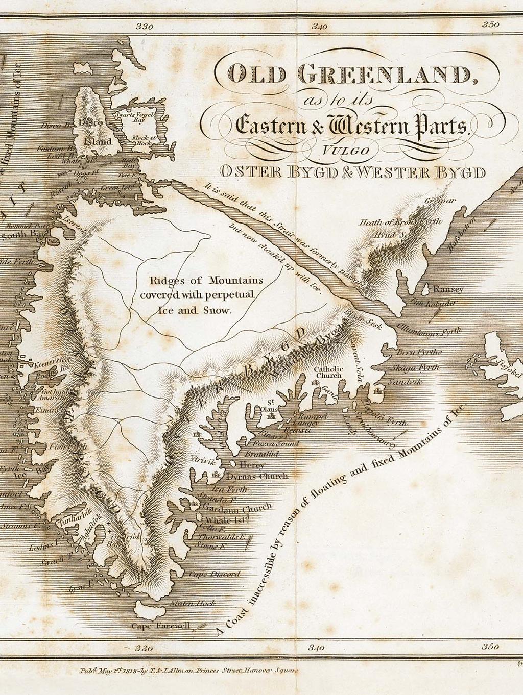
2 Geological Survey of Denmark and Greenland Bulletin 21 Keywords Exploration history, northern East Greenland, place names, Lauge Koch s geological expeditions, Caledonides. Cover illustration Ättestupan, the 1300 m high cliff on the north side of Kejser Franz Joseph Fjord discovered and so named by A.G. Nathorst in Frontispiece: facing page Map of Greenland by Egede (1818), illustrating the incorrect assumption that the Norse settlements of Greenland were located in South-West and South-East Greenland. Many of the localities named in the Icelandic Sagas are placed on this map at imaginary sites on the unknown east coast of Greenland. The map is from the second English edition of Hans Egede s Description of Greenland, a slightly modified version of the first English edition published in Chief editor of this series: Adam A. Garde Editorial board of this series: John A. Korstgård, Department of Earth Sciences, University of Aarhus; Minik Rosing, Geological Museum, University of Copenhagen; Finn Surlyk, Department of Geography and Geology, University of Copenhagen Scientific editor of this volume: Adam A. Garde Editorial secretaries: Jane Holst and Esben W. Glendal Referees: Ian Stone (UK) and Christopher Jacob Ries (DK) Illustrations: Eva Melskens Maps: Margareta Christoffersen Digital photographic work: Benny M. Schark Layout and graphic production: Annabeth Andersen Geodetic advice: Willy Lehmann Weng Printers: Rosendahls Schultz Grafisk a/s, Albertslund, Denmark Manuscript received: 22 April 2010 Final version approved: 1 July 2010 Printed: 21 December Minor factual corrections made May 2011 in the version. ISSN ISBN Velux Fonden supported publication of this Bulletin (see acknowledgements). Citation of the name of this series It is recommended that the name of this series is cited in full, viz. Geological Survey of Denmark and Greenland Bulletin. If abbreviation of this volume is necessary, the following form is suggested: Geol. Surv. Den. Green. Bull. 21, 368 pp. Available from Geological Survey of Denmark and Greenland (GEUS) Øster Voldgade 10, DK-1350 Copenhagen K, Denmark Phone: , fax: , geus@geus.dk or at De Nationale Geologiske Undersøgelser for Danmark og Grønland (GEUS), 2010 For the full text of the GEUS copyright clause, please refer to
3
4 Contents Abstract Introduction Geographical limits Exploration and discovery Scope of place names approved / unapproved Acknowledgements Official place names in Greenland Exploration history of northern East Greenland Pioneer exploration and discovery: c BC Commercial activities, early mountaineering, geological mapping: Modern scientific investigations, adventure and sporting expeditions Catalogue of place names in northern East Greenland Glossary Administrative organisation of Greenland Abbreviations Geographical terms References Maps 1 3 (end of volume) Maps 4 & 5 (folded in pockets)
5 Abstract Higgins, A.K. 2010: Exploration history and place names of northern East Greenland. Geological Survey of Denmark and Greenland Bulletin 21, 368 pp. + 2 maps. The first recorded landing by Europeans on the coast of northern East Greenland (north of 69 N) was that of William Scoresby Jr., a British whaler, in This volume includes a chronological summary of the pioneer 19th century exploration voyages made by British, Danish, Norwegian, Swedish, French and German expeditions all of whom reported that the region had previously been occupied by the Inuit or Eskimo; also included are brief outlines of the increasing number of government and privately sponsored expeditions throughout the 20th century, whose objectives included cartography, geology, zoology, botany, trapping and the ascent of the highest mountain summits. In 1934 the Place Name Committee for Greenland was established, the tasks of which included a review of all place names hitherto recorded on published maps of Greenland, their formal adoption in danicised form, and the approval or rejection of new name proposals. In northern East Greenland, by far the largest numbers of new place names were those proposed by scientists associated with Lauge Koch s geological expeditions that lasted from 1926 until This volume records the location and origin of more than 3000 officially approved place names as well as about 2650 unapproved names. The author s interest in the exploration history and place names of northern East Greenland started in 1968, when the Geological Survey of Greenland initiated a major five-year geological mapping programme in the Scoresby Sund region. Systematic compilation of names began about 1970, initially with the names given by William Scoresby Jr., and subsequently broadened in scope to include the names proposed by all expeditions to northern East Greenland. The author has participated in 16 summer mapping expeditions with the Survey to northern East Greenland. Publication of this volume represents the culmination of a lifetime working in the Arctic. Authors address Geological Survey of Denmark and Greenland, Øster Voldgade 10, DK-1350 Copenhagen K, Denmark akh@geus.dk 5
6 6
7 Introduction The place names of northern East Greenland, be - tween 69 and N, provide a vivid record of the exploration of one of the least accessible parts of Greenland. This region includes the eastern part of the North-East Greenland National Park, the largest national park in the world, and extends southwards beyond the national park limits to include the East Greenland settlement of Scoresbysund / Illoqqor - toormiut (Ittoqqortoormiit) that was founded in Illoqqortoormiut is the official spelling, while Ittoqqortoormiit is the East Greenlandic dialect spelling used by the inhabitants. All of East Greenland was formerly occupied by Inuit (Eskimo) cultures, whose house ruins are found throughout the region, but none of the names the Inuit used have survived. The region was re-discovered by whalers in the early 19th century and mainly explored by European expeditions of British, Danish, Norwegian, Swedish, French and German origin. An increasing number of expeditions with varied objectives visited the region throughout the 20th century. After formation of the Place Name Committee for Greenland (Stednavneudvalget) in 1934, the names used on all existing published maps were systematically reviewed and with few exceptions approved in danicised form. More than 190 place names used by the Greenlandic inhabitants of Scoresbysund / Illoq - qortoormiut (Ittoqqortoormiit) since 1925 were re - corded in In this volume the term Inuit is used in references to the former eskimo residents of northern East Greenland, whereas Greenlandic or Green - landers is used in respect of the present day in ha bitants. A very large number of place names were proposed by geologists and other scientists associated with Lauge Koch s expeditions between 1926 and 1958, and reflect to some extent the diverse nationalities of the participants; names were given after persons, towns or geographical locations of Danish, Swiss, Finnish, French, Swedish and British origin. One of the principal reasons that so many names proposed by Lauge Koch s scientists have been approved is that the journal Meddelelser om Grønland (published by the Videnskabelige Kommission for Grønland: the Scientific Commission for Greenland) insisted that only officially approved place names could be used in their publications. Up until the 1960s Meddelelser om Grønland was the preferred publication for rou - tine geological and other scientific descriptions, be - cause it had the resources to produce well-illustrated accounts that were often accompanied by coloured folding maps. The author s interest in East Greenland s exploration history and place names was stimulated during his first summer in East Greenland in This visit to the Scoresby Sund region was undertaken with the Geological Survey of Greenland (GGU subsequently the Geological Survey of Denmark and Greenland, GEUS). Between 1968 and 1998 the Survey mapped geologically the entire region of northern East Green - land between 69 and N, and the author participated in a total of 16 summer expeditions to this region with the Survey. In about 1970 the author began compilation of the place names used on the various discovery and exploration expeditions that have visited East Greenland since 1822, and this work has continued until publication of this volume. From 1990 onwards participants in the GGU/GEUS regional mapping expe ditions were supplied with collections and explanations of official place names relevant to the region of study (Higgins 1990, 1994a, 1997). It is these preliminary col lec tions of place names that form the basis for the present work. A variety of publications on place names used in Greenland exist, for example on the names that can be traced to the Norse settlements in South-West and West Greenland (Vebæk 1966), and those that relate to the Dutch whale-hunting period in West Green - land (Bobé 1915, 1921; Rosendahl 1974). The only attempt at a regional account on the origin of place names is Dan Laursen s The Place Names of North Greenland (Laursen 1972). Laursen s work has close similarities with this volume in that the great majority of place names listed relate to European and North American voyages of exploration. However, the pre - sentation is somewhat verbose in giving very detailed information on each of the expeditions that visited North Greenland, and the place name section is not presented in strict alphabetical order. When developing a style of presentation for this volume, I have followed in many respects that of the Dictionary of Alaska Place Names by Donald J. Orth (1967) that 7
, The Place Names of Svalbard, lists the more than 8000 currently approved names for that region, but has only a summary section describing the exploration of Svalbard.")
8 lists a very large number of place names in a compact and, for the reader, an informative and easily understood way. The monumental volume by Orheim et al. (2003), The Place Names of Svalbard, lists the more than 8000 currently approved names for that region, but has only a summary section describing the exploration of Svalbard. The individual name entries are presented in a very summary way, such that it is not always obvious which expedition or person is responsible for the name. Note that throughout this volume officially ap - proved names are given in ordinary type, and in the place name catalogue in bold type. Unapproved or unofficial names are always given in italics. The names of ships are given emphasis by use of CAPITALS. Geographical limits The traditional divisions of Greenland are illustrated in Fig. 1. East Greenland ( Østgrønland in Danish, Tunu in Greenlandic) comprises the entire eastfacing coast from Lindenow Fjord / Kanger lus suat - siaq at N to Nordostrundingen at N. The boundary between East Greenland and North Greenland ( Nordgrønland in Danish, Avannaarsua in Greenlandic) follows the SW NE-trending watershed in Kronprins Christian Land. This official boundary between North Greenland and East Green - land is followed in this volume. East Greenland can be conveniently divided into northern and southern re - gions at c. 69 N, where a high ice cap and a long inhospitable coast have hindered migration of both the Inuit and land animals. This natural boundary at 69 N has been adopted in this volume as the southern limit of northern East Greenland. In 1976 the Geological Survey of Greenland (GGU) introduced regional subdivisions of all of Greenland that were considered more appropriate and useful for geological descriptions (Fig. 2; Escher & Watt 1976). For northern East Greenland the sub - divisions chosen essentially follow the informal usage of Lauge Koch s expeditions and other workers, with the notable exception of the boundary between North and East Greenland, that is placed at an artificial limit of latitude N rather than following the official boundary (Fig. 1). The Survey subdivisions thus somewhat illogically place the northernmost segment of the east-facing coast of northern East Greenland in an enlarged North Greenland. Fig. 1. The three official divisions of Greenland: Tunu Østgrønland (East Green land), Avannaarsua Nordgrønland (North Greenland), Kitaa Vest - grønland (West Greenland). KMJ: Kap Morris Jesup; PL: Peary Land; KCL: Kronprins Christian Land; DLL: Dronning Louise Land; R: Rigny Bjerg; G: Gunnbjørn Fjeld; KF: Kap Farvel. These Survey subdivisions were first used extensively in the Survey s volume on the Geology of Greenland (Escher & Watt 1976). The subdivisions were slightly amended by Ghisler (1990), mainly to bring the offshore divisions into line with the onshore divisions. While these revised subdivisions have no formal official status they have been very widely used in geological publications for the past 30 years. Indeed, the widespread usage particularly of the English term North-East Greenland has led to the assumption that there is an equivalent Danish term for this part of East Greenland, such that Nordøst - grønland is commonly encountered in Danish scientific publications and even in the formal title of Nordøstgrønlands Nationalpark (North-East Green - land National Park). 8
9 Ellesmere Island Canada Pituffik / Thule Air Base Melville Bugt Upernavik Svartenhuk Halvø Disko Disko Bugt Aasiaat Sisimiut 52 Nares Strait Nuuk western North - West cent ral West Kangerlussuaq southern West South - West Ivittuut Qaqortoq South Arctic Ocean Peary Land central North Inland Ice South - East 44 Kap Farvel central East southern East eastern North - East Tasiilaq / Ammassalik Exploration and discovery Station Nord Blosseville Kyst Daneborg Mestersvig Iceland North Atlantic Ocean 400 km Scoresby Sund Fig. 2. The subdivisions of Greenland as used by GGU/GEUS. The Geological Survey s subdivisions were based on unofficial usage in published reports by geologists, botanists, zoologists and other scientists. Although not officially recognised these divisions have been very widely used in geological publications since A detailed summary of all significant expeditions to northern East Greenland makes up the section on the Exploration history of northern East Greenland (see page 17). In this section the main phases of exploration are briefly outlined. Maps 1 5 at the end of this volume give the most important place names used in northern East Greenland. The former indigenous inhabitants of northern East Greenland have left abundant evidence of their presence in the form of house ruins and tent rings. The Inuit (Eskimo) cultures can be related to several waves of immigration, of which the last few survivors of the Thule culture in northern East Greenland were probably the group of 12 encountered by Douglas Clav ering on Clavering Ø (74 15 N) in 1823 (Clave - ring 1830). The earliest names still applied to East Greenland geographical features are those found in the Icelandic sagas, but these were mainly given for distant high mountains used as landmarks when sailing to the Norse settlements of South-West and West Green land (Østerbygden and Vesterbygden; see Frontis piece) from about AD 1000; these settlements gradually declined during the Little Ice Age that followed, with the last certain contacts with Europe about Records of sightings of northern East Greenland were few until Henry Hudson s voyage in 1607 that observed Hold with Hope at N and reported abundant whales in the waters near Spitsbergen in the North Atlantic. Whalers of many nations flocked to Spitsbergen after 1612, and when whales became scarce there about 1630 they began to sail to East Green land waters in search of new hunting grounds. For more than 200 years, however, the coast of northern East Greenland, protected by a wide belt of pack ice, was widely considered inaccessible. It was not until 1822 that the British whaler William Scoresby Jr. made the first recorded landings around the mouth of Scoresby Sund (70 15 N). From the mid-1800s onwards there were numerous visits to East Green - land waters by whalers, and notably Norwegian sealers, who approached the land to supplement their catch with walruses and muskoxen. The German explorer Karl Koldewey made an attempt to reach the North Pole via East Greenland in 1869, but his ship GERMANIA only reached as far north as Germania Havn (74 32 N) where it was forced to overwinter. During the autumn and the spring of 1870, sledge journeys were sent northwards as far as 77 N, and the region from 74 to 77 N was mapped in outline for the first time. The next major mapping expedition was the Danish expedition led by Carl Ryder in , that overwintered at Hekla Havn on Danmark Ø in the inner Scoresby Sund re - gion (70 72 N). The system of fjords was explored by boat and on sledge journeys. In 1899, a Swedish expedition led by A.G. Nathorst visited the Kong Oscar Fjord region in a search for traces of Salomon Andrée s balloon expedition that had vanished in 1897 during an attempt to reach the North Pole. During the summer of 1899, Nathorst explored Kej - ser Franz Joseph Fjord and the network of fjords 9
10 centred on Kong Oscar Fjord (72 74 N); the expedition surveyor, Per Dusén, carried out an epic pro - gramme of mapping. The Danmark-Ekspe - ditionen was the largest and most ambitious of early Danish expeditions, whose aims were to survey the large unknown region north of 77 N and to link up with the explorations of the American Robert E. Peary in North Greenland. Their success cost the lives of three members, of whom only the body of one has been found. Norwegian activities entered a new phase with the first deliberate overwintering of a fox-trapping expedition in This was the start of the Norwe - gian Danish trapper era that was to last until A series of expeditions from both nations overwintered at hunting stations with networks of small hunting huts surrounding them, trapping foxes and occasional wolves for their skins. The expansion of their relative trapping terrains led to the trappers becoming involved in the Norwegian-Danish dispute over the sovereignty of East Greenland that was settled in Den mark s favour at the International Court of Jus - tice in The Hague in During World War II Da - nish and Norwegian hunters co-operated as mem bers of Nordøstgrønlands Slædepatrulje (forerunner of the present Sirius Sledge Patrol). Trapping was resumed after the war but was only sustained with government subsidies, and when subsidies were suspended, falling skin prices led to the effective cessation of hunting in The full story of the trapping era is related in fascinating detail by Peter Schmidt Mikkelsen (2008). Members of the pioneer exploration voyages made occasional ascents of significant mountains, not ably Julius Payer during Karl Koldewey s expedition, but voyages aimed primarily at climbs of the highest known mountains in northern East Green land began with the British Cambridge expedition led by J.M. Wordie that travelled to East Green land in 1926 aboard the HEIMLAND. The professed objectives in - cluded surveying and archaeology, but included a reconnaissance of a route to the 2940 m summit of Petermann Bjerg, first seen by Karl Kolde wey s expedition in Wordie s second expedition in 1929 was rewarded by its successful ascent. An Italian expedition led by Leonardo Bonzi had sailed to East Greenland with a small climbing expedition in 1934 intending to make an attempt on the Watkins Bjerge, the range of high summits south of Scoresby Sund at around 69 N. Frustrated by ice conditions they explored the then unknown mountains of Volquaart Boon Kyst (c. 70 N). It was another British expedition led by Augustine Courtauld and Lawrence R. Wager that made the first ascent of Gunnbjørn Fjeld (Hvit - serk) in August 1935; at 3694 m this is the highest peak in the Watkins Bjerge and the highest summit in Greenland. These early climbing expeditions were all reliant on boats for transport. The competing interests of Danish and Norwe - gian trappers led to signing of a treaty on East Green - land (Østgrønlandstraktaten) in 1924 that allowed both nations to hunt, fish and carry out scientific investigations, but made no decision on sovereignty. However, the treaty specifically allowed Denmark to establish a colony in the Scoresby Sund region, and this proposal was brought to fruition thanks to the influence and initiative of Ejnar Mik kelsen. In 1925 the Greenlandic settlement of Scores bysund / Illoq - qortoormiut (Ittoqqortoormiit) was esta blished with the arrival of 70 Greenlandic settlers, mainly from Ammassalik / Tasiilaq. This act and the series of geo - logical expeditions initiated by Lauge Koch in 1926 were part of a strategy to expand Danish influence in northern East Greenland that eventually led to recognition of Danish sovereignty over all of Greenland. Lauge Koch s expedition was followed by summer expeditions in 1929 and 1930 and then Treårsekspeditionen (the Three-year expedition), the largest and most comprehensive expedition hitherto sent to East Greenland by Denmark, and also led by Lauge Koch. The Danish Geodætisk Institut (Geo - detic Institute) was an integral part of this expedition, and initiated a long-running programme of surveying leading to publication of 1: scale topographic maps. Treårsekspe di tionen was succeeded by the socalled Two-year expedition , but the outbreak of World War II led to a halt in scientific activities. Lauge Koch s expeditions continued from 1947, with an almost entirely geological focus, until the annual grants for field work were abruptly suspended after the 1958 season. Significant activities by other nations included the seven voyages to the Scoresby Sund region by Jean- Baptiste Charcot in his three-mast barque POURQUOI PAS?, that included the setting up of the French Inter - national Polar Year station in Scoresbysund / Illoqqortoormiut (Ittoqqortoormiit) and the four voy - ages by the American Louise A. Boyd with the VESLE - KARI that visited most of the northern East Greenland fjords undertaking photography and surveying. In 1952 an airport was constructed west of Mesters Vig, subsequently known as Mestersvig (one-word), in connection with exploitation of the lead deposits 10
11 discovered by Lauge Koch s expeditions nearby. The excellent 1800 m gravel airstrip has provided easy access to East Greenland for aircraft, and between 1954 and 1985 about 200 scientific and sports expeditions made use of the airstrip facility to reach East Greenland (Mestersvig was partly replaced in 1985 by the new airport built at Constable Pynt). From the mid-1950s onwards climbing expeditions paid particular attention to the high mountains of the Stauning Alper that could be reached either by walking in, or by using small rubber boats for transport westwards along the coast (Bennet 1972). In 1974 the National Park in North-East Greenland was established and in 1988 was expanded westwards across North Green - land. At present it is the largest national park in the world. The Sirius sledge patrol, whose primary pur - pose is to patrol the uninhabited regions of northern East and North Greenland, also act as wardens in the National Park; visitors can only enter the National Park with permits issued by the Greenland authorities. In 1967 the Geological Survey of Greenland sent a small reconnaissance expedition to the Scoresby Sund region. This was a precursor to the major re - gional geological mapping programme that was to prepare 1: scale geological maps of northern East Green land over a period of 30 years (Henriksen & Higgins 2008). Between 1978 and 1987 super wideangle, vertical, aerial photographs were taken covering all of Greenland, and a new network of fixed survey stations was established by the Geodætisk Institut (GI, Geodetic Institute, now part of Kort & Matrikelstyrelsen KMS). KMS has produced a new topographic database for all of Greenland at a nominal scale of 1: based on a combination of digitised existing published 1: scale map sheets with new maps drawn of previously unmapped areas ( In connection with their re - gional geological mapping programmes, GGU/GEUS in co-operation with KMS has prepared topographic maps on a 1: scale for almost all of northern East Greenland. The Sirius sledge patrol began to use Twin Otter aircraft for transport of personnel to and from Dane - borg in 1977, and from 1978 GI and GGU/GEUS expeditions to East and North Greenland also made extensive use of Twin Otter aircraft, whose short takeoff and landing (STOL) capabilities are ideal for transport of equipment and personnel between base camps and unprepared natural landing strips (usually river terraces; P.S. Mikkelsen 2006). Twin Otter aircraft chartered from Iceland were also extensively used to supply the DYE stations (part of the Amer - ican Distant Early Warning radar system) on the Inland Ice, and to support the ice-drilling operations at various locations on the Inland Ice. The Icelandic Twin Otter pilots thus achieved considerable experience in landing on snow and ice surfaces, and these skills have since been utilised by climbing expeditions to provide easy access to the high mountain ranges at around 69 N and other areas. Climbing expeditions have also been transported by Twin Otter to less precipitous areas otherwise difficult to reach, and many of these expeditions appear to have had as their sole objective the ascent of unclimbed peaks that they can then name after themselves or members of their families. However, no unofficial names given by climbers have been recognised by the Place Name Committee for Greenland since about In many remote nunatak areas the summits climbed may be only a few hundred metres above the surrounding glacier surfaces on which the Twin Otter aircraft landed. Claims by such expeditions to have made 30 first ascents are not unusual. Scope of place names approved / unapproved The bulk of this volume comprises a catalogue of approved and unapproved place names, arranged al - phabetically, that have been used on maps and in publications for localities in northern East Greenland (see page 117). There are more than 3000 officially recognised place names in the region N, that is to say names that have been approved by the Place Name Com mittee for Greenland in Copenhagen (Sted navne - udvalget) established in In 1979 Green land achie ved Home Rule (Hjemmestyre), and in January 1984 the responsibility for place names in Greenland was transferred to Grønlands Sprognævn in Nuuk, the present Nunat Aqqinik Aalajangiisartut / Grønlands Stednavnenævn. A review of the work of the Place Name Committee for Greenland from 1934 to De - cember 1983 is the subject of the section that follows below: Official place names in Greenland (p. 13). Several hundred place names that appeared on the 1: and 1: scale Norwegian maps of parts of northern East Greenland are also listed, although only a small number were approved, the great major- 11
12 ity being rejected by the then Place Name Committee as being politically motivated, i.e. given to support Norwegian arguments for claims to sovereignty over parts of East Greenland. The detailed account of Norwegian and Danish trapping activities in northern East Greenland by P.S. Mikkelsen (1994, 2008) illustrates all their hunting stations and hunting huts, as well as the names and alternative names by which they are known. All these names receive brief mention here. Unapproved names used on published maps by scientists of J.-B. Charcot s expeditions ( ), Louise A. Boyd s expeditions (1932, 1935, 1948) and in the 1968 edition of Den Grønlandske Lods (this volume, published in Danish, is The Greenland Pilot for East Greenland ) are also included. Up to 1960 many of the names given by climbing expeditions to peaks in the Stauning Alper were ap - proved in danicised form, but the proposals for an increasing number of foreign-sounding names led to adoption of a more critical attitude to approval of names by the Place Name Committee for Greenland. The existence of detailed topographic maps of the Stauning Alper has allowed identification of the positions of virtually all summits climbed up to 2008, and a special map on a 1: scale giving both ap - proved and unapproved names applied to features in this region accompanies this volume as Map 5. The large numbers of scientific, tourist and climbing expeditions that have visited, and continue to visit East Greenland have inevitably led to the naming of geographical features. Only a selection of unapproved names used for significant reference localities receive mention here. In general, any names given after living persons, or used for minor peaks or variations of climbers routes, are not included. The most important source of information for this volume has been a near complete set of the minutes of the former Place Name Committee for Greenland; these include the documentation submitted to the committee and its various sub-committees in considering place name proposals. This material was kindly lent to the author by Henry W. Bjørn of the then Geodetic Institute (Geodætisk Institute, now incorporated into Kort- & Matrikelstyrelsen). Acknowledgements Peter Schmidt Mikkelsen (Rønde, Denmark) has kind - ly allowed me to add to this volume the many variations of hut names used by trappers, and to quote the GPS latitudes and longitudes he has determined for all the hunting stations and hunting huts in East Greenland. This data, and the histories of the individual stations and huts, is taken from the English edition of his account of Danish and Norwegian trapping activities (P.S. Mikkelsen 2008). Jan Løve (Skagen, Denmark) has for many years independently compiled data on place names used by expeditions to East Greenland, backing up his compilations with studies of published and unpublished diaries and other original material in various Danish archives. He has freely allowed me to make use of his deductions and conclusions with respect to specific names, thus correcting many of my errors and misinterpretations; the most important corrections are acknowledged in the relevant individual entries. Jan Løve s name compilations are on file (in Danish) on the website of the Danish Arctic Institute ( - institut.dk: Østgrønlandske Stednavne). Niels Henriksen (GEUS and Birkerød, Denmark) has been a constant source of support and encouragement throughout the compilation process for this volume. He was also leader of all the GGU/GEUS geo - logical mapping expeditions in which I have participated. He has kindly read large sections of this vo lume, and provided many helpful comments and suggestions. Many individuals have kindly provided valuable information on place names given by themselves or by others during expeditions in which they participated. I am particularly grateful to: Svend Bendix-Almgren, John Cowie, Peter R. Dawes, Henrik Elling, J.D. (Di - dom) Friderichsen, John Haller, Colwyn Jones, David Malmquist, Arne Noe-Nygaard, N.E. Odell, Fritz H. Schwarzen bach, Cordelia Stamp, W. Stuart Watt and Anker Weidick. The support of Velux Fonden is gratefully ac - know ledged, and is provided under the statutes of the Fund that encourage and give financial support to active pensioneers. Finally, I would like to acknowledge the very helpful suggestions of the two reviewers, Christopher Ries and Ian Stone. 12
13 Official place names in Greenland Professor N.E. Nørlund, Director of the Geodætisk Institut (Geodetic Institute), wished to solve the problems of names given in various languages by expeditions of different nationalities, and also the use of East and West Greenlandic dialects, as East Greenland orthography diverges from that of West Greenland. Nørlund therefore took the initiative to form the Place Name Committee for Greenland (Sted navne kommis - sionen or Stednavneudvalget), under the auspices of the Scientific Commission for Greenland, with the aim of ratifying place names in Greenland. The initiative was prompted by the introduction of the regulations of journeys to and from Greenland issued by the Ministry for Shipping and Fisheries on 7 August 1930, of which section VIII states (in translation): Expeditions that wish to bestow place names on localities visited, must send proposals to the Danish Government, who will make the final decision. The first meeting of the committee was held on 6 June The members included prominent Green - land administrators and scientists: Jens Daugaard- Jensen, Lauge Koch, Niels Erik Nørlund, Knud Ras - mussen, William C. Thalbitzer, F.O. Jørgensen and Hother Ostermann. A second meeting was held on 15 November Officially the Place Name Com - mittee for Greenland was established on 1 Fe b ru ary 1934, when the Danish State Department issued a regulation announcing the establishment of a Place Name Committee, and stated that no place names given to Greenland localities by expeditions would be recognised by the Danish state until they had been approved by the committee. Four meetings of the Place Name Committee were held in 1934, eight in 1935, and regular meetings were held subsequently until interrupted by the war years. One of the early decisions was to establish a subcommittee with the task of considering for approval all place names that had hitherto been used on pub lished maps. In respect of East Greenland, the systematic listing of published place names, and their approval or deletion continued until the 1940s. In the post-war pe - riod, up to 31 December 1983, the sub-committee con - tinued to approve, modify or reject newly proposed place names, of which final approval was then made by the full committee. The minutes of the Place Name Com mittee for Greenland from 1933 onwards were for - m erly accessible at the Danish Geo detic Institute, and the main activities and conclusions of the Com mittee and its sub-committees rele vant to northern East Greenland are summarised here. Greenland was granted Home Rule in 1979, and took over responsibility for its place names on 1 Jan uary 1984; the Place Name Committee archives are now in Nuuk, Green land. One of the early difficulties facing the committee was the significant differences between the West Green land dialect and that of East Greenland, and the consequent varied spelling of Greenlandic place names. At the first meeting of the committee in June 1933, Professor William C. Thalbitzer, the acknowledged expert on the East Greenlandic dialect, argued strongly for preservation of the East Greenland forms, rather than the incorrect variations introduced in the Ammassalik / Tasiilaq region by West Green land in - ter preters such as Hansêrak. At the third meeting it was commented that up to six dialect variations might be required to accurately reflect local usage. Jens Daugaard-Jensen, Director of Grønlands Styrelse (the Greenland administration), expressed his preference for the general application of Samuel Kleinschmidt s orthography as practised in West Greenland, a view supported by C. Wilhelm Schultz-Lorentzen who pro - phesied (incorrectly) that there would be a general movement towards a common (West Greenland) dia - lect throughout Greenland. Thalbitzer threatened to resign from the committee at the 14th meeting in November 1935, partly on the grounds that his views on preservation of dialect forms were repeatedly overruled by other committee members, and partly due to disagreement on the principles for approving future place names. He confirmed his resignation at the 17th meeting in February The East Green - land dialect continues to thrive today in the East Greenland towns of Illoqqortoormiut (Ittoqqortoormiit) and Tasiilaq / Ammassalik and outlying settlements. The preferred East Greenlandic spelling of the name of the town Scoresbysund is Ittoqqortoormiit, and this is the spelling used by the inhabitants and on the official website ( but it is the West Greenland spelling Illoqqortoormiut that appears on official maps of Greenland. Early meetings of the committee were marked by at times acrimonious discussion on the commemora- 13
14 tion of living persons in place names. The third meeting agreed that commemoration of living persons should be reduced to a minimum. An analysis of pre - vious practice in East Greenland presented at the sixth meeting revealed that 69% of the names pro - posed by A.G. Nathorst in 1899 commemorated persons, and that 54% of his names had been given after persons then still alive. The corresponding figures for G.C. Amdrup s 1900 expedition to southern East Greenland were 80% and 74% respectively. At the fourth meeting reference was made to a somewhat caustic letter by Ejnar Mikkelsen, who had drawn attention to some of the names on the 1932 edi tion of the 1:1 million scale topographic map com - piled by Lauge Koch (Geodætisk Institut 1932) that commemorated persons without the remotest con - nection with Greenland (e.g. Anna Sten Gletscher and Gerda Gletscher that were named after actresses; see also Fig. 15). The large number of names arising from the activities of Treårsekspeditionen had also attracted unfavourable press comment because so many had been given after living persons. Most of the names applied to geographical fea - tures during the Treårsekspeditionen by Lauge Koch, and the scientists working under his lead ership, were published between the regulations of 1930 and 1934, and thus essentially prior to establishment of the Place Name Committee. Lauge Koch there fore argued, at the ninth meeting of the committee in February 1935, that the decree of 7 August 1930 was the authority. Since this stated that names should be placed before the Government for approval, and since Koch was the appointed police authority in East Greenland during Treårsekspeditionen, then he was also (in his view) to be considered the Government authority and thus could approve his own names. As an additional argument for the blanket approval of all names given during Treårsekspeditionen, Koch cited the usage of his maps as documentary evidence at the International Court of Justice in The Hague, during the Danish Norwegian controversy over the sovereignty of East Greenland. At the eighth meeting of the committee in Feb - ruary 1935, discussion on the commemoration of living persons in place names concluded with the recommendation that they should be avoided as far as possible, although this might prove difficult in practice. It was proposed that the committee should de - cide in individual cases, by vote if necessary. This decision was soon brought into effect with, at the 10th committee meeting in May 1935, the rejection of many names proposed by J.G. Jennov (director of the Danish trapping company Nanok) and Ejnar Mik - kelsen. In rejecting Jennov s names it was incorrectly stated that they had been given after the act of 1 Feb - ruary 1934; Jennov argued that many of his proposed names were given during the 1932 Gefion expedition and were in common use amongst Danish hunters. Jennov s names were rejected for the third time in 1940, when a sub-committee suggested alternatives for three of Jennov s disputed names (Tuxen Ø, Engelhardt Sund and Frieda Sø), which became Nanok Ø, Jægersund and Gunner Andersen Sø. Nume rous sub - se quent attempts, by various expeditions, to introduce names obviously given after living persons were rejected. However, the regulations were often circumvented, for example by geologists of Lauge Koch s expeditions who would include personal names on their names lists with the discrete explanation girl s name. Occasionally the Place Name Committee ap - pears to have simply turned a blind eye to such pro - posals, and for example approved the names Ebbe Sø, Eigil Sø and Winston Bjerg proposed by the British North Greenland expedition, although they obviously commemorated Ebbe Munck, Eigil Knuth and Sir Winston Churchill (all then alive). Exceptions to the living person rule are only officially allowed for the Danish Royal family, a practice that has con - tinued to the present day: e.g. Dronning Margrethe II Land (1990, on the occasion of the Danish Queen s 50th birthday), Qeqertaq Prins Henrik (2004, on the occasion of the 70th birthday of the prince consort the Danish Queen s husband), Kronprins Frederik Land (2008, to commemorate the military service of crown-prince Frederik in the Sirius Sledge Patrol). At the sixth meeting of the committee in March 1934 it was agreed to establish a sub-committee, the tasks of which were to go through all published Da - nish and foreign maps, and to make decisions on the danicised form of names to be approved for official usage. Name lists were drawn up for consideration by the Geodetic Institute, divided up for convenience into degrees of latitude, and with the names numb - ered consecutively. This system was also to apply to future proposed names, with the number given to each name following it throughout the entire ap - proval process. The first meeting of the sub-committee was in January Some principal decisions had already been made by the full committee, such as the usage of West Greenlandic spellings for localities in East Green - land (as noted above), and the usage of the letter q for 14
15 the special Greenlandic ĸ introduced by Samuel Kleinschmidt. Amongst other proposals, usage of the Danish aa form was preferred to the Swedish å (a decision reversed in 1948). Hyphens were to be avoided, such that composite names such as Zoolog-dalen were to be given in one word as Zoologdalen. Names given after persons were to be expressed in two or more words (e.g. Milne Land, not Milneland. In practice it was the sub-committee that made recommendations on place names to be ap proved or rejected, their proposals then being placed before the full committee. At the first meeting of the sub-committee the new names appearing on the maps produced by Norges Svalbard- og Ishavsundersøkelser (NSIU) on scales of 1: and 1:1 million in 1932 were considered, and with only a few exceptions all were rejected, on the grounds that they were politically motivated. A similar fate was to be meted out to the 299 new names given on the Norwegian 1: scale maps covering Clavering Ø, Geographical Society Ø and Jordan Hill (Lacmann 1937). Although the committee ad - mitted that Lacmann s maps contained significantly more detail than the best existing Danish maps, the procedure for approval of new names by Danish authorities had not been followed. In the event, a few names used on Clavering Ø were allowed by the subcommittee in 1939, but all others were rejected. The sub-committee approved long lists of names given after localities in Denmark, notably those pro - posed by the surveyors of the Geodetic Institute. Some lists of names proposed by Swiss geologists or British scientists were adjudged too foreign-sounding, even in danicised versions, and were rejected en - tirely or replaced by the sub-committee s own sug - gestions. Other lists of equally foreign-sounding names were approved. Although the committee as early as 1937 had expressed the view that large num - bers of foreign-sounding names were to be avoided as far as possible, the rule was inconsistently applied. The indiscriminant usage of the genitive s in place names was raised at the eighth meeting of the committee in February Following the recommendations of the sub-committee, already published names that did not use the genitive s were considered to have won recognition in that form, whereas newly proposed names should use the genitive form except where circumstances argued against it. However, in practice usage continued to be inconsistent, and the problem was raised again in the 1960s and 1970s when it was realised that charts published by the Danish Hydrographic Office used one form, and the Geodetic Institute map sheets the other form. One of the last decisions of the Place Name Committee, to restore consistency, was to remove all the genitive s endings previously approved. To resolve the general problem in Greenland of the use of both Danish and Greenlandic names for the same feature, particularly as applied to towns and settlements, the principle of officially approving both Danish and Greenlandic place names was established. When Greenland acquired Home Rule in 1979 there was a subtle change in the double name giving, with the Greenlandic town names taking precedence over the Danish equivalent. However, while in some cases the Danish town names gradually fell into disuse, in other cases the Danish town names were officially abandoned by decision of the local town council leaving just the Greenlandic names. In some towns this policy went to the extremes of deliberately replacing all former Danish street names with Greenlandic alternatives. However, maps that show the original double names for Greenland towns still appear in the most recent Greenland atlases (Berthelsen et al. 1989; Jakobsen et al. 2000). The regulations concerning travel to and from Greenland were revised in 1939 and 1948, and a regulation of 11 April 1949 re-organised the Place Name Committee, with Eske Bruun (then head of the Green - land administration) as chairman. The responsibilities of the new committee were essentially identical to those of the original committee. One of the early initiatives of the new committee was to undertake the systematic collection of Greenlandic place names used by local populations in Greenland. This process began in 1949, and in 1955 a two-man party from the Geodetic Institute visited Scoresbysund / Illoqqor - toormiut (Ittoqqortoormiit) and collected a total of about 190 names used locally, the majority being of the characteristic descriptive type. Following revision of the Danish orthography in 1948, the changes proposed were also applied to danicised place names in Greenland. The main change was that of the Da - nish aa to å, although Geodetic Institute map sheets continued the old usage until In 1973 a major revision of the Greenlandic ortho - graphy was implemented (Greenland spelling re - form), with the new system notably abandoning all the accents on letters (introduced by Samuel Klein - schmidt as an aid to pronunciation). The modern written language, and spelling of place names, makes extensive use of double vowels and consonants. Since 15
16 the existing Geodetic Institute map sheets, and other atlases, used the old-style spelling, a systematic database of all place names in Greenland was compiled by the Geodetic Institute in , that includes both the old and new Greenlandic spellings for place names in Greenland. Both old and new spellings of Greenlandic approved names in northern East Green - land are given in this volume, with the main entry under the new spelling, with cross-references for all the old spellings. In 1979 Greenland was granted Home Rule, which meant that Greenland acquired a special status within the Kingdom of Denmark, with its own parliament in Nuuk in West Greenland. As a result of this major change many responsibilities previously carried out by Denmark on behalf of Greenland were transferred to Greenland. On 31 December 1983 the Place Name Committee for Greenland was disbanded, and responsibility for place names in Greenland was transferred to Grønlands Sprognævn, today the Nunat Aqqinik Aalajangiisartut / Grønlands Stednavnenævn / Green - land Place Names Committee. In 2009 Greenland was officially granted Selfgovernment (selvstyre), a further measure of independence from Denmark, with exceptions in respect of foreign policy and defence, but still with a substantial annual subsidy of 3400 million Danish kroner (c. $637 million). 16
17 Exploration history of northern East Greenland This section comprises brief summaries of all activities in northern East Greenland from c BC up to the present day. These activities range from large scientific expeditions with more than 100 participants to minor tourist visits by a few persons. Due to the remote and isolated situation of northern East Greenland, virtually all visiting groups need to be self-supporting and are therefore characterised as expeditions. The various activities are presented chronologically, with brief information on the nature of the objectives and results of scientific investigations, and with particular emphasis on place names proposed by the participants. In general the name of the expedition is given in the original language, followed by the expedition name in English (where relevant) and the name of the leader. In 1979, Greenland was granted Home Rule, and took over many of the responsibilities formerly car - ried out by Denmark on its behalf. From 1989 until 2009 the Danish Polar Center (DPC) undertook the issue of permits to visit northern East Greenland and the North-East Greenland National Park. One of the conditions of the permits was that a report should be submitted to DPC, but some expeditions have failed to submit reports and the expedition list that follows is therefore incomplete. Many of the modern activities, from about 1961 onwards, are recorded only in unpublished expedition reports deposited with the organisations that supported the activity, or from 1989 with the Danish Polar Center. Where such reports have been located at the British Mountainering Council in Manchester [BMC report archive], Royal Geographical Society in London [RGS report archive] or the Danish Polar Center in Copenhagen [DPC report archive], this is indicated at the end of the activity description. In 2009 Greenland acquired a further degree of independence from Denmark, and from 2010 permission to visit northern East Greenland must be re - quested from the Ministry of Domestic Affairs, Nature and Environment of the Government of Green land in Nuuk. Note that in the following accounts of activities officially authorised place names are in normal type, whereas unofficial place names, or unapproved variations of names, are given in italics. The names of ships are given in capitals, e.g. the HOPEWELL. Note that hunting trips made by the residents of Scoresbysund / Illoqqortoormiut (Ittoqqortoormiit) are not included in this volume, although such tours may extend northwards into the North-East Green - land National Park and southwards along the Blosseville Kyst. Local excursions organised by the travel agents Nanu Travel Aps for groups visiting Scoresbysund / Illoqqortoormiut (Ittoqqortoormiit) are in general outside the scope of this volume. Similarly, excursions by personnel from Danmarks - havn weather station (or the former weather and/or radio stations at Daneborg and Kap Tobin) are not generally on public record. The numerous scientists that visit the Zackenberg Ecological Research Opera - tion (ZERO) are mainly involved in projects in the vicinity of the research station, but a few projects range more widely afield (see Meltofte et al. 2008); a few ZERO projects merit mention below, but most projects are included in the general descriptions of activities see: 1997 present Zackenberg Ecological Research Operations (ZERO). Cruise ships have occasionally visited East Greenland since the early 1970s, and many cruise organisations now include regular visits to East Greenland in their schedules; up to 17 ships annually have been recorded carrying a total of about 1000 passengers see: 1998 present: Nuna Travel Aps. With few exceptions these cruises are not individually listed here. The Sirius Sledge Patrol covers a total of km on patrol with dogsledge teams in northern East Greenland and North Greenland during the winter and spring every year. Details of these patrols are confidential, but P.S. Mikkelsen (1986, 2005) has provided an informative and well-illustrated account of his own experiences with the Sirius Sledge Patrol. 17
18 Pioneer exploration and discovery: c BC AD 1912 c BC c Inuit (palaeoeskimo) immigrations About 4500 years ago, long before European whalers and explorers set foot on the east coast of Greenland, the entire region had been settled by Inuit (palaeo- eskimos). The Independence I culture, which is closely related to the Saqqaq culture of West Greenland and the early pre-dorset culture of Canada, had spread from Ellesmere Island (Canada) across North Greenland and down the coast as far as Scoresby Sund (70 N). The Independence I people remained in East Greenland for up to 600 years (Bennike et al. 2008). About 1100 years later a new wave of Inuit (pa laeo - eskimos), the Greenlandic Dorset, retraced their pre - decessors footsteps. Both cultures depended for their existence on musk oxen, seals, hares, birds and fish. The tent rings of the Greenlandic Dorset are widely distributed along the coast of East Greenland, with a concentration in Dove Bugt and on Île de France (now Qeqertak Prins Henrik). The Green landic Dorset people lived in East Greenland from about 800 BC to 0. About AD 1200 the ancestors of the present day Greenlanders, the Thule culture, reached Greenland, and via North Greenland soon populated the entire coast of East Greenland. They were whale-hunters and possessed skin boats (kayaks and umiaks), but also depended on musk oxen, seals, hares, birds and fish (Larsen 1970). The last remnants of this population north of 69 N latitude may have been the group of 12 encountered by Douglas Clavering at Clavering Ø (74 15 N) in 1823 (Clavering 1830). Ruins of their winter houses are common throughout East Green - land. c Norse (Viking) voyages The Icelandic sagas include accounts of a number of voyages to Greenland, although most of the place names recorded have usually been identified with locations in South or West Greenland (Rafn 1845). Some names have appeared in a variety of positions on old charts which were based partly on interpretations of the sagas (Egede 1818; Steenstrup 1886, 1889; Bjørnbo 1911; Trap 1928; see Frontispiece). How ever, Tornøe (1935, 1944) has argued that places described in Landnámabók, Eirik Raudes saga, Tor finn Karls - evnes saga and other sources might have been situated in East Greenland. North of latitude 69 N Tornøe suggests locations for Bláserkr, Breidi fjórdr, Finns búdir, Greipar, Krosseyjar and Òllumlengri. Apart from Bláserkr (now Rigny Bjerg) their positions are debateable, and none of them have acquired the status of approved names. Òllumlengri or Ollum lengri Fiordr is said to have been discovered by Norse voyagers from Iceland in 1194 or 1195, and here they for many years hunted seals, walruses, narwhales and bears. Gustav Holm (1925, 1926) considered their description of the fjord longer than all other fjords admirably fitted the present day Scoresby Sund, a viewpoint supported by Tornøe (1944) and Ejnar Mikkelsen (1989). Scoresby Sund with its inner branch of Nordvestfjord is in fact the longest fjord in the World. The Icelandic Annals also refer to the discovery in 1194 of Svalbardr, or Svalbarda í Hafsbotn, the country of the cold coasts, which some authorities identify with the Scoresby Sund region (70 72 N) of East Greenland (Rafn 1845; Ryder 1892; Holm 1926), others with Jan Mayen (Wordie 1922) or Spitsbergen (Tornøe 1935, 1944). Svalbard is today the official name of the group of islands including Spitsbergen that were placed under the sovereignty of Norway by the Treaty of Paris in Direct evidence of Norse visits to East Greenland north of latitude 69 N is limited to finds in Inuit graves at Scoresbysund of silver buttons and beads (Storgaard 1926) and of an ornamented bone comb (Thalbitzer 1909); these have been argued by Tornøe (1944) to indicate some contacts between the Norse inhabitants of Iceland and the former Inuit population Henry Hudson s voyage In 1607, Henry Hudson was sent out by the Muscovy Company with a crew of 11 on the HOPEWELL to seek a passage to Japan and China across the North Pole. He sighted the coast of East Greenland on several occasions between latitudes 68 and 74 N, and on 22 June 1607 lay off Hold with Hope (73 30 N). The only account of his observations is reproduced in Asher (1860) and Purchas (1906) It was a mayne high land, nothing at all covered with snow: and the North part of that mayne high Land was very high Mountaynes... wee thought good to name it, Hold with hope, lying in 73. degrees of latitude (Asher 1860, p. 3; Purchas 1906, p ). 18
19 Hold with Hope is the oldest place name currently in use in northern East Greenland. While Hudson failed in the main purpose of his voyage, his accounts of the abundant whales in the waters near Spitsbergen are said by many authors to have led to the development of the northern whale-fishery; other writers give the credit to Nicholas Woodcock s 1612 voyage (see below). c c Northern whale-fishery Until the pioneer charting of the coast of East Green - land by William Scoresby Jr. in 1822, the only information on the region north of latitude 69 N came from the chance sightings of whalers. British whalers began to sail to Spitsbergen waters after Nicholas Woodcock s successful voyage in 1612, and as a result of their success were soon joined by Dutch whalers, and subsequently by French, Spanish, Danish and others. Whales became scarce in the bays of Spits - bergen after 1630, leading to a temporary decline in British whaling. After 1720 whales were then sought along the edge of the East Greenland pack ice. Revival of British whaling about 1750 was linked to the introduction of a government bounty. Fluctuations in whal - ing returns, especially in the British trade, were in - fluenced by variations in the bounty (which lasted until 1824), the attacks of hostile privateers, the weather conditions and whale migrations. In view of the numbers of whalers engaged in the fishery, there were probably numerous sightings of the Greenland coast, but records are few. No deliberate attempts were apparently made to penetrate the ice belt before 1822, the general opinion among whalers up to about 1818 being that the land was inaccessible (Scoresby 1823). A note on an Italian map from 1690 by Coronelli records that the Dutch sighted the coast of East Greenland at about 79 N in 1614, and that Broer Ruys reached land and observed Gael Hamkes Land at c. 73 N in 1654 (Bobé 1928). A collection of Dutch charts, De groote nieuwe Zee-Atlas door Gerrit van Keulen from 1706, includes a chart recording the discovery of t land v. Broer Ruys in 1655 at N, t bay v. Gale Hamkes in 1654 at 74 N, t land v. Adam in 1655 at 77 N and t land v. Lambert in 1670 at N. Nearly all these names were preserved by subsequent explorers, and were later approved in danicised form. In 1761, a Danish whaler, Volquaart Boon, aboard a Dutch or German ship, followed the East Greenland coast from to N, and at about latitude N was dragged by a strong current into a wide and deep fjord, the present Scoresby Sund (Bobé 1928). Other whalers known to have sighted the coast, usually reported as Gale Hamkes Land, include DIE FRAU MARIA ELISABETH in 1769, DE SANKT PETER in 1773 and WILLEMINA in 1777 (Ryder 1892). In 1798, British cruisers had captured the Dutch whaling fleet, and by the early 1800s the northern whale fishery was largely in British hands. A series of prosperous whaling years lasted until about 1826, although with a progressive shift in interest from the Greenland Sea to the Davis Strait (offshore West Greenland). William Scoresby Sr. and his son had notable success in East Greenland waters, and their search for the declining whales led to attempts to penetrate the pack ice. William Scoresby Jr. sighted land at 74 N in 1817, and in 1821 observed the coast from to N (Manby 1822); William Sco - res by Sr. also followed the coast in 1821 from 74 to 70 N (Scoresby 1823). However, all these observations were from a great distance, and it was only in 1822 that William Scoresby Jr. came close enough to the coast to construct a chart (see below). Other whale fishers also approached the coast and good catches were often made. From about the 1750s whalers had begun to take seals in increasing numbers, Hamburg and Altona ships taking in the Greenland Sea in As whaling declined, sealing gained in importance, Scottish ships beginning intensive sealing in 1831, were joined in 1847 by Norwegian sealers who subsequently dominated the trade (see below). Whaling in East Greenland waters was maintained largely due to the enterprise of a few notable whaling skippers. Following the retirement of the Scoresbys after 1822, the Gray family of Peterhead were most celebrated, with their equally notable ships, ACTIVE, ECLIPSE and HOPE. They were amongst the few to make paying voyages to the Greenland Sea in the 1870s, and the Peterhead fishery ceased with the retirement of David Gray in Tom Robertson was among the last to seek whales off East Greenland, and made regular voyages from 1895 until 1907 with the ACTIVE and BALAENA with moderate success, and occasionally reached land. In 1899 he assisted A.G. Nathorst s expedition, and took home 10 musk oxen. The effective end of the Greenland whale fishery is placed at about 1910 (Lubbock 1937; Jackson 1978). 19
. 1822 William Scoresby Jr. s whaling voyage William Scoresby Jr.")
20 Fig. 3. Part of the chart of the East Greenland coast drawn up by William Scoresby Jr. in 1822, showing the numerous features that he named in Liverpool Land (Liverpool Coast) and adjacent areas. From: Scoresby (1823) William Scoresby Jr. s whaling voyage William Scoresby Jr. and his father were important figures in the history of Arctic whaling, but were also natural scientists, and even while engaged in the search for whales concerned themselves with scientific observations of all kinds (Stamp & Stamp 1975). William Scoresby Jr. became one of the leading au - tho rities on magnetism, especially on marine com - passes and their deviation, published many articles on a variety of subjects, and has been considered a founder of Arctic science and the beginnings of ocean ography. One major result of Scoresby Jr. s whaling career was his celebrated two volume An account of the Arctic regions (Scoresby 1820), and the journal of his 1822 voyage which brought back for the first time anything approaching accurate information on the fjord region of East Greenland (Scoresby 1823). Between June and August 1822, William Scoresby Jr. on the BAFFIN was close to land on numerous occasions, sometimes in company with his father on the FAME, sometimes with other whalers up to 20 or 30 whalers were at times reported in sight. William Scoresby Jr. succeeded in laying down a chart of the East Greenland coast between latitudes 69 and 75 N, the original of which is now in Whitby Museum (Eng - land). The most accurate portion is that from 70 to N, where landings were made at Kap Lister, Neill Klinter, Kap Brewster and Kap Moorsom (Fig. 3), the first landings recorded by European visitors. Areas farther north were observed from a distance. Scoresby (1823) recorded geological, botanical and zoological observations. Scoresby Sund was given its name after William Scoresby Sr., described as the first to enter the sound, and Hurry Inlet was explored. One of the most important results of Scoresby s survey was a correction of the serious errors of longitudes, placed 7 to 14 too far to the east on earlier charts. Subse - quent explorers have had little difficulty in recognising the features Scoresby laid down, and nearly all of Scoresby s 80 place names have survived. However, a few earlier Dutch names were misplaced by Scoresby, and some of his capes subsequently proved to be mountains standing well back from the coast (White 1927). The majority of Scoresby s place names were given after his friends, notably including a number of scientists from Edin burgh who had encouraged his scientific interests Voyage of Douglas Clavering and Edward Sabine on the GRIPER The British Board of Longitude decided that Edward Sabine s pendulum observations should be continued to the most northerly latitude possible, and appointed Douglas Clavering as captain of the GRIPER for a voyage to Spitsbergen and Greenland in Ed - ward Sabine s pendulum experiments were aimed at determination of the Earth s magnetic field and the shape of the Earth, and for this purpose he had travelled widely in America and Africa. After completion of observations in Spitsbergen in 1823, course was set for Greenland. An attempt to penetrate the ice belt at 77 N failed, and the coast was eventually reached at about 74 N. An observatory was set up on what was subsequently called Sabine Ø (74 35 N) on 13 August, and the pendulum experiments successfully completed (Sabine 1825). Meanwhile a boat journey was made by Douglas Clavering to the present Clavering Ø 20
21 (74 15 N), where the only recorded meeting with the last remnants of the Thule-culture Inuit was made on and August (Clavering 1830; Ryder 1892). Clavering also explored and named Loch Fyne (73 45 N). In the course of the voyage Clavering, with his midshipman Henry Foster, surveyed the coast be - tween and 74 N, joining up with the 1822 ob - servations of William Scoresby Jr. All of Clave ring s 18 names have survived. Most were given for Scottish localities and friends, while the islands on which the pendulum experiments were carried out are com - memorated as the Pendulum Øer Albert Haake and the BREMEN Albert Haake, sailing on the BREMEN, is reported to have made a landing in East Greenland at about 74 N in July 1831, and reported a broad strip of ice-free water along the coast (Ryder 1892) Jules de Blosseville and LA LILLOISE Jules de Blosseville was a French naval officer who in 1833 had command of the brig LA LILLOISE, and the task of maintaining order among the whalers and fishing vessels around Iceland. On 29 July he sighted the coast of East Greenland between 68 and N that now bears his name. He returned to Iceland to dispatch a report and sketch-map of his discoveries, and on 5 August set sail again to continue his observations, but vanished without trace with his crew of 80. His map included a number of names mostly given for ministerial officials (Fig. 4), and while exact identification of his named features was often not possible, Georg Carl Amdrup s expedition pre - served many of them (Blosseville 1834; Amdrup 1902a, 1902b). Only four were given for features north of latitude 69 N, of which two names survive on modern maps Rigny Bjerg and D Aunay Bugt (c. 69 N) Norwegian fishing and hunting voyages Norwegian sealers made their first appearance in the Greenland Sea in 1847, and within a few years at - tained a dominance of the trade. Sealing reached its height in the 1850s, and in one season 40 ships took seals. Norwegian landings on the coast of East Greenland can be dated back to 1889, a poor sea - Fig. 4. This map shows Jules de Blosseville s observations in 1833 north and south of latitude 69 N, on what came to be known as Blosseville Kyst after he was lost in the ice with the crew of LA LILLOISE. This was the map sent home to France from Iceland, after which Blosseville returned to the East Greenland coast with the intention of continuing his observations (Blosseville 1834). Very few of Blosseville s place names have been preserved, except for Rigny Bjerg (Mt. Rigny) that later proved to lie just north of latitude 69 N. ling season, when the HEKLA captained by Ragnvald Knudsen visited the coast between and N. The HEKLA returned home with a substantial catch of more than 2700 seals, 267 walrusses, 9 bears and 24 musk oxen (Knudsen 1890; Solberg 1929). In subse- 21

22 Fig. 5. The discovery of Petermann Bjerg (2970 m) by Karl Koldewey s expedition. The mountain is on the skyline at the centre of the drawing, and was observed by Julius Payer after climbing Sonklargletscher to a vantage point on the icecap north-east of Payer Tinde (the peak at left). The fjord visible is the inner part of Kejser Franz Joseph Fjord, first completely explored by A.G. Nathorst s 1899 expedition. From: Verein für die Deutsche Nordpolarfahrt in Bremen ( ). quent years Norwegian sealers periodically followed the HEKLA s example, visiting the coastal waters to supplement their catch of seals. Isachsen & Isachsen (1932) record 142 visits by Nor we gian ships between 1889 and 1931, numbering usually one to four each year, but with eight in 1900 (Isachsen 1922). Catches were sometimes notably large, that of the ASPØ in 1898 including 66 bears, those of the SØSTRENE and the SPIDSBERGEN in 1899 including 79 and 69 musk oxen respectively, and the first two live musk-ox calves, while the SPIDSBERGEN in 1901 took 46 wal - russes. In the first Nor wegian overwintering expedition was led by Severin Liavaag, followed in by Vebjørn Landmark s expedition. Nor we - gian ships made something of a speciality of bringing live musk oxen to Europe for sale to zoos, and Alendal (1980) records that 290 musk oxen were brought back between 1899 and After the signing of the Danish Norwegian treaty on East Greenland in 1924 (Østgrønlands Traktaten, see below), a succession of Norwegian and Danish fox-trapping expeditions wintered in East Greenland, some state-supported while many others were private initiatives. Most are briefly described individually be - low. A general account of Norwegian hunting up to 1939 is given by Rogne (1981), and a detailed account of all Danish and Norwegian trapping activities by P.S. Mikkelsen (1994, 2008). In 1946, after World War II, Norwegian hunting was resumed under the auspices of Arktisk Nærings - drift and Hermann Andresen (see also below). By 1959 hunting had virtually ceased following withdrawal of state subsidies and falling skin prices. As a consequence of reduced Norwegian activity, and other factors, Denmark availed itself of the termination clause in the Danish Norwegian treaty, which expired on 9 July Die zweite deutsche Nordpolarfahrt (The Second German North Pole expedition): Karl Koldewey This expedition was organised on the initiative of the noted German geographer August Petermann, who 22
 on the south side of Sabine Ø (Sabine I.). had suggested an attempt be made to reach the North Pole along the coast of Greenland or Spitsbergen.")
23 Fig. 6. Segment of the map just north of N produced by Karl Koldewey s expedition. From: Verein für die Deutsche Nordpolarfahrt in Bremen ( ). The expedition wintered at Germania Havn (Germania Hafen) on the south side of Sabine Ø (Sabine I.). had suggested an attempt be made to reach the North Pole along the coast of Greenland or Spitsbergen. A reconnaissance expedition led by Karl Koldewey on the GRØNLAND was sent out in 1868, failed to penetrate the pack ice off East Greenland, but eventually reached Spitsbergen. Based on this experience a larger-scale expedition was organised, and in June 1869 the steamer GERMANIA, especially built for the voy - age, together with the schooner HANSA, set out for East Greenland. The GERMANIA reached land at 74 N. However, the HANSA was crushed in the pack ice and sank off the coast of Liverpool Land (71 N), the crew drifting on an ice floe down the coast, rounding Kap Farvel (59 46 N) and eventually reaching land near the settlements in West Greenland. The GERMANIA was captained by Karl Koldewey, and the ship s officers included the Austro-Hungarian Lieutenant Julius von Payer, Ralph Copeland as sur - vey or, Carl Börgen as meteorologist and Adolph Pansch as surgeon. After failed attempts to penetrate northwards along the coast with the ship, the GER - MANIA anchored in Germania Havn on Sabine Ø (74 32 N) where it overwintered. In the autumn of 1869, sledge journeys were made to Fligely Fjord, Kuhn Ø, Clavering Ø and Tyrolerfjord (74 75 N). In the spring of 1870, two sledges and 10 men were sent northwards along the unknown coast and reached Germania Land at 77 N. Further sledge journeys were made to Ardencaple Fjord, Shannon and Clavering Ø. In the summer of 1870, attempts were made to press northwards with the GERMANIA, but without success, and the expedition turned southwards to dis - cover and partially explore Kejser Franz Joseph Fjord (73 15 N). The local ice cap adjacent to Payer Tinde was climbed, from the top of which Petermann Bjerg was sighted far inland to the west (Fig. 5). Although the expedition failed to reach the North Pole or to demonstrate a practical route, it made important geographical discoveries and mapped large parts of the coastal region of East Greenland between 73 and 77 N. Important meteorological, geological, botanical and zoological observations were made. This ex - pedition was the first to report musk ox in East Greenland. The detailed maps of the expedition record about 125 new place names (Fig. 6; Verein für die Deutsche Nordpolarfahrt in Bremen ; Koldewey 1874; Payer 1876, 1877), nearly all of which survive on mo - dern maps. The names proposed were evidently the work of a committee and incorporate many suggestions of August Petermann (see e.g. Verein für die Deutsche Nordpolarfahrt in Bremen ). Most were given for prominent German scientists, the officers and scientists of the ships, and colleagues who had assisted or promoted the expedition. Others were given during the expedition and commemorate incidents (e.g. Stormbugt), or the ap pearance of features (e.g. Eiger, Tyrolerfjord, Teufel kap). 23

24 1879 Orlogskonnerten Ingolf Ekspedition i Dan marksstrædet (The Ingolf expedition to Danmark Strait) The Danish schooner INGOLF captained by A. Mourier was dispatched in 1879 to undertake hydrographical observations in Danmark Strait. It came suf - fic iently close to the East Greenland coast to sketch many features between 65 and 69 N (Mourier 1880). Only few are relevant to this account, and in clude a more accurate placing of Jules de Blosse ville s Mont Rigny (Rigny Bjerg) Den østgrønlandske Expedition (The East Greenland expedition): Carl Ryder Lieutenant Carl Ryder was appointed leader of an 11- man Danish government-sponsored expedition to East Greenland, which sailed from Copenhagen in early June 1891 aboard the Norwegian sealer HEKLA, captained by Ragnvald Knudsen. A direct route through the ice pack to Scoresby Sund proved im - prac tical, and a detour was made to the north, the coast being reached in the vicinity of Hold with Hope (73 40 N) on 20 July, and the mouth of Scoresby Sund (70 20 N) on 31 July. After entering Scoresby Sund, a visit was made to Kap Stewart, the site originally planned for the wintering station, but this proved not to be suitable. From a vantage point on Neill Klinter it was observed that Hurry Inlet was not a channel as depicted by William Scoresby Jr. in 1822, but a closed fjord. Sail - ing westwards into the unknown inner reaches of Scoresby Sund, a small enclosed harbour (Hekla Havn) was discovered on Danmark Ø, and became the winter harbour for the expedition and ship. From Hekla Havn journeys were made by motor boat into Gåsefjord, Føhnfjord, Rødefjord and Nord - vest fjord, the first explorations by Europeans, as well as along the coast of Jameson Land. In spring 1892, several sledge journeys were made. The first revisited Føhnfjord and Rødefjord, and discovered Rypefjord and Harefjord. The second pene trated to the inner parts of Vestfjord. Subse - quently journeys were also made to Sydbræ and the inner parts of Gåsefjord. Details of the journeys are found in the official report of Ryder (1895), the diaries of Ragnvald Knudsen published in edited form by Giæver (1937), and the diaries of Lieutenant Helge Vedel (Gulløv 1991). In August 1892, the HEKLA left Hekla Havn, with 70 N 25 W Fig. 7. Part of the geological map of the inner Scoresby Sund region produced during Carl Ryder s expedition. The expedition wintered at Hekla Havn on the south side of Danmark Ø (Danmarks Ö) From: Bay (1896). a stop being made at Kap Stewart where a depot house (Ryders Depot) was constructed. The HEKLA then sailed via Iceland to Ammassalik, and after a short visit returned to Copenhagen. In addition to exploration and mapping of the inner ramifications of the Scoresby Sund fjord system, significant botanical, zoological and geological observations were made (Fig. 7). About 50 new place names are recorded, nearly all of which were given for natural features, incidents and the animal life of the region. 24
 was entirely in the Ammassalik region (65 66 N), and it was only in 1900 that it turned its attention to surveying and")
25 Carlsbergfondets Expedition til Øst- Grønland (The Carlsberg Foundation ex pedi - tion to East Greenland often called the Amdrup expedition): Georg Carl Amdrup This was a three-year Danish expedition, but the work of the first two years ( ) was entirely in the Ammassalik region (65 66 N), and it was only in 1900 that it turned its attention to surveying and exploration of the almost unknown coast extending northwards between Ammassalik and Scoresby Sund. The ANTARCTIC left Copenhagen in mid-june 1900 with an 11-man expedition led by G.C. Amdrup that reached the coast of East Greenland at Lille Pendulum (74 40 N). Turning southwards the expedition reached Kap Dalton (69 25 N) on 18 July and there divided into two parties (Amdrup 1902a). After building a depot house just to the north of Kap Dalton, Amdrup set off southwards with a crew of three in an 18-foot open boat along the virtually unknown Blosseville Kyst. Ice conditions were more favourable than expected, and the expedition suc - ceeded in making a rough chart of the coast between Kap Dalton (69 25 N) and Agga Ø (67 22 N). Ammas - salik was reached on 2 September (Jacobsen 1900; Am - drup 1902b). Meanwhile, the ANTARCTIC with the remainder of the expedition under the leadership of Nikolaj Hartz explored the islands and fjords north of Kap Dalton, finding hot springs, and running aground in Turner Sund (Hartz 1902). Entering Scoresby Sund, the ANT - ARCTIC sailed to the head of Hurry Inlet where zoo - logical and geological excursions were made inland, and Carlsberg Fjord was discovered. Kap Brew ster was visited before the ANTARCTIC sailed north along the outer coast of Liverpool Land making several landings and charting further new fjords and valleys. Entering Kong Oscar Fjord (72 10 N) an excursion was made into the inner part of Forsblad Fjord map - ped the previous year by A.G. Nathorst (see above). The ship then left the coast for Iceland, before returning to Ammassalik to fetch Amdrup s party. About 30 new names were given for features north of latitude 69 N. Some of these commemorate earlier explorers to the coast and Danish scientists, while others were given for geological or other characteristics of the localities. J.P. Koch (1902), who was responsible for the surveying from the ship, noted that he used all previous names that he could identify with certainty, except for those he considered mis - leading. Thus, eight of Scoresby s capes were omitted Fig. 8. Segment of A.G. Nathorst s map of his discoveries in the Kong Oscar Fjord region, showing Ella Ø (Ellas Ö), named after his wife, and Maria Ø (Marias Ö) and Ruth Ø (Ruths Ö), named after his two daughters. Many of the capes shown were named by Nathorst for other members of his family. From: Nathorst (1900). as they appeared to be mountains; some of these names were later transferred to mountains following mapping by James Wordie s expeditions (White 1927) Swedish East Greenland expedition: Alfred Gabriel Nathorst A.G. Nathorst led two Arctic expeditions in search of traces of Salomon Andrée s lost balloon expedition (Nathorst 1900). The first in 1898 was to Spitsbergen, and the second in 1899 to East Greenland. The 1899 expedition left Stockholm in May aboard the ANTARCTIC, met difficult ice conditions, and reached land at Scoresby Sund (70 10 N) where the head of Hurry Inlet was visited. When ice conditions improved the ANTARCTIC sailed north to the mouth of Kejser Franz Joseph Fjord (73 10 N), and 25
26 followed the entire length of the fjord reaching the inner end for the first time and exploring Kjerulf Fjord. The connection with Kong Oscar Fjord via Antartcic Sund was discovered, and the network of interconnecting fjords and islands explored. Nathorst chose the mapping of these new territories as more important than other scientific investigations. Sur - veying was largely undertaken by Per Dusén with the assistance of F. Åkerblom. About 94 new names ap - peared on the published maps, many of them given for supporters of the expedition, for expedition mem - bers, and notably for members of Nathorst s own family (Fig. 8) Till Spetsbergen och Nordöstra Grönland (To Spitsbergen and North-East Greenland): Gustav Kolthoff Gustav Kolthoff led a zoological expedition to Spits - bergen and East Greenland aboard the FRITHJOF in 1900 (Kolthoff 1901). The expedition reached land at Mackenzie Bugt (73 25 N) on 31 July, sailed north to the Pendulum Øer where mail by tradition was deposited on Hvalrosø, and then into Kejser Franz Joseph Fjord and Moskusoksefjord where two muskox calves were captured. A large collection of birds and animals was taken home, including two wolves. Only one new place name was used, Tärnholmen for a small island in Mackenzie Bugt Baldwin-Ziegler depot-laying voyage by the BELGICA To support the possible line of retreat of the Amer - ican Baldwin-Ziegler expedition, which was to make an attempt on the North Pole from Franz Joseph Land, depots were laid out by the BELGICA in specially built huts on southern Shannon at Kap Phil lip Broke and on Bass Rock. The ill-fated Baldwin- Ziegler expedition was led by Evelyn Baldwin and generously financed by William Ziegler, but achieved practically nothing. The depots were visited and checked by the MAGDALENA in 1905, in connection with the relief of the Fiala-Ziegler polar expedition. Subsequently the huts and the depots they contained were used by Norwegian and Danish hunters. Fig. 9. Part of the map of the observations by the Duke of Orléans between latitudes N and 79 N, made in 1905 aboard the BELGICA. The northernmost landing was on Île de France (from 2004 known as Qeqertaq Prins Henrik). From: Orléans (1907b). 26
27 1905 Expédition Arctique du Duc d Orléans (Arctic expedition of the Duke of Orléans) This expedition aboard the BELGICA was led by Louis- Philippe-Robert Duke of Orléans [ ], with Adrien Victor Joseph de Gerlache de Gomery [ ] as captain. After visiting the west coast of Spitsbergen, the BELGICA sailed for East Greenland, and off the coast near Kap Bismarck (76 42 N) met the Norwegian sealer SØSTRENE which had reached latitude 77 N and reported ice conditions to be the best its captain had known in 30 years. Thus encouraged the BELGICA pressed northwards along the coast, touching land at N, and had reached N when stopped by unbroken winter ice. Landings were made at several places, and a rough chart made of newly discovered land areas between 77 and N. Geological, botanical, oceanographic and meteorological observations were also made during the voyage (Orléans 1907a, b). Soundings were made at 74 locations and the relatively shallow Belgica Bank was discovered and delineated (Barr 2010). L.-P.-R. Duke of Orléans included 28 new names on his charts, given mainly for members of the Orlé - ans family, for notable French and Belgian ex plorers, and for officers of the ship s company (Fig. 9). Few ex - planations of the names are given. The Duke of Orlé - ans (1907a) notes with regret that some of the names on his original chart were modified at the request of the Danish authorities. Thus, his original name Terre de France was changed to Terre de Duc d Orléans, the present Hertugen af Orléans Land. The Danmark-Ekspeditionen (see be - low) had received an advance copy of the Orléans chart, and in the course of their explorations re map - ped the area in considerably more detail. They record the difficulty of correctly locating the features seen and named by the Duke of Orléans, and while pre - serving as many of the original names as possible, admit that some positions may be incorrect. Never - theless, it is these positions that have survived on modern maps. In 2010 the cruise ship PLANCIUS visited Île de France (now Qeqertaq Prins Henrik) with Queen Paola of Belgium and nine descendents of the captain of the BELGICA, Adrien de Gerlache de Gomery, on board. The journey was arranged to commemorate that de Gomery had reached the island with the BELGICA in A similar but unsuccessful attempt had been made on the 100th anniversary of the event Danmark-Ekspeditionen til Grøn - lands Nordøstkyst (Danmark expedition to North-East Greenland): Ludvig Mylius- Erichsen This was one of the largest and most ambitious of early Danish expeditions, whose aims were to explore and survey the large unknown region north of Kap Bismarck (76 42 N) and to link up with the explorations of Robert E. Peary in North Greenland. The expedition numbered 28, including scientists, ship s crew and three Greenlanders, and was led by Ludvig Mylius-Erichsen (Friis 1909; Amdrup 1913). The expedition sailed from Copenhagen on 24 June 1906 aboard DANMARK, met difficult ice conditions, and reached the coast of East Greenland at Store Koldewey (76 30 N) on 13 August. After sailing north along the coast to Íle de France (in 2004 renamed Qeqer - taq Prins Henrik), DANMARK turned south again to Danmark Havn (76 46 N) which was to be come the expedition base for the next two years (the ICAO International Civil Aviation Organi sation weather station Danmarkshavn, spelt as one word, was established on the north side of Danmark Havn in 1948). During the course of the expedition nearly 200 short and long journeys were made by sledge, boat or on foot. Many of these were made during exploration of the islands and fjords around Dove Bugt south of Danmark Havn. A meteorological station set up west of Danmark Havn at Pustersvig was manned for a long period by Peter Freuchen. Two journeys were made across the glacier Storstrømmen, one via Sæl - søen to Dronning Louise Land, and the second via Annekssø to Ymer Nunatak. Two long journeys were also made southwards along the coast to check the depots at Bass Rock (74 43 N), and also to deposit the traditional mail. Four depot-laying journeys were made northwards in the winter of in preparation for the main spring sledge journeys. On 28 March 1907 a start was made from Danmark Havn with four parties, in all 10 men and 86 dogs. Two of the parties turned back from N, surveying on the way and reaching the ship again in late April. At Nakkehoved (81 42 N) the two other parties, led by Ludvig Mylius-Erichsen and J.P. Koch respectively, parted company. Koch s party went northwards along the east coast of Peary Land as far as Kap Bridgman (83 29 N), retrieving Peary s record at Kap Clarence Wyckhoff on the way. Returning southwards they unexpectedly met Mylius- Erichsen s party on 27 May, and then retraced their outward steps to reach Danmark Havn on 23 June
28 Ludvig Mylius-Erichsen, Niels Peter Høeg-Hagen and Jørgen Brønlund travelled westwards after parting from J.P. Koch s party, to explore Independence Fjord and Danmark Fjord, and were forced by open water to spend the following summer on the west shore of Danmark Fjord (81 30 N), where they and their dogs suffered badly due to poor hunting. They began their return journey in mid-october, but My - lius-erichsen and Høeg-Hagen died (possibly near Nioghalvfjerdsfjorden N), while Brønlund reached the east point of Lambert Land (79 09 N) before he also died. Two relief parties were sent out to look for the missing party, the first in autumn 1907, and the second in March 1908 that found Brønlund s body and diary. The bodies of Mylius-Erichsen and Høeg- Hagen have never been found, and the precise route followed by the retreating party from Danmark Fjord to Lambert Land has remained a lasting topic of speculation (e.g. E. Mikkelsen 1913; Knuth 1958; Lund - bye 1984). The expedition sailed back to Denmark in August More than 200 names are associated with the activities of Danmark-Ekspeditionen in northern East Greenland, of which 190 have official status. They record incidents during the expedition, geological characteristics, associations with bird and animal life, while some were named after Danish localities, Danish personalities and the families of the expedition members Floren expedition: Severin Liavaag A seven-man hunting expedition on the FLOREN was sent out from the Sunnmøre district of Norway on the initiative of Severin Liavaag and the Ålesund mer - chant Hans Koppernes, and became the first Nor - wegian hunting expedition to overwinter in East Greenland. The FLOREN anchored in Germania Havn (74 32 N), and two huts were built nearby, at Kap Wynn and Kap Borlase Warren. In the winter and spring hunting was carried out between Kap Herschel and Germania Havn, and in the summer as far north as Shannon (75 10 N). Two men were drowned, in - cluding Liavaag, when they fell through the ice in May 1909 during a bear hunt. The only original pub - lished account of the expedition is a diary by Brandal (1930), which mentions 15 names used by the hun - ters. A brief account of subsequent Sunnmøre expeditions is given by Rogne (1981) Expédition Arctique du Duc d Orléans (Arctic expedition of the Duke of Orléans) The Duke of Orléans, aboard the BELGICA captained by Adrien de Gerlache de Gomery as in 1905, made a voyage to East Greenland, Spitsbergen and Franz Josef Land in In East Greenland, difficult ice conditions restricted movements to the area between Hold with Hope and Shannon ( N), where they met the surviving members of the Floren expedition (Orléans 1911; Barr 2010) Vebjørn Landmark s expedition A six-man Norwegian hunting expedition led by Vebjørn Landmark was sent out in the 7DE JUNI on the initiative of S.Th. Sverre of Kristiania (Oslo). A hunting station was built at Kap Mary (74 10 N), and a smaller house in Germania Havn (74 32 N). Hunting was carried out between Clavering Ø and the Pen - dulum Øer in the winter and between Jackson Ø and Shannon in the summer. It was this expedition that in 1910 rescued five members of the Alabama expedition from Bass Rock (see below; E. Mikkelsen 1913, 1922) Alabama-ekspeditionen til Grøn - lands Nordøstkyst (Alabama expedition to North-East Greenland): Ejnar Mikkelsen This seven-man expedition was organised and led by Ejnar Mikkelsen, and had as its main aim the recovery of the lost diaries and journals of Mylius Erichsen and Høeg-Hagen, who had died with Jørgen Brønlund during Danmark-Ekspeditionen After a very difficult passage through the pack ice aboard the ALABAMA, the expedition was forced to overwinter at Kap Sussi on the east coast of Shannon (75 19 N). At the end of September 1909, a sledge journey was made northwards to Lambert Land (79 15 N), where Jørgen Brønlund s body had been found in 1908, but no significant new documents were found on the body, and no traces of Mylius-Erichsen and Høeg-Hagen were found in the vicinity. In March 1910, a five-man sledge party embarked on a long journey northwards, crossing Dove Bugt and ascending onto the Inland Ice via the glacier Storstrømmen. Three men then explored northernmost Dronning Louise Land (76 08 N) before returning to the ALABAMA, while Mikkelsen and Iver P. Iversen continued northwards across the margin of 28

29 the Inland Ice to the inner part of Danmark Fjord (80 34 N). From here they attempted to retrace Mylius-Erichsen s route and located two cairn reports. Returning home along the outer coast of Kronprins Christian Land the two men met great difficulties, suffered from illness and hunger, and at one point abandoned their equipment and even their diaries to make a dash for Danmark Havn, where they arrived on 18 September. After a failed attempt to reach their abandoned equipment, they retreated southwards, only to find on reaching Shannon on 25 November that the ALABAMA had sunk. A house (subsequently known as Alabama) had been built on shore, but there was no sign of their five companions, who had left for Norway aboard the 7DE JUNI in early August. In the spring of 1911, Mikkelsen and Iversen made a sledge trip northwards to recover their diaries, but it was not until the summer of 1912 that the two men were picked up from Bass Rock by the Norwegian sealer SJØBLOMSTEN. The popular accounts of the expedition contain no new place names (E. Mikkelsen 1913), but the official report including scientific observations (E. Mik - kelsen 1922) provides 23 new names, mostly given for members of the expedition committee, members of the expedition, and others who had assisted them Den danske Ekspedition til Dron - ning Louises Land og tværsover Nordgrøn - lands Indlandsis (The Danish expedition to Dronning Louise Land and across the Inland Ice): Johan Peter Koch J.P. Koch and Alfred Wegener, both of whom had been members of the Danmark-Ekspedi - tionen, organised a four-man expedition whose principal aims were to study meteorological and glacial conditions at the margin of the Inland Ice (Koch 1913; Sigurðsson 1948; Wegener 1961). A traverse of the main ice cap of Iceland with their Icelandic ponies was made to gain experience of travelling on ice, after which the expedition was transported to Greenland aboard the GODTHAAB, on loan from the Danish government, arriving at Danmark Havn (76 46 N) on 23 July Equipment un - loaded at Danmark Havn and Stormkap included a motorboat, 16 Icelandic ponies, 20 tons of pony food and a house for overwintering. During the summer the expedition goods were transported overland and by motorboat, around and across Dove Bugt, as far as Kap Stop where further progress was halted until the fjord froze over in the autumn (Fig. 10); several of their ponies were shot at Fig. 10. J.P. Koch and Alfred Wegener with their two helpers (Vigfus Sigurðsson and Lars Larsen) disembarked from the GODTHAAB on 23 July 1912 at Danmark Havn. Their equipment included a motorboat, 16 Icelandic ponies, 20 tons of pony food and a wintering house. From Danmark Havn the expedition travelled overland, and by motorboat, around and across Dove Bugt as far as Kap Stop, where they were forced to wait until the fjord ice froze. At Kap Stop messages were left in a bottle attached to a wooden pole anchored in a stone-filled barrel. The messages were recovered in 1989, although the barrel had been blown over by strong katabatic winds. 29
30 Kap Stop. Equipment was then sledged to the front of Bredebræ, and about halfway across the glacier towards Dronning Louise Land, at which point the winter house Borg was erected. Koch fell into a cre - vasse on 5 November and broke a leg, but this healed well during the winter. In the spring of 1913, the journey was resumed with the remaining five ponies. Dronning Louise Land was traversed from east to west via Borgjøkelen, Fari - magsdalen and Kursbræ, and several peaks in clud ing Dronningestolen and Kaldbakur were climbed. On 8 May the last nunatak was left behind and the crossing of the Inland Ice began, the west coast of Greenland being reached north-east of Prøven (72 23 N) on 4 July. The majority of the 40 new place names found on the expedition maps are in Dronning Louise Land; a large group of names commemorate members of Danmark-ekpeditionen , while others were given after Danish localities, incidents on the journey, or the appearance of features. Commercial activities, early mountaineering, geological mapping: A/S Østgrønlandsk Kompagni (East Greenland Company Ltd.) Østgrønlandsk Kompagni was a Danish trapping company founded in February 1919 on the initiative of former members of the Danmark-Ekspe - ditionen. It was based on private capital, with some state assistance, but poor hunting and the loss of two ships in the ice led to its closure in The first group of 10 hunters sailed in 1919 aboard the DAGNY to the Danmark Havn region (76 46 N), and established hunting stations at Danmark Havn (Danmarkshavnhuset) and Hvalrosodden, with an - oth er farther south at Germania Havn (74 32 N). The company eventually had 14 huts and stations between Kap Broer Ruys in the south and Hvalros - odden in the north, including two taken over from the 1901 Baldwin-Ziegler expedition, and Alabama on Shannon built by the Alabama expedition. In August 1920, the DAGNY was crushed in the ice off Shannon, before it could reach the northern sta - tions. The crew overwintered, but two died before the rescue ship TEDDY arrived in One of the hun - ters, John Tutein, was killed by a bear in February The TEDDY supplied the hunting stations in 1921, and also in 1922 and On the way home in 1923, a bad ice year, the TEDDY was crushed in the ice, but the 21 crew and hunters eventually reached land in the Ammassalik region (Bistrup 1924; Dahl 1925; Tutein 1945), and were picked up by the QUEST in In 1924 the GODTHAAB was sent up to evacuate the remaining hunters from Carlshavn, Germania - havn and Sandodden, and the company suspended operations. Descriptions of hunting with the company are given by Lund (1926), and a general account of com - pany activities by Møller (1939) and Lauritsen (1984). Jennov (1945) records the total catch of the company s hunters from as 679 foxes and 117 bears. Numerous place names originated from the hun - ters and the captains of the two ships. Lists of huts and stations with their names are given by Møller (1939) and P.S. Mikkelsen (1994, 2008). Most of these were named for their geographical locations, some for features and incidents, and a number for persons, including members of the board of directors of the company. Møller s account includes a sketch map from Gustav Thostrup s 1921 logbook with about 20 names around eastern Clavering Ø. Many of these names now have approved status Johan A. Olsen expedition A seven-man Norwegian expedition sailed to East Greenland on the ANNI I, with the prime objectives of fox trapping and setting up a weather station at Mygg bukta for the Geofysisk Institutt in Tromsø. The station transmitted weather reports three times daily from 14 October 1922 until 15 August 1923, when the expedition began its homeward voyage. The ANNI I was lost with all hands, presumably crushed in the pack ice was a bad ice year Foundation of Scoresbysund Harald Olrik had proposed the foundation of a settlement in the unpopulated tracts of Scoresby Sund (70 71 N) in The project was brought to fruition in 1924 due to the interest and influence of Ejnar Mikkelsen. The Scoresbysund-Komiteen was founded on 24 March 1924 with Ejnar Mikkelsen as chairman, a post he was to hold for 40 years. An appeal to the Danish public was immediately successful thanks to the support of Valdemar Galster, editor 30
31 of the Ferslew Press, and H.N. (Hans Niels) Andersen of the Østasiatisk Kompagni that purchased a ship for the expedition, the FOX II that was renamed the GRØNLAND. The GRØNLAND left Copenhagen on 10 July 1924 laden with building materials and provisions, made an easy passage of the ice belt and arrived off the mouth of Scoresby Sund on 24 July. At Fox Pynt near Kap Tobin the ship was caught in the ice and lost its rudder, an incident which led to immediate selection of a site nearby for the settlement without the plan - ned preliminary reconnaissance (E. Mikkelsen 1925). Materials were unloaded at Ferslew Pynt, and the GRØNLAND returned home leaving behind a wintering party of seven, including three carpenters and three scientists. One of the latter, the geologist Bjerring Pedersen, died in July 1925, apparently of scurvy (Bengtsson 1927). A large house was built at the present Scoresby - sund (the name of the settlement is spelt in Danish in one word as Scoresbysund, to distinguish it from the fjord known as Scoresby Sund) and small houses were built at Kap Stewart, Kap Hope and Kap Tobin for the Greenlandic hunters and their families. About 16 names are associated with the colonisation expedition and reports of the overwintering scientists; some were given for expedition supporters and the ship, others record the bird and animal life. About 85 Greenlanders arrived in 1925, the nucleus of what was to be a successful settlement (see also below) Østgrønlandstraktaten (Danish Nor we gian treaty on East Greenland) The Danish Norwegian treaty on East Greenland (Øst grønlandstraktaten) which came into effect in July 1924 gave both countries the right to engage in hunting, fishing and scientific activities in the uninhabited parts of East Greenland, including the operation of meteorological stations. However, no agree - ment was reached concerning sovereignty. The provisions of the treaty were exploited by both nations. Denmark founded the new colony of Scoresbysund, specifically allowed for by the treaty, and both Norway and Denmark developed trapping activities; Norway re-opened the radio and weather station at Myggbukta. Danish scientific activities were initiated by Lauge Koch in 1926, the first of a succession of mainly geological expeditions under his leadership which continued until Norway also embarked on scientific explorations, the Norges Svalbard- og Ishavsundersøkelser (NSIU Norwegian Svalbardand Arctic Ocean Survey) expeditions of , but these were suspended when the dispute over the sovereignty of East Greenland was determined in Denmark s favour by the Court of International Jus - t ice at The Haage in April 1933 (Blom 1973; Skar - stein 2006). The treaty was to have lasted for 20 years, after which it could be terminated with two years notice. After the war, in which both Danish and Norwegian hunters had co-operated as members of Nordøstgrønlands Slædepatrulje, the treaty was ex - tended (Bruun 1966) and both Danish and Norwe - gian fox-trapping activities were resumed. However, the value of fox skins had halved, and in practice the trapping companies were only able to exist with state subsidies. The Danish state withdrew its subsidies to Nanok in 1952, and Norway similarly withdrew its subsidies to Arktisk Næringsdrift in After 1959 there was effectively no longer a Norwegian presence in East Greenland. Denmark therefore took advantage of the termination clause of the treaty, and gave two years notice of its intentions in Østgrøn - landstraktaten was finally suspended on 9 July 1967; one of the principle arguments for the move was the need to establish a National Park in North-East Green - land to protect its wildlife (Bruun 1966) Campagne du Pourquoi Pas? (Greenland voyages of Pourquoi Pas?): Jean-Baptiste Charcot The French Polar explorer Jean-Baptiste Charcot made numerous voyages to the Arctic in his threemast barque POURQUOI PAS?, of which seven visited the Scoresby Sund region (Charcot 1929, 1938; Faure 1933). Charcot was France s leading polar explorer, the father of French polar research, and had earlier led two major expeditions to the Antarctic in and (Malaurie 1989) (Fig. 11). During his first visit to East Greenland in 1925, to the newly founded settlement of Scoresbysund (70 29 N), a short trip was made to nearby Jameson Land. In 1926 Ejnar Mikkelsen and Ebbe Munck travelled up as guests on the POURQUOI PAS? when Charcot made a second visit to the Scoresbysund settlement. The voyages between 1931 and 1933 were mainly concerned with the French Polar Station for the International Polar Year established at Scores bysund. Before leaving for home in 1932, the 31

32 severe storm just after leaving Reykjavik in Iceland; only one crew member survived. About 20 names are linked with Charcot s expeditions, only one of which is commemorated on mod - ern maps, a minor peak on Milne Land known as Pourquoi Pas Tinde. The localities Charcot Gletscher and Charcot Havn, also located on Milne Land, were named subsequently by Lauge Koch s expeditions. Charcot s place names are found in scientific reports of the work in the Kap Leslie region, and on a map of the area around Scoresbysund (Rothé 1941). Fig. 11. The French polar explorer Jean-Baptist Charcot [ ] made seven voyages to the Scoresby Sund region with his 3 mast ice strengthened barque POURQUOI PAS?. Charcot was drowned on 16 September 1936, when POURQUOI PAS? was wrecked shortly after leaving Iceland with the loss of 39 crew and scientists; only one man survived. Photo: Kindly supplied by Emilie Thomassot, Centre de Recherches Pétrographiques et Géochimiques, Nancy, France. POURQUOI PAS? visited the Kap Leslie area of Milne Land with Lauge Koch (see also Fig. 71). Charcot re - turned in 1933 to pick up the International Polar Year wintering party, and the station buildings were handed over to the settlement. The POURQUOI PAS? also brought up the three-man 1933 Cambridge East Greenland expedition that worked in the Hurry Inlet area. Charcot once again visited the Kap Leslie area. Charcot returned to Scoresbysund in 1934 and 1936, but on the voyage back to Europe in 1936, the POURQUOI PAS? was wrecked on 15 September in a 1925 present: Scoresbysund / Illoqqortoormiut [Ittoqqortoormiit] The first party of Greenlandic settlers, about 70 from Ammassalik and 15 from West Greenland, arrived at Scoresbysund with the GUSTAV HOLM (formerly the GRØNLAND, and originally the FOX II) on 1 Sep tember Different accounts give slightly different figures for the actual number of settlers. Pho to graphs indicate there were a large proportion of children. The 15 from West Greenland were Henrik Høegh (later colony manager) and the priest Sejer Abelsen, and their families. The first colony manager was Johan Petersen, former manager of the Ammassalik colony for 30 years (Nielsen 1957). The first few months were made difficult by an influenza epidemic, picked up when the ship called at Iceland. Everyone became ill, and three women, one man and a child died. By the end of the first year, however, 10 hunters had achieved a catch of 12 narwhales, seals, 60 walruses, 115 bears and 75 foxes, and favourable hunting subsequently ensured the survival of the settlement (E. Mikkelsen 1989). However, walrus were reported as rare after In 1926 the colony was reinforced by a family of 10 from West Greenland, and in 1935 by a further 31 Greenlanders from Ammassalik (E. Mikkelsen 1950). The Greenlandic name for the settlement of Sco - res bysund started as Igtorqortôrmît, which translates as those that live at the place with one large house. E. Mikkelsen (1950) describes the large house as com - prising living quarters for the families of the colony manager and the priest, which were separated by a small shop. When a church was built at the settlement in 1928, the priest had his own residence at tached to the church and there was also space for a school. The Greenlanders lived at first in the villages of Kap Stewart, Kap Tobin and Kap Hope, near the best hunting grounds. A tendency for a concentration of the population at Scoresbysund was later reported, 32

33 allegedly due to the influence of the priest. Kap Stewart proved liable to heavy snow, and was abandoned in In 1947 two hunters with their families moved to a new settlement established west of Kap Brewster on the south side of Scoresby Sund. Hunters also spent periods at Sydkap in , and a shop and store house were built there in 1946; however, this site has only occasionally been occupied. Hunting huts have been built in several areas, including Hurry Inlet, Steward Ø, the coast of Jameson Land and the east coast of Liverpool Land. In 1928 Scoresbysund was expanded with the addition of 10 houses, as well as the church noted above. A radio station was established by Janus Sør - ensen in In 1932 the French expedition house, built for the International Polar Year, was taken over by the settlement, and used first as the telegraphist s house, and later as a hospital. A new hospital was built in 1957 after a fire had destroyed the old buiding. During World War II, American forces operated a weather station manned by men in Hvalros - bugten nearby. A larger weather and radio station was established at Kap Tobin just south of Scoresbysund in 1947, and closed down in The population of Scoresbysund / Illoqqor toor - miut was 430 in 1983, with an additional 79 at the settlements at Kap Tobin and Kap Hope (Statistisk årbog 1984), and in 2009 a total of 489 persons all in Scoresbysund (Statistisk årbog 2009). In 1983, there were 77 persons licensed as full-time hunters and 99 as part-time hunters. The yearly catch by registered hunters totaled about 6000 ringed seals, polar bears, and smaller numbers of other seals, narwhales and walruses. The activities of Greenpeace and Bri - gitte Bardot have influenced the market for ringed seal skins since 1978, and as a result bear skins have provided an increased proportion of income. Spring hunting for polar bears now ranges far afield, south along the Blosseville Kyst, north to Daneborg, and westwards to Gåsefjord. The Greenlandic population has given numerous names to features in the vicinity of the settlements and the main hunting grounds. About 190 names were recorded by the 1955 Geodætisk Institut name registration, all of which were approved. The spelling of the Greenlandic name for the settlement that began as Igtorqortôrmît became Ittoqqortoormiit in the East Greenland dialect following the revision in spelling (see e.g. Arke 2003). However, a West Greenland dialect spelling Illoqqortoormiut that had appeared in many Ministry for Greenland documents in the 1970s, was applied on official maps in 1995 for the town; however, the Ittoqqortoormiit spelling variation officially survives for several names derived from their proximity to the town (e.g. Ittoq - qortoormiit Ilinnerat, Ittoqqortoormiit Kimmut Kang er tivat, Ittoqqortoormiit Qinngerajivat) W 73 N Fig. 12. While James Wordie investigated a possible route to Petermann Bjerg (climbed during his 1929 expedition) during the 1926 Cambridge East Greenland expedition, other members of the party carried out geological and other investigations. This is part of the map surveyed by White (1927), showing the location of three of William Scoresby Jr. s capes (Scoresby 1823) that he was able to identify as mountains (Mt. Freycinet, Mt. Leitch, Mt. Laplace; now Freycinet Bjerg, Leith Bjerg, Laplace Bjerg). 33
34 1926 Cambridge East Greenland expedition: James Mann Wordie J.M. Wordie led an eight-man expedition to East Greenland in 1926, travelling aboard the HEIMLAND with Lars Jakobsen as captain. Most of the scientists were from Cambridge University in England. The expedition aims included surveying, archaeology and exploration of a route to the 2970 m high mountain of Petermann Bjerg (73 05 N) seen from a distance by Karl Koldewey s expedition (Wordie 1927). A similar expedition in 1923 on the smaller HEIMEN had failed to reach the coast due to very bad ice conditions. The 1926 expedition left Aberdeen on 30 June, stopped briefly at Jan Mayen, then made an easy passage of the ice belt to reach Lille Pendulum on 12 July. Pendulum experiments were made on Sabine Ø (74 35 N), repeating Sabine s observations of During the summer, extensive surveying was carried out around the Pendulum Øer, the west side of Clavering Ø (where Granta Fjord was discovered), Hold with Hope and the interior of Loch Fyne (leading to the discovery of Stordal), and along the outer poorly known coasts of Geographical Society Ø and Traill Ø. From the inner part of Kejser Franz Joseph Fjord a route to Petermann Bjerg via Ridderdal was explored, but the short time available prohibited an attempt on the peak. The HEIMLAND left the East Greenland coast on 25 August after calling briefly at Scoresbysund. In addition to the great improvements to existing charts in the coastal region, success was achieved in correctly placing many of the features named by William Scoresby Jr. in 1822 (Fig. 12); many of his capes proved to be mountains standing well back from the coast (White 1927). About 30 new names were proposed for the coastal region and the area west of Kjerulf Fjord, some commemorating polar explorers, others Cambridge locations and the general appearance of features Lauge Koch s geological expedition Lauge Koch s East Greenland expedition of comprised three geologists and two Greenlandic dog-sledge drivers, and had as its object a general geological survey of the region north of Scoresby Sund (70 15 N). The Danish geologist Lauge Koch [ ] had already made his name as a member of Knud Rasmussen s 2nd Thule expedition, and especially for his geological and topographical map - ping during his own Jubilæumsekspeditionen Nord om Grønland (Jubilee expedition of North Green - land) The expedition was the first of a long series of East Greenland geological expeditions led by Lauge Koch that were to continue until The expedition travelled to Greenland with the GUSTAV HOLM in July In August and September two geologists, Alfred Rosenkrantz and Tom Harris, worked in eastern Jameson Land (70 50 N), while Koch organised construction of an expedition house in Scoresbysund. In October Koch made a sledge journey northwards to Hold with Hope via Hurry Inlet, Kong Oscar Fjord and Sofia Sund, returning westward around Ymer Ø and retracing his outward track in November. Between February and June 1927 Koch made a long sledge journey to Danmark Havn (76 46 N). On the return journey the fjord system between 72 and 74 N was explored, and an unexpected extension of Dusén Fjord discovered. Meanwhile Rosenkrantz and Harris had continued their work in Jameson Land, and also on eastern Milne Land. Rosenkrantz made a journey to the interior of Gåsefjord in 1927 to search for H.K.E. Krueger, a German geologist erroneously supposed to have crossed the Inland Ice. The expedition returned to Denmark aboard the GUSTAV HOLM in August The main geological results of the expedition are described by Koch (1929a, b, 1930a), and include a geo logical reconnaissance map of the region N. Both Alfred Rosenkrantz, a geologist and palaeontologist based at the Mineralogical Museum in Copenhagen, and Tom Harris, a palaeobotanist from Cambridge University in England, carried out pioneer investigations of the Mesozoic sedimentary rocks of the Jameson Land region. Koch s sledge journeys gave rise to about 12 place names, while the work of Alfred Rosenkrantz and Tom Harris gave rise to an additional 47 place names, mainly in Jameson Land and southern Liverpool Land. These were given for the shape and character of features, for geological associations such as finds of fossils, for animals, and for a few persons including their Greenlandic assistants. Many of these names first appeared on maps drawn by Lauge Koch (Koch 1929a), and others in reports by Harris (1931) and Rosenkrantz (1932, 1934, 1942). 34
35 Foldvik expedition The Norwegian Foldvik expedition was the third to overwinter in East Greenland, but broke new ground in adapting techniques of hunting used in Spitsbergen and Jan Mayen to the larger Greenland terrains. The practice of building numerous small huts over a wide area around a central station was subsequently fol - lowed by all Norwegian and Danish hunting expeditions. The expedition comprised Nils Fold - vik, Hallvard Devold and Fritz Øien, all tele graphists from the Geofysisk Institutt (Geophysical Institute) in Tromsø, who with three hunters travelled to Greenland in 1926 aboard the RINGSEL. Two hunting stations were built, at Revet (74 22 N) and near Kap Stosch (Krogness; N), and 17 huts in the sur - rounding areas. Hunting was carried out between Kap Bennet in the south and Tyrolerfjord in the north, the catch including 287 foxes, 18 bears and seven wolves. The expedition returned to Norway aboard the TERNINGEN in A short account of their work is given by Foldvik (1933) Alwin Pedersen Scoresbysund As a follow up of his work in on the expedition that had founded Scoresbysund, the German zoologist Alwin Pedersen organised an independent expedition to continue his studies. Two years were spent at Scoresbysund (70 29 N), during which he made a number of sledge journeys, one of them to the interior of Nordvestfjord which led to the discovery of new arms of the fjord and the finding of polar bear dens (Pedersen 1930). Another trip took him south of Scoresby Sund as far as Kap Dalton Finn Devold s expedition A six-man Norwegian hunting expedition led by Finn Devold sailed to East Greenland in 1928 on the TER - NINGEN, taking over the Foldvik expedition terrain. A larger station was built at Revet (74 22 N), and four new huts. Their catch amounted to 346 foxes, 11 bears and 8 wolves (Giæver 1939). The expedition returned to Norway in 1930 with the VESLE KARI Scoresbysund seismic and radio station: Janus Sørensen Following a short visit to Scoresbysund (70 29 N) in 1926 to choose a site, Janus Sørensen returned in 1927 to erect a radio station and seismic station at the settlement. The latter operated until 1948, when it was moved to Kap Tobin. Janus Sørensen made sledge journeys around the coast of southern Liverpool Land, as a result of which a simple map was prepared that included several new names, including Kap Høegh, named after the colony manager (Sørensen 1928) Hird expedition: Jonas Karlsbak This six-man Norwegian expedition led by Jonas Karlsbak took its name from the 49-foot fishing boat HIRD which carried it to Greenland, and which sank in its winter harbour in the Finsch Øer (74 N) in August The expedition built three hunting sta - tions, one at Kap Herschel, another on the south-east side of Clavering Ø (Elvsborg), and the third on Jackson Ø; in addition seven huts were erected, of which five were on Wollaston Foreland. Their catch amounted to 352 foxes and 42 bears. They returned home with the VESLEKARI in 1929 (Giæver 1939) Cambridge East Greenland expedition: James Mann Wordie Wordie s nine-man expedition from Cambridge Uni - versity in England, had two prime aims: the ascent of Petermann Bjerg (2970 m; N) and geological exploration. The HEIMLAND that had been used in 1926 was again chartered, captained by Karl Jakob - sen, and departed from Aberdeen on 2 July. However, ice conditions were severe, and the coast of East Greenland was not reached until 4 August. From the inner end of Kejser Franz Joseph Fjord six of the party set off via Ridderdal for what proved to be a successful first ascent of Petermann Bjerg, via Ptar - migan Gletscher, across Nordenskiöld Gletscher and up Disa Gletscher. The summit of Petermann Bjerg was reached via the south-west ridge on 15 Au gust (Wordie 1930a, b). Meanwhile two of the geologists carried out regional geological studies from the ship (Wordie & Whittard 1930; Parkinson & Whit tard 1931). The survey work of the expedition, much of it carried out by R.C. (Cuthbert) Wakefield and Augu - stine Courtauld, was mainly around the head of Kej - ser Franz Joseph Fjord and Petermann Bjerg, and most of the 20 new place names are in this region. A few elsewhere derive from the geological work. The expedition left the Greenland coast on 25 August, again meeting difficult ice conditions which took them five days to clear. 35
.")
36 Fig. 13. Part of the 1932 map by Norges Svalbard- og Ishavsundersøkelser (NSIU) at a scale of 1: The map is part of the region that Norwegian trappers called Eirik Raudes Land, and the segment shown gives the location of Myggbukta on the south coast of Hold with Hope (NSIU 1932a) Lauge Koch s geological expeditions Lauge Koch organised a summer expedition in 1929, financed largely by private contributions with the balance provided by the Carlsberg Foundation and Rask-Ørsted Foundation; the ship GODTHAAB was supplied by the Danish state. The expedition numbered 22, including the ship s crew, four geological parties and one botanical party. Difficulties were experienced in penetrating the ice belt both on the way in and out. Work was mainly carried out in the fjord region between N, with topographical surveying of parts of Clavering Ø, Wollaston Forland, Hudson Land and Ymer Ø (Koch 1930b). For the 1930 summer expedition, Koch secured passage on the GODTHAAB, which was to visit East Greenland on a Danish navy inspection cruise. There were two geological, one zoological and one botanical parties on board. Ice conditions created some difficulties, but work was carried out on Clavering Ø, and in parts of the Kap Stosch and Moskusoksefjord areas. A brief description of the expedition is given in Koch (1955 pp ). The summer expeditions of 1929 and 1930 visited the same general region and had many of the same participants. The majority of the c. 100 place names associated with these two expeditions are discussed by Seidenfaden (1931), while others appear in the report of Backlund (1932). About 45 names comme - morate persons, including Danish and Swedish scientists, and members of J.M. Wordie s 1926 and 1929 expeditions. Most others refer to incidents, or to characteristics of the features Norges Svalbard- og Ishavsundersøkelser (Norwegian Svalbard- and Arctic Ocean Survey) Norges Svalbard- og Ishavsundersøkelser (NSIU) commenced scientific activities in East Greenland in 1929 on the initiative of Adolf Hoel, a move coinciding with the foundation of Arktisk Næringsdrift A/S (see below) and the commencement of intensive land-based fox trapping. From 1929 to 1931 the scientific activities were on a modest scale, and included topographical surveying, oceanographical, botanical, zoological and geological investigations, mainly in the region between Antarctic Havn (72 N) in the south to Wollaston Forland (74 15 N) in the north. Following the declaration of sovereignty over Eirik Raudes Land ( N) by Norway in 1931, the pace of activities was greatly increased. A 36

37 Fig. 14. Segment of one of the 1: scale topographic maps published to support the Norwegian claims to the part of East Greenland they called Eirik Raudes Land (Lacmann 1937). The excerpt shows the eastern part of Vega Sund that forms the south boundary of Geographical Society Ø. Most of the place names were new, and were not approved by the Danish authorities. major expedition sent up in 1932 with the POLAR - BJØRN included two aeroplanes to undertake aerial photography. The ruling of the Court of International Justice at The Hague in April 1933 in Denmark s favour led to a reduction in activities. The NSIU scientific group in 1933 numbered nine and from 1934 scientific activities virtually ceased. However, NSIU continued to cooperate with Arktisk Næringsdrift in the dispatch of relief ships to serve the Norwegian hunters, as well as supplying the telegraphists at Myggbukta. The majority of place names associated with NSIU are found on map sheets published by NSIU at scales of 1: (Fig. 13) and 1:1 million (NSIU 1932a, 1932b), the 1: topographic maps of Lac mann (1937; Fig. 14), and in expedition reports by Orvin (1930, 1931) and NSIU (1937). Lacmann lists the derivation of 299 new names appearing on the new maps, most of which were given for natural fea - tures of the terrain (75), followed by Norwegian place names (41), Norwegian ships (32), hunters (30) and scientists involved in photogrammetric developments (26). Only a selection of the many names used by NSIU has been officially approved for usage on Danish maps of Greenland, largely because of the nationalistic climate associated with the dispute over East Greenland, and an impression that the namegiving was more prolific than necessary. However, a few of the NSIU names subsequently appeared on the United States Air Force 1: scale aeronautical charts published in the 1950s Østgrønlandsk Fangstkompagni Nanok A/S (East Greenland Trapping Company Nanok Ltd.) Østgrønlandsk Fangstkompagni Nanok (The East Greenland Trapping Company Nanok, commonly known as Nanok ) was founded in May 1929 on the basis of a plan by J.G. (Johannes Gerhardt) Jennov, following several failed attempts to revive the old Østgrønlandsk Kompagni. The capital was secured by the support of several large Danish companies. However, trapping was often poor, and Nanok only survived with the assistance of the Danish State, which provided free transport to and from Green - land, and the support of private funds, notably Lau - rits Andersens Fond, Otto Mønsteds Fond, Julius Skrikes Stiftelse, Tuborg Fondet and Kaptain Alf Trol le og Hustrus Legat. The interest in the maintainance of Danish hunting activities was largely a consequence of the challenge to Danish sovereignty of East Greenland by Norway, and the necessity of competing with Norwegian hunters. In 1929 Nanok sent up 10 hunters with the BIR - GILD, accompanied by Jennov and the geologist Richard Bøgvad, but due to poor ice conditions only the southern hunting stations taken over from Øst - 37
38 grønlandsk Kompagni were occupied. Transport to and from Greenland was subsequently largely undertaken with the GODTHAAB or the GUSTAV HOLM, the two ships serving Lauge Koch s geological expeditions. Ice conditions often meant that stations in one or another area could not be reached, although J.G. Jennov blamed the failure to relieve Nanok s stations in 1934 on Lauge Koch s lack of interest in helping the Danish hunters, a viewpoint unexpectedly supported by John Giæver (Lauritsen 1984). In 1935, the GODT - HAAB failed to reach the coast, but three hunters were evacuated by plane, and another four by the Nor - wegian sealer BUSKØ. In 1937, the GUSTAV HOLM became trapped by ice in Scoresby Sund, and no stations were reached. Nanok had taken over 14 hunting stations from Østgrønlandsk Kompagni and built many new huts in the period 1930 to In 1932 the GEFION was sent up to re-occupy the station at Danmark Havn, and a radio station was built at Hvalrosodden (Jennov 1935). Following a fund-raising campaign numerous huts were built in 1938, and the company eventually had more than 60 huts between Kap Broer Ruys (73 32 N) in the south and Sælsøen (77 04 N) in the north. Hunting success varied; and were reported as good trapping seasons, while trapping was poor in the 1934 to 1937 seasons. Jennov (1945) reported the catch for the years as 1232 foxes and 67 bears. Accounts of hunters experiences with Nanok are given by Drastrup (1932), Hvidberg (1932), Hansen (1939), Kristoffersen (1969) and Nyholm-Poulsen (1985), and summaries of Na - nok s activities by Jennov (1935, 1939, 1945, 1953), Lauritsen (1984) and P.S. Mikkelsen (1994, 2008). Operations were suspended in 1941 with the advent of war in Europe, and the hunters returned home, moved to West Greenland or North America, or joined Nordøstgrønlands Slædepatrulje. Hunting was resumed in Names originating from Nanok are found in the descriptive, published accounts of the hunters, but notably in the maps and reports of Jennov (1935, 1945) and the systematic descriptions of huts and stations by P.S. Mikkelsen (1994, 2008). Some names were officially approved, but others conflicted with the principles established by the then newly formed Place Name Committee and were rejected. A large proportion of the names were suggested by J.G. Jennov Arktisk Næringsdrift A/S (Arctic Commercial Enterprise Ltd.) The Norwegian trapping company Arktisk Nærings - drift was founded in October Following Hall - vard Devold s return from a private hunting ex - pedition to East Greenland, Devold gained Adolf Hoel s interest and support in greatly expanding Norwegian hunting activities, while Hoel saw the opportunity of developing NSIU scientific investigations (see above). Arktisk Næringsdrift began operations in 1929, and had hunters in East Greenland continuously until 1942, and again from 1946 to The company had variable, often substantial, financial support from the Norwegian state, and lesser amounts from the Norwegian Meteorological Institute on whose behalf the Myggbukta radio and weather station was operated from Transport of hunters to and from Greenland was undertaken by NSIU from 1929 to 1934, after which Arktisk Næ - rings drift took over responsibility for ship charter for their own hunters (still in cooperation with NSIU), as well as those of private Norwegian hunting expeditions. Between 1929 and 1931, Arktisk Næringsdrift built 35 hunting huts between Vega Sund and Mos - kus oksefjord, and by 1938 with the other Norwegian hunting expeditions had established 130 hunting huts and stations between Canning Land (71 41 N) in the south, and southern Dove Bugt in the north (76 15 N). On 29 June 1931, Hallvard Devold raised the Norwegian flag at Myggbukta and took possession of Eirik Raudes Land, the region between N and N where Norwegian hunters had been most active; this action was supported by Norway who proclaimed annexation on 10 July The claim was contested by Denmark, which appealed to the International Court of Justice at The Hague; the case was decided in Denmark s favour on 5 April 1933, by a majority verdict (12 to 2). Arktisk Næringsdrift had 10 hunters in East Green land from 1929 to 1931, and subsequently had 5 6 hunters active each year. Many spent long periods in East Greenland; Gerhard Antonsen wintered for a total of seven years at Revet. Norwegian hunters seem to have been generally more successful than their Danish counterparts, Arktisk Næringsdrift reporting a catch of 3400 foxes and 26 bears between 1929 and 1938 (Giæver 1939). In the season a single hunter at Kap Herschell caught a record 642 foxes. Norwegian hunters are reported to have shot large 38
39 numbers of birds (Schaanning 1933), including in the period 1928 to 1931 a total of 190 ravens, 40 snowy owls, 170 falcons (70 shot by Finn Devold at Mygg - bukta in 1928), 200 barnacle geese, 80 eider ducks, 65 red-throated divers and 2040 ptarmigans. Supply ships visited the hunting stations every year; those used including the VESLEKARI, POLAR - BJØRN, SÆLBARDEN, BUSKØ and ISBJØRN. The supply ships occasionally carried small parties of tourists or sport hunters (Munsterhjelm 1937). In spite of the outbreak of war in Europe and Norway s capitulation, the VESLEKARI was sent to East Greenland in 1940 to relieve the Norwegian hunting stations as usual. On its return voyage it was arrested by the FRIDTHOF NANSEN, a Norwegian naval ship in the service of the allied forces, which also destroyed the radio facilities at Myggbukta. In 1941 another supply vessel, the BUSKØ, was arrested by the United States patrol boat NORTHLAND. Only three hunters wintered in , and in the summer of 1942 trapping operations were suspended. One hunter went to West Greenland, another joined the US forces, while Henry Rudi remained in East Greenland as a member of Nordøst - grønlands Slædepatrulje. Personal accounts of hunting activities and experiences in East Greenland are given by Giæver (1930, 1931), Bang (1944), Akre (1957) and Winther (1970, 1980), and summaries of the work of Arktisk Næringsdrift and other hunting expeditions by Giæver (1939) and Lønø (1964). All hunting stations and huts had names, some incidental or commemorative, although many were known simply by their geographical location. A large number were known by different names at different times. The most exhaustive account of the stations and huts is that of P.S. Mikkelsen (1994, 2008) Robert A. Bartlett East Greenland expedition Robert A. (Bob) Bartlett, the noted American skipper who captained the ROOSEVELT during Robert E. Peary s attempts on the North Pole, made a journey to East Greenland with his schooner EFFIE M. MORRIS- SEY in 1930, accompanied by the big-game hunter Harry Whitney. Their main objective was to collect archaeological and anthropological specimens for the Museum of the American Indian, Heye Foundation (now part of the Smithsonian Institution). The expedition visited the coastal region between 74 and N, Kap Bismarck being the northernmost point reached. Archaeological excavations were made at Kap David Gray and Eskimonæs (Bartlett & Bird 1931; Bartlett 1934) Constantin Dumbrava s Scoresby Sund expedition Having spent several years in the Ammassalik / Tasii - laq region, the Rumanian scientist Constantin Dum - brava moved his area of interest to the Scoresby Sund region, in defiance of the wishes of the Danish authorities. The Norwegian sealer GRANDE, cap - tained by Bernt Heide, had disembarked Dumbrava with his equipment on the east side of Hurry Inlet in the summer of 1930; Dumbrava built a house and made meteorological observations. The next year the GODTHAAB was diverted to pick him up and extradite him to Europe. His visit gave rise to use of three place names: Dumbrava, Dumbravap Imia and Dumbrava Kangileqitaa, all of which were incorrectly spelt Dombrava for many years. [Place Name Committee archive.] Deutsche Grönland-Expedition (German Greenland expedition): Alfred L. Wegener The main 19-man party of Alfred Wegener s expedition to undertake a systematic study of the Greenland Inland Ice and its climate sailed to West Greenland. The expedition ascended the ice cap using primitive tracked vehicles, and established the Eismitte station. Wegener died while attempting to return from Eismitte to the coast of West Greenland in November 1930 (Wegener 1932, 1935). A three-man party led by Walther Kapp travelled to the Scoresby Sund region of East Greenland in July 1930 aboard the GERTRUD RASK, to establish Wege - ner s eastern land station that was to carry out complimentary meteorological observations. Initially studies were undertaken around the town of Scores - bysund, but in early September the party moved with the help of Greenlanders to the west coast of Jameson Land where Wegener s Oststation was established south of the present Gurreholm (Wege ner 1932, 1935). The party sledged back to Scores bysund in May 1931, and in July sailed back to Europe aboard the GERTRUD RASK. Only three names in the Scoresby Sund region are associated with this expedition, including one given by the Greenlanders, Tyskit Nunaat. 39
40 Møre Grønlands ekspedition (Møre Greenland expedition) This Norwegian six-man hunting expedition was led by Jonas Karlsbak, and included four members who had previously hunted with the Hird expedition. They travelled up in 1930 with the VESLEKARI. Three of the hunters opened up new terrain on the south side of Kong Oscar Fjord with main stations at Ant - arctichavn and Kap Peterséns, and built twelve new huts between Canning Land and Alpefjord. In au - tumn 1931, one of the hunters, Knut Røbek, fell through the fjord ice and drowned. Two men return - ed home in 1931 because of illness, and the others in 1932 aboard the POLARBJØRN (Giæver 1939; P.S. Mikkelsen 1994) Louise A. Boyd s Arctic expedition This was Louise Boyd s third Arctic expedition, but the first to visit East Greenland; the earlier expeditions were to Franz Josef Land in 1926, and to Spits - bergen and Franz Josef Land in Louise Arner Boyd [ ] had inherited her father s considerable fortune in 1920, and her independent and adventurous spirit led to her becoming involved in Arctic exploration. Her 1931 East Greenland expedition was primarily a photographic reconnaissance in preparation for the more ambitious 1933 expedition. The Norwegian sealer VESLEKARI was chartered, and in the course of the summer visited every fjord and sound between 72 and 74 N. The inner part of Is - fjord was visited for the first time and Gerard de Geer Gletscher discovered, and from the south end of Kjerulf Fjord a new route to Hisinger Gletscher was explored and mapped. Alpefjord and Röhss Fjord were also penetrated to their inner ends (Anrick 1932; Boyd 1932). The passengers included the big-game hunter Harry Whitney. A small group of names are associated with the expedition Von Gronau s flight over the Inland Ice The German aviator, Wolfgang von Gronau, with three companions made a pioneer flight in August 1931 from Europe to North America in a Dornier seaplane, Grönland-Wal, which included a crossing of the Greenland Inland Ice from Scoresbysund to Maniit - soq/sukkertoppen (Gronau 1933). After taking off from Scoresbysund strong winds were encountered in the inner part of the fjords. A diversion was made southwards to gain altitude, in the process flying over unexplored mountains south of Scoresby Sund; one group of these mountains now bears the name Gro - nau Nunatakker Høygaard & Mehren expedition The Norwegians Arne Høygaard and Martin Mehren made a crossing of the Inland Ice from west to east in July and August On 6 August they sighted the first nunataks of East Greenland at about N, and during the next ten days made their way through the unexplored glaciers and nunataks between and N, eventually reaching northern Strind - berg Land, and via Waltershausen Gletscher the west coast of Nordfjord. The return to Norway was made with the POLARBJØRN (Høygaard & Mehren 1931). Of the 14 new names recorded, nine commemorate Norwegians who had assisted them, or had con - nec tions with Arctic whaling or exploration. Other names were given for the appearance of features Norcross-Bartlett expedition to the Greenland Sea Robert A. Bartlett again visited East Greenland with his schooner EFFIE M. MORRISSEY, this time in company with Arthur D. Norcross. The aims were similar to his 1930 voyage, to make collections for the Smith - sonian Institute, the American Museum of Natural History and the Heye Foundation. Ice conditions off East Greenland were very difficult, and the ship was trapped for 37 days before land was reached at Clave - ring Ø. Visits were made to Kap Stosch, Shannon and a few other localities (Bartlett 1934) Treårsekspeditionen til Christian X s Land (The Three-year expedition to East Greenland): Lauge Koch Treårsekspeditionen was the largest and most com - prehensive expedition hitherto sent to East Green - land by Denmark. The financial support came largely from the Carlsberg Foundation and from private contri butions, while government support was in the form of transport in the ships GUSTAV HOLM and GODTHAAB and seaplanes borrowed from the Danish Navy. Topographical surveying was entrusted to the Geodetic Institute (Geodætisk Institut). The expedition was to extend over four summers and three winters, the scientists wintering in specially built stations. The specific tasks of the expedition includ- 40
 and Koch (1955).")
41 ed preparation of topographic maps of the region N, together with geological, zoological, bota - nical, archaeological and hydrographical studies in the same region. General accounts of the expedition are given by Thorson (1937) and Koch (1955). Lauge Koch was empowered as the Danish police authority in East Greenland pending the verdict on sovereignty of East Greenland by the International Court of Justice at The Hague. After the decision in favour of Denmark, Ejnar Mikkelsen was appointed Inspector for East Greenland under the authority of Grønlands Styrelse (The Greenland Administration) although in practice Lauge Koch continued to represent police authority in East Greenland during his expeditions until The 1931 expedition numbered 65, including 22 scientists and their assistants. The principal task of the first year was construction of the two main win - tering stations at Eskimonæs and on Ella Ø, and two smaller houses at Nordfjord and Kap Brown (see also Fig. 40). Scientific work of all kinds was commenced, but was not extensive during the summer because of difficult ice conditions and house-building. Geolo g i - cal work was carried out mainly on Clavering Ø, Ymer Ø, Traill Ø and Hochstetter Forland. Ten scientists overwintered in , and a great deal of scientific work was carried out during autumn and spring sledge journeys. The 1932 expedition numbered 95, including 37 scientists and their assistants. Two sea-planes were borrowed from the Danish Navy, one carried up aboard the GUSTAV HOLM, and the second brought up on the French ship POURQUOI PAS?. The Danish Army Flying Corps provided four aerial photographers. The air support meant a considerable increase in the effectiveness of the cartographic work, with aerial photography supporting the ground trigonometrical surveys. On the basis of reconnaissance flights a working chart was prepared of the region from 70 to 77 N and was published in 1932 at a scale of 1:1 million (Geodætisk Institut 1932); it included many hitherto unexplored areas along the margin of the Inland Ice, (Fig. 15). A new house (Kulhus) was built during the summer on Hochstetter Forland. Scien - 24 W 22 W 20 W 74 N Fig. 15. The :1 million scale Geodætisk Institut published map was drawn during the Treårsekspedition by Lauge Koch (Geodætisk Institut 1932), and is partly based on aerial observations. Following public criticism of Lauche Koch s naming policy the glacier names Gerda Gl. and (A)nna Sten Gl. indicated at the top were not approved. 41
42 tific studies were carried out between Hochstetter Forland in the north and Traill Ø in the south. Zoological and hydrographical investigations based on the GODTHAAB were carried out in most of the fjord system from 72 to 74 N. Archaeological studies were made on the Thule cul ture sites on Clavering Ø (Dødemandsbugten), and in the district around Ella Ø. Icelandic ponies were used with some success for the transport of camp equipment and geological samples. Weather and ice conditions were more favorable than in Twelve scien tists overwintered in The summer of 1933 saw the culmination of the expedition, which numbered 109, of whom half were scientists. Weather and ice conditions were very favourable, and in August the GUSTAV HOLM reached as far north as the Norske Øer off Lambert Land (77 N), from where reconnaissance flights were made northwards to Peary Land. Aerial photography was undertaken throughout the region between 72 and 76 N, and the ground- trigonometrical survey was completed. Geological studies extended from Liver - pool Land in the south to Skærfjorden in the north, and westwards to the innermost parts of the fjord systems. A mining camp was established on Clavering Ø to investigate a mineralised dyke with a conspicuous gossan; the gold mine was found to comprise 90% pyrite and trace amounts of gold and silver. The GODTHAAB undertook zoological and hydrographical studies in the Scoresby Sund fjord system. Eleven ponies were used for transport, mainly to supply the mining camp. Seven scientists overwintered in The l934 expedition numbered only 65, including 31 scientists and assistants, and had only one ship, GUSTAV HOLM, and one sea-plane. The main work of the summer was geological, including work in the coastal region between Canning Land and Hudson Land, while inland Eugène Wegmann s party reached Cecilia Nunatak and Helge G. Backlund s party investigated the inner Scoresby Sund fjord system. Poor weather and bad ice conditions hindered activities, and in particular prevented planned relief and transport of supplies to hunters of the Nanok company. The intensive scientific activity over most of the region north of latitude 70 N, reaching many previously unexplored regions, gave rise to the introduction of a very large number of new place names. More than 480 names are credited to members of the expedition. Most of the names can be attributed to particular expedition members as summa r - ised below. [Place Name Committee archive.] Hermann Aldinger visited the Kap Leslie region of eastern Milne Land in 1933 and introduced 22 new names. They were given chiefly for geological characteristics and geographical location, except for four names for French scientists who had worked in the same region with J.-B. Charcot s expeditions (Al din - ger 1935). Helge G. Backlund joined the expedition in the years , although the majority of his names derive from his 1933 explorations of Liverpool Land. His 16 names were given for geological phenomena and other natural features, with some personal names. Many other names proposed by Backlund have not appeared in print, the alternative suggestions by Laurits Bruhn (mainly given after Danish localities) being preferred by the Place Name Com - mittee, although as Backlund pointed out they have no resemblance to their namesakes in Denmark. Laurits Bruhn was a member of the Geodetic In - stitute surveying party in 1932 and 1933, when he was mainly at work in the Scoresby Sund region. Of his 98 recorded names, many were named after Danish localities, in particular the fjords of eastern Liverpool Land and the rivers of Jameson Land (Map 4). Other names were given for the appearance of features, a few for characters in fairy tales, while the precipitous cliffs of the Volquaart Boon Kyst and its hinterland were given names with an element of fantasy. The Ella Ø overwintering party of , that included Ole Simonsen, Arne Noe-Nygaard and Gun - nar Thorson, is credited with 10 names in the vicinity of the station, mainly named after the appearance of features and different animals. Hans Frebold undertook geological work in Wol - la ston Forland and Hochstetter Forland in His 13 names were mainly given for geological features (Frebold 1932, 1935). Lauge Koch was largely responsible for the numerous new names that appeared on the 1932 edition of the Geodetic Institute (Geodætisk Institut) 1:1 mil - lion scale topographical map of the region from 70 to 77 N (Geodætisk Institut 1932), which included ex - tensive, previously unmapped regions. Many of his 59 names were given for Danish politicians, army and navy officers and scientists who had assisted his expeditions. Some were given for British and American scientists. The overwintering parties at Kulhus in and Eskimonæs from 1931 to 1934 were credited with 45 names in the region from 74 to 76 N. They have a 42
43 variety of origins, including their geographical location, size, shape and colour, while a few derive from incidents and from Norse mythology. David Malmquist in company with Thorvald Sør - ensen reached 77 N aboard the GUSTAV HOLM in Their exploration and mapping of the Skær - fjorden area gave rise to 23 names, given for the size and shape of features, incidents, and for family mem - bers and friends (Seidenfaden & Sørensen 1937). Eigil Nielsen, a vertebrate palaeontologist, gave 25 names to features in the vicinity of Kap Stosch, arising from his work in 1932 and They record a mixture of geological features, shape and colour, together with four Greenlandic names (Nielsen 1935). Arne Noe-Nygaard and the Swedish palaeontologist Gunnar Säve-Söderbergh gave seven names to fea - tures in north-east Clavering Ø deriving from their joint work in 1931 (Noe-Nygaard & Säve- Söder bergh 1932). They were given for geological characteristics, shape and colour. A further 35 names originate from Noe-Nyegaard s work in Canning Land in the years 1931 to 1934, often in association with other geologists (Noe-Nygaard 1934). These names were given mostly for natural features of the localities, or for existing named features nearby. Some features were named after notable scientists. Gunnar Säve-Söderbergh studied late Palaeozoic stratigraphy and palaeontology between Jameson Land and Clavering Ø from 1931 to Most of his 34 names were given for features in Gauss Halvø, and derive from geological characteristics, notable geologists, and girls names (Säve-Söderbergh 1932, 1933, 1934, 1937). Ole Simonsen was a member of the Geodætisk Institut (Geodetic Institute) surveying party from 1931 to 1933, and is credited with 52 names from parts of Andrée Land, Frænkel Land, Suess Land, Nat - horst Land, Traill Ø and the Stauning Alper. Many of them were named after Danish place names, while others result from incidents, or derive from the ap - pearance of features. Three were given for his Green - landic assistants. Ragnar Spärck and Gunnar Thorson were en - gaged in marine zoological studies aboard GODTHAAB in 1932 and 1933 in the fjord systems between 72 and 74 N. They proposed l4 names, mostly given for natural features of the localities. The Swiss geologist Eugène Wegmann carried out work in the inner parts of the fjord system from 1932 to 1934, including the first exploration of the interior parts of Suess Land, Gletscherland and Lyell Land, and the first visit to Cecilia Nunatak. About 60 names have been recorded, the great majority given for Swiss localities, and a number for French and Swiss scientists (Wegmann 1935). A further 30 names arose during the expedition, but cannot be credited with any certainty to particular members. Some are botanical localities apparently first used by Gelting (1934), and others derive from a journey along the margin of the Inland Ice by Th. Sørensen and others in 1932 (Koch 1940). [Place Name Committee archive.] 1932 Østgrønlandsk Fangstkompagni Nanok (East Greenland Trapping Company Nanok): Gefion expedition J.G. (Johannes Gerhardt) Jennov led an expedition in the GEFION in 1932 with the objective of re-occupying the Danmark Havn trapping station and establishing and extending Danish hunting activities in the Dove Bugt region (75 77 N; Jennov 1935). A radio station was established at Hvalrosodden. A number of new names appear on the map published in Jen - nov s account of the voyage, but very few of them were officially approved in spite of repeated applications to the Place Name Committee. [Place Name Committee archive.] 1932 Scoresbysund Committee second East Greenland expedition: Ejnar Mikkelsen Ejnar Mikkelsen, chairman of the Scoresbysund Com - mittee for more than 40 years, was leader of this expedition to the relatively poorly known coastal region south of Scoresby Sund. The aims were in part scientific, and in part to erect houses at suitable locations to enable communication between the settlements at Ammassalik / Tasiilak and those of Scores bysund / Illoqqortoormiut (Ittoqqortoormiit). The expedition included British and Danish scientists and sailed from Copenhagen on 22 June aboard the SØKONGEN, reaching the Greenland coast at Kap Dalton on 10 July (E. Mikkelsen 1933). Scientific work was begun here and extended progressively southwards, detailed work being carried out in the Kangerlussuaq region ( N). The expedition left Ammassalik for Copenhagen on 10 September. Only one new place name is recorded north of latitude 69 N, Høst Havn, a bay near Kap Barclay. 43
44 1932 Skaun & Welde Dagsposten expedition Sigurd Skaun and Harald Welde visited East Green - land with the support of the Norwegian newspaper Dagsposten and Adolf Hoel, to investigate supposed columns of smoke seen by Arne Høygaard and Martin Mehren in 1931 on the east side of Waltershausen Gletscher. They travelled to Greenland with the POLARBJØRN, and were landed at Kap Bull at the mouth of Moskusoksefjord. A three week journey in difficult terrain in western Hudson Land and Ole Rømer Land yielded no evidence of volcanic activity or hot springs (Skaun 1932). Their explorations gave rise to 12 new names, eight of which have come into general use with approved status. They returned home with the POLARBJØRN. In 1952 further sightings of smoke in this region were reported by Charles Swithinbank and others aboard the POLARBJØRN, who were convinced that it was due to volcanic activity; this gave rise to reports in the New Yorker and Norwegian newspapers. An unpublished letter by Lauge Koch, dated 1953, states that he is familiar with the smoke in this region that consists of clouds of dust derived from dried- out silt deposits on the floor of an ice-dammed lake beside Waltershausen Glet - scher, periodically disturbed by strong winds [GEUS archive.] th Thule expedition: Knud Rasmussen Knud Rasmussen [ ] was a Danish Green- landic polar explorer and anthropologist, most noted for his Thule Expeditions, that take their name from the trading station he established with Peter Freu - chen in North-West Greenland in The 7th Thule expedition, the last of Knud Rasmussen s Thule expeditions, involved major scientific investigations along the south-east coast of Greenland from Kap Farvel in the south to Kangerlussuaq (68 30 N) in the north. Emphasis was placed on surveying, and a sea-plane was supplied by the Danish Navy to undertake aerial photography. Geological, archaeological, botanical and zoological studies were also prominent, and in 1933 Knud Rasmussen was notably involved in the production of a cinematographic record of Greenlandic Inuit life. Almost all the work of the expedition was south of 69 N, but some of the aerial photography extended into the almost unknown region of high mountains and glaciers between Kangerlussuaq (68 30 N) and Scoresby Sund, a region that figures prominently in official reports of the expedition as Knud Rasmussens Land (Gabel-Jørgensen 1940). Rasmussen had sailed along the Blosseville Kyst in August 1933 aboard the KIVIOQ on the way to visit Scoresbysund, returning to Ammassalik by the same route. Knud Rasmussens Land was the official name of the region between Kangerlussuaq and Scoresby Sund ( N) from 1936 to 1953, but was then abandoned when the name was transferred at the suggestion of Eske Bruun (Head of Grønlands Styrelse the Greenland Ad mi n - i stration) to cover much of western North Green land, explored by Knud Rasmussen during the 1st and 2nd Thule expeditions. The official Knud Rasmussen Land is very rarely used as a place name due to the very broad region which it now covers. However, the region between Kangerlussuaq (68 30 N) and Scores - by Sund is still commonly referred to as Knud Ras - mussens Land, especially in mountaineering lite - r a ture International Polar Year: J.-B. Charcot Jean-Baptiste Charcot had selected the site for a French scientific station at Scoresbysund in In 1932, the POURQUOI PAS? and the French icebreaker POLLUX carried materials and personnel to set up the station, which comprised a main building Ker Dou - mer and a smaller house Ker Virginia. The station was manned until the summer of 1933 (Rothé 1941). Elsewhere in East Greenland the Norwegian weath er stations at Myggbukta and Jónsbu took part in the International Polar Year project Sigurd Tolløfsen s expedition A Norwegian six-man hunting expedition led by Sigurd Tolløfsen travelled to East Greenland together with John Giæver s expedition aboard the ISBJØRN in Tolløfsen s party used the Arktisk Næringsdrift terrain between Revet and Godthåb Gulf ( N), and the so-called Sunnmøre terrain from Jackson Ø to Kuhn Ø ( N). The expedition expanded the northern terrain with a new station, Sigurdsheim, and six new huts. One of the hunters, Arnljot Tolløfsen, was drowned between Loch Fyne and Kap Herschel, and the remaining five went home with the NSIU relief ship SÆLBARDEN in 1934 (Giæver 1939). 44
45 Helge Ingstad s expedition This six-man expedition was led by Helge Ingstad, a Norwegian writer and lawyer who had been appointed sysselmann (= governor) of Eirik Raudes Land following Norway s declaration of sovereignty over parts of East Greenland in The expedition went up with the POLARBJØRN and took over the territory on the south side of Kong Oscar Fjord. Several huts were built, and a number of sledge journeys made, including one in the spring of 1933 across Jameson Land to the interior of Nordvestfjord (Ingstad 1935, 1937). After news that Norway had lost the court case in The Hague was received, Ingstad returned home in 1933 with the POLARBJØRN, while the remainder of the expedition returned to Norway with the SÆL - BARDEN in John Giæver s expedition John Giæver s six-man hunting expedition travelled up with Tolløfsen s expedition on the ISBJØRN. They established the trapping and radio station Jónsbu, which operated from 1932 to 1934, and two other hunting stations north of Ardencaple Fjord (Ottostrand and Olestua). Eighteen hunting huts were built between the south coast of Ardencaple Fjord and Kap Niels ( N), including two inland by large lakes, together representing a considerable expansion in the range of Norwegian hunting activities. The expedition returned home with the SÆLBARDEN in 1934 (Giæver 1939) Louise Boyd s Arctic expedition Louise A. Boyd s fourth Arctic expedition was organised with the cooperation and assistance of the American Geographical Society, and included five scientists: two surveyors, a physiographer, a geologist and a botanist. The botanist developed appendicitis and returned home without reaching Greenland. The VESLEKARI, captained by Johan Olsen, was the expedition ship and left Norway on 28 June for Jan Mayen and Greenland. Hold with Hope was reached on 13 July after an easy passage through the ice. Nearly all the fjords from to 74 N were visited, and the expedition departed from Mackenzie Bugt on 9 Sep - tember (Boyd 1935). Louise Boyd continued, during this voyage, her primary interest of making a photographic record of Arctic scenery. For the 1933 voyage the VESLEKARI had been fitted with an echo sounder, and profiles were successfully made in all the fjords, as well as on the Atlantic crossing. Knækdalen (Gregory Valley) was discovered and explored for the first time, and a photogrammetric map was made of the valley, as well as detailed maps of glaciers in Knækdalen and on Louise Boyd Land. In the course of geological studies Noel E. Odell ascended a number of mountains around Knækdalen and in other areas (Odell 1934a, b, 1937a, b, 1939, 1943, 1944). Tidal guages set up at two localities gave useful information. About 20 new names are associated with the expedition, nearly all arising from the exploration of Knækdalen (Boyd 1935), and were given mainly for the appearance of features Charles Lindbergh s flight across Greenland The American aviator Charles Lindbergh and his wife crossed the Greenland Inland Ice from west to east on 4 August in their Lockheed Sirius monoplane Ting- mis sartoq as part of a six month series of flights which took them around much of the North Atlantic Ocean. Lauge Koch provided them with weather reports, and they landed at Ella Ø, subsequently visiting Eskimonæs on 5 August. On 6 August the Lind - berghs flew south to Ammassalik, with instructions from Koch to pay particular attention to the high mountains south of Scoresby Sund. They re-crossed the Inland Ice westwards to Nuuk (then known as Godthåb), then rounded the south coast of Green - land and flew back to Ammassalik. At Ammassalik they were entertained by Knud Rasmussen on 13 August, before departing the next day for Iceland (Lindbergh 1934). Lauge Koch subsequently named a group of nunataks south of Scoresby Sund after Lind - bergh Cambridge expedition to East Greenland G.C.L. (Colin) Bertram, David Lack and Brian B. Roberts, scientists based at Cambridge University (England), travelled to East Greenland in 1933 as guests of J.-B. Charcot aboard the POURQUOI PAS?. Zoological and ornithological studies were made around the inner part of Hurry Inlet (Roberts 1935). Most of their place names were adopted from the work of Alfred Rosenkrantz and Tom Harris, al - though several were misplaced on their maps. 45
46 1933 John K. Howard expedition to East Greenland The American John K. Howard visited East Green - land in August with the NORDKAP II. A small geological party disembarked on western Ymer Ø (73 20 N), and their work gave rise to five new names (Cleaves & Fox 1935). Two of their names were brought into general use by the next geologist to undertake systematic work in the area (Eha 1953) Count Leonardo Bonzi spedizione italiana (Italian climbing expedition) A five-man Italian climbing expedition led by Leo - nardo Bonzi had intended to make an attempt on the Watkins Bjerge (69 N) from the Blosseville Kyst. However, the expedition ran into difficult ice conditions in their small Icelandic boat NJALL, and turned their attention instead to the unexplored mountains behind Volquart Boon Kyst (70 N) on the south side of Scoresby Sund. Between 22 and 29 August parties explored and climbed a number of mountains and glaciers over an E W distance of 35 km. Thirteen names, nearly all with Italian connections, were bestowed on a variety of features. Bonzi s (1935, 1936) sketch map proved difficult to reconcile with existing maps, and only three of his names were later adopted officially Savoia Halvø, Milano Gletscher and Roma Gletscher. However, all Bonzi s peaks have since been identified on modern maps (Fantin 1969). Ice conditions de - layed departure, and the expedition did not leave the Greenland coast until 7 September Alfred Rosenkrantz expedition to Scoresby Sund The Danish geologist Alfred Rosenkrantz spent the summer in the Scoresby Sund region studying Jurassic stratigraphy, assisted by Greenlanders from Scores - bysund (Rosenkrantz 1942). The Greenlanders sub - sequently gave the name Ilimananngip Nunaa to two of the areas where Rosenkrantz worked, around Kap Leslie and around Rødeelv in eastern Jameson Land. Ilimananngip translates roughly as one does not expect anything from him, implying that Rosen - krantz was not a generous employer; however Alfred Rosenkrantz was noted for his good relationships with the Greenlandic members of his West Greenland expeditions (Niels Henriksen, personal communication 2010) British trans-greenland expedition: Martin Lindsay Martin Lindsay led a three-man expedition to investigate the mountainous region south of Scoresby Sund in 1934, approaching the area after crossing the Inland Ice from West Greenland by dog sledge. From the area of the Gronau Nunatakker the expedition traversed south-west around the head of Kanger - lussuaq (68 30 N), and eventually reached Ammas - salik. The expedition sailed back to Europe with the JACINTH (Lindsay 1935). Only a short time was spent north of latitude 69 N, and only three names are relevant to this ac - count; two of these, Prinsen af Wales Bjerge and Grønlands Styrelse Gletscher, are approved Suløya Grønlands ekspedition (Suløya Greenland expedition) This four-man Norwegian hunting expedition in - cluded two of the pioneers from the Hird expedition, Hermann Andresen and Peder Sulebak. The group travelled up with the SÆLBARDEN, and hunted in two parties of two, on the south side of Kong Oscar Fjord (72 N) and on Wollaston Forland (74 20 N). Two men travelled home in 1936, and the other two in 1937 (Giæver 1939) Anglo-Danish expedition to East Greenland Augustine Courtauld and Lawrence R. Wager joined forces in 1935 for a summer expedition based at Kangerlussuaq (68 30 N), with the primary aim of an ascent of the highest summit of the Watkins Bjerge. The 14-strong party included a Danish archaeological group (Eigil Knuth, Helge Larsen and Ebbe Munck) as well as four wives of expedition members. On the way to Kangerlussuaq the QUEST picked up two Greenlandic families who were to experiment with hunting. In August 1935, a six-man climbing party, which included Courtauld, Wager and Munck, embarked on the successful ascent of Gunnbjørn Fjeld (3694 m), the highest peak of the Watkins Bjerge, and the highest summit in Greenland; a 190 km round trip via Sorgenfri Gletscher and Christian IV Gletscher (Cour- tauld 1936; Longland 1936; Munck 1957a, 1957b). The main peak lies south of latitude 69 N, but two new names given during this venture lie north of 69 N, Guiden and Ismågen. 46
47 The QUEST left Kangerlussuaq on 29 August, leaving behind seven members who were to continue work as the British East Greenland expedition British East Greenland expedition: Lawrence R. Wager This was a continuation of the 1935 Anglo-Danish expedition to East Greenland and was made up of a party of seven led by Lawrence R. Wager, supported by a group of 14 Greenlanders. The greater part of the work of the expedition was geological, and was car - ried out south of latitude 69 N. Wager discovered the Skaergaard intrusion, possibly the best known layered igneous intrusion in the world (Wager 1937, 1947), that has subsequently been intensively studied by geologists and prospecting companies. Two sledge journeys penetrated north of 69 N, one in the spring of 1936 up Frederiksborg Gletscher to Gronau Nuna - takker and Seward Plateau, and the second in the summer of 1936 up Frederiksborg Gletscher, west of Prinsen af Wales Bjerge, and south around the head of Kangerlussuaq. The party returned to Europe in late August aboard the SELEIS. These explorations gave rise to eight place names north of 69 N, and many more to the south outside the scope of this account Alfred Rosenkrantz expedition to Scoresby Sund Alfred Rosenkrantz again spent a summer in East Greenland studying Jurassic stratigraphy, mainly in the area north of Kap Hope (Rosenkrantz 1942). He was assisted by Greenlanders from Scoresbysund, and the expedition was made possible by financial sup - port from the Carlsberg Foundation Quest expedition: Gaston Micard Count Gaston Micard hired the QUEST, captained by Ludolf Schelderup, for a trip to East Greenland, with the QUEST overwintering at the mouth of Loch Fyne (74 N). Micard made use of Norwegian hunting huts in Loch Fyne, and also built three new huts, later taken over by Arktisk Næringsdrift. Two of the crew, Willie Knutsen and Karl Nicolaisen wintered at Kap Stosch (Knutsen 1949). The crew of the QUEST caught 162 foxes. At the end of July 1937, the QUEST returned to Europe, making short stops at Scores by - sund and Ammassalik on the way Bird & Bird ornithological expedition Edward and Charles Bird spent respectively one and two years at Myggbukta and Peters Bugt making ornithological studies (Bird & Bird 1941). Transport and other facilities were provided by NSIU (Norges Svalbard- og Ishavsundersøkelser) and Arktisk Næ - ringsdrift Two-year expedition: Lauge Koch This expedition, which had almost entirely geological objectives, was to last for three summers and two winters. Each summer expedition was ship-based, with up to seven motor boats providing local transport, and in 1938 a sea-plane was used for aerial re - connaissance. Ponies were used extensively for trans port in Jameson Land. Large wintering parties extended the field season using dog sledges for spring geological exploration. The expedition was financed in part by private contributions, the balance and loan of the ship being provided by the Danish state (Koch 1955) The GUSTAV HOLM carried 47 men to East Greenland, reaching Scoresbysund on 23 July. It was an exceptionally favourable ice year, no pack ice being encountered either on the voyage out or the voyage home. Five geological teams were at work mainly between latitudes 71 and 74 N, including parts of Gauss Halvø, Kap Stosch, Ella Ø, Traill Ø and Nat - horst Fjord. Fourteen men wintered at the stations Ella Ø and Eskimonæs Ice conditions proved extremely difficult this year. One of the main objectives was the erection of a new wintering station, planned to be placed in Nathorst Fjord, but the GUSTAV HOLM could not reach the area because of pack ice, and the new station Gurreholm was built instead in western Jame - son Land, near the mouth of Schuchert Dal. Ice pre - vented the relief of the northern wintering stations, with the result that the scientists who had intended to return home were forced to overwinter for a further year. Eight geological, one zoological and one botanical team were at work during the summer in parts of Hold with Hope, the Giesecke Bjerge and Jameson Land (71 74 N). Twenty-three men overwintered at four stations The GODTHAAB was expedition ship, and carried one additional geological party to Greenland to join those already in the field. Ice conditions again proved difficult, although not as bad as Work 47
48 was carried out in Hudson Land, the Giesecke Bjerge, Jameson Land and Scoresby Land (71 74 N). Only two members overwintered, both returning home in Hans Stauber spent the entire period in Greenland, wintering at Ella Ø and Gurreholm, and working on Traill Ø, in Scoresby Land and Jameson Land. Of the 21 place names that he proposed several had geological connections, some were derived from existing names, a few record incidents during the ex - pedition and others commemorate Swiss geologists. Wolf Maync and Andreas Vischer also spent in Greenland, wintering at Eskimonæs. They gave 33 names to features on Gauss Halvø, the Giesecke Bjerge, Wollaston Forland and Kuhn Ø; these record geological associations, the appearance of features, or commemorate Swiss localities and scientists. How - ever, a further group of suggested names were considered unsuitable by the Place Name Committee that proposed alternative names. Un for tunately more than 30 unapproved names were used in their publications, and some of these have subsequently come into use as type localities of geological formations. Heinrich Bütler worked in the summers of 1936 and 1938 in Hudson Land and Ole Rømer Land. Most of his proposed names were given for Swiss localities, Swiss geologists, or for characteristics of the features. [Place Name Committee archive.] 1937 Louise A. Boyd s Arctic expedition Louise Boyd once again chartered the VESLEKARI, cap - tained by Johan Olsen, for a voyage to East Greenland and Spitsbergen. Scientific staff included two geologists, a botanist, a surveyor and a hydrographer. The expedition left Tromsø on 30 June, visited Jan Mayen, and then made a difficult passage of the pack ice belt arriving at the East Greenland coast on 25 July. Working first in the Tyrolerdal area, the VESLEKARI went to the assistance of the POLARBJØRN which had run aground, then sailed south and west to the inner part of Kejser Franz Joseph Fjord, where work was carried out at the head of Kjerulf Fjord. Rhedin Fjord, Alpefjord and Narhvalsund were also visited. Dif - ficulties with the pack ice caused delays and diversions, but the VESLEKARI came free of the ice on 25 August and set course for Spitsbergen. The expedition s results are fully described by Boyd (1948). Scientific results in East Greenland included a general hydrographic chart of the region 72 to 74 N, as well as detailed hydrographic surveys of Tyroler - fjord, Kjerulf Fjord and Narhvalsund. Photo gram - metic topographic maps were produced of parts of Tyrolerdal and Narhvalgletscher, as well as a planetable survey of Agassiz Dal. Regional botanical studies were made, while geological work concentrated on aspects of glacial and Quaternary geology. Only a few new place names are associated with the expedition, mainly found in the geological re - ports Søren Richter s expedition Søren Richter, an archaeologist who had twice overwintered with Arktisk Næringsdrift expeditions, led a three-man hunting group using the terrain south of Kong Oscar Fjord. The expedition travelled up and back with the POLARBJØRN, except for Peder Sulebak who continued until 1939 hunting alone (Giæver 1939; P.S. Mikkelsen 1994) Hermann Andresen s expedition Hermann Andresen and Lars Vemøy travelled up in 1937 with the POLARBJØRN to work the Wollaston Forland terrain. Lars Vemøy returned to Norway in 1938, while Andresen continued alone until The season was generally a poor trapping year for the Norwegian hunters, but Andresen had a record year with 642 foxes, the highest total ever re - corded by a single trapper (Giæver 1939; P.S. Mik - kelsen 1994) Sigurd Tolløfsen s expedition In 1937 a six-man hunting expedition led by Sigurd Tolløfsen travelled up on the POLARBJØRN, but due to bad ice conditions could not reach their hunting terrain and returned home. Four men went up in 1938, and occupied the hunting terrain between Kuhn Ø and Dove Bugt. Three returned home in 1939, with Eivind Tolløfsen continuing alone from a base at Jónsbu until 1940 (Giæver 1939; P.S. Mik - kelsen 1994) Louise A. Boyd s Arctic expedition The 1938 expedition proved to be Louise Boyd s last major expedition to East Greenland. The VESLEKARI, captained by Johan Olsen, was expedition ship, and scientists included a hydrographer, a surveyor and a geologist. Leaving Norway on 13 June, the VESLEKARI 48
49 visited Jan Mayen on the way to the coast of East Greenland which was reached at Bass Rock on 25 July. Investigations were made around Clavering Ø and in Granta Fjord until 31 July, when the VESLEKARI headed northwards along the coast. On 2 August the north-east end of Île de France (now Qeqertaq Prins Henrik; N) was reached just south of Kap Montpensier (the BELGICA had reached N in the pack ice in 1905, but their northernmost landing was on southern Île de France). Retreating southwards, parts of Dove Bugt were explored, and the inner parts of Bessel Fjord and Ardencaple Fjord visited. On 27 August the VESLEKARI left the coast for Spitsbergen. An account of the voyage is given by Boyd (1948). The main scientific results included a general hydrographic chart of the region 74 to 77 N, with detailed profiles in Pustervig and off Soraner Glet - scher. Tidal observations were made at Danmark Havn. Other work included geological studies, botanical work and a survey of the Orienteringsøer Sea-plane expedition to Peary Land: Lauge Koch Supposed sightings of land between Kronprins Chri - stian Land and Spitsbergen had been made by J.P. Koch during the Danmark-Ekspedi tionen, by Lauge Koch in 1933 and Peter Freuchen in Another alleged sighting of what had become known as Fata Morgana Land by Ivan D. Papanin s ice drift expedition in 1937 led directly to Lauge Koch s 1938 seaplane expedition (Koch 1940). Koch flew to Kings Bay in Spitsbergen with the Dornier seaplane to be used on the two Greenland flights, while the GUSTAV HOLM sailed to Kings Bay with a reserve Heinkel seaplane. The first flight on 10 May reached the coast of Kronprins Christian Land, while the second on May extended across Peary Land. Both flights crossed the supposed position of the mysterious land sightings, but no trace of land was seen Ole Klokset s expedition This two-man Norwegian hunting expedition, com - prising Ole Klokset and a Swedish assistent, was put on land by the sealer GRANDE. A station was built on the north side of Geographical Society Ø at Kap Mackenzie and huts built on the north side of Ymer Ø and east of Walterhausen Gletscher (Pedersen 1969) Den Norsk Franske Polar ekspedisjon (The Norwegian French Polar expedition) Willy Knutsen and Count Gaston Micard embarked on a combined hunting and scientific expedition in Micard purchased the RINGSEL, which was renamed the EN AVANT and captained for the voyage by Karl Nicolaisen. A main station, Micardbu, and three huts were built on the east coast of Germania Land, and two huts on islands south of Danmark Havn. Thirteen men overwintered, the EN AVANT in winter harbour in northern Lille Koldewey. Weather reports were sent to Oslo three times a day. During the winter Gaston Micard became ill, and was evacuated by a Stinson seaplane operating from the ship VESLEKARI (Knutsen 1949) Den Danske Hundeslæde- Ekspedition (The Danish dog-sledge expedition): Elmar Drastrup In the winter of , Elmar Drastrup and Finn Kristoffersen made a journey by dog sledge along the coast of East Greenland from Sandodden in Young Sund to Ingolf Fjord, and explored a new route to the interior of Kronprins Christian Land. The purpose of the journey was to find a better land route to Peary Land, and if possible to traverse across to North-West Greenland, although the latter objective was frustrated by open water and heavier than usual snow conditions that forced a retreat back along the East Green - land coast. A journey of 2350 km was completed in 105 travelling days. Improvements were made to the map on the route of the expedition, especially in the interior of Ingolf Fjord and the valley system of Vandredalen. Sixteen place names, nine of them approved, are found in expedition reports (Drastrup 1945; Kristoffersen 1969). Most names were given for incidents or the shapes of features, while the name Vandredalen commemorates the probable migration route of musk oxen between North and East Green land Mørkefjord expedition: Eigil Knuth & Ebbe Munck An alleged sighting of the mythical Fata Morgana Land between Spitsbergen and Kronprins Christian Land by Ivan D. Papanin in 1937 was a prime factor in the promotion of this expedition, although its main aims came to be the exploration of the little known land region between latitudes 76 and 82 N, only 49
50 traversed previously by Danmark-Ekspedi - tionen and the Alabama expedition (Knuth 1940, 1942). The somewhat cumbersome full name of the expedition led by Eigil Knuth and Ebbe Munck was Den Danske Nordøstgrønlands Ekspedition, ud - sendt af Alf Trolle, Ebbe Munck og Eigil Knuth til Minde om Danmark-Ekspeditionen (The Danish North-East Greenland expedition, sent out by Alf Trolle, Ebbe Munck and Eigil Knuth to commemorate the DAN - MARK expedition); the participants some times used an abbreviated form MUNEK-Ekspeditionen, but it is generally known as the Mørke fjord expedition after the main base at Mørkefjord. Alf Trolle had made very substantial financial donations, while other support came from the Carlsberg and Tuborg Foundations. Ebbe Munck and Eigil Knuth were coleaders of the expedition, Knuth being in charge of the wintering party (five scientists and three Greenl - ander sledge drivers). The ship GAMMA was purchased, and captained by Peder Marcus Pedersen departed from Copenhagen on 19 June 1938 with a cargo including 70 dogs and a De Havilland Tiger Moth aircraft fitted with floats. The coast of East Greenland was reached near Store Koldewey, and the expedition and its equipment were unloaded west of Hvalrosodden at the mouth of Mørkefjord. The wintering house, Mørkefjord Station, was built here, while Alwin Pedersen, a zoologist loosely attached to the expedition, had his own small house at Hvalrosodden. Between October 1938 and March 1939 seven sledge journeys were made northwards to lay out depots for the spring sledge journeys, of which there were three between April and June. Eigil Nielsen reached the north point of Kronprins Christian Land, exploring on the way the interior of Ingolf Fjord. Eigil Knuth reached as far as Antarctic Bugt, but also explored part of Skærfjorden and the Norske Øer. Svend Sølver explored Jøkelbugten, and penetrated westwards into the nunatak region climbing Mile - pælen on Moltke Nunatak. Meanwhile, farther south, Alwin Pedersen and Paul Gelting made numerous shorter journeys around Dove Bugt, and to Sælsøen and Annekssøen. Knuth (1942) lists 156 new place names, some with explanations of their origin. Some of the fea - tures named, especially around the Mørkefjord Station, are very minor. The great majority of the names are descriptive, given for the shape, colour or geographical position. About 15 commemorate per - sons, including Danish princes and princesses, and members of earlier expeditions. The main party returned home with the GAMMA in 1939, but Mørkefjord Station continued to be operated as a weather station by four men until 1942, although with increasing difficulty due to the war in Europe. Two men made a 1000 km journey from Mørke fjord to Scoresbysund in May July 1940 (Haar - løv 1941, 1957). In April 1941 four men left the station to go south, leaving just Ib Poulsen and Marius Jensen. The last two men were evacuated by the NORTHLAND in the summer of Ib Poulsen was to become leader of Nordøstgrønlands Slædepatrulje (the forerunner to the present Sirius Sledge Patrol) Swedish-Norwegian expedition to East Greenland This five-man expedition to Clavering Ø included the Norwegian medical student Kaare Rodahl, who in - vestigated vitamins in Arctic diet, and the Swedish professor Hans W:son Ahlmann, who carried out glaciological studies (Rodahl 1943). Three assistants, two of them Norwegian hunters, accompanied the expedition. Ahlmann and Rodahl travelled up with the POLARBJØRN arriving in July 1939; Ahlmann re - turned with the ship in August Rodahl re - mained in East Greenland until August 1940, when he went with theveslekari to Iceland, and later to the Orkney Islands. The hunting station at Revet was used as a base and laboratory, while a small hut was built in Lerbugt on northern Clavering Ø. Glaciological studies were carried out mainly on Frejagletscher, and ascents were made of Højnålen and Moltke Bjerg. Rodahl s biological studies led, amongst other things, to the discovery that poisoning due to eating polar bear liver arises from vitamin A enrichment. Usage in the scientific publications of this expedition of several Norwegian place names on northern Clavering Ø (Lacmann 1937) led to their formal ap - proval by Danish authorities in Søren Richter s expedition This three-man Norwegian hunting expedition worked the terrain on the south side of Kong Oscar Fjord. A new main station, Havna, was built near Noret and made the best catch of all the Norwegian stations that winter, a total of 82 foxes, 34 of them kept alive in cages until their condition was optimal when they were killed. After the outbreak of war in 50
51 Europe the hunters travelled to Iceland in the summer of German meteorological expeditions When the Danish and Norwegian weather stations in East Greenland ceased to transmit at the outbreak of war, Germany attempted to establish its own meteorological stations in order to follow the development of weather conditions in the North Atlantic. Five main expeditions are recorded (Holzapfel 1953) and are listed below, of which two operated radio stations for some time before being put out of action (Ho- warth 1957; Olsen 1965). Named features are associated with one of these, the Operation Bassgeiger The Veslekari and Furenak expeditions The first attempts by the German occupying powers in Norway to obtain weather reports from East Green land involved the sending of Nazi sympathisers to East Greenland with hunting personnel. Bjerre (1980) records that the VESLEKARI was sent to Green - land as usual to relieve the radio station at Mygg - bukta, but was arrested by the the FRIDTJOF NANSEN, a Norwegian patrol boat in allied service; the radio facilities at Myggbukta were destroyed. The FURENAK was sent to East Greenland from Ålesund and landed a party of four Danes on the south side of Davy Sund in the autumn of 1940; the party was discovered by the FRIDTJOF NANSEN, while building a winter-house, and the house and installations were destroyed (Lønø 1964; Akre 1983; P.S. Mikkelsen 1994, 2008) The Buskø expedition The Norwegian sealer BUSKØ landed a small party of German meteorologists in Peters Bugt in the summer of The sledge patrol observed the BUSKØ and alerted the United States coast guard ship NORTH - LAND which arrested the landing party Nordøstgrønlands Slædepatrulje (North-East Greenland Sledge Patrol) The first North-East Greenland Sledge Patrol was formed in the summer of 1941 on the initiative of Eske Brun [ ]. Eske Brun was then provincial governor (landsfoged) of North Greenland, and when Denmark was occupied he activated his emergency powers and moved to Godthåb (Nuuk) as head of a united Greenland administration (see also be - low). The sledge patrol was to consist of volunteers amongst the 27 Danes and Norwegians stranded in East Greenland at the outbreak of the war (mainly hunters and staff at the weather stations), and initially comprised six Danes, three Norwegians and six Greenlander dog drivers. Their responsibility was to patrol the coast from 70 to 77 N and to prevent and report German activity. The sledge-patrol activities led to the discovery of the German meteorological expedition at Hansa Bugt in March 1943 (see Operation Holzauge: The SACHSEN expedition ), as a consequence of which the patrol member Eli Knudsen was shot at Sandodden, and the sledge patrol base at Eskimonæs burnt down. A second Ger - man expedition at Kap Sussi on Shannon was attacked by the sledge patrol in April 1944 (see Operation Bassgeiger ). Accounts of these events are given by Malmquist (1955), Howarth (1957), Willoughby (1957), Henry Rudi (in: Søren sen 1958), Liversidge (1960), Olsen (1965), Bjerre (1980) and P.S. Mikkelsen (1994, 2008). In 1943 a new patrol base was established at Døde - mandsbugten, replaced in 1944 by a larger station erected with USA assistance at Sandodden. Emer - gency huts were built on Maria Ø and in Blæsedalen. The sledge patrol was disbanded in 1945 but revived in August 1950, the forerunner of the present Sirius Sledge Patrol USA Northeast Greenland Task Unit United States activities in the coastal waters of East Greenland during the war years began with the agreement negotiated in 1941 by Eske Brun (head of the United Greenland administration at Nuuk / Godt - håb) and the Danish ambassador in Washington, Henrik Kaufmann, by which the USA agreed to pro tect Greenland against foreign invasion. From 1941 three coastguard patrol boats (the NORTHLAND, NORTH STAR and BEAR) were on duty in East Green land under the command of Edward H. Smith ( Ice berg Smith ), and to some extent supported and sup plied Nordøst - grønlands Slædepatrulje (Willough by 1957). In 1944 the patrol boats were partly replaced by the icebreakers EASTWIND and SOUTHWIND. In 1944 the NORTHLAND sank the KEHDINGEN, and the two icebreakers captured the EXTERNSTEINE; both ships had been carrying German meteorological expeditions. 51

52 Operation Holzauge : The Sachsen expedition A 19-man German meteorological expedition transported aboard the SACHSEN landed in Hansa Bugt in August 1942, and operated undetected until March 1943 when members of the sledge patrol met a group of German soldiers. In subsequent encounters, Eli Knudsen was killed at Sandodden, Eskimonæs sta - tion was burnt down, and the leader of the German party, Lieutenant Herman Ritter, was captured and taken to Scoresbysund (Howarth 1957). The Hansa Bugt weather station was bombed by four B-24 air - craft on 25 May 1943 (Balchen 1958), causing some damage, and leading to evacuation of the per sonnel by a German flying-boat between 7 and 17 June. The ship SACHSEN was burnt, and other installations de - stroyed. One member of the German expedition accidently left behind (Rudolf Sensse) was taken prisoner by the NORTHLAND in July. An account of events from the German side is given by Weiss (1949). A different interpretation of events is given by Bjarne Akre (1983). The two Norwegian Akre cousins in the Sledge Patrol were unhappy with their Danish colleagues, and disagreed with just about every decision that was made by Ib Poulsen, the Sledge Patrol leader. The account by Akre suggests that Eli Knud - sen and Ib Poulsen were actually Nazi-sympathisers, and that Lieutenant Herman Ritter (the German com - mander captured and taken as a prisoner to Scores - bysund) may have been an imposter, perhaps the Norwegian Captain Sverre Strøm whom they had met in Ivigtut the previous year. This strange story does not seem to have aroused much interest in Denmark, and Bjarne Akre does not make his case more plausible by constantly referring to the leader of the Sledge Patrol as Palle Operation Bassgeiger A German meteorological expedition of 27 men aboard their ship COBURG was frozen in off Kap Sussi on the outer coast of Shannon in October The COBURG was eventually crushed by the ice and abandoned. The expedition established a subsurface base camp in a snow fan at Kap Sussi, which on 22 April 1944 was attacked by members of Nordøstgrønlands Slædepatrulje. The only casualty was Gerhard Za c - her, a German lieutenant, who was buried at Kap Sussi (Fig. 16). The expedition was evacuated by Ger - man flying-boat on 3 June Olsen (1965) de - scribes the events, and also notes nine place names used by the expedition for localities in the im mediate vicinity of the base camp. German accounts of this operation include those of Triloff (1948) and Schatz (1951). A recent detailed and well-illustrated ac count (in Danish) is provided by Frederiksen (2008). Fig. 16. On 22 April 1944 the Nordøstgrønlands Slædepatrulje (sledge patrol) attacked the German meteorological station established in a large snow drift near Kap Sussi on Shannon. The only casualty was Gerhard Zacher, a German lieutenant, whose grave lies undisturbed at Kap Sussi. Following the attack the German expedition was evacuated by air on 3 June

53 Fig. 17. Depot of fuel drums laid out by a German meteorological expedition at Røseløbet, Lille Koldewey, on 1 October The 12-man landing party was captured on 4 October by troops from the US icebreaker EASTWIND Operation Edelweiss An attempt was made by the KEHDINGEN to land a German meteorological expedition in 1944, but it was intercepted by the US patrol boat NORTHLAND near the south point of Store Koldewey, and sunk (Wil - loughby 1957; Liversidge 1960; Olsen 1965). The crew of 28 was taken prisoner Goldschmied expedition: Operation Edelweiss II This 12-man German meteorological expedition reached land on the east side of Lille Koldewey on 1 October 1944 (Fig. 17). The landing party was cap - tured on 4 October by troops from the US icebreaker EASTWIND. The expedition ship EX TERN STEINE was trapped in the ice and subsequently captured by the EASTWIND and SOUTHWIND; it was unofficially re - named the EASTBREEZE (Willoughby 1957; Liversidge 1960; Olsen 1965), and later became USS CALLO Østgrønlandsk Fangstkompagni Nanok A/S (East Greenland Trapping Company Nanok Ltd.) The Danish hunting company Nanok resumed hunting activities in Their huts were then in a poor state of repair after the ravages and neglect of the war years, although the Danish government did pay compensation for the use of the huts and provisions during the war years, and continued to pay an annual subsidy until Between 1945 and 1951 a total of 23 huts were built, as well as new stations at the head of Loch Fyne and at Germaniahavn. The suspension of subsidies was related to the establishment of Slæde patruljen Sirius in 1950 which was henceforth to be the official Danish presence in East Greenland. By the summer of 1952 only one Danish hunter re - mained in East Greenland, and 1952 effectively marked the end of Danish trapping. J.G. Jennov had visited East Greenland virtually every summer since the war, and his last visit was after the end of hunting, in 1954, when he rescued Mønstedhus from falling into the sea; it was moved 20 m to safety. Brief ac - counts of post-war activities are given by Lauritsen (1984) and P.S. Mikkelsen (1994, 2008) Arktisk Næringsdrift A/S (Arctic Commercial Enterprise Ltd.) Arktisk Næringsdrift resumed hunting operations in 1946, with the aid of a Norwegian state subsidy towards hire of the annual relief ship, and an interest-free loan. Many hunting huts and stations were in poor condition, partly due to neglect and partly due to deliberate destruction during the war years. Mygg - bukta weather station was repaired and weather re - ports resumed in August In 1948, a replacement for the destroyed Jónsbu radio station was built. However, the northern stations of Ottostrand and Ny Jónsbu were given up in 1953, due to poor hunting and difficulties of access. In 1959 the Norwegian state suspended its subsidy to the weather station at Mygg - bukta, and this, together with falling skin prices and the increasing cost of ship hire led to a cessation of Norwegian hunting. The POLARBJØRN was the relief ship from 1946 to 53
54 1948, the QUEST in 1949, and the new POLARBJØRN from 1950 to In 1957, the POLARBJØRN was crush ed in the ice and lost, the crew and passengers being rescued by the Danish naval cutter TEISTEN and flown home from Mestersvig. In addition to the hunters, the Norwegian ships occasionally transported scientific and climbing expeditions to East Green - land, and in the later years a few tourists. Fox hunting was very poor in and , and catastrophic in when hunters at Myggbukta, Hoelsbo and Revet had to - gether a catch of only 36 foxes. Salmon fishing was undertaken in some years, sometimes with success, sometimes with disastrous results. Lønø (1964) de - scribes the post-war Norwegian hunting activities, and reported the total catch of Arktisk Næringsdrift from 1946 to 1959 as more than 5000 foxes and 40 bears. The Danish Norwegian agreement on East Green - land was terminated in 1967, and in 1969 the Danish state took over the 150 Norwegian hunting huts and stations paying Danish kroner (DKK) in com - pensation Hermann Andresen s expeditions Hermann Andresen, a Norwegian hunter who had last overwintered in , organised a series of expeditions to what Norwegian trappers called the Sunnmøring terrain from 1946 onwards. Kap Her - schell was the main station in the north, and in the south the stations at Antarctic Havn, Havna and Kap Peterséns were used. Andresen received a state subsidy in 1946 to repair the old huts and build new, and received further annual subsidies subsequently. Three or four hunters were active each year, altogether 32 men with a total of 42 winters between them. Four hunters in the southern terrain broke their contracts in poor hunting seasons, taking work at the lead mine near Mestersvig. From 1948 Andresen also organised summer salmon (Arctic char) fishing, sending up to five men with the relief ships to fish, mainly in the rivers at Brogetdal, Zackenberg, Dusén Fjord and Loch Fyne. Together with Arktisk Nærings drift, 358 barrels of salmon were taken between 1937 and 1959 (Lønø 1964). Andresen s expeditions were dependent on Arktisk Næringsdrift for transport to and from Greenland, and were also obliged to suspend activities in United States Air Force photo - grammetric flights Photogrammetric flights were made in 1947 over East Greenland, as well as the greater part of the ice-free areas of other parts of Greenland, by the United States Air Force. The oblique and vertical aerial photographs obtained were used to produce the 1: scale map sheets of the Army Map Service (AMS), the East Greenland sheets being compiled in The USAF Aeronautical charts at the same scale used the same database, but with altitudes and contours in feet rather than metres Dansk Peary Land Ekspedition (Danish Peary Land expedition) The main area of activity of this expedition, one of the series of expeditions to Peary Land led by Eigil Knuth, lies in North Greenland, north of the area of interest of this volume (Martens et al. 2003). How - ever, a southern base of the expedition was established at Zackenberg Bugt in Young Sund (74 28 N); every year equipment and expedition members were sailed to the base by the GODTHAAB. Catalina sea - planes were used to ferry stores and personnel to Peary Land. Eigil Knuth frequently used the incorrect one word name Pearyland when referring to the activities of his expeditions. Opportunity was taken by some expedition mem - bers to carry out archaeological and other work around the southern base. In addition other expeditions took advantage of the transport possibilities of the GODTHAAB to reach East Greenland. The latter included the 1948 Leeds University Greenland expedition, the 1949 W.R.B. Battle expedition and the 1951 British North Greenland (reconnaissance) expedition De danske ekspeditioner til Østgrønland (The Danish expeditions to East Greenland): Lauge Koch Lauge Koch s expeditions to East Greenland resumed in 1947, with government support and on a more re - gular basis than pre-war, and with an almost entirely geological bias (Koch 1961). Their format was at first similar to the last pre-war expeditions, based on ships with groups of scientists overwintering. How ever, Catalina flying boats soon replaced ships for transport of personnel, and after 1952 when the air port 54

55 was constructed at Mestersvig, DC-4 aircraft were used. In 1948 the expedition acquired its first Norse - man seaplane, and in 1949 a second Norseman (Fig. 18). Overwintering was given up in Koch re - cords that 691 persons took part in his post-war expeditions, but this figure included in addition to scientists, the crews of the boats, and the mining engineers and drilling teams involved in prospecting around Mestersvig. In general six to eleven geological teams were active each year. Compilation of geological maps was begun in 1955 by John Haller, and to complete these maps and fill out gaps, more than km of reconnaissance and photographic flying was carried out with the two Norseman aircraft in 1955, 1956 and John Haller s compilation work continued after the expeditions stopped in 1958, and the geological maps printed in 1964 were pub - lished in 1971 (Koch & Hal ler 1971). A major geological account of the East Greenland Caledonides was published the same year (Haller 1971). A brief sum - mary of each year s activities is given below The expedition was based on the GUSTAV HOLM, and comprised 30 members including four geological parties; it was active between latitudes 72 and 74 N GUSTAV HOLM and one Norseman seaplane provided transport for 47 members including eight geological parties. The area of activity was again from 72 to 74 N, and lead and zinc deposits were found near Mestersvig The expedition comprised 97 members including seven geological parties, and was supported by the GUSTAV HOLM with two seaplanes for transport and reconnaissance. Icelandic ponies were used for the last time. Special attention was given to the lead mineralisation near Mestersvig Catalina and Norseman aircraft were used to transport the 120 members of the expedition, which included nine geological parties and 86 pros - pecting and drilling personnel. The ships GUSTAV HOLM, VESLEKARI and POLARSTJERNE were used to transport equipment and materials for the prospecting group. Erdhardt Fränkl made one of the earliest explorations of the Stauning Alper, and Gerold Styger made ascents in the Werner Bjerge Catalina and Norseman aircraft were used to transport the group of 104 to East Greenland, the numbers including 58 prospecting and drilling per - sonnel. Eight geological parties were active between 70 and 74 N. One party, including Eduard Wenk and John Haller, climbed Petermann Bjerg and other near by peaks during geological mapping (Wenk & Haller 1953; Buess 1953), and a second party led by Hans R. Katz made a journey to the nunatak region at 74 N in weasel tractors of Paul-Emile Victor s expedition (see Expéditions Polaires Françaises, Missions Paul-Émile Victor ), supported by an air - drop at Cecilia Nunatak (Fig. 19; Katz 1951; Diehl 1953). Fränkl continued his explorations in the northern Stauning Alper, making first ascents of Fri heds - tinde and Elisabethsminde The expedition numbered 49, including eight geological parties, and was transported by Cata - lina and Norseman aircraft. Two parties worked from a base at Centrumsø in Kronprins Christian Land (80 10 N). A two-man group overwintered at Ella Ø from 1952 to 1953, after which wintering was given up (Fig. 40). West of the bay known as Mesters Vig an airfield was constructed (subsequently known in the one-word form Mestersvig), and the newly formed mining company, Nordisk Mine selskab, be gan ex - ploi tation of the lead deposits. Fig. 18. Norseman aircraft of Lauge Koch s expedition that was used extensively in the 1950s for aerial photography and geological reconnaissance flights. The John Haller photograph collection, GEUS archive. 55

56 Fig. 19. In 1951, H.R. Katz and two companions were transported by weasel snow tractors of Paul Emile Victor s expedition from Cecilia Nunatak westwards and northwards into the nunatak region at about 74 N. After they were dropped off, valuable geological observations were made while making their way eastwards on skis. At Eleonore Sø, at about 1600 m above sea level, the party abandoned their skis due to lack of snow on the glaciers. This depot was found by a GGU expedition in Catalina and Norseman aircraft transported 41 expedition members to Greenland, including seven geological parties. Two parties again worked out of Centrumsø, one of them flying northwards to Peary Land by Catalina, and traversing the North Greenland fold belt to reach Kap Morris Jesup (the northernmost point of the Greenland mainland). Another party made a long journey to the nunataks west of Goodenough Land, including an ascent of Shackleton Bjerg (Haller 1954), and south of Mesters - vig molybdenum was discovered at Malmbjerg Catalina, Norseman and DC4 aircraft trans ported 39 personnel to Greenland, including nine geological parties (Christensen 1955). One par - ty, including John Haller, Wolfgang Diehl and Fritz Schwarzenbach worked in the Stauning Alper and made several major ascents, including Danske tinden and Norsketinden (Diehl 1956) Catalina and Norseman aircraft transported 34 members to East Greenland. There were seven geological parties working over a wide area between 70 and 78 N. Two parties supported by Norseman aircraft worked out of a base at Krumme Langsø (75 03 N). Extensive reconnaissance and photographic flights were made with Norseman aircraft out of satellite bases at Daneborg, Krumme Langsø, Dan - mark Havn and Britannia Sø Catalina, Norseman and DC-4 aircraft were used to transport the 33 personnel to Greenland. These included eight geological parties, two of which worked between 70 and 72 N. Two Sikorsky helicopters were used in co-operation with Nordisk Mine - selskab, and extensive aerial reconnaissance and pho - to graphy were carried out with Norseman aircraft between Bessel Fjord and the Stauning Alper Norseman, Catalina and DC-4 aircraft trans - ported 47 expedition members to East Green land. Five of the 11 geological parties worked between 70 and 72 N Catalina, Norseman and DC-4 aircraft transported 55 members of Lauge Koch s last expedition to East Greenland. Eight of the 11 geological parties worked south of 72 N. Some extended reconnaissance and photographic flights were made. Expeditions had been planned to complete the mapping of the Scoresby Sund region (70 to 72 N) from a base at Rypefjord, but financing of Lauge Koch s expeditions was unexpectedly brought to an end after the 1958 season. Lauge Koch s post-war expeditions were responsible for the introduction of about 550 new place names in East Greenland. The minutes of the Place Name Committee for this period are almost complete, and nearly all the names can be attributed to specific geologists. However, the origin of the names is not always apparent. Peter Bearth worked in the Werner Bjerge region in 1953 and 1954, and gave about 70 names (Bearth 1959). Many were given for the shape and character of features, some for events, some with geological con - nec tions, while a few commemorate Swiss geologists. Heinrich Bütler took part in expeditions in 1948, 1950 and from 1952 to 1957, but appears to have been directly responsible for only two new names. John W. Cowie took part in expeditions from 1949 to 1954, and gave five names in the Ella Ø region, 56
.")
57 Fig. 20. Ernst Hofer, a photographer from the Swiss Topographical Institute, was employed by Lauge Koch s geological expeditions to East Greenland from Hofer accompanied John Haller on many reconnaissance flights with the expedition s Norseman aircraft, and his photographs illustrate his book Arctic Riviera (Hofer 1957). most of them commemorating persons (Cowie & Adams 1957). Desmond T. Donovan worked mainly on Traill Ø during five summers between 1947 and He is credited with 25 names, some with geological con nec - tions, two for the English towns of Bath and Bristol, and two for noted British geologists (Donovan 1964). Silvio Eha took part in expeditions from 1947 to 1949, working mainly on Ymer Ø and in Lyell Land. His 15 place names were mainly given for the shape or character of features, or for events during the expedition (Eha 1953). Erdhardt Fränkl gave 53 names to features following his work between 1948 and Of these 11 were at about 80 N, while others were in the Stauning Alper and Andrée Land regions (Fränkl 1953, 1954). Most were given for characteristics of the features or events during the expeditions. P. Graeter gave four names to various features on Gauss Halvø following his work in John Haller worked throughout northern East Greenland in the years and 1958, and made many geological reconnaissance and photographic flights together with Ernst Hofer (Fig. 20), using Norseman aircraft. He gave 154 names in the region N, including some commemorating Scottish castles, some for Austrian geologists, some for mem - bers of the Danmark-Ekspeditionen, a group with geological connections, a few for Swiss mountains and a few for the shapes of features (Haller, 1953a, b, 1955, 1956, 1958; Wenk & Haller 1953). M.Y. Hassan worked up collections made at Kap Brewster for F.W. Sherrell, and used four new names, three with geological connections (Hassan 1953). Hans P. Heres worked on south-east Traill Ø in , and his 16 names were given mainly for the shape or character of features, with one commemorating Countess Maria-Theresia of Austria. Hans Kapp took part in expeditions from 1955 to 1958, and gave 27 names to features in northern Scores by Land (Kapp 1960). Most were given for the shape or character of features, or for geological con - nections, with a few commemorating incidents during the expedition. Hans R. Katz mapped areas in Hobbs Land and Strindberg Land in the years 1948, 1949 and 1951, giving 44 names (Katz 1952). Most relate to the shape of features, to geological characteristics or events during the expeditions. Enrico Kempter took part in the 1956 to 1958 expeditions, and gave 16 names to features north of Sydkap, mainly for natural characteristics of the fea - tures and their geology (Kempter 1961). David Malmquist gave four names to features at c. 79 N, including the Eli Knudsen Øer. Paul Stern took part in the 1955 to 1958 expeditions, and is credited with five names. Peter Vogt mapped parts of Hinks Land in the years , and gave four names, one of them for Peter Freuchen (Vogt 1965). Eduard Wenk took part in expeditions in the years 1951 to 1954 and 1957 to He was responsible for 26 names, a number given for their appearance, a group with Greek connections originating from his Greek assistant, while a few have Swiss origin (Wenk 1961). Hans Zweifel mapped Nathorst Land in 1954 and 57
58 1955, and proposed 21 names (Zweifel 1958). Some record natural characteristics of the features, while a few have Swiss connections. The prospecting activity near Mestersvig in the years 1949 to 1851 led to preparation of 1: scale topographic maps, and the introduction of 48 place names. Most of these relate to the prospecting and lead mineralisation, while some record the shape of features, and a few commemorate Danish personalities. [Place Name Committee archive.] 1948 Leeds University Greenland expedition: W.R.B. (Ben) Battle A four-man expedition from Leeds University led by W.R.B. (Ben) Battle travelled to East Greenland with the Danish Peary Land expedition (see above, Dansk Peary Land Ekspedition ) aboard the GODTHAAB, arriving at Zackenberg Bugt at the end of July. A base camp was established in Tyrolerdal west of the head of Tyrolerfjord, where the expedition divided into two parties. One group undertook glacio - l ogical studies on Pasterz and nearby glaciers (Battle 1952), while the second group made a general geological reconnaissance extending north to Grand jean Fjord (Leedal 1952). Fourteen new names were proposed for valleys, mountains and glaciers in the valley system of northern Payer Land and A.P. Olsen Land. The names were given mainly for natural features, while a few com - memorate Leeds University and Cambridge Colleges (e.g. Ledesia Bjerg, Trinity Gletscher) present Danmarkshavn ICAO weather station The International Civil Aviation Organization (ICAO) weather station Danmarkshavn (spelt in one word) was established in 1948 at Danmark Havn. The ship G.C. AMDRUP had transported 400 tons of materials and 17 carpenters and radio personnel to the site during the summer, and the VESLEKARI brought in more equipment in August the same year. The first station leader was Ib Poulsen (Leader of the Sledge Patrol during the war years). Operations were begun in the autumn of 1948, and the station was to have been completed in 1949; however, the G.C. AMDRUP was diverted due to difficult ice conditions to Nord - fjord, and exchange of personnel was carried out using Norseman and Catalina aircraft (Thomsen 1966). The weather station is normally supplied in alternate years by ship from Denmark, although it is not unusual for ice to prevent access. The staff at the station has given a number of place names to local features 1949 W.R.B. (Ben) Battle expedition Originally planned as a four-man Cambridge Univer - sity expedition, Battle travelled up alone due to lack of space aboard the GODTHAAB, the expedition ship of the Dansk Peary Land Ekspedition (see above, Dansk Peary Land Ekspedition ). Glacio - logical work was carried out on several of the glaciers on Clavering Ø (Battle 1952), and the work led to formal approval of four Norwegian names for Clave - ring Ø glaciers (Lacmann 1937), all derived from Norse mythology Geodætisk Institut (Geodetic Institute) aerial photography and surveying In 1949 low-level, vertical, aerial photography was car ried out in the region around Mestersvig for the Danish Geodetic Institute, with the main purpose of constructing detailed topographic maps in connection with the lead-zinc prospecting. Oblique aerial photography was also carried out over much of the region between 69 and 81 N be - tween 1950 and In 1951 a Geodetic Institue surveying party based on the OLE RØMER visited the Scoresby Sund region. This project continued in 1953 and 1954, with larger parties based on the TYCHO BRAHE and with helicopter support. In 1953 a helicopter technician was killed in an accident, a tragic incident commemorated by the name C. Hofmann Halvø Plankton studies in Scoresby Sund: Peter Digby Peter S.B. Digby and his wife Vi, who had travelled to Scoresbysund (70 29 N) with the JOPETER in August 1950, made regular plankton hauls in the waters of Scoresby Sund between August 1950 and August 1951 from a small boat and through holes in the ice (Digby & Digby 1954). They lived in Lauge Koch s expedition house at Scoresbysund built in Digby re - turned home with the JOPETER in August 1951, his wife having flown home in July with their newly born baby. 58
59 Expéditions Polaires Françaises, Missions Paul-Émile Victor (French Polar expeditions) Paul-Émile Victor embarked in 1948 on a long series of expeditions to investigate the Inland Ice of Green - land, including meteorological, geophysical and glaciological observations. Seismic and gravity sur - veys were made over an extensive region between 63 and 74 N (Fristrup 1966). In 1950 Victor s weasels (powerful snow tractors) reached Cecilia Nunatak (72 30 N) in East Greenland, and some of the expedition members made their way to Ella Ø and re - turned to Europe with Lauge Koch s expedition. In the summer of 1951 a group of Lauge Koch s geologists, led by Hans R. Katz, was transported by Victor s weasel tractors from Cecilia Nunatak to the nunatak region near Hobbs Land at 74 N. Katz and his party undertook a strenuous tour by ski and on foot eastwards to the coast of Nordfjord present: Slædepatruljen Sirius (Sirius Sledge Patrol) The sledge patrol, which had operated in East Green - land during the war years, was re-established in August This followed the realisation by NATO (North Atlantic Treaty Organization) of the strategic significance of northern East Greenland in the event of war, and some concern as to whether Denmark was doing enough to uphold its rights of sovereignty over the unoccupied regions of North and East Greenland. The patrol was known at first as Operation Resolut, and had a base at Ella Ø. In l951 it changed its name to Slædepatruljen Resolut, and moved to new headquarters at Daneborg. A last name change to Slæde- patruljen Sirius (Sirius Sledge Patrol), in common parlance Sirius, was made in 1953, the name being given after the brightest star in the constellation Canis Major. Sirius is a Danish military police force which patrols the uninhabited regions of North and East Greenland, roughly corresponding to the boundaries of the present day North-East Greenland National Park (Nordøstgrønlands Nationalpark). During the winter and spring dog-sledge teams cover a total of km on patrol. Occasional use is made of the old Danish and Norwegian hunting stations, but these have largely been replaced by prefabricated bear-proof huts. During the short summers, depots are laid out by aircraft and boat, and damaged huts repaired. Widespread damage to the old hunting huts by bears in search of food means that few huts now survive in their original form. Small military groups maintain the airfields at Station Nord and Mesters - vig. Recent accounts of the activities of the patrol are given by Bjerre (1980) and P.S. Mikkelsen (1986, 2005) Norwegian climbing expedition A party of three Norwegians, A.R. Heen, K. Barstad and Ø. Roed, climbed three peaks in the northern Stauning Alper from a base at Kap Peterséns (72 25 N). These were the first ascents of Tårnfjeld and Varde - fjeld, and the second ascent of Elisabeths minde (Ben- net 1972) British North Greenland expedition reconnaissance: C.J.W. (James) Simpson As a guest of the Dansk Peary Land expedition in 1950, C.J.W. Simpson had observed from a distance the largely unexplored nunataks of Dronning Louise Land ( N), and considered the region as a suitable goal for a major British Joint Services expedition. A reconnaissance expedition in 1951 to check its possibilities was led by Simpson. In July a depot was air-dropped on Dronning Louise Land and a fourman group was landed by Sunderland flying boat on Sælsøen. Accompanied by a trapper from Hvalros - odden (Orla Jensen), a journey was made across Stor - strømmen to Dronning Louise Land where a site for a base was found on the shores of Britannia Sø. After limited exploration, the party recrossed Stor strøm - men and was picked up from Sælsøen at the end of August (Simpson 1955, 1957) British North Greenland expedition: C.J.W. (James) Simpson This major expedition to Dronning Louise Land ( N) led by Commander C.J.W. Simpson was a co-operative venture involving all three branches of the British armed forces, the Shell Petroleum Company and civilian scientists. The name of the expedition is a misnomer, as Dronning Louise Land is a long distance from North Greenland. The expedition in the field numbered 30, eight of whom returned home in the summer of 1953, while an additional five members took part only in the second year. The objects of the expedition included a comprehensive scientific programme, as well as providing mem - 59
60 Fig. 21. The British North Greenland Expedition established a base at Britannia Sø, Dronning Louise Land, in The expedition was supplied by air, and carried out scientific investigations throughout Dronning Louise Land until the summer of This simplified map shows the new place names given by the expedition as well as earlier names (from: Peacock 1958). 60
61 bers of the armed forces with Arctic experience. Glaciological, meteorological, physiological and geo - physical studies were carried out (Fig. 21). The meteorological work included establishment of a station, Northice, at the centre of the Inland Ice west of Dron ning Louise Land, while the geophysical work involved a traverse from Dronning Louise Land across the Inland Ice to Thule in North-West Green - land. Accounts of the expedition include those of Sim pson (1955, 1957), Banks (1957) and Hamilton (1958). The British armed forces provided air transport, equipment and many of the expedition mem - bers, while financial backing came chiefly from the Shell Petroleum Company and a personal contribution from Sir Winston Churchill. In July 1952 the Norwegian sealer TOTTAN sailed equipment to the southern base at Zackenberg Bugt in Young Sund, on its first journey sailing via Ivittuut (Ivigtut) in West Greenland to pick up dogs. In early August most of the expedition members and their equipment were air-lifted to Britannia Sø by Sunder - land aircraft, and a main base was established on the north shore of the lake. Eight weasel snow tractors, too bulky to be carried by air, were landed at Kap Rink (75 08 N) by the TOTTAN in late August. While waiting for the ice to freeze, several peaks were climbed in the nearby Barth Bjerge. With assistance from the Danish personnel at Danmarkshavn and members of Sirius, the group with the weasel tractors made the journey to Danmarkshavn in the au - tumn. Meanwhile Northice had been established with the aid of airdrops from Thule, in the course of which a Hastings aircraft crash-landed. While surveying in April 1953, the Danish mem - ber of the expedition, Hans A. Jensen, was killed in a fall near Kap Niels (76 23 N). The eight weasel tractors made a difficult journey to Britannia Sø via Sæl - søen and Storstrømmen, and in May began their jour neys on the Inland Ice. New supplies were brought into Young Sund (74 27 N) in early August 1953 by the POLAR SIRKEL, and air-lifted to Britannia Sø together with the five new expedition members replacing those leaving. Surveying and geological exploration was carried out on numerous journeys throughout Dronning Louise Land in 1953 and the first half of In August 1954 the entire expedition was evacuated from Britannia Sø, apart from members of the gravity team who returned home from Thule, after their crossing of the Inland Ice. Sixty new place names were proposed as a result of the expedition (Fig. 21), given mainly for notable phy sicists, musical composers, and organisations or individuals who had given substantial assistance to the expedition. An additional 12 unapproved variations of names occur in expedition reports Nordisk Mineselskab (Northern Mining Company) Following discovery of lead and zinc mineralisation in the Mesters Vig region (72 13 N) by geologists of Lauge Koch s expeditions in 1948, the Northern Mi n - ing Company (Nordisk Mineselskab) was established in 1952; it was commonly known by the abbreviated name Nordmine. Originally 27.5% of the company was owned by the Danish state, the balance being held by Danish, Swedish and Canadian interests. An exclusive concession covering the region 70 to N was granted in 1952 for a period of fifty years. Detailed studies of the lead-zinc showings were commenced in 1952, and in the following years a mining town was built in Blydal, a road built between the town and the harbour (Nyhavn), and underground workings opened. Production commenced in 1956 and the mine was worked out by Ap - proximately tons of concentrate (9.3% Pb and 9.9% Zn) were shipped out, with expenses roughly balancing earnings (Thomassen 2005a). The airfield known as Mestersvig, which was opened in 1952 to serve the mine, remained open for general use until 1985 when it was replaced for most purposes by a new airfield built at Constable Pynt (70 44 N). In 1958 diamond drilling was commenced at a new prospect known as Malmbjerg (71 59 N), where Lauge Koch s geologists had reported molybdenum mineralisation in Further drilling was carried out in 1959 and 1960, after which the company Ark - tisk Mineselskab was formed to continue investigations. A concession to exploit molybdenum and re - lated minerals was granted in 1961, originally for a period of fifty years, but following extensive negotiations was relinquished in From 1968 to 1972 extensive regional prospecting was carried out throughout the Nordisk Mineselskab concession area ( 'N), in many years with helicopter support. Preliminary oil exploration studies were carried out in 1971 and 1972 in cooperation with the Atlantic Richfield Company (ARCO), but these were suspended as they appeared to be in breach of the terms of the original concession. Regional prospecting activities were continued 61
62 from 1974 to 1976 and 1979 to From 1979 to 1982 investigations had financial support from the EEC (European Economic Community), and led to finds of widespread scheelite. Another EEC-supported project in 1983 and 1984, to study tungsten-antimony mineralisation on Ymer Ø, included drilling at two localities in Margerie Dal (73 09 N). Extensive negotiations in concerning concessions to explore for and exploit oil and gas in the Jameson Land Basin ( N) by Nordisk Mineselskab and ARCO led to granting of an exclusive concession in 1984 (see below). At the same time the original Nordisk Mineselskab concession rights were relinquished, and replaced by six exclusive mine - ral concessions and one concession for hydrocarbons. However, these concessions lapsed when Nordisk Mineselskab closed down in Grønlands Zoogeografiske Undersøgelse (Zoogeographical investigations in Greenland): Christian Vibe In 1948 Christian Vibe was appointed head of Grøn - lands Zoogeografiske Undersøgelse and was based at the Zoological Museum in Copenhagen. His travels to Greenland were directly funded by the Ministry for Greenland, and between 1953 and 1964 he made six visits to East Greenland (Vibe 1967) Christian Vibe visited the region around Mestersvig (72 13 N) to study birds and mammals Vibe returned to East Greenland with the specific objective of capturing musk-ox calves that were to be transferred to West Greenland. However, reconnaissance flights in Jameson Land, Andrée Land and Ymer Ø (71 73 N) revealed very few calves and a very high death rate among musk oxen in the winter of Christian Vibe visited the Scoresby Sund region to study the population of musk oxen. Jameson Land and Liverpool Land were traversed on foot, and the interior branches of the fjord system were overflown using Catalina aircraft Christian Vibe and Torben Andersen visited the Scoresby Sund region (70 72 N) to continue studies of musk oxen. In co-operation with Lauge Koch s expedition, large areas were overflown by Catalina, with landings in Gåseland, Charcot Land and Rypefjord (Andersen 1960) Christian Vibe again visited the Scoresby Sund region (70 72 N) with six assistants and with the purpose of capturing musk-ox calves. Twelve calves were captured at Rypefjord, and a further two at Daneborg. They were taken back to Copenhagen aboard the KISTA DAN. One died soon after arrival, and in 1962 the surviving 13 calves were transferred to the Søndre Strømfjord region of West Greenland (Nielsen & Küter 2000) Christian Vibe assisted by J. van Hauen, J. Højsgaard, C.C. Scavenius and others, captured 16 musk-ox calves and two yearlings in Rypefjord (71 N). These were sailed to Copenhagen with the THALA DAN. Two calves died and two others were sick in early 1965, but the remaining 14 were transferred to Søndre Strømfjord to join the group sent there in This original 27-strong group of musk oxen bred so successfully that its numbers had risen to 200 by 1980, 1000 in 1985, and the population was estimated at 4000 in 1999 (Nielsen & Küter 2000). In 1986 a number of yearlings from the Søndre Strøm - fjord population were flown to Inglefield Land, with the intention of forming a new breeding group Danish Norwegian expedition to the Stauning Alper A four-man climbing expedition explored the Vi - king e bræ region of the Stauning Alper (72 N). Three participants (A.R. Heen, Ø. Roed and E. Jensen) took part in the ascent of their main objective, Norske - tinde, which they originally called Eirik Rødes Tinde or Stortoppen (Hoff 1955; Bennet 1972). Two lesser peaks overlooking Alpefjord (Hellefjeld and Skifer - bjerg) were also climbed Cambridge expedition to East Greenland: J.B. Latter An ornithological expedition of five led by J.B. Latter visited Antarctic Havn and Fleming Fjord ( N) in late July and early August, and succeeded in ringing 11 pink-footed and 299 barnacle geese (Latter 1956). Three members of the party were from Cam - bridge University (UK), and one each from Oslo Uni - versity (Norway) and Birmingham University (UK) Geodætisk Institut (Geodetic Institute) name registration A party of two from the Danish Geodætisk Institut (Captain J. Balle and E. Laursen) were sent to Scores - bysund / Illoqqortoormiut (Ittoqqortormiit) (70 29 N) in 1955 to record place names used by the Greenlandic 62
63 population in the region, a procedure also carried out by the Geodætisk Institut in other parts of Green - land. Approximately 190 names were registered, nearly all of them of the typically descriptive type, some of which clearly originated from the earliest days of the settlement and were still in use. A further names have been introduced in modern times, reflecting the changing use of the resident Green - landers. The East Greenland dialect dif fers from that of West Greenland, and differences are sometimes reflected in the place names. Names are listed in this volume according to the new orthography (spelling reform) that came into use in 1972, but cross-references from the old spelling still found on many published maps are included. [Place Name Com mit - tee archive.] Mestersvig geomorphological research: A.L. (Linc) Washburn A.L. Washburn embarked in 1955 on a long-term programme of geomorphological studies from a base adjacent to the airport at Mestersvig (72 13 N), in association with H.M. Raup, F. Ugolini and other scientists at different times. Reconnaissance studies in 1955 and 1956 were followed by the main phase of the study which lasted from 1957 to 1961, with fol - low-up studies in 1964 (Washburn 1965). The head - quarters of the expedition was at Camp Tahoe, a house north of Tunnelelv on a section of road be tween Nyhavn and Minebyen; this house has subsequently become known as Washburn s Hus Cambridge University and Marlborough College expedition to North-East Greenland: G. Thomas Wright A party of six led by G. Thomas Wright visited the Hold with Hope area (74 N) in late summer to make observations of pink-footed and barnacle geese. The party travelled up with the POLARBJØRN, and visited many localities between Loch Fyne and Ymer Ø. However, the cold spring and early summer meant that 1956 was a non-breeding year for geese, and only four were ringed. The party was picked up by the POLARBJØRN, that was escorting the salvaged sealer JOPETER back to Europe (Wright 1957; Goodhart & Wright 1958) Mountaineering in the Werner Bjerge: W.D. Brooker A party led by W.D. Brooker is reported to have climbed two peaks in the Werner Bjerge (including Malmbjerg; 72 N), and two peaks in the Stauning Alper 1523 m and 1676 m high (Fantin 1969, p. 71) Operation Defrost : S.M. Needleman A four-man party led by S.M. Needleman carried out a reconnaissance survey of North Greenland for the Air Force Cambridge Research Center to locate potential aircraft landing sites. The Centrumsø region (79 N) of Kronprins Christian Land was visited from August (Needleman 1962). Investigations were continued in 1960 as Operation Groundhog Austrian East Greenland expedition (Die Österreichische Grönlandexpedition): Hans Gsellman A party of eight Austrians, led by Hans Gsellman, visited Furesø and the Stauning Alper region (72 N). The party flew by Catalina directly to the Dammen region of inner Alpefjord. Two men made a boat trip to the west end of Furesø and climbed a peak overlooking Violin Gletscher. Sefström Gletscher was explored and a total of 19 summits were climbed, including 11 first ascents. The latter included Sef - ström Tinde and Sefströmsgipfel, both over 2700 m high. Their nine other first ascents were named mainly for their appearance. The party had difficulty leaving the area, and were eventually transported from Dammen to Mestersvig aboard the small boat the NETTA DAN (also referred to as Vippa Dan ) owned by the Danish ship-owner Knud Lauritsen (Gsellman 1958a, b; Koglbauer 1965; Bennet 1972) Scottish East Greenland expedition: C.M.G. (Malcolm) Slesser A nine-member climbing expedition led by C.G.M. (Malcolm) Slesser explored the Bersærkerbræ and Sefström Gletscher area of the Stauning Alper (72 N), and made first ascents of Merchiston Tinde, Dunot - tar Bjerg and Tantallon Spids. A crossing was made of the south Stauning Alper from Alpefjord to Sydkap, and the first traverse of the central Stauning Alper from Gully Gletscher to Bersærkerbræ was completed via Col Major (Majorpasset). Limited glaciological 63
64 work was carried out on lower Sefström Gletscher. A few climbs were also made west of Alpefjord. Many glaciers and mountains were named, and most names have approved status. Slesser s names were mostly given after Scottish castles (Bennet 1959; Slesser 1959, 1964a, b) Carlsberg Foundation Scoresby Sund expedition Botanical and biological studies were carried out by two parties, supported financially by the Carlsberg Foundation. Co-operation with Lauge Koch s expedition provided air transport facilities. Parties visited many localities between Gåseland (70 N) in the south, and Geographical Society Ø and Ella Ø (73 N) in the north Grønlands Geologiske Undersøgelse (GGU) expeditions to Kap Stosch In both 1958 and 1959, small parties, led by Svend E. Bendix-Almgren and with support from Grønlands Geologiske Undersøgelse (GGU), visited the Kap Stosch region (74 03 N). Geological and palaeontological collections were made Operation Groundhog : J.M. Hartshorn An investigation of ice-free sites for emergency air - craft landings was carried out between 70 and 74 N in East Greenland by scientists of the United States Air Force Cambridge Research Center and the United States Geological Survey under US Air Force con - tract. The six-man scientific party, led by J.M. Hartshorn, was based on the icebreaker USS ATKA and operated in the region from 15 August to 10 Sep - tember. Of numerous potential sites selected from studies of aerial photographs, many were inspected briefly by helicopter, and a few were mapped and marked out. Special attention was given to sites around Scoresbysund, southern Ymer Ø and Storelv (Hartshorn et al. 1961). Helge Larsen accompanied the party and made archaeological observations. No new place names are recorded in their official report Tristan Jones voyage with the yacht CRESSWELL Tristan Jones made a single-handed sailing voyage to East Greenland via Iceland in his converted wooden lifeboat CRESSWELL. After reaching Scoresby Sund (70 N) in August 1959, he sailed northwards along the coast almost to Kap Bismarck (76 42 N), but was trapped in the pack ice, and drifted with the ice down to the latitude of Scoresby Sund, where he met the GUSTAV HOLM. Refusing an offer of a lift to Iceland, Tristan Jones with the CRESSWELL overwintered at Sydkap from October 1959 to May After leaving East Greenland, Jones sailed for Spitsbergen, where he was again caught in pack ice and the CRESS - WELL was lost (Jones 1979, 1983) American glaciological expeditions Fred Pessl and Norman P. Lasca carried out glaciological studies around the head of Mesters Vig (72 N) in 1959 and 1961, funded from American sources, and with local help from Nordisk Mineselskab (Pessl 1962) Geodætisk Institut (Geodetic Institut) aerial photography Aerial photography was carried out for the Danish Geodetic Institute over large areas of North and East Greenland from a base at Station Nord (81 36 N) in northern Kronprins Christian Land. Vertical photo - graphs at a scale of 1: were obtained for the en - tire region north of 76 N, while a number of oblique routes were flown in the Scoresby Sund region in Operation Groundhog : S.M. Needleman The United States Air Force Cambridge Research Cen ter and the United States Geological Survey under Air Force contract carried out scientific studies and investigations of emergency aircraft landing strips at Centrumsø (80 10 N), culminating in test landings by a Canadian Air Force C-119 and a US Air Force C- 130 Hercules aircraft. The scientific parties, led by S.M. Needleman, received some support from the US Army Operation Lead Dog working on the ice cap nearby (Needleman 1962). Two new names (Græselv and Grottedal) later came into use in the area covered by this volume. Three of the scientists, led by W.E. Davies, worked for part of the summer in Peary Land, northernmost Greenland. 64
65 1960 British East Greenland expedition: John Hunt John Hunt led a party of 38, including 21 boys, on a largely climbing expedition to the Stauning Alper (c. 72 N). Several first ascents were made around Ber - særkerbræ, including that of the Hjørnespids (Slesser 1961, 1964a, b). From Alpefjord, reached with the motor boat, POLYPEN, the party traversed via Spærre - gletscher and Duart Gletscher into the southern Stau - ning Alper, where several mountains were climbed around Bjørnbo Gletscher. About 12 mountains and 14 glaciers were named, and nearly all have approved status. Following the system introduced by Malcolm Slesser in 1958 the mountains were named after Scottish castles, while glaciers were named after planets or constellations of stars (Jackson et al. 1961; Hunt & Sugden 1962; Slesser 1964a, b). Some glaciological and ornithological observations were also made USAF aerial photography A small number of vertical aerial photography routes were flown by the United States Air Force (USAF) over parts of the Scoresby Sund region (70 72 N). Modern scientific investigations, adven ture and sporting expeditions Bangor Junior Mountaineering Club expedition: M.K. Lyon A nine-man expedition led by M.K. Lyon explored the region around the Schuchert Gletscher and Stor - gletscher in the southern Stauning Alper (71 55 N), making several first ascents, the most notable being Royal Peak. One man had a bad accident and was flown out to Iceland. A brief account of the expedition is given in Bennet (1972). The names given for the peaks climbed show no clear system, and none have acquired approved status Junior Mountaineering Club of Scotland expedition: James Clarkson Encouraged by the reports of John Hunt s 1960 expedition, a nine-man group led by James Clarkson explored the Bjørnbo Gletscher system in the southern Stauning Alper (71 40 N) making 24 first ascents. A return crossing of the range from Bjørnbo Glet - scher to Alpefjord via Spærregletscher was also made (Clarkson 1962, 1964). Following earlier usage many of the peaks were named after Scottish castles, while other peaks and 12 glaciers were named after heavenly bodies. Proposals to authorise the names were made, but in contrast to its earlier practice the Place Name Committee now declined to accept large num - bers of foreign-sounding names within the Stauning Alper. [Place Name Committee archive.] 1961 Cambridge East Greenland expedition: Russel Marris A party of six led by Russel Marris visited the Fleming Fjord and Mestersvig areas ( N), ma k - ing ornithological and biological observations (Mar- ris & Ogilvie 1962; Hall 1964). A total of 569 barnacle geese and six pink-footed geese were ringed Leicester University East Greenland expeditions: Geoffrey Halliday These expeditions carried out a varied programme of botanical, geological and zoological work, and flew into Mestersvig from Iceland by chartered aircraft Geoffrey Halliday led a party of 12, mainly from Leicester University (England), to the region west of Mestersvig and between 8 July and 9 Sep - tember visited Forsblad Fjord, Alpefjord and Furesø (72 N). From the head of Furesø, reached by boat, a traverse was made via Jomfrudal to the coast of Nordvestfjord. Botanical, zoological and geological observations were made. Two members also reached the highest point of the ice cap north of Furesø, approached via Schaffhauserdal (Halliday 1962, 1963). Five unapproved names are recorded Geoffrey Halliday continued his botanical studies in East Greenland from 18 July until 10 Sep - tember, leading a five-man group to the Kong Oscar Fjord region (72 10 N). Investigations were concentrated in the area around Mestersvig, the coast of the northern Stauning Alper and southern Traill Ø (Halliday 1963) Arktisk Minekompagni (Arctic Mining Company) Arktisk Minekompagni was a consortium with 50% interests held by respectively Nordisk Mineselskab 65
66 and AMAX (American Metal Climax Inc.), formed to undertake investigations of the molybdenum deposit at Malmbjerg (72 N). An exclusive consession to mine and ship molybdenum was granted in 1961, but the concession was suspended in 1984 in association with negotiations over oil exploration rights in Jame - son Land (see below). Extensive drilling of the prospect was carried out in 1961 and 1962, the 67 drill holes bringing the total length drilled up to 20 km. Reserves of close to 200 million tons of ore with 0.25% molybdenum sulphide were proven (Thomassen 2005b). A small mining town of wooden barracks was built for the drilling crews on the moraines just south of the deposit, but the site was cleared in the 1980s. The situation of the deposit, surrounded by glaciers, and its relatively low grade has so far hindered exploitation, but following dramatic price rises for molyb denum, new investigations were initiated in Oxford University expedition to East Greenland An eight-man scientific party led by D.E. Sugden and B.S. John visited Pingodal and Schuchert Dal in Jame - son Land, and Oxford Gletscher in the southern Stau - ning Alper (c N). They undertook geo morp h - ological, ornithological and botanical studies. The party flew in via Mestersvig, and sailed home from Scoresbysund with the KISTA DAN (John & Sugden 1963; Worm 1963). Four new approved names resulted from the expedition s work, including the name Oxford Gletscher, while several unapproved names have appeared in ornithological reports (Hall 1963, 1966) Geodætisk Institut (Geodetic Institute) expedition to Scoresby Sund Surveying teams from the Danish Geodætisk Institut carried out triangulation in the inner Scoresby Sund region in 1963, supported by the ships TYCHO BRAHE and OLE RØMER. About 10 new names were proposed for various features, all of which are approved. ornithological studies in Hurry Inlet, Carlsberg Fjord and the Jameson Land coast of Hall Bredning ( N). Some of their equipment was airdropped onto Jameson Land from their DC-4 aircraft (Campbell 1964). Elio Pampanini flew a Beechcraft Bonanza aircraft to the region in August to assist in the evacuation of the expedition Cambridge University East Greenland expedition: Colin F. Knox This 12-member climbing expedition from Cam - bridge University (England) was led by Colin F. Knox, and concentrated its activities in the region of Gullygletscher and Sefström Gletscher in the Stau - ning Alper (72 N). They were assisted by an airdrop of food and equipment onto Sefström Gletscher at the beginning of the season. A total of 25 first ascents were claimed, including C.F. Knox Tinde, Sne top - pen, Pembroke Kuppel, Korsspids and Canta brigia Tinde, all over 2700 m high (Roschnik 1964; Knox 1964a, b). Several long traverses were also made, and the expedition is generally considered to have been one of the most successful to have visited the Stauning Alper (Bennet 1972). Most of their named peaks commemorate Cambridge colleges, or have associations with Cambridge, and were subsequently ap - proved in danicised form. One of their peaks, Grandes Jorasses, was subsequently renamed C.F. Knox Tinde following the death of Knox in the French Alps in Some glaciological work was carried out on the lower Sefström Gletscher La spedizione Italiana, G.M. 63 (Italian expedition to the Stauning Alper): Guido Monzino The Italian climber Guido Monzino led a group of 14 Italians to the Bersærkerbræ region of the Stauning Alper (72 N); the group could not reach their original goal around Petermann Bjerg due to the presence of winter ice in the fjords. Five camps were set up on Bersærkerbræ, and the second ascent of Glamis Borg (Cima di Granito) was made by a new route (Fantin 1969; Bennet 1972) Trinity College East Greenland expedition: K.C. Campbell A party of 10 led by K.C. Campbell, mainly from Trinity College, Dublin, carried out botanical and 1963 British East Greenland expedition: Russel Marris Russel Marris led an eight-man party which visited the Ørsted Dal area (71 47 N) to make ornithological 66
67 observations (Hall & Waddingham 1966). One of their main objectives was to ring barnacle geese. Some geological observations were made around Pingel Dal Imperial College East Greenland expedition: M.H. Key A climbing group from Imperial College (London, England) led by M.H. Key visited the Stauning Alper (72 N), concentrating on the peaks around the Ber - særkerbræ. Some glaciological and geological studies were also made. Of the 24 mountains climbed, 15 were first ascents. The names proposed for their peaks were all given after London boroughs, because all the members of the group were from a London college. However, while some attempt was made to seek official approval of their names, the formalities were never concluded. Accounts of the expedition are given by Key (1964) and Watson (1964) La spedizioni Italiana, G.M. 64 (Italian expedition to the Stauning Alper): Guido Monzino Guido Monzino returned to the Stauning Alper (72 N) with a party of 20 climbers; from Mestersvig they travelled to Alpefjord by inflatable boat. Two peaks on the south side of Vikingebræ were climbed, Cima Est and Cima Oest, and the second ascent of Dansketinde was made by a new route (Bennet 1972). A 1550 m peak south of Kap Peterséns was also climbed Expedition des Academischen Alpen clubs Zürich in die Stauningsalpen (Academic Alpine Club Zurich expedition to the Stauning Alper): A. Hofmann A party of 10 Swiss climbers led by A. Hoffman made five first ascents in the Syltoppene area of the northernmost Stauning Alper, subsequently moving by inflatable boat to the Sefström Gletscher region (72 N) where a further four first ascents were made. Finally they moved to the Spærregletscher area and climbed at least another eight peaks (Meinherz 1965). Some reports record a total of 21 first ascents (Fantin 1969). None of their place names have acquired official status Daneborg ornithological expedition A Danish three-man ornithological expedition made observations in the Daneborg region (74 18 N) be - tween mid-april and mid-july. From a base at Dane - borg weather station, where a landing was made on the sea-ice with a DC-3 on 18 April, journeys were made northwards as far as Germaniahavn and Linde - man Fjord, and westwards to Revet (Christensen 1965, 1967; Rosenberg et al. 1970) Oxford University expedition to East Greenland: J.C. Rucklidge A geological expedition of six men from Oxford Uni - versity (England) led by J.C. Rucklidge sailed to Scoresbysund with the THALA DAN, and then crossed Scoresby Sund with the settlement boat ENTALIK to reach their working area near Kap Brewster, the ba - salt region on the south side of Scoresby Sund (70 N). An advance base was established near the front of Torvgletscher, from which journeys were made to the upper reaches of the glacier, and Pind svinet was climbed (Rucklidge 1966). The expedition was pick - ed up by the ENTALIK on 4 September, but because of bad ice conditions was forced to abandon much of their equipment (Rucklidge & Brooks 1966). No new place names are recorded. [RGS report archive.] 1966 Cambridge expedition to East Greenland: Russel Marris Russel Marris and A.M.F. Webbe made botanical and ornithological observations in the region between Mestersvig and Daneborg ( N), with especial reference to the barnacle geese (Marris & Webbe 1970) Deutsche Grönland-Expedition in die Staunings-Alpen (German expedition to the Stauning Alper): Karl M. Herligkoffer A six-man party led by Karl M. Herligkoffer had originally intended visiting the Peary Land region of North Greenland, but was frustrated by lack of aircraft fuel at Mestersvig preventing them from con tinuing their journey. Instead they combined forces with a four-man group from Munich which had sailed to Mestersvig with the NELLA DAN, and turned their attention to the nearby Stauning Alper (72 N). About 30 first ascents were claimed in the region around the 67
68 heads of Spærregletscher, Roslin Gletscher and Borg - bjerg Gletscher (Herligkoffer 1967); some were probably second ascents (Bennet 1972). An attempt was made to gain approval of the names for their peaks, which were mainly given for German towns or localities, but their localities were said at the time not to be sufficiently precise. Most peaks have since been located on modern maps (Bennet 1972); see also Map Grønlands Geologiske Undersøgelse (GGU) international expedition to Kap Stosch A nine-person group of Danish, Swiss and American geologists, with support from Grønlands Geologiske Undersøgelse (Geological Survey of Greenland, GGU), visited the Kap Stosch region (74 03 N) to undertake geological and palaeontological studies of Permian and Triassic rocks Ohio State University expedition A two-man American party, John Gunner and Dave Par rish, made a visit to the inner fjord region of Scores by Sund (70 N), including a two-week walking trip from inner Føhnfjord along Hjørnedal to the interior of Gåseland around Gnejssø Lambert Land search expedition J.L. Christiansen and N. Preben-Andersen visited Lambert Land (79 15 N) by Catalina in mid-august to search for traces of Mylius-Erichsen and Høeg- Hagen, two of the three members of the Dan mark-ekspeditionen who had died in Nothing significant was found Berchtesgaden expedition to the Stauning Alper Four German climbers from Berchtesgaden (Ger- many), visited the area west of Spærregletscher (72 N), making 13 first ascents. Their highest peak was Schnee kuppel, 2640 m high. Their names were apparently given for German localities and notable mountaineers, but none have approved status. Sum mary accounts of the expedition are to be found in Bennet (1972), Fantin (1969) and Hoff (1979) Spedizione sci-alpinistica Italiana in Groenlandia (Italian expedition to the Stauning Alper): Toni Gobbi This Italian climbing party of 12 led by Toni Gobbi was most interested in ski-mountaineering, and visited the Stauning Alper (72 N) from mid-june. A num - ber of climbs were made from the Bersærkerbræ including Dunottar Bjerg and Kensington, and a first ascent was made of Panoramic Peak (Fantin 1969; Bennet 1972; Hoff 1979) Geodætisk Institut (Geodetic Institute) surveying and aerial photography Triangulation was carried out in 1967 on the Blosse - ville Kyst (69 N), mainly south of D Aunay Bugt, based on the motor cutter OLE RØMER. In 1968 and 1969 a variety of surveying objectives were carried out from the boats OLE RØMER and TYCHO BRAHE, to increase the detailed triangulation network and density of fixed points. The 1968 work included a survey of Schuchert Dal and Malmbjerg. Aerial photography was carried out in 1968 and 1969 of parts of the Scoresby Sund region (70 72 N), although it was considerably hindered in 1969 by poor weather Grønlands Geologiske Undersøgelse (GGU) Scoresby Sund expeditions A series of major expeditions by the Geological Sur - vey of Greenland (Grønlands Geologiske Under - søgelse: GGU) to the Scoresby Sund region were led by Niels Henriksen. They had as their principal ob - jective the systematic geological mapping of the region N, to be published as 1: and 1: scale map sheets (Henriksen 1986). A twoman reconnaissance expedition in 1967 based on a small cutter JYTTE visited the entire fjord system, and provided a logistical and geological background for planning of the subsequent major expeditions The 31-member expedition sailed to Scores - by Sund aboard the MARTIN KARLSEN (formerly the KISTA DAN), which functioned as a floating base throughout the summer for two helicopters serving 12 geological teams. Activities were concentrated in the inner parts of Nordvestfjord, and in northern Jameson Land The MAGGA DAN was the expedition ship, and carried the party of 38, mainly scientists, to 68

69 Fig. 22. The MAGGA DAN was a Polar expedition ship built for the J. Lauritsen shipping company. In 1969 it was the expedition ship for GGU s summer expedition to the Scoresby Sund region. Fitted with helicopter platforms at the front and rear it functioned as a floating base. GGU s cutter JYTTE seen moored to the ship to the right provided local transport for geological parties. Scores by Sund, as well as acting as base ship for the two helicopters (Fig. 22). The 15 geo logical teams wor ked in the southern Stauning Alper, Renland, Jame son Land and southern Liver pool Land The expedition numbered 43, including 16 geological teams, and operated with two helicopters from the base ship PERLA DAN. The main working areas were in Renland, Milne Land and areas west of Rødefjord, with five groups working on the Mesozoic rocks of eastern Milne Land and Jameson Land This 44-member expedition operated from a tent base camp at the head of Hurry Inlet, the 16 teams of geologists being served by three helicopters. The working areas were Liverpool Land and Jameson Land, with two teams working on the basalts south of Scoresby Sund. The Norwegian sealer BRANDAL transported fuel and supplies to the region, and also supported a geophysical group working in Scoresby Sund. A three-man GGU group carried out an aeroradiometric survey of selected areas of east Milne Land and Schuchert Dal using a Dornier 28 aircraft; these studies continued in subsequent years (see GGU/AEK expeditions to East Greenland below) The last year of the Scoresby Sund expeditions worked out of a land base at Hjørnedal in Føn - fjord, the 44 participants being served by three helicopters and a Pilatus Porter STOL (Short Takeoff and Landing) aircraft. Working areas for the 14 teams were on southern Milne Land, Gåseland, and the basalt areas along the south side of Scoresby Sund. The detailed mapping and exploration in areas only scantily investigated by earlier expeditions led to approval of 70 new place names for large and small features, their derivations being as diverse in character as the numerous geologists who proposed them Scottish expedition to the Stauning Alper This seven-man expedition traversed from Mesters - vig (72 13 N) overland to the central Stauning Alper, making the first crossings of passes between Edinbræ and Schuchert Gletscher, and between Storgletscher and Grantagletscher. Two first ascents were made of peaks on the north side of Sefström Gletscher, as well as the third ascent of Sefström Tinde (Bennet 1969, 1972) Graham Tiso s East Greenland expedition Graham Tiso led a five-man climbing party to the Gully gletscher region of the Stauning Alper (72 N). The third ascent of Norsketinde was made by a new route, after which the party crossed Alpefjord to climb in eastern Nathorst Land around Trekant gletscher (Hill 1969; Bennet 1972) Nordost Grönland expedition (German North-East Greenland expedition): Hermann Huber Hermann Huber led a four-man German climbing ex - pedition to the Vikingebræ region of the Stauning Alper (72 N). Several first ascents were made, including Dreispitze and Högspids (Fantin 1969; Bennet 1972) University of Dundee Scoresby Land expedition: Ian H.M. Smart Iain H.M. Smart led an eight-man group with climb- 69
70 ing and scientific objectives to the southern Stauning Alper and Pingo Dal (71 40 ). From Mestersvig the par ty walked via Mellempas to Malmbjerg, and thence to Pingo Dal where pingos were studied and surveyed until the end of July; pingos are ice-cored conical mounds found on braided river plains (see also Fig. 70). The climbing group found a new route to the peaks at the head of Roslin Gletscher, and made nine first ascents (Bennet 1972). Smart carried out studies of Arctic terns on the Menander Øer. None of the names given for their peaks have been approved. One of these, Dreverspids, commemorates the patrons of the expedition, James and Harald Drever. An associated party of six from Edinburgh University and the University of Dundee, including George and Irene Waterston, carried out ornithological and biological studies between Antarctic Havn and Mestersvig (Waterston & Waterston 1969). [RGS report archive.] 1968 Expédition Française au Groenland Nord-Est (French expedition to North-East Greenland): Claude Rey A large climbing expedition of 16 men and women led by Claude Rey sailed to the head of Dammen by rubber dinghy, and explored the area around Prinses - se gletscher, at the west margin of the Stauning Alper (72 N). Nineteen first ascents were made of the high peaks on both sides of the glacier, including several long climbs and traverses (Georges & Rey 1969; Ben - net 1972) Womens East Greenland mountaineering expedition: Joan Busby A five-member women s expedition led by Joan Busby made a number of climbs in the Bersærkerbræ region of the northern Stauning Alper (Hoff 1979) Ornithological studies: Russel & David Marris The brothers Russel and David Marris visited the Scoresby Sund region (70 72 N) in 1968, travelling in the fjords by small boat. Their activities led to the approval of four names, mainly with botanical ori - gins. [Place Name Committee archive.] Cambridge Greenland expeditions: Peter F. Friend A series of geological expeditions led by Peter F. Friend of Cambridge University (England) visited the region N, with the main purpose of in - vestigating the Devonian sandstones. Each year the party arrived at Mestersvig by chartered aircraft, con - tinued to Ella Ø by Catalina aircraft or boat, and sub se - quently used inflatable boats for transport through out the fjord system. Occasional use was made of chartered helicopters to reach inland areas. The parties num - bered 11 in 1968, 10 in 1969 and 12 in Three new place names were introduced in the course of their studies (Friend et al. 1983) East Greenland expeditions: Keith J. Miller Keith John Miller [ ] was a mechanical en - gineer of world standing, and an enthusiastic mount - aineer. His expeditions to East Greenland often com bined scientific activities with climbing, and were partly used to develop radio echo-sounding techniques for measuring the thickness of ice in glaciers Keith Miller led an eight-man party from Queen Mary College, London (England) to the Bersærkerbræ region of the Stauning Alper (72 N). Climbing groups made the first ascent of Bersærker - tinde, the second ascent of Hjørnespids and the third ascent of Dansketinde. Glaciological work was car - ried out on Besærkerbræ. Miller fell into a crevasse and was evacuated to Reykjavik for treatment, while another member of the party (Tom Hird) fell into a melt-water stream on the glacier and was lucky to escape with minor injuries (Bennet 1972) This ten-man chiefly scientific expedition led by Keith J. Miller of Cambridge University (UK) flew by helicopter from Mestersvig to Roslin Glet - scher (71 48 N), where the British Royal Air Force had parachuted in supplies and equipment. Glacio - logical studies included echo-sounding experiments to determine the thickness of the glacier ice. Three peaks over 2000 m high were climbed, two of them first ascents A 12-man party led by Keith J. Miller from Cambridge University continued their studies on the Roslin Gletscher (71 48 N). Their main pro - jects included testing a thermal ice probe, and radio echo-sounding of ice thickness. In 1972 they co-oper- 70
71 ated with a two-man Imperial College Greenland ex - pedition and with the Cambridge Schuchert ex - pedition. Six peaks were climbed at the end of the summer, including two first ascents. In 1973 a fourman party continued the work Keith J. Miller led a four-man group from Cambridge University (England) to the Stauning Alper, that made a spectacular and very long (250 km) N S traverse of the range from Kap Peterséns in the north to Sydkap in the south, including crossing two new passes. The return to Mestersvig was made via Schuchert Dal (Miller l976). [RGS report archive.] 1969 Spedizione sci-alpinistica Italiana in Groenlandica (Italian ski-mountaineering expedition to the Stauning Alper): Toni Gobbi A 13-member Italian climbing party led by Toni Gobbi visited the Bersærkerbræ region of the Stauning Alper (72 N), making several first ascents (Bennet 1972). Their prime interest was ski-mountaineering; a particularly fine ski traverse was made by one group via Skelgletscher, Schuchert Gletscher and Sefström Gletscher to Alpefjord, returning via Gullygletscher and Majorpasset (Col Major) Zoogeographical investigations: Christian Vibe & Ivar Silis Christian Vibe and Ivar Silis carried out studies of polar bear and musk ox in the Daneborg and Clave - ring Ø areas (74 20 N) Norwegian musk-ox expedition: John J. Teal John J. Teal of the University of Alaska was leader of an expedition aboard the HARMONI which visited Kejser Franz Joseph Fjord in search of musk oxen. Twenty-five young musk oxen were captured, and taken back to Norway for release in the Bardu dis - trict Watkins Bjerge expedition: A.J. Allen A.J. Allen led a six-man Anglo-Danish expedition to the Scoresby Sund region whose aim was to reach the Watkins Bjerge (69 N) from the north. The party flew into Scoresbysund in early July, but the break-up of the fjord ice frustrated their planned sledge journey, and they eventually reached Danmark Ø by boat. On 22 July they were lifted by helicopter to Sydbræ. A long journey across Geikie Plateau brought them to within 30 km of their goal, but very poor weather led to a retreat to innermost Gåsefjord, where the party was picked up by the ENTALIK on 28 August. [RGS report archive.] 1969 International Mount Mikkelsen expedition: Malcolm Slesser The objective of this four-man expedition led by C.M.G. (Malcolm) Slesser was to climb Ejnar Mik - kelsen Fjeld (69 N), 40 km inland from the Blosseville Kyst. Three of the party flew to Scoresbysund, while the fourth (Carlos Ziebell) reached Gurreholm by air from Mestersvig then walked the rest of the way to Scoresbysund. The party sailed from Scoresbysund in an open boat southwards to Kap Brewster, and down the Blos - se ville Kyst as far as the south-east point of Turner Ø. However, because of delays due to storms and difficult ice conditions they succeeded only in climbing a few minor peaks near the coast (Smart 1970; Slesser 1970). Hot springs in Rømer Fjord were investigated. Six place names, mainly with Scottish associations, were approved. [RGS report archive.] Hans Meltofte ornithological observations, Danmarkshavn While employed at Danmarkshavn weather station (76 42 N) from April 1969 to April 1971, Hans Meltofte made regular ornithological observations (Meltofte 1975). Observations were concentrated in the vicinity of the station, but sledge journeys were also made northwards to Kap Amélie, and westwards to Annekssøen, Sælsøen, Ålborghus and Rechnitzer Land. More than 500 birds, mostly snow buntings, were ringed. Seven names reported by Meltofte as in use by personnel at the station were subsequently formally approved British expedition to Ejnar Mikkelsen Fjeld: Andrew Ross Andrew Ross led a party of four which made the first successful ascent of Ejnar Mikkelsen Fjeld (68 53 N) in the Watkins Bjerge. The approach was made from Scoresbysund down the Blosseville Kyst in a large open boat. On the return voyage along the coast, the 71
72 party was caught in bad weather, lost their fuel sup - plies, and were rescued by the PERLA DAN (the GGU expedition ship) at Søkongens Bugt (68 40 N; Ross 1971). Mesters vig to Alpefjord and made five climbs in the Vikingebræ region (72 10 N). These included the fourth ascent of Norsketinde, and the first ascent of Mythotinde (Bennet 1972) Scottish expedition to the Stauning Alper David Bennet and Malcolm Slesser climbed together in the Stauning Alper (72 N), making a new and easier route on the Bersærkertinde, and the first ascent of a small rock peak to its east (Bennet 1972) St. Andrews University East Greenland expedition: R.M. Nisbet This climbing expedition from St. Andrews Uni ver - sity (Scotland) was led by R.M. Nisbet, and climbed seven peaks in north-east Nathorst Land around Schaff hauserdalen (72 20 N). Nisbet broke a leg in an accident, and was evacuated by helicopter (Bennet 1972) Münchner Grönland-Fahrt (German climbing expedition to Nathorst Land): Wolfgang Weinzierl This German climbing expedition led by Wolfgang Weinzierl visited north-east Nathorst Land (72 N), and made seven first ascents around Trekantgletscher and one in the Stauning Alper (Weinzierl 1971). The brief report is confusing as directions are misleading (e.g. Trekantgletscher is said to be east of Alpefjord whereas it is to the west). The peaks are also very difficult to locate as the report has no map Ladies Scottish East Greenland expedition: Helen Steven A party of 12 ladies led by Helen Steven climbed in the Stauning Alper and Nathorst Land (72 N). Five ascents were made west of Bersærkerbræ, including a repeat of the Bennet/Slesser route on the Bersærker - tinde, and four climbs (three first ascents) in Nat - horst Land (Bennet 1972; Hoff 1979) Expédition Française au Groenland Nord-Est (French expedition to the Stauning Alper): Claude Rey A climbing group led by Claude Rey sailed from 1970 University of Dundee Scoresby Land expedition This 14-man University of Dundee (Scotland) expedition to the central and southern Stauning Alper (72 N) was organised as four groups, mainly operating independently. Three groups subsequently com - bined to carry out glacier exploration and mountaineering in the southern Stauning Alper. Seven or eight peaks were climbed, mainly first ascents, two of which received unofficial names Taurobjerg and Boulderbjerg (Bennet 1972). Hydrological and biological studies were also made. A boat journey was made by one party to the Bjørneøer and into Nordvestfjord as far as Nordbugt. [RGS report archive.] Swedish expeditions to East Greenland These Swedish expeditions were active between Fle - ming Fjord and Hold with Hope ( N), and were primarily concerned with Quaternary geology and ornithology (Hjort 1976) Christian Hjort and three others visited the Kong Oscar Fjord region A party including Christian Hjort visited the area around Mestersvig, Lyell Land, Ella Ø and the east coast of Geographical Society Ø Visits were made to Fleming Fjord, Traill Ø and Kempe Fjord C. Hjort and J. Mikaelsson visited the Hold with Hope and Hudson Land region Radley College East Greenland expedition: G. Treglown A party of six from Radley College (UK) led by G. Treglown flew into Mestersvig by British Royal Air Force Hercules at the end of July. Ornithological studies were made from camps near Mestersvig, on Traill Ø and Ella Ø (72 73 N; Hardy 1979). [RGS report archive.] 72
73 1971 Grumman Ecosystems aerial photography Vertical aerial photography was carried out by Grum - man Ecosystems Corporation for Greenarctic Con - sortium, over selected areas between 74 N and 76 N in East Greenland. Greenarctic Consortium was a large prospecting company with interests in the Da - nish and Canadian Arctic University of Lancaster expedition to the southern Stauning Alper: Harry Pinkerton A three-man University of Lancaster (England) expedition led by Harry Pinkerton to the southern Stau - ning Alper (71 40 N), was later joined by two mem bers of the 1971 Northern Universities East Green land expedition. Four ascents were made around Bjørnbo Gletscher, three of them first ascents (Bennet 1972; Pinkerton 1972) Expédition Française au Groenland Nord-Est (French climbing expedition to North-East Greenland): Claude Rey A small French climbing group led by Claude Rey visited the Vikingebræ region of the Stauning Alper (72 10 N). Among other climbs, the first ascent was made of a peak north of Helvedespas (Bennet 1972) American East Greenland expedition: George Wallerstein George Wallerstein led a party of six American clim - bers that intended to make an attempt on Ejnar Mikkelsen Fjeld (68 53 N) from the north. The party failed to reach their goal, but made a reconnaissance of Sydbræ (70 N), and climbed three minor peaks in Milne Land (Liska 1972; Hoff 1979). They had great problems returning to Scoresbysund when their boat was trapped by pack ice on the shore of Jameson Land British expedition to the Roscoe Bjerge, Liverpool Land: Malcolm Slesser C.M.G. (Malcolm) Slesser led a party of six to southern Liverpool Land, carrying out ski-mountaineering and making nine first ascents in the Roscoe Bjerge, Liverpool Land (70 39 N; Slesser 1972) Northern Universities East Greenland expedition: Geoffrey Halliday A British, largely scientific, party of up to nine members led by Geoffrey Halliday visited the Scores - by Sund region to carry out botanical, ornithological and geological studies. Supplies were air-dropped at Scoresbysund, Gurreholm and Nordbugt. One party flew into Scoresbysund and worked in southern Liver pool Land (70 40 N). A second party flew into Mestersvig and walked to Gurreholm, from where a boat journey was made along Nordvestfjord to Nord - bugten and Flyverfjord (71 33 N). Several long walks were made inland from Nordbugt, in Hinks Land and along Edvard Bay Dal. Two members joined a climbing group from the 1971 University of Lan caster expedition that ascended several peaks in the Bjørn - bo Gletscher region, including three first ascents (Bennet 1972; Pinkerton 1972). Five names in the inner reaches of Nordvestfjord, given as botanical reference localities, were subsequently approved. Some are given for plants, two others Leeds and Lan - caster Universities. [RGS report archive.] Atlantic Richfield Oil Company (ARCO) ARCO in association with Nordisk Mineselskab carried out geological studies over an extensive region in East Greenland. Up to three helicopters were used to transport geological teams and equipment, and these gave occasional assistance to the various sports expeditions in the region GGU/AEK expeditions to East Greenland Co-operation between Grønlands Geologiske Under - søgelse (Geological Survey of Greenland: GGU) and the Atomenergikommissionen (Danish Atomic Ener - gy Commission: AEK) led to an extended series of activities, including aero-radiometric surveys, uranium prospecting and ground-based studies of radioactive anomalies An aerial gamma spectrometric survey was carried out in July and August between Scoresby Sund (70 N) and Hold with Hope (74 N) using a Dornier 28 twin-engine aircraft. Follow-up ground investigations were initiated Follow-up ground investigations of anomalies were continued (Nielsen & Løvborg 1976) A 15-person group was based at Stordal. 73
74 This undertook a detailed airborne geophysical pro - gramme in the same region as in 1971, and extended coverage to 76 N using a Britten-Norman Islander aircraft. This included radiometric and aeromagnetic surveys with an average ground clearance of 100 m (Nielsen & Larsen 1974) A further, large group based at Stordal continued systematic geophysical prospecting using a Britten-Norman Islander. Ground prospecting was carried out of anomalous localities, assisted by a helicopter carrying a scintillometer. A geochemical samp l - ing programme of stream waters and sediments was commenced The uranium prospecting programme based at Stordal was continued, with detailed helicopter-supported geological and radiometric investigation of radioactive anomalies, and geochemical sampling A large group continued detailed investigations of radioactive anomalies, and continued geo - che mical sampling, assisted by a helicopter The last of the Stordal-based expeditions completed the geochemical water and sediment sampling programme, and follow up studies of the gamma-spectrometer work. Detailed work was car - ried out on previously detected anomalies (Steenfelt & Nielsen 1978). From 1974 onwards, small groups of GGU geologists took advantage of the Stordal facilities to carry out general mapping projects see Grøn - lands Geologiske Undersøelse (GGU) mapping pro - jects in East Greenland below University of Dundee North-East Greenland expedition: R.M.G. O Brien R.M.G. O Brien was leader of an 11-member Uni - versity of Dundee (UK) expedition which carried out ornithological and zoological observations in Andrée Land, Ymer Ø and the Mestersvig area (72 74 N; Sum mers & Green 1974). The expedition was assisted by British Royal Air Force (RAF) air drops made at Kap Peterséns and Renbugten. Travel was by inflatable boat and on foot, and a long traverse was made from Ren bugten via Djævlekløften to Grejsdalen in An - drée Land. In addition, three peaks were climbed at the head of Haredalen on the west side of Isfjord. [RGS report archive.] 1972 H.W. Tilman s voyage with the SEABREEZE H.W. (Bill) Tilman took to sailing in 1955 as a means of reaching unclimbed mountains, and made three voyages to West Greenland and two to the Ammas - salik region of East Greenland in his Pilot Cutter MISCHIEF. He later made three attempts to reach Scoresby Sund with the SEABREEZE, a 49-foot Bristol Channel Pilot Cutter, the most successful in 1972 when he came to within a few kilometres of Kap Tobin (71 24 N). His earlier voyages in 1969 and 1971 were, as in 1972, frustrated by pack ice at the mouth of Scoresby Sund. The SEABREEZE ran aground and foundered south of Ammassalik in 1972 on her way home (Tilman 1974) Knud Lauritzen, summer cruise During August of 1972, Knud Lauritzen, owner of the Danish J. Lauritzen shipping company, sailed through parts of the Scoresby Sund fjord system (70 72 N) in his motor yacht BAMSA DAN. This included a circuit of Milne Land and a visit to the GGU base camp at Hjørnedal Cambridge Schuchert expedition: F. Alayn Street Six ladies from the Geography Department of the University of Cambridge (England) led by F. Alayne Street undertook botanical and glaciological studies near the terminal moraines of Roslin Gletscher in Schuchert Dal (71 48 N). They were assisted by Bri - tish Royal Air Force (RAF) air-drops, and an occasional helicopter lift from the Atlantic Richfield Company (ARCO). [RGS report archive.] Geodætisk Institut (Geodetic Institute) surveying and aerial photography The Danish Geodetic Institute (Geodætisk Institut) continued in 1972 their improvement of point control on the Blosseville Kyst with a party based on the OLE RØMER. An attempt to fix the position of the Gronau Nunatakker south-west of Gåsefjord was unsuccessful. Vertical aerial photography was flown over large parts of the Scoresby Sund region in In 1973 aerial photography coverage was extended northwards to N, but was brought to an untimely end by the crash of the aircraft at Mestersvig airfield with the death of the pilot and one of the surveyors. 74
75 Imperial College Greenland expedition: Peter W. Chaplin 1972 Peter W. Chaplin and Richard A. Carter from Imperial College (London, UK) accompanied the Cambridge Stauning Alper expedition to the Ros - lin Gletscher region (71 48 N) of the southern Stau - ning Alper, where they maintained meteorological records and made a plane table survey of the routes of echo-sounding traverses. [RGS report archive.] 1973 A party of four led by Peter W. Chaplin revisited the Roslin Gletscher (71 48 N), where the stake lines of the 1972 expedition were re-surveyed, despite difficulties with heavy snow. New lines were surveyed at the front of Storgletscher. The party walked south as far as Sydkap, before returning to Mestersvig on foot (Chaplin et al. 1976). [RGS report archive.] 1973 Sheffield University geological expedition to Mestersvig: Charles Downie Charles Downie of Sheffield University (UK) led a four-man geological group to the Mestersvig area (72 N), whose objectives included sampling the Meso - zoic sequence at Antarctic Havn and on Traill Ø with particular reference to the oil resource potential Swedish Scoresbysund expedition: Magnus Elander Magnus Elander made two summer expeditions to East Greenland to undertake environmental studies of trace amounts of poisons in birds and animals. In 1972 he visited Mestersvig and Scoresbysund. In 1975 work was carried out from bases on Rathbone Ø (70 40 N) and in Hurry Inlet. [DPC report archive.] 1973 Hurry Inlet expedition: R.M. Sykes & S.R.A. Kelly R.M. Sykes and S.R.A. Kelly visited the Hurry Inlet region (70 40 N), making stratigraphical observations and palaeontological collections (Sykes & Callo mon 1979) Nederlandse Groenland Expeditie (Dutch Greenland expeditions) Two or three-man ornithological expeditions from Dutch universities and research organisations visited Jameson Land and southern Liverpool Land three years in succession. Their main study was the ecology of the long-tailed skua, and additional studies were made of waders that winter in or migrate through Holland. In 1973 their base camps were on Rathbone Ø and at Kap Stewart, in 1974 at Kap Stewart and near Kærelv, and in 1975 at Kærelv (Korte et al. 1981) De danske isbjørneekspeditioner (The Danish polar bear expeditions): Christian Vibe Christian Vibe led a series of expeditions to East Greenland to study and mark polar bears in their main breeding area, the fjord region between 69 and 78 N latitude, most of which lies within the borders of Nordøstgrønlands Nationalpark established in The expeditions were supported by the Danish Natural Science Research Council (SNF) and the Ministry for Greenland. Activities took place mainly in the spring, in 1973 using snowscooters and a small Cessna 185 aircraft, in 1974 helicopter and small aircraft, and in 1975 when activities extended into the pack ice off the coast, the Norwegian sealer POLAR - STAR and helicopter. Scoresbysund, Mestersvig air - field, Daneborg and Danmarkshavn were used as sup port bases. The observations suggested there was a resident population of about 200 bears in the region, with regular additions to the population drifting in with the pack ice from Spitsbergen (Vibe 1982) Nordøstgrønlands Nationalpark (North-East Greenland National Park) Eske Bruun (1966) had argued strongly for the establishment of a national park in northern East Green - land at a time when the Østgrønlands Traktat was about to expire in Christian Vibe was an enthusiastic supporter of the idea as a result of his wideranging studies of musk oxen and polar bears (Vibe 1967, 1971, 1982, 1984). In 1974 these ideas came to fruition when Greenland s first national park was established; after expansion across North Greenland in 1988 Nordøstgrønlands Nationalpark became the largest national park in the World; it has sometimes been referred to as Nord- og Nordøst grønlands Na - tional park (North and North-East Green land Na - tional Park). The park incorporates the land areas of northern East Greenland with a southern boundary at approximately latitude 71 N, and extends throughout North Greenland. The park area includes the main 75
76 breeding area of the polar bear in Greenland, and the greater part of the distribution area of the musk ox. Access to the National Park requires prior permission from the Greenland authorities Hans Meltofte, ornithological observations at Kap Tobin Hans Meltofte was employed at Kap Tobin weather station from March to September, during which period he made continuous ornithological observations. These included observations on journeys along the coast of southern Liverpool Land, and southwards across Scoresby Sund to Kap Brewster and Steward Ø (Meltofte 1976) Joint biological expedition to North-East Greenland This large British expedition comprised two main groups, the Wader Study Group North-East Green - land expedition of 12 members led by G.H. Green, and the Dundee University Greenland expedition of 10 members led by J.J.D. Greenwood. Ornithological and zoological studies were made from base camps at Holm Bugt (Traill Ø), Mestersvig, Ørsted Dal and Antarctic Havn (Ferns & Green 1975; Ferns & Mudge 1976; Fletcher & Webby 1977). The full report (Green & Greenwood 1978) gives positions of many of the numerous unofficial names used by this and earlier expeditions around Mestersvig, in Ørsted Dal and around Holm Bugt in Traill Ø. [RGS and DPC report archives.] 1974 Northern Universities East Greenland expedition: Geoffrey Halliday Geoffrey Halliday led a five-strong group that carried out botanical observations between Mestersvig and Fleming Fjord Cambridge East Greenland glaciological expedition: S.E. Howarth A nine-member expedition led by S.E. Howarth followed up the work of earlier Cambridge University (UK) expeditions on Roslin Gletscher, where glaciological objectives included testing of a strain meter and thermal probe, and the surveying of stake lines. Stakes were also surveyed on Schuchert Gletscher and Arcturus Gletscher. The expedition was supported by air drops by the British Royal Air Force (RAF). [RGS and DPC report archives.] 1974 Ice King scientific expedition The ice-strengthened motor yacht ICE KING, com - manded by Michael Tuson, sailed along the Blosse - ville Kyst and into Scoresby Sund. A scientific party of botanists and geologists included R.M. Sykes and S.R.A. Kelly. Geological studies were made in the Kap Leslie area of Milne Land (Sykes & Callomon 1979) Sandhurst Greenland expedition, Exercise Snow Goose A seven-man expedition from the Royal Military Academy Sandhurst, Surrey, England, led by R.A.L. Anderson, visited the Bersærkerbræ region of the Stauning Alper. They camped at the junction of Bersærkebræ and Harlech Gletscher, and were sup - ported by a parachute drop of supplies by the British Royal Air Force. Due to poor weather only one ascent was made, of Harlech on 16 August Grønlands Geologiske Undersøgelse (GGU) mapping projects in East Greenland The Geological Survey of Greenland (Grønlands Geo - logiske Undersøgelse, GGU) supported a number of general geological investigations in East Greenland that made use of the base facilities at Stordal set up for the GGU/AEK radiometric investigations until 1977 (see above). Some GGU groups operated independently, using the GGU cutter JYTTE based at Mesters vig, or making use of chartered helicopters stationed at Mestersvig airfield Five mapping groups were active, and studies included a photographic reconnaissance of the Blosseville Kyst that clarified the distribution of the coast-parallel dyke swarm (Watt 1975), sedimentological studies of Mesozoic strata, and sampling for isotopic studies between 72 and 74 N (Rex & Gled - hill 1981) Six groups were in the field, their projects including reconnaissance studies of the crystalline rocks between 72 and 74 N, studies of the Triassic rocks on Jameson Land, and reconnaissance mapping of the Blosseville Kyst Four groups carried out reconnaissance studies of the crystalline rocks between 72 and 74 N, 76

77 studies of basalts of Hold with Hope, and of Triassic sediments Five parties carried out a variety of studies, including work on Lower Palaeozoic rocks, Tertiary basic rocks, and metamorphic studies in the crystal - line complexes Four groups continued work on projects including the basalts of the Blosseville Kyst and Gauss Halvø (Upton et al. 1980), the crystalline complexes between 72 and 74 N (Higgins et al. 1981), and on Permian rocks on Wegener Halvø Only one group was in the field, working on Upper Permian sediments west of Schuchert Flod Stirling University East Greenland expedition: Andrew Ross Andrew Ross of Stirling University (UK) flew to Mesters vig and carried out studies in the vicinity and on boat trips to Ella Ø. More wide-ranging activities planned were frustrated by lack of transport Hans Meltofte, ornithological observations around Danmarkshavn Hans Meltofte was employed at Danmarkshavn weath - er station from March to September, and car ried out systematic ornithological observations (Mel tofte 1977). for the Bundesanstalt für Geowissenschaften und Rohstoffe, Hannover, Germany. One of the legs reached into the mouth of Scoresby Sund. The cruise continued in 1976 with further routes north and south of the mouth of Scoresby Sund. [DPC report archive.] Geodætisk Institut (Geodetic Institute) surveying N Surveying was carried out between 72 and 76 N in 1975 by the Danish Geodetic Institute from the motor cutter OLE RØMER with the aim of expanding a reliable triangulation network. In 1976 a number of the Norwegian trigonometrical stations established by NSIU (Lacmann 1937) were re-surveyed and syste - m a tic gravity measurements undertaken Knud Lauritzen, summer cruises Knud Lauritzen, owner of the Danish J. Lauritsen shipping company, visited many of the fjords between N in his small motor yacht SAGA DAN in both 1975 and 1976 (Fig. 23). Soundings were made in sev - eral small harbours and channels, including the sound between the head of Alpefjord and Dammen, and the narrow sound at Strømnæs leading to the interior of Röhss Fjord Ship-borne geophysical studies in the North Atlantic Geophysical investigations were carried out between Jan Mayen and East Greenland using the RV EXPLORA Scottish Scoresby Land expeditions: E.A.M. Walker 1975 A four-man expedition led by E.A.M. Walker carried out glaciological and botanical inves- Fig. 23. Knud Lauritzen, owner of the J. Lauritzen shipping company, cruising in the East Greenland fjords in 1976 with his motor-boat SAGA DAN. 77
78 tigations around Oxford Gletscher in the southern Stauning Alper (71 33 N), and also undertook a little climbing. The group had flown into Mestersvig air - field, and walked to Gurreholm, from which a boat trip was made to Scoresbysund to collect their equipment. Many problems with transport were overcome, and the party was eventually flown to Iceland from the rough airstrip in Jættedal near Scoresbysund. [DPC report archive.] 1976 A party from Edinburgh University (UK) led by E.A.M. Walker carried out botanical and ecological work around Bersærkerbræ and between Kap Peterséns and Mestersvig. [DPC report archive.] 1976 Karl Herligkoffer climbing expedition Karl Herligkoffer led a seven-man German expedition to the Spærregletscher region of Scoresby Land (72 N). Ten ascents were made in the area around Spærregletscher Austrian Greenland expedition: Helmut Seerainer Helmut Seerainer led a six-man Austrian expedition to East Greenland, which made a number of climbs in Liverpool Land, and in the Syltoppene in the northern Stauning Alper (Hoff 1979) Cambridge East Greenland expedition: Alan J. Colvill A four-man Cambridge Univerity (UK) expedition led by A.J. Colvill visited Roslin Gletscher (71 48 N) to undertake glaciological studies. These included measurement of a longitudinal profile and re-surveying of stake lines established by previous Cambridge expeditions (see above East Greenland ex - peditions: Keith J. Miller ). [RGS report archive.] 1976 Swedish-Danish North-East Greenland expedition A party of six made ornithological and Quaternary geological investigations in the region of Hochstetter Forland, Shannon, Kuhn Ø and Sabine Ø ( N) between 26 May and 26 August (Meltofte et al. 1981). The party was lifted into the area by helicopter, and subsequently made extensive journeys by ski and on foot. The main census area was in the vicinity of the Nanok hunting station in southern Hochstetter Forland. Two lakes (Peters Bugt Sø and Ailsa Sø) were the subject of Quaternary studies, and were named after nearby features Joint Services expedition to Liverpool Land M.P.N. Sessions led a 14-man Joint Services expedition (made up of members of the British armed forces) to Liverpool Land, with the object of making ornithological and botanical studies, and investigating hot springs. The group flew in at the end of May and sledged to Carlsberg Fjord (71 30 N). Four peaks were climbed in northern Liverpool Land, including one unofficially named Jubilee Peak. [RGS report archive.] 1977 Voyages of the RONDØ and SANTHO Two sailing ships visited the fjord region north of Mestersvig in 1977, the RONDØ, a barque built by Colin Archer (the noted Norwegian ship builder who built the FRAM), and the SANTHO, a 32-foot pilot boat with a crew of four Norwegians. Both ships became trapped in the pack ice on the way home and were lost. The crews of the two boats were rescued by helicopter University of Dundee graduate expedition to North-East Greenland: R.M.G. O Brien R.M.G. O Brien led a six-man group which travelled by sea to Ella Ø, and subsequently by inflatable boat in the Kejser Franz Joseph Fjord region. Biological, geomorphological and hydrological studies were made, and the third ascent of Petermann Bjerg was made via Knækdalen (Rotovnik & Søndergaard 1988) Cambridge Womens expedition to East Greenland: V.M. Haynes V.M. Haynes led a seven-person group to Roslin Glet - s cher (71 48 N), to continue the Cambridge Uni - versity (UK) glaciological and geomorphological studies (see above East Greenland expeditions: Keith J. Miller and 1976 Cambridge East Green land expedition: Alan J. Colvill ). They also cooperated with the 1977 Cambridge East Greenland glaciological expedition led by E.W. Smith (see below). [RGS report archive.] 78
79 1977 Cambridge East Greenland glaciological expedition: E.W. Smith E.W. Smith led a four-man glaciological expedition from Cambridge University (UK) to the Roslin Glet - s cher area, where they co-operated with the 1977 Cambridge Womens expedition Schwäbische Grönland Kundfahrt, Stauning Alper (German expedition to the Stauning Alper, East Greenland): Winfried Baumgärtner This seven-person German expedition was led by Winfried Baumgärtner, and was lifted by helicopter to the Borgbjerg Gletscher area by helicopter. A total of 17 ascents were made around the head of the glacier, 16 of them first ascents (Schloz 1979; Rotovnik & Søndergaard 1988). No names were given in the original report, the peaks being distinguished only by altitude, e.g. P However, some names probably given by the expedition appear on the maps of the 1988 and 1992 Scottish Staunings expeditions The British North-Polar expedition: Wally Herbert Wally Herbert and Allan Gill had as their aim the first circumnavigation of Greenland by dog sledge and umiak. They left Thule in western North Greenland in January 1978, but frustrated by very difficult ice conditions and non-availability of aircraft restarted their journey from Station Nord in May By 14 June they had reached Daneborg, and by 22 June Loch Fyne. They were airlifted to Mestersvig airfield, used their umiak to retrace their steps to Stordal, and then attempted to progress south of Mestersvig. The attempt was abandoned in September 1978 due to difficult ice conditions, and a further attempt to resume their journey in 1979 was frustrated, again by ice (Herbert 1979). Further equipment was taken up in 1980, but a planned restart in 1981 was prevented by a telegraphists strike Army Mountaineering Association expedition, Exercise Red Eric I P.D. Breadmore led a six-man expedition from the British Army Mountaineering Association to the inner fjords of the Scoresby Sund region, climbing in the southernmost Stauning Alper, eastern Renland, the Bjørneøer and the inner part of Vestfjord. Trans - port in the fjords was by inflatable boat, and included a circuit of Milne Land. One member injured an ankle in a fall, and was flown out to Mestersvig airfield. Sixteen peaks were climbed, of which 12 were reported as first ascents. Some members made several long marches at the end of the expedition, including one from southern Jameson Land via Hurry Inlet to Mestersvig. [RGS report archive.] 1978 Familie Journalen expedition A group of four led by Jørgen Bjerre, and financed by the Danish magazine Familie Journalen, visited Brøn - lunds Grav (79 09 N) on the 70th anniversary of the return of Danmark-Ekspeditionen. The jour ney to Lambert Land by helicopter was made in co-operation with the Sirius relief and depot-laying flights. A memorial plaque was erected at the old de - pot cairn. The body of Brønlund had been rediscovered in April 1963 by Sirius, who had buried the remains beneath a large cairn and erected a brass plate (a gift from Knud Lauritzen) with the inscription Brønlund s Grav Angus Erskine ecological expeditions to North-East Greenland Angus Bruce Erskine [ ] led a series of tourist expeditions to the Mestersvig area, each with up to 13 participants. Activities included walking tours, minor climbs, and ornithological and zoological observations. The expeditions continued in 1982 (see Angus Erskine ecological expeditions to North-East Greenland. [DPC report archive.] GI/GGU North Greenland expeditions A three-year programme of geological and topographical surveying was carried out by a group from the Geological Survey of Greenland (GGU) led by Niels Henriksen and members of the Geodetic Insti - tute (GI), with a total of about 40 participants each year. The party was supported by three helicopters and a Twin Otter aircraft (Peel & Sønderholm 1991). In 1978 ground operations were in Peary Land, north of the region covered by this volume. Super wide-angle aerial photography at a scale of 1: was carried out throughout North Greenland, and also in East Greenland from 76 to 82 N; the super 79
80 wide-angle aerial photography of northern East Green land from 70 to 76 N was carried out in In 1979 both groups had limited activity in northern Kronprins Christian Land, but the main activities were further north. A Twin Otter was lost in a refuelling accident at Daneborg. The GI expedition was based at Centrumsø in 1980, and control points were fixed over a large area of East Greenland between 76 and 81 N. GGU field teams were active throughout Kronprins Christian Land in the 1976 Swedish-Danish North-East Greenland expedition (Elander & Blomqvist 1986) Zoological Museum Hurry Inlet expedition J.M. Hansen and N.O. Jensen of the Zoological Mu - seum, Copenhagen, visited the head of Hurry Inlet (70 51 N) to carry out ornithological observations. Between mid-may and early August they carried out intensive studies of waders GGU, Project EASTMAR Project EASTMAR was a Grønlands Geologiske Under søgelse (GGU) energy research project, funded initially by the Danish State through the Energy Agen cy, and subsequently included as part of a Euro - pean Economic Community supported geophysical project ( Project NAD see below). The EASTMAR project commenced in 1977, and in 1979 an aeromagnetic survey was flown over the continental margin off East Greenland between 60 N and 80 N. Survey operations were carried out by the Western Geo phys - ical Company of America, using a DC-3 aircraft operating out of Narsarssuaq, Kulusuk, Mestersvig and Reykjavik airports. A total of line km of data were acquired (Larsen & Thorning 1980) GGU, Project DANA 79 This project was part of Grønlands Geologiske Under søgelse (GGU) geophysical investigations of the East Greenland shelf, with special reference to its oil and gas potential. It was sponsored mainly as an energy-related research programme by the Danish Ministry of Trade, Industry and Shipping, with support from the Danish Natural Science Research Council. The survey was carried out by a GGU team of 10 using the DANA, and a total of line km of shallow seismic, magnetic and bathymetric profiles were completed between latitudes 60 and 71 30'N, including several lines within Scoresby Sund (Larsen 1980) Swedish North-East Greenland expedition, Myggbukta: Magnus Elander Magnus Elander and a companion made ornithological studies in the Myggbukta region (73 29 N) of East Greenland. This was a continuation of the studies by 1979 GREA Groupe de Recherches en Écologie Arctique (Arctic Ecology Research Group) A French expedition of four visited Traill Ø from June to August, and from a base camp at Holm Bugt car - ried out ornithological and ecological observations. This was the first of a long series of GREA expeditions to East Greenland focused on the ecology of the Arctic (GREA 2003). [DPC report archive.] 1979 GGU / GDTA, Airborne remote sensing in East Greenland Grønlands Geologiske Undersøgelse (GGU) and the Groupement pour le Développement de la Télé détec - tion Aérospatiale, Toulouse (GDTA), co-operated to carry out airborne remote sensing over se lect ed areas of East Greenland between 70 and 74 N, with the support of the European Economic Community (EEC) and the Danish Natural Science Research Council. Test areas with known types of mineralisation were overflown at different altitudes in August, using a Boeing B-17 aircraft based at Mestersvig air field RAOC Greenland expedition, Exercise Icy Mountains V A nine-man British Army expedition (Royal Army Ordance Corps) led by Major A.J. Muston visited the Stauning Alper and Lyell Land. From the head of Dickson Fjord (72 50 N) a traverse was made via Agassiz Dal and Charpentier Fjord to Nordenskiöld Gletscher, originally with the intention of making an ascent of Petermann Bjerg. This proved beyond the resources of the expedition, but ascents were made of several mountains in Lyell Land, including Jeannet Bjerg, Argandhorn and Snehætten (Rotovnik & Sønder gaard 1988). [RGS report archive.] 80
81 1980 Dundee & Milngavie North-East Greenland expedition A six-member Scottish group carried out systematic ornithological and botanical studies between Skeldal and Deltadal in the Mestersvig area during August. Their objectives were to expand the orithological studies of J.J.D. Greenwood (University of Dundee), and contribute to the botanical work of G. Halliday (University of Lancaster). [DPC report archive.] 1980 Kaptajn Ejnar Mikkelsens mindeekspedition (Captain Ejnar Mikkelsen memorial expedition): John Andersen This two-man expedition led by John Andersen made a journey from Kap Dalton (69 25 N) southwards to Ammassalik by kayak, to commemorate the centennial of Ejnar Mikkelsen s birth. The kayak journey was made in 59 days. Their main mission was to search for traces of former Inuit habitation (Andersen 1980, 2005). [DPC report archive.] 1980 British Army East Greenland expedition, Exercise Icy Groove An expedition led by Major H.W. Beaves visited Nathorst Land and the Stauning Alper (Rotovnik & Søndergaard 1988). The party also gave some assistance to Geoffrey Halliday s British North-East Green land expedition British army Exercise Icy Mountains VI : A.J. Muston A two-man British Army group led by Major A.J. Muston formed part of the British North-East Green - land expedition (see below) which visited Hoch stet - ter Forland. Tours were initially made in the Mesters Vig region. Subsequently climbs were made of Wild - spitze and Matterhorn in the Barth Bjerge (75 30 N) British North-East Greenland expedition: Geoffrey Halliday Geoffrey Halliday led a party to the Bessels Fjord and Wollaston Forland regions ( N), with the main purpose of carrying out ornithological and botanical studies. The group was landed by Twin Otter at the head of Bessel Fjord, where supplies had been dropped earlier by the RAF (British Royal Air Force). The party walked via Langelv to Mønstedhus, and then southwards. A move was then made to Lindeman Fjord by Twin Otter where further studies were carried out. [RGS and DPC report archives.] 1980 YMER-80 In the course of this Swedish expedition with the icebreaker YMER to Spitsbergen and the waters of northern Greenland, observations were made along the coast of northern Kronprins Christian Land. Kilen was visited briefly by the geologist Christian Hjort (Elg et al. 1981). [DPC report archive.] GGU, Project NAD The objectives of Project NAD involved geophysical mapping of the continental margin off East Green - land. The first part of the project, an aeromagnetic survey, was carried out as Project EASTMAR in 1979 (see above). The second part was a marine geo - physical programme to collect seismic, gravity and magnetic data, scheduled to last from 1980 to 1982 and to cover the region from 69 to 77 N. The project was financed by the European Economic Community (EEC) and the Danish Ministry of Energy. The marine survey was contracted in 1980 to Western Geophysical Company Ltd. of America, who acquired 2610 line km of data using the survey vessel WESTERN ARCTIC. In 1981 Seismic Profilers, Oslo, were the contractors, and a further 2388 line km of data were acquired by the NINA PROFILER. In 1982, Western Geophysical Company Ltd., again with the WESTERN ARCTIC, completed the survey with 2794 line km of data (Larsen 1983) Geodætisk Institut (Geodetic Institute) aerial photography Super wide-angle aerial photography was carried out in East and South-East Greenland between latitudes 62 and 70 N as part of a Geodætisk Institut project Italian Stauning Alper expedition: Giuseppe Dionisi Giuseppe Dionisi led eight-person groups from the Italian Alpine Club to the Stauning Alper in both 1981 and 1982 (Rotovnik & Søndergaard 1988). In 1981 Hjørnespids, Norsketinde and Dansketinde were climbed. In 1982 nine peaks around Vikingebræ were climbed, again including Hjørnespids, the first 81
82 ascent of Norsketinde by the north ridge and the first traverse of Dansketinde (Dionisi 1983) GFM (Grønlands Fiskeri- og Miljøundersøgelser), GBU (Grønlands Botaniske Undersøgelse), Zoologisk Museum, Vildtbiologisk Station Kalø: Jameson Land activities A variety of environmental studies on the musk oxen, vegetation and birds of Jameson Land were carried out between 1981 and 1987, with particular reference to possible disturbances associated with intensive field activities during oil exploration Vildtbiologisk Station, Kalø, on contract to Grønlands Fiskeri- og Miljøundersøgelser (GFM), began a survey of musk oxen in the spring, although a summer survey was suspended due to a telegraphists strike An aerial census of musk oxen was carried out by Vildtbiologisk Station, Kalø, in April, and revealed a population of animals in Jame - son Land. Follow-up studies on the ground were made between April and August, noting in particular the reaction of musk ox to helicopters. In July a total of 103 musk oxen were immobilised and tagged. Also in 1982, the Zoologisk Museum, Copenhagen, on contract to GFM, carried out ornithological studies, with particular reference to the goose population. Grønlands Tekniske Organisation (GTO) established an automatic weather station in central Jameson Land in August Grønlands Botaniske Undersøgelse (GBU), on contract to GFM, carried out studies mainly of the distribution of vegetation types. Vildtbiologisk Sta - tion, Kalø, continued studies of musk oxen, a further 388 animals being immobilised and tagged Groups from Vildtbiologisk Station, Kalø, GBU and the University of Copenhagen continued studies of musk oxen, vegetation and birds in the Jameson Land region. The Zoologisk Museum con - tinued studies of the goose population, recording in excess of 6000 barnacle geese and 5500 pink-footed geese on the west coast of Jameson Land, Ørsted Dal and Hurry Inlet (Madsen et al. 1984). GFM sponsored studies of the catch and distribution of marine mammals and seabirds utilised by the hunters of Scoresbysund, including an aerial census of seals in Kong Oscar Fjord and Scoresby Sund GFM continued studies of musk oxen, vegetation and birds in the Jameson Land area, and GBU also carried out studies of vegetation. The Zoologisk Museum made a special study of little auks on the coast of Liverpool Land and Volquart Boon Kyst, recording a population of approximately 10 million birds Studies were continued by GFM and GBU in Jameson Land, notably on the effects of human and helicopter disturbance on musk-oxen behaviour in the period January to March; during the summer vegetation studies were continued Studies by GFM included an aerial census of barnacle geese (about 5000) and pink-footed geese (about 4000) in July and August. Ground studies of breeding birds were carried out around Gåseelv and Ulveodde (inner Hurry Inlet) Studies of breeding birds were carried out around Ugleelv and on the coast of Hall Bredning around Jyllandselv (Mortensen 2000) Sheffield University North-East Greenland expedition: Bob Andrews A seven-man group from Sheffield University (UK) led by R.M. (Bob) Andrews visited the Bersærkerbræ region (72 15 N), where geomorphological and gla - cio logical studies were made, and a few peaks climbed. One party visited Roslin Gletscher to check supply depots left by earlier expeditions. [DPC & RGS report archives.] 1982 Swedish North-East Greenland expedition: Magnus Elander Magnus Elander led a two-man group to the Myggbukta region (73 29 N) to continue ecological studies of birds, especially ducks and waders GREA Groupe de Recherches en Écologie Arctique (Arctic Ecology Research Group) to East Greenland Christian Kempf led a seven-person group on a follow-up to the GREA 1979 expedition, visiting Traill Ø and Vega Sund. Ornithological and ecological studies were continued (Kempf 1986; GREA 2003) Skeldal expedition: Keith J. Miller Keith J. Miller led a four-man expedition to Skeldal and the Stauning Alper, a follow-up to his previous 82
83 expeditions to the region (see East Green - land expeditions: Keith J. Miller ) Stauning Alper expedition: C.M. Baker C.M. Baker led a four-man climbing expedition to the region around the southern part of Alpefjord East Greenland expedition: Matti Taponen A three-man expedition led by Matti Taponen visited the Scoresby Sund region. A helicopter search and rescue operation was carried out on 3 June after the expedition asked for assistance GGU / GDTA ground control studies The 1979 airborne remote sensing work carried out by Grønlands Geologiske Undersøgelse (GGU) and the Groupement pour le Développement de la Télé - détection Aérospatiale, Toulouse (GDTA) (see above, 1979 GGU / GDTA, Airborne remote sensing in East Greenland ), was followed up by ground control studies in 1982 by a two-man group. Areas in northern Scoresby Land, south-east Traill Ø and Wegener Halvø were visited. [GEUS archive.] Nordisk Mineselskab / Atlantic Richfield Company (ARCO) Under the terms of a non-exclusive exploration per - mit, geophysical, geological and technical investigations were carried out in Jameson Land. Exploration was continued in 1984 under the terms of an exclusive concession (see page Nordisk Mine sel - skab / ARCO oil exploration ) GGU, Jameson Land hydrocarbon studies Grønlands Geologiske Undersøgelse (GGU) initiated a programme of source rock sampling, stratigraphical and sedimentological studies in Jameson Land, related to the planned oil prospecting of Nordisk Mine - selskab and ARCO. In 1982 shallow drilling was carried out, and 265 m of core was obtained from 10 holes. In 1983 a further nine holes were drilled, each about 30 m deep (Surlyk et al. 1984) Henry Dissing fungi expedition In 1982 a Danish party of two led by Henry Dissing made studies of fungi in the Mesters Vig region and on Ella Ø. In 1983 the work was extended southwards to Jameson Land (Dissing 1989) Marathon Oil Company, Wollaston Forland A concession to prospect for oil and and gas in parts of Wollaston Forland was granted to Marathon Oil Co., who undertook field work supported by a helicopter in the summer of In 1983 a group of geologists made a study of faulting in the Jurassic and Cretaceous sequence, led by Finn Surlyk La Croisiere Glaces (Crossing of the Inland Ice) Christian Gallissian had planned an expedition in 1981 to cross the Inland Ice from Scoresby Sund in East Greenland to Uummannaq in West Greenland, from there continuing northwards, ultimately to reach the North Pole. The 1981 plans were abandoned due to the telegraphists strike. In 1982 the expedition reached Scoresby Sund, but no further. In 1983 a renewed attempt met with success with a sledge crossing of the Inland Ice from Scoresby Sund to Uummannaq Archaeological studies by Grønlands Landsmuseum In 1982 archaeological studies were made along the coast of Jameson Land between Gurreholm and Hurry Inlet, the region in which oil exploration work was to commence in Thirty-seven house ruins were registered, the interesting discoveries including a range of carved animal toys. In 1983 two winter houses were excavated, with amongst other things recovery of a large collection of perle, ornaments carved from bone and slate representing seals, birds and bears (Sandell & Sandell 1985). Investigations were also carried out on the east side of Hurry Inlet. Continued work in 1984 was concentrated on the west side of Hurry Inlet, where a new airfield (Con- stable Pynt) to support oil exploration was to be con - structed in
84 In 1985 a party of two carried out archaeological studies in the inland areas of Jameson Land. Further activities in 1986 included ethnological and archaeological studies in western Jameson Land by a party of two, and preliminary excavations in the Sydkap area by a six-man group, in cooperation with Ilisimatusarfik (Inuit Institute) saw a continuation of excavations around Syd kap, with reconnaissance activities in northern Jameson Land Angus Erskine ecological expeditions to North-East Greenland Angus B. Erskine continued his regular expeditions of l4 22 members to the Mesters Vig region, Traill Ø, Hold with Hope and Hurry Inlet, making walking and scrambling tours, and zoological and botanical observations. Angus B. Erskine had taken part in the British North Greenland expedition in , and also spent time in the Antarctic during his career with the British Navy. After his retirement in 1972 he founded his own small travel company Erskine Expeditions that pioneered ecotourism in the Arctic with trips to Svalbard, the Canadian Arctic and Greenland. The company was taken over by Arcturus that continues to arrange small expeditions to East Greenland and organises Arctic cruises in East Greenland waters Salford University Mountaineering Club Greenland expedition: Gerry McCulloch Gerry McCullough led a nine-member climbing ex - pedition from the University of Salford (UK) to the Stauning Alper, setting up camp at the junction of Bersærkerbræ and Dunottar Gletscher. Eleven sum - mits were climbed of which six were first ascents (Rotovnik & Søndergaard 1988). Considerable time was spent filming an ascent for the BBC (British Broadcasting Company; Peck 1984) Expédition A.N.S., East Greenland Frédérik Elin led a botanical expedition to Scoresby - sund on the 50th anniversary of the International Polar Year Expedition to Scoresbysund. Studies were made in the southern part of Liverpool Land Nathorst Land reconnaissance expedition: J.L.W. Walton J.L.W. Walton led a party of nine to the Furesø region of Nathorst Land (72 N). Hydrographic surveys of Dammen and Furesø were made using inflatable boats. Journeys included a walk via Schaffhauserdal and Violingletscher to the west end of Furesø, and an ascent of Sydgletscher University of St. Andrews expedition Jean Balfour and Robert Burton led a party of seven from the University of St. Andrews (Scotland) to the Wollaston Forland and Sabine Ø region, with climbing, botanical, ornithological and zoological objectives Dutch natural history expedition to North-East Greenland: H.D. van Bobemen H.D. van Bohemen led a 12-member expedition to the Mesters Vig region between 23 July and 10 Au - gust, which made botanical and ornithological observations. [DPC report archive.] 1983 Brathay Trust North-East Greenland expedition: Steve F. Newton A party of eight from the Brathay Trust led by Steve F. Newton made zoological investigations in Ørsted Dal and Coloradodal (71 47 N), including a census of barnacle and pink-footed geese. The Brathay charitable trust is based in the UK, and works with children and young people. It organises adventure training expeditions. [DPC & RGS report archives.] 1983 Deutsche Trans-Grönland-expedition auf den spuren Alfred Wegeners (German trans-greenland expedition in the tracks of Alfred Wegener): Arved Fuchs An expedition led by Arved Fuchs retraced the steps of the 1933 Alfred Wegener expedition on the 50th anniversary of Wegener s death. After leaving Mar - mo rilik in West Greenland on 8 May, the two-man party crossed the Inland Ice on skis, reaching East Greenland at Harefjord (70 55 N) on 15 July. As they were behind schedule the fjord ice had melted, and they were air-lifted to Mestersvig by helicopter (Fuchs 1984). 84
85 1983 French speleological expedition, Centrum 83 J.-F. Loubiere led a four-man group, supported by Federation Française de Speleologie and Societe Arc - tique Française, to the Centrumsø region of Kron - prins Christian Land (80 10 N). The French Air Force transported the group to Station Nord, from where they were air-lifted to Centrumsø. A number of long foot traverses were made in the vicinity, including visits to the limestone caves of Grottedalen, and caves south-west of Centrumsø. The largest cave, at Grottenfjeldet, has an opening nine metres high and was penetrated horizontally for 70 m (Loubière 1989). [DPC report archive.] 1983 Danish Stauning Alper expedition A Danish three-man climbing expedition led by Søren P. Eisenhardt visited the Stauning Alper. Their activities were restricted by bad weather to attempts on Glamis Borg and other minor summits (Rotovnik & Søndergaard 1988) Robert Peroni s Inland Ice expedition An Italian-German expedition of three led by Robert Peroni made an east to west crossing of the Inland Ice, beginning from Ardencaple Fjord (75 20 N) reached by helicopter on 17 June. They arrived at Kraulshavn (74 07 N) in West Greenland on 9 September (Peroni 1992) K.G. Swett geological expedition A four-man American geological expedition led by K.G. Swett carried out studies of the Upper Pre - cambrian and Cambro-Ordovician sequence in the fjord region of East Greenland between 72 and 74 N Geodætisk Institut (Geodetic Institute) activities The Danish Geodætisk Institut carried out gravity measurements in Jameson Land and on the Blosse - ville Kyst in 1983, as well as doppler-position determinations and gravity measurements north and west of Mestersvig. In 1984 activities were concentrated in the south-west part of the Scoresby Sund fjord complex, and a network of fixed points was established across to the Blosseville Kyst. In 1985 super wide-angle aerial photography was flown over a large region from 70 to 76 N with an aircraft based at Reykjavik activities, that were co-ordinated with a Grønlands Geologiske Undersøgelse (GGU) party, included a geodetic survey between Ammas - salik and Scoresby Sund Irish Biological expedition to Jameson Land: David Cabot An Irish expedition of four members led by David Cabot visited Ørsted Dal (71 47 N) in June July with the main aim of studying the breeding ecology of bar - nacle geese. A total of 644 barnacle geese and 8 pinkfooted geese were ringed. Filming of their activities was released as an Irish television film Valley of the Geese. [DPC report archive.] 1984 GREA Groupe de Recherches e Écologie Arctique (Arctic Ecology Research Group) East Greenland expedition A French expedition of 14 led by Christian Kempf, sponsored by GREA, continued their studies of 1979 and 1982, visiting Geographical Society Ø and Wolla - ston Forland to study tundra ecosystems (Kempf 1986; GREA 2003). [DPC report archive.] 1984 Bedford College wildlife expedition: Michael Lea A four-member expedition from Bedford College (Lon don, UK) led by Michael J. Lea visited the Mestersvig and Scoresbysund areas to make wildlife sound recordings of birds Swiss geological expedition: Christian Böhm Christian Böhm of the University of Bern, with the support of the Schweizerische Naturforschende Gesellschaft, led a three-man expedition to the Jame - son Land and Mestersvig region to study stratabound lead-zinc-copper mineralisation. Excur sions were made to the northern Stauning Alper, Malmbjerg and south-west Liverpool Land. A minor summit on the north side of Skjoldungebræ was climbed Italian climbing expedition to the Stauning Alper: Sandro Pucci Sandro Pucci led an Italian climbing expedition of 85
86 eight persons to the Stauning Alper. Despite bad weather, the expedition claimed 10 first ascents around Gullygletscher that were all given Italian names (Anonymous 1985) Jørgen Brønlund mindeekspedition (Jørgen Brønlund memorial expedition): Niels Preben-Andersen A 12-man Danish expedition led by Niels S. Pre ben- Andersen searched large areas of Lambert Land, Kron prins Christian Land and Danmark Fjord (79 81 N) for traces of the diaries and maps of L. Mylius Erichsen, N.P. Høeg-Hagen and Jørgen Brøn - lund, the three men who died in 1907 during the Danmark-Ekspeditionen. No major discoveries were made. One man was evacuated by helicopter with a broken leg after falling 27 m down a crevasse on the glacier in Nioghalvfjerdsfjord. [DPC report archive.] 1984 Kayakekspedition Station Nord Scoresbysund John Andersen and Boas Madsen made a journey by kayak and sledge along the coast of East Greenland from Station Nord to Scoresbysund. In the course of their voyage they shot six walrus and two polar bears, and were also rescued by helicopter from a position 55 km east of the Norske Øer after drifting out to sea in the pack ice. A second rescue operation was launched on 14 August after emergency signals were picked up by satellite, but this was a false alarm. They arrived at Scoresbysund on 1 September (Andersen 2005). [DPC report archive.] 1984 American geological expedition Gerard C. Bond and Peter A. Nickeson visited the region north of Mestersvig in July. Geological work including two weeks in the rarely visited nunatak region around Eleonore Sø (74 N), which was reach - ed by helicopter French Stauning Alper ski-mountain eering expedition: Marc Breuil A six-person French expedition led by Marc Breuil made a three-week, ski-mountaineering journey through the Stauning Alper between Alpefjord and Mestersvig in April May. Eight summits were climb - ed, all over 2000 m (Rotovnik & Søndergaard 1988) Swiss East Greenland mountaineering expedition: Alwin Reither A group of four led by Alwin Reither made a twoweek mountaineering tour in the Mestersvig region Österreichischer Alpenverein (Austrian Alpine Association) expedition: Otmar Resch Otmar Resch led a group of five on what was planned to be an ambitious mountain walking and skiing tour through the Werner Bjerge, across Jameson Land, and down the axis of southern Liverpool Land. The party arrived in June, but their activities were much hinder - ed by melting snow Geological expedition to central East Greenland A four-man expedition (M.J. Hambrey, A.C.M. Mon - crieff, G. Bylund and G. Vidal) visited Ella Ø, Ymer Ø and Suess Land in 1984 to study Precambrian tillites, as part of a North Atlantic Arctic synthesis. In 1985 studies were continued, and included visits to known tillite localities on Charcot Land and in Paul Stern Land (Moncrieff 1989; Manby & Hambrey 1989) Nordisk Mineselskab / ARCO oil exploration A consortium formed by Atlantic Richfield Company (ARCO: 63.75%), Arktisk Minekompagni (a subsidi - ary of Nordisk Mineselskab: 11.25%) and Nunaoil (25%) was granted a 12-year concession to explore for and exploit oil and gas in a square kilometre area centred on Jameson Land. The Italian oil company AGIP took over half of ARCOs concession in the spring of A supply base was set up in Hurry Inlet in 1985 at Constable Pynt where a new airfield was built, and seismic surveys were begun in the winter of Exploration drilling was initially planned for the summers of 1987 and Seismic operations were suspended in the early spring of 1986 following a drastic fall in oil prices, but resumed in late 1987 after renewed negotiations led to a slightly revised concession. About 1500 km of seismic profiles had been acquired by the end of 1988, at a cost of 100 million dollars. In connection with the concession negotiations in 1984 the existing law governing 86
87 Nordisk Mineselskab and Arktisk Minekompagni and their concession rights was suspended. The con - cession was given up without drilling in I.M. Marsh College East Greenland expedition: Michael Peckham Michael Peckham led a six-member expedition from I.M. Marsh College, Liverpool Polytechnic (UK), to study the sedimentology and palaeoecology of raised marine sediments west of Mestersvig from mid-july to early-september. Climbs were made around Ber - særkerbræ, and 14 ascents were made, including the first ascent of D. Eglin Spids. [DPC & RGS report archives.] 1985 Danish Peary Land expedition Eigil Knuth and Henrik Elling carried out archaeological studies in the region between Frigg Fjord (83 07 N) and Lambert Land (78 30 N), with helicopter support supplied by Peter Rutschman Ørsted Dal botanical expedition to Greenland Geoffrey R. Shaw led a four-man expedition to the Ørsted Dal region (71 47 N) with botanical objectives. Several minor mountains were also climbed Kilen 85 : Eckart Håkansson A party of six led by Eckart Håkansson carried out geological, botanical and ornithological studies in the Kilen area of Kronprins Christian Land. The party was flown in to Kilen (81 12 N) from Station Nord by Twin Otter aircraft, and used all-terrain motorcycles for local transport (Pedersen 1991) Brathay Trust East Greenland expedition Steve Newton led a three-member party to the Traill Ø region for the Brathay Trust lasting from mid-june to early August. The Brathay Trust is a UK charitable organisation that arranges adventure holidays for young people. The ornithology studies, especially of geese, begun in 1983 were continued. A total of 117 geese were ringed, of which 85 were subsequently observed at the Isle of Islay, Scotland, in November [RGS report archive.] 1985 GFM / GGU environmental studies Environmental studies were carried out by Grønlands Fiskeri- og Miljøundersøelse (GFM) and Grønlands Geologiske Undersøgelse (GGU) around Mestersvig to investigate pollution arising from the mining activities of Collections were made using the ship ADOLF JENSEN in August and September Belgium expedition to the Stauning Alper A group of eight climbers sailed with a ketch, via Jan Mayen, to East Greenland. The ship was used as a base from an anchorage in Dammen. Climbs were made of Dunottar Bjerg and Attilaborgen, and some members of the party explored the north shore of Furesø and reached the col south-west of the head of the lake (Borlée 1986) Dundee University Kejser Franz Joseph Fjord expedition I.H.M. (Ian) Smart of Dundee University (UK) and C.M.G. (Malcolm) Slesser were members of a fiveperson expedition which made botanical and orni - thological studies in western Frænkel Land. The fourth ascent of Petermann Bjerg was made by both east and north-east ridges on 8 August. The southwest peak of Trappebjerg was also climbed and named Luxembourg Spids, and one member of the party made a solo climb of Gog (the fourth ascent). During their return to Mestersvig an attempt was made on the highest peak of the Syltoppene, but the party was repulsed by very poor rock (Slesser 1987) Geological excursion to East Greenland Claus Heinberg and Lars Stemmerik led a party of 10 geologists from the Norwegian oil company Statoil to Milne Land, to make sedimentological studies GREA Groupe de Recherches en Écologie Arctique (Arctic Ecology Research Group) to East Greenland Christian Kempf led a party to Ella Ø in 1985 to under take ornithological and biological studies, a continuation of the 1978 activities by the Groupe de Recherches en Écologie Arctique (GREA). Studies were continued in 1986 in the region between Mes - 87
88 ters vig and Myggbukta, with the aid of inflatable boats. [DPC report archive.] Expédition Scientifique Française au Groenland Est (French scientific expedition to East Greenland) Two small French expeditions visited the area around Scoresbysund in 1985 and 1987, to carry out botanical and entomological studies. (72 30 N). Source rock studies and shallow core drillings were undertaken in connection with oil exploration. In 1987 studies were continued with 17 participants, and extended northwards to Kuhn Ø (74 50 N) (Marcussen et al. 1988). The Devonian basin project formed part of these studies and involved fieldwork in the period 1986 to 1988, supplemented by stereoscopic studies of vertical aerial photographs in GGU s photogrammetric laboratory (Larsen & Olsen 1991) Austrian Alpine Club, UK section, Greenland expedition: John Shrewsbury A group of seven led by John Shrewsbury visited the inner Scoresby Sund region, landing by Twin Otter on eastern Milne Land. Several peaks up to 1500 m high were climbed in July August on the south side of Charcot Gletscher, and two 1200 m peaks west of Bregnepynt (Sales 1987a, b). [RGS report archive.] 1986 Remote sensing studies on Ymer Ø A party of two led by John L. Pedersen visited a test area on western Ymer Ø, to study the applicability of remote sensing techniques on Landsat data in mineral exploration Expedition Chamalieroise Groenland (French expedition to Greenland): Bernard Thomas A French expedition of nine led by Bernard Thomas visited Strindberg Land (73 50 N), making walking tours and climbs from a base near the mouth of Brogetdal (Rotovnik & Søndergaard 1988) Grønlands Landsmuseum investigations at Sydkap, Scoresby Sund Hans Kapel, Henrik Elling and Tina Møbjerg carried out archaeological excavations at a Thule culture site at Sydkap GGU studies of the onshore hydrocarbon potential in East Greenland In 1986 a 19-member party from Grønlands Geo - logiske Undersøgelse (GGU) led by Christian Mar - cussen and Stefan Piasecki worked out of a base camp at Stordal, with the main activities on Traill Ø 1987 Irish Expedition to North-East Greenland David Cabot organised a three-person expedition to Nordmarken (77 30 N), west of Skærfjorden, lasting from end-may to mid-august. The principle aim was to study barnacle geese and pink-footed geese in their northern area of distribution. Some helicopter assistance was provided by Peter Rutschman. Numerous localities were given reference names in the expedition report (Cabot et al. 1988), and a selection of them is included in this volume. [DPC & RGS report archives] Jørgen Brønlund mindeekspedition (Jørgen Brønlund memorial expedition) Niels S. Preben-Andersen followed up his 1984 expedition in search of traces of the lost members of the Danmark-Ekspeditionen. The five-man ex - pedi tion visited southern Kronprins Christian Land (79 45 N) British-Danish palaeontological expedition to East Greenland An expedition of five members led by Svend E. Bendix-Almgreen, visited Gauss Halvø (73 26 N). Extensive new collections of Upper Devonian tetra - pods were made from around Stensiö Bjerg (Bendix- Almgreen et al. 1988) Eric Steen Hansen lichen studies Eric Steen Hansen carried out studies of lichen in the vicinity of Scoresbysund, Kap Hope and Kap Tobin in July (Hansen 1995). 88
89 1987 Liverpool Land expedition: Michael Lea Michael and Katherine Lea, together with Rob and Sue David, visited the Kalkdal area of Liverpool Land (70 50 N). [DPC report archive.] 1987: 2nd Battalion Royal Green Jackets Greenland expedition: Exercise Red Eric II A British Army training expedition of eight members from The Royal Green Jackets, led by Robert A. Chur cher, visited the inner Scoresby Sund region (70 72 N) from mid-july to late September, using inflatable boats for transport. Climbs were made of two 2000 m peaks north of Stormpynt in the southernmost Stauning Alper, four 2000 m peaks in Paul Stern Land north-east of Arken, and a further two peaks in eastern Paul Stern Land. The summits were all reported as easy, and none were given names. The return to Constable Pynt was made in extremely poor weather conditions. [DPC & RGS report archives.] 1987 Geodætisk Institut (Geodetic Institute) aerial photography The final season of the project to carry out super wide-angle aerial photography of all of Greenland was completed in 1987, with coverage of the region 70 to 76 N in East Greenland. Opportunity was taken to fly supplementary routes to fill out gaps in the coverage of other regions Stauning Alper expedition: François Wolf François Wolf led a party of six on a ski and climbing tour in the southern Stauning Alper in April and May. The party covered about 400 km on skis (Rotovnik 1988) Inland Ice mass balance expedition A 13-man expedition from three German institutes undertook a largely airborne expedition to study the Inland Ice between Ilulisat / Jakobshavn in West Green land and Cecilia Nunatak in East Greenland. A helicopter visit to Cecilia Nunatak (72 30 N) was made on 10 July. Geophysical flights were made using a specially equipped Dornier research aircraft Polar 2 from the Alfred Wegener Institute, Germany Renland glaciological expedition Niels S. Gundestrup (Geophysical Institute, Univer - sity of Copenhagen) led a glaciological expedition of four members to the local ice cap on Renland (71 15 N), as a prelude to drilling in Field work was completed in seven days in early July, and an automatic weather station was erected for the Meteoro - logisk Institut (Danish Meteorological Institute). A 1988 follow-up expedition with six participants was carried out from 1 to 25 July, and an ice core drilled to bedrock at a depth of 325 m (Johnsen et al. 1992) Archaeological investigations on Île de France (now Qeqertaq Prins Henrik): Eigil Knuth In 1987 Claus Andreasen and Henrik Elling from Grønlands Landsmuseum joined up with Eigil Knuth and a student for an investigation of Inuit sites in the Dove Bugt region that Knuth had originally studied during his Mørkefjord expedition. The group of four was provided with helicopter assistance by Peter Rutschman. Sites at Stormnæs, Danmarks - havn, Rosio, Rødeø and Île de France were examined. The visit to Île de France (now Qeqertaq Prins Hen - rik; N) revealed more than 300 Inde pendence II ruins. In 1988, 1989 and 1990 Eigil Knuth returned to Île de France with a few assistants and the support of the Home Rule Authorities to continue his excavations, and the number of registered ruin sites rose to almost 500 (Andreasen 2003) POLARSTERN cruise ARK-V/3 to Scoresby Sund region The R/V POLARSTERN, research vessel of the Alfred Wegener Institute for Polar and Marine Studies (AWI), sailed to the Scoresby Sund region in August and conducted a combined sea- and land-based pro - gramme. Six land-based stations were established. Reflection seismographic profiles were run across the passive continental margin and many geological samples were recovered. A further programme was carried out in British Schools Exploration Society (BSES) expedition to East Greenland A 77-member BSES expedition led by Ray Ward and George Downy undertook a variety of scientific stud- 89
90 ies in the region south of Mestersvig. This mountainering training expedition was carried out under the auspices of the Duke of Edinburgh award scheme and the Royal Geographical Society, London. Ski tours were undertaken on Roslin Gletscher, and oil drums and debris from mining operations were collected and tidied. [RGS report archive.] 1988 Exercise Icy Mountains VIII : Milne Land, Greenland A nine-member British military expedition led by Lt. Col. A.J. Muston visited Milne Land (70 43 N) in July August. Travel from Constable Pynt was by rubber boat. Climbing and walking tours were undertaken, while the four civilian members of the expedition also made botanical collections. [RGS report archive.] 1988 Scottish Stauning Alper expedition: John Peden John S. Peden led an eight-member expedition to the southern Stauning Alper. A planned ski traverse from Sydkap in the south to Kap Peterséns in the north was frustrated by bad weather, and reached only as far as Roslin Gletscher. Two new col crossings were made. [RGS report archive.] 1988 Exercise Richmond Circle, First Green Howards Greenland expedition: David Charles Johnson A party of eight from the British Army regiment the First Green Howards, led by Captain David Charles Johnson flew into Constable Pynt, with their boats to be used for transport. Their journey from Constable Pynt to Sydkap along the coast of Jameson Land was severely delayed by pack ice and bad weather. Gurre - holm was reached, but the party then abandoned their main objective of Renland and retraced their steps; climbing and exploring was carried out in part of Liverpool Land. [DPC & RGS report archives.] 1988 BP Wollaston Forland A group from the BP (British Petroleum) Oil Com - pany visited Wollaston Forland (74 26 N) to make a geological training film. Geological developments on shore East Greenland are very similar to those in offshore areas of the North Sea Wildfowl Trust expedition to Hold with Hope A group from the Wildfowl Trust, a charitable con - ser vation organisation based in the UK, sent a group to the Hold wth Hope area in July and August. In addition to their observations of birds, two wolves with two young cubs were observed; the female wolf was subsequently shot by another visiting group (Turner & Dennis 1989) Harvard University palaeontological expeditions to East Greenland: Farish A. Jenkins Farish A. Jenkins Jr. of the Museum of Comparative Zoology, Harvard University led expeditions to the Jameson Land area in 1988 and 1989, with the pur - pose of collecting vertebrate fossils from Late Triassic sediments. Notable tetrapod samples were recovered, and spectacular footprint trails were observed (Jenkins et al. 1994). The expeditions continued in Grønlands Geologiske Undersøgelse (GGU) East Greenland expedition This three-year Grønlands Geologiske Undersøgelse (GGU) expedition led by Niels Henriksen operated from base camps on the west side of Fligely Fjord (1988) and at Hvalrosodden ( ). Geological objectives included systematic mapping of the region N (Higgins 1994b; Henriksen & Higgins 2009). Two helicopters and a Twin Otter aircraft provided transport to and within the area of research, and this logistical support was shared with other groups active in the region: the Geodætisk Institut (GI), Alfred Wegener Institute for Polar and Marine Studies (AWI), Grønlands Landsmuseum, the Zoo - logical and Botanical museums in Copenhagen, and Eigil Knuth s archaeological studies Greenland Home Rule Government project: Biologisk arkæologisk kortlægning af Grønlands østkyst mellem 75 N og N (Biological archaeological mapping of East Greenland between 75 and N) These investigations, sponsored by the Greenland National Museum in Nuuk, were a co-operative ven - ture between the Zoological and Botanical Museums 90
91 in Copenhagen and the Greenland Na tional Museum, and were focused on the North-East Greenland National Park. In 1988 botanical and zoological observations from the air (72 78 N) were made to select the areas for 1989 ground observations. The 1989 botanical, ornithological and entomological studies were carried out at 14 localities between Bessel Fjord and Zachariae Isstrøm ( N), with particular reference to areas with breeding geese and other birds and the distribution of musk oxen (Boertmann et al. 1991). Botanical studies continued in 1990 (Boertmann & Forch hammer 1991). Archae - ological studies covering the entire area were carried out in 1989 and 1990 by zodiac rubber boat and helicopter by Claus Andreasen and Henrik Elling. Helicopter transport in 1989 and 1990 was supplied by arrangement with the GGU base camp at Hval ros - odden. The 1989 Danmarks Radio, Nordøst grønland rejse (Danish Broadcasting Corporation, North-East Greenland visit) (see be low) was an activity under this project GREA Groupe de Recherches en Écologie Arctique (Arctic Ecology Research Group) to North-East Greenland: Benoît Sittler A nine-person expedition led by Benoît Sittler visited the Karupelv region of Traill Ø in This was a follow-up of earlier GREA expeditions. A similar expedition in 1989 visited the same region. In 1990 there were two groups, a group of four led by Benoît Sittler based at Karupelv on Traill Ø, and a second group of four led by Christian Kempf engaged in ornithological studies between Kong Oscar Fjord and Myggbukta. In 1991 Benoît Sittler continued studies of birds, animals and snow-melt patterns in the Karupelv area of Traill Ø with a nine-person party (GREA 2003). [DPC report archive.] 1989 Newcastle University East Greenland expedition: S.J. Munro S.J. Munro was leader of a group of six persons from Newcastle University working in the Mestersvig re - gion in July August on a study of the impact of the former lead mine on sediments and the floral com - munities. Four members made climbs in the Stauning Alper. [DPC & RGS report archives.] 1989 Danmarks Radio, Nordøstgrønland rejse (Danish Broadcasting Corporation, North East Greenland visit) Under the Greenland Home Rule Govern - ment project (see above) the Danish Broadcasting Corporation (Danmarks Radio: DR) made a summer visit to northern East Greenland to make a series of television films of the activities carried out under the Greenland Home Rule Government s pro - ject: Biologisk-arkæologisk kortlægning af Grøn - lands østkyst mellem 75 N og N; they also visited the Sirius headquarters at Daneborg, the Danmarkshavn weather station, the GGU geological activities based at Hvalrosodden (see above), and Eigil Knuth s archaeological excavations on Île de France (now Qeqertaq Prins Henrik). Television pro - grammes were later broadcast on DR television and in a number of countries Nordøstgrønlandsekspeditionen (North-East Greenland expedition): Jan Juel-Brockdorff Jan Juel-Brockdorff and a companion visited the area of Nordostrundingen (81 15 N) in a continued search for traces of the lost records of the Danmark- Ekspeditionen. Bad weather in mid-august led to their evacuation by helicopter to Station Nord. [DPC report archive Mylius-Erichsens mindeekspedition (Mylius-Erichsen memorial expedition): Finn Rasmussen A six-man group led by Finn Rasmussen working from a base at Marmorvigen (80 05 N), followed the coasts of Holm Land and Hovgaard Ø in a continued search for traces of the lost records of the Danmark-Ekspeditionen. [DPC report archive.] 1989 Greenland Milne Land expedition: Malcolm Sales Malcolm Sales led a group of eight on a climbing expedition to Milne Land in August, landing by Twin Otter at the rough airstrip on the coast between Breg - ne pynt and Charcot Havn. Seven peaks up to 2080 m high were climbed around the glacier-filled valley Korridoren. [DPC & RGS report archives.] 91
92 1989 Exercise Snow Dance, British Army expedition to Liverpool Land: M.T. King An eight-member British Army expedition led by Major M.T. King took part in adventure training and exploration in southern Liverpool Land. Nine peaks were climbed, including Korsbjerg, where a cairn with a record from 1933 was found. [DPC & RGS report archives.] Hvalrosundersøgelser i Nordøstgrønland (Walrus studies in North-East Greenland): Erik Born Erik W. Born and Lars Ø. Knutsen undertook studies of walrus at a haul-out location at Lille Snenæs on the south coast of Germania Land in August 1989 and Their observations indicate that about 52 male walruses used the Lille Snenæs site in 1990, with the maximum number of walruses on a single occasion numbering 48. A total of 12 walruses were equipped with satellite radio transmitters, so that their wanderings, diving frequency and swimming speed could be recorded for up to six months (Born & Knutsen 1991) Alfred Wegener Institute, East Greenland expedition Three participants from the Alfred Wegener Institute for Polar and Marine Studies (AWI) made glaciological studies at the ice-sheet margin on Storstrømmen (77 N) and west of Dronning Louise Land in July and August. Studies were part of an EU-supported project Climate change on a century time scale and included the present dynamic and climatic conditions, fluctuations of the position of the glacier and velocity variations (Reeh et al. 1994; Weidick et al. 1996). Lo - gistics were shared with the Grønlands Geologiske Undersøgelse (GGU) expedition based at Hvalros - odden. [GEUS archive.] PONAM (Polar North Atlantic Margins) project The PONAM project was a study of the Late Ceno - zoic climatic and environmental history of the European Arctic, focusing on the last inter glacial/ glacial cycle. In East Greenland the main groundbased work was in 1990 on Jameson Land and in 1992 on Hochstetter Forland and Wollaston Foreland. The almost 50 participants in the PONAM project were mainly from the Scandinavian countries, Germany and the UK (Funder et al. 1994). In 1990 the investigations on land were complemented by a marine geological survey of Scoresby Sund by the POLAR - STERN (see below) The POLARSTERN geophysical cruise ARK-VII/3 in Scoresby Sund The POLARSTERN, research vessel of the Alfred Wege - ner Institute for Polar and Marine Studies (AWI), Bremen, carried out a programme of geophysical work in Scoresby Sund and on the adjacent shelf in September. These marine investigations of the Late Quaternary sedimentary record were a supplement to the onshore studies of the PONAM project (Dowdes- well et al. 1994) British Schools Exploring Society (BSES) expedition Mestersvig region Ray Ward again visited the Mestersvig region with a party of 48 young people as a follow-up of the 1988 expedition organised by the British Schools Ex - ploring Society (BSES); see above. Tours in the vicinity of Mestersvig were extended to Deltadal, Schu - chert Dal and Roslin Gletscher, where activities included climbing, and biological and glaciological studies. Departure from Mestersvig airfield was de layed by a week due to heavy rain that closed the runway British North-East Greenland expedition: Geoffrey Halliday Geoffrey Halliday led a botanical expedition from the University of Lancaster to the Kuhn Ø and Wollaston Forland areas (74 75 N). A total of 18 persons divided into two groups were involved in botanical, ornithological and faunal surveys. One group undertook an archaeological survey of Kuhn Ø and eastern Th. Thomsen Land, with a visit to Mågenæs in Grandjean Fjord. [DPC report archive.] 1990 Hold with Hope insect project A Finnish group of two led by Erkki M. Laasonen visited the Hold with Hope region (73 45 N) to study the insect fauna, part of a circum-arctic project Bristol University North-East Greenland expedition: Jonathan Rowe Jonathan Rowe led a six-member party to the northern Stauning Alper in July and August. Activities 92
93 included investigations of meltwater streams on glaciers and studies of atmospheric pollutants. Climbs were made on Beaumaris, Tintagel and Spiret (Ber - zaerkerspire). [DPC & RGS report archives.] 1990 CASP East Greenland project: Chrispin Day The Cambridge Arctic Shelf Programme (CASP, UK) made studies of Devonian sedimentation and tectonics in the Kong Oscar Fjord and Kejser Franz Joseph Fjord region with a party of four led by Chrispin Day Exercise Green Ice, Royal Military College of Science: Andrew B. Syme A British expedition of eight members from the British Royal Military College of Science, Shriven - ham, led by Andrew B. Syme visited the Stauning Alper in July and August. Activities included glaciological and meteorological observations, skiing and climbing. On 7 August an ascent was made of an 1800 m high peak on the south-west side of Schuchert Gletscher, which they named Mt. Shrivenham. [DPC & RGS report archives.] 1990 Icelandic Greenland expedition: Ingimundur Stefansson Ingimundur Stefansson led a five-person expedition from the Icelandic Alpine Club to the Stauning Alper. The group flew into Mestersvig on 21 July, with an air-drop of equipment on Bersærkerbræ on the way. From Mestersvig the party walked in to Bersærker - bræ, and over the next five weeks climbed Tintagel Fjeld, Kensington, Spiret, Dunottar Bjerg and Blackwall. A failed attempt was made on Glamis Borg (Rotovnik 1991) Expedition Greenland: Bernard Thomas A nine-person group led by Bernard Thomas attempted to reach Petermann Bjerg via Knækdalen, to which they had been transported by the icebreaker CARI - BOO. The party attempted to ascend Knækdalen on the west bank of Knækelven, which was in flood and proved uncrossable. The ascent was given up. The party was picked up by members of the French GREA expedition, and after a difficult return journey by rubber boat to Ymer Ø, was flown to Iceland by Twin Otter. [DPC report archive.] 1991 British Schools Exploration Society (BSES) North-East Greenland Expedition: Dave Walker A party of 80 persons, made up of 17 leaders and 63 young expeditioners, under the overall leadership of Dave Walker, visited the Mestersvig region in July and August. An integrated programme of scientific studies, adventure and personal challenge was undertaken in the Skeldal and Deltadal areas of Scoresby Land. [DPC & RGS report archives.] 1991 Scottish Stauning Alps Expedition: Alex Erskin Alex Erskin led a four-man climbing expedition to the Bersærkerbræ area of the northern Stauning Alper. Ascents were made of Beaumaris, Elizabeths - minde, Spiret and Pimlico. A summit north of Tintagel was climbed and called Bear Peak. [DPC report archive.] 1991 Nordøstgrønlands Ekspedition (North-East Greenland expedition): Jan Juel-Brockdorff Jan Juel-Brockdorf with one companion undertook a thorough search of the coast of Lambert Land and the islands in front of Nioghalvfjerdsfjord, for traces of the lost members of the Danmark-Eks - pedi tionen between May and August. [DPC report archive.] Vertebrate palaeontological expedition to Jameson Land: Farish A. Jenkins A follow up of the expeditions, Farish A. Jenkins Jr. led an 11-strong expedition to the Ørsted Dal Allday Dal region of Jameson Land in July August Excellent collections of Triassic vertebrate fossils were made (Jenkins et al. 1994). A further eight person expedition in July August 1992 was somewhat hindered by extensive snow cover. [DPC report archive.] Greenland wolf research project The Danish scientist Ulf Marquard-Petersen began a long-running research project on the ecology of Arctic wolves in Greenland in Fieldwork was carried out in Nansen Land (North Greenland, 83 N, 1991), Hold with Hope (74 N, ), Peary 93
94 Land (North Greenland, 83 N, 1995), Wollaston Forland and Hold with Hope (74 N, 1996), Liverpool Land (70 30 N, 1997) and Germania Land (77 N, 1997), Kronprins Christian Land (80 N, 1998) and Hold with Hope (74 N, 1998). Numerous observations of wolves, some with recent young, have been documented (Marquard-Petersen 1994). [DPC re - port archive.] GREA/CEDME East Greenland expeditions The Groupe de Recherches en Écologie Arctique (GREA Arctic Ecology Research Group) continued their studies in East Greenland in 1991, and from 1992 another long-term project was launched by the Centres d Études et de Documentation sur les Milieux Polaires (CEDME) (GREA 2003) GREA again based their activities at Karupelv with a group of six persons GREA continued their routine monitoring studies around Karupelv with a six-person group, and CEDME undertook botanical, ornithological and mammal studies in the fjord region N with a three-person party GREA started their Karupelv studies very early this year, in May, and the seven members experienced problems with a polar bear that destroyed two tents The GREA group of eight was joined in 1994 by a Danish Polar Center participant on their monitoring studies around Karupelv. They were witness to a peak in the lemming population A GREA group of seven again undertook routine monitoring studies around Karupelv, and a CEDME group of four worked in the fjord region N The GREA groups of four to eight members continued their monitoring studies around Karupelv. The CEDME group worked mainly in the fjord region N in , on a project mainly focused on lemming predators. In 1999 radiocollars were fitted to 17 lemmings to track distances covered (GREA 2003) The GREA monitoring project based around Karupelv was continued with groups of up to five persons. In 2002 an additional group of five undertook studies around Kejser Franz Joseph Fjord using kayaks for transport. A CEDME four-person group continued their studies of lemming predators in the fjord region N (GREA 2003). See also 2003 Ecopolaris (GREA) expedition, 2004 Ecopolaris (GREA) TARA 5 expedition and 2007 GREA Sagax-Revo and Ecopolaris expeditions below present: Nanok expeditions All Danish and Norwegian hunting stations and hunting huts within the National Park were granted preservation status in After trapping ceased in 1952, the company continued to exist with J.G. Jen - nov as director until 1976, when he was succeeded by Mogens Graee. The old Østgrønlandsk Fangst - kompagni Nanok was liquidated in November 1990 and the assets passed over to Mogens Graee. In July 1991 six enthusiasts with interests in northern East Greenland met at Graee s cottage in Jutland, and this was followed by a two-man summer expedition in August Setember 1991, and a few months later the rebirth of Nanok. On 12 January 1992 the official name of the company was changed to Nordøst- grønlandsk Kompagni Nanok (North-East Green - land Company Nanok), usually known as Nanok. The vision of the new company was to: disseminate knowledge of North-East Greenland and its cultural history, and to contribute to maintenance of the cultural relics and buildings of the area... (P.S. Mikkelsen 2008, p. 47). From 1991 members and associates of Nanok began a regular programme of repairs and maintenance with between three and 10 persons in - volved each summer : During the first two years of the programme, repairs were carried out on the Zacken - berg hunting station. 1993: A three-man group restored the Loch Fyne Station and Arvehytten in July August. 1994: A two-person party undertook maintenance in July August of the Sandodden and Moskusheimen hunting stations. 1995: A three-member party renovated the hunting station of Ny Jónsbu in the Ardencaple Fjord region in July August. 1996: A group of four persons undertook repairs of Hochstetter Station, known also under the approved name Nanok. 1997: The Norwegian hunting stations at Kap Humboldt (known as Humboldt), and at Kap Peter - séns were renovated. 1998: Repairs were continued at Kap Peterséns and the hut adjacent to the burnt-down Eskimonæs sta - tion was restored. 94
95 1999: Maintenance activities were concentrated on the Danish Germaniahavn station on Sabine Ø, and the Norwegian stations Hoelsbo in Moskus - oksefjord and Myggbukta in Mackenzie Bugt. 2000: Renovation of Hoelsbo was completed, and repairs were made of the hut at Kap Ovibos. A cultural historical collection of artifacts relating to the hunting period in East Greenland was established in a building ( Hotel Karina ) at Sandodden. 2001: The station at Antarctic Havn was restored, and repairs carried out on the huts at Kongeborgen and Holm Bugt. 2002: Restoration of the Myggbukta station, begun in 1999, was completed, and extensive repairs made of Herschellhus on Wollaston Forland. The Varghytta in Blomsterbukten was rebuilt. 2003: Two groups undertook a major programme of registration of the status and exact (GPS) positions of huts and stations between 72 and 75 N. 2004: Registration of the condition and positions of huts was continued, again in two groups, reaching as far north as Hochstetter Forland (75 25 N). 2005: Two groups continued the status pro gramme of registration and photographing of hunting huts, and fixing of their positions. 2006: Two groups continued registration of the status of huts. The northern group also gave special attention to the preservation of Villaen / Danmarks Minde at Danmarkshavn. 2007: The programme of registration and repair of huts was continued, with particular attention given to the condition of many huts previously repaired in the period : Two groups continued the programme of restoration of huts. A southern team restored and re - paired the huts Maristua, Arentzhytten, Bjørnheimen and Noa Sø hytten. A northern team repaired the huts Elvsborg, Fiskerhytten, Bjørnnesstua and Leirvågen. [DPC report archive.] 1992 Scottish Bersærkertinde Expedition Greenland: Stan Pearson A four-member Scottish climbing expedition led by Stan Pearson visited the northern Stauning Alper in June July, approached from Alpefjord and Sefström Gletscher. Deep fresh snow and high meltwater streams proved considerable hinderances. Failed at - tempts were made on Bersærkertinde and Attila - borgen. [DPC & RGS report archives.] 1992 Scottish Staunings expedition: John Peden A party of six Scottish and French climbers made a splendid 18-day south-to-north, ski traverse of the Stauning Alper in May. Dropped off by Twin Otter on the sea ice of Nordvestfjord near Stormpynt, the tra - verse began on 7 May with an ascent of Oxford Glet - scher. A total of eight passes were crossed and three sum mits climbed, ending with a descent of Skjold - ungebræ to reach Kap Peterséns on 24 May (Peden 1993). [DPC & RGS report archives.] 1992 Eclogite expedition to Danmarkshavn: Jane A. Gilotti Jane A. Gilotti continued her studies of eclogites, be - gun during the GGU East Greenland expeditions, concentrating her efforts in the vicinity of Danmarkshavn in July. [DPC report archive.] 1992 Scottish Mountaineering Club expedition to the Stauning Alps: W. Wallace A nine-person group led by W. Wallace visited the Stauning Alper in May. They were assisted by an airdrop of equipment and provisions near Gefion Pas. The group split into two parties. One party climbed Harlech Fjeld and minor peaks around Blyklippen. The second party climbed Dunottar Bjerg and Beau - maris Fjeld. Other peaks were attempted, but the climbing parties were repulsed by snow conditions. [DPC report archive.] 1992 High Latitude Astronomers expedition to East Greenland This seven-person climbing party comprised two British, four Canadian and one Norwegian climber. They flew into Mestersvig on 24 July, and reached Bersærkerbræ via Skelbræ, Kishmul Gletscher and Glamis Pas. They were frustrated in many of their objectives by poor weather and difficult snow conditions. Ascents were made of Richmond and Harlech Fjeld (Aarseth 1993). They flew out from Mestersvig on 8 August. [DPC report archive.] 95
96 1992 DR Derude til Nordøstgrønland (Danish Broadcasting Corporation outsidebroadcast unit visits North-East Greenland): Mogens Guldbrandsen Mogens N. Gulli Guldbrandsen, for many years leader of the Sirius sledge patrol, visited northern East Greenland between mid-february and mid-may. The group included a two-person TV film crew, a former Sirius patrol member Tavse, two sledges and 22 dogs. The party flew from Iceland to Mestersvig, and after about 10 days of preparation and training sledged from Mestersvig to Daneborg (74 18 N), with periodic stops at various former trapping sta - tions for filming purposes. After a five-day stopover at Daneborg the group was flown on 23 April by Twin Otter to Kap Stop (76 38 N), with a short stop at Alabamahuset on Shan non on the way. From Kap Stop the sledge journey was continued along the west side of Dove Bugt and the south coast of Germania Land to Danmarks - havn (76 46 N). A 12-day stopover at Danmarkshavn was followed by a further Twin Otter flight on 18 May, via Brøn - lunds Grav, to Station Nord and Kap Morris Jesup, the north point of Greenland. The group was later flown back to Mestersvig, where they arrived on 22 May. As a result of these activities, a series of excellent short film episodes were broadcast on Danish television in [DPC report archive.] British North-East Greenland project Rob David organised a series of expeditions, surveying archaeological sites, with subsidiary botanical and ornithological observations. Some notes on the archaeological observations were published by David (1995, 1999). Michael J. Lea also organised and led many of the expeditions. [DPC report archive.] 1992 A seven strong group visited the Clavering Ø region in July August An eight person group visited the Lyell Land region, documenting archaeological sites on Hammer Ø, Kap Lagerberg and at Kap Harry on Ella Ø A six member group visited the Strindberg Land region, studying archaeological sites at Primula - bugt, Nordfjord and Kap Ovibos. Botanical studies were concentrated in Brogetdal Seven persons visited the Bjørneøer region of inner Scoresby Sund. Study areas extended from northern Milne Land, through the islands of the Bjørne øer to Sydkap A second visit was made to Milne Land in the Scoresby Sund region Kejser Franz Joseph Fjord was visited by a nine-person group led by Michael Lea and an attempt made on Petermann Bjerg, turning back 300 m from the summit due to dangerous ice conditions Rob David led an eight-person group to southern Clavering Ø. Investigations were mainly bo - tanical Michael J. Lea led a group to the region around the southern coast of Clavering Ø, making walking tours and wildlife studies in July August. Observations of walrus were reported Mountaineering, botanical and wildlife observations were made on Clavering Ø and vicinity, led by Michael J. Lea See British North-East Greenland project below Mylius-Erichsens mindeekspedition (Mylius-Erichsen memorial expedition): Finn Rasmussen A Danish four-man group continued the regular expeditions looking for traces of the lost records of the missing members of Danmark-Ekspedi tio - nen. In July August areas were visited on the west side of Danmark Fjord, along Skjoldungeelven, and in southern Kronprins Christian Land between Blåsø and Kap Bernhoft. No significant new relics were dis - covered. [DPC report archive.] GGU/GEUS Lambert Land and Kronprins Christian Land mapping project A three-year regional geological mapping project led by Niels Henriksen was commenced in 1993 by GGU, aimed at production of a map sheet in the Survey s 1: scale series (Sheet 9: Lambert Land) (Fig. 24). The Lambert Land map sheet covers the region between Jökelbugten (78 N) and northern Kronprins Christian Land (81 N). In all three years work was car ried out from a base camp at the west end of Centrum sø, with the field parties supported by 1 2 helicopters and a Twin Otter aircraft (Henriksen 1996; Fig. 25). In 1995 Grønlands Geologiske Under - søgelse (Geological Survey of Greenland: GGU) was merged with Danmarks Geologiske Undersøgelse (Geo- logical Survey of Denmark: DGU) to form a new insti - tute, the Geological Survey of Denmark and Green land 96

97 Fig. 24. Segment of the 1: geological map Lambert Land published by the Geological Survey of Denmark and Greenland (GEUS) after the mapping project ( Jepsen 2000). The segment extends from the west end of Centrumsø, where the base camp was located, eastwards to Lynn Ø and Dimphna Sund. (GEUS), and this and other geological projects were continued as GEUS projects (see Ghisler 1996). Collaboration was carried out with two German geoscientific institutes, the Alfred Wegener Institute for Polar and Marine Research (AWI Bremerhaven) and the Federal Institute for Geosciences and Natural Resources (BGR Hannover) Glaciological research in northern East Greenland Scientists from the Alfred Wegener Institute for Polar and Marine Research (AWI) continued their studies of on Storstrømmen, setting up and measuring stake lines to determine velocities and establishing a number of automatic climate stations. In 1995 similar studies were made on the margin of the Inland Ice south-west of Centrumsø (Henriksen 1996) GGU/GEUS/DLC East Greenland field activities From 1993 onwards summaries of activities in Green - land were issued each year ( Feltaktiviteter i Grøn - land ) covering the work planned to be carried out by GGU/GEUS/DLC (Grønlands Geologiske Under - søgelse GGU / Danmarks og Grønlands Geologiske Undersøgelse GEUS / Danish Lithosphere Center DLC). The activities planned in northern East Green - land, extracted from these summaries, are given below. 1993: The main GGU-sponsored activities included the first summer of the regional geo logical mapping programme (see separate entry above). Another large group initiated a planned three-year programme of studies of post-caledonian sedimentary basins with sequence stratigraphic studies in Jame - son Land. A related project on the onshore hydro - carbon potential of East Greenland continued with sampling of Lower Cretaceous sequences for dinoflagellate cysts. Ablation-climate studies were carried out on the margin of the Inland Ice near Kronprins Christian Land, and of glacier outlet dynamics on Storstrømmen, the glacier at the north-east margin of Dronning Louise Land. These were part of joint projects between GGU, the Alfred Wegener Institute for Polar and Marine Research (AWI) and other institutes, related to global climate change. 1994: As part of the GGU/DLC East Greenland volcanic rifted margin project, systematic stereophotography was undertaken in August 1994 of the lava plateau basalts and the coastal dyke swarm between 66 and 70 N using a Twin Otter aircraft. A total of 1600 km of mountain sides were photo - graphed. This was part of the DLC (Danish Litho - sphere Centre) programme of studies on the opening of the North Atlantic Ocean. 1995: The project Resources of the sedimentary basins in North and East Greenland was a joint project that involved geologists from GEUS (formed in 1995 by a merger of the Geological Survey of Green - land GGU, and the Geological Survey of Den mark DGU; Ghisler 1996), the Universities of Copenhagen and Aarhus and the Danish Environ mental Research Institute (DMU). Work in 1995 was carried out in the 97

98 Fig. 25. The GGU/GEUS base camp at Centrumsø, Kronprins Christian Land. Two small helicopters transport two-person geological field teams to new camp sites at about 6 7 day intervals. The Twin Otter aircraft was mainly used for transport of helicopter fuel from Station Nord to Centrumsø. The large tent holds supplies for the aircraft, while the small tents at left house base camp staff and geologists. Photo: Jakob Lautrup. Franklinian Basin of North Green land and in the East Greenland rift basins (Traill Ø). Studies of the petroleum systems in the Wandel Sea Basin in Kronprins Christian Land were co-ordinated with the GGU/ GEUS Lambert Land and Kronprins Christian Land mapping project. A large international field team of 34 scientists carried out fieldwork south of Scoresby Sund (70 N) as part a continuation of the GGU/DLC (now GEUS/DLC) project on the East Greenland volcanic rifted margin. Two helicopters allowed ac - cess to areas previously considered inaccessible. 1996: The project Resources of the sedimentary basins in North and East Greenland was continued with nine field teams active between 71 and 74 N. Investigations of the Pleistocene sedimentary record of the Falsterelv area of Jameson Land were carried out, a continuation of earlier studies in the same area. A programme of glaciological research was initiated on the Nioghalvfjerdsfjorden glacier, an international project involving GEUS and the Danish Polar Center as Danish partners; this was part of a threeyear project studying ice-sheet response to climate change. 1997: The GEUS regional mapping project of the Kong Oscar Fjord region ( ) is described separately below. Petroleum-geological activities were continued by five field teams working particularly on Permian to Cretaceous sedimentary successions. Continued glaciological studies around the Nioghalvfjerdsfjorden glacier revealed several pingos and pingo-like structures, the northernmost known in Greenland. GEUS carried out an airborne electromagnetic and magnetic survey over northern Jame - son Land (part of project AEM Greenland ; Stemp 1998; Rasmussen et al. 2001). 1998: Continued Quaternary studies around the Ni oghalvfjerdfjorden glacier included visits to Søndre Mellemland and Île de France / Qeqertaq Prins Henrik. The main GEUS activities were the second and final summer of the Kong Oscar Fjord regional mapping project (see below). 1999: The main GEUS activity in East Greenland was a visit to southern Renland (71 N), to determine the relationships between previously described oro - genic deformation and c. 935 Ma magmatic activity. Samples were collected for isotopic age determinations (Leslie & Nutman 2003). 2000: Studies of Vendian Ordovician stratigraphy were conducted on Ella Ø in association with geologists from the Geological Museum, Copen - hagen. In the Mestersvig area activities included an assessment of the changes in periglacial processes since the studies by A.L. (Linc) Washburn in Airborne hyperspectral data were acquired over selected areas of northern East Greenland be tween and N, part of a collaborative ven ture by nine European research organisations and two min - ing companies (projects Mineo and Hyper green ). 2001: Activities in northern East Greenland in - cluded sample collection from known ore showings on Clavering Ø (project HyperGreen ); fossil collections from the Cambrian successions on Ella Ø and Albert Heim Bjerge; and investigations of the thin sediments at the tops of lava flows in the Kap Dalton 98
99 area and the northern Blosseville Kyst, with in particular a search for oil seeps. 2002: GEUS was responsible for leading a field excursion in Jameson Land and Milne Land for a number of oil companies interested in comparisons with the Jurassic Cretaceous strata offshore the Nor - wegian coast. 2003: Investigations were concentrated in the Scoresby Sund area, with particular reference to the Cretaceous Tertiary sediments underlying the Ter - tiary basalt succession at Bopladsdalen west of Kap Brewster. [GEUS archive.] 2003 present: See 2003 present Geocenter Den - mark below Mountain adventure kayak expedition An eight-person group undertook kayak tours ex - tend ing from Revet west of Clavering Ø, to Dane - borg, Eskimonæs and Loch Fyne Cardiff University Greenland Expedition: Gary Timms Gary Timms led a six-strong party from Cardiff Univerity (UK) to the Bersærkerbræ area of the Stau - ning Alper in July August. Studies were made of temperature and pore-water pressure on periglacial slopes. Climbs were made on Dunottar Bjerg and Glamis Borg. [RGS report archive.] 1995 Botanical studies in Kronprins Christian Land Six botanists from the University of Copenhagen and the University of Münster, divided into three twoperson teams, studied plants, lichens and mosses in Kronprins Christian Land during July and August. They were moved periodically by the helicopters at the GEUS base camp at Centrumsø (Henriksen 1996) Arild Andresen Caledonian geological studies East Greenland Arild Andresen, of the University of Oslo, began a major project in 1995 to study aspects of the collisional and extensional history of the Caledonides, and the post-caledonian sedimentation linked to orogenic collapse. Geological groups, under the leadership of Arild Andresen, have been active throughout the region between Scoresby Sund (71 29 N) and Ardencaple Fjord (75 30 N), and included participants from Norway, Denmark and the USA. The activities were funded by Statoil and Norwegian research foundations. In the early years activities were mainly in the central fjord zone (72 75 N). In 2002 activities were concentrated on the Arden caple Fjord region, reached by Twin Otter with a landing at Ny Jonsbu. In 2003 a systematic collection was made of lamprophyres in the central fjord zone, and included visits to Blomsterbugt, Ella Ø and Strind berg Land. In 2004 a party of 20 visited Jame - son Land, Milne Land and Kong Oscar Fjord. In 2003, 2004 and 2007 (and probably other years) Arild Andresen assisted a Statoil group of geologists, by arranging a guided Twin Otter excursion. In 2007 activities were mainly on Clavering Ø and Hold with Hope. [DPC report archive.] 1996 Stauning Alper, Nordaustgrønland (North-East Greenland): Frode Guldal A Norwegian expedition of nine persons led by Frode Guldal undertook a ski and climbing traverse of the Stauning Alper in April May. A ski party was landed by Twin Otter in Nordvestfjord close to the glacier Løberen, and a climbing party on upper Roslin Glet - scher. A total of 33 peaks were climbed, of which 16 were claimed to be first ascents. Numerous passes were traversed, several for the first time. [DPC report archive.] 1996 Mylius-Erichsens mindeekspedition (Mylius-Erichsen memorial expedition): Finn Rasmussen A six-member expedition searched southern Hov - gaard Ø and the islands and skerries off the front of Nioghalvfjerdsfjord and Lambert Land for traces of the lost members of the Danmark-Ekspeditionen. No new relics were found. [DPC report archive.] 1996 The Professor Molchanov East Greenland cruise The Plancius Foundation organised a cruise in late August with the cruise ship PROFESSOR MOLCHANOV and 32 guests that called at Foster Bugt, Myggbukta, Antarctic Havn, Rypefjord, Nordvestfjord and Scores - bysund. [DPC report archive.] 99
100 1996 Scottish Mountaineering Club East Greenland expedition: Colwyn Jones An eight-member expedition led by Colwyn Jones visited the Stauning Alper in July August. They were landed by Twin Otter aircraft near Majorpasset in the heart of the Stauning Alper. A number of peaks, in - cluding Dansketinde and Hjørnespids, were climbed, and several first ascents were claimed including Jaalspids (2100 m), Susan s Peak (2238 m), Aliertinde (2580 m) and Annesketinde (2460 m). Climbing was brought to a halt on 1 August by bad weather which forced a retreat to Mestersvig that took eight arduous days (Reid 1997). [DPC & RGS report archives.] GEUS studies of ice-sheet response to climate change In 1996 glaciological research was initiated by the Geological Survey of Denmark and Greenland (GEUS) and the Danish Polar Center (DPC) on the floating glacier tongue filling Nioghalvfjerdsfjord. The research was supported by the European Com - munity Environment and Climate Programme. In 1997 Quaternary field work was carried out around Blåsø, a tidal lake at the margin of the floating glacier. In 1998 supplementary field work was undertaken on Søndre Mellemland and on Île de France (now Qa - qer taq Prins Henrik; Thomsen et al. 1997; Bennike & Weidick 1999) GEUS geological mapping of the Kong Oscar Fjord region The Kong Oscar Fjord region from 72 to 75 N was mapped geologically as part of a regional mapping programme by the Geological Survey of Denmark and Greenland (GEUS) to produce 1: scale map sheets (Escher 2001). Survey geologists worked with an international group of guest geologists, under the overall leadership of Niels Henriksen (Henriksen 1999). The main base was at Mestersvig, with a secon - dary base at Krumme Langsø. The mapping teams were supported by two helicopters, while Twin Otter operations were carried out under a charter agreement with the Danish Polar Center that co-ordinated GEUS transport requirements with other expedition groups. This geological mapping project was notable for the first demonstration of large scale (hundreds of km) westward thrust displacement (Higgins & Leslie 2000; Leslie & Higgins 2008) present: Zackenberg Ecological Research Operations (ZERO) The ecological research station on the north side of Tyrolerfjord, about 5 km north-east of the mountain Zackenberg beside Zackenbergelv was officially open - ed in august 1997 after a two-year building phase. It initially comprised about 10 buildings, including laboratories, and had accommodation for 15 scientists. Discussions on the possibility of establishing a permanent research facility in the North-East Green - land National Park were initiated in 1986 (Meltofte & Thing 1996). A location in the Daneborg Zacken - berg region was considered appropriate as it lies in the transition zone between the lush and snow-rich southern parts of the high Arctic and the more arid northern parts. The build ing phase was initiated in 1995, and included preparation of a 450 m runway suitable for Twin-Otter aircraft. The first ZERO annual report for 1995 was published in 1996 (Meltofte & Thing 1996). In 1994 a marine studies project was begun, based at the former weather station at Daneborg. Significant enlarge ments to the main facilities beside Zackenbergelv were made in The station is normally open from 1 June to 1 September, but in 2008 was extended from 13 March to 2 November. The total number of scientific visitors to the station were 81 in 2008, and 2700 overnight stays were re corded. The research station has a number of major re - search programmes. The first observations for the GeoBasis and BioBasis programmes were made as early as 1995, during the building phase. In 1998 a KlimaBasis programme was added, and in 2002 the marine studies project started at Daneborg in 1994 became the MarinBasis programme. In 2007 another major programme, GlacioBasis, was initiated. In addition to the major research programmes, 10 or more large and small research projects are carried out each year (Meltofte & Rasch 2009). Zackenberg Ecological Research Operations (ZERO) was organised and operated by the Danish Polar Center (DPC) up to 2008, but with the closure of DPC in early 2009 responsibility has been taken over by the National Environmental Research In - stitute at Aarhus University. ZERO issues annual re - ports of activities, and in 2008 issued a thick sum - mary volume recording 10 years of monitoring and research (Meltofte et al. 2008). There are official place names for many of the mountains, rivers and valleys surrounding the re - search station, but numerous unapproved names have 100
101 been introduced by visiting scientists for minor features, such as small lakes and areas of vegetation, and have been used in reports of their observations British Schools Exploration Society (BSES) expedition to East Greenland: Pat Cannings The British Schools Exploration Society carried out a large-scale programme of adventure and exploration in the general Mestersvig area. A total of 68 young adventurers were guided by 17 leaders under the overall leadership of Pat Cannings. [DPC & RGS report archives.] 1998 present: Tangent expeditions Tangent Expeditions International (Paul H. Walker) began to organise climbing and ski expeditions to East Greenland in 1989, and expanded activities to northern East Greenland in Expeditions that have given accounts of their activities in accessible reports are individually described under the year of activity below. Those expeditions that were organised by Tangent, or made extensive use of their logistic support, and that reached areas north of 69 N are briefly listed here. Tangent has not deposited full reports of many of their expeditions with the Danish Polar Center, apparently leaving this task to the initiative of individual leaders. Many of the expeditions organised by Tangent have been specifically aimed at ascents of unclimbed summits. In general, names given to summits where a substantial part of the ascent was achieved by the use of Twin Otter aircraft are not included in this volume. 1998: Three expeditions visited the Petermann Bjerg Shackleton Bjerg region (73 N), and two the Rigny Bjerg region (69 03 N). 1999: Expeditions were made to the Lindbergh Fjelde (69 07 N), to Louise Boyd Land (73 30 N), and two to the Rigny Bjerg region (60 03 N). 2000: Expeditions visited the Lindbergh Fjelde (69 07 N), Dronning Louise Land (76 30 N), and two the Rigny Bjerg region (69 03 N). 2001: Expeditions were made to the Lindbergh Fjelde (69 07 N), two to the Rigny Bjerg region (69 03 N, and two to the Martin Knudsen Nunatakker (73 15 N). 2002: Expeditions visited Nils Holgersen Nuna - takker (73 20 N) and Louise Boyd Land (73 30 N), and two expeditions were made to both Liverpool Land (71 N) and Knud Rasmussen Land (69 30 N); four expeditions touched on the Gronau Nunatakker (69 30 N). Snow conditions in 2002 were reported as unusually poor. 2003: Expeditions were made to Liverpool Land (71 N), the Hvidbjørn Nunatakker (73 38 N), the Rigny Bjerg region (69 03 N), and three to various parts of Knud Rasmussen Land (69 30 N). 2004: Expeditions visited Liverpool Land (71 N), Knud Rasmussen Land (69 30 N), and two reached Milne Land (70 40 N). 2005: Expeditions were made to Liverpool Land (71 N) and two to Milne Land (70 40 N). 2006: Five expeditions visited parts of Milne Land (70 40 N), one Liverpool Land (71 N), two the re - gion around Sortebræ at 69 N, and one part of Knud Rasmussen Land (69 30 N). 2007: Two expeditions visited Liverpool Land (71 N), one making a N S traverse. Three expeditions visited Dronning Louise Land (76 30 N), one went to a part of Knud Rasmussens Land (69 30 N), and a large West Lancashire Scouts expedition climbed in Renland (71 10 N; see report below). 2008: Again three expeditions visited parts of Milne Land (70 40 N), two visited Paul Stern Land (70 10 N), and an expedition led by Georg Czak made a ski traverse from near the Watkins Bjerge (69 N) to Paul Stern Land (70 10 N; see report below). [Information from Tangent Expeditions/Climb - greenland website.] 1998 Nunatak expedition: Daniel Caise A party led by Daniel Caise was landed by Twin Otter on 1 April at the mouth of Knækdalen in inner Kejser Franz Joseph Fjord. They had as their main objectives the ascent of Petermann Bjerg and Shackleton Bjerg in April, but frustrated by poor snow conditions abandoned the Knækdalen route and travelled south to Hisinger Gletscher, from where ascents were made of Verena Horn, Hamlet Bjerg and Vähfreude. In Kjerulf Fjord the expedition observed a total of nine polar bears, including cubs. [DPC report archive.] 1998 Ejnar Mikkelsen Fjeld expedition: H.C.F. Sørensen An attempt on Ejnar Mikkelsen Fjeld was made by a Danish group led by H.C.F. Sørensen in May June, starting from Scoresbysund and using skis and pulks to cross Geikie Plateau. 101
102 1998 Swiss expedition to Gunnbjørn Fjeld: Martin Fischer A Swiss expedition led by Martin Fischer made several ascents in the Watkins Bjerge in late April to early May. Most activity was south of latitude 69 N, but a few days were spent farther north Rigny Bjerg expedition: Mark Bailey A four-member mountaineering expedition led by Mark Bailey visited the Rigny Bjerg region in July. Access was by Twin Otter aircraft. A total of 14 first ascents were claimed between 2000 m and 2600 m high, including an attempt on Rigny Bjerg (their Mr. Big) that turned back 183 m below the summit. [RGS report archive.] 1998 Suess Land kayak expedition: Hugh Simpson Hugh Simpson led a four-person expedition whose objective was to circumnavigate Suess Land. The intended portage of their kayaks along the north flank of Hisinger Gletscher proved too difficult, and the party returned to Mestersvig. [DPC report archive.] 1998 Scottish Mountaineering Club (SMC) Greenland expedition: Colwyn Jones Colwyn Jones led an eight-person SMC expedition to the central Stauning Alper in May. The group flew in to Constable Pynt using a ski-equipped Twin Otter and, after refueling, continued to a base camp established on the upper part of Sefström Gletscher. Several first ascents were made, and on 15 May the party began an arduous six day journey through deep snow to reach Mestersvig on 21 May. [DPC & RGS report archives.] 1998 Vertebrate Palaeolontological expedition to Jameson Land: Farish Jenkins Farish A. Jenkins Jr. led a 10-person expedition to north-east Jameson Land, continuing his earlier in - vestigations ( & ) of vertebrate fossils in Triassic sediments. A further expedition was made in [DPC report archive.] Øfjord expedition: Grundtvigskirken Grundtvigskirken, a spectactular mountain on the north-west side of Øfjord dominated by a central granite tower 1997 m high, was the objective in 1998 of a four-person climbing group (three Norwegians and one Swedish member) led by Bengt Nilfors. The approach was made using kayaks. A further attempt in 1999 by the same group (but with a different Swedish climber) was successful. The climb by the south ridge took 2½ days, and one of the particants commented that it was the best Alpine rock climb he had done (Anonymous 2000 p. 241). A small cairn on the summit recorded an earlier ascent by an easier route, probably the south-west face. In their report the mountain is named Tsavagattaq, a Greenlandic name for the tip of a harpoon. In 2010 the mountain was climbed by a National Geographic -supported climbing party (Hans Ambühl, personal communication 2010) present: Nanu Travel Aps The Icelandic travel company Nonni Travel founded a branch at Scoresbysund / Illoqqoortoormiut (Ittoqqortoormiit) in 1998, later changing its name to Nanu Travel Aps. This company has greatly assisted the promotion of tourism in this part of East Greenland, and in particular has brought the visits of cruise ships to the town into a comfortable routine to the benefit of both the visitors and the resident population. Cruise ships that visit East Greenland most frequently call at Scoresbysund / Illoqqoortoormiut (Ittoqqortoormiit) on their passage from Longyear - byen (Svalbard) to Keflavik (Iceland), or vice-versa. The ships used by the shipping companies have a degree of ice-strengthening to ensure safe passage through the ice-belt, and carry scientific experts who act as guides. In recent years the shipping lines most active have included: Oceanwide, Peregrine Ship - ping, Aurora Expeditions, Polar Star Expeditions, Albatros, Phoenix and Quark. Depending on ice conditions, the ships may call at historically interesting sites in the North-East Greenland National Park, or localities where musk oxen and other wild life can be viewed safely. Nanu Travel Aps at Scoresbysund / Illoqqortoormiut (Ittoqqortoormiit) have recorded up to 17 visits annually by cruise ships in recent years, carrying an annual total of passengers. [Nanu Travel, personal communication 2008.] 102
103 1999 Swedish Øfjord expedition A party of seven Swedish climbers visited the Øfjord region of the inner Scoresby Sund region, and climbed two of the summits of a mountain group about 4 km south-west of Grundtvigskirken. In their report this mountain group is erroneously assumed to be Grundtvigskirken, although it has no resemblance to the church Grundtvigskirken in Copenhagen. A party of four climbed the middle summit by the south-east pillar, and the south face of the southern spire was climbed by two members in 25 pitches (Anonymous 2000) Arcturus Clavering Ø expedition: Simon Fraser An expedition organised by the travel company Arcturus, and led by Simon Fraser, visited Clavering Ø in July August. Natural history observations of birds and plants and visits to Inuit archaeological sites were made Tangent Rigny Bjerg expedition A four-person expedition led by Nigel Edwards, and organised by Tangent Expeditions, visited the Rigny Bjerg region in late May, and claimed 10 first ascents (Gregson 2000a) Greenland Rigny Bjerg mountain eering expedition A three-man party explored part of the Rigny Bjerg region from 3 to 25 July, and ascended three peaks. A base camp was established by Twin Otter at N, in co-operation with Tangent Expeditions. The weath er was clear, sunny and calm, with temperatures around minus 20 C. In addition to their three ascents, the party also carried out six two-day exploratory ski tours (Mitchell 2000). [RGS report archive.] 1999 Tangent expedition to the Lindbjergh Fjelde Paul Walker of Tangent Expeditions led a nine-per - son expedition to the Lindbergh Fjelde region (69 N 31 W) from late July to early August. Access was by Twin Otter aircraft. The rock was reported to be of poor quality, but the weather was perfect and 20 ascents between 2600 and 3200 m were made in 16 days (Gregson 2000b) Scoresbysund ecological studies: Hans-Ulrich Peter Ornithological and associated botanical and biological studies were carried out by a small group in July August around Scoresbysund; the group was led by Hans-Ulrich Peter Cambridge North-East Greenland expdition: Mathew Tinsley A group of five led by Matthew Tinsley visited Louise Boyd Land from 2 July to 26 August. Basecamp was established at N W, and the climbs around the base were mostly ski ascents with little technical difficulty. North of base a secluded high glacier gave access to more challenging climbs on excellent granite. On their way south to their pick-up point, Petermann Bjerg was climbed by two new routes, thought to be the sixth and seventh ascents. Their descent to the pick-up point at the head of Kjerulf Fjord involved an awkward descent of Hisinger Gletscher and a 5 km hike along Bocksriet - dalen (Bostock 2000). [RGS & BMC report archives.] 1999 Young Sund walrus studies: Erik W. Born Erik W. Born (Greenland Fisheries Research Insti - tute) carried out studies of the energy requirements of walrus in Young Sund, East Greenland. Sandøen in Young Sund is one of the regular haul-out localities for walrus (Born et al. 1997) Maria Ø expedition: John Thorogood John Thorogood led three-person expeditions to North-East Greenland in 1999 and 2000, using an inflatable boat for transport in the fjords Boat trips were made in the fjord system east and west of Ella Ø and Maria Ø in July August. Ascents were made of Angelin Bjerg and Rødebjerg on Ymer Ø. Boat trips were also made to the heads of Rhedin Fjord, Röhss Fjord and Dickson Fjord. An ascent was made of Langenthaler Gletscher, to the col overlooking Concordiaplads Boat visits were made to the inner parts of Alpefjord and Forsblad Fjord in August. [DPC report archive.] 103
104 2000 Caledonian eclogite studies: Jane Gilotti Jane A. Gilotti continued her studies in the northern East Greenland eclogite province in July. Her earlier studies were carried out as part of the GGU geological mapping of the Dove Bugt region in , her own expedition to Danmarkshavn in 1992, and as a member of the GGU/GEUS geological mapping group in the Lambert Land region in Geologfjord expedition: Iain Smart A journey by inflatable boat was made from Mesters - vig to Geologfjord in August September, led by Iain Smart, in association with Nanu Travel Aps Rigny Bjerg Watkins Bjerge expedition An eight-member British party led by Brian Needle - man visited the Rigny Bjerg region and made a num - ber of first ascents. Two members of the group skied west to the Watkins Bjerge, and made a successful ascent of Gunnbjørn Fjeld (Gregson 2001a) Scottish Suess Land expedition: Douglas Anderson Boat tours in the fjords around Suess Land, Lyell Land and Frænkel Land were made in July August, by a party led by Douglas Anderson Hvalrosundersøgelser i Nordøst grønland (Walrus studies in North-East Greenland): Erik W. Born Erik W. Born returned to Lille Snenæs (76 53 N) on the south coast of Germania Land to continue his studies of walrus at the same location in This was part of a project Changes in Arctic Marine Production supported by Grønlands Naturinstitut (Greenland Nature Institute) and Grønlands Miljø - undersøgelser (Greenland Environmental Investi - gations). E.W. Born and M. Acquarone were flown to Hvalrosodden by Twin Otter, from where they pro - ceeded to Lille Snenæs; they took blood samples from seven walruses and attached radio senders to six walruses during the summer. On their return to Hvalrossodden in late August the party observed several walruses hauled out on the Hvalrosodden peninsula, site of the massacre of 11 walruses during the Danmark-Ekspeditionen (Born & Acqua rone 2001) Graae-Rasmusen Expedition Walking tours and visits to Danish hunting huts in Hochstetter Forland were made in August by a twoman party, Jesper Graae and Hans Rasmusen. [DPC report archive.] 2000 Lancaster University Hiking Club expedition to Dronning Louise Land Ski touring and mountaineering were undertaken in the nunatak region of Dronning Louise Land in May by a nine-person group from Lancaster University Hiking Club. There were delayed for about a week at Constable Pynt due to rescue operations for an expedition that had lost a man down a crevasse. The expedition was eventually flown in to Dronning Louise Land by Twin Otter. Twenty-two summits were climbed, but many of them were small nunataks only a few hundred metres above the surrounding ice cap surface. The rock was mainly of poor quality and ascents presented little difficulty British Dronning Louise Land expedition Scott Umpleby led a climbing group to Dronning Louise Land, but like the Lancaster University expedition (see above) they were delayed at Constable Pynt. When they eventually arrived by Twin Otter at Dronning Louise Land, they set up their base camp at 1870 m, and climbed 34 summits in 10 days (Gregson 2001b) Expedition to Lindbergh Fjelde: Paul Walker Paul Walker (Tangent Expeditions) led a 10-person group to the Lindbergh Fjelde, where a base camp was established at 2120 m by Twin Otter aircraft. About 16 summits were climbed, ranging in altitude from 2260 to 3150 m (Keaton 2001) Expedition Sirius Teams of the Sirius Sledge Patrol undertook a fourmonth sledge journey from Thule (Qaanaaq) in North-West Greenland across North Greenland and down the coast of northern East Greenland to Dane - borg (Expedition Sirius 2000). This particular journey by Sirius deserves special note only because the members of the patrol included Crown Prince Frede - 104
105 rik of Denmark, and the activities were given wide press and television coverage Late Quaternary history of Jameson Land: Lena Andrielsson Lena Andrielsson led a group of four to the Ugleelv area of Jameson Land in July August, investigating Late Quaternary deposits. Earlier studies in the same area were made during the PONAM (Polar North Atlantic Margins) project Sports-Ekspedisjon i Nord Østgrønland (Sports expedition to North-East Greenland): Hans Lapstun The Norwegian Hans Lapstun undertook a series of summer sports expeditions to northern East Green - land. [DPC report archive.] 2000 Walking tours were undertaken in the Mestersvig area with a small group in July and August Boat tours were made with a small group in the fjords north of Mestersvig, visiting Ella Ø, Blom - ster bugten and Strindberg Land A zodiac rubber boat was used for transport through the central fjord region, calling at Kap Peterséns, Blomsterbugten, Strindberg Land, Ella Ø, Sorte Hjørne and Nyhavn. Lapstun s report contains information on the condition of the huts he visited, and notes minor repairs he carried out A three-man group led by Hans Lapstun under took a three week tour on foot between Nat - horst Fjord and Mestersvig in July August SMOG in Greenland: Martin Knudsen Nunatakker: Mark Lampard An eight-person Slough Mountaineering Group (SMOG) party led by Mark Lampard visited the Mar tin Knud - sen Nunatakker (73 15 N) in June, undertaking skitouring and climbing. Poor weather meant they were landed by Twin Otter 40 km short of their destination, but this was reached with a three-day sledge trip and 30 summits m high were climbed. [BMC & RGS report archives.] 2001 Quest Historisk Expedition ( Quest historical expedition): Jan Brun A Norwegian tourist expedition with 43 participants led by Jan Brun sailed with the FOGO ISLE to East Greenland in August. Landings were made at the former Norwegian and Danish hunting stations at Germaniahavn, Kap Herschell, Revet, Krogness, Mygg - bukta and Ella Ø. [DPC report archive.] 2001 Lanchester Greenland expedition: Jonathan White Jonathan White led a six-member party on a climbing expedition to the Lindbergh Fjelde. Access was by Twin Otter aircraft, and the landing site on 22 June was at N W. All six members climbed their first peak, after which the party split into groups of two or three. A total of 28 summits were climbed, ranging from 2270 m to 2935 m in altitude, of which 25 were thought to be first ascents (White 2002). On one summit a survey pin was found drilled into the rock, but this was not, as surmised a relic of Martin Lindsay s surveying in 1934, but a fixed point established by the Danish Geodætisk Institut (Geodetic Institute) in the mid-1980s (Willy Weng, personal communication 2004). [BMC & RGS report archives.] 2001 Vertebrate palaeolontological expedition to Jameson Land: Farish A. Jenkins Farish A. Jenkins Jr. led a four-person expedition to north-east Jameson Land in June July, to continue his earlier investigations ( , , 1998) of vertebrate fossils in Triassic sediments. [DPC report archive.] 2001 Bioteknologisk Institut Østgrønland expedition (Danish Technological Institute, East Greenland expedition): Peter Stougaard A three-person group from this institute based in Hørsholm, Denmark, made investigations of the hot springs on Liverpool Land and the northern Blosse - ville Kyst. Nørrefjord, Rømer Fjord and Knighton Bugt were visited. [DPC report archive.] 2001 Scottish Mountaineering Club Expedition: Colwyn Jones Colwyn Jones led a six-man party to the central Stauning Alper in July August. From Mestersvig the party was lifted by helicopter to the upper part of Cantabræ. The weather was generally fine and stable, and climbs were made of Sussex (2330 m) and first ascents of Pap of Cumbrae (1885 m), Tandlaegetinde 105
106 (2350 m), Keswicktinde (2380 m) and Mears Fjeld (2100 m) (Read 2002). The return to Mestersvig was also by helicopter. [BMC & RGS report archives.] 2002 Øst-Grønland under seil (East Greenland under sail) The 33-foot sailing boat LODYN with a three-person Norwegian crew sailed from Bergen via Iceland to reach Scoresbysund/Illoqqortoormiut on 2 August. They travelled into the fjord making landings at Sydkap, the Bjørnøer and Bregnepynt before returning to Scoresbysund. On 12 August they left Green - land on their return voyage. [DPC report archive.] 2002 Nils Holgersen Nunatakker expedition: Paul Walker A party of six climbers led by Paul Walker (Tangent Expeditions) left Iceland by Twin Otter on 17 June, and after refueling at Constable Pynt landed in the Nils Holgersen Nunatakker (73 20 N). The weather was perfect, with unexpectedly high temperatures. About 16 peaks ranging from 2061 to 2543 m high were climbed, some involving 7 km long ski journeys on the glaciers. The party departed by Twin Otter on 5 July (Keaton 2003) Gronau Nunatakker British-American expedition A group of six climbers visited the Gronau Nuna - takker in July, establishing a base camp at N by Twin Otter aircraft. They skied and climbed in two groups, and made a series of ascents of peaks up to 2900 m high (Burch 2003) With the ARNAK from Mestersvig to Strindberg Land The ARNAK is a 23-foot motor-cutter built in 1963, and from used by Sirius to lay out depots in the fjord region of East Greenland. In 1997 it was purchased by two former Sirius members, and is stationed at Mestersvig in the winter. A 2002 voyage in the southern part of the North-East Greenland National Park from Mestersvig to Strindberg Land and return is described by Christensen (2003) Exploration of north-west Watkins Mountains, East Greenland A two-person group (Al Read and John Hulse) were dropped off on the ice cap in the north-west Watkins Bjerge by Twin Otter, and in June and July explored and climbed four easy summits north of 69 N. The summits appear in their report as Summit 1 to Summit Cambridge Greenland glaciology expedition: Chris Lockyear A five-person expedition led by Chris Lockyear visited northern Louise Boyd Land in July and August. The expedition was landed at their study area by Twin Otter. Glaciological and geological studies were carried out, and six climbs were made of summits up to 2340 m high (Lockyear 2003). Following completion of the scientific work, a long 17-day ski traverse was made west of Louise Boyd Land, along Victor Madsen Gletscher, west of the heads of Nordenskiöld Gletscher and Hisinger Gletscher, and via Langen - thaler Gletscher to Dickson Fjord (72 50 N) where they were picked up by rubber boat. [DPC report archive; BMC report archive.] 2002 Belgian expedition aboard the KITTIWAKE This expedition reached Greenland on 17 August, an - choring at Ella Ø. The ship then sailed into the inner ends of Kejser Franz Joseph Fjord and Kjerulf Fjord, returning via Antarctic Sund and Kong Oscar Fjord to Forsblad Fjord where the ship anchored at the western inner end. A short visit was made to Scoresbysund before leaving for Europe on 3 September. [DPC report archive.] 2002 Liverpool Land and Knud Rasmussens Land: Tim Mosedal Tim Mosedal with a small group visited southern Liverpool Land and parts of Knud Rasmussen Land. A total of 15 peaks were climbed Loughborough Grammar School Greenland expedition An expedition comprising 13 pupils and two teachers from Loughborough Grammar School (UK), and two 106
107 leaders from Tangent Expeditions, visited Liverpool Land in July. Six first ascents were claimed of summits west of Bjerring Pedersen Gletscher. [RGS report archive.] 2002 Shackleton Bjerg Expedition: John Thorogood This four-person expedition was led by John Thoro - good, and travelled by boat from Mestersvig to the head of Dickson Fjord. They reached the ice cap by ascending Langenthaler Gletscher on Gletscher land and climbed Shackleton Bjerg and several nearby summits including Verena Horn and Guld tinderne. [DPC report archive.] 2002 Explorers Corner North-East Greenland National Park sea-kayaking trip: Olav Malver Olaf Malver led a 12-member group on a kayaking tour north of Mestersvig in August. The group was flown back to Mestersvig from Strindberg Land. [DPC report archive.] 2002 International geological expedition to Jameson Land: Jennifer McElwain An international group of geologists visited Ranun - kel dal and Astartekløft in Jameson Land in July August. This field work was part of a project Fossil floral dynamics across the Triassic-Jurassic boundary of East Greenland funded by the National Geograp - hic Society of the USA. The expedition was extremely successful. [DPC report archive.] 2002 French Literary expedition A five-person expedition sailed through the central fjord zone using three kayaks and a rubber boat for transport. The objectives were to make a film to celebrate the life of Jørn Riel, a noted Danish author who took part in Lauge Koch s geological expeditions in East Greenland in the early 1950s (Rohan et al. 2003). Jørn Riel is noted in particular for his skrøner, a series of tall stories or fables loosely based on his Greenland experiences Jónas G. Allanson visit to Scoresbysund Jónas G. Allanson stayed at Scoresbysund / Illoqoor - toormiut (Ittoqqortoormiit) from September 2002 un - til the summer of 2003 as part of a research project on the use of marine resources by an isolated community. He took part in local hunting journeys. [DPC re - port archive.] Arcturus expeditions to North-East Greenland A series of expeditions led by Robert Burton and Kath leen Cartwright, and organised by the travel com pany Arcturus, visited various parts of northern East Greenland. [DPC report archive.] 2002 Robert Burton and Kathleen Cartwright led a 12-person expedition to Wollaston Foreland in July August. The party were landed by Twin Otter at Slettedalen, and made observations on the fauna, flora and archaeological sites. In August Robert Burton led a three-person expedition to the region around Blyklippen near Mestersvig in August, mainly bird-watching and scrambling. Washburn s hus west of Mestersvig was used as a base An eight-person expedition with archaeological objectives made observations in the inner fjords of the Scoresby Sund region in August. Amongst other places, Hekla Havn and C. Hofmann Halvø were visited. Another 12-person expedition led by Kathleen Cartwright and Robert Burton, visited the Clavering Ø region in July. They used a Twin Otter aircraft to reach Revet, and a zodiac rubber boat for local transport as far as Eskimonæs. Archae - ological and botanical observations were carried out A 15-person expedition, led by Kathleen Cartwright and Robert Burton, was transported to southern Geographical Society Ø in July by Twin Otter. One group surveyed Inuit ruin sites on the shore of Vega Sund This expedition led by Kathleen Cart - wright visited the southern part of Dove Bugt in July and August, landing by Twin Otter at the airstrip adjacent to the Sirius hut in Ravnedal, Rechnitzer Land. Botanical observations and registration of sparse Inuit ruins were made in the coastal areas of Rechnitzer Land and on the north coast of Ad. S. Jensen Land to the south-east, reached using inflatable rubber boats An eight-person expedition led by Kath - 107
108 leen Cartwright explored the coastal region of eastern Lyell Land in July and early August, landing by Twin Otter on a rough landing strip between Kap Lager - berg and Kirschdalen. Archaeological sites were visited and surveyed, including some on Åkerblom Ø and at Kap Harry on Ella Ø, reached by Zodiac rubber boat Expedition to Knud Rasmussen Land, East Greenland A six-person expedition visited the northern Watkins Bjerge in the region formerly known as Knud Ras - mussen Land in July and August, landing by Twin Otter aircraft at N. A total of 20 first ascents were claimed. [RGS report archive.] 2003 BSES Liverpool Land expedition The British Schools Exploration Society (BSES) took a large party of young people to Liverpool Land in July and August. The overall leader was John Muston, and 15 deputy leaders were in charge of the 60 young explorers divided into five groups. Access was via Constable Pynt. [RGS report archive.] 2003 Ecopolaris (GREA) This 2003 Ecopolaris expedition, part of the Arctic activities of Groupe de Recherches en Écologie Arc - tique (GREA Arctic Ecology Research Group), visited North Greenland and northern East Green - land, and amongst other activities ringed 270 ivory gulls. On Henrik Kröyer Holme Inuit ruins were inspected, and in Dove Bugt new walrus haul-out locations were recorded. [DPC report archive.] 2003 Liverpool Land geological studies: Ebbe Hartz Ebbe Hartz visited Liverpool Land in August, and collected samples for isotopic age determinations around Storefjord and Mariager Fjord. Samples were also collected for Ebbe Hartz at different altitudes on Dansketinden by Stephen Reid s Scottish Mountain - eering Club expedition (see entry below), in exchange for helicopter transport. [DPC report archive.] 2003 Scottish Mountaineering Club East Greenland Expedition: Stephen Reid A four-man expedition led by Stephen Reid visited the Stauning Alper, starting with a helicopter lift to Majorpasset (Col Major) at the foot of Dansketinden, the central focus of the summer s climbing. Despite periods of poor weather, new spectacular routes were made on the south and south-west ridges of Danske - tinden. [BMC, DPC & RGS report archives.] 2003 TUNU-I expedition: fish fauna North-East Greenland fjords A ship-based expedition aboard the JAN MAYEN visited the fjord region between 74 and 77 N in October, to study the fish fauna of the fjords. This expedition was planned following a brief visit to Dove Bugt and Godthåb Golf in October 2002, and further expeditions are planned. [DPC report archive.] 2003 Midnight Sun 03 expedition to Rigny Bjerg: Martin Bohl An eight-person expedition to the Rigny Bjerg area led by Martin Bohl visited the Rigny Bjerg area in July, and claimed to have climbed 38 summits. One of these was the 1971 m high peak wrongly identified as Rigny Bjerg on AMS (American Map Service) maps, but on 19 July 2003 Martin Bohl and Mike Palmer climbed the real Rigny Bjerg, the highest summit in the area. [BMC & RGS report archives.] 2003 Nordvestfjord kayak expedition A small group of kayak enthusiasts visited the inner parts of Nordvestfjord in July August, reaching as far west as Eskimovig. [DPC report archive.] 2003 Nord-Østgrønlandsk kayakekspedition (North-East Greenland kayak expedition) This four-person expedition visited the fjord region of North-East Greenland in July and August. Starting from Daneborg, they travelled around Clavering Ø to the head of Loch Fyne, made a long portage through Stordal to reach the head of Moskusoksefjord, and continued via Ella Ø to Mestersvig. [DPC report archive.] 108
109 2003 Geological expedition to Jøkelbugten, North-East Greenland: Jane Gilotti Jane A. Gilotti led a four-person geological expedition to the Jøkelbugten region to continue her studies of eclogites. Investigations were mainly carried out in Sanddal reached by Twin Otter aircraft, and at Rabbit ears island in Jøkelbugten reached by helicopter. This was a continuation of her earlier eclogite studies with GGU/GEUS mapping expeditions ( , ) and her own expeditions in 1992 and [DPC report archive.] 2003 present: Geocenter Danmark East Greenland activities Geocenter Copenhagen was established in 2003 as a formalised cooperation between the Geological Sur - vey of Denmark and Greenland (GEUS), the Danish Lithosphere Centre (DLC), the Geological Museum and the Geological and Geographical Institutes of the University of Copenhagen. DLC closed down when its funding expired in In 2008 with the inclusion of the Department of Earth Sciences of the University of Aarhus the name was changed to Geo - center Denmark. Annual summaries of field activities planned in Greenland by the Geocenter partners were issued from 2004 onwards. Many geographers and some geologists have been attached to the ecological projects operated by the Zackenberg Ecological Research Operations ZERO (see above, 1997 pre - sent Zackenberg Ecological Research Opera tions ) and are included in the annual sum maries. Extracts of work planned in northern East Green - land (excluding ZERO projects) are given below. 2004: The Geological Museum continued studies of Cambro-Ordovician sediments on Ella Ø. In southeast Jameson Land studies were made of the Kap Stewart Formation, with special reference to the mass extinction that took place at the Trias/Jurassic boun - dary. 2005: Ella Ø was again the subject of studies, but of the Eleonore Bay Supergroup and Tillite Group, with collection of material for analyses of stable car - bon isotopes. GEUS carried out studies in the Mesters - vig region in July and August, a follow-up of hyper - spectral anomalies discovered during airborne surveys in : Studies of the Neoproterozoic Eleonore Bay Supergroup and Tillite Group were extended to Andrée Land, with collection of material for analyses of stable carbon isotopes to be compared with results from samples taken in 2005 on Ella Ø. A small group from GEUS undertook sedimentological and stratigraphical studies of late Carboniferous sediments in two coast profiles in eastern Kronprins Christian Land. 2007: Neoproterozoic Palaeozoic geological studies were continued on Ella Ø, with an extension of the study region to Krumme Langsø. Lower Cretaceous rocks on Wollaston Forland were investigated. 2008: Northern East Greenland was the focus of a variety of studies in Monitoring of the Inland Ice (DANCEA project; Danish Cooperation for Environment in the Arctic) involved establishment of automatic mass-balance stations on the Inland Ice margin in Kronprins Christian Land, on Violin - gletscher in Nathorst Land and in A.P. Olsen Land near Zackenberg. Another mass-balance station was established near Malmbjerg by Quadra Mining, in connection with the planned mining project. 2009: The automatic mass-balance stations established in 2008 on the Inland Ice margin in Kronprins Christian Land and on Violingletscher, and on local ice caps in A.P. Olsen Land, were inspected and necessary maintenance carried out. The station erected by Quadra Mining on Schuchert Gletscher was also visited. GEUS undertook a major project, led by Jørgen Bojesen-Koefoed, involving seven field teams working between Jameson Land in the south and Germania Land in the north, aimed at the sedimentology and oil geology of rock sequences related to the offshore sedimentary basins; a special group undertook drill coring of Jurassic and Cretaceous sequences in Wollaston Foreland and Hold with Hope. Ten seismological stations were established along a 250 km E W cross-section of the Caledonian orogen at about N (aimed at the registration of distant natural earthquakes) by a small group from the Department of Earth Sciences at Aarhus University; samples for fission-track analysis were also collected. Trine Dahl- Jensen co-ordinated activities by GEUS and the Institute of Geography and Geology at Copenhagen University, that undertook the establishment of 22 seismometers along a 610 km profile at 70 N; mea - sure ments over a period of two years will contribute to new detailed models of the Earth s crust and upper mantle. [GEUS archive.] 2004 Sailboat JONATHAN visit to NE Greenland The sailing boat JONATHAN with a crew of two sailed 109
110 from Longyearbyen (Svalbard) to the northern East Greenland fjord region, where they visited Vega Sund, Geologfjord, Ella Ø and Mestersvig. [DPC report archive.] 2004 Rando aux Alpes de Stauning (French climbing expedition to the Stauning Alper) A seven-member expedition led by Yves Dupont visited Borgbjerg Gletscher in the south-west Stauning Alper in April. They made slow progress in deep and sticky snow, abandoned attempts at climbing and returned to Constable Pynt. [DPC report archive.] 2004 Liverpool Land ski-mountaineering A four-person group visited Liverpool Land in April May. From Scoresbysund/Illoqqortoormiut they reached their starting point by dog sledge, and spent more than three weeks climbing and skiing around Emmanuel Gletscher, Kolding Gletscher and Åge Nielsen Gletscher before returning to Scores - bysund (Thomson 2005). [Climb Magazine News - letter, November 2005.] 2004 West Lancashire County Scouts Mountaineering Group East Greenland expedition A large group of scouts from West Lancashire visited Milne Land, reached by Twin Otter aircraft, and climbed numerous peaks on both sides of Korridoren, the large glacier that cuts across the island from east to west. This well-organised expedition led by Dick Griffiths made a number of impressive ascents (Griffiths 2004). A selection of unapproved names given to peaks is included in this volume. [DPC & RGS report archives.] 2004 Chicago Field Museum expedition to Kap Stewart A three-person expedition from Chicago Field Mu - seum visited Kap Stewart in July August to collect Triassic Jurassic fossils. [DPC report archive.] 2004 British expedition to Knud Rasmussen Land A four-person British expedition flew by Twin Otter into the region south of Scoresby Sund formerly known as Knud Rasmussen Land, and established a base camp at N. A total of nine first ascents were made, up to 2884 m high (Windsor 2005). [Climb Magazine Newsletter, November 2005.] 2004 Ecopolaris (GREA) TARA 5 expedition to NE Greenland This was a more ambitious and wide-ranging tour than the usual land-based Groupe de Recherches en Écologie Arctique expeditions (GREA Arctic Eco - logy Research Group). The TARA 5 is a 36-metre iceclass schooner built in 1989, with a crew of five and space for about 15 scientists and their equipment. The expedition carried out investigations between the Blosseville Kyst (69 N) and Danmarkshavn (76 46 N) between 8 July and early September, before sailing eastwards to Jan Mayen and south to Iceland. Akureyri was reached on 7 September. [DPC report archive.] 2005 Greenpeace ship expedition: Project Thin Ice: Martina Krüger Martina Krüger led an expedition on the ship ARCTIC SUNRISE that visited the inner part of Nordvestfjord. A survey was made of parts of Daugaard-Jensen Glet - scher and F. Graae Gletscher, and an iceberg survey was conducted in Scoresby Sund. A short visit was also made to the Zackenberg research station. [DPC report archive.] 2005 Cruise of Grigoriy Mikheev: Dennis Schmitt discovers new island in Liverpool Land In 2005 Dennis Schmitt was aboard a cruise with the GRIGORIY MIKHEEV and in early September reported sailing around an island in northern Liverpool Land that was not marked on the map and was unknown to the residents in Scoresbysund. This island has been unofficially named Uunartoq Qeqertaq / Warming Is - land. The new island was widely reported in the international press as dramatic evidence of climate warming, but is in fact the result of slow melting of a small ice cap over a period of years. [DPC report archive.] 2005 East Greenland ship visits In addition to the 17 visits by regular cruise ships, 110
111 Nuna Travel Aps recorded visits by several small ships to Scoresbysund / Illoqqortoormiut (Ittoqqortoormiit) in These included the COELAN, VAGABOND and VAMOS. [Nanu Travel Aps personal communication 2008.] 2005 TUNU-II expedition: fish fauna of North-East Greenland fjords This continuation of the 2003 TUNU-I investigations had been planned for the region between Bredefjord (75 33 N) and Carlsberg Fjord (71 26 N), but the heavy pack ice in late September prevented access, and activities were diverted to Scoresby Sund. Trawling was carried out by the ship JAN MAYEN at nine locations, and hydrographic stations were established in Føhnfjord and at Kap Stephenson. [DPC report archive.] 2005 East Milne Land expedition: Barry Roberts Barry Roberts led a group to Milne Land for Tangent Expeditions. The snout of Charcot Gletscher was reached after a seven hour journey across the sea ice from Constable Pynt. About 20 ascents were made, mainly by ski. The expedition flew out by Twin Otter aircraft. Some of the climbs made were repeated by the 2006 Milne Land expedition led by Phil Poole (Editors comments in Poole 2007) Comer scientific studies of glacial features and relative sea-level changes the past years An expedition aboard the R/V TURMOIL, equipped with a helicopter, visited the Scoresby Sund region in August. Two field parties were set out in the Schuchert Dal area, and visits were made by helicopter to Milne Land and the Stauning Alper. [DPC report archive.] Trekking expeditions to Milne Land: Jim Gregson Jim Gregson led trekking expeditions to Milne Land for Tangent Expeditions in both 2005 and In 2005 a group visited the Arabertoppen area of southeast Milne Land. In 2006 a group visited south-west Milne Land where a number of easy ascents were made at about N W. Access required an uncomfortable trip of 200 km in an open boat through heavy pack ice (Gregson 2007a) Malmbjerg new exploration phase Quadra Mining Ltd. initiated a new phase of exploration and drilling at the molybdenum prospect at Malmbjerg, following a dramatic increase in metal prices. This major activity undertook extensive new drill-coring. The project was put on hold in 2008 when prices collapsed at the beginning of the financial crisis present: British North-East Greenland project In a continuation of the earlier project of the same name, small expeditions visited areas for walking tours and natural history observations, using inflatable boats for local transport Visit to Krumme Langsø and the Men an - der Øer Alpefjord was visited A small group led by Michael J. Lea flew to Krumme Langsø by Twin Otter, and visited sur - rounding areas using a rubber boat for local transport Vega Sund. A seven-person expedition led by Michael J. Lea visited the Vega Sund region in July and August, flying in and out with Twin Otter and using rubber boats for local transport. Numerous musk oxen were seen on Geographical Society Ø and single, non-aggressive polar bears were encountered. [DPC report archive.] 2006 Scoresby Sund late glacial ice advances: Meredith A. Kelly A seven-person group from several USA universities made investigations of glacial advances in the Scores - by Sund region in western Jameson Land and on eastern Milne Land in August Camps were set out and moved by the helicopter based at Con stable Pynt. [DPC report archive.] 2006 Oxford University Greenland expedition to Gronau Nunatakker: Hauke Engel A three-person expedition flew by Twin Otter from Iceland direct to their target area at around N in the Gronau Nunatakker on 6 August. They claimed 111
112 12 first ascents. They flew back to Iceland on 29 August, on a shared charter with the Anglo-Scottish expedition (Engel 2007). [RGS report archive; Climb Magazine Newsletter, January 2008; BMC report archive.] 2006 Milne Land circumnavigation by kayak A three-person group flew into Constable Pynt and chartered a boat to carry them and their kayaks to south-east Milne Land. From here they travelled along Føhn Fjord and on south-west Milne Land climbed a rock route to Hermelintop (called Hergen- litop in their report). After completing their tour around Milne Land they paddled their kayaks back to Scoresbysund/Illoqortoormiut (Ittoqortoormiit) (Sanders 2007). [Climb Magazine Newsletter, January 2008.] 2006 Tangent Expeditions visits to Knud Rasmussen Land, Sortebræ mountains Two groups from Tangent Expeditions were active in the Sortebræ region in May A Rosie Goolden group arrived in early May and spent 20 days in the region, making a number of first ascents at the mar - gin of the ice cap. The group was lifted out on 27 May by the Twin Otter that brought in a six-person party led by Jim Gregson. This group established a base camp at N, and made six first ascents up to 2405 m high (Gregson 2007b) Brathay expedition to Knud Rasmussen Land: Paul Williams An eight-person expedition from Brathay Explora - tion Group, led by Paul Williams, made a visit to a group of nunataks in the western part of Geikie Plateau from 17 July to 7 August. Four peaks were climbed ranging from 1950 m to 2350 m high. Ten rock samples with lichen were collected for the University of Copenhagen (Griffin 2007). [Climb Magazine Newsletter, January 2008.] 2006 Milne Land expedition: Phil Poole Phil Poole led a three-person expedition to Milne Land from 8 to 16 May, reached by skidoo from Constable Pynt. A base camp was established about 10 km up Char cot Gletscher, and ski ascents were made of seven peaks from 1254 m to 1770 m high. The expedition was lifted back to Constable Pynt by helicopter because of the melt (Poole 2007) BSES Liverpool Land expedition The British Schools Exploration Society (BSES) again organised a trip to Liverpool Land. The 14 leaders and 54 young explorers were landed at Constable Pynt, and used local boats to reach a base camp established near the head of Hurry Inlet at Kalkdal. The five groups of young explorers ranged northwards as far as Carlsberg Fjord and south to Sødal carrying out a variety of scientific projects. [DPC report archive.] 2006 Glasgow Academy expedition to Milne Land: Neal Gwynne A 16-member expedition of four leaders and 12 pupils from Glasgow Academy (Scotland) visited Milne Land in July. The group, led by Neal Gwynne, was landed by Twin Otter on eastern Milne Land, and walked south and west to reach the upper reaches of Charcot Gletscher. A series of peaks up to 1800 m high were climbed. Two first ascents were claimed, while many other summits were reported to have previously been climbed by a ski-tour expedition. [DPC & RGS report archives.] 2006 Anglo-Scottish expedition to the Wager Nunatakker and Watkins Bjerge This four-person expedition was dropped off in the Wager Nunatakker at N W by the Twin Otter taking out the Brathay expedition. Over the next two weeks the group undertook ski-mountain - eering and alpine mountaineering. After a long icecap crossing, they were picked up in the northern Watkins Bjerge, together with the three members of the Oxford University expedition. A total of 16 sum - mits were climbed, mostly first ascents, but few of the peaks were more than a few hundred metres above the ice-cap surface; while providing spectacular views in a very isolated region none of the climbs were apparently of great difficulty. [BMC, DPC & RGS report archives.] 2007 SMC East Greenland expedition: Colwyn Jones An eight-member expedition from the Scottish Mountaineering Club (SMC) led by Colwyn Jones 112
113 visited the Stauning Alper in April and May. After landing by Twin Otter on the upper part of Stor - gletscher, a series of first ascents were made on both the west and east sides of the glacier. The expedition then moved northwards, climbing several summits around the upper Gullygletscher, then crossed Major - passet (Col Major) and descended Bersærker bræ to eventually reach Mestersvig. Many of their peaks were given danicised names, spids, tinde and bjerge, although the singular form bjerg would have been more accurate. [RGS report archive.] 2007 West Lancashire County Scouts Mountaineering Group East Greenland expedition A large group of scouts from West Lancashire visited Renland, established a base camp on Edward Bailey Gletscher, and made numerous climbs of peaks and high points on the ice caps to the north, south and west (Griffiths 2007). Access was by Twin Otter to an established rough airstrip on eastern Milne Land, from which speedboats were hired to ferry the group to the coast of Renland. Some helicopter transport was also necessary. Like the earlier 2004 expedition to Milne Land, this was a well-organised and successful expedition that achieved all its objectives. Unap - proved names were given to 34 summits climbed; only a selection of names are included in this volume. [BMC, DPC & RGS report archives.] 2007 Army Mountaineering Association: Boreal Zenith expedition to Andrée Land: Sam Marshall Mountaineering was carried out in July by a party led by Sam Marshall from a base camp established in central Grejsdalen, reached by Twin Otter aircraft. The members of the party made numerous climbs of summits to the north and south of the valley, most claimed as first ascents. The expedition made use of Geodætisk Institut 1: scale topographic maps compiled in 1932 being unaware of the existence of modern topographic maps. Of the 25 summits climbed and named by the Boreal Zenith Expedition, only selected names are included in this volume. [BMC & DPC report archives.] 2007 British Dronning Louise Land expedition This three-member expedition led by Gavin Booth visited Dronning Louise Land in May June. Ten nunataks were climbed, of which eight were thought to be first ascents. A Twin Otter aircraft was used for transport. [RGS report archive.] 2007 Japanese Milne Land expedition: Yasushi Yamanoi The Japanese mountaineer Yasushi Yamanoi made an aerial reconnaissance of Milne Land looking for a suitable mountain wall to climb. He returned in July with his wife Taeko and two others, one a TV producer with the Japan Broadcasting Company. The party took a helicopter from Constable Pynt to Ittoqqortoormiit from where they hired a boat to take them and their climbing and film equipment on an eight hour journey to east Milne Land. Another helicopter lift on 27 July took them to the foot of a 1250 m vertical wall, that they named Orca, at the west end of the glacier Korridoren. The climb took them 17 days to complete, after which they were lifted by helicopter back to Constable Pynt. [Climb Magazine News - letter, January 2009.] 2007 North Liverpool Land expedition: Jimi Gregson Jim Gregson led a party of six that visited north Liverpool Land from 7 to 21 April. From Constable Pynt they travelled by skidoo to the head of Carlsberg Fjord. A total of seven climbs were made, the highest 770 m. [Climb Magazine Newsletter, January 2009.] 2007 N S traverse of Liverpool Land: Phil Poole Phil Poole led a party on a north to south ski traverse of Liverpool Land. They travelled with Jimi Greg son s skidoo party to Carlsberg Fjord, from where the traverse was to begin. The traverse was successful, with the last stage to Ittoqqortoormiit being completed by dog sledge. Both Phil Poole s party and James Gregson s group flew back to Europe from Constable Pynt on 21 April. [Climb Magazine Newsletter, Janu - ary 2009.] 2007 South Liverpool Land: Eduard Birnbacher A German climber, Eduard Birnbacher, travelled about 15 km north of Scoresbysund/Illoqortoormiut 113
114 (Ittoqqortoormiit) with a Greenlandic assistant, and made two solo ascents between 13 and 23 April; the north-east pillar of Kronen and an 800 m high summit south of Kronen. [Climb Magazine News - letter, January 2009.] 2007 GREA Sagax-Revo and Ecopolaris expeditions to East Greenland These expeditions were organised by Groupe de Re - cherches en Écologie Arctique (GREA Arctic Ecology Research Group). The Sagax-Revo party car - ried out ivory gull censuses and botanical sampling on the ice cap south of Scoresby Sund (69 45 N W) in June 2007, before flying to Station Nord to carry out further studies. The Ecopolaris group carried out studies around Holm Bugt on Traill Ø in July and August, a continuation of a long-running GREA research project (see GREA 2003). Visits were also made to areas on Ymer Ø and around Forsblad Fjord. [DPC report archive.] 2007 East Greenland Sortebræ expedition: David Jakulis The first group of this 8-person expedition flew by Twin Otter via Constable Pynt arriving in the area west of Sortebræ (69 01 N W) on 9 June. The plane buried its nose in soft snow on landing, and took some time to dig out, helped by extra personnel landed by helicopter. The second party was flown out on 11 June, but due to snow conditions was landed some 40 km away from the first group. Despite these problems, the two groups were reunited and attempted or climbed a number of peaks. Four of these were north of 69 N latitude. The party flew back to Iceland on 29 June. [BMC report archive.] 2007 Ogwen Valley Dronning Louise Land expedition: Russ Hoar A three-person expedition comprising members of the Ogwen Valley Mountain Rescue Organisation visited the nunatak region of south-west Dronning Louise Land in May June. Travel to and from the region was by Twin Otter. The constant strong katabatic winds were a problem, as it was bitterly cold. Numerous minor nunataks from 1900 to 2240 m high were climbed and claimed as first ascents. However, as the ice-cap surface is at c m, none of the climbs involved ascents of more than a few hundred metres, and none were difficult. [BMC & RGS report archives.] 2008 Arctic summits expedition In April and May 2008 Georg Czak and Dominik Rind made a long ski journey to the Watkins Bjerge, and via the Gronau Nunatakker to Paul Stern Land. A total of six first ascents were made, as well as climbs of the four highest mountains in Greenland (south of 69 N) around and including Gunnbjørn Fjeld. They had been set out by helicopter high on the ice cap and were picked up by Twin Otter from Paul Stern Land. [DPC report archive.] 2008 Paul Stern Land Three British climbers (Geoff Bonney, Jim and Sandy Gregson) were dropped off by Twin Otter in southwest Paul Stern Land on 24 May. From their landing point they moved to northern Paul Stern Land where they set up a base camp at 1800 m. The group suffered from strong katabatic winds but five first ascents were made, the highest being Ararat. On 7 July the party was picked up by by a Twin Otter bringing in a Nigel Edwards climbing group (see below). [Climb Maga - zine Newsletter, January 2010.] 2008 Nunataks north of Paul Stern Land: Nigel Edwards Nigel Edwards led a six-person group of climbers that explored the nunatak region north of Paul Stern Land. Over the next 2½ weeks a total of 11 first and second ascents were made. The rock was reported as very poor, and none of the ascents involved more than about 500 m of vertical gain. [Climb Magazine News - letter, January 2010.] 2008 Greenland Renland expedition: Nat Spring A three-member British expedition led by Nat Spring visited Renland in June and July. The party flew into Constable Pynt airfield and on 27 June was lifted by helicopter to their base camp established on the lower part of Edward Bailey Gletscher. Three new peaks were climbed, and in the course of the expedition the party travelled the full length of Edward Bailey Gletscher. A helicopter lifted them back to Constable Pynt on 21 July. [BMC & RGS report archives.] 114
115 2008 Queens University Belfast Mountaineering Club expedition: Anthony Garvey This six-person expedition led by Anthony Garvey visited Renland in June. From Constable Pynt the party was lifted by two helicopter flights to a base camp set up on Edward Bailey Gletscher. Snow conditions were worse than in 2007 (West Lancashire Scouts expedition), and planned climbing routes had to be modified. The party climbed two summits by ski, and two impressive peaks on rock and ice. Return to Constable Pynt was made by helicopter in a single flight. [BMC & RGS report archives.] 2008 The AKTIV celebrates the centenary of the Danmark-Ekspeditionen The ice-strengthened wooden schooner AKTIV visited northern East Greenland as part of the centenary commemoration of the Danmark-Ekspedi - tionen. The ship provided a working platform for geological investigations by GEUS (Geological Sur - vey of Denmark and Greenland) in connection with the 2008 International Polar Year. Leaving Copen - hagen on 3 July, the AKTIV carried out a number of geological tasks and called at a several historical localities, including Hekla Havn, Ella Ø, Mestersvig, Daneborg and Kap Sussi, and arrived at Danmarks - havn on 23 August. The ship arrived back in Copen - hagen on 10 September (N. Mikkelsen 2009) Expedition Blosseville Kyst: Pascal Hémon A six-person expedition led by Pascal Hémon visited the Blosseville Kyst in July August, using the 16 m aluminum yacht MIO PALMO for transport. A trip was also made along the Liverpool Land coast to the mouth of Kong Oscar Fjord. An attempt was made to photograph Rigny Bjerg from the sea, first seen during the 1833 voyage of Jules de Blosseville, but poor weather hindered observations. [DPC report archive.] 2008 Dresden University R/V POLARSTERN voyage Mirko Scheinert led a four-man team aboard the R/V POLARSTERN with the objective of setting up new GPS stations at ice-free locations on the northern East Greenland coast. In June and July a total of 16 new stations were established between 74 and 81 N, and 10 stations of the KMS (Kort- & Matrikelstyrelsen: National Survey and Cadastra) geodetic network were re-observed. [DPC report archive.] 2008 Odder Museum and Danish Arktisk Institut Eight curators from Odder Museum and Danish Arktisk Institut joined 48 paying participants aboard the Russian cruise ship ALEKSEY MARISHEV for a maritime archaeological cruise organised by the travel company Oceanwide. This voyage in September 2008 was part of a series of initiatives to commemorate the 100th anniversary of the Dan mark- Ekspeditionen. In Danmark Havn part of the telephone cable that had connected the ship DANMARK with the buildings on shore in was observed, as well as an abandoned iron pot. At Snenæs a search was made for the motor vehicle that sank through the ice here in 1907, but no trace was found. Off the north-east coast of Shannon a search was made for the wreck of the ALABAMA that had sunk off Alabama Havn in March 1910, but only the anchor was found. [DPC report archive.] 2008 Norfra winter expedition to North-East Greenland: Hans Lapstun This three-person expedition led by the Norwegian Hans Lapstun visited the region around Nyhavn and Mestersvig airfield in April and May. A month was spent at Washburn s Hus, and for the last few weeks Nyhavn was used as a base. [DPC report archive.] 2008 Kayak expedition Daneborg to Ella Ø Two Greenlanders from Aasiaat in West Greenland made a kayak tour through the fjords of northern East Greenland between 28 July and 30 August. Due to ice conditions their route was from Daneborg, west of Clavering Ø, through Loch Fyne, a portage to the head of Muskusoksefjord, and via Ymer Ø to Ella Ø. Transport to Daneborg and from Ella Ø was with Twin Otter. [DPC report archive.] 2008 The PROFESSOR MOLCHANOV visit to the North-East Greenland National Park A group from Foreningen af Danske Biologer (So- 115
116 ciety of Danish Biologists) took advantage of a cruise by the PROFESSOR MOLCHANOV to visit sites in the North-East Greenland National Park that relate to Danish-Norwegian expeditions and whaling activities. Between 8 and 11 September the group visited Dan markshavn, Germaniahavn, Ella Ø, Alpefjord and Scoresbysund. [DPC report archive.] 2008 Eastern Liverpool Land Simon Burke and Olly Sanders undertook a kayak tour along the outer coast of southern Liverpool Land, and made stops at Raffles Ø, Rathbone Ø and Kap Høegh. Some short climbs were made, and the party experienced problems with curious polar bears on several occasions. [Climb Magazine Newsletter, January 2010.] 2008 Kayak expedition Mestersvig to Ella Ø: Morten Asklund A four-man expedition led by Morten Asklund made a problem-free kayak trip from Mestersvig to Ella Ø, and return, between 28 July and 12 August. [DPC re - port archive.] 116
117 Catalogue of place names in northern East Greenland In this section all officially approved, and many unapproved, names are listed, together with explanations where known. Approved names are listed in normal type or bold type, whereas unapproved names are always given in italics. Names of ships are given in small CAPITALS. Individual name entries are listed in Danish alphabetical order, such that names beginning with the Danish letters Æ, Ø and Å come after Z. This means that Danish names beginning with Å or Aa (e.g. Aage Bertelsen Gletscher, Aage de Lemos Dal, Åkerblom Ø, Ålborg Fjord etc) are found towards the end of this catalogue. Å replaced aa in Danish spelling for most purposes in 1948, but aa is commonly retained in personal names, and is optional in some Danish town names (e.g. Ålborg or Aalborg are both correct). However, Greenlandic names be - ginning with aa following the spelling reform dating from 1973 (a long vowel sound rather than short) are treated as two consecutive a s. In the reference list of this volume the standard English alphabetical order is used. In each individual name entry the name (e.g. A. Schmidt Gletscher) is followed by the Place Name Committee reference number (e.g. 74Ø-161) and then the latitude and longitude in degrees, minutes and tenths of a minute (e.g N W). Alternative approved names are given in square brackets. Description and explanation of the name then follows, and each entry closes with any recorded name variations in italics. Greenlandic names are spelt according to the modern Greenland orthography (spelling reform 1973), with cross-references from the old-style spelling still to be found on many published maps. Prospectors place names used only in confidential company reports are not found in this volume. In general, only selected unapproved names introduced by scientific or climbing expeditions are included. Incomplete documentation of climbing activities by expeditions claiming first ascents on Milne Land and in nunatak regions such as Dronning Louise Land, has led to a decision to exclude them. Many recent expeditions to Dronning Louise Land, and other nunatak areas, have gained access to their region of interest using Twin Otter aircraft, such that the remaining climb to the summits of some peaks may be as little as a few hundred metres; this raises the question of what constitutes an ascent? An exception is made for climbs in the Stauning Alper (Map 5), where there is almost full documentation by visiting expeditions with many climbing reports either published, or deposited in the report archives of the Danish Polar Center (DPC), the Royal Geographical Society of London (RGS) or British Mountaineering Council (BMC). In this section north-east, north-west, south-east and south-west are replaced by NE, NW, SE and SW. A A. Schmidt Gletscher 74Ø-161 ( N W). Minor glacier in the Nørlund Alper, NE Hudson Land, draining north to Wordie Bugt, so named by Lauge Koch s expeditions. Lacmann s (1937) maps apply this name to Nippoldt Gletscher, immediately to the west. A. Stelling Sund 76Ø-47 ( N W; Map 4). Sound between Djævleøen and Nanok Ø. Named by the Danmark-Ekspeditionen for Anton Stelling, who supplied paint to the expedition from his business in Copenhagen without charge (J. Løve, personal communication 2009). (A. Stellings Sund, Stellings Sund.) A.B. Drachmann Gletscher 76Ø-131a ( N W; Maps 2, 4; Fig. 21). Large E W-trending glacier in Carlsbergfondet Land, southern Dronning Louise Land. The area was mapped by Lauge Koch on reconnaissance flights in 1932 during the Treårsekspeditionen, and the name was originally applied to the present Budolfi Isstrøm farther to the north. However, since Budolfi Isstrøm had been named by J.P. Koch in 1917, the name A.B. Drachmann Gletscher was transferred to the present glacier. The name commemorates Anders Bjørn Drach mann [ ], professor at the University of Copenhagen , and chairman of the board of the Carlsbergfondet (A.B. Drachmann Bræ.) A.P. Olsen Land 74Ø-181 ( N W; Maps 2, 4). Land area between Svejstrup Dal and inner Tyrolerfjord. Mapped by Lauge Koch on reconnaissance flights in 1932 during the Treårsekspeditionen (Fig. 15), and named after Anders Peter Olsen [ ], colony manager in Jakobs havn [Illulissat] and later head of a department in Grøn lands Styrelse. (A.P. Olsens Land.) 117
118 Aamarsuit [Ikkaalissat] 70Ø-294 ( N W). Abandoned coal-mine, a small quarry on the coast of SW Liverpool Land east of Aamarsuit Nuaat. Recorded by the 1955 Geodætisk Institut name registration, the name means coal. Aumarssuit (= Aamarssuit) was said in 1955 to be the name used by the younger generation. It has also been called Dortes Kulmine. See also Ikkaalisaat. (Aumarssuit). Aamarsuit Nuaat [Basaltnæs] 70Ø-293 ( N W). Minor cape east of Ittaajimmit [Kap Hope], SW Liverpool Land. Recorded by the 1955 Geodætisk Institut name registration, the name translates as coal cape, a reference to nearby outcrops of coal. (Aumarssuit nûat, Íkauligssat nûat.) Aantuuntap Taartaa 70Ø-297 (70 28 N W). Large stone on the west side of Rosenvinge Bugt, southernmost Liverpool Land. The name was recorded by the 1955 Geodætisk Institut name registration, and translates roughly as Antonies helping spirit. It recalls an incident when Henrik Høegh s kivfak (house-keeper) was said to have seen a spirit-being at this point. (Ântûntap târtâ.) Aappalaartukajik [Røde Hytte] 70Ø (70 32 N W). Name used in Grønlands Landsmuseum reports for the Inuit ruins around the present hunting hut known as Røde Hytte in southern Jameson Land. It translates as the little reddish. Aappalaatsiaq 73Ø-387 ( N W). This is probably the 1998 m high summit on the north side of Grejsdalen in Andrée Land. It was named by Erdhardt Fränkl during Lauge Koch s expeditions, although the position is not found on any of his maps (Fränkl 1953). It is Greenlandic for the red, and the name derives from the colour of the rocks. (Augpalâtsiaq, Apalatiak.) Aappaleqisaap Kuua [Tværelv] 70Ø-187 ( N W). River in southernmost Liverpool Land, draining into the west side of Hvalrosbugt. Recorded by the 1955 Geodætisk Institut name registration, the name translates as reddish river. (Augpaleqisâp kûa.) Aappaleqisaaq 70Ø-298 ( N W). Hillside on the west side of Rosenvinge Bugt, southern Liverpool Land, corresponding to the flanks of Gulefjeld (= yellow hill). One of the names recorded by the 1955 Geodætisk Institut name registration, it is named for its colour, translating as the reddish. (Aug pa le - qisâq.) Aappaleqisaaq Kiatteq 70Ø-189 ( N W). Delta or slope on the west side of Hvalrosbugt, southern Liverpool Land, across which Aappaleqisaap Kuaa [Tværelv] drains. Recorded by the 1955 Geodætisk Institut name registration, the name translates roughly as east of the reddish. (Augpaleqisâq kiáteq.) Aaronip Sarpaa 72Ø-284 ( N W; see also Fig. 66). Narrow entrance channel to Noret, the enclosed bay near to Mesters - vig airfield. The name was recorded by the 1955 Geodætisk Institut name registration, and translates as Aron s current, a reference to strong tidal currents. (Âronip sarpâ.) Abraxas 72Ø ( N W). Peak 1900 m high on the south side of Gully Gletscher where it meets Cavendish Gletscher, Stau - ning Alper. It was named by the 1984 Paternò expedition, which made the first ascent on 1 August Abraxas is a mystic word found engraved and sometimes personified as a half-animal halfhuman deity on gemstones used as charms up to the 13th century. Absalon Havn 76Ø-79 ( N W). Small bay on the NE coast of Store Koldewey. Named by the Danmark-Ekspe - ditionen as Absalons Havn, possibly for the schooner ABSALON, a 341-ton trainingship of the Danish Navy, in its turn named after Bishop Absalon [ ], founder of the city of Copenhagen. Achnacarry Spids 72Ø-363 ( N W; Map 5). Peak about 2130 m high in the north Stauning Alper at the head of Dunottar Gletscher. First climbed and so named by Malcolm Slesser s 1958 expedition for Achnacarry Castle, Inverness, home of Clan Cameron, which was burnt down in Achnacarry House now stands on the site. (Achnacarry.) Achton Friis Ø 78Ø-40 79Ø-28 ( N W; Map 4). Island north of Schnauder Ø, Jøkelbugten. Named by Eigil Knuth s Mørkefjord expedition for Johannes Achton Friis [ ], a Danish artist and writer. He was an artist on the Danmark-Ekspeditionen, when he made about 100 paintings and drawings. Ad Astra Iskappe 77Ø-137 ( N W; Maps 2, 4; Fig. 21). Ice cap in northern Dronning Louise Land, east of the lower part of Admiralty Gletscher. Named by the British North Greenland Expedition as Adastra Iskappe in honour of the Royal Air Force which supplied transport to the expedition, and whose motto is Per ardua ad astra (through difficulties to the stars). The current approved form was retained despite efforts by Brian Roberts on behalf of the expedition to change it to Adastra Iskappe. See also Adastra Lake. Ad. S. Jensen Land 75Ø-41 76Ø-345 ( N W; Maps 2, 4). Land area north of Bessel Fjord. One of the names found on the 1932 edition of the Geodætisk Institut 1:1 million scale map, it derives from Lauge Koch s aerial observations during the Treårsekspeditionen. It was named after Adolf Severin Jensen [ ], a zoologist noted for his fishery investigations in West Greenland, and professor at the University of Copenhagen ; he was a member of the committee of the Treårsekspeditionen. Adam af Bremen Dal [William Smith Dal] 72Ø-173 ( N W; Map 4). E W-trending major valley on SE Geogra - phical Society Ø. The name was one of a group given by the Place Name Committee in 1939 to replace proposals by Hans Stauber. Adam af Bremen [d. 1075], is noted for De Hamburgske Ærke - biskoppers Historie, a description of Scandinavia based on written and spoken sources in which Greenland is described. The valley is more usually known by its second authorised name, William Smith Dal. It was also called Brandal by Norwegian scientists. Adastra Lake 77Ø ( N W). Ice-dammed lake in eastern Dronning Louise Land, which periodically develops on the site of southern Strandelv. It was present in 1951 during the British North Greenland reconnaissance expedition, when it was surveyed as a possible landing site for Sunderland aircraft. See also Ad Astra Iskappe. Admiralty Gletscher 76Ø Ø-131a ( N W; Maps 2, 4; Fig. 21). Glacier in northern Dronning Louise Land draining from the Inland Ice into Støvdal. The name was given by the British North Greenland Expedition to commemorate the help given to the expedition by the Royal Navy. Several of the expedition members were from the Royal Navy, and the Admiralty also made available a secretary and the expedition headquarters in London. Admiralty Lake 77Ø ( N W). Name given to Bri t - annia Sø in north Dronning Louise Land by the 1951 British North Greenland reconnaissance expedition, but changed to Britannia Sø when it became the site of the expedition base (Banks 1957). Slamsøen has also been used. Adolf Hoel Gletscher 73Ø Ø-384a ( N W; Maps 2, 4). Name used for the E W-trending glacier south of Arnold Escher Land by the 1931 Høygaard and Mehren expedition, originally in the form Adolf Hoels Bre. The name is now used in a more restricted sense than the original, and is confined to the NE SW-trending part of the glacier. Adolf Hoel, a Norwegian geologist and director of NSIU (see also Hoelsbo), had provided transport for the expedition, and wrote the preface to the expedition narrative (Høygaard & Mehren 1931). Adolf Jensen Bjerg 79Ø-33 ( N W). Mountain on SW Hovgaard Ø, NW of Kap Adolf Jensen. Named by John Haller during Lauge Koch s expeditions. See also Ad. S. Jensen Land. Afgrunden 73Ø-63 ( N W). Valley in Hudson Land 118
119 west of Stordal. So named during Lauge Koch s expeditions in the form Afgrund Valley, because it is a hanging valley with a cliff (= afgrund) at its mouth. Agardh Bjerg 73Ø-519 ( N W). Mountain 1820 m high in NE Andreé Land, on the west side of Geologfjord. It was named by A.G. Nathorst s 1899 expedition as Agardhs Berg, probably for the Swedish botanist Jacob Georg Agardh [ ], professor of botany at the University of Lund from Nathorst was at the University of Lund from , where he had originally intended to study botany, although his interests subsequently became palaeobotanical. (Mount Agardh, Agardhs Plateau). Agardhskløft 73Ø ( N W). Name used during Lauge Koch s expeditions for a ravine NW of Agardh Bjerg, Andrée Land (e.g. Fränkl 1953). Agassiz Bjerg 73Ø-332 ( N W). Mountain on central Gauss Halvø. Named during Lauge Koch s expeditions by Wolf Maync and Andreas Vischer for Louis Agassiz [ ], a Swiss palaeontologist. Agassiz was noted especially for his studies of living and fossil fishes, and for his theories of widespread glaciation. Agassiz Dal 72Ø-428 ( N W; Map 4). Valley in southern Goodenough Land, named during the Treårs - ekspeditionen by Eugène Wegmann in the form Agassiz Valley. See also Agassiz Bjerg. Agatdalen 69Ø ( N W). Cleft leading up to the plateau on the SW side of Steward Ø where Tuborg & Sandell (1999) reported finding mounds of loose agate blocks, interpreted as raw material mined by the Inuit for use as tools and weapons. Agda Dal 73Ø-284 ( N W). Valley on the SW coast of Gauss Halvø. Named during the Treårsekspeditionen by Gunnar Säve-Söderbergh as Agda Valley, after Agda Brasch, a technical assistant at the Riksmuseum, Stockholm. Aggersborg 72Ø-225 ( N W; Map 5). Mountain south of Mesters Vig. Named by prospecting teams associated with Lauge Koch s expeditions after the Viking fortress of the same name near Aggersund, Jylland, Denmark. Agnes-Tufta 74Ø (c N W). Norwegian hunting hut 3 km west of Kap Schumacher on the west side of Albrecht Bugt, northern Wollaston Forland. It was built in September 1928 by the Hird expedition, and named after the youngest daughter of Jørgen Furnes who had helped build the hut; she was born after Jørgen Furnes left for Greenland in the summer of The hut was moved in August 1930 to southern Kuhn Ø where it was known as Furnes. Agnesbjerg 74Ø-407 ( N W). Mountain in the Nørlund Alper, NE Hudson Land. This name appears to have been suggested by the Place Name Committee in 1963 as a substitute for a proposal by Paul Stern. Girl s name. Agnete Sø 75Ø-44 ( N W; Map 4). Lake in NW Hochstetter Forland. The lake was visited by Norwegian hunters and Danish scientists in l933, and the name subsequently appeared as a reference locality in botanical reports of the Treårs - ekspeditionen. Girl s name. A Norwegian hut at the south point of the lake is known as Agnetehytten. Another hut, said by some sources to have been built in 1948 and to be known as Agnete Sø, was never erected according to P.S. Mikkelsen (1994, 2008). (Agnete Lake, Agnetes Sø.) Agnetehytten 75Ø ( N W). Norwegian hunting hut built by John Giæver s expedition in the spring of 1933 at the south point of Agnete Sø, NW Hochstetter Forland. (Agnete Sø Hytten, Agnetesøen.) Agnetenæs 74Ø ( N W). Minor cape on the SE coast of Clavering Ø, just east of Basaltkap. The name appears on a sketch map in Gustav Thostrup s 1921 logbook (in: Møller 1939). Girl s name. Agnetesøelven 75Ø-91 ( N W). River draining Ag - nete Sø, northern Hochstetter Forland. Named by the Danish hun - ting company Nanok in Agpaliarsseqarteq See Appaliarseqarteq. Agpaliarssoqarfik See Appaliarsoqarfik. Agpalik See Appalik. Agpalîp timâ, Agpalîp tunua See Appaliip Timaa, Appaliip Tunua. Agsutsund See Assutsund. Agurkesø 76Ø-350 ( N W). Lake close to Dan - markshavn weather station. The name was reported by Hans Meltofte as in general use by the staff at the weather station in , and derives from the shape of the lake (agurk = cucumber); it was later approved with other Meltoft suggestions. Aiguille de Jardin 71Ø (71 55 N W). Mountain on the west side of Prinsessegletscher, south of Furesø. Named and first climbed by the 1968 Claude Rey expedition. Origin of name uncertain. Ailsa 75Ø-2 ( N W; Map 4). Hill 196 m high in Hochstetter Forland. Named by Douglas Clavering in 1823 for its resemblance to the island Ailsa Craig in the Firth of Clyde. Scottish maps of the early 19th century used the short form Ailsa. (Ailsa Bjerg, Mt. Ailsa, Ailsa Hill.) Ailsa Sø 75Ø-111 ( N W). Small lake west of Ailsa, Hochstetter Forland. The name was first used by the 1976 Swedish-Danish expedition which core-sampled the sediments in the lake (see also Björck et al. 1994). Ailsahytten 75Ø-101 ( N W). Danish hunting hut on the east coast of Hochstetter Forland, east of Ailsa, built by Nanok in August Aina Dal 73Ø-115 ( N W). Ravine on the SW coast of Gauss Halvø. So named by Gunnar Säve-Söderbergh during the Treårsekspeditionen, for Aina Stensiö, wife of Erik A:son Stensiö. See also Stensiö Bjerg. Ainadalhytten 73Ø ( N W). Name often used for the Norwegian hut built in October 1930 a few kilometres east of the mouth of Aina Dal, Gauss Halvø. It has also been known as Von Krogh or Krogh-hytta. Ajorpoq 73Ø-395 ( N W). Mountain in eastern Andrée Land, NE of the mouth of Grejsdalen. So named by Erdhart Fränkl during Lauge Koch s expeditions because his Greenlandic assistant did not like it. The name translates as something bad. (Agiorpoq.) Ajúngilaq See Ajunngilaq. Ajunngilaq 73Ø-580 ( N W). Nunatak 2284 m high in southern Hobbs Land. The name was used by Arne Høygaard and Martin Mehren in 1931 in the form Ajungilakfjellet, and was employed in a broader sense than the present to include the whole of the present Hobbs Land. The nunatak seemed initially to threaten their progress, but was found to mark the western extension of the flat and easily negotiable Adolf Hoel Gletscher. Ajungilak, an Inuit word for something very good, became their motto and is the title of the expedition narrative (Høygaard & Mehren 1931). The nunatak was climbed by Hans Katz on 8 August (Ajúngilaq, Ajungilak.) Akileqitâ See Akileqitaa. Akileqitaa 69Ø-63 ( N W). Narrow cape or point in east Henry Land, on the northern Blosseville Kyst. The name was recorded by the 1955 Geodætisk Institut name registration, and translates as that lying inbetween. (Akileqitâ, Aqiliqitâ.) Akínartequtâ See Akinnarteqitaa. Akinnarteqitaa 69Ø-56 ( N W; Map 4). Peninsula west of Steward Ø, northern Blosseville Kyst. One of the names recorded by the 1955 Geodætisk Institut name registration, it derives from its position between two fjords, translating as that lying inbetween. (Akínartequtâ.) Akselborg 72Ø-249 ( N W; Map 5). Mountain in the northern Stauning Alper, SW of Syltoppene. Named by Erdhart 119
.")
120 Fränkl during Lauge Koch s expeditions, originally in the form Gammel Axels Tinde (Fränkl 1953), after Axel Jensen, skipper of the POLYPEN in The name was altered to the present form by the Place Name Committee, apparently to disguise the fact that it was named after a living person. Akuliaruseq Janet Watson 76Ø ( N W). Peninsula at the head of Bræfjorden, west of Dove Bugt. The name was proposed by Brian Chadwick, following his geological mapping in the region with the GGU North East Greenland project. It commemorates Janet V. Watson [ ], an eminent British geologist noted for her contributions to the understanding of the evolution of complex remobilised gneiss terrains. (Janet Watson Halvø.) Alabama 75Ø-70 ( N W; Map 4; Fig. 26). Hut in NE Shannon built from the timbers of the ALABAMA, a 50-ton sloop purchased and strengthened for the Alabama expedition. The hut was used by Østgrønlandske Fangstkompagni from 1920 to 24, and from 1929 was taken over by Nanok. The hut is still standing, surrounded by a variety of debris salvaged from the wreck of the ALABAMA, but even in mid-summer contains icy snowdrifts inside and is uninhabitable (1988). (Alabamahytten, Alabama hus, Alabama Hus.) Alabama Havn 75Ø ( N W). Small bay on the east coast of Shannon adjacent to the hut Alabama. The ALABAMA wintered here in , and sank in the bay in March See also Alabama. (Alabamahavn.) Alabama Nunatak 77Ø-52 ( N W; Maps 1, 2, 4). Nunatak west of Hertugen af Orléans Land, so named by the Alabama expedition for the expedition ship. See also Alabama. Alabamablick 75Ø (c N W). Feature in the vicinity of the base camp of the German meteorological station at Kap Sussi, Shannon. The name is recorded by Olsen (1965). It apparently had a view to the south of the hut Alabama. Albert 71Ø ( N W; Map 5). Peak about 2300 m high in the southern Stauning Alper between Borgbjerg Gletscher and Orion Gletscher. Named and climbed by the 1971 University of Lancaster expedition. Albert Heim Bjerge 74Ø-326 ( N W; Map 4). Mountain range on the north side of Promenadedal, south of Wordie Gletscher. So named during Lauge Koch s expeditions by Heinrich Bütler for one of the most noted of Swiss geologists, Albert Heim [ ]. He was a structural geologist and professor at the University of Zurich , and was celebrated for his studies of alpine geology. (Albert Heimberge, Albert Heims Bjærge.) Albrecht Bugt 74Ø-36 ( N W; Fig. 15). Large bay on the north coast of Wollaston Forland. Named by Karl Koldewey s expedition as Albrecht Bai (Fig. 6) for George Alexander Albrecht [ ], treasurer of the Bremisches Comité für die zweite Deutsche Nordpolarfahrt, one of the principal expedition support organisations. (Albrechts Bugt, Albrecht Bay, Albrecht bugten.) Albrechts-slette 74Ø ( N W). Name used by Danish hunters and others (e.g. Christensen 1965) for the plain in northern Wollaston Forland, SW of Albrecht Bugt, which is officially known as Storsletten. (Albrechtsletten.) Albrechtbugthytten 74Ø ( N W). Sirius hut built in August 1960 about 2 km NW of the head of Albrecht Bugt, northern Wollaston Forland, adjacent to the old Norwegian hut (Sletta) built in August 1928 by the Hird expedition and known as Albrechtsbugthytten. Albuen [Nuugaatsaa] 70Ø-144 ( N W). Cape on the west side of Hurry Inlet, so named by Alfred Rosenkrantz during Lauge Koch s expeditions for its shape (albuen = the elbow). Aldebaran Gletscher 71Ø-285 ( N W; Map 5). Glacier in the SW Werner Bjerge flowing west to join Schuchert Gletscher. The name first appeared on the maps of Styger (1951), in his report on a climbing excursion during Lauge Koch s 1950 expedition. It was named after the red giant star Aldebaran (= the follower) in the constellation Taurus. Several other features in the region were named after constellations or planets. Aldersro See Kap Helgoland Hytten. Aldinger Elv 70Ø ( N W). Major south-flowing river on SE Milne Land. The name appears on the maps of Callomon & Birkelund (1980) and Larsen et al. (2003), and commemorates Hermann Aldinger, a geologist who made pioneer studies in the region in Attempts to obtain approval of the name in 1977 failed on the grounds that he was then still alive. Aletschhorn 73Ø-682 ( N W; Map 4). Mountain in eastern Louise Boyd Land, west of Gerard de Geer Gletscher. It was named by John Haller during Lauge Koch s expeditions, Fig. 26. Alabama, the hut on north-east Shannon built from timbers rescued from the ship ALABAMA that sank in its winter harbour nearby in March The hut is surrounded by a variety of debris from the ship, including a large rusty ice-saw in the left foreground. 120

121 after the mountain of the same name in central Switzerland. Alf Bruns Red 76Ø ( N W). Anchorage off Bessel Fjord hunting station, north of the mouth of Bessel Fjord near Vesternæsset. So named by the 1932 Gefion expedition, which anchored here, after Captain Alf Brun [ ], one of the committee of Østgrønlandske Fangstkompagni. (Alf Bruuns Red.) Alfabet Nunatakker 71Ø-380 ( N W; Maps 3, 4). Group of nunataks in western Charcot Land, extending from Beta Nunatak in the south to latitude 72 N. During geological mapping on the 1968 GGU expedition, the different nunataks were for convenience labelled alphabetically. Beta Nunatak is the largest. Alfred Escher Land See Arnold Escher Land. Alfred Wegener Bjerg 71Ø ( N W; Map 5). Peak in the southern Stauning Alper, in the inner NE part of Borgbjerg Glet - scher. Probably first climbed and named by the 1977 Schwäbische Stauning Alper expedition. Aliertinde 72Ø ( N W; Map 5). Rock peak on the SW ridge of Dansketinden about 2580 m high. It was climbed and so named by the 1996 Scottish Mountaineering Club expedition. Allday Dal 71Ø-171 ( N W). Valley draining north into Ørsted Dal, Scoresby Land. The name was one of a group given by the Place Name Committee in 1939 to replace proposals by Hans Stauber. Allday Dal commemorates Jacob Allday, sent out by Frederik II of Denmark in 1759 to rediscover Greenland. Allday Hytte 71Ø ( N W). Norwegian hunting hut built by Helge Ingstad and Normann Andersen in in Ørsted Dal, at the mouth of Allday Dal, Scoresby Land. It was repaired by Otto Lapstun in 1982 as a memorial to Norwegian hunting activities. The hut is also known as Ørsted Dal Hytte. Alliance Col 71Ø ( N W; Map 5). High pass (2250 m) in the southern Stauning Alper between the upper Bjørnbo Gletscher (Main Glacier) and a branch of Roslin Gletscher. So named by the 1992 Scottish Stauning Alper expedition for the Auld Alliance between Scotland and France, since the expedition included Scottish and French members. Alte Hütte See Hansa Bugt. Alpebjerg 73Ø-398 ( N W; Map 4). Mountain 2052 m high in SE Andrée Land overlooking Eleonore Bugt. Named during Lauge Koch s expeditions by Erdhart Fränkl for its alpine character. Alpedal 73Ø-397 ( N W; Map 4). Valley in SE Andrée Land draining into Eleonore Bugt, named by Erdhart Fränkl during Lauge Koch s expeditions. Alpedal 74Ø Ø-352 ( N W). Valley in the central part of northern Strindberg Land. Named during Lauge Koch s expeditions by Hans R. Katz for its alpine character. Alpefjord 72Ø-27 ( N W; Maps 3 5; Fig. 27). N Strending fjord between Nathorst Land and the northern Stauning Alper. Named Alpfjorden by A.G. Nathorst s 1899 expedition for the spectacular high mountains of the Stauning Alper on the east side of the fjord. (Alp Fiord.) Alpefjordhytten 72Ø ( N W). Norwegian hunting hut on the east side of Alpefjord. It was built by Helge Ingstad s expedition about (Alpehuset.) Alvinhögda 73Ø ( N W). Hill 365 m high in southern Hold with Hope, east of Myggbukta. The name is found on an NSIU map (1932a), and is apparently derived from a personal name. Alwin Pedersens Hus 76Ø ( N W). Hut built in August 1938 at Hvalrosodden, adjacent to Hvalrosodden Station, and used by the zoologist Alwin Pedersen during the Mørkefjord expedition. It was in good condition in Amaroqarteq 71Ø-201 ( N W). Inuit ruin on the north coast of Nordvestfjord, opposite the mouth of Flyverfjord. Recorded by the 1955 Geodætisk Institut name registration, the name translates as where there are wolves. Ambolten 78Ø-24 ( N W; Maps 1, 4). Island in Jøkelbugten, named by Eigil Knuth s Mørkefjord expedition together with Stigbøjlen and Hammeren, for an apparent resemblance in shape to bones in the ear (ambolt = anvil). Amdrup Havn [Ittoqqortoormiit Kimmut Kangertivat] 70Ø-312 ( N W). Small sheltered bay east of the settlement of Scoresbysund [Illoqqortoormiut], southern Liverpool Land. Frihedstinde Dansketinden Norsketinden Korsspids Sefström Tinde Alpefjord Fig. 27. View south-east across Alpefjord to the high summits of the Stauning Alper. From left: Frihedstinde 2610 m, Dansketinden 2842 m, Norsketinden 2797 m, Korsspids 2780 m and Sefström Tinde 2714 m. The John Haller photograph collection, GEUS archive. 121
122 First visited by Otto Nordenskjöld in 1900, the bay was named subsequently by the colonisation expedition after Georg Carl Amdrup [ ], a Danish naval officer and Greenland explorer. Amdrup led the Carlsbergfondets expedition that in 1900 explored and mapped the East Greenland coast from Kap Dalton (69 25 N) to Agga Ø (67 24 N). (Amdrup harbour, Amdrups-Hafen, Port Amdrup.) Amdrup Hytte 69Ø-18 ( N W). Hut built by G.C. Amdrup s expedition in a small bay on the north side of Kap Dalton, northern Blosseville Kyst. It was intended as an emergency wintering hut for the planned 1900 coast exploration, and features on expedition maps as Amdrups Depot. It was still standing in 1980, but reported to be in poor condition. (Amdrups Hytte.) Amdrup Land 80Ø-10 81Ø-128 ( N W; Maps 1, 4). Land area between Antarctic Bugt and Ingolf Fjord. It was named by the Danmark-Ekspeditionen after Georg Carl Amdrup [ ], a member of the expedition committee who had also presented the expedition with the boat used during his 1900 expedition. (Amdrups Land.) Ameliebugt 77Ø ( N W). Name used by C.S. Poulsen during the Danmark-Ekspeditionen for Skærfjorden (Lundbye 1984), the large fjord north of Germania Land which is bounded to the north by Kap Amélie. Ammonitbjerg 70Ø-117 ( N W). Part of the SW slope of Dusén Bjerg, NW of the head of Hurry Inlet. Named during G.C. Amdrup s expedition, the name was first found in reports and on maps in the form Ammonite Mountain. Madsen (1909) notes it as the locality where Otto Nordenskjöld had collected well-preserved ammonites in The name appeared on maps at the approximate position of the present Eli Bjerg for many years, until observations by Tom Harris (in: Rosenkrantz 1934) showed that Nordenskjöld s mountain must lie farther inland. Amoebites-Elv 74Ø ( N W). Name used by Wolf Maync for a river on western Kuhn Ø. It derives from his work during Lauge Koch s expeditions, and was given for finds of the fossil Amoeboceras (Maync 1947). (Amöbites Elv.) Amphitheatre Cliffs 77Ø ( N W). Cliffs west of Dead Lake in Nordmarken. Named by the 1987 Irish expedition to North East Greenland. Amphitheaterpingo 71Ø ( N W). Name used by Fritz Müller for the amphitheatre-shaped remains of a pingo in Pingo Dal, northern Jameson Land (Müller 1959). Amsjøhytten 75Ø ( N W). Norwegian hunting hut built in the spring of 1949 by Arktisk Næringsdrift about 14 km up in Kildedal, C.H. Ostenfeld Land. The hut was built by Eigil Amsjø. An Caisteal 72Ø ( N W; Map 5). Mountain 2614 m high between the heads of Gullygletscher and Storgletscher, northern Stauning Alper. Climbed and named by the 2007 SMC East Greenland Expedition; the name means The Castle. An Dorus Mor 71Ø ( N W; Map 5). Name used by the 1996 Norwegian Stauning Alper expedition for the pass between Orion Gletscher and Borgbjerg Gletscher, also known as the Orion- Borgbjerg Col. The name is derived from the Gaelic and means the great gate. Anden Hvide 74Ø-170 ( N W). Part of a mountain range on NE Clavering Ø, named by Arne Noe-Nygaard and Gunnar Säve-Söderbergh during the Treårs ekspe di - tionen. Originally three peaks were given the names Erste Weisse, Zweite Weisse and Dritte Weisse, for the colour of the rocks, names usually used in a shortened danicised form as 1. Hvide, 2. Hvide and 3. Hvide (Anden Hvide = second white). See also Første Hvide and Tredie Hvide. Anders Jahre Nunatak 73Ø-573 ( N W; Map 4). Nunatak north of Hamberg Gletscher. So named by Arne Høy - gaard and Martin Mehren in 1931 for Anders Jahre, a Norwegian whaling-ship owner and lawyer. (Anders Jahres Nunatak.) Andreas Lundager Ø 76Ø-212 ( N W). Island in Dove Bugt north of Godfred Hansen Ø. Named by Paul Gelting during Eigil Knuth s Mørkefjord expedition for Andreas Lundager [ ], the botanist of the Danmark- Ekspeditionen. (Lundagers Ø, Andreas Lundagers Ø.) Andrée Land 73Ø-512 ( N W; Maps 2, 3, 4). Land area bounded by Geologfjord, Kejser Franz Joseph Fjord, Gerard de Geer Gletscher and Adolf Hoel Gletscher. Named by A.G. Nat - horst s 1899 expedition for Salomon August Andrée [ ], a Swedish engineer who attempted to reach the North Pole from Spitsbergen by balloon in 1897 with two companions, but crashlanded on the ice and died on Kvitøya (White Island). One of the principal aims of Nathorst s 1899 expedition was to search for traces of Andrée s expedition. (Andrées Land.) Andresensfjell 74Ø ( N W). Name used by Norwegian hunters for a mountain on northern Clavering Ø, probably that which appeared on 1932 NSIU maps as Tiedemannfjellet. It may have been named after Herman Andresen, who organised numerous hunting expeditions to the region. See also Herman Andresen - fjellet. Anduin 81Ø ( N W). River draining SE in east Kilen, Kronprins Christian Land. The name is found on a coloured geological map of Kilen printed in 1991 (Pedersen 1991), and was named after a locality in Tolkien s Lord of the Rings. Angalassut nûat See Angalasut Nuuat. Angalasut Nuuat 70Ø-366 ( N W). Cape to the west of Scoresbysund [Illoqqortormiut], southern Liverpool Land, probably identical with the original Ferslew Pynt. Recorded by the 1955 Geodætisk Institut name registration, the name translates as travellers cape. The colonisation ship unloaded its cargo directly ashore at this point in 1924, and it was here that visitors to the settlement came ashore. (Angalassut nûat.) Angelin Bjerg 73Ø-528 ( N W). Mountain 1900 m high on central Ymer Ø. A.G. Nathorst s 1899 expedition named it after Nils Peter Angelin [ ], a Swedish palaeontologist and stratigrapher noted especially for his work in Skåne, Sweden. Angelin had introduced Nathorst to geology when he was a student at the University of Lund. (Angelin Mountain, Angelinfjellet.) Anita Ø 72Ø-334 ( N W). Small island in Vega Sund. The Danish Søkortarkivet proposed the name in when surveying the channel through Vega Sund as an alternative ap - proach for ships on their way to Nyhavn. It was named after the ANITA DAN, a 3225-ton ice-strengthened polar ship built for the J. Lauritzen shipping company for the Greenland and Finnish trade. In 1967 the ship was sold and rebuilt as the HMS ENDURANCE, a British supply and ice-patrol vessel used in the Antarctic. Ankerbjerg 73Ø-66 ( N W; Map 4). Mountain on the north side of Moskusoksefjord. It was named by Helge Backlund during Lauge Koch s 1929 expedition in the form Mt. Ankar for the anchorage on its south side. Farther east Moskus - oksefjord becomes very shallow and unnavigable. (Kap Anker, Ankerberg, Ankar Bg.) Ankerbjergsdalen 73Ø-723 ( N W). Valley in south - ern Hudson Land, in which Ankerbjergselv flows, and which reaches the coast east of Ankerbjerg. The name was approved at the suggestion of Peter Friend following his expeditions, although it had also been used occasionally earlier (e.g. Backlund 1930). (Ankar Valley, Ankerbergtal). Ankerbjergselv 73Ø-67 ( N W). River draining into Moskusoksefjord east of Ankerbjerg, named by Lauge Koch s expeditions in the form Anker River. Ankerbukta 73Ø ( N W). Bay SE of Ankerbjerg in Moskusoksefjord, an anchorage used by NSIU in 1929, and probably identical with Ankerplads. (Ankerhamna, Ankerplassen). 122
123 Ankerlien 73Ø ( N W). Norwegian hunting hut built in September 1929 by Arktisk Næringsdrift near Ankerbjerg, about 6 km from the head of Moskusoksefjord. It is also known as Braasted. Ankerplads 73Ø ( N W). Name used by Gelting (1934) during the Treårsekspeditionen for the anchorage SE of Ankerbjerg in Moskusoksefjord. Probably identical with Ankerbukta. Ankerpladsen 76Ø-268 (c N W). Anchorage on the north side of inner Mørkefjord, Daniel Bruun Land, named by Eigil Knuth s Mørkefjord expedition which anchored the expedition motorboat here. Ankervig 70Ø-394 ( N W). Small bay at the mouth of Hjørnedal, on the north coast of Gåseland. So named by the 1963 Geodætisk Institut expedition because it is possible to anchor small boats here. Anna Bistrup Fjelde 79Ø-34 ( N W; Maps 1, 4). Mountain on southern Hovgaard Ø, west of Kap Anna Bistrup. Named by John Haller during Lauge Koch s expeditions. See also Kap Anna Bistrup. Anna Sten Gletscher 74Ø ( N W; Fig. 15). Name used for the present Tvegegletscher, west of Th. Thomsen Land. The name only appears on the :1 million scale Geodætisk Institut map prepared by Lauge Koch during the Treårs eks - peditionen. It commemorates a Russian-American film star whose first major success was in Zola s Nana in the USA. This was one of the few Lauge Koch name suggestions which the Place Name Committee would not accept. Annekssøen 77Ø-24 ( N W; Map 4). Elongate NW SE-trending lake north of Sælsøen. It was discovered by the Danmark-Ekspeditionen and named as Annekssöen or Annekssø. Like nearby Sælsøen it appears at one time to have been a fjord. (Anneks Sø, Annexsø, Anneks-Søen.) Annielva 73Ø ( N W). Stream in southern Hold with Hope, east of Myggbukta. So named on the NSIU 1932 map (NSIU 1932a; Fig. 13), probably for the ANNI 1, a Norwegian sealer which brought the Johan A. Olsen expedition to Greenland in The expedition founded the weather station at Myggbukta, but was lost without trace when the ANNI 1 disappeared in 1923 on its way home through the coastal ice belt. Ansgar 72Ø-207 ( N W; Map 4). One of the summits of Korsbjerg, 1011 m high, south of Mestersvig airfield. It was named by prospecting teams associated with Lauge Koch s expeditions, probably after Ansgar [ ], arch bishop of Hamburg. A missionary to Denmark, he built the first Danish church in Slesvig in the year 850. Annsketinde 72Ø ( N W; Map 5). Peak 2460 m high on the southern spiky ridge of Dansketinden. It was climbed and so named by the 1996 Scottish Mountaineering Club expedition. Antarctic Bugt 80Ø-14 81Ø-129 ( N W; Maps 1, 5). Fjord or large bay on the north side of Amdrup Land. So named by the Danmark-Ekspeditionen, probably for the ship ANTARCTIC used on A.G. Nathorst s 1899 expedition to East Greenland. The ANTARCTIC was a 353-ton, steam-driven bargue, built in Drammen in 1871, which had sailed as a sealer and whaler under the name CAP NOR. Renamed the ANTARCTIC in 1893 for a hunting trip to the Antarctic, it was also used by Nathorst for his expedition to Spitsbergen in 1898 and to East Greenland in In 1903 it was crushed by pack ice in the Weddel Sea during Otto Nordenskjöld s Antarctic expedition. Antarctic Dal 72Ø ( N W). Name used by Bearth (1959) for the present Kolledalen, which drains eastwards to Antarctic Havn, northern Scoresby Land. Antarctic Gletscher 71Ø ( N W). Name occasionally used by Bearth (1959) for Nedre Antarctic Gletscher in the Werner Bjerge, Scoresby Land. Antarctic Havn 72Ø-19 ( N W; Map 4). Large bay on the south side of Davy Sund, northern Scoresby Land, so named Antarctics Hamn by A.G. Nathorst s 1899 expedition because the expedition ship ANTARCTIC anchored here on 20 August. See also Antarctic Bugt. Tornøe (1944) suggested the harbour might correspond to the Finnsbúdir of the Icelandic sagas. The hunting station at the head of the bay, originally known as Karlsbak, has sometimes been referred to as Antarctic Havn Station. (Antarctichamna, Antarctic Harbour.) Antarctic Havn Station See Karlsbak. Antarctic Pas 71Ø-248 ( N W; Map 5). Col on the east side of Østre Gletscher in the Werner Bjerge, Scoresby Land, leading east to Kolledalen (sometimes called Antarctic Dal) and Antarctic Havn. Named during Lauge Koch s expeditions by Peter Bearth and Eduard Wenk. Antarctic Spids 71Ø-249 ( N W; Map 5). Mountain 1483 m high in the Werner Bjerge, Scoresby Land, north of Antarctic Pas. It was named during Lauge Koch s expeditions by Peter Bearth and Eduard Wenk, and climbed by Bearth in Antarctic Sund 73Ø-526 (73 07 N W; Map 4). Sound con - necting central Kejser Franz Joseph Fjord with Kong Oscar Fjord. It was named by A.G. Nathorst during his 1899 expedition for the ship ANTARCTIC. See also Antarctic Bugt. (Antarctics Sund, Antarc - tic Strait, Antarcticsundet, Antarktiksundet.) Antezedenzpingo 72Ø ( N W). Name given to a pingo in Karupelv valley, Traill Ø, during Lauge Koch s expeditions. So named because it developed across the former course of the river (Müller 1959). Anthons Ø 76Ø ( N W). Island east of Daniel Bruun Land, the present Midterholmen. So named on maps of the l932 Gefion expedition (Jennov 1935), after Anthon Jensen, ship s boy on the GEFION. Antiklinalbugt 72Ø-278 ( N W; Fig. 28). Bay on SW Ella Ø, dominated by an imposing anticlinal structure in the rocks of the cliff behind the bay. Named by John Cowie during Lauge Koch s expeditions. Antoinette s Bjærg 74Ø ( N W). Name used by Wolf Maync during Lauge Koch s expeditions for a mountain 992 m high in Wollaston Forland, north of Hammeren (Maync 1949). Girl s name. Anton Jensensundet 72Ø ( N W). Sound between Nordenskiöld Ø and Kap Palander in Vega Sund. Used only on NSIU maps (Lacmann 1937), and named after Anton Jensen [b. 1890]. As captain of the TERNINGEN, Jensen sailed a Norwegian hunting expedition to East Greenland in Antonsens Hytte 74Ø ( N W). Norwegian hunting hut built in the summer of 1937 by Gerhard Antonsen for Arktisk Næringsdrift in Store Sødal, A.P. Olsen Land. Ântûntap târtâ See Aantuuntap Taartaa. Apostlene 74Ø-241 ( N W). Name used by the Floren expedition (Brandal 1930) for two rock pinnacles on the mountain forming Kap Wynn, eastern Wollaston Forland (apostlene = the apostles). Appaliarseqarteq 70Ø-204 ( N W). Cliffs between Kap Lister and Kap Hodgson, Liverpool Land. Recorded by the 1955 Geodætisk Institut name registration, the name translates as the place where there are little auks. Little auk colonies are found on many of the cliffs of eastern Liverpool Land. (Agpaliarsse - qarteq.) Appaliarsoqarfik 70Ø-351 ( N W). Cliff west of Kap Brewster on Volquaart Boon Kyst, forming the northern steep face of the mountain ridge known as Søstrene. One of the names recorded by the 1955 Geodætisk Institut name registration, the name means where there are little auks. (Agpaliarssoqarfik.) Appaliip Timaa 70Ø-208 ( N W). Coastal stretch of 123
 Appaliip Tunua 70Ø-207 (70 33.2 N 21 33.6 W).")
124 Fig. 28. The bay on the west side of Ella Ø known as Antiklinalbugt, named for the spectacular anticline developed in Lower Palaeozoic rocks. the bay Appaliip Tunua, south Liverpool Land. Recorded by the 1955 Geodætisk Institut name registration, the name means the inner side of the place with little auks. (Agpalîp timâ.) Appaliip Tunua 70Ø-207 ( N W). Bay due south of Appalik [Raffles Ø], SE Liverpool Land. The name was recorded by the 1955 Geodætisk Institut name registration, and translates as Appalik s back-side. The local spelling has been recorded as Appalip dunua. (Agpalîp tunua.) Appalik [Raffles Ø] 70Ø-209 ( N W). Island in Lillefjord, SE Liverpool Land. One of the names recorded by the 1955 Geodætisk Institut name registration, the name means here are little auks. (Agpalik.) Appenzeller Nunatak 72Ø-464 ( N W). Nunatak west of Gletscherland in the upper reaches of Hisinger Gletscher. So named by Eugène Wegmann during the Treårsekspe - di tionen, for the inhabitants of the Swiss canton of Appenzeller, noted for their conservatism (behind the mountains and behind the times). The nunatak was reached by a geological party led by Wegmann in August Apuseeq [Hvidefjeld] 70Ø-202 ( N W). Ice cap NE of Scoresbysund [Illoqqortormiut], south Liverpool Land. Re - corded by the 1955 Geodætisk Institut name registration, the name translates as the big snow-patch. (Apusêq.) Apusêq See Apuseeq. Apusiaajiip Nuaa 70Ø-338 ( N W). Cape NE of Kap Swainson, south Liverpool Land. Recorded by the 1955 Geodætisk Institut name registration, the name means Apusiaajik s cape. (Apusiâjîp nûa, Apusiaajiip nuua.) Apusiaajik 70Ø-337 ( N W). Area of perennial snow NE of Kap Swainson, south Liverpool Land. Recorded by the 1955 Geodætisk Institut name registration, the name means it has a lot of snow. (Apusiâjik.) Apusiâjik See Apusiaajik. Apusiâjîp nûa See Apusiaajiip Nuaa. Apusiikajik [Aage Nielsen Gletscher] 70Ø-215 ( N W). Glacier in south Liverpool Land draining SE into Lillefjord. Recorded by the 1955 Geodætisk Institut name registration, the name translates as the rather large snow patch. (Apusîkajik.) Apusîkajik See Apusiikajik. Apusinikajik 71Ø-215 ( N W). Glacier at the head of Skillebugt, east Renland. Recorded by the 1955 Geodætisk Institut name registration, the name means the little snow. Aqartersiorpik 72Ø-283 ( N W). Lead mine, now abandoned, near Mestersvig airfield. Recorded by the 1955 Geo - dætisk Institut name registration, the name translates as where one looks for lead. See also Minebyen and Store Blydal. Aqigssip kangertiva See Aqissip Kangertiva. Aqissip Kangertiva [Rypefjord] 70Ø-3 71Ø-38 ( N W). Fjord between SE Renland and C. Hofmann Halvø. The name was recorded by the 1955 Geodætisk Institut name registration, and is a translation of the Danish name (= ptarmigan fjord). (Aqigssip kangertiva, Aqissit Kangersuat). Arabertoppe 70Ø-397 ( N W). Mountain range in south Milne Land, north of Rensund, named by the 1963 Geo - dætisk Institut expedition for a supposed resemblance to a row of Arab tents. Ararat 70Ø-435 ( N W). Nunatak 2480 m high in NW Paul Stern Land. Named by Laurent Jemelin during the GGU Scoresby Sund expeditions after Mount Arrarat of the Old Testament, in association with the nearby nunatak known as Arken. Aravis 73Ø-321 ( N W). Mountain in Hudson Land north of Dybendal. Named during Lauge Koch s expeditions by Heinrich Bütler for the mountain chain of the same name in the Savoy Alps. Arbenz Kolle 72Ø-110 ( N W; Map 4). Domeshaped mountain in NE Lyell Land, with a summit ice cap, named during the Treårsekspeditionen by Eugène Wegmann as Arbenz-Dome. Paul Arbenz [ ] was a Swiss structural geologist mainly known for his work in the Alps. Arbino Bjerg 72Ø-446 ( N W; Map 4). Mountain on the south side of Dickson Fjord, Gletscherland. The name was used by Eugène Wegmann during the Treårsekspedi - tionen. Archangel Peak 72Ø ( N W; Map 5). Summit 2558 m high on the west side of upper Gullygletscher, northern Stauning Alper. Climbed and named by the 2007 SMC East Greenland Expedition. Archer Øer 72Ø-21 ( N W; Map 4). Two islands on the south side of Kong Oscar Fjord, named by A.G. Nathorst in 1899 as Archers Öar for Colin Archer [ ]. The son of a Scottish ship builder who settled in Norway, Colin Archer built the FRAM used by Fridtjof Nansen in his crossing of the Arctic Ocean, and also carried out improvements on the ANTARCTIC for Nathorst. (Archer Island, Archeröyane). Arctic Riviera 72Ø, 73Ø, 74Ø (72 74 N). Popular name used for parts of northern East Greenland with a generally favourable summer climate, but in particular that part of East Greenland around Ella Ø where Lauge Koch s geological expeditions were based. Erik Hofer s Arctic Riviera (1957) was illustrated largely by photographs taken during Lauge Koch s summer expeditions. Arcturus Gletscher 71Ø-261 ( N W; Map 5). Glacier in the Werner Bjerge flowing SW to join Schuchert 124
125 Gletscher. The name appeared first on the maps of Styger (1951), a record of a climbing excursion during Lauge Koch s 1950 expedition. It was named after the star Arcturus. Ardencaple Fjord 75Ø-4 ( N W; Maps 2, 4; see also Fig. 59). Fjord between Dronning Margrethe II Land and C.H. Ostenfeld Land, which divides westwards into two branches known as Bredefjord and Smallefjord. It was named by Douglas Clavering in 1823 as Ardencaple Inlet for Ardencaple Castle, Dum - barton, the residence of his friend and relative Lord John Camp - bell. (Ardencaple-Bai, Ardencaple Fiord.) Ardvreck Bjerg 72Ø-353 ( N W). Mountain 1866 m high in eastern Nathorst Land between Sandgletscher and Syd - vestgletscher. It was first climbed by a Malcolm Slesser party in 1958, and named Ardvreck for Ardvreck Castle, a MacLeod stronghold on the shore of Loch Assynt, Sutherland, built in 1591 and now a ruin. Arenaen 73Ø-425 ( N W). Small plateau on northern Ymer Ø, named by Silvio Eha during Lauge Koch s expeditions (arenaen = the arena). Arentzhytta 73Ø ( N W). Norwegian hunting hut on the north side of Sofia Sund, west of the mouth of Barnabas Dal and about 7 km east of Rødebjerg. It was built in October 1929, and named after Gustav A. Arentz, a director of Arktisk Næringsdrift. It has also been known as Snehytten and Rødebjerghytten. (Arentz- Hytten.) Argand Gletscher 72Ø-105 ( N W). Glacier in northern Lyell Land, draining north to Kempe Fjord. The name was used by Eugène Wegmann during the Treårsekspedi - tionen in the form Argand glacier, and commemorates Émile Argand [ ], a structural geologist especially known for his studies in the Swiss Alps. Argandhornene 72Ø-106 ( N W). Mountain summits in northern Lyell Land, east of Argand Gletscher. Named by Eugène Wegmann during the Treårsekspeditionen. See also Argand Gletscher. (Argandhorns.) Aries Glacier 71Ø ( N W; map5). Glacier in the southern Stauning Alper draining from First Point of Aries via Gurreholm Dal to Schuchert Dal. The name was first used by James Clarkson s 1961 expedition. (Arial Gletscher.) Arion Bjerg 70Ø-376 ( N W). Mountain 1010 m high in western Gåseland, on the south side of Snesø, so named during Lauge Koch s 1958 expedition by Eduard Wenk s Greek assistant (J. Papageorgakis), who was the only man to climb it. It was named after the Greek singer Arion, the semi-legendary poet and musician of Mrthymna on Lesbos, credited with the invention of the dithyramb (a choral poem or chant). Arken 70Ø-395 ( N W). Nunatak in the glacier north of Paul Stern Land. Named by the 1963 Geodætisk Institut expedition for its supposed likeness to a ship in a sea of ice (arken = the ark). Arkosedal See Øvre Arkosedal. Arkoseelv 73Ø Ø-203a ( N W). River in eastern Hudson Land draining NE to Loch Fyne. The name was used by Gunnar Säve-Söderbergh during the Treårsekspedi - tionen in the form Arkose River, and records the presence of arkosic sandstones. Arkosepas 71Ø-305 ( N W). Pass between Øvre Arkosedal and Ødemarksdal, on the west side of Schuchert Flod. Named by Enrico Kempter during Lauge Koch s expeditions. Army Iskappe 76Ø-318 ( N W; Map 4). Ice cap in central Dronning Louise Land. Named by the British North Greenland expedition to commemorate the help given by the British Army, which provided several of the expedition members, as well as tracked vehicles and clothing. Arnljotstua 75Ø ( N W). Norwegian hunting hut built in September 1932 for Sigurd Tolløfsen s expedition on the south side of Kap Buch, easternmost C.H. Ostenfeld Land. It was named after Arnljot Tolløfsen, who died during a hunting trip in May Arnold Escher Land 73Ø-420 ( N W; Maps 2, 4). Nunatak group NW of Andrée Land. Named during Lauge Koch s 1951 expedition by Hans R. Katz for the pioneer of Swiss geology, Arnold Escher von der Linth [ ]. A structural geologist and stratigrapher, noted for his studies in the Voralberg, he was professor of geology at Zurich from The name was originally used in the incorrect form Alfred Escher Land, which also appeared on the Geodætisk Institut 1: scale topographic maps. Âronip sarpâ See Aaronip Sarpaa. Arringgletscher 72Ø-350 ( N W). Small glacier on SE Traill Ø. Named by H.P. Heres during Lauge Koch s expeditions. Arthur Dal 73Ø-630 ( N W; Map 4). Glacier-filled valley in northern Suess Land, named during the Treårsekspeditionen by Eugène Wegmann as Arthur valley. Arundel Gate 72Ø ( N W; Map 5). Mountain on the east side of Bersærkerbræ, NW of Panoramic Peak, Stauning Alper. Climbed by the 1982 University of Sheffield expedition. Arundel Ø 73Ø-12 ( N W; Map 4). Small island off the coast of Hold with Hope, named by William Scoresby Jr. in 1822 as Cape Arundel in compliment to the Revd John Arundel, who had married a sister of Scoresby s first wife (Mary Eliza Lockwood). Scoresby s cape was probably a mountain on Hold with Hope, and the name was transferred to an island by White (1927). (Arundel Island). Arundelhytten 73Ø ( N W). Danish hunting hut on Arundel Ø, off the coast of Hold with Hope, built by Nanok in August Arve 73Ø-306 ( N W; Map 4). River in eastern Hudson Land draining from Afgrunden into Storelv. Named by Heinrich Bütler during Lauge Koch s expeditions for the river of the same name in the Mont Blanc area of the French Alps. Arvehytten 73Ø ( N W). Danish hunting hut in Stordal, Hudson land, where the river Arve flows into Storelv. Built by Nanok in May 1947, it has also been known as Vuachehytten and Storelvhytten. Arwidsson Ø 72Ø-28 ( N W; Map 5). Island at the confluence of Alpefjord and Forsblad Fjord. It was named during A.G. Nathorst s 1899 expedition after Ivar Arwidsson [ ], the expedition zoologist, who subsequently became conservator at the Zoological Museum in Uppsala. (Arwidssons Ö, Arwids - sonöya). Aschenbrennerfjellet 72Ø ( N W). Mountain 1370 m high on western Geographical Society Ø. The name is used on the NSIU maps of Lacmann (1937), and was named after Claus Aschenbrenner [b. 1894], a German engineer who constructed photogrammetric instruments in Munich and Berlin. He also took part in the Arctic flight of the Graf Zeppelin in Askers-øyane 72Ø ( N W). Name occasionally used in diaries of the Møre Greenland expedition (Rogne 1981) for the present Archer Øer, on the south side of Kong Oscar Fjord. Askheimfjellet 72Ø ( N W). Mountain 1600 m high on western Geographical Society Ø. Used only on NSIU maps (Lacmann 1937), it was named after Thor Askheim [b. 1889], a Norwegian surveyor who took part in NSIU expeditions to East Greenland Assutsund [Agsutsund] 77Ø-69 ( N W; Map 4). Sound SW of C. Silverberg Ø in the inner part of Skærfjorden. Named by David Malmquist during the Treårsekspedi - tionen for the motorboat ASUT, which was wrecked north of Holland Ø in October The name means fast. Astartedal 70Ø-50 ( N W). Valley on the east coast 125
126 of Milne Land between Charcot Havn and Kap Leslie. Named Astarte-Tal during the Treårsekspeditionen by Hermann Aldinger, for the fossil lamellibranchs. (Astarte Valley). Astarteelv 70Ø-140 ( N W). River in Astartekløft on the west side of Hurry Inlet. The name was first used in the form Astarte River by Harris (1931), reporting work during Lauge Koch s expedition. The name was given for the abundant fossils. Astartekløft 70Ø-139 ( N W). Ravine on the west side of Hurry Inlet in which Astarteelv flows. The name derives from work by Tom Harris and Alfred Rosenkrantz during Lauge Koch s expedition, and was commonly used in the form Astarte Klöft. (Astarteklöft). Astralhytten 75Ø ( N W). Norwegian hunting hut on the south side of Sønderelv, on the coast of Hochstetter Forland about 12 km north of Haystack. It was built by Arktisk Nærings - drift about as a replacement for the 1933 Sønderelv hut. Astrupfjellet 73Ø ( N W). Mountain ridge 1700 m high in the Nørlund Alper, northern Hudson Land. The name is used on the NSIU maps of Lacmann (1937), and commemorates Eivind Astrup [ ], a Norwegian explorer who took part in Robert Peary s and expeditions to North Green - land. Astrup died mysteriously while skiing alone in Norway in late December Asut Havn 74Ø (74 59 N W). Sheltered bay east of Mågenæs, on the north side of central Grandjean Fjord. The name was used in reports by Helge G. Backlund on his work during the Treårsekspeditionen (in: Koch 1955), and was given for the motorboat ASUT which used the bay as an anchorage in August 1932 (asut = swift). See also Assutsund. Atanikertik 70Ø-222 ( N W). Low ridge connecting the main part of Rathbone Ø, off SE Liverpool Land, with its eastern headland. The name was recorded by the 1955 Geodætisk Institut name registration, and translates as it has a little appen - dage. Ataûsek âjertok 70Ø ( N W). Name used by Rosenkrantz (1934) for a small hill or peninsula immediately south of Tancrediakløft, on the west side of Hurry Inlet. It translates as the bad place on the coast. (Ataûseq âjertoq.) Attestupan See Ättestupan (near the end of this catalogue; Ä is treated as Æ in Danish, and comes after Z in the Danish alphabet). Attilaborgen 72Ø-320 ( N W; Map 5). Mountain between Sefström Gletscher and Krabbegletscher, northern Stau - ning Alper. Named by John Haller and Malcolm Slesser following explorations during Lauge Koch s 1954 expedition and Slesser s 1958 expedition. The Slesser expedition climbed to within 30 m of the summit, and the first complete ascent was by the 1963 Cambridge University expedition. It is a ferocious-looking mountain resembling a castle, appropriately named after Attila, king of the Huns from , and one of the greatest of barbarian rulers. (Attilaborg.) Aucellabjerg 74Ø-154 ( N W; Map 4). Mountain 985 m high in western Wollaston Forland, named during the Treårsekspeditionen by Hans Frebold for finds of species of Aucella, a fossil lamellibranch. Aucellabjerget 76Ø-157 ( N W; Map 4). Mountain on southern Store Koldewey. So named by the Danmark- Ekspeditionen for the presence of conglomerate beds containing the fossil Aucella. It was occasionally called Muslingebjerget (J. Løve, personal communication 2009). (Aucella Mt.) Aucellaelv 70Ø-99 ( N W; Map 4). River in SW Jameson Land. Named by G.C. Amdrup s expedition, the name appeared first in the form Aucella Elv in a report by Nordenskjöld (1907). It was given for the fossil finds. (Aucella River, Aucellariver.) Aucellaelv 74Ø ( W W). River draining the slopes of Aucellabjerg, Wollaston Forland. The name has been used as a reference locality by scientists visiting Zackenberg Forsknings - station (e.g. Meltofte & Thing 1996). Aucellapasset 74Ø-93 ( N W; Map 4). Pass between Palnatoke Bjerg and Aucellabjerg in Wollaston Forland, so named by Lauge Koch s expeditions for the common fossil Au - cella. (Aucellapas.) Aucellaskråningerne 74Ø ( N W). SW slope of Aucel - la bjerg. The name has been used as a reference locality by scientists at Zackenberg Forskningsstation. Augpaleqisâp kûa See Aapaleqisaap Kuaa. Augpaleqisâq, Augpaleqisâq kiáteq See Aappaleqisaaq, Aappa leqi - saaq Kiatteq. Augsburger Spids 71Ø ( N W; Map 5). Mountain on the north side of uppermost Duart Gletscher, central Stauning Alper. First climbed by Karl M. Herligkoffer s 1966 expedition on 17 August, and named after the Bavarian city of Augsburg. (Augsburger-Spids.) Augustadalen See Dronning Augustadalen. Augustadalshytten 74Ø ( N W). Name often used for the Norwegian hunting hut built at the mouth of Dronning Augustadalen in July 1928 by the Hird expedition. It was originally known as Bjørnebu, and has also been called Stordalen. (Augusta Dal Hytten, Dronning Augusta Dal Hytten.) Aumarssuit, Aumarssuit nûat See Aamarsuit, Aamarsuit Nuaat. Auspiciedalen 74Ø-303 ( N W). Small valley on south Clavering Ø, east of Eskimonæs. The name originated from the wintering party at Eskimonæs during the Treårs - ekspe di tionen, and refers to an area thought to be promising (auspicious) for mineral prospecting. O. Eklund and David Malm - quist opened a small mine in the valley in 1933 in a pyrite vein with a distinct yellow gossan traceable for 1500 m. It contained 90 per cent pyrite and trace amounts of gold and silver (Eklund 1944; Harpøth et al. 1986). Avalanche Valley 72Ø (c N W). Name used by Ingstad (1937) for a valley visible from Antarctic Havn, eastern Scoresby Land. Exact location uncertain. Avantpost 74Ø ( N W). Mountain ridge on eastern Clavering Ø. The name is found on Lacmann s (1937) maps. Aztekerborgen 72Ø-260 ( N W; Map 5). Mountain in the northern Stauning Alper, south of the front of Skjold - ungebræ. Named by John Haller during Lauge Koch s 1954 expedition, for a resemblance to an Aztec pyramid. It was first climbed by a Norwegian party in Aagenoesfjellet 74Ø ( N W). Mountain on north Clavering Ø, so named on Lacmann s (1937) topographic maps. B Bacchus Gletscher 71Ø ( N W; Map 5). Glacier in the NE part of the Borgbjerg Gletscher region, southern Stauning Alper, north of Bacchustinde. Probably named by the 1977 Schwä - bische Stauning Alper expedition. Bacchustinde 71Ø ( N W; Map 5). Peak 2397 m high in the NE part of the Borgbjerg Gletscher region, southern Stauning Alper. Probably first climbed and named by the 1977 Schwäbische Stauning Alper expedition. Bach Dal 76Ø-319 (76 52 N W; Map 4). Valley in central Dronning Louise Land draining SW from Ad Astra Iskappe to join Beethoven Dal. One of the names given by the British North Greenland expedition for German composers, it commemorates Johan Sebastian Bach [ ], noted especially for his choral music. Backlund Bjerg 71Ø Ø-134 ( N W). Moun - tain c m high on the north side of innermost Nord vestfjord. Named by Eduard Wenk after Helge Götrik Backlund [ ], a Swedish geologist especially noted for studies of rapakivi 126
127 granites. He was professor of geology at Uppsala from Back lund was said to have been the first to set foot on the mountain in August 1934, and was one of a party that included Wenk and narrowly escaped disaster when giant waves produced by the calving of Daugaard-Jensen Gletscher swamped their boat. Wenk climbed to the highest point of the mountain in The mountain has also been called Reinhard Bjerg. Backlund Ridge 72Ø 73Ø ( N W). Mountain ridge on northern Geographical Society Ø, east of Rudbeck Bjerg. The name was used by Gunnar Säve-Söderbergh (1933, Plate 3) during his work on the Treårsekspeditionen, and commemorates Helge G. Backlund. See also Backlund Bjerg. (Backlundkammen.) Badger 71Ø ( N W). Summit 2044 m high on the ice cap between Catalinadal and Edward Bailey Gletscher, Renland. Climbed and named by the 2007 West Lancashire Mountaineering Group Expedition. Badlanddal 73Ø-41 ( N W; Map 4). Broad N Strending valley between Loch Fyne and Mackenzie Bugt. So named by Lauge Koch s expeditions in the form Badland Valley, because of the characteristic erosion forms developed in the glacial sediments on the valley floor. (Badland Tal.) Baesdalen 74Ø-245 ( N W). Valley on SE Clavering Ø, between Rundetårn and Brinkley Bjerg, in which Moskus - okseelv flows. The name originated from the wintering party at Eskimonæs during the Treårsekspeditionen, and was first used in the form Basdalen (baes = bas = lead dog in a sledge team). Mausdalen has also been used. Bagatellerne 79Ø-6 ( N W). Group of small islands off SE Hovgaard Ø. So named by the Danmark-Ekspe - ditionen, which left a depot here in October Named for their small size (bagatel = trifle). Bagdalen 80Ø-53 81Ø-67a ( N W; Map 4). Name given to a valley that appeared to run west and north of Amdrup Land (bag = behind), so named by Eigil Nielsen during the Mørkefjord expedition. To the north the valley follows a broad depression in the ice cap. To the west the valley drains into Ingolf Fjord on the east side of Tobias Gletscher. Bagfjorden 76Ø-117 ( N W; Map 4). Name given by J.P. Koch s expedition to a small fjord unexpectedly found west of Lindhard Ø and Kap Jarner (bag = behind), partially blocked by an ice tongue from Storstrømmen. (Bagfjord, Bak fjörður.) Baie Brongniart 69Ø ( N W). Bay on the northern Blosseville Kyst, probably identical with Barclay Bugt. The name is found on a map by Jules de Blosseville from 1833 (Fig. 4). Baie Watkins 70Ø ( N W). Name used for a small bay on the west side of Lillefjord, southern Liverpool Land, on a very inaccurate map prepared by Maurice Parat during J.B. Charcot s 1933 expedition (Parat & Drach 1934). An adjacent glacier was referred to as Glacier Watkins. The names commemorate Henry George (Gino) Watkins [ ]. See also Watkins Bjerge. Baie d'orleans 77Ø (c N W). Large bay bounded to the east by Kap Philippe, corresponding approximately to the present Skærfjorden. The name was given during the 1905 Duke of Orléans expedition. See also Hertugen af Orléans Land. Bakkehaug 74Ø ( N W). Norwegian hunting hut on the NW side of Clavering Ø, west of Louise Elv, built by the Foldvik expedition in August It has also been called Louise Elv Hytten. (Bakkehytten, Bakkehuset.) Bakkehuset See Karlsbak. Bakkehytta 72Ø (72 59 N W). Norwegian hunting hut built in September 1930 for Arktisk Næringsdrift on the NW point of Geographical Society Ø. The name derives from it being placed on an awkward slope (= bakke). The hut has also been known under the names Svedenborg, Joplassen, Røvballehytten and Valborghytten. Balderbreen 74Ø ( N W). Glacier on central Clav - ering Ø, a minor tributary to Skillegletscher. So named on the NSIU maps of Lacmann (1937) after Balder, son of Odin in old Nordic mythology, noted for his gentleness. Balders Hage 74Ø (74 59 N W). Name reported used by the wintering party at Kulhus in 1935 for Mågenæs, the peninsula on the north side of central Grandjean Fjord. See also Balderbreen. Baldwin-Huset 74Ø (74 56 N W). Name sometimes used for the eight-sided depot hut built at Kap Philip Broke in south Shannon for the 1901 Baldwin-Ziegler expedition. It has also been known as Ziegla-Husa. See also Kap Philip Broke. Balmunggletscher 74Ø-381 ( N W). Small glacier on northern Clavering Ø, named on the NSIU maps of Lacmann (1937) in the form Balmungbreen. The name is derived from old Nordic mythology. Balnes 74Ø ( N W). Small cape on the east coast of Payer Land, south of Revet. Named after the area near Troms, Norway, from which many Norwegian hunters originated. Lac - mann s (1937) maps use the spelling Balsnes. Baltos Bre 71Ø ( N W; Map 5). Name given to a northern branch of Roslin Gletscher by the 1996 Norwegian Stauning Alper expedition. It was named after Samuel Johannes Balto [ ], who accompanied Fridtjof Nansen on his crossing of the Inland Ice in Balås flyveplass 73Ø (c N W). Natural landing field on Vestersletten, west of Mackenzie Bugt. Named during the 1932 NSIU expedition, which had two aircraft used mainly for aerial photography based there. (Balås Flyvplass.) Bamsegletscher 72Ø-157 ( N W). Glacier on SE Traill Ø, south of Mountnorris Fjord. Named during Lauge Koch s expeditions by Hans Peter Schaub for the polar bear (bamse = teddy bear). Banangletscher 72Ø-342 (72 18 N W). Glacier on SE Traill Ø. Named by Hans-Peter Heres during Lauge Koch s expeditions for the banana-like shape of the glacier. Barclay Bugt 69Ø-12 ( N W; Map 3). Name given by Amdrup s expedition to the bay on the northern Blosseville Kyst south of Kap Barclay. It may be identical with Jules de Blosseville s 1833 Baie Brongniart. (Barclay-Bugt, Barclay Bight, Barchlay Bugt.) Bärenkamm 73Ø ( N W). Mountain in southern Andrée Land. The name is found on a panorama sketch drawn by John Haller in 1949 published in Schwarzenbach (1993). Barenzahne 72Ø ( N W; Map 5). Mountain between Sefström Gletscher and Gully Gletscher, Stauning Alper. Climbed and so named by the 1964 Zurich expedition. Barnabas Dal 73Ø-639 ( N W). Valley on southern Ymer Ø, draining SE to Sofia Sund. Named during the Treårsekspeditionen by Ove Simonsen after Jørgen Barnabas, a Greenlander who assisted the expedition from 1932 to 34 and sometimes hunted here. It has also been called Raudalen. Barnabasdal Hytten 73Ø ( N W). Norwegian hunting hut built in October 1930 on the east side of Barnabas Dal, Ymer Ø. It is also known as Raudalshytta and Stor-Dalen. Barnacle Cliffs 77Ø ( N W). Cliff west of Klægbugt, Nordmarken, where barnacle geese nest. Named by the 1987 Irish expedition to northern East Greenland. Barriere Gletscher 74Ø-375 ( N W). Minor glacier in western Svejstrup Dal, the valley between Th. Thomsen Land and A.P. Olsen Land, so named by the 1948 Leeds University expedition because it formed a difficult obstacle. (Barrier Glacier). Barrieren 73Ø-428 ( N W). Elongate N S mountain ridge on northern Ymer Ø, named by Silvio Eha during Lauge Koch s expeditions (barrieren = the barrier). Barrieren 76Ø-336 ( N W; Map 4). High peak in Dronning Louise Land, which to the British North Greenland expedition appeared to form a barrier across Budolfi Isstrøm when sledging down that glacier from the west. 127
128 Barrikadegletscher 72Ø-151 ( N W). Glacier on SE Traill Ø, NE of Steenstrup Bjerg. So named during Lauge Koch s expeditions by Hans Peter Schaub because it formed a barrier across Bjørnedal in 1937; the glacier has retreated significantly since then. Barrikadental 72Ø ( N W). Name used by Stauber (1938) for the present Bjørnedal, a valley on the south side of Mountnorris Fjord on SE Traill Ø partially blocked by Barrikade - gletscher. Barth-hytta 75Ø ( N W). Norwegian hunting hut built in August 1932 for John Giæver s expedition on the north side of Ardencaple Fjord, west of the Barth Bjerge. It was originally called Berglann, and more usually known as Holmsnes. Now a ruin. Barth Bjerge 75Ø-18 ( N W; Map 4; see also Fig. 59). Mountain range west of Hochstetter Forland, on the north side of Ardencaple Fjord. Named by Karl Koldewey s expedition as Barth Berge, probably after Heinrich Barth [ ], an influential German geographer who made important expeditions to central Africa. (Barth Mountains, Barth Bjergene, Barthberge, Barth Berge, Barthfjellene.) Barth Bjerge 75Ø (c N W). Name used for the Norwe - gian hunting hut built in 1949 by Arktisk Næringsdrift in a valley on the north side of the Barth Bjerge, southern Dronning Mar - grethe II Land. It was reported to have been destroyed by strong winds in 1949 or 1950 (P.S. Mikkelsen 1994, 2008). Bartholin Borg 74Ø-394 ( N W; Map 4). Mountain c m high in east Bartholin Land. Named by John Haller during Lauge Koch s expeditions. Thomas Bartholin [ ] was a Danish mineralogist noted for studies of amber in Denmark (borg = castle). Bartholin Bræ 69Ø-19 ( N W). Glacier west of Henry Land, on the northern Blosseville Kyst. Named by G.C. Amdrup s expedition as Bartholins Bræ for Thomas Bartholin. See also Bartholin Borg. Böggild (1905) used Henry Glacier for the same feature. (Bartholin Glacier.) Bartholin Land 74Ø-139 ( N W; Maps 2, 4). Land area on the north side of Waltershausen Gletscher. So named by Lauge Koch s expedition, and better defined in 1932 as a result of aerial reconnaissance (Fig. 15). Its boundaries are now Vibeke Gletscher, Indelukket, and to the west longitude W. See also Bartholin Borg. (Bartholins Land, Bartholin-Hochland.) Bartholin Nunatak 74Ø-391 ( N W; Map 4). Nuna - tak south of Korsgletscher, in southern Bartholin Land. Named during Lauge Koch s expeditions by John Haller. See also Bartholin Borg. Bartletts Skær 74Ø (c N W). Submerged skerry west of Kap Stosch where Robert Bartlett ran aground in the EFFIE M. MORRISSEY in He was dragged off with the assistance of the POLARBJØRN, and was somewhat offended to receive later a bill from the owners (see Bartlett 1934). The name is used in Den Grønlandske Lods (1968). Robert A. Bartlett [ ] was one of the great American Arctic skippers. He made more than 40 Arctic voyages, and is particularly noted for his association with Robert Peary as first mate on the WINDWARD and skipper of the ROOSEVELT ( ). He was also skipper of the ill-fated KARLUK ( ), and made numerous scientific voyages to the Arctic with the EFFIE M. MORRISSEY ( ). Basalt Havn 74Ø (74 20 N W). Reference locality used by Dunbar (1955) for the harbour (= havn) on the NW coast of Clavering Ø, west of Basalt Ø. Dunbar misspells the name as Basalt Haven. (Diabase Haven.) Basalt Table Mountain 70Ø (c N W). Locality in southern Jameson Land, referred to by Spath (1935) as a place where H. Bütler collected fossil ammonites. Basalt sills form small plateaus at several locations in this area (see Aldinger 1935, plate 2). Basaltdal 72Ø-347 (72 14 N W). Valley on SE Traill Ø, so named during Lauge Koch s expeditions by Hans-Peter Heres for the presence of thick basalt sills. Basaltelv 70Ø-403 ( N W). River in SE Jameson Land, originally named by Aldinger (1935) as Basalt River for the dolerite sills. The name was officially approved in 1972, following new work in the area by GGU. Basaltkap 74Ø-164 ( N W; Map 4). Minor cape on the SE coast of Clavering Ø. The name arose during the Treårsekspeditionen, and was first used in a report by Backlund & Malmquist (1932). The cape is formed by a basalt intrusion. Basaltkløft 72Ø-380 ( N W). Minor valley or ravine in northern Scoresby Land, west of the Pictet Bjerge. So named by Hans Kapp during Lauge Koch s expeditions because of the presence of a basalt sill. Basaltnæs [Aamarsuit Nuaat] 70Ø-293 ( N W). Peninsula east of Kap Hope, southern Liverpool Land, made of basaltic rocks. So named by Alfred Rosenkrantz during Lauge Koch s expedition. Basaltpynt 72Ø-164 ( N W; Map 4). Cape on eastern Traill Ø, NW of the mouth of Æbeltoft Vig. Named during Lauge Koch s expeditions by Hans Peter Schaub for the basaltic rocks. Basaltpynten 74Ø ( N W). Peninsula on eastern Clav - ering Ø, west of Basaltø. The name is used on Lacmann s (1937) maps. Basaltspids 74Ø-387 ( N W). Peak of basalt in northern Arnold Escher Land, named by Hans R. Katz during his traverse through the nunatak region on Lauge Koch s 1951 expedition. Basaltsø 72Ø-400 ( N W; Map 4). Lake on southern Geographical Society Ø. The name came into use in the 1950s during Lauge Koch s geological expeditions, and records the occurrence of basaltic rocks. Hofgaardvatna has also been used. Basaltø 74Ø-116 ( N W; Map 4). Island in Young Sund off eastern Clavering Ø, so named during Lauge Koch s expeditions in the form Basalt Island because it is composed of basaltic rocks. Klippeø has also been used. Baselbjerget 74Ø-339 ( N W; Map 4). Mountain 750 m high on western Kuhn Ø, so named during Lauge Koch s expeditions by Wolf Maync and Andreas Vischer for the Swiss city of Basel. (Baselbjærget.) Baselfjeld 73Ø-705 ( N W). Nunatak 2600 m high in western Frænkel Land. Named by John Haller and Eduard Wenk during Lauge Koch s 1951 expedition, for the city and university of Basel in Switzerland where both were based. Basen 74Ø ( N W). Name used for the house and depot hut built in 1947 at Zackenberg Bugt, east of Zackenberg, for Eigil Knuth s Danish Peary Land expeditions; it was subsequently used by the British North Greenland expedition. It is also known as Zackenberg Base. Basisdalen 71Ø-104 ( N W). Common name for Søndre Basisdal and Nordre Basisdal in SE Canning Land. The name appears to have first been used by Säve-Söderbergh (1937) in the form Basis Valley, and derives from work during Lauge Koch s expeditions. Basiskæret 76Ø-104 (76 46 N W). Swampy area north and east of the original expedition house at Danmarkshavn. So named by the Danmark-Ekspeditionen because the triangulation base for the maps of the expedition was measured here. The staff at Danmarkshavn weather station know it as Kærene (kær = marsh). (Basiskær.) Bass Rock 74Ø-18 (74 43 N W; Maps 2, 4). Small island NE of Lille Pendulum. Named by Douglas Clavering in 1823 for its resemblance to Bass Rock on the south side of the Firth of Forth, Scotland, an impressive, steep-sided island which was the site of a castle, later a prison and fortress destroyed in Depot huts 128

129 were built on Bass Rock in 1901 (see Bass Rock-husene). The Norwegian Floren expedition climbed to the summit in June (Bass Klippe.) Bass Rock-husene 74Ø ( N W). Two eight-sided de - pot huts were built on the south side of Bass Rock for the Baldwin- Ziegler expedition in They were subsequently visited and used by the Danmark-Ekspeditionen, the Ala - bama expedition, Østgrønlandske Fangstkompagni , and Nanok The Alabama expedition made use of the supplies in the depot after the ALABAMA sank in winter quarters off Shannon, as did the crew of the DAGNY in 1921 after their ship had been crushed in the ice. The huts were transferred to Norwegian ownership in 1930, and in 1969 to Danish ownership when all Norwegian huts in East Greenland were taken over by Denmark. They have also been referred to as the Ziegler-husa. Bastian Bugt 74Ø-25 ( N W; Map 4). Pronounced bay on eastern Kuhn Ø. Named by Karl Koldewey s expedition as Bastians Bai for Adolf Bastian [ ], a German explorer and ethnologist who had formed a committee for raising funds for the expedition. A Norwegian hunting hut (Bolettestua) was built on the north side of the bay by the Tolløfsen expedition. (Bay of Bastian, Bastians Bugt, Bastiansbucht.) Bastians Dal 74Ø ( N W). Name occasionally used for the E W valley on Kuhn Ø draining into the head of Bastian Bugt (e.g. Vischer in: Koch 1955). Bastille 71Ø ( N W; Map 5). Peak 1870 m high south of Concordia, on the SW side of Bjørnbo Gletscher, southern Stauning Alper. First climbed by James Clarkson s 1961 expedition, and named after the medieval fortress on the east side of Paris, a notorious French state prison in the 17th and 18th centuries. Bastionbugt 72Ø-122 ( N W). Bay on NW Ella Ø, east of Bastionen, so named during the Treårsekspedi - tionen by the Ella Ø wintering party. Bastionen 72Ø-50 ( N W; Fig. 29). Mountain forming the west cape of Ella Ø, which rises nearly vertically from the sea for 1200 m. Named by A.G. Nathorst in 1899 for its massive appearance. (Bastion, Mt. Bastion). Bastionerne 76Ø-57 ( N W). Small hills on the east side of Lakseelven, western Germania Land. So named by the Danmark-Ekspeditionen. (The Bastions, Bastion, Basti onen.) Bastionerne 76Ø (c N W). Name used for part of the east side of northern Store Koldewey during the Dan - mark-ekspeditionen by Thostrup (2007). Perhaps intended as descriptive rather than a place name (J. Løve, personal communication 2009). Bastionpynt 72Ø-277 ( N W). Cape on the west side of Bastionen, which is also the westernmost point of Ella Ø. Named by John Cowie during Lauge Koch s expeditions. Bath Elv 72Ø-235 ( N W). River on eastern Traill Ø, draining south into Mountnorris Fjord. So named by Desmond Donovan during Lauge Koch s expeditions for his home town of Bath in England. Bathosbjerg 73Ø ( N W). Mountain 2032 m high on the south side of Grejsdalen, Andrée Land. Climbed by the 2007 Army Boreal Zenith Expedition. Bavariaspitze 72Ø ( N W; Map 5). Mountain 2180 m high east of Sefström Gletscher, Stauning Alper. First climbed by Hans Gsellman s 1957 expedition, and named as a friendly gesture to the German member of the party, Herman Köllensberger. (Bavariaspids.) Bavnen 74Ø-291 ( N W; Map 4). Mountain 1250 m high between Odin Dal and Svejstrup Dal, Th. Thomsen Land. The name originated from the wintering party at Kulhus during the Treårsekspeditionen (bavnen = the beacon). Bay Fjelde 70Ø-56 ( N W; Map 4). Group of peaks up to 830 m high west of Kap Leslie, east Milne Land. Named by Alfred Rosenkrantz during Lauge Koch s expeditions as Mts Bays Fjælde after Edvard Bay, geologist of the Den Østgrønlandske expedition led by Carl Ryder. See also Edvard Bay Dal. Bayerndom 72Ø ( N W). Mountain 2312 m high in the Trekantgletscher area, west of Alpefjord. It was climbed by Wolfgang Weinzierl s 1970 expedition, and named after the south German district of Bayern (Bavaria). Exact location a little uncertain. (Bavarian Cathedral.) Bays Elv 70Ø ( N W). Minor river draining the flanks of Bay Fjelde, SE Milne Land, a tributary to Aldinger Elv. The name appears on the maps of Callomon & Birkelund (1980). Attempts to obtain official approval of the name in 1977 were unsuccessful. See also Edvard Bay Dal. Bear Mountain 71Ø (c N W). Name used by Ingstad (1937) for one of the summits SE of Olympen on Jameson Land where they shot a bear. Exact location uncertain. They were stormbound in their camp in the upper reaches of Pingel Dal for eight days in 1932, and survived on a diet of almost raw bear meat. Bear Peak 72Ø ( N W) Peak about 800 m north of Tintagel Fjeld on the west side of Bersærkerbræ, northern Stauning Alper. A rock perched on the summit resembles a bear in shape. Climbed and so named by the 1991 Scottish Stauning Alper Expedition. (Bear.) Lyell Land Traill Ø Kongeborgen Narhvalsund Fig. 29. Looking south at Bastionen, the cliff forming the west point of Ella Ø. Kap Alfred is the north cape of Lyell Land, separated from Ella Ø by Narhvalsund. Kongeborgen in western Traill Ø can be seen in the background. The John Haller photograph collection, GEUS archive. Bastionen Ella Ø Kap Alfred 129
.")
130 Fig. 30. The steam-assisted sailing ship BELGICA used by the Baldwin-Ziegler expedition to lay out depots in 1901 and by the Duke of Orléans in The BELGICA, formerly PATRIA, was purchased by Adrien de Gerlache de Gomery in 1896 for the Belgian Antarctic expedition. Beaufort Tinde 72Ø-361 ( N W; Map 5). Rock spire 2277 m high in the northern Stauning Alper, NE of Sefström Gletscher. First climbed by Malmolm Slesser s 1958 expedition, and named after Beaufort Castle, Invernesshire, a 19th century man sion, seat of the Frasers of Lovat. Hans Gsellman s 1957 expedition had earlier reached to within 100 m of the summit, and called it Kapellenturm. (Beaufort.) Beaumaris Fjeld 72Ø-491 ( N W; Map 5). Moun - tain 1900 m high at the head of Bersærkerbræ, northern Stauning Alper. First climbed by John Hunt s 1960 expedition, and named after Beaumaris Castle, Anglesey, North Wales. The second ascent was by the 1968 Queen Mary College expedition. The position of this mountain is incorrect in Bennet s (1972) guide to the Stauning Alper, and has caused problems for many climbing groups. Some later climbers viewed the higher peak to the east as the possible real Beaumaris Fjeld, and Beaumaris Fjeld was then labled incorrectly as Beaumaris West. (Beaumaris.) Beaumaris Gletscher 72Ø-492 ( N W; Map 5). Glacier on the south side of Bersærkerbræ, north of Beaumaris Fjeld, northern Stauning Alper. Named by John Hunt s 1960 expedition. Beaumaris West See Beaumaris Fjeld. Beethoven Dal 76Ø-320 ( N W; Map 4; Fig. 21). Valley in central Dronning Louise Land. One of the names given by the British North Greenland expedition for German composers, it was named after Ludvig van Beethoven [ ], noted especially for his classical symphonies. Begtrup Vig 72Ø-82 ( N W). Bay on the north side of Mountnorris Fjord, eastern Traill Ø. Named during the Treårsekspeditionen by Ove Simonsen for the Danish locality of the same name in the Mols district of Jylland. Beinhaugen 72Ø ( N W). Norwegian hunting hut at Kap Lagerberg, SE Lyell Land, built by the Møre expedition in August The name (= bone hill) is a reference to Inuit remains near the hut. It is now generally known as Lagerberghytte. (Bein - hauen.) Belgica Banke 78Ø-41 (c N W; Fig. 30). Offshore bank discovered during the 1905 Duke of Orléans expedition, and named Bank de la Belgica for the expedition ship the BELGICA, a 300-ton three-masted barque. (Belgica Shoal.) Bellavista 73Ø-363 ( N W). Mountain in western Strindberg Land, overlooking Geologfjord, named by Hans R. Katz during Lauge Koch s expeditions for the spectacular view. Bellerophon Glacier 71Ø ( N W). Minor tributary glacier to Bjørnbo Gletscher, southern Stauning Alper. Named by James Clarkson s 1961 expedition for Bellerophon, the hero of the Iliad. Bellevue 71Ø-265 ( N W; Map 5). Mountain in the Werner Bjerge between Langefirn and Bredefirn. The name ap - pears to have been given by the Place Name Committee as a replacement for Styger s (1951) Pyramiden. The mountain was climbed by Hans Stauber in 1948 and Peter Bearth in Bellevue is a common locality name in Switzerland. Bendaelv 73Ø-192 ( N W). River flowing into the south end of Loch Fyne. So named on the NSIU 1932 map (NSIU 1932a), as Benda because of the pronounced curve in the inland course of the river. Benjamin Dal 73Ø-640 ( N W). Valley in SE Andrée Land, draining into Eleonore Bugt west of Teufelsschloss. Named by Ove Simonsen during the Treårsekspeditionen for Benjamin Samuelsen, a Greenlander who assisted the surveying parties. (Benjamins Dal.) Benjamins Bugt 73Ø ( N W). Name used by the 1972 University of Dundee expedition for the bay at the mouth of Benjamin Dal, which is part of Eleonore Bugt. Bennethytta 73Ø ( N W). Norwegian hunting hut on the south side of Kap Bennet, eastern Gauss Halvø, built by the Foldvik expedition in August It has also been known as Giesecké, Giskehytta and Foldvik. (Kap Bennet Hytte.) Bennethøgda 73Ø ( N W). Name used on the NSIU (1932a) map for the 358 m hill west of Kap Bennet, eastern Gauss Halvø. (Bennet Ridge.) Berchtesgadener Gletscher 71Ø ( N W). Name used by the 1967 Berchtesgadener expedition for the glacier on the west side of Spærregletscher, Stauning Alper, more usually known as Hecate Gletscher. Named with Berchtesgadener Kopf at the head of the glacier for Berchtesgaden, a popular holiday and climbing resort in the Bavarian Alps, Germany. Berchtesgadener Kopf 71Ø ( N W; Map 5). Mountain 130

131 Bersærkerbræ Stauning Alper Fig. 31. View southwards over Bersærkerbræ to the high summits of the Stauning Alper. The John Haller photograph collection, GEUS archive. about 2500 m high between Prinsessegletscher and Hecate Gletscher, Stauning Alper. Named and first climbed by the 1967 Berchtes gadener expedition. Berchtesgadener Tinde 71Ø ( N W; Map 5). Peak 2560 m high on the south side of the upper basin of Spærre - gletscher, Stauning Alper. Climbed by Karl M. Herligkoffer s 1966 expedition on 18 August, and named after the home town of Josef Anzenberger, one of the climbers. See also Berchtesgadener Gletscher. Berg Fjord 76Ø-34 ( N W; Map 4). Fjord on the west side of Store Koldewey, which nearly divides the island into two parts. Named by the Danmark-Ekspeditionen as Bergs Fjord, for the chairman of the engineers association in Copen - hagen (Thostrup 2007), who had helped obtain permission for Hermann Koefoed s participation in the expedition (J. Løve, personal communication 2009). Berg Fjordhytten 76Ø ( N W). Norwegian hunting hut, built in September 1938 in the NE part of Berg Fjord, Store Koldewey, by the Norsk Franske Polarekspedisjon. It is also known as Inderhytten. Bergfjordhytten 76Ø-202 ( N W). Danish hunting hut on the east side of Store Koldewey, at the col leading to Berg Fjord; it is also known as Pashytten and Yderhytten. It was built by Nanok in August (Bergs Fjord Hytten.) Berggeistspids 71Ø ( N W; Map 5). Peak about 2615 m high on the SW side of the upper basin of Spærregletscher, Stauning Alper. Climbed by Karl M. Herligkoffer s 1966 expedition, and named after their climbing club. Berglann See Holmsnes. Berlin-Stua 74Ø ( N W). Norwegian hunting hut in the bay SE of Kap Berlin, northern Wollaston Forland. Built by the Møre expedition in August (Kap Berlinhytte.) Berliner Bjerg 71Ø ( N W; Map 5). Mountain on the west side of the upper basin of Spærregletscher, Stauning Alper. First climbed by Karl M. Herligkoffer s 1966 expedition on 23 August, and named after the city of Berlin, Germany. Position uncertain; some climbers consider this peak may be identical with Schneekuppel. Bern Plateau 74Ø (74 36 N W). Name used by Maync (1947, 1949) for the basalt-capped southern part of Brorson Halvø in northern Wollaston Forland. Named during Lauge Koch s expeditions for the city of Bern, Switzerland. Bernbjerget 74Ø-338 (74 47 N W; Map 4). Mountain 620 m high on south Kuhn Ø, so named during Lauge Koch s expeditions by Wolf Maync and Andreas Vischer, for the Swiss city of Bern (Maync 1947). (Bernbjærget.) Bernhard Studer Land 74Ø-384 (74 04 N W; Map 4). Nunatak region between Eyvind Fjeld Gletscher and Hindrings - gletscher, north of Andrée Land. Named during Lauge Koch s 1951 expedition by Hans R. Katz after Bernhard Rudolf Studer [ ], a noted Swiss geologist. He was professor of geology at the University of Bern from 1834, and noted for his stimulation of the first geological mapping of Switzerland and studies of molasse. (Bernhard Studers Land.) Bersærker Tinde 72Ø-372 ( N W; Map 5). Domi - nant peak 2428 m high at the head of Bersærkerbræ, north Stau - ning Alper. The name is attributed to John Haller and Malcolm Slesser, and derives from the adjacent glacier. It was first climbed by the 1968 Queen Mary College expedition. (Bersaerker Tinde.) Bersærkerbræ 72Ø-98 ( N W; Map 5; Fig. 31). Large glacier in the northern Stauning Alper draining NE into Skeldal. Named by Ove Simonsen during the Treårsekspe - ditionen. In old Nordic mythology the bersærker ( bare -breast) were savage warriors who in their frenzy in battle destroyed everything in their path. Berzaerkerspire 72Ø ( N W; Map 5). Dramatic 2000 m high peak, officially known as Spiret, between Dunottar Gletscher and Bersærkerbræ. This name is invariably used by climbers in preference to the official name. (Berzaerker Spire.) Berzelius Bjerg 72Ø-36 ( N W; Maps 4, 5; Fig. 32). Mountain massif in SE Lyell Land. Named by A.G. Nathorst in 1899 as Berzelius' Berg, or Berzelii Berg. Jöns Jakob Berzelius [ ] was a noted Swedish chemist, the father of modern chemistry, most celebrated for his table of atomic weights published in (Berzelius Mountain, Berzelius Peak, Berzelius Bjærg, Berzelius Fjellet). Bessel Fjord 75Ø-6 76Ø-211a (75 59 N W; Maps 2, 4). Fjord between Ad. S. Jensen Land and Dronning Margrethe II Land. It was named Bessel Bai by Karl Koldewey s expedition after Franz Friedrich Wilhelm Bessel [ ], a noted German astronomer who was professor of astronomy and director of the observatory at the university in Königsberg. Koldewey apparently applied the name to a bay at the mouth of the fjord, and it was moved to the fjord itself by the Danmark-Ekspeditionen. The Bessels Fjord form (with final genetive s ) is most often encountered, and was that used on the Geodætisk Institut 1: scale topographic map sheets up to (Besselbai, Bessel Bay, Bessel - fjord.) Bessel Fjord 76Ø-211 ( N W). Danish hunting station at the mouth of Trumsdalen on the north side of the mouth of Bessel Fjord. Built by Nanok in 1932, it replaced a hut on the same site (Bessels Fjord Hytten) built in May The station was only manned in , as the site proved liable to constant strong winds. The station was still standing in 1989, but is now in poor condition. It has also been known as Trumsdalen. (Bessels - fjordstation, Bessel Fjord Station.) Bessels Fjord Hytten See Bessel Fjord. Besselsfjordhytten 75Ø ( N W). Danish hunting hut built for Nanok in September 1932 at Kap Møbius, south of the mouth of Bessel Fjord. It has the approved name Mundingshytten. Bessfjellet 73Ø ( N W). Mountain in the southern Giesecke Bjerge, Gauss Halvø, corresponding to the present Huit - feldt Bjerg. So named on the NSIU 1932 map (NSIU 1932a), the name derives from a Norwegian dialect form (besse = male bear). The mountain lies north of the Björnedalen of the NSIU 1932 map (NSIU 1932a). Bessvatnet 74Ø ( N W). Lake on the SE flank of Blosseville Bjerg, at the front of Wordie Gletscher. Used only on 131

132 Fig. 32. Looking south at part of Berzelius Bjerg, the spectacular mountain formed in multicoloured late Precambrian rocks of the Eleonore Bay Supergroup; north side of Segelselsällskapet Fjord, Lyell Land. NSIU maps (Lacmann 1937), the name derives from the Norwe - gian dialect word for a male bear (= besse). Beta Nunatak 71Ø-381 ( N W; Map 4). Largest nunatak in the Alfabet Nunatakker, western Charcot Land. Named during the GGU Scoresby Sund expeditions. See also Alfabet Nunatakker. Betulahavn 75Ø-59 ( N W). Bay with a good anchorage on the SW side of central Grandjean Fjord. The locality was visited by Gunnar Seidenfaden in 1932 during the Treårsekspeditionen, and samples of dwarf birch (Betula nana) were collected. The name was used as a botanical reference locality (Gelting 1934) and records the then northernmost occurrence of the species. (Betula Harbour.) Betulahavnhytten 75Ø ( N W). Danish hunting hut at Betulahavn, inner Grandjean Fjord, built by Nanok in It is also known as Birkedalshytten. (Betula Havn Hytten.) Betvatna 72Ø ( N W). Small lake on eastern Geo - graphical Society Ø, on the peninsula Lacmann (1937) called Werenskioldflya. The lake was named after Elisabeth (Beth) Ma - thilde Werenskiold [b. 1897], wife of the painter Dagfin Weren - skiold. See also Dagfinvika. (Bethvatna.) Beurmann See Olestua. Bielven 70Ø ( N W). Name used by G.C. Amdrup s expedition for the tributary to Ryder Elv which drains Hodal in Liverpool Land. Big Chocolate Mountain See Chokoladebjerg. Big Nev 70Ø ( N W). Peak 761 m high in Liverpool Land, west of innermost Horsens Fjord. It was climbed and named by the 2002 Loughborough Grammar School expedition. Big River 72Ø ( N W). Name used by the 1974 Joint biological expedition for a river west of Karupelv draining into Holm Bugt, SW Traill Ø. Bildsøe Nunatakker 77Ø-99 78Ø-18 ( N W; Maps 1, 2, 4). Nunatak group west of Hertugen af Orléans Land, named by the Alabama expedition as Bildsöe s Nunatakker. Jens Arnold Diedrick Jensen Bildsøe [ ] was noted for five exploration voyages to West Greenland, four of them as leader, that included a 70 km sledge expedition on Frederikshåb Isblink. Bildsøe was navigation director at Marstal Navigation School when Ejnar Mikkelsen was studying there (J. Løve, personal com - munication 2009). Binnenland 74Ø 75Ø ( N W). Name used in the minutes of the publication committee of Karl Koldewey s expedition (Verein für die deutsche Nordpolarfahrt ). It was apparently used for Kuhn Ø and the adjacent mainland in the sense of the interior of the country (binnen = within). Binnental See Inderdal. Binucleus 74Ø-129 ( N W). Mountain on SE Clavering Ø with two summits, 1493 m and 1471 m high. Named during Lauge Koch s expeditions in the form Mt. Binu - cleus. See also Monacleus and Trinucleus. (Binucleusfjellet, Binu - cleus Bjerg ). Biot-Stua 71Ø ( N W). Norwegian hunting hut 3 km NW of Kap Biot, eastern Scoresby Land, built by the Møre expedition in August It also goes by the names Davy Sund Hytten, Villa and Nordre Biot. Birgitnæs 74Ø ( N W). Minor cape on SE Clavering Ø, possibly the present Basaltkap. So named on a sketch map in Gustav Thostrup s 1921 logbook (Møller 1939). Girl s name. Birgitsbjærg 72Ø ( N W). Name given by Erdhart Fränkl during Lauge Koch s expeditions to the present Nordsylen, a mountain about 1500 m high in the northern Stauning Alper. The name appears on the profiles in Fränkl (1953). Girl s name. Birkedal 75Ø-80 ( N W; Map 4). Valley on the west side of inner Grandjean Fjord. The name originated from the wintering party at Kulhus in 1935, and was given for the occurrence of the dwarf birch. See also Betula Havn. Birkedalshytten 75Ø ( N W). Alternative name for Betulahavnhytten, a Danish hunting hut built in 1951 at Betula - havn, inner Grandjean Fjord. It is sited at the mouth of Birkedal. Bischofsmütze 72Ø ( N W). Mountain 1360 m high in the Trekantgletscher area, west of Alpefjord. Climbed by Wolf - gang Weinzierl s 1970 expedition, and named after the Austrian peak of the same name, the highest mountain in the Dachstein group. (Bishop s Mitre.) 132
133 Bishops Glacier 72Ø ( N W; Map 5). Name used by Bennet (1972) for a glacier in NE Nathorst Land draining east to Alpefjord. Biskop Alfs Gletscher 71Ø ( N W). Glacier draining the south flank of the Werner Bjerge, the present Breithorn Glet - scher. The name was one of a group of names for glaciers given by the Place Name Committee in 1939, which replaced proposals by Hans Stauber. Alf (Álfr) was bishop to the Norse settlers of Green - land from 1365 to The name was officially approved from 1939 to 1956, and appears on some later published map sheets, but has rarely been used in scientific reports. In 1956 the name was formally abandoned in favour of the more commonly used name Breit horn Gletscher. Biskop Joseph Fjeld 71Ø ( N W). The name is used in Den Grønlandske Lods (1968) for a mountain in Liverpool Land, the present Kirken. It was one of the names introduced by Henning Bistrup on his coast profiles drawn in 1923 and Bison Lake 77Ø ( N W). Lake south of Klægbugt, Nordmarken. Named by the 1987 Irish expedition to NE Green - land. Bispehuen 71Ø-389 ( N W). Mountain 1261 m high east of Pothorst Bjerge, northern Jameson Land, with a shape said to resemble a bishop s mitre. The name was suggested by Russel Marris following his explorations in Bivuakkammen 71Ø-245 ( N W). Ridge in the Werner Bjerge. Named by Peter Bearth and Eduard Wenk during Lauge Koch s 1953 expedition for the locality of one of their satellite camps used during geological exploration (kam = ridge). Bjarne Larsenfjellet 74Ø ( N W). Mountain 1293 m high on central Clavering Ø. Used only on NSIU maps (Lacmann 1937), the name was given for Bjarne Larsen [b.1904], a Norwegian aeroplane mechanic who took part in the 1932 NSIU expedition. Bjergandesø 76Ø-239 ( N W). Lake on Winge Kyst in southern Germania Land. So named by the Danmark- Ekspeditionen because a pair of scaups (= bjergænder) were ob - served here in June 1907, an uncommon bird in this part of East Greenland. Bjergkronerne 71Ø-163 ( N W; Map 4). Mountain range in Scoresby Land north of Ørsted Dal, with summits formed by basalt sills giving a crown-like appearance (krone = crown). Named during Lauge Koch s expeditions by Hans Stauber. Bjerring Pedersen Fjæld 70Ø ( N W). Name used by Rosenkrantz (1934, 1942) after one of the summits of Gulfjelde in southern Liverpool Land, an area first investigated by Bjerring Pedersen in See also Bjerring Pedersen Gletscher. (Mt. Bjerring Pedersen.) Bjerring Pedersen Gletscher 70Ø-231 ( N W). Glacier in southern Liverpool Land draining east to the head of Vejle Fjord. Named by Laurits Bruhn during the Treårs - ekspeditionen after Bjerring Pedersen [ ], a Danish geologist who led the party of six scientists and carpenters during the colonisation expedition to Scoresbysund, until his death on 2 July (Bjerring Pedersens Gletscher.) Bjørktun 72Ø ( N W). Norwegian hunting hut built in September 1931 by the Møre expedition, about 10 km from the inner end of Forsblad Fjord. It was destroyed by an avalanche in the spring of The hut was named after the small birch trees surrounding the hut (Rogne 1981), and has also been known as Inderhytten. Bjørn Jorsalfarers Gletscher 71Ø ( N W). Glacier in the Stauning Alper draining east to Schuchert Dal, the present Storgletscher. The name was one of a group of names for glaciers given by the Place Name Committee in 1939, which replaced proposals by Hans Stauber. The name was officially approved from 1939 to 1971, although rarely used on maps. It commemorated the widely travelled Icelander Björn Einarsön of Vatnafjord, also called Björn Jorsalsfarer (or Jorsalfarer), who in 1385 made a voyage to Greenland. Due to confusion arising from inaccurate topographical maps the names Langgletscher and Storgletscher were also applied to the same glacier, until in 1971 Storgletscher became the only approved name. Bjørn Pynt 76Ø-81 ( N W). Cape on eastern Lille Koldewey, so named by the Danmark-Ekspeditionen, possibly after Poul Harald Bjørn who at one time worked with Bendix Thostrup at the Danish nautical charts archive (J. Løve, personal communication 2009). (Björns Pynt, Bjørn Odde.) Bjørnbo Gletscher 71Ø-153 ( N W; Maps 4, 5). Large glacier in the southern Stauning Alper draining SE into Schuchert Dal. The name was one of a group of names for glaciers given by the Place Name Committee in It commemorates Axel Anthon Bjørnbo [ ], a noted authority on Green - land and author of Cartographia Groenlandica. (Bjørnbos Glet - scher.) Bjørnbos Corner 71Ø (71 41 N W). Name used by Kempter (1961) for the area NE of the terminus of Bjørnbo Gletscher where it meets Schuchert Dal; this has become the type locality of his Bjørnbos Corner Formation. The name is not approved. Bjørnbos Elv 71Ø ( N W). Name occasionally used in reports of the 1962 Oxford University expedition for the river draining Bjørnbo Gletscher. Bjørnebu 72Ø ( N W). Norwegian hunting hut built in August 1930 for the Møre expedition east of the mouth of Mesters Vig. It was originally called Jostein, and has also been known as Pictetbjergshytten and Segldalen. Bjørnebu 74Ø ( N W). Norwegian hunting hut on the coast of Wollaston Forland, on the north side of Dronning Augustadalen. Built by the Hird expedition in July 1928, it has also been known as Stordalen and Augustadalshytten. Hunters considered it to be one of the best huts on the coast (P.S. Mikkelsen 1994). Bjørnedal 72Ø-102 ( N W). Valley on SE Traill Ø between Mountnorris Fjord and Kong Oscar Fjord. So named during the Treårsekspeditionen by Ove Simonsen be - cause while surveying here two bears were shot. The valley appears to be a bear migration route between the two fjords. The names Barrikadental and Volldal have also been used for this valley. Bjørnedal 73Ø ( N W). Valley in the southern Giesecke Bjerge, corresponding to the present Randbøldalen. So named on the NSIU (1932a) map, and given for the polar bear. Franklindalen has been used for the same feature (Bang 1944). Bjørnegletscher 80Ø-58 ( N W; Map 4). Glacier on the west side of outer Ingolf Fjord, draining the Prinsesse Elisabeth Alper. Named by the Drastrup/Kristoffersen expedition, possibly for the incident recorded by Kristoffersen (1969) of a bear that had followed their ski tracks up to the sledge and insisted on being shot (Fig. 33). Bjørn-heimen See Borganes. Bjørneheimen 73Ø ( N W). Norwegian hunting hut on the west side of Antarctic Sund at the mouth of Nanortalikdal, Andrée Land, built in September 1934 by Arktisk Næringsdrift. This hut is often referred to as Nanortalik or Nanortalikhytten. Bjørneheimen (= home of the bear) has almost the same meaning as Nanortalik (= the place where there are many bears). (Bjørne - heimhytta.) Bjørnehytten 73Ø ( N W). Norwegian hunting hut built for Arktisk Næringsdrift in September 1950 at Kap Broer Ruys, the SE point of Hold with Hope. So named because a bear had disturbed the depot of materials intended for the hut, and dragged a complete wall out to sea. The wall was replaced by planks intended for the floor (P.S. Mikkelsen 1994). The hut is also known as Gnisten. Bjørnepas 72Ø-165 ( N W). Pass between Æbeltoft 133

134 Fig. 33. Bjørn(e) or strictly isbjørn (polar bear) is a common visitor in East Greenland fjords. This mother with two large cubs was photographed from a cruise ship in the pack ice off the coast. Photo: Adam A. Garde. Vig and Begtrup Vig, eastern Traill Ø, a migration route for bears. Named during Lauge Koch s expeditions by Hans Peter Schaub. Bjørneskærene 77Ø-41 ( N W). Line of skerries NE of Gamma Ø. So named by the Danmark-Ekspeditionen because they encountered many bears here, of which two were shot. (Björneskærene, Bear Skerries, Bjørne Skærene, Bjørneskær). Bjørnesø 72Ø-228 ( N W). Small lake on the east side of Mesters Vig. Named by prospecting teams associated with Lauge Koch s expeditions, for an incident involving a bear. Bjørnesø 72Ø-240 ( N W). Lake SE of Lauge Koch s scientific station on northern Ella Ø. The name is said to have originated in the 1930s with Aage de Lemos, Lauge Koch s telegraphist at the station, and was given for an incident involving a bear. (Bear Lake). Bjørnesø 76Ø-165 ( N W). Lake in Påskedalen, Ad. S. Jensen Land. The name first appeared on the map of the 1932 Gefion expedition (Jennov 1935), and was so named because on his first visit to the lake J.G. Jennov had seen bear tracks. Bjørnesø 72Ø (c N W). Lake near Mesters Vig where samples were taken for radiocarbon age determinations (Cremer et al. 2008). Bjørnetoppen 74Ø (c N W). Name used by the Floren expedition for a hill near their house at Kap Borlase Warren, SE Wollaston Forland, where they shot bears in October and December The name is used in the diary of the expedition published by Brandal (1930), although the exact position is uncertain. Bjørneø 73Ø-516 ( N W). Small island near the mouth of Geologfjord, so named by A.G. Nathorst in 1899 as Björnön because a polar was shot here by Ivar Arwidsson, the expedition zoologist. (Bear Island, Bjørnøn.) Bjørneøer [Nannut Qeqertaat] 71Ø-42 ( N W; Maps 3, 4; Fig. 34). Group of islands off NE Milne Land. So named by Carl Ryder s expedition as the Bjørne Øer, because a bear was shot during exploration of the islands on 4 September The main islands are sometimes numbered I to XI (see e.g. Kalsbeek 1969), the notation deriving from the first survey carried out by Eduard Wenk and Helge Backlund in The 1934 party climbed parts of the spectacular ridges of islands VI and IX (Första Nålbrevet, Sista Nålbrevet), while further climbs were made in 1978 by a British Army expedition. (Björneöer, Bjørne Islands, Bear Islands, Bären Inseln.) Bjørnnesstua 74Ø ( N W). Norwegian hut SE of the Giesecke Bjerge built in July 1932 by the W. Holmboe salmon fishing expedition. It has also been known as Holmboehytten and Giskehuset. Bjørnselv 74Ø-201 ( N W). Minor stream on eastern Clavering Ø, between Storstrømmen and Grønnedal, so called by Danish hunters. The name first appeared on a sketch map in Gustav Thostrup s 1921 logbook (Møller 1939). The name has apparently also been used for the present Henningselv, and on some AMS maps has been applied to the river in Grønnedal. Black Hills 73Ø ( N W). Area of low hills between Noa Sø and innermost Dusén Fjord, Ymer Ø. The name was given for the colour of the rocks by Cleaves & Fox (1935) during geological work on the 1933 John K. Howard expedition. Black Mountain 70Ø ( N W). Mountain 1635 m high south of Korridoren, Milne Land, carved into black basaltic lava flows. Climbed by the 2004 West Lancashire Scouts expedition, after an approach by ski. Black Twin See Schwarzer Zwilling. Blackwall 72Ø ( N W; Map 5). Mountain 1850 m high between Dunottar Gletscher and Harlech Gletscher, northern Stauning Alper. First climbed by the 1963 Imperial College expedition and named, like many of their other ascents, after a London locality. Blackwall is a district of Poplar on the north bank of the River Thames. Blair 71Ø ( N W; Map 5). Mountain about 2200 m high on the SW side of Orion Gletscher, southern Stauning Alper. First climbed by James Clarkson s 1961 expedition, and named after Blair Castle, a Scottish mansion built by the Duke of Atholl in 1269, and rebuilt in Blanke Bugt 70Ø-410 ( N W). Small bay on SW Milne Land, SW of Mudderbugt. Named during the GGU Scoresby Sund expeditions by Svend Funder for the calm water. Blaskbjerg 73Ø-596 ( N W). Mountain in Gunnar Andersson Land, northern Ymer Ø. The name was used by Gunnar Säve-Söderbergh during the Treårsekspeditionen in the form Mt. Blask, because he had expected to find fossils here, and when he didn t it was a blask (blask = splash, which can best be 134
 and the numbering system in Roman numerals. GEUS archive. translated here as a flop ).")
135 Fig. 34. Original survey of Bjørneøer, the island group south of the mouth of Nordvestfjord, drawn by Helge Backlund and Eduard Wenk in The sketch map shows sight lines from trigonometric points (TP) and the numbering system in Roman numerals. GEUS archive. translated here as a flop ). The name was said to have been introduced by Aage de Lemos, one of the wintering party in on Ella Ø. Blastfjord See Føhnfjord. Blattspitze 72Ø ( N W). Mountain 2000 m high in the Trekantgletscher area, west of Alpefjord. Climbed and so named by Wolfgang Weinzierl s 1970 expedition. Exact location a little uncertain. (Leaf Peak.) Blika 73Ø ( N W). River flowing into the south end of Loch Fyne. So named on the NSIU (1932a) map, and apparently derived from a Norwegian dialect word for a white stripe on a hillside. Blindeskær 71Ø-47 ( N W). Submerged rock 1.5 km off Kap Tyrrell, the NW point of Canning Land, which the ANT - ARCTIC sailed over on 24 August Named by G.C. Amdrup s expedition. Blindtarmen 71Ø-109 ( N W). Short fjord in east Liverpool Land NW of Kap Jones. So named by Laurits Bruhn during the Treårsekspeditionen (blindtarm = appendix). Blindtarmen 74Ø ( N W). Name sometimes used by Norwegian hunters for the narrow NW SE-trending inner part of Tyrolerfjord, between Payer Land and A.P. Olsen Land. Blindtarmen 79Ø-22 ( N W). Deep bay on the east side of inner Dijmphna Sund. The name is attributed to David Malmquist, and arose during Lauge Koch s geological expeditions. It was approved in Bloch Nunatakker 79Ø-12 ( N W; Maps 1, 4). Nunatak group on the north side of Lambert Land, named by the Alabama expedition after Commander Bloch of the HEKLA, who had assisted the expedition. The Place Name Com - mittee position for this group of nunataks, adjacent to the north point of Lambert Land, is probably incorrect. From his position high on the Inland Ice it is more likely that Ejnar Mikkelsen observed the small group of islands that split the ice front filling Nioghalvfjerdsfjorden at about N W. Jacob Christian Demant Bloch [ ] was commander of the cruiser HEKLA and had helped Ejnar Mikkelsen with his sick dogs in the Faeroe Islands (J. Løve, personal communication 2009). (Bloch s Nunatakker.) Blockfjellet 74Ø ( N W). Mountain on central Clav - ering Ø, named on NSIU maps (Lacmann 1937) after Walter Block [b. 1902], who assisted in the photogrammetric construction of the 135
. Blokdal 73Ø-50e (73 58.3 N 21 24.")
136 NSIU maps of East Greenland. Blokadedal 73Ø-61 ( N W). Valley in Hudson Land west of Stordal. So named by Lauge Koch s expeditions in the form Blocade Valley, because the mouth of the ice-filled valley is partially blocked by moraine. (Blockade Tal). Blokdal 73Ø-50e ( N W). Minor valley in NW Hold with Hope on the north slope of Stensiö Plateau, draining into Blåelv. So named during the Treårsekspeditionen by Eigil Nielsen, probably because of the numerous fossiliferous boulders. Blokelv 70Ø-299 ( N N; Map 4). River in south Liverpool Land west of Scoresbysund [Illoqqortoormiut]. So named by Alfred Rosenkrantz during Lauge Koch s expeditions as Blok Elv or Block River, because in 1926 he found here two large boulders containing a particular suite of fossils. Blokelv 70Ø-97 ( N W). River in Jameson Land flowing SW to enter the sea close to Vandreblokken. So named by Laurits Bruhn during the Treårsekspeditionen, after Vandreblokken. Blokelv 73Ø-50d (73 58 N W). Minor river in Blokdal, on the north slope of Stensiö Plateau, draining into Blåelv, NW Hold with Hope. Named during the Treårsekspeditionen by Eigil Nielsen. Blokken 73Ø-597 ( N W; Map 4). Mountain in eastern Strindberg Land. The name was first used by Teichert (1933) during the Treårsekspeditionen (blokken = the block). Blokken 74Ø ( N W). Name occasionally used by Eigil Nielsen for Knolden, a minor feature north of Frebold Bjerg, Hold with Hope. Blomsterbjerg 73Ø-401 ( N W). Mountain in southern Andrée Land between Luciagletscher and Blåbær glet - scher, named by Erdhart Fränkl during Lauge Koch s expeditions for the abundant flowering plants (= blomster). Blomsterbugten 73Ø-562 ( N W; Map 4; Fig. 35). Bay on the west coast of Ymer Ø. So named by Gunnar Seidenfaden and Arne Noe-Nygaard during Lauge Koch s 1929 expedition be - cause abundant botanical collections were made here. Vargbukta has also been used. (Blomster Bay, Blomster bukta, Bay of Flowers.) Blomsterbugthytten 73Ø ( N W). Norwegian hunting hut built for Arktisk Næringsdrift in March 1930 at Blomster - bugten, west Ymer Ø. It was originally known as Varghytta. (Blom - ster bugt.) Blomsterdal 71Ø-254 ( N W). Valley in northern Scoresby Land draining via Kolledalen into Antarctic Havn. The name was given by the Place Name Committee about 1956 as a replacement for a suggestion by Peter Bearth. (Blomsterdalen.) Blomsternunatak 72Ø-289 ( N W). Large nunatak on the north side of Hisinger Gletscher, west of Gletscherland. Named during Lauge Koch s 1953 expedition by John Haller, for the abundant flowers. Blomstersø 72Ø-481 ( N W). Lake at the NW end of Snedrivegletscher, SW of Tærskeldal, Nathorst Land. Named during Lauge Koch s expeditions by Hans Zweifel, for the many flowers along its shores. Blosseville Bjerg 74Ø-79 ( N W; Map 4). Mountain 1283 m high west of Clavering Ø. Karl Koldewey s expedition had given the name Cap Blosseville in commemoration of Jules Baron de Blosseville [ ], a lieutenant in the French navy who disappeared without trace off the east coast of Greenland in the LA LILLOISE in The name appeared in the form Cape Blosseville on the maps of J.M. Wordie s 1926 expedition and Lauge Koch s expeditions, and also on NSIU maps (Lacmann 1937). It was transferred to the mountain by the Place Name Com - mittee about 1934 because of discrepancies between Koldewey s description and map and modern maps. Koldewey s map does not show Granta Fjord, and he appears to have mistaken the present Blosseville Bjerg for Jordanhill. (Cape Blosseville, Kapp Blosseville.) Blosseville Kyst 68Ø-17 (69 00 N W; Map 3). Name in general use for the inhospitable coastal stretch of basalt cliffs extending from about 68 N to N. Officially the name applies only to that part of the coast from N surveyed by Jules Baron de Blosseville [ ] in 1833, but it is nearly always used in a wider sense (e.g. in Den Grønlandske Lods, 1968). On early maps the coast was marked Land opdaget af J. de Blosseville or simply Blosse - ville 1833, and appears first as Blossevilles Kyst on the maps of the 1879 Ingolf expedition. Blosseville was a French marine officer who had made several voyages to the West Indies, South America, India and Burma, and was lost with his ship the LA LILLOISE and his entire crew on this stretch of coast in 1833 (J. Løve, personal com - munication 2009). See also Blosseville Bjerg. (Blossevilles-Kyst, de Blosseville Coast, Côte de Blosseville.) Bluie East 3 71Ø ( N W). Code name used by the US Coast Guard during the Second World War for Gurreholm, on the west coast of Jameson Land. Lt. Arnold Peterson of the US Coast Guard wintered at Gurreholm in The code names beginning Bluie West were in West Greenland. Bluie East 4 71Ø ( N W). Code name used by the US Payer Tinde Suess Land Ymer Ø Hvidevæggen Blomsterbugten Kejser Franz Joseph Fjord Noa Sø Fig. 35. View over Noa Sø on Ymer Ø across Blomsterbugten and central Kejser Franz Joseph Fjord to Hvidevæggen in Andrée Land, with Payer Tinde in Suess Land in the background. The John Haller photograph collection, GEUS archive. 136
.")
137 Fig. 36. The entrance to the closed lead mine at Blyklippen, near Mestersvig. The mine was worked from August 1952 until May Coast Guard during the Second World War for Ella Ø station, Ella Ø, built by Lauge Koch in Bluie East 5 74Ø ( N W). Code name used by the US Coast Guard during the Second World War for Eskimonæs, Lauge Koch s scientific station on south Clavering Ø. The same code name was used for Myggbukta after Eskimonæs was destroyed in Blyklippen 72Ø-188 ( N W; Map 4; Fig. 36). Hill - side to the west of Store Blydal, north Scoresby Land. Named by prospecting teams associated with Lauge Koch s expeditions for the presence of lead ore (bly = lead). A lead mine, sometimes referred to as Blyklippen Mine, was excavated beneath Bly - klippen in a major quartz vein containing a sulphide lens, and between 1956 and 1962 yielded tons of lead-zinc concentrate (A. Mikkelsen 1992; Thomassen 2005a). Blyryggen 72Ø-213 ( N W; Map 5). Ridge west of the bay Mesters Vig, north Scoresby Land, rising to 1051 m. Named by prospecting teams associated with Lauge Koch s expeditions for finds of lead ore. Blæsebræ 78Ø-35 ( N W; Maps 1, 4). Glacier between Søndre Mellemland and Nørre Mellemland, Hertugen af Orléans Land. Named by the Mørkefjord expedition, for the strong katabatic winds. Blæsebælgen 74Ø ( N W). Name used by Hvidberg (1932) for the hut in Germaniahavn on Sabine Ø where he experienced a violent two-day storm in August 1929 (blæsebælgen = the bellows). The hut has usually been known as Germaniahavn or Villaen. Blæsedal Retrætdepot 74Ø ( N W). Hut built by Nordøstgrønlands Slædepatrulje in December 1944 about 3 km into Blæsedalen, Wollaston Forland. It was intended to support a retreat position should the main station at Daneborg be attacked by German forces. Blæsedalen 74Ø-244 ( N W). Valley west of Her - schell Bjerg, Wollaston Forland. It records the strong katabatic winds. Glesdalen has also been used. Blæsedalhytten 74Ø ( N W). Danish hunting hut built by Nanok in May 1947 about 11 km up in Blæsedalen, Wollaston Forland. Blæsedalhytten 74Ø ( N W). Norwegian hunting hut built in May 1947 by Hermann Andresen s expedition about 15 km up in Blæsedalen, Wollaston Forland. This hut was extended by Sirius in 1961 (P.S. Mikkelsen 1994). Blæsenborghytten 74Ø ( N W). Danish hunting hut at the east end of Store Sødal, NE of Zackenberg. Built by Nanok in August 1938, it was named by one of the hunters for very strong winds experienced in November It has also been known as Dalhytten. Blödelbreen 74Ø ( N W). Glacier on central Clav - ering Ø. Used on the NSIU maps of Lacmann (1937), the name is derived from the German epic poem from c. 1200, the Nibelungen - lied. Blå Sø 70Ø ( N W). Name reported used by Catalina pilots in 1958 for the present Kaskadesø in western Gåseland. Eduard Wenk noted that it was an inappropriate name as the lake is grey rather than blue in colour. Blaabær-Cliff 74Ø ( N W). Name used as a geological reference locality by Wolf Maync (1947) for the cliff section south of the Danish hunting hut, Blåbærhytten, on the west side of Fligely Fjord. The Danish blåbær (= blueberry) are equivalent to the edible bilberry. (Blaabærcliff, Blaabærhytten-Cliff.) Blaabærdal 75Ø ( N W). Name used by Danish hunters for the present Kildedal, a valley on the south side of Ardencaple Fjord (Hvidberg 1932). It was named for its berries. Blåbærdal 73Ø-400 ( N W). Valley in southern Andrée Land. Named during Lauge Koch s expeditions by Erdhart Fränkl for its berries. (Blaabærdal, Blaabær Dal.) Blåbærdalen 74Ø-297a ( N W; Map 4). Valley in east Th. Thomsen Land, draining into Fligely Fjord. Named probably by Nanok, which built a hut at the mouth of the valley in Berries are plentiful here in the summer. The original form was Blaabærdal. (Blaabær Dal.) Blåbærfjeldet 76Ø-150a ( N W). Mountain in southern Daniel Bruun Land, named by J.P. Koch during his expedition as Blaabærfjældet. He found large quantities of bilberries here towards the end of a strenuous 35-hour march in Blåbærgletscher 73Ø-399 ( N W; Map 4; Fig. 37). 137

138 Andrée Land Blåbærgletscher Fig. 37. Looking north-west across the glaciers and alpine mountains of Andrée Land. The folded rocks on the north side of Blåbærgletscher were deformed during the Caledonian orogeny. The John Haller photograph collection, GEUS archive. Glacier in southern Andrée Land draining via Blåbærdal to Eleo - nore Bugt. Named during Lauge Koch s expeditions by Erdhart Fränkl. (Blaabær Gletscher.) Blåbærhus See Blåbærhytten. Blåbærhytten 74Ø-297 ( N W). Approved name for the Danish hunting hut on the west side of Fligely Fjord at the mouth of Blåbærdalen built by Nanok in August Nyholm- Poulsen (1985) described it in 1932 as a simple hut, two by two metres, with a roof of musk-ox skin. It was extended in August 1951, and unofficially promoted to Blåbærhus. (Blaabærhytten.) Blåbærhøj 70Ø-64 ( N W). Small hill about 80 m high north of Hekla Havn on Danmark Ø. So named by Carl Ryder s expedition as Blaabærhøjen, because bilberries were common here. Blåelv 73Ø-47 ( N W). River in Home Forland draining north into Godthåb Golf. Named by Lauge Koch s expeditions in the form Blue River, for the occurrence of bluish grey sandy shales of Carboniferous age. The name is found in Koch (1931), and corresponds to his River 16. It may be the same as that originally named Wordie Creek by Lauge Koch, which has been identified with either River 15 or River 16; see also Wordie Kløft. (Blåelva, Blaaelv.) Blåhorn 72Ø-244 ( N W; Map 5). Mountain 1589 m high in the northern Stauning Alper. Named by Erdhart Fränkl during Lauge Koch s expeditions, for the colour of the rocks. (Blaahorn.) Blåhö ( full name = Blåhögda) 73Ø ( N W). Mountain 1067 m high, part of the present Ravnebjerg, Hold with Hope. So named on an NSIU map (NSIU 1932a; Fig. 13). Blårævekløft 73Ø-667 ( N W). Minor ravine draining into Junctiondal, south Andrée Land. Named during Lauge Koch s expeditions by Erdhart Fränkl, after the blue fox (= blåræve), one of which stole some of Fränkl s underwear. (Blaarævekløft.) Blåræven 74Ø (c N W). Norwegian hunting hut built in 1935 for Arktisk Næringsdrift about 3 km NE of Hansen Havn, at the front of Wordie Gletscher; now disappeared. It was also known as Hansen Havnhytten. Blåsærk 69Ø ( N W). Mountain behind the Blosse - ville Kyst, equivalent to the present Rigny Bjerg according to Tornøe (1935, 1944). The name features in several of the Icelandic sagas (Landnámabók, Eirik Raudes saga, Torfinn Karlsevnes saga), and is usually given in the form Bláserkr (blåsærk = blue shirt). Other authorities have located this feature farther south in SE Greenland. Blåserkjøkulen 69Ø ( N W). In the Icelandic sagas Blåserk is used both for the mountain and the glacier from which the mountain rises. Tornøe (1935) has argued convincingly that Blåserk is identical with Rigny Bjerg, as seen from the sea; Rigny Bjerg rises from behind a marked glacier that he terms Blåserkjøkulen. Blåsø 79Ø-9 ( N W; Maps 1, 4). Tidal lake in southernmost Kronprins Christian Land, dammed by the floating glacier filling Nioghalvfjerdsfjorden. It was mapped from the air by Lauge Koch during the Treårsekspeditionen and named for its blue colour. (Blaasö Lake.) Bocksrietdalen 72Ø-417 ( N W). Broad valley at the head of Kjerulf Fjord extending southwards to Hisinger Glet - scher. It was named during the Treårsekspeditionen by Eugène Wegmann as Bocksriet valley, after a locality near Schaff - hausen in Switzerland. In Swiss German dialect the name means a place where the devils are dancing (Fritz Schwarzenbach, personal communication 1996). New Valley and Kjerulfsdalen were used by Louise Boyd, who explored the valley in 1931 and Bodal 70Ø-153 ( N W). Valley in Liverpool Land on the east side of Hurry Inlet. Named during the Treårs - ekspeditionen by Laurits Bruhn. Bodger 71Ø ( N W). Summit 1954 m high on the ice cap between Catalinadal and Edward Bailey Gletscher, Renland. Climbed and named by the 2007 West Lancashire Mountaineering Group Expedition. Bohr Bjerg 77Ø-129 ( N W; Map 4). Prominent mountain in NW Dronning Louise Land. One of the names given by the British North Greenland expedition for notable 138
139 scientists, it was named after the Danish physicist and Nobel laureate Niels Bohr [ ]. He made major contributions to the development of quantum physics, and was responsible for the Bohr theory of the atom. Bolettestua 74Ø ( N W). Norwegian hunting hut built in August 1932 for Sigurd Tolløfsen s expedition about 5 km south of Kap Bremen, Kuhn Ø. It was named after Tolløfsen s wife Bolette. Boksehandsken 71Ø ( N W). Lake in western Jameson Land about 54 m above sea level. This informal name is used in descriptions of the Quaternary geology of the area (Ingólfs- son et al. 1991), and reflects the shape of the lake that resembles a boxing glove (= boksehandske). (Lake Boksehandsken.) Bolværket 72Ø-322 ( N W; Map 5). Mountain 2571 m high on the south side of Gullygletscher, north Stauning Alper. Named during Lauge Koch s 1954 expedition by John Haller, for its appearance (bolværk = bulwark). It was first climbed by the 1963 Cambridge University expedition, that considered it their most difficult peak of the summer. Bonar Bjerg 71Ø ( N W; Map 5). Mountain 2241 m high between Gannochy Gletscher and Roslin Gletscher, south Stauning Alper. First climbed by the 1968 University of Dundee expedition, and possibly named after Bonar Bridge, a village on the Kyle of Sutherland, Scotland. Bonney Plateau 73Ø-338 ( N W). Flat-topped mountain in the central Giesecke Bjerge. It commemorates Tho - mas George Bonney [ ], a British theologian and naturalist noted for his popular texts on geology. The mountain was climbed by Noel Odell and Walter Wood in Breidhausen has also been used. (Bonneys Plateau.) Bonsachs Ø 76Ø ( N W). Island east of Daniel Bruun Land, the present Ringøen. So named by the 1932 Gefion expedition. Bontekoe Ø 73Ø-4 ( N W; Maps 3, 4). Large island in Foster Bugt. The name occurs on charts published in Paris by F.E. Foster in 1783 and 1788, and that published in 1818 to accompany Hidde Dirks Kats Dagboek eener Reize i de jaren 1777 en The name was adopted by William Scoresby Jr. in 1822 as Bontekoe Island, but he incorrectly identified it with Kap Broer Ruys, and his own Cape Humboldt was probably the real Bontekoe Ø. The island was correctly placed SE of Kap Franklin on Clav ering s (1830) maps. The name is probably that of the Dutch whaler who first sighted the island. A.G. Nathorst built a cairn on the summit in 1899, his message being retrieved by Adolf Hoel in (Bontekoe Ö, Bonte - koe Ön, Bonte-Koe-Insel, Bontekoes Ø, Bonteko Ø, Bonteco.) Bopladsdalen 70Ø-354 ( N W). Valley behind the settlement at Kap Brewster. The name was used by Hassan (1953) in his report on material collected during Lauge Koch s 1951 expeditions (boplads = settlement). Bordbjerget 72Ø-230 ( N W). Mountain on NE Traill Ø, a flat-topped summit in the Rold Bjerge. So named by Desmond Donovan during Lauge Koch s expeditions (bord = table). Bordet 74Ø-385 ( N W). Ice-covered area at the margin of the Inland Ice NW of Hobbs Land. This name was given by the Place Name Committee replacing a suggestion by Hans R. Katz. The area is flat and notable for a lack of crevasses (bordet = the table). Boreal Zenith 73Ø ( N W). Impressive summit with fine views on the south side of Grejsdalen, Andrée Land. Climbed by the 2007 Army Boreal Zenith expedition. Borestok 72Ø-399 ( N W). Ridge in northern Scores by Land between Jægerdal and Segldal. So named by Hans Kapp during Lauge Koch s expeditions because of the three stake-like humps on the ridge eroded in basalt (bore = drill, stok = stick, stake). Boresø 74Ø ( N W). Lake in the Zackenberg area where samples were taken for radiocarbon age determinations (Cremer et al. 2008). Borg 76Ø (c N W). Wintering station of J.P. Koch s expedition in the centre of Bredebræ, to which it had been transported by pony and boat from Danmarkshavn. The name had been given by Koch s wife after Eigil Skallegrimsson s farm, Borg, in Iceland (P.S. Mikkelsen 1994). The station was only manned in the winter of , and subsequently disappeared, carried out into Dove Bugt by the calving of the glacier. Borganes 74Ø ( N W). Primitive Norwegian hunting hut at Kap Borlase Warren, Wollaston Forland, originally built in 1908 by Severin Liavaag s Floren expedition on the ruins of an Inuit house. The old hut and the cape have been known by a variety of names: Bjørn-heimen, Gammen, Sverdrupsnes (P.S. Mikkelsen 1994); see also Grønlænderhuset. Østgrønlandske Fangstkompagni built a house at the same site in 1922 known as Valdermarshaab, which was taken down in 1923 following a poor trapping season. The Hird expedition repaired the old hut in In his diary of the expedition Brandal (1930) employs this name for the cape itself, which as Giæver (1958) notes was entirely appropriate as the cape resembles a stone castle (= borg). (Borgarnes.) Borgbjerg Gletscher 71Ø-61 ( N W). Major glacier on the north side of central Nordvestfjord. One of the names used on the 1932 edition of the Geodetic Institute 1:1 million scale map, it derives from Lauge Koch s aerial observations during the Treårsekspeditionen. Frederik Borgbjerg [ ] was a member of the Danish parliament from 1892, and minister of education from He was present at the departure of Treårs - ekspeditionen from Copenhagen in Borgbjergkamm 71Ø ( N W). Ridge up to 2400 m high leading northwards to Borgbjergtinde, in the NE part of the Borgbjerg Gletscher region, southern Stauning Alper. Probably named by the 1977 Schwäbische Stauning Alper expedition. Borgbjergtinde 71Ø ( N W; Map 5). Peak 2546 m high in the NE part of the Borgbjerg Gletscher region, southern Stau - ning Alper. Probably first climbed and named by the 1977 Schwäbische Stauning Alper expedition. Borgen 70Ø-264 ( N W; Map 4). Mountain on Volquaart Boon Kyst flanked by Østre Borggletscher and Vestre Borggletscher. Named during the Treårsekspeditionen by Laurits Bruhn for its castle-like appearance. Borgen 74Ø-228 ( N W). Feature in NW Hold with Hope, named by Eigil Nielsen during the Treårs ekspe - ditionen. The position is said to be uncertain because it is not found on his map, but from the description in the text (Nielsen 1935 p. 49), it is most probably the ridge between Pyramiden and Fiskeplateau. Borgfjorden 76Ø-116 ( N W; Maps 2, 4). Fjord between Daniel Bruun Land and Lindhard Ø, so named by J.P. Koch during his expedition because it lay east of the wint - ering station Borg. (Borg Fjorden, Borg-Fjord, Castle Fjord, Borgar - fjorður.) Borggletscher 73Ø-439 ( N W). Glacier in Suess Land between Østre Vikingeborg and Vestre Vikingeborg. Named by John Haller during Lauge Koch s expeditions. Borgjøkelen 76Ø-126 ( N W; Map 2). Glacier in central Dronning Louise Land, so named by J.P. Koch during his expedition as Borgjøklen or Borgjöklen, because it was situa - ted west of the wintering station Borg. The definitive en end ing was part of the approved name for many years, but has been omitted on the most recent lists of authorised names. (Borgjøkelen, Borgarjökull.) Borgvig 70Ø-261 ( N W). Bay at the front of Vestre Borggletscher, west of Borgen, Volquaart Boon Kyst. Named during the Treårsekspeditionen by Laurits Bruhn. 139
140 Borgøen 73Ø-247 ( N W; Map 4). Largest island in the Broch Øer group, east of Ymer Ø. The name seems to appear first on an NSIU map (NSIU 1932a) in the form Borgöya, and was presumably named for a castle-like appearance. Bórje Elv See Börje Elv. Borlase Warren Hytten 74Ø ( N W). Danish hut built by Sirius in the summer of 1956 at Kap Borlase Warren, Wollaston Forland (P.S. Mikkelsen 1994). Bosigran 72Ø ( N W; Map 5). Pinnacle about 2700 m high on the NE ridge of Hjørnespids, north Stauning Alper. Climbed by the 1968 Queen Mary College expedition on 13 August, and named after a climbing locality in Cornwall. Botanikerbugt 73Ø-595 ( N W; Map 4). Bay on the south coast of Ymer Ø. The name was used as a botanical reference locality in reports of the Treårsekspeditionen. Thorvald Sørensen carried out detailed botanical studies here. (Botaniker Bugt). Bothriolepis Cleft 73Ø ( N W). Ravine on the south side of Gauss Halvø, west of Paralleldal. The name was used by Gun nar Säve-Söderbergh during the Treårsekspedi tion - en, because of finds of fossil Bothriolepis (Säve-Söderbergh 1934). Bothriolepis Mtn 73Ø ( N W). Name used by Stensiö (1936) for a mountain on the north side of Ymer Ø where De - vonian fossils (Bothriolepis) were collected in Location uncertain, but it may be the 826 m high mountain east of the mouth of Zoologdal. Botnhuset 73Ø ( N W). Norwegian hunting hut at the south end (botn = bottom) of Loch Fyne, built by the Foldvik expedition in August It was also known as Øiens hus and Bunnhuset. Botten See Bundhytten i Besselfjord. Bottom Terrace 73Ø ( N W). Name used by Gunnar Säve-Söderbergh during the Treårsekspeditionen for a terrace at the foot of Stensiö Bjerg, southern Gauss Halvø (Säve- Söderbergh 1933). (Bottenterrassen.) Boulder 71Ø ( N W; Map 5). Prominent small nuna - tak 3 km from the head of Oxford Gletscher, southern Stauning Alper. Named by the 1970 University of Dundee expedition which had a base camp on its top. The 1975 Scottish expedition made use of the same site. Boulder Glacier 71Ø ( N W). Name occasionally used by the 1970 University of Dundee expedition for Oxford Gletscher, south Stauning Alper; they established their base camp on a locality named Boulder. Uranus Glacier has also been used. Boulder Ridge 74Ø ( N W). Ridge on the south side of Djævlekløften, east Clavering Ø, where large boulders of Per - mian and crystalline rocks were found in a Cretaceous sequence. The name was used by Maync (1949). Boulderbjerg 71Ø ( N W; Map 5). Prominent peak about 2200 m high on the west side of upper Oxford Gletscher, south Stauning Alper. So named by the 1970 University of Dundee expedition, which made the first ascent, because of its proximity to their base camp on Boulder. (Boulder Peak.) Bourbon Ø 78Ø-44 ( N W; Maps 1, 5). Island in the Franske Øer. Named after Kap Bourbon by John Haller during Lauge Koch s expeditions. Bow 72Ø ( N W; Map 5). Mountain 1700 m high at the head of Harlech Gletscher, north Stauning Alper. First climbed by the 1963 Imperial College expedition, and named after the London locality of Bow, which originally had a bow-shaped bridge over the River Lea. Bowen Bjerg 71Ø-100 ( N W). Mountain in east Canning Land. Named by Arne Noe-Nygaard during the Treårsekspeditionen as Mt. Bowen after Norman Levi Bowen [ ]. A leading Canadian petrologist and geochemist, he was noted particularly for his studies of assimilation in igneous magmas at the Carnegie Institute, Washington D.C. Boxøerne 78Ø-16 ( N W; Map 4). Small islands in the southern part of Jøkelbugten. So named by the Danmark-Ekspeditionen, probably because a depot of 37 boxes of dog-pemmican was made here during a snowstorm in February (Boxöerne, Box Islands.) Boyd Bastion 73Ø-703 ( N W). Mountain forming the SW point of Louise Boyd Land. Named by John Haller during Lauge Koch s 1951 expedition. Boykowdalen 72Ø ( N W). Valley on NE Geogra - phical Society Ø, equivalent to the present Hundeklemmen. Used only on NSIU maps (Lacmann 1937), it was named after Johann Maria Boykow [ ], an Austrian who gave instruction in photogrammetry, navigation and ballistic principles at the Naval Officers Academy in Berlin. Brachiopoddal 74Ø-148 ( N W). Valley in western Wollaston Forland. So named by Hans Frebold during the Treårsekspeditionen, for finds of fossil brachiopods. (Brachio po - dendal.) Bragebreen 74Ø ( N W). Glacier on central Clavering Ø, a tributary to Skillegletscher. Used on NSIU maps (Lacmann 1937), and named after Brage, the poet-god of old Nordic mythology noted for his wisdom. Bramgåsesø 76Ø-241 ( N W). Small lake on Winge Kyst in southern Germania Land. Named Bramgaasesø by the Danmark-Ekspeditionen after the barnacle geese (= bram - gås), which are common breeding birds in the region. Bramgåssø 70Ø-415 ( N W). Small lake on SW Milne Land near Rødefjord. Named during the GGU Scoresby Sund expeditions by Svend Funder for the numerous young barnacle geese seen here. Bramsen Bjerg 74Ø-125 ( N W). Mountain ridge with three summits about 1270 m high on west Clavering Ø. Named by Lauge Koch s expeditions in the form Mt. Bramsen. The name has been applied to two different summits of the same mountain, but now covers the entire mountain. It is a common Danish surname. (Bramsens Bjerg, Bramsens Bjærg.) Brandaelv 73Ø-168 ( N W). River on the south coast of Hold with Hope, named on an NSIU map (NSIU 1932a; Fig. 13) as Branda. There are many similar Norwegian place names. Brandal 72Ø ( N W). Valley on SE Geographical Society Ø, equivalent to the present Adam af Bremen Dal. So named on NSIU maps of Lacmann (1937), for the locality of the same name in Sunnmøre, Norway, home port of many sealers. Brandalhytten 73Ø ( N W). Norwegian hunting hut in Andrée Land on the west side of Geologfjord, built in September 1933 for Arktisk Næringsdrift; it has now disappeared. The hut was named after Knut O. Brandal, who helped build the hut, but died two weeks later of an acute illness; he was buried west of Hoelsbu hunting station (P.S. Mikkelsen 1994). It was also known as Mørkebjerghytten. Brandalvatnet 72Ø ( N W). Lake in Adam af Bremen Dal (= Brandal), Geographical Society Ø. Used on the NSIU maps of Lacmann (1937). Brandegga 72Ø ( N W). Mountain 726 m high on the north side of Adam af Bremen Dal (= Brandal), on SE Geo - graphical Society Ø, equivalent to the present Leitch Bjerg. Used on NSIU maps (Lacmann 1937). Bratskæret 76Ø-178 ( N W; Map 4). Island in western Dove Bugt, perhaps rather large for a skerry. Named by the Eigil Knuth s Mørkefjord expedition, for its appearance (brat = steep; skær = skerry). Tutlas Ø has also been used. Brattegga 73Ø ( N W). Mountain 1260 m high on northern Geographical Society Ø, south of Rudbeck Bjerg. So named on the NSIU maps of Lacmann (1937), for the steep (= bratt) sides of the mountain. 140
141 Bratthuken 72Ø (72 28 N W). The name is used in Den Grønlandske Lods (1968), for the present Takkerne, the NE point of Ellemandsbjerge, eastern Traill Ø. It was named for the steep coastal cliffs. (Kap Bratthuken.) Breccie Elv 74Ø (74 24 N W). Stream in Brachiopoddal, western Wollaston Forland. The name was used in the geological report of Rosenkrantz (1932) following work during Lauge Koch s 1929 expedition, and was given for the brecciated nature of the rocks. (Breccia River.) Brede Spærregletscher 80Ø-52 ( N W; Map 4). Glacier on the south side of Ingolf Fjord, which extends across the fjord and partly blocks the sledge route to the interior. Named by Eigil Nielsen during Eigil Knuth s Mørkefjord expedition as Spærregletscher (brede = broad, spærre = block, obstruct). Bredebræ 76Ø-107 ( N W). Broad glacier at the head of Borgfjorden, formed by the confluence of Storstrømmen and L. Bistrup Bræ; it produces many large icebergs. Named as Brede Bræ by the Danmark-Ekspeditionen. (Broad Glacier, Brede Glacier, Brei di jökull.) Bredefirn 71Ø-264 (71 58 N W; Map 5). Glacier in the Werner Bjerge flowing west to join Arcturus Gletscher. Named during Lauge Koch s expeditions by Peter Bearth and Eduard Wenk. Bredefjord 75Ø-36 ( N W; Maps 2, 4; see also Fig. 51). The broader of the two inner branches of Ardencaple Fjord, named Brede Fjord by the Danmark-Ekspeditionen. The narrower branch was named Smallefjord. (Brede Fiord, Breifjorden.) Bredegletscher 70Ø-76 ( N W; Maps 3, 4). Wide glacier on the south side of Scoresby Sund flowing north into Vikingebugt. So named during the Treårsekspeditionen by Laurits Bruhn. Bredehorn 71Ø-283 ( N W; Map 5). Mountain 1900 m high in the southern Werner Bjerge at the head of Breithorn Gletscher. It was originally named Breithorn by Peter Bearth and Eduard Wenk during Lauge Koch s expeditions (Bearth 1959), after the Swiss mountain of the same name. The name was initially approved as Breidhorn, later becoming Bredehorn. The mountain was climbed by Bearth in See also Breithorn Gletscher. Bredehorn Gletscher See Breithorn Gletscher. Bredetop 74Ø-402 ( N W; Map 4). Broad flattopped mountain in NW Strindberg Land, west of Granitelv. Named during Lauge Koch s expeditions by Hans R. Katz for its broad summit. (Breitstock.) Bredevik See Breivik. Bredgletscher 72Ø-152 ( N W; Map 4). Glacier on SE Traill Ø, south of Mountnorris Fjord. So named during Lauge Koch s expeditions by Hans Peter Schaub, because it is broad compared to nearby glaciers. Bredningskærene 76Ø-284 (76 22 N W). Group of skerries and islands on the east side of Inderbredningen, east of Rechnitzer Land. So named by Eigil Knuth s Mørkefjord expedition because of their position in the expansion of a sound (= bredning). Bredruphytten See Brædalhytten. Bregnepynt 70Ø-28 ( N W; Map 4). Peninsula on the NE coast of Milne Land, so named Bregne Pynt by Carl Ryder s expedition because Nikolaj Hartz found numerous ferns (= bregne) here. Brehytta 73Ø ( N W). Norwegian hunting hut in Nord fjord, on the east side of Waltershausen Gletscher (bre = gletscher = glacier). It has also been known as Solstrand, Nordfjord and Rødtophytten. Brehytten See Bræhytten. Breidhausen 73Ø ( N W). Mountain north of Foldaelv in the Giesecke Bjerge, corresponding to the present Bonney Plateau. So named on an NSIU map (1932a), it derives from the Norwegian for broad (= breid, brei). It was climbed in 1933 by Noel Odell and Walter Wood. Breidifjòrdr 76Ø ( N W). Broad fjord, interpreted as possibly equivalent to the present Dove Bugt by Tornøe (1944). The name is recorded in the Icelandic sagas (Bjørn Jónssons Grønlands Annaler), and has been variously placed by early authorities. Tornøe (1944) suggested this location in connection with his arguments for the site of another Icelandic saga name, Krosseyjar. Breidvika See Breivika. Breifjorden See Bredefjord. Breithorn Gletscher 71Ø-157 ( N W; Maps 4, 5). Gla cier in the southern Werner Bjerge, draining into the NW end of Pingo Dal. The name was given by Peter Bearth and Eduard Wenk during Lauge Koch s expeditions, and named after the mountain at the head of the glacier (Breithorn, now Bredehorn). It was approved in 1956 in the form Bredehorn Gletscher, the name replacing the rarely used Biskop Alfs Gletscher. However, in 1971 the name was officially changed to Breithorn Gletscher to conform with the common use of this form in scientific publications, although the mountain Bredehorn has retained its danicised name. Breivik 74Ø-252 ( N W). Norwegian hunting hut on the south side of Clavering Ø, east of Eskimovig. Originally built on west Clavering Ø by the Foldvik expedition in 1927, it was moved to this site in the summer of It was named after the bay which the Norwe gians called Breivika. A newer Norwegian hut on the same site, known as Breivikhytten, was probably built in August Breivika 74Ø ( N W). Bay on south Clavering Ø, equivalent to the present Eskimovig. So named in this form on 1932 NSIU maps, and as Breidvika on the later maps of Lacmann (1937). Named for the form of the bay (breid = broad, wide). Breivikdalen 74Ø-251 ( N W). Valley on south Clav ering Ø. So named on the NSIU (1932a) map, after the hunting hut (Breivik) and bay (Breivika) at the mouth of the valley. On Lacmann s (1937) maps Breidvidalen is used. (Breidvikadalen.) Bremsholmane 72Ø ( N W). Line of skerries off SE Geo graphical Society Ø. The skerries form a hinderance or brake (= brem se) to the winter-ice. So named on the NSIU maps of Lacmann (1937). Brescia Hill 70Ø ( N W). Name used by Leonardo Bonzi s 1934 expedition during their exploration of Volquaart Boon Kyst, most probably for the summit west of their Ghiaccaio Brescia. Breslauer Spids 71Ø ( N W; Map 5). Mountain about 2510 m high between Hecate Gletscher and the upper part of Spærre gletscher, southern Nathorst Land. Climbed by Karl M. Herligkoffer s 1966 expedition on 23 August, and named after the town of Breslau/Wroclaw in SW Poland. The peaks on this mountain ridge are also known as Silberspitzen. Brillen 76Ø ( N W). Two islands SW of Vindseløen are so named on C.S. Poulsen s (1991) map in his published diary of the Danmark-Ekspeditionen (J. Løve, personal communication 2009). They may correspond to the present Ringøen and Midterholmen. Brinkley Bjerg 74Ø-11 ( N W). Mountain 1075 m high on SE Clavering Ø, named by William Scoresby Jr. in 1822 as Cape Brinkley. It probably commemorates John Brinkley [ ], Bishop of Cloyne, first Astronomer Royal for Ireland, and professor of astronomy at Dublin. Scoresby s cape was probably the mountain to which the name was transferred by the Place Name Committee in about Brinkley Plateau 74Ø-230 ( N W). Plateau on SE Clavering Ø from which Brinkley Bjerg rises. First used by Lauge Koch s expedition, originally in the form Mt Brinkley 141
142 Plateau. Brinkmann Fjæld 70Ø ( N W). Minor summit on the west side of Hurry Inlet, north of Muskusoksekløft. The name was used by Aldinger (1935) in his report on work during the Treårseks peditionen, and was given for R. Brinkmann, a German geologist with interests in Jurassic ammonites. (Brinkmannfjæld, Brinkmann Fjaeld.) Brisbane Bjerg 74Ø-10 ( N W). Mountain 486 m high on east Clavering Ø, named by William Scoresby Jr. in 1822 as Cape Brisbane in compliment to Sir Thomas Makdougall Brisbane [ ]. A noted astronomer, Brisbane was president of the Royal Society of Edinburgh. Scoresby s cape was later found to be a mountain, and the name changed accordingly. Bristol Elv 72Ø-234 ( N W). River on eastern Traill Ø, draining south into Mountnorris Fjord. So named by Desmond Donovan during Lauge Koch s expeditions, after the town of Bristol in England. Donovan was at Bristol University. Britannia Gletscher 77Ø-121 ( N W; Maps 2, 4; Fig. 21). Large glacier in north Dronning Louise Land flowing into Britannia Sø. The name is derived from the Roman name for an - cient Britain, and was given by the British North Green - land expedition for patriotic reasons; the expedition was British and Queen Elizabeth II had recently succeeded to the throne. The name Unicorn Gletscher was apparently used during the expedition, and is still occasionally encountered in correspondance (e.g. P.S. Mikkelsen 1994). Britannia Sø 77Ø-100 ( N W; Map 4). Large lake in northern Dronning Louise Land, named by the British North Greenland expedition. The expedition had its main base on the north shore of the lake, but the buildings were destroyed by the advance of Britannia Gletscher in the 1980s. In 1951 Admiralty Lake was used, and the name Slamsøen is occasionally encountered. Britta Dal 73Ø-114 ( N W). Ravine on the SW coast of Gauss Halvø between Stensiö Bjerg and Smith Woodward Bjerg. So named by Gunnar Säve-Söderbergh during the Treårsekspeditionen, after his wife Britta Kerstin Arnell [d. 1952]. Broad Ridge 73Ø ( N W). Locality between two ravines on the south side of Sederholm Bjerg, Gauss Halvø. The name was used in a report on work during the Treårseks - peditionen (Johansson 1935). (Breda Ryggen.) Brocchieridalen 72Ø ( N W). Valley on western Geographical Society Ø. So named on the NSIU maps of Lacmann (1937) for Vittorio Beonio-Brocchieri [b. 1902], a professor at the University of Pavia who took part in the 1930 NSIU expedition. Broch Øer 72Ø-68 73Ø-273 ( N W; Maps 3, 4). Group of islands off NE Geographical Society Ø and the mouth of Sofia Sund, including Langåren, Borgøen, Tveholmen, Skild pad - den, Søstjernen, Kamelen and other unnamed islands. The name Broch Inseln had originally been given by Karl Koldewey s expedition to the present Vinterøer, although the name is only found on the maps in Payer s (1876) narrative. The 1899 A.G. Nat - horst expedition (Nathorst 1901) transferred the name to the present site, but this was probably unintentional. The islands were probably named after Ole Jacob Broch [ ], a Norwegian mathematician, physicist and politician. (Brochs Öar, Broch Islands, Brochöyane, Brocks Øer.) Brockmeyer Bjerg 80Ø-20 ( N W). Mountain in Kronprins Christian Land. The name was given to a distant nuna - tak by the Alabama expedition, and commemorates Commander Brockmeyer of the Danish inspection ship ISLANDS FALK that had assisted the expedition on several occasions. Ernst Jens Gustav Brockmeyer [ ] had provided Ejnar Mik - kelsen with an engineer, Iver P. Iversen, to replace his own engineer (J. Løve, personal communication 2009). The Place Name Com - mittee could not locate the mountain with certainty, but wishing to retain the name placed it in an area which then had relatively few names; the only map in their archives suggesting a location places it just south of Sødalen. On modern maps the 1028 m ice-capped summit south of Sødalen and NE of Keglen is the most appropriate location. (Brockmeyer s Nunatak.) Broer Ruys Nord 73Ø ( N W). Danish hunting hut at the mouth of Glommen, about 4 km NE of Kap Broer Ruys, built by Nanok in September It has often been known as Dom - kirken. It is close to, and slightly south of the Norwegian hut known as Skandalen or Bukta. Broer Ruys Station See Kap Broer Ruys Station. Broer Ruys Syd 73Ø ( N W). Danish hunting hut on the south coast of Hold with Hope, SW of Kap Broer Ruys. It was built by Nanok in Brogetdalen 73Ø-598 ( N W; Map 4). Large valley in Strindberg Land draining east to Nordfjord. The name was first used by Teichert (1933) during the Treårsekspeditionen, and is a translation of his original Buntes Tal (= painted valley) given for the extravagant colours of the rocks (broget = multicoloured). The map of Giæver (1939) indicates a hunting hut in Brogetdalen about km inland, but this was never built (P.S. Mikkelsen 1994). The names Strindberg Valley, Stordalen and Giæverdalen have also been used for the valley. (Brogede Dal.) Brorson Halvø 74Ø-342 ( N W). Northern peninsula of Wollaston Forland. The name appears to have been given by the Place Name Committee in 1939, possibly after Hans Adolf Brorson [ ], a Danish bishop and noted hymn writer. Maync (1947) used the form Brorsons Halbinsel. Brorson Pynt 76Ø-89 ( N W). South cape of Måt - ten, an island south of Kap Bismarck. Named by the Danmark-Ekspeditionen as Brorsons Pynt, perhaps for H.A. Bror - son. See also Brorson Halvø. Brown-Stua 71Ø ( N W). Norwegian hunting hut built by the Møre expedition in Fleming Fjord in August 1931, about 5 km SW of Kap Brown. It is also known as Holstad. (Kap Brown Hytten, Brownhuset.) Broxdalen 72Ø ( N W). Valley on western Geo - graphical Society Ø. So named on the NSIU maps of Lacmann (1937) after the Norwegian telegraphist Leif Brox [b. 1905], who was stationed at Myggbukta from 1928 to Bruce Fjord 69Ø-71 ( N W; Map 4). Fjord on the north side of Manby Halvø, northern Blosseville Kyst. Named by Malcolm Slesser s 1969 expedition for William Speirs Bruce [ ], a polar explorer and oceanographer, who took part in expeditions to the Antarctic in and Spitsbergen in Bruddal 70Ø-290 ( N W). Valley in south Liverpool Land, so named by Alfred Rosenkrantz during Lauge Koch s expeditions because the valley follows a fault zone (= brud). (Fault Valley.) Brudelv [Kuukajik Kittikajik] 70Ø-296 ( N W). River in south Liverpool Land draining Bruddal. Named during the Treårsekspeditionen by Laurits Bruhn. Brumse Gletscher 72Ø-154 ( N W). Glacier on SE Traill Ø, south of Mountnorris Fjord. Named during Lauge Koch s expeditions by Hans Peter Schaub for the lead dog in his sledge team. (Brumsegletscher, Brumses Gletscher.) Brun Bjerg 73Ø-315 ( N W). Mountain in central Hudson Land, north of Ritomsø. Named by Heinrich Bütler during Lauge Koch s expeditions for Albert Brun, a naturalist who visited Spitsbergen in the early 1900s. (Brunberg, Bruns Bjerg.) Brune Nunatakker 71Ø-428 ( N W; Map 4). Nuna - tak group west of Graben Land. So named by Peter Home wood during the GGU Scoresby Sund expeditions be cause of their characteristic brown (= brune) colour. 142
143 Brunedal 70Ø-413 ( N W; Map 4). Valley on the west side of Rødefjord. Named during the GGU Scoresby Sund expeditions by Kai Sørensen, for the dominant brown-weathering colour of the rocks. Brünhildbreen 74Ø ( N W). Small glacier on north Clavering Ø. Used on the NSIU maps of Lacmann (1937), the name commemorates Brunhild (Brunhilde), the Queen of outstanding strength and beauty who married Gunther in the the German epic poem from c. 1200, the Nibelungenlied. Brunhild also features in old Norse literature. Brünhorn 73Ø ( N W). Peak 2066 m high on the south side of Grejsdalen, Andrée Land. Climbed by the 2007 Army Boreal Zenith expedition. Brunknøs 75Ø-76 ( N W). Mountain in C.H. Ost - en feld Land. The name originated from the wintering party at Kulhus during the Treårsekspeditionen, and was given for the abundant occurrence of rusty brown rocks. Brygger Elven 75Ø ( N W). Name used by Danish hunters in the 1930s for a minor river west of Nanok hunting station, Hochstetter Forland (Nyholm-Poulsen 1985). Bryozoen-Ryg 73Ø ( N W). Ridge in NE Giesecke Bjerge where Bendaelv begins. The name was used by Maync (1942), and was given for finds of fossil bryozoa. Brystet 76Ø-53 ( N W). Conical hill 412 m high at the SE end of Sælsøen, so named by the Danmark- Ekspeditionen because of its shape. (The Breast.) Brystværnene 73Ø-548 ( N W). Mountain ridge about 2000 m high in northern Goodenough Land, east of Nordenskiöld Gletscher. It was named by J.M. Wordie s 1929 expedition as Battlements for its appearance. Brædal 75Ø-81 ( N W). Valley in SW Dronning Margrethe II Land draining into Bredefjord. The name originated from the wintering party at Kulhus during the Treårs - ekspeditionen, and was given for the many glaciers which drain into the valley (bræ = glacier). Brædalhytten 75Ø ( N W). Norwegian hunting hut east of the mouth of Brædal, on the north side of Bredefjord, built in August 1933 by John Giæver s expedition. It was also known as Bredruphytten and Solstrand, but had completely disappeared by Bræfjorden 76Ø-166 ( N W; Map 4). Fjord on the north side of Rechnitzer Land. The name was reported as used by Nanok hunters, and appears first on a map in Jennov (1939). It was named for the two picturesque glaciers on the south side of the fjord. (Bræfjord.) Bræfjordhytten 76Ø-204 ( N W). Danish hunting hut on the north side of the mouth of Bræfjorden, built by Nanok in May Now a ruin. It has occasionally been referred to as Jarnershytte. Bræhytten 73Ø ( N W). Norwegian hut east of the mouth of Knækdalen, south Frænkel Land, built in April The inner part of the fjord is often blocked by ice calved from Nordenskiöld Gletscher (bræ = glacier). The hut has also been known as Gregorydalhytten and Knækelvhytten. (Brehytten, Bræ- Hytten.) Brændestablen 70Ø-20 ( N W). Small skerry just off the south point of Rødeø in Rødefjord, so named by Carl Ryder s expedition. A prominent dolerite dyke here is divided by joints into horizontal prismatic blocks which resemble a pile of firewood (= brændestablen). Bræøerne 76Ø-114 ( N W; Map 4). Three islands off the front of Bredebræ at the west end of Borgfjorden. So named by the Danmark-Ekspeditionen. The southernmost island has been referred to as Southern Bræ Ø. (Bræöerne, Glacier Islands, Bræ-Inseln, Bræöerne, Jökuleyjar.) Brøggerhytta 73Ø ( N W). Norwegian hunting hut on the north side of Dusén Fjord, Gunnar Andersson Land, east of Zoologdalen. Built by Arktisk Næringsdrift in September 1929, the name commemorates a lawyer named Brøgger (P.S. Mikkelsen 1994). (Brødger, Brøgger-hytta, Brœgger-Hytta, Brøggers Hytte.) Brønlunds Grav 79Ø-4 ( N W; Maps 1, 4). Point on the east coast of Lambert Land, so named by the Dan - mark-ekspeditionen because Jørgen Brønlund died here about November December 1907, one of the three expedition members to die on their return from their northern explorations. Jørgen Brønland [ ], a Greenlandic member of the expedition, had previously taken part in the Literary Expedition to North-West Greenland. A relief party found his body in March In 1909 Ejnar Mikkelsen also visited the site. Eigil Knuth (1940) records that Lambert Land rises behind the grave like a mighty burial mound. The site was visited in April 1963 by members of the Sirius sledge patrol, who erected a bronze memo - rial plaque, a gift from Knud Lauritzen, and re-buried the remains of the body under a large cairn. On the 70th anniversary of the Danmark-Ekspeditionen in 1978 a group of four led by Jørgen Bjerre erected another memorial plaque. (Brönlunds Grav.) Braastad 73Ø ( N W). Norwegian hunting hut on the north side of Moskusoksefjord, east of Ankerbjerg. Built in September 1929 by Arktisk Næringsdrift, the hut was named after Johan Braastad [b. 1888], geologist and secretary of NSIU from It is also known as Ankerlien. (Bråstad, Bråstedhytte.) Buache Ås 71Ø-23 ( N W). Ridge in eastern Scores - by Land north of Fleming Fjord. It was named by William Scoresby Jr. in 1822 as Cape Buache in compliment to a French philosopher, probably Jean Nicholas Buache [ ]. Buch Bjerg 71Ø-25 ( N W; Map 4). Mountain 770 m high on the west side of Carlsberg Fjord. Named by William Scoresby Jr. in 1822 as Cape Buch after the celebrated geological traveller Baron Christian Leopold von Buch [ ]. Buch was considered to be the most illustrious geologist that Germany produced in the 19th century. Scoresby s cape was evidently a mountain and the name was later changed accordingly. Buddha 71Ø-429 ( N W; Map 4). Mountain 1880 m high NE of Graben Land. So named by Johan D. Friderichsen during the GGU Scoresby Sund expeditions because from the SW it resembles a buddha. Buddingbjerg 73Ø-407 ( N W). Mountain 1805 m high between Benjamin Dal and Junctiondal, southern Andrée Land. Named during the Lauge Koch expeditions by Erd - hart Fränkl for its rounded shape and layered appearance, resembling a pudding (= budding). It was climbed by Fränkl and Fritz Schwarzenbach in August Budolfi Isstrøm 76Ø-131 ( N W; Maps 2, 4; Fig. 21). Large glacier in Carlbergfondet Land, southern Dronning Louise Land, flowing eastwards to join L. Bistrup Bræ. Named by J.P. Koch during his expedition, perhaps for Saint Bu - dolfi, patron of a church in Ålborg, Denmark. The British North Greenland expedition that traversed the glacier considered the term isstrøm particularly unsuitable for this glacier, because it moves only slowly. A.B. Drachmann Glet scher has also been used, but this name is now applied to a more southerly glacier. (Budolfi Gletscher, Budolfs Skriðjökull.) Buegletscher 72Ø-158 ( N W). Glacier on SE Traill Ø, south of Mountnorris Fjord. Named during Lauge Koch s expeditions by Hans Peter Schaub for its curved shape (bue = bow, curve). Bukta 73Ø ( N W). Norwegian hunting hut in a bay (= bukta) on the east coast of Hold with Hope, NW of Kap Broer Ruys, built by the Foldvik expedition in August It was also known as Skandalen and Moskusoksehytten. Bulbjerg 70Ø-275 ( N W). Mountain on Volquaart Boon Kyst. So named by Laurits Bruhn during the Tre - 143
144 årsekspeditionen, after the prominent cliff of the same name in NW Jylland, Denmark. It was climbed by the 1934 Bonzi expedition and named Punta Roma. Bültrop Fjelde 77Ø-61 ( N W; Map 4). Mountains on the south side of V. Clausen Fjord, inner Skærfjorden. So named by David Malmquist during the Treårsekspeditionen, after the husband of his wife s sister, the mathematician Einar Bül - trop Lunell. He was professor at the University of Umeå, Sweden. Bundermannfjellet 74Ø ( N W). Mountain 1369 m high on west Clavering Ø, corresponding to Koralbjerg. So named on the NSIU maps of Lacmann (1937) for Max Bundermann [b. 1904], who took part in photogrammetric work on NSIU aerial photographs of East Greenland. Bundfjeldet 76Ø-230 ( N W). Innermost mountain on the north side of Vigfus Dal, Daniel Bruun Land. Named by Eigil Knuth s expedition for its position at the end of the fjord (bund = bottom, also the inner part of a fjord or bay). Bundhuset 71Ø ( N W). Norwegian hunting hut built in August 1932 by Helge Ingstad s expedition about 3 km from the inner end of Fleming Fjord. It has also been known as Heimen and Ingstadheimen. Bundhuset See Bunnhuset. Bundhytten See Inderhytten. Bundhytten 75Ø ( N W). Danish hunting hut on the north (inner) side of Peters Bugt, north of the mouth of Arden - caple Fjord, built for Nanok in August It is officially known as Petersbugthytten, and has also been called Nummer 1 Hytten. Bundhytten i Besselfjorden 75Ø ( N W). Norwegian hunting hut built by John Giæver s expedition in innermost Bessel Fjord in August It was a ruin in (Botten, Bundhytten.) Bundhytten i Tyrolerfjorden 74Ø ( N W). Norwegian hunting hut built in September 1932 by Sigurd Tolløfsen s expedition about 1 km inland from the innermost part of Tyrolerfjord, northern Payer Land. (Tyrolerfjord Bundhytte, Fjordbotten). Bundstykket 75Ø ( N W). Peninsula and mountain on the north side of inner Bessel Fjord, that Charles Poulsen com - pared to Danmarksmonumentet in Mørkefjord during the Danmark-Ekspeditionen (Poulsen 1991). Bunn-huset 71Ø ( N W). Norwegian hunting hut built in August 1932 by Helge Ingstad s expedition in the inner part of Nathorst Fjord. It has also been referred to as Siste-huset. Bunnhuset 73Ø ( N W). Norwegian hunting hut at the south end of Loch Fyne, built in August 1926 by the Foldvik expedition, and also known as Øiens hus. (Botnhuset, Bundhuset, Bundhytten.) Bunnhuset 73Ø ( N W). Hut at the west end of Dusén Fjord, Ymer Ø, built in August 1932 by the crew of the ISBJØRN for salmon fishing, and subsequently also used by hunters. It has also been known as Noahytten, Laksehytten and Holmboe-hytta. Buntes Tal 73Ø ( N W). Original name for Broget - dalen in Strindberg Land, given by Curt Teichert in 1931 because the colour effects of the rocks in the steep walls of the valley were reminiscent of those he had seen in the Painted Desert of Colorado and Utah. Teichert considered the official name Brogetdalen (= the multicoloured valley) did not adequately convey the extravagance of colour. Buri Søer 72Ø-461 ( N W). Group of lakes in Niklausdal, western Gletscherland. Named during the Treårsekspeditionen by Eugène Wegmann, for a geologist of this name at Zürich, who subsequently became professor. The association with Niklausdal is said to be significant, a klaus in Swiss dialect being a simple character (Fritz Schwarzenbach, personal communication 1996). Buskøysundet 72Ø ( N W). Sound between Gåseøen and Kista Ø in Vega Sund. Used on the NSIU maps of Lacmann (1937), the name commemorates the BUSKØ, a Norwegian sealer used by Arktisk Næringsdrift expeditions to East Greenland. (Busk - öysunde.) Bütlers Klippe 72Ø ( N W). Name used on preliminary map sheets of the Mesters Vig region, for a cliff about 100 m above sea level; it was changed on the published maps printed in 1951 to the present Permklippen (e.g Bondam 1955). The name was given by prospecting teams associated with Lauge Koch s expeditions after Heinrich Bütler, a Swiss geologist who worked for many years in East Greenland with Lauge Koch s expeditions. Bælgen 76Ø-15 ( N W; Map 4). NE cape of Nanok Ø, so named by the Danmark-Ekspeditionen. Achton Friis and Aage Bertelsen camped here for 14 days, and the name may derive from the windy and exposed location.the island Nanok Ø has a bellows-like shape on a map (J. Løve, personal communication 2009). (Kap Bælgen, Bælget, The Bellows.) Bæltenunatak 70Ø-446 ( N W). Nunatak on the SE side of Vestfjord Gletscher. So named by W.E. Adrian Phillips during the GGU Scoresby Sund expeditions because it is cut by a N S-trending belt of black rocks (bælte = belt). Bændelbjerg 70Ø-449 ( N W). Mountain 2341 m high in west Paul Stern Land. Named by W.E. Adrian Phillips during the GGU Scoresby Sund expeditions for the tapelike striped rocks on its western side (bændel = tape). Bærtun 72Ø ( N W). Norwegian hunting hut built by the Møre expedition in September 1931 on the north side of Fors - blad Fjord, west of Polhem Dal. It was named for the berries (= blok - kebær; Rogne 1981). The hut has also been known as Polhemsdalhytten. Bødtker-Hytta 73Ø (c N W). Norwegian hunting hut about 10 km west of Rudbeck Bjerg, northern Geographical Society Ø, a locality known to Norwegians as Kapp Veslekari. The hut was built here in September 1929 by Arktisk Næringsdrift, moved to the opposite side of the fjord in 1930 where it was known as Stor-Dalen, and moved again in 1931 to Renbugten where it was called Reinsbukta. (Bødker, Sejerstedt Bødtkers Hytte.) Bøggild Bjerg 73Ø-78 ( N W). Mountain on Gauss Halvø. Named by Lauge Koch s expeditions in the form Mt. Böggild after Ove Balthazar Bøggild [ ], a Danish geologist and mineralogist, noted particularly for his studies of cryolite. (Bøggilds Bjerg.) Bøllebakken 74Ø ( N W). Feature SE of Zackenberg Forskningsstation. The name has been used by visiting scientists. Börge Elv 77Ø-77 ( N W; Map 4). River draining the SE part of Stormlandet. Named during the Treårseks - peditionen by David Malmquist in the form Börje Elv after Börje Uhnno, a friend of Malmquist who became a medical superintendant at Gävle hospital, Sweden. Børsnæsset 80Ø ( N W). Cape on the east coast of Amdrup Land where the sledge parties of the Danmark- Ekspeditionen split up. Their provisions were divided and the remainder placed in a depot (børs = stock exchange; J. Løve, per - sonal communication 2009). Børøya 72Ø ( N W; Fig. 14). Island in central Vega Sund, the present Silja Ø. So named on the NSIU maps of Lacmann (1937) for an island of the same name in Vesterålen, Norway. (Böröya.) Bøygen 72Ø ( N W; Map 5). Summit about 2200 m high between Col des Pulkas and Grantalang Col, Stauning Alper. Climbed by the 1996 Norwegian Stauning Alper expedition, and named after the supernatural being in Peer Gynt by Henrik Ibsen. Bådhytten 72Ø ( N W). Hut built on the south coast of Traill Ø in the summer of 1968 by personnel from Mestersvig airfield. It was constructed from an old boat, the POLYPEN, formerly owned by Lauge Koch s expeditions and based at Koch s research station on Ella Ø. 144
145 Bådskæret 76Ø-68 ( N W). Small island or skerry off Wendel Pynt, west of Danmark Havn. Named by the Danmark-Ekspeditionen as Baadskæret, apparently because of Inuit stone ruins found here interpreted as supports for kayaks (båd = boat). According to Friis (1909) the skerry was initially called Hvalrosskærene. Baadskær 77Ø ( N W). Name used by C.S. Poulsen during the Danmark-Ekspeditionen for a skerry off eastern Rosio, NE Germania Land (Poulsen 1991). The boat from the first boat trip was laid up here because further progress was blocked by ice (J. Løve, personal communication 2009). Bådsted 74Ø-185 ( N W). Small bay east of Eskimo - vig, south Clavering Ø. The name was used as a botanical reference locality in reports of the Treårsekspeditionen in the form Baadsted (Gelting 1934); it was said to be a good harbour for small boats. C C. Drost Ø 77Ø-28 ( N W; Map 4). Island at the inner end of Penthievre Fjord. So named by the Danmark- Ekspeditionen, probably for Carl Drost [ ], a businessman and ship-owner. (C. Drosts Ö.) C.F. Knox Tinde 72Ø-509 ( N W; Map 4). Moun - tain about 2750 m high at the head of Bersærkerbræ, Gully Glet - scher and Schuchert Gletscher. First climbed by a Cambridge Uni versity expedition on 22 July 1963, it is best known in mountaineering literature under the name Grandes Jorasses, the name originally proposed by Malcolm Slesser following his 1958 expedition. The name was changed in November 1964 to commemorate Colin Frederick Knox [ ], a New Zealand climber who led the 1963 Cambridge expedition, and who died the following year in the French Alps. The second ascent was made by an Imperial College expedition in August (Knoxtinde.) C.F. Mourier Fjord 77Ø-34 ( N W; Map 4). Fjord in the SW part of Skærfjorden. Named by the Danmark- Ekspeditionen, probably after Christian Frederik Denys Mourier [ ], a lieutenant in the Danish navy (J. Løve, personal communication 2009). C.H. Jørgensen Nunatak 80Ø (c N W). Mountain in Kronprins Christian Land. Named by the Alabama expedition after Christian H. Jørgensen, a lieutenant in the Danish army and one of the expedition members. Initially approved, this name was subsequently discarded because of the difficulty of identifying the original feature. C.H. Ostenfeld Land 75Ø-93 ( N W; Maps 2, 4). Land area between Grandjean Fjord and Ardencaple Fjord. Map - ped in part by Lauge Koch during flights in 1932 on the Treårsekspeditionen, it was named after Christian Emil Hansen Ostenfeld [ ], a Danish botanist noted for his Flora of Greenland and its origin. Ostenfeld was chairman of the Carlsberg Foundation that supported the Treårsekspeditionen. (C.H. Ostenfelds Land.) C.H. Ostenfeld Nunatak 74Ø-142 ( N W; Map 4). Large nunatak in Wordie Gletscher, named by Lauge Koch s expeditions. See also C.H. Ostenfeld Land. (C.H. Ostenfelds Nunatak.) C. Hoffman Halvø 70Ø-400 ( N W; Map 4). Penin - sula between Harefjord and Rypefjord. Named by the 1963 Geo - dætisk Institut expedition after the helicopter mechanic, C. Hoff - man, who was killed here when he walked into a rotor blade. C.J. Ring Fjelde 80Ø-115 ( N W; Map 4). Mountain range on the north side of Hekla Sund. Named by John Haller following explorations during Lauge Koch s expeditions. Carl Johan Ring [ ] was the Norwegian ice-pilot on the Danmark-Ekspeditionen, and had previously sailed on the expedition ship as 1st mate when it went under the name the MAGDALENA. As an experienced skier he took part in many of the most demanding depot-laying journeys during the Dan - mark-ekspeditionen. C. Mountain 72Ø ( N W). Mountain in Gletscher - land, the present Lugano Bjerg. This was a temporary designation used by Louise Boyd s 1931 expedition (Boyd 1935). C. Silfverberg Ø 77Ø-29 ( N W; Map 4). Island be - tween Penthievre Fjord and Agsutsund. Named by the Dan - mark-ekspeditionen as C. Silfverbergs Ö, possibly for Conrad Emil Silfverberg [ ], a lieutenant in the Danish navy, who from 1902 worked for a salvage company. (Silferbergs Ø, Silverbergs Ø.) CAI Torino 72Ø ( N W). Peak about 2000 m high in the northern Stauning Alper west of Frihedsgletscher. It was climbed by G. Dionisi s 1982 expedition, and named after the Turin branch of the Italian Alpine Club (CAI = Club Alpine Italiano). Cadegnosø 73Ø-310 ( N W). Lake in central Hud - son Land. Named by Heinrich Bütler during Lauge Koch s expeditions for the Cadegnosee, a lake in the St. Gotthard region of Switzerland. Caerleon 72Ø ( N W). Mountain 2028 m high on the north side of Bersærkerbræ, north Stauning Alper. Named by John Hunt s 1960 expedition after Caerleon Castle, Wales, a Roman legionary fortress and site of a Norman castle associated with the legends of King Arthur. Hunt s party abandoned their ascent close to the summit when a cornice gave way. The 1963 Imperial College expedition claimed the first ascent. Bennet (1972) noted Caerleon as identical with Tårnfjeld, while Slesser (1964a, b) considered them to be different summits, although close to each other. Caerleon Glacier 72Ø ( N W). Glacier on the north side of Bersærkerbræ, north Stauning Alper, equivalent to the present Tårnfjeld Gletscher, with Tårnfjeld (Caerleon) at its head. So named by John Hunt s 1960 expedition. Caius Fjeld 72Ø-505 ( N W; Map 5). Caius Fjeld and Gonville Fjeld are two sharp rock summits each about 2280 m high on the west side of Cavendish Gletscher, Stauning Alper. First climbed by the 1963 Cambridge University expedition, this peak was named after Caius College, Cambridge (properly Gonville and Caius), founded by Edmond Gonville in 1348 and refounded by Dr. Caius in Calamites Dal 71Ø ( N W). Valley on the SE side of Wegener Halvø in which Calamiteselv flows. The name is used occasionally in geology reports. Calamiteselv 71Ø-53 ( N W). River on the SE side of Wegener Halvø, named by Lauge Koch s expeditions as Calamites River for finds of fossils. Calamiteselv 72Ø-209 ( N W; Map 5). River draining north from Lille Blydal into Noret, west of Mesters Vig. Named by prospecting teams associated with Lauge Koch s expeditions, for the fossil finds. Calcitdalen 70Ø-429 ( N W; Map 4). East westtrending valley in eastern Gåseland, draining into Gåsefjord. Named during the GGU Scoresby Sund expeditions by Georg Sawatzki for several occurrences of limestone. Caledoniahytten 72Ø (c N W). Norwegian hut said to have been built in 1931 south of Caledoniaø in Forsblad Fjord. It has also been referred to as Sulebak. According to P.S. Mikkelsen (1994) the hut was never built. Caledoniaø 72Ø-131 ( N W). Island in Forsblad Fjord, named by Helge G. Backlund in 1929 at the suggestion of his assistant (Arne Noe-Nyegaard) as Caledonia Island. The island lies in an area influenced by orogenic (mountain building) activity of Caledonian age. Cambridge Bugt 72Ø-73 ( N W; Maps 3, 4). Large bay on the east side of Geographical Society Ø. Named by J.M. 145
146 Wordie s 1926 expedition as Cambridge Bay. All three of Wordie s East Greenland expeditions, in 1923, 1926 and 1929, were sent out under the auspices of the University of Cambridge. Cambridge Toppe 73Ø-533 ( N W). Series of summits about 2200 m high in northern Goodenough Land, named by J.M. Wordie s 1926 Cambridge expedition as Cambridge Peaks. The peaks were climbed in 1926, and on the maps of his 1929 Cambridge expedition (Wordie 1930a, b) five summits on the ridge were included under this general name. Camp Col 71Ø ( N W; Map 5). Pass at the head of Oxford Gletscher leading over to Triton Glacier. Camp Creek 73Ø-288 ( N W). Stream draining the south coast of Gauss Halvø east of Koralkløft. So named by Gun - nar Säve-Söderbergh during the Treårseks pedi tionen. Camp Lindquist 72Ø ( N W). Norwegian hunting station built in 1930 by Arktisk Næringsdrift on NE Ella Ø, about 3 km south of Kap Elisabeth. Gustav Lindquist helped to build the station, and over-wintered here It has also been known as Maristua. Camp River 70Ø ( N W). Minor river in south Jame - son Land flowing into Hesteelv. So named by Hermann Aldinger during the Treårsekspeditionen, because his camp was sited by the river (Aldinger 1935). Camp Peninsula 77Ø ( N W). Peninsula on the south side of Klægbugt, Nordmarken, the site of the base camp of the 1987 Irish expedition to northern East Greenland. Camp Tahoe 72Ø ( N W). Name used by Washburn (1965) for the house north of Tunnelelv on a section of road between Nyhavn and Minebyen, the headquarters for his geomorphological studies between 1955 and It was named after his wife, Tahoe Washburn. It is usually known as Washburns Hus. Campanulavig 77Ø-72 ( N W). Small inlet or fjord in the inner part of Skærfjorden. So named by David Malmquist during the Treårsekspeditionen, because of the finds of Campanula uniflora here, which were then the northern limit of the species in East Greenland. The name has usually appeared on maps in the form Campanulavigen. Campbell Sund 71Ø-5 ( N W; Map 4). Sound between Trekanten and the mainland on the coast of north Liver - pool Land, originally named Campbell Bay by William Scoresby Jr. in This name, and others in the vicinity, were given by Scoresby for friends chiefly resident in Manchester. Terminal Sund has also been used. (Campbell Sound, Campbell Bucht.) Campo Venezia 72Ø (c N W). Name used by Braun (1953) for a camp site on Skjoldungebræ, north Stauning Alper, from which ascents of four peaks were made during Lauge Koch s 1951 expedition. The camp was surrounded by a system of glacial streams, compared to the canals of Venice. Canis Major Gletscher 71Ø ( N W; Map 5). Upper tributary of Jupiter Gletscher, southern Stauning Alper, so named by the 1975 Scottish Scoresby Land expedition for the constellation. See also Kap Canis Major. Canis Minor Gletscher 71Ø ( N W; Map 5). Upper tributary of Jupiter Gletscher, south Stauning Alper, so named by the 1975 Scottish Scoresby Land expedition for the constellation. See also Kap Canis Minor. Canning Land 71Ø-12 ( N W; Maps 3, 4; see also Fig. 90). Major peninsula between Nathorst Fjord and Carlsberg Fjord. William Scoresby in 1822 had used the name Canning Island for a tract of bold land that appeared to be insular (Fig. 3). It was named after one of the secretaries of state, George Canning [ ], member of the British parliament for Liverpool from Hartz (1902) recorded that on sailing north in the ANTARCTIC on 23 August 1900 Canning Island re vealed itself as a peninsula and was renamed Canning Land. (Canning Ø, Cannings Ö, Canning Peninsula, Canningland, Caning Land). Canongletscher 75Ø-75 ( N W; Map 4; see also Fig. 81). Glacier SW of the head of Smallefjord, C.H. Ostenfeld Land. The name originated from the wintering party at Kulhus during the Treårsekspeditionen. Canta Bræ 71Ø-366 ( N W; Map 5). Glacier on the SW side of Sefström Gletscher, Stauning Alper. Named by the 1963 Cambridge University expedition, the name derives from Cante - brigge, an ancient name for Cambridge. According to myth the University of Cambridge was founded by Prince Cantaber of Spain. Cantabrigia Tinde 71Ø-362 ( N W; Map 5). Moun - tain 2780 m high at the head of Canta Bræ. It was climbed by a Cambridge University expedition on 18 August See also Canta Bræ. (Cantabrigia). Cantons-land 72Ø ( N W). Name used by Eugène Wegmann during the Treårsekspeditionen (Wegmann 1935) for the present area of Gletscherland, and given for the Cantons of Switzerland. Canutusdal 72Ø ( N W). Minor valley west of Karup elv. The name was used by the 1974 Joint biological expedition. Canyondalene 74Ø-359 (74 32 N W). Valley system in NW Wollaston Forland. Named during Lauge Koch s expeditions by Wolf Maync and Andreas Vischer for the canyon-like valleys. (Canion Dalene.) Canyonflod 74Ø-360 ( N W). River draining through Canyondalene, NW Wollaston Forland, to enter the sea at Albrecht Bugt. Named by Wolf Maync and Andreas Vischer during Lauge Koch s expeditions. Cap See also Cape, Kap and Kapp. Cap Albert de Belgique 77Ø (c N W). This may be a cape in southern Hertugen af Orléans Land, or possibly one of the islands east of Hagen Ø. It was observed from a great distance by the Duke of Orléans in 1905, and named after Albert 1 [ ], King of Belgium from Cap Alf 74Ø ( N W). Cape on SE Clavering Ø east of Dødemandsbugten. The name occurs as C. Alf on a sketch map in Gustav Thostrup s 1921 logbook (in: Møller 1939), and was possibly named after Alf Trolle [ ], one of the committee of Østgrønlandske Fangstkompagni. See also Kap Alf Trolle. Kapp Landmark has also been used. Cap Blosseville 74Ø ( N W). Name used for the cape at the SE foot of Blosseville Bjerg at the front of Wordie Gletscher by Karl Koldewey s expedition, the present Kap Ruth. The name was subsequently transferred to the mountain see Blosseville Bjerg. Cap de Guise 77Ø ( N W). Alternative name for Kap Louise on the south side of the mouth of Orléans Sund. It was named by the Duke of Orléans in 1905, probably for his cousin Jean, Duc de Guise [ ], who succeeded Orléans as pre - tender to the French throne. It is used only on one of the folding maps in Orléans (1907a). Cap Deegen 73Ø ( N W). Name proposed by Karl Koldewey s expedition for a cape thought to be on the north coast of Hold with Hope, but probably corresponding to the present Diener Bjerg; there is no well defined cape here. Named after Kammerrichtstrat Deegen of Leipzig, promoter of the 1873 German West African Expedition and a supporter of German Arc - tic expeditions. (Cap Degen). Cap Duc des Abbruzzes 78Ø (c N W; Fig. 9). Cape or mountain in southern Hertugen af Orléans Land, named by the Duke of Orléans in 1905 after Luigi Amedeo Abbruzzi. A member of the Italian Royal family, he was noted for an expedition to Franz Josef Land in 1901 during which a new farthest north record was set on the ice of the Arctic Ocean. The cape was observed from a great distance, and could not be precisely located by subsequent explorers. Cap Hélène 77Ø (c N W; Fig. 9). Cape on the south side 146
147 of Skærfjorden, SW of Kap Li, possibly the northern end of the present Valdemarsmuren west of Slædelandet. Named by the Duke of Orléans in 1905, probably after his grandmother Hélène de Mecklenbourg-Schwerin [d. 1858]. Cap Holcha 74Ø-F34 ( N W). Cape on east Clavering Ø corresponding to the present Kap Breusing. The name appears as C. Holcha on a sketch map in Gustav Thostrup s 1921 logbook (in: Møller 1939), and was occasionally used by Østgrønlandske Fangstkompagni. It has also been used in the forms C. Holga, Kap Olga or Kap Holka (e.g. Madsen 1925). Cap Marie 77Ø (c N W; Fig. 9). Cape on the south side of Skærfjorden, so named by the Duke of Orléans in 1905, probably after his wife Marie Dorothée d Autriche [d. 1932]. The position of the cape could not be definitely fixed by subsequent expeditions, but may have been the present Kap Li. Cap Pse. Maud 78Ø (c N W; Fig. 9). Cape on one of the northern Danske Øer, named by the Duke of Orléans in 1905, possibly after Princess Maud who became Queen of Norway in The position of the cape could not be fixed by the Danmark-Ekspeditionen. Cap Aase 74Ø ( N W). Minor cape on SE Clavering Ø west of Basaltkap. The name appears as C. Aase on a sketch map by Gustav Thostrup in his 1921 logbook (in: Møller 1939). Girl s name. Cape See also Cap, Kap and Kapp. Cape Beaufoy 74Ø (c N W). This feature was observed at a great distance by William Scoresby Jr. in 1822, and may have been a mountain in Wollaston Forland, possibly Huhnerbjerg. It was named after Colonel Mark Beaufoy [ ], a British astronomer and physicist. Cape Blosseville See Blosseville Bjerg. Cape Bright 74Ø (c N W). One of the summits of Sabine Ø, this feature was named by William Scoresby Jr. in 1822 and placed on his chart north of his Kater Bay. It was probably named after the physician Richard Bright [ ], a contemporary of Scoresby s at the University of Edinburgh. Cape Brown Mountain 71Ø ( N W). Name used in a report by Säve-Söderbergh (1937) for the mountain making up Kap Brown, the north point of Wegener Halvø. See also Kap Brown. Cape Carnegie 71Ø (c N W). Probably a mountain on Wegener Halvø, this feature was observed from a great distance by William Scoresby Jr. in 1822 and could not be identified by subsequent expeditions. It was named in compliment to a much respected Edinburgh family. Cape Crawford 71Ø (c N W). Named by William Scoresby Jr. in 1822 after an Edinburgh friend, the name was intended for a cape on Canning Land halfway between Kap Allen and Kap Fletcher. However, Scoresby s map is difficult to reconcile with modern maps and his cape may have been a mountain west of Ålborg Fjord. Cape Hold with Hope See Hold with Hope. Cape Krusenstern 71Ø ( N W). Name given by Wil - liam Scoresby Jr. in 1822 to a cape on the west side of the present Carlsberg Fjord, the present Nordenskiöld Bjerg. It commemorates the Russian navigator Adam Johann von Krusenstern [ ], who made several notable voyages, including the first Rus - sian navigation of the world in Cape Mewburn 72Ø (c N W). Headland on Traill Ø north of Kap Moorsom, so called by William Scoresby Jr. in 1822 after John Mewburn, a school friend at Whitby who had shared lodgings with Scoresby while at the University of Edinburgh where he studied medicine. The name seems to have been applied to an insignificant rounding of the coast on the south side of Gåsebugt, and has not been used by subsequent explorers. (Kap Mewburn.) Cape Read 70Ø ( N W). Cape on the coast of Liver - pool Land between Randers Fjord and Mariager Fjord, the present Ravnenæs. The name was proposed by Helge G. Backlund during the Treårsekspeditionen to honour the British geologist Herbert Harold Read [ ]. Read was noted for his work in the Scottish highlands, especially on granitic rocks, while employ - ed by the British Geological Survey, and as professor at the Uni - versity of Liverpool and Imperial College. Cape Ross 71Ø (c N W). William Scoresby Jr. in 1822 reported Cape Ross as a bold promontory, but was uncertain wheth - er it formed part of Jameson Land or some other distinct region. Ryder (1895) said that the cape did not exist at the position indicated, while Bay (1896) placed it at a position approximating that of Vandreblokken. It is probable that Scoresby saw the distant mountains of the southern Stauning Alper beyond Sydkap. The supposed cape was named by Scoresby after Captain John Ross [ ], who had made an important Arctic voyage in 1818 to Davis Strait. (Cap Ross). Cape Rossel 73Ø ( N W). William Scoresby Jr. gave this name in 1822 to what he thought was a cape, but was probably a mountain on Ymer Ø, perhaps the present Celsius Bjerg. The name, which has not survived, was given out of respect to Elisabeth Paul Edouard de Rossel [ ], honorary vice-admiral in the French marine, and first president of the Société royale de géographie. Cape Stufenberg 74Ø ( N W). Name given to the SW cape of Lille Pendulum by J.M. Wordie s 1926 expedition, which was named after the mountain above it, Karl Koldewey s Stufenberg, now Terrasseberg. Cape Syntektite 71Ø ( N W). Name proposed by Helge G. Backlund for the present Kap Buddicom, Liverpool Land, during the Treårsekspeditionen. The name derives from the geology, but was never approved, and occurs on only very few maps (e.g. Kranck 1935). Capella Plateau 73Ø ( N W). Name given by Lauge Koch s expeditions to the plateau area west of Margre the - dal, corresponding to the present Vestreplateau. Carbondal 74Ø (c N W). Name used by Dunbar (1955) for a valley in western Wollaston Forland where Lauge Koch col - lected rock samples of Carboniferous age. The exact location is uncertain, but it is probably the present Sandstensdal, in which flows the river Alfred Rosenkrantz had called Karbon Elv. Cardiocerasbjerg 74Ø-153 ( N W). Mountain c m high in western Wollaston Forland, named during the Treårsekspeditionen by Hans Frebold for finds of the fossil ammonite Cardioceras. (Cardiocerasbjærg.) Cardiocerasdal 74Ø-92 ( N W). Small valley in western Wollaston Forland draining SW from Cardiocerasbjerg into Young Sund. Named by Lauge Koch s expeditions as Cardioceras Valley for the common occurrence of the fossil am - monite. Cardioceraselv 74Ø ( N W). Name used by Rosen - krantz (1932) during Lauge Koch s 1929 expedition, for the river flowing in Cardiocerasdal, western Wollaston Forland. Cardioceraskløft 70Ø-38 ( N W). Ravine on the coast of east Milne Land between Charcot Havn and Kap Leslie. The name was used by Hermann Aldinger during the Treårsekspeditionen in the form Cardiocerasschlucht or Cardioceras-Schlucht, after the fossil ammonite. (Cardioceras Valley, Car - dio ceras Ravine.) Carissima Dal 73Ø-435 ( N W). Valley in east Suess Land, south of Skildvagten, named by Silvio Eha during Lauge Koch s expeditions. As used by Eha (1953) the name included the lake and the valleys draining both west (in front of his Carissima Gletscher) and east into Antarctic Sund. Carissima Gletscher 73Ø ( N W). Name occasionally used by Eha (1953) for the glacier SW of Niviarsiat which drains 147
148 southwards into Carissima Dal. Carl Heger Ø 76Ø-20 ( N W; Map 4). Island in the SW part of Dove Bugt, named by the Danmark-Ekspedi - tionen as Carl Hegers Ö. Probably named by Henning Bistrup after a member of his family, where the names Carl and Carl Heger are found (J. Løve, personal communication 2009). (Karl Hegers Ø, Hegers Ø, Carl Heger Island.) Carl Ritterhytta 76Ø ( N W). Norwegian hunting station built in 1932 by John Giæver s expedition at Kap Carl Rit - ter, on the east coast of Ad. S. Jensen Land. It was originally known as Olestua and has also been known as Beurmann and Ullestuen. (Kap Carl Ritter.) Carlsberg Dal 71Ø ( N W). Name used by Stauber (1940) for the valley Passagen in NE Jameson Land, which drains into Carlsberg Fjord. It derives from his work during Lauge Koch s expeditions. Carlsberg Fjord [Kangerterajitta Itterterterilaq] 71Ø-46 ( N W; Maps 3, 4). Fjord between Canning Land and Liverpool Land, first observed by William Scoresby Jr. in 1822, who thought it connected with Hurry Inlet. It was mapped by G.C. Amdrup s expedition, which had the official name Carlsbergfondets Expedition til Øst-Grønland. The Carlsberg Foundation, which derives its funds from the sales of Carlsberg beer and mineral waters, continues to support scientific and cultural activities. (Carlsberg Fiord, Carlsberg-Fjord, Carlsberg Fjorden, Karlsbergfjord.) Carlsbergfondet Land 76Ø-111 ( N W; Maps 2, 4). Part of Dronning Louise Land, south of Borgjøkel. Named Carlsberg fondets Land by J.P. Koch s expedition, for the most generous single contributor to the expedition s finances. See also Carlsberg Fjord. Carlshavn 73Ø-40 ( N W; Map 4). Bay in eastern Hold with Hope, south of Home Forland. Both the bay and the hunting station at the head of the bay built in 1920 were named after the station motorboat CARL; the boat was abandoned at Bass Rock in Norwegian maps from about 1929 used Carlshamn for the bay. (Carls Harbour, Karlshavn.) Carlshavn 73Ø ( N W). Danish hunting station at the head of the bay Carlshavn, on the east coast of Hold with Hope. It was built by Østgrønlandske Fangstkompagni in 1920, manned from 1920 to 1924, and accidently burnt down by Norwegian hunters in the autumn of See also Carlshavn. The station has also been referred to as Station A. (Karlshavn). Carraradal 71Ø-373 ( N W). Narrow valley in Hinks Land draining into the head of Flyverfjord. Named by Peter Vogt during Lauge Koch s 1957 expedition for the outcrops of marble, a tribute to the noted Italian marble from Carrara. Carrick Spids 72Ø-366 ( N W; Map 5). Twin rock spires 1970 m high SW of Dunottar Gletscher in the northern Stau - ning Alper. Named by Malcolm Slesser s 1958 expedition, which made the first ascent, after Carrick Castle on Loch Goil, Argyll - shire, Scotland. (Carrick.) Caspar Spids 71Ø-257 ( N W; Map 5). Mountain about 1450 m high in the SE Werner Bjerge on the east side of Søndergletscher. Named during the Lauge Koch expeditions by Peter Bearth and Eduard Wenk, and climbed by Wenk in Castle 72Ø ( N W; Map 5). Mountain 1830 m high at the head of Tårnfjeld Gletscher, north Stauning Alper. First climbed by the 1963 Imperial College expedition, and named after the London locality, Elephant and Castle, originally a smithy which was converted to a tavern in Castor 71Ø ( N W; Map 5). Peak 2520 m high on the SW side of the upper basin of Spærregletscher. Climbed by Karl M. Herligkoffer s expedition on 19 August 1966, it is one of two granite pinnacles, the other which they did not climb being named Pollux. The names are derived from the twins of Greek mythology, which also gave rise to the names of the stars Castor and Pollux. Castor Elv 70Ø-181 ( N W). One of a pair of similar rivers in south Liverpool Land draining west into Hurry Inlet, the other being known as Pollux Elv. Named during the Treårsekspeditionen by Laurits Bruhn. See also Castor. Castor Glacier 71Ø ( N W; Map 5). One of two minor tributaries to Spærregletscher on its western side, so named by James Clarkson s 1961 expedition. See also Castor. German climbing expeditions have used Grosse Sydney Gletscher for the same glacier. Castorbjerg 72Ø-478 ( N W). Mountain north of Furesø, Nathorst Land, opposite Polluxbjerg on the south side of the lake. Named during Lauge Koch s expeditions by Hans Zweifel together with Polluxbjerg for two similar named mountains in the Swiss canton of Wallis. See also Castor. Catalinadal 71Ø-357 ( N W; Map 4). Major valley in south Renland with several large lakes. Named by the 1963 Geodætisk Institut expedition, at the suggestion of J.V. Helk. The valley had apparently been known by this name since the area was photographed during Catalina flights by the Royal Danish Air Force for the Geodætisk Institut in Tindernes dal has also been used. Cavendish Gletscher 72Ø-502 ( N W; Map 5). Gla - cier in the Stauning Alper, draining north to Gully Gletscher. Named by the 1963 Cambridge University expedition for the Ca - ven dish Physical Laboratory, Cambridge, England. Cecilia Nunatak 72Ø-412 ( N W; Maps 3, 4). Large nunatak west of Gletscherland and south of Goodenough Land. Mapped by Lauge Koch on reconnaissance flights in 1932 during the Treårsekspeditionen, and named after the daughter of the British Admiral Goodenough. See also Goodenough Land. (Cäcilia Nunatak, Cæcilia Nunatak, Caecilia Nunatak.) Celsius Bjerg 73Ø-27 ( N W; Map 4). Mountain 1426 m high on eastern Ymer Ø. Named by A.G. Nathorst s 1899 expedition as Celsius Berg, probably for Anders Celsius [ ], a Swedish astronomer who was professor in astronomy and mathematics at the University of Uppsala from He was the most noted of three astronomers in the family. This is probably the mountain which William Scoresby Jr. had called Cape Russel in 1822 (White 1927). (Celsius Mountain, Mount Celsius, Celsius - fjellet.) Centralbjerg 71Ø-351 ( N W). Mountain 630 m high in east Jameson Land, west of the head of Carlsberg Fjord. It was named by John H. Callomon during the Lauge Koch expeditions. Centralen 71Ø-279 ( N W; Map 5). Mountain 1370 m high in the Werner Bjerge between Sirius Gletscher and Aldebaren Gletscher, named by Peter Bearth and Eduard Wenk during Lauge Koch s expeditions. See also Centralen. Centralen 72Ø ( N W). Name used by Styger (1951) for a mountain between Mellem Gletscher and Østre Gletscher, north Werner Bjerge, the present Kolossen. This position for Centralen is used in a number of climbing reports (e.g. Monzino 1966; Fantin 1969), but the name is only approved for the position de - fined by Peter Bearth and Eduard Wenk (see above). Centralen See Margarinecentralen. Centrumspasset 74Ø-348 ( N W). Pass at the head of Dronning Augustadalen in central Wollaston Forland (centrum = centre). Named during Lauge Koch s expeditions by Wolf Maync and Andreas Vischer (Maync 1947). (Centrumspas.) Centrumsø 80Ø-76 ( N W; Maps 1, 4; Fig. 24). Lake in southern Kronprins Christian Land, observed from the air in 1938 by Lauge Koch. On some maps it has been shown to drain through Sødalen and given the name Troldsøen (e.g. Nielsen 1941; Drastrup 1945). It acquired its present name in when it 148
149 became the natural centre of geological activities after Catalina aircraft landed parties here. (Centrum Sø). Cerburus 72Ø ( N W; Map 5). Mountain about 2000 m high between Gully Gletscher and Sefström Gletscher, Stauning Alper. It was climbed by the 1964 Zurich expedition, and was so named because it resembled a dog s head. See also Kerberus. Charcot Bugt See Charcot Havn. Charcot Gletscher 70Ø-30 ( N W; Map 4). Glacier on east Milne Land at the head of Charcot Havn. The name appears to have first been used by Aldinger (1935) in his report on work during the Treårsexpedion, and was named after Jean-Baptiste Charcot [ ]. A French polar explorer and oceanographer, Charcot led two expeditions to the Antarctic in and , and visited the Scoresby Sund region of East Greenland seven times between 1925 and In 1932 he had transported one of Lauge Koch s seaplanes aboard the POURQUOI PAS? from Iceland to Scoresby Sund. Charcot died in the shipwreck of the POURQUOI PAS? off Iceland in French scientists used Glacier Chatton for the same glacier. Charcot Gletscher 73Ø ( N W). Name used during the 1968 GGU expedition for an E W-trending glacier dissecting northern Charcot Land in the inner Scoresby Sund region (Olesen & Reeh 1969). Use of the name was abandoned when it was found to have been previously given to a glacier on Milne Land, and this glacier at present has no name. Charcot Havn 70Ø-29 ( N W; Maps 3, 4). Bay on the east coast of Milne Land. The name was first used in reports of the work of the Treårsekspeditionen in the form Charcots Harbour (Thorson 1934), and commemorates Jean-Baptiste Char - cot, whose expeditions had carried out geological work in the vicinity between 1925 and The name is found on many maps in the form Charcot Bugt. See also Charcot Gletscher. Chattonbugt has also been used. Charcot Land 71Ø Ø-415 ( N W; Maps 3, 5). Land area at the head of Nordvestfjord between Daugaard-Jensen Gletscher and F. Graae Gletscher. The name first appears on the :1 million scale Geodætisk Institut map prepared on the basis of aerial observations by Lauge Koch during the Treårsekspeditionen. See also Charcot Gletscher. (Charcots Land.) Charpentier Gletscher 72Ø-465 ( N W). Glacier in southern Goodenough Land draining into Agassiz Dal. Named during Louise Boyd s 1937 expedition as Charpentier Glacier after Johann von Charpentier [ ], a Swiss naturalist whose work on glaciers in was closely related to that of Louis Agassiz. Chatham Elv 77Ø-76 ( N W; Map 4). River draining the SE part of Stormlandet. Named during the Treårseks - peditionen by David Malmquist for a friend, Gottfrid Nordland, usually known as Chatham, who subseqently became headmaster and dean in Gällivaare, Sweden. Chattonbugt 70Ø ( N W). Bay on east Milne Land, the present Charcot Havn. The name was used in the report by Parat & Drach (1934), who visited the region during J.-B. Charcot s 1933 expedition. It was named after A. Chatton, captain of the expedition ship POURQUOI PAS? in 1932 and (Baie Chatton.) Chattonkløft 70Ø ( N W). Gulley SW of Charcot Havn on east Milne Land, equivalent to the small valley termed Kosmocerasdal by Callomon & Birkelund (1980). The name was used by Parat & Drach (1934). See also Chattonbugt. Chokoladebjerg 73Ø-422 ( N W; see also Fig. 74). Mountain 1010 m high on western Ymer Ø, north of Blomster - bugten. The name was given by Arthur B. Cleaves and Ernest F. Fox in the course of geological work during John K. Howard s 1933 expedition, originally in the form Big Chocolate Mountain. Eha (1953) adopted the name during his geological studies, and it was eventually approved in the present form. The name records the conspicuous deep brown colour of the rocks. Chopin Dal 76Ø-321 ( N W; Map 4; Fig. 21). Valley trending E W in central Dronning Louise Land between Himmer - land Hede and Beethoven Dal. One of the names given by the British North Greenland expedition after composers, it commemorates Frédérik François Chopin [ ], a Polish musician noted especially for his piano solos and concertos. Christian IV Gletscher 69Ø-33 ( N W; Map 3). Major glacier draining from Geikie Plateau southwards to the Blosseville Kyst. The glacier is said to have been partly mapped by Gino Watkins, but its extent was first realised during flights by Lauge Koch in 1933 during the Treårsekspeditionen. The name first appeared on maps in the form King Christian IV Glacier, and commemorates the Danish King, Christian IV [ ], king of Denmark and Norway from He was noted for his establishment of a powerful navy, the foundation of many towns (including Christiania, now Oslo), and for many fine buildings in Copenhagen. Christians Skær 76Ø (c N W). Skerry east of Bælgen, Nanok Ø, in Dove Bugt. Discovered and so named during the 1932 Gefion expedition after one of the Danish hunters, Christian Jensen, who prevented the ship from running into it (Jennov 1935). The name is used in Den Grønlandske Lods (1968). Christianshavn 74Ø ( N W). Danish hunting station built in 1921 at Kap Mary, eastern Clavering Ø, by Østgrønlandske Fangstkompagni, beside a Norwegian hunting hut originally built in 1909 (see Maryhuset). The station may have been named after Christian Thielst [ ], who was on the board of Østgrøn - landske Fangstkompagni. The Danish station was manned from 1921 to 1923, and was then moved to Sandodden, after which the Norwegian hut at this location was sometimes referred to by this name. (Christians Harbour.) Christinabjerg 72Ø (c N W). Peak about 2350 m high on the north side of Kirkbrae, NE of Sefström Gletscher, Stauning Alper. Climbed and named by the 1968 Scottish expedition. Churchill Pas 72Ø-512 ( N W; Map 5). Pass between the head of Storgletscher and Kirkbrae, a side glacier to Sefström Gletscher. Named by the 1963 Cambridge University expedition after Churchill College, Cambridge, founded in 1960 and named after Sir Winston Churchill. See also Winston Bjerg. (Churchill Col.) Cicero 72Ø ( N W). Mountain 2400 m high on the east side of Cavendish Gletscher, northern Stauning Alper. Climbed on 26 July 1984 by Sandro Pucci s expedition, and named after the Roman orator and statesman Marcus Tullius Cicero [ BC]. Cima Blonde 72Ø ( N W). Peak on the NE side of Vertebræ, on the north side of Gully Gletscher, Stauning Alper. Climbed on 29 July 1984 by Sandro Pucci s climbing expedition, and probably named for the light colour of the rocks. Cima Caesar 72Ø ( N W). Peak WNW of Danske - tinden, north Stauning Alper. Climbed on 6 August 1984 by Sandro Pucci s climbing expedition, and named after the Roman general and statesman Gaius Julius Caesar [ BC]. Cima di Granito 72Ø ( N W). Name used by Guido Monzino s 1963 expedition for Glamis Borg, a 2200 m granite peak on the SW side of Bersærkerbræ. The expedition made the second ascent by a new route. Cima Est 72Ø ( N W; Map 5). Peak about 2500 m high on the south side of Vikingebræ, north Stauning Alper. First climbed by Guido Monzino s 1964 expedition, and probably named after the mountain of the same name in the Dolomites, one of the Tre Cime. Cima Marco Aurelio 72Ø (c N W). Peak on the north side of Gully Gletscher, north Stauning Alper. Climbed on 2 Au - gust 1984 by Sandro Pucci s climbing expedition, and named after 149
150 the Roman emperor Marcus Aurelius [AD ]. (M. Aurelio). Cima Ouest 72Ø ( N W; Map 5). Peak about 2400 m high on the south side of Vikingebræ, north Stauning Alper. First climbed by Guido Monzino s 1964 expedition, and probably named after the mountain of the same name in the Dolomites, one of the Tre Cime. Cima Virgilio 72Ø ( N W). Pinnacle on Satans Gal - leri, the ridge running NNE from Korsspids, north Stauning Alper. Climbed on 6 August 1984 by Sandro Pucci s climbing expedition, and named after the Roman poet Virgil [70 19 BC]. (Virgilio). Cirkusbjerg 73Ø-77 ( N W). Mountain on Gauss Halvø between Karin Dal and Paralleldal, named by Helge G. Backlund during Lauge Koch s expeditions in the form Mt. Karboncircus. The original name was found to be geologically misleading and was changed to Circus Mountain (subsequently Cirkusbjerg) at the suggestion of Gunnar Seidenfaden and Helge G. Backlund (Säve-Södergergh 1934). (Karboncircus Bg.) Cirkusdal 74Ø-167 ( N W). Upper part of Djævle - kløften, NE Clavering Ø. So named by Arne Noe-Nygaard and Gunnar Säve-Söderbergh during the Treårseks pedi - tionen for the bowl-shape of the valley. Cirkuselv 73Ø-292 ( N W). River in east Hudson Land draining NE into Loch Fyne. The name was used by Gunnar Säve-Söderbergh during the Treårsekspeditionen, originally as Cirkus River, because it drains a cirque or bowl-shaped valley. Cirkusgletscher 71Ø-256 ( N W). Glacier on the east side of the Werner Bjerge, at the head of Blomsterdal. Named during Lauge Koch s expeditions by Peter Bearth and Eduard Wenk for the arena-like shape. It has occasionally been called Escher von der Linth Gletscher. Cirkuskløft 77Ø-90 ( N W). Ravine east of Farve - fjældet on the north side of Sælsøen. Named by Eigil Knuth s Mørkefjord expedition, probably for its shape. Cirque d'acropole 71Ø ( N W). Name used by the 1968 Claude Rey expedition for a traverse of the snow domes around their Glacier des Oubliettes on the west side of Prinsesse - gletscher, eastern Nathorst Land. The peaks include L'Acropole, Dôme de Trappeur, Dôme de Blizzard, Dôme des Seracs and Dôme de Leopard. The traverse was named after the Acropolis of Athens. Citadel 71Ø ( N W; Map 5). Mountain about 2000 m high on the north side of Mercurius Gletscher, south Stauning Alper. First climbed by James Clarkson s 1961 expedition, and so named because when first seen it towered above all the neighbouring peaks. Città di Roma 72Ø (c N W). Peak about 2410 m high in the Vikingebræ area of the north Stauning Alper, climbed by G. Dionisi s 1982 expedition. Exact location uncertain. It was named after the Italian city of Rome. City Hytta 75Ø ( N W). Norwegian hunting hut at Kap Negri on the west side of Fligely Fjord, built by Sigurd Tolløf - sen s expedition in August It was named after Gerhard City Antonsen [ ], a legend among Norwegian hunters who spent seven years without a break at Moskusheimen. The hut has also been called Kap Negri Hytten. (Citystua.) Claraiadal 71Ø-400 ( N W). Valley in the SW part of Wegener Halvø. Named by Katherina Perch-Nielsen during the GGU Scoresby Sund expeditions for the fossil mussel Claraia, commonly found in the valley. Clare Fjeld 72Ø-503 ( N W; Map 5). Snow peak 2220 m high on the south side of Gully Gletscher, Stauning Alper. Climbed on 19 August 1963 by the Cambridge University expedition. It was named after Clare College, Cambridge, founded in 1326 as University Hall, and refounded in 1338 by Lady Elizabeth de Clare. (Clare.) Clare Lloyd River 72Ø ( N W). Name used by the 1974 Joint biological expedition for the river in Lunedal draining into Holm Bugt, SW Traill Ø. It was named after one of the expedition participants. Clare s Pingo 71Ø ( N W). Name used by the 1974 Joint biological expedition for a pingo on the south side of Kolle - dalen, north Scoresby Land. See also Clare Lloyd River. Clark Bjerg 74Ø-6 ( N W; Map 4). Mountain about 400 m high in eastern Wollaston Forland. It was observed at a distance by William Scoresby Jr. in 1822, and named Cape Clark in compliment to John Clark, who had married Scoresby s sister Mary. The cape was identified as a mountain south of the entrance to Dronning Augustadalen by the Place Name Committee in about (Clark Bjærg.) Claudius Clavus Bjerge 71Ø-166 ( N W; Map 4). Mountain range m high north of Ørsted Dal, Scoresby Land. The name was one of a group of names given by the Place Name Committee in 1939, and commemorates the Danish cartographer Claudius Clavus, who prepared some of the earliest maps of Greenland. Claverhouse 71Ø ( N W; Map 5). Mountain about 2300 m high between Storgletscher and Gannochy Gletscher, central Stauning Alper. Named by the 1968 University of Dundee expedition which made the first ascent, probably for John Graham of Claverhouse [ ], 1st Viscount of Dundee. Clavering Bukta 74Ø ( N W). Name used by Norwe - gian hunters in the 1920s and 1930s for the present Kirchenpauer Bugt, NE Clavering Ø (see e.g. White 1927). Clavering Fjorden 74Ø ( N W). Name used by Norwegian hunters, and on NSIU maps from about 1929, for the sound on the south side of Clavering Ø now known as Godthåb Gulf. The Floren expedition appears to have been the first to have used the name, although they may have intended it for the present Young Sund or possibly Kirchenpauer Bugt, north of Clavering Ø (see also Clavering Bukta). (Claveringfjorden, Clav - eringsfjorden, Clavering Fjord, Clavering Sund, Klaveringsfjorden.) Clavering Landet See Clavering Ø. Clavering Ø 74Ø-78 ( N W; Maps 2, 4; Fig. 15). Large island west of Wollaston Forland. Named by Karl Koldewey s expedition as Clavering Insel after Douglas Charles Clav - ering [ ], commander of the GRIPER on the 1823 voyage to this region (Sabine 1825; Clavering 1830). The west side of the island is separated by a narrow channel from the mainland, which gave rise to reports that it was joined to the mainland and should be called Clavering Landet (Hansen 1912). (Clavering Island, Clave - ringöya.) Claveringstrædet 74Ø-4 ( N W; Maps 2, 4). Strait between Sabine Ø and Wollaston Forland. Named by Karl Koldewey s expedition as Clavering Strasse, for Douglas Charles Clavering (see Clavering Ø). It corresponds approximately to William Scoresby s Kater Bay. (Clavering Strait.) Cleft Island 72Ø ( N W; Fig. 12). Small island off Kap Young, eastern Traill Ø, so named by J.M. Wordie s 1926 expedition; officially it has the name Rock. The island has a split appearance. Cliff Lake 77Ø ( N W). Lake south of Klægbugt, Nordmarken. Named by the 1987 Irish expedition to northern East Greenland. Cloos Klippe 76Ø-324 (76 48 N W; Map 4). Cliff on the south side of Borg Gletscher, central Dronning Louise Land. Named by the British North Greenland expedition after the German structural geologist Hans Cloos [ ], professor at the University of Breslau and subsequently at the University of Bonn. He was a pioneer of granite tectonics. Col de Furesoe 71Ø ( N W; Map 5). Pass between the heads of Prinsessegletscher and Borgbjerg Gletscher, eastern Nathorst Land. Named by Claude Rey s 1968 expedition after 150
151 nearby Furesø. Col de Scoresby 71Ø ( N W; Map 5). Pass between the heads of Prinsessegletscher and Borgbjerg Gletscher, eastern Nathorst Land. Named by Claude Rey s 1968 expedition after William Scores by Jr. See also Scoresby Land. Col de la Tourmente 71Ø ( N W). Pass between two tributary glaciers in the upper part of Prinsessegletscher, eastern Nathorst Land. Named and first climbed by Claude Rey s 1968 expedition. Col des Jaspes 70Ø ( N W). Col in the mountain range south of Charcot Gletscher, east Milne Land, explored by a group from J.B. Charcot s 1933 expedition (Parat & Drach 1934). Prob - ably named for the presence of the mineral jasper in the basalts. Col des Pulkas 72Ø ( N W; Map 5). High col (2130 m) between Kirkbrae and Storgletscher, discovered in May 1985 dur - ing a W E crossing of the northern Stauning Alper. Col Major See Majorpasset. Cold Shoulder 72Ø ( N W; Map 5). Peak 2450 m high on the east side of upper Gullygletscher, northern Stauning Alper. Climbed and named by the 2007 SMC East Greenland expedition. Colinedal 73Ø (73 09 N W). Valley on SW Ymer Ø draining southwards, where Colin Hallenstein located a tungsten-antimony mineralisation while prospecting for Nordisk Mineselskab (Har - pøth et al. 1986). Colle Colosseum 72Ø (c N W). Col 1950 m high between Colosseum Gletscher and Vertebræ, north Stauning Alper. Climbed on 27 July 1984 by Sandro Pucci s climbing expedition, and named after the Colosseum in Rome, one of the most impressive of Roman remains. Colle Genova 70Ø ( N W). Broad col on Torv - gletscher, Volquaart Boon Kyst. Named by Leonardo Bonzi s 1934 expedition, after the Italian city. The expedition also used the name Ghiacciao Genova for the present Torvgletscher. Colle Milano 70Ø ( N W). Col at the head of Milano Gletscher, between Punta Gilberti and Punta Balestrieri, Volquaart Boon Kyst. Named by Leonardo Bonzi s 1934 expedition. Milan was the point of departure of the expedition. Collet Bjerg 73Ø-316 ( N W). Mountain about 1550 m high in central Hudson Land, NE of Ritomsø. Named during Lauge Koch s expeditions by Heinrich Bütler after Léon Wil - liam Collet [ ], a noted Swiss geologist and geomorphologist. (Collets Bjerg, Colletberg, Colletbjerg.) Coloradodal 71Ø-188 ( N W). Valley in north Jame son Land draining NW into Ørsted Dal. So named by Hans Stauber during Lauge Koch s expeditions because the valley is incised into coloured layered rocks reminiscent of the Grand Canyon, Colorado. Coloradodal Hytten 71Ø (c N W). Hut in northern Jameson Land built in July 1983 for Grønlands Miljøundersøgelse where the rivers draining Coloradodal and Major Paars Dal meet at Qilerneq. It was used by a group studying and marking musk ox. Colosseum Gletscher 72Ø (c N W). Glacier on the north side of Gully Gletscher, Stauning Alper. Named by the 1984 Sandro Pucci climbing expedition after the Colosseum in Rome. See also Colle Colos seum. Coltart 71Ø ( N W; Map 5). Summit 2395 m high in the upper reaches of Sefström Gletscher. Climbed by the 1998 Scottish Mountaineering Club expedition, and so named for a shape like a lobster claw. Combe d Argent 71Ø ( N W). Tributary glacier on the west side of Prinsessegletscher, eastern Nathorst Land. Named by Claude Rey s 1968 expedition, perhaps for the colour (combe d'argent = silver comb). Commandment Peak 71Ø ( N W). High point, 2127 m high, on the ice cap south of Edward Bailey Gletscher and east of Catalinadal, Renland. Climbed and named by the 2007 West Lancashire Mountaineering Group expedition. Concordia 71Ø-334 ( N W; Map 5). Confluence of several glaciers in central Bjørnbo Gletscher, Stauning Alper, forming a broad level area. So named by John Hunt s 1960 expedition after similar glacier confluences in the Swiss Alps. Concordia Fjeld 73Ø-416 ( N W). Nunatak in Arnold Escher Land north of a confluence of glaciers. Named during Lauge Koch s 1951 expedition by Hans R. Katz. Concordia Plads 72Ø-444 ( N W; Maps 3, 4). Con - fluence of glaciers north of Cecilia Nunatak. So named by Eugène Wegmann during the Treårsekspeditionen after the similarly named glacier confluences in the Swiss Alps. (Konkor dia - platz). Cône des Eboulis 71Ø ( N W). Mountain about 1600 m high west of the front of Prinsessegletscher. Named and first climbed by Claude Rey s 1968 expedition. Consolation Point 71Ø ( N W). Summit 1914 m high south of Edward Bailey Gletscher, Renland. Climbed and named by the 2007 West Lancashire Mountaineering Group expedition. Constable Pynt 70Ø-133 ( N W; Maps 3, 4). Low peninsula on the west side of Hurry Inlet, the northernmost point in the fjord reached by William Scoresby Sr. in It is also the location of the airport known as Constable Pynt [Nerlerit Inaat], built in The name originated from William Scoresby Jr. as Point Constable, and appears to be placed on Scoresby s map due west of the Fame Øer (Fig. 3). Although the latter position was retained on Per Dusén s map (Nathorst 1901), on the map in Am - drup (1902a) it is placed 7 km SW of the Fame Øer, the present site and that used on nearly all maps since Amdrup. Named after Archibald Constable [ ], bookseller and publisher, who had published several of Scoresby s books. The airport was constructed at Constable Pynt to serve the oil and gas exploration centred on Jameson Land, and subsequently largely replaced Mestersvig airfield. (Konstabel Pynt.) Continental Banke 76Ø (c N W). Offshore bank east of Germania Land. The name appears to have first been used by the Danmark-Ekspeditionen (e.g. Johansen 1912). Conus I, Conus II See Kegle I, Kegle II. Copeland Fjord 74Ø-123 ( N W; Map 4). N Strending fjord on the west side of Clavering Ø, named by Lauge Koch s expeditions. Ralph Copeland, astronomer and physicist of Karl Koldewey s expedition, made observations in the vicinity in October 1869, and had discovered the connection between Rudi Bugt and Copeland Fjord. See also Copeland Gletscher. (Copelands Fjord.) Copeland Gletscher 74Ø-321 ( N W). Glacier on the SW side of Tyrolerdal, Payer Land, named by Louise Boyd s 1937 expedition after Ralph Copeland, who accompanied Julius Payer to the vicinity of this glacier in Pasterze was used for this glacier on the 1932 Geodætisk Institut 1:1 million scale map, and on some maps the names of Copeland Gletscher and Kløft Gletscher are interchanged. See also Copeland Fjord. (Copeland Glacier.) Copeland Gulf 74Ø ( N W). Name used by Rodahl (1946) for the present Godthåb Golf, south of Clavering Ø, an ex - tension of Copeland Fjord. See also Copeland Fjord. Copelandshytten See Kap Copeland hytten. Cordulaspids 71Ø ( N W; Map 5). Mountain 2430 m high on the west side of upper Storgletscher, central Stauning Alper. Climbed and named after a living person by the 2007 SMC East Greenland expedition. Corrugated Roof Ridge 73Ø ( N W). Name used in a report by the 1972 University of Dundee expedition for the ridge on the north side of Haredalen, NE Frænkel Land. It was climbed on 20 August, and has a series of regular ravines grooving its side. Cotton Peak 73Ø ( N W). Peak 1979 m high on the 151
152 south side of Grejsdalen, Andrée Land. Climbed by the 2007 Army Boreal Zenith expedition. Courier Passet 71Ø ( N W; Map 5). Easy pass be - tween Dalmore Glacier and Gannochy Gletscher, central Stau ning Alper. Explored and named by the 1968 University of Dundee expedition. Courtauld Bjerg 74Ø-144 ( N W). Mountain 1255 m high west of Clavering Ø. The name was originally used by Lauge Koch s expeditions in the form Courtauld Land for the area of which the present Courtauld Bjerg is the highest point. The name commemorates Augustine Courtauld [ ], a noted Brit ish Arctic explorer. He took part in Wordie s 1926 and 1929 Cambridge expeditions to East Greenland, but is best known for his five months isolation at a meteorological station on the Inland Ice during the British Arctic Air Route expedition. (Courtaulds Bjerg ). Craig Øer 72Ø-7 ( N W; Map 4). Islands in Mount - norris Fjord. They were named the Craig Islands by William Scores by Jr. in 1822 after a much respected episcopalian clergyman of Edinburgh. Scoresby evidently intended the name to apply to eight islands, including those close to the north side of Mount - norris Fjord, but the name is usually used in a more restricted sense for the four islands in the centre of the fjord. (Craig Öer, Craigöya). Crescent Pas 72Ø-510 ( N W; Map 5). Col or pass between the heads of Gully Gletscher and Storgletscher, Stauning Alper, first reached by the 1961 Bangor expedition. It may have been given its name by the 1963 Cambridge University expedition. (Crescent Col). Crescent Tind 72Ø ( N W; Map 5). Summit about 2450 m high on the west side of Crescent Pas, at the head of Gully Gletscher, Stauning Alper. Climbed and so named by the 1996 Norwegian Stauning Alper expedition. Crinoid Bjerg 70Ø-401a ( N W). Minor hill in south Jameson Land on the west side of Muslingeelv. It was originally named in the form Crinoid Mt. by Hermann Aldinger (1935) during the Treårsekspeditionen for finds of fossil crin - oids, although the name was first approved in 1972 at the suggestion of the GGU Scoresby Sund expeditions. Crossopterygian Ravine 73Ø ( N W). Ravine on the south side of the west end of Sederholm Bjerg, Gauss Halvø. The name was used by Johansson (1935), and records his finds of vertebrate fossils during the Treårsekspeditionen. (Crossopterygie-ravinen.) Culross 71Ø ( N W; Map 5). Mountain about 2067 m high on the south side of Jupiter Gletscher, southern Stauning Alper. Named by James Clarkson s 1961 expedition after Culross Palace, Fife, Scotland. Curie Klippe 76Ø-310 ( N W; Map 4). Cliff south of Admiralty Gletscher in Dronning Louise Land. One of the names given by the British North Greenland expedition for notable scientists, it commemorates Pierre and Marie Curie who with Henri Becquerel were jointly awarded the Nobel prize in 1903 for their research into radioactivity. Czoks Topp 71Ø ( N W; Map 5). Mountain about 2490 m high on the north side of Roslin Gletscher, between the two branches of the minor glacier Valhallbreen. It was climbed by the 1996 Norwegian Stauning Alper expedition, and so named after Andrzej Czok [ ] a polish climber and colleague who died climbing in the Himalayas. D D. Eglin Spire 72Ø ( N W; Map 5). Peak about 2500 m high at the head of Bersærkerbræ, between Bersærker Tinde and Royal Peak, Stauning Alper. It was climbed and so named by the 1985 I.M. Marsh College expedition. D Aunay Bugt 69Ø-15 ( N W). Deep bay or fjord south of Kap Ryder on the Blosseville Kyst. The name was adopted by G.C. Amdrup s expedition from a map made by Jules de Blosseville in 1833, where it appears as Baie d Aunay. Raoul d Aunay was second in command of the LA LILLOISE, Blosseville s ship during his 1833 voyage to East Greenland. (d Aunay-Bugt, D Aunay Fjord.) Daedalus 71Ø ( N W; Map 5). Mountain 2040 m high between Jupiter Gletscher and Mercurius Gletscher, southern Stauning Alper. Named and first climbed by James Clarkson s 1961 expedition. Daedalus was the mythical Greek architect said to have built the labyrinth for King Minos of Crete. Dagfinvika 72Ø ( N W; Fig. 14). Bay on south Geo - graphical Society Ø, west of Kap McClintock. Used only on NSIU maps (Lacmann 1937), the name was given for the Norwegian painter and sculptor Dagfin Werenskiold [ ] who participated in the 1931 NSIU expedition to the area. See also Werenskioldflya. Dagmar Havn 76Ø-78 ( N W). Small bay on the NE coast of Store Koldewey, named by the Danmark-Ekspe - di tionen as Dagmars Havn. Possibly named after the 640-ton cor - vette DAGMAR on which J.P. Koch, a member of the expedition, trained for entry into the navy in (Dagmar Harbour). Dagmar Havn Hytten 76Ø ( N W). Norwegian hunting hut built in September 1938 by the Norsk Franske Polarekspedisjon near Dagmar Havn, NE Store Koldewey. It has also been called Øresundshytten, but this is misleading as it is located on the strait named Lille Bælt and not that named Øresund. Dagny-Bankerne 75Ø (c N W). Offshore banks NE of Shannon. According to Jennov (1935) they had been known by this name since the DAGNY noted depths of fathoms here in 1919, and was sunk over the banks in The DAGNY was a schooner which carried the first party of Danish hunters to East Greenland for the Østgrønlandske Kompagni in Alf Trolle considered Danmarksbankerne a more appropriate name, because the Danmark-Ekspeditionen had found the north side of the banks in The 1968 edition of Den Grønlanske Lods uses the form Dagny Banke. Daguerrefjellet 74Ø ( N W). Snow summit about 1585 m high on north Clavering Ø between Ortlerspids and Høj - nålen. So named on NSIU maps of Lacmann (1937) after Louis Jacques Mandé Daguerre [ ], the Frenchman who in - vented the Daguerreotype. Dahl Skær 74Ø-106 ( N W). Small island off eastern Clavering Ø. The name first appears on a sketch map in the 1921 logbook of Gustav Thostrup (Møller 1939) in the form Dahlsskær. So named after Kai R. Dahl, who as a journalist for the Danish newspaper Berlingske Tidende sailed in this area with the TEDDY in 1921 and (Dahls Skerry, Dahl Island, Dahl Insel.) Dahl Skær Hytten 74Ø ( N W). Norwegian hunting hut built in the summer of 1948 for Hermann Andresen s expedition immediately north of Dahl Skær, eastern Clavering Ø. The hut was enlarged by Sirius in (Dahls Skær Hytten). Dahlisfjell See Dæhlis Fjell. Dalføret 73Ø-434 ( N W). Broad pass at the crest of Nanortalikdal in Suess Land (dal = valley, føret = the passage). Dalheim 73Ø ( N W). Norwegian hunting hut on the south side of Gauss Halvø at the mouth of Paralleldal. Built in August 1930 by Arktisk Næringsdrift, who used the name Tromsdal for the valley because of a similarity with the region in Norway. Dalhytten 74Ø ( N W). Danish hunting hut at the east end of Store Sødal, NE of Zackenberg. Built by Nanok in August 1938, it has also been known as Blæsenborghytten. Dalmore Glacier 71Ø ( N W; Map 5). Glacier on the north side of Roslin Gletscher. Explored and named by the 1968 University of Dundee expedition. 152
. Mountain 1454 m high on south Clavering Ø.")
153 Dalmore Junior 71Ø ( N W; Map 5). Mountain about 2140 m high on the north side of Roslin Gletscher, west of Dalmore Glacier. The name was used by the Cambridge University expedition which climbed it on 27 July Dalskuta 74Ø ( N W). Mountain 1454 m high on south Clavering Ø. The mountain lies at the north end of Skræl - lingedalen (skut = a prominent cliff or rock-wall). The name is used only on NSIU maps (Lacmann 1937). Dalstrøget 73Ø ( N W). Valley on the west side of Geologfjord, Andrée Land, possibly identical with Tillitkløft. The name is used in Den Grønlandske Lods (1968). Daltærskel 80Ø-121 ( N W; Map 4; Fig. 24). Local - ity at the east end of Centrumsø, from which Sæfaxi Elv drains eastwards (tærskel = threshold). Named during Operation Groundhog Damelv 70Ø-165 ( N W). River in south Liverpool Land draining west into Hurry Inlet, so named during the Treårsekspeditionen by Laurits Bruhn because it drains a small lake (= dam). Damesten 73Ø-655 ( N W). Boulder on the southernmost flat peninsula of Strindberg Land. Named during the Treårsekspeditionen by Th. Johansen after the glaciertransported boulder known by this name on Fyn, Denmark. Dammen 72Ø-90 ( N W; Map 5; Fig. 38). Embay - ment at the south end of Alpefjord almost completely dammed by Sefström Gletscher and Gully Gletscher. Named during the Treårsekspeditionen by Ove Simonsen. In the past the glaciers formed a complete dam and a series of terraces record water levels up to 60 m above present sea level (Sugden 1962). Damslottet 72Ø-267 ( N W; Maps 4, 5). Mountain west of Dammen, at the corner between innermost Alpefjord and the east end of Furesø. Named by John Haller following explorations during Lauge Koch s 1954 expedition (slottet = the castle). This mountain is probably identical with Mitternachspitze, climbed in Daneborg 74Ø-278 ( N W; Maps 2, 4). This name was originally given to the Nordøstgrønlands Slædepatrulje base at Sandodden, built in 1944 with assistance of USA forces (daneborg = the Danes castle), and is the name now used for the present Sirius headquarters. At the end of the war the base was taken over as an ICAO weather station, with significant extensions in 1947, 1952 and Sirius Daneborg, headquarters of Slædepatruljen Reso - lute, was established a few hundred metres south of the weather station in The weather station closed in the summer of 1975, and the buildings were taken over by the sledge patrol. Daneborg has been noted for many years for its large colony of eider ducks (70 pairs in 1964) which nest between the tethered dog teams, and are thus protected from foxes (Rosenberg et al. 1970). See also Sand - odden and Karina. Danevirke 72Ø-210 ( N W; Map 5). Ridge SE of Noret, north Scoresby Land. Named by prospecting teams associated with Lauge Koch s expeditions, after the complex of earthworks in Sydslesvig between Trene and Slien, the oldest dating from AD c Daniel Bruun Land 76Ø Ø-118a ( N W; Maps 2, 4). Land area between Sælsøen and Borgfjorden, named by J.P. Koch s expedition as Daniel Bruuns Land. Daniel Bruun [ ], a captain in the Danish Navy and author of several books on the Arctic, had assisted Ludvig Mylius-Erichsen in planning the Danmark-Ekspeditionen. Daniel Schmidtfjellet 74Ø ( N W). Mountain 1400 m high on north Clavering Ø. Named after Daniel Schmidt [b. 1902], who undertook photogrammetric work on the detailed NSIU maps of Clavering Ø and Geographical Society Ø (Lacmann 1937). Danmark Havn 76Ø-35 ( N W; Map 4). Sheltered harbour in south Germania Land, so named by the Dan - mark-ekspeditionen after the expedition ship DANMARK, which winter ed here. The DANMARK, a 377-ton barque built in Sunder - land in 1855, had previously sailed under the names SIR COLIN CAMPBELL, STEAMER, and under Norwegian ownership as the MAGDALENE. In 1906 it was purchased for the expedition and renamed DANMARK. The name has commonly been used in the form Danmarks Havn (with genetive s ), and it is this form that is most often seen on maps. Skibshavn has also been used. The ICAO weather station Danmarkshavn (spelt as one word) is at the north side of the harbour. (Danmark Harbour, Danmarkshamnen, Dan - merkurhöfn.) Danmark Ø [Ujuaakajiip Nunaa] 70Ø-67 ( N W; Maps 3, 4). Island in the inner part of Scoresby Sund, named Danmarks Ø by Carl Ryder s expedition for the kingdom of Denmark (Fig. 7). The expedition wintered in Hekla Havn on Danmark Ø. Ragnvald Knudsen occasionally used Heklalandet for the island in his diaries (Knudsen 1890). (Dan marks Ö, Danmark Island, Ile de Danemark, Dänemark-I.) Danmarks Monumentet 76Ø-49 ( N W). Im pres - sive mountain buttress between inner Mørkefjord and Pustervig, Stauning Alper Fig. 38. Looking eastwards towards the Stauning Alper, with Dammen and Krabbegletscher in the foreground. The John Haller photograph collection, GEUS archive. Dammen Krabbegletscher 153
154 Daniel Bruun Land, so named during the Danmark- Ekspeditionen. According to Charles Poulsen (1991), and Tho - strup (2007) it received its name from the pattern of light and dark rocks in the steep east face, which resembled the monogram of the Danish king, Christian IX. (Monumentet, Monumentfjæld, Monu - ment fjeldet, Monumentum Daniæ, Danmarks Monument, Danmer k - ur-minnisvarðis, Chr. d. 9. Monumentet.) Danmarks Pynt 70Ø ( N W). Name used by Gulløv (1991) for the east peninsula of Hekla Havn where the over-wintering station was erected (J. Løve, personal communication 2010). Danmarksbankerne See Dagny-Bankerne. Danmarkshavn 76Ø-198 ( N W; Maps 2, 4). Weath - er station at Danmark Havn, the site of the original base of the Danmark-Ekspeditionen. The modern ICAO weather and radio station around Østerelv was established in 1948 and is still in use. Fischer (1983) reported it as manned by 11 men and comprising houses. Relief ships normally sail to Danmarks - havn with supplies in alternate years, but ice not uncommonly prevents their arrival. Danmarkshavnhuset 76Ø ( N W). Name often used for the base of the Danmark-Ekspeditionen at Danmark Havn, which was originally known as Villaen. It was briefly used by the Alabama expedition, and repaired and taken over in 1919 as a hunting station by Østgrønlandske Fangstkompagni. From 1929 it was used by Nanok. The graves of two hunters, Robert Frørup and Hans Nielsen, who died of scurvy after the DAGNY sank in 1920 and provisions failed to arrive, are behind the house, as is the memorial to the three lost members of the Danmark- Ekspeditionen. The house is now known as Danmarksminde (Fisch er 1983; P.S. Mikkelsen 1994, 2008). (Danmarkshavn Sta - tion, Danmarks Minde.) Danmarksminde See Danmarkshavnhuset. Dannebrogsfjeldene 76Ø-145 ( N W). Range of mountains and nunataks in SW Dronning Louise Land, east of Revaltoppe. Named by J.P. Koch s expedition as Dannebrogs Fjeldene after the Danish flag, the Dannebrog, said to have fallen from the sky in 1219 during a battle between Danes and Esto nians at Reval, an old Nordic name for the capital of Estonia. (Dannebrogs Tinder, Dannebrogs Fjall.) Danske Roseneath See Mønstedhus. Danske Villa 73Ø ( N W). Danish hunting hut on the west side of Loch Fyne, immediately south of Strømmen, built by Nanok in September It has also been known as Strømmenhytten. A Norwegian hut known as Norsk Villa is on the opposite side of the fjord. Danske Øer 77Ø Ø-48 ( N W; Maps 1, 4). Island group in Jøkelbugten. Named by John Haller during Lauge Koch s expeditions, to commemorate the work of the Danmark-Ekspeditionen. Dansketinden 72Ø-266 ( N W; Maps 4, 5; Fig. 27). Highest mountain in the Stauning Alper, 2842 m high, situated between the heads of Vikingebræ, Gullygletscher and Bersærker - bræ. It was first climbed by John Haller, Wolfgang Diehl and Fritz Schwarzenbach on 5 August The second ascent was made by Guido Monzino s 1964 expedition. (Dansketinden = the Danes peak.) Darien 71Ø ( N W; Map 5). Small snow peak about 2400 m high on the divide between the heads of Bjørnbo Gletscher and Spærregletscher, Stauning Alper, first climbed by James Clarkson s 1961 expedition. Darien was the name formerly applied to the entire district of Panama, where, from a high peak, Vasco Nuñez de Balboa first saw the Pacific Ocean in Some view this peak as identical with Muhldorfer Spids. Darien Pass 71Ø ( N W; Map 5). Pass between the upper part of Bjørnbo Gletscher, and the head of Spærregletscher, Stauning Alper. The name is used by Bennet (1972), and derives from nearby Darien. Daudmannsvågen See Dødemandsbugten. Daudmannsøyra 74Ø ( N W). Coastal stretch of Døde mandsbugten on south Clavering Ø, where numerous Inuit houses and graves occur (daudmann = dead man). The name was reported in 1930 as used by Norwegian hunters, and subsequently incorporated in NSIU charts (Lacmann 1937). Danish hunters used the roughly equivalent term Dødemandstomten. (Daumanns - øyra, Daudmannsöyra.) Daugaard-Jensen Gletscher 71Ø-65 ( N W; Maps 3, 4). Large glacier between Hinks Land and Charcot Land, and one of the most productive in East Greenland. The name first appears on the :1 million scale Geodætisk Institut map prepared on the basis of aerial observations by Lauge Koch during the Treårsekspeditionen. It was named after Jens Dau - gaard-jensen [ ], a Danish administrator who was In - spector of NW Greenland from 1900, and director of Grønlands Styrelse from He was president of the expedition committee, and Koch notes that he constantly followed the work of the expedition with interest. (Daugård-Jensen Gletscher.) David Gray Hytten See Kap David Grayhytten. Davy Sund 71Ø Ø-12 ( N W; Maps 3, 4). Wide inlet connecting to the NW with Kong Oscar Fjord. William Scoresby Jr. named Davy s Sound in 1822 for Sir Humphry Davy [ ]. Davy was a noted chemist, president of the Royal Society from , and most remembered for his invention of the miners safety lamp. Nathorst (1901) suggested latitude N as the limit of Davy Sund, the approximate present limit, while White (1927) suggested the limit ought to be carried as far as Kap Peterséns and the Haslum Øer. (Davys Sund, Davis Sund, David Sund, Davysund). Davy Sund Hytten 71Ø ( N W). Norwegian hut on the south side of Davy Sund, NW of Kap Biot, built in August It has also been known as Biot-Stua and Villa. (David Sund Hytten). De Dødes Bjerg See Dødemandstoppene. Dead Lake 77Ø ( N W). Large lake SW of Klægbugt, Nordmarken. Named by the 1987 Irish expedition to northern East Greenland. Deceit Bugt See Lumskebugten. Deichmann Fjord [Pukkitsivakajiip Oqqummut Kangertiva] 69Ø-22 ( N W; Maps 3, 4). Fjord SW of Manby Halvø on the northern Blosseville Kyst. Named by G.C. Amdrup s expedition after Henrik Deichmann [ ], entomologist, physician and ornithologist on the expedition. He had also taken part in Carl H. Ryder s expedition as zoologist, and subsequently practised as a doctor in West Greenland. Delta Øen 72Ø ( N W; Map 5). Name occasionally used on maps in the 1950s for the large area between two branches of Tunnelelv, that before Mestersvig airfield was built appeared as an island during the melt when rivers were high. Deltadal 72Ø-297 ( N W; Map 5). Wide, flatbottomed valley draining into Mesters Vig, marked by a meandering network of streams and deposits of sand and mud. The name was adopted by the Place Name Committee from a suggestion by Peter Bearth and Eduard Wenk during Lauge Koch s expeditions. Sieburgerdal, Siborgdal and Storedal have been used for the same valley. Demos Glacier 71Ø ( N W; Map 5). Minor glacier on the SW side of Bjørnbo Gletscher, Stauning Alper. The name ap - pears on some of the maps of James Clarkson s 1961 expedition and in Bennet (1972). Possibly named after Deimos, a small moon of Mars. Den Ny Hytte 76Ø ( N W). Hut built by Danmarks - havn weather station personnel in 1966 on an island in Dove Bugt, NE of Licht Ø. The name means the new hut. Den Store Nanuták 76Ø ( N W). This was said by 154
155 Trolle (1909) to be the original name for Dronning Louise Land, the extensive region of large and small nunataks west of L. Bistrup Bræ and Storstrømmen. The name translates as the large nunatak. Den Lille Sø 76Ø (76 46 N W). Name used by Trolle (1909) for a small lake near Danmark Havn, the present Drikkevandsø. The name translates as the small lake. Dendritgletscher 69Ø-31 ( N W; Map 3). Large, many branched glacier system in northern Christian IX Land, draining east to Blosseville Kyst. The name was given for the striking dendritic pattern first observed by Lauge Koch on flights in 1933 during the Treårsekspeditionen. Dentdal 72Ø-518 ( N W). Small valley on western Traill Ø draining north into Karupelv. Named by Geoffrey Halli - day following botanical work during the 1961 Leicester University expedition and 1971 Northern Universities expedition. Denti della Norsketinde 72Ø ( N W). Peak about 2500 m high in the northern Stauning Alper, north of Norske - tinden, climbed and so named by G. Dionisi s 1982 expedition. Depotelv 71Ø-45 ( N W). River in Jameson Land rising on the slopes of Fossilbjerget and Treford Bjerg, and flowing west into Hall Bredning. Named by G.C. Amdrup s expedition as Depot Elven during the first exploration of Jameson Land in August 1900 by Otto Nordenskjöld and Henrik Deich - mann. Depotfjeld 80Ø-32 ( N W; Map 4). Mountain in SE Holm Land. So named by Eigil Nielsen during the Mørke - fjord expedition because depots were made at its foot. The Danmark-Ekspeditionen had sometimes referred to this mountain as Mallemukfjeld, but the latter name was established by Eigil Knuth s Mørkefjord expedition as referring to a nearby mountain. Depotgletscher 80Ø-33 ( N W). Glacier between Depotfjeld and Mallemukfjeld in SE Holm Land. Named by Eigil Nielsen during the Mørkefjord expedition. See also Depotfjeld. Depotkulle 77Ø-87 ( N W). Mountain about 420 m high on the north side of Sælsøen. Named during the Mørkefjord expedition by Paul Gelting who had made a depot at the foot of the mountain in June 1939 when exploring Sælsøen. Depotnæsset 77Ø-104 ( N W; Maps 1, 2, 4). East - ern most cape of Stormlandet. So named by Eigil Knuth s Mørkefjord expedition because both the Danmark- Ekspeditionen and the Mørkefjord expedition had made depots here. Svend Sølver found a depot here in April 1939 laid out by Gaston Micard s expedition. Depot ryg See Smalleryg. Depotskæret 76Ø-12 ( N W). Small island off SE Ad. S. Jensen Land. So named by the Danmark-Ekspedi - tionen, probably for the prominent Inuit cairn built as a marker for a large meat depot (Thostrup 1911). Den Grønlandske Lods (1968) uses Depotskærene for a group of nine islands between Trums Ø and Kap Beurmann. (Depotskjæret, Depot Reef.) Depotsten 73Ø (c N W). Rock on the east side of Loch Fyne, north of Strømmen. The rock had been used as a depot marker, and the name occurs as a botanical reference locality in reports of the Treårsekspeditionen (Gelting 1934). Depotø [Immikkertaa] 71Ø-51 ( N W). Island on the south side of Nathorst Fjord, so named by Lauge Koch s expeditions as Depot Island because supplies were cached here during his sledge journeys. Derry 71Ø ( N W). Mountain 1480 m high north of the front of Bjørnbo Gletscher, the present Snekuppel. Climbed during John Hunt s 1960 expedition, and named after Derry Lodge, Aberdeenshire, where young men selected for the expedition were trained. Det Lille Rød Hus See Washburns Hus. Devaux Plateau 70Ø-34 ( N N). Plateau south of Charcot Havn, east Milne Land, so named during the Treårsekspeditionen by Hermann Aldinger after J. Devaux, a member of the 1933 Charcot expedition which visited the area. He was drowned in the wreck of the POURQOUI PAS? in (De - vaux-plateau.) Devoldhalvøya 72Ø ( N W). Broad peninsula on Geographical Society Ø, north of Cambridge Bugt. So named on the NSIU maps of Lacmann (1937), after the brothers Finn, Halvard and Joakim Devold. See also Devoldhytta, Hallvardvatnet, Finnvatnet and Joakimpasset. Devoldhytta 73Ø ( N W). Norwegian hunting hut on the north side of Dusén Fjord, Ymer Ø, west of Zoologdalen. It was built in 1929 for Arktisk Næringsdrift by Olav Kjelbotn and Hal - vard Devold, and named after Halvard Ophus Devold [ ]. A Norwegian telegraphist, he worked at meteorological stations in Finnmark, Svalbard and Jan Mayen between 1920 and 1926, and helped to found Arktisk Næringsdrift for whom he worked as a hunter from In 1931, either on his own initiative or at the suggestion of activists in Norway, he took part in the annexation of Eirik Raudes Land, an action which led to the dispute between Norway and Denmark over the sovereignty of East Greenland. He was appointed secretary of NSIU in 1940, but was captured by the US coast guard while leading a relief expedition to the Norwegian hunting stations in East Greenland. He spent the war years in a camp on the Isle of Man. (Devold, Devold Hytte.) Devon Canyon 73Ø ( N W). Name used by Poulsen (1937) for a narrow ravine 1 km south of Gunvor Bjerg, Strindberg Land. It was given for the rocks of Devonian age. Devon Hills 73Ø ( N W). Name used by Lauge Koch in 1930 for the 900 m high mountains between the Nørlund Alper and Nordhoek Bjerg, NE Hudson Land, corresponding to the present Passagehøje. They were originally named for the presumed occurrence of Devonian rocks. Helge G. Backlund suggested the name be discontinued in favour of his Passage Hills (now Pas - sagehøje) when the rocks proved to be Carboniferous in age. (Devonhaugane, Devon Hill, Devon Høje.) Devondal 71Ø-402 ( N W). Valley on south Weg - ener Halvø, draining into Nathorst Fjord. So named by Katharina Perch-Nielsen during the GGU Scoresby Sund expeditions because the southernmost outcrops of Devonian rocks in East Greenland are found here. Devonpas 74Ø-399 ( N W). Pass in Ole Rømer Land leading eastwards to Vibeke Gletscher. Named by John Haller during Lauge Koch s expedition, after occurrences of Devonian rocks. Diadem 71Ø ( N W; Map 5). Name used by Hans Gsellman s 1957 expedition for a three-peaked mountain about 2400 m high east of Granta Bræ, Stauning Alper, because of the manner in which the peaks caught the sun. According to Bennet (1972) the west peak was subsequently climbed in 1963 by a Cambridge University party and is now known as Downing Fjeld. The second ascent of two of the peaks was made by a 1968 party led by Donald Bennet. Fantin (1969) and Bennet (1972) give different positions for this peak, the uncertainty arising from the quality of Gsellman s original maps. Diamond Peak 71Ø ( N W; Map 5). Peak about 2150 m high on the south side of Roslin Gletscher, south Stauning Alper. Climbed by the 1982 Sheffield University expedition. Diannsketinden 72Ø ( N W). Peak about 2532 m high on the spiky ridge south of Dansketinden, Stauning Alper. So named by the 1996 Scottish Mountaineering Club expedition, although after their return they discovered it had been climbed two months earlier by the 1996 Norwegian Stauning Alper expedition and named Tårnet. The Norwegian party estimated a height of 155
156 2310 m. Dickens Bjerg 76Ø-335 ( N W; Map 4). Prominent mountain in SW Dronning Louise Land. One of the names given by the British North Greenland expedition for novelists, it commemorates Charles Dickens [ ], generally regarded as the greatest English novelist. It was climbed by the Lancaster University expedition in May Dickson Fjord 72Ø-402 ( N W; Map 4; see also Fig. 52). Fjord between Suess Land and Gletscherland. Named by A.G. Nathorst s 1899 expedition for Robert Dickson [ ] who had made contributions to the expedition s finances. (Dicksons Fjord.) Didrik Pining Bjerge 71Ø-173 ( N W; Map 4). Mountain range up to 966 m high west of Fleming Fjord. The name was one of a group of names given by the Place Name Committee in 1939 to replace proposals by Hans Stauber. It was given for Didrik Pining, an admiral and administrator in Iceland whom Christian I sent to Greenland in Diener Bjerg 73Ø-52 ( N W). Mountain 800 m high in northern Hold with Hope, named by Lauge Koch s expeditions in the form Mt. Diener. It commemorates Carl Diener [ ], an Austrian stratigrapher and vertebrate palaeontologist noted for his studies of Triassic strata. Rocks of Triassic age make up the mountain. (Dienerfjellet, Dieners Bjerg.) Diener River 73Ø ( N W). Name used by Eigil Niel - sen during the Treårsekspeditionen for a river draining Diener Bjerg, northern Hold with Hope (Nielsen 1935). Dijmphna Sund 79Ø-29 80Ø-2 ( N W; Maps 1, 4; Fig. 24). Sound north of Hovgaard Ø and south of Holm Land and Lynn Ø. Named by the Danmark-Ekspeditionen for the steamer DIJMPHNA, which captained by Andreas Peter Hovgaard became trapped in the Kara Sea in during an attempt to assist two Dutch expedition ships, and lost its screw. See also Kap Maria Dijmphna. (Dymphna Sund.) Dinosaur 71Ø ( N W; Map 5). Highest summit, about 1900 m high, of an impressive row of rock peaks SW of Ursus Minor Gletscher, south Stauning Alper. First climbed by James Clarkson s 1961 expedition, and named for the profile of the ridge that resembled a dinosaur s back. Dinosaurus Elv 70Ø ( N W). River on the west side of Hurry Inlet, near the mouth of which an alleged dinosaur footprint was found by Nikolaj Hartz in July 1900 during G.C. Amdrup s expedition. The name was used by Rosenkrantz (1934) who expressed doubt as to the identification of the find. (Dinosaurus River.) Dinosaurus Klöft 70Ø ( N W). Name used by Rosen - krantz (1934) for the ravine west of Hurry Inlet in which Dino - saurus Elv flows, the present Quppaalakajik. Dipperne 81Ø ( N W). Nunataks at the NW margin of Kilen, Kronprins Christian Land. The name was given for a sighting of a bird of the dipper family, and is found on a coloured geological map of Kilen printed in Disa Gletscher 73Ø-712 ( N W). Minor glacier on the north side of Nordenskiöld Gletscher, named by J.M. Wordie s 1929 expedition as Disa Glacier and traversed on the approach to Petermann Bjerg. The name was approved in 1951 at the suggestion of John Haller. (Disas Gletscher, Disagletscher.) Diskordansdal 71Ø-394 ( N W). Valley on Wegener Halvø. Named by Katharina Perch-Nielsen during the GGU Scoresby Sund expeditions for a well-exposed discordance between two geological formations. Dislokationsdal 74Ø ( N W). Valley on east Clavering Ø marked by a tectonic dislocation or fault. The name was used by Maync (1949). Diver Loch 72Ø ( N W). Name used by the 1974 Joint biological expedition for a very small lake in the hills west of Nyhavn, near Mestersvig airfield, and named after the red-throated diver. In some descriptions, two lakes are distinguished, Diver North Loch and Diver South Loch. Djævleborg 73Ø-677 ( N W; Map 4). Mountain about 1800 m high in central Andrée Land, on the south side of Grejsdal. So named during Lauge Koch s expeditions by John Haller, because the mountain can be likened to a castle (= borg), and is sited at the entrance to Djævlekløft. Djævlehjørnet 73Ø-685 ( N W). Mountain about 2000 m high on the north side of the west entrance to Djævle - kløften in SW Andrée Land. Named during Lauge Koch s expeditions by John Haller. Djævlehånden 70Ø-438 ( N W). Flat ice plateau on the north side of Paul Stern Land, formed by the confluence of five glaciers. It is an exposed and windy place where the wind follows the five glacier fingers (djævlehånden = the devil s hand). Named by Laurent Jemelin during the GGU Scoresby Sund expeditions. Djævlekløften 73Ø-642 ( N W; Map 4). Narrow valley in Andrée Land, connecting central Rendalen with the head of Grejsdal. So named by Ove Simonsen during the Treårsekspeditionen because of its wild and threatening appearance. Djævlekløften 74Ø-113 ( N W). Deep valley on east Clavering Ø, named by Lauge Koch s expeditions, apparently for its forbidding appearance. (Djævleklöft, Djaevlakløften, Djevleklöften.) Djævlekløfthytten 74Ø ( N W). Danish hunting hut on the north side of the mouth of Djævlekløften, NE Clavering Ø, built by Nanok in August Djævlespalterne 73Ø-421 ( N W). Area of extensively crevassed glaciers along the margin of the Inland Ice, west of Frænkel Land. Hans R. Katz encountered large numbers of wide crevasses here during his journey with motor-sledges in 1951 (djævlespalterne = the devil s crevasses). Djævleøen 76Ø-164 ( N W; Map 4). Island in west Dove Bugt. So named by the 1932 Gefion expedition because of its association with Teufelcap (= devil s cape) and Hestefoden (= horse s hoof ) on the same island. Dobbeltglacier Valley See Gletscherdal. Dobbeltskæret 76Ø ( N W). Skerry off the east coast of Germania Land, south of Syttenkilometernæsset. The name is found in Thostrup s (2007) account of the Danmark-Eks - pe di tionen (J. Løve, personal communication 2009). Dobbelttop 74Ø-81 ( N W). Mountain 1090 m high on NE Kuhn Ø, named by Karl Koldewey s expedition as Doppelgipfel for its two summits. Dobbelttoppen 71Ø-31 ( N W). Mountain 1040 m high south of Storefjord in Liverpool Land. Named by William Scoresby Jr. in 1822 as Double Mount for its two summits. It is similar to but slightly lower than Kirken on the north side of Storefjord. (Doppelberg.) Dobbeltvigen 71Ø-94 ( N W). Enclosed bay on the west coast of Canning Land. Named during the Treårs - eks peditionen by Arne Noe-Nygaard in the form Doubletvigen, for its two indentations. (Doubletvig.) Dobbeltøerne 79Ø ( N W). Two small islands on the south side of Nioghalvfjerdsfjorden, the present Eli Knudsen Øer. The name was used by Eigil Nielsen, who passed by the islands on a sledge journey in June Tvillingøer has also been used. Doctordalen See Dronning Augustadalen. Doggerelv 71Ø-192 ( N W; Map 4). River in Jame - son Land draining south into Fegin Elv. Named by Hans Stauber during Lauge Koch s expeditions for the age of the rocks (Dogger stage of the Jurassic period). Dolerite Point Ponds 71Ø ( N W). Name used in an 156
157 ornithology report of the 1963 British East Greenland expedition (Hall & Waddingham 1966) for several small lakes in lower Ørsted Dal, Scoresby Land. They were named for outcrops of dolerite. Dolezalfjellet 72Ø ( N W). Mountain on central Geo - graphical Society Ø, corresponding to the present Tørvestakken. Used on the NSIU maps of Lacmann (1937), the name was given for Eduard Doležal [ ], an Austrian, and one of the leading developers of photogrammetric techniques. Dolken 70Ø-452 ( N W). Mountain 1810 m high in Paul Stern Land. So named by W.E. Adrian Phillips during the GGU Scoresby Sund expeditions for its knife-sharp ridge (dolk = knife). Dollar 71Ø ( N W; Map 5). Mountain 2085 m high on the south side of Jupiter Gletscher, south of Culross, south Stauning Alper. First climbed by James Clarkson s 1961 expedition, and perhaps named after the small Scottish town near Castle Campbell, best known for its academy. Dolomitdal 74Ø-165 ( N W). Valley on NE Clav - ering Ø. The name was used by Arne Noe-Nygaard and Gunnar Säve-Söderbergh during the Treårsekspedi tionen, be - cause of the occurrence of dolomite. (Dolomittal.) Dolomitpynt 73Ø-566 ( N W; Map 4). Cape in east Andrée Land NW of Kap Weber. Named by Christian Poulsen during Lauge Koch s 1929 expedition as Dolomite Point, for the occurrence of dolomite. Dombjerg 74Ø-64 ( N W; Map 4). Snow-capped mountain about 1200 m high south of Lindeman Fjord and north of Store Sødal. Named Domberg by Karl Koldewey s expedition, possibly for the Alpine mountain of similar name. (Mt Domberg.) Dom Brava See Dombravahytten. Dombrava, Dombravap See Dumbrava, Dumbravap. Dombravadal 70Ø ( N W). Name briefly in use in the 1930s for Gubbedal, Liverpool Land, which contains the localities Dumbravap Imia and Dumbrava. Dombravahytten 70Ø ( N W). Name used until about the 1950s for the hut which Constantin Dumbrava built on the east side of Hurry Inlet at the locality known as Dumbrava. The inhabitants of Scoresbysund today use a two word version of the name, Dom Brava, for the hut on the same site. (Dumbravahytten.) Dome 71Ø ( N W; Map 5). Mountain on the ridge between Storgletscher and Dalmore Glacier, central Stauning Alper. Named by the 1968 University of Dundee expedition, which made the first ascent in August of that year. Dôme Charcot 70Ø ( N W). Ice cap about 680 m high in south Liverpool Land, equivalent to the present Hvidefjeld [Apuseeq]. The French International Polar Year expedition had determined the thickness of the ice at m, and the name is used on maps in several of their reports (e.g. Rothé 1941). It was named after Jean-Baptist Charcot [ ], most noted for his polar explorations. He led French expeditions to the Antarctic in the FRANÇAISE in and the POURQUOI PAS? in , and later a series of expeditions to East Greenland in the POURQUOI PAS? See also Charcot Land. Dôme de l'envoi 71Ø ( N W). Snow dome about 2400 m high on the west side of Prinsessegletscher, eastern Nathorst Land. Named and first climbed by Claude Rey s 1968 expedition. Dôme della Norsketinde 72Ø (c N W). Peak about 2500 m high in the north Stauning Alper, near Norsketinden, climbed by G. Dionisi s 1982 expedition. Dôme des Séracs 71Ø ( N W). Snow dome about 2650 m high on the west side of Prinsessegletscher, eastern Nathorst Land. First climbed by Claude Rey s 1968 expedition and named for the crevasses. Dôme du Blizzard 71Ø ( N W). Snow dome about 2500 m high on the west side of Prinsessegletscher, eastern Nat - horst Land. Named and first climbed by Claude Rey s 1968 expedition. Dôme du Leopard 71Ø ( N W). Snow dome about 2600 m high on the west side of Prinsessegletscher, SE of Dôme des Séracs, eastern Nathorst Land. Named and first climbed by Claude Rey s 1968 expedition. Dôme du Trappeur 71Ø ( N W). Snow dome about 2500 m high on the west side of Prinsessegletscher, eastern Nat - horst Land. Named by Claude Rey s 1968 expedition. Domkirken 72Ø-205 ( N W; Map 5). Mountain 1025 m high on the NW side of Store Blydal, north Scoresby Land. Named by prospecting teams associated with Lauge Koch s expeditions for its shape (domkirken = cathedral), most impressive as seen from the site of Minebyen. Domkirken 73Ø ( N W). Danish hunting hut at the mouth of Glommen about 4 km north of Kap Broer Ruys, Hold with Hope, built by Nanok in September The name derives from a 3 4 m high tower built onto the hut, which due to heavy snowfall is the only means of access in winter. It has also been known as Broer Ruys Nord. (Kirkehytten.) Donau Passet 71Ø ( N W; Map 5). Pass on the south side of the head of Roslin Gletscher, leading to the head of Bjørnbo Gletscher. So named by Karl M. Herligkoffer s 1966 expedition after the river Donau (Danube), the major river which rises in the Schwarzwald of southern Germany. (Donnau Pass.) Dortes Kulmine 70Ø ( N W). Coal seam about 50 cm thick at the mouth of Brudelv, on the west coast of Rosenvinge Bugt, south Liverpool Land. It was found by an eight-year-old Greenlandic girl (Dorte) in 1925, and has been worked periodically. It is now exhausted. It is also known as Aamarsuit and Ikkaa - lissat. Doseths Fjell 71Ø ( N W; Map 5). Mountain about 2590 m high on the north side of Roslin Gletscher, Stauning Alper. It was climbed by the 1996 Norwegian Stauning Alper expedition, and so named after Hans Christian Doseth [ ], a prominent Norwegian climber who died climbing in the Himalayas. Double Ravine See Western Upper Terrace. Doumer Høj 70Ø-370 ( N W). Point on the east side of Scoresbysund where a memorial to Paul Doumer was erected by the French International Polar Year Station P. Doumer [ ], a mathematician, journalist and politician, was president of France when assassinated in He was J.B. Charcot s closest friend, and a large portrait of Doumer had a place of honour above the mess table in the POURQUOI PAS? See also Ker Doumer. The monument was described in 1933 as comprising six whitepainted fuel drums piled on top of each other (Nyholm-Poulsen 1985). Dove Bugt 76Ø-6 ( N W; Maps 2, 4). Extensive bay west of Store Koldewey, bounded to the north by Germania Land and to the south by Ad. S. Jensen Land. So named Dove Bai by Karl Koldewey s expedition, after the German physicist and meteorologist Heinrich Wilhelm Dove [ ]. A prominent scientist he was professor at the University of Berlin, and from 1849 director of the Prussian Meteorological Institute (J. Løve, personal communication 2010). Koldewey s usage was restricted to the extreme NW part of the present bay. The bay has, somewhat speculatively, been identified with the Breidifjòrdr of the Icelandic sagas (Tornøe 1944). (Dove Bay.) Downing Fjeld 71Ø-358 ( N W; Map 5). Snow mountain about 2500 m high south of Granta Bræ, Stauning Alper. Climbed by the 1963 University of Cambridge expedition, and named after Downing College, Cambridge, founded in 1800 with the proceeds of the estates of Sir George Downing. (Downingfjeld.) Draba Sibirica Elv 71Ø-378 ( N W; Map 4). River in Jameson Land draining west to Hall Bredning. So named by Geoffrey Halliday following botanical work during the
158 University of Leicester expedition, after a species of whitlow-grass. Drach Kløft 70Ø-31 ( N W). Ravine SE of Charcot Havn, east Milne Land, named during the Treårsekspedi - tionen by Hermann Aldinger as Drach-Schlucht. Pierre Drach, a scientist at the University of Paris, was a member of J.B. Charcot s 1933 expedition that visited this region. Dragneset 72Ø ( N W). Peninsula in eastern Geo - graphical Society Ø. The name was used on the NSIU maps of Lacmann (1937), and derives from the Norwegian word sjødrag (= swell of the sea). Dragøyane 72Ø ( N W). Small islands in Cambridge Bugt, off eastern Geographical Society Ø. So named on the NSIU maps of Lacmann (1937), the name derives from the Norwegian (see Dragneset.) Draugen 73Ø ( N W). Skerry off Kap Kraus in Home Forland, northern Hold with Hope. Used on an NSIU map (1932a), the name is a Norwegian dialect word for a ghost, often a headless evil spirit which appears as a warning of death. Dreiecks Plateau 74Ø ( N W). Triangular plateau about 508 m high in Th. Thomsen Land, on the west side of Fligely Fjord. The name was used by Vischer (1943) in a report on work during Lauge Koch s expeditions (dreieck = triangle). Dreieselbjerg 72Ø-308 ( N W; Map 5). Mountain 1442 m high in the north Werner Bjerge, named by Peter Bearth and Eduard Wenk during Lauge Koch s expeditions. It was climbed by a party of three in 1953, a not particularly nice climb of an unimpressive peak. The climbers were the three donkeys (= drei Esel). Dreikant 72Ø ( N W; Map 5). Mountain about 2400 m high on the NE side of Sefström Gletscher, Stauning Alper. Named for the shape of the mountain, a three-sided pyramid, and first climbed by Hans Gsellman s 1957 expedition. Dreikonigsgrat 71Ø ( N W; Map 5). Ridge with three peaks between the heads of Borgbjerg Gletscher and Orion Glet - scher. Probably first climbed and named by the 1977 Schwäbische Stauning Alper expedition. Dreispitz 72Ø ( N W; Map 5). Three rock peaks, about 2000 m high, on the north side of Vikingebræ, north Stau - ning Alper. They were traversed by Hermann Huber s 1968 expedition. (Trespids.) Dresdner Spids 71Ø ( N W). Mountain 2580 m high on the north side of Duart Gletscher, Stauning Alper, the present Duart Borg. Climbed by Karl M. Herligkoffer s expedition on 17 August 1966, and named after the town of Dresden, Germany. Mont Saussure has also been used. (Dresdner Bjerg.) Dreverspids 71Ø ( N W; Map 5). Mountain 2210 m high between Dalmore Glacier and Gannochy Glacier, central Stauning Alper. First climbed by the 1968 University of Dundee expedition and named after Harold Irving Drever [ ], professor at the University of St. Andrews. Drever had visited West and North-West Greenland nine times and had developed a passionate interest in Greenland Inuit culture. (Drever.) Driftwood Valley 73Ø ( N W). Small valley on the NE coast of Suess Land, east of Scheele Bjerg. The name is used only in the archaeological report of McI. Johnson (1933) describing his work during J.M. Wordie s 1929 expedition. Drikkevandsø 76Ø-251 ( N W). Small lake near Danmark Havn, SE Germania Land. The name was used during the Danmark-Ekspeditionen (Lundager 1912), as the lake was the source of the expedition s drinking water. Trolle (1909) referred to the same lake as Den Lille Sø. It may be identical with Skibssø. Drillinge 71Ø ( N W; Map 5). Mountain 2560 m high between Hecate Glacier and the upper part of Spærregletscher, Stauning Alper, with three conspicuous granite pinnacles (drillinge = three barrelled rifle). It was climbed by Karl M. Herligkoffer s expedition on 23 August It has also been called Grosse Kederbacher Spids. Dritte Weisse See Tredie Hvide. Dritten Lagergipfels 72Ø ( N W). Temporary name (dritten lager = camp 3) used by Hans Gsellman s 1957 expedition for a 2500 m high mountain on the north side of Sefström Glet - scher, Stauning Alper. They later called it Sonnblick Spids (Koglbauer 1965). Dromledome 81Ø ( N W). Hill in NW Kilen, Kron - prins Christian Land, with a dome-shaped geological structure formed in sandstone. Soil creep leads to movement of large sandstone slabs that can be heard at long distances. The name is found on a coloured geological map of Kilen printed in 1991 (Pedersen 1991). Dronning Augustadalen 74Ø-58 ( N W). Prom - inent valley in eastern Wollaston Forland. Named by Karl Kolde - wey s expedition as Königin Augusta Thal, after Maria Luise Augusta Katharina [ ], Queen of Prussia and German Empress. She had made a substantial donation to the expedition finances. Norwegian hunters have occasionally referred to the valley as Doktordalen, due to a misinterpretation of the abbreviation Dr. for Dronning. (Königin-Augusta-Thal, Drottning Augustas dal, Dr. Augusta Dal, Queen Augusta Valley, Augusta - dalen.) Dronning Louise Land 75Ø-86 76Ø Ø-135a ( N W; Maps 2, 4). Extensive region west of Dove Bugt com - prising several very large and numerous small nunataks. Named by the Danmark-Ekspeditionen as Dronning Louises Land for Louise [ ], the Swedish wife of the Danish King Frederik VIII. Trolle (1909) occasionally referred to it as Den Store Nanuták, which he states was its original name. (Queen Louise Land.) Dronning Margrethe II Land 75Ø-113 ( N W; Maps 2, 4; see also Fig. 59). Land area with a southern boundary at Ardencaple Fjord and Bredefjord and a northern boundary at Bessel Fjord, equivalent to the present Nørlund Land together with Wollaston Forland. It was named after Queen Margrethe II of Denmark on the occasion of her 50th birthday, 16 April Dronningestolen 76Ø-130 ( N W; Map 4). Moun - tain in SW Dronning Louise Land between Kursbræ and Pony Gletscher, named by J.P. Koch s expedition. The mountain was climbed by members of the expedition on 29 April 1913 and provided a magnificent view of all of Dronning Louise Land. Named for the association (dronningestolen = Queen s throne), and the well-known locality with the same name at Møns Klint, Denmark. (Dronningestol, Drotningarstóll.) Drumglas 71Ø ( N W; Map 5). Summit 2330 m high on the west side of upper Storgletscher, central Stauning Alper. Climbed and named by the 2007 SMC East Greenland expedition. Drumglas Beag 71Ø ( N W; Map 5). Peak 2060 m high on the west side of upper Storgletscher, central Stauning Alper. Climbed and named by the 2007 SMC East Greenland expedition. Dryasdal 77Ø-124 (77 11 N W; Map 4). Valley in north Dronning Louise Land. Named by the British North Greenland expedition for the occurrence of the plant Dryas octo - petala in what is described as a pleasant, green and flower-filled valley. Drygalskifjellet 74Ø ( N W). Mountain 1500 m high on north Clavering Ø. So named on the NSIU maps of Lac mann (1937) after Erich von Drygalski [ ], a German geophysicist and geographer who was professor in Berlin from 1899 to He took part in expeditions to West Greenland in , to the Antarctic in the GAUSS , and to Spits bergen with Count Zeppelin in See also Kap Drygalski. Drømmebjerg 80Ø-74 ( N W; Map 4; Fig. 24). 158
159 Mountain NE of Centrumsø, Kronprins Christian Land. Named during Lauge Koch s expeditions by Erdhart Fränkl, who had planned to visit the area because of its promising geological relationships, but was forced to return to base; his plans remained but a dream (= drømme). Drømmebugten 72Ø-60 ( N W; Map 4). Deep bay on SE Traill Ø. It was first seen by the jägmästeren on A.G. Nathorst s 1899 expedition who thought it to be a significant new fjord. Discovery of its somewhat restricted extent gave rise to many jokes, and its name as Drömbukten (= dream bay). (Drombugten, Dream Bay, Drømbugt, Drombukta.) Drømmetinde 72Ø-294 (72 56 N W). Nunatak summit about 2500 m high on the west side of Nordenskiöld Gletscher. Named during Lauge Koch s 1953 expedition by John Haller. After a long and difficult traverse across several large glaciers, the party was prevented by bad weather from completing their exploration of this nunatak region. Ascent of this peak, the highest mountain, thus remained a dream. Dråbegletscher 80Ø-48 ( N W). Hanging glacier on the east side of innermost Ingolf Fjord. So named Draabegletscher by Eigil Nielsen during the Mørkefjord expedition be - cause it resembled a round, clear glass drop (= dråbe), which had hardened halfway down the mountain (Nielsen 1941). Duart Borg 71Ø-311 ( N W; Map 5). Mountain 2583 m high on the NE side of Duart Gletscher, south Stauning Alper. Named by Malcolm Slesser s 1958 expedition after Duart Castle in the Isle of Mull, Scotland, a 13th century stronghold of the Lords of the Isles, and now the home of the chiefs of Clan Maclean. It was first climbed by the 1964 Zürich expedition that named it Mont Saussure. It has also been called Dresdner Spids. Duart Gletscher 71Ø-310 ( N W; Map 4). Glacier in the south Stauning Alper, a branch of Spærregletscher SW of Duart Borg. First traversed by Malcolm Slesser s 1958 expedition, and named Duart Glacier. Duart Roslin Col 71Ø ( N W; Map 5). Broad flat col at the heads of Duart Gletscher and Roslin Gletscher, Stauning Alper. Duck Lake 76Ø ( N W). Lake on Store Koldewey where samples were taken for radiocarbon age determinations and phytoplankton studies (Cremer et al. 2005, 2008). Duck Pond 72Ø (c N W). Name used by the 1974 Joint biological expedition for a small lake at the SE end of Mestersvig airfield. Dudhope 71Ø ( N W; Map 5). Mountain between Storgletscher and Gannochy Gletscher, central Stauning Alper. Named by the 1968 University of Dundee expedition, which made the first ascent. Dukkegletscher 73Ø-649 ( N W). Small glacier in NE Andrée Land, draining into Geologfjord. So named by Th. Johansen during the Treårsekspeditionen, probably because of its small size (dukke = doll). Dumbrava 70Ø-179 ( N W). Locality on the east coast of Hurry Inlet where Constantin Dumbrava, a Rumanian scientist, built a house without permission in 1930, with the intention of trading with the Greenlanders. He was picked up by the GODTHAAB and taken back to Europe in 1931, and the house was taken over by Scoresbysund municipality and used for hunting. The name was recorded by the 1955 Geodætisk Institut name registration. Contemporary accounts of the incident record his name as Dombrava, a spelling carried over into the place names and still found on many maps, although it was officially corrected in (Dombrava.) Dumbravahytten See Dombravahytten. Dumbravap Imia 70Ø-177 ( N W). River draining Gubbadal, entering Hurry Inlet at Dumbrava. Recorded during the 1955 Geodætisk Institut name registration, the name translates as Dumbrava s water. (Dombravap imia.) Dumbravap Kangileqitaa 70Ø-170 ( N W). Minor cape on the east coast of Hurry Inlet north of Dumbrava. Recorded during the 1955 Geodætisk Institut name registration, the name translates as Dumbrava s inner cape. (Dumbravap kanileqitâ, Dom - bravap kanileqitâ.) Dumbravap kanileqitâ See Dumbravap Kangileqitaa. Dump Pool 72Ø (c N W). Name used by the 1974 Joint biological expedition for a small lake SE of Mestersvig airfield near the dump. Dunderdalen 72Ø ( N W). Valley on the NW side of Antarctic Havn, the present Eneboerdal (dunder = thunder, rumble). The name is found on Norsk Søkort 511, published in Dunholm [Immikkeerterajivit] 69Ø-24 ( N W). Small island NE of Steward Ø on the north Blosseville Kyst. Named by G.C. Amdrup s expedition for the down of nesting eider ducks (dun = down). Numerous eiders were noted here by N. Hartz on 30 July (Dunholme.) Dunken 74Ø-286 ( N W). Mountain on west Clav - ering Ø whose top resembles a square petrol can (= dunk). The name originated from the wintering party at Eskimonæs during the Treårsekspeditionen. Dunlin Swamp 72Ø ( N W). Name used by the 1974 Joint biological expedition for the coastal marsh on the SW side of inner Antarctic Havn, NE Scoresby Land, where many dunlins were observed. Dunlin Valley 72Ø ( N W). Name used by the 1974 Joint biological expedition for a minor valley in the hills west of Nyhavn, near Mestersvig airfield. Named for the dunlin. Dunne Fjæld 70Ø ( N W). Minor summit 700 m high on the west side of Hurry Inlet between Muskusoksekløft and Astartekløft. So named by Hermann Aldinger during the Treårsekspeditionen (Aldinger 1935). Dunottar Bjerg 72Ø-365 ( N W; Map 5). Mountain 2524 m high on the west side of Bersærkerbræ, north Stauning Alper. First climbed by Malcolm Slesser s 1958 expedition, and named after Dunottar Castle, Kincardinshire, Scotland, a spectacular fortress dating largely from the 14th century, now a ruin. The second ascent was made in 1967 by Toni Gobbi s expedition. (Dunottar.) Dunottar Gletscher 72Ø-364 ( N W; Map 5). Gla - cier on the west side of Bersærkerbræ, north of Dunottar Bjerg, north Stauning Alper. Named Dunottar Glacier by Malcolm Sles - ser s 1958 expedition. Dunskjold Col 72Ø ( N W; Map 5). Name used by the 1982 Sheffield University expedition for the col between Dunottar Gletscher and Skjoldungebræ, Stauning Alper, situated between Achnacarry and Elisabethsminde. It was first climbed from the Dunottar Gletscher side. Dunvegan Toppene 72Ø-367 ( N W; Map 5). Moun tain summits 1894 m high between Bersærkerbræ and Skel - bræ, north Stauning Alper. First climbed by Malcolm Slesser s 1958 expedition, and named after Dunvegan Castle, Isle of Skye, Scotland, seat of the chiefs of Clan Macleod since at least In an early report of the expedition it went under the name of Garbh Bheinn. (Dunvegan.) Durham Klippe 76Ø-334 (76 21 N W; Map 4). Cliff on the north side of Budolfi Isstrøm, south Dronning Louise Land. The name was given by the British North Greenland expedition and commemorates the University of Durham, founded in 1832, from which two of the expedition members, Hal Lister and Peter Taylor, had graduated. Durin 73Ø ( N W). One of the peaks of Troels-Lund Bjerg in the Giesecke Bjerge. So named on an NSIU map (1932a) for a dwarf in old Nordic mythology. See also Dvalin. 159
160 Dusén Bjerg 70Ø-126 ( N W). Mountain in east Jameson Land, NE of the head of Hurry Inlet. Named by Alfred Rosenkrantz during Lauge Koch s expeditions as Dusén Mt., after Per Karl Hjalmar Dusén [ ], the botanist, cartographer and photographer on A.G. Nathorst s 1899 expedition. Dusén was the first to map around the head of Hurry Inlet. See also Dusén Fjord. (Duséns Bjerg.) Dusén Fjord 73Ø-30 ( N W; Maps 3, 4). E W fjord almost dividing Ymer Ø. Named by A.G. Nathorst s 1899 expedition after Per Dusén, who was the first to observe the mouth of the fjord. His mapping work in the two and a half weeks of Nathorst s expedition is regarded as his life s greatest scientific achievement. See also Dusén Bjerg. Lauge Koch s Greenlandic assistants in 1927, Karl and Tobias, reported the fjord to be considerably longer than first thought. It was first fully explored by Lauge Koch and by NSIU in (Dusen Fjord, Duséns Fjord, Dussinfjorden). Dusens Fjordhytten 73Ø ( N W). Hut south of the mouth of Dusén Fjord, west of Kap Wijkander, built by Arktisk Næringsdrift in August It was known originally under the name Kikut, and later occasionally as Steffensens Hytte. Dvalin 73Ø ( N W). One of the peaks of Troels-Lund Bjerg in the Giesecke Bjerge. So named on an NSIU map (1932a) after a dwarf in old Nordic mythology. See also Durin. Dværgarvedal 71Ø-379 ( N W). Valley draining from the east flanks of the Werner Bjerge northwards into Blom - sterdal. Named by Geoffrey Halliday following botanical work during the 1961 University of Leicester expedition, after a plant of the carnation family. Dværgfjorden 80Ø-56 ( N W; Map 4). Small fjord on the east coast of Amdrup Land, south of Sophus Müller Næs. So named by Eigil Knuth during his Mørkefjord expedition because of its small size (dværg = dwarf ). Dybedal 74Ø-191 ( N W). Deeply incised tributary valley to Skrællingedalen on south Clavering Ø (dybe = deep). The name was used originally as a botanical reference locality in reports of the Treårsekspeditionen (Gelting 1934). (Dybental.) Dybendal 73Ø-58 ( N W; Map 4). Valley in Hudson Land draining east into Stordal, so named during the Treårsekspeditionen by Th. Johansen because of the high, steep valley sides. Material for an intended hut was transported into the valley by Nanok in March 1952, but with the cessation of Nanok s activities was never built. Dyndvulkan This designation (= mud volcano) is occasionally en - countered on published maps (e.g. Kempter 1961) for the periglacial ice-cored sand mounds known as pingos (see also Pingo Dal). Dyndvulkanen See Vulkanhytte. Dyraelv 73Ø-150 ( N W). River in south Hold with Hope, first named on the 1932 NSIU map (NSIU 1932a; Fig. 13) in the form Dyra. Probably named for the abundant cast antlers of reindeer (dyra = dyr = animal). Dyrdalen 73Ø ( N W). Valley in south Hold with Hope in which Dyraelv flows. The name appears in this form on the 1932 NSIU map (NSIU 1932a; Fig. 13), and also in occasional ornithology reports (e.g. Bird & Bird 1941). Dyrfaret 73Ø ( N W). Name used for a Norwegian hunting hut on the north side of innermost Dusén Fjord (NSIU 1932c), built by Arktisk Næringsdrift in September It has also been known as Trangen and Strømhytta. (Dyrstien, Dyrstein.) Dyrfjellet 73Ø ( N W). Ridge in the southern Tågefjeldene, Hold with Hope, equivalent to part of the present Ravnebjerg. The name appears on the 1932 NSIU map (NSIU 1932a; Fig. 13), and may have been named for the abundant cast antlers of reindeer. Dyrhö (full name = Dyrhögda) 73Ø ( N W). Moun - tain 1041 m high at the SE end of Dyrfjellet, Hold with Hope. The name is found only on the 1932 NSIU map (NSIU 1932a; Fig. 13). Dyrskolten 73Ø ( N W). Mountain in the central Tågefjeldene, Hold with Hope. The name appears only on an NSIU map (1932a). Dæhlis Fjell 71Ø ( N W; Map 5). Summit about 2570 m high on the north side of Roslin Gletscher. It was climbed by the 1996 Norwegian Stauning Alper expedition, and so named after Finn Dæhli [ ], a prominent Norwegian climber who died climbing in the Himalayas. Døde Bræ 70Ø-436 ( N W; Map 4). Glacier north of Paul Stern Land draining into Vestfjord. So named during the GGU Scoresby Sund expeditions to Scoresby Sund by Ole Olesen because studies showed it to be stationary (død = dead). Døde Slette 73Ø-385 ( N W; Map 4). Ice plateau in eastern Andrée Land, north of Grejsdalen. Named by Erdhart Fränkl during Lauge Koch s expeditions for its extremely desolate nature, where not even flowers grow. (Dødesletten Gletscher). Dødehundebræ 74Ø-240 ( N W). Glacier in north Strindberg Land draining into Granitsø. It was named as De Døde Hundes Bre by Arne Høygaard and Martin Mehren in 1931, because they shot five of their dogs here after crossing the Inland Ice from west to east. Dødemandsbugten 74Ø-248 ( N W). Bay on SE Clavering Ø. The name appears in the form Daudmannsvågen on an NSIU map (1932a), and like the term Daudmannsøyra for the coastal stretch, may have been in use earlier by Norwegian hunters. At this site there are 43 Inuit winter houses in three groups (of which half have been excavated), 25 tent rings and 30 graves. This is believed to be the locality where Douglas Clavering encountered the last Inuit seen alive in this part of East Greenland in Storbukta has been used for the same feature. Dødemandsbugten 74Ø ( N W). Name used for the station on south Clavering Ø at Dødemandsbugten, built in 1943 as a headquarters for Nordøstgrønlands Slædepatrulje. It replaced the burnt out station Eskimonæs, and was itself succeeded in 1944 by Daneborg. It has also been known as Ny Station. (Daumanne - vågen.) Dødemandsdalen 74Ø ( N W). Name occasionally used by Danish hunters in the 1930s for Skrællingedalen, a valley on south Clavering Ø draining into Dødemandsbugten. Dødemandstomten 74Ø ( N W). Coastal stretch of Dødemandsbugten, SE Clavering Ø. The name was used by Danish hunters about 1931 because of the numerous Inuit house ruins (tomt = building site). See also Daudmannsøyra. Dødemandstoppene 69Ø-69 ( N W). Mountain range on the east side of Grønlands Styrelse Gletscher, in the high plateau region south of Scoresby Sund. The name originated from Martin Lindsay s 1934 British Trans-Greenland expedition, and has appeared on maps in the forms Mountains of the Dead and De Dødes Bjerg (Lindsay 1935). The mountains looked black and sinister when first seen, with a likeness to the pyramids that were the graves of the pharaohs. Dødis Sø 75Ø ( N W). Lake in Hochstetter Forland where samples were taken for radiocarbon age determinations (Björck et al. 1994; Cremer et al. 2008). Dødørnryggen 72Ø ( N W). Name used for the SW ridge of Dansketinden by the 1996 Scottish Mountaineering Club expedition. Part of the ridge was climbed, and it was described as resembling a dead eagle lying on its back. Dåsen 71Ø-397 ( N W). Mountain 780 m high on SW Wegener Halvø. Named by Katharina Perch-Nielsen during the GGU Scoresby Sund expeditions for its shape (dåse = box, can). 160
161 E E. Horse-shoe Mountain 71Ø ( N W). Eastern of the two ridges of Hesteskoen on Canning Land. The name is used by Säve-Söderbergh (1937). East Cape 73Ø ( N W). Eastern cape of Jackson Ø. The name is used only in the English edition of Koldewey s narrative (Koldewey 1874). The expedition anchored here on 1 August East Icecap 69Ø ( N W). Name used in a report of the 1969 Watkins Bjerge expedition for the present Geikie Plateau, an ice-covered plateau south of Scoresby Sund. East Island See Orienteringsøerne. East Plateau See Western Upper Terrace. East Pond 72Ø ( N W). Name used by the 1974 Joint biological expedition for a small lake near Langdyssen, east of Mestersvig airfield. Easter Glacier 72Ø ( N W). Name used in reports of the 1962 Oxford University expedition for the present Østre Glet - scher in the north Werner Bjerge. The name appears to have arisen from a mis-translation of østre as Easter (østre = eastern). Eastern Circus Valley 73Ø ( N W). Name used by Gunnar Säve-Söderbergh during the Treårsekspedi - tionen, together with Western Circus Valley, for two small cirqueshaped valleys on the north slopes of Celsius Bjerg, Ymer Ø (Säve-Söderbergh 1932). Eastern Mountain 71Ø ( N W). Mountain on eastern Wegener Halvø, the present Tårnet. The name is found in Säve- Söderbergh (1937). Eastern Upper Terrace See Western Upper Terrace. Ebbe Gletscher 76Ø-340 ( N W; Map 4; Fig. 21). Glacier in south Dronning Louise Land flowing NE into Budolfi Isstrøm. Named by the British North Greenland expedition after the Danish journalist and diplomat Ebbe Munck [ ]. Munck began his close association with Greenland as a mem - ber of the 1924 Scoresbysund expedition to found the new colony, and took part in several other expeditions to East Greenland. He had assisted C.J.W. Simpson in the planning of the British North Greenland expedition, and was on the expedition committee. Ebeltoft Vig See Æbeltoft Vig. Ebensbjerge 72Ø ( N W; Map 5). Summit 2510 m high between the heads of Gullygletscher and Storgletscher, northern Stauning Alper. Climbed and named by the 2007 SMC East Greenland expedition. The name derives from a personal name. Eckhorn 71Ø ( N W). Mountain about 2230 m high in the northern Stauning Alper. Named and first climbed by Hans Gsellman s 1957 expedition (eck = corner). Fantin (1969) and Bennet (1972) give different locations for this peak. Fantin locates it close to Diadem and Bavariaspitze, between the heads of Kirkbrae and Storgletscher. Eckspitze See Hjørnespids. Eckturm 71Ø ( N W; Map 5). Peak in the NE part of the Borgbjerg Gletscher region, southern Stauning Alper. Probably named by the 1977 Schwäbische Stauning Alper expedition. Edam Kulle 76Ø-106 (77 00 N W; Map 4). Highland area in east Germania Land. The Land van Edam was reported as discovered at about this latitude by a Dutch whaler in 1655, and the name is found on several early Dutch charts (e.g. Joannes van Keulen s atlas printed in 1785). The name was adopted by the Danmark-Ekspeditionen, and placed on the most prominent point of Germania Land as viewed from the sea. (Edams Kulle.) Edderfugldal 71Ø-343 ( N W; Map 4). Valley north of Fleming Fjord, about 4 km west of Kap Biot. Named during Lauge Koch s 1958 expedition by K. Grasmück and Rudolf Trüm - py, for the large numbers of eider ducks observed here. Edinbrae 72Ø ( N W; Map 5). Name used by Bennet (1972) for a glacier draining from the east flank of the Stauning Alper north wards into Skeldal. Edinburgh 71Ø ( N W; Map 5). Mountain 2010 m high north of Jupiter Gletscher, south Stauning Alper. First climbed by James Clarkson s 1961 expedition, and named after Edinburgh Castle, Scotland. Edla Skær 73Ø ( N W). Two skerries, one of them 8 m high, about 1400 m due east of the SE point of Jackson Ø. They are said to have been found by L.M. Coulet-Svendsen, first mate on the GUSTAV HOLM in Girl s name. The name is used in Den Grønlandske Lods (1968). Edvard Bay Dal 71Ø-388 ( N W; Maps 3, 4). Major NE SW-trending valley between Martin Karlsen Bugt and Eielson Gletscher. Named during the GGU Scoresby Sund expeditions after Edvard Bay, the geologist of Carl Ryder s expedition. See also Bay Fjelde. (Edward Bay Dal.) Edvard Ø 76Ø-21 ( N W; Map 4). Island in the west part of Dove Bugt, so named by the Danmark-Ekspedi - tionen. Probably named after a member of Henning Bistrup s family (J. Løve, personal communication 2009). (Edvards Ö, Edwards Island.) Edward Bailey Gletscher 71Ø-420 ( N W; Map 4). Glacier more than 40 km long in eastern Renland. Named during the GGU Scoresby Sund expeditions by Brian Chadwick, after Sir Edward Bailey [ ], a British geologist noted especially for his work on the Caledonian rocks of Scotland. The rocks of the Scoresby Sund region form part of the circum-atlantic Caledonian orogenic province. Edward Ensom Plateau 70Ø ( N W). Small plateau on the west side of Hurry Inlet, north of Moskusoksekløft. Named by Hermann Aldinger during the Treårsekspeditionen (Al - dinger 1935). Egede Land 69Ø (c N W). Some atlases place this name in the region south of Scoresby Sund (e.g. Bartholomew 1920). Hans Egede [ ], Greenland s apostle, travelled to West Greenland in 1721 in search of the remnants of the lost Viking settlers, and founded a mission to serve the Greenlandic Inuit near present-day Nuuk [Godthåb]. Ehrenberg Fjeld 74Ø-69a ( N W; Map 4). Mountain 1239 m high in east Payer Land, west of Kap Ehrenberg. The name came into general use among Danish and Norwegian hunters in the 1930s, and appears to have first been used on NSIU maps (Lac - mann 1937) in the form Ehrenbergfjellet. Eidechselspitze 72Ø ( N W). Snow summit about 2500 m high west of Trekantgletscher, eastern Nathorst Land, climbed and so named by Wolfgang Weinzierl s 1970 expedition. The name translates as Lizard Peak. Eielson Gletscher 71Ø-67 ( N W; Map 4). Glacier at the head of Rypefjord. This is one of the new names on the 1932 edition of the Geodætisk Institut 1:1 million scale map, drawn on the basis of Lauge Koch s aerial observations during the first two summers of the Treårsekspeditionen. The name comme - morates Carl Benjamin Eielson [ ], a noted aviator who had made a pioneer flight with George H. Wilkins in 1928 from Barrow, Alaska to Green Harbour, Spitsbergen. Eielson was especially noted for his ambulance flying in Alaska. Eiger 74Ø-70 ( N W). Cliff about 800 m high on the north side of Clavering Ø, so named by Julius Payer during Karl Koldewey s expedition for its resemblance to the mountain of the same name in the Bernese Oberland, Switzerland. (Eigerfjellet.) Eiger Fjeld 73Ø-672 (73 40 N W). Mountain about 2000 m high in central Andrée Land, on the north side of Gneisdal. Named by John Haller during Lauge Koch s expeditions, after the 161
162 mountain of the same name in the Bernese Oberland, Switzerland. Eigerhytta 74Ø ( N W). Norwegian hunting hut in the corner of Lerbugt, north Clavering Ø, east of the mountain Eiger. It was built in August 1939 as a base hut for glaciological studies by Hans W:son Ahlmann and Kåre Rodahl, and is also known as Leirvågen. Eigil Elv 74Ø-118 ( N W; Map 4). Large river on west Clavering Ø, draining west into the delta Tangen. Named during Lauge Koch s 1930 expedition in the form Eigil River, possibly after Eigil Riis-Carstensen [ ], a naval officer who was commander of the GODTHAAB during the 1930 expedition. See also Riis-Carstensens Dyb.(Eigilelva.) Eigil Sø 76Ø-325 ( N W; Map 4; Fig. 21). Lake in west Dronning Louise Land, east of Revaltoppe. Named by the British North Greenland expedition after Eigil Knuth [ ], sculptor and archaeologist, noted for his numerous expeditions to Greenland between 1932 and 1994 and the discovery of the early Inuit Independence cultures. C.J.W. Simpson had first discussed his plans for an expedition to Dronning Louise Land with Eigil Knuth in 1950 while in Greenland, and Knuth had made possible Simpson s 1951 reconnaissance of Sælsøen as a means of access. (Eigel Sø.) Eigtvedsund 75Ø-34 ( N W; Map 4). Sound south of Trums Ø in the mouth of Bessel Fjord. Named by Henning Bistrup during the Danmark-Ekspeditionen as Eigtved Sund, after his future wife Ellen Marie Birgitte Eigtved. Her father was Carl Anton Eigtved [ ], a lieutenant in the Danish Navy (J. Løve, personal communication 2009). Eilan Donan 72Ø ( N W; Map 5). Rock peak about 1500 m high on the east side of Dammen, north Stauning Alper. First climbed by Malcolm Slesser s 1958 expedition, and named after Eilan Donan Castle, Scotland, a stronghold of Clan MacRae, now a memorial. Einarfjellet 73Ø ( N W). Mountain about 1200 m high on the south side of Gauss Halvø, corresponding to part of Smith Woodward Bjerg. The name is found on an NSIU map (1932a), and was giver for Einar, one of the original Norse settlers of Greenland. Eirik Raudes Land 71Ø, 72Ø, 73Ø, 74Ø, 75Ø (71 30 N N W). Land area of East Greenland claimed for Norway by Halvard Devold when he raised the Norwegian flag at Myggbukta on 29 June The action was supported on 10 July 1931 by the Norwegian state, and led to the court case at the International Court of Justice at The Hague. Named after Eirík Rauða (Eric the Red), a Norseman banished from Iceland who was noted for his discovery of Greenland in 982, and its colonisation in 986. (Eirik-Raudes-Land.) Eirik Raudes Tinde 72Ø ( N W). Name occasionally used for Norsketinden, a 2797 m high peak in the north Stauning Alper. The name occurs in accounts of the first ascent on 7 August 1954 by the Dansk Norsk Grønlandsekspedition. See also Eirik Raudes Land and Norsketinden. (Erik Rødes Tinde, Eirik den Rødes Tinde.) Ejnar Gletscher 76Ø-333 ( N W; Map 4; Fig. 21). Short glacier in south Dronning Louise Land flowing west into Vedel Sø. Named by the British North Greenland expedition after the Danish explorer Ejnar Mikkelsen [ ]. See also Ejnar Mikkelsen Gletscher. Ejnar Mikkelsen Gletscher 75Ø-48 ( N W; Map 4; see also Fig. 81). Large N S-trending glacier draining south into the head of Smallefjord and east into the head of Bredefjord. The name first appeared on the 1932 edition of the Geodætisk Institut 1:1 million scale map, and derives from Lauge Koch s aerial observations during the Treårsekspeditionen. Ejnar Mikkelsen [ ] was one of Denmark s most eminent Arctic explorers. A member of the Amdrup expedition, and leader of the Alabama expedition, he was the main instigator and leader of the 1924 expedition to found Scoresbysund. From 1933 to 1950 he was inspector for East Greenland. Ekkodal 72Ø-343 ( N W). Valley on SE Traill Ø, so named during Lauge Koch s expeditions by Hans-Peter Heres, for an echo. Ekspeditionshuset 72Ø ( N W; Map 5). House built on the west side of Mesters Vig by prospecting teams associated with Lauge Koch s expeditions. In early 1973 it was swept away by an avalanche, and a new house, Nyt Ekspeditionshus, was built in 1974 about 200 m to the south. (Expeditionshus.) Ekstra Bladets Varde 72Ø ( N W). Cairn on the north side of Dickson Fjord, Suess Land, built on 6 August 1932 by C. Eugène Wegmann and Aage Poulsen. Its name records the support given to the Treårsekspeditionen by Ekstra Bladets Øst - grønlands Fond. The cairn record was recovered by a GGU party in Ekstraelv 74Ø-205 ( N W). River in Home Forland, SW of Kap Stosch, so named during the Treårsekspedi - tionen by Eigil Nielsen. The name was originally given to the first large river south of River 1. However, in 1952 the published Geodætisk Institut map sheet attached the name Ekstraelv to the larger river farther south (the present location), and to avoid confusion Nielsen s (1935) original Ekstraelv was renamed River Zero (see discussion in Teichert & Kummel 1976). Elefantbjerg 71Ø-314 ( N W). Ridge 490 m high in northern Scoresby Land, on the north side of Kolledalen. The name was used by Hans Kapp during Lauge Koch s expeditions, and given for the massive, rounded ridges, supposedly elephant-like in proportions. Eleonore Bugt 73Ø-503 ( N W; Map 4). Broad bay on the east coast of Andrée Land between Teufelsschloss and Grejsdalen. Named by Karl Koldewey s expedition as Eleonoren-Bai. This is the only girl s name given by the expedition, and was apparently given by Koldewey himself, although there is no indication as to whom she was (J. Løve, personal communication 2010). A.G. Nathorst s 1899 expedition seems to have used the name in a more restricted form than the present, for the small bay at the mouth of Grejsdalen. (Eleonore Bay, Eleonoren Bay, Eleonores Bugt, Eleonora Bay, Eleanore Bay.) Eleonore Sø 73Ø-415 ( N W; Map 4). Lake in Arnold Escher Land. So named during Lauge Koch s 1951 expedition by Hans R. Katz because the rocks appeared to be of the same type as those found at Eleonore Bugt. (Eleonore-See, Eleonores Sø.) Eleonorebukta 73Ø ( N W). Norwegian hunting hut in the NE part of Eleonore Bugt at the mouth of Grejsdalen. Built by Arktisk Næringsdrift in March 1937, it was originally known as Ragnildshytta. Eleonorebuktdal 73Ø ( N W). Name occasionally used by Norwegian hunters for Grejsdalen, the large valley in Andrée Land draining into the sea on the north side of Eleonore Bugt. Bretz (1935) used the English variation Eleonore Bay Valley. Elephant 72Ø ( N W; Map 5). Mountain 1830 m high at the head of Tårnfjeld Gletscher, north Stauning Alper. First climbed by the 1963 Imperial College expedition, and named after the London locality, Elephant and Castle, originally a smithy converted to a tavern in Eli Knudsen Øer 79Ø-24 ( N W; Map 4). Two small islands off Lambert Land. The name was approved in 1958, and is attributed to the work of David Malmquist during Lauge Koch s expedi tions. It commemorates Eli Knudsen, Danish hunter and member of Nordøstgrønlands Slædepatrulje, who was shot by German soldiers at Sandodden in March Dobbeltøer and Tvillingøer have also been used Eli Knudsens Hytte 72Ø ( N W). Hut built in 1934 at the head of a small bay on the west side of Maria Ø. It was repaired 162
.")
163 Fig. 39. Prominent cairn on the north cape of Kap Hedlund, built by Eli Knudsen on 1 August 1942, and generally known as Eli Knudsens Varde. The seated geologists are reading a copy of Eli Knudsen s cairn record. in September 1941 by Eli Knudsen and Hans Siewers. Eli Knudsens Varde 72Ø ( N W; Fig. 39). Prominent cairn on the north cape of Kap Hedlund, built by Eli Knudsen on 1 August 1942 when he was stationed on Ella Ø. Eli Knudsens Vig 72Ø ( N W). This name was reported by Olsen (1965) as used for the small bay on western Maria Ø where Eli Knudsens Hytte was built in Elis Bjerg 70Ø-123 ( N W). Mountain 540 m high NW of the head of Hurry Inlet. Named by Alfred Rosenkrantz during Lauge Koch s expeditions after his Greenlandic assistant, Eli Napartok, and used in the form Eli Fjæld and Mount Eli Fjæld. A.G. Nathorst s Ammonitbjerg had been erroneously placed at this location, but was moved by Rosenkrantz (1934) further inland. Elisabeth Bjerg 73Ø-530 ( N W). Mountain 588 m high on the west side of Geologfjord, Andrée Land, named by A.G. Nathorst s 1899 expedition as Elisabeths Berg, probably after Nathorst s daughter Elisabeth. See also Kap Elisabeth. Elisabethsminde 72Ø-252 ( N W; Map 5). Moun - tain 2260 m high in the northern Stauning Alper, climbed by Peter Braun and Fritz Schwarzenbach in August 1951 during Lauge Koch s 1951 expedition. The original name was Elisabethstinde (Braun 1953), and was given for Elisabeth Fränkl-Fischer, wife of Erdhart Fränkl. The significance of the change from tinde to minde (= memorial) is uncertain, as Elisabeth was still alive in Braun and Schwarzenbach (whose wife is also named Elisa - beth) had assisted Fränkl in his geological work in this region in Elizabeth Sharon Sø 76Ø ( N W). Name used on 1952 WAC maps for the present Gunner Andersen Sø in eastern Ad. S. Jensen Land. Ella Ø 72Ø-49 ( N W; Maps 3, 4; Figs 8, 29). Large island at the mouth of Kempe Fjord, inner Kong Oscar Fjord. Named by A.G. Nathorst during his 1899 expedition as Ellas Ö, after his wife Amy Rafaela (Ella) Windahl [ ]. (Ella Is - land, Ella-öya, Ellainsel.) Ella Ø Station 72Ø ( N W; Fig. 40). Name often used for Lauge Koch s scientific station built in August 1931 at the head of Solitærbugt, an excellent harbour in northern Ella Ø. The main house, often referred to as Ørnereden, was continuously manned from 1931 to 1943 and 1947 to 1952, and used by Lauge Koch s expeditions as a summer station until During the war years the station was taken over by Nordøstgrønlands Slæde patrulje and was occasionally known under the code name Bluie East 4. The station was damaged and the radio masts cut down by German soldiers in A variety of additional houses were built later, of which a canteen and barrack east of the main house still stand. Eight small houses were built in to house 51 staff, including 18 aircrew, engaged in aerial photography with three Catalina flying boats. Sirius make use of the last of these houses, largely rebuilt, and have added several storehouses for their own use. (Ellaøstation.) Ellemandsbjerge 72Ø-85 ( N W; Map 4). Mountain range on the north side of Mountnorris Fjord, eastern Traill Ø. Named during the Treårsekspeditionen by Ove Simonsen after the Danish locality of the same name at Helgenæs, Jylland. Elsa Dal 73Ø-116 ( N W). Ravine on the SW coast of Gauss Halvø. So named by Gunnar Säve-Söderbergh during the Treårsekspeditionen, after Elsa Warburg, an assistant professor at the University of Uppsala, Sweden. Elsinore Fjeld 72Ø-486 ( N W; Map 5). Mountain 1829 m high north of Bersærkerbræ, north Stauning Alper. First climbed by John Hunt s 1960 expedition, and named Elsinore after the castle in the Danish town of Helsingør, made famous by Shakespeare s Hamlet. The second ascent of the peak was by the 1963 Imperial College expedition. Elvdal 70Ø-308 ( N W). Valley adjacent to the settlement of Scoresbysund, south Liverpool Land (elv = river, dal = valley). It was so named during the 1924 colonisation expedition (Pedersen 1926). Elvdalen 70Ø-63 ( N W). NW SE-trending valley north of Hekla Havn on Danmark Ø, which carries the only significant stream on the island. So named by Carl Ryder s expedition. Elveidet 72Ø ( N W). Name used by the Møre expedition for a Norwegian hunting hut built in August 1930 east of the mouth of Skeldal, northern Scoresby Land (Rogne 1981). It was named for the low eid (= meadow) between the river and the hut. The hut is now usually known as Skeldal-Hytte and has also been called Havnhytta. (Elv-Eidet.) Elvsborg 74Ø-100 ( N W). Norwegian hunting station on SE Clavering Ø, SE of Brinkley Bjerg. It was named after the large river (= elv) beside the station. Built in 1927 by the Hird expedition, it has also been referred to as Hirds Fox Farm. Trapped foxes were kept alive in cages until the condition of the fur was optimal, and were then killed. (Elfsborghytten, Elfsborg.) Emilia Bjerg 72Ø-421 ( N W; Map 4). Mountain about 1700 m high in SW Suess Land. Named during the Treårsekspeditionen by Eugène Wegmann as Mt. Emilia, allegedly after an Italian locality. 163

164 Fig. 40. Lauge Koch s expedition base on Ella Ø, Ella Ø Station, viewed from the east. One of the expedition s Norseman aircraft is moored close to the shore of Solitærbugt in the foreground. The large house with the white-painted gables at centre is the original expedition house built in 1931, known as Ørnereden. The overwintering geologists and telegraphists lived in this house during the winter. The two houses at the right near the beach are a kitchen house and a barrack. On the beach is a large depot of fuel drums. The houses at the left were built in to house the crews of the Catalina aircraft and personnel engaged with Geodætisk Institut aerial photography. The John Haller photograph collection, GEUS archive. Emmabjerg 71Ø-298 ( N W). Mountain 2540 m high on the south side of Furesø, Nathorst Land, named by Hans Zweifel during Lauge Koch s expeditions. Girl s name. Published Geodætisk Institut map sheets show the location several kilometres further to the south. Emmanuel Fjeld 71Ø-361 ( N W; Map 5). Peak about 2400 m high in the Stauning Alper. Climbed by a Cambridge University expedition on 3 August 1963, and named after Emma - nuel College, Cambridge, founded in (Emmanuel.) Emmanuel Gletscher 70Ø-243 ( N W; Map 4). Glacier in Liverpool Land draining eastwards to reach the sea near Janus Ø. Named by Brian Roberts after Emmanuel College, Cam - bridge, which had given financial support to his 1933 Cambridge expedition. See also Emmanuel Fjeld. Endalip kangersiva 70Ø ( N W). Name recorded by the local Scoresbysund newspaper in 1984 as in use for the bay close to Scoresbysund, south Liverpool Land, officially known as Ittoqqortoormiit Kimmut Kangertivat [Amdrup Havn]. Endeløs 73Ø-377 ( N W; Map 4). Long glacier in NE Andrée Land draining east via Morænedal to Geologfjord (endeløs = endless). Named during Lauge Koch s expeditions by Erdhart Fränkl, who traversed the glacier many times with his assistant during geological field work, transporting equipment and food. (Endeløs Gletscher.) Eneboerdal 72Ø-394 ( N W). Valley on the NW side of Antarctic Havn, north Scoresby Land. The name was used by Hans Kapp during Lauge Koch s expeditions (eneboer = hermit). Enehøj 75Ø-69 ( N W). Solitary hill 82 m high on central Shannon. The name is attributed to the wintering party at Kulhus during the Treårsekspeditionen. Named for its isolated location, and possibly also after the island of this name in Nakskov Fjord, Denmark, which was owned by Peter Freuchen from 1926 to Engdalen 73Ø-599 ( N W; Map 4). Valley in south Frænkel Land, named by Gunnar Thorson during the Treårsekspeditionen because of the rich vegetation (eng = meadow). Engelhardts Sund 76Ø ( N W). Sound between Na - nok Ø and Tvillingerne, SW Dove Bugt, corresponding to the pres - ent Jægersund. The name appears in the account of the
165 Gefion expedition (Jennov 1935), and was given for Svend Engel - hardt, a lawyer who was one of the founders of the Nanok hunting company. (Engelhards Sund.) Engelsborg 70Ø ( N W). Cliff about 1000 m high on Volquaart Boon Kyst, west of Solgletscher, the present Stejlfjeld. The name was reported by Henning Bistrup in 1939 as communicated to him in 1930 by Johan Petersen (governor of Scoresbysund) aboard the GUSTAV HOLM (engelsborg = angels castle). Engledal 72Ø-346 ( N W). Valley on SE Traill Ø, so named during Lauge Koch s expeditions by Hans Peter Heres (engle = angels). Engpasset 74Ø ( N W). Pass in Wollaston Forland east of Kuppelpasset, between summits 450 m and 703 m (eng = meadow). The name was used by Andreas Vischer during 1937 field work with Lauge Koch s expeditions (Vischer in: Koch 1955). Enhjørningen 70Ø-260 ( N W). Prominent peak 1730 m high on Volquaart Boon Kyst, so named during the Treårsekspeditionen by Laurits Bruhn for its single spire (enhjørning = unicorn). Enhjørningen 80Ø-79 ( N W). Mountain in southern Kronprins Christian Land, south of Sæfaxi Elv. Named during Lauge Koch s expedition by Erdhart Fränkl for its single summit peak. Enhjørningen Dal 71Ø-176 ( N W; Map 4). Valley draining from Jens Munk Plateau NE to Fleming Fjord. The name was one of a group of names given by the Place Name Committee in 1939, and commemorates the ENHJØRNINGEN, one of Jens Munk s ships used on his voyage in search of the NW Passage in Eremitdal 73Ø-603 ( N W; Map 4). Major E Wtrending valley in north Andrée Land draining into Geologfjord. The name was first used in botanical reports of the Treårsekspeditionen (Gelting 1934), and may record the find of a solitary Inuit house ruin at the mouth of the valley in 1931 (eremit = hermit). Eremitdalshytten 73Ø ( N W). Norwegian hunting hut built for Arktisk Næringsdrift, probably in 1936, on the north side of the mouth of Eremitdal, NE Andrée Land. It is also known as Wintherheimen. (Eremitdalhytten.) Eremitten 74Ø-195 ( N W). Nunatak north of Wordie Gletscher, discovered on a journey along the Inland Ice margin in 1932 during the Treårsekspeditionen. So named by Th. Johansen and Curt Teichert because of its isolation (eremit = hermit). (Eremit Nunatak, Mt. Eremit.) Erik Rødes Tinde See Eirik Raudes Tinde. Erik S. Henius Land 81Ø-70 ( N W; Maps 1, 4). Coastal area between Nordostrundingen and Nakkehoved, NE Kronprins Christian Land. So named by the Danmark- Ekspeditionen after Erik Semmy Henius [ ], a Danish businessman and consul, generous supporter of Danish Arctic exploration and a member of the Danmark-Ekspedi - tionen committee. Eros 71Ø ( N W; Map 5). Mountain about 2018 m high at the head of Mercurius Gletscher and Oxford Gletscher, south Stauning Alper. It was first climbed by the 1975 Scottish Scoresby Land expedition, and named after the minor planet Eros which has a highly eliptical orbit; the planet was named after the goddess of love. Erratic Bloc Bay 73Ø ( N W). Name used by Bütler (1954) for a small bay at Kap Franklin, Gauss Halvø, where erratic boulders were found. This name is only used on Bütler s maps, and in the text of his report is replaced by Findlingsbucht. Erste Weisse See Første Hvide. Erzberg 71Ø ( N W). Name commonly found in Swedish and German publications (erz = ore) describing the molyb - denum deposit at Malmbjerg, Werner Bjerge (e.g. Sjögren 1962). See also Malmbjerg. Escher von der Linth Gletscher 71Ø ( N W). Name occasionally used for the present Cirkusgletscher which drains from the eastern Werner Bjerge to Blomsterdal. The name is found in the description by Brooks et al. (1982) of samples collected by Peter Bearth in See also Arnold Escher Land. Eskdal 72Ø-517 ( N W; Map 4). Valley on SW Traill Ø draining south into Karupelv. Named by Geoffrey Halliday following his botanical work during the 1961 Leicester University expedition and the 1971 Northern Universities expedition, probably after Eskdale in the Lake District of northern England. Eskimo Land 74Ø ( N W). Name used by Dahl (1925) for the peninsula west of Germaniahavn, Sabine Ø, where Kolde - wey s observatory was built in It was given for the presence of Inuit (Eskimo) ruins. Eskimobugt 71Ø-355 ( N W). Bay on the north side of inner Nordvestfjord, southern Nathorst Land, on the shore of which are well-preserved Inuit ruins. The site has been known since the 1930s when visited by Eduard Wenk, but was named by the 1963 Geodætisk Institut expedition who noted the ruins while anchored here with the TYCHO BRAHE. The published Geodætisk Institut 1: scale map sheet (71 Ø.2) locates the bay incorrectly about 8 km further north. Eskimohamna 74Ø ( N W). Name used on the NSIU (1932a) map for Østhavn in south Clavering Ø, beside Eskimonæs scientific station. Eskimonæs 74Ø-126 ( N W; Maps 2, 4). Prominent peninsula on south Clavering Ø, named by Lauge Koch s expeditions as Eskimonæsset, for the Inuit (Eskimo) settlement of four houses here, of which two were excavated (Glob 1946). The same name is now officially used for the ruins of the scientific station built by Koch in 1931 in the bay NE of the cape ( N W). Eskimonæs station was used as a wintering station by scientists from 1931 to 1939, and from 1941 to 1943 was the headquarters of Nordøstgrønlands Slædepatrulje. The main building was damaged by a German patrol on 25 March 1943, and the site bombed by the US Air Force on 14 May the same year. The burntout remains of the station are a conspicuous memorial to war-time activities, and remain essentially undisturbed. The names South - cape and Foxtrap Point have also been used for the peninsula. Eskimonæs 80Ø-7 ( N W; Maps 1, 4). Peninsula on the NE coast of Holm Land. So named by the Danmark- Ekspeditionen as Eskimonæsset, because ruins of a large Inuit settlement were found here in March The same name is used for the Sirius hut at the cape slightly farther north. (Eskimo Naze, Eskimo Peninsula, Esquimo Peninsula.) Eskimovig 74Ø-91 ( N W). Small bay on the south side of Clavering Ø, named by J.M. Wordie s 1926 expedition as Eskimo Bay because of the many Inuit (Eskimo) ruins. A settlement of 25 winter houses occurs here, of which 18 have been excavated (Glob 1946). On Norwegian maps (Lacmann 1937) this site is referred to as Breivika or Breidvik, their Eskimohamna (the present Østhavn) lying farther west. (Eskimobugt.) Essemmceebrae 71Ø ( N W; Map 5). Minor glacier on the south side of Sefström Gletscher, Stauning Alper. Explored by the 1998 Scottish Mountaineering Club expedition, and so named after the club (SMC). Etagefjældet 74Ø ( N W). This name has been used by Danish hunters of Østgrønlandske Fangstkompagni for a mountain in south Wollaston Forland, probably the present Herschell Bjerg. It probably derives from the stratified appearance of the basalt rock formations (etage = tier, floor). Etzelbreen 74Ø ( N W). Glacier draining NW in north Clavering Ø. So named on the NSIU maps of Lacmann (1937) after Etzel (Attila), King of the Huns, the second husband of Kriemhild in the German epic poem from c. 1200, the Nibe - 165
166 lungenlied. Eugen-Heinz Tinde 71Ø ( N W; Map 5). Peak 2415 m high in the NE part of the Borgbjerg Gletscher region, southern Stauning Alper. Probably first climbed and named by the 1977 Schwäbische Stauning Alper expedition. Eva Ø 79Ø ( N W). Small island off NE Lambert Land. The name was used by the 1996 Mylius-Erichsen s Minde - ekspedition. Evald Gletscher 77Ø-59 ( N W; Map 4). Glacier in NE Søndermarken, on the south side of C.F. Mourier Fjord. So named by David Malmquist during the Treårsekspedi - tionen after Evald Hellman, an old friend and class-mate, later chemist and assistant at the Chemical Institute in Uppsala, Sweden. Evans Bjerg 73Ø-286 ( N W). Mountain on the SW coast of Gauss Halvø. Named during the Treårsekspedi - tionen by Gunnar Säve-Söderbergh as Mt. Evans, after John Wil - liam Evans [ ], a widely travelled British geologist, who was an authority on the Devonian deposits of Great Britain. Eventyrfjelde 76Ø-344 ( N W; Maps 2, 4; Fig. 21). Nunatak with summits reaching 2000 m south of A.B. Drachman Gletscher, south Dronning Louise Land. The name was given by the British North Greenland expedition, and arose apparently because this outlying area was hardly investigated by the expedition. Anything they could say about it was likely to be a fairy tale (= eventyr). Evers Gletscher 73Ø-593 ( N W; Map 4). Glacier between Hvidbjørn Nunatakker and Knud Ringnes Nunatak. The area was first explored by Arne Høygaard and Martin Mehren in 1931, and in 1932 overflown by Lauge Koch during the Treårsekspeditionen. The name first appears on the 1932 Geo - dætiske Institut 1:1 million scale map, and was given for the captain of the HVIDBJØRN in 1932, who had assisted Koch. This was probably Christian Vilhelm Evers [ ], who served in the Danish Navy from 1908 to Ewaldfjellet 74Ø ( N W). Mountain 1500 m high in north Clavering Ø. So named on the NSIU maps of Lacmann (1937), after Erich Ewald [b. 1884], a German minister who encouraged the NSIU work on maps of East Greenland which were drawn in Berlin. (Ewald-Fjellet.) Expeditionshus See Ekspeditionshuset. Eyvind Fjeld Gletscher 74Ø-176 ( N W; Map 4). Tributary glacier on the north side of Adolf Hoel Gletscher. Named by Arne Høygaard and Martin Mehren in 1931 after their fellow student Eyvind Fjeld, the initiator of their expedition who had been unable to join them on their crossing of the Inland Ice. F F. Graae Gletscher 72Ø-414 ( N N; Map 4). Glacier at the head of Nordvestfjord, on the NE side of Charcot Land. The name first appeared on the :1 million scale Geodætisk Institut map prepared by Lauge Koch during the Treårs - eks pedi tionen. It was named after Frederik Graae [ ], under-secretary of state and vice-president of the Treårs ekspe - ditionen committee. Graae had been particularly helpful in obtaining support for Koch s 1929 expedition (Koch 1930b). The name appears incorrectly on some maps as Graah Gletscher (e.g. Koch & Haller 1971). F. Toula Plateau 77Ø-145 ( N W; Map 4). Plateau in Germania Land, SE of Fladebugt. Named during Lauge Koch s expeditions by John Haller after the Austrian geologist Franz Toula [ ], who had worked up collections made in this area by Karl Koldewey s expedition. Fakirgryde 72Ø-385 ( N W). Glacier-filled, basinshaped valley north of the head of Segldal, northern Scores by Land. Named by Hans Kapp during Lauge Koch s expeditions. Falkberget 74Ø ( N W). Norwegian hunting hut SE of Falkebjerg, on the north side of Falskebugt, Wollaston Forland, built by the HIRD expedition in August The name of both hut and mountain derive from the gyrfalcon, formerly common in the region. The hut has also been known as Taymors Fjell and Falske Bugt Hytten. (Falkeberget, Falkenberg, Falkerbjerghytte.) Falkebjerg 74Ø-287 ( N W). Mountain 307 m high in NE Wollaston Forland, north of Falskebugt. See also Falkberget. Falkeelv 70Ø-111 ( N W). River draining into Ugle - elv on the west side of the head of Hurry Inlet. Named by Alfred Rosenkrantz during Lauge Koch s expeditions as Falkon River. Roberts (1935) placed the name in error on a south-flowing river west of Nathorst Fjeld. (Falke Elv.) Falkepynt 70Ø-68 ( N W; Map 4). Peninsula in NE Gåseland. Named by Carl Ryder s expedition as Falke Pt. Gyrfalcons were seen by the expedition on several occasions. Falkeryg 74Ø-221 ( N W). Minor ridge between River 9 and River 10, on the north flank of Frebold Bjerg, Home Forland. So named by Eigil Nielsen during the Treårseks - pedi tionen, after the gyrfalcon. Falketind 73Ø ( N W). Eastern peak of Celsius Bjerg, about 880 m high, NW of Kap Humboldt on Ymer Ø. So named on an NSIU map (1932a). Falkonerklippe 76Ø-135 ( N W; Map 4). Nunatak in SW Dronning Louise Land, west of Helgoland. So named during J.P. Koch s expedition because two gyrfalcons were seen here on 5 May (Falkonerklippen, Falkoner Klippen.) False Col 72Ø ( N W; Map 5). Col between the heads of Bersærkerbræ and Skjoldungebræ, between Bosigran and Kensington, Stauning Alper. Named by the Queen Mary College expedition which climbed the col from the Bersærkerbræ side on July Falske Bugt Hytten 74Ø ( N W). Norwegian hunting hut built in August 1928 on the peninsula north of Falskebugt, Wollaston Forland, by the HIRD expedition. It was originally known as Falkberget, and has also been known as Taymors Fjell. See also Falskebugt. Falskebugt 74Ø-55 ( N W). Bay in NE Wollaston Forland. So named by Karl Koldewey s expedition as Falsche Bai, because the bay appears from the sea to be much larger than it is, due to the low ground at its head (falske = false). (Falschen Bai, Falschen Bay, Falsche Bay, Flache Bugt.) Falskenæs 74Ø-313 ( N W). Prominent peninsula NW of Vesthavn, near Eskimonæs, on the south coast of Clavering Ø, similar to and sometimes mistaken for the peninsula Eski - monæs. Named by the wintering party at the station during the Treårsekspeditionen. (Falske Næs.) Falsterselv 70Ø-93 ( N W). River in Jameson Land flowing west into Hall Bredning. Named during the Treårsekspeditionen by Laurits Bruhn after the island of Falster, Denmark. Fame Øer 70Ø-158 ( N W; Map 4). Group of two large and three small islands at the head of Hurry Inlet. Named by William Scoresby Jr. during his 1822 expedition as the Fame Islands, after his father s ship the FAME of Hull, the first to explore Hurry Inlet. The FAME was a teak-built ship, a prize from the French purchased by William Scoresby Sr. in He sailed it to the whale fishery from 1819 to 1822, and retired after the FAME was destroyed by fire at Stromness in the Orkneys in (Fame Öar, Fame Öarne, Îles Fame.) Fangergletscher 73Ø-388 ( N W). Glacier in An - drée Land draining south into Grejsdalen. Named during Lauge Koch s expeditions by Erdhart Fränkl (fanger = hunter, sealer). (Fanger Gletscher.) 166
167 Fangersund 76Ø-283 ( N W). Sound inside the skerries off the coast of Ad. S. Jensen Land between Soranerbræen and Syttendemajfjorden. Named by the Mørkefjord expedition for the Danish hunters who operated in the region. Fangsthytte, Fangsthus, Fangststation These names are in general use on official topographic maps for Danish or Norwegian hunting huts and stations, most of which have individual names given in this catalogue, and which are described in detail by P.S. Mikkelsen (1994, 2008). The representation of a hut or station on a published map is no guarantee of its continued existence, as many have been destroyed by katabatic winds or by bears, and only a few of the larger stations are now maintained by Sirius. Fangsthytten 75Ø-99 ( N W). Official name for the Danish hunting hut on the south side of Ardencaple Fjord at the mouth of Femdalen, built by Nanok in September Now a ruin (1988). This hut was usually known as Femdalhytten. Fangsthyttegletscher 72Ø-313 ( N W; Maps 4, 5). Glacier in the NW Stauning Alper draining into Alpefjord. Named by John Haller during Lauge Koch s 1954 expedition, for the hunting hut west of the front of the glacier. Faraway How 74Ø-87 ( N W; Map 4). Nunatak about 1500 m high in the upper part of Wordie Gletscher, named by J.M. Wordie s 1926 expedition. It is a whimsical name for a very distant object. Farimagdalen 76Ø-128b ( N W; Map 4). Valley south of Borgjøkel in central Dronning Louise Land containing Farigmagsø. Named by J.P. Koch s expedition as Farimagsdalen or Farimag-Tal because it was easy sledging (far i mag = travel at leisure). Farimagsø 76Ø-128 ( N W; Map 4). Lake in Fari - magdalen, on the south side of Borgjøkel, Dronning Louise Land. Named by J.P. Koch s expedition as Farimagsvandet or Farimagsøen, because it was covered by snow-free smooth ice. (Farimagsee.) Farsund 76Ø-30 ( N W). Sound between Winge Kyst and Nørre Orienteringsø, off the south coast of Germania Land. So named by Christian B. Thostrup during the Danmark-Ekspeditionen because they always travelled this way during their journeys in Dove Bugt; however, in his diary Thostrup records that he always thought of his father (= far; Thostrup 2007). (Fairway, Far Sound.) Farvefjeldet 77Ø-91 ( N W; Map 4). Mountain on the north side of western Sælsøen. Named by the Mørke - fjord expedition, for the contrasting colours of the rocks (farve = colour). (Farvefjældet.) Farvel Nunatak 77Ø-140 ( N W; Map 4). This nunatak was originally two small nunataks close together, the most westerly nunataks of Dronning Louise Land. Since 1954 the melting of the ice has revealed a group of six closely spaced nunataks. So named by the British North Greenland expedition because they were the last landmark of the expedition groups proceeding west to the Northice station on the Inland Ice (farvel = goodbye). Fata Morgana Landet 79Ø, 80Ø (c N W). Elusive land area or island supposedly lying between NE Greenland and Spitsbergen. Eigil Knuth (1940) reported it was first seen by Johan Peter Koch and Aage Bertelsen in 1907, and subsequently noted by Lauge Koch from the air in 1933, and by Peter Freuchen in Another supposed sighting by Ivan Papanin during his ice-flow drift in 1937 led directly to Lauge Koch s 1938 seaplane expedition from Spitsbergen, which found no trace of it (Koch 1940). The reported sightings were possibly of Tobias Ø, an island somewhat further south and 70 km from the Greenland coast whose position was determined in The Fata Morgana or castles in the air are a spectacular form of mirage (see also Fig. 53), common in the Arctic, named after Morgan Le Fay, King Arthur s fairy half-sister, who according to the Arthurian legend lived in a crystal castle under the sea. (Fata Morgana Øerne.) Fault Valley 73Ø ( N W). Name used by Gunnar Säve-Söderbergh during the Treårsekspeditionen for a deep and narrow valley on the NW side of Celsius Bjerg, Ymer Ø. In Säve-Söderbergh (1933) Northern Fault Valley is used for this feature and together with Southern Fault Valley, forms the valley known to Norwegians as Forkastningsdalen. Faustsøen 73Ø-668 ( N W; Map 4). Long lake in innermost Eremitdal, central Andrée Land. Named by John Haller during Lauge Koch s expeditions, for the magical, grave and mysterious scenery surrounding the lake. Faust, or Dr. Faustus, was the hero of the legend of a German astrologer who sold his soul to the devil. Favoritdal 74Ø ( N W). Valley on the SE slope of Zackenberg. The name is used as a reference locality by scientists visiting Zackenberg Forskingsstation (e.g. Meltofte & Thing 1996). (Favorite valley.) Favre Bjerg 73Ø-314 ( N W; Map 4). Mountain about 1900 m high in central Hudson Land. Named by Heinrich Bütler during Lauge Koch s expeditions after Jean Alphonse Favre [ ], a Swiss structural geologist and pioneer of alpine geology, who became director of the Schwei - zerische Geologische Kommission. Faxa Sø 70Ø-384 ( N W; Map 4). Large lake in western Gåseland, draining via Hjørnedal to Fønfjord. It was reported by Eduard Wenk to have been so called throughout the 1958 summer by Lauge Koch, expedition members, and the crew of the Flugfélag Islands Catalina which landed Wenk and his assistants on the lake. The name is a corruption of Sæfaxi, the name of the Catalina. See also Sæfaxi Elv. (Faxa-sø.) Fegin Elv 71Ø-194 ( N W; Map 4). River in Jameson Land draining SW to Hall Bredning. One of a group of names given by the Place Name Committee in 1939, it was given for Finn Fegin, son of Olav den Hellige, who was lost with his ship in Greenland in about See also Lodin Elv. Fellenberg Gletscher 73Ø-330 ( N W). Glacier in Hudson Land. Named during Lauge Koch s expeditions by Wolf Maync and Andreas Vischer after one of the pioneers of Swiss geology, E. von Fellenberg. Lacmann s (1937) maps use Höygaardbreen. Felspingo 71Ø ( N W). Name used by Müller (1959) for the remains of a pingo in Pingo Dal, north Jameson Land, which consists of a barrier of rock debris 29 m high across the valley (fels = rock). Femdalen 75Ø-35 ( N W; Map 4). Valley on the SW side of Ardencaple Fjord, named by the Danmark- Ekspeditionen in the form Fem-Dalene because it branches into five valleys. (Femdalene.) Femdalen 75Ø (c N W). Norwegian hunting hut built by Arktisk Næringsdrift in November 1949 on the north side of the mouth of Femdalen. It had disappeared by November 1952 (P.S. Mikkelsen 1994). Femdalhytten 75Ø ( N W). Danish hunting hut on the south side of Ardencaple Fjord at the mouth of Femdalen, whose official name is Fangsthytten. The hut is said to have been made on Sabine Ø and transported here in September Hansen (1939) described it as a miserable hut made out of packing cases. It was a ruin in (Femdalshytten.) Fermi Klippe 76Ø-307 (77 00 N W; Map 4). Cliff on the north side of Admiralty Gletscher, NW Dronning Louise Land. One of the names given by the British North Greenland expedition for notable scientists, it commemorates the Italian physicist Enrico Fermi [ ], considered to be one of the chief architects of the nuclear age. Ferskesø 70Ø-62 ( N W). Lake on Danmark Ø, 167
168 draining through Elvdalen. Named by Carl Ryder s expedition as Ferske Sø because it was the source of drinking water for the winter quarters at Hekla Havn. Ferslew Pynt [Palasip Qammavaajua] 70Ø-305 ( N W). Peninsula in Rosenvinge Bugt, south Liverpool Land, ad jacent to the settlement of Scoresbysund established in Named during the colonisation expedition in 1924 (E. Mikkelsen 1925) after Valdemar Galster, owner of the Ferslew Press, who had done much to raise funds for the enterprise. (Ferslew Cape, Ferslews Pt.) Festningen 72Ø ( N W). Norwegian hunting hut built for Arktisk Næringsdrift on the east side of Stromnæs, Glet scher - land, in July It is also known as Strømnæshytten and Röhss Fjord Hytten. Filosofbjerg 72Ø-470 ( N W; Map 4). Mountain 1965 m high at the west end of Furesø, Nathorst Land. Named by Hans Zweifel during Lauge Koch s expeditions, perhaps for its appearance, or for Zweifel s meditations while camped near the mountain (filosof = philosopher). Fimbulbreen 71Ø ( N W; Map 5). Name given to a northern branch of Roslin Gletscher by the 1996 Norwegian Stauning Alper expedition. It was named after the Fimbulsvinter of Nordic mythology. See Fimbulfjeld. Fimbulfjeld 72Ø-129 ( N W). Mountain 634 m high on northern Ella Ø, whose north side is in shadow most of the year. So named by the Ella Ø wintering party during the Treårsekspeditionen, the name deriving from the Fimbulsvinter of Nordic mythology, according to which three successive winters killed everything living and caused Ragnarok. The wintering par - ties had experienced three long, dark winters in succession, with intervening poor summers. (Fimbul Mt.) Fimbulpasset 71Ø ( N W; Map 5). Pass between the head of Canta Bræ and Fimbulbreen. The name was used by the 1996 Norwegian Stauning Alper expedition, probably the first to cross it and also responsible for naming Fimbulbreen. (Fimbul Passet.) Findelen Sø [Issø] 72Ø-457 ( N W). Lake to the north of Hisinger Gletscher, Goodenough Land, so named during the Treårsekspeditionen by Eugène Wegmann, after the valley and glacier of the same name near Zermatt, Switzerland. (Findelensee.) Findlingsbucht 73Ø ( N W). Name used by Bütler (1954) for a small bay at Kap Franklin. On the plates of his publication Bütler uses Erratic Bloc Bay for the same feature. Both names refer to finds of fossils in ice-transported boulders in the bay. Fingerbøllet 71Ø-278 ( N W; Map 5). Mountain in the Werner Bjerge between Sirius Gletscher and Aldebaren Glet - scher, named by Peter Bearth and Eduard Wenk during Lauge Koch s expeditions (fingerbøllet = thimble). It was climbed by Bearth s party in 1954, and named for the shape. (Fingerhut.) Fingerfjeld 74Ø ( N W). This name is used in Den Grønlandske Lods (1968) for an 800 m high mountain on NE Clavering Ø, the present Langelinie. Possibly named for a fingerlike shape. Fingerklippen 74Ø ( N W). Cape on NE Clavering Ø south of Kap Breusing, the present Kap Arnakke. The name is used in Den Grønlandske Lods (1968). Possibly named for a finger-like appearance. Finnsbúdir 71Ø, 72Ø ( N W). Bay mentioned in the Icelandic sagas (Ivar Baardsson s annaler), which according to Tornøe (1944) might correspond to the present Antarctic Havn on the south side of Kong Oscar Fjord. In support of his speculations Tornøe noted the remains of a wooden house of supposed Norse origin on the east side of Antarctic Havn (Lavenesset), found by Jonas Karlsbak in The name derives from Finnr (Finn) Fegin, a son of Olav den Hellige, who with his ship s crew was said to have drowned in the harbour in See also Fegin Elv. Finnvatnet 72Ø ( N W). Lake on eastern Geo graph - ical Society Ø. Used only on the NSIU maps of Lacmann (1937), the name was given for Finn Devold [ ], who led Nor - wegian hunting expeditions to East and southern East Greenland in and From 1938 until his retirement he worked with the Norwegian Fiskeridirektorat (Ministry of Fisheries). Finsch Øer 73Ø-21 74Ø-266a ( N W; Maps 2, 4). Group of five large islands south of Clavering Ø, including Store Finsch, Stille Ø, Kalven and Lille Finsch. The islands were named by Karl Koldewey s expedition as Finsch Inseln, after Otto Friedrich Hermann Finsch [ ], a German zoologist and ethnologist. He contributed the ornithology chapter to Koldewey s expedition narrative. (Finsch Islands, Finschøya.) Fireogtyvekilometernæsset See Fyrretyvekilometernæsset. Fireskæret 76Ø-279 (76 26 N W). Skerry east of Godfred Hansen Ø in the SW part of Dove Bugt. Named by the Mørkefjord expedition. Firkanten 73Ø-220 ( N W). Mountain 970 m high north of Margrethedal in SE Gauss Halvø, so named on an NSIU map (1932a) for its shape (firkant = square). Firkanten 73Ø (c N W). Norwegian hunting hut built by Arktisk Næringsdrift in the summer of 1937 about 5 km west of Kap Franklin. It was also known as Funkis. No trace of it now remains. Firmannsdalen 73Ø ( N W). Name given in 1934 to Fladedal, central Ymer Ø, to record a successful hunting trip in the valley by four Norwegian hunters (firmann = four men). The name has also been used for the Norwegian hut built in 1934 at the mouth of the valley (see Namdalsstua). Firndalen 80Ø-38 ( N W; Map 4). N S-trending valley crossing Holm Land. So named by Eigil Nielsen during the Mørkefjord expedition because of the large glaciers (= firn) on both sides. First Point of Aries 71Ø ( N W). Peak 1944 m high on the south side of Mercurius Gletscher, south Stauning Alper. First climbed and so named by James Clarkson s 1961 expedition. The First Point of Aries is the intersection of the celestial equator and the apparent annual pathway of the sun, from which celestial longitude and latitude is measured. (Aries.) Fiskeelv 74Ø-104 ( N W). Small river on SE Clav - ering Ø, named by Lauge Koch s expeditions in the form Fish River because of finds of fossil fish. Fiskeplateau 74Ø-224 ( N W). Minor plateau be - tween River 7 and River 8, on the north slope of Frebold Bjerg, Home Forland. So named by Eigil Nielsen during the Treårsekspeditionen for finds of fossil fish. (Fiskeplateauet.) Fiskergrav 71Ø (c N W). Locality in SW Jameson Land between Schuchert Flod and Gurreholm Dal where Stemmerik et al. (2001) located the Permian Triassic boundary on the basis of palynological data. Fiskerhytten 74Ø ( N W). Norwegian hut built for fishing by Hermann Andresen s expedition about 500 m west of Zackenberg hunting station. It is also known as Laksehytten. Fiskerhytten 76Ø ( N W). Danish hunting hut at the head of Syttendemajfjorden, Ad. S. Jensen Land, built by Nanok in August Fjellborg-hytten 75Ø ( N W). Norwegian hut built in October 1950 by Arktisk Næringsdrift on the SW side of Langelv, 18 km from the east coast of Hochstetter Forland. It replaced Langelv-hytten. Fjerma 73Ø ( N W). River on Ymer Ø draining north into Dusén Fjord. So named on an NSIU map (1932a). Fjordblick Schulter 71Ø ( N W). Snow dome with a view of Nordvestfjord in the NE part of the Borgbjerg Gletscher 168
169 region, southern Stauning Alper. Probably first climbed and named by the 1977 Schwäbische Stauning Alper expedition. Fjord-Eidet 71Ø ( N W). Name used for a Norwegian hunting hut said to have been built by the Møre expedition in 1931 in Nathorst Fjord. However, P.S. Mikkelsen (1994) records that the first hut built on this site was Siste-Huset, erected in (Fjordeidet.) Fjordbotten See Bundhytten i Tyrolerfjord. Fjordhytten 74Ø ( N W). Danish hunting hut on the south side of Lindeman Fjord, built by Nanok in August It is also known as Lindeman Fjord Hytten. It was burnt down in December 1978 (P.S. Mikkelsen 1994). Fjortenkilometernæsset See Fyrretyvekilometernæsset. Flade Isblink 81Ø-73 ( N W; Maps 1, 4). Large, flat ice cap in northern Kronprins Christian Land. Mapped and named by Lauge Koch during reconnaissance flights in 1933 during the Treårsekspeditionen (flade = flat). Flade Teltø 76Ø-217 ( N W). Island off SE Daniel Bruun Land near Port Arthur. So named by the Mørke - fjord expedition because of the occurrence of 14 large Inuit tent rings (telt = tent). Fladebugt 74Ø-57 ( N W; Maps 2, 4). Small bay on the east coast of Wollaston Forland. Named Flache Bai by Karl Koldewey s expedition because the water was so shallow that the greater part of the bay became dry at low tide (flache = flade = flat). The name has appeared on the published Geodætisk Institut map sheet (74 Ø.1) and also on AMS map sheets in the form Flakkebugt (see also Flakkebjerge). (Flache Bugt, Flachen Bai, Flache Bay.) Fladebugt 77Ø-55 ( N W; Map 4). Bay on the south side of Skærfjorden. So named by David Malmquist during the Treårsekspeditionen. Eigil Knuth (1940) expressed the view that this name should never have been given as sledging across the bay was usually difficult due to high snow drifts, and to describe it as flat (= flade) was misleading. Fladedal 73Ø-431 ( N W; Map 4). Large, flatbottomed valley in the central part of Ymer Ø, named by Silvio Eha during Lauge Koch s expeditions. Fladedalhytten See Flatdalshytta. Fladegletscher 72Ø-167 ( N W). Glacier on eastern Traill Ø on the north flank of Ellemandsbjerge. So named during Lauge Koch s expeditions by Hans P. Schaub because it is fairly flat. Fladepynt 70Ø-12 ( N W). Low-lying point on the north side of Vestfjord. Named by Carl Ryder s expedition as Flade Pynt, and traversed on the expedition s second sledge trip in May Fladestrand See Lapstun Hytten. Fladstrand 74Ø-197 ( N W). Beach near Eski - monæs, south Clavering Ø, on the east side of Østhavn. The name was first used in botanical reports of the Treårsekspedi - tionen (Gelting 1934). Flagellarislette 81Ø ( N W). Plain in central Kilen, Kronprins Christian Land. The name records a variety of saxifraga, and is found on a coloured geological map of Kilen printed in Flakkebjerge 72Ø-172 ( N W). Mountain range about 800 m high on southern Traill Ø, overlooking Kong Oscar Fjord. The name was one of a group given by the Place Name Committee in 1939 (flakke = low, flat). Flakkebugt See Fladebugt. Flakkerhuk 70Ø-255 ( N W; Maps 3, 4). Flat-lying coastal region in south Jameson Land, characterised by a moraine ridge system 1 2 km wide and m high. Hermann Aldinger s original name for this feature was The Highway, and it was changed to Flakkerhuk by the Place Name Committee in Flata 73Ø ( N W). Norwegian hunting hut in Bad - land dal, NW of Myggbukta, built by Arktisk Næringsdrift in 1931 (NSIU 1932c). It was named for the flat terrain. It has also been known as Giesecke. Flatbreen 73Ø ( N W). Name used by Arne Høygaard and Martin Mehren in 1931 for the present Hamberg Gletscher. They described it as a large, flat glacier about 10 km wide with a very low gradient. Flatdalshytta 73Ø ( N W). Norwegian hunting hut on the south side of Ymer Ø at the mouth of Fladedal, built in August 1934 by Arktisk Næringsdrift. It has also been known as Firmannsdalen and Namsdalsstua. (Flatdalen, Fladedalhytten.) Flatstranda 71Ø (c N W). Norwegian hunting hut built in August 1931 by the Møre expedition on the NW side of Fleming Fjord, and named for the flat terrain around the hut. It was destroyed by high seas in 1953 (P.S. Mikkelsen 1994, 2008). (Stranda-huset.) Flatøyra 73Ø ( N W). Delta on the north side of Geographical Society Ø. So named on the NSIU maps of Lacmann (1937) for its flat nature. Fleineset 72Ø ( N W). Small peninsula in extreme SE Geographical Society Ø. So named on the NSIU maps of Lacmann (1937) after the locality of the same name in Vesterålen, Norway. Fleming Dal 71Ø ( N W). Name sometimes used by Norwegian hunters for the present Pingel Dal, which drains into Fleming Fjord (Ingstad 1935, 1937). The name has occasionally been used in ornithology reports (e.g. Marris & Ogilvie 1962). Fleming Dal Hytten 71Ø ( N W). Norwegian hunting hut in Pingel Dal (sometimes called Fleming Dal), built by Helge Ingstad s expedition in about 8 km south of the head of Fleming Fjord. It has also been known as Pingel Dal Hytten and Landhuset. Fleming Fjord 71Ø-19 ( N W; Maps 3, 4). Fjord NW of Wegener Halvø. Named by William Scoresby Jr. in 1822 as Fleming Inlet after John Fleming [ ], noted for his Phi - losophy of Zoology published in He subsequently became professor at Aberdeen and Edinburgh. Scoresby thought that his Fleming Inlet might have a connection with his Hall Inlet (now Hall Bredning) which would have made Jameson Land an island. Amdrup s expedition demonstrated that it was a fjord (Hartz 1902), although the Inlet form continued to appear on maps for many years. (Flemming Inlet, Flemming Fjord.) Fleming Fjord Hytten 71Ø ( N W). Norwegian hunting hut on the north side of Fleming Fjord, 10 km SW of Kap Biot, built for Hermann Andresen s expedition in September It has also been known by the names Lapstun-Hytten, Fladestrand, Surøje and Søndre Biot. (Flemmingfjordhytten, Fleming-Inlet Hytte). Fleming Fjord Nord 71Ø ( N W). Norwegian hut erected in the summer of 1955 for Hermann Andresen s expedition beside Lapstun Hytten on the north side of Fleming Fjord, 10 km SW of Kap Biot. The hut was moved by Otto Lapstun from Nat - horst Fjord, where it was known as Kaares-bu. Lapstun had intended to place the hut in Ørsted Dal, but this was never achieved. Flemingfjordhuset 71Ø ( N W). Small wintering station on the east side of Fleming Fjord at the mouth of the valley Vimmelskaftet. It was built in 1934 during the Treårseks - pedi tionen, and is also known as Vimmelskaftet and Kap Brown Huset. (Flemmingfjordhuset, Fleming Fjord Huset.) Fleskesvoren 72Ø ( N W; Map 5). Icefall in the upper part of Gullygletscher. So named by the 1996 Norwegian Stauning Alper expedition because the symmetrical pattern of the crevasses resembled the crackling on roast pork. Flett Plateau 73Ø-298 ( N W; Map 4). Plateau about 1500 m high on western Gauss Halvø. So named during the Treårsekspeditionen by Gunnar Säve-Söderbergh after Sir John Smith Flett [ ], a British petrologist who was director of the British Geological Survey from 1920 to He 169

170 Nathorst Land Th. Sørensen Land Fig. 41. The E W-trending iceberg-filled Flyverfjord between Hinks Land to the north and Th. Sørensen Land to the south. In the background is Nathorst Land. The icebergs have been calved from the very productive glacier Daugaard- Jensen Gletscher, and have drifted east and southeast before running aground in Flyverfjord. The John Haller photograph collection, GEUS archive. Hinks Land Flyverfjord had interests in Devonian fossils and stratigraphy. (Fletts Plateau.) Flexurdal 71Ø-151 ( N W). Valley draining north into Antarctic Havn. Named by Hans Stauber during Lauge Koch s expeditions for the curved flexure in the rocks following the valley. Flexurebjerg 73Ø-294 ( N W). Mountain 880 m high in eastern Hudson Land. Named during the Treårs - ekspeditionen by Gunnar Säve-Söderbergh as Flexure Hill, because the rocks are folded near the summit. (Fleksurfjellet.) Fligely Fjord 74Ø-31 75Ø-20a ( N W; Maps 2, 4; Fig. 15). N S-trending sound bounding the west side of Kuhn Ø. Named by Karl Koldewey s expedition after August von Fligely [ ], an Austrian field marshal and cartographer. Fligely was noted for his map making, especially of Hungary, and was director of the Militärgeographische Institut (Military Geo - graphical Institute); it was from this institute that Julius Payer had been granted leave to take part in Koldewey s expedition (J. Løve, personal communication 2010). (Fliegely Fjord, Fligelys Fjord, Fligely-Fjord.) Fligelyhytten 74Ø-F26 ( N W). Danish hunting hut on the east coast of Fligely Fjord, about 8 km SW of Kap Mosle. It was built by Nanok in August (Nordlige Fligelyhytten.) Flipa 74Ø ( N W). Small river on south Clavering Ø draining into Vesthavn, equivalent to the present Vesterelv. The name is used on an NSIU map (1932a) and the maps of Lacmann (1937), and derives from the Norwegian dialect word (flipa = whine or whimper). Flisane 72Ø-N87 ( N W). Long narrow island at the east mouth of Vega Sund. So named on the NSIU maps of Lacmann (1937) for the shape. Flodskær 73Ø-244 (c N W). Small skerry off eastern Ymer Ø, named on an NSIU map (1932a) as Floskjer (flodskær = flo skjer = tidal skerry). Fluoritdal 72Ø-144 ( N W). Valley in extreme SE Traill Ø on the east side of Drømmebugten. Named during Lauge Koch s expeditions by Hans P. Schaub for the occurrence of the mineral fluorite. Flyveplads See Mestersvig. Flyverbjerg 80Ø-77 ( N W; Map 4; Fig. 24). Moun - tain in south Kronprins Christian Land, south of Centrumsø. Named during Lauge Koch s expeditions by Erdhart Fränkl, for the pilots of the Catalina aircraft which transported the expedition. This was the only mountain which the Catalina pilots climbed during the summer (flyver = airman, flyer). Flyverfjord 71Ø-63 ( N W; Maps 3, 4; Fig. 41). Fjord branching off the south side of Nordvestfjord between Hinks Land and Th. Sørensen Land. Mapped by Lauge Koch during flights in 1932 on the Treårsekspeditionen. Koch noted it as a tribute to his pilot, N.V. Petersen (see also Kap Jørn). The mouth of the fjord was first seen by Alwin Pedersen during a long sledge journey from Scoresbysund in Flyversø 77Ø-142 ( N W; Map 4). Lake in Nord - marken. So named by John Haller following explorations during Lauge Koch s 1955 expedition, because it was possible to land on the lake with a Heinkel sea plane in August The name is a tribute to the pilot (flyver = airman, flyer). Flødegletscher 72Ø-250 ( N W; Map 5). Glacier in the north Stauning Alper, draining east into Skeldal. Named by Erdhart Fränkl during Lauge Koch s expeditions for the milky colour (fløde = cream). (Flöde-Gletscher, Flode Gletscher.) Fløelv 73Ø-304 ( N W). River draining Jakob Dal flowing across Vestersletten, eastern Hudson Land. The name was proposed by the Place Name Committee (flø is an old Danish expression for a reversed tidal flow in the mouth of a river). Fog River 70Ø ( N W). Minor river in south Jameson Land flowing into Hesteelv. The name was used during the Treårsekspeditionen by Aldinger (1935), and is assumed to record the common coastal fog in the vicinity while working here. Foksa 73Ø ( N W). River on the west side of Loch Fyne, draining the east slope of Nordhoek Bjerg. So named on an NSIU map (1932a), the name may derive from the Norwegian dialect word for drifts of snow. Foldaelv 73Ø-212 ( N W). River draining the southern Giesecke Bjerge. Named on an NSIU map (1932a) as Folda, probably because it flows in the valley the Norwegians called Folddalen, and reaches the coast close to the Norwegian hunting hut known as Foldvik. Folda is a common place name in Norway, used for a number of fjords and rivers. Folddalen 73Ø ( N W). Valley in the southern Giesecke Bjerge. So named on an NSIU map (1932a), possibly after the Norwegian hunting hut Foldvik built at its mouth. It carries the river known as Foldaelv. Foldebjerg 72Ø-447 ( N W; Map 4). Mountain about 1400 m high in SW Gletscherland. So named by Eugène Weg mann during the Treårsekspeditionen because of the pronounced folds in the rocks. Foldegletscher 70Ø-83 ( N W). Glacier on Vol - 170
171 quaart Boon Kyst draining north to Terrassevig. Named during the Treårsekspeditionen by Laurits Bruhn, probably for the presence of folded dirt bands in the ice. Foldvik 73Ø ( N W). Norwegian hunting hut on the south side of Kap Bennet, built by the Foldvik expedition in August This name appears on the NSIU (1932a) map, and commemorates Nils Foldvik [b. 1892], assistant at the Geophysical Institute in Tromsø, and leader of the expedition. Folddalen and Foldaelv reach the coast close to the hut. The names Bennethytta, Giskehytta and Giesecké have also been used. Foldvik Kløft 74Ø-94 ( N W). Ravine about 6 km east of Kap Stosch, named by Lauge Koch s expeditions as Foldvik Creek after Nils Foldvik, leader of the Foldvik expedition. See also Foldvik. This is an important geological type locality for the Foldvik Creek Formation, but was not shown on any of Koch s maps. According to Teichert & Kummel (1976), based on information from Svend Bendix-Almgren and Tove Birkelund, it corresponds to the ravine carrying either River 7 or River 8, most probably River 8. (Foldviks Kløft.) Foldvikfjellet 72Ø ( N W). Mountain 1120 m high on western Geographical Society Ø. So named on the NSIU maps of Lacmann (1937) after Nils Foldvik (see also Foldvik). Folly 76Ø ( N W). Surveying station in eastern Dronning Louise Land used by the British North Green - land expedition. The name appears on the maps of Hamilton et al. (1956). Foraarsboplads See Forårsboplads. Forbindelsesdal 73Ø-445 ( N W). Valley on the north side of Moskusoksefjord providing a route through to Ankerbjergsdal. The name is attributed to Heinrich Bütler, and arose from his work with Lauge Koch s expeditions in the 1950s (forbindelse = connection). Forchhammer Bjerg 72Ø-59 ( N W). Mountain about 1350 m high on SE Traill Ø. Named by A.G. Nathorst s 1899 expedition as Forchhammers Berg after Johan Georg Forchhammer [ ], a Danish geologist and chemist, and professor of mineralogy and geology at the University of Copenhagen from 1831 to (Forchhammer Mt., Mt. Forchhammer, Forch ham mer - fjellet.) Forchhammerdal 72Ø-147 ( N W). Valley in ex - treme SE Traill Ø, east of Forchhammer Bjerg. The name was given by Hans P. Schaub during Lauge Koch s expeditions. Forellenseepingo 72Ø ( N W). Large pingo beside Forelsø, south of Karupelv, Traill Ø. The pingo is 29 m high, 515 m in circumference, and was so named by Fritz Müller during Lauge Koch s expeditions after the adjacent lake Forelsø. Forelsø 72Ø-336 ( N W). Large lake south of Karupelv, Traill Ø, in the vicinity of five large pingos. The name was given by Fritz Müller during his work on the pingos in , for the numerous trout (= forel). Forhindringsgletscher 73Ø-373 ( N W). Glacier in north Andrée Land, partially blocking Eremitdal. So named during Lauge Koch s expeditions by Erdhart Fränkl because it hindered progress along the valley. (Forhindrings Gletscher.) Forkastningsdalen 73Ø-90 ( N W). Valley in Home Forland. The name appears to have been adopted from the Great Fault Valley of Koch (1931), a name used for the valley in which Blåelv flows. Officially it is said to be a side valley draining into Blåelv, but this may be an error. Forkastningsdalen 73Ø ( N W). Valley on eastern Ymer Ø, west of Celsius Bjerg, so named on an NSIU map (1932a) because the valley is eroded along a fault, a geologically weak zone (forkastning = fault). Forkastningspasset 74Ø-366 ( N W). Pass between Grønnedal and Storstrømmen, eastern Clavering Ø. So named during Lauge Koch s expeditions by Wolf Maync and Andreas Vischer, because it coincides with a major fault line. Forkdal 71Ø-404 ( N W). Small valley in NE Jameson Land which forks into two at its head. It drains northwards into Passagen. Named by Katharina Perch-Nielsen during the GGU Scoresby Sund expeditions. Forkgletscher 72Ø-150 ( N W). Glacier on SE Traill Ø, at the head of Steenstrup Dal. So named during Lauge Koch s expeditions by Hans P. Schaub because the glacier divides into two parts. Formanden 74Ø-315 ( N W). Nunatak about 1850 m high SW of the head of Grandjean Fjord, discovered during the journey by Curt Teichert and Th. Johansen along the Inland Ice margin in The name records its upstanding character (for - manden = the chairman). Forposten 71Ø-139 ( N W; Map 4). Cape 680 m high in east Liverpool Land, named during the Treårs - ekspeditionen by Laurits Bruhn (forpost = outpost). Forposten 74Ø-132 ( N W). Mountain 1312 m high on east Clavering Ø, named by Lauge Koch s expeditions in the form Avantpost Mtns. It was situated in front of the main crystalline mountain range, separated from them by Djævlekløften (forpost = outpost). (Mt Avantpost.) Forsblad Fjord 72Ø-30 ( N W; Maps 4, 5). Fjord between Lyell Land and Nathorst Land, continuing eastwards as Segelsällskapet Fjord. So called by A.G. Nathorst in 1899 after Nils Jakob Forsblad [b. 1874], the master of the expedition ship ANTARCTIC. (Forsblads Fjord.) Forsteningskløft 71Ø (c N W). Name used by Jensen (1909) in his report on mammals seen during G.C. Amdrup s expedition, and used for a ravine in Jameson Land. Exact locality uncertain, but possibly in the vicinity of Fossilbjerget (forstening = fossil). Fortet 70Ø-107 ( N W). Summit in Jameson Land, NE of J.P. Koch Fjeld, so named during the Treårseks - peditionen by Laurits Bruhn (fortet = the fort). Forårsdal 72Ø-143 ( N W). Valley in extreme SE Traill Ø, SE of Drømmebugten. Named during Lauge Koch s expeditions by Hans P. Schaub for the attractive springlike setting (forår = spring). (Foraarsdal.) Forårsboplads 76Ø ( N W). Descriptive name for the Inuit (Eskimo) ruins 500 m east of Gravelven, corresponding ap - proxi mately to the present Gravsletten. It was used by the Danmark-Ekspeditionen in the form Foraarsboplads (forår = spring). Forårsstedet 73Ø-413 ( N W). Locality west of Eleonore Sø, Arnold Escher Land. So named by Hans R. Katz during Lauge Koch s 1951 expedition because plants were found here during his traverse through the nunatak region. The site seems to be a moraine on a glacier at an altitude of 1500 m. (Foraars - stedet.) Fosdalen 73Ø-136 ( N W). Valley on the north coast of Home Forland, draining north into Gael Hamke Bugt. The name appears on an NSIU map (1932a) in the form Fossdalen, and was given for a waterfall (= foss). River 25 has also been used. Fossdal 72Ø-519 ( N W). Valley on SE Traill Ø draining east into Mountnorris Fjord. Named by Geoffrey Halliday following botanical work during the 1961 Leicester University expedition and 1971 Northern Universities expedition (foss = waterfall). Fossilbjerget 71Ø-44 ( N W). Mountain 910 m high in Jameson Land, west of Carlsberg Fjord. Named by G.C. Amdrup s expedition as Fossil-Bjerget. The name originated during the exploration of Jameson Land by Otto Norden - skjöld and Henrich Deichmann in August 1900, because they found many fossils here. On the 1968 published 1: scale Geo dætisk Institut map sheet (71 Ø.1) the name is placed in error 171
172 against a 1010 m high mountain 13 km to the NE. (Fossil Berg, Fossil Mountain, Mont des Fossils.) Fossilelv 74Ø-102 ( N W). Small river on SE Clavering Ø, named by Lauge Koch s expeditions in the form Fossil River because of the common occurrence of fossils. On Norwegian maps it appears as Svinta. Foster Bugt 72Ø-15 73Ø-272 ( N W; Maps 3, 4). Broad bay between Hold with Hope and Bontekoe Ø. Named by Douglas Clavering in 1823 as Foster s Bay, in compliment to Henry Foster [ ], a midshipman on Clavering s ship who also drew the chart. Foster subsequently sailed with William Parry on his 3rd and 4th Arctic voyages, and was drowned in 1831 during an expedition to Panama. (Foster Bay, Fosterbukta, Foster-Bukta, Fosters Bugt.) Foto Sø 74Ø-196 ( N W). Small lake NE of Eski - monæs station on southern Clavering Ø, on detailed maps (1:10 000) a freshwater lake at 42 m altitude draining east into Østerelv. A small hut was built here. Large numbers of aerial photographs taken by Norseman aircraft were developed at Eskimonæs during Lauge Koch s expeditions. Fox Havn [Ujaattuttalerajiip Kangererajiva] 70Ø-314 ( N W). Harbour south of Scoresbysund, south Liverpool Land. Named after the FOX II, a 409 ton steam-driven barque that, renamed GRØNLAND, carried the Scoresbysund colonisation expedition in 1924 and lost its rudder when almost wrecked near Fox Pynt. The ship was later renamed GUSTAV HOLM and sailed regularly to East Greenland, notably with Lauge Koch s geological expeditions. It was sold in 1951 and broken up. The FOX II was originally built for the Kryolite Company in 1893, as a replacement for the more famous FOX used by F.L. McClintock in on his search voyage for Sir John Franklin s lost expedition. Fox Lake 76Ø ( N W). Lake on Store Koldewey where sampling was undertaken for phytoplankton studies (Cremer et al. 2005). Fox Pynt [Qattiterpaajik] 70Ø-313 ( N W). Penin - sula between Amdrup Havn and Fox Havn, on the east side of Rosenvinge Bugt, south Liverpool Land. Named after the ship GRØNLAND, formerly the FOX II, which was almost wrecked near this point in See also Fox Havn. Foxtrap Point 74Ø ( N W). Name used in the archaeology report of J.M. Wordie s 1926 expedition for the peninsula Eskimonæs, because two well-preserved Inuit fox traps were found here. Framnes 74Ø ( N W). Peninsula east of Eskimovig in south Clavering Ø. Named after the Norwegian engineer and hunter Niels Framnes Hansen, who hunted in East Greenland from 1928 to 1930 and 1935 to 1937, and in southern East Greenland from 1931 to The name was first used on NSIU maps (Lac - mann 1937). Frankfurter Spids 71Ø ( N W). Mountain on the SE side of the upper basin of Spærregletscher, eastern Nathorst Land. Climbed by Karl M. Herligkoffer s 1966 expedition on 19 August, and named after the German city of Frankfurt. The map in Fantin (1969) is difficult to fit with modern detailed maps. Franklin Dal 73Ø-441 ( N W). Steep valley near Kap Franklin, SE Gauss Halvø. Named during Lauge Koch s 1950 expedition by P. Graeter. See also Kap Franklin. Franklin Strand Hytten See Franklinhytta. Franklin Ø 72Ø-16 (c N W). Small island off Geo - graphical Society Ø. The name Franklin Island first appeared on the 1872 Admiralty Chart no. 2282, and according to White (1927) was probably a mistake by the draughtsman, who may have had Kap Franklin in mind when engraving the copper plate. Franklin-huset 73Ø ( N W). Norwegian hunting station built for Johan A. Olsen s expedition between Kap Franklin and Kap Bennet. It was demolished by the Foldvik expedition in 1927 and the material used to build Franklinhytta and Foldvik. Franklindalen 73Ø ( N W). Name occasionally used in Norwegian reports (e.g. Bang 1944) for a valley in the southern Giesecke Bjerge, the present Randbøldalen. Björnedalen has also been used. Franklinfjellet See Franklinspitze. Franklinhytta 73Ø ( N W). Norwegian hunting hut about 7 km north of Kap Franklin, southern Giesecke Bjerge, built by the Foldvik expedition in September 1927 using material from the 1922 Franklin-huset nearby. It appears as Franklinstranda on an NSIU map (1932a). (Franklin-hytta, Franklin-Stranda, Franklin Strand Hytten.) Franklinspitze 73Ø ( N W). Mountain about 1200 m high behind Kap Franklin, southern Giesecke Bjerge, now known as Knuden. The name was used in Koldewey s (1874) narrative of his expedition, in the description of the first ascent by Ralph Copeland and Julius Payer on 8 August An NSIU map (1932a) uses Franklinfjellet. See also Kap Franklin. (Franklin- Spitze, Franklinfjæld.) Franske Øer 78Ø-4 ( N W; Maps 1, 4). Island group east of Jøkelbugten, north of the Pariserøerne. The Duke of Orléans in 1905 had given the name Îles Françaises to an island group south of the Pariserøerne, approximating to the position of the present Danske Øer (Fig. 9). The Danmark-Ekspedi - tionen transferred the name to the present position, corresponding to the northernmost islands the Orléans expedition could have seen. The WAC maps from 1952 retain the name in the original position. (Franske Islands.) Frebold Bjerg 73Ø-43 74Ø-205a ( N W; Map 4). Mountain 1207 m high in Home Forland, SW of Kap Stosch. Named by Lauge Koch s expeditions as Mt Frebold, after Hans Frebold, a geologist who studied Permian and Carboniferous fossils from the 1930 collections and took part in the Treårsekspeditionen. Frederiksborg Gletscher See Øvre Frederiksborg Gletscher. Frederiksborg Nunatakker 69Ø-47 ( N W). Group of nunataks between Lindberg Fjelde and Prinsen af Wales Bjerge, named by L.R. Wager s expedition as Frederiksborg Nuna - taks after Frederiksborg Castle in Denmark. Frederiksdal 71Ø Ø-436 (71 53 N W to N W; Map 4). Valley system extending from the west end of Furesø south to Trianglen, then east to reach Nordvestfjord at Nordbugt. Named during the Treårsekspeditionen by Ove Simonsen after the Danish locality of the same name NW of Copenhagen (see also Furesø). Fredhaug 75Ø ( N W). Norwegian hunting hut built for John Giæver s expedition in September 1932 on the south side of Bessel Fjord. It has also been known as Svarthammerhytten. Freeden Bugt 74Ø Ø-29a ( N W; Map 4). Bay on the south side of Shannon. Named Freeden Bai by Karl Kolde - wey s expedition after Wilhelm Ihno Adolph von Freeden [ ], a German teacher of navigation and founder and director of Norddeutschen Seewarte (North German Naval Obser - vatory). He was one of the principal supporters of Koldewey s expedition, and wrote the introduction to the meteorology and hydrography chapters of the expedition narrative (Verein für die Deutsche Nordpolarfahrt in Bremen ). (Freeden Bay, Freedenbukta, Freedens Bucht, Freedensbucht.) Freja Fjeld 74Ø-296 ( N W). Mountain about 1300 m high in Th. Thomsen Land. The name originated from the wintering parties at Eskimonæs and Kulhus during the Tre - årsekspeditionen, and was given for Freja, daughter of Njord, goddess of love in Nordic mythology and the greatest of the female gods. Frejagletscher 74Ø-379 ( N W). Glacier on north Clavering Ø draining into Skilledal. Named in the form Fröjabreen 172
 Freke 74Ø-294 (74 45.0 N 21 17.5 W). Mountain 844 m high at the south end of Odin Dal, Th. Thomsen Land.")
173 on the NSIU maps of Lacmann (1937) after the goddess Freja. See Freja Fjeld. The name was approved in 1950, after it had been used in reports of glaciological studies. (Frøya Glacier, Fröya Glacier.) Freke 74Ø-294 ( N W). Mountain 844 m high at the south end of Odin Dal, Th. Thomsen Land. The name originated from the wintering party at Kulhus during the Treårs - ekspeditionen, and was given for one of Odin s dogs in Nordic mythology. Freuchen Gletscher 71Ø-375 ( N W; Map 4). Gla - cier between Royston Nunatakker and SW Hinks Land, draining SE into Krummedal. Named by Peter Vogt during Lauge Koch s 1957 expedition, after Peter Freuchen [ ], Danish journalist, author and Arctic explorer associated with Knud Ras - mussen s Thule expeditions. Freuchens Hytte 76Ø ( N W). Name commonly used for the meteorological station in Pustervig manned by Peter Freuchen during the Danmark-Ekspeditionen. See also Pustervig. Freyberg Fjæld 70Ø ( N W). Mountain 673 m high on the west side of Hurry Inlet, south of Astartekløft. The name was used in a report by Hermann Aldinger (1935) on work during the Treårsekspeditionen, and was given for Bruno von Frey - berg, a German geologist who had worked in Brazil. (Freybergfjæld.) Freycinet Bjerg 72Ø-10 ( N W; Map 4; Fig. 12). Mountain about 900 m high on eastern Geo graph ical Society Ø. William Scoresby Jr. named Cape Freycinet in 1822 after Louis- Claude Desaules de Freycinet [ ], a French navigator who made notable voyages of discovery to Australia between 1800 and 1804, and sailed around the World in the L URANIE in Scoresby s cape was identified by White (1927) as a mountain on Geographical Society Ø and renamed Mount Freycinet, later Frey - cinet Bjerg. (Freycinetfjellet.) Fribjergene 74Ø-335 ( N W; Map 4). Mountain 1300 m high in Ole Rømer Land, so named during Lauge Koch s expeditions by Heinrich Bütler. It was named after the 17th century Swiss national park in Glarus, Friberg, where the animals range at liberty (= fri). Frieda Sø 76Ø ( N W). Lake in Ad. S. Jensen Land at the head of Syttendemajfjord, the present Gunnar Andersen Sø. The name was given for J.G. Jennov s wife and was reported as in common use among Danish hunters. It first appears on the maps of the 1932 Gefion expedition, and appeared periodically in later publications (e.g. Jennov 1963). Repeated attempts by Jennov to obtain official approval of the name were unsuccessful. (Friedasø.) Friedas Ø 75Ø ( N W). Name reported used by Danish hunters from about 1923 for the present Ulla Ø at the mouth of Grandjean Fjord. It was named after J.G. Jennov s wife. See also Frieda Sø. Friggbreen 74Ø ( N W). Glacier on central Clavering Ø, draining east into Skillegletscher. So named on the NSIU maps of Lacmann (1937) after Frigg, wife of Odin in old Nordic mythology. Frihedsgletscher 72Ø-315 ( N W; Map 5). Tribu - tary glacier on the north side of Vikingebræ, west of Friheds tinde, Stauning Alper. Named by John Haller following explorations during Lauge Koch s 1954 expedition (frihed = freedom, liberty). See also Frihedstinde. Frihedspas 72Ø-497 ( N W; Map 5). Pass about 1800 m high between Vikingebræ and Skjoldungebræ, north of Friheds tinde, Stauning Alper. Named by the 1963 Cambridge University expedition. Frihedstinde 72Ø-251 ( N W; Map 5; Figs 27, 42). Mountain 2610 m high in the north Stauning Alper, between the heads of Vikingebræ and Skjoldungebræ. The first ascent was made by Peter Braun and Fritz Schwarzenbach in August 1951, and the name was given to honour the freedom-fighters of the Danish resistance during World War II (frihed = freedom). This ascent has been claimed as the first major climb in the Stauning Alper. Fritz Johansen Ø 76Ø-347 ( N W; Map 4). Island north of Ad. S. Jensen Land. Named by John Haller following ex - plorations during Lauge Koch s expeditions, after Fritz Johansen [ ], zoologist on the Danmark-Eks - pedi tionen. He subsequently took part in Vilhjalmur Stefans son s Arctic expedition. Frique Peak 72Ø ( N W; Map 5) Mountain a short distance NE of Glamis Borg in the northern Stauning Alper. The name was used by the 1991 Scottish Stauning Alper expedition, which failed to reach the summit. (Frique.) Froggies Beaut 72Ø ( N W; Map 5). Peak on the divide between the heads of Gullygletscher and Schuchert Glet - scher. The name is used by the 1996 Norwegian Stauning Alper expedition in their report and on their maps, but was not claimed as a first ascent. Frosnebugt 75Ø-28 ( N W; Map 4). Large bay on east Shannon. Named by Karl Koldewey s expedition as Gefrorne Bai, because the bay was still ice-covered and impassable when their ship reached here in July 1870 (gefrorne = frosne = frozen). (Gefrorene Bai, Frozen Bay.) Frydendal 71Ø-136 ( N W). Valley on the south side Frihedstinde Fig. 42. Looking west to Frihedstinde, a 2610 m high peak in the Stauning Alper. The John Haller photograph collection, GEUS archive. 173
174 of Storefjord, central Liverpool Land. So named by Laurits Bruhn during the Treårsekspeditionen (fryd = delight). Frænkel Land 73Ø-514 ( N W; Maps 3, 4). Land area bounded by Isfjord and inner Kejser Franz Joseph Fjord. Originally named as Frænkels Halfö by A.G. Nathorst s 1899 expedition, after Knut Hjalmar Ferdinand Frænkel [ ], a Swedish engineer and member of Salomon Andrée s balloon expedition to the North Pole on which he made the meteorological observations. Nathorst s expedition was searching for traces of the lost Andrée balloon expedition. (Frænkel Peninsula, Fränkels Land.) Fuchs Bjerg 73Ø-62 ( N W). Mountain ridge up to 1600 m high in eastern Hudson Land, named by Lauge Koch s expeditions in the form Fuchs Ridges or Mt Fuchs after Vivian Ernest Fuchs [ ]. He was one of the geologists of J.M. Wordie s 1929 expedition that made investigations in this region. Fuchs was director of the Falkland Islands Dependencies Survey from 1947 to 1950 and 1960 to 1973, and is particularly noted for his leadership of the Transantarctic expedition. (Fuchsfjellet.) Fuchsberg 71Ø (c N W). Locality in west Jameson Land, about 5 km NE of Alfred Wegener s eastern scientific station, where a fox den was observed on the summit of a small hill (fuchs = fox). (Fox Hill.) Fugleneset 74Ø (c N W). Name used by Severin Liavaag s expedition (Brandal 1930) for a feature in the vicinity of Kap Borlase Warren, SE Wollaston Forland, where the expedition had shot ptarmigan (fugl = bird). Exact position uncertain. Fuglenæbsfjeldet 76Ø-51 ( N W). Mountain 810 m high in Daniel Bruun Land, north of Mørkefjordsbugten. So named by the Danmark-Ekspeditionen for a resemblance to a bird s beak. Koch (1916 p. 398) used the latin form Rostrum Avis on the Christmas card sent to Peter Freuchen at Pustervig in (Fuglenæbsfjeld, Fuglenæb Mt.) Fuglesø 76Ø ( N W). Name reported by Fischer (1983) as used by staff at Danmarkshavn for Lille Skibssø, a small lake SW of Vandsø. A hide apparently built by Alwin Pedersen for bird-watching in was said to be still in use in the early 1980s. Fuglesøen 73Ø-662 ( N W). Small lake on the south side of Noa Dal, Ymer Ø. The name originated during the Treårsekspeditionen, presumably for the numerous birds seen there, and was approved at the suggestion of R. Spärck. Fuglevarden 72Ø-204 ( N W; Map 5). Highest point of the peninsula Hovedet, east of the mouth of Noret, north Scores by Land, marked by a mound built up from generations of bird droppings (fuglevarden = the bird cairn). Named by prospecting teams associated with Lauge Koch s expeditions. Fugleø 70Ø-393 ( N W). Small island on the north side of inner Føhnfjord. Named by the 1963 Geodætisk Institut expedition for the many birds. Fugleø 76Ø-273 ( N W). Small island in NW Dove Bugt, east of Vædderen. Named by the Mørkefjord expedition for the numerous birds. Fugleøya 72Ø ( N W). Island in Vega Sund, the present Gåseøen. This name appears on the NSIU maps of Lac - mann (1937), and derives from the abundant traces of geese and ducks seen here. (Fugleöya.) Fulach Gletscher 72Ø-452 ( N W; Map 4). Glacier on the north side of Dickson Fjord, Suess Land. So named by Eugène Wegmann during the Treårsekspeditionen, after Fulach near Schaffhausen, Switzerland. He visited the glacier in Fulachtal 72Ø ( N W). Name used by Andersen (1937), and probably intended for the valley in southern Suess Land containing Fulach Gletscher. On his map it is misplaced southwards to Gletscherland. Fundal, Funddal See Nedre Funddal and Nordre Funddal. Fundal Glacier 72Ø ( N W). Term used by Pessl (1962) for the glacier formerly occupying the valley he calls Fundal (Nedre Funddal), near Mestersvig. Funkhütte 75Ø ( N W). In 1943 a German meteorological station was established at Kap Sussi on the east coast of Shannon. The expedition lived at different times on their ship the COBURG, in a camp on the ice, in a cavern excavated in a snow fan, and in a hut on land known as Funkhütte. The station was destroyed by American forces in the summer of 1944, but many relics of the station remain, as well as the grave of Gerhard Zacher, shot by the sledge patrol on 22 April Funkis See Firkanten and Syveren. Fura 73Ø ( N W). River on the south coast of Hold with Hope, east of Myggbukta. Named in this form on an NSIU map (1932a; Fig. 13), possibly after the river of the same name in the Hedmark district of Norway. Furesø 72Ø-95 ( N W; Maps 3, 4). E W-trending 30 km long ice-dammed lake in Nathorst Land. Named during the Treårsekspeditionen by Ove Simonsen after the Danish lake of the same name NW of Copenhagen (see also Frederiksdal). It is dammed at the east end by Spærregletscher, where Hans Gsellman reported a rise in water level of 1.3 m in 48 hours in 1957 when the outlet was blocked by ice. Furkla 74Ø ( N W). Stream in a steep ravine on the east side of Dødemandsbugten, south Clavering Ø. Used on an NSIU map (1932a) and maps of Lacmann (1937), the name is derived from the Norwegian dialect word for a ravine. Furnes 74Ø (c N W). Norwegian hunting hut on southern Kuhn Ø, 3 km west of Kap Hamburg, erected by the Møre expedition in August It was named after Jørgen Furnes [b. 1897], a Norwegian hunter who overwintered in East Greenland from 1927 to The hut was moved to this site from Kap Schumacher where it was known as Agnes-tufta, and at the present location has also been known as Kap Hamburghytten, Røsnes and Kapp Norge. Now disappeared. Furnesfjellet 74Ø ( N W). Mountain about 900 m high on south Clavering Ø, equivalent to the present Jernhatten. So named on the NSIU maps of Lacmann (1937) after Jørgen Furnes See also Furnes. Füssener Ryggen 71Ø ( N W; Map 5). Ridge on the SW side of Roslin Gletscher, Stauning Alper. It was climbed by Karl M. Herligkoffer s expedition on 20 August 1966, and named after Füssen, a small picturesque town in the Bavarian Alps, Germany. Fynselv 70Ø-102 ( N W; Map 4). River in Jameson Land flowing south into Scoresby Sund. So named by Laurits Bruhn during the Treårsekspeditionen after the island of Fyn, Denmark. Fyrbøderdal 69Ø-28 ( N W). This is probably a valley on Turner Ø at the east side of Turner Sund, although the precise location is uncertain. The name was used in the form Fyrböderdal in Böggild s (1905) report on mineral collections from G.C. Amdrup s expedition (fyrbøder = stoker). Fyriselv 77Ø-66 ( N W). River in east Nordmarken draining south into H.G. Backlund Fjord. Mapped in 1933 by David Malmquist during the Treårsekspeditionen, and named after the Swedish river Fyrisån that he passed every day on the way to his office when drawing up the map. Fyrretyvekilometernæsset 77Ø-17 ( N W; Map 4). Peninsula on the east coast of Germania Land. So named by the Danmark-Ekspeditionen, because it was approximately 40 km sledging distance from the expedition base at Danmark Havn. The published diaries of Poulsen (1991) and Thostrup (2007) demonstrate that numerous other capes on the east coast of Ger - 174
175 mania Land were given informal names recording the approximate sledging distance from Danmark Havn; these include Nioghalvtredskilometernæsset (59 km), Fireogtyvekilometernæsset (24 km), Fjortenkilometernæsset (14 km), Niogtredivekilometernæsset (39 km), Seksogtredivekilometernæsset (36 km), and Treogtredivekilometernæsset (33 km). None of these capes can be precisely located on mo d ern maps. Nioghalvtredskilometernæsset was also known as Snefogsdepot according to Poulsen (1991). Fyrtårnet 72Ø-208 ( N W; Map 5). One of the summits of Korsbjerg NW of Mesters Vig. Named by prospecting teams associated with Lauge Koch s expeditions (fyrtårnet = the beacon). (Fyrtaarnet.) Fældestrand 80Ø-8 ( N W; Map 4). Stretch of coast on the east coast of Holm Land, south of Eskimonæs. So named during the Danmark-Ekspeditionen by Christian B. Tho - s trup because of the presence of large, very well-preserved Inuit fox traps. (Shore of Traps.) Fønbugt 70Ø-406 ( N W). Bay on the north side of Fønfjord. Named by W. Stuart Watt during the GGU Scoresby Sund expeditions after Fønfjord (føn = katabatic wind). Føndal 72Ø-135 ( N W). Small valley in the extreme SE of Traill Ø. The name was adopted from a suggestion by Arne Noe-Nygaard during the Treårsekspeditionen, and de - rives from the strong winds experienced here in Fønfjord [Ujuaakajiip Kangertiva] 70Ø-18 ( N W; Maps 3, 4). Fjord between Milne Land and Gåseland. Named by Carl Ryder s expedition as Føhnfjord because strong winds were encountered here on their first day of exploration in August 1891 (Fig. 7). The variation Blastfjord was used by Gulløv (1991); blast = blæst = wind (J. Løve, personal communication 2010). (Föhnfjord, Føhn Fiord, Føhn Fjord.) Första Nålbrevet 71Ø ( N W). Name used in a report by Helge G. Backlund on work during the Treårseks - peditionen for the north pinnacle on Bjørneøer VI, a surveying point on one of the islands climbed in Første Hvide 74Ø-169 ( N W). One of three lightcoloured areas of sedimentary rocks in NE Clavering Ø, contrasting with dark basalts. They were named by Arne Noe-Nyegaard and Gunnar Säve-Söderbergh during the Treårseks - peditionen, and first appeared in the forms Erste Weisse, Zweite Weisse and Dritte Weisse, normally used in danicised form as 1. Hvide, 2. Hvide and 3. Hvide. See also Anden Hvide and Tredie Hvide. Første Hytten 73Ø ( N W). Norwegian hunting hut built for Arktisk Næringsdrift in August 1932 on the north side of Moskusoksefjord. It was subsequently renamed Petrahytten, and has also been known as Røiskattlia. Førstemai-bukta 73Ø ( N W). Small bay near Kap Petersen in NW Ymer Ø, where two Norwegian hunters, John Giæver and Søren Richter, camped on 1 May 1930 during a journey from Blomsterbugt to Eleonore Bugt. G G. Glacier See Gerard de Gerr Gletscher. Gabet [Nuukajiit Akornganni Kangerterajik] 70Ø-218 ( N W). Bay on the east coast of Liverpool Land, between Hagen and Snuden. Named during the Treårseks pe di - tionen by Laurits Bruhn for its shape on the map (gabet = the jaws). (Gabet Bugt.) Gadekæret 74Ø ( N W). Locality in the vicinity of Zackenberg Forskningsstation. The name is used as a reference locality by visiting scientists. Gael Hamke Bugt 73Ø-1, 74Ø-90a ( N W; Maps 2, 4; Fig. 15). Large bay between Clavering Ø and Home Forland. The present position corresponds with that of the Baey door Gael Hamkes found on the 1666 Dutch charts of Hendrick Doncker and Peter Goos, and said to have been discovered by a Dutch skipper of that name in Scoresby (1823) had positioned the bay incorrectly, and the present position is that determined by Clavering (1830). (Gael Hamkes Bay, Gael-Hamkes-Bucht, Bay of Gael Hamkes, Gael Hamke Bai, Gaél Hamke Fjorden, t'bay v. Gale Hamkes, Baay van Gale Heinkes). Gaffeldal 73Ø-50b ( N W). Minor valley on the north slope of Stensiö Plateau, draining from the east into Blåelv, NW Hold with Hope. So named by Eigil Nielsen during the Treårsekspeditionen because the valley splits into many branches (gaffel = fork). Gaffelelv 70Ø-169 ( N W). River in south Liverpool Land with two main tributaries, draining west into Hurry Inlet. Named during the Treårsekspeditionen by Laurits Bruhn (gaffel = fork). Gaffelfjeld 70Ø-168 ( N W). Mountain ridge about 600 m high in southern Liverpool Land, south of Sødal, drained by Gaffelelv. So named by Laurits Bruhn during the Treårs - ekspeditionen. Gaffelgletscher 72Ø-155 ( N W). Glacier on SE Traill Ø, south of Mountnorris Fjord. Named during Lauge Koch s expeditions by Hans Peter Schaub for its fork-like shape (gaffel = fork). Gaflen 80Ø ( N W). Glacier on the west side of the Prinsesse Caroline-Mathilde Alper, inner Ingolf Fjord, which forks upwards into two branches. Named by the Danske Hunde slæde-ekspedition (Drastrup 1945) for its fork-like shape (gaffel = fork). The name is also found on 1957 AMS maps. Galadriel Fjeld 81Ø ( N W). Hill 356 m high in central Kilen, Kronprins Christian Land. The name is found on a coloured geological map of Kilen printed in 1991 (Pedersen 1991), and is said to derive from Tolkien s Lord of the Rings. Gale Hamke s Land 74Ø (c N W). Name appearing on a number of old Dutch maps, e.g. on Hendrick Doncker s 1663 chart as Landt door Gaal Hamkes and Joh. van Keulen s 1681 map as Landt van Gaal Hamkes, and said to have been discovered by a Dutch skipper of that name in See also Gael Hamkes Bugt. It was the land most frequently reported as having been seen by whalers in the 17th and 18th century, who probably saw part of the present Wollaston Forland or the Pendulum Øer. William Scoresby had placed the name at about latitude 75 N in Use of the name was discontinued in the 1930s by a decision of the Place Name Committee. Galenadal 72Ø-241 ( N W; Maps 4, 5). Valley in east Nathorst Land on the west side of Alpefjord, named by Erdhardt Fränkl during Lauge Koch s expeditions for finds of galena-bearing quartz veins. Veins in this area also contain other ore minerals (Harpøth et al. 1986). Gamle Jim Øer 79Ø-41 ( N W; Maps 1, 4). Island group on the east side of Lambert Land, one of five names given by the Place Name Committee after dogs used on the Danmark-Ekspeditionen. The dog Gamle Jim appeared to have died during a three-day snow storm on a sledge journey, but revived when kicked (gamle = old). Gamle Jonsbu See Jónsbú. Gamma Havn 76Ø-291 ( N W). Small bay in front of Mørkefjord Station where the GAMMA anchored to unload equipment for the Mørkefjord expedition. The GAMMA was a three-mast, 200 ton Danish schooner built in 1919 at Thorseng, and purchased and strengthened for the expedition. (Gamma Harbour.) Gamma Ø 77Ø-94 ( N W; Maps 1, 2, 4). Large island north of Orléans Sund. Named by the Mørkefjord expedition after the expedition ship GAMMA. See also Gamma Havn. Orleans Island has also been used. 175
176 Gammel Axels Tinde See Akselborg. Gammel Hellerup Gletscher 78Ø-36 ( N W; Map 4). Glacier between Nørreland and Nørre Mellemland, Hertugen af Orléans Land. Named during the Mørkefjord expedition by Svend Sølver, after Gammel Hellerup Gymnasium, his old school. Gammen See Borganes and Germania-Hamn. Gamssteig 75Ø (c N W). Feature in the vicinity of the base camp of the Operation Bassgeiger at Kap Sussi, Shannon. The name is recorded by Olsen (1965). Gamvik 73Ø ( N W). Norwegian hunting hut on the east coast of Hold with Hope, NW of Holland Ø. Built by Nils Foldvik s expedition in August 1927, the hut name appears in the Orvin (1930) list of hunting huts. It may have been named after Gamvik in the Tromsø region of Norway. Gannochy Gletscher 71Ø ( N W; Map 5). Glacier in the Stauning Alper, between Storgletscher and Roslin Gletscher. Named and explored by the 1968 University of Dundee expedition. Garagebugt 71Ø ( N W). Bay on the north side of Flyverfjord, the present Lancaster Bugt, where numerous icebergs are stranded, as if parked in a garage. So named during the Treårsekspeditionen by Helge G. Backlund (in: Koch 1955). Garbh Bheinn 72Ø ( N W). Name appearing in an early report of Malcolm Slesser s 1958 expedition (Bennet 1959) for the present Dunvegan Toppene, in the north Stauning Alper. It was named for its resemblance to a Scottish mountain of the same name. Garde Nunatakker 78Ø-19 ( N W; Maps 1, 4). Nuna - tak group west of Hertugen af Orlèans Land, including Grønne Nunatak and Tuborgfondet Land. Named by the Alabama expedition after Captain Thomas Vilhelm Garde [ ], director of the Naval Department and from 1918 admiral, who had showed great kindness and interest in the expedition. It was Garde who had granted Iver Iversen leave to join Ejnar Mikkelsen s expedition (J. Løve, personal communication 2009). Garde was particularly noted for his participation in the umiak expe di - tion to southern East Greenland with Gustav Holm. (Garde s Nuna - takker.) Garmischer Spids 71Ø ( N W; Map 5). Mountain 2209 m high on the SW side of Roslin Gletscher, Stauning Alper. Climbed by Karl Herligkoffer s 1966 expedition, and named after the Bavarian mountain resort of Garmish-Partenkirchen. Gasserfjellet 72Ø ( N W). Mountain about 1000 m high on central Geographical Society Ø. Used only on NSIU maps (Lacmann 1937), the name was given for Max Gasser [ ], one of the pioneers in the development of practical mapping techniques from aerial photographs. Gastisdal 73Ø-70 ( N W). Valley on Gauss Halvø draining north into Moskusoksefjord. Named by Lauge Koch s expeditions in the form Gastis Valley, it commemorates the then famous Uppsala restaurant Gästis. Gauche Peak 72Ø ( N W; Map 5). Mountain at the head of Schuchert Gletscher, SE of Trumpington Pas, Stauning Alper. First climbed by the 1961 University of Bangor expedition. Gauli Dal 73Ø-695 ( N W). Valley in southern Andrée Land, draining west from Gauli Gletscher. Named by John Haller following explorations during Lauge Koch s expeditions. See also Gauli Gletscher. Gauli Gletscher 73Ø-695a ( N W). Glacier in southern Andrée Land. Named by John Haller following explorations during Lauge Koch s expeditions after the glacier of this name in the Bernese Oberland, Switzerland, where an American war plane had made an emergency landing. Gauli Gletscher in Andrée Land seemed also to be a possible emergency landing site. Gausa 73Ø ( N W). River in west Hold with Hope flowing into the head of Loch Fyne. So named on an NSIU map (1932a), possibly after the river Gausa in the Oppland district of Norway. Gauss Halvø 73Ø-31 ( N W; Maps 3, 4). Peninsula between Muskusoksefjord and Kejser Franz Joseph Fjord. Karl Koldewey s expedition originally gave the name Cap Gauss to a point on the south side of this peninsula, probably the present Sydvestpynt, but A.G. Nathorst s 1899 expedition was unable to determine the position because of the rounding of the coast and applied the name Gauss Halfö to the entire peninsula. It was named after Karl Friedrich Gauss [ ], a German mathematician, astronomer and physicist. (Gauss Peninsula, Gauss Halvöya, Gauss Halbinsel, Gaußhalbinsel.) Gavlen 70Ø-267 ( N W). Mountain 1150 m high on Volquaart Boon Kyst, so named during the Treårseks - peditionen by Laurits Bruhn because in shape it resembled the gable of a house. Gedderyggen 74Ø-285 ( N W). Mountain ridge 1050 m high on west Clavering Ø. The name originated from the wintering party at Eskimonæs during the Treårseks - peditionen and was given for the spikey appearance, like the fin of a fish (gedde = pike). Gefion Havn 76Ø-160 ( N W). Harbour on the south coast of Godfred Hansen Ø, SW Dove Bugt. So named after the three-masted Danish schooner GEFION, the ship of the 1932 Gefion expedition which anchored here and unloaded building material in the harbour. The Nanok hunting station Ålborghus was built here in (Gefions Havn, Gefionhavn.) Gefion Havn Hytten 76Ø (c N W). Danish hunting hut built for Nanok in May 1934 at Gefion Havn, on the south side of Godfred Hansen Ø, SW Dove Bugt. It was replaced in 1938 by Ålborghus hunting station. Gefion Pass See Øvre Gefionpas. Gefiontinder 76Ø-133 ( N W). Group of summits in SW Dronning Louise Land, named by J.P. Koch s expedition as Gefions Tinder. Gefion was the virgin sister of Danish gods said to have ploughed out the island of Sjælland from Sweden in a single night. (Gefionstinder, Gefionland, Gefions-zinnen, Gefju - nar Tindar.) Geheimrat Finsterwalders Fjell 72Ø ( N W). N Strending mountain ridge in Geographical Society Ø. Used on the NSIU maps of Lacmann (1937), the name was given for Sebastian Finsterwalder [ ], a German pioneer of theoretical de - vel opments in aerial photogrammetry. Geikie Plateau 69Ø-30 ( N W; Maps 3, 4). Extensive ice plateau south of Scoresby Sund. It was mapped and named by Lauge Koch during flights in 1933 on the Treårseks pe di - tionen. The name commemorates Archibald Geikie [ ], a Scottish igneous petrologist and stratigrapher, professor of geology at the University of Edinburgh from 1871 to 1881, and director of the British Geological Survey from 1882 to Geisha 73Ø-259 ( N W). Norwegian hunting hut on the south coast of Hold with Hope, 15 km east of Myggbukta, built by the Foldvik expedition in August It was named after their Alsatian dog Geisha purchased in Tromsø for the expedition. (Geischa.) Gelbe Rinne 71Ø ( N W). Zone of prominent red and yellow staining surrounding the molybdenum deposit at Malm - bjerg, eastern Stauning Alper (gelb = yellow, rinne = furrow). The name arose during prospecting by Nordisk Mineselskab (Harpøth et al. 1986). Gemini Col 71Ø ( N W). Col between a NE branch of Borgbjerg Gletscher and the southern part of Spærregletscher. This high pass was traversed by the 1988 Scottish Staunings expedition. Gemmedal 73Ø-645 ( N W; Map 4). Valley in west Andrée Land draining SW to Gerard de Geer Gletscher. So named 176
.")
177 during the Treårsekspeditionen by Ove Simonsen be - cause it is well hidden and difficult of access (gemmedal = hidden valley). General Director River 70Ø ( N W). Name used by Hermann Aldinger during the Treårsekspeditionen for the present Mønselv, a river in southern Jameson Land. Genvejsdalen 73Ø-327 ( N W). Valley in Moskus - okselandet, south Hudson Land, draining into Moskusoksefjord. The name is a modification of a suggestion by Heinrich Bütler arising from his work during Lauge Koch s expeditions. The valley provided a route to the interior of Hudson Land (genvej = short cut). See also Hurtigrute-Tal. Geographical Society Ø 72Ø-64 73Ø-277 ( N W; Maps 3, 4). Large island between Sofia Sund and Vega Sund. Named by A.G. Nathorst s 1899 expedition as Geographical Society s Ö after the Royal Geographical Society of London, because of its great interest in Arctic research. The society had also made a contribution to Nathorst s expedition. (Geographical Society s Island, Geographical Societyöya, Geographical Society-øya, Geographic Society Insel.) Geologfjord 73Ø-517 ( N W; Maps 2 4). Fjord be - tween Strindberg Land and Andrée Land. Named Geolog fjorden by A.G. Nathorst s 1899 expedition because of the spectacular and colourful rock formations, and in honour of his own pro fession. (Geologists Fjord, Geology Fjord.) Geologhytten 73Ø (c N W). Norwegian hunting hut on the west side of Geologfjord, east of Mørkebjerg, Andrée Land, built by Arktisk Næringsdrift in September Disappeared. It was also known as Mørkebjerghytten and Brandalhytten. Geologists Glacier 74Ø ( N W). Tributary glacier to Pasterze, Th. Thomsen Land. The name was used informally by Battle (1952), a tribute to the first man known to have sledged down it in , the Swiss geologist Adolf Ernst Mittelholzer. Gerard de Geer Gletscher 73Ø-570 ( N W; Maps 2, 4). Large N S-trending glacier between Louise Boyd Land and Andrée Land. It was named by Louise Boyd and Carl-Julius Anrick in 1931, originally as G. Glacier, subsequently De Geer Glacier (Anrick 1932), after the Swedish geologist Gerard Baron de Geer [ ]. De Geer was noted for his six expeditions to Spits - bergen, where his explorations gave rise to many of the place names. He was the originator of the varve-counting method of glacial geochronology, and professor of geology at the University of Stockholm from 1897 to (G. Glacier.) Gerda Gletscher 74Ø ( N W; Fig. 1932Geodætisk Insititut). Name used on the 1932 edition of the Geodætisk Institut 1:1 million scale map for the present Pasterze. On this map Pasterze was moved to the position of the present Copeland Gletscher. Gerda Gletscher was said to have been named by Lauge Koch after the Danish actress Gerda Madsen. Gere 74Ø-293 ( N W). Mountain 902 m high at the south end of Odin Dal, Th. Thomsen Land. The name originated from the wintering party at Kulhus during the Treårseks - peditionen, and was given for one of Odin s dogs in Nordic mythology. Germania Bjerg 74Ø-2 ( N W). Mountain 302 m high on southern Sabine Ø. Named by Karl Koldewey s expedition as Germaniaberge after the expedition ship GERMANIA (Fig. 43), a 90-foot, 143-ton steamer built at Bremerhaven in 1869 for the expedition. The mountain may correspond to Scoresby s Cape Bright. (Mt. Germania, Germaniabjerget.) Germania Ekspeditionens Varde 77Ø-19 (c N W). Cairn in central Germania Land erected by Karl Koldewey s expedition on 15 April 1870, and marking their farthest north. It was found by the Danmark-Ekspeditionen who described it as two feet high and built on an inconspicuous summit. Koldewey s message was illegible. Exact position uncertain. Germania Havn 74Ø-47 ( N W; Map 4). Small en - closed bay on the south side of Sabine Ø. This was the winter harbour of the GERMANIA (Fig. 43), Karl Koldewey s expedition ship. See also Germania Bjerg. The original name for the bay was Germaniahafen. Edward Sabine conducted pendulum experiments on the shore of the bay in 1823, and Koldewey s expedition carried out astronomical observations in The Danish hunting station Germaniahavn was built here in (Germania Hafen, Germaniahamnen, Germania Har bour.) Germania Land 76Ø-11 77Ø-110a ( N W; Maps 2, 4). Large land area between Skærfjorden and Dove Bugt, so named by the Danmark-Ekspeditionen. J.P. Koch (1916) records that the name was given by Mylius-Erichsen to commemorate its Fig. 43. The GERMANIA was the ship that carried Karl Koldewey s Second German North Pole expedition to northern East Greenland. From: Verein für die Deutsche Nordpolarfahrt in Bremen ( ). 177
178 discovery by Karl Koldewey s expedition in the GER - MANIA (Fig. 43), and was also intended as a compliment to Alfred Wegener, the German member of the Danmark-Eks - peditionen. See also Germaniahavn. Current approved usage re - stricts the name to the area east of Valdemarsmuren. (Germanialand, Germania Halbinsel). Germania Land Hytten 77Ø ( N W). Hut built by Danmarkshavn weather station personnel in 1979, WNW of Ger - mania Ekspeditionens Varde in Germania Land. Germania-Hamn 74Ø ( N W). Norwegian hunting hut built in 1909 at Germania Havn, southern Sabine Ø, by Vebjørn Landmark. It was also known as Gammen. A Danish hunting sta - tion was built nearby in See also Germaniahavn. Germaniahavn 74Ø ( N W). Danish hunting station built in 1919 at Germania Havn in southern Sabine Ø by Øst - grønlandske Fangstkompagni. The station was manned in the periods , and ; it was also known as Germaniahavn-huset, Blæsebælgen and Villaen (P.S. Mikkelsen 2008). In 1948 it was replaced by a new station built by Nanok, which is still maintained by Sirius. Ruins of earlier huts include a Norwegian station built in 1909, and Karl Koldewey s observatory dating from A hut beside the station known as H.L. Jensens hus was taken down in (Germania Havn Station.) Germaniahavn-huset See Germaniahavn. Gessnerfjellet 74Ø ( N W). Mountain on southern Clavering Ø. So named on the NSIU maps of Lacmann (1937) after Wilhelm Gessner [b. 1890], director of Hansa Luftbild Gesell - schaft, Berlin, which undertook construction of the detailed NSIU maps of East Greenland. Ghiacciaio Brescia 70Ø ( N W). Minor glacier west of Milano Gletscher on the northern Blosseville Kyst. Named by Leonardo Bonzi s 1934 expedition after the north Italian city of the same name. (Brescia Glacier.) Ghiacciaio Genova 70Ø ( N W). Glacier above Klin - ten on Volquaart Boon Kyst, draining south, corresponding in part to the present Torvgletscher. The glacier was first traversed during Leonardo Bonzi s 1934 expedition, and was named after the Italian city of the same name. On some Italian maps (Fantin 1969), Torv - gletscher is placed south of latitude 69 N and extends to the coast, and Ghiacciaio Genova is shown as a tributary to it on its northern side. (Genova Glacier.) Gibson s Point 70Ø ( N W). Prominence in Hurry Inlet named by William Scoresby Jr. in 1822 as Gibson s Point or Point Gibson, after one of his two partners on the BAFFIN. The name is not marked on his chart, although it can be identified (Scoresby 1823, p. 463) as a point on the west coast of Liverpool Land, the present Suluppik south of the mouth of Gubbedal. Giesecké 73Ø ( N W). Norwegian hunting hut south of Kap Bennet, built by the Foldvik expedition in This name appears on an NSIU map published in 1929, and was given for its situation east of the Giesecke Bjerge. The hut has also been known as Foldvik, Bennethytta and Giskehytta. Giesecke See Flata. Giesecke Bjerg 74Ø-66 ( N W; Map 4). Mountain 1328 m high on the north side of Tyrolerfjord, southern A.P. Olsen Land. Named by Karl Koldewey s expedition as Cap Giesecke, after the German naturalist Karl Ludwig (Charles Lewis) Giesecke [ ], who made extensive mineral collections in West Greenland between 1806 and 1813, and from 1813 was professor of geology at the University of Dublin, Ireland. It is the mountain that has the appearance of a cape, but this is not so clear on a map, and the name was therefore applied by the Place Name Committee to the mountain forming the cape. (Gieseckes Bjerg.) Giesecke Bjerge 73Ø-8 ( N W; Map 4). Range of mountains in eastern Gauss Halvø. William Scoresby Jr. on his 1822 voyage had named Cape Giesecké in compliment to Charles Lewis Giesecke [ ] see also Giesecke Bjerg. A few early Danish maps placed Kap Giesecke south of Mackenzie Bugt at the present site of Kap Bennet. Nathorst (1901) suggested the name be given to a mountain, which was probably what Scoresby had seen. J.M. Wordie s 1926 expedition extended the name to the range of mountains between Kap Franklin and Ladder Bjerg. (Cape Gie - secke, Giesecké Mountains, Giesecke Bjærge, Giezecke-fjella, Giske - landet.) Gieseckedalen 74Ø ( N W). Name used by Norwegian hunters for the valley on the north side of Tyrolerfjord east of Giesecke Bjerg, A.P. Olsen Land. A hut at the mouth of the valley used for fishing was known as Giskehuset. (Giesecke Dal.) Gieseckehytten See Giskehuset. Gilbert-Murray Brae 72Ø ( N W). Small glacier near the mouth of Jomfrudal, Nathorst Land. The name was introduced by Geoffrey Halliday during the 1961 Leicester University expedition, and was given for Gilbert Murray, a pioneer of British rock climbing. One of the halls of residence at Leicester University is called after him. Gille Valley 73Ø ( N W). Valley on Gauss Halvø, draining north to Moskusoksefjord. So named by Gunnar Säve- Söderbergh during the Treårsekspeditionen, after the then famous restaurant in Uppsala, Sweden. Gimle 71Ø-185 ( N W). Mountain 928 m high in northern Jameson Land, NW of Olympen. The name was one of a group of names given by the Place Name Committee in 1939 to replace proposals by Hans Stauber. Gimle in norse mythology was the golden hall where (after Ragnarok) the good would enjoy eternal happiness. Gimli Height 73Ø ( N W). Summit 2062 m high on the south side of Grejsdalen, Andrée Land; described as a fine summit with a knife-edge ridge. Climbed by the 2007 Army Boreal Zenith expedition. Gipsdalen 71Ø-162 ( N W; Map 4). Valley south of the Werner Bjerge draining south and east into Ørsted Dal. Named during Lauge Koch s expeditions by Hans Stauber for the gypsum-bearing Triassic rocks. Girton Fjeld 72Ø-513 ( N W; Map 5) Mountain between Gully Gletscher and Sefström Gletscher, Stauning Alper. Bennet (1972) placed the mountain immediately SE of Churchill Pass. Named by the 1963 Cambridge University expedition, which made the first ascent on 21 August, after Girton College, Cam - bridge. A noted women s college originally founded at Hitchin in 1869, Girton College was transferred to Cambridge in (Girton.) Giskehuset 74Ø ( N W). Norwegian hunting hut SE of Giesecke Bjerg, A.P. Olsen Land, built by the W. Holmboe fishing expedition in 1932 for salmon fishing. It is also known as Holmboehytten and Bjørnestua. (Gieseckehytten.) Giskehytta See Giesecké. Giskeodde 73Ø ( N W). Name sometimes used by Norwegian hunters for Kap Bennet, eastern Gauss Halvø, derived from its position east of the Giesecke Bjerge. Gisvold 74Ø ( N W). Norwegian hunting hut in SW Wollaston Forland, on the NE side of Zackenberg Bugt. It was built by Nils Foldvik s expedition in 1927, and named after Arnulf Gis - vold, a member of the expedition. It has also been called Norskepashytten. Givskovselv 74Ø ( N W). River on east Clavering Ø, the present Moskusokseelv. The name appears on a sketch map in Gustav Thostrup s 1921 logbook (Møller 1939), and was apparently given for the Danish hunter, Hans Givskov. Giæver-hytta 73Ø ( N W). Norwegian hunting hut in Strindberg Land at the mouth of Brogetdal, erected by Arktisk Næringsdrift in It was transported from a site on the south side of Gauss Halvø on two sledges. Named after John Schelderup 178
179 Giæver [ ], who used this hut from 1930 to 1931, and led his own expedition to regions farther north in He was a journalist from 1921 to 1929, and then became an Arctic trapper visiting East Greenland, the White Sea and Jan Mayen. Giæver was secretary of NSIU in 1935, and from 1937 to 1956 (apart from the war years and ) leader of the annual summer relief expeditions. The hut has also been called Strindberghytta. It was demolished and the material used to build Strindberghuset. (Giæver-Tun, Giæverhytten.) Giæverdalen 73Ø ( N W W). Norwegian hunters name for Brogetdal, the large valley in Strindberg Land which drains eastwards into Nordfjord. The name appears on several NSIU maps and in hunting accounts from about 1932, and is still occasionally seen in Norwegian publications. Strindberg Valley has also been used. See also Giæver-hytte. Glacier 21 72Ø ( N W). Temporary name used for the present Kishmul Gletscher in the Stauning Alper in early reports of Malcolm Slesser s 1958 climbing expedition (Bennet 1959). Glacier Bj. Petersen 70Ø ( N W). Minor glacier north of Scoresbysund, southern Liverpool Land, SE of Trefoden. The name was used on an inaccurate 1933 chart by M. Parat prepared during J.B. Charcot s expeditions, and named after Bjerring Pedersen. The name was not approved, because another glacier in southern Liverpool Land had already received the name Bjerring Pedersen Gletscher. Charcot s 1925 expedition on the POURQUOI PAS? had sent the first report of Pedersen s death during the colonisation expedition back to Denmark. Glacier Ch. Maurain 70Ø ( N W). Small glacier on east Milne Land, a minor tributary to Charcot Gletscher on its north side. The name was used by Parat & Drach (1934) in their report on J.B. Charcot s 1933 expedition, and was named after Chevallier Maurain, a French professor who had participated in the 1932 expedition. Glacier Chatton 70Ø ( N W). Glacier on east Milne Land corresponding to the present Charcot Gletscher. The name was used by Parat & Drach (1934) in their report on J.B. Charcot s 1933 expedition. See also Chattonbugt. Glacier de la Petite Sirène 71Ø ( N W). Minor glacier on the east side of Prinsessegletscher, eastern Nathorst Land, named and traversed by Claude Rey s 1968 expedition during their ascent of Pic Ludovica. (Sirène = siren). Glacier Dérobé 71Ø ( N W). Minor glacier on the west side of Prinsessegletscher, eastern Nathorst Land. Named by Claude Rey s 1968 expedition. Glacier des Lutins 71Ø (71 57 N W). Minor glacier on the east side of Prinsessegletscher, west Stauning Alper. Named by Claude Rey s 1968 expedition (lutin = troll). Glacier des Myrtilles 71Ø ( N W). Tributary glacier on the west side of Prinsessegletscher, eastern Nathorst Land. Named by Claude Rey s 1968 expedition (myrtille = bilberry). Glacier des Oubliettes 71Ø ( N W). Tributary glacier on the west side of Prinsessegletscher, east Nathorst Land. Named by Claude Rey s 1968 expedition, perhaps for the crevasses and cavities within the ice (oubliette = dungeon). Glacier des Sires D equealoir 71Ø ( N W). Minor glacier on the west side of Prinsessegletscher, east Nathorst Land. Named by Claude Rey s 1968 expedition. Glacier des Tours 71Ø ( N W). Glacier east of Prin - ses se gletscher, western Stauning Alper, named by Claude Rey s 1968 expedition which traversed the glacier during their climb of Tour Vercors and Tour Chartreuse (tour = tower). Glacier des Violettes 71Ø ( N W). Tributary glacier on the SW side of Prinsessegletscher, eastern Nathorst Land. Named by Claude Rey s 1968 expedition, probably for the colour of the ice (violette = purple, violet). Glacier du Furesoe 71Ø ( N W). Name used by Claude Rey s 1968 expedition for the present Prinsessegletscher, which drains north into Furesø. Glacier du Renard 71Ø ( N W; Map 5). Minor tributary glacier on the east side of Prinsessegletscher, western Stauning Alper. So named by Claude Rey s 1968 expedition, presumably for the sighting of a fox (= renard). Glacier J.L. Faure 70Ø ( N W). Glacier tongue draining south into Vinkeldal, SE Milne Land. The name was used by Parat & Drach (1934), and named after Jean-Louis Faure, a French surgeon who accompanied J.B. Charcot s 1932 expedition and wrote an account of that voyage (Faure 1933). Glacier Lauge Koch 70Ø ( N W). Glacier in south Liverpool Land NE of Scoresbysund, draining north to Lillefjord. The name was used on maps and in accounts of the Campagne du Pourquoi Pas? led by J.B. Charcot (e.g. Faure 1933; Parat & Drach 1934). The French expeditions had received help and advice from Lauge Koch, and considered him one of Denmark s most eminent geologists. See also Lauge Koch Bjerg. (Glacier Lauge Kock.) Glacier le Mouchoir 71Ø ( N W). Minor glacier on the east side of Prinsessegletscher, western Stauning Alper, named and traversed by Claude Rey s 1968 expedition on their ascent of Pic Ludovica. The name may recall its small size (mouchoir = handkerchief ). Glacier Watkins 70Ø ( N W). Name used on an inaccurate 1933 map drawn by M. Parat during J.B. Charcot s 1933 expedition for a small glacier on the west side of Lillefjord, southern Liverpool Land. See also Baie Watkins. Glamis Borg 72Ø-368 ( N W; Map 5). Mountain 2200 m high between Bersærkerbræ and Kishmul Gletscher, northern Stauning Alper. First climbed by Malcolm Slesser s 1958 expedition, and named after Glamis Castle, Angus, the imposing and historic 17th century home of the Earls of Strathmore and King - horne, and said to be Queen Elizabeth II s favourite castle. The second ascent was by Guido Monzino s 1963 expedition that called it Cima di Granita, and the third ascent by Toni Gobbi s party in (Glamis.) Glamis Gletscher 72Ø-370 ( N W; Map 5). Minor glacier on the SE side of Bersærkerbræ, SW of Glamis Borg, north Stauning Alper. Named Glamis Glacier by Malcolm Slesser s 1958 expedition. Glamis Pas 72Ø-369 ( N W; Map 5). Col between Glamis Gletscher and the head of Kishmul Gletscher, north Stauning Alper. The approved position of the pass is SE of Glamis Borg, the name having originated from Malcolm Slesser s 1958 expedition who climbed the mountain from the pass. In most mountaineering literature (e.g. Bennet 1972), Glamis Col ( W; Map 5) is placed on a lower col NE of Glamis Borg. Glasgow Ø [Tartaajik] 70Ø-235 ( N W). Small island off the coast of Liverpool Land, named by William Scoresby Jr. in 1822 as Glasgow Island after the Scottish city. (Île Glasgow, Glasgow Ö.) Glatze 71Ø ( N W; Map 5). Snow mountain on the east side of Prinsessegletscher, western Stauning Alper, at the head of Castor Glacier and Pollux Glacier. Named and first climbed by the 1967 Berchtesgaden expedition. Glaukonitbjerg 70Ø-46 ( N W). Minor summit about 180 m high NW of Kap Leslie, east Milne Land. Named by Hermann Aldinger during the Treårsekspeditionen as Glaukonitberg or Glaukonit Berg, for the presence of the mineral glauconite in the sandstones. Gleditschfjellet 72Ø ( N W). Mountain about 1200 m high on Geographical Society Ø. The name was used only on NSIU maps (Lacmann 1937), and commemorates Kristen Gran Gle - ditsch [ ], a Norwegian colonel who was head of Norges Geografiske Opmåling (Norwegian Geographical Survey). Glemmedalen 72Ø-304 ( N W; Map 5). Valley on 179
180 the NE side of Werner Bjerge, draining into the head of Oksedal. So named by Peter Bearth and Eduard Wenk during Lauge Koch s expeditions because the valley is hidden from sight until one is abreast of its mouth (glemme = forget). Glesdalen 74Ø ( N W). Valley in southern Wollaston Forland, west of Herschell Bjerg, corresponding to the present Blæsedalen. The name appears on an NSIU map (1932a), and may derive from a glistening appearance. Gletscherbugt 70Ø-214 ( N W). Bay or small fjord on the SE coast of Liverpool Land, a NW branch of Lille Fjord. So named by Laurits Bruhn during the Treårsekspeditionen for the glacier draining into the bay. It has also been called Baie Watkins. Gletscherdal 73Ø-296 ( N W). Small valley on Gauss Halvø draining NW to join Paralleldal. Named by Lauge Koch s expeditions. The original usage was Dobbeltglacier Valley (Seidenfaden 1931), a mixture of Danish and English, and a reference to the glaciers occupying the valley. Gletscherland 72Ø-426 ( N W; Maps 3, 4). Land area bounded by Dickson Fjord and Wahlenberg Gletscher, and divided almost into two parts by Röhss Fjord. The name was adapted from a suggestion by Ove Simonsen during the Treårs - ekspeditionen, and was given for the many ice caps and glaciers. Cantonsland has also been used. Gletscherpas 73Ø-353 ( N W). Pass in central Strindberg Land at the south end of Alpedal, in front of a glacier that drains both NW and SE. Named during Lauge Koch s expeditions by Hans R. Katz. Gletscherpingo 72Ø ( N W). Name used by Fritz Müller during Lauge Koch s expeditions for a pingo beside Karupelv, Traill Ø. The pingo is 350 m across and 38 m high, and the ice-core bears a close resemblance to glacier ice (Müller 1959). Gletscherryggen 72Ø-183 ( N W; Map 5). Ridge in north Scoresby Land, east of Skeldal. Named by prospecting teams associated with Lauge Koch s expeditions for the glacier on the flank of the highest, southernmost summit. Gletscherskærene 79Ø-19 ( N W; Map 4). Small skerries off the coast of east Hovgaard Ø, south of a glacier lobe draining the ice cap which just reaches the coast. Named by the Mørkefjord expedition. Gletschersø 74Ø N W; Map 4). Lake at the front of the south branch of Korsgletscher, southern Bartholin Land. Named by John Haller following explorations during Lauge Koch s expeditions. Glipa 73Ø ( N W). River in the Giesecke Bjerge draining the present Gustav Dal. The name appears only on the NSIU (1932a) map, and may derive from the Norwegian word for a long, small opening. Glòës Sø 76Ø-229 (c N W). Easternmost lake in Vigfus Dal, Daniel Bruun Land, west of the head of Mørkefjord. So named by the Mørkefjord expedition after J.P. Koch s best dog (Glòë) which accompanied him on his crossing of the Inland Ice in Exact location uncertain, as the lake appears to be one of the wide stretches of the river. Glommen 73Ø-151 ( N W). River in SE Hold with Hope, named on an NSIU map (1932a; Fig. 13) in the form Glåma. A common place name in Norway, it is probably derived from the dialect word meaning milky water. Glückstadt Nunatak 77Ø-50 ( N W; Fig. 21). Nuna - tak in NW Dronning Louise Land, named by the Ala - bama expedition after Consul General Valdemar Josef Glückstadt [ ], a member of the Alabama expedition committee. (Glückstadt s Nunatak). Glyphea Elv 70Ø ( N W). Name used by Alfred Rosen - krantz (1942) for a river draining south from Gulfjelde in south Liverpool Land. It was named after the fossil Glyphea. (Glypheaelv.) Glöysa 73Ø ( N W). Stream on the south side of Gauss Halvø, flowing in the present Aina Dal. So named on an NSIU map (1932a). (Gløysaa.) Gneisdal 73Ø-674 ( N W; Map 4). Western branch of Grejsdal, central Andrée Land. So named by John Haller following explorations during Lauge Koch s expeditions, be - cause of the westward change from metasediments to high grade paragneisses along the valley. Gnejsnæs 79Ø-36 ( N W; Maps 1, 4). Peninsula in SW Lambert Land protruding into Zachariae Isstrøm. Named by John Haller following explorations during Lauge Koch s expeditions, for the rock type (gnejs = gneiss). Gnejssø 70Ø-381 ( N W; Map 4). Lake in western Gåseland, at the west end of Vindblæsedal. So named during Lauge Koch s 1958 expedition by Eduard Wenk because of the gneissic rocks around the lake. Lauge Koch had landed on the lake during a reconnaissance flight in August (Gneiss Sø.) Gnipa-Höhlen-Gletscher 76Ø ( N W). Small glacier NW of Danmark Havn in which the ice cave Gnipahulen is excavated. The name is used in the Koch & Wegener (1911) scientific report of the Danmark-Ekspeditionen. See also Gnipa - hulen. (Gnipa Cave Glacier, Höhlengletscher.) Gnipahulen 76Ø-233 ( N W). Extensive ice cave NW of Danmark Havn, which periodically collapses and re-forms. It was so named by the Danmark-Ekspeditionen and described and illustrated by Koch & Wegener (1911). Trolle (1909) described it as a castle of ice, a cathedral of colour and light. Named after Gnipahelleren, a cave in Norse mythology. Jennov (1935) reported that the cave had completely melted away before his visit in 1932, while Thomsen (1966) visited it in 1950 and penetrated the cave system for 250 m, and Fischer et al. (2009) report a visit in It is reported to have collapsed again in (Gnipahöhle, Gnipa-Höle, Gnipa Grotto, Gnipa Cave.) Gnisten 73Ø ( N W). Norwegian hunting hut built in September 1947 in SE Hold with Hope at Kap Broer Ruys. Stein Sørensen, who erected the hut, was telegraphist (= gnisten = the spark) at the Myggbukta hunting and weather station. Gnitaheia 74Ø ( N W). Mountain ridge in central Clav ering Ø on the east side of Skillegletscher. So named on the NSIU maps of Lacmann (1937), after a character in the German epic poem from c. 1200, the Nibelungenlied. Godfred Hansen Ø 76Ø-167 ( N W; Map 4). Island in SW Dove Bugt, where the Ålborghus hunting station was established in So named during the 1932 Gefion expedition after Godfred Hansen [ ], an officer in the Danish navy who took part in Amundsen s Gjoa expedition from 1903 to 1906 and the 3rd Thule expedition He was chairman of Øst - grønlanske Fangstkompagni Nanok. The name was not approved until after his death in Godthåb Golf 74Ø-146 ( N W; Map 4; Fig. 15). Inner embayment south of Clavering Ø, divided from Gael Hamke Bugt by the Finsch Øer. Named by Lauge Koch s expeditions in the form Godthaab Golf, evidently after the GODTHAAB, which served as expedition ship on Koch s and 1937 voyages. The GODTHAAB was a 287-ton barquentine built at Sande - fjord in 1898, and purchased on the slip by Grønlands Styrelse. She made more than 60 voyages, mainly to East Greenland as an expedition ship and as a supply ship to Ammassalik and Scoresbysund, and was laid up in Clavering Fjord, Clavering Sund and Inner Bay have been used for the same stretch of water. (Godthaab Rhede, Godthaabs Golf, Godthåbs Golf ). Gog 73Ø-534 ( N W; Map 4; Fig. 65). Mountain about 2600 m high in west Frænkel Land, one of two similar high mountains west of the head of Knækdal known as Gog and Magog. They were named by J.M. Wordie s 1929 expedition, probably after 180
181 the Gogmagog Hills near Cambridge. Gog and Magog were two giants whose wooden effigies guard the Guildhall in London, and were the supposed survivors of a race of legendary giants. The first ascent of Gog was made by N.E. Odell and his wife during Louise Boyd s 1933 expedition, the second by John Haller s party in 1951, and the third by a GGU party in Gog Magog Glacier 73Ø ( N W). Name used by Odell (1937a, b), for the glacier between the mountains Gog and Magog, west Frænkel Land. Gondulfjellet 73Ø ( N W). Mountain ridge about 1530 m high on Ymer Ø, south of Dusén Fjord. Named in this form on an NSIU map (1932a), possibly for its shape (gondol = gondola). Goniomyakløft 70Ø-142 ( N W). Ravine in Neill Klinter on the west side of Hurry Inlet. Named by Alfred Rosen - krantz during Lauge Koch s expeditions as Goniomya Kløft after the numerous fossils of the lamellibranch Goniomya. (Goniomyaklöft.) Gonville Fjeld 72Ø-506 ( N W; Map 5). Caius Fjeld and Gonville Fjeld are two rock summits about 2280 m high on the west side of Cavendish Gletscher, Stauning Alper. They were first climbed by the 1963 Cambridge University expedition, and named after Gonville and Caius College, Cambridge. The college was founded by Edmond Gonville in 1348 and re-founded by Dr. Caius in Goodenough Land 72Ø-411 ( N W; Maps 3, 4). Land area between Nordenskiöld Gletscher and Kjerulf Fjord. The name first appears on the :1 million scale Geodætisk Institut map prepared on the basis of 1932 aerial observations by Lauge Koch during the Treårsekspeditionen. It was given for Admiral Goodenough, then president of the Royal Geographical Society of London. The area was partially explored and mapped by J.M. Wordie in 1926 and A number of the place names here were given after geologists from Geneva, Switzerland (Fritz Schwar - zen bach, personal communication 1996). (Goodenoughs Land.) Goose Cliff 74Ø ( N W). Reference locality used by Madsen (1925) for a breeding site of barnacle geese. Rosenberg et al. (1970) suggest it was located at Kap Mary, eastern Clavering Ø, or perhaps at Basaltkap, southern Clavering Ø. Goose Lake 76Ø ( N W). Lake on Store Koldewey where sampling was undertaken for phytoplankton studies (Cre - mer et al. 2005). Gorm Spids 72Ø-195 ( N W). Mountain on the east side of Store Blydal, north Scoresby Land. Named by prospecting teams associated with Lauge Koch s expedition, after Gorm den Gamle, Danish king of part of Jylland from , with his seat at Jelling. (Gorms Spids.) Government Station 72Ø ( N W). Designation occasionally used in reports and maps for the airfield now known as Mestersvig (e.g. Washburn 1965). Graah Bugt / Graah Gletscher See below. Double a (aa) is treated as å in Danish. Graben Land 71Ø-438 ( N W; Maps 3, 4). Large nunatak area between Eielson Gletscher and Vindue Gletscher. Named by Peter Homewood during the GGU Scoresby Sund expeditions for the faults which characterise the area and form a geological structure known as a graben. Granatbjerg 73Ø-700 ( N W; Map 4). Mountain about 2100 m high in Frænkel Land. Named during Lauge Koch s expeditions by John Haller, for the abundant garnets, which reach up to 40 cm in diameter near the summit. Granatdal 74Ø-262 ( N W). Valley on SW Clavering Ø in which Granatelv flows. The name came into use about 1935, and was given for the presence of garnets in the rocks. Greindalen has also been used. Granatelv 74Ø-172 ( N W). River on SW Clavering Ø, flowing in Granatdal. The name was first used in reports of the Treårsekspeditionen (Malmquist 1932), and records finds of garnets. (Garnet Fluss, Granatelva.) Granathytta 74Ø ( N W). Norwegian hunting hut on the coast of south Clavering Ø, west of the mouth of Granatdal. The hut was built by the Foldvik expedition 5 km farther east in 1926, and moved to the present site in It has also been known as Sandvik, Svampebugthytten, and as Granittelva, a corruption of Granatelv. Now a ruin. Granatskæret 76Ø-276 ( N W). Small island north of Andreas Lundager Ø, western Dove Bugt. It was named by the Mørkefjord expedition, presumably for the presence of garnets in the rocks. Grande Jorasses 72Ø ( N W). Mountain 2750 m high at the head of Bersærkerbræ, north Stauning Alper, equivalent to the present C.F. Knox Tinde. So named by Malcolm Slesser s 1958 expedition because of a resemblance to the mountain of the same name SW of Chamonix. It was first climbed by the 1963 Cam - bridge University expedition led by C.F. Knox, and later the same year by the Imperial College expedition. Grande Jorasses is the name used in most mountaineering accounts. Grandjean Fjord 74Ø Ø-45a ( N W; Maps 2, 4; see also Fig. 86). Fjord between C.H. Ostenfeld Land and Th. Thom sen Land. Mapped and named by Lauge Koch during flights in 1932 during the Treårsekspeditionen, and partially ex - plored by Gunnar Seidenfaden in August It was named after Commander, later Captain, Emil Valdemar Asger Grandjean [ ], chief of the Danish naval air force from 1925 to (Grandjeans Fjord.) Grandjeanhytten 75Ø-106 ( N W). Danish hunting hut on the north side of central Grandjean Fjord about 7 km NE of Mågenæs, built by Nanok in Only the foundations now remain (1988). (Grandjean Bundhytte.) Granit Spids 71Ø ( N W; Map 5). Mountain about 2159 m high on the SW side of Roslin Gletscher, Stauning Alper. Climbed by Karl Herligkoffer s 1966 expedition on August, and named for the granitic rocks of which the mountain is formed. It has also been called Hird Star. Granite Mountain 73Ø ( N W). Name used occasionally by Koch (1930), apparently for the present Nordhoek Bjerg (or possibly part of the Nørlund Alper) in Hudson Land. Named for the occurrence of granite. Granite Valley 73Ø ( N W). Name used by Helge G. Backlund (1930) for the present Stordal, because of the considerable developments of granites at its lower end. The name was subsequently used in a more restricted sense by Seidenfaden (1931) and Backlund (1932) for the side valley to Stordal now known as Dybendal. The name for the river in this side valley (Granitelv) was approved. (Granit-Tal, Granittal, Granit Valley.) Granitelv 73Ø-59 ( N W). River in Hudson Land flowing into Stordal. The name was originally used during Lauge Koch s expeditions for the lower part of the river now known as Storelv, as well as the tributary in Dybendal to which it is now applied. See also Granite Valley. (Granit River, Granit Fluss, Granittelva.) Granitelv 74Ø Ø-351 ( N W). River draining Granitsø, NW Strindberg Land, and flowing into the head of Geologfjord. Named during Lauge Koch s expeditions by Hans R. Katz for the widespread developments of granite. Granitfjeld 74Ø-393 ( N W). Mountain 1800 m high east of Korsgletscher in Bartholin Land, formed of granite. Named by John Haller following explorations during Lauge Koch s expeditions. Granitsattelbeerg See Sadelberg. Granitsø 74Ø-401 ( N W; Map 4). Lake in NW Strindberg Land, named by Hans R. Katz during Lauge Koch s 181
182 expeditions for the outcrops of granite. (Granitsee.) Grannitelva See Granathytta. Granta Kirk Passet 72Ø ( N W; Map 5). Pass be - tween Kirkbrae and Grantabrae, about 2100 m high. So named by the 1996 Norwegian Stauning Alper expedition, which had been aiming for the Grantalang Col but took a slightly too northerly route. Grantabotn 74Ø ( N W). Norwegian hunting hut on the north side of inner Grantafjord, southern Payer Land, built by Arktisk Næringsdrift in September 1931 (NSIU 1932c). (Grantafjord hytten, Grantahytta, Granta-botn.) Grantabrae 71Ø ( N W; Map 5). Tributary glacier on the north side of upper Sefström Gletscher, so named by the 1963 Cambridge University expedition. See also Grantafjord. Grantafjellene 74Ø ( N W). Name occasionally used by Norwegian hunters for the mountains on the north side of Gran - ta fjord in southern Payer Land. Grantafjord 74Ø-85 ( N W). Fjord west of Clav - ering Ø, The name was given by J.M. Wordie for the River Gran ta (also known as the Cam) which runs through the city of Cam - bridge, England. (Grant s Fjord.) Grantafjordhytten See Grantabotn. Grantagletscher 74Ø-163 ( N W; Map 4). Branch of Wordie Gletscher draining into Grantafjord. Named by Lauge Koch s expeditions in the form Granta Gletscher. Grantalang Col 71Ø ( N W; Map 5). Col on the south side of upper Langgletscher (now Storgletscher) leading to the head of Grantabrae and Sefström Gletscher, Stauning Alper. The name was used by Bennet (1972). Grantapynt 74Ø-86 ( N W). Elongate peninsula between Grantafjord and Copeland Fjord, west of Clavering Ø. One of the fixed points in J.M. Wordie s 1926 survey of the region was located here, which he named Granta Point. Graue Schlucht See Gråkløft. Graupa 74Ø ( N W). Stream on south Clavering Ø draining into the sea west of Falskenæs. Used on the NSIU maps of Lacmann (1937), it apparently derives from the Norwegian dialect word meaning to dig or excavate. Gravelven 76Ø-246 ( N N). Small river in SW Germania Land between Rypefjeldet and Brystet. So named by the Danmark-Ekspeditionen (Thostrup 1911), because an Inuit grave was found on one of the small islands in the river delta. It was occasionally called Ruinelven (J. Løve, personal communication 2009). (Grave River.) Graven 74Ø-333 ( N W). Deep valley in Ole Rømer Land draining into the head of Krumme Langsø. Named by Hein - rich Bütler during the Two-year expedition (graven = the grave). Gravhøjen 72Ø-142 ( N W). Mountain about 1500 m high NE of Lumskebugten, SE Suess Land. Named by Ove Simon - sen during the Treårsekspeditionen for its appearance (gravhøj = burial mound). Mount Marcel Bertrand has also been used. Gravsletten 76Ø-295 ( N W). Plain immediately east of Gravelven, east of Mørkefjord Station, SW Germania Land. Named by the Mørkefjord expedition. Foraarsboplads was occasionally used by the Danmark-Ekspeditionen for this locality. Gravstenene 71Ø-70 ( N W). Series of mountain summits up to 1800 m high on the NE side of Nordvestfjord opposite the mouth of Flyverfjord. The name originated during the Treårsekspeditionen because the mountain tops resembled a row of gravestones, and was adopted at the suggestion of R. Spärck. Great Claw See The Great Claw. Great Cumbrae 71Ø ( N W; Map 5). Upper branch of Cantabræ, Stauning Alper. So named by the 1998 Scottish Moun - taineering Club expedition. Great Fault River 73Ø ( N W). Reference locality used by Dunbar (1955) for one of Lauge Koch s sample sites east of Kap Stosch, Home Forland. This is probably the river flowing in Forkastningsdal (Great Fault Valley), also called River 16,and officially known as Blåelv. Great Fault Valley See Forkastningsdal. Great Snow Crest 72Ø ( N W; Map 5). Snow ridge up to 2373 m high in NE Nathorst Land, NW of Galenadal. It was the highest climb made by the 1970 St. Andrews University expedition. (The Great Snow Crest.) Great White 70Ø ( N W). Marked summit 1645 m high on the north side of Korridoren, Milne Land. Climbed by the 2004 West Lancashire Scouts expedition via the glacier to the north of the summit, which they named Great White Glacier. Green River 72Ø ( N W). Name used by the 1974 Joint biological expedition for a minor stream on SW Traill Ø, west of Karupelv, which drains into Holm Bugt. Gregory Cove 73Ø ( N W). Name used by N.E. Odell (1939) during Louise Boyd s 1933 expedition for the bay at the mouth of Knækdalen (their Gregory Valley) in western Strindberg Land. It was named after. John Walter Gregory [ ], a noted British geologist, who was drowned in 1932 in the gorge of the Urumbamba, Peru. Gregory Gletscher 73Ø-540 ( N W; Map 4). Glacier flowing NNE from Petermann Bjerg to the head of Knækdalen, western Strindberg Land. Named by J.M. Wordie s 1929 expedition as Gregory Glacier after J.W. Gregory. See Gregory Cove. (Gregorys Gletscher.) Gregory Lake 73Ø (c N W). Name occasionally used in Louise Boyd s 1933 expedition reports for the traces of a former lake in Knækdalen, western Strindberg Land, their Gregory Valley. Gregory Stream 73Ø ( N W). Name occasionally used in Louise Boyd s 1933 expedition reports for the present Knæk - elven, western Strindberg Land, the river in Knækdalen, their Gregory Valley. Gregory Valley 73Ø ( N W). Name originally used by J.M. Wordie s 1929 expedition for the valley in western Frænkel Land containing Gregory Gletscher and continuing northwards to the Mysteriesøer. The name was subsequently applied by the Louise Boyd expedition of 1933 to the valley draining from Gregory Gletscher to the head of Kejser Franz Joseph Fjord, the present Knækdalen. Upper Gregory Valley and lower Gregory Valley were used for different sections. Norwegian hunters used Gregorydal in preference to the official name as late as the 1950s. Gregorydalhytten 73Ø ( N W). Norwegian hunting hut built in April 1950 by Arktisk Næringsdrift east of the mouth of Knækdalen in western Strindberg Land (also known as Gregorydal see Gregory Valley). The hut has also been known as Bræhytten and Knækelvhytten. Greindalen 74Ø ( N W). Valley on south Clavering Ø, the lower part of the present Granatdal. So named on NSIU maps of 1932 and 1937, because it has numerous branches (= grein) or tributary valleys. Greindalsbreen 74Ø ( N W). Glacier on Clavering Ø, a branch of the present Snemarken draining into Greindalen. So named on the NSIU (1932a) map, but not distinguished on the NSIU map of Lacmann (1937) where it is part of Lars Chris - tensenfonna. It corresponds to the SW part of the present Sne - marken. The name derives from its proximity to Greindalen. Greipar 72Ø-S4 73Ø ( N 24 30'W). This name is one of several appearing in the Icelandic sagas (e.g. Hauksbók), which Tornøe (1944) suggested might lie in East Greenland. Tornøe pro - posed that the name, taken to mean the space between fingers might have been applied to the fjord region between N, 182
183 rather than the Disko region of West Greenland as early authorities had proposed (Rafn 1845). Grejsdalen 73Ø-647 ( N W; Maps 2 4; see also Fig. 74). Major E W valley in Andrée Land draining into Kejser Franz Joseph Fjord between Eleonore Bugt and Kap Weber. So named by Ove Simonsen during the Treårsekspeditionen because of the rich vegetation and wildlife, after its Danish namesake Grejsdal, north of Vejle, Jylland. Grejsdalshytten 73Ø ( N W). Norwegian hunting hut on the east side of the mouth of Grejsdalen, Andrée Land, built for Arktisk Næringsdrift in March It was originally known as Ragnhildshytta and has also been called Eleonorebukta. Grenen 81Ø-74 ( N W; Map 1, 4). Eastern branch of Flade Isblink in north Kronprins Christian Land. Mapped and named by Lauge Koch during flights in 1933 during the Treårsekspeditionen. The name probably derives from it being a branch of a larger glacier (grenen = the branch), though it may also have been named after the northernmost point of Jylland, Den - mark. Grey Mound 73Ø ( N W). Mountain 1975 m high on the south side of Grejsdalen, Andrée Land. Climbed by the 2007 Army Boreal Zenith expedition. Grete Gletscher 70Ø-174 ( N W; Map 4). Glacier in south Liverpool Land draining west into Gubbedal. So named by Laurits Bruhn during the Treårsekspeditionen, together with Hans Gletscher and Heksefjeldet, after the characters in the Grimm brothers fairy tale Hänsel und Gretel (Hans og Grete in Danish; Hansel and Gretel in English). Grifgletscher 74Ø-373 ( N W). Small corrie glacier on the NE side of Grossglockner, Thomas Thomsen Land, where glaciological studies were made by the 1948 Leeds University expedition. The gryphon (or griffin), a mythical figure with an eagle s head and wings and a lion s body, is the emblem of Leeds Uni - versity Union, Battle s university home. (Gryphon Glacier.) Grifhovedet 73Ø-696 ( N W). Mountain 1710 m high in south Andrée Land. Named during Lauge Koch s expeditions by John Haller who made the first ascent in May The shape of the summit resembles the head of a bird. The griffin is associated in legend with Basel, Switzerland (where John Haller was based). In January each year a festival is held in Basel for Vogel Gryff. Grimm Fjelde 76Ø-341 ( N W; Map 4; Fig. 21). Hilly region south of Budolfi Isstrøm, south Dronning Louise Land. The name was given by the British North Green - land expedition, in association with the nearby features Eventyr - fjelde (eventyr = fairy tale) and H.C. Andersen Fjelde, and com - me morates the German philologist and mythologist Jacob Ludwig Carl Grimm [ ] and his brother Wilhelm Carl Grimm [ ]. The Grimm brothers made a noted collection of folk tales transcribed from oral sources. Grindøya 72Ø ( N W). Island in Vega Sund, equivalent to the present Kista Ø. The Norwegian term grind signifies a structure used to control the flow of water in a canal or channel. Griper Red 74Ø-19 ( N W). Anchorage off south Sabine Ø, west of Germaniahavn. Named by Douglas Clavering as Griper Roads (red = roads) after the GRIPER, the ship of his 1823 voyage which had anchored here. The GRIPER was a 180 ton sloopof-war, the same ship used by William Parry on his 1st Arctic voyage in Gronau Gletscher 69Ø-41 ( N W). Glacier in northern Kong Christian IX Land, named by L.R. Wager during his expedition as Gronaus Glacier after nearby Gronau Nunatakker. Gronau Nunatakker 69Ø-34 ( N W; Map 3). Nuna - tak area in north Kong Christian IX Land discovered by Wolfgang von Gronau on 15 August 1931 during his flight from Scoresby Sund across the ice cap to Sukkertoppen. Mapped and named by Lauge Koch during flights in 1933 during the Treårs - ekspeditionen, and reported as undoubtedly the mountains seen by von Gronau. Wolfgang von Gronau [ ] was a pioneer aviator. (von Gronau Nunataks.) Gross Bjerg 73Ø-285 ( N W). Mountain about 1000 m high on the SW coast of Gauss Halvø. Named during the Treårsekspeditionen by Gunnar Säve-Söderbergh as Mt. Gross, after Walter Robert Gross [ ], a Latvian vertebrate palaeontologist especially noted for studies of Devonian fishes at the Universities of Frankfurt am Main and Tübingen. Grosse Kederbacher Spids 71Ø ( N W; Map 5). Moun - tain on the west side of Spærregletscher. Named and climbed by the 1967 Berchtesgadener expedition. It has also been called Drillinge. Grosse Sirius Pass 71Ø ( N W; Map 5). Broad col between Sirius Gletscher and Østre Gletscher, between Taget and Øbjerg in the Werner Bjerge. The name is found on the maps of Styger (1951), an account of climbing activities during Lauge Koch s 1950 expedition. Grosser Sydney Gletscher 71Ø ( N W). Name used by the 1967 Berchtesgadener expedition for the tributary glacier west of Spærregletscher more commonly known as Castor Glacier. It was named after Sydney Tinde at the head of the glacier. Grosses Becken See Skålen. Grossglockner 74Ø-68 ( N W; Map 4). Mountain massif 1300 m high NW of inner Tyrolerdal, Thomas Thomsen Land. Named by Karl Koldewey s expedition as Gross Glockner. Discovered by Julius Payer in November 1869, it was named after the mountain of the same name in Austria. See also Pasterze and Tyrolerfjord. (Gross-Glockner, Mt. Gross Glockner.) Grottedal 80Ø-122 ( N W; Map 4). Valley north of Centrumsø, Kronprins Christian Land. Named during Operation Groundhog 1960 for the presence of several limestone caves (Davies & Krinsley 1960). These were explored by a French speleological expedition in Grottenfjeldet 80Ø ( N W). Name used by the 1983 French speleological expedition for a limestone cave in Kronprins Christian Land at the corner between Græselv and Centrumsø. (Grotte des Quatre.) Grouchs Snack 75Ø ( N W). Southernmost skerry of the Depotskærene, ENE of Trums Ø. The name is used in Den Grønlandske Lods (1968). Gruberfjellet 74Ø ( N W). Mountain on central Clav - ering Ø, west of Skillegletscher. So named on the NSIU maps of Lacmann (1937) after Otto von Gruber [ ], who made significant contributions to the development of photogrammetry while working with Carl Zeiss, Jena. Grundtvigskirken 71Ø-71 ( N W; Map 3; Fig. 44). Mountain massif 1977 m high in Renland, on the NW side of Ø - fjord, dominated by a granite tower bearing a remarkable resemblance (as seen from the east) to the tower of Grundtvigskirken in Copenhagen. A photograph of this peak appears in reports of the Treårsekspeditionen (Thorson 1937). Due to poor topographic maps and an inaccurate description the name was positioned on some maps against a prominent peak 1882 m high 4 km to the SW of the original mountain (71 05 N W; Higgins 1986). The mountain was attempted by a party of four climbers from Norway and Sweden in 1998, who were successful with a second attempt in 1999; the climbing party gave it the name Tsavagattaq (sometimes seen written as Tasvagattaq). Grunnvågen 72Ø ( N W). Bay on east Geographical Society Ø, north of Cambridge Bugt. So named on the NSIU maps of Lacmann (1937), because the bay is shallow (= grunn). Gryden 73Ø-87 ( N W). Major depression in central Gauss Halvø at the head of Vastidal. Named by Lauge Koch s 183

184 Fig. 44. Distinctive 1977 m high mountain on the north-west coast of Renland, that has a remarkable resemblance to the tower of Grundtvigskirken in Copenhagen. When the Treårsekspeditionen departed for East Greenland only the tower of the Copenhagen church had been completed, and a photograph of the mountain Grundtvigskirken features as a landmark in Thorsen s (1937) popular account of the expedition expeditions (gryden = the bowl). Grydepas 72Ø-393 ( N W). Minor pass at the head of Medusagryde, north of Kolledalen in northern Scoresby Land. Named by Hans Kapp during Lauge Koch s expeditions. Grytvika 73Ø ( N W). Bay on the south side of Knudshoved, on the east coast of Hold with Hope. So named on the NSIU (1932a) map for its cauldron-like shape. The name also appears in Den Grønlandske Lods (1968). Grænsebjerg 72Ø-469 ( N W). Mountain on the south side of Grænsedal where it meets Frederiksdal, Nathorst Land. Named during Lauge Koch s expeditions by Hans Zweifel. It is just south of latitude 72 N on modern maps. Grænsedal 72Ø-439 ( N W; Map 4). E W-trending valley running almost along the 72 N line of latitude. So named during the Treårsekspeditionen by Ove Simonsen because latitude 72 N was the original south limit of surveying during the expedition (grænse = boundary, limit). Grænsedalen 71Ø (71 59 N W). E W-trending valley draining into Antarctic Havn, the present Kolledalen. So named by Hans Stauber during the Two-year expedition, because it was the north boundary (= grænse) of his working area. Grænsedalen 74Ø-353 ( N W). Valley in southern Wollaston Forland. This name was originally used by Frebold (1931), but not precisely delineated until the work of Wolf Maync and Andreas Vischer during the Two-year expedition. Grænseelv 74Ø ( N W). Minor river east of Zacken - berg Forskningsstation draining into Young Sund. The name is used as a reference locality by visiting scientists (Meltofte & Thing 1996). (Border river.) Grænseryggen 74Ø ( W W). Name used by Maync (1947) for the ridge north of Gyldenspids in northern Wollaston Forland, which is bounded by a marked fault line. The name arose during work on Lauge Koch s expeditions. (Boundary Ridge.) Grænsesø 72Ø-468 ( N W). Lake in Grænsedal, Nat horst Land, named by Hans Zweifel during Lauge Koch s expeditions. Græsdalen 72Ø-175 (72 59 N W). Side valley to Tværdal in central Geographical Society Ø. Named on the NSIU maps of Lacmann (1937) in the form Teigandalen for the clumps (= teigan) of grass. (Græsdal). Græselv 79Ø-44 80Ø-119 ( N W; Maps 1, 4; Fig. 24). Valley in southern Kronprins Christian Land draining north into Centrumsø, with relatively luxuriant vegetation com pared to adjacent areas. Named during Operation Groundhog (Græselven, Græselv River.) Græstørvshytten 74Ø ( N W). Norwegian hunting hut built in August 1928 by the HIRD expedition on the west side of Albrecht Bugt, Wollaston Forland. The walls of the hut were sup - ported by turf (= græstørv). The hut was more commonly known as Sletta. Grøfteelv [Niinngarpik] 70Ø-185 ( N W). River in south Liverpool Land draining west into Hurry Inlet. Named during the Treårsekspeditionen by Laurits Bruhn for the shape of the valley it occupies (grøft = ditch). Grøndalsvatnet 74Ø (74 14 N W). Lake in Grønnedal, eastern Clavering Ø, so named on the NSIU maps of Lacmann (1937). (Gröndalsvatnet.) Grønhorn 73Ø-418 ( N W). Nunatak in Arnold Escher Land formed by greenish volcanic rocks. Named during Lauge Koch s 1951 expedition by Hans R. Katz. (Grönhorn.) Grønlands Styrelse Gletscher 69Ø-37 ( N W). 184
185 Glacier in the ice plateau region south of Scoresby Sund, which drains southwards. Named by Martin Lindsay s 1934 British Trans-Greenland expedition after Grønlands Styrelse, the Danish administrative department responsible for Greenland, subsequently the Ministeriet for Grønland (Ministry for Greenland). Grønlænderhusene 74Ø ( N W). A hut of this name is shown on Jennov s (1939) map SW of Herschell Bjerg, about 3 km east of Blæsedalen, Wollaston Forland. It was built by Nanok in July 1930, washed away by a storm in 1931, and replaced by a new hut in The original hut was built on the site of an Inuit house. (Grønlænderhuset.) Grønlænderhuset 74Ø ( N W). Name used by hunters of Østgrønlandske Fangstkompagni for the hunting hut at Kap Borlase Warren in SE Wollaston Forland. An old Inuit house had been used as a hunting hut by Severin Liavaag s expedition, which had called it Borganes. A Danish station built on this site in 1922 (Valdemarshaab) replaced the hut, but was taken down in 1923, and the Inuit house was again taken into use. See also Borganes. Grønne Nunatak 78Ø-27 ( N W; Map 4). Nunatak in the Garde Nunatakker group, south of Zachariae Isstrøm, de - scribed by Eigil Knuth (1942) as the largest nunatak (grøn = green). The name is misplaced on some maps to one of the smaller nunataks to the NW. Grønnebjerge 72Ø-231 ( N W). Mountain range up to 950 m high on NE Traill Ø, south of Rold Bjerge. So named by Desmond T. Donovan during Lauge Koch s expedition for the greenish colour of the rocks. Grønnedal 74Ø-110 ( N W; Map 4). Valley on eastern Clavering Ø. The name was reported by Seidenfaden (1931) as in common use by Danish hunters, and was subsequently adopted in scientific reports. A Sirius hut built between 1950 and 1960 about 10 km up the valley ( N W) is also known by the name Grønnedal (P.S. Mikkelsen 1994, 2008). (Grönnedal, Grønnedal Valley, Green Valley, Gröndalen.) Grønnedalshytten 74Ø ( N W). Danish hunting hut built in April 1947 by Nanok about 6 8 km up Grønnedal, Clav - ering Ø. It was destroyed by wind in the spring of 1950, and re - placed by the Sirius hut known as Grønnedal (see above). Grønnesø 71Ø-326 ( N W). Lake in Charcot Land. The name was approved in 1961 at the suggestion of Ulrik Røen, and records the green colour of the water. Grønningen 74Ø-370 ( N W). Valley in Th. Thom - sen Land draining into Svejstrup Dal. It was named by the 1948 Leeds University expedition because of the plentiful grass and vegetation. (Green Valley.) Grønsø 72Ø-377 ( N W). Small lake on the north side of Kolledalen, north Scoresby Land. Named by Hans Kapp during Lauge Koch s expedition, for the colour of the lake. Gråbeinryggen 73Ø ( N W). Ridge in the southern Tågefjeldene, Hold with Hope. So named on an NSIU map (1932a; Fig. 13), and probably derived from the Norwegian dialect word for a wolf (= gråbein). Gråfjeld 79Ø-32 ( N W; Map 4). Mountain on the west side of Dijmphna Sund, south of the mouth of Rivieradal. The name was suggested by the Place Name Committee in 1960 as a replacement for a proposal by John Haller. It records the colour of the rocks. Gråfjellet 73Ø ( N W). Mountain 1099 m high on eastern Ymer Ø, south of Dusén Fjord. The name appears in this form on an NSIU map (1932a), and appears to be identical with the present Teglbjerg. Graah Bugt 71Ø ( N W). Name used by Helge G. Backlund during the Treårsekspeditionen for the innermost section of Nordvestfjord in front of F. Graae Gletscher (occasionally incorrectly referred to as Graah Gletscher). The name arose because of the assumption that the glacier had been named after the Danish naval officer Wilhelm August Graah [ ]. See Kap Graah. Graah Gletscher 72Ø ( N W). Name used on some of Lauge Koch s geological map compilations (e.g. Koch & Haller 1971) for F. Graae Gletscher. See also Graah Bugt. Gråhorn 73Ø-673 ( N W). Mountain in west central Andrée Land, on the south side of Gneisdal. Named during Lauge Koch s expeditions by John Haller, for the grey colour of the rocks. Gråhoved 72Ø-466 ( N W). Nunatak on the west side of upper Nordenskiöld Gletscher, west of Shackleton Bjerg. It was named by John Haller following explorations during Lauge Koch s 1953 expedition, presumably for the shape and colour of the nunatak. Gråklint 71Ø-445 ( N W). Characteristic greycoloured cliff NE of the Solfaldsdal delta on the north side of Fleming Fjord. Named by Lars B. Clemmensen during field work with GGU s 1976 expedition. Gråkløft 70Ø-39 ( N W). Ravine on the coast of eastern Milne Land between Charcot Havn and Kap Leslie. Named during the Treårsekspeditionen by Hermann Aldinger as Graue Schlucht (= grey ravine) for the colour of the rocks. (Gray Ravine). Gråkollen 73Ø ( N W). Norwegian hunting hut built in July 1947 for Arktisk Næringsdrift on the north coast of Suess Land. It is commonly known as Polarheimen. Gråvæggen 72Ø-391 ( N W). Mountain wall NW of Antarctic Havn, north Scoresby Land, formed by a grey gabbrodiorite intrusion. Named by Hans Kapp during Lauge Koch s expeditions. Guardian of Korridoren 70Ø ( N W). Summit about 1490 m high on the south side of Korridoren, Milne Land, that is a conspicuous feature when ascending Korridoren from the east. Named by the 2004 West Lancashire Scouts expedition. Gubbedal 70Ø-178 ( N W). Valley in Liverpool Land draining west to Hurry Inlet (gubbe = old man). So named during the Treårsekspeditionen by Laurits Bruhn, possibly after the Rumanian scientist, Constantin Dumbrava, who had built a house at the mouth of the valley in 1934 see also Dum - brava. Dombravadal has also been used. Gudenelv 72Ø-88 ( N W; Map 4). River on Traill Ø flowing SE into Mountnorris Fjord, named during the Treårsekspeditionen by Ove Simonsen after the Danish river Gudenå in Jylland. Guglia della Norsketinde 72Ø (c N W). Peak 2400 m high in the northern Stauning Alper, in the vicinity of Norske - tinden. It was named and climbed by G. Dionisi s 1982 expedition. Guiden 69Ø-38 ( N W). Nunatak 2926 m high on the east side of Christian IV Gletscher. It was used by sledging parties as a steering mark, and was originally termed The Guider. Guldhorn 73Ø-383 ( N W). Mountain 1851 m high in eastern Andrée Land, north of Grejsdalen. So named during Lauge Koch s expeditions by Erdhardt Fränkl because the summit was formed by yellow quartzite (guld = gold). Guldtinderne 72Ø-292 ( N W). Two mountain sum mits 2400 m high in southern Goodenough Land. Named by John Haller following explorations during Lauge Koch s 1953 expedition, presumably for the colour of the rocks forming the sum mit. (Guldzinnen.) Guldtoppen 74Ø (c N ). Name reported used by the FLOREN expedition for a hill in the vicinity of Kap Borlase Warren (Brandal 1930). Exact position uncertain. Gule Horn 71Ø-348 ( N W). Mountain 975 m high in eastern Jameson Land, west of inner Carlsberg Fjord. Named in 185
186 geological reports during Lauge Koch s 1958 expedition by John H. Callomon, for the colour of the rocks (gule = yellow). Gulelv 73Ø-48 ( N W). River in Home Forland, northern Hold with Hope draining north. Named by Lauge Koch s expeditions in the form Yellow River, probably for the colour of the Triassic rocks. It has also been referred to as River 19 (Koch 1931). (Gula, Gulaelv.) Gulfjelde 70Ø-190 ( N W). Mountains of yellow sandstone about 300 m high on the west side of Rosenvinge Bugt, southern Liverpool Land. Named during the colonisation expedition. (Gule Fjælde, Yellow Fjeld, Montagne Jaune.) Gully Lang Col 72Ø ( N W; Map 5). Pass in the north ern Stauning Alper between the head of Gully Gletscher and Storgletscher (formerly Langgletscher). Gullygletscher 72Ø-79a ( N W; Maps 4, 5). Glacier occupying a deep and spectacular gully in the Stauning Alper. The name originated from J.M. Wordie s 1929 expedition, and appears to have been used originally as an alternative name for Sefström Gletscher, with which the present Gullygletscher merges to almost block Alpefjord. Wegmann (1935) designated the two glaciers Gully-Gl.1 and Gully-Gl.2. Gulmann Sund 73Ø-121 ( N W). Sound between Jackson Ø and Home Forland, NE Hold with Hope. The name was in use by hunters of Østgrønlandske Fangstkompagni from about 1923, and is said to originate with Gustav Thostrup, captain of the TEDDY in It was named after Christian Gulmann [ ], journalist and editor of the Danish newspaper Berlingske Tidende from (Gulmans Sound.) Gultop 77Ø-136 ( N W; Map 4; Fig. 21). Mountain in northern Dronning Louise Land at the NW edge of Ad Astra Iskappe. So named by the British North Greenland expedition because of the yellow quartzite forming its summit. (Guletop.) Gultop Gletscher 77Ø-135 ( N W; Fig. 21). Small glacier flowing from Ad Astra Iskappe, near Gultop, to the snout of Admiralty Gletscher, north Dronning Louise Land. Named by the British North Greenland expedition. Gundahl Knold 76Ø-123 ( N W; Fig. 21). Isolated hill in eastern Dronning Louise Land at the front of Borgjøkel. Named by J.P. Koch s expedition as Gundahls Knold, after Jens Gundahl Knudsen [ ]. He was the carpenter on the Danmark-Ekspeditionen, where he built the expedition house, meteorological station and expedition sledges. He also worked in West Greenland at a copper mine near Ivigtut from 1910 to Gunnar Andersson Land 73Ø-23 ( N W; Maps 3, 4). North part of Ymer Ø, north of Dusén Fjord. In 1929 Lauge Koch followed up the reports by his Greenlandic hunters that Dusén Fjord was longer than it was thought to be, and found that it almost divided Ymer Ø into two parts. He named the northern part after Carl Filip Gunnar Andersson [ ], a Swedish geographer who was Koch s father-in-law, and also editor of the Swedish journal Ymer for 27 years. The day of Koch s observations was just one year after Andersson s death (Koch 1930b). (Gunnar Anderssons Land.) Gunnar Hornsletta 72Ø ( N W). Low-lying area on the NE side of Geographical Society Ø. Used only on NSIU maps (Lacmann 1937), the name commemorates Gunnar Horn [ ], an NSIU geologist who participated in several expeditions to Svalbard and Franz Joseph Land between 1924 and 1930, and is most noted as leader of the expedition that discoved the remains of Andrée s balloon expedition on Kvitøya in He visited SE Greenland on a 1932 NSIU expedition. Gunnbjörnfjellet 73Ø ( N W). Mountain on the south side of Gauss Halvø, corresponding to the west end of the present Hjelmbjergene. So named on an NSIU map (1932a) after Gunn - björn Ulfsson, noted for the discovery of skerries off SE Greenland which bear his name. The name appears as Mt Gunnbjørn, and in - correctly as Mt Grimbjørn, on plates 1 and 2 of Säve-Söderbergh (1933). (Gunnbjørns Bjerg.) Gunner Andersen Sø 76Ø-179 ( N W). Lake in Ad. S. Jensen Land. The name was proposed by the Place Name Com - mittee as a substitute for the rejected Nanok name Frieda Sø. It commemorates Gunner Andersen, a Nanok telegraphist who died of exhaustion when overtaken by bad weather during a sledge journey in April Gunnsteinfjellet 73Ø ( N W). Mountain north of Gustav Dal in the Giesecke Bjerge, corresponding to the east sum - mit of Troels-Lund Bjerg. Used only on the NSIU (1932a) map. (Gunnsteinsbjærg.) Guntherbreen 74Ø ( N W). Glacier on central Clav - ering Ø, draining west. So named on NSIU maps of Lacmann (1937), after Gunther, who married Brunhilde in the German epic poem from c. 1200, the Nibelungenlied. Gunvor Bjerg 73Ø-568 ( N W). Mountain 1231 m high in Strindberg Land. Named during the Treårseks - peditionen in the form Mt Gunvor, apparently after Paul Gelting s wife. Gelting visited the area in November (Gunvørs Bjerg, Gunvors Bjerg.) Gurreholm 71Ø-159 ( N W; Maps 3, 5). Danish scientific station in western Jameson Land near Nordostbugt, built in It was named after a summerhouse of that name belonging to the owner of the Bulldog shopping chain, who had made a large contribution to Lauge Koch s expedition finances. This scientific station was originally planned for a site in the interior of Fleming Fjord, but ice conditions in 1937 made access impossible. Lauge Koch s expeditions used the station in when Icelandic ponies were stationed here and employed for transport in the wide expanses of Jameson Land. It was occasionally occupied during the war years when it went under the code name Bluie East 3. Post-war, it was used occasionally by Danes and Greenlanders from Scores - bysund, and Nordisk Mineselskab also made use of the building during mineral prospecting in the 1970s. Fuchs (1984) mistakenly refered to it as Alfred Wegener s eastern station, but this was sited some distance to the south (see Tyskit Nunat). Inuit ruins in this vicinity have been referred to under the Greenlandic name Ittikajik. Gurreholm Bjerge 71Ø-161 ( N W; Maps 4, 5). Mountain range up to 1360 m high in western Jameson Land, about 30 km NNW of Gurreholm station on the west side of Schuchert Dal. The mountains were named by Hans Stauber during Lauge Koch s expeditions. (Gurreholmberge, Gurreholm-Bjerge.) Gurreholm Dal 71Ø-160 ( N W; Maps 4, 5). Valley NNW of Gurreholm station in western Jameson Land. Named during Lauge Koch s expeditions by Hans Stauber. (Gurreholmtal.) Gurreholm Slugt 71Ø-371 ( N W; Map 5). Ravine at the mouth of Gurreholm Dal, western Jameson Land, draining south into Nordostbugt. Named by the 1962 Oxford University expedition. (Gurreholms Gorge.) Gurreholms Elv 71Ø ( N W). Name used by the 1962 Oxford University expedition (Sugden & John 1965) for the river flowing in Gurreholm Dal. Gustav Dal 73Ø-344 ( N W). Valley in the Giesecke Bjerge, eastern Gauss Halvø, draining eastwards. Named by Wolf Maync and Andreas Vischer during Lauge Koch s expeditions after the Greenlander who assisted them in the summer of Gustav Thostrup Bjerg 79Ø-31 ( N W). Mountain c m high on western Hovgaard Ø. Named during Lauge Koch s expeditions by John Haller after Gustav Gustavsen Thostrup [ ], 2nd mate and surveyor on the
187 Danmark-Ekspeditionen. He subsequently took part in several voyages to East Greenland as pilot or ice-pilot, including that of the DAGNY in 1919 and the TEDDY in 1921 and Guthrie Bjerg 69Ø-76 ( N W). Mountain in Henry Land, on the northern Blosseville Kyst. Named by Malcolm Sles - ser s 1969 expedition after the old tumble-down quarter of the small royal burgh of Brechin in the Tayside region of Scotland, where one of the expedition members lived. The mountain was climbed on 8 August, and described as comprising tumble-down rocks. (Mt Guthrie.) Gyldenspids 74Ø-345 ( N W). Mountain about 660 m high in Wollaston Forland. So named by Wolf Maync and Andreas Vischer during Lauge Koch s expeditions, because the pyramid-shaped summit is formed of golden-yellow sedimentary rocks (Maync 1947). (Goldene Spitze.) Gylfeelv 72Ø-194 ( N W; Map 5). River in northern Scoresby Land, SW of Mestersvig, draining from the SW flank of Domkirken into Store Blydal. Named by prospecting teams associated with Lauge Koch s expeditions. Gylfe was the Swe - dish saga king who gave Gefion all the land she could plough in a day, which is said to have resulted in the separation of the island of Sjælland from Sweden. Gänsepingo 72Ø ( N W). Name used by Fritz Müller during the Lauge Koch expeditions for a pingo in a side valley north of Karupelv, Traill Ø. It was named for the geese (= gänse) in the area. Gaase Dal 70Ø ( N W). Name used by Rosenkrantz (1934) for the valley in east Jameson Land in which Gåseelv flows. Gåsebugt 72Ø-159 ( N W; Map 4). Bay on SE Traill Ø between Kap Young and Kap Moorsom. Named during Lauge Koch s expeditions by Hans Peter Schaub for the presence of geese. (Gaasebugt.) Gåsedal 74Ø-344 ( N W). Valley in NE Wollaston Forland, so named during Lauge Koch s expeditions by Wolf Maync and Andreas Vischer for the geese. Gåsedal 74Ø ( N W). Valley east of Zackenberg Forskningsstation. The name has been used by visiting scientists. Gåseelv 74Ø ( N W). River east of Zackenberg Forskningsstation. The name has been used by visiting scientists. Gåseelv 70Ø-108 ( N W; Map 4). River on the west side of Hurry Inlet entering the fjord north of Constable Pynt. Named during Lauge Koch s expeditions by Alfred Rosen krantz, although the name first appeared in Harris (1931) without a precise location. The present position is that of Rosen - krantz (1934), who used the form Gaase Elv. It was named for the numerous barnacle geese. The same name was used in error for the present Primulaelv by Roberts (1935). (Gaaseelv, R. Gaase Elv.) Gåseelv 76Ø-305 ( N W). River in western Ger - mania Land, flowing west through Gåsesøen and into the south end of Sælsøen. Named by the Mørkefjord expedition. (Gaaseelv.) Gåsefjeldet 76Ø-354 ( N W). Mountain north of Ålborghus on Godfred Hansen Ø, western Dove Bugt. The name was reported by Hans Meltofte as in regular use by personnel at Danmarkshavn weather station because of the large barnaclegoose colony, and is said to have first been used by Danish hunters (Jennov 1963). Gåsefjord [Nertivit Kangersivat] 70Ø-17 ( N W; Maps 3, 4). Large E W-trending fjord south of Gåseland named by Carl Ryder s expedition as Gaasefjord (Fig. 7). Barnacle geese and pink-footed geese are very common throughout the Scoresby Sund region. Sydfjorden was used for the same fjord in Ragnvald Knudsen s diaries of the expedition, and Taagefjord in a report by Nikolaj Hartz. (Gaasefjorden, Gaase Fiord, Gaase Fjord, Gänse-Fjord.) Gåseflade 70Ø-385 ( N W). Part of Vindblæsedal south of Faxe Sø in western Gåseland. Named during Lauge Koch s 1958 expedition by Eduard Wenk, for the numerous geese. (Gaaseflade.) Gåsegletscher 70Ø-387 ( N W; Maps 3, 4). Glacier draining into the head of Gåsefjord. Named during Lauge Koch s 1958 expedition by Eduard Wenk. (Gaasegletscher.) Gåseholm See Gåseholmhytten. Gåseholmhytten 75Ø-94 ( N W). Danish hunting hut at the west end of Bessel Fjord, built by Nanok in August 1938 at the east end of a narrow gravel spit (Gåseholm). Named for the geese, which breed commonly in the region. The hut was still standing in 1990, but is a ruin. (Gåseholmshytten, Gaaseholmhytten). Gåsehytten 72Ø ( N W). Name sometimes used for the Norwegian hunting station built by Arktisk Næringsdrift in 1929 in Geographical Society Ø on the north side of Vega Sund, about 5 km NW of Gåseøen. It is usually known as Sverresborg. Gåseland 70Ø-15 ( N W; Maps 3, 4). Large peninsula or landmass between Gåsefjord to the south and Fønfjord and Vestfjord to the north. Named by Carl Ryder s expedition in the form Gaaseland for the geese. See also Gåsefjord. Vestlandet has also been used. (Gaaselandet, Gaase Land, Gåslandet, Gänse- Land.) Gåselien 74Ø-306 ( N W). Slope on the SW side of Østhavn, close to Eskimonæs station, Clavering Ø. The name originated from the wintering party at Eskimonæs during the Treårsekspeditionen and was given for the grazing geese. Gaasepas 73Ø (c N W). Name used by Gelting (1937) for a locality near Knudshoved, Hold with Hope, exact locality uncertain. It may have have been a Danish hunters name. Gåsepynt [Ujuaakajiip Nunaata Akia] 70Ø-69 ( N W; Maps 3, 4). Eastern cape of Gåseland, named by Carl Ryder s expedition as Gaasepynt. Gulløv (1991) also uses Gåselandspynten (J. Løve, personal communication 2010). See also Gåsefjord. Gåsereden See Kalkdalen. Gåseslette 81Ø ( N W). Plain in eastern Kilen, Kron - prins Christian Land where large flocks of barnacle geese congregate. The name is found on a coloured geological map of Kilen printed in 1991 (Pedersen 1991). Gåsesø 72Ø-201 ( N W). Small lake west of Noret, close to Mestersvig airfield. Named by prospecting teams associated with Lauge Koch s expeditions. Gåsesø 74Ø ( N W). Small lake east of Zackenberg Forskningsstation. The name has been used as a reference locality by visiting scientists. Gaasesøen 70Ø ( N W). Lake west of Blåbærhøj on Danmark Ø, limited to the west and north by steep slopes. So named during Carl Ryder s expedition because geese were seen nesting here. The name is used in the report by Hartz (1895). Gåsesøen 77Ø-22b ( N W). Small lake east of the SE end of Sælsøen. Named by the Danmark-Ekspeditionen as Gaasesöen, because numerous traces of barnacle geese were seen here in May Due to inaccurate topographic maps, the position of the lake was officially placed north of latitude 77 N, but on modern topographic maps from 1989 the lake is just south of latitude 77 N. Gåseøen 72Ø-75 ( N W). Flat island in Vega Sund, north of the Scott Keltie Øer. Named by NSIU in 1929 as Gåsøya, because of the abundant signs of breeding geese and eider ducks. It was considered by A.K. Orvin and B. Lynge as the best bird terrain they had seen. Later NSIU maps used Fugleøya for the same location. (Gaaseø.) Gåshamrane 73Ø ( N W). Western cliff of Robertson Ø at the eastern end of Sofia Sund. Used on the NSIU maps of Lac - mann (1937), the name records a breeding locality for geese. Gåsneshuset 74Ø ( N W). Norwegian hunting hut 187
188 built by Arktisk Næringsdrift in 1928 close to Kap Wynn, the eastern cape of Wollaston Forland. Named after Severin Gaasnes Lia - vaag [ ], leader of the expedition, skipper and part-owner of the FLOREN, who was drowned during a bear hunt between Kap Wynn and Hvalrosø in May No trace of the hut remains. (Gaasneshuset, Gåsenes.) Gåssjøen 73Ø ( N W). Lake in Ole Rømer Land, the SW end of the present Krumme Langsø. So named by Sigurd Skaun and Harald Welde in 1932 because of the large number of geese along its banks. (Gaasesjö.) H H.A. Jensen Bjerg 77Ø-101 ( N W; Map 4). Mountain in northern Dronning Louise Land, with a cairn on the summit said to have been built by the Danmark-Eks - peditionen (Hamilton et al. 1956). The name was given by the British North Greenland expedition for Hans A. Jensen, Danish surveyor on the expedition who died in a fall on 2 April 1953 near Kap Niels. A memorial inscription is carved on a boulder at Danmarkshavn where his body was taken for shipment to Denmark. H.C. Andersen Fjelde 76Ø-342 ( N W; Map 4; Fig. 21). Hilly region south of the lower part of Budolfi Isstrøm, southern Dronning Louise Land. The name was given by the British North Greenland expedition, in association with the names Grimm Fjelde and Eventyrfjelde, for the Danish author and poet Hans Christian Andersen [ ]. H.G. Backlund Fjord 77Ø-143 ( N W; Map 4). Small fjord in the inner part of Skærfjorden, named by John Haller following explorations during Lauge Koch s expeditions. It was said to have been one of the last unexplored fjords in Caledonian crystalline rocks, and thus suitably named after the noted Swedish petrographer. See also Backlund Bjerg. H.L. Jensens hus 74Ø (c N W). Hut built at Germania - havn, Sabine Ø, by Østgrønlandske Fangstkompagni in the sum - mer of 1922, and named after Hans Ludvig Jensen [ ], also known as Grønlands-Hans. One of the founders of the company, he had previously participated in the Danmark- Ekspeditionen. The hut was taken down in See also Germaniahavn. Ha-Ha-hytta 73Ø ( N W). Name occasionally used for the Norwegian hunting hut in Renbugten, southern Andrée Land, usually known as Renbugthytten or Reinsbukta. Haakonshytta See Håkonshytta. Hagar Bjerg 72Ø-420 ( N W; Map 4). Mountain 2470 m high in southern Goodenough Land, named during the Treårsekspeditionen by Eugène Wegmann as Mt. Hagar after a Swiss mountain of similar name. Hagar Massif has also been used in a broader sense for the mountain range including Hagar Bjerg. J.F.B. Mountain has also been used. Hagen [Risip Qaarusaa] 70Ø-217 ( N W). Peninsula on the east coast of Liverpool Land. So named by Laurits Bruhn during the Treårsekspeditionen for its shape on the map relative to the nearby features Gabet and Snuden (hagen = the chin). Hagen Ø 77Ø-49a ( N W; Map 4). Island in the southern part of Jøkelbugten. Named by the Danmark- Ekspeditionen as Hagens Ø, after Niels Peter Høeg Hagen [ ], a Danish army officer who was the expedition cartographer. Hagen camped here for two days in the autumn of He was one of the three men of The Danmark-Ekspeditionen who died during the return from a sledge journey to Independence Fjord. The island has occasionally been called Observationsø. (Hagens Ö.) Hagenbreen 74Ø ( N W). Glacier on north Clavering Ø, draining westwards. So named on NSIU maps of Lacmann (1937), after Hagen, who killed the hero Sigfred in the German epic poem from c. 1200, the Nibelungenlied. Hagenpasset 72Ø-N140 ( N W). Col or pass in west Geographical Society Ø. So named on NSIU maps of Lacmann (1937) after Asbjørn Hagen [b. 1912], a Norwegian who participated as botanist in the 1933 NSIU expedition to East Greenland. Hahnenkamm 72Ø (c N W). Mountain in the Vikinge - bræ region of the Stauning Alper. It was attempted unsuccessfully by Hermann Huber s 1968 expedition, and climbed in 1970 by a party led by Wolfgang Weinzierl. The name was given for the Austrian mountain near Kitzbühel, site of the classic downhill ski run. Exact location uncertain. (Coxcomb.) Hakkemandstoppene 77Ø-27 ( N W). Mountain in Stormlandet, north of Penthievre Fjord, so named by the Danmark-Ekspeditionen. Hakkemand is a constructed Danish word, from hakke (= chop) and mand (= man), perhaps inspired by Hakon Jarner s nickname Hakke known to have been used by the family (J. Løve, personal communication 2009). Hall Bredning 70Ø-72 71Ø-123 (70 54 N W; Maps 3, 4). Very wide inlet between Jameson Land and Milne Land, named by William Scoresby Jr. in 1822 as Hall s Inlet out of respect to Basil Hall [ ]. A captain in the Royal Navy, Hall published journals of several of his voyages. (Hall Fjord, Halls Inlet, Hatts Fjord.) Hallebjergene 74Ø-124 ( N W; Map 4). Range of mountains up to 1200 m high on west Clavering Ø, named by Lauge Koch s expeditions in the form Halle Mtns. Named after Thore Gustav Halle [ ], a professor at the University of Stockholm who had worked on plant material from the expedition. Hallehytta 73Ø ( N W). Norwegian hunting hut on the north side of Moskusoksefjord, at the mouth of Prospektdal in southern Hudson Land. It was built by Finn Devold s expedition in September 1929 and was named after Thor Halle, a Norwegian hunter with Arktisk Næringsdrift from 1929 to (Halle-Hytta, Halle.) Hallvardvatnet 72Ø ( N W). Lake on eastern Geographical Society Ø. Used only on NSIU maps (Lacmann 1937), and so named after Hallvard Ophus Devold [ ], a Norwegian telegraphist, meteorologist and hunter. See also Devold - hytta. Halsneshytta 75Ø ( N W). Norwegian hunting hut on the north side of Ardencaple Fjord, built in August 1932 for John Giæver s expedition. Now a ruin (1988). It is also known as Holmsnes and Berglann. Halveøen 74Ø ( N W). Peninsula on the coast of Zackenberg Bugt, south of Zackenberg Forskningsstation. The name has been used as a reference locality in reports by visiting scientists. Ham-Gletscher 72Ø ( N W; Map 5). Central of three small glaciers between Vestre Gletscher and Mellem Gletscher in the northern Werner Bjerge. The name was used by Styger (1951) in a report on a climbing excursion during Lauge Koch s 1950 expedition, and with two of his other names (Sem-Gletscher and Joffert-Gletscher) commemorates the sons of Noah. Hamberg Gletscher 73Ø-571 ( N W; Maps 2 4). Major glacier west of Louise Boyd Land, which swings NE to join Gerard de Geer Gletscher. The name first appeared on the :1 million scale Geodetic Institute map drawn by Lauge Koch during the Treårsekspeditionen. It was given for Axel Hamberg [ ], a Swedish mineralogist and geographer, who was professor of geography at the University of Uppsala from 1907 to He took part in several Arctic expeditions. Hamlet Bjerg 72Ø-291 ( N W). Mountain 2390 m high in southern Goodenough Land. Named during Lauge Koch s 1953 expedition by John Haller, whose party made the first ascent 188
189 on 1 August that year. It was named after Hamlet, prince of Den - mark in Shakespeare s play of the same name. Hammar Ø 72Ø-38 ( N W). Island off the east coast of Lyell Land. Named by A.G. Nathorst s 1899 expedition as Hammars Ö after Josef Hammar [ ], an army doctor who was surgeon on Nathorst s expedition and also made rich ethnographical collections. (Hammar Island, Hammer Island, Hamme r - öya.) Hammarskjöld Brae 72Ø ( N W). Glacier in SW Nathorst Land, draining south to Nordvestfjord, the present Uni - versitets Gletscher. The name was introduced by Geoffrey Halli - day during the 1961 Leicester University expedition, and com - me morates Dag Hammarskjöld, a Swedish diplomat who died in an aeroplane crash on 18 September Hammeren 73Ø-658 ( N W; Map 4). Mountain 1427 m high in Gunnar Andersson Land, northern Ymer Ø. Named by Th. Johansen during the Treårsekspeditionen, probably after the north point of the Danish island of Bornholm (ham- meren = the hammer). Hammeren 74Ø-349 ( N W). Mountain 1008 m high in central Wollaston Forland. The name was proposed by the Place Name Committee in 1939, and was given for the north point of the Danish island of Bornholm. Hammeren 78Ø-23 ( N W; Maps 1, 4). Large island in Jøkelbugten. Named by the Mørkefjord expedition together with Stigbøjlen and Ambolten for a supposed resemblance in shape to bones in the ear (hammeren = the hammer). (Ham- merøen.) Hamna Hytten See Havna. Hamspitze 72Ø ( N W). Mountain about 1300 m high at the head of Ham-Gletscher, northern Werner Bjerge. The name was used in Styger s (1951) account of climbing activities during Lauge Koch s 1950 expedition. See also Ham-Gletscher. Hans Gletscher 70Ø-172 ( N W; Map 4). Glacier in southern Liverpool Land draining west into Nøkkedal. Named during the Treårsekspeditionen by Laurits Bruhn, together with Heksefjeldet and Grete Gletscher, after the characters in the Grimm brothers fairy tale Hänsel und Gretel (Hans og Grete in Danish; Hansel and Gretel in English). Hansa Bugt 74Ø-45 ( N W; Map 4). Enclosed bay on NE Sabine Ø. Named by Karl Koldewey s expedition as Hansa Bai, after the second ship of his expedition which was trapped in the ice and sank off Liverpool Land in East Greenland. The crew drifted south with the ice and came ashore in Frederiks - dal, SW Greenland. The HANSA was a 77-ton Prussian schooner, built in 1864 as the FULTON, and renamed for the expedition. A hunting hut was built on the south side of the bay in 1928 by the Norwegian HIRD expedition, who called the bay and hut Ingridhavn. The hut disappeared during the war years. In a German meteorological station, comprising two huts (Alte Hütte and Neue Hütte), operated from the bay until bombed by the US Air Force on 25 May (Hansa Bay, Hansabugten, Ingridhavn.) Hansa Bugthytten 74Ø ( N W). Danish hunting hut on a small skerry off Hansa Bugt, Sabine Ø, built by Nanok in August (Hansabugten, Hansa Bugt Hytten). Hansabugthuset See Ingridhavn. Hanseeraq Fjord 80Ø-35 ( N W; Maps 1, 4). Small fjord on the east coast of Holm Land. Named by Eigil Knuth during his expedition after the Greenlander Johannes Christian Hansen (Hansêrak) [ ] of Sydprøven, who had been a member of Gustav Holm s Konebaadsekspedition to Ammassalik. (Hansêraqs Fjord, Hansêraks Fjord, Hansêraq Fjord.) Hansen Havn 74Ø-162 ( N W). Small bay north of Jordan Hill, named by Lauge Koch s expeditions after P.M.J. Hansen, first mate on the GODTHAAB on the 1929 voyage. (Hansen Hafen, Hansen Harbour, Hansenfjorden, Hansenfjorden.) Hansen Havnhytten 74Ø (c N W W). Norwegian hunting hut built in 1935 for Arktisk Næringsdrift about 3 km NE of Hansen Havn. Now disappeared. It was also known as Blåræven. Harald Grieg Fjeld 73Ø-582 ( N W). Mountain in eastern Arnold Escher Land, named in 1931 by Arne Høygaard and Martin Mehren as Harald Griegs Fjell after Harald Grieg [ ], a Norwegian publisher. The original usage was for a broader region of nunataks between Skråbræ and the present mountain, somewhat larger than the present Arnold Escher Land. The mountain was climbed by a party led by Hans R. Katz in August Haraldsborg 75Ø ( N W). Danish hunting hut on the west coast of Shannon about 10 km south of Kap Copeland, built for Nanok in September It was named after Harald Mik - kelsen who helped build the hut. It is also known as Kap Copeland hytten or Copelandshytten. Harder Bjerg 73Ø-83 ( N W). Mountain 1675 m high on Gauss Halvø, named by Lauge Koch s expeditions in the form Mt. Harder. Probably named after the Danish geologist P.J. Harder [ ]. Harebjerg 74Ø-51 ( N W). Mountain 575 m high on Sabine Ø, named by Karl Koldewey s expedition as Hasenberg, because Arctic hares were seen frequently here during the expedition (hase = hare; Fig. 45). (Mt Hazenberg.) Haredal 74Ø-105 ( N W). Valley in east Wollaston Forland south of Clark Bjerg. The name was reported by Seiden - faden (1931) as a Danish hunters name, but is probably identical with the Haredalen of Severin Liavaag s expedition (Brandal 1930). (Hare Valley). Haredalen 73Ø-600 ( N W; Map 4). Valley on the NE side of Frænkel Land, so named during the Treårseks - peditionen by Gunnar Thorson for the many hares seen here. Haredalshytten 74Ø ( N W). Norwegian hunting hut on the east side of Wollaston Forland, built by the Møre expedition in July 1930 about 4 km south of Haredal. It was originally known as Djevlekløft and later Hermansbu. Hareelv 70Ø-132 ( N W; Map 4). River in eastern Jameson Land, on the west side of Hurry Inlet. Named by Alfred Rosenkrantz during Lauge Koch s expeditions in the form Hare Elv, after the Arctic hares (Fig. 45). Harefjeld 80Ø-84 ( N W; Map 4). Mountain in Kronprins Christian Land, on the NE side of Vandredalen. Named during Lauge Koch s expedition by Erdhardt Fränkl, after the Arctic hares. Harefjeldet 76Ø-67 ( N W). Hill 177 m high in southern Germania Land, on the west side of Danmarkshavn. So named by the Danmark-Ekspeditionen because flocks of hares were often to be seen here. The hill apparently corresponds to the position of Karl Koldewey s original Kap Bismarck, but this name was moved by the Danmark-Ekspeditionen to the long, low tongue of land SE of Danmarkshavn. (Harefjeld, Hare - fjæld, Hare Fjeld, Hare Hill). Harefjord 70Ø-1 ( N W; Maps 3, 4). Fjord running west from the north end of Rødefjord, named by Carl Ryder s expedition. It was named after the Arctic hares. The Green - landic form Ukattit Kangersuat has been recorded (Tuborg & Sandell 1999). Haregletscher 72Ø-341 ( N W). Glacier on SE Traill Ø, draining Ellemandsbjerge. Named by H.P. Heres during Lauge Koch s expeditions for the presence of hares. Haregletscher 73Ø ( N W). Name used by the 1972 Uni versity of Dundee expedition for the glacier in Haredalen, NE Frænkel Land. Hareklöft 70Ø ( N W). Name used by Rosenkrantz (1942) for the ravine in which Hareelv flows. Hareknoldene 74Ø-310 ( N W). Small hills on the east side of Østelv, east of Eskimonæs station, Clavering Ø. The 189
.")
190 Fig. 45. Arctic hares are common throughout northern East Greenland. Photo: Jakob Lautrup. name originated from the wintering party at Eskimonæs during the Treårsekspeditionen, and was named after the Arctic hares. Haremarken 73Ø-381 (73 38 N W). Plain in eastern Andrée Land between Morænedal and Grejsdalen, named by Erdhardt Fränkl during Lauge Koch s expedition. A total of 34 hares were shot here for food one summer when the expedition ship was delayed by ice and many parties were running short of provisions. Hareskindpynten 80Ø-83 ( N W). Point on the north side of the inner part of Ingolf Fjord, Kronprins Christian Land, named by the Danske Hundeslæde-Ekspedition. The expedition had a camp at this location, and presumably shot and skinned a hare. Hareskåret 76Ø ( N W). Name reported by Fischer (1983) as used by staff at Danmarkshavn for the ravine on the NW side of Harefjeldet, between Hulesøen and Stormbugt (hareskåret = harelip). Hareø 73Ø ( N W). Small island in Carlshavn on the east coast of Hold with Hope, probably identical with Mågeungen. The name was used as a botanical reference locality by Gelting (1934) who visited the island in 1932 during the Treårs - eks peditionen. Named after the hares. Harlech Fjeld 72Ø-487 ( N W; Map 5). Mountain 1896 m high on the NW side of Bersærkerbræ, north Stauning Alper. First climbed by John Hunt s 1960 expedition, and named Harlech after Harlech Castle, Wales. Harlech Gletscher 72Ø-489 ( N W; Map 5). Glacier on the north side of Bersærkerbræ, SW of Harlech Fjeld, north Stauning Alper. Named Harlech Glacier by John Hunt s 1960 expedition. Harris Fjeld 70Ø-135 ( N W). Hill about 500 m high in eastern Jameson Land, between Primulaelv and Hareelv on the west side of Hurry Inlet. The name was first used in reports by Rosenkrantz (1934) in the form Harris Fjæld, and was given for Thomas (Tom) Maxwell Harris [ ], who ascended the mountain on 2 September 1926 during Lauge Koch s ex - peditions and brought back from it the first fossils. Harris was a distinguished palaeobotanist who was professor of botany at the University of Reading from 1935 to (Harris Mountain, Mt. Harris Fjæld.) Harry s Hump 72Ø ( N W). Name used by the 1974 Joint biological expedition for two conspicuous small hills on the south side of the valley west of Mestersvig airfield. Hartz Fjeld 70Ø-41 ( N W). Mountain 669 m high near Kap Leslie, east Milne Land. Named by Alfred Rosenkrantz during Lauge Koch s expeditions in the form Hartz Fjæld, to commemorate the botanist of Carl Ryder s expedition, Nikolaj Hartz [ ]. (Hartz Berg.) Hartz Vig [Kangertivatsiaakajik] 70Ø-332 ( N W; Map 4). Bay in southern Liverpool Land, NE of Kap Tobin. The colonisation expedition of had given it the name Hartz s Havn, and envisaged it as a possible alternative harbour for ships visiting Scoresbysund (E. Mikkelsen 1925). It was named after Nikolaj Hartz, who knew the ice conditions from his participation in Carl Ryder s expedition, and had taken great trouble to ease the negotations between the colonisation expedition and the ministry. The bay proved to be often blocked with ice and was never used as a harbour, and the name was later changed to Hartz Vig. See also Hartz Fjeld. (Hartz Havn.) Hasdal 72Ø-113 ( N W; Map 4). Valley in Lyell Land draining east into Polhem Dal. The name was an adaption by the Place Name Committee of a proposal by Eugène Wegmann in Wegmann s original suggestion was thought to be a personal name. Hasentinde 72Ø ( N W; Map 5). Summit 2376 m high on the east side of upper Storgletscher, central Stauning Alper. Climbed and named by the 2007 SMC East Greenland expedition. Häsi Bjerge See page 200 (in Danish ä is treated as æ). Haslum Øer [Traill-iup Immikkeertivi] 72Ø-57 ( N W; Maps 4, 5). Group of islands off the SW coast of Traill Ø. They were named Haslums Öar by A.G. Nathorst s 1899 expedition, after H.J. Haslum [b. 1856] the first mate on the expedition ship ANTARCTIC. (Haslum Island, Haslumöyane.) Hasserishytten 76Ø-207 ( N W). Danish hunting hut on the south point of Nanok Ø, built by Nanok in September It was named after Hasseris, a suburb of Ålborg, Denmark. The hut has also been known as Sydlige Jægersundhytte. (Hasseriis - hytten, Hasseris hytten.) Hastings Gletscher 77Ø-123 ( N W; Map 4). Glacier in NW Dronning Louise Land. Named by the British North Greenland expedition after the Hastings aircraft of the Royal Air Force, which air-dropped fuel and equipment to the expedition. One of the aircraft crashed near the Northice station west of Dronning Louise Land. Hastværkshytten 73Ø ( N W). Name often used for the Norwegian hunting hut built by Arktisk Næringsdrift in 1938 on the north side of Morænedal, NE Andrée Land. It is also known as Morænedalshytten. One of the Norwegian hunters recorded it as the worst hut he had ever used (P.S. Mikkelsen 1994); hastværk means a rushed job, implying the hut was poorly built. (Villa Hastværk.) Haugneset 72Ø ( N W; Fig. 14). Small peninsula in extreme SE Geographical Society Ø. So named on the NSIU maps of Lacmann (1937) after Henry Georg Haug [b. 1907], a Nor - wegian telegraphist who was stationed at Myggbukta in and Haugöya 73Ø ( N W). Island in the delta at the mouth of the river draining into Carlshavn, Hold with Hope. The name appears on the NSIU (1932a) map, and commemorates Hen - ry Georg Haug, a Norwegian telegraphist. See Haugneset. Haussman Gletscher 74Ø-159 ( N W). Small glacier in the Nørlund Alper, northern Hudson Land, draining north into Wordie Bugt. First used during Lauge Koch s expedi- 190
191 tions in the form Haussmann Gletscher by Backlund (1932). Haven 70Ø ( N W). Area on the west slope of Hekla Havn, Danmark Ø, where vegetation is particularly rich. The name is found in one of the reports of Carl Ryder s expedition (have = garden). Havgrimfjellet 73Ø ( N W). Mountain 1283 m high on the south side of Gauss Halvø, corresponding to part of the present Smith Woodward Bjerg. So named on the NSIU (1932a) map after Hafgrim (or Havgrim), one of the original Norse settlers of Greenland. Havlitsø 70Ø-416 ( N W). Small lake on SW Milne Land near Rødefjord. Named during the GGU Scoresby Sund expeditions by Svend Funder after the numerous long-tailed duck (= havlit). Havlitsø 76Ø-242 ( N W). Lake on Winge Kyst in southern Germania Land. So named by the Danmark- Ekspeditionen after the long-tailed duck, a common breeding bird in the region. Havna 72Ø ( N W). Norwegian hunting station east of Noret on the south side of Kong Oscar Fjord, built by Søren Richter s expedition in Named after a small bay below the station known as Havna or Hamna (= harbour). An earlier hut near the site known as Solstrand was moved in The station was manned from 1939 to 1940 and 1946 to 1951, and subsequently often used as a weekend hut by personnel from Mestersvig airfield. It has also been known as Trønderheim. (Havnahytte, Hamna Hytte, Hamnahytten, Hamna Hut, Hauna.) Havnevig 70Ø ( N W). Bay on the south side of Constable Pynt [Nerlerit Inaat], where ships anchor to discharge cargo for the Constable Pynt airfield. The name is used in the Grøn lands Havnelods (KMS 1990). Havnhytta See Elveidet. Hawkins Vandfald 76Ø ( N W). Waterfall m high on the north side of Bessel Fjord, NW of Trums Ø, where ships can readily take on water. The name is used in Den Grøn - landske Lods (1968). Hawley Skær 72Ø-327 ( N W). Skerry west of Haw - ley Ø in Holm Bugt, SW Traill Ø. Hawley Ø 72Ø-326 ( N W). Island in Holm Bugt, SW Traill Ø. The name was proposed by Søkortarkivet following their surveying of the channel through Vega Sund as an alternative approach for ships en route to Mestersvig airfield. Haystack 75Ø-1 ( N W; Maps 2, 4). Prominent peninsula 305 m high on the east coast of Dronning Margrethe II Land, north of Roseneathbugt, with a conical profile viewed from north and south. Named by Douglas Clavering in 1823 as Haystack or The Haystack, because of its characteristic shape. Originally thought to be an island, it was shown by Karl Koldewey s expedition to be connected to the mainland. It is a conspicuous landmark, despite its modest height, and figures as a geodetic marker in many surveys. The difference in position as measured by the Koldewey expedition and the Danmark- Ekspeditionen was said to be one of the factors that led to Alfred Wegener s theory of continental drift. Wegener took part in the Danmark-Ekspeditionen. (Haystock-Insel, Cape Haystack, Kap Haystack.) Haystack-Tangen 75Ø ( N W). Norwegian hunting hut on the low neck of the Haystack peninsula, built by John Giæver s expedition in November 1932 (Haystackhytten.) Hecate Glacier 71Ø ( N W; Map 5). Tributary to Spærre gletscher in the Stauning Alper, named by James Clarkson s 1961 expedition after the Greek goddess. Berchtesgadener Gletscher is used for the same glacier in German mountaineering reports. Hecla 71Ø ( N W; Map 5). Peak about 2400 m high at the head of Cantabræ, Stauning Alper. So named by the 1998 Scottish Mountaineering Club expedition. Heden 70Ø-100 ( N W). Low-lying coastal stretch of western Jameson Land. Named during the Treårseks - peditionen by Laurits Bruhn for its appearance (hede = moor, heath). Heden 74Ø ( N W). Area NE of Zackenberg Forsk - nings station. The name has been used by visiting scientists. Heens Fjell 71Ø ( N W; Map 5). Mountain about 2530 m high on the north side of Roslin Gletscher, between Ravnas Bre and Baltos Bre. The southern of three summits was climbed by the 1996 Norwegian Stauning Alper expedition, and so named after Arner Randers Heen [ ] of Åndalsnes, one of the Norwegian climbers who made the first ascent of Norsketinden in Heeringhus 76Ø ( N W). Hut built by Danmarkshavn weather station personnel east of the station in the autumn of 1949, on a small island south of Øksebladet. It was named after E. Heering-Hansen, chief mechanic at the station (Thomsen 1966). It is also known as Øksebladet. Heidelbeerberge 73Ø (c N W). Locality near Eleonore Bugt where the GERMANIA ran aground during Koldewey s expedition. Opportunity was taken to carry out scientific investigations, and the name was used in reports (e.g. Müller 1974) because of finds of edible berries (J. Løve, personal communication 2010). Heidrunvatnet 74Ø ( N W). Lake on Theodolit pla - teau on west Clavering Ø. So named on NSIU maps of Lacmann (1937), after the goat of old Nordic mythology which stood on the roof of the Valhal, eating the leaves of a tree. Heimdalbreen 74Ø ( N W). Glacier on central Clav - ering Ø draining east into Skillegletscher. So named on NSIU maps of Lacmann (1937), after Heimdal of old Nordic mythology, who was born of nine maidens. Heimen 71Ø ( N W). Norwegian hunting hut on the west coast of Wegener Halvø, in the inner part of Fleming Fjord. It was built in the autumn of 1932 by Helge Ingstad and Normann Andersen, and was their main depot and hunting station (heimen = the home). It has also been known as Ingstadheimen. Heimland Havn 74Ø-83 ( N W). Bay on the west side of Sabine Ø, named by J.M. Wordie s 1926 expedition after the expedition ship HEIMLAND, which used the bay as an anchorage. (Heimlands Havn.) Heindalen 74Ø ( N W). Small valley on east Clavering Ø. Used on the NSIU maps of Lacmann (1937), and named after Heinir, a poetic old Norwegian expression for the inhabitants of Hedmarksfylke. Heinkel Gletscher 75Ø-46 ( N W; Map 4). Glacier at the head of Grandjean Fjord. Mapped and named by Lauge Koch during flights in 1932 on the Treårsekspeditionen. It was named after the three-seater Heinkel seaplanes used for surveying flights in 1932 and (Heinkels Gletscher.) Heintz Bjerg 73Ø-725 ( N W). Mountain about 1500 m high in Gunnar Andersson Land, north Ymer Ø. Named by Peter Friend following his expeditions after Anatal Heintz [d. 1975], a vertebrate palaeontologist who had worked in both Spitsbergen and Greenland, and was director of the Palæon - to logisk Museum, Oslo. Heivatnet 72Ø ( N W). Lake on east Geographical Society Ø. Used only on NSIU maps (Lacmann 1937), and named for its elevated position (heivatnet = high water). Hekla Havn 70Ø-65 ( N W; Map 4). Shallow, sheltered bay on the south side of Danmark Ø. Named by Carl Ryder s expedition after the expedition ship HEKLA, as the bay was its first place of anchorage since leaving Copenhagen and subsequently became the winter harbour. The HEKLA, registered in Tønsberg, was a 240-ton barque-rigged auxiliary steam whaler, built in Later it was purchased by the Scottish 191
192 National Antarctic expedition and renamed SCOTIA. During the war the SCOTIA was lost by fire in the Scilly Isles while operating as an ice-patrol vessel. Cairns at the mouth of Hekla Havn were built by Ryder s expedition, and by members of J.B. Charcot s expeditions in the 1930s. The harbour was apparently known during the expedition under the name Kehlers Havn. (Hekla Harbour.) Hekla Sund 80Ø-3 ( N W; Maps 1, 4; Fig. 24). Sound running north and west of Lynn Ø, south of Holm Land. So named by the Danmark-Ekspeditionen after the ship HEKLA. See Hekla Havn. (Hecla Sund.) Heklalandet 70Ø (70 30 N W). Name occasionally used by Ragnvald Knudsen in his diaries of Carl Ryder s expedition for the present Danmark Ø in the inner part of Scoresby Sund (Giæver 1937). The HEKLA was the expedition ship. See also Hekla Havn. Heklas Hvalrossnæss 74Ø ( N W). Name used for Kap Berghaus, SW Wollaston Forland, by Ragnvald Knudsen during the first visit by Norwegian sealers to East Greenland in So named because the crew of the HEKLA shot 100 walrus on the beach here in half an hour on 16 July (Knudsen 1890; Solberg 1929; Giæver 1937). See also Hekla Havn. A few walrus still come ashore regularly on nearby Sandøen. (Heklas Hvalrosnæs.) Heksefjeldet 70Ø-173 ( N W). Mountain about 800 m high in southern Liverpool Land between Hans Gletscher and Grete Gletscher. Named during the Treårsekspeditionen by Laurits Bruhn with the two glaciers after the characters in the Grimm brothers fairy tale Hänsel und Gretel (Hans og Grete in Danish; Hansel and Gretel in English; heks = witch). Helgegletscher 70Ø-78 ( N W). Glacier on the south side of Scoresby Sund, on the east side of Vikingebugt, entering the sea just west of Helgenæs. So named by Laurits Bruhn during the Treårsekspeditionen after Helgenæs. Helgenæs 70Ø-80 ( N W; Map 4). Peninsula on the south side of Scoresby Sund, east of Vikingebugt. Named by Laurits Bruhn during the Treårsekspeditionen after the peninsula of the same name east of Aarhus in Jylland, Denmark. Helgoland 76Ø-134 ( N W; Map 4; Fig. 21). Nuna - tak 2125 m high in SW Dronning Louise Land. Named by J.P. Koch s expedition after the island of the same name off the NW coast of Germany. It was climbed by the Lancaster Uni - versity expedition in May Helispids 71Ø-411 ( N W). Mountain 838 m high south of Antarctic Havn, NE Scoresby Land. So named by Kathe - rina Perch-Nielsen during the GGU Scoresby Sund expeditions because it was climbed by helicopter. Hellandfjellet 74Ø ( N W). Mountain ridge in the Nørlund Alper, north Hudson Land. So named on NSIU maps of Lacmann (1937), after Amund Helland [ ], a Norwegian geologist who visited West Greenland in Hellas Strømhvirler 70Ø-382 ( N W). Whirlpool in the turbulent river between Gnejssø and Kaskadesø, western Gåse - land. Named during the 1958 Lauge Koch expedition by Eduard Wenk, for an incident in which his Greek assistant, J. Papage - orgakis, was nearly drowned. Derived from Hellas, the Greek name for Greece. Helledalen 76Ø-218 ( N W). Valley crossing Daniel Bruun Land from Hellefjord to Port Arthur. The name was sug - gested by the Place Name Committee to replace a proposal by the Mørkefjord expedition. Hellefjeld 72Ø-263 ( N W; Map 5). Mountain 1947 m high in the northern Stauning Alper, north of the front of Vikingebræ. It was first climbed by the Dansk Norsk Grøn - landsekspedition in August 1954, and named at the suggestion of John Haller, possibly after the German word for light (= hell) recording the light colour of the rocks. Hellefjord 76Ø-23 ( N W; Map 4). Wide and open fjord extending westwards into Daniel Bruun Land. Named by the Danmark-Ekspeditionen, possibly for the contrast with the narrow enclosed Mørkefjord, and perhaps derived from the German word for light (= hell). The expedition included the Ger - man scientist Alfred Wegener. (Helle Fjord, Helle Fiord, Hellu - fjorður.) Hellefjordhytten 76Ø-195 ( N W). Danish hunting hut on the north side of inner Hellefjord, western Dove Bugt, built by Nanok in September It is now a ruin (1989). Helmspitzen 71Ø ( N W; Map 5). Mountain about 2400 m high on the SW side of Sefström Gletscher, Stauning Alper. Climbed by the 1964 AAC Zürich expedition, and named for its helmet-like shape. Helvedespas 72Ø-253 ( N W). Pass between Vikingebræ and Skjoldungebræ, north Stauning Alper. Named during Lauge Koch s 1951 expedition by Erdhardt Fränkl, the first approach being made by Peter Braun and Fritz Schwarzenbach from the Skjoldungebræ side in an attempt to reach Dansketinden. They failed to climb Dansketinden on this occasion because they could not reach the damned pass. Helvedes is a Danish expletive (helvede = hell). Hendil Valley 73Ø ( N W). Name used by Noel E. Odell during Louise Boyd s 1933 expedition for a valley just north of Kap Hendil, Louise Boyd Land (Odell 1939). Henius Nunatak 77Ø-51 ( N W; Fig. 21). Nunatak in NW Dronning Louise Land, so named by the Alabama expedition after Erik Semmy Henius [ ], a member of the expedition committee. Henius was a Danish consul and businessman noted for his interests in Arctic research. Hennigryggen 70Ø-43 ( N W). Ridge between Kostenbaderbjerg and Slottet, NW of Kap Leslie, east Milne Land. Named by Hermann Aldinger during the Treårseks - peditionen as Hennigrücken or Hennig Berg, probably after Edwin Hennig [b. 1882], a German palaeontologist and stratigrapher noted for his work in Africa. Henning Dal 76Ø-147 ( N W; Map 4). Valley in west Daniel Bruun Land, named by J.P. Koch s expedition as Hennings Dal. It was probably named after Henning Bistrup [ ], one of the founders of Østgrønlandske Fangst - kompagni, a member of the Danmark-Ekspeditionen and captain of the TEDDY in (Henningsdalur.) Henning Valley 74Ø ( N W). Name occasionally used by Danish hunters for the valley on east Clavering Ø in which Henningelv flows. See Henningelv. Henningelv 74Ø-109 ( N W). Stream on east Clavering Ø flowing north into Young Sund. The name first appeared in the form Henningselv on a sketch map in Gustav Tho - strup s 1921 logbook, but was there applied to a river flowing east to enter the sea just south of Kap Arnakke. The name was subsequently commonly used by Danish hunters for the present river, and probably commemorates Henning Bistrup. See also Henning Dal. (Henning River.) Henningelvhytten 74Ø ( N W). Danish hunting hut on the west side of the mouth of Henningelv in east Clavering Ø. Built by Nanok in July 1930, and renovated by Sirius in Henrik Kröyer Holme 80Ø-12 ( N W; Maps 1, 4). Group of three low islands SE of Amdrup Land, named by the Danmark-Ekspeditionen as Henrik Kröyers Holme, after Henrik Nikolaj Krøyer [ ]. Krøyer was a Danish zoologist who travelled widely, including voyages to South America and Spitsbergen, and was noted particularly for his Danmarks Fiske, published from 1838 to The islands were first visited by Gustav Thostrup and Alfred Wegener in April The islands are a notable breeding area for birds; 300 pairs of ivory gulls, more than 100 pairs each of Arctic tern and common eider, 50 pairs of 192
 Henrik Møller Dal 71Ø-169 (71 52.7 N 22 57.6 W). Valley north of the mouth of Ørsted Dal. The name was one of a group of names given by the Place Name Committee in 1939.")
193 sabine gull and smaller numbers of other birds were noted in An automatic weather station was erected on one of the islands in July (Henrik Kröyers Islet.) Henrik Møller Dal 71Ø-169 ( N W). Valley north of the mouth of Ørsted Dal. The name was one of a group of names given by the Place Name Committee in It commemorates the Danish civil servant Henrik Møller, head of the customs administration, who promoted David Danel s three voyages to Greenland from Henry Bjerg 69Ø-26 ( N W). Name used by Böggild (1905) in his mineralogical description of G.C. Amdrup s rock collections, which was used in the form Mount Henry or Henry Mountain. The name was probably intended for the southern large peninsula of Henry Land, on the northern Blosseville Kyst. See also Henry Land. (Henry Bjærg.) Henry Glacier 69Ø ( N W). Name used by Böggild (1905) in his mineralogical report of G.C. Amdrup s expedition for the glacier SW of Henry Land now known as Bar - tholin Bræ. Henry Land 69Ø-7 ( N W; Map 3). Land area between Rømer Fjord and Bartholin Bræ on the northern Blosse - ville Kyst. William Scoresby Jr. named Henry Island in 1822 after Dr. William Henry [ ], a prominent chemist, who had studied medicine at Edinburgh University at the same time as Scoresby. Scoresby s island was later discovered to be a peninsula, the name Henry Land being first used by Hartz (1902) and Koch (1902). (Henry Ö, Henry Peninsula, Henry Halvø.) Herdal 73Ø (c N W). Name used in a report by NSIU (1932c) for a prospective hut on the south side of Moskusoksefjord at the mouth of Västidal. Material for the hut was deposited here in 1930 by Arktisk Næringsdrift, but the hut was never built (P.S. Mikkelsen 2008); the material was used later for Petrahytten. The hut name was given for Eilif Herdal [b. 1897], a Norwegian hunter who took part in a hunting expedition to East Greenland from 1929 to 1932, and led his own expedition in Herdalfjellet 72Ø ( N W). Mountain 960 m high on western Geographical Society Ø. Used only on NSIU maps (Lac - mann 1937), and named after Eilif Herdal. See also Herdal. Herjaelv 73Ø-197 ( N W). River on the east side of Loch Fyne, named on the NSIU (1932a) map in the form Herja. Derived from the Norwegian word for something violent or strong. Herjahytten 73Ø ( N W). Danish hunting hut in Hold with Hope on the south side of Herjaelv, about 4 km inland. Built by Nanok in August (Herjadalshytten.) Herman Andresenfjellet 74Ø ( N W). Mountain 1330 m high on south Clavering Ø, equivalent to the present Pladen. So named on NSIU maps of Lacmann (1937), after Herman Andresen [b. 1901], a Norwegian hunter who spent several years in East Greenland between 1927 and From 1947 to 1959 Andresen organised a succession of Norwegian hunting expeditions to East Greenland. He was regarded by Norwegian hunters as their greatest story teller. Hermann von Barth Tinde 71Ø ( N W; Map 5). Moun - tain 2681 m high on the west side of Spærregletscher in the western Stauning Alper, at the head of Pollux Glacier. Named after the noted German mountaineer Hermann von Barth [ ], born in Berchtesgaden. First climbed by the 1967 Berchtesgadener expedition. Hermansbu 74Ø ( N W). Norwegian hunting hut on the east coast of Wollaston Forland about 4 km south of Haredalen. Built in July 1930 by the Møre expedition, and named after the Norwegian hunter Herman Andresen, who helped build it. See Herman Andresenfjellet. It was originally called Djevlekløft,and has also been known as Haredalshytten. Hermelintop 70Ø-396 ( N W; Map 4). Summit 1172 m high on SW Milne Land. So named during the 1963 Geodætisk Institut expedition because ermine (= hermelin) were observed here during surveying (Fig. 46). Hermes 71Ø ( N W; Map 5). Mountain about 2100 m high on the south side of Mercurius Gletscher, south Stauning Alper. First climbed by James Clarkson s 1961 expedition, and named after the Greek god, son of Zeus and Maia. Hermitage 71Ø ( N W; Map 5). Mountain about 2200 m high at the head of Mars Gletscher, south Stauning Alper. First climbed by James Clarkson s 1961 expedition, and probably named after Hermitage Castle, a remote 13th castle on the Scottish Borders. Hermodbreen 74Ø ( N W). Glacier on central Clav - ering Ø, draining east into Skillegletscher. So named on NSIU maps of Lacmann (1937), after Hermod, son of Odin in old Nordic mythology. Heron Hump 70Ø ( N W). Minor summit 788 m high in Liverpool Land, on the north side of Bjerring Pedersen Glet - scher. It was climbed and named by the 2002 Loughborough Grammar School expedition. Herschell Bjerg 74Ø-8 ( N W; Map 4). Mountain Fig. 46. Ermine (hermelin) are only seen in large numbers in so-called lemming-years, when the abundance of lemmings boosts the breeding popu - lation of ermine, foxes and snowy owls. 193
194 682 m high in south Wollaston Forland. It was named Cape Herschel by William Scoresby Jr. in 1822 after John Frederick William Herschel [ ], baronet, physicist and astron - omer, noted for his survey of the skies in the southern hemisphere. Like many of Scoresby s capes it was observed from a great distance and the name was later transferred to the mountain he had probably seen. Scoresby misspelt the name as Cape Herschell on the maps in both English (1823) and German (1825) editions of his narrative, and it is this spelling that has been used on virtually all maps to the present. It was commonly referred to as Kapp Herschel in the 1930s in association with the Norwegian hunting station Her - schell hus at its foot. Danish hunters have used Etagefjældet for the same feature. (Mt Hershell, Herschelfjellet.) Herschellhus 74Ø-243 ( N W). Norwegian hunting station south of Herschell Bjerg, southern Wollaston Forland. Originally built by the HIRD expedition in 1927, it was improved and enlarged in 1929, 1930 and The name appears on the NSIU (1932a) map as Herschelhus, and is often referred to in hunting accounts as Kapp Herschel. It was manned almost continuously in the periods and Herthabjerg 72Ø-473 ( N W). Mountain 1910 m high on the north side of the mouth of Herthadal, Nathorst Land. Named by Hans Zweifel during Lauge Koch s expeditions. See also Herthadal. Herthadal 72Ø-435 ( N W; Map 4). Valley west of Violingetscher, Nathorst Land. Named during the Treårs - ekspeditionen by Ove Simonsen, and given for a Danish locality of the same name near Roskilde, Sjælland. Hertugen 77Ø-125 ( N W; Map 4; Fig. 21). High, dark peak in NW Dronning Louise Land, NE of Prinsessen. Named by the British North Greenland expedition after Prince Philip, Duke of Edinburgh [b. 1921], husband of the expedition patron Queen Elizabeth II. Prinsessen and Hertugen (= the Duke) are the two highest peaks in northern Dronning Louise Land. Hertugen was climbed by Mike Banks and Malcolm Slesser in 1953, who reported finding the bones of a wolf near the summit. Hertugen af Orléans Land 77Ø-97a 78Ø-1 (77 34 N W to N W; Maps 1, 2, 4). Land area on the west side of Jøkelbugten. Named by the 1905 the Duke of Orléans expedition as Terre du Duc d Orléans, although originally used in a wider sense to include the offshore islands (Fig. 9). The Duke of Orléans had wanted to call the region Terre de France, but the Danish administration vetoed this suggestion. The Danmark-Ekspedi - tionen moved the name to the present location after consultation with Adrien de Gerlache (Koch 1916 p. 376), where it includes Sønderland, Søndre Mellemland, Mellemland and Nørreland. Louis-Philippe-Robert, Duke of Orléans [ ] had served with the British army in the West Indies, and on the death of his father became pretender to the French throne. He made a number of voyages to the Arctic. Hesleyside 73Ø ( N W). Summit 2099 m high on the south side of Grejsdalen, Andrée Land. Climbed by the 2007 Army Boreal Zenith expedition. Hessbreen 74Ø ( N W). Glacier in the Nørlund Alper, north Hudson Land, equivalent to A. Schmidt Gletscher. Used on the NSIU maps of Lacmann (1937), it was named after Hans Hess [ ], a German glaciologist. Hesselbergfjellet 72Ø ( N W). Mountain 1677 m high on west Geographical Society Ø, corresponding to part of the present Svedenborg Bjerg. Used only on NSIU maps (Lacmann 1937), it was named after Hans Theodor Hesselberg [ ], a director of the Norwegian meteorological institute from Hesselberg was responsible for the Norwegian weather stations in Greenland. Hesteelv 70Ø-103 ( N W; Map 4). River in south Jameson Land, named by Hermann Aldinger during the Treårsekspeditionen as Horse River. It commemorates the use of Icelandic ponies (heste = horse) during the geological exploration of Jameson Land. Hestefoden 76Ø-16 ( N W). The curved horse-shoe shaped northern part of Djævleøen, Dove Bugt, so named by the Danmark-Ekspeditionen. The devil (= djævle) is alleged to have had hooved feet (= hestefod). Hestehale Sø 74Ø ( N W). Small lake in the SW part of Morænebakkerne, north of Zackenberg Forskningsstation. The name has been used as a reference locality in ornithological reports by visiting scientists. Hestepas 72Ø-223 ( N W; Map 5). Low col beside Myggesø, west of the mouth of Mesters Vig. So named by prospecting teams associated with Lauge Koch s expeditions, because it lies on the pony route between the airfield at Mestersvig and Expeditionshus. (Hestepasset.) Hesteskoen 71Ø-91 ( N W). Mountain on Canning Land, named during the Treårsekspeditionen by Arne Noe-Nygaard as Hesteskofjeld because of its shape (hestesko = horseshoe). Hesteskoen 72Ø-182 ( N W; Map 5). Mountain in northern Scoresby Land, east of Skeldal. Named by prospecting teams associated with Lauge Koch s expeditions for its horse-shoe like shape. Heywood Bjerge 70Ø-220 (70 41 N W). Mountain massif between Kolding Fjord and Lille Fjord on the coast of Liverpool Land. Named originally as Heywood Island by William Scoresby Jr. in 1822 in compliment to a Mr. B.A. Heywood. (Heywood Insel.) Hidden Valley 73Ø ( N W). Valley between Choko - lade bjerg and Rosinante, west Ymer Ø, the present Rosinante Pas. The name was given by Arthur B. Cleaves and Ernest F. Fox in the course of geological work during John K. Howard s 1933 expedition (Cleaves & Fox 1935), because the valley was hidden by Little Chocolate Mountain (now Rosinante). Highgate 72Ø ( N W; Map 5). Mountain 2450 m high at the head of Kishmul Gletscher, north Stauning Alper, the present Kishmul Borg. First climbed by the 1963 Imperial College expedition, and named after the north London district of High - gate, which originally had a toll gate on top of a hill. Highway See The Highway. Hildebrandbreen 74Ø ( N W). Glacier on central Clavering Ø, draining to the west. So named on the NSIU maps of Lacmann (1937) after Hildebrand, who features in the German epic poem from c. 1200, the Nibelungenlied. Hildegard Island 71Ø ( N W). Name used occasionally in reports of the Treårsekspeditionen (e.g. Kranck 1935) for the present island Trekanten, Liverpool Land. The name was given by Helge G. Backlund for his wife Hildegard Dischner, whom he married in Two nearby capes, Kap Hilding and Kap Vidar, were named after his sons. Hill End Pond 72Ø ( N W). Name used by the 1974 Joint biological expedition for a pool near Langdyssen at the NE end of Mestersvig airfield. Himmelberget 74Ø ( N W). Mountain 241 m high on east Clavering Ø, on the west side of Henningelv. The name is used by Lacmann (1937), and may be a reference to Himmelbjerget in Jylland, Denmark. Norwegians traditionally make fun of the diminutive height (175 m) of this Danish mountain. Himmelbjerg 73Ø-359 ( N W; Map 4). Mountain about 1400 m high in Strindberg Land, named by Hans R. Katz during Lauge Koch s expeditions (himmel = sky). (Himmelbjærg.) Himmelpas 73Ø-360 ( N W). High pass between Rævedal and Rodedal, Strindberg Land. Named during Lauge Koch s expeditions by Hans R. Katz. Himmelstinde 72Ø ( N W; Map 5). Peak 2492 m high 194
195 on the west side of upper Gullygletscher, northern Stauning Alper. Climbed and named by the 2007 SMC East Greenland expedition; the name was translated as Heavens Peak. Himmerland 70Ø Ø-130 (71 02 N W). Peninsula between Mariager Fjord and Storefjord, Liverpool Land. So named during the Treårsekspeditionen by Laurits Bruhn after the district of the same name in Jylland, Denmark. Himmerland Hede 76Ø-125 ( N W; Map 4). Pla - teau on the north side of Borgjøkelen, Dronning Louise Land. Named by J.P. Koch s expedition as Himmerlandshede, after the area of the same name in Denmark where one of the expedition members, Lars Larsen, was born (hede = heath). (Himmerlands Hede, Himmerlandsheiði.) Hindarfjellet 74Ø ( N W). Mountain ridge about 1430 m high on north Clavering Ø, NE of Ortlerspids. The name appears on the NSIU maps of Lacmann (1937), and was named after a character in the German epic poem from c. 1200, the Nibe - lungenlied. Hindringsgletscher 73Ø-417 ( N W). Glacier between Bernhard Studer Land and Arnold Escher Land; so named by Hans R. Katz during Lauge Koch s 1951 expedition because it was an obstacle (= hindring) to their progress. Hinks Land 71Ø-64 ( N W; Maps 3, 4; Fig. 41). Land area between Daugaard-Jensen Gletscher and Flyverfjord. The name first appeared on the :1 million scale Geodætisk Institut map prepared on the basis of 1932 aerial observations by Lauge Koch during the Treårsekspeditionen. The name was given for Arthur Robert Hinks [ ], a British mathematician and an authority on map projections, and the very influential secretary of the Royal Geographical Society from 1915 to Hird Bay 74Ø ( N W). Open bay on SE Clavering Ø, west of Basaltkap. Named by Lauge Koch s expeditions after the main hunting station (Elvsborg ) constructed by the HIRD expedition on the west side of the bay. See also Hirdhavn. (Hirds Bay.) Hird Star 71Ø ( N W). Prominent peak on the south side of Roslin Gletscher, about 2159 m high. So named and climbed by the 1970 University of Cambridge expedition on 15 August 1970, the 3rd ascent. Probably named after T.A. Hird, a member of the 1968 Queen Mary College expedition, who was evacuated by helicopter after falling into a glacier stream. The first ascent of the mountain was by Karl Herligkoffer s 1966 expedition, which had called it Granit Spids. The second ascent in 1970 was by a University of Dundee party. Hirdhavn 74Ø-265 ( N W). Small bay or harbour on the north side of Store Finsch, the largest island of the Finsch Øer. The HIRD, a 48 foot fishing boat used by the HIRD expedition, was anchored in the bay for the winter, but was wrecked and sank in a storm on 27 August Norwegian hunters used the form Hirdbukta or Hirdhamna. Hirds Fox Farm 74Ø ( N W). Hunting station built in 1927 by the Norwegian HIRD expedition in SE Clavering Ø, also known as Elvsborg. The name is encountered in a number of expedition reports, and is a reference to the practice of keeping trapped foxes alive in cages at the station until their fur was in optimal condition. See also Hirdhavn. (Hirds Rævefarm.) Hirschbichler Spids 71Ø ( N W; Map 5). Mountain on the west side of Spærregletscher, western Stauning Alper, between Castor Glacier and Pollux Glacier. Named and first climbed by the 1967 Berchtesgadener expedition. Hisinger Gletscher 72Ø-401 ( N W; Map 4). Gla - cier at the head of Dickson Fjord, between Suess Land and Gletscherland. Named by A.G. Nathorst s 1899 expedition, probably after Wilhelm Hisinger [ ], a chemist and mineralogist who with J.J. Berzelius had discovered the element cerium. Hisinger s interests were mainly geological, and his collections form the basis of the Rijksmuseum mineralogical collections in Stockholm. (Hisingers Glacier.) Hjelmbjergene 73Ø-101 ( N W; Map 4). Range of mountain summits on the SE coast of Gauss Halvø. The name was adopted from a suggestion by Th. Johansen during the Treårsekspeditionen, who had likened them to the helmets of a line of Roman soldiers. Hjelmen 72Ø-120 ( N W). Snow-capped mountain 2152 m high in southern Suess Land, west of Kap Buxtorf. So named by the Ella Ø wintering party during the Treårsekspeditionen for its helmet-like appearance. Hjelmen 74Ø ( N W). Mountain on west Clavering Ø, equivalent to the present Dunken. Used only on NSIU maps (Lacmann 1937), and named for its helmet-like shape. Hjelmen 76Ø-143 ( N W; Map 4). Mountain in SW Dronning Louise Land, named by J.P. Koch s expedition for its rounded form resembling a helmet. Hjerte Sø 74Ø ( N W). Small heart-shaped lake in the area known as Morænebakkerne, north of Zackenberg Forsknings - station. The name is used as a reference locality by scientists studying lake ecosystems. Hjertet 74Ø-133 ( N W). Mountain about 1400 m high on central Clavering Ø. The name was first used by Mittel - holzer (1941), and is a reference to the shape, or possibly the central placing of the mountain (hjertet = the heart). Hjort Lake 76Ø ( N W). Lake on Store Koldewey where samples were taken for radiocarbon age determinations and phytoplankton studies (Cremer et al. 2005, 2008). Hjælmen 76Ø-223 ( N W). Mountain west of Pyra - midedalen on the north side of Mørkefjord, Daniel Bruun Land. Named by the Mørkefjord expedition, probably for the helmet-like shape. Hjælm is an old Danish spelling of hjelm (= helmet). Hjørnebjerg 72Ø ( N W). Name used by Zweifel (1958), apparently for the mountain north of Hjørnesø, Nathorst Land, of which the peak is known as Herthabjerg. Hjørnebjerget 74Ø-334 ( N W). Mountain 1137 m high at the bend of Krumme Langsø (hjørne = corner, bend). Named during Lauge Koch s expeditions by Heinrich Bütler. (Hjørneberg.) Hjørnedal 70Ø-16 ( N W). Valley in Gåseland draining into the sea where Fønfjord meets Rødefjord at a right angle. Named in this form by Carl Ryder s expedition. Hjørnefjeld 77Ø ( N W). Name given by the Mørkefjord expedition to the southernmost part of Valdemars - muren, NW of Trekroner, western Germania Land. It may be identical with the summit above Depotkulle. Hjørnefjeldet 71Ø-57 ( N W). Mountain c. 800 m high in eastern Jameson Land with a curved summit ridge. Named during Lauge Koch s expeditions by Alfred Rosenkrantz and Tom Harris as Mt Hjørnefjæld. It is misplaced about 10 km farther north on some editions of the Geodætisk Institut 1: scale map sheet (71 Ø.1). Hjørnegletscher 80Ø-49 ( N W; Map 4). Glacier on the north side of inner Ingolf Fjord, where the fjord makes a right-angled bend. Named by Eigil Nielsen during the Mørkefjord expedition. Hjørnemoræne 71Ø-372 ( N W; Map 5). Moraine ridge east of Sydkap, at the corner between the mouth of Schuchert Dal and Nordvestfjord. Named by the 1962 Oxford University ex - pedition. Hjørnepunktet 73Ø-50g ( N W). Point between Wordie Kløft and Blåelv, NW Hold with Hope. So named by Eigil Nielsen as Hjörnepunkt during the Treårsekspeditionen because of its location at a corner overlooking Blåelv. 195
196 Hjørnespids 72Ø-323 ( N W; Map 5). Mountain 2650 m high between the heads of Gully Gletscher and Bersærker - bræ, north of Majorpasset, north Stauning Alper. Named by John Haller in 1957, it is sometimes confused with the mountain Pyra - midefjeld to the north (Bennet 1972). First climbed by John Hunt s 1960 expedition, and subsequently by the 1968 Queen Mary College expedition. (Eckspitze.) Hjørnesø 72Ø-434 ( N W; Map 4). Lake between Jomfrudal and Violingletscher, Nathorst Land. So named by Ove Simonsen during the Treårsekspeditionen because of its position at a corner of the glacier. Hjørnet 72Ø-215 ( N W; Map 5). Mountain north of the mouth of Nedre Funddal, northern Scoresby Land. Named by prospecting teams associated with Lauge Koch s expeditions. Hjørnet 73Ø-671 ( N W). Mountain c m high in west Andrée Land. So named during Lauge Koch s 1950 expedition by John Haller, because it was in an outlying corner (= hjørne) of the region he mapped. Hobbs Land 73Ø-594 ( N W; Map 4). Area of nunataks at the west extremity of Adolf Hoel Gletscher. Mapped and named by Lauge Koch during flights in 1932 on the Treårsekspeditionen. The name commemorates William Herbert Hobbs [ ], an American geologist who was professor at the University of Wisconsin from 1889 to 1905 and at the Uni ver - sity of Michigan from 1905 to He led several University of Michigan expeditions to West Greenland in the 1920s. On modern maps the area is just north of 74 N latitude. Hochstetter 75Ø ( N W). Name commonly used by Danish hunters in the 1930s for the Danish hunting station in southernmost Hochstetter Forland, officially known as Nanok. (Hochstetter Station.) Hochstetter Forland 75Ø-31 ( N W; Maps 2, 4). Low-lying land area NE of Ardencaple Fjord, limited to the west by the Barth Bjerge. Named by Karl Koldewey s expedition as Hochstetter Vorland, after Ferdinand Ritter von Hochstetter [ ]. An Austrian geologist, he was professor in mineralogy in Vienna and had coordinated the geological chapter of Kolde - wey s expedition narrative. (Hochstetter s Promontory, Hochstetters Forland.) Hochstetterbugten 74Ø Ø-31a ( N W; Maps 2, 4). Broad bay between Hochstetter Forland and Shannon to the north, and Wollaston Forland and the Pendulum Øer to the south. The name is said to have been in use from 1929 by Danish hunters, and first appeared on the maps of the 1932 Gefion expedition. (Hochstetters Bugt.) Hochwacht 73Ø-326 (73 46 N W). Mountain 1605 m high in Hudson Land south of Ritomsø. Named during Lauge Koch s expeditions by Heinrich Bütler, after the small prominent hills of Switzerland used as watchtowers (= hochwacht). Hodal 70Ø-152 ( N W). Valley in Liverpool Land on the east side of Hurry Inlet. So named by Laurits Bruhn during the Treårsekspeditionen, possibly after the small town of Ho near Esbjerg, Denmark. Hodbreen 74Ø ( N W). Glacier on Clavering Ø draining east to the front of Skillegletscher. The name is used on the maps of Lacmann (1937), and derives from old Nordic mythology. Høder, the blind son of Odin, was lured into shooting his brother Balder with an arrow made of misteltoe, the only thing which could hurt him. Hoelhuset See Holstad. Hoelsbo 73Ø-265 ( N W). Norwegian hunting station on the north side of Moskusoksefjord, 5 km SW of Genvejsdal, built by John Giæver and Otto Johnsen in August 1930 for Arktisk Næringsdrift. Named Hoelsbu after Adolf Hoel [ ], a Norwegian geologist, and the driving force behind Norwegian scientific activities in East Greenland. From 1909 onwards, Hoel took part in about 30 Norwegian government-sponsored expeditions to the Arctic. He was director of NSIU (subsequently Norsk Polar - institutt) from 1928 to 1945, and was actively concerned with Norwegian acquisition of polar territories, Svalbard in 1928 and Dronning Maud Land in the Antarctic in Hoelsbo was manned almost continuously in the periods and It has been maintained by Sirius, and was still in good condition in 1988, although the floor slopes gently towards the fjord. (Hoelsby.) Hofgaardvatna 72Ø ( N W; Fig. 14). Lake on SE Geographical Society Ø, the present Basaltsø. Used on the NSIU maps of Lacmann (1937), the name was given for Knut Hofgaard [b. 1903], a Norwegian hunter who wintered in East Greenland from 1932 to Hohe Kugel 74Ø-30 ( N W; Map 4). Mountain 1337 m high on the north side of Lindeman Fjord, so named by Karl Kolde - wey s expedition probably after the mountain of the same name in Austria. (Mt Hohe Kugel, Store Kugle.) Hohgant 74Ø-354 ( N W). Mountain 658 m high in northern Wollaston Forland. So named during Lauge Koch s expeditions by Wolf Maync and Andreas Vischer (Maync 1947) because in shape and geology it resembles the mountain ridge of the same name in the Berner Oberland, Switzerland. Holberg Elv 72Ø-220 ( N W; Map 5). River draining from Holbergpasset eastwards to Mesters Vig. Named by prospecting teams associated with Lauge Koch s expeditions after Ludvig Holberg [ ], a Danish historian and writer, who wrote 25 plays for the theatre. On detailed 1: scale topographic maps it is also referred to by the designation 2V. Holbergpasset 72Ø-212 ( N W). Pass across Blyryg - gen at the head of Store Blydal, north Scoresby Land. Named by prospecting teams associated with Lauge Koch s expeditions. See also Holberg Elv. (Holberg Pass.) Holbergs Bjærg 73Ø ( N W). Name used on the maps of Maync (1942) for the point 818 m high on the present Bonney Plateau, Giesecke Bjerge. It was originally suggested by the Place Name Committee, and approved in 1938, but was later abandoned. See also Holberg Elv. (Holbergs Fjeld.) Hold with Hope 73Ø-2 74Ø-80a ( N W; Maps 2 4). Land area between Foster Bugt and Gael Hamke Bugt, bounded to the west by Loch Fyne. The name is the oldest place name in East Greenland north of 69 N to have survived, and derives from Henry Hudson s 1607 voyage in the HOPEWELL of Hull, a Muscovy Company whaler active in the 17th century. Hudson described it as a mayne high Land, a good Land, and worth the seeing (Pur- chas 1906 pp ). The name appears on a Dutch map by J. Hondius dated 1618 as Holde with hope, and has been variously applied to smaller parts of the present area, or to include also Gauss Halvø and Hudson Land. It has also been appended to the present Kap Broer Ruys, which appears on a number of maps as Cape Hold with Hope. (Hold With Hope, Hold-with-Hope, Hold-with-Hope Land.) Holger Danske Briller [Imeq] 71Ø-60 ( N W; Maps 4, 5). Name given to two adjacent large lakes at the south extremity of the Stauning Alper, north of Sydkap. The name first appeared on the :1 million scale Geodætisk Institut map prepared on the basis of 1932 aerial observations by Lauge Koch during the Treårsekspeditionen. The lakes resemble in plan a pair of giant spectacles (= briller), whose size suggests they might be the property of the Danish legendary sleeping giant Holger Danske, said to awaken whenever Denmark is in peril. It has been suggested that the name was given as a symbol of protest against Norwegian claims to sovereignty over East Greenland. Holger Danske Tinde 74Ø-140 ( N W). Isolated snow covered pyramid 2000 m high in Bartholin Land. Named by Lauge Koch s expeditions in the form Holger Danske Peak, 196
197 and thought originally to be 3000 m high (Seidenfaden 1931). See also Holger Danske Briller. Holland Ø 73Ø-11 ( N W; Map 4). Small island 89 m high off Hold with Hope. William Scoresby Jr. had named a feature in this vicinity as Cape Holland, in Henry Holland [ ] was a physician who graduated from Edinburgh University in 1811 where he probably met Scoresby. Scoresby s cape was seen at a great distance, and may have been a mountain on Hold with Hope, possibly that between Tværelv and Orvaelv. The name was transferred to an island by Karl Koldewey s expedition. (Holland Insel, Dutch Island, Cape Holland, Holland øya). Holloway Bugt 70Ø-244 ( N W; Map 4). Bay south of Kap Greg on the coast of Liverpool Land. Named Holloway Bay by William Scoresby Jr. in 1822 after his friend, the Revd Richard Holloway, a preacher of evangelical and calvinistic sentiments. Scoresby had named his second son (born 1818) Frederick Richard Holloway Scoresby. (Halloway Bugt.) Holm Bjerg 80Ø-18 ( N W; Map 4; Fig. 24). Moun - tain about 1430 m high in Kronprins Christian Land, east of Centrumsø. Named by the Alabama expedition as Holm s Nunatakker after Gustav Frederick Holm [ ], Danish naval officer and polar explorer. Holm took part in several expeditions to Greenland, notably as leader of the expedition to SE Greenland which discovered the Greenland Inuit community at Ammassalik. He was a member of the Alabama expedition com - mittee. In May 1913 Ejnar Mikkelsen married Gustav Holm s daughter, Naja Marie Heiberg Holm (J. Løve, personal communication 2009). The identification of this particular mountain as the nunatak seen by the Alabama expedition is somewhat speculative, but the Place Name Committee decided the name should be preserved. Holm Bugt 72Ø-56 ( N W). Bay on SW Traill Ø. Named as Holms Vik by A.G. Nathorst s 1899 expedition, probably after Gustaf Birger Anders Holm [ ], a publisher of edu - cational books who guaranteed a sum of 2500 Swedish kronor in respect of the expedition. A hut was built in the bay by Norwegian hunters in 1932 (see Holm-Vika). (Holm Bay, Holmbukta, Holm vika.) Holm Bugt Hytten See Holm-Vika. Holm Land 80Ø-5 ( N W; Maps 1, 4). Land area between Ingolf Fjord and Dijmphna Sund, eastern Kronprins Christian Land. It was named by the Danmark-Ekspedi - tionen as Holms Land, after Gustav Frederick Holm. See also Holm Bjerg. Holm-Vika 72Ø ( N W). Norwegian hunting hut at the head of Holm Bugt, Traill Ø, built by Helge Ingstad s expedition in July The hut has been used as a base by the GREA Karupelv Valley project, and was restored by Nanok in It has also been known as Karupelv Hytten. (Holms Vig Hytten, Holmsvik, Holmbugta, Holm Bugt Hytten.) Holmboe-hytta 73Ø ( N W). Hut in innermost Dusén Fjord built for salmon fishing in August 1932 on behalf of F.A.W. Holmboe, Tromsø. It is also known as Noahytten, Bunnhuset and Laksehytten. Holmboehytten 74Ø ( N W). Hut about 4 km SE of Giesecke Bjerg, southern A.P. Olsen Land. It was built for salmon fishing in July 1932 for F.A.W. Holmboe, Tromsø, and is also known as Bjørnnesstua and Giskehuset. Holmenbukta 74Ø ( N W). Small bay on the SE coast of Clavering Ø, west of Eskimovig, and east of Eskimohavna. So named by Richter (1934) in the archaeological report of the NSIU expeditions, because of the several small islands (= holme) guarding a small harbour. Glob (1946) used Holmevig for the same feature. Holmeslethuset 74Ø ( N W). Norwegian hunting hut 3 km west of Kap Schumacher, NW Wollaston Forland, built in August 1932 by Sigurd Tolløfsen s expedition. The name was given for the hunter Johannes Holmeslet, a member of the expedition. It was also known as Kap Schumacherhytten. (Holmset Huset, Holme - slet.) Holmesø 73Ø-365 ( N W). Small lake in Brogetdal, Strindberg Land, named by Hans R. Katz during Lauge Koch s expeditions for the small island (holm) in the lake. Holmevig See Holmenbukta. Holmsnes 75Ø ( N W). Norwegian hunting hut built in August 1932 on the north side of Ardencaple Fjord for John Giæver s expedition. It had originally been called Berglann after an editor of that name in Bodø, Norway. Giæver subsequently renamed it Holmsnes after Johan Holm [b. 1910], a Norwegian telegraphist stationed at Myggbukta between 1932 and The hut has also been known as Barth-hytta and Halsneshytta. (Holmneshytta.) Holmneset 72Ø ( N W). Small peninsula on the east coast of southern Geographical Society Ø. So named on NSIU maps of Lacmann (1937), after Johan Holm (see Holmsnes). Holstad 71Ø ( N W). Norwegian hunting hut built in August 1931 for the Møre expedition on the west side of Wegener Halvø. It was named after Adolf Hoel [ ] (see Hoelsbo). The hut has also been known as Brown-stua. Home Forland 73Ø-13 ( N W; Maps 2, 4). NE part of Hold with Hope, bounded by Tobias Dal and Tværelv. Described by William Scoresby Jr. in 1822 as a bold and pic tur - esque foreland, he named the area Home s Foreland after Sir Everard Home [ ], professor of anatomy and surgery at the College of Surgeons from 1804 to Scoresby had met Home at the house of Sir Joseph Banks in (Home Foreland, Homes Vorland, Holmes Foreland, Home-Forland.) Homerton 72Ø ( N W; Map 5). Snow dome reaching an altitude of 2360 m west of the head of Cavendish Gletscher, Stauning Alper. Named by the 1963 Cambridge University expedition which climbed to within 30 m of the summit on 20 August Hondal 81Ø ( N W). Valley in NW Kilen, Kronprins Christian Land, perhaps named after the 3-wheeled Honda motorcycles used on the 1985 expedition. The name is found on a coloured geological map of Kilen printed in 1991 (Pedersen 1991). Horsedal 71Ø-165 ( N W; Map 4). Valley on the north side of Ørsted Dal, Scoresby Land. Named by Hans Stauber during Lauge Koch s expeditions following a suggestion by Ib Poulsen, who travelled this route to Antarctic Havn with horses (Icelandic ponies) in the summer of Horsens Fjord 70Ø-237 ( N W; Map 4). Fjord on the east coast of south Liverpool Land. So named by Laurits Bruhn during the Treårsekspeditionen after the fjord of the same name on the east coast of Jylland, Denmark. Horsnæs Fangststation 74Ø ( N W). Danish hunting station built by Nanok in the summer of 1945 on the west side of the river draining into Zackenberg Bugt, western Wollaston For - land. This was the proposed original name, as the finances to build the station were offered by the Danish newspaper Horsens Folkeblad. When the funds failed to arrive, the name was changed to Zackenberg. Horva 73Ø ( N W). Stream on the north side of Geographical Society Ø, so named on the NSIU (1932a) map. Possibly a derivation from the Norwegian dialect word for a sea-monster. Hospital Bugt 70Ø ( N W). Bay below the hospital at Scoresbysund [Ittoqqortoormiit], southern Liverpool Land. The name is used in the Den Grønlandske Havnelods (KMS 1990). Hoved-Bræen 70Ø ( N W). Name occasionally used by Carl Ryder s expedition for Vestfjord Gletscher at the head of Vestfjord. Hovedet 72Ø-203 ( N W; Maps 4, 5; see also Fig. 197
198 66). Peninsula east of the mouth of Noret, north Scoresby Land. Named by prospecting teams associated with Lauge Koch s expedition, for the shape (hoved = head). Hovgaard Ø 79Ø-2, 80Ø-2a ( N W; Maps 1, 4). Island north of Nioghalvfjerdsfjorden. Named by the Danmark-Ekspeditionen as Hovgaards Ø, after Andreas Peter Hovgaard [ ], a Danish naval officer and polar explorer. Hovgaard took part in the 1881 VEGA expedition through the NE Passage and around Asia, and was leader of the DIJMPHNA expedition to the Kara Sea. Hudson Land 73Ø-25 ( N W; Maps 2, 4). Land area bounded by Loch Fyne, Moskusoksefjord and Promenadedal. The name was adopted by A.G. Nathorst in 1899, probably from a British chart. It commemorates Henry Hudson [d. 1611], who had made an early sighting of East Greenland in 1607, a voyage during which he is sometimes said to have discovered Jan Mayen. The name has been variously applied to larger areas, sometimes including all of the present Gauss Halvø and Hold with Hope. Hugershoff-fjellet 72Ø ( N W). Mountain about 1300 m high on western Geographical Society Ø. Used only on NSIU maps (Lacmann 1937), the name was given for Reinhard Hugers - hoff [b. 1882], a German engineer who made significant contributions to the development of photogrammetric techniques. Huggeblokken 76Ø-103 ( N W). Small skerry in the inner NW part of Danmark Havn, southern Germania Land. So named during the Danmark-Ekspeditionen by Charles Poulsen. In his published diary (Poulsen 1991) he relates that to avoid waking sleeping members of the expedition on their ship the DANMARK he had rowed out to the skerry to chop up (= hugge) food for the dogs ashore. Unfortunately, the dogs saw what he was doing and swam out to the skerry for an early meal (huggeblok = chopping block). Hugin 74Ø-289 ( N W). Mountain 1100 m high on the east side of Odin Dal, Th. Thomsen Land. The name originated from the wintering party at Kulhus during the Treårs - ekspeditionen. Hugin and Munin were Odin s two ravens in old Nordic mythology, who every morning flew from his shoulder, returning to tell him what was happening in the world. Hugin Sø 70Ø-404 ( N W). Small lake in the Heden area of SW Jameson Land. Named during the GGU Scoresby Sund expeditions by Svend Funder, for its association with the nearby rivers Fegin Elv and Lodin Elv, whose names derive from old Nordic mythology. See also Hugin. Hühnerberg-Gletscher 74Ø ( N W). Probably the glacier at the innermost end of Gåsedal on the SW side of Hühner - bjerg, Wollaston Forland. Named by Karl Koldewey s expedition, it was briefly studied during the ascent of Hühnerbjerg on 11 April The name is only found on a drawing (Verein für die Deutsche Nordpolarfahrt in Bremen ). See also Hühnerbjerg. Hühnerbjerg 74Ø-5 ( N W). Mountain 630 m high in Wollaston Forland. Named by Karl Koldewey s expedition as Hühnerberg, probably after the ptarmigan (German: hühn = hen). The mountain was climbed by a Koldewey party including Ralph Copeland. The second ascent was made by Augustine Courtauld on 21 July 1926, who recovered the message left by Copeland. Andreas Vischer noted many ptarmigan during an ascent and remarked on the suitability of the name. It approximately corresponds to William Scoresby Jr. s Cape Beaufoy. (Hühner Berg.) Huitfeldt Bjerg 73Ø-340 ( N W). Mountain in the southern Giesecke Bjerge. The name was proposed by the Place Name Committee in 1939 to replace suggestions by Wolf Maync and Andreas Vischer. It commemorates Arild Huitfeldt [ ], a Danish historian and nobleman. Bessfjellet has also been used. (Huitfeldts Bjerg.) Huledal 71Ø-306 ( N W; Map 4). Valley in Karstryggen, west of Schuchert Flod, at the eastern flank of the Stauning Alper. Named for the large caves (hule = cave) in the limestones of Karstryggen by Enrico Kempter during Lauge Koch s expeditions. Hulelv [Quppaalakajik Kangitteq] 70Ø-183 ( N W). River in south Liverpool Land draining west to Hurry Inlet. So named by Laurits Bruhn during the Treårseks peditionen for the shape of the valley it occupies (hul = hollow, hole). Hulesøen 76Ø-234 ( N W). Lake close to the entrance of Gnipahulen, NW of Danmark Havn, southern Ger - mania Land. So named by the Danmark-Ekspeditionen because of its proximity to the ice cave Gnipahulen (hule = cave). (Hule Lake.) Hullet 71Ø-354 ( N W; Map 4). Ice-dammed lake at the north margin of Eielson Gletscher, situated in a depression (hullet = the hole). Named by the 1963 Geodætisk Institut expedition. Humboldt 73Ø ( N W). Name commonly used for the Norwegian hunting station at Kap Humboldt, Ymer Ø, built by Arktisk Næringsdrift in See also Kjelbotn. (Kap Humboldt Fangststation.) Hundedal 72Ø-160 ( N W). Valley on SE Traill Ø, south of Mountnorris Fjord, draining into Gåsebugt. So named during Lauge Koch s expeditions by Hans Peter Schaub (hund = dog). Hundehushytten 75Ø-96 ( N W). Danish hunting hut at the mouth of Sønderelv, 13 km north of Haystack. Built in May 1931 by Nanok, and rebuilt in 1932 (hundehus = dog house, dog kennel). It has also been known as Terrassehytten. (Hundehuset.) Hundeklemmen 72Ø-176 ( N W). Valley on NE Geographical Society Ø. The name was one of a group of names given by the Place Name Committee in 1939, and is said to derive from a Danish place name. Boykowdalen has also been used. Hurry Inlet [Kangerterajiva] 70Ø-148 ( N W; Maps 3, 4). Fjord between south Liverpool Land and Jameson Land. This long fjord was named by William Scoresby Jr. in 1822 as Hurry s Inlet out of respect to Mr Nicholas Hurry, managing-owner of his ship, the BAFFIN. Scoresby believed it to be a channel joining up with the present Carlsberg Fjord and making Liverpool Land an island (Fig. 3). Ryder (1895) found that it was a fjord and not a sound. The form Hurry Fjord often appears on Danish maps, al - though the original usage Hurry Inlet is that officially approved. (Hurrys Inlet, Hurry-Inlet, Hurry Bugt, Hurry s Einbucht, Hurry - fjorden.) Hurtigrute-Tal 73Ø ( N W). Original name used by Heinrich Bütler during Lauge Koch s expeditions for the present Genvejsdalen in Moskusokselandet, southern Hudson Land (e.g. Rittmann 1940). The valley was thought to provide a fast (= hurtig) and easy route to the interior of Hudson Land, but there proved to be a steep ravine in its upper part. Husblokken 74Ø ( N W). Minor locality NE of Zackenberg Forskningsstation. The name has been used by visiting scientists. Husbukta 72Ø ( N W). Name used for the bay on the south side of Geographical Society Ø where the 1929 NSIU expedition unloaded material for eight hunting huts for Arktisk Nær - ings drift. The name has been used as a reference locality by Norwegian and Danish botanists. (Husbugt.) Huselv 73Ø-182 ( N W). Stream in southern Hold with Hope flowing into Mackenzie Bugt. It appears on the NSIU map (NSIU 1932a; Fig. 13) as Huselva, and was presumably named so because it flows close to Myggbukta radio station. Huttetu 73Ø ( N W). Norwegian hunting hut in west ern Gauss Halvø 5 km north of Sydvestpynten, built by John 198
 Hvalpesø 72Ø (72 52.6 N 25 06.9 W). Lake in the vicinity of Ella Ø station.")
199 Giæver and Otto Johnsen for Arktisk Næringsdrift in Huttetu is a Norwegian expression for unpleasant cold conditions, which prevailed while building the house. It has also been known as Sydvestpynten. (Huttetuhytten.) Hvalpesø 72Ø ( N W). Lake in the vicinity of Ella Ø station. The name was used by Hammer (1944) for one of the localities where he had collected insects (hvalp = puppy). Hvalpynten See Morænepynt. Hvalrosbugt [Ittoqqortoormiit Qinngerajivat] 70Ø-302 ( N W). Name given during the colonisation expedition for the inner part of Rosenvinge Bugt, southern Liverpool Land, because of the numerous walrus which came ashore onto the low gravel beach. In 1924 about 27 were seen on one occasion, and 60 walrus were shot by the Greenlanders during the first year of the colony ( ). Walrus were reported as uncommon here after An American weather station manned by men operated from Hvalrosbugt during the war years. (Walrus Bay.) Hvalrosodden 76Ø-29 ( N W; Map 4). Peninsula on the north coast of Dove Bugt, SW Germania Land, at the mouth of Lakseelven. So named by the Danmark-Ekspeditionen because they shot 12 walruses here on one of their first boat journeys in August Walruses commonly came ashore to rest here in the early part of the 20th century, but harassed by Danish hunters in the 1930s moved away, and currently come ashore at Lille Snenæs (Fig. 47). (Hvalrosnæs, Hvalros Odde, Walrus Point, Hvalros odde, Hvalrosnäs, Odden, Rostungsoddi.) Hvalrosodden 76Ø-29a ( N W). Danish hunting station on the north coast of Dove Bugt, SW Germania Land, at the peninsula of the same name. The station was established by Østgrønlandske Fangstkompagni in 1919, and taken over by Nanok in Improvements and a radio station were added in It was manned in the periods , , and (P.S. Mikkelsen 1994). Gunnar Andersen died in April 1933 when a party of hunters was trapped by a snowstorm, and was buried beside the station. Sirius use and maintain the station, which is regularly visited by parties from Danmarkshavn weather station. (Hvalrosodden Station, Odden.) Hvalrosskærene 76Ø ( N W). Small island off Wendel Pynt, west of Danmark Havn, southern Germania Land. According to Friis (1909) this was the original name the Danmark- Ekspeditionen had given to the present Bådskæret, and arose because Alf Trolle had shot at a walrus here. Hvalrosø 74Ø-50 ( N W; Maps 2, 4). Island south of Sabine Ø. Named by Karl Koldewey s expedition as Walross Insel (Fig. 6), because of the numerous walrus seen in the vicinity. One of the Østgrønlandske Fangstkompagni hunters (Lund 1926) noted that the island resembled an enormous walrus lying on the ice, and suggested that this was the reason it received its name. (Wallross I., Hvalrossön, Walrus Island.) Hvalrosø Depotskur 74Ø ( N W). Small depot hut built on the SE side of Hvalrosø in the summer of 1921 by Øst - grønlandske Fangstkompagni. It was later used by Nanok who moved it to the SW side of the island in Now a ruin. (Hvalros Ø depotskur.) Hvalryggen 77Ø-133 ( N W; Map 4). Hill in north Dronning Louise Land on the south side of Britannia Sø. So named by the British North Greenland expedition because it has a whale-backed crest. Hvalsletten 76Ø-54 ( N W). Extensive plain at the SE end of Sælsøen, east of Hvalrosodden. So named by the Danmark-Ekspeditionen because the skeleton of a whale was found here several kilometres from the coast, evidently stranded when the sea level was higher than at present. A Danish hut built in 1938 a short distance to the north, on the east side of Trekroner, has sometimes been known as Hvalsletten see Trekronerhytten. Hvide Ryg 71Ø-281 ( N W; Map 5). Mountain ridge Fig. 47. Walrus (hvalros) off Lille Snenæs, Germania Land. Photo: Jakob Lautrup. between Sirius Gletscher and Aldebaren Gletscher, Werner Bjerge. It was named by Peter Bearth and Eduard Wenk during Lauge Koch s expeditions for the light-coloured nepheline syenite rocks. Hvide Støvhorn 72Ø-425 ( N W; Map 4). Mountain about 2000 m high in Gletscherland, on the south side of Dickson Fjord, named during the Treårsekspeditionen by Eugène Wegmann as White Staubhorn. Origin uncertain, but see Røde Støvhorn. (Weisses Staubhorn.) Hvidbjerg 72Ø-388 ( N W). Mountain 974 m high on the east side of Majdal, northern Scoresby Land, partly formed of light-coloured syenite. Named by Hans Kapp during Lauge Koch s expeditions. Hvidbjørn Nunatakker 73Ø-592 ( N W; Map 4). Extensive nunatak group between Evers Gletscher and Hamberg Gletscher. This nunatak region was first partly explored by Arne Høygaard and Martin Mehren in 1931, and was mapped and named by Lauge Koch during flights in 1932 on the Treårsekspeditionen. It was named after the naval inspection ship HVIDBJØRN, which had assisted Koch s expedition in Hvidefirn 71Ø-284 ( N W). Glacier in the southern Werner Bjerge draining NW along the west flank of Mågeborg. Named during Lauge Koch s expeditions by Peter Bearth and Eduard Wenk. Hvidefjeld [Apuseeq] 70Ø-202 ( N W). Ice cap 730 m high in south Liverpool Land, NE of the town of Scoresbysund. The name came into use during the colonisation expedition (E. Mikkelsen 1927). French expeditions used the name Dôme Charcot. (White Fjeld.) Hvidefjeld 73Ø-357 ( N W). Mountain over 2000 m 199
200 high in east-central Strindberg Land, on the north side of Rævedal. Named during Lauge Koch s expeditions by Hans R. Katz. Hvidevæggen 73Ø-629 ( N W; Map 4; Fig. 35). Cliff in SE Andrée Land formed by white limestones, named by Eugène Wegmann during the Treårs eks peditionen as White Wall. Hvidhoved 73Ø-679 ( N W). Mountain about 2100 m high in western Andrée Land, north of Kalvedal. Named by John Haller following explorations during Lauge Koch s expeditions, for its large, rounded summit ice cap. Hynes-hytten See Kap Hynæs. Hyolithuskløft 73Ø-565 ( N W). Small ravine in eastern Andrée Land, NW of Kap Weber, draining into Geolog - fjord. Named by Christian Poulsen during Lauge Koch s 1929 expedition as Hyolithus Creek for the finds of numerous fossil hyo li thids. The position of the ravine is incorrectly placed on official place names maps, and published on the Geodætisk Institut 1: scale, topographic map. Hyttebugt 70Ø-245 ( N W). Bay on the SW side of Kap Greg, Liverpool Land, close to a hunting hut established by Scoresbysund municipality. The name was introduced by Helge G. Backlund in Hyænen 73Ø ( N W ). Name used in a climbing report by Buess (1953) for a summit north of Petermann Bjerg and SW of Kalifbjerg, western Frænkel Land (hyænen = the hyena). Häsi Bjerge 72Ø-460 ( N W; Maps 3, 4). Moun - tainous region west of Violin Gletscher. The name was used by Eugène Wegmann during the Treårsekspeditionen, and derives from häsi, a Swiss dialect word for many hares. Hætten 76Ø-221 ( N W). Mountain north of Mørkefjord Station, between Fuglenæbsfjeldet and Brystet, Daniel Bruun Land. Named by the Mørkefjord expedition, presumably for the shape (hætten = the hat, the hood). Hödgletscher 74Ø-382 ( N W). Glacier on north Clavering Ø draining NE to Skilledal. Named on the NSIU maps of Lacmann (1937) in the form Hodbreen, after Høder of old Nordic mythology, who was lured into killing his twin brother Balder. The name was not approved for general usage until Högbom Bjerg 73Ø-68 ( N W; Map 4). Mountain 1297 m high on the north side of Moskusoksefjord, southern Hudson Land. Named during Lauge Koch s expeditions by Helge G. Backlund, after Arvid Gustaf Högbom [ ], a Swedish igneous and metamorphic petrologist, who was professor at the University of Uppsala from 1896 to He was succeeded as professor by Backlund. (Mt. Högbom, Høgboms Bjerg, Högbom - berg, Högbomfjellet.) Högspids 72Ø ( N W; Map 5). Peak about 2100 m high on the south side of Vikingbræ, north Stauning Alper, climbed by Hermann Huber s 1968 expedition. (Hogspids.) Højedal 72Ø-433 ( N W; Map 4). High hanging valley west of the head of Forsblad Fjord, SW Lyell Land. Named during the Treårsekspeditionen by Ove Simonsen (høj = high). Højkæret 74Ø ( N W). Vegetated area north of Zacken berg Basen. The name is used by visiting scientists to Zacken berg Forskningsstation. Højnålen 74Ø-73 ( N W). Mountain 1512 m high on Clavering Ø, named by Karl Koldewey s expedition as Hohe Nadel, possibly after a mountain of similar name in Austria (hohe nadel = high needle). There is some uncertainty as to the original positions of this mountain and Ortlerspids according to Seidenfaden (1931), but Højnålen is usually placed west of Skille - gletscher. This was the peak climbed by Kaare Rodahl in (Mt. Hohe Nadel, Hohe Nadeln, Hohe Nadil, High Needle.) Højsletten 73Ø-333 ( N W). Flat-topped mountain on Gauss Halvø, west of Giesecke Bjerge. The name was proposed by the Place Name Committee in 1939 to replace suggestions by Wolf Maync and Andreas Vischer (højsletten = high plain). Hønsetarmen 76Ø-96 ( N W). Small N S-trending fjord with marked width variations east of Danmark Havn, SE Germania Land. So named by the Danmark-Ekspedi - tionen, probably for finds of the plant Cerastrium, known as hønsetarm in Danish (chickweed) because in Europe it is eaten by chickens (J. Løve, personal communication 2010). Høst Havn 69Ø-29 ( N W). Name proposed by Ejnar Mikkelsen during the 1932 Second Scoresby Sund expedition for a small bay on the north side of Barclay Bugt. It was given for Oluf Høst [ ], a prominent Danish artist, who had helped to finance the expedition. (Høsts Havn.) Høstakken 71Ø-262 ( N W; Map 5). Mountain about 1100 m high in the Werner Bjerge, on the summit ridge of Malmbjerg. Named during Lauge Koch s expeditions by Peter Bearth and Eduard Wenk for the shape (høstakken = hay - stack). Høstakken 70Ø ( N W). Point on the south side of Føhnfjord, about 7 km west of Falkepynt. The name is only used in Helge Vedel s diaries of Carl Ryder s expedition (Gulløv 1991; J. Løve, personal communication 2010). Høygaardbreen 73Ø ( N W). Glacier in the Nørlund Alper, north Hudson Land, corresponding to the present Fellen - berg Gletscher. Used only on NSIU maps (Lacmann 1937), and named after Arne Høygaard [b. 1906], a Norwegian who made a crossing of the Inland Ice from west to east with Martin Mehren in He wintered in Ammassalik in (Höygaardbreen.) Håbets Dal 72Ø-379 (72 01 N W). Valley in north Scoresby Land, draining south into Kolledalen. Named by Hans Kapp during Lauge Koch s expeditions (håb = hope). Håkampen 73Ø ( N W). Mountain 1250 m high in the Giesecke Bjerge, corresponding to the present Suhm Bjerg. The name was used on the NSIU (1932a) map (håkamp = high knoll). Håkonshytta 74Ø ( N W). Norwegian hunting hut on SW Kuhn Ø, built in August 1932 for Sigurd Tolløfsen s expedition, and named after Haakon Karlsen, one of the expedition hunters. It is now a ruin. The name is occasionally used as a reference locality in scientific reports (e.g. Donovan 1964; Koch 1955). (Håkons hut, Haakonshytta, Håkonsstua.) I I.P. Jacobsen Ø 76Ø-86 ( N W). Island east of Lille Koldewey. Named by the Danmark-Ekspeditionen as J.P. Jacobsens Ö, probably after Jacob Peter Jacobsen [ ]. A physicist and hydrographer, and one of the pioneers of Danish hydrographical research, Jacobsen had advised Alf Trolle in obtaining hydrographical instruments for the expedition. The letters I and J are interchangeable in old Danish. (J.P. Jacobsens Island.) Ian s Peak 72Ø ( N W; Map 5). Peak 2607 m high north of Majorpasset (Col Major), northern Stauning Alper. Climbed and named by the 2007 SMC East Greenland expedition. The name was given for an SMC climber, Ian Angel, who died in Ice Col 71Ø ( N W; Map 5). Col on the west side of Schuchert Gletscher, Stauning Alper, providing a short cut to a northern branch of Storgletscher. It was first traversed and named by the 1961 University of Bangor expedition. Ida Elv 73Ø ( N W). River in east Hudson Land, the present Suselv. Derived from a girl s name, it may originate with the work of H.G. Backlund during Lauge Koch s expeditions in the 1930s. Idahøj 75Ø ( N W). Name used by Hans Frebold in a report on his work during the Treårsekspeditionen, for the present Negeren, a mountain 252 m high in south Hochstetter 200
201 Forland. Girl s name. Idivrodej 69Ø ( N W). Name recorded by Sølberg (1980) for a point on the south side of Steward Ø, a little west of the eastern cape. It was given for the ruins of 15 Inuit houses, a locality where geese breed. Tuborg & Sandell (1999) use Ittikortaajik for the same ruin site. Idunbreen 74Ø ( N W). Glacier on central Clavering Ø draining NW into Skillegletscher. So named on NSIU maps of Lacmann (1937) after Idun, goddess of youth in old Nordic mythology. Idwal 73Ø ( N W). Peak 2102 m high on the north side of Grejsdalen, Andrée Land. Climbed by the 2007 Army Boreal Zenith expedition. Idwal Tooth 73Ø ( N W). Large rock tower 2162 m high on a ridge on the north side of Grejsdalen, Andrée Land. Climbed by the 2007 Army Boreal Zenith expedition. Igtâjingmit See Ittaajimmit. Igterajik See Itterajik. Igterajivit 70Ø ( N W). Original name for the settlement at Kap Hope, reported in 1933 by Johan Petersen, first governor of Scoresbysund. It translates as the small houses. This was also the approved name until 1978, when it was changed to Igtâjingmit (now spelt Ittaajimmit) to comply with the present usage by the inhabitants. (Iderajivit, Igterajiut.) Igtertivâ See Ittertivaa. Igtorqortôrmît, Igtorqortôrmît ilivnerat, Igtorqortôrmît kímut kangertivat, Igtorqortôrmît qíngerajivat See Illoqqortoormiit, Ittoq qor - toormiit Ilinnerat, Ittoqqortoormiit Kimmut Kangertivat, Ittoq qor - toormiit Qinngerajivat. Ikaasakajiip Nuua 71Ø-218 ( N W). Prominent cape on north Milne Land. Recorded by the 1955 Geodætisk Institut name registration, the name translates as the bad fjord s cape and was given for its proximity to Ikaasakajik [Øfjord]. (Ikâsakajîp nûa.) Ikaasakajik [Øfjord] 70Ø-5 71Ø-41 ( N W). Long fjord or sound between Renland and Milne Land. One of the names recorded by the 1955 Geodætisk Institut name registration, the name translates as the bad sound, probably a reference to the frequent strong katabatic winds blowing along the fjord. (Ikâsakajik.) Ikâsakajik, Ikâsakajîp nûa See Ikaasakajik, Ikaasakajiip Nuua. Íkauligssat See Ikkaalissat. Ikkaalissat [Aamarsuit] 70Ø-294 ( N W). Aban - doned coal mine, a very small coastal excavation in south Liverpool Land, east of Aamarsuit Nuaat. The name Ikalissat was recorded by Alfred Rosenkrantz as in use by the Greenlanders in 1935, and has also been spelt Igaliset or Igalisat. Íkauligssat, now Ikkaalissat, was recorded in 1955 as the form used by the older generation, and was noted also to be that used by the inhabitants at Kap Hope. Ildbjerg 72Ø-345 ( N W). Mountain 820 m high on SE Traill Ø, so named during Lauge Koch s expeditions by H.P. Heres. Origin uncertain (ild = fire). Ilddal 72Ø-344 ( N W). Valley on SE Traill Ø, draining the north flank of Ildbjerg. So named during Lauge Koch s expeditions by H.P. Heres. Île de France (from 2004 Qeqertaq Prins Henrik) 77Ø-1 ( N W; Maps 1, 2, 4). Large island east of Jøkulbugten. Named by the Duke of Orléans in July 1905, when the French flag was raised and a cairn built (Fig. 9). The cairn message was recovered by Eigil Knuth in The name may have been inspired by the name of the French cruise ship ÎLE DE FRANCE that the Duke of Orléans had met while in Svalbard in 1904 (Barr 2010). In 2004 the name Île de France was officially changed to Qeqertaq Prins Henrik to commemorate the 70th birthday of Prince Henrik of Denmark, French husband of Queen Margrethe II of Demark. However, the original name is so well established in archaeological and other sciencific publications that it will probably continue to be the preferred usage for many years to come. Île Lieutier 69Ø (c N W). Island on the northern Blosse - ville Kyst, not identifiable with certainty, but probably a nunatak area north of D Aunay Bugt. The name is found on Jules Blosse - ville s 1833 sketch map (Fig. 4), and was given for a French naval officer who was navigator on the LA LILLOISE in 1833 (J. Løve, personal communication 2009). Ilimanángip nunâ See Ilimananngip Nunaa. Ilimananngip Nunaa [Kap Leslie] 70Ø-48 ( N W). East cape of Milne Land. One of the names recorded by the 1955 Geodætisk Institut name registration, it is interpreted as Rosen - krantz s land. Alfred Rosenkrantz, who worked in the Kap Leslie region in 1926, was known to his Greenlandic assistants as Ilimanange, roughly meaning he one does not expect anything from. On modern official maps the name is now used as an alternative name for the entire island of Milne Land. (Ilimanángip nunâ.) Ilimananngip Nunaa 70Ø-121 ( N W). Valley in east Jameson Land, carrying the river Rødelv. The name was recorded by the 1955 Geodætisk Institut name registration and, like its equivalent in east Milne Land, derives from the work of Alfred Rosenkrantz in the region in (Ilimanángip nunâ.) Ilinnerajiva 70Ø-356 ( N W). Sledge route through the valley SE of Kangikajik [Kap Brewster]. Recorded by the 1955 Geodætisk Institut name registration, the name means the little crossing place. (Ilivnerajiva). Ilinnikajia [Roma Gletscher] 70Ø-341 ( N W). Glacier on Volquaart Boon Kyst which is used as a sledge route by hunters travelling from Scoresbysund or Kap Tobin southwards to Kap Dalton on the northern Blosseville Kyst. Recorded by the 1955 Geodætisk Institut name registration, the name means roughly the little crossing place. (Ilivnikajia.) Ilinnikajiip Kiammut Kangertiva 69Ø-48 ( N W). Bay or small fjord SW of Kap Brewster. The name was recorded by the 1955 Geodætisk Institut name registration, and translates as the sheltered fjord south of Ilinnikajiip Kiammut Nuaa. (Ilivni - kajîp kiámut kangertiva.) Ilinnikajiip Kiammut Nuaa [Kap Russel] 69Ø-1 ( N W). Cape on the northern Blosseville Kyst, SW of Kap Brewster. The name was recorded by the 1955 Geodætisk Institut name registration, and roughly translates as the cape to the south of Ilinnerajiva. (Ilivnikajîp kiámut nûa.) Ilittiartiip Nuaa [Kap Wardlaw] 71Ø-15 ( N W). Cape in NE Canning Land. The name was recorded by the 1955 Geodætisk Institut name registration, and translates as the cape at the little crossing place. (Ilivtiartîp nûa.) Ilittiartik 71Ø-235 ( N W). Low col between Nathorst Fjord and Carlsberg Fjord, probably identical with Itilleq. Recorded by the 1955 Geodætisk Institut name registration, it means the little crossing place. (Ilivtiartik.) Ilivnerajiva See Ilinnerajiva. Ilivnikajia See Ilinnikajia. Ilivnikajîp kiámut kangertiva, Ilivnikajîp kiámut nûa See Ilinni kajiip Kiammut Kangertiva, Ilinnikajiip Kiammut Nuaa. Ilivtiartik See Ilittiartik. Ilivtiartîp nûa See Ilittiartiip Nuaa. Illikasiit / Itterajivit See Ittaajimmit [Kap Hope]. Illoqqortoormiut [Scoresbysund] 70Ø-306 ( N W; Maps 3, 4). The town of Scoresbysund, south Liverpool Land, founded in See also Scoresbysund. The Greenlandic name for the settlement began as Igtorqortôrmît, which translates as those that live at the place with one large house, and refers to the early days of the colony when the priest and the governor both lived in the only large house. With the revision of spelling, the official spelling became in East Greenland dialect Ittoqqortoormiit; the 201
202 settlement newspaper recorded the local spelling in 1984 as Iddoqordoormiit. Ministry for Grønland official documents had begun to use the West Greenland dialect form, Illoqqortoormiut in the 1970s, and this spelling was imposed on official maps in East Greenlanders continue to use the form Ittoqqortoormiit (e.g. Arke 2003). The population of the town in 1994 was reported as 484, with an additional 40 in outlying settlements. The 2007 population is recorded as 529. (Igtorqortôrmît, Igdlorqortôrmiut, Igdlor - kortôrmiut, Ittorqortoorme, Ittoqqortoormiit.) Ímaqa See Immaqa. Imeq [Holger Danske Briller] 71Ø-60 ( N W). Two large lakes in a valley to the north of Sydkap. Recorded by the 1955 Geodætisk Institut name registration, the name means fresh water. One of the lakes has also been called Taseq, which means the lake. Imiilaajiva 70Ø-301 ( N W). Inner, north side of Hvalrosbugt, south Liverpool Land. Recorded by the 1955 Geo - dætisk Institut name registration, the name translates roughly as the cove. (Imîlâjiva.) Imiilaajiva 70Ø-331 ( N W). Inner bay of Hartz Vig, south Liverpool Land. Recorded by the 1955 Geodætisk Institut name registration, the name can be translated as the bay with the narrow mouth, or the channel. (Imîlâjiva.) Imikaajik 70Ø ( N W). Name recorded in 1984 as used by inhabitants at Scoresbysund for Ravnekløft, which they also call Ravneskåret. Imîlâjiva See Imiilaajiva. Immaqa 74Ø-222 ( N W). Ravine in NW Hold with Hope, on the north slope of Frebold Bjerg, through which River 9 flows. Named by Eigil Nielsen during the Treårseks - peditionen as Immacradal, possibly after the Ella Ø station boat IMARA, which was wrecked near Store Finsch in This word is commonly used by Greenlanders as an answer to a question, and translates as perhaps. (Ímaqa.) Immikkeertikajik / Immikkeertaajik 70Ø ( N W). Names used by Sandell & Sandell (1991) and Tuborg & Sandell (1999) in their description of Iniut ruins on the west side of the largest of the Fame Øer. The names translate as the little island. Immikkeertaa [Depotø] 71Ø-51 ( N W). Island in the south part of Nathorst Fjord. One of the names recorded by the 1955 Geodætisk Institut name registration, it means the island. (Ingmikêrtâ.) Immikkeertaa [Mågetuen] 71Ø-203 ( N W). Island in Nordvestfjord east of Nordbugten. The name was recorded by the 1955 Geodætisk Institut name registration and means the island, literally that which sits alone. (Ingmíkêrtâ.) Immikkeertaaji 71Ø-213 ( N W). Two small islands in the centre of the mouth of Nordvestfjord. Recorded by the 1955 Geodætisk Institut name registration, the name means the two islands. (Ingmíkêrtâje.) Immikkeertaata Kangertiva [Nordbugten] 71Ø-36 ( N W). Bay on the north side of Nordvestfjord at the mouth of Frederiksdal. Recorded by the 1955 Geodætisk Institut name registration, the name means Immikkeertaa s bay, a reference to the nearby island Immikkeertaa [Mågetuen]. (Ingmíkêrtâta kanger - tiva.) Immikkeerterajii [Menander Øer] 72Ø-23 ( N W; Maps 4, 5). Island group on the south side of Kong Oscar Fjord, west of the mouth of Skeldal. Recorded by the 1955 Geodætisk Institut name registration, the name means the islands. (Ingmí - kêrterajê.) Immikkeerterajik 70Ø-329 ( N W). Small island off the coast of south Liverpool Land, NE of Kap Tobin. Recorded by the 1955 Geodætisk Institut name registration, the name means the little island. (Ingmíkêrterajik.) Immikkeerterajik 70Ø-333 ( N 21 47i6 W). Island in the mouth of Hartz Vig, SE Liverpool Land. Recorded by the 1955 Geodætisk Institut name registration, the name means the little island. In 1984 Scoresbysund s newspaper recorded the local spel - ling as Immikoordaajik. Immikkeerterajik Kitterpaaq 70Ø-162 ( N W). Island south of the Fame Øer group, the southernmost of the islands at the head of Hurry Inlet. Recorded during the 1955 Geodætisk Institut name registration, the name translates as the outer island. (Ingmíkêrterajik kíterpâq.) Immikkeerterajivit [Dunholm] 69Ø-24 ( N W). Small island NE of Steward Ø, north Blosseville Kyst. One of the names recorded by the 1955 Geodætisk Institut name registration, it translates as the not very large island. (Ingmîkêrterajivit.) Immikkeerterajivit Iliverta [Kap Pillans] 69Ø-3 ( N W). Cape on the northern Blosseville Kyst, SW of Kap Brewster. One of the names recorded by the 1955 Geodætisk Institut name registration, it translates as the cape on the inner side of Immikkeerterajivit. (Ingmíkêrterajivit iliverta.) Immikkeerterajivit Kangittiit 70Ø-156 ( N W). Northernmost of the islands in the Fame Øer group. One of the names recorded by the 1955 Geodætisk Institut name registration, it translates as the inner island. (Ingmíkêrterajivit kangigtît.) Immikkeerterajivit Qeqqartiit 70Ø-157 ( N W). Middle island of the Fame Øer group in Hurry Inlet. The name was recorded by the 1955 Geodætisk Institut name registration, and means the middle island. (Ingmíkêrterajivit qeqartît, Immikkoortu - kajik.) Immikkeertikajiip Ikaasakajia [Turner Sund] 69Ø-21 ( N W). Sound west of Immikkeertikajik [Turner Ø]. The name was recorded by the 1955 Geodætisk Institut name registration, and translates as Immikkeertikajik s little sound. (Ingmíkêr - tikajîp ikâsakajia.) Immikkeertikajiit Martik [Murray Ø, Reynolds Ø] 71Ø-9 ( N W). Two islands off the coast of north Liverpool Land. Recorded by the 1955 Geodætisk Institut name registration, the name translates as the two islands. (Ingmíkêr - tikajît martik.) Immikkeertikajik [Rathbone Ø] 70Ø-221 ( N W). Island off the east coast of south Liverpool Land. Recorded by the 1955 Geodætisk Institut name registration, the name means the little island. (Ingmíkêrtikajik.) Immikkeertikajik [Turner Ø] 69Ø-6 ( N W). Island on the north Blosseville Kyst. One of the names recorded by the 1955 Geodætisk Institut name registration, it translates as the little island. (Ingmíkêrtikajik.) Immikkeertikajik 71Ø-223 ( N W). Island east of Sydkap, at the mouth of Nordvestfjord. The name was recorded by the 1955 Geodætisk Institut name registration, and means the little island. (Ingmíkêrtikajik.) Immikkeertikajik Kiattikajik [Trekanten] 71Ø-119 ( N W). Island in east Liverpool Land between Campbell Sund and Tværsund. One of the names recorded by the 1955 Geodætisk Institut name registration. Immikkeertikajik Uunertertalik [ Janus Ø] 70Ø-239 ( N W). Island off the east coast of Liverpool Land. Recorded by the 1955 Geodætisk Institut name registration, the name means the little island which has something that burns, a reference to hot springs on the SW side of the island. (Ingmíkêrtikajik ûnartertalik.) Immikkeertivaqqat 71Ø-222 ( N W). Two islands and a skerry east of Sydkap. One of the names recorded by the 1955 Geodætisk Institut name registration, it translates as the small islands. (Ingmíkêrtivarqat.) Immikkoortilaq 71Ø-199 ( N W; Fig. 48). Pro mi - nent high and narrow peninsula of northern Hinks Land projecting eastwards into Nordvestfjord. It is connected to Hinks Land by a 202
. Imperial College Peak 72Ø (72 05.7 N 24 46.9 W). Minor peak on the north ridge of Merchiston Tinde, at the head of Bersærkerbræ, Stauning Alper.")
203 relatively low neck of land. Recorded by the 1955 Geodætisk Institut name registration, the name can be translated as that which looks like an island. It has also been known as Kap Basel (Ingmíkôrtilaq). Imperial College Peak 72Ø ( N W). Minor peak on the north ridge of Merchiston Tinde, at the head of Bersærkerbræ, Stauning Alper. The name was used by the 1968 Queen Mary College expedition during their climb of Bersærker Tinde via this ridge. A cairn from the 1963 Imperial College expedition was found here. Indelukket 74Ø-302 ( N W; Map 4). Hidden valley in Bartholin Land, closed off at both east and west ends by glaciers. The name is said to have originated from the wintering party at Eskimonæs during the Treårsekspeditionen (indelukket = shut in). Inderbredningen 76Ø-215 ( N W). Broad bay at the front of Soranerbreen east of Rechnitzer Land. Named by the Mørkefjord expedition, possibly by Paul Gelting during his journey in April 1939 (inderbredning = inner bay). Inderdal 72Ø-163 ( N W). Valley on east Traill Ø draining the Mols Bjerge. Named during Lauge Koch s expeditions by Hans P. Schaub for its position within the mountains. It appears as Binnental on Stauber s (1938) map. (Indlandsdal.) Inderdalen 73Ø-334 ( N W). Valley on south Gauss Halvø, draining east into Margrethedal. Named by Wolf Maync and Andreas Vischer during Lauge Koch s expeditions. Inderfjord 71Ø-115 ( N W). Fjord in east Liverpool Land, SW of Kap Vidar. So named by Laurits Bruhn during the Treårsekspeditionen because of its situation in the interior of a fjord and island complex. Inderhytten 72Ø ( N W). Norwegian hunting hut built in September 1931 about 10 km from the inner end of Fors - blad Fjord by the Møre expedition. It was destroyed by an avalanche in the spring of It had also been known as Bjørktun. Inderhytten 76Ø ( N W). Norwegian hunting hut built in September 1938 by the Fransk Norsk Polarekspedition on a small peninsula in the NE corner of Berg Fjord. It is also known as Bergfjordhytten. Inderhytten 77Ø-79 (c N W). Danish hunting hut on the north coast of inner Sælsøen, said to have been built by Nanok in Officially known as Inderhytten, it has also been known as Bundhytten, although in fact the hut was never built (P.S. Mik - kelsen 1994, 2008). The innermost hut in Sælsø was Midternæshytten. Ingerborgvatnet 72Ø ( N W). Lake in extreme SE Geo graphical Society Ø. So named on NSIU maps of Lacmann (1937), after Ingeborg Leuch Elieson [b. 1884], wife of Werner Werenskiold. See also Werenskioldflya. Ingers Vig 75Ø ( N W). Name used for a bay on the north side of Bessel Fjord by Poulsen (1991, p. 191). It may have been named after Inger Martie Thostrup [b. 1884], sister of Christian Thostrup (J. Løve, personal communication 2009). Ingmíkêrtâ See Immikkeertaa. Ingmíkêrtâje See Immikkeertaaji. Ingmíkêrtâta kangertiva See Immikkeertaata Kangertiva. Ingmíkêrterajê See Immikkeerterajii. Ingmíkêrterajik, Ingmíkêrterajik kíterpâq See Immikkeerterajik, Immikkeerterajik Kitterpaaq. Ingmíkêrterajivit iliverta, Ingmíkêrterajivit kangigtît, Ingmíkêrterajivit qeqartît See Immikkeerterajivit Iliverta, Immikkeerterajivit Kang - it tiit, Immikkeerterajivit Qeqqartiit. Ingmikêrtikajik kiátikajik, Ingmíkêrtikajik ûnartertalik See Immik - keerikajik Kiattikajik, Immikkeertikajik Uunartertalik. Ingmíkêrtikajîp ikâsakajia See Immikkeertikajiip Ikaasakajiip. Ingmíkêrtikajît martik See Immikkeertikajiit Martik. Ingmîkêrterajivit See Immikkeerterajivit. Ingmíkêrtivarqat See Immikkeertivaqqat. Ingmíkôrtilaq See Immikkoortilaq. Ingolf Fjord 80Ø-9 ( N W; Maps 1, 4). Fjord between Amdrup Land and Holm Land, Kronprins Christian Land. Named Ingolfs Fjord by the Danmark-Ekspedi - tionen after the 544-ton schooner INGOLF, which had been used for hydrographic investigations in Greenland waters in 1879 and 1895, and which Andreas Peter Hovgaard had used on a voyage to the West Indies in (Ingolfs Fjorden.) Ingridbugt 72Ø-273 ( N W). Minor bay south of Lemmingbugt in east Ella Ø. Named by John W. Cowie during Lauge Koch s expedition after Queen Ingrid [ ], wife of Kong Frederik IX of Denmark, and only daughter of Gustav VI Adolf of Sweden. The name was also said to be a tribute to the work of Ingrid Beck, Lauge Koch s long-serving secretary. Ingridfjellet 72Ø ( N W). Mountain 1300 m high on west Geographical Society Ø. Used only on NSIU maps (Lacmann 1937). Girl s name. Fig. 48. Distinctive peninsula, Immikkoortilaq, projecting eastwards in Nordvestfjord. The numerous icebergs have calved from Daugaard- Jensen Gletscher just beyond the right side of the photograph. The Greenlandic name means that which looks like an island. It has also been called Kap Basel. 203
204 Ingridhavn 74Ø ( N W). Norwegian hunting hut on the south side of Hansa Bugt in east Sabine Ø, built by the HIRD expedition in September The name appears on an NSIU 1930 list, and seems also to have been used for Hansa Bugt, or for a very small bay near the hut. The hut has also been known as Hansabugthuset. The German meteorological station established nearby by Operation Holzauge in August 1942 was bombed by the US Air Force in May (Ingrid Havn, Ingrid-Hamn.) Ingstadhalvøya 72Ø ( N W; Fig. 14). Peninsula on SE Geographical Society Ø. The name is only found on Lacmann s (1937) maps, and was given for Helge Ingstad [ ], a Norwegian lawyer, author and hunter, who was sysselmand (= governor) of Eirik Raudes Land in Inkabjerg 73Ø-675 ( 'N 'W). Mountain in central Andrée Land, on the north side of Grejsdal. Named by John Haller following explorations during Lauge Koch s expeditions, and named for the tobacco-brown colour said to be typical of the Inca civilisation. It was first climbed by John Haller in Inland Ice Translation of the Danish designation Inlandsis for the major ice cap covering central Greenland, and the conventional spelling in publications in English (see Weidick 1967). Indlandsdal 72Ø ( N W). Valley west of Æbeltoft Vig that drains south into Begtrup Vig. The name was used by Schaub (1942a, b). Indlandsis The major ice cap covering central Greenland, the second largest ice cap in the world. Innakajik [Kap Stewart] 70Ø-281 ( N W). Cape in SE Jameson Land. One of the names recorded by the 1955 Geo - dætisk Institut name registration, it means the little slope. (Ivnakajik, Ideridek.) Inner Bay 74Ø (74 06 N W). Name occasionally used for the embayment south of Clavering Ø, the present Godthåb Golf. Inoceramus Elv 74Ø ( N W). Minor river on east Clav ering Ø, draining north into Storstrømmen. The name was used by Maync (1949), and was given for finds of fossil inoceramus during Lauge Koch s expeditions. Ingstadhalvøya 72Ø ( N W). SE peninsula of Geo - graphical Society Ø. So named on NSIU maps of Lacmann (1937), after Helge Ingstad [ ], Norwegian lawyer, polar traveller and writer. From 1926 to 1930 he was a hunter in Canada, and in led a hunting expedition to East Greenland where he was governor (sysselmand) of Eirik Raudes Land. Ingstadheimen 71Ø ( N W). Norwegian hunting hut built in the autumn of 1932 by Helge Ingstad and Normann Andersen about 3 km from the inner end of Fleming Fjord. The name Heimen was originally used by Ingstad (1937). See also Ingstadhalvøya. Inner Sanctum 71Ø ( N W; Map 5). Inner branch of Essemmceebrae, on the south side of Sefström Gletscher, Stauning Alper. The name was used by the 1998 Scottish Mountaineering Club expedition. Inugsukajik See Inussukajik. Inussukajik 70Ø-318a ( N W). Low hill SE of Scoresbysund, south Liverpool Land. The name was recorded by the 1955 Geodætisk Institut name registration, and means the little cairn, a reference to a cairn on the summit. (Inugsukajik.) Inverarnan 72Ø-354 ( N W; Map 5). Mountain with twin summits 2035 m high east of Dammen, Stauning Alper, apparently very close to the mountain Metacarpel. The mountain was first climbed by Malcolm Slesser s 1958 expedition, and was named after the Inverarnan hotel, centre of Scottish climbing. Invertebrae 72Ø ( N W). Minor glacier in the Stau - ning Alper south of Vikingebræ. Ipaqqiarpik 70Ø-288 (70 29 N W). Hillside NE of Ittaajim - mit [Kap Hope], SW Liverpool Land. One of the names recorded by the 1955 Geodætisk Institut name registration, it translates as where one gathers wall-moss. (Iparqiarpik.) Iparqiarpik See Ipaqqiarpik. Irene Ø 73Ø (c N W). Small island 10 m high and 100 m across off the coast of Hold with Hope, about 6 km SE of Knudshoved. The name is used in Den Grønlandske Lods (1968), and is said to have been given by L.M. Coulet-Svendsen, the first mate on the GUSTAV HOLM in Girl s name. Irisgletscher 74Ø-136 ( N W; Map 4). Minor southern branch of Wordie Gletscher, named by Lauge Koch s expedition in the form Iris Glacier, because of the variable colours resembling the iris of the eye. Isar-Passet 71Ø ( N W; Map 5). High pass on the SW side of Roslin Gletscher in the Stauning Alper, connecting with a branch of Mars Gletscher. So named by Karl Herligkoffer s 1966 expedition after the Bavarian river Isar. Isboksen 73Ø ( N W). Norwegian hunting hut built in October 1929 by Arktisk Næringsdrift on the north side of Dusén Fjord (isboksen = icebox, freezer). It was originally known as Devoldhytta. Isbrosund 70Ø-241 (70 52 N W). Sound between Janus Ø and the east coast of Liverpool Land. The name was given by Helge G. Backlund because the sound was bridged by winter ice during his explorations in 1933 (isbro = ice bridge). Isdal 74Ø-149 (74 23 N W). Valley in west Wollaston For - land, so named during the Treårsekspeditionen by Hans Frebold (isdal = ice valley). Isfjeldsund 76Ø-285 ( N W; Map 4). Sound be - tween Edvard Ø and Carl Heger Ø, western Dove Bugt, where icebergs from Bredebræ accumulate. Named by the Mørkefjord expedition. (Isfjældsund.) Isfjord 73Ø-522 ( N W; Maps 3, 4). Fjord between Andrée Land and Frænkel Land, named by A.G. Nathorst s 1899 expedition as Isfjorden because the icebergs encountered were of such colossal dimensions that the ship could not proceed farther than the mouth of the fjord. The head of the fjord was first reached in 1931 by the Louise Boyd expedition on the VESLEKARI, and later the same summer by the NSIU expedition with the POLARBJØRN. (Ice Fjord.) Isfjord 77Ø ( N W). Name used on Christian Poulsen s map (1991) for the present Orléans Sund, in his diary of the Danmark-Ekspeditionen, presumably because of the presence of ice (J. Løve, personal communication 2009). Isfjord 70Ø ( N W). Name used for Vestfjord, the fjord extending westwards from Rødefjord, in the diaries of Helge Vedal (Gulløv 1991). The name recorded the abundant icebergs calved from Vestfjord Gletscher. (Isfjorden). Isfjordhytten See Lille Stu. Isikajia 71Ø-232 ( N W). Hill on the floor of the upper part of Klitdal, between Liverpool Land and Jameson Land. One of the names recorded by the 1955 Geodætisk Institut name registration, it means the little spire. Isikajia 71Ø-239 ( N W). Small peninsula in NE Liverpool Land. One of the names recorded by the 1955 Geodætisk Institut name registration, it means the little spire. Isjomfruen 70Ø-271 ( N W). Mountain 1636 m high on Volquaart Boon Kyst. Named during the Treårs - eks peditionen by Laurits Bruhn for its solitary splendour (= ice maiden). It was first climbed by the 1934 Bonzi expedition and given the name Punta Umberto Balestrieri. Iskap 80Ø-126 ( N W; Maps 1, 4). Cape on the east coast of Kilen, Kronprins Christian Land. The original placement between latitudes 80 and 81 N is due to inaccurate topographic maps. It has also been called Iver Pynt. Islantit [Parker Øer] 70Ø-227 ( N W). Small islands east of Kap Høegh, south Liverpool Land. Recorded by the 1955 Geodætisk Institut name registration, the islands were so 204
205 called by the Greenlanders because they were situated far off the coast in the direction of Iceland. Isle de Philippe 77Ø ( N W). Name occasionally used by the Danmark-Ekspeditionen for Île de France (from 2004 Qeqertaq Prins Henrik), of which the SE cape is Kap Philippe. Islington 72Ø ( N W). Mountain 2400 m high at the head of Bersærkerbræ, north Stauning Alper, the present Merchi - ston Tinde. This name was used by the 1963 Imperial College expedition, which made the second ascent, and was given for the London district of Islington. The mountain was first climbed by Malcolm Slesser s 1958 expedition. Ismarken 72Ø-432 ( N W; Maps 3, 4). Ice sheet covering the plateau between Wahlenberg Gletscher and Violin - gletscher, western Lyell Land. Named by Ove Simonsen during the Treårsekspeditionen (ismark = ice field). Ismågen 69Ø-39 ( N W). Locality in the NW Watkins Bjerge, where three ivory gulls were seen, and initially located on maps as The Ivory Gulls (Courtauld 1936). Several ivory gull colonies have subsequently been located in this nunatak region. Ispassagen 73Ø-636 ( N W; Map 4). Glacier in NW Suess Land. Named during the Treårsekspeditionen by Ove Simonsen. The original description is of a glacier draining to both north and south, which fits nearby Borggletscher better than the official location. The two names may have been accidently exchanged. Ispynt 70Ø-13 ( N W). Small peninsula on the north coast of inner Vestfjord. Named in this form by Carl Ryder s expedition, possibly because an ice-filled ravine adjacent to the point was ascended during their sledge journey in May (Is Pynt.) Issø 70Ø-386 ( N W). Lake 140 m above sea level at the south side of Gåsegletscher, west Gåseland. Named during Lauge Koch s 1958 expedition by Eduard Wenk. Issø [Findelen Sø] 72Ø-288 ( N W; Map 4). Lake at the north margin of Hisinger Gletscher at the head of Agassiz Dal. Named during Lauge Koch s 1953 expedition by John Haller. Apart from major features with both Greenlandic and Danish names, this is one of the few localities in East Greenland with two officially approved names. Istoppene 73Ø-687 ( N W). Mountain in the centre of an ice cap in south Andrée Land. Named during Lauge Koch s expeditions by John Haller. Istorvet 70Ø-151 ( N W; Map 4). Large N S-trending ice cap in central Liverpool Land. So named by Laurits Bruhn during the Treårsekspeditionen (torv = a square or mar - ket place). (Istorvet Gletscher.) Italytinde 72Ø (c N W). Peak 2710 m high in the Vikingebræ area of the north Stauning Alper, climbed and named by G. Dionisi s 1982 expedition. Exact location uncertain. Itilleq 71Ø-89 ( N W). Low crossing place in Can - ning Land between Nathorst Fjord and Carlsberg Fjord. Named during the Treårsekspeditionen by Arne Noe-Nygaard as Ituidlek, Greenlandic for a low area where an umiak (women s boat) can be carried over land. It is probably identical with Ilitti - artik. (Itivdleq.) Itivdleq See Itilleq. Ittaajik 70Ø (c N W). Name used by Sandell & Sandell (1991) for a locality near Kap Hope, south Liverpool Land, where Inuit ruins were recorded. Ittaajimmit [Kap Hope] 70Ø-287 ( N W). Settle - ment close to Kap Hope, SW Liverpool Land, established in 1924 by the colonisation expedition. It was known as Igterajivit from 1925 to 1978, when the official name was changed to that used by the inhabitants, Igtâjimmit, now Ittaajimmit. The name translates as the small houses. The population in 1970 was a high of 108, reduced to 20 in 2000 and nine in 2005; there were no permanent residents in The most recent annual statistical reports for Greenland use the name Itterajivit / Illukasiit for the settlement. (Ittaaijeme, Ittaajimme.) Itterajik 70Ø-285 ( N W). Inuit ruin north of Kap Hope, on the east side of Hurry Inlet. Recorded by the 1955 Geodætisk Institut name registration, the name means the little house. (Igterajik.) Itterajivit / Illukasiit See Ittaajimmit [Kap Hope]. Ittertivaa [Kap Dalton] 69Ø-8 ( N W). Cape on the north Blosseville Kyst. The name was recorded by the 1955 Geo - dætisk Institut name registration. Although applied to the cape, the name actually refers to the depot hut, the big house, built by the Amdrup expedition in the bay on the north side of the cape (see Amdrup Hytte). (Igtertivâ.) Ittikajik 71Ø (c N W). Greenlandic name used by Tuborg & Sandell (1999) for an Inuit ruin site near Gurreholm on the west coast of Jameson Land. Ittikortaajik 69Ø ( N W). Peninsula in the SE part of Steward Ø, on the northern Blosseville Kyst, one of the few locations on the island where it is possible to land, and the site of Inuit ruins. The name is used by Tuborg & Sandell (1999), and means the place with house ruins. Sølberg (1980) used the name Idivrodej, that he said the Greenlanders called it. This locality is reported to have long been known by hunters from Scoresbysund / Illoqqortormiut. Ittoqqortoormiit See Illoqqortoormiut. Ittoqqortoormiit Ilinnerat 70Ø-201 ( N W). Sledge route, or crossing place, between Illoqqortoormiut and Lillefjord. Recorded by the 1955 Geodætisk Institut name registration, the name translates as the crossing place from Illoq qortoor - miut. The local newspaper recorded the spelling Iddoqordoormiit ilinnerat in (Igtorqortôrmît ilivnerat.) Ittoqqortoormiit Kimmut Kangertivat [Amdrup Havn] 70Ø-312 ( N W). Fjord or harbour east of Illoqqortoormiut [Scoresbysund]. The name was recorded by the 1955 Geodætisk Institut name registration, and describes its location, Illoqqor - toormiut s eastern fjord. The local Scoresbysund newspaper recorded in 1984 the name Endalip kangersiva for this feature. (Igtor - qor tôrmît kímut kangertivat.) Ittoqqortoormiit Qinngerajivat [Hvalrosbugt] 70Ø-302 ( N W). Inner part of Rosenvinge Bugt, south Liverpool Land, west of the town Illoqqortoormiut [Scores bysund]. Recorded by the 1955 Geodætisk Institut name registration, the name translates roughly as the bottom of Illoqqor toor miut. (Igtorqortôrmît qíngerajivat.) Ittorisseq 70Ø-284 ( N W). Former settlement north of Kap Stewart. This was one of the original sites chosen by the founders of the Scoresbysund colony for hunters settlements. Three houses were built in 1924, and Ryder s depot house built here in 1892 was repaired. The site fell into disuse about 1930 due to frequent heavy snow, and subsequently has mainly been visited by hunters from Kap Hope / Ittaajimmiit (Sandell & Sandell 1991). The name was recorded as Ivtorigseq by Ejnar Mikkelsen in 1925 and Johan Petersen in It translates roughly as here there is good turf. Turf was used to build the traditional Greenlandic winter houses. (Itoissoq, Ivtssorigsek, Ittoritteq, Ivssorigsed, Ivssorig - sek.) Iuel-Brockdorff Bjerg 77Ø-49 ( N W; Fig. 21). Nunatak in NW Dronning Louise Land, named during the Alabama expedition as Juel-Brockdorff s Nunatak, probably by Vilhelm Laub. This nunatak region was explored by Laub, who had sailed with Juel-Brockdorff aboard the ISLANDS FALK to Iceland in Niels Juel-Brockdorff [ ] was a naval officer, from 1904 a First Lieutenant and from 1915 a Captain (J. Løve, person- 205
206 al communication 2009). The letters I and J are interchangeable in old Danish. Ivar Baardsøn Gletscher 71Ø ( N W; Map 5). Large glacier in the Stauning Alper draining SE into Schuchert Dal, the present Roslin Gletscher. This name was one of a group of names for glaciers given by the Place Name Committee in It was also the officially approved name from 1939 to 1971, although had only rarely been used on maps (e.g. Kempter 1961; Cruikshank & Col - houn 1965). Due to some confusion, and the lack of accurate topographic maps, the name Roslin Gletscher was approved for the same glacier in Roslin Gletscher became widely used, and the use of Ivar Baardsøn Gletscher was abandoned in The original name had commemorated Ivar Baardsøn, a priest from the Bergen region of Norway who was sent as bishop to the Norse settlements of Greenland at the end of the 14th century. He is noted for his description of Greenland. (Ivar Baardsöns Gletscher.) Iver Pynt 81Ø ( N W). Peninsula on the coast of eastern Kilen, Kronprins Christian Land, identical with the approved name Iskap. The name is found on a coloured geological map of Kilen printed in 1991 (Pedersen 1991), and was given for Iver P. Iversen, who accompanied Ejnar Mikkelsen during the 1910 search by the Alabama expedition for the lost members of the Danmark-Ekspeditionen. Ivingdalen 74Ø ( N W). Valley on NE Clavering Ø. Used only on NSIU maps (Lacmann 1937), the name is derived from old Nordic mythology. Ivnakajik See Innakajik. Ivtoriseq See Ittoriseq. J J.F.B. Mountain 72Ø ( N W). Mountain on the west side of Bocksrietdalen, the present Hagar Bjerg. Named by Louise Boyd during her 1931 expedition in memory of her father John F. Boyd, a pioneer in the USA mining industry, whose financial suc - cess made possible her series of Arctic voyages. J.H.L. Vogt s Fjeld See Vogt Bjerg. J.L. Mowinckel Land 73Ø-577 ( N W; Maps 2 4). Mountainous region south of Adolf Hoel Gletscher and west of Andrée Land. Named by Arne Høygaard and Martin Mehren during their 1931 expedition as J.L. Mowinckels Fjell for the Nor - wegian prime minister [Johan Ludwig Mowinckel, ], who had shown interest in their expedition. State contributions covered half the expedition expenses. (I.L. Mowinckel Land.) J.P. Koch Fjeld 70Ø-106 ( N W; Map 3, 4). Hill 909 m high, the highest point in southern Jameson Land. The name was used in the form J.P. Koch Mountain by Alfred Rosenkrantz in L. Koch (1929a), and was given for Johan Peter Koch [ ]. A Danish army officer and explorer, Koch took part in G.C. Amdrup s expedition, the Danmark-Ekspe - ditionen as leader of the cartographic work, and in accompanied by Alfred Wegener led an expedition across the Inland Ice. (Mt. I.P. Koch Fjæld, J.P. Kochs Fjeld.) J.P. Jacobsen Ø See I.P. Jacobsen Ø. Jaalspids 72Ø ( N W). Peak in the Stauning Alper on the SW ridge of Dansketinden. It was climbed by the 1996 Scottish Mountaineering Club expedition. Jacks Hytte 74Ø ( N W). Danish hunting hut built by Nanok in August 1950 on the west side of Brorson Halvø, northern Wollaston Forland. The name commemorates an incident in the winter of , when the hunter Jack Christensen lost two of his toes to frostbite. Jackson Ø 73Ø-14 ( N W; Map 2, 4). Island NE of Hold with Hope. Named by William Scoresby Jr. in 1822 as Jackson Island after Thomas Jackson of Whitby, who had married Scores - by s third and youngest sister Arabella in He was also a cousin of Scoresby s. Jackson s son, Robert Edmund Scoresby-Jackson, wrote a biography of William Scoresby. (Jacksons Ö, Jack son Insel, Jakson Insel, Jacksonöya, Jacksonøya.) Jacksonstua 73Ø ( N W). Norwegian hunting station on SW Jackson Ø, built by the Hird expedition in The station was manned only in the periods and , and was subsequently occasionally used by hunters (P.S. Mikkelsen 2008). It was maintained by Sirius, until accidently burnt down in (Jackson Hytten, Jacksonhytta.) Jacksontoppen 73Ø ( N W). Highest point of Jackson Ø, 422 m in altitude. The name appears on the NSIU (1932a) map. Jacob s House 69Ø ( N W). Name used by Tuborg & Sandell (1999) for one of four hunters houses in a bay on the NW side of Steward Ø, northern Blosseville Kyst. The houses are used by hunters from Scoresbysund, who regularly overwinter here, and the first house was built in 1971 by Jakob Sanimuinaq. Jägmästeren Ø Note that ä is treated as æ in Danish, thus Jäg - mästeren Ø is listed after Jægersund on page 210. Jakhellnsundet 72Ø ( N W). Narrow sound between Kista Ø and Traill Ø in Vega Sund, corresponding to the present Snævringen. The name is used on the NSIU maps of Lacmann (1937), and was given for Anton Jakhelln [ ]. A Norwe - gian meteorologist and oceanographer, he took part in NSIU expeditions in 1931 and 1932, and was in the Antarctic in Jakob Dal 73Ø-343 ( N W). Valley in the Giesecke Bjerge, draining eastwards. It was named by Wolf Maync and Andreas Vischer during Lauge Koch s expeditions after Jakob Sanimuinak of Scoresbysund, their Greenlandic assistant and sledge-driver in 1937 and (Jakobsdal.) Jakob Kjøde Bjerg 74Ø-177 ( N W; Map 4). Large nunatak 1850 m high on the north side of Adolf Hoel Gletscher. Named by Arne Høygaard and Martin Mehren during their 1931 expedition as Jakob Kjødes fjell, for one of Norway s largest ship owners [Jakob Kjøde ]. (Jacob Kjødes fjell, Jakob Kjødes Bjærg.) Jakob Severin Bjerg 71Ø-196 ( N W). Mountain in central Jameson Land, south of Olympen. The name was one of a group of names given by the Place Name Committee in 1939 to replace proposals by Hans Stauber. It was given for Jakob Severin [ ], a Danish businessman and nobleman who acquired the trading rights in Greenland in 1734, and founded the colonies of Christianshåb, Frederikshåb and Jakobshavn. Jakobsbo 72Ø ( N W). Two huts, built in 1960 by Nordisk Mineselskab in the interior of Deltadal, were known by this name, which commemorates Gamle Jakob, a carpenter from Minebyen, the lead mine near Mestersvig airfield. They were built in connection with bulldozer transport between Mestersvig and Malmbjerg. (Jacobsbo.) Jakobsendalen 72Ø ( N W). Valley on north Geo - graphical Society Ø. Used only on NSIU maps (Lacmann 1937), it was named after Anton Karl Hagbart Jakobsen [ ], a Nor wegian bank director and politician, who was also a shipowner. Jaksla 72Ø ( N W). Mountain 1330 m high on west Geographical Society Ø. Used on the NSIU maps of Lacmann (1937), and apparently named for its tooth-like shape. Jamesondal 71Ø ( N W). Name occasionally used for the valley on Wegener Halvø containing Jameson Elv. Jameson Elv 71Ø-85 ( N W). River on Wegener Halvø draining NE into Nathorst Fjord. Named by Arne Noe- Nygaard during the Treårsekspeditionen as Jameson River, because of its proximity to Jameson Land. Jameson Land 70Ø-91 71Ø-122 ( N W; Maps 3, 4). Extensive land area bounded by Hall Bredning, Scoresby Sund, Hurry Inlet and Carlsberg Fjord, with its northern boundary fixed in 1966 following Major Paar Dal, Coloradodal, Olympen and 206
207 Passagen at about latitude 71 35'N. Named by William Scoresby Jr. in 1822 as Jameson s Land (Fig. 3) in token of friendship to Robert Jameson [ ], professor of natural history at Edinburgh from He became Scoresby s friend and mentor, and introduced him to Edinburgh society. Jameson contributed the appendix on rock specimens to Scoresby s (1823) narrative. Janus Ø [Immikkeertikajik Uunartertalik] 70Ø-239 ( N W; Map 4). Island off the east coast of southern Liverpool Land, so named during the Treårsekspeditionen by Lau - rits Bruhn after Janus Sørensen who had visited Scoresbysund in to build a radio station, and the seismic station of which he was leader. He prepared a map of south Liverpool Land on the basis of his sledge journeys. Japetus Bjerg 72Ø-136 ( N W; Map 4). Mountain on south Traill Ø, NW of Drømmebugt. The name came into use during Lauge Koch s geological expeditions in the 1930s, and is attributed to Helge Backlund. The name may have been given for Japetus Steenstrup, see Steenstrup Bjerg. Jarner Plateau 77Ø-75 ( N W; Map 4). Plateau in SE Stormlandet, north of Skærfjorden. So named by David Malmquist during the Treårsekspeditionen after Hakon Høeg Jarner [ ], the geologist of the Danmark-Ekspedi - tionen. See also Kap Jarner. Jarners Hytte 76Ø ( N W). Name occasionally used for Bræfjordhytten, southern Lindhard Ø, north of the mouth of Bræfjord. A Danish hunting hut, it was built by Nanok in May Now a ruin. See also Kap Jarner. Jarners Kulmine 75Ø-54 ( N W). Coastal coal outcrops in SW Hochstetter Forland, originally found by Julius Payer during Karl Koldewey s expedition. The locality was relocated by H.H. Jarner in May 1908 during the Danmark-Ekspeditionen, and found again in April 1927 by Lauge Koch. The name appears to have originated from J.G. Jennov and Richard Bøgvad who visited the locality in 1930, and was perhaps first used in the geological report of Frebold (1932). Lauge Koch laid claim to the mine in 1931 on behalf of the Danish state, when the GODTHAAB took on board 36 tons of coal here. Kulfjeldet has also been used. See also Kap Jarner. The name Jarners Kulmine has occasionally been used for the Danish station Kulhus that was erected at this location. (Jarner s Kohlengrube.) Jassdal 72Ø ( N W). Name used in a climbing report by Braun (1953) for the present Skipperdal in the north Stauning Alper. Braun accompanied Erdhart Fränkl on his geological explorations during Lauge Koch s expedition. See also Jasspas. Jasspas 72Ø-303 ( N W; Map 5). Col or pass on the south side of Aggersborg, south of Mesters Vig, named by Peter Bearth and Eduard Wenk during Lauge Koch s expeditions. Origin uncertain, but possibly named after Jass, a Swiss cardgame played with a deck of 36 cards. Jeannet Bjerg 72Ø-111 ( N W; Map 4). Ice-capped mountain 1800 m high in east Lyell Land, named during the Treårsekspeditionen by Eugène Wegmann in the form Mt. Jeannet, for a Swiss professor. It was climbed by Wegmann s geological party in July (Jeannets Bjerg, Mont Jeannet.) Jelsdal 72Ø-114 ( N W; Map 4). Valley in Lyell Land draining east into Polhem Dal. The name was an adaptation by the Place Name Committee of a suggestion by Eugène Wegmann in 1935 (Jezlerdal), rejected because it was thought to be a family name. Jelstrupfjellet 72Ø ( N W). Mountain on west Geo - graphical Society Ø. So named on NSIU maps of Lacmann (1937) for Hans Severin Jelstrup [ ], a Norwegian astronomer who took part in the 1931 and 1932 NSIU expeditions to East Greenland, and also expeditions to Svalbard. Jennovs Næse 76Ø ( N W). Name reported by the British North Greenland expedition as in regular use by the personnel at Danmarkshavn weather station for the prominent mountain Sylen, near Ålborghus. It commemorates Johannes Ger - hardt Jennov [ ], founder of Nanok Østgrønlandske Fangstkompagni (commonly known as Nanok), of which he was director from 1929 to The name Jennovs Næse has been used by Nanok hunters for a number of other mountains in East Green - land. Jennovshåb 74Ø ( N W). Danish hunting hut built for Nanok in September 1930 about 8 km south of Kap Maurer, Kuhn Ø. It was more commonly known as Kap Maurer Hytten. See also Jennovs Næse. Jens Munk Plateau 71Ø-175 ( N W; Map 4). Plateau in northern Jameson Land, north of Olympen. The name was one of a group of names given by the Place Name Committee in 1939 to replace proposals by Hans Stauber. It commemorates the admiral Jens Munk, who was sent out by Christian IV of Denmark and Norway in 1619 to find the NW Passage. Jensenhytta 73Ø (c N W). Norwegian hunting hut east of Kap Kolthoff on the south side of Moskusoksefjord, built in 1930 by Arktisk Næringsdrift. It was swept away by an avalanche in Perhaps identical with Johnsen-Hytta, of which Jensenhytta may be a variant. Jenssonhøgda 72Ø ( N W). Range of low hills on east Geographical Society Ø. So named on NSIU maps of Lacmann (1937) for the Norwegian journalist Gunleik Jensson [b. 1891], who accompanied the 1929 NSIU expedition to Greenland. Jernhatten 71Ø-251 ( N W; Map 5). Mountain in the eastern Werner Bjerge, south of Antarctic Pas. The name was given by the Place Name Committee in the 1950s (jern = iron). It was climbed by Peter Bearth in Jernhatten 74Ø-284 ( N W). Mountain on SE Clavering Ø. The name originated from the wintering party at Eskimonæs during the Treårsekspeditionen, and records the rusty red weathering colour of the summit rocks. Jernvæggen 76Ø-224 ( N W). Mountain in Daniel Bruun Land, on the north side of inner Mørkefjord. Named by the Mørkefjord expedition, presumably for its appearance (jernvæggen = the iron wall). Jezlerdal See Jelsdal. Jo-Neset 72Ø ( N W). Name used in an NSIU report (1932c) for a cape on the south side of the mouth of Sofia Sund, north of Svedenborg Bjerg, where a hunting hut (Jopladsen) was built in September The cape has also been known as Kapp 7. Juni. Joakimpasset 72Ø ( N W). Pass on central Geograph - ical Society Ø, corresponding to part of Tværdal. Used only on NSIU maps (Lacmann 1937), and named after Joakim Devold [b. 1908], a Norwegian artist who took part in expeditions to East and SE Greenland in 1931 and Jobjerg 71Ø ( N W; Map 5). Summit 2330 m high on the west side of upper Storgletscher, central Stauning Alper. Climbed and named after a living person by the 2007 SMC East Greenland expedition. Joffert-Gletscher 72Ø ( N W; Map 5). Northern of three small glaciers between Vestre Gletscher and Mellem Glet - scher in the northern Werner Bjerge. The name was used by Styger (1951) in a report on a climbing excursion during Lauge Koch s 1950 expedition, and was named after Japheth, one of the sons of Noah. See also Ham-Gletscher and Sem-Gletscher. Joh. G. Guildal Ø 76Ø-92 ( N W). Small island east of Kap Bismarck. Named by the Danmark-Ekspeditionen as Guildals Ö, after Johan Peter Samuel Goldschmidt Guildal [ ], a Danish businessman who was on the board of directors of many important Danish companies. He made a contribution to the expedition finances. Joh. H. Andresenfjellet 74Ø ( N W). Mountain ridge 207
208 on SW Clavering Ø, equivalent to the present Hallebjergene. Used on the NSIU maps of Lacmann (1937), and named after Johan Henrik Andresen [b. 1888], Norwegian businessman and owner of J.L. Tiedemanns Tobaksfabrik (an Oslo-based Norwegian tobacco company). His financial support made possible the aerial photography undertaken on the 1932 NSIU expedition. Johan Davidsen Dal 73Ø-93 ( N W). Valley in west Hud son Land draining SW from Krumme Langsø to Waltershausen Gletscher. Named during the Treårseks peditionen by Th. Johansen after his Greenlandic assistant (Johan Davidsen). Moskusdalen has also been used. A large ice-dammed lake periodically forms at the margin of Waltershausen Gletscher, and when empty the fine-grained silt on the lake-bottom may be lifted by katabatic winds to form large clouds that have been mistaken for volcanic eruptions. Norwegian newspapers carried reports of volcanic eruptions seen by John Giæver and Charles Swithinbank in August Similar reports in 1931 led directly to the 1932 expedition by Sigurd Skaun and Harald Welde. (Johan Davidsental.) Johan Ligners älv 74Ø ( N W). River flowing into Young Sund near Zackenberg, where Johan Ligner, a Swedish doc - tor from Örebro, fished for salmon (arctic char) in The name is only used in Munsterhjelm (1937). Johan Olsen-högda 73Ø ( N W). Hill NE of Mygg - bukta station in southern Hold with Hope. The name occurs on the NSIU map (1932a; Fig. 13), and was probably given for Johan A. Olsen whose 1922 expedition built the first Myggbukta radio sta - tion. The entire expedition was lost when the ANNI 1 was crushed in the ice on the way home in Johannes Knudsens topper 73Ø ( N W). Name used by Sigurd Skaun and Harald Welde in 1932 for a mountain with two characteristic tops in southern Ole Rømer Land, north of Posten. Johannesendalen 73Ø ( N W). Valley on west Geogra - phical Society Ø draining north into Sofia Sund. The name is used only on NSIU maps (Lacmann 1937), and was given for Sigurd Hal - v orsen Johannesen [ ], a Norwegian businessman who was a member of several Norwegian ministries connected with whaling and fishing. John Phillips Dal 72Ø-258 ( N W). Valley on NE Geographical Society Ø. Named during Lauge Koch s expedition by Desmond T. Donovan for John Phillips [ ], a geologist who became professor of geology at Kings College Lon - don, and the Universities of Dublin and Oxford. He was a nephew of William Smith (see William Smith Dal). Johns Hytta 76Ø ( N W). Norwegian hunting hut built in September 1932 by John Giæver s expedition on the north side of Bessel Fjord, Ad. S. Jensen Land. It was named after John Johnsen who helped to build it. Now a ruin (1988). (John Johnsens Hytte, Johnshytten.) Johnsen-Hytta 73Ø (c N W). Norwegian hunting hut east of Kap Kolthoff at the mouth of Moskusoksefjord. Erected in November 1930 by Arktisk Næringsdrift, it was named after the Norwegian hunter Otto Johnsen who helped build it. It has now disappeared. See also Otto Johnsenvika. The hut has also been known as Jensenhytta and Kolthoffhytten. (Johnsenhytten). Johnstrup Bjerg 72Ø-45 ( N W; Map 4). Ice-capped mountain about 1860 m high in eastern Suess Land. Named by A.G. Nathorst s 1899 expedition as Johnstrups Berg after Johannes Frederik Johnstrup [ ], a noted Danish geologist who was professor of geology and mineralogy at the Mineralogisk Muse um, Copenhagen, from He was the first chairman of Com - missionen for Ledelsen af de geologiske og geografiske Undersøgelser i Grøn land that later became Kommissionen for Videnskabelig Under søgelser i Grønland (The Commission for Scientific Research in Greenland), and he was also an editor of the journal Meddelelser om Grønland. (Johnstrup Mountain.) Joinville Ø 77Ø-10 (77 29 N W; Map 4). Island in the inner part of Skærfjorden. Named by the Duke of Orléans in 1905 as I. Joinville, possibly for his grandfather s brother, François Ferdinand Philippe d Orléans, prince de Joinville [ ]. Jomfru Gletscher 72Ø-521 (72 08 N W; Map 4). Glacier in western Nathorst Land draining into Jomfrudal. Named by Geoffrey Halliday following botanical work during the 1961 Leicester University and 1971 Northern Universities expeditions. (Jomfrubræ.) Jomfru Tidsfordriv Fjord 79Ø-42 ( N W; Map 4). Narrow N S-trending fjord in eastern Lambert Land. This was one of five names given by the Place Name Committee after dogs used on the Danmark-Ekspeditionen. Jomfru Tidsfordriv was a lady dog of good repute who knew how to keep the gentleman dogs at a distance. The dog was named after a noted Copen - hagen character, Juliane Maria Hansen, the daughter of a priest. When jilted by a lieutenant, she took to wandering the streets of Copenhagen in a green skirt and large boots, and gave sweets to the children who called after her. Jomfru-Hytta 72Ø ( N W). Norwegian hunting hut built in August 1929 by Arktisk Næringsdrift on SE Geographical Society Ø, at the mouth of Malia Havn. (Jomfruen). Jomfrubjerg 72Ø-472 ( N W). Mountain 2210 m high at the confluence of Herthadal and Jomfrudal, Nathorst Land. Named during Lauge Koch s expeditions by Hans Zweifel. Jomfrudal 72Ø-437 ( N W; Map 4). Narrow valley west of Violingletscher, named during the Treårseks - peditionen by Ove Simonsen because its hidden position meant it was virgin territory (= jomfru). Jomfruelv 72Ø (72 04 N W). Name used by Geoffrey Halliday during the 1961 University of Leicester expedition after the river in Jomfrudal, west Nathorst Land. Jomfruen 70Ø-421 ( N W; Map 4). Nunatak 1770 m high in the upper part of Rolige Bræ, north of Paul Stern Land. Named by Laurent Jemelin during the GGU Scoresby Sund expeditions for its isolation and appearance. Jomfrupollen 72Ø ( N W; Fig. 14). Small, nearly en - closed bay on the south side of Geographical Society Ø, corresponding to Malia Havn. The name was used by Norwegian hunters as early as 1929, and occurs also on NSIU maps (Lacmann 1937); it can be translated as virgin bay. Jomsborg 73Ø-660 ( N W; Map 4; Fig. 49). Moun - tain 1900 m high in SW Andrée Land west of Renbugten, with a conspicuous, near-vertical, SE cliff face rising more than 1300 m from the fjord. The name originated from the Treårs - ekspeditionen, and was approved at the suggestion of R. Spärck. It commemorates the fortress of Jomsborg, founded by Palnatoke, the hero of the Joms Vikings saga. Jomsborg Dal 73Ø-692 ( N W). Valley in SW Andrée Land, east of Jomsborg on the opposite side of Rendalen. Named by John Haller following explorations during Lauge Koch s expeditions. Jomsdal was used by John Haller, who also used Joms Gletscher for the glacier draining westwards into the valley. Jónsbú 75Ø-61 ( N W). Norwegian hunting station on the west side of Peters Bugt, NE of the mouth of Ardencaple Fjord. It was erected by John Giæver s expedition in 1932, and named Jonsbu for John Schjelderup Giæver [ ], a journalist from , a hunter in East Greenland from , and from 1935 secretary of NSIU. He was one of the best known of Norwegian hunters, and noted for his many books on hunting and the Arctic (e.g. Giæver 1930, 1931, 1937, 1939, 1958). The original station, to the ruin of which the name is still officially applied, was burnt down in August 1943 by a patrol from the US ship NORTHLAND to prevent it from being used by German forces. In 1948 a new Jonsbu hunting station was built on the south side of 208

209 Ardencaple Fjord SE of the mouth of Kildedal ( N W). The two huts have sometimes been distinguished as Gamle Jonsbu and Ny Jonsbu. The accents on the approved version of the name were added by the Place Name Committee as an aid to correct pronunciation. Norsk Petersbugt Station has also been used. (Johnsbu.) Jones-Fairey Spur 71Ø ( N W). This is described as the SW spur of a western outlier of Sefströmsgipfel that was climbed by the 2001 SMC East Greenland expedition to reach Point Jones- Fairy (2570 m). It is located in the upper reaches of Sefström Glet - scher. Joplassen 72Ø ( N W). Norwegian hunting hut built in 1929 at Kapp 7. Juni, the NW point of Geographical Society Ø, which has also been known by Norwegians as Jo-Neset. The hut has also been known as Svedenborg and Valborghytten,andin recent years has also been called Røvballehytten. Jordanbukta 74Ø ( N W). Small bay between Kap Adam and Kap Eva, north of Jordan Hill, equivalent to the present Hansen Havn. Used by Norwegian hunters, the name appears on the NSIU (1932a) map. Jordanhill 74Ø-21 ( N W; Maps 2, 4; Fig. 15). Pro - minent landmass 1410 m high at the front of Wordie Gletscher. So named by Douglas Clavering in 1823, who climbed to within 200 m of the top, after the residence of his friend James Smith. See also Kap James. Jordanhill is near Glasgow, Scotland. (Jordanhill Insel, Jordan Hill.) Jordanhill Glacier 74Ø ( N W). Name used by J.M. Wordie in 1926 for the large glacier west of Jordanhill now known as Wordie Gletscher. Jordanhill Hytta 74Ø ( N W). Norwegian hunting hut on the east coast of Jordanhill, built by Arktisk Næringsdrift in August 1953 as a replacement for Jordanstranda. It is now a ruin. Jordanstranda 74Ø ( N W). Norwegian hunting hut on the east coast of Jordan Hill, built by the Foldvik expedition in September It was replaced by a new hut known as Jordanhill Hytta in (Jordan-Stranda, Jordan.) Jordflommen 74Ø-311 ( N W). Solifluction flow on the east side of Østhavn, east of Eskimonæs station, south Clav - ering Ø. The name originated from the wintering party at Eski - monæs during the Treårsekspeditionen. Detailed un - published maps (1:10 000) show two such flows to which the name could be applied, on either side of Østelv. Jordly 73Ø ( N W). Danish hunting hut in central Tobias Dalen, Hold with Hope, built by Nanok in the spring of 1945 (jord = earth). It has also been known as Vulkanhytten. Jostein 72Ø ( N W). Hunting hut 15 km NW of Kap Syenit, east of the mouth of Mesters Vig. It was built in 1930 by the Møre expedition, and named after Jostein, the youngest son of Odd Åmbakk, one of the hunters. It has also been called Segldalen, Bjørnebu and Pictetbjerghytten. (Josteinshytte.) Jostgletscher 74Ø ( N W). Name used by Mittelholzer (1941) for the present Snemarken, central Clavering Ø, in his report on work during Lauge Koch s expeditions. (Josts Gletscher.) Josvakajiip kaporniagaqarpia 70Ø ( N W). Name sometimes used for the hut at the mouth of Hjørnedal, where Fønfjord and Rødefjord meet. Jotunheim 75Ø-78 (75 14 N W; Map 4). Ice plateau in western C.H. Ostenfeld Land. The name originated from the wintering party at Kulhus during the Treårsekspeditionen, and was given for the region of the same name in south Norway. Jubilee Peak 71Ø ( N W). Mountain 1048 m high west of Stensund, Liverpool Land, climbed by four members of the 1977 Joint Services expedition. The name, given to commemorate the 25th jubilee year of Queen Elizabeth II s accession, was reported in several British newspapers. Fig. 49. The 1300 m high south face of the mountain Jomsborg, on the west side of Renbugten. The lower half of the cliff comprises light coloured foliated granite. Juel-Brockdorff s Nunatak See Iuel-Brockdorff Bjerg. Julekagen 72Ø-177 ( N W). Mountain range be - tween Græsdalen and Lysedal, Geographical Society Ø. The name was derived from a suggestion by Hans Stauber during Lauge Koch s expeditions, who had compared the mountain to a giant Christmas cake (= julekagen). Juliasbjerge 71Ø ( N W; Map 5). Peak 2058 m high on the west side of upper Storgletscher, central Stauning Alper. Climbed and named after a living person by the 2007 SMC East Greenland expedition. Jûlut Dal [ Juluut Dal] 73Ø-638 ( N W; Map 4). Valley on south Ymer Ø, draining west to Karl Jakobsen Bugt. Named by Ove Simonsen during the Treårsekspeditionen for Jørgen Petersen, known as Jûlut, a Greenlander who acted as assistant and dog-driver throughout the expedition and hunted in this valley. (Jûluts Dal.) Junction Peak 71Ø ( N W; Map 5). Peak in the upper reaches of Roslin Gletscher, Stauning Alper. Named by the 1970 Cambridge University expedition which climbed the mountain on 1 August Junctiondal 73Ø-559 ( N W; Map 4). Valley in southern Andrée Land, named by J.M. Wordie s 1929 expedition as Junction Valley, because the valley followed fault contacts between different rock units. On some maps a hunting hut is shown at the mouth of the valley, but this was never built; the material left here was removed in 1935 to build a hut in Nordfjord (P.S. Mikkelsen 1994). Jupiter Gletscher 71Ø-331 ( N W; Map 5). Glacier 209

210 Fig. 50. GGU s small cutter JYTTE painted in the traditional deep red colour sailing with geological parties in the East Greenland fjords. flowing NE to join Bjørnbo Gletscher, south Stauning Alper. Named Jupiter Glacier by John Hunt s 1960 expedition, for the planet Jupiter, fifth major planet from the sun. Juradal 71Ø ( N W) Name used on the maps of Callomon (1970) for the valley in NE Jameson Land carrying Liaselv, which flows east into Carlsberg Fjord. The valley was used during Lauge Koch s 1958 expedition as a route to the interior of Jameson Land, and named after the Jurassic age of the rocks. Juraelv 71Ø-191 (72 06 N W; Map 4). River in west Jameson Land draining SW into Lodin Elv. Named by Hans Stauber during Lauge Koch s expeditions after the widespread outcrops of Jurassic rocks. Juraklöft 74Ø (74 39 N W). Name used by Maync (1947) for a ravine in north Wollaston Forland, just east of Sillerendal. The name arose during Lauge Koch s expeditions, and was given for the Jurassic rocks. Jyllandselv 70Ø-94 ( N W; Map 4). River in SW Jameson Land flowing SW to enter the sea north of Vandre - blokken. Named during the Treårsekspeditionen by Lau - rits Bruhn for Jylland (= Jutland), Denmark. Jytte Havn 71Ø-417 ( N W; Fig. 50). Pronounced bay in the SW island of the Bjørneøer, regularly used as an anchorage by GGU s 9-ton motor cutter JYTTE during the GGU Scoresby Sund expeditions. Jægerdal 72Ø-398 ( N W). Valley in north Scoresby Land, SW of Mesters Vig. Named by Hans Kapp during Lauge Koch s expeditions, and named after the Norwe gian hunters (= jæger). Jægerly 74Ø ( N W). Name sometimes used for the Danish hunting hut built in 1923 by Østgrønlands Fangst kom - pagni about 2 km NE of Kap David Gray, Shannon (see Kap David Grayhytten). Jægersund 76Ø-172 ( N W; Map 4). Sound between Tvillingerne and Nanok Ø, in the SW part of Dove Bugt. The name was suggested by the Place Name Committee as a substitute for a proposal by Eigil Knuth. It commemorates the Danish hunters (= jæger) operating in the region. A Danish hut on the south point of Nanok Ø, known officially as Hasserishytten, is also known as Jægersundhytte or Sydlige Jægersundhytte. Engelhards Sund has also been used. Jägmästeren Ø 72Ø-32 ( N W; Map 5). Island at the mouth of Segelsällskapet Fjord. The name Jägmästerens Ö was originally given by A.G. Nathorst s 1899 expedition to the present Karlenes Ø, and commemorated E. Nilson [b. 1863], the expedition hunter, always referred to in the expedition narrative as jäg - mästeren. Koch (1929a) extended the original usage to four large islands and several small skerries which he termed Jagmasters Islands. In time the name became attached to the present island. (Forest Officer Island, Jägmästernsö.) Jættebringen 77Ø-39 ( N W; Map 4). Eastern part of Ymer Nunatak in north Dronning Louise Land. So named by Danmark expedition probably for its shape, and perhaps also after the feature of the same name at Møns Klint, Denmark. Koch (1916) translates it as the giant s chest. (Jættebrinken.) Jættedal 73Ø ( N W). Major valley in Louise Boyd Land draining east to Jættegletscher. The name was used by Jan Escher describing geological fieldwork in Jættedal 70Ø-192 ( N W). Major valley in southern Liverpool Land draining into Hvalrosbugt, so named during the Treårsekspeditionen by Laurits Bruhn for its size (jætte = giant). A rough landing strip here, suitable for small aircraft, was used for many years as a means of access to nearby Scoresbysund. Jætteelv 70Ø-191 ( N W). River draining through Jættedal in southern Liverpool Land. So named by Laurits Bruhn during the Treårsekspeditionen. Jættegletscher 73Ø-521 ( N W; Map 4; see also Fig. 58). Glacier at the head of Isfjord, between Frænkel Land and Louise Boyd Land. Named Jätteglacieren by A.G. Nathorst s 1899 expedition because it gave rise to the very large icebergs in Isfjord (jætte = giant). (Jatte Glacier, Giant Glacier, Jettebreen, Jaette - gletscher.) Jættehorn 73Ø-676 ( N W). Mountain in central Andrée Land, on the south side of Grejsdal. Named by John Haller following explorations during Lauge Koch s expeditions, because of its large size and central spire. Jættevæggen 75Ø-77 ( N W; Map 4). Impressive cliff on the north side of Heinkel Gletscher and inner Grandjean Fjord. The name originated from the wintering party at Kulhus during the Treårsekspeditionen. Unpublished maps show the original field name to have been the Seven Pillars of Hell. Jøkelbugten 78Ø-11 ( N W; Maps 1, 4). Extensive bay east of Hertugen af Orléans Land. The name was originally 210
211 used by the Danmark-Ekspeditionen in the form Jøkelbugt and Jökelbugten, and arose because the bay was covered by an essentially connected mass of floating glacier ice, extending out to the outlying row of islands and skerries. Jökel is old Norse for a glacier, a form still in use in Iceland. (Jökel Bay, Jøkel Bay.) Jötulen 71Ø ( N W). Mountain SW of the head of Fleming Fjord between Rhætelv and Enhjørning Dal. Named by the Norwegian hunters Helge Ingstad and Normann Andersen during their expedition because of its ominous appearance and curious reddish colour (jötulen = ogre). (Ogre Mountain.) K Kaasarip Nasaa [Storø] 70Ø-6 ( N W). Large is - land on the east side of Rødefjord. One of the names recorded by the 1955 Geodætisk Institut name registration, it translates as kejsers (emperor s) hat, and derives presumably from the shape. (Kaisarip naâ.) Kai Nielsen Fjeld 79Ø-16 ( N W; Map 4). Mountain in northern Lambert Land. Named by the Mørkefjord expedition after the Danish sculptor Kai Nielsen [ ], and described as a steep mountain on the north side of Lamberts Land (Knuth 1942). It was probably intended for the 1023 m mountain known as Trompeteren Bastion, but on official maps it has been misplaced westwards to the not very conspicuous north cape of Lambert Land and with the erroneous spelling Kap Nielsen Fjeld. Kai Nielsen s works include the monument to Mylius-Erichsen, Høeg-Hagen and Jørgen Brønlund of the Danmark-Ekspeditionen, erected on Langelinje, Copenhagen. Kaisarip nasâ See Kaasarip Nasaa. Kajkap 77Ø-56 ( N W). Cape on the south side of Skærfjorden. So named by David Malmquist during the Treårsekspeditionen after Karin (Kaj) Lunell (born Hadders), his wife s sister. Kaka 72Ø ( N W). Small island in Vega Sund, south of the Scott Keltie Øer, the present Thora Ø. So named on the NSIU maps of Lacmann (1937), for the shape (kaka = cake). Kaldbakur 76Ø-139 ( N W; Map 4). Nunatak in SW Dronning Louise Land, named by J.P. Koch s expedition. The expedition was delayed here for seven days by bad weather, and Koch (1913) records the name is Icelandic for cold hill. Kalebarodden See Kobberpynt. Kalifbjerg 73Ø-708 ( N W; Map 4). Mountain 2667 m high in the nunatak region of western Frænkel Land near Peter - mann Bjerg. Named by John Haller and Eduard Wenk during explorations on Lauge Koch s 1951 expedition, because the windpacked snow collapsed under their weight such that the only way of progressing was upon their knees, as if approaching a caliph. (Kalif Bjerg ). Kalkdal 70Ø-160 ( N W; Map 4). Valley in Liver - pool Land east of Fame Øer. Named in the geological account of G.C. Amdrup s expedition as Kalkdalen or Limestone Valley, for the occurrence of limestone. The name was not used on maps until 1934 when it was revived and approved at the suggestion of Brian Roberts. It is used as a sledge route between Hurry Inlet and the eastern outer coast of Liverpool Land. Kalkdalen 70Ø ( N W). A hut built by Scoresbysund municipality south of the mouth of Kalkdal is known as Kalkdalen or Gåsereden (goose s nest), and by the Greenlandic name Kangersaaiva. Sandell & Sandell (1991 p. 96) use the name Nerterit Inaat for this hut, which they report has been used for char-fishing. Kalles Hytte 74Ø ( N W). Norwegian hunting hut on the south side of Wordie Bugt, 2 km west of Surprise Elv. Erected by Finn Devold s expedition in 1929, and named after Karl Nico - laisen who helped build it. It is also known as Wordie Bugt Hytten. Kalotten 74Ø-299 ( N W). Mountain about 1000 m high in Th. Thomsen Land. The name originated from the wintering parties at Eskimonæs and Kulhus during the Treårs - eks peditionen, and was given because the ice cap on the summit resembles a skull cap (= kalot). Kalsneset 72Ø ( N W; Fig. 14). Cape on SE Geo - graph ical Society Ø on the north side of Vega Sund. So named on NSIU maps of Lacmann (1937), for the locality of the same name in Vesterålen, Norway. Kalvedal 73Ø-643 ( N W; Map 4). Valley in SW Andrée Land draining south to Rendal. Named during the Treårsekspeditionen by Ove Simonsen because many new-born musk-ox calves were seen here. Kalven 74Ø-266 ( N W; Map 4). Island in the Finsch Øer group, south of Store Finsch. The name first appears on an NSIU map (1932a), and derives from its small size relative to Store Finsch (kalven = the calf ). Kalven 76Ø-52 ( N W). Island in Mørke fjords bug ten. So named by the Danmark-Ekspeditionen (kalven = the calf ). (Kalvenø, Kálfur.) Kalvodden 76Ø-269 ( N W). Headland on the north side of Vædderen, opposite the west end of Kalven. Named by the Mørkefjord expedition. Kamelen 73Ø-254 ( N W). Small island in the Broch Øer group. The name appears on an NSIU map (1932a), and de - rives from a resemblance to the hump of a camel. Kamelen 74Ø ( N W). Hill with a pronounced hump, NNE of Zackenberg Forskningsstation Kamelgletscher 70Ø-346 ( N W). Glacier on the NE side of Kamelryggen, Savoia Halvø. Named during the Treårsekspeditionen by Laurits Bruhn. Kamelryggen 70Ø-345 ( N W). Mountain ridge with two summits (or humps) 1037 m and 900 m high on Savoia Halvø. Named during the Treårsekspeditionen by Laurits Bruhn for its shape. Kamelryggen 74Ø ( N W). Hill with two summits on east Clavering Ø, probably the present Magnetikerbjerg. The name came into use among hunters of Østgrønlandske Fangstkompagni about 1923 due to its shape in profile. (Camel Hill.) Kamæleon 76Ø-329 ( N W; Map 4). Nunatak in SW Dronning Louise Land between Kaldbakur and Gefiontinder. Named by the British North Greenland expedition be - cause of its variable colour in different lights, after the chameleon. From the north it appears to be a pyramid, but is in fact a long N Strending ridge. Kanaans Land 71Ø ( N W). Name used by Ingstad (1935) for the area of Jameson Land SW of Olympen, which Helge Ingstad and Normann Andersen had been unable to reach in the spring of 1932 because of deep snow. They had to cross this region to reach the interior of Nordvestfjord, the promised land lying north of N latitude and thus within the boundaries of their Eirik Raudes Land. Kangerdlugssuaq See Kangerlussuaq. Kangerlussuaq / Kangertittivaq [Scoresby Sund] 70Ø-258 ( N W). Very large E W-trending fjord. Recorded by the 1955 Geodætisk Institut name registration, the name translates as the big fjord. The West Greenland form Kangerdlugssuaq (= Kangerlussaq) was said to be in use in 1955, whereas Kangertítivak (now Kangertittivaq) was said to be the official name. Both these names have approved status. Some recent maps (e.g. Tuborg & Sandell 1999) give the spelling Kangersuttuaq. Kangersaaiva See Kalkdalen. Kangersik Kiattek [Nordvestfjord] 71Ø-37 ( N W; Map 4). Name found on modern maps, that replaces Kangertertivarmiit Kangertivat recorded by the 1955 Geodætisk Institut name registration. Kangerstua 71Ø (c N W). Name occasionally used for 211
212 the larger of the two houses built at Sydkap. See also Kanger - tertivarmiit. Kangersuttuarmiit Kangersuat See Kangertertivarmiit Kangertivat. Kangersuttuaq See Kangerlussuaq. Kangersuttuup Kangersua See Kangertertivarmiit Kangertivat. Kangerterajígtap igtiva See Kangerterajittap Ittiva. Kangerterajigtap ilivnera See Kangerterajittap Ilinnera. Kangerterajitta Itterterilaq [Carlsberg Fjord] 71Ø-46 ( N W). Fjord between Jameson Land and northern Liverpool Land. The name was recorded by the 1955 Geodætisk Institut name registration, and translates roughly as our little fjord s equivalent on the other side. This refers to the relative positions of Carlsberg Fjord and Hurry Inlet north and south of Kanger - terajittap Ilinnera [Klitdal]. (Kangerterajivta igterterilâ.) Kangerterajittap Ilinnera [Klitdal] 70Ø Ø-125 ( N W). Low valley providing an easy sledge route north from the head of Kangerterterajiva [Hurry Inlet]. One of the names recorded by the 1955 Geodætisk Institut name registration, it translates roughly as the crossing place at the head of the little fjord. (Kangerterajigtap ilivnera.) Kangerterajittap Ittiva 70Ø-155 (c N W). Hunting hut at Ulveodde, at the head of Hurry Inlet. The name was recorded by the 1955 Geodætisk Institut name registration, and can be translated as our hut in Kangerterajiva. It was said in 1971 to have disappeared. (Kangerterajígtap igtiva.) Kangerterajiva [Hurry Inlet] 70Ø-148 ( N W). Fjord between south Liverpool Land and Jameson Land. One of the names recorded by the 1955 Geodætisk Institut name registration, it translates as the little fjord. Kangerterajiva [Nordostbugt] 71Ø-33 ( N W; Map 4). Bay or short fjord east of Sydkap at the mouth of Schuchert Flod. Recorded by the 1955 Geodætisk Institut name registration, the name means the little bay. The Greenlandic name Marrakajik (= the little clay ) has also been used for the bay, but is correctly the approved name for the nearby large river (Schuchert Flod). Kangerterajiva 71Ø-208 ( N W). Bay west of Syd - kap at the mouth of Nordvestfjord. Recorded by the 1955 Geo - dætisk Institut name registration, the name means the little bay. Kangerterajivta igterterilâ See Kangerterajitta Itterterilaq. Kangertertivarmît See Kangertertivarmiit. Kangertertivarmît kangertivat See Kangertertivarmiit Kangertivat. Kangertertivarmiit [Sydkap] 71Ø-212 ( N W). Inuit (Eskimo) settlement at Sydkap, at the mouth of Nordvestfjord. There are many ruins in the vicinity and on outlying islands, and the locality was periodically occupied by Greenlanders from Scores bysund between 1934 and Two stone built houses were built here in 1946, one a shop and store house. Recorded by the 1955 Geodætisk Institut name registration, the name translates as those that live at the big fjord. The name has also been reported as Kangerstua, a reference to the larger of the houses. (Kangertertivarmît.) Kangertertivarmiit Kangertivat [Nordvestfjord] 71Ø-37 ( N W). Large and very long fjord arm. This name was recorded by the 1955 Geodætisk Institut name registration for Nord - vestfjord, and the name means Kangertertivarmiit s big fjord. Tuborg & Sandell (1999) record the variations Kangersuttuarmiit Kangersuat and Kangersuttuup Kangersua, and on modern maps the name Kangersik Kiattek is used. (Kangertertivarmît kangertivat.) Kangertítivak See Kangertittivaq. Kangertittivaq / Kangerlussuaq [Scoresby Sund] 70Ø-258 ( N W). Very wide, E W-trending fjord. One of the names recorded by the 1955 Geodætisk Institut name registration, the name means the big fjord. In 1955 Kangertítivak (now Kangertittivaq) was said to be the official name, although the West Greenland form Kangerdlugssuag (now Kangerlussuaq) was also in use. Current local usage is said to be Kangertittivaq, and both names have approved status. The variation Kangersuttuaq was recorded by Tuborg & Sandell (1999). Kangertivatsiaakajiip Nuaa 70Ø-211 ( N W). Cape on the south side of Kangertivatsiaakajik [Lillefjord]. One of the names recorded by the 1955 Geodætisk Institut name registration, it translates as the large bay s cape. (Kangertivatsiâkajîp nûa). Kangertivatsiaakajik [Hartz Vig] 70Ø-332 ( N W). Bay between Kap Tobin and Kap Swainson. Recorded by the 1955 Geodætisk Institut name registration, the name translates as the rather large bay. The local Scoresbysund newspaper recorded in 1984 the name Nappangulikajiip kangersiva for this bay. (Kanger - tivatsiâkajik). Kangertivatsiaakajik [Lillefjord] 70Ø-212 ( N W). Large bay or small fjord in SE Liverpool Land. Recorded by the 1955 Geodætisk Institut name registration, the name means the little fjord. (Kangertivatsiâkajik). Kangertivatsiâkajîp nûa See Kangertivatsiaakajiip Nuaa. Kangertivatsiâkajik See Kangertivatsiaakajik. Kangertivit Anginersaat [Storefjord] 71Ø-129 ( N W). Largest of the fjords on the east coast of Liverpool Land. Recorded by the 1955 Geodætisk Institut name registration, the name means the largest of fjords. (Kangertivit anginersât). Kangertivit anginersât See Kangertivit Anginersaat. Kangigai See Kangikajik [Kap Brewster]. Kangikajiip Appalia [Kap Brewster] 70Ø-361 ( N W). Prominent headland on the south side of Scoresby Sund, whose alternative approved name is Kap Brewster. Until 1978 the authorised Greenlandic name was Kangikajik, but al - though this name is still found on some modern maps (e.g. Tuborg & Sandell 1999), it is now officially applied to the settlement west of the cape. The present name translates as little auk s cape, and refers to the bird colonies on the cliffs. Kangikajiip Kangerterajiva [Vikingebugt] 70Ø-75 ( N W). Bay or short fjord east of Kap Stevenson (Kangikajik) on the south coast of Scoresby Sund. One of the names recorded by the 1955 Geodætisk Institut name registration, it translates as Kangikajik s bad fjord. (Kangikajîp kangerterajiva.) Kangikajik [Kap Brewster] 70Ø-355 ( N W). Settlement west of Kap Brewster, occupied periodically. Until 1978 the authorised name of the settlement was Kangikajingmît, the present name Kangikajik formerly being applied to the cape itself (see Kangikajiip Appalia). Kangikajik translates roughly as the bad cape. On some recent maps (e.g. Tuborg & Sandell 1999) the name Kangikajik is still used as the Greenlandic name for the cape. Recent reports suggest there is only one habitable house, that goes by the name Kangigai. (Kangikaiimit.) Kangikajik [Kap Stevenson] 70Ø-73 ( N W). Prominent headland on the south coast of Scoresby Sund. The name was recorded by the 1955 Geodætisk Institut name registration, and translates as the bad cape. Some modern maps record Kangikajik Kangitteq (Tuborg & Sandell 1999). Kangikajingmît 70Ø (70 08 N W). This was formerly the authorised name for the settlement west of Kap Brewster, and was that recorded by the 1955 Geodætisk Institut name registration. It translates as those that live at the bad cape. In 1978 the authorised form was changed to Kangikajik to comply with current usage by the inhabitants. Recent reports suggest there is only one habitable house, that goes by the name Kangigai. Kangikajîp agpalia See Kangikajiip Appalia. Kangikajîp kangerterajiva See Kangikajiip Kangerterajiva. Kangoq Ryg 81Ø ( N W). Ridge of moraine in eastern Kilen, Kronprins Christian Land. The name is found on a coloured geological map of Kilen printed in 1991 (Pedersen 1991), and is the Greenlandic name for the barnacle goose. Kap See also Cap (old Danish, German), Cape (English), Kapp (Norwegian). 212
213 Kap Achton Friis 76Ø-121 ( N W; Map 4). Capelike feature in eastern Dronning Louise Land, named by J.P. Koch s expedition after [Johannes] Achton Friis [ ], Danish artist on the Danmark-Ekspeditionen. Together with Aage Bertelsen he made several hundred paintings and drawings during the expedition. Some of Friis portraits are included in Koch (1913). Friis was also an author and wrote a popular book on the Danmark-Ekspeditionen, but was most noted for his books on Denmark, particularly De Danskes Øer published in Kap Adam 74Ø-273 ( N W). Cape on the north side of Hansen Havn, north of Jordan Hill. Named, probably by Norwegian hunters, as Kapp Adam, the name first appearing on an NSIU map (1932a) together with Kapp Eva, now Kap Eva. Kap Adolf Jensen 79Ø-5 ( N W; Map 1, 4). SW cape of Hovgaard Ø. So named by the Danmark-Ekspe - ditionen for Adolf Severin Jensen [ ], a Danish zoologist who assisted Mylius-Erichsen in the planning of the Danmark-Ekspeditionen. See also Ad. S. Jensen Land. Kap Agnes See Agnes-Tufta. Kap Ahrens 76Ø (c N W). Name given to a cape on the east coast of Hochstetter Forland north of Haystack by Karl Koldewey s expedition. The name occurs only in the article by Lenz (1874) (J. Løve, personal communication 2010). Kap Alf Trolle 75Ø-90 ( N W; Map 2, 4). Southernmost low cape of Store Koldewey, south of Kap Arendts (it has also been called Kap Arendts Næs). The name was given by the 1932 Gefion expedition after Alf Trolle [ ], captain of the expedition ship during the Danmark-Ekspe - ditionen. He was also deputy leader and hydrographer, and had made astronomical observations at the cape during the expedition. Later Trolle also took part in the 1932 Gefion expedition. In 1933 he founded with his wife a memorial fund, which published a series of reports relevant to the Danmark-Ekspeditionen and hunting and exploration in East Greenland. Kap Alfred 72Ø-42 ( N W; Map 4; Fig. 29). North - ern cape of Lyell Land at the mouth of Kempe Fjord, named by A.G. Nathorst s 1899 expedition. The name was probably given for a member of Nathorst s family, as were many other capes in the vicinity. (Cape Alfred.) Kap Alfred Beauvais 76Ø-84 ( N W). Cape on the east side of Lille Koldewey. So named by the Danmark- Ekspeditionen for the supplier of provisions to the expedition. Alfred Beauvais was a director of the meat-packing company Danica which supplied this and many other Danish expeditions (J. Løve, personal communication 2009). Kap Allen 71Ø-14 ( N W; Map 4). Cape on Canning Land named by William Scoresby Jr. in 1822 as Cape Allan for an Edinburgh friend. This was probably Thomas Allan [ ], a mineralogist who had purchased Giesecké s Greenland mineral collection, which among other items included a new mineral called after its purchaser, allanite. Scoresby used the spelling Allen on his chart in error, and it is this form that is invariably used on maps today. The German edition of Scoresby s narrative (1825) uses the correct Allan form throughout. (Cape Allen, Cape Allén.) Kap Amélie 77Ø-8 ( N W; Map 1, 2, 4). Cape north of the mouth of Penthievre Fjord. Named by the Duke of Orléans in 1905 as Cap Amélie, possibly for Marie Amélie des Deux Siciles [ ], wife of Louis-Philippe 1, King of France. (Cap Amelie.) Kap Amélie Hytten 77Ø ( N W). Hut built on 15 March 1941 about 3 km NE of Kap Amélie by Ib Poulsen and other meteorologists of Eigil Knuth s expedition. The outbreak of war in Europe had disrupted normal contacts with Denmark, but meteorological observations were continued at Mørkefjord Station. The hut was still erect in 1990, missing only the lower parts of the north and south walls. A newer Sirius hut is found at the same locality. Kap Amundsen 78Ø-43 ( N W; Map 1, 4). South cape of the southernmost island in the Norske Øer. Named by John Haller following explorations during Lauge Koch s expeditions after Roald Amundsen [ ]. A noted Norwegian Polar explorer, Amundsen s first major exploit was the traverse of the NW passage in the GJÖA in , followed up by the first attainment of the South Pole in June He also took part in the first flight over the North Pole in 1926 with Lincoln Ellsworth and Umberto Nobile, and disappeared in 1928 during an attempt to rescue Nobile whose airship had crashed off West Spitsbergen. Kap Anatektite See Kap Jones. Kap Anna Bistrup 79Ø-7 ( N W; Map 1, 4). SE cape of Hovgaard Ø. So named by Henning Bistrup, during the Danmark-Ekspeditionen after his mother Anna Vilhelmine Augusta Østerberg [ ]. See also L. Bistrup Bræ. Kap Arendts 75Ø-88 ( N W; Map 4). Name used for the mountain north of Kap Alf Trolle on Store Koldewey. It was named by Karl Koldewey s expedition as Cap Arendts for Karl Arendts [ ], German geographer, professor at Munich, and amongst the founders of the Geographical Society of Munich. He was a supporter of the expedition and had formed a committee to raise funds. Kap Arendts Næs was used by the Danmark- Ekspeditionen for the low peninsula between Kap Arendts and Kap Alf Trolle. Kap Arnakke 74Ø-107 ( N W). East cape of Clavering Ø. The name first appears on a sketch map in Gustav Thostrup s 1921 logbook (Møller 1939) in the form C. Arnak. (Cap Arnak, Cape Arnak.) Kap Barclay 69Ø-11 ( N W). Cape on the northern Blosseville Kyst, named by William Scoresby Jr. in 1822 as Cape Barclay, after John Barclay [ ]. He was a noted anato - mist, and lecturer at the Edinburgh College of Surgeons from Kap Basel 71Ø ( N W). Name used for the northern peninsula of Hinks Land, in the report on the Treårsekspeditionen by Helge G. Backlund (in: Koch 1955). The location is referred to by Haller (1971). Named after the Swiss city of Basel, the home town of Eduard Wenk, a member of Backlund s 1933 party. Kap Bayard 72Ø-409 ( N W; Map 2; see also Fig. 52). Cape between the mouths of Dickson Fjord and Röhss Fjord. Named by A.G. Nathorst during his 1899 expedition, probably for A.G. Bayard, a Stockholm engineer who had contributed 400 Swedish kronor to the expedition finances. Kap Beijer 72Ø-410 ( N W; Map 4; see also Fig. 52). Cape in south Suess Land, east of the mouth of Dickson Fjord. Named by A.G. Nathorst during his 1899 expedition for Gottried Beijer [ ], a successful Malmö businessman who contributed 600 Swedish kronor to the expedition finances. Beijer was noted as one of the founders of modern Malmö. (Cape Beijer.) Kap Bellevue 77Ø-38 ( N W; Map 4). Cape-like prominence or mountain in Dronning Louise Land on the west side of Storstrømmen. So named by the Danmark-Ekspedi - tionen for the spectacular view. Kap Bennet 73Ø-10 ( N W; Maps 3, 4). Cape on the south side of Mackenzie Bugt. William Scoresby Jr. named a feature in this area as Bennet Island, after Captain Bennet of the VENERABLE, one of the group of whalers that accompanied Scoresby in The location of Scoresby s original island is uncertain, although he placed it north of the Mackenzie Bay of his chart. The name was transferred to a cape at the present location on Koldewey s (1874) maps, and although moved north of Mackenzie Bugt on subsequent Danish maps, it was later moved back to the present site. Scoresby probably could not have seen the present Kap Bennet. Norwegian hunters have occasionally called 213
214 the cape Giskeodde. (Cape Bennet, Cape Bennett, Halbinsel Bennet, Kapp Bennet, Bennet Hill.) Kap Bennet Hytte See Bennethytta. Kap Bergendahl 78Ø-6 ( N W; Map 4). East cape of one of the Franske Øer. Named by the Duke of Orléans in 1905 as Cap Bergendahl for R.-Svante Bergendahl, a lieutenant in the Swedish navy who was one of the officers on the expedition ship. Kap Bergendahl 79Ø ( N W). Name used for the east cape of Lambert Land in the popular account of the Danmark-Ekspeditionen by Friis (1909). As this name had previously been used for a cape in the Franske Øer (see above) it was discontinued for this site, which is now known as Brønlunds Grav). Kap Berghaus 74Ø-61 ( N W). Cape in SW Wolla - ston Forland. Named by Karl Koldewey s expedition as Cap Berghaus, perhaps after Hermann Berghaus [ ], a Ger - man cartographer at Justus Perthes Geographisches Anstalt in Gotha, publishers of Petermanns Mitteilungen. Possibly also named after Heinrich Berghaus [ ], one of the initiators of the Berlin Geographical Society. Norwegian hunters have used Heklas Hvalrossnæss for the same feature. (Cape Berghaus). Kap Berghaushytten 74Ø ( N W). Danish hunting hut immediately east of Kap Berghaus, south Wollaston Forland, built by Nanok in September (Kap Berghaus Hytten.) Kap Bergliot 77Ø-31 ( N W). Cape between Assut - sund and H.G. Backlund Fjord, west of Skærfjorden. Named by Alf Trolle during the Danmark-Ekspeditionen for his future wife Bergliot Holm [ ]. Kap Berlin 74Ø-37 ( N W; Maps 2, 4). Cape in northern Wollaston Forland. Named by Karl Koldewey s expedition as Cap Berlin, after the capital city of the North German Federation. A large collection of donations in support of the expedition was made in Berlin. (Cape Berlin.) Kap Berlin Hytte See Berlin-Stua. Kap Bernhoft 79Ø-11 ( N W). Cape in southern Kronprins Christian Land, NW of Nioghalvfjerdsfjorden. Mapped from the air by Lauge Koch during the Treårsekspedi - tionen, it was named after H.A. Bernhoft [ ]. Bernhoft was director of the Danish Foreign Ministry during the dispute over East Greenland decided at the International Court at The Hague. Kap Beurmann 76Ø-1 ( N W; Map 4). Cape on the north side of the mouth of Bessel Fjord. Named by Karl Koldewey s expedition as Cap Beurmann, for Karl Moritz von Beur - mann [ ], a German African explorer. The Norwegian Giæver expedition built a hut in the bay west of the cape. (Cape Beurmann Point, Kap Beurmanns Næs.) Kap Biot 71Ø-21 ( N W; Map 4). Cape north of Fleming Fjord. It was named by William Scoresby Jr. in 1822 as Cape Biot, in compliment to the French philosopher and astron - omer, Jean Baptiste Biot [ ]. Kap Biot 71Ø ( N W). Danish hunting station built in September 1940 on the NW side of Fleming Fjord at the foot of Kap Biot. The station and personnel were brought up by the FURENAK with the intention of establishing a weather station for support of German activities in the North Atlantic. The Norwe - gian ship FRIDTJOF NANSEN, in the service of the United States, evacuated the personnel and burnt the station on 7 September Kap Bismarck 76Ø-10 ( N W; Map 4). Southern - most peninsula of Germania Land. Named Cap Bismarck by Karl Koldewey s expedition, after Otto Eduard Leopold von Bismarck [ ]. Bismarck was at the time chancellor of the North German Federation, and was present with Kong Wilhelm when the expedition sailed from Bremerhaven on 15 June Koldewey s original Cap Bismarck was said to be the south spur of Harefjeldet according to Koch (1916 p. 374). The name was used for the low cape at the present position by the Duke of Orléans in 1905, a position retained by the Danmark-Ekspeditionen. (Cape Bismarck Mountain, Bismarckshöfdi.) Kap Bismarck Hytten 76Ø ( N W). Hut at Kap Bismarck built for Danmarkshavn weather station in Kap Bismarck-Næsset 76Ø ( N W). Name used by Friis (1909) in his popular account of the Danmark- Ekspeditionen for the low peninsula of which the present Kap Bismarck forms the south end. (Kap-Bismarck-Tangen.) Kap Bjarne Nielsen 76Ø ( N W). Prominent NE cape of Edvard Ø, in Dove Bugt. So named by the 1932 Gefion expedition after Bjarne Nielsen [ ], a businessman and general consul, who was a member of the board of Østgrønlandske Fangst - kompagni Nanok The name is used in Den Grønlandske Lods (1968). Kap Borlase Warren 74Ø-20 ( N W; Map 4). Cape in SE Wollaston Forland, named Cape Borlase Warren by Douglas Clavering in It was the first place at which Clavering landed, and was named after Sir John Borlase Warren [ ], who in 1780 had married Caroline, a daughter of Sir John Clavering. The Norwegian and Danish hunting huts built at the cape have been known by various names: Kap Borlase Warren hytten, Kap Borlase Warren Station, Borganes, Valdermarshaab, Grønlænderhuset, Sverd - rups nes, Bjørn-heimen. (C. Borlace Warren, Cape Borlase Warren.) Kap Bornholm 76Ø-85 ( N W). Northern cape of Lille Koldewey. So named by Christian B. Thostrup during the Danmark-Ekspeditionen, after Herman Koefoed, a mem - ber of the expedition who was educated and worked on the Danish island of Bornholm, and was Thostrup s faithful assistant during preparation of detailed maps (Thostrup 2007). Kap Bourbon 78Ø-5 ( N W; Map 4). East cape of Bourbon Ø, the northernmost point seen by the Duke of Orléans in 1905, who named it Cap Bourbon. The Orléans family was linked to the Bourbons through Louise-Philippe 1 of France, great-grandfather of the Duke of Orléans. Kap Bratthuken See Bratthuken. Kap Bremen 74Ø-24 ( N W; Maps 2, 4). Cape on NE Kuhn Ø. Named by Karl Koldewey s expedition as Cap Bremen, for the city of that name. Bremen was the home of the principal supporting committee of the expedition, Der verein für die deutsche Nordpolarfahrt in Bremen, which was responsible for publication of Koldewey s narrative. The Senate of Bremen made substantial donations to the expedition finances. Kap Bremen Hytten 74Ø ( N W). Danish hunting hut on the south side of Kap Bremen, NE Kuhn Ø, built by Nanok in September Now a ruin. (Kap Bremenhytten.) Kap Breusing 74Ø-75 ( N W). Cape on east Clavering Ø. Named by Karl Koldewey s expedition, and on different maps spelt Cap Breusing or Cap Breussing. The name was evidently intended to honour Friedrich August Arthur Breu - sing [ ]. A German nautical expert, and director of the naval academy at Bremen from 1858, he played a leading part in the organisation of German polar expeditions. Cap Holcha has been used for the same feature by Danish hunters. (Kapp Breusing.) Kap Breusinghytten 74Ø ( N W). Hut on the south side of Kap Breusing, built in 1951 by Daneborg weather station personnel using material from the wartime American station at Dødemandsbugten. Kap Brewster [Kagikajiip Appalia] 70Ø-361 ( N W; Maps 3, 4). Prominent cape on the south side of the mouth of Scoresby Sund. It was named Cape Brewster by William Scoresby Jr. in 1822 in compliment to a much esteemed friend, David Brewster [ ]. Brewster was very active in scientific circles, pub - lished many papers on the polarisation of light, and invented the kaleidoscope. Kap Brewster [Kangikajik] 70Ø-355 ( N W). 214
215 Settlement west of Kap Brewster periodically occupied by families from Scoresbysund. Until 1978 the authorised name was Kangikajingmît, the present name Kangikajik formerly being applied to the cape itself (see Kangikajiip Appalia). Kangikajik translates roughly as the bad cape. (Kangikaiimit.) Kap Broer Ruys 73Ø-3 ( N W; Maps 2 4). Cape in SE Hold with Hope. The name was applied to the cape by Douglas Clavering, who climbed to an adjacent summit (Rochusspids) on 7 September This cape approximately corresponded with the position of Cape Broer Ruys of old Dutch charts, a name originating with a sighting by a whaler in The name appears on charts in the collection by van Keulen dating from 1681 and 1706 as t'land v. Broer Ruys. Cape Hold with Hope was used for the same general fea - ture by whalers in the 19th century, and Norwegian hunters in the 1930s. The grave of a Norwegian hunter, John Tutein, killed by a bear in 1921 is found here. Kap Broer Ruys Nord See Broer Ruys Nord. Kap Broer Ruys Station 73Ø ( N W). Danish hunting station in SW Hold with Hope. Built by Østgrønlandske Fangst - kompagni in 1920 and taken over by Nanok in 1929, it was severely damaged by a storm in the winter of It has also been known as Cape Hold with Hope, Kap Hold with Hope Station and Station B. Kap Broer Ruys Syd See Broer Ruys Syd. Kap Brown 71Ø-17 ( N W; Map 4). Cape at the north point of Wegener Halvø. It was named Cape Brown by William Scoresby Jr. in 1822 after the botanist Robert Brown [ ], who published memoirs on Australian plants, and became keeper of botanical collections at the British Museum. Kap Brown Hytten See Brown-Stua. Kap Brown Huset 71Ø ( N W). Small wintering station on the east side of Fleming Fjord, 15 km SW of Kap Brown, built by the Treårsekspeditionen in August1931. It has also been known as Vimmelskaftet and Flemmingfjordhuset. Kap Buch 75Ø-19 ( N W; Map 4). Cape between the mouths of Ardencaple Fjord and Grandjean Fjord. Named Cap Buch by Karl Koldewey s expedition, after the noted German geologist and palaeontologist Christian Leopold von Buch [ ]. Von Buch was responsible for the first geological map of Germany, and played an important part in the controversies of Wernerism and Neptunism. See also Buch Bjerg. Kap Buchenau 74Ø-38 ( N W; Map 4). Northern cape of Lille Pendulum. Named Cap Buchenau by Karl Koldewey s expedition, for Franz Georg Philipp Buchenau [ ]. A botanist, he was professor of a school in Bremen, and had prepared one of the botanical sections of Koldewey s narrative (J. Løve, personal communication 2010). (Kap Buchi now.) Kap Buchenau Hytten 74Ø ( N W). Danish hunting hut at Kap Buchenau, NW Lille Pendulum. Built by Nanok in (Kap Buchenauhytten.) Kap Buchhytten 75Ø-104 ( N W). Danish hunting hut about 6 km north of Kap Buch, on the south side of Ardencaple Fjord, built by Nanok in Only the stone foundations of the hut remain (P.S. Mikkelsen 2008). (Kap Buch Hytten, Kap Buch Hytta.) Kap Buddicom 71Ø-128 ( N W; Map 4). Cape on the east coast of Liverpool Land south of Storefjord, named Cape Buddicom by William Scoresby Jr. in 1822 in compliment to a respected clergyman of Liverpool. Scoresby took lessons in Latin and Greek from Revd Buddicom in 1823, the first essentials towards ordination. Kranck (1935) used Cape Syntektite for the same feature. Kap Bull 73Ø-34 ( N W). Cape on the north side of the mouth of Moskusoksefjord. Named by A.G. Nathorst s 1899 expedition for Henrik Johan Bull [ ]. Nathorst s ship, the ANTARCTIC, that he used for his 1898 expedition to Spitsbergen and 1899 expedition to East Greenland, had previously been used by the Norwegian Antarctic expedition led by Bull in (Cape Bull). Kap Buxtorf 72Ø-119 ( N W; Map 4). Cape west of the mouth of Lumskebugten, SE Suess Land. So named by Eugène Wegmann during the Treårsekspeditionen after August Buxtorf [ ], a Swiss structural geologist and stratigrapher who had mapped large areas of the Swiss Alps. (Cape Buxtorf.) Kap Börgen 75Ø-22 ( N W; Maps 2, 4). North cape of the island of Shannon. Named Cap Börgen by Karl Koldewey s expedition after Carl Nicolay Jensen Börgen [ ], astronomer and geophysist at the observatory at Leipzig. He was meteorologist and astronomer on Koldewey s expedition, and one of the original party to explore the island in August Kap Koner was also used for the cape in some of the expedition reports. (Cape Börgen, Kap Børgen.) Kap Canis Major 80Ø-107 ( N W; Map 4). Cape on the south side of inner Ingolf Fjord, opposite Hjørnegletscher, Kronprins Christian Land. Named by John Haller following explorations during Lauge Koch s expeditions, after the constellation Canis Major. Kap Canis Minor 80Ø-106 ( N W). Cape on the north side of central Ingolf Fjord, where the fjord narrows and is bordered by steep cliffs. Named by John Haller following explorations during Lauge Koch s expeditions, after the constellation Canis Minor. Kap Carita 70Ø ( N W). Cape at the south entrance to Vestfjord, the present Renodde. The name was reported by Helge G. Backlund (in: Koch 1955) as used by members of his group during the Treårsekspeditionen. Eklund (1944) also used this name in a report on mineralisation. Kap Carl Ritter 76Ø-2 ( N W; Map 4). Cape on the east coast of Ad. S. Jensen Land. Named Cap Carl Ritter by Karl Koldewey s expedition, for Carl Ritter [ ], an influential German geographer. Ritter was professor of geography at the University of Berlin and first president of the Berlin Geo - graphical Society. The Carl-Ritter-Stiftung had made a grant towards publication of Koldewey s expedition narrative. A Norwe - gian hunting station south of the cape was sometimes known as Carl Ritterhytten see Olestua. (Kap Karl Ritter.) Kap Christian 76Ø-36 ( N W; Map 4). South cape of Lille Koldewey, so named during the Danmark-Eks - pedi tionen by Christian Bendix Thostrup for his son Christian (Thostrup 2007). Kap Copeland 75Ø-23 (75 20 N W; Maps 2, 4). NW cape of Shannon. Named Cap Copeland by Karl Koldewey s expedition, after Ralph Copeland [ ], a surveyor on Kolde - wey s expedition and in part responsible for the astronomical section of the expedition narrative. In 1870 he was appointed astronomer to the observatory at Parsonstown, Ireland, and was from 1889 director of Edinburgh Observatory. Kap Copeland hytten 75Ø ( N W). Danish hunting hut on the west coast of Shannon about 10 km south of Kap Copeland, built by Nanok in September It has also been known as Haraldsborg. (Copelandshytten.) Kap Curly Lillie 76Ø-87 ( N W). South cape of the island Maroussia, south of Danmark Havn. So named by the Danmark-Ekspeditionen. Origin of name unknown. Kap Dalton [Ittertivaa] 69Ø-8 ( N W; Map 3). Bold headland on the northern part of the Blosseville Kyst. It was named Cape Dalton by William Scoresby Jr. during his 1822 voyage after John Dalton [ ]; a chemist and natural philosopher, Dalton was the first to describe colour blindness. (Kap Daltonip Nuua.) Kap Daly 75Ø-14 ( N W; Map 4; Fig. 51). Cape in the inner part of Ardencaple Fjord, between Bredefjord and 215

216 Storborgen Fig. 51. Kap Daly separates Smallefjord at left from Bredefjord to the right. The mountain between the two fjords is known as Storborgen. Ejnar Mik - kelsen Gletscher is just visible at the inner end of Bredefjord. Smallefjord Kap Daly Bredefjord Smalle fjord. It was named Cap Daly by Karl Koldewey s expedition, possibly after Charles Patrick Daly [ ], president of the American Geographical Society from 1864 to 1899 (J. Løve, personal communication 2010). Kap David Gray 74Ø-23 ( N W; Maps 2, 4). South cape of the island Shannon. Named Cap David Gray by Karl Kolde - wey s expedition for Captain David Gray [ ], who had corresponded with August Petermann on ice conditions off East Greenland in David Gray was one of the noted Peter - head whaling family. Known as the Prince of Whalers, he made 43 voyages to the Arctic from 1867 to 1890 in the ECLIPSE, and had a total reported catch of 197 whales and 168,956 seals. (Cape David Gray.) Kap David Grayhytten 74Ø-107a ( N W). Danish hunting hut 2 km NE of Kap David Gray on the south coast of Shannon. It was built by Østgrønlandske Fangstkompagni in 1923, and from 1929 used by Nanok. It was also known as Jægerly. In 1930 the hut was rebuilt by J. van Hauen and A. Hvidberg, but is now a ruin. A Norwegian hut built at the same locality in 1952 was known as Tåkeheim. (David Gray Hytten, Kap David Gray-hus, Kap David Grey hytten.) Kap Desbrowe 74Ø-15 ( N W; Map 4). SE cape of Lille Pendulum. Named Cape Desbrowe by Douglas Clavering in 1823 at the request of Captain Edward Sabine, in honour of Edward Desbrowe, member of parliament for Windsor and vice-chamberlain to Queen Charlotte. Desbrowe had assisted Sabine s entry into the army. The present position corresponds to that of Clavering s description of a bold headland, although his map is inaccurate and the maps of Koldewey s expedition placed the name against the southernmost low cape. James Wordie noted the discrepancy in 1929, and considered the name may have been intended for the SW cape below the mountain Terrassebjerg. Kap Desbrowe Hus 74Ø ( N W). Danish hunting hut on SE Sabine Ø, about 4 km SW of Kap Desbrowe, built in the summer of 1921 by Østgrønlandske Fangstkompagni. It was later used by Norwegian hunters who called it Pendelbua. (Kap Des - browe Hytten). Kap Drygalski 79Ø-27 ( N W; Map 4). North cape of the small unnamed island north of Achton Friis Ø at the front of Zachariae Isstrøm. The cape was named by the Danmark- Ekspeditionen after Erich von Drygalski [ ], a noted German geographer and geophysicist who led expeditions to Greenland in 1891 and , and the German South Pole expedition. He was professor in geography at Munich from 1906 to Kap Dufva 72Ø-40 ( N W; Map 4). Cape in eastern Lyell Land. Named by A.G. Nathorst s 1899 expedition after John Hilmar Dufva [b. 1864], a Stockholm businessman who guaranteed a sum of 2500 Swedish kronor for the expedition finances. A hunting hut thought to lie about 4 km west of Kap Dufva is now considered never to have been built (P.S. Mikkelsen 1994, 2008). (Cape Dufva.) Kap Dundee [Pukkitsivakajiip Akinnarteqitaa] 69Ø-60 ( N W). Cape on the west side of the mouth of Deichmann Fjord, northern Blosseville Kyst. Named by Malcolm Slesser during his 1969 expedition after the University of Dundee, to which one of the expedition members (Ian Smart) was affiliated. Dundee, the third city of Scotland, dates from the late 12th century, while its university was founded in Kap Ehrenberg 74Ø-69 ( N W). Cape in eastern Payer Land where Rudi Bugt meets Tyrolerfjord. It was named Cap Ehrenberg by Karl Koldewey s expedition after Christian Gottfried Ehrenberg [ ], who contributed one of the chapters of Koldewey s narrative. He was one of the pioneers of microbiology and micropalaeontology. (Cape Ehrenberg, Kapp Ehrenberg.) Kap Elisabeth 72Ø-52 ( N W). NE cape of Ella Ø. Named by A.G. Nathorst in 1899, probably after his daughter Elisabeth Jane [b. 1885]. The Norwegian hunting station 3 km south of the cape is known as Maristua. (Kap Elizabeth.) Kap Ellen 77Ø-32 ( N W). Cape between Helge G. Backlund Fjord and V. Clausen Fjord, west of Skærfjorden, so named during the Danmark-Ekspeditionen. It may have been named by Henning Bistrup after his wife, Ellen Marie Birgitte Eigtved. Kap Eva 74Ø-272 ( N W; Map 4). Cape on the north side of Jordanhill opposite Kap Adam. Named as Kapp Eva on the 1932a NSIU map. The two capes were evidently named after Adam and Eve. Kap Ewart 69Ø-9 ( N N; Map 3). Cape on the north Blosseville Kyst. Named by William Scoresby Jr. in 1822 as Cape Ewart, probably after Peter Ewart [ ], an engineer, and owner of a cotton mill in Manchester. Kap Fennia 71Ø-114 ( N W). Cape in east Liverpool Land west of Trekanten. So named by Helge G. Backlund during the Treårsekspeditionen, after his homeland Finland. Kap Fletcher 71Ø-13 ( N W; Map 4). Cape on the east coast of Canning Land, named Cape Fletcher by William Scoresby Jr. in 1822 after an Edinburgh friend, possibly John Fletcher [ ]. Scoresby s original cape was probably
217 km further south, the position used on Koch s (1902) map. The present position was chosen as being more natural by the Place Name Committee. (Kap Fletscher.) Kap Franklin 73Ø-7 ( N W; Maps 3, 4). Cape on the east point of Gauss Halvø. It was named by William Scoresby Jr. in 1822 as Cape Franklin after John Franklin [ ], a noted Arctic explorer, whose last expedition to discover the NW Passage was lost with all hands. This calamity led to an important series of search expeditions in the Canadian Arctic, which Franklin had earlier explored during two overland expeditions. Karl Koldewey s expedition maps and 1888 Danish charts place the name too far north, while Payer (1876) used the correct (present) position. A Norwegian hut 7 km north of the cape was sometimes known as Kap Franklin see Franklin Stranda. (Kapp Franklin.) Kap Freuchen 76Ø-132 ( N W; Map 4). Cape-like peninsula in Dronning Louise Land between Budolfi Isstrøm and L. Bistrup Bræ, named by J.P. Koch s expedition after Peter Freuchen, their companion during the Danmark- Ekspeditionen. Peter Freuchen [ ] was stoker and assistant meteorologist on the Danmark-Ekspeditionen. In 1910 he accompanied Knud Rasmussen to Thule and helped establish the trading station, of which he was manager until He took part in the 1st and 5th Thule expeditions, and travelled extensively in the Arctic. He is best known as the author of stories of eskimo (Inuit) life based on his experiences. Kap Givagt 74Ø ( N W). Cape on the west side of Kuhn Ø. The name is seen in reports by Helge G. Backlund on his work during the Treårsekspeditionen (in: Koch 1955), and warns of the numerous, dangerous sandbanks around the cape (giv agt = beware). Kap Gladstone 71Ø-11 ( N W; Map 4). Bold headland forming the northern termination of Liverpool Land. Named Cape Gladstone by William Scoresby Jr. in 1822 (Fig. 3) as a compliment to John Gladstone [ ], an enterprising Liverpool merchant and member of parliament. Kap Godfred Hansen 71Ø-198 ( N W; Map 4; see also Fig. 72). Peninsula on the east coast of north Liverpool Land. The name was originally used by Henning Bistrup on his coast profiles drawn in 1923 during the drift of the TEDDY, but was not approved until See also Godfred Hansen Ø. Kap Graah aa is treated as å in Danish see after Kap Greville. Kap Graham 69Ø-2 ( N W; Map 4). Cape SW of Kap Brewster between Kap Russel and Kap Pillans. It was named by William Scoresby Jr. in 1822, although the name does not occur on his chart. From his table of latitudes and longitudes it is clear that Scoresby s Cape Graham was intended for a cape west of Steward Ø, corresponding probably to the present Akinnarteqitaa. Its current position derives from its order of listing in Scoresby s text (Scoresby 1823, p. 231). All three capes were named after professors at the University of Edinburgh. Possibly named after Robert Graham [ ], first Regius professor of Botany , and founder of the Edinburgh Botanical gardens. Kap Greg 70Ø-248 ( N W; Maps 3, 4). Headland, almost an island, on the east coast of Liverpool Land. Named Cape Greg by William Scoresby Jr. in 1822 out of respect and regard to Samuel Greg [ ] of Quarry Bank. A hunting hut was built on the low col west of the cape by Scoresbysund municipality. Kap Greville 71Ø-29 ( N W; Map 4). Cape in north Liverpool Land. William Scoresby Jr. named Cape Greville in 1822, with several other promontories after different friends chiefly resident in Edinburgh. Robert Kaye Greville [ ], was a noted botanist, and like Scoresby a member of the Wernerian Society and the Royal Society of Edinburgh. (Cape Grewille). Kap Graah 73Ø-22 ( N W; Maps 3, 4). East cape of Gunnar Andersson Land, the northern part of Ymer Ø. Named Cap Graah by Karl Koldewey s expedition for Wilhelm Au - gust Graah [ ], a Danish naval officer, especially noted for his expedition to SE Greenland in which mapped the east coast of Greenland up to N. (Cape Graah, Kap Gråh.) Kap H.N. Andersen 80Ø-1a ( N W; Maps 1, 4). NE cape of Hovgaard Ø. So named by the Danmark-Eks - peditionen after Hans Niels Andersen [ ], one of the founders and a director of the Østasiatiske Kompagni, then Den - mark s largest shipping company. The company had contributed Danish kroner to the expedition finances. (Cape H.N. Andersen.) Kap Hamburg 74Ø-34 ( N W; Map 4). South cape of Kuhn Ø. Named Cap Hamburg by Karl Koldewey s expedition, probably for the German city of Hamburg, the base for one of the expedition s supporting committees, the Hamburger Comité fur die Nordfahrt v The senate of Hamburg made a large contribution to the expedition finances. A Norwegian hut 3 km west of the cape, sometimes known as Kap Hamburg Hytten, is more commonly called Furnes. (Kap Hamborg.) Kap Harry 72Ø-53 ( N W; Map 4). SE cape of Ella Ø. Named by A.G. Nathorst s 1899 expedition, probably after his son Harry Johan Hjalmar Nathorst [ ], who became a mining engineer. Many features in the vicinity were named by Nathorst after members of his family. (Cape Harry.) Kap Hartlaub 74Ø-39 ( N W). Cape in NE Lille Pendulum. Named Cap Hartlaub by Karl Koldewey s expedition after Carl Johan Gustav Hartlaub [ ], an ornithologist noted for his studies of African birds. Hartlaub together with Moritz Lindeman edited Koldewey s narrative and scientific reports for publication. Kap Hedlund 72Ø-407 ( N W; Map 4; Fig. 52). Prominent cape in NW Lyell Land at the mouth of Rhedin Fjord. Named by A.G. Nathorst s 1899 expedition, possibly after both Sven Adolf Hedlund [ ] and Henrik Hedlund [ ]. Both were publishers, and both had made financial contributions to Nathorst s expedition. (Cape Hedlund.) Kap Hedlund Hytten 72Ø ( N W). Hut built by Sirius in 1964 in the bay on the east side of Kap Hedlund. It replaced the Norwegian hut on the same site known as Kapp Hedlund hytta or Rimhytten. Kap Helgoland 76Ø-8 ( N W; Map 4). Northern cape of Store Koldewey. Named Cap Helgoland by Karl Koldewey s expedition after the island off the NW coast of Germany. Kap Helgoland Hytten 76Ø ( N W). Hut built by Danmarkshavn weather station personnel in 1965 in a small bay near Kap Helgoland. It is also known as Aldersro. Kap Hendil 73Ø-591 ( N W; Map 4). SE cape of Louise Boyd Land. This is one of the names found on the 1932 edition of the Geodætisk Institut 1:1 million scale map, drawn from Lauge Koch s aerial observations during the Treårs - ekspeditionen. It was named after Leif Hendil [ ], a journalist with the Danish newspaper Ekstrabladet, who had helped attract private financial support for Lauge Koch s expeditions. Kap Herschell See Herschellhus. Kap Hewitt 71Ø-8 ( N W; Maps 3, 4). Cape on the east coast of Liverpool Land, named by William Scoresby Jr. in It was one of several names in the north part of Liverpool Land which Scoresby gave for different unspecified friends chiefly resident in Manchester. Scoresby probably intended his Cape Hewitt to correspond to that now known as Kap Godfred Hansen, a position also used on unpublished profiles drawn by Henning Bistrup. However, Scoresby s chart and early Danish maps are poor in northern Liverpool Land, and misplacement of named features is not surprising. Kap Hilding 71Ø-118 ( N W). Cape on the west side of Trekanten, east Liverpool Land. So named by Helge G. Back - lund during the Treårsekspeditionen after his youngest 217

218 Suess Land Fig. 52. View northwards over Kap Hedlund, where Kempe Fjord divides into three fjords: Rhedin Fjord, Röhss Fjord and Dickson Fjord, with the prominent capes Kap Knut Söderström, Kap Bayard and Kap Beijer. Suess Land is in the background. The John Haller photograph collection, GEUS archive. Röhss Fjord Kap Knut Söderström Kap Bayard Kap Beijer Dickson Fjord Kempe Fjord Rhedin Fjord Kap Hedlund son. Officially it is stated to be in the sense of hilding (= giant or warrior). Kap Hodgson [Kiammut Nuukajia] 70Ø-206 ( N W; Maps 3, 4). Prominent cape in SE Liverpool Land. Named Cape Hodgson by William Scoresby Jr. in 1822 after his friend Adam Hodgson. Kap Hold with Hope Station See Kap Broer Ruys Station. Kap Hooker 70Ø-95 ( N W; Map 4). The south point of Jameson Land was named Cape Hooker by William Scoresby Jr. in 1822 after William Jackson Hooker [ ], professor of botany at the University of Glasgow from 1821, and from 1841 director of Kew Gardens. Hooker contributed the list of plants that appeared as Appendix II in Scoresby s narrative. Ryder (1895) observed that the term cape does not fit very well because of the smooth rounding of the low and flat coastline, and the name has been placed as far north as the Vandreblokken. In 1965 a location at the mouth of Fynselv was selected by the Place Name Committee. (Cap Hooker.) Kap Hope [Ittaajimmiit] 70Ø-287 ( N W). Green - landic village east of Kap Hope (see below) in south Liverpool Land. The expedition that founded Scoresbysund built two houses here in , and it has been continuously occupied until the late 1980s. The population in 1987 was reported as 41. Official ministry reports used the Greenlandic names Itterajivit and Illukasiit for the settlement up to 1987, although the Place Name Committee had substituted Igtâjingmit (Ittaajimmiit) for Igterajivit (Itterajivit) in 1978 to comply with the usage of the inhabitants. Kap Hope [Noorajik Kangitteq] 70Ø-286 ( N W; Maps 3, 4). SW point of Liverpool Land, named Cape Hope by William Scoresby Jr. in 1822 out of respect to Samuel Hope of Everton. The settlement east of the cape is known as Kap Hope [Ittaajimmiit] (see also above). Kap Hovgaard 72Ø-71 ( N W; Fig. 14). Cape on southern Geographical Society Ø, west of Nordenskiöld Ø. The name was given by J.M. Wordie s 1926 expedition, originally as Cape Hovgaard, to commemorate the Danish member of the VEGA expedition through the NE Passage. Andreas Peter Hov gaard [ ], a lieutenant in the Danish Navy, was in charge of the magnetic and meteorological work of the VEGA expedition. See also Hovgaard Ø. (Kap Hovgård, Kapp Hovgaard). Kap Humboldt 73Ø-5 ( N W). Eastern cape of Ymer Ø. William Scoresby Jr. named Cape Humboldt in 1822 in compliment to the celebrated traveller Friedrich Heinrich Alex - ander, Freiherr von Humboldt [ ]. Humboldt was noted for his travels in Central and South America betwen 1799 and The cape sighted by Scoresby was probably either the present Bontekoe Ø (which he placed farther north), or possibly Celsius Bjerg. Koldewey s maps (Verein für die Deutsche Nordpolarfahrt in Bremen ) moved the name to a cape west of Bontekoe Ø on the south side of Kejser Franz Joseph Fjord, a position more precisely defined by Nathorst (1900) as the east cape of Ymer Ø. Kap Humboldt Fangststation See Humboldt. Kap Hynæs See Kapp Agnes. Kap Høegh [Ukaleqarteq] 70Ø-226 ( N W; Map 4). East cape of Sandbach Halvø, south Liverpool Land. The name first appeared on a map compiled by Janus Sørensen (Sørensen 1928), and was evidently given for Henrik Høegh, manager of the Scoresbysund colony from The spelling of the original map, Kap Höegh, has survived on many published maps. A hunting hut was built on the low col west of the cape for the use of hunting parties from Scoresbysund. Kap Ingrid 77Ø-73 ( N W; Map 4). Cape east of the mouth of Campanulavigen, inner Skærfjorden. Named by David Malmquist during the Treårsekspeditionen after his sister, Ingrid Madsen. Kap Isabelle 77Ø-5 ( N W; Map 4). SE cape of Gamma Ø, on the north side of the mouth of Orléans Sund. Named by the Duke of Orléans in 1905 as Cap Isabelle, probably after his mother, Isabelle de Montpensier [ ], Countess of Paris. Kap James 73Ø-15 ( N W; Map 4). NE cape of Home Forland on the south side of Gael Hamke Bugt. It was named Cape James by Douglas Clavering in 1823 after his friend James Smith [ ], who wrote the introduction to Clav - ering s (1830) narrative of his 1823 expedition. Smith was a geologist and writer, and generally known as Smith of Jordanhill. See also Kap Mary. (Kapp James.) Kap James Hytten 73Ø ( N W). Norwegian hunting hut built by Møre Grønlandsekspedition in 1930 on the NW side of Kap James. It was originally known as Röbeckstua. Kap Jarner 76Ø-119 ( N W; Map 4). Cape on the south side of Borgfjord, named by J.P. Koch s expedition after the geologist of the Danmark-Ekspeditionen, Hakon Høeg Jarner [ ]. Jarner was trained as an architect, and for most of his career worked as a factory inspector. See also Jarners Kulmine. (Jarnerhöfdi.) 218
219 Kap Jona 74Ø ( N W). Danish hunting hut built in 1921 for Østgrønlandsk Fangstkompagni. Jonas Karlsbak came across the hut in 1928 and called it Kap Jona after one of his daughters, and it has subsequently figured in Norwegian hut lists under this name or as Pendelbua. Kap Jones 71Ø-1 ( N W; Maps 3, 4). Cape on the north side of the entrance to Storefjord, Liverpool Land. It was named Cape Jones by William Scoresby Jr. in 1822 in compliment to John Jones [ ], a successful evangelical minister, who in 1815 became the first incumbent of St. Andrews Church, Liver - pool. H.G. Backlund used Kap Anatektite for the same feature during his 1933 explorations of Liverpool Land. Kap Jungersen 80Ø-11 ( N W; Maps 1, 4). South cape of Amdrup Land. So named by the Danmark- Ekspeditionen for Hector Frederik Estrup Jungersen [ ], a Danish zoologist who took part in the deep-sea hydrographical 1895 and 1896 voyages around Iceland with the INGOLF, and was professor of zoology at the Zoological Museum in Copenhagen from He was a member of the committee of the Danmark-Ekspeditionen. (Kap-Jungersen-Fjæld.) Kap Jørn 71Ø-62 ( N W). Cape in NE Hinks Land on the north side of the mouth of Flyverfjord. It was mapped by Lauge Koch from the air in 1932, during the Treårs - ekspeditionen, and named after the son of Victor Petersen, pilot of Koch s seaplane. Kap Klinkerfues 75Ø-12 ( N W). Cape on the north side of the mouth of Ardencaple Fjord. Named by Karl Koldewey s expedition after Ernst Friedrich Wilhelm Klinkerfues [ ], a German astronomer who was director of Göt - tingen observatory. He was a good friend of Koldewey s. (Cap Klinkerfues, Cape Klinkerfues, Kap Klingafus.) Kap Knut Söderström 72Ø-408 ( N W; Fig. 52). Cape in eastern Gletscherland between Röhss Fjord and Rhedin Fjord. Named by A.G. Nathorst s 1899 expedition for Knut Söder - ström, a supporter of the expedition who had donated generous quantities of wines and cognac. (Cape Knut Soderstrom.) Kap Koefoed 78Ø-7 ( N W; Maps 1, 4). East cape of the southernmost island of the Franske Øer. Named by the Duke of Orléans in 1905 as Cap Koefoed, after Einar Laurentius Koefoed [ ], a zoologist who was the expedition biologist. The cape has been placed farther north on some maps. Kap Kolthoff 73Ø-35 ( N W; Map 4). NW cape of Gauss Halvø at the entrance to Moskusoksefjord. Named by A.G. Nathorst s 1899 expedition after Gustaf Isak Kolthoff [ ], a Swedish zoologist, and conservator at the University of Uppsala from 1878 to Nathorst described him as a valued friend and companion on two polar voyages (Spitsbergen in 1898 and East Greenland in 1899). In 1900 Kolthoff led his own zoological expedition to East Greenland. (Cape Kolthoff.) Kap Koner 75Ø ( N W). Name used for the NE point of Shannon in the geology section of Karl Koldewey s narrative (Verein für die Deutsche Nordpolarfahrt in Bremen ) of his expedition. It was named after Wilhelm David Koner [ ], a German geographer and librarian at the University of Berlin. Elsewhere in Koldewey s maps and text it is replaced by Cap Börgen (now Kap Börgen). Kap Kraus 73Ø-19 ( N W; Map 4). SE cape of Home Forland, named as Cap Kraus by Karl Koldewey s expedition. It was probably named after Gregor Konrad Michael Kraus [ ], professor and director of the botanical gardens at Erlangen. He contributed a chapter on driftwood to Koldewey s scientific reports (J. Løve, personal communication 2010). (Cape Kraus.) Kap Kuhre 76Ø ( N W). Cape on the south side of the mouth of Berg Fjord, Store Koldewey. The name is used in Den Grønlandske Lods (1968), and is an adaption of Kap Kuré, a name proposed by J.G. Jennov, and given for the captain of the GEFION during the 1932 expedition. Neither version of the name is approved. Kap Kuré See Kap Kuhre. Kap Lagerberg 72Ø-37 ( N W; Map 4). Cape in east Lyell Land. Named by A.G. Nathorst s 1899 expedition, possibly after Carl Sven Axel Lagerberg [ ], a count and army general, reported as a popular Swedish figure. (Cape Lagerberg.) Kap Lagerberg Hytten See Beinhaugen. Kap Lapparant 73Ø-624 ( N W). South cape of Andrée Land, so named during the Treårsekspeditionen by Eugène Wegmann in the forms Cape Lapparant and Cape Lapparent. It is said to have been given for several French mineralogists and geologists: Albert Auguste de Lapparent [ ], Albert Felix de Lapparent [ ] and Jacques de Lapparent [d. 1949]. Kap Laplace See Laplace Huset. Kap Leslie [Ilimananngip Nunaa] 70Ø-48 ( N W; Maps 3, 4). Eastern cape of Milne Land, which William Scoresby in 1822 named as Cape Leslie in compliment to John Leslie [ ]. Scoresby attended professor Leslie s mathematics lessons at the University of Edinburgh in Kap Li 77Ø-14 ( N W; Map 4). Cape at the south side of the the mouth of C.F. Mourier Fjord in SW Skærfjorden. So named by David Malmquist during the Treårs ekspedi - tionen for Li Hadders [b. 1913], whom he married in Kap Li Hytten See Knuthsminde. Kap Lister 70Ø-340 ( N W; Map 4). Cape in SE Liverpool Land. William Scoresby Jr. named Cape Lister in 1822 after a friend, the Revd Lister. The cape was one of Scoresby s landing places during his 1822 voyage. Kap Louise 77Ø-6 ( N W; Map 4). Cape in NE Stormlandet on the south side of the mouth of Orléans Sund. Named Cap Louise by the Duke of Orléans in 1905, possibly after Louise [d. 1850], a sister of his grandfather Ferdinand who was married to Léopold 1 of Belgium. On one of the expedition maps the same cape is named Cap de Guise. Kap McClintock 72Ø-72 ( N W; Maps 3, 4). SE cape of Geographical Society Ø. The name was given by J.M. Wordie s 1926 expedition to the point opposite Kap Parry to commemorate the Arctic explorer, Leopold M Clintock. Named originally in the form Cape McClintock or C. Mc.Clintock, it was adopted on NSIU maps in the form Kapp Mac Clintock and on Danish maps as Kap Mac Clintock, the usual Danish convention for Scottish names of this type. Sir Francis Leopold M Clintock [ ], a British naval officer and explorer, was most noted for his voyage in the FOX, which found the cairn record revealing the fate of the 1845 Franklin expedition. Kap MacClintock Hytten 72Ø ( N W). Sirius hut erected in 1956 on a small peninsula about 3 km west of Kap Mc - Clin tock. It is also known as Valmuehytten. Kap Mackenzie 72Ø-17 ( N W; Maps 3, 4). NE cape of Geographical Society Ø. The name Mackenzie Island first appeared on the 1872 edition of British Admiralty chart 2282 together with Franklin Island. White (1927) suggested the two names owe their origin to a mistake by the draughtsman, who may have had Mackenzie Bugt and Kap Franklin in mind when engraving the copper plate. Wordie found the supposed island to be a cape in 1926, and named it Cape Mackenzie. Kap Madelaine 73Ø-697 ( N W). Prominent cape in SW Andrée Land, on the NE side of Isfjord. Named by John Haller following explorations during Lauge Koch s expeditions. Kap Margrethe 72Ø-270 ( N W). Minor cape on NE Ella Ø. Named by John W. Cowie during work carried out from 1949 to 1954 on Lauge Koch s geological expeditions. It is said to have been given for the eldest of the Danish princesses, Margrethe 219
220 Alexandrine Þórhildur Ingrid [b. 1940], the eldest daughter of Frederik IX of Denmark, who became Queen Margrethe II of Denmark in Kap Marie Dijmphna 80Ø-30 ( N W). Cape on northern Hovgaard Ø, on the south side of Dijmphna Sund west of Kap Povl. So named by the Mørkefjord expedition after Eigil Knuth s great grandmother Marie Dijmpha [ ]. The ship DIJMPHNA, used for the Danish expedition to the Kara Sea in , was christened by Knuth s mother, Marie Gàmel. Kap Marie Valdemar 77Ø-12 ( N W; Maps 2, 4). Cape in northern Germania Land, named in 1905 as Cap Marie Waldemar by the Duke of Orléans. The original cape was the present Kajkap farther west, and the name was accidently transferred to the present location by the Danmark-Ekspe - ditionen, who used it extensively in their reports before the error of position was discovered. (Cape Marie-Valdemar.) Kap Martha Hytten See Kapp Martha. Kap Mary 74Ø-22 ( N W; Map 4). Cape on eastern Clavering Ø, on the north side of Gael Hamke Bugt. Named Cape Mary by Douglas Clavering in 1823 after the wife of his friend James Smith. See also Kap James. Mary Wilson [d. 1847] had married Smith in Two hunting huts built at the cape were known as Maryhuset and Christianshavn. (Kapp Mary.) Kap Maurer 74Ø-26 ( N W; Map 4). Cape on east Kuhn Ø. It was named Cap Maurer by Karl Koldewey s expedition after professor Konrad von Maurer [ ]. He studied natural sciences and law, and contributed a chapter on the exploration of Greenland to Koldewey s expedition narrative (J. Løve, personal communication 2010). Kap Maurer Hytten 74Ø (74 48 N W). Danish hunting hut about 8 km south of Kap Maurer on the east coast of Kuhn Ø, built by Nanok in It was also known as Jennovshåb. (Kap Maurer - hytten, Maurer-hytten.) Kap McClintock, Kap McClintock Hytten Mc is treated as Mac See above before Kap Mackenzie Kap Menelik 77Ø-146 ( N W; Map 4). Cape on the south side of Sælsøen. Named during Lauge Koch s expeditions by John Haller after Menelik II, also known as Sahle Miriam [ ], one of Ethiopia s greatest rulers. He is said to have played a role for some members of the Danmark- Ekspeditionen. Kap Mérite 78Ø-3 ( N W; Map 4). East cape of the island Stigbøjlen. Named by the Duke of Orléans in 1905 as Cap Mérite, after Édouard Mérite [ ], painter and naturalist on the expedition. Kap Mohn 73Ø-507 ( N W; Map 4). Western cape of Ymer Ø. Named during Karl Koldewey s expedition, although the name is only found in the narrative of Payer (1876) in the form Insel Mohn. Henrik Mohn [ ] was a Norwegian meteorologist, founder and director of the meteorological institute in Christiania (now Oslo), and had corresponded with the expedition committee and Payer. Mohn encouraged Norwegian sealer captains to make geographical and meteorological observations during their voyages, and their results were published in Peter - manns Mitteilungen. A.G. Nathorst observed in 1899 that the island depicted by Payer was joined by a low promontory to another island (Insel Petersen), and moved both names to western capes of Ymer Ø. (Mohn Insel, Cape Mohn.) Kap Montpensier 77Ø-2 ( N W; Maps 1, 2, 4). Northern cape of Île de France (from 2004 Qeqertaq Prins Henrik). Named by the Duke of Orléans in 1905 as Cap Montpensier, probably after his mother, Isabella de Montpensier [d. 1919]. Kap Moorsom 72Ø-4 ( N W; Map 4). Short pro - montory on SE Traill Ø, named Cape Moorsom by William Scores - by Jr. in 1822 out of respect to Richard Moorsom Jr. of Whitby. Kap Mosle 75Ø-21 ( N W; Map 4). NW cape of Kuhn Ø. Named by Karl Koldewey s expedition as Cap Mosle, after Alexander Georg Mosle [ ]. He was president of the Bremisches Comité für die zweite Deutsche Nord - polar fahrt, one of the expedition s principal supporting orga - nisations. Kap Mæchel 72Ø-29 ( N W; Maps 4, 5; see also Fig. 61). Cape between Forsblad Fjord and Alpefjord, named by A.G. Nathorst s 1899 expedition. The name appears on charts in both Swedish (1900) and English (1901) editions of Nathorst s narrative in the form Mæchel, but appears in the index of the Swedish edition as Kap Maechel. It was evidently named after Captain E. Maechel of the Swedish Royal Navy who had assisted Nathorst in his choice of ships for his voyages to Spitsbergen and East Greenland. (Cape Maechel, Cape Moechel.) Kap Mæchelhytten See Mæchel-Stua. Kap Möbius See Möbius Bjerg. Kap Nansen 79Ø-13 ( N W; Map 1, 4). North cape of the largest of the Norske Øer. Named by the Mørke - fjord expedition after the Norwegian Arctic explorer Fridtjof Nansen [ ], who was noted especially for his crossing of the Inland Ice of Greenland in 1888, and his drift across the Arctic Ocean with the FRAM in Kap Nax 77Ø-30 ( N W; Map 4). SE cape of C. Silfverberg Ø, so named by the Danmark-Ekspeditionen. Origin of name unknown. Kap Negri 75Ø-20 ( N W; Map 4). Cape on the south side of the mouth of Grandjean Fjord. Named Cap Negri by Karl Koldewey s expedition, after Baron Christoforo Negri [ ]. An Italian geographer, he was founder and first president of the Reale Società Geografica Italiana, and a supporter of the expedition. A Norwegian hunting hut built at the cape by Sigurd Tolløfsen s expedition, and sometimes known as Kap Negri Hytten, is now in poor condition; it is better known under the names City Hytta and Vedethytten. Kap Neumayer 74Ø-43 ( N W; Map 4). Northern cape of Sabine Ø. Named Cap Neumayer by Karl Koldewey s expedition after Georg Balthasar von Neumayer [ ]. A German meteorologist and oceanographer, he was founder of Deutsche Seewarte Hamburg (German Naval Obser - va tory, Hamburg), and a promoter of polar research. The success of the First International Polar Year is attributed in large part to Neumayer. (Cape Neumayer, Kap Neumayr.) Kap Niels 76Ø-19 ( N W; Map 4). Cape on the east coast of Rechnitzer Land, so named by Henning Bistrup during the Danmark-Ekspeditionen. Possibly named after Niels Baron Juel-Brockdorff, a colleague at the marine cadet school in 1898 (J. Løve, personal communication 2009). Kap Niels Hytten 76Ø ( N W). Norwegian hunting hut at the peninsula north of Kap Niels, NE Rechnitser Land, built in August 1933 by John Giæver s expedition. Hunters had assumed this more prominent cape was Kap Niels, and as it has no other name the name is still often used. Kap Nielsen Fjeld See Kai Nielsen Fjeld. Kap Norge See Kapp Norge. Kap Oetker 74Ø-77 ( N W). Cape on SW Clavering Ø. Named Cap Oetker by Karl Koldewey s expedition after Friedrich Oetker [ ], a German author and lawyer. Huts at and SE of the cape have been known as Kap Øtker Hytten (see Nes-Odden) and Kapp Oetker. (Cape Oetker, Kapp Oetker.) Kap Olga See Cap Holcha. Kap Oswald 72Ø-51 ( N W). Cape on NW Ella Ø. So named by A.G. Nathorst s 1899 expedition, possibly for Oswald Heer [ ] (see also Kap Oswald Heer), or more probably for a member of Nathorst s own family. (Cape Oswald). Kap Oswald Heer 75Ø-8 ( N W; Map 4). Relatively elevated section of the east coast of Hochstetter Forland, with the 220
221 appearance of a cape in the field, although it is not particulary prominent on a map. Named Cap Oswald Heer by Karl Koldewey s expedition after Oswald Heer [ ], a noted Swiss botanist and geologist, professor in Zurich from 1852 to He was an expert on Arctic fossil floras, and contributed a section on fossil plants to Koldewey s narrative. (Cape Oswald Heer, C. Heer, C. Osvald Heer.) Kap Oswald Heerhytten 75Ø-98 ( N W). Danish hunting hut about 4 km south of Kap Oswald Heer, built by Nanok in May 1931, and rebuilt in 1932 and (Kap Oswald Heer Hytten, Oswald Heer Hytten.) Kap Ovibos 73Ø-515 ( N W; Map 4). SE cape of Strindberg Land. So named by A.G. Nathorst s 1899 expedition for the musk ox (Ovibos muschatus), of which he saw five at the cape. (Cape Ovibos.) Kap Oviboshytten 73Ø ( N W). Norwegian hut on the south side of Kap Ovibos, built by Arktisk Næringsdrift in Sep - tember It was originally known as Solheim. (Ovibos.) Kap Palander 72Ø-61 ( N W). Cape on eastern Traill Ø on the south side of Vega Sund. So named by A.G. Nat - horst s 1899 expedition after Adolf Arnold Louis Palander af Vega [ ], baron, Swedish admiral, explorer and politician. Palander made several polar voyages, most notably through the NE Passage and around Asia as commander of the VEGA with N.A.E. Nordenskiöld. (Cape Palander.) Kap Pansch 75Ø-27 ( N W; Maps 2, 4). Cape on eastern Shannon. Named Cap Pansch by Karl Koldewey s expedition after Adolph Georg Pansch [ ], the expedition doctor. He was professor of botany at Zurich from 1852 to 1882, and contributed many of the narrative sections to Koldewey s book of the expedition (J. Løve, personal communication 2010). Kap Parry 72Ø-9 ( N W; Maps 3, 4). Cape on eastern Traill Ø, 609 m high. William Scoresby Jr. gave the name Cape Parry in 1822 to a bold headland on the north side of Mountnorris Fjord, in honour of Captain William Edward Parry [ ]. Parry was noted for three voyages in search of the NW Passage, in , and , and for an attempt to reach the North Pole by boat in Kap Payer 73Ø-567 ( N W; Map 4). Cape on the south side of Kejser Franz Joseph Fjord, north of Payer Tinde. The name was used first by Lauge Koch s expeditions in the form Cape Payer, although judging from the description in Koch (1930) for a less conspicuous cape 18 km east of the present location. See also Payer Tinde. Kap Peschel 76Ø-3 ( N W; Map 4). NE cape of Ad. S. Jensen Land, south of Roon Bugt. Named Cap Peschel by Karl Koldewey s expedition after Oskar Peschel [ ], a German geographer who was professor at Leipzig. One of the horse-sledges used by J.P. Koch s expedition is deposited on a small island off the cape (see Slædeøen). A Norwegian hunting hut west of the cape is sometimes known as Kap Peschelhytten (see Strømsbukta). (Peschelkap, Kap Peschell.) Kap Petersen 73Ø-508 ( N W). Western cape of Gunnar Andersson Land, NW Ymer Ø. It was named Petersen Insel during Karl Koldewey s expedition, although the name only occurs in the narrative of Payer (1876). The origin of the name is uncertain, but it is likely to have been given for a Norwegian scientist as are three other names only found on Payer s maps (the present Kap Mohn, Broch Øer and Kjerulf Fjord). As the supposed island did not exist, A.G. Nathorst transferred the name to the cape in See also Kap Mohn. Kap Peterséns 72Ø ( N W; Map 5). Cape on the SW side of Kong Oscar Fjord at the mouth of Segelsällskapet Fjord. It was named by A.G. Nathorst s 1899 expedition, probably after Carl Justus Frederik af Petersens [ ], a contemporary of Nathorst s at the University of Lund who became notable as head of the university library. In his published maps Nathorst distinguishes between Kap Peterséns and Kap Petersén (the latter a cape on Ymer Ø, spelt without the final s ). This practice was followed on the maps of many subsequent explorers (e.g. Wordie 1930a, b). Kap Peterséns figured on official Danish maps for many years (the accent was added in 1935 by the Place Name Committee as an aid to pronunciation), and is a reference locality often used in geological, botanical and climbing publications. It is also the type locality for a formation of the Eleonore Bay Supergroup. The name was dropped from official Danish maps in 1963, following allegations of confusion with Kap Petersen by Knud Lauritzen, the shipping magnate. However, the name continues to be used, both for the cape and the Norwegian hunting station SE of the cape (see below). (Cape Petersens, Kap Petersen, Kapp Pettersens.) Kap Peterséns 72Ø ( N W). Norwegian hunting station 2 km SE of Kap Peterséns, built in 1930 by the Møre expedition, and manned in the periods and The original name was Sunnmørsheimen, but it is still generally known as Kap Peterséns, despite attempts to supress the name (see above). The station was regularly maintained and used by Sirius after 1960, and was restored by Nanok in 1997 and (Kapp Petersens.) Kap Philip Broke 74Ø-13 ( N W; Map 4). South - ernmost cape of Shannon. Named by Douglas Clavering in 1823 as Cape Philip Broke for the commander of the frigate SHANNON under whom he had served as midshipman. Sir Philip Bowes Vere Broke [ ] had been appointed captain of the SHANNON in 1806, and was most noted for his capture of the CHESAPEAKE in A depot hut was built adjacent to the cape in 1901 (see below) for the Baldwin-Ziegler expedition. (Kap Philipp Broke). Kap Philip Broke 74Ø ( N W). Distinctive eight-sided hut just west of Kap Philip Broke, and known by the same name. Originally built as a depot hut for the 1901 Baldwin-Ziegler expedition, it was used as a refuge hut by members of the Danmark-Ekspeditionen and the Alabama expedition, and later as a hunting hut by Østgrønlandske Fangstkompagni from 1920 to 1924 and Nanok from 1929 to In 1930 the hut was transferred to Norwegian ownership, but reverted to Danish ownership in 1969 when all the other Norwegian huts and stations in East Greenland were taken over by the Danish state. Kap Philippe 77Ø-3 ( N W; Maps 1, 2, 4). SE cape of Île de France (from 2004 Qeqertaq Prins Henrik), named in 1905 as Cap Philippe. The name was given for Philippe Duke of Orléans at the suggestion of his companions on the 1905 expedition. See also Hertugen af Orléans Land. A cairn was built here on 29 July 1905, the record being recovered in 1988 by Eigil Knuth. (Kap Phillipe, Isle de Philippe.) Kap Pillans [Immikkeerterajivit Iliverta] 69Ø-3 ( N W; Map 4). Cape SW of Kap Brewster. Named Cape Pil - lans by William Scoresby Jr. in 1822 after James Pillans [ ], a Scottish educational reformer who was professor of hu - man ity and laws at the University of Edinburgh from 1820 to Kap Povl 80Ø-1 ( N W; Map 4). NE cape of Hovgaard Ø, so named during the Danmark-Ekspedi - tionen by J.P. Koch after Povl Hammershøj [ ], the infant son of a friend. Povl Hammershøj became a major-general and military attache. (Kap Paul). Kap Quist Hytten 76Ø ( N W). Hut on the east side of Kap Bismarck, SE Germania Land. It was built in 1951 for Dan - marks havn weather station by Steen Malmquist. It is now a ruin. Kap Récamier 77Ø-11 ( N W; Map 4). Cape on the north side of the mouth of C.F. Mourier Fjord. It was named by the Duke of Orléans in 1905 as Cap Récamier after Joseph Récamier [ ], surgeon on the expedition and chief physician at the Hôtel-Dieu de Paris, the oldest hospital in Paris. Kap Reinhardt 75Ø-13 ( N W). Cape on the SW side of Ardencaple Fjord, north of the mouth of Kildedal. Named 221
222 by Karl Koldewey s expedition as Cap Reinhard or Cap Reinhardt, probably after Johannes Theodor Reinhardt [ ], the director of the Natural History Museum in Copenhagen and professor at the University from 1865; he had been consulted on zoological questions by the expedition committee. Kap Rink 75Ø-9 ( N W; Maps 2, 4). South cape of Hochstetter Forland. Named Cap Rink by Karl Koldewey s expedition after Heinrich Johannes Rink [ ], a Danish geologist, Greenland explorer and administrator. He had corresponded with the expedition committee. The Danish hunting station built near the cape in 1929 has occasionally been known as Kap Rink, but is officially known as Nanok. (Cape Rink.) Kap Robert 72Ø-419 ( N W). Cape in NE Glet - scher land, named during the Treårsekspeditionen by Eugène Wegmann as Cape Robert. Kap Russel [Ilinnikajiip Kiammut Nuaa] 69Ø-1 ( N W; Map 4). Cape SW of Kap Brewster. Named in 1822 by William Scoresby Jr. as Cape Russel after James Russell [ ], professor of clinical surgery at the University of Edinburgh from 1803 to (C. Rushel.) Kap Ruth 74Ø-274 ( N W). Cape on the SE side of Jordanhill at the front of Wordie Gletscher. The name seems first to have been used in the form Kapp Ruth on the 1932a NSIU map. Girl s name. Kap Ruth Hytten 74Ø ( N W). Hut at the SE point of Jordanhill (Kap Ruth), built for the East Greenland police authorities in It is now a ruin. Kap Ryder 69Ø-17 ( N W; Maps 3, 4). Cape between Barclay Bugt and d Aunay Bugt on the northern Blosseville Kyst. Named by G.C. Amdrup s expedition after Carl Hart - vig Ryder [ ], leader of the expedition to East Greenland. The cape was the south limit of Ryder s explorations, the point where the expedition met unbroken winter ice on 14 Au - gust Kap Schumacher 74Ø-35 ( N W; Map 4). Peninsula south of Kuhn Ø opposite Kap Hamburg. Named Cap Schumacher by Karl Koldewey s expedition, after Hermann Albert Schumacher [ ], a jurist and historian, and one of the mem bers of the expedition organising committee (J. Løve, personal communication 2010). He was later general consul in New York. The cape has also been called Kapp Agnes or Kapp Hynæs by Norwe - gian hunters. A Norwegian hut 3 km west of the cape, occasionally referred to as Kap Schumacherhytten, is more usually known as Holmslethuset. (Kap Schuhmacher.) Kap Seaforth 71Ø-20 ( N W; Map 4). Headland on the west side of Fleming Fjord. Named in 1822 by William Scores - by Jr. in compliment to a much respected family of Edinburgh. (Cape Seaforth, Kap Seaford, Kap Seagrave.) Kap Simpson 72Ø-3 ( N W; Map 3, 4). Rounded SE headland of Traill Ø. Named in 1822 by William Scoresby Jr. as Cape Simpson. (Kapp Simpson.) Kap Simpson Hytte 72Ø ( N W). Danish hut built by Sirius in about 2 km west of Kap Simpson. It is also known as Simpson-stranda. Both name variations had also been given to an early proposed hut on this site, which was never built, although materials were deposited here by the VESLEKARI in Kap Skt. Jacques 77Ø-4 ( N W; Map 4). SW cape of Île de France (from 2004 Qeqertaq Prins Henrik), named by the Duke of Orléans in 1905 as Cap St. Jacques. Eigil Knuth suggested (personal communication, 1990) that it was named after Rue Saint- Jacques that runs through the area known as Île de France in the centre of Paris. (Cap Saint-Jacques.) Kap Smith 71Ø-4 ( N W; Map 4). SE point of Tre - kanten in eastern Liverpool Land. Named Cape Smith by William Scoresby Jr. in 1822, together with other names in the vicinity for different friends, chiefly resident in Manchester. Possibly given for Sir William Sidney Smith [ ], an admiral in the Royal Navy who had corresponded with Scoresby. Kap Steensby 76Ø-41 ( N W; Maps 2, 4). Cape on the east coast of Germania Land. It was named during the Danmark-Ekspeditionen after Hans Peder Steensby [ ], who had assisted Thostrup in preparation of his archaeological report. Steensby was professor in geography at the University of Copenhagen from 1911, and took part in several expeditions to Africa, Greenland and Labrador. A hut built here by the Norsk Franske Polarekspedisjon in 1938, sometimes referred to as Kap Steensby Hytten, has more usually been known as Margarinecentralen. Kap Steglich-Petersen 79Ø-10 ( N W; Map 4). Cape-like feature in southern Kronprins Christian Land facing south towards the Inland Ice. The area was mapped by Lauge Koch from the air in 1933 during the Treårsekspeditionen, and the feature was named after the high-court lawyer Kristian Steglich-Petersen [ ]. He was Denmark s representative during the court action against Norway at The Hague concerning sovereignty of East Greenland. Kap Stevenson [Kangikajik] 70Ø-73 ( N W; Map 4). Prominent headland 950 m high on the south coast of Scoresby Sund. Named Cape Stevenson by William Scoresby Jr. in 1822, after Robert Stevenson [ ]. An English civil engineer, Steven - son developed revolving lights, and designed and built 20 lighthouses, the most important being the Bell Rock Lighthouse off the coast of Angus, Scotland. (Kap Stewenson, Cape Steven.) Kap Stewart [Innakajik] 70Ø-281 ( N W; Maps 3, 4). SE cape of Jameson Land. It was named Cape Stewart by Wil - liam Scoresby Jr. in 1822 after Dugald Stewart [ ], who was professor of mathematics at the University of Edinburgh from 1775, and of moral philosophy from The name was misspelt Kap Steward in the German edition of Scoresby s narrative (1825) and Ejnar Mikkelsen used the incorrect Kap Steward form in several of his descriptions of the Scoresysund colonisation (E. Mik - kelsen 1950, 1989). The former settlement north of the cape was also occasionally called Kap Stewart, although was usually known as Ittorisseq (see also Tsuletsulekajik.) Kap Stop 76Ø-113 ( N W; Map 4). South cape of Daniel Bruun Land, so named by J.P. Koch s expedition because their progress by boat was stopped here at the entrance of Borgfjorden by dense glacier ice calved from Bredebræ. The expedition waited until the fjord froze before continuing their journey by horse-drawn sledge. Koch s camp site, the skeletons of ponies, and a cairn were found here during the 1989 GGU expedition. (Hindrunarhöfdi.) Kap Stophytten 76Ø-201 ( N W). Danish hunting hut on the north side of Kap Stop in southern Daniel Bruun Land, built by Nanok in September 1933, and replaced by a new hut in (Kap Stop Hytten.) Kap Stosch 74Ø-80 ( N W; Maps 2, 4). North point of Hold with Hope. Named by Karl Koldewey s expedition as Cap Stosch for Albrecht von Stosch [ ], a German general and admiral (J. Løve, personal communication 2010). Norwegian hunters used Kapp Krogness for a minor cape near Kap Stosch, although it was often assumed to refer to the main cape (see Kapp Krogness). Krogness was the name of the Norwegian hunting station SW of Kap Stosch. (Kapp Stosch, Cape Stosch.) Kap Sussi 75Ø-38 ( N W; Map 4). Cape on the east side of Shannon, named by the Alabama expedition as Cape Sussi. The name is unknown amongst present-day members of Ejnar Mikkelsen s family, and may have been adopted from an unpublished chart by one of Mikkelsen s whaling associates. The remains of the German meteorological station of the Operation Bassgeiger are found nearby ( N N), together with the grave of lieutenant Gerhard Zacher shot here by 222
223 the Sledge Patrol on 22 April 1944 (Fig Bassgeiger). See also Fünkhütte. (Cape Suci). Kap Swainson [Nuua] 70Ø-335 ( N W; Map 4). Cape in southern Liverpool Land. Named Cape Swainson by William Scoresby Jr. in 1822 in compliment to William Swainson [ ], a naturalist who made valuable zoological collections during travels to the Mediterranean and Brazil. A large hut has been built at the cape by Scoresbysund municipality. (Cape Svainson). Kap Syenit 72Ø-132 ( N W; Map 4). Cape on the NW side of Antarctic Havn, NE Scoresby Land. The name was proposed by Lauge Koch during the Treårsekspeditionen, and first used by Noe-Nygaard (1934) in the form Cape Syenite. The cape is formed by a syenite intrusion. Kap Tattershall 71Ø-3 ( N W; Map 4). Cape in NE Liverpool Land. Named Cape Tattershall by William Scoresby Jr. in 1822, together with other features in the vicinity for different friends chiefly resident in Manchester. Kap Thermopylæ 71Ø-138 ( N W). Cape on the south side of Storefjord, so named during the Treårs - ekspeditionen by Helge G. Backlund because of the conspicuous hot springs. The locality Thermopylae in east central Greece is noted for its hot mineral springs. Kap Tobin 70Ø-322 ( N W; Maps 3, 4). Radio and weather station at Kap Tobin [Uunarteq], southernmost Liverpool Land. It was built in 1947 and closed down in An automatic weather station was erected in August Some buildings were taken over by Scoresbysund municipality for use by the Kap Tobin settlement, but most are now abandoned (see below). Kap Tobin [Uunarteq] 70Ø-323 ( N W; Map 3). Greenlandic village at Kap Tobin in southernmost Liverpool Land. The expedition that founded Scoresbysund built two houses here. Further houses were subsequently built, and the locality was permanently occupied until Some of the weather station buildings abandoned after its closure in 1980 were taken over by the village, which had a population of 48 in 1990, but only six in 2000; there were no permanent residents after (Pt. Tobin.) Kap Tobin [Uunartip Nuua] 70Ø-324 ( N W; Map 3). Southern cape of Liverpool Land, named by William Scoresby Jr. in 1822 as Cape Tobin, in compliment to Sir John Tobin [ ] of Liverpool, merchant and ship-owner (Fig. 3). The settlement near the cape has been known as Kap Tobin or Uunarteq, and the radio station as Kap Tobin. Scoresbysund town has occasionally used the name Vardepynten for this cape. (Cap Tobin.) Kap Topham 71Ø-6 ( N W; Map 4). Cape in north Liverpool Land, named Cape Topham by William Scoresby Jr. in 1822 after his friend John Topham. Kap Toula 75Ø ( N W). Cape opposite Kap Negri at the mouth of Grandjean Fjord. The name is occasionally seen in reports by Helge G. Backlund on work during the Treårs - ekspeditionen (in: Koch 1955). It was given for the Austrian geologist Franz Toula [ ], a contempory of Christoforo Negri (see Kap Negri), and well known for his studies of Carboniferous faunas. Kap Tramnitz 75Ø-30 ( N W; Map 4). SW cape of Shannon. Named Cap Tramnitz by Karl Koldewey s expedition after Otto Tramnitz [ ], second officer of the expedition ship GERMANIA. He was drowned in a shipwreck in (Cape Tramnitz.) Kap Tramnitz hytten 75Ø ( N W). Danish hunting hut on the west coast of Shannon, about 6 km north of Kap Tram - nitz. It was built by Nanok in September 1948, and is also known as Tomsborg. (Tramnitzhytten.) Kap Trekløver 77Ø-44 ( N W; Fig. 21). NW projection of Prins Axel Nunatak, Dronning Louise Land. Named during the Alabama expedition, probably by Wilhelm Laub, for its appearance (trekløver = clover). (Cape Tre kløver, Kap Treklöver.) Kap Tyrrell 71Ø-16 ( N W; Map 4; see also Fig. 90). Northern cape of Canning Land. Named during the Tre - årsekspeditionen by Arne Noe-Nygaard for George Walther Tyr - rell [ ], a British igneous petrologist noted especially for his work in Scotland and his book on The principles of petrology. (Cape Tyrrel.) Kap Udkiggen 76Ø-70 ( N W). South cape of Ørnen Ø, east of Danmarkshavn. Named by Christian B. Thostrup during the Danmark-Ekspeditionen for the Danish petty officer association journal Udkiggen (J. Løve, personal communication 2009). (Cape Look-out, Kap Udkiggeren.) Kap Ullidtz 76Ø-46 ( N W; Map 4). Cape in Rech - nitzer Land at the front of Soranerbræen. So named by the Danmark-Ekspeditionen, possibly by Henning Bistrup after Hans Christian Ullidtz [ ], a captain in the Danish navy. Henning Bistrup and H.C. Ullidtz were promoted to second lieutenent on the same day (J. Løve, personal communication 2009). A Norwegian hunting hut built near the cape in August 1933 was known as Sjelnan. Kap Ursus Major 71Ø ( N W). Name used by Helge G. Backlund during the Treårsekspeditionen for the east cape of Charcot Land (in: Koch 1955), and given for the constellation. See Ursus Major Gletscher. Kap Ursus Minor 71Ø ( N W). Cape at the foot of Backlund Bjerg, inner Nordvestfjord, so named during the Treårsekspeditionen by Helge G. Backlund (in: Koch 1955) after the constellation. See Ursus Minor Gletscher. Kap Uttental 80Ø ( N W). Cape on the north side of Ingolf Fjord, named by Elmar Drastrup s expedition after Waldemar Uttental, chairman of the Scoresbysund Committee that had supported the expedition. Drastrup (1945) reported it as a cape immediately west of Kap Jungersen where he deposited a message in a cairn, whereas Knuth (1942) reported this cairn to be at Kap Jungersen. Kap Vidar 71Ø-113 ( N W). Cape in eastern Liverpool land west of Trekanten. So named by Helge G. Backlund during the Treårsekspeditionen, after his oldest son, Vidar, who was his assistant in To avoid the recently introduced prohibition of naming features after living persons, Back - lund claimed it was named after the son of Odin, god of Norse mythology. Kap Wardlaw [Ilittiartiip Nuaa] 71Ø-15 ( N W; Map 4; see also Fig. 90). NE cape of Canning Land, named Cape Wardlaw by William Scoresby Jr. in 1822 after Robert Wardlaw of Tillicoultry. Kap Weber 73Ø-502 ( N W; Map 4). Eastern cape of Andrée Land. Named Cap Weber by Karl Koldewey s expedition, possibly for Wilhelm Eduard Weber [ ], a German scientist who had worked with Gauss. From 1849 he was head of Göttingen Observatory (J. Løve, personal communication 2010). See also Gauss Halvø. (Cape Weber.) Kap Weinschenck 76Ø-120 ( N W; Map 4). Low hill on the east side of Dronning Louise Land, west of Strandelv, named by J.P. Koch s expedition after Ivar Kjerulff Weinschenck [ ]. Weinschenck was first engineer on the DANMARK during the Danmark-Ekspeditionen, and a chief engineer with the Østasiatiske Kompagni and other shipping companies. He had visited Dronning Louise Land on a sledge journey in Kap Wijkander 73Ø-28 ( N W; Maps 3, 4). Easternmost cape of Ymer Ø. Named by A.G. Nathorst s 1899 expedition as Wijkanders Ö, probably after Erik Anders Gustaf August Wijkander [ ], a Swedish physicist and politician who had participated in the expedition to Spitsbergen. In 1929 NSIU and Lauge Koch independantly made the observation 223
224 that the island was connected to Ymer Ø by a low peninsula. (Wijkander Island, Wijkander Peninsula, C. Wijkander, Wijkander - halvøya, Wijkander-Ø, Kapp Wijkander, Kapp Vikander.) Kap Wynn 74Ø-17 ( N W; Map 4). Cape in eastern Wollaston Forland, named Cape Wynn by Douglas Clavering in Several hunting huts were built about 1 km NW of the cape (see Kopperneshuset, Liavaag, Gåsneshuset). (Cap Wynn, Cape Wyen, Kap Wyen.) Kap Young 72Ø-5 ( N W; Maps 3, 4). Headland on SE Traill Ø, named Cape Young by William Scoresby Jr. in 1822 after George Young [ ]. He became pastor of a presbyterian congregation at Whitby in 1806, and stayed there 42 years. Kap Zachariae 79Ø-37 ( N W; Map 4). Peninsula on the south side of Lambert Land, north of Zachariae Isstrøm. Named by John Haller following explorations during Lauge Koch s expeditions. Kap Øtker See Kap Oetker. Kap Øtker Hytten See Nes-Odden. Kap Aage Bertelsen 76Ø-122 ( N W; Map 4). Minor feature in eastern Dronning Louise Land forming a small cape-like feature at the confluence of Storstrømmen and L. Bistrup Bræ. Named by J.P. Koch s expedition after Aage Ber - telsen [ ], artist on the Danmark-Ekspedi - tionen. Bertelsen and Achton Friis made several hundred paintings and drawings during the expedition. Kapelle 72Ø ( N W; Map 5). Mountain on the NE side of Sefström Gletscher, Stauning Alper. Named and first climbed by Hans Gsellman s 1957 expedition. Kapelleturm 72Ø ( N W). Name used by Hans Gsellman s 1957 expedition for the present Beaufort Tinde, Stau - ning Alper, located on the NE side of Sefström Gletscher NE of Kapelle. Their attempt on the peak was frustrated, and it was first climbed in 1958 by Malcolm Slesser s party. Kaphytten 75Ø ( N W). Norwegian hunting hut at Kap Møbius, south of the mouth of Bessel Fjord, built by John Giæver s expedition in November Kaporniagaqarpik [Konglomeratelv] 71Ø-226 ( N W). River draining from the eastern lake of Holger Danske Briller into the west side of Nordøstbugt, east of Sydkap. Recorded by the 1955 Geodætisk Institut name registration, the name translates as where there are trout. Kaporniagaqarpik 71Ø-204 ( N W). River draining westwards from the west lake of Holger Danske Briller, southernmost Stauning Alper. Recorded by the 1955 Geodætisk Institut name registration, the name means where there are trout. Kaporniagaqarteq [Søelv] 70Ø-166 ( N W). River on the east side of Hurry Inlet draining Sødal. Recorded during the 1955 Geodætisk Institut name registration, the name translates as it has trout. Kapp See also Cap, Cape and Kap. Kapp 17. Mai 72Ø ( N W). Cape on western Geo - graphical Society Ø, so named on the NSIU maps of Lacmann (1937) for Norway s National Day. (Cape 17th of May.) Kapp 7. Juni 72Ø ( N W). Cape on west Geographical Society Ø. So named on the NSIU maps of Lacmann (1937) after the 7DE JUNI, a 14-ton, 40-foot sealer used by the pioneer wintering expedition led by Vebjørn Landmark. Kapp Agnes 74Ø (c N W). Norwegian hunting hut on the south side of Lindemann Fjord, near Kap Schumacher, built by the Hird expedition in September The Norwegians often referred to Kap Schumacher as Kapp Agnes or Kapp Hynes. Agnes was the youngest daughter of Jørgen Furnes, who helped move the hut to this site from Kap Stosch. She was born after Furnes left for Greenland in The hut was moved in August 1930 to Kap Hamburg on Kuhn Ø. It has also been known as Furnes. (Hyneshytten, Agnes-Tufta.) Kapp Astrid 74Ø ( N W). Minor cape in southern Payer Land on the north side of the mouth of Grantafjord. This position is shown on the 1: scale NSIU maps (Lacmann 1937), but on the 1932a NSIU map it appears to be indicated as the cape on the opposite side of the fjord, the present Grantapynt. The latter usage was adopted by Den Grønlandske Lods (1968). (Kap Astrid.) Kapp Bjørvig 74Ø ( N W). Cape on the west side of Lerbugt, north Clavering Ø. So named on the NSIU maps of Lacmann (1937) after Paul Bjørvig [ ], a Tromsø hunter who had participated in expeditions to the Arctic and Antarctic. Kapp Blosseville See Blosseville Bjerg. Kapp Brandal 74Ø ( N W). Cape on NW Clavering Ø. Used only on NSIU maps (Lacmann 1937), the name commemorates Peter Severinsen Brandal [ ] of Brandal, the Norwegian ship-owner who instituted Norwegian sealing activities off East Greenland. Kapp Cathrine 74Ø ( N W). Cape on the south side of Grantafjord. Used on the NSIU maps of Lacmann (1937). Girl s name. Kapp Dagny 74Ø ( N W). Cape in southernmost Payer Land on the north side of Grantafjord. Used only on the NSIU maps of Lacmann (1937). Kapp Else 74Ø ( N W). Minor cape on the south side of Jordanhill. So named on the NSIU maps of Lacmann (1937). Kapp Floren 73Ø ( N W). Minor cape on the north side of western Geographical Society Ø. So named on the NSIU maps of Lacmann (1937), after the FLOREN, the sealer used by the Floren expedition led by Severin Liavaag. The 37-ton FLOREN was constructed by Hans Gravdal of Opsanger, and was the first ship built in Sunnmøre for Arctic use. See also Kapp Liavåg. Kapp Giæver 74Ø ( N W). Minor cape north of Jordanhill. So named on the NSIU maps of Lacmann (1937) after John Giæver. See also Giæverhytte. Kapp Gjöa 72Ø (72 54 N W). Minor cape on the south side of Geographical Society Ø. The name is used only on NSIU maps (Lacmann 1937), and was given for the GJÖA, the 47-ton herring boat with which Roald Amundsen made his voyage through the NW Passage in It is now a museum ship in Oslo. Kapp Grödahl 74Ø ( N W). Cape on NE Clavering Ø, corresponding to the delta of Storstrømmen. Used only on NSIU maps (Lacmann 1937), the name was given for Ole Iversen Grødahl [ ], a Norwegian skipper who pioneered summer sealing off East Greenland. Kapp Hedlund hytta 72Ø ( N W). Norwegian hunting hut in the bay east of Kap Hedlund, built by Arktisk Næringsdrift in 1934, and also known as Rimhytten. It was replaced in 1964 by a new hut built by Sirius. The skeleton of an unnamed hut occurs on the west side of Kap Hedlund; strong winds from Rhedin Fjord prevented its completion, and Kap Hedlund hytta (Rimhytten) was built instead (P.S. Mikkelsen 1994, 2008). (Kapp Hedlund.) Kapp Hekla 72Ø ( N W). Minor cape on west Geographical Society Ø. So named on the NSIU maps of Lacmann (1937) after the Norwegian ship HEKLA. See Hekla Havn. Kapp Herschell See Herschellhus. Kapp Hynæs See Kapp Agnes. Kapp Isachsen 73Ø ( N W). Cape on the north side of the mouth of Dusén Fjord, SW of Kap Graah. Named on an NSIU map (1932a) after Gunnerius Ingvald Isachsen [ ], a Nor we gian polar explorer who led several expeditions to Spits - bergen, and the Norvegia expedition to the Antarctic. Kapp Isbjørn 72Ø ( N W). Minor cape on the south side of Geographical Society Ø. So named on NSIU maps of Lacmann (1937) after the ISBJØRN, a 172-ton Norwegian sealer built in 1918, and used by a variety of Norwegian and foreign expe- 224
225 ditions for voyages to Franz Josef Land, Svalbard and Greenland. Kapp Johan Olsen 74Ø ( N W). Cape on west Clave - ring Ø, the present Kap Oetker. The name is used only on NSIU maps (Lacmann 1937), and was given for Johan Peter Kornelius Olsen [b. 1879] who as skipper of the VESLEKARI made great contributions to the scientific expeditions of NSIU in East Greenland. He is said to have found the cod banks off West Greenland and to have opened up the fishery in Kapp Krogness 74Ø ( N W). Minor cape close to the Norwegian hunting station Krogness, SW of Kap Stosch. Named by the Foldvik expedition after Ole Andreas Krogness (see also Krogness) who had given them great help and advice, and stimulated them to undertake the expedition. This was the first place where the expedition landed. The hunting station has also often been referred to as Kapp Krogness. For many years it was assumed that Kapp Krogness was the Norwegian name for Kap Stosch, but this was a misunderstanding (Svend Bendix-Almgren, personal communication 1997). Kapp Landmark 74Ø ( N W). Cape on the SE side of Clavering Ø. So named on the NSIU maps of Lacmann (1937) after Vebjørn Landmark [b. 1879], who led the hunting expedition which overwintered in East Greenland in with the 7DE JUNI. He was mate on the VESLEKARI in 1929 and the POLARBJØRN in 1930, during NSIU expeditions to East Greenland. The cape has also been called Cap Alf. Kapp Laura 72Ø ( N W). Minor cape on the south side of central Geographical Society Ø. Used on the NSIU maps of Lacmann (1937), it was named after the Norwegian sealer LAURA. Kapp Liavåg 74Ø ( N W). Name used for the delta on east Clavering Ø at the mouth of Grønnedal on the NSIU maps of Lacmann (1937). It was named after Severin Gaasnes Liavaag [ ], who was leader of the hunting expedition to the region. See also Gåsneshuset. Kapp Lillenæs 74Ø ( N W). Minor cape north of Jordanhill. Used on the NSIU maps of Lacmann (1937), the name commemorates Paul Lillenæs [b. 1877], skipper of the VESLEKARI which carried the NSIU expedition to East Greenland in 1930, and Louise Boyd s expedition to the same region in Kapp Martha 73Ø ( N W). Cape on the NE side of of Ymer Ø, so named on an NSIU map (1932a). A hunting hut at the cape sometimes known as Kapp Martha Hytten is better known as Slippenhytten. Kapp Marö 74Ø ( N W). Name used for the delta on the east coast of Payer Land south of Kap Ehrenberg on NSIU maps (Lacmann 1937). The name was given for Kristoffer Marø [b. 1884], skipper of the POLARBJØRN which was extensively used by NSIU expeditions to East Greenland. During the war Marø with the POLARBJØRN carried ammunition and supplies to Arctic waters for the United States, and the POLARBJØRN acquired the reputation of the ship that always arrives. Kapp Minerva 72Ø ( N W). Minor cape on the south side of central Geographical Society Ø. So named on the NSIU maps of Lacmann (1937) after the Norwegian sealer MINERVA of Tromsø, occasionally used to carry expeditions to Greenland. (Kap Minerva). Kapp Minna 72Ø ( N W). Minor cape on the south side of west Geographical Society Ø. So named on the NSIU maps of Lacmann (1937) for the MINNA, a 68-ton Norwegian sealer built in Hardanger in 1894, that under the command of Peter S. Brandal initiated Norwegian sealing off the coast of East Greenland. Kapp Myklebust 72Ø ( N W). North cape of Kista Ø in Vega Sund. Used only on NSIU maps (Lacmann 1937), it was named after Johannes Myklebust [b. 1894], who visited East Greenland as skipper of the BUSKØ in Kapp Norge 74Ø ( N W). Name sometimes used by Norwegian hunters for Kap Hamburg in southern Kuhn Ø, which they also called Røsnes. Kapp Norge has also been used for the Norwegian hunting hut west of the cape, usually known as Furnes. Kapp Næssø 74Ø ( N W). Cape on NW Clavering Ø. Used only on NSIU maps (Lacmann 1937), and named after Ole Næs sø [ ], a Norwegian skipper who made many sum - mer hunting expeditions to East Greenland. Kapp Oetker 74Ø (c N W). Norwegian hunting hut at Kap Oetker, west Clavering Ø, built in August 1927 by the Foldvik expedition. It was moved in 1929 to Eskimovig. Kapp Petersens See Kap Peterséns. Kapp Polarbjørn 73Ø ( N W). Minor cape on the north side of central Geographical Society Ø, west of Robertson Ø. So named on the NSIU maps of Lacmann (1937) after the POLAR - BJØRN, a 360-ton sealer built in 1919 and used as an expedition ship by NSIU and Arktisk Næringsdrift from 1932 to 1939 and from 1946 to It was lost by fire off Newfoundland in In the war years, with Kristoffer Marø as skipper, it was used by the United States for transporting ammunition and supplies to the Arctic (see Kapp Marø.) Kapp Quest 72Ø ( N W). Minor delta on the north side of Geographical Society Ø. So named on the NSIU maps of Lacmann (1937) for the Norwegian sealer QUEST. Built as a sealer in 1917, it went under the name FOCA 1 until its purchase for the Shackleton-Rowett Antarctic expedition of The QUEST was subsequently used for a number of Arctic expeditions. It picked up the TEDDY expedition crew from Ammassalik in 1924, brought home Umberto Nobile after his failed attempt to reach the North Pole in 1928, and transported the British Arctic Air Route expedition to East Greenland in In 1962 it was lost in the ice off Labrador. Kapp Ragnvald Knudsen 74Ø ( N W). Cape on NE Clavering Ø, the delta at the mouth of Dolomitdal. Used only on NSIU maps (Lacmann 1937), it was named after Ragnvald Knud - sen [ ], who as skipper of the HEKLA made one of the earliest Norwegian hunting visits to East Greenland in With the HEKLA he sailed Carl Ryder s expedition to the Scores by Sund fjord complex, and is said to have discovered two new fjords on the Blosseville Kyst. Kapp Randi 74Ø ( N W) Cape on the north side of the mouth of Grantafjord. The name is only found on the NSIU maps of Lacmann (1937). Kapp Ringsæl 74Ø (74 54 N W). Minor cape on the south side of west Geographical Society Ø. So named on the NSIU maps of Lacmann (1937) for the RINGSEL of Tromsø, a Norwegian sealer which made several visits to East Greenland. In it was renamed EN AVANT for the duration of Gaston Micard s Norsk Franske Polarekspedisjon. It was lost off East Greenland in Photographs of the sealer clearly show the spelling Ringsel. Kapp Rygg 72Ø ( N W). Norwegian hunting hut on the north side of Vega Sund, east of the pronounced cape marked on Norwegian maps as Kapp Rygh. The hut was built by Arktisk Næringsdrift in It was also known as Kapp Rygh, Rev-Odden, Solveigs Hytten and Sverdrup Hytte. Kapp Rygh 72Ø ( N W). Pronounced cape on the south side of Geographical Society Ø. So named on the NSIU maps of Lacmann (1937) after Oluf Rygh [ ], a Norwegian archae - o logist and historian. The name was also adopted for the Norwegian hunting hut east of the cape (see Kapp Rygg). Kapp Sandefjord 74Ø ( N W). Cape on the SW coast of Wollaston Forland. The name is used only on NSIU maps (Lac- mann 1937), and was given for the district of Sandefjord in Nor - way, the home of several important whaling companies. Kapp Schjelderup 74Ø ( N W). Cape on west Clave - ring Ø, the delta at the mouth of Tørelv. So named on the NSIU maps of Lacmann (1937) after Ludolf Schjelderup [b. 1894], a noted Norwegian sealer skipper. He captained the QUEST during 225
226 expeditions to East Greenland and Svalbard. Kapp Sjøblomsten 73Ø ( N W). Minor cape and delta on the north side of west Geographical Society Ø. So named on the NSIU maps of Lacmann (1937) for the SJØBLOMSTEN, a Norwegian sealer which visited East Greenland in (Kapp Sjöblomsten.) Kapp Sulabak 73Ø ( N W). SE cape of Jackson Ø, named in this form on an NSIU map (1932a). Named after Peder Sulabak, a member of the Hird expedition which operated in this area. He was also a member of the Møre expedition. (Cape Sulabak.) Kapp Sælbarden 73Ø ( N W). Minor cape and delta on the north side of central Geographical Society Ø. Named after the Norwegian sealer SÆLBARDEN of Ålesund, used by NSIU expeditions in It was wrecked in Kapp Thor Iversen 72Ø ( N W). Cape on the NE side of Traill Ø, west of Nordenskiöld Ø. Used only on NSIU maps (Lacmann 1937), the name commemorates Thor Iversen [ ], leader for many years of the Fiskeri Direktoratet (Directo - rate of Fisheries) in Bergen and responsible for dispatch of numerous expeditions to Arctic waters. Kapp Tromsø 73Ø ( N W). Minor spit on the large delta on the west side of Loch Fyne. The name is used on the NSIU maps of Lacmann (1937), and was given for the town of Tromsø, the traditional departure point of Norwegian Arctic expeditions. (Tromsöyra.) Kapp Veslekari 73Ø ( N W). Minor cape and delta on the north side of Geographical Society Ø. So named on the NSIU maps of Lacmann (1937) after the VESLEKARI, a 282-ton, 125-foot sealer built in 1918 for Svend Foyn and extensively used for sealing in Spitsbergen, Greenland and Newfoundland waters. It was often used as an expedition ship to East Greenland, in 1929 and 1930 with NSIU expeditions, and in 1931, 1933, 1937 and 1938 with Louise Boyd s expeditions (Ellefsen & Berset 1957). It was still considered one of Norway s best sealers when lost off Newfound - land in Kapp Wollebæk 72Ø ( N W). Cape on the north side of central Traill Ø, the present Østernæs. So named on the NSIU maps of Lacmann (1937) after Alf Wollebæk [ ], a Nor - we gian zoologist who became director of the Zoological Museum in Oslo. Veganeset has been used on Norwegian maps for the same feature. Kapp Øien 74Ø ( N W). Cape on SW Clavering Ø, equivalent to the delta at the mouth of Granatdal. The name is used on the NSIU maps of Lacmann (1937), and was given for Jens Øien [b. 1870], a Norwegian skipper who with the LAURA sailed a number of hunting expeditions to East Greenland. Kapp Ålesund 74Ø ( N W). Cape on the east coast of Jordanhill. Used on the NSIU maps of Lacmann (1937), the name was given after the town of Ålesund in Norway, home of many of the Norwegian sealers that hunted off East Greenland. Kapspidsen 76Ø-10a ( N W; Map 4). Mountain near Kap Peschel in Ad. S. Jensen Land. The name Kap-Spitze is only mentioned in the geology section of Karl Koldewey s expedition narrative, but was adopted by subsequent visitors to the region and approved in its Danish form. Kaptajn Hansens Promenade 74Ø ( N W). Name given by Danish hunters to a pathway constructed by Captain F. Hansen on Bass Rock to improve the passage from the beach to the higher parts of the island. After the wreck of the DAGNY commanded by Hansen in 1920, the nine crew and Danish hunters wintered at Bass Rock and Shannon. Kar Glacier 74Ø ( N W). Name used by Andreas Vischer (in: Koch 1955) in a report on his 1937 field work, for a glacier on the slopes of Hühnerbjerg east of point 630 m (kar = large vessel or bathtub). Karabiner Fjeld 71Ø-341 ( N W; Map 5). Mountain 2000 m high south of Leo Gletscher, southern Stauning Alper. First climbed by John Hunt s 1960 expedition, and named Karabiner for the Karabiner Mountaineering Club of which he was Honorary President. The second ascent was by the 1971 University of Lan - caster expedition. Karbon Elv 74Ø ( N W). River flowing through Sandstensdal, west Wollaston Forland. The name was used by Alfred Rosenkrantz (1932) because rocks of Carboniferous (= Kar - bon) age were found here in (Karbon River.) Karboncircus Bjerg See Circusbjerg. Kargletscher 71Ø-267 ( N W; Map 5). Small glacier in the Werner Bjerge, merging to the north with Østre Gletscher. Named during Lauge Koch s expeditions by Peter Bearth and Eduard Wenk. Karhøjen 71Ø-268 ( N W; Map 5). Mountain in the Werner Bjerge between Kargletscher and Østre Gletscher, named by Peter Bearth and Eduard Wenk during the Lauge Koch expeditions. It was climbed by Bearth in Karin Dal 73Ø-74 ( N W). Valley on Gauss Halvø draining north into Moskusoksefjord, named by Lauge Koch s expeditions in the form Karin Valley. Girl s name, said to be a Swedish girlfriend of one of the expedition members. (Karins - dal, Karin Tal.) Karina 74Ø ( N ). Wintering house at Sand odden/ Daneborg, said to have been built by the Scoresbysund Committee about The present Hotel Karina at Daneborg has been con - verted to a museum to trapping activities (P.S. Mikkelsen 2008). Karinas Lyst 70Ø ( N W). Name given to the first small house built by the 1924 expedition that founded Scoresby - sund; it was a food store. It was named after Karina Bell, a Danish actress who was Aage Nielsen s cousin. See also Aage Nielsen Bjerg. Karl Dal 73Ø-342 ( N W). Valley in the northern Giesecke Bjerge draining east into Badland Dal. Named during Lauge Koch s expeditions by Wolf Maync and Andreas Vischer, after Karl Andersen, their Greenlandic assistant and sledge-driver in 1937 and Karl Jakobsen Bugt 73Ø-558 ( N W; Map 4). Bay on the south coast of Ymer Ø, named by J.M. Wordie s 1929 expedition as Karl Jakobsen Bay after the skipper of the HEIMLAND which carried the expedition to Greenland. A Norwegian hut on the coast of the bay sometimes known under the name Karl Jakobsen Bugt is better known as Namdalsstua. (K. Jakobsens Bugt.) Karl Pynt 75Ø-58 ( N W; Map 4). Peninsula on the south side of Lauge Koch Vig, southern Hochstetter Forland. Named by Hans Frebold during the Treårsekspeditionen. (Karls Pynt.) Karlenes Ø 72Ø-100 ( N W; Map 5). Island at the mouth of Segelsällskapet Fjord. Named during the Tre - årsekspeditionen by Ove Simonsen in tribute to the crew of A.G. Nathorst s 1899 expedition ship, frequently referred to in the expedition narrative as karlarne (= the crew). (Karlenes Insel.) Karlsbak 71Ø ( N W). Hunting station in the inner part of Antarctic Havn, erected for the Møre expedition in August 1930 by Jonas Karlsbak and Odd Åmbak. It was manned in the periods and The station has also been known under the names Bakkehuset, Antarctic Havn Station and Antarctichamna. It was restored by Nanok in the summer of 2001, but destroyed in an avalanche the following winter. Karlsbakfjellet 74Ø ( N W). Mountain on south Clavering Ø, the south ridge of the present Pladen. Used only on NSIU maps (Lacmann 1937), the name was given for the Norwe - gian hunter Jonas Karlsbak [b. 1895], who wintered in East Green - land in and Karlshavn See Carlshavn. Karstgraven 71Ø-307 ( N W). Valley in the south part of the the Karstryggen area, which shows characteristic karst 226
227 features. Named by Enrico Kempter during Lauge Koch s expeditions (graven = the grave). Karstryggen 71Ø-158 ( N W). Ridge west of Schuchert Dal in which a thick dolomite bed gives rise to karst topography. Named by Hans Stauber during Lauge Koch s expeditions. Karupelv 72Ø-89 ( N W; Map 4). River on SW Traill Ø, named by Ove Simonsen during the Treårsekspedi - tionen after the Danish river Karup Å in Jylland. Karupelv Hytten 72Ø ( N W). Name sometimes used for the Norwegian hut built in July 1932 at the mouth of Karupelv in Holm Bugt, Traill Ø. It was restored by Nanok in See also Holm-Vika. Kaskadesø 70Ø-377 ( N W). Lake in west Gåseland surrounded by waterfalls (= kaskade). Named during Lauge Koch s 1958 expedition by Eduard Wenk. The pilots of the Catalina that landed Wenk s party here called it Blå Sø. Kassen 71Ø-398 ( N W). Mountain 942 m high on SW Wegener Halvø. Named by Katherina Perch-Nielsen during the GGU Scoresby Sund expeditions, for its angular shape (kasse = box). Kastellet 70Ø-360 ( N W). Mountain 441 m high west of Kap Brewster, Savoia Halvø, named during the Treårsekspeditionen by Laurits Bruhn for its appearance (kastellet = the citadel). Kastenberg 71Ø ( N W; Map 5). Mountain on the SW side of Sefström Gletscher, Stauning Alper. First climbed by Hans Gsellman s 1957 expedition. Katederet 71Ø-273 ( N W). Mountain between Arcturus Gletscher and Sirius Gletscher. Named during Lauge Koch s expeditions by Peter Bearth and Eduard Wenk (katederet = the pulpit). Katederryggen 71Ø-274 (71 56 N W; Map 5). Ridge between Arcturus Gletscher and Sirius Gletscher, west Werner Bjerge. Named during Lauge Koch s expeditions by Peter Bearth and Eduard Wenk (see Katederet). Katederspidsen 71Ø-275 ( N W; Map 5). Mountain between Arcturus Gletscher and Sirius Gletscher, west Werner Bjerge. Named during Lauge Koch s expeditions by Peter Bearth and Eduard Wenk (see Katederet). Katedralen 70Ø-112 ( N W). Mountain 610 m high in eastern Jameson Land west of the head of Hurry Inlet, named by Alfred Rosenkrantz during Lauge Koch s expeditions in the form Cathedral Mt, after its shape. Kater Bay 74Ø ( N W). This is probably identical with Claveringstrædet between Wollaston Forland and Sabine Ø. William Scoresby Jr. in 1822 had named Kater Bay after Henry Kater [ ], for many years treasurer of the Royal Society, and noted for his pendulum experiments. Scoresby observed his Kater Bay from a great distance, and it could not be definitely located by subsequent visitors. (Kater s Bay). Kathedrale 72Ø ( N W). Alternative name used in a report of Hans Gsellman s 1957 expedition (Koglbauer 1965) for Attilaborgen opposite their main camp on the upper reaches of Sefström Gletscher, Stauning Alper (kathedrale = cathedral). Käthispids See after Kærelv ( ä is treated as æ in Danish). Katinkakkut Nunat 70Ø-365 (70 29 N W). Cape on the west side of Scoresbysund. Recorded by the 1955 Geodætisk Institut name registration, the name means Katinka s land. Digby & Digby (1954) record that Katinka, a resident of Scoresbysund, was held in respect and awe by everybody, and held territorial rights over the rocky point where her house was built and the adjacent waters. (Katinkákut nûat). Katinkákut nûat See Katinkakkut Nunat. Kavalerfjorden 76Ø-153 (76 32 N W; Map 4). Narrow fjord which almost divides Lindhard Ø. Named by J.P. Koch s expedition as Kavaller Fjorden, after one of the expedition s Icelandic ponies (Kavalleren) which became stuck in loose snow here in March Kayak Vig 71Ø ( N W). Small bay on the west side of Nordostbugt where the river draining Holger Danske Briller enters the sea. The name was used by Hall (1966) in his description of birds observed during the 1962 Oxford University expedition. It was considered a suitable place to bring small boats ashore. Keferstein 74Ø-53 ( N W). Mountain 699 m high on Sabine Ø. Named by Karl Koldewey s expedition as Kefersteinberg, probably after Wilhelm Moritz Keferstein [ ], professor of zoology at Göttingen (J. Løve, personal com - munication 2010). (Mt Keferstein). Kegle I 71Ø-81 ( N W). Cone-shaped mountain east of Tvekegledal, Wegener Halvø, named during the Tre - årsekspeditionen by Arne Noe-Nygaard as Conus I. Kegle II 71Ø-82 ( N W). Cone-shaped mountain east of Tvekegledal, Wegener Halvø, named during the Treårsekspeditionen by Arne Noe-Nygaard as Conus II. Keglebjerg 74Ø-184 (74 31 N W). Mountain about 1450 m high on the north side of Wordie Gletscher. The mountain was climbed by Th. Johansen and Curt Teichert on 23 March 1932 in the course of a journey along the Inland Ice margin during the Treårsekspeditionen. The name was given by Johansen, and used first by Teichert (1933) and Gelting (1934). In their original map reproduced in Koch (1940; Fig. 34) the name Kentebjerg is used. Both names refer to its cone-like shape. Kegleformet Top 73Ø (c N W). Mountain on southern Gauss Halvø with a cone-like shape, possibly one of the Hjelm - bjergene on southern Gauss Halvø. The name appears on one of the folding maps of Carl Ryder s expedition. Keglen 80Ø-63 ( N W; Map 4). Mountain 949 m high on the west side of southern Vandredalen, south of Port fjeldet, named by Elmar Drastrup s expedition. This cone-shaped mountain was used as a surveying mark, and its position is clearly shown on Eigil Nielsen s (1941) and Drastrup s (1945) maps. The 1957 AMS maps place the name against the higher flat-topped mountain to the NE known as Brockmeyer Bjerg. Keglerne 71Ø-82a ( N W). Common official name for Kegle I and Kegle II, two cone-shaped mountains east of Tve - kegledal on Wegener Halvø. So named by Arne Noe-Nygaard during the Treårsekspeditionen. Kehlers Havn 70Ø ( N W). Helge Vedel s diaries of Carl Ryder s expedition (Gulløv 1991) indicate that this was the name originally used for the present Hekla Havn, southern Danmark Ø. Kejser Franz Joseph Fjord 73Ø-17 (73 15 N W 73 08'N W; Maps 3, 4; see also Fig. 68). Major E W-trending fjord system, bounded by Suess Land and Ymer Ø to the south, and Frænkel Land, Andrée Land and Gauss Halvø to the north. It was discovered and partially explored by Karl Koldewey s expedition and named Kaiser Franz Josephs Fjord, after Franz Joseph Karl von Habsburg [ ], Emperor of Austria from He made substantial donations to the expedition finances. Norwegian maps use the spelling Franz Josef Fjord. (Kaiser Franz Josef Fjord, Kejsar Frans Josefs Fjord, Frans Josefs Fjord, Frans Josefs Inlet, Frantz Joseph Fjord, Emperor Franz-Joseph s Fjord, Fiord François-Joseph, Le Fjord de l Empereur Franz Joseph.) Kelhofer Gletscher 73Ø-722 ( N W). Glacier in Suess Land draining NW from Payer Tinde. The name commemorates a Swiss naturalist, Ernst Kelhofer [ ], and was said to have been suggested in the 1930s by Swiss geologists for the present Sonklargletscher. Eugène Wegmann and Heinrich Bütler were both students of Kelhofer. The name was revived in 1969 at the suggestion of Kelhofer s daughter, but relocated to a glacier 15 km west of Sonklargletscher. 227
228 Kelvin Klippe 76Ø-311 ( N W; Map 4). Cliff south of Admiralty Gletscher in Dronning Louise Land. One of the names given by the British North Greenland expedition for notable scientists, it commemorates the Scottish physicist Lord Kelvin [ ]. He was professor of natural philosophy at the University of Glasgow from 1846, and was particularly noted for his role in the development of the conservation law of energy and the absolute temperature scale. Kempe Fjord 72Ø-43 ( N W; Maps 3, 4; Fig. 52). Wide E W-trending fjord between Suess Land and Lyell Land. Named by A.G. Nathorst s 1899 expedition after the most generous supporter of the expedition, Seth Michael Kempe [ ], a successful Stockholm businessman. He was a good friend of Per Dusén, surveyor on the expedition. (Kempes Fjord, Kempe Fiord, Kempefjorden, Kjempefjorden.) Kemptner Horn 71Ø ( N W; Map 5). Mountain 2337 m high on the ridge between Roslin Gletscher and Mars Gletscher. Climbed by Karl Herligkoffer s 1966 expedition, and possibly named after the Bavarian town of Kempten. Kensington 72Ø ( N W). Mountain 2600 m high at the head of Bersærkerbræ and Skoldungebræ, north Stauning Alper, the present Pyramidefjeld. First climbed by the 1963 Im - perial College expedition, and named after the royal borough of Kensington in SW London, merged with Chelsea in The se - cond ascent was made by Toni Gobbi s 1967 party. Kentebjerg See Keglebjerg. Ker Doumer 70Ø (c N W). Name of the French International Polar Year station at Scoresbysund, south Liverpool Land, which was named after Paul Doumer [ ], a friend and supporter of Jean-Baptiste Charcot who helped establish the station. Doumer was president of France when assassinated in Nyholm-Poulsen (1985) described the station in 1933 as comprising two buildings connected by a long passage. The building was subsequently used as a telegraphists house, and later as a hospital. A new hospital was built in See also Doumer Høj. (Station Poul Doumer.) Ker Virginie 70Ø ( N W). Name used for a house erected in south Liverpool Land for the French International Polar Year It was apparently built on a 425 m high col NE of Scoresbysund by the crews of the French ships POURQUOI PAS? and POLLUX, and named after Virginie Hériot [ ], a French sailor who won a gold medal in the 1928 olympics. She is said to have made generous contributions towards the expenses of the expedition. Kerberus 73Ø-709 ( N W; Map 4). Nunatak 2500 m high north of Petermann Bjerg, western Frænkel Land. So named by John Haller and Eduard Wenk following explorations during Lauge Koch s 1951 expedition, because it resembled in shape a sitting dog. Kerberus in Greek mythology was a dog which guarded the entrance to a tomb. Haller s party climbed the mountain on 15 August Kerstin Dal 73Ø-283 ( N W). Small valley on Gauss Halvø draining north to Paralleldal. Named during the Treårsekspeditionen by Gunnar Säve-Söderbergh after his wife Britta Kerstin Arnell [d. 1952]. (Kerstin Valley.) Keswicktinde 71Ø ( N W; Map 5). Peak 2430 m high in the Stauning Alper. Climbed by the 2001 Scottish Mountain - eering Club expedition. Ketilfjellet 73Ø ( N W). Mountain 1502 m high on the south side of Gauss Halvø, corresponding to the present Nat - horst Bjerg. So named on an NSIU map (1932a), after Ketil, one of the original Norse settlers of Greenland. (Mt. Ketil.) Kiammut Nuukajia [Kap Hodgson] 70Ø-206 ( N W). North-facing cape in SE Liverpool Land. One of the names recorded by the 1955 Geodætisk Institut name registration, the name translates as its small cape in the north. (Kiámut nûkajia, Kiammut nuukajia.) Kiámut nûkajia See Kiammut Nuukajia. Kiderlen Kløft 70Ø-40 ( N W). Ravine on the east coast of Milne Land between Charcot Havn and Kap Leslie. Named by Hermann Aldinger during the Treårsekspedi - tionen as Kiderlenschlucht or Kiderlen Schlucht. (Kiderlens Kløft, Kiderlen Ravine.) Kieferer Toppen 71Ø ( N W; Map 5). Mountain 2430 m high on the south side of the head of Roslin Gletscher. Climbed by Karl Herligkoffer s 1966 expedition on 17 August, and named after the small town of Kiefersfelden in the Bavarian Alps, birthplace of Gebhart Plangger, one of the climbers. (Kieferner Toppen.) Kigkaqángitseq See Kikkaqanngitseq. Kikiakajiip Qaqqartivartaa 70Ø-347 (70 05 N W). Summits on Savoia Halvø, on the south side of Scoresby Sund. Recorded by the 1955 Geodætisk Institut name registration, the name means Kikiakajiip s big mountains. (Kikiakajîp qáqartivartâ.) Kikiakajik 70Ø-348 ( N W). Valley or ravine on the SE side of Savoia Halvø. One of the names recorded by the 1955 Geodætisk Institut name registration, it means the little ravine. Kikiakajîp qáqartivartâ See Kikiakajiip Qaqqartivartaa. Kikkaqanngitseq 70Ø-230 ( N W). Cliff on the south side of Sandbach Halvø, south Liverpool Land. One of the names recorded by the 1955 Geodætisk Institut name registration, it translates roughly as it has no pinnacles. (Kigkaqángitseq.) Kikut 73Ø ( N W). Norwegian hunting hut on the coast of Ymer Ø, south of the Vinterøer, built by Arktisk Nærings - drift in August The name is a Norwegian expression for a locality with a good view. The hut is also known as Dusens Fjord - hytten, and occasionally as Steffensen. Kildedal 75Ø-39 ( N W; Map 4). Valley on the south side of Ardencaple Fjord. So named for the warm springs (= kilde) discovered here by the Danish hunter Andreas Hvidberg in The valley was known at the time as Blaabærdal. Large, clear ice-domes develop above the springs in the winter, but the water temperature is said to be only a few degrees above freezing so that the springs are not conspicuous in the summer. (Kildedalen.) Kildedalhytten 75Ø-103 ( N W). Danish hunting hut on the north side of the mouth of Kildedal, Ardencaple Fjord, built by Nanok in September Now a ruin (1988). (Kildedal hytten.) Kildeelv 74Ø ( N W). Small river south of Zacken - berg Forskningsstation. The name is used by visiting scientists. Kildeelven 75Ø ( N W). Name occasionally used by Danish hunters for the river draining Kildedal, also occasionally seen in the form Lakseelven. Kiledal 71Ø-387 ( N W; Map 4). Wedge-shaped side valley to Martin Karlsen Dal, Th. Sørensen Land. Named during the GGU Scoresby Sund expeditions (kile = wedge). Kiledal 73Ø-430 ( N W; Map 4). Wedge-shaped steep valley on western Ymer Ø, south of Blomsterbugten. Named during Lauge Koch s expeditions by Silvio Eha. Kilen 73Ø-50i ( N W). Minor wedge-shaped feature at the head of River 14 on the north slope of Stensiö Plateau, NW Hold with Hope. Named by Eigil Nielsen during the Tre - års ekspeditionen. Kilen 76Ø-326 ( N W; Map 4). Wedge-shaped land area projecting north on the south side of Borgjökel. Named by the British North Greenland expedition. Kilen 81Ø-72 (81 12 N W; Maps 1, 4). Wedge of land on the east side of Flade Isblink, Kronprins Christian Land. Named by Eigil Nielsen during the Mørkefjord expedition for its shape (kile = wedge). Kilen Fjelde 81Ø ( N W). Range of hills at the extreme NW of Kilen, Kronprins Christian Land. The name is found on a coloured geological map of Kilen printed in 1991 (Peder sen 1991). 228
. Small island at the south end of Stille Ø in the Finsch Øer group.")
229 Kilesø 71Ø-294 ( N W). Lake in Frederiksdal, Nathorst Land, dammed by a glacier and named by Hans Zweifel during Lauge Koch s expeditions for its wedge-like shape. It is not present on recent aerial photographs. Killingen 73Ø ( N W). Small island at the south end of Stille Ø in the Finsch Øer group. So named on an NSIU map (1932a), for its relative size (killingen = the kitten). Kilmory Fjeld 71Ø-329 ( N W; Map 5). Mountain peak about 2100 m high between Jupiter Gletscher and Pegasus Gletscher, Stauning Alper. First climbed by John Hunt s 1960 expedition, and named Kilmory, after the Scottish base of the National Association of Mixed Clubs that had sponsored the expedition. Kilroy 71Ø ( N W; Map 5). Mountain peak about 1520 m high on the north side of Mercurius Gletscher, southern Stauning Alper. First climbed by James Clarkson s 1961 expedition. Kilvrough Fjeld 71Ø-337 ( N W; Map 5). Mountain 2081 m high on the north side of Bersærkerbræ, north Stauning Alper. First climbed by John Hunt s 1960 expedition, and named Kilvrough, probably after Kilvrough Manor Outdoor Education Centre. Kilöya 73Ø (73 58 N W). Name used on an NSIU map (1932a) for the present Stille Ø in the Finsch Øer group. Named for its wedge-like shape (kil = wedge). Kindtænderne 70Ø-242 ( N W). Row of summits on the east coast of Liverpool Land between Randers Fjord and Horsens Fjord, west of Holloway Bugt. Named during the Treårsekspeditionen by Laurits Bruhn for the resemblance to a row of teeth. King Eider Fjell 72Ø ( N W). Name used by the 1974 Joint biological expedition for a hillside west of Karupelv, SW Traill Ø. Named after the King Eider. Kingofjeldet 74Ø-337 ( N W; Map 4). Mountain on SE Kuhn Ø. The name was proposed by the Place Name Com - mittee in 1939, and commemorates Thomas Kingo [ ], a Danish poet and bishop noted for his revised hymn book and more than 100 hymns. Kings Tinde 72Ø-501 ( N W; Map 5). Peak 2470 m high on the Sefström Gletscher Gully Gletscher divide, overlooking Alpefjord. Climbed by the 1963 Cambridge expedition, and named after King s College, Cambridge (The King s College of Our Lady and St. Nicholas) founded in King s College Chapel, built is regarded as the crowning glory of Cambridge University. (Kings, Kings Peak, Picco King ). Kingua i Gaasefjord 70Ø ( N ). Name used for the inner part of Gåsefjord in a report by Hartz (1895) on the work of Carl Ryder s expedition. It was probably intended as a descriptive rather than a formal place name, as kingua in Green - landic signifies the inner part of a fjord. Kirchenpauer Bugt 74Ø-74 ( N W). Broad indentation of the NE coast of Clavering Ø on the south side of Young Sund. Named by Karl Koldewey s expedition as Kirchenpauer Bai, after Gustav Heinrich Kirchenpauer [ ], businessman, politician and mayor of Hamburg in He con - tributed one of the zoology chapters to Koldewey s narrative. The bay is much less pronounced than shown on Koldewey s maps. Norwegian hunters have used Clavering Bukta for the same feature. (Kirchenpauers Bugt, Kirchenpauer Bay.) Kirkbrae 72Ø ( N W; Map 5). Minor glacier on the NE side of Sefström Gletscher, Stauning Alper. Kirkehytten See Domkirken. Kirken 71Ø-2 ( N W; Map 4; Fig. 53). Mountain 1209 m high north of Storefjord, Liverpool Land. Named by William Scoresby Jr. in 1822 as Church Mount for its striking resemblance to a church. Scoresby describes it as having two vertical towers at the summit with gable-formed tops, closely studded with pinnacles. The mountain was relocated in 1923 by Henning Bistrup during the voyage of the TEDDY, although he used the name Biskop Joseph Fjeld. (Church Mountain, Kirchberg, Kirke Bjerg, Kirkefjellet.) Kirkeruden 73Ø-654 ( N W). Feature in a cliff in south Strindberg Land, where a black rock with the shape of a church-window occurs in a light-coloured cliff. Named by Th. Jo - hansen during the Treårsekspeditionen. Kirkespiret [Napassorssuaq] 74Ø-40 ( N W; Map 2). Mountain 497 m high on Lille Pendulum. Named by Karl Kolde wey s expedition as Kirchenspitze, because the rocky summit was reminiscent of a church spire. (Church Point.) Kirriemuir 71Ø ( N W; Map 5). Mountain 2100 m high at the head of Jupiter Gletscher, south Stauning Alper. First climbed by James Clarkson s 1961 expedition, and named after the small Scottish town of the same name. Kirschdalen 72Ø-112 ( N W; Map 4). Valley in eastern Lyell Land draining east to Kong Oscar Fjord. So named by Eugène Wegmann during the Treårsekspeditionen, after Swiss cherry brandy (= kirsch). Kisbjerg 74Ø-131 ( N W). Mountain about 1369 m high on Clavering Ø. Named by Lauge Koch s expeditions as Mt. Kis, after a considerable outcrop of pyrite ore. (Kisfjellet, Kis Bjerg.) Kishmul Borg 72Ø-373 ( N W; Map 5). Mountain Fig. 53. Mirage view of the twin towers of Kirken on Liverpool Land viewed from the east. The photograph was taken from a cruise ship and illustrates the results of a temperature inversion (dense, cold air beneath relatively warm air) that leads to distant objects towering above their normal height. Kirken is only 1200 m high. Spectacular Arctic mirages with great vertical exaggeration are known as Fata Morgana. Photo: C. Kent Brooks. 229
230 2450 m high at the head of Kishmul Gletscher, north Stauning Alper. Named as Kishmulborg by Malcolm Slesser s 1958 expedition, probably after the legendary 14th century pirate who plied his trade on the NE coast of Scotland. The mountain was first climbed by the 1963 Imperial College expedition. Kishmul Gletscher 72Ø-374 ( N W; Map 4). Glacier NE of Kishmul Borg, north Stauning Alper, that merges with Skelbræ. Named Kishmul Glacier by Malcolm Slesser s 1958 expedition, although in an early report of the expedition it had been called Glacier 21. Kista Dan Gletscher 69Ø-79 ( N W). Smaller of two large glaciers draining into Gåsefjord. Named by W. Stuart Watt during the GGU Scoresby Sund expeditions. The KISTA DAN (Fig. 54) was the first of a series of ice-strengthened polar expedition and cargo vessels built by the J. Lauritzen shipping company, and the 1100-ton vessel was initially used for the transport of lead ore from the mine near Mesters Vig. Sailing under the name MARTIN KARLSEN, it was the expedition ship of the 1968 GGU Scoresby Sund expedition. The same ship, renamed BENJA - MIN BOWRING, was used as the support vessel for the Transglobe expedition led by Ranulph Fiennes. See also Martin Karlsen Bugt and Magga Dan Gletscher. Kista Ø 72Ø-329 ( N W; Map 4). Island in Vega Sund, between Traill Ø and Geographical Society Ø. The name was proposed by Søkortarkivet in following surveying of the channel through Vega Sund as an alternative approach for ships en route to Mestersvig, and was given for the KISTA DAN (Fig. 54). See Kista Dan Gletscher. Grindøya has also been used. Kjelbotn 73Ø ( N W). Norwegian hunting station about 1 km north of Kap Humboldt on SE Ymer Ø, built by Arktisk Næringsdrift in It was named after Olav Kjelbotn [ ], a noted Norwegian cross-country skier, who hunted in the region from 1929 to 1931 and built the station with Ingwald Strøm. Kjelbotn made a memorable 70 km ski journey from Kap Hum - boldt to Myggbukta in deep snow in 32 hours. The station was intermittently manned in the periods and , and has commonly been referred to as Kap Humboldt or Humboldt. Subsequently Kjelbotn took part in the Riiser-Larsen Antarctic expedition. (Kjellbotn.) Kjellbotn 72Ø ( N W). Small valley on west Geo - graphical Society Ø draining south into Vega Sund. So named (incorrectly with ll ) on the NSIU maps of Lacmann (1937) after Olav Kjelbotn. See also above. Kjeldstrups Tinde 71Ø ( N W). Summit about 2250 m high on the north side of Roslin Gletscher, between Fimbulbreen and Valhallbreen. It was climbed and so named by the 1996 Norwe - gian Stauning Alper expedition after Øystein Kjeldstrup [ ], a promising climber who died in a mountaineering accident. (Kjeldstrups topp.) Kjerulf Fjord 72Ø-417a 73Ø-509 ( N W; Map 4; see also Fig. 65). N S-trending fjord on the south side of innermost Kejser Franz Joseph Fjord. Named during Karl Koldewey s expedition, although the name is only found on the maps in Payer s (1876) narrative. Probably named after Theodor Kjerulf [ ], professor of geology at the university in Christiania (now Oslo), and founder in 1858 of the Geological Survey of Norway. A.G. Nathorst observed in 1899 that Payer s Kjerulf Fjord did not exist in the position indicated and transferred the name to the present fjord farther west. Josef Hammar reached the inner end of the fjord by canoe in August The north half of the fjord is filled by stranded icebergs derived from Nordenskiöld Gletscher; Louise Boyd counted large bergs here on a visit in (Kjærulffjorden, Kjer ulfs Fjord.) Kjerulfsdalen 72Ø ( N W). Name used by Boyd (1932) in her report on her 1931 expedition for the present Bocks - rietdalen, south of the head of Kjerulf Fjord. Kjovedammen 74Ø ( N W). Minor locality SW of Zackenberg Forskningsstation. The name has been used by visiting scientists (kjove = skua). Kjoveland 71Ø-353 ( N W). Land area on the north side of the mouth of Nordvestfjord, bordered to the east by Schuchert Dal. Named by the 1963 Geodætisk Institut expedition after the long-tailed skua (= kjove). Kjovestenen 74Ø ( N W). Minor locality north of Zackenberg Forskningsstation. The name has been used by visiting scientists. Kjoveøen 74Ø ( N W). Locality near Zackenberg Forsk ningsstation. The name has been used by visiting scientists. Kjærsundet 73Ø ( N W). Sound between the SE cape of Ymer Ø and Robertson Ø. Used on the NSIU maps of Lacmann (1937), the name was given for Rolf Kjær [b. 1897], a Norwegian hydrographer who participated in NSIU expeditions to Svalbard and East Greenland, and from 1936 to 1967 was director of Norges Sjøkartverk. Klassischer Pingo 71Ø ( N W). Informal name used by Müller (1959) in his report on work during Lauge Koch s expeditions, for a pingo in Pingo Dal, northern Jameson Land. The pingo is of classic shape, 20 m high and with a circumference of 410 m. Klatten 72Ø ( N W). Island in Vega Sund north of Gåseøen. So named on the NSIU maps of Lacmann (1937) for the shape (klat = lump). Kleine Kederbacher Spids 71Ø ( N W). Mountain about 2400 m high on the west side of Spærregletscher. Named and first climbed by the 1967 Berchtesgadener expedition. Kleine Sirius-Pass 71Ø ( N W; Map 5). Broad col at the head of the north branch of Sirius Gletscher between Bellevue and Taget, Werner Bjerge. The name is used in a description of climbing activities during Lauge Koch s 1950 expedition (Styger 1951). Kleine Sydney Gletscher 71Ø ( N W). Name used by the 1967 Berchtesgadener expedition for a tributary glacier on the west side of Spærregletscher, Stauning Alper, which is more usually known as Pollux Glacier. Named after Sydney Tinde at the head of the glacier. Klinten 70Ø-272 ( N W). Cliffs on Volquaart Boon Kyst between Milano Gletscher and Østre Borggletscher. So named during the Treårsekspeditionen by Laurits Bruhn (klinten = the cliff ). Klippedal 73Ø-307 ( N W). Valley in central Hudson Land draining into Ankerbjergselv. The name was adapted from a suggestion by Heinrich Bütler during Lauge Koch s expeditions (klippe = rock, cliff ). Klipperne 74Ø-323 ( N W). Mountain range in north Hudson Land. Named by Heinrich Bütler during Lauge Koch s expeditions. Klippeø 74Ø ( N W). Name used for Basaltø in Young Sund in the ornithology report of Løppenthin (1932). (Klippeøen.) Klitdal [Kangerterajittap Ilinnera] 70Ø-118 ( N W; Maps 3, 4). Valley between Liverpool Land and Jame - son Land, named by G.C. Amdrup s expedition as Klitdalen for the sand dunes (= klitter) in the southern part of the valley. (Klit Valley.) Kloksethytten See Slippenhytten. Kloksetøyane 72Ø ( N W). Small islands in Vega Sund, NW of Silja Ø. Used only on NSIU maps (Lacmann 1937), and named after Ole Klokset [b. 1910], a Norwegian hunter who led an expedition to East Greenland from 1933 to Klosterbjerg 73Ø (c N W). Name used for a mountain in the Martin Knudsen Nunatakker during Lauge Koch s 1951 expedition (Buess 1953). Like nearby Spalenbjerg, it was named after a locality in the old town centre of Basel, Switzerland. 230
. Mountain massif on the SW side of Schaffhauserdalen.")
231 Fig. 54. The ice-strengthened cargo vessel KISTA DAN in the 1950s, on its way to Nyhavn near Mesters vig to pick up lead-zinc ore. The John Haller photograph collection, GEUS archive. Klosterbjerge 72Ø-312 ( N W; Map 5). Mountain massif on the SW side of Schaffhauserdalen. Named by John Haller following explorations during Lauge Koch s 1954 expedition, after part of the old town centre of Basel. Klubben 70Ø (c N W). The name has been used for a mountain on eastern Gåseland, west of Falkepynt. Klubben 74Ø (c N W). Name used by the FLOREN expedition for a feature in the vicinity of Kap Borlase Warren (Brandal 1930). Exact position uncertain. Klubtinde 71Ø ( N W; Map 5). Mountain about 2550 m high on the NE side of Orion Gletscher. Climbed by the 1996 Norwegian Stauning Alper expedition, and named after the Norsk Tindeklub (a Norwegian mountaineering club). Klumpen 70Ø ( N W). Mountain between Rolige Bræ and Vestfjord, the present Rundefjeld, so named in Helge Vedel s diary of Carl Ryder s expedition (Gulløv 1991). Klus 73Ø-313 ( N W). Pass in central Hudson Land at the west end of Dybendal. Named by Heinrich Bütler during Lauge Koch s expeditions. The name signifies a narrow valley or pass, and is commonly used for the narrow valleys in the limestone country of the Jura, Switzerland. Klægbugt 77Ø-70 ( N W). Bay on the east coast of Nordmarken, innermost Skærfjorden. So named by David Malm - quist during the Treårsekspeditionen, because the coastal flats are of clay which when wet is so sticky that progress is impossible (klæg = sticky). Kløft 1 74Ø ( N W). Small ravine, the northern upper branch of Sandstensdal, western Wollaston Forland. Used as a re - ference locality by Rosenkrantz (1932). Kløft I 76Ø-263 ( N W; Map 4). Narrow ravine on the east side of Store Koldewey. Named by the Danmark- Ekspeditionen, and first used as a geological reference locality by Ravn (1911). Håkon Jarner used Vardekløft for the same feature in June 1907 (J. Løve, personal communication 2009). Kløft 2 74Ø ( N W). Small ravine, the southern upper branch of Sandstensdal, western Wollaston Forland. Used as a re - ference locality by Rosenkrantz (1932). Kløft II 76Ø-264 ( N W; Map 4). Narrow ravine on the east side of Store Koldewey, a little south of Kløft I. Named by the Danmark-Ekspeditionen, and first used by Ravn (1911) as a geological reference locality. Kløftbjerge 71Ø-352 ( N W). Mountain range with a summit ice cap in NE Renland, south of the mouth of Nordvest - fjord, noted for its many ravines (kløft = ravine). Named by the 1963 Geodætisk Institut expedition. Kløftdalen 73Ø-701 ( W N). Narrow, cleft-like valley in Frænkel Land. Named by John Haller following explorations during Lauge Koch s expeditions. Kløftelv 70Ø-124 ( N W). River NW of the head of Hurry Inlet. Named during Lauge Koch s expeditions by Alfred Rosenkrantz, originally as Corrie River, because it drains a glacial feature, a valley formerly occupied by a glacier and known as a corrie. The name kløft (= ravine) is an alternative rather than a translation of corrie. Kløftelv 72Ø-128 ( N W). River on NW Ella Ø, draining from Ulvesø into Solitærbugt. So named by the Ella Ø wintering party , during the Treårsekspedi - tionen, because it drains through a ravine. Kløftelv 73Ø-361 ( N W). River in central Strind - berg Land that drains from Søgletscher through a ravine into Laksesø in Brogetdal. Named during Lauge Koch s expeditions by Hans R. Katz. Kløftfjeld 76Ø-250 ( N W). Hillside on Winge Kyst between Snenæs and Lille Snenæs, cut by a ravine. Named by the Danmark-Ekspeditionen in the form Kløftfjeldet, and first used by Lundager (1912) in his description of the vegetation of the region. Kløftgletscher 74Ø-322 ( N W). Glacier on the SW side of Tyrolerdal, named by Louise Boyd s 1937 expedition as Kløft Glacier because it occupies a steep and narrow ravine. On some maps the names of Copeland Gletscher and Kløftgletscher have been interchanged. (Kløft Gletscher.) Kløfthytten 77Ø ( N W). Hut built in 1940 by the Mørkefjord expedition on the west side of Fladebugt, north of 231
232 Michelangelo Kløft, Germania Land. It is also known as Knuthsminde and Kap Li Hytten. Kløvskæret 76Ø-272 ( N W). Small island on the east coast of Germania Land, north of Øksebladet. Named by the Mørkefjord expedition (kløve = cleave, split). Knabendalen 72Ø ( N W). Valley on south Geo - graphical Society Ø between Lysdal and Adam af Bremen Dal. The name is used on the NSIU maps of Lacmann (1937), and was given for the Norwegian zoologist Nils Knaben [ ], who participated in the 1929 and 1930 NSIU expeditions. He became head curator at the Zoological Museum in Oslo. Knacke Glacier 72Ø ( N W; Map 5). Minor glacier on the NE side of Sefström Gletscher. Knasten 73Ø-196 ( N W; Map 4). Mountain 768 m high on the east side of Loch Fyne, western Hold with Hope. It has also been called Øienfjellet. Knasten 76Ø-216 ( N W). Southernmost solitary island in Borgfjorden. Named during the Mørkefjord expedition by Paul Gelting in November 1938, for its appearance as a spot or pimple on the otherwise level fjord ice. Knebel Vig 72Ø-84 ( N W; Map 4). Bay on the south side of Mountnorris Fjord, SE Traill Ø. Named during the Treårsekspeditionen by Ove Simonsen after the Danish locality of the same name in the Mols district of Jylland, Denmark. Kneet 73Ø ( N W). Name occasionally used by Norwegian hunters for the pronounced bend towards the eastern end of Moskusoksefjord (= the knee). Knibtangen 73Ø-372 ( N W). Two glacier tongues in Eremitdal in northern Andrée Land, that descend from opposite sides of the valley and almost meet, and have a pincer-like shape in plan (knibtangen = the pincers). Named during Lauge Koch s expeditions by Erdhardt Fränkl. Knighton Fjord 69Ø-10 ( N W; Map 3). Fjord on the northern Blosseville Kyst. William Scoresby Jr. in 1822 gave it the name Knighton Bay in honour of Sir William Knighton [ ], physician to the Prince of Wales, who in 1822 was appointed private secretary and keeper of the privy purse to George IV. Ejnar Mikkelsen had suggested C. Holms Bugt for the same feature in (Knighton Bugt, Knighton Bai.) Knivbjerg 73Ø-689 ( N W; Map 4). Mountain in SW Andrée Land. Named by John Haller, following explorations during Lauge Koch s expeditions, for its sharp snow ridge (kniv = knife). Knivneset 74Ø (c N W). Name used by the FLOREN expedition (Brandal 1930) for a peninsula or ridge in the vicinity of Kap Borlase Warren (kniv = knife). Exact position uncertain. (Knivberget.) Knivodden 72Ø ( N W). Peninsula on the SE side of the mouth of Antarctic Havn. The name is found on Norsk Søkort 511 (1937) and in Den Grønlandske Lods (1968). Knoen 73Ø-549 ( N W). Mountain 2300 m high in northern Goodenough Land, named by J.M. Wordie s 1929 expedition as Knuckle. Knogledal 71Ø-412 ( N W). Side valley to Flexur - dal, south of Antarctic Havn. Named by Katharina Perch-Nielsen during the GGU Scoresby Sund expeditions for the abundance of bones (= knogler) of musk ox. Knolden 72Ø-180 ( N W). One of the peaks of Julekagen, Geographical Society Ø. The name was one of a group of names given by the Place Name Committee in 1939 and was given for the shape (knold = hill). Meydenbauerfjell has also been used. Knolden 73Ø-410 ( N W). Nunatak in J.L. Mowinckel Land. The name appears on a map in Katz (1952) as Knalden, and was corrected to Knolden by the Place Name Com - mittee. Knolden 73Ø-443 ( N W). Minor summit on the south flank of Knuden, near Knudedal, SE Gauss Halvø. Named during Lauge Koch s 1950 expedition by P. Graeter. Knolden 73Ø-554 ( N W). Mountain 2302 m high NE of Mercanton Gletscher in north Goodenough Land, named by J.M. Wordie s 1929 expedition as The Knoll. Knolden 74Ø-227 ( N W). Minor feature in NW Hold with Hope, between River 6 and River 7, on the north slope of Frebold Bjerg. Named by Eigil Nielsen during the Treårs - ekspeditionen. Blokken has been used for the same feature. Knolden 74Ø-307 ( N W). Small promontory im - mediately below Eskimonæs station, which interrupts the line of the beach in Østhavn. The name originated from the wintering party at Eskimonæs during the Treårsekspeditionen (knold = hill). Knolden 74Ø-347 ( N W). Hill of basalt in lower Dronning Augustadalen, Wollaston Forland. Named by Wolf Maync and Andreas Vischer during Lauge Koch s expeditions. Knolden 76Ø ( N W). Name used by the Danmark-Ekspeditionen for a minor feature on the south coast of Germania Land NW of Bådskæret. The name is found on a handcoloured map of the Danmark Havn area in the Arktisk Institut, Copenhagen (J. Løve, personal communication 2009). Knophdalen 72Ø ( N W). Valley on west Geo - graphical Society Ø draining south into Vega Sund. So named on the NSIU maps of Lacmann (1937) after Gunnar Knoph [b. 1898], a Norwegian hunter. See also Knophstua. Knophstua 73Ø ( N W). Norwegian hunting hut on the north coast of Home Forland south of Terneskær, about 1 km SE of the mouth of Rødelv, built by Finn Devold s expedition in It replaced a hut built by the Foldvik expedition in 1926, but taken down in This name appears on an NSIU map (1932a). The hut was named after Gunnar Knoph [b. 1898], who built the hut and hunted in the region from a main base at Örnereiret from 1929 to It has also been known as Rødelv. (Knoph-Stua, Knopstua.) Knorten 73Ø ( N W). Hill 292 m high on the east coast of Hold with Hope. So named on the 1932a NSIU map because of its shape, a knobby lump. Knot Hill 72Ø ( N W). Name used by the 1974 Joint biological expedition for a hill west of Karupelv, SW Traill Ø. It was named after the Knot, a small wader. Knotten 72Ø ( N W). Small island off the coast of east Geographical Society Ø, SW of Kap Mackenzie. Used only on NSIU maps (Lacmann 1937), the name was given for the shape (knott = rounded lump, protuberance). Knud Rasmussen Land 68Ø, 69Ø, 70Ø (68 20 N 70 N). Extensive land area between the south coast of Scoresby Sund and Kanger - lussuaq. The name appears throughout the official report of the 7th Thule expedition (Gabel-Jørgensen 1940), and was the officially approved name for this region from 1940 until Knud Johan Victor Rasmussen [ ], a noted Danish Green - landic explorer and ethnographer, died shortly after the return of this expedition, in the course of which much of the region was photographed from the air. In 1953 the name was transferred to cover North Greenland between Melville Bugt and Danmark Fjord, an area including Thule (now Dundas), the base from which Knud Rasmussen organised many of the Thule expeditions. However, the name Knud Rasmussen Land is still often used in its original sense for the region south of Scoresby Sund, especially by mountaineering expeditions. Knud Ringnes Nunatak 73Ø-574 ( N W; Map 4). Nunatak north of Evers Gletscher. Named by Arne Høygaard and Martin Mehren in 1931 after Knud Ringnes, a Norwegian businessman and director. The Ringnes brewery was at one time the 232
233 largest in Norway, and was noted for its support for Norwegian Arctic exploration. As chairman of the Fram Committee, Knud Ringnes was responsible for the preservation of the FRAM as a museum ship in Knudedal 73Ø-440 ( N W). Steep valley draining south from Knolden, SE Gauss Halvø. Named during Lauge Koch s 1950 expedition by P. Graeter. (Knuden Dal.) Knuden 73Ø-100 ( N W). Mountain north of Kap Franklin, SE Gauss Halvø. Named during the Treårs - ekspeditionen by Th. Johansen (knude = knot). Franklinfjellet has also been used. Knuds Dal 75Ø ( N W). Name occasionally used by Danish hunters for a minor valley in SW Hochstetter Forland east of Niels Hansen Næs (Nyholm-Poulsen 1985). Personal name. Knudsens Nunatakker See Martin Knudsen Nunatakker. Knudshoved 73Ø-72 ( N W; Maps 2, 4). Peninsula on the east coast of Hold with Hope. The name is credited to the ship s crew aboard the GODTHAAB in 1930, and was given for its supposed similarity to the peninsula of the same name near Ny - borg, Denmark. (Knuts Hode.) Knudshoved Station 73Ø-73 ( N W). Danish hunting station on the east coast of Hold with Hope, 3 km south of the peninsula Knudshoved. It was manned in the periods , and The station has usually been referred to simply as Knudshoved. It was built by Nanok in 1930 as a replacement for the Carlshavn station, burnt down in Knuthsminde 77Ø ( N W). Hut built in 1940 for the Mørkefjord expedition on a peninsula on the west side of Flade - bugt, and named after Eigil Knuth, leader of the expedition. The hut has also been known as Kløfthytten and Kap Li Hytten. Knytlingen 73Ø ( N W). Small skerry very close to the coast of eastern Hold with Hope. So named on an NSIU map (1932a), the name derives from the Norwegian word for something nearby or connected, in this case presumably the closeness of the skerry to the coast. Knækdalen 73Ø-606 ( N W; Map 4; see also Fig. 65). Valley in SW Frænkel Land. So named by Ove Simonsen during the Treårsekspeditionen, because of the right-angled bend (= knæk) in the valley. Gregory Valley has also been used. (Knægt - dalen, Knækdal, Knäkdalen.) Knækelven 73Ø-622 ( N W). River flowing in Knækdal, SW Frænkel Land. The name was proposed by the Place Name Committee in Gregory River has also been used. Knækelvhytten See Bræhytten. Knækket 70Ø-391 ( N W; Maps 3, 4). Relatively narrow part of Gåsefjord where the fjord bends and changes direction (knækket = the break). Named by the 1963 Geodætisk Institut expedition. Knæksø 75Ø-108 ( N W; Map 4). Lake in western Nørlund Land, draining the north branch of Ejnar Mikkelsen Glet - scher. The name is a modification of an original suggestion by Lauge Koch, approved in 1957, and records the pronounced bend in the lake. Knøsen 77Ø-93 ( N W; Map 4). Mountain on SE Gamma Ø with a broad summit ice cap. Named by the Mørkefjord expedition after a Danish locality of the same name. Kobberpynt 70Ø-11 ( N W). Peninsula on the north coast of Vestfjord. Named in this form by the Carl Ryder expedition because the deep, red-brown weathering, ultrabasic in - tru sions appeared to contain copper ore there are small amounts of titanomagnetite and pyrrhotite. This is probably the same locality as Nordenskjöld s (1907) Black Point or Sorte Pynt. See also Sortepynt. The variation Kalebarodden that appears in Helge Vedel s published diaries of Carl Ryder s expedition (Gulløv 1991) is a transcription error for Kobberpynt (J. Løve, per - sonal communication 2010). Koch Stones 76Ø (c N W). This designation is used in some of the the Danmark-Ekspeditionen reports for the cairn at Kap Bismarck used as a surveying station. The Green - landers on the expedition used the term to distinguish cairns built by members of the expedition (e.g. J.P. Koch) from the various constructions built by the Inuit that were known as Eskimo Stones. Koch s Corridor 77Ø (c N W). Term used by the British North Greenland expedition for the route across Storstrømmen from near Annekssøen to Ymer Nunatak, a problem-free passage used by J.P. Koch during the Danmark- Ekspeditionen. The British expedition failed to find it in 1953 while exploring for a route for their Weasel tractors, probably be - cause this glacier periodically surges, with resulting major changes in surface features. Kocheler Spids 71Ø ( N W; Map 5). Mountain on the SW side of Roslin Gletscher. Climbed by Karl Herligkoffer s 1966 expedition on 21 August, and named after Kochel, a small town on the banks of the Kochelsee in the Bavarian Alps. Kochi-Ridge See Western Upper Terrace. Kochsvighytten 75Ø-102 ( N W). Danish hunting hut in Lauge Koch Vig on the SW coast of Hochstetter Forland, built by Nanok in September (Koch Vig Hytten.) Kodak Ridge 70Ø ( N W). Name given to a 1500 m high ridge in northern Milne Land by the 1989 Greenland Milne Land expedition. Kofoed-Hansen Bræ 77Ø-37 ( N W). Large glacier flowing north between Sønderland and Nordmarken. Named by the Danmark-Ekspeditionen as Kofoed-Hansens Bræ, after Otto Joachim Moltke Kofoed-Hansen [ ], a director of the Danish Admiralty who had shown great interest in the expedition. Kohleninsel 74Ø, 75Ø ( N W). Temporary name given during Karl Koldewey s expedition to the present Kuhn Ø, and so named because layers of coal up to 50 cm thick were found at Kap Hamburg. Kokkens Lyst 71Ø ( N W). Hut in the inner part of Nathorst Fjord erected in the summer of 1977 by Jan Juel-Brock - dorff for Mestersvig airfield. It was intended as an emergency hut for aircraft personnel operating between Scoresbysund and Mesters vig. Brockdorff was cook (= kok) at Mestersvig airfield. Kolddal 72Ø-520 ( N W). Small valley on SE Traill Ø draining into Fossdal. Named by Geoffrey Halliday following botanical work during the 1961 Leicester and 1971 Northern Universities expeditions. Koldewey Øer 76Ø-38a ( N W). Island group in - cluding Store Koldewey and Lille Koldewey. Named by Karl Kolde - wey s expedition as Koldewey Inseln after Karl Kolde wey [ ] (Fig. 55), captain of the GERMANIA and leader of the first and second German Polar expeditions. The present Store Koldewey is shown as three large islands on Kolde wey s maps. There is a remote possibility (Tornøe 1944) that the island Ran- sey on a 1706 map by Torfæus might correspond to this island group. (Koldewey Island, Iles Koldewey, Koldewey Islands.) Kolding Fjord 70Ø-224 ( N W; Map 4). Fjord on the east coast of south Liverpool Land, so named during the Treårsekspeditionen by Laurits Bruhn after the fjord of the same name in Jylland, Denmark. Kolledalen 71Ø-150 ( N W). Valley west of Antarctic Havn in north Scoresby Land. Derived from the Kolldal of Norwegian hunting expeditions based at Karlsbak, Antarctic Havn. The name is found in the form Kolldalen on Norsk Søkort 511 (1937). Antarctic Dal was used by some members of Lauge Koch s expeditions. Kollen 70Ø-127 ( N W). Mountain on the west side of the head of Hurry Inlet between Postkassen and Statuebjerg, and joined to Statuebjerg by a high col. Named by Alfred Rosen - 233
. Koloni 70Ø (70 29.1 N 21 57.9 W).")
234 krantz and Tom Harris during Lauge Koch s expeditions as Coll Mountain. Kollen 71Ø-90 ( N W). Elongate hill on Canning Land, so named during the Treårsekspeditionen by Arne Noe-Nygaard, because of its shape (kolle = a rounded top). Koloni 70Ø ( N W). Name occasionally used on maps and in publications for the town of Illoqqortormiut / Scoresbysund (koloni = colony). Kolossen 72Ø-301 ( N W). Mountain 1038 m high between Mellem Gletscher and Østre Gletscher, northern Werner Bjerge. Named during Lauge Koch s expeditions by Peter Bearth and Eduard Wenk, and climbed in 1953 by Wenk. It ap - peared on earlier maps of Styger (1951) as Centralen. Kolstad 75Ø ( N W). Norwegian hunting station south of Haystack on the east coast of Hochstetter Forland. It was built by John Giæver s expedition in 1932, and has also been known as Ottostrand. The name Kolstad has also been used for another Norwegian station farther north, also erected in 1932 see Jónsbú. The name Kolstad was intended as a tribute to the Norwegian prime minister, but he considered the political implications unfortunate, and alternative names were subsequently used. Kolthoffhytten See Johnsenhytten. Kommafjæld 73Ø ( N W). Name suggested by Gustav Thostrup for Midterfjeld in SW Hold with Hope. During the voyage of the TEDDY in 1922 Thostrup sketched the coast and observed that a glacier on the east side of the mountain had the shape of a comma. Kong Christian IX Land 69Ø-70, 70Ø-89 (65 30 N 70 N). Exten - sive region between Ammassalik and the south side of Scoresby Sund. The name had been given by Gustav Holm to the area north of Ammassalik, and was later extended by G.C. Amdrup following his expedition as far as Scoresby Sund. The region between Kangerlussuaq (c 'N) and Scoresby Sund has sometimes been referred to as Nordlige Christian den IX s Land (Storgaard 1927). It had become a tradition to name newly explored areas of Greenland after the reigning monarch, and Christian IX [ ] was King of Denmark from Kong Christian X Land 70Ø-90, 71Ø-323, 72Ø-485, 73Ø-720, 74Ø-405, 75Ø-109, 76Ø-346 (70 N 76 N). Major geographical division of East Greenland, with a south boundary following the south coast of Scoresby Sund, and a north boundary at Bessel Fjord. The region was overflown by Lauge Koch in 1932, and during the planning session for the flight Koch is reported to have said Let s get this over with as quickly as possible and then we can call the whole thing King Christian X Land. The name was first used on the :1 million scale Geodætisk Institut map, and follows the tradition of naming newly explored land areas for the ruling monarch at the time of exploration. Christian X [ ] was King of Denmark from Kong Frederik VIII Land 75Ø-110, 76Ø-244, 77Ø-140a, 78Ø-42, 79Ø-25, 80Ø-109, 81Ø-127 (76 N 81 N). Major geographical division of northern East and eastern North Greenland, with a south boundary running along Bessel Fjord, and a north boundary through the middle of Independence Fjord and Academy Glet - scher. The name was used on the Danmark-Ekspedi - tionen maps for the region N, on a map by Storgaard (1927), and came into general usage following the Tre - årsekspeditionen explorations. The region was explored largely by the Danmark-Ekspeditionen, the Alabama ex - pedition and J.P. Koch s expedition, when the ruling monarch was Frederik VIII [ ], King of Denmark from Storgaard (1927) proposed a division of this extensive region into two parts (Nordlige and Sydlige Frederik den VIII s Land) with a division along Nioghalvfjerdsfjorden. Kong Oscar Arkipelag 72Ø, 73Ø (72 74 N). This was one of the physiographic divisions of East Greenland proposed by Storgaard Fig. 55. Karl Koldewey [ ], the leader of the Second German North Pole expedition to northern East Greenland. From: Verein für die Deutsche Nordpolarfahrt in Bremen ( ). (1927), and was intended to cover the land areas and islands be - tween latitudes 72 and 74 N. It approximately corresponds to the Arctic Riviera of Hofer (1957). Kong Oscar Fjord 72Ø-54 ( N W; Maps 3 5; see also Fig. 78). Major fjord km in width, bounded by Traill Ø and Geographical Society Ø to the east, and Ella Ø, Lyell Land and the Stauning Alper to the west. Named by A.G. Nathorst s 1899 expedition as Konung Oscars Fjord after Oscar II [ ], King of Sweden from 1872 to 1907, and a supporter of the expedition. White (1927) had suggested the name be restricted to only the N S-trending section of the fjord, with a corresponding greater extent for Davy Sund, but this proposal has not been followed. (King Oscar Fjord, Kong Oscars Fjord, Fjord, Fiord de Roi Oscar, Kong Oskarfjord.) Kong Wilhelm Land 75Ø-32 (c N W; Maps 2, 4; see also Fig. 81). Land area west of the head of Bredefjord, between 75 25'N and N. Named by Karl Koldewey s expedition as König Wilhelms Land, after Wilhelm I [ ], King of Prussia and Emperor of Germany He had made the largest single donation to the expedition finances, and the Koldewey expedition reports (Verein für die Deutsche Nord - polarfahrt in Bremen ) are dedicated to Wilhelm I. Kolde - wey s original usage was in a much broader sense than the present, covering an extensive unmapped region between latitudes N, that appeared on the Duke of Orléans map from 1905 as Terre du Roi Guillaume (Fig. 9). (King Wilhelm Land, King Wil - liam s Land, Kong Vilhelms Land, Terre du Roi Guillaumo.) Kongeborg 72Ø ( N W). Norwegian hunting hut built in for Helge Ingstad s expedition on the SW point of Traill Ø, at the south end of the cliffs known as Kongeborgen. The roof of the hut was an upturned boat. The hut was replaced in 1950 by a new hut, known as Kongeborgen. (Kongeborgenhytten, Kongs borg.) 234
235 Kongeborgen 72Ø ( N W). Norwegian hunting hut built in August 1950 for Hermann Andresen s expedition. It re - placed the Kongeborg hut on the same site. (Kongeborghytte.) Kongeborgen 72Ø-55 ( N W; Map 4; Fig. 29). Western cliffs of Traill Ø, which reach altitudes of m. Named Konungaborgen by A.G. Nathorst s 1899 expedition for its impressive high walls and pyramid-formed tops and projections bordering Kong Oscar Fjord. On his chart, Nathorst (1900) used the form Kungaborgen. (Royal Castle, Konga borgen, King s Castle Mountain.) Kongespejlet 71Ø ( N W W). Glacier draining from the central Stauning Alper SE and south to the head of Schuchert Dal, the present Schuchert Gletscher. The name was one of a group of names for glaciers given by the Place Name Committee in 1939, which replaced proposals by Hans Stauber. The name was officially approved from 1939 to 1960, although it is only occasionally found on maps. In 1960 the name was replaced by the widely used Schuchert Gletscher. The Kongespejlet is one of the Icelandic manuscripts dating from c. 1250, in which Greenland is described. Konglomeratelv [Kaporniagaqarpik] 71Ø-226 ( N W). Minor river draining south to the west side of Nord - ostbugt. Named by Enrico Kempter during Lauge Koch s expeditions, for the outcrops of conglomerate. Konglomeratelv 74Ø ( N W). River draining north into Lindeman Fjord, northern Wollaston Forland. The name was used by Wolf Maync during Lauge Koch s expeditions, and given for the presence of conglomerate (Maync 1947). Konglomeratnæs 73Ø-436 ( N W). Peninsula on the south coast of Ymer Ø, between Karl Jakobsen Bugt and Bo - tanikerbugt. It was named by Silvio Eha for the conglomeratic rocks (Eha 1953). Konglomeratpas 71Ø ( N W). Minor pass between Gurreholm Dal and Konglomeratelv, on the west side of Schuchert Flod. The name was used by Kempter (1961). Konglomeratrücken 74Ø ( N W). Ridge on west Kuhn Ø west of Baselbjerget, where Maync (1947) reported finds of conglomerates during Lauge Koch s expeditions. Kongsholmen 77Ø-68 (77 28 N W). Island in innermost Skærfjorden, so named during the Treårsekspeditionen by David Malmquist after Kungsholmen, an island in central Stockholm, Sweden. Konrad Bjerg 77Ø-71 ( N W). Mountain on the east coast of Nordmarken, innermost Skærfjorden. Named by David Malmquist during the Treårsekspeditionen in the form Konradsberg, after a Swedish mental hospital of that name. You are now ready to go to Konradsberg was a rather usual comment to anyone who made a stupid remark. Kontaktravine 74Ø-166 ( N W). Ravine on NE Clavering Ø. So named by Arne Noe-Nygaard and Gunnar Säve- Söderbergh during the Treårsekspeditionen, because a geological boundary occurs here. Koorajik 70Ø-292 ( N W). Stream east of Ittaajim - mit [Kap Hope], SW Liverpool Land. Recorded by the 1955 Geodætisk Institut name registration, the name means the little river. (Kôrajik.) Koppefjellet 72Ø ( N W). Mountain 1730 m high on west Geographical Society Ø, east of Svedenborg Bjerg. Used on the NSIU maps of Lacmann (1937), and named after Karl Koppe [ ], German professor of geodesy at the Technischen Hochschule, Braunschweig, who contributed important developments in photogrammetry. Kopperneshuset 74Ø ( N W). Norwegian hunting station west of Kap Wynn, Wollaston Forland, built by the FLOREN expedition in 1908, and named after an Ålesund merchant, H. Koppernes, who had helped finance the seven-man expedition. Only the foundations of this house remain. The last timbers were used to build the HIRD expedition hut 300 m to the east in A new hut known as Gåsneshuset was built beside it by Arktisk Næringsdrift in (Koppernes-Tufta.) Kôrajik See Koorajik. Koralbjerg 74Ø-364 ( N W). Mountain 1370 m high on NE Clavering Ø. Named by Wolf Maync and Andreas Vischer during Lauge Koch s expeditions for the finds of large numbers of fossil corals in Permian dolomites. Bundermannfjellet has also been used. Koralkløft 73Ø-89 ( N W). Small ravine west of Margrethedal on SE Gauss Halvø. Originally the river was named by Lauge Koch s expeditions in the form Coral Creek or Coral River, because of the abundance of fossil corals. Säve- Söderbergh s (1934) maps suggest the official placing west of Camp Creek may be incorrect. Korpvatnet 72Ø ( N W). Small lake SW of Freycinet Bjerg on SW Geographical Society Ø. So named on the NSIU maps of Lacmann (1937) (korp = raven). Korridoren 70Ø-409 ( N W; Map 4; Fig. 56). Deep valley occupied by a major glacier extending from central Øfjord eastwards across Milne Land. So named during the GGU Scoresby Sund expeditions by Niels Henriksen, because the valley provided a route, or corridor, across Milne Land that was often used by helicopters. Korridoren 76Ø-351 ( N W). Broad sound between Kap Bornholm, the north point of Lille Koldewey and Bådskæret, Danmarkshavn, marked by a strong current. The name was reported by Hans Meltofte as in general use by weather station staff in Korsbjerg 70Ø-232 ( N W; Map 4). Mountain in southern Liverpool Land, so named during the Treårs - ekspeditionen by Laurits Bruhn, probably for the four summit ridges in the shape of a cross. A cairn at the 1400 m high summit was discovered by the 1989 Snow Dance expedition, and contained records of an ascent by two Swiss members of Lauge Koch s expeditions in 1933, and a visit by the Geodetic Institute in Korsbjerg 72Ø-206 ( N W; Map 5). Mountain in north Scoresby Land west of Mesters Vig, with the highest summit at 1060 m. So named by prospecting teams associated with Lauge Koch s expeditions, because it is formed by several intersecting high ridges. Korseneset 74Ø (c N W). Name used by the FLOREN expedition for a peninsula in the vicinity of Kap Borlase Warren (Brandal 1930). Exact position uncertain. Korsgletscher 74Ø-390 ( N W; Map 4). Glacier in Bartholin Land dividing into three branches in a cross-shaped pattern. Named by John Haller following explorations during Lauge Koch s expeditions. Korsspids 72Ø-321 ( N W; Map 5; Fig. 27). Massive mountain about 2780 m high east of the head of Cavendish Gletscher, Stauning Alper. Climbed by the 1963 University of Cambridge expedition. Hans Gsellman s 1957 expedition may also have climbed the peak, and called it Weisswand, but no sign was seen on the summit, and it is suspected they climbed the adjacent peak to the SE. So named during Lauge Koch s 1954 expedition by John Haller, probably because the ridges form a cross. Korstrollet See Søstjernen. Kortedal 71Ø-316 ( N W; Map 5). Valley south of Roslin Gletscher draining east into Schuchert Dal. Named by the Place Name Committee in 1959 as a replacement for a suggestion by Enrico Kempter. Kosmoceras Bjerg 71Ø ( N W). Name found only in Surlyk et al. (1973), where it was used for a mountain in Jameson Land west of Olympen. It derives from finds of fossil kosmoceras ammonites. Kosmocerasdal 70Ø ( N W). Minor valley on SE 235

236 Milne Land Fig. 56. The eastern end of Korridoren, the deep glacier-filled valley that crosses the centre of Milne Land, and that provided a low-level flying route for helicopters during the Geological Survey of Greenland Scoresby Sund expeditions. Korridoren Milne Land draining NE into Charcot Bugt. The name appears on maps of Callomon & Birkelund (1980), and derives from finds of kosmoceras ammonites. It has also been called Chattonkløft. Kostenbaderbjerg 70Ø-42 ( N W). Minor peak 460 m high NW of Kap Leslie, east Milne Land. Named during the Treårsekspeditionen as Kostenbader Berg or Kostenbaderberg by Hermann Aldinger. Origin uncertain, but possibly given for a German geologist. Kote Ø ( N W). Prospectors name for the 800 m high isolated hill west of Bay Fjelde, east Milne Land, where Nordisk Mineselskab investigated a placer deposit. Shallow drilling has proved 5 million tons of ore with 1 3.8% Zr and % rare-earth elements (Harpøth et al. 1986). Krabbedalen 70Ø-353 ( N W). Small valley at the head of Bopladsdalen, Kap Brewster, where well-preserved fossil crabs were collected by D. Mackney and F.W. Sherrell during Lauge Kochs 1951 geological expedition. The name was used by Hassan (1953). Krabbegletscher 72Ø-268 ( N W; Map 5; Fig. 38). Glacier draining into Dammen at the head of Alpefjord, notable for the two partly submerged moraine ridges resembling the claws of a crab. Named during Lauge Koch s 1954 expedition by John Haller. Kradshytten 76Ø ( N W). Hut built by Danmarks - havn weather station personnel in 1968, NE of Bådskæret, near Danmark Havn. The name derives from an expression in use at the station in the 1960s, which meant to go hunting. Kragenrede 71Ø ( N W). Summit 2037 m high on the corner between Edward Bailey Gletscher and Catalinadal, Ren - land. Climbed and named by the 2007 West Lancashire Mountain - eering Group expedition. Kranges Fjeld 75Ø ( N W). Mountain on the south side of Ardencaple Fjord between Femdalen and Kildedal, corresponding to the present Vesterport. The name was used by Nanok hunters (Hvidberg 1932), and was said to have been given for a Copenhagen lawyer of that name. Kratersee 72Ø ( N W). Name used by Fritz Müller during Lauge Koch s expeditions for a lake 100 m across in his Kraterseepingo, Karupelv valley, Traill Ø (kratersee = crater lake). Kraterseepingo 72Ø ( N W). Name used by Müller (1959) in his report on work during Lauge Koch s expeditions, for a 12 m high pingo in Karupelv valley, Traill Ø. Kratersee occupies the centre of the pingo. Kratlien 74Ø-305 ( N W). Slope on the SE side of the peninsula of Eskimonæs. The name originated from the wintering party at Eskimonæs during the Treårsekspedi - tionen, and refers to an area covered by scrub (= krat). Kravebjerg 71Ø-277 ( N W). Mountain in the SE Werner Bjerge, named by Peter Bearth and Eduard Wenk during Lauge Koch s expeditions for a collar-like feature (krave = collar). It was climbed by Wenk in Krebs Bjerg 77Ø-47 ( N W; Map 4). Mountain in Dronning Louise Land, so named by the Alabama expedition. Probably named after Holger Klingberg Krebs [ ], a Danish marine officer promoted to captain in 1909 (J. Løve, personal communication 2009). It was climbed by members of the British North Greenland expedition, and their surveying station on the summit was informally referred to as Lurcher s Crag. (Krebs Nunatak.) Krebsedal 70Ø-49 ( N W). Small valley on the east coast of Milne Land between Charcot Havn and Kap Leslie. Named by Hermann Aldinger during the Treårsekspedi - tionen as Krebstal or Krebs-Tal, for the fossil crabs. (Crab Valley.) Kriemhildbreen 74Ø ( N W). Glacier on north Clave - ring Ø. So named on the NSIU maps of Lacmann (1937), after Krimhild, wife of Siegfried, Burgundian princess of Worms who killed the defenceless Hagen in the German epic poem from c. 1200, the Nibelungenlied. Kristianshavn See Christianshavn. Kristiern Nielsen Dal 71Ø ( N W). Valley draining east into Ørsted Dal, the present Pingo Dal. The name was one of a group of names given by the Place Name Committee in 1939, which replaced proposals by Hans Stauber. The name was officially approved from 1939 to 1957, although only rarely used on maps (e.g. Hübscher 1943). Kristiern Nielsen was a priest who accompanied Jacob Allday s expedition to rediscover Greenland in 1759, and was noted especially for his diary of the voyage. Krogen 70Ø-427 ( N W). Peninsula on the south coast of Gåsefjord. Named during the GGU Scoresby Sund expeditions by Georg Sawatzki for the hook-like shape (krogen = the hook). Krogh-Hytta 73Ø ( N W). Norwegian hunting hut on the south side of Gauss Halvø east of the river in Aina Dal, built by 236
237 Arktisk Næringsdrift in October John Giæver and Otto Johnsen, who built the hut, had got to know Rolf von Krogh during the summer, when he had undertaken hydrographical observations with the NSIU expedition. The name was intended to apply to the general location as well as the hut, but never acquired this usage. Rolf von Krogh [ ] combined long service in the Norwe - gian navy with active Arctic exploration, and took part in many expeditions to Svalbard from 1924, and was in charge of survey work in the East Greenland fjords from 1930 to The hut has also been known as Aina Dal Hytten. (Von Krogh). Krogh-Johansens Isbanke 76Ø ( N W). Shallow part of Dove Bugt between Kap Bjarne Nielsen, the NE point of Edvard Ø, and Bratskæret, where hundreds of icebergs derived from Brede - bræ lie stranded. So named during the 1932 Gefion expedition, after V. Krogh-Johansen, a member of the committee of Øst grøn - landske Fangstkompagni. Søkort-Arkiv (Danish Nautical charts archive) uses the form Krogh-Johansen Isfjeldsbanke. Kroghsundet 73Ø ( N W). Sound between Jackson Ø and Home Forland. The name was used on the 1932a NSIU map for the present Gulmann Sund, and commemorates Rolf von Krogh. See also Krogh-Hytta. Krognesfjellet 73Ø 74Ø ( N W). Name sometimes used by Norwegian hunters for the mountain behind the hunting station Krogness, equivalent to the present Frebold Bjerg. Krogness 74Ø ( N W). Norwegian hunting station about 2 km SW of Kap Stosch, built by the Foldvik expedition in 1926, and also commonly called Kapp Krogness. The station was manned from 1926 to 1930 and 1935 to It was named after Ole Andreas Krogness [ ], Norwegian geophysicist and director of the Geophysical Institute at Tromsø. He was responsible for the establishment of the first Norwegian weather station at Myggbukta in (Krognæshytta.) Krognessfjellet 72Ø ( N W). Mountain ridge on cen - tral Geographical Society Ø. The name was used on the NSIU maps of Lacmann (1937), and commemorates O.A. Krogness. See Krogness. Krogsø 73Ø-544 ( N W). Small lake at the corner where Ptarmigan Gletscher meets Nordenskiöld Gletscher, named by J.M. Wordie s 1929 expedition as Corner Lake (krog = corner). Krokdalen 72Ø ( N W). Valley on west Geographical Society Ø draining north into Sofia Sund. Used only on NSIU maps (Lacmann 1937), and named for the shape (krok = hook). Kroken 76Ø ( N W). Norwegian hunting hut built in August 1933 for John Giæver s expedition on the west side of Tvillingerne, Dove Bugt. It has also been called Tvillinghytten and Nordre Jægersund Hytten. Krokfjellet 73Ø (73 42 N W). Mountain 801 m high on east Hold with Hope. So named on the 1932a NSIU map for its hook-like shape. Kronborg Gletscher 69Ø-32 ( N W). Large glacier in East Greenland. From the coast at c N it extends northwards to just beyond latitude 69 N. It was named after the noted castle, Kronborg, in Helsingør, Denmark. Kroneberghytten 74Ø ( N W). Danish hunting hut (so spelt) on the west side of Sabine Ø below Kronebjerg. Built by Nanok in August Kronebjerg 74Ø-52 ( N W). Mountain 544 m high on west Sabine Ø, named by Karl Koldewey s expedition as Kronenberg for the crown-like shape of the summit carved out of a basalt sill. Sechsspitze and Sevenspits have also been used. (Kronenberge, Mt Kroneberg, Landskrone, Kronebjerget.) Kronebjergpynten 74Ø ( N W). Name used by Danish hunters for the locality beneath Kronebjerg, Sabine Ø, where Kroneberghytten was built in Kronedal 71Ø-409 ( N W). Valley in the Bjerg - kronerne massive, draining south into Ørsted Dal. Named by Katherina Perch-Nielsen during the GGU Scoresby Sund expeditions. Kronen 70Ø-193 ( N W). Snow-capped mountain in south Liverpool Land, named during the Treårsekspedi - tionen by Laurits Bruhn for its appearance (kronen = the crown). Kronen 70Ø-53 ( N W; Map 4). Prominent mountain 674 m high NW of Kap Leslie, east Milne Land. Named by Alfred Rosenkrantz during Lauge Koch s expeditions as Mt Kronen, for the shape of its summit (kronen = the crown). (Kronenberg.) Kronprins Christian Land 80Ø-110 ( N ; Maps 1, 4). Extensive land area between Danmark Fjord to the west and the Green land Sea (Grønlandshavet) to the east, with a southern bound - ary at Nioghalvfjerdsfjorden. So named by the Danmark- Ekspeditionen after the then Crown Prince of Denmark, later King Christian X [ ]. He became king in This region corresponds to the northern part of Kong Frederik VIII Land. Kronprins Frederik Land 80Ø ( N W). Land area at the NE margin of the Inland Ice including a large part of North Greenland west of Kronprins Christian Land. It commemorates the journey made by Kronprins Frederik of Denmark in 2000 as a member of the Sirius Sledge Patrol. Kronprins (Crown Prince) Frederik [b. 1968] is heir to the Danish throne. Krosseyjar 76Ø (c N W). According to Tornøe (1944) the group of islands in the SW part of Dove Bugt may have been the Krosseyjar of the Icelandic sagas, but the identification is highly speculative. The description in Bjørrn Jónssons Grønlands Annaler is of four large islands surrounded by other small islands. If correctly identified the islands would represent the north limit of Viking exploration in East Greenland. (Korsøy, Krosseyjum, Kaarsøø, Kor - søerne.) Krumme Langsø 73Ø-92 74Ø-334a ( N W; Map 4). Long lake in west Hudson Land, with a pronounced right-angled bend (krumme = bend). Named by Th. Johansen during the Treårsekspeditionen. Gaassjø has also been used. (Krumme Langsee.) Krummedal 71Ø-376 ( N W; Map 4). Valley with a pronounced hook-like shape, draining via Rencontre Dal to Flyver fjord. Named by Peter Vogt during Lauge Koch s 1957 expedition (krumme = bend). Krumodden 74Ø ( N W). Peninsula with a hookshaped termination on the coast of Zackenberg Bugt. The name has been used by scientists at Zackenberg Forskningsstation. Krypt Gletscher 72Ø-496 ( N W). Minor glacier in a deep, crypt-like valley in the Syltopperne, north Stauning Alper. Named by the 1963 University of Cambridge expedition who as - cended the glacier on their route to Menander Spir. (Crypt Glacier.) Kuglelejet 81Ø ( N W). Area in central Kilen, Kron - prins Christian Land, where a synclinal structure is developed in rocks containing football-sized concretions. The name is found on a coloured geological map of Kilen printed in 1991 (Pedersen 1991). Kuhn Ø 74Ø-32 75Ø-21a ( N W; Maps 2, 4; Fig. 15). Large island NW of Wollaston Forland. Named by Karl Koldewey s expedition as Kuhn Insel, after the Austrian war minister, Baron Franz Kuhn [ ], who supplied generous quantities of rifles and ammunition to the expedition. It is occasionally re - ferred to in the expedition reports by the temporary name Kohleninsel. (Kuhn Island, Kuhnön, Kunoøya.) Kuhnpashytten 74Ø ( N W). Danish hunting hut west of Kuhnpasset, Wollaston Forland, about 6 km from the coast. Built by Nanok in July (Kuhn Pas-hytten.) Kuhnpasset 74Ø-156 ( N W). Pass in Wollaston For - land between Cardiocerasbjerg and Aucellabjerg. Named during the Treårsekspeditionen by Hans Frebold as Kuhnpas, perhaps because it was used as a route to Kuhn Ø. 237
238 Kûk, Kûkajik, Kûkajik kítikajik See Kuuk, Kuukajik, Kuukajik Kittikajik. Kuldal 70Ø-358 ( N W). Small valley NE of the settlement at Kap Brewster, so named for a sequence of Tertiary sediments containing three coal beds. Greenlanders collected coal here. The name was used by Hassan (1953) in his description of material collected during Lauge Koch s 1951 expedition. Kuldedal 71Ø-309 ( N W). Valley west of southern Schuchert Flod draining into Ødemarksdal, eroded in barren, sterile sandstone. Named by Enrico Kempter during Lauge Koch s expeditions. Kulfjeldet 75Ø ( N W). Coastal cliffs adjacent to Kulhus, where Danish hunters have mined substantial supplies of coal (Hansen 1939; Nyholm-Poulsen 1985). The official name of this locality is Jarners Kulmine. (Kulfjæld.) Kulhus 75Ø-62 ( N W). Danish scientific station on the SW coast of Hochstetter Forland, built in 1932 during the Treårsekspeditionen. It was named for the nearby outcrops of coal see also Kulfjeldet and Jarners Kulmine. The station was rarely used after the 1930s, and is now reported in poor condition (1990). (Kulhuse.) Kulhøj 77Ø-25 (c N W). Hill at the NW end of Annexssøen, so named by the Danmark-Ekspeditionen for the occurrence of abundant loose blocks of low-grade coal. The coal blocks are found over a wide area, and the exact location of the original finds is uncertain. (Kulhöj.) Kulisserna See Western Upper Terrace. Kullabjerg 72Ø-467 ( N W). Nunatak in the upper part of Nordenskiöld Gletscher, SW of Shackleton Bjerg. The name derives from Kullaberg (or Kullen) in southern Sweden, which features in the childrens story by Selma Lagerlöf (see also Nils Holgersen Nunatakker). Kullerne 70Ø-418 (c N W). Moraine ridge 3 m high and 2 km long on the north side of Harefjord. Named during the GGU Scoresby Sund expeditions by Svend Funder. Kumaat 70Ø-295 ( N W). Fossil locality at the coast on the west side of Rosenvinge Bugt, south Liverpool Land. The name was first recorded by Alfred Rosenkrantz in 1926, and reported to be that used by the settlers at Kap Hope [Ittaajimmiit]. Greenlandic Inuit are said to refer to fossils as the lice of the mountains. (Kumait.) Kumaat 71Ø-52 ( N W). Mountain on the NW side of Nathorst Fjord, named by Lauge Koch s expeditions as Komait, after the Inuit word for lice. Numerous fossils were collected here. The original locality was at the south foot of the mountain which now bears the name. (Kumait.) Kumait See Kumaat. Kumaqarteq a (c N W). Coastal stretch on the NW side of Nathorst Fjord. Recorded by the 1955 Geodætisk Institut name registration, the name means it has lice (= fossils) see also Kumaat. Kuplen 70Ø-426 ( N W; Map 4). Ice-capped mountain 1750 m high north of Rolige Bræ. Named by Laurent Jemelin during the GGU Scoresby Sund expeditions for the dome-like appearance. Kuplen 74Ø-155 ( N W). Mountain 506 m high in west Wollaston Forland, named during the Treårs - ekspedi tionen by Hans Frebold (kuplen = the dome). Kuppelpashytten 74Ø ( N W). Danish hunting hut near Kuppelpasset, near the head of Isdal. Built by Nanok in May Kuppelpasset 74Ø-363 ( N W). Pass at the head of Isdal, west Wollaston Forland, north of the mountain Kuplen. So named probably by Nanok. The name appears on a map in Jennov (1939) and also scientific reports from the same year. Hunters used the pass as a route across Wollaston Forland. Kursbræ 76Ø-129 ( N W; Map 4). Glacier in south Dronning Louise Land draining east into Farimagdal. So named by J.P. Koch s expedition because by following its direction the expedition regained their planned route (kurs = bearing). (Kurs bræen.) Kuuk 70Ø-307 ( N W). River flowing in Elvdal, south ern Liverpool Land, entering the sea at Ittoqqortoormiit [Scoresbysund]. Recorded by the 1955 Geodætisk Institut name registration, the name means the river. (Kûk.) Kuuk iserdoq 70Ø ( N W). Name reported by the Scores bysund local newspaper in 1984 as in use by the inhabitants of the town for Mågeelv. It translates as muddy river. Kuukajik 70Ø-311 ( N W). River in south Liverpool Land, flowing into Amdrup Havn. One of the names recorded by the 1955 Geodætisk Institut name registration, the name means the little river. (Kûkajik.) Kuukajik 71Ø-225 ( N W). Small stream NE of Sydkap. The name was recorded by the 1955 Geodætisk Institut name registration, and translates as the little river. (Kûkajik.) Kuukajik 72Ø-280 ( N W). River in Ørkendal, SE Suess Land. The name was recorded by the 1955 Geodætisk Insti - tut name registration, and translates as the little river. (Kûkajik.) Kuukajik Kittikajik [Brudelv] 70Ø-296 ( N W). River on the west side of Rosenvinge Bugt, southern Liverpool Land. Recorded by the 1955 Geodætisk Institut name registration, the name translates as the western little river. (Kûkajik kítikajik.) Kvaksnes 72Ø ( N W). SW peninsula of Magga Ø in Vega Sund. So named on the NSIU maps of Lacmann (1937), be - cause it resembles in shape the body of a wasp (kvaks = hveps = wasp). Kvalen 73Ø ( N W). Island in the Broch Øer group. So named on the 1932a NSIU map, possibly from its appearance. The name may derive from the Norwegian dialect word for a whale. Kvalpen 72Ø ( N W; Fig. 14). Small island in Vega Sund, east of the Scott Keltie Øer. Used only on NSIU maps (Lac - mann 1937), the name was given for its diminutive size (kvalp/ hvalp = whelp, young dog). Kvarven 72Ø ( N W). Mountain on central Geo - graphical Society Ø, SW of Rudbeck Bjerg. So named on the NSIU (1932a) map, and in Lacmann (1937), after a mountain of the same name in the Nordland district of Norway. Kvelnadalen 74Ø ( N W). Valley on east Clavering Ø draining south into Lervig. So named on the NSIU maps of Lacmann (1937) after the Norwegian river Kvelna. Kvina 73Ø ( N W). River on the east coast of Loch Fyne, south of Midtstua. So named on an NSIU map (1932a), possibly after a river of the same name in the Vest-Agda area of south Norway. Kvisladalen 74Ø ( N W). Valley on SW Clavering Ø, the present Vildbækdalen. The name is used on the NSIU (1932a) map, and by Lacmann (1937), and derives from the Norwegian dialect word to describe the turbulent noise of a swift-flowing river. Kvitegga 71Ø ( N W; Map 5). Minor snow summit about 2400 m high on the south side of Darien Pass, just south of the snow peak Darien, on the divide between the heads of Bjørnbo Gletscher (Main Glacier) and Spærregletscher, Stauning Alper. It was climbed and so named by the 1996 Norwegian Stauning Alper expedition. Kvitfjell 72Ø ( N W; Map 5). Mountain about 2350 m high on the ridge between the heads of Gullygletscher and Schu - chert Gletscher. Climbed and so named by the 1996 Norwegian Stauning Alper expedition (kvit = white). Kyber 76Ø ( N W). Surveying station in central Dron ning Louise Land. The name was used in the report on the British North Greenland expedition by Hamilton et al. 238
239 (1956), and was presumably named after the Kyber Pass. Kystens Perle 72Ø ( N W). Name by which the Sirius summer station on Ella Ø, beside Lauge Koch s scientific station, is affectionately known (Bjerre 1980). It is also the name of a noted Danish restaurant in Kastrup, near Copenhagen (Café Kystens Perle). See also Ella Ø Station. Kystens Perle 73Ø (73 40 N W). Name by which Danish trappers commonly referred to Loch Fyne Station, in the inner part of Loch Fyne. Kystfjæld 75Ø ( N W). Name used by Danish hunters for part of Søndre Muschelbjerg in Hochstetter Forland, close to the coast (Nyholm-Poulsen 1985). Kystkærene 74Ø ( N W). Boggy area along the coast of Zackenberg Bugt, south of Zackenberg Forskningsstation. The name is used as a reference locality in reports by visiting scientists. Kaares-bu 71Ø (c N W). Norwegian hunting hut in Nathorst Fjord, 6 7 km south of Kap Brown. Built in August 1932 by Helge Ingstad and Normann Andersen, and named after Ing - stad s brother, Kaare [b. 1901], a diplomat who was Norway s ambassador in Tel Aviv from 1966 to The hut was moved to Fleming Fjord in 1955, where it is known as Flemming Fjord Nord. (Kåresbu, Pass-huset.) Kæmpebænken 73Ø-572 ( N W). Nunatak west of Hamberg Gletscher. Named by Arne Høygaard and Martin Mehr - en s 1931 expedition as Kjempebenken, and described as a strange box-like nunatak 800 m long, 400 m wide and 75 m high, resembling a giant bench. (Kämperbänken.) Kæmpegletscher 72Ø-482 ( N W). Broad glacier at the head of Schaffhauserdalen, Nathorst Land. Named by John Haller following explorations during Lauge Koch s geological expedition in 1954 (kæmpe = giant). Kæmpehøjen 70Ø-196 ( N W). Snow-covered mountain 1050 m high in southern Liverpool Land, north of Scores bysund. Named by G.C. Amdrup s expedition as Kæmpehöjen for its large size. (Kæmpehøj). Kærelv 70Ø-161 ( N W). Small river in south Liver - pool Land draining west into Hurry Inlet. Named during the Treårsekspeditionen by Laurits Bruhn (kær = marsh). Kærdal 74Ø ( N W). Minor valley east of Zackenberg Forskningsstation in which Kærelv flows. The name is used as a reference locality by visiting scientists. Kærelv 74Ø ( N W). Minor river east of Zackenberg Forskningsstation draining south into Young Sund. The name is used as a reference locality by visiting scientists (Meltofte & Thing 1996). (Fen river.) Käthispids 72Ø ( N W; Map 5). Minor peak 2350 m high at the head of Vikingebræ climbed by Peter Braun and Fritz Schwarzenbach in late August It was named after a girlfriend of Peter Braun. Kødgravene 80Ø-57 ( N W; Map 4). Coastal area in NE Amdrup Land, north of Sophus Müllers Næs. So named by the Mørkefjord expedition because of the numerous stone mounds which proved to be Inuit meat caches (kød = meat). (Ködgravene.) L L. Bistrup Bræ 75Ø-86a 76Ø-109 ( N W; Maps 2, 4; Fig. 21). Large glacier flowing northwards between Dronning Louise Land and Rechnitzer Land. Named by Henning Bistrup as L. Bistrupsbræ during the Danmark-Ekspeditionen, after his father Lauritz Hans Christian Bistrup [ ], who was a colony manager in West Greenland. See also Kap Anna Bistrup. (Bistrups Bræ, Bistrup-Bræ, L. Bistrup Glacier, Bistrupsjökull.) L Acropole 71Ø ( N W). Nunatak at the head of Glacier des Oubliettes on the west side of Prinsessegletscher. Named and climbed by Claude Rey s 1968 expedition. La Cour Bjerg 73Ø-69 ( N W). Mountain 1031 m high on Gauss Halvø, named by Lauge Koch s expeditions in the form Mt. La Cour after Dan Barfod La Cour [ ], a physicist and meteorologist. He was director of the Danish Meteorological Institute from La Place Huset, Laplace See Laplace Huset. La Placeneset 73Ø ( N W). Peninsula on the north coast of Geographical Society Ø, north of Laplace Bjerg. The name was used on an NSIU map (1932a), and was adopted by Den Grønlandske Lods (1968) in the form Laplacenæsset. Labben 72Ø-202 ( N W). Peninsula west of the mouth of Noret, north Scoresby Land. Named by prospecting teams associated with Lauge Koch s expeditions. Labyrinth Glacier 71Ø ( N W). Glacier on the south side of Edward Bailey Gletscher, Renland. Named by the 2007 West Lancashire Mountaineering Group expedition. Lächen See after Lystergletscher ( ä is treated as æ in Danish). Lacmannfjellet 74Ø ( N W). Mountain on north Clavering Ø. So named on the NSIU maps of Lacmann (1937), after Otto Lacmann [ ], a pioneer of photogrammetry and professor at the Technische Hochschule Berlin, who was involved in Norwegian map-making in the Arctic from 1919, and prepared the description of the three 1: scale Norwegian maps of parts of East Greenland. Lacroix Bjerg 73Ø-625 ( N W; Map 4). Mountain with ice-capped summit about 2100 m high in SW Andrée Land, on the NE side of Isfjord. Named during the Treårseks - peditionen by Eugène Wegmann in the form Lacroix Mts; it was said to have been named after several French scientists, including the geologist Françoise A.A. Lacroix [ ]. Ladderbjerg 73Ø-37 ( N W). Northernmost peak of the Giesecke Bjerge on east Gauss Halvø, named by J.M. Wordie s 1926 expedition as Ladder Mountain, presumably for the step-like appearance caused by horizontal lava flows. The English form ladder was retained in the approved name because it had been extensively used in publications. (Ladderfjeldet.) Lady Øer 78Ø-51 ( N W; Map 4). Small island group west of the Danske Øer. The name was one of a group of five given by the Place Name Committee after dogs used on the Danmark-Ekspeditionen, that replaced names suggested by John Haller. Lady was noted for running away with another dog on a sledge journey, and arriving home after six weeks absence in excellent condition. She was later found to have lived a life of luxury at a food depot. Laffon Bjerg 73Ø-320 ( N W). Mountain 1402 m high in Hudson Land, south of Ritomsø. Named by Heinrich Bütler during Lauge Koch s expeditions after the naturalist Johann Conrad Laffon [ ] of Schaffhausen. (Laffons Bjerg, Laffonberg.) Lagerberghytte 72Ø ( N W). Norwegian hunting hut at Kap Lagerberg, SE Lyell Land, built by the Møre expedition in August It was originally known as Beinhaugen. (Kap Lager - berg Hytten.) Lagerholmen 74Ø ( N W). Name used by the FLOREN expedition, probably for the small island off Kap Wynn which they also called Maageholmen (Brandal 1930). During the expedition they had deposited stocks of coal and salt here (lager = depot). Lagernunatak 73Ø ( N W). Name used by Katz (1952) for a nunatak west of Orienteringsnunatak where he camped on 5 August 1951 (lager = depot). Lagertoppen 71Ø ( N W; Map 5). Peak in the NE part of the Borgbjerg Gletscher region, southern Stauning Alper. Probably named by the 1977 Schwäbische Stauning Alper expedition. 239
240 Lagfjeld 73Ø-97 ( N W; Map 4). Cliff up to 1821 m high on western Gauss Halvø, named during the Treårs - ekspeditionen by Th. Johansen for the striped appearance (lag = layer). The more common usage of the name is Lagfjeldet. Lagunen 74Ø-308 ( N W). Small lagoon that builds up behind the beach ridge of Østhavn, adjacent to Eskimonæs station. The name originated from the wintering party at Eskimo - næs during the Treårsekspeditionen. Lagunenæs 76Ø-296 ( N W). Minor cape between Mørkefjord Station and Hvalrosodden. Named by the Mørkefjord expedition (lagune = lagoon). Lagunenæsdal 71Ø-396 ( N W). Valley on Wegener Halvø reaching Fleming Fjord at Lagunenæset. The name was adopted by Katherina Perch-Nielsen during the GGU Scoresby Sund expeditions after the Lagunenæsset valley of Grasmück & Trümpy (1969) and the Lagunenæsset Dal of Trümpy (1969), names used during Lauge Koch s 1958 expedition. See also Lagunenæsset. Lagunenæsset 71Ø-84 ( N W). Peninsula on the NW side of Wegener Halvø, so named during the Treårs - ekspeditionen by Arne Noe-Nygaard for a coastal lagoon. (Lagunenæs.) Lake B1 72Ø (c N W). Lake on Geographical Society Ø where samples were collected for radiocarbon age determinations (Cremer et al. 2008). Lake N1 73Ø (c N W). Lake on Ymer Ø where samples were collected for radiocarbon age determinations (Cremer et al. 2008). Lakse Sø 77Ø ( N W). Name sometimes used in reports of the Danmark-Ekspeditionen for Sælsøen, from which Lakseelven drains. The Arctic char found in rivers and lakes in East Greenland is commonly referred to as salmon (= laks). Lakseelv 70Ø-280 ( N W; Map 4). River in SE Jameson Land west of Kap Stewart. Named by Alfred Rosenkrantz during Lauge Koch s expeditions as Lakse Elv after the Arctic char (Fig. 57; laks = salmon). Lakseelv 73Ø-604 ( N W; Map 4). River draining Laksesø in Brogetdal, east Strindberg Land. Salmon (= Arctic char) were regularly fished here by Norwegian hunters. (Salmon River.) See also Giæver-hytta. Lakseelva 74Ø ( N W). Norwegian hunters name for a river in Tyrolerfjord where they fished in the summer, probably that east of Giesecke Bjerg. See also Giskehuset. Lakseelven 74Ø-183 ( N W). River draining Blåbærdalen, east Th. Thomsen Land, draining into Fligely Fjord. The name is said to have been given by Danish hunters in 1929, and first appeared in print on the 1932 edition of the Geodætisk Institut 1:1 million scale map prepared during the Treårs - ekspeditionen. (Lakselv, Lakseelv.) Lakseelven 75Ø ( N W). Name occasionally used by Danish hunters for the river draining Kildedal on the south side of Ardencaple Fjord, which they also called Kildeelven (Nyholm- Poulsen 1985). Lakseelven 76Ø-61 ( N W). River draining Sælsøen. So named by the Danmark-Ekspeditionen because of the many salmon (Arctic char), of which 200 kg were caught here in August (Salmon River, Laxá.) Laksehytta 73Ø ( N W). Norwegian summer station at the mouth of Brogetdal, Strindberg Land. It was built by Arktisk Næringsdrift in June 1935 for fishing, and attempts at packing the salmon (Arctic char) in tins were made here in It is also known as Strindberghuset. Laksehytta 73Ø ( N W). Hut at the head of Dusén Fjord, Ymer Ø, built in August 1932 by the crew of the ISBJØRN to support fishing. It is also known as Noahytten, Bunnhuset and Holmboe-hytta. Laksehytten 74Ø ( N W). Norwegian hut built for salmon fishing in the summer of 1949 west of Zackenberg hunting station for Herman Andresen s expeditions. It is also known as Fiskerhytten. Laksehytten 76Ø-209 (c N W). Danish hunting hut on the NE shore of Laksesø, Ad. S. Jensen Land, said to have been built by Nanok in Although this name is officially approved, the hut was never built (P.S. Mikkelsen 1994). It may have been confused with the Danish hut Fiskerhytten between Syttendemaj - fjorden and Laksesø. Laksesø 72Ø-229 ( N W). Small lake on the east side of Mesters Vig. Named by prospecting teams associated with Lauge Koch s expedition. Laksesø 73Ø-366 ( N W). Largest of the lakes in Brogetdal, Strindberg Land. Named during Lauge Koch s expeditions by Hans R. Katz, after the abundant Arctic char. Laksesø 76Ø-191 ( N W). Lake in Ad. S. Jensen Land at the head of Syttendemajfjorden. The name was proposed by Nanok, and appears on a map in Jennov (1939). Lambert Land 79Ø-1 ( N W; Maps 1, 4). Land area almost surrounded by the glaciers of Nioghalvfjerdsfjorden and Zachariae Isstrøm. Adapted by the Danmark-Ekspedi - tionen from an old Dutch chart from 1718, which reported t'land van Lambert to have been discovered at this latitude by a whaler of that name in (Lamberts Land.) Lambeth 72Ø ( N W; Map 5). Mountain 2450 m high between Gully Gletscher and the head of Bersærkerbræ, north Stauning Alper. First climbed by the 1963 Imperial College expedition, and named after the south London borough. Lamorna 72Ø ( N W; Map 5). Pinnacle about 2700 m high on the NE ridge of Hjørnespids, north Stauning Alper. Named and climbed by the Queen Mary College expedition on 13 August Lamprenen Dal 71Ø-177 ( N W; Map 4). Valley west of Fleming Fjord draining NW into Ørsted Dal. The name was one of a group of names given by the Place Name Committee in 1939 to replace proposals by Hans Stauber. It was given for one of the ships used by Jens Munk on his voyage in search of the North- West Passage in (Lamprenens Dal.) Lancaster 71Ø ( N W; Map 5). Peak about 2510 m high in the south Stauning Alper between Borgbjerg Gletscher and Orion Gletscher. Climbed by the 1971 University of Lancaster expedition. See also Lancaster Bugt. Lancaster Bugt 71Ø-440 ( N W; Map 4). Deep bay on the north side of Flyverfjord. Named by Geoffrey Halliday during the 1971 Northern Universities expedition after the University of Lancaster, to which he was affiliated. The town of Lancaster grew up on the site of a Roman fortification, while the university was founded in Garagebugt has also been used. Landhuset 71Ø ( N W). Norwegian hunting hut built in 1932 or 1933 for Helge Ingstad s expedition in Pingel Dal, about 12 km south of the head of Fleming Dal. It is also known as Fleming Dal Hytten and Pingel Dal Hytten. Landingsdalen 74Ø-187 ( N W). Valley in east Wollaston Forland, south of Kap Wynn. So named by NSIU in 1929 when the VESLEKARI was unable to reach the huts at Kap Wynn due to ice conditions, and landed all their supplies at the mouth of this valley. Landtungen 71Ø ( N W). Name used by Kempter (1961) for the tongue of land between Nordostbugt and Schuchert Flod. Langtungen was used by the 1962 Oxford University expedion for the same feature (Sugden & John 1965). Lang Peak 1, 2, 3, 4, 5, 6 71Ø (c N W to N W; Map 5). Series of six summits ranging from 1940 m to 2100 m in altitude on the ridge NE of Storgletscher, central Stauning Alper. Storgletscher was for a period known as Langgletscher. The

241 Fig. 57. Laks (salmon) is the name commonly used for the Arctic char in northern East Greenland. They were formerly caught in large numbers using nets at the mouths of rivers. In the National Park area at the present day fishing is only permitted using rods. Bangor Mountaineering Club expedition named the peaks, and climbed numbers 2, 3, 5 and 6. Langbjerg 72Ø-256 ( N W). Elongate mountain ridge up to 522 m high on Geographical Society Ø, so named during Lauge Koch s expedition by Desmond T. Dono - van. Langbjerg 73Ø-289 ( N W). Elongate N S ridge on Gauss Halvø, named during the Treårsekspeditionen by Gunnar Säve-Söderbergh as Long Mountain. Langdyssen 72Ø-200 ( N W). Small ridge west of Noret, north Scoresby Land, resembling an elongate burial mound (langdyssen = long barrow). Named by prospecting teams associated with Lauge Koch s expeditions. Langdyssen Pools 72Ø (c N W). Name used by the University of Dundee expeditions for five interconnected pools near Langdyssen at the NE end of Mestersvig airfield. Langefirn 71Ø-259 ( N W; Map 5). Glacier in the Werner Bjerge flowing west to join Arcturus Gletscher. Named during the Lauge Koch expeditions by Peter Bearth and Eduard Wenk. Langelandselv 70Ø-101 ( N W; Map 4). River in southern Jameson Land flowing south into Scoresby Sund. Named during the Treårsekspeditionen by Laurits Bruhn after the island of Langeland, Denmark. Langelinie 72Ø-189 ( N W; Map 5). Mountain ridge rising to 1058 m south of Store Blydal, north Scoresby Land. Named by prospecting teams associated with Lauge Koch s expeditions after the Langelinie in Copenhagen harbour between Kastellet and Frihavnen, where the Little Mermaid is located. Langelinie 74Ø-111 ( N W). Mountain ridge about 800 m high on east Clavering Ø, named by Lauge Koch s expeditions in the form Mt. Langelinie after the locality of the same name in Copenhagen, Denmark. (Langelinie Bjærg.) Langelv 75Ø-64 ( N W; Map 4). River draining Langsø and Knæksø in the interior of Nørlund Land, entering Rose neathbugt on the south side of Mønstedhus. The name is attributed to the wintering party at Kulhus in 1935, and first appears on a map in Jennov (1939). Langelv-hytten 75Ø (c N W). Norwegian hunting hut about 15 km from the mouth of Langelv on the right bank, built by Arktisk Næringgsdrift in 1932, and rebuilt in Langelv Fiskerhytte 75Ø ( N W). Norwegian hut built for salmon fishing by Arktisk Næringsdrift in June 1949 on the south side of Langelv, about 500 m south of Mønstedhus. Langemands Sø 74Ø ( N W). Small lake in the area known as Morænebakkerne, north of Zackenberg Forsknings - station. The name is used as a reference locality by scientists studying lake ecosystems. (Langemandssø, Langemand Sø.) Langemanden 70Ø-439 ( N W). Glacier between Rolige Bræ and Døde Bræ. Named by Laurent Jemelin during the GGU Scoresby Sund expeditions for its length and the association with Djævlehånden (langemand = long finger). Langenthaler Col 72Ø ( N W). Broad, flat col at the head of Langenthaler Gletscher leading to the NW part of Glet - scher land. The name was used by the 2002 Shackleton Bjerg expedition, which used this route to reach the ice cap and climb Shackleton Bjerg. Langenthaler Gletscher 72Ø-462 ( N W). Glacier in north Gletscherland, draining north to the head of Dickson Fjord. The name was used by Eugène Wegmann during the Treårsekspeditionen, and was given for Langenthal, a municipality in the canton of Bern, Switzerland. The glacier was ascended by Eugène Wegmann, Augusto Gansser and others on 10 August 1933 during their exploration of inner Gletscherland. (Langdals - gletscheren, Langdal Bræ.) Langenæs 70Ø-9 ( N W; Map 4). Long, narrow peninsula between the front of Rolige Bræ and Vestfjord, named by Carl Ryder s expedition. A party from the expedition camped here during their first sledge journey in April (Lange Næs.) Langeryg 73Ø-411 ( N W). Elongate nunatak in Arnold Escher Land, named by Hans R. Katz during Lauge Koch s 1951 expedition. Langesø 70Ø-60 ( N W). The largest lake on Danmark Ø, named during Carl Ryder s expedition. Langevåg 73Ø-N287 ( N W). Wide bay on the east coast of Hold with Hope, SW of Holland Ø. So named on the 1932a NSIU map because of the size of the bay. Langgletscher 71Ø ( N W). Name occasionally used, and also briefly officially approved, for the long glacier in the Stauning Alper flowing east to Schuchert Dal, now known as Storgletscher. Bjørn Jorsalfarers Gletscher has also been used, and was the approved name between 1939 and Langgletscher 72Ø-153 ( N W). Glacier on SE Traill Ø south of Mountnorris Fjord. Named during Lauge Koch s expeditions by Hans P. Schaub, for its length relative to other glaciers. (Lang-gletscher.) Langgletscher Dal 73Ø-433 ( N W). Valley in NE 241
242 Suess Land that drains north into Antarctic Sund, named for the long glacier that occupies most of the valley. Named during Lauge Koch s expeditions by Silvio Eha. Langholmen 77Ø-63 ( N W). Island in the inner part of Skærfjorden, so named during the Treårsekspe - ditionen by David Malmquist. It was named after the locality Långholmen in central Stockholm, Sweden. On Malmquist s original maps it is elongate in shape, but on modern maps is almost circular. Langkløftgletscher 72Ø-477 ( N W). Glacier north of Furesø, north of Castorbjerg. So named during Lauge Koch s expeditions by Hans Zweifel, because the glacier occupies a long, narrow ravine. Langryggen 70Ø-263 ( N W). N S-trending ridge up to 1800 m high on the west side of Vestre Borggletscher, south of Scoresby Sund. So named during the Treårsekspe - ditionen by Laurits Bruhn. Langsiden 73Ø-129 ( N W). N S-trending ridge in Home Forland. Named originally in the form Langsuen on the NSIU (1932a) map. Langsø 72Ø-125 ( N W). Elongate lake on NW Ella Ø, so named by the wintering party on Ella Ø. (Langesø, Long Lake, Langsee.) Langsø 75Ø-43 ( N W; Map 4). Long lake in Dronning Margrethe II Land, that first appears with this name on the 1932 Geodætisk Institut 1:1 million scale map compiled by Lauge Koch. Langsødalen 75Ø-110 ( N W). Very long E Wtrending valley in Hochstetter Forland that contains the lake Langsø. Although commonly used, this name was not officially approved until Langsøhytten 75Ø (c N W). Danish hunting hut built by Nanok in August 1933 on the north side of Langelv. It was rescued from falling into the sea by J.G. Jennov in 1948, who moved it nine metres inland. It functioned as a provisions shed after Mønstedhus was built on the same site in Following severe coastal erosion Langsøhytten was taken by the sea in 2001, and Mønstedhus was lost in the same way in September Langtungen See Landtungen. Langåren 73Ø-246 ( N W). Elongate island in the Brochs Øer group, first named on the 1932a NSIU map in the form Langåra. (Langaaren.) Laplace Bjerg 72Ø-13 ( N W; Map 4; Fig. 12). Moun tain 1190 m high on Geographical Society Ø. William Scores by Jr. in 1822 gave the name Cape Laplace out of respect to Pierre Simon, Marquis de Laplace [ ], a mathematician and astronomer. Both spellings of his name (Laplace and La Place) are found in biographies and Scoresby s (1823) narrative. White (1927) observed that Scoresby s cape was easily identifiable with a mountain on Geographical Society Ø which he called Mount La - place, and that has become Laplace Bjerg. (La Placefjellet, La - placefj.) Laplace Huset 73Ø ( N W). Name sometimes used for the Norwegian hunting station built in 1938 at the foot of Laplace Bjerg, Geographical Society Ø, by Ole Klokset s expedition. It was manned as a wintering station only in , and is now in poor condition. (Laplace, Kap Laplace, La Place Huset.) Laplace Øer 72Ø ( N W). Low islands NE of Geo - graphical Society Ø. The name is used in Den Grønlandske Lods (1968), and they are probably the small islands off Laplaceneset. Laplaceneset 73Ø ( N W). Cape on the north coast of Geographical Society Ø, due north of Laplace Bjerg. The name is used on Lacmann s (1937) maps, and also in Den Grønlandske Lods (1968). Lapstun Hytten 71Ø ( N W). Norwegian hunting hut erected in September 1954 by Otto Lapstun for Herman Andre - sen s expedition on the NW side of Fleming Fjord. It replaced the nearby hut Flatstranda, which was swept away by a storm in The new hut has also sometimes been known as Flatstranda, as well as Surøje-hytten, Søndre Biot and Fleming Fjord Hytten. Large Débris Cone See Western Upper Terrace. Lars Christensenfonna 74Ø ( N W). Ice cap on central Clavering Ø, the present Snemarken. So named on the NSIU maps of Lacmann (1937) after Consul Lars Christensen [ ], a Norwegian whaling magnate, ship owner and philanthropist. He made major contributions to Antarctic exploration, subsidising a series of Antarctic expeditions between 1926 and He also subsidised Norwegian activities in East Greenland, notably the re-establishment of Myggbukta radio station in 1930, and the loan of an aeroplane for the 1932 aerial photography. Lars Jakobsen Pynt 74Ø-84 ( N W). Peninsula on the south side of Heimland Havn, west Sabine Ø. Named by J.M. Wordie s 1926 expedition as Lars Jakobsen Point after the captain of the HEIMLAND, the expedition ship. Larsens Skær 76Ø (c N W). Skerry 5 km NE of Teufelkap in Dove Bugt. Discovered during the 1932 Gefion expedition (Jennov 1935), and named after a business acquaintance named Larsen. The name is used in Den Grønlandske Lods (1968). Larsfjeldene 77Ø-67 ( N W). Mountains in east Nordmarken between Agsutsund and V. Clausen Fjord, on both sides of H.G. Backlund Fjord, so named during the Treårsekspeditionen by David Malmquist. The name has been changed in recent official name lists to Larsfjeld. Laub Nunatakker 78Ø-18a ( N W; Map 4). Nunatak group west of Hertugen af Orléans Land. Named by the Alabama expedition after Vilhelm Laub, second in command of the expedition, who led a party to the west side of Dronning Louise Land. Vilhelm Laub [ ] later became a director of the Østasiatisk Kompagni, and in 1932 director of Copenhagen Harbour. (Laub s Nunatakker, Laub s Nunataks.) Lauge Koch Bjerg 72Ø Ø-557 ( N W; Map 4). Mountain 2436 m high in Goodenough Land. J.M. Wordie gave it the name Mount Lauge Koch in 1929, as a mark of his respect for Koch s work. Lauge Koch [ ], a Danish geologist and Greenland explorer, took part in the Second Thule expedition, led the Jubilæumsekspedition Nord om Grønland, and became most noted for his long series of geological expeditions to East Greenland between 1926 and (Lauge Kochs Bjerg.) Lauge Koch Vig 75Ø-57 (75 17 N W; Map 4). Bay on the SW coast of Hochstetter Forland. The name appears to have first been used on a sketch map made by T. Johansen in 1932 during the Treårsekspeditionen, and was subsequently used by Koch (1940). See also Lauge Koch Bjerg. (Lauge Koch s Vig.) Laugeites Ravine 74Ø ( N W). Small ravine on SE Kuhn Ø, named by Maync (1947) for finds of fossils during Lauge Koch s expeditions. The name, although unapproved, has subsequently been used as a type locality for a geological unit. Laupdalen 74Ø ( N W). Valley on north Clavering Ø. Used on the NSIU maps of Lacmann (1937), the name is derived from a Norwegian dialect word (laupa = shine, glisten). Laussedatfjellet 74Ø ( N W). Mountain 1525 m high on north Clavering Ø. Used only on NSIU maps (Lacmann 1937), the name was given for Aimé Laussedat [ ], a French officer and scientist credited with the invention of photogrammetry. He became professor of geodesy at the École Polytechnique, and was subsequently director of the Conservatoire des Arts et Métieres in Paris (National Conservatory of Arts and Crafts). Lavenesset 72Ø ( N W). Low peninsula on the SE side of Antarctic Havn. The name was used by Norwegian hunters, e.g. by Jonas Karlsbak in the excerpt from his 1930 diary published in Tornøe (1944). It has also been called Knivodden. Lavinegletscher 73Ø-612 ( N W). Glacier on the 242
243 south side of Knækdalen, named by Louise Boyd in 1933 as Avalanche Glacier because of the periodic ice-falls from the front (lavine = avalanche). Lavkæret 74Ø ( N W). Reference locality used by visitors to Zackenberg Forskningsstation for a boggy area north of Zackenberg hunting station. Lavøira 72Ø (c N W). Norwegian hunting hut built in August 1930 for the Møre expedition on the east side of Hovedet, near Mestersvig. It was also known as Solstrand. It was moved in 1954 to Fleming Fjord. (Lavøyra, Laag-Øyra, Lavøren, Lavøyra - huset.) Le Casque 71Ø ( N W; Map 5). Peak about 2450 m high at the head of Prinsessegletscher, between Col de Scoresby and Col de Furesoe. Named and first climbed by Claude Rey s 1968 expedition. Le Nez Blanc 70Ø ( N W). Minor summit in Liver - pool Land, 892 m high, north of Bjerring Pedersen Gletscher. Climbed and named by the 2002 Loughborough Grammar School expedition. Ledesia Bjerg 74Ø-371 ( N W; Map 4). Mountain or nunatak in the NW upper part of Pasterze. Named by the 1948 Leeds University expedition, the name derives from the Latin name for Leeds. Leeds Bugt 71Ø-441 ( N W; Map 4). Bay on the north side of Flyverfjord. Named by Geoffrey Halliday during the 1971 Northern Universities expedition after the University of Leeds, to which the senior geologist David Rex was affiliated. Leeds in west Yorkshire originated as an Anglo-Saxon settlement, while its university was founded in Leicester Bugt 71Ø-377 ( N W; Map 4). Bay on the north side of inner Nordvestfjord, east of Backlund Bjerg. Named by Geoffrey Halliday during the 1961 Leicester University expedition, which reached this point during botanical journeys. The university in Leicester was founded as a college in 1918, and re - ceived its charter in Leira 73Ø ( N W). River flowing into Mackenzie Bugt. So named on an NSIU map (1932a; Fig. 13) because of its clayey nature. (Leira River.) Leirasund 73Ø ( N W). Sound between Stille Ø and the delta at the mouth of Gulelv. So named on the 1932a NSIU map because of the muddy water. Leirdalen 73Ø ( N W). Valley on north Geographical Society Ø, draining north into Sofia Sund, west of Robertson Ø. So named on NSIU maps of Lacmann (1937) for the clay deposits. Leirneset 73Ø ( N W). Clayey delta on the north side of Geographical Society Ø, at the mouth of Leirdalen. So named on the NSIU maps of Lacmann (1937) for the clay. Leirvågen 74Ø ( N W). Norwegian hunting hut built in August 1939 on the west side of Lerbugt, originally for glacial investigations by Hans W:son Ahlmann. It was also known as Eigerhytta. Norwegians also used the name Leirvågen for the bay. (Lerbugt, Ler Bay, Leirevaagen, Lerbugthytta.) Leitch Bjerg 72Ø-11 ( N W; Map 4; Fig. 12). Mountain 726 m high on Geographical Society Ø. William Scores - by Jr. in 1822 gave the name as Cape Leitch, but his cape was recognised as a mountain by White (1927) and renamed Mount Leitch. NSIU maps placed their Leitchfjellet a few kilometres to the WSW, and gave the name Brandegga to the present Leitch Bjerg (Lacmann 1937). Rund Top was used apparently for the same feature by Carl Ryder s expedition. (Leitchfjellet.) Lejrelv 71Ø-56 ( N W). River in east Jameson Land, draining into Klitdal. Named during Lauge Koch s expeditions by Alfred Rosenkrantz and Tom Harris, and used in various forms, Lejr River, Camp River or Lejr Elv, because they had a camp here. Lejrgletscher 73Ø-618 ( N W). Glacier on the north side of Knækdalen, named by Louise Boyd in 1933 as Camp 2 Glacier, because their second camp in the valley was sited close to the glacier front. (Camp 2 Gletscher.) Lejrryggen 71Ø-247 ( N W; Map 5). Ridge on the east side of Østre Gletscher, Werner Bjerge. So named during Lauge Koch s expeditions by Peter Bearth and Eduard Wenk, because Bearth had a camp at the foot of the ridge during geological exploration in Lembcke Bjerg 77Ø-48 ( N W; Fig. 21). Nunatak in NW Dronning Louise Land, named during the Alabama expedition as Lembcke s Nunatak. Preben Lembcke [ ] was a Danish naval officer and a contemporary of Wilhelm Laub who had explored this area. Lemenkjeften 73Ø ( N W). Small, enclosed bay on the west side of Mackenzie Bugt. Named in this form on an NSIU map (1932a), after the lemmings. Lemming Bay 72Ø ( N W). Name used by the Dundee University expeditions for the bay east of the mouth of Skeldal Elv. Lemming Lake 76Ø ( N W). Lake on Store Koldewey where sampling was undertaken for phytoplankton studies (Cremer et al. 2005). Lemming Valley 72Ø ( N W). Name used by the Dundee University expeditions for the broad valley west of Mestersvig airfield. Lemmingbugt 72Ø-130 ( N W; Map 4). Bay on eastern Ella Ø, named during the Treårsekspeditionen by the Ella Ø wintering party after the lemmings. Lemmingdal 72Ø-275 ( N W). Valley on eastern Ella Ø, draining into Lemmingbugt. Named by John W. Cowie during work carried out during Lauge Koch s expeditions. Lemmingelv 72Ø-181 ( N W). Name used for the river in Lemmingdal, eastern Ella Ø, by Christian Poulsen about Lemminghoved 73Ø-670 ( N W). Mountain ridge 1527 m high in west Andrée Land, at the east border of Gerard de Geer Gletscher. So named by John Haller following explorations during Lauge Koch s 1950 expedition, because the rounded, long mountain ridge resembled in shape the head of a lemming. It was climbed by Haller in (Lemminghovet.) Lenggrieser Ryggen 71Ø ( N W; Map 5). Mountain ridge about 2550 m high on the south side of the upper basin of Spærregletscher. Climbed by Karl M. Herligkoffer s 1966 expedition on 19 August. Lennox Spids 72Ø-355 ( N W; Map 5). Peak about 1800 m high on the SW side of Sefström Gletscher, north Stauning Alper. First climbed by Malcolm Slesser s 1958 expedition, and named after the castle of Lennoxlove, East Lothian, Scotland. (Lennox.) Leo Gletscher 71Ø-340 ( N W; Map 5). Glacier on the south side of Bjørnbo Gletscher, south Stauning Alper. So named by John Hunt s 1960 expedition after the constellation, the 5th sign of the zodiac. (Leo Glacier.) Lepidoceraselv 71Ø-74 ( N W). River in eastern Jameson Land draining east into Carlsberg Fjord. Named during Lauge Koch s expeditions by Alfred Rosenkrantz and Tom Harris as R. Lepidoceras Elv, for the fossil flowering plants. Lepidurus Loch 72Ø ( N W). Name used by the University of Dundee expeditions for a very small lake in the hills west of Nyhavn, because of the occurrence of Lepidurus arcticus, a common freshwater entomostracean (daphnia). Lerbugt 74Ø-316 ( N W; Map 4). Bay on the north coast of Clavering Ø, named on NSIU 1937 maps in the form Leirevag, for the clay deposits. (Ler Bugt, Ler Bay, Leirevaagen, Leirvågen.) Lerbugthytta See Leirvågen. 243
244 Lerelv 70Ø-7 ( N W; Map 4). Large river draining into the west side of Rødefjord. So named by Carl Ryder s expedition because of the large banks of clay and silt formed at its mouth. Lerelv 77Ø-78 (77 19 N W). Clayey river draining into the south side of C.F. Mourier Fjord, west of Kap Li. The name was first used by David Malmquist, following his surveying in the region with the Treårsekspeditionen. Lersøen 75Ø (c N W). Name used by Danish hunters for a lake behind the hunting station Nanok in southern Hochstetter Forland (Hansen 1939). Lervig 74Ø-190 ( N W). Small bay on the SE coast of Clavering Ø. The name was first used by Gelting (1934) as a botanical reference locality during the Treårsekspeditionen, and records the clayey nature of the bay. Lerø 76Ø-253 ( N W). Small island in Østerelven, north of Danmark Havn, largely made up of clay (= ler). So named by the Danmark-Ekspeditionen, and first used in the description of the vegetation by Lundager (1912). (Lerö.) Les Cinq Doigts 70Ø ( N W). Line of five nunataks on the south side of Charcot Gletscher, SE Milne Land. So named by Parat & Drach (1934) in their report on J.B. Charcot s 1933 expedition. There were five in 1933, but three have merged, and there are now two nunataks with a long thin strip of land joined to the mainland to the east. Les Diablarets 73Ø ( N W). Name used in a climbing report by Buess (1953) for the ridge on the north side of Knæk - dalen, opposite Portgletscher. It was climbed by a party during explorations on Lauge Koch s 1951 expedition, and apparently resembles the 3246 m peak above the Swiss winter sports centre at Les Diablarets. Leutkircher Tinde 71Ø ( N W; Map 5). Mountain on the SW side of Roslin Gletscher. Climbed by Karl M. Herlig - koffer s 1966 expedition on 21 August, and named after the Ba - varian town of Leutkirch. (Leutkirchnertinde.) Levynitfjeld 69Ø-80 ( N W). Mountain ridge 1826 m high between Magga Dan Gletscher and Kista Dan Gletscher. Named by W. Stuart Watt during the GGU Scoresby Sund expeditions for an occurrence of the zeolite mineral levynit. Liaselv 71Ø-182 ( N W). River on the west side of Carlsberg Fjord north of Liasryggen. So named during Lauge Koch s expeditions by Hans Stauber because it cuts through rocks of Liassic age. Liasryggen 71Ø-349 ( N W). Mountain ridge 840 m high in eastern Jameson Land, west of inner Carlsberg Fjord. Named in geological reports on work during the Lauge Koch expeditions by John H. Callomon, for the age of the rocks. Liavaag 74Ø ( N W). Norwegian hunting station built in 1929 for Arktisk Næringsdrift beside the 1928 Gåsneshuset, about 1 km north of Kap Wynn. Named after Severin Gaasnes Liavaag, see also Gåsneshuset. The two huts have also been known for their location as Kap Wynn hytter. (Liavåg ), Lichenryg 81Ø ( N W). Ridge in NW Kilen, Kronprins Christian Land, named after the black lichen that decorate the light-coloured sandstone slabs. The name is found on a coloured geological map of Kilen printed in 1991 (Pedersen 1991). Licht Ø 76Ø-22 ( N W; Map 4). Island in SW Dove Bugt, so named by the Danmark-Ekspeditionen. Possibly given for Mathias Kjeldsen de Fine Licht [ ], a lieutenant in the Danish navy and chief pilot (J. Løve, personal communication 2009). (Lichts ö, Lichts Island, Lichts Ø.) Lidskjalv 74Ø-295 (74 51 N W). Mountain about 1300 m high in Th. Thomsen Land, east of Odin Dal. The name originated from the wintering party at Kulhus during the Tre - årsekspeditionen, and was given for Odin s throne in Nordic mythology. Lilienthalflya 73Ø ( N W). Lower slopes of northern Geographical Society Ø, WSW of Tveholmen (flya = plain). The name is used only on NSIU maps (Lacmann 1937), and commemorates Otto Lilienthal [ ], a German pioneer of gliding. His death in a gliding accident was reported to be the first ever arising from pilot error. Lille Blydal 72Ø-211 ( N W). Valley in northern Scoresby Land draining northwards into Noret. It is separated from Store Blydal by a low pass. Named by prospecting teams associated with Lauge Koch s expeditions. Lille Bælt 76Ø-74 (76 41 N W; Maps 2, 4). Sound between Lille Koldewey and Store Koldewey. Named by the Danmark-Ekspeditionen, and first used in the hydrographical report by Trolle (1913). Named after the sound of the same name in Denmark between the island of Fyn and Jylland. See also Store Bælt. (Lille-Bælt, Lille Belt, Lillebælt.) Lille Cervin 73Ø-663 ( N W; Map 4; Fig. 58). Moun tain about 1600 m high in northern Frænkel Land on the south side of Jættegletscher. The name apparently arose independently from two sources, Laurits Bruhn of the Geodætisk Institut and Noel E. Odell. Both remarked on its resemblance to the Matterhorn (= Monte Cervino or Mont Cervin) on the border between Switzerland and Italy. The 1972 University of Dundee expedition made an attempt to climb it, but did not reach the summit. (Matterhorn south Peak.) Lille Cirkusbjerg 71Ø-107 ( N W). Mountain on south Wegener Halvø, named during Lauge Koch s expeditions by Gunnar Säve-Söderbergh (1937) as Little Circus Mountain. Lille Finsch Ø 74Ø ( N W). Next largest of the Finsch Øer. Distinguished first on maps of Lauge Koch s expeditions as Little Finsch Island, and on Norwegian charts as Vesle Finsch; the name was briefly in use as an approved name, but later discontinued. Lille Kløft 70Ø ( N W). Small ravine on the west side of Hurry Inlet, north of Moskusoksekløft. The name was used in a report by Heinrich Aldinger (1935) on work during the Treårsekspeditionen. Lille Koldewey 76Ø-38 ( N W; Maps 2, 4). Two islands separated by a narrow sound, Røseløbet, situated NE of Store Koldewey. So named by the Danmark-Ekspedi - tionen. North Koldewey Island was used by Amdrup (1913) for the same feature. A depot left on the east coast of the northern island by the German meteorological Edelweiss expedition in 1944 is known as Tyskedepot. (Little Koldewey, Lilla-Koldewey.) Lille Myteklippe 70Ø-379 ( N W). Cliff on the south coast of Kaskadesø, western Gåseland. So named during Lauge Koch s 1958 expedition by Eduard Wenk, because it and the adjacent cliff (Store Myteklippe) were in their shape and tectonic relationships similar to the Grossen Mythen and Kleinen Mythen in Canton Schwyz, Switzerland. Lille Noa Sø 73Ø ( N W). Name occasionally used by Eha (1953) for a small lake east of Noa Sø in Ymer Ø, but first used by Andersen (1937) in the form Kleine Noa See. Lille Oksedal 72Ø-306 ( N W). Valley draining from Oksehorn into the north side of Kolledal. So named during Lauge Koch s expeditions by Peter Bearth and Eduard Wenk, because of the numerous musk-ox calves seen here. Officially it is considered to be identical to Rødedal, although Hans Kapp evidently regarded Lille Oksedal as a minor valley on the south side of his Rødedal. Lille Pendulum 74Ø-1 ( N W; Maps 2, 4). Island NE of Sabine Ø, part of the Pendulum Øer group. Named by Karl Koldewey s expedition as Kleine Pendulum Insel (Fig. 6), possibly an unfortunate choice of name as the original pendulum experiments were carried out on the present Sabine Ø. It may corre- 244

245 Fig. 58. Looking west over the 4 km wide Jættegletscher that separates Louise Boyd Land from Frænkel Land. The mountain Lille Cervin in north Frænkel Land is 1600 m high. The John Haller photograph collection, GEUS archive. Frænkel Land Lille Cervin Louise Boyd Land Jættegletscher spond to the area designated by William Scoresby Jr. in 1822 as Gale Hamke s Land. (Pendulum Insel, Kleine Pendulum, Lille Pen - dulum Ø, Little Pendulum Island, Pendu lum- Eiland.) Lille Petermann 73Ø-715 ( N W; see also Figs 65, 69). Pronounced peak 2700 m high on the west side of Norden - skiöld Gletscher, SW of Petermann Bjerg. Named by J.M. Wordie s 1929 expedition as Little Peter mann, and approved in the 1950s at the suggestion of John Haller. Lille Ravnefjeld 71Ø-346 ( N W). Mountain 3 km SW of Ravnefjeld, Wegener Halvø. Named during the Lauge Koch expeditions in the 1950s by Rudolf Trümpy. Lille Skibssø 76Ø-349 ( N W). Small lake at Dan - markshavn, immediately SW of Skibssø. The name was sug gested by Hans Meltofte in 1972, who also noted that the lake was often referred to by the staff at Danmarkshavn weather station in as Lille Vandsø. Fischer (1983) notes it was also known as Fuglesø. Lille Snenæs 76Ø-63 ( N W; Map 4). Peninsula east of Lumskebugten on the south coast of Germania Land. So named by the Danmark-Ekspeditionen, because it was often confused with nearby Snenæs (Thostrup 2007). It is now a noted haul-out locality for walrus. Up to 48 walruses have been recorded here at one time (Born et al. 1997). (Little Snow Naze.) Lille Snenæshytten 76Ø ( N W). Danish hunting hut at Lille Snenæs on the south coast of Germania Land. Built by Nanok in October Lille Stu 73Ø ( N W). Small Norwegian hunting hut at the head of Isfjord, on the east side of Gerard de Geer Gletscher, built in March 1940 for Arktisk Næringsdrift (lille stu = small room). It has also been known as Isfjordhytten. Lille Sødal 74Ø-300 ( N W). Valley in south Wollaston Forland where there are many small lakes. The name originated from the wintering parties at Kulhus and Eskimonæs during the Treårsekspeditionen. Lille Vandsø 76Ø ( N W). Name reported by Hans Meltofte as in use by the staff at Danmarkshavn weather station in for Lille Skibssø. Lille Vandsø 74Ø ( N W). Hut built by Daneborg weather station at a small fresh-water lake in Lille Sødal, Wollaston Forland. Lillebittesødal 74Ø (c N W). Name used by Daneborg weather station personnel for a side valley to Lille Sødal, Wollaston Forland (bitte = diminutive; lillebitte = very small; lillebittesødal = very small lake valley). Lilledal 72Ø-392 ( N W). Minor tributary valley to Slugtdal, west of Antarctic Havn. The name was used by Hans Kapp during Lauge Koch s expeditions. Lilleelv 72Ø-232 ( N W). Small river on NE Traill Ø draining into Vega Sund. Named by Desmond T. Donovan during Lauge Koch s expedition. Lillefjord [Kangertivatsaakajik] 70Ø-212 ( N W; Maps 3, 4). Fjord on the east coast of southern Liverpool Land. The name first appears as Lille Fjord on a map compiled by Janus Sørensen (Sørensen 1928). Lillegletscher 71Ø ( N W). Name occasionally used for a minor glacier between Toscano Gletscher and Sydgletscher, on the south side of northern Frederiksdal, Nathorst Land (Zweifel 1958). Lillegletscher 75Ø-84 ( N W). Glacier west of the head of Bessel Fjord. The name appears to have been suggested by the Place Name Committee in 1935, probably as a replacement for a proposed name they considered unsuitable. Limfjordsbakkerne 76Ø ( N W). Eastern slopes of Harefjeldet, near Danmark Havn. The name was used by Friis (1909) in his popular account of the Danmark- Ekspeditionen, because the slopes resembled the locality of the same name in Denmark after a heath fire. Lindauer Hörnli 71Ø ( N W; Map 5). Mountain about 2000 m high on the SW side of Roslin Gletscher. Climbed by Karl M. Herligkoffer s 1966 expedition on 21 August, and named after Lindau, a town at the east end of Bodensee, of which the old town centre dating from the Middle Ages is built on an island. Lindbergh Fjelde 69Ø-35 ( N W). Nunatak area west of Christian IV Gletscher, northern Christian IX Land. Mapped by Lauge Koch during flights in 1933 on the Treårsekspeditionen, and named Lindbergh Land after Colonel Charles Lindbergh and his wife, whom Koch met on Ella Ø in August The Lindberghs had flown across the Inland Ice from the west coast of Greenland, and discussed with Koch the new land Lindbergh had seen. Charles Augustus Lindbergh [ ] was best known for the first solo flight across the Atlantic Ocean in (Lindbergh Fjælde; Lindbergh Nunatakker.) Lindbergh Gletscher 69Ø-45 ( N W). Glacier in northern Kong Christian IX Land, named by Lawrence Wager s 245
246 expedition as Lindberghs Glacier after nearby Lindbergh Fjelde. Lindeman Fjord 74Ø-33 ( N W; Maps 2, 4). Fjord SW of Kuhn Ø. Named by Karl Koldewey s expedition as Lindeman Bai (Fig. 6), after Moritz Karl Adolf Lindeman [ ]. He was secretary of the Bremen geographical society, the Verein für die deutsche Nordpolarfahrt, and editor with G. Hartlaub of Koldewey s narrative of the expedition. During the Treårsekspeditionen the bay was found to extend inland as a 20 km long fjord, and the name amended accordingly (Fig. 15). The eastward extension of the fjord between Kuhn Ø and Wolla - ston Forland is still occasionally re ferred to as Lindemans Bugt. (Lindemann Bay, Lindemans Fjord.) Lindeman Fjord hytten 74Ø ( N W). Danish hunting hut on the south side of Lindeman Fjord, built by Nanok in 1931, and rebuilt in It was burnt down in December It was also known as Fjordhytten. A Norwegian hut nearby is known as Svendsby. Lindemannelv 74Ø ( N W). River in Lindemans - dalen, north of Zackenberg Forskningsstation. The name is used as a reference locality by visiting scientists. Lindemannhytten 74Ø ( N W). Danish hunting hut on the west side of Fligely Fjord, north of the mouth of Lindeman Fjord, built by Nanok in It is also known as Sydlige Fligely - hytten. (Lindeman hytten.) Lindemans Bugt 74Ø ( N W). Koldewey s original Lindeman Bai between Kuhn Ø and Wollaston Forland was renamed Lindeman Fjord when the extent of the bay became clear during the Treårsekspeditionen. However, Vischer (1943) and Maync (1947) both used Lindemans Bugt on their maps for the east extension of Lindeman Fjord south of Kuhn Ø, and this unapproved usage has subsequently been perpetuated by its use in a formal stratigraphical division. Lindemansdalen 74Ø-157 ( N W). Valley running from Lindeman Fjord southwards to Young Sund. The name first appears in a geological report by Frebold (1932). (Lindemann Dal, Lindemanndal.) Lindemanspashytten 74Ø ( N W). Danish hunting hut built by Nanok in May 1951 on the west side of the pass at the southern end of Lindemansdalen. Lindemanssø 74Ø ( N W). Lake in the SW part of Lindemansdalen. The name is used as a reference locality in orni - thological reports by visiting scientists to Zackenberg Forsk nings - station. Lindhard Ø 76Ø-118 ( N W; Map 4). Island south of Borgfjord. Named by J.P. Koch s expedition as Lind - hards Ø, after Jens Peter Johannes Lindhard [ ], doctor on the Danmark-Ekspeditionen. (Lindhards Ey.) Lindqvist-Hytta 72Ø ( N W). Norwegian hunting hut on the north side of Vega Sund, SE of Svedenborg Bjerg (NSIU 1932c), built by Arktisk Næringsdrift in The name was given for Gustav Lindqvist, a Norwegian hunter who in addition to hunting in East Greenland had spent 17 years in Spitsbergen. The hut has also been known as Nils Hermans hytta and Nansen-hytten. Lindsay Nunatak 69Ø-40 ( N W). Nunatak NW of the Prinsen af Wales Bjerge, northern Kong Christian IX Land, originally named by L.R. Wager s expedition in the form Lindsay Nunataks to cover a group of three. On the northernmost nunatak L.R. Wager had found a broken ice axe left by Martin Lindsay s 1934 expedition. Wager s map (Wager 1947) shows the location some distance NW of the Prinsen af Wales Bjerge, but a much closer placing is favoured on modern accurate maps (e.g. Brooks et al. 1996; Nielsen et al. 2001, fig. 3). The locality was visited by a helicopter party in 1995, and more detailed geological studies were made in Martin Lindsay [ ] came to fame in the 1930s when he led a series of expeditions to Greenland. He later became a Conservative Member of Parliament, and was awarded a Baronetcy in (Lindsays Nunatak.) Lingularyggen 70Ø-45 ( N W). Minor ridge NW of Kap Leslie, east Milne Land, between Glaukonitbjerg ansd Slottet. It was named during the Treårsekspeditionen by Her - mann Aldinger as Lingularücken or Lingula Rücken after the fossil brachiopod Lingula. Linné Gletscher 72Ø-243 ( N W; Map 5). Large glacier in the northern Stauning Alper, named by Erdhardt Fränkl during Lauge Koch s expeditions after Carl von Linné [ ]. Linné (or Carol Linnaeus) was a noted Swedish bota - nist and explorer, who framed the principles for defining genera and species. Lisbet Ø 71Ø ( N W). Small island south of Sydkap, one of the present Immikeertivaqqat. It was named in 1937 by Aage Gilberg after his girlfriend, later his wife, in the course of archaeological excavations (Gilberg 1987). Glob (1946) referred to the island as Ruin Ø. Gilberg also built a cairn on the island referred to as Lisbets varde. Lisbeth Thora Gilberg [ ] set a record in 1939 for the farthest north then reached by a European woman with a dog sledge (79 N), and made anthropological studies of polar Inuit. Listerudodden 73Ø ( N W). Small peninsula at the mouth of Annielven on the south coast of Hold with Hope. So named on the 1932a NSIU map, after the telegraphist, named Listerud, who had manned the first Myggbukta radio station in He was lost with the other members of the expedition when the ANNI 1 was crushed in the pack ice in Listhaugøya 72Ø ( N W). Small island in Vega Sund, part of the present Scott Keltie Øer group. So named on the NSIU maps of Lacmann (1937), after the Norwegian hunter Johan Listhaug [b. 1910], who wintered in East Greenland from 1933 to Little Chocolate Mountain 73Ø ( N W). Prominent ridge north of Noa Sø, west Ymer Ø, the present Rosinante. The name was given by A.B. Cleaves and E.F. Fox in the course of geological work during John K. Howard s 1933 expedition, for the chocolate-brown colour of the rocks. Little Cumbrae 71Ø ( N W; Map 5). Small glacier, an upper branch of Cantabræ, Stauning Alper. So named by the 1998 Scottish Mountaineering Club expedition. Liverpool Land 70Ø Ø-121 ( N W; Maps 3, 4; see also Fig. 72). Mountainous land area bounded to the west by Hurry Inlet, Klitdal and Carlsberg Fjord, and extending from latitude N to N. William Scoresby Jr. in 1822 originally gave the name The Liverpool Coast to the south and east sides of the tract of land now known as Liverpool Land, because its headlands and islands had been chiefly named after Liverpool friends. Nordenskjöld (1907) considered the name inappropriate and changed it to Liverpool Land. (Liverpool Coast, Liverpool Kyst, Liverpool Kusten, Terre de Liverpool, Liverpoolland, Côte de Liver - pool, Liverpool Kuste, Liverpoolküste.) Lizard Peak 73Ø ( N W). Subsidiary peak on the south side of Grejsdalen, Andrée Land, on which a series of rock climbs were made. Climbed by the 2007 Army Boreal Zenith expedition. Lloyds Point 70Ø (c N W). A prominence in Hurry Inlet, it was named by William Scoresby Jr. in 1822 after the captain of the TRAFALGAR, who had made useful investigations in the area. It was probably a point on the west side of Hurry Inlet, but was not depicted on Scoresby s (1823) map, and the name has not been approved. Loch Fyne 73Ø-16 74Ø-268a ( N W; Maps 2, 4). N S-trending fjord between Hold with Hope and Hudson Land. It was explored by Douglas Clavering in 1823 and named Loch Fine after the fjord of the same name in Scotland. Maps of Scotland 246
247 used the form Loch Fine until at least the middle of the 19th century, whereas the modern spelling is Loch Fyne. Loch Fine was used on Norwegian maps of East Greenland in the 1930s. The change in spelling seems to date from the maps of J.M. Wordie s 1926 and 1929 expeditions. (Loch-Fine, Loch Fine Fjord.) Loch Fyne Station 73Ø ( N W). Danish hunting station built by Nanok in 1945 on the west side of inner Loch Fyne. It was manned from 1945 to 1951, and subsequently maintained by Sirius. It is considered to be one of the best stations on the coast, which has given rise to the alternative and flattering name of Kystens Perle. (Loch Fyne, Loch Fyne-hytten.) Loddevig 76Ø-93 ( N W). Small bay south of Danmark Havn, so named by the Danmark-Ekspedi - tionen because detailed soundings were made here (J. Løve, personal communication 2009; lod = a sounding weight). Lodin Elv 71Ø-195 ( N W; Map 4). River in Jameson Land draining SW to Hall Bredning. The name was one of a group of names given by the Place Name Committee in 1939 to replace names proposed by Hans Stauber. It was given for Lodin, who brought home the body of Finn Fegin from Greenland about 1028 after he was lost with his ship. (Lodins Elv.) Lodlineklippe 76Ø-343 ( N W; Map 4). Near vertical cliff on the south side of Budolfi Isstrøm, south Dronning Louise Land. Named by the British North Greenland expedition as Lodlinieklippe because it was so nearly vertical that a plumb line (= lodline) could be dropped from top to bottom. Lollandselv 70Ø-92 ( N W; Map 4). River in Jameson Land flowing west to Hall Bredning. So named by Laurits Bruhn during the Treårsekspeditionen after the island of Lolland, Denmark. Lommensø Hytten 71Ø (c N W). Hut built by Nordisk Mineselskab not far from the Lomsøen airstrip, where Pingo Dal meets Schuchert Dal. It is also known as Pingo Dal Hytten. The hut was removed in 1990 by a Nordisk Mineselskab clear-up team. Lomsø 76Ø-237 ( N W). Small lake on Winge Kyst. So named by the Danmark-Ekspeditionen after the red-throated diver (= rødstrubet lom), a common breeding bird in the region. (Lomsøen.) Lomsø 74Ø ( N W). Minor lake south of Zacken berg Forskningsstation, close to Young Sund. The name is used as a reference locality by visiting scientists (Meltofte & Thing 1996). (Loon lake). Lomsøen 71Ø-292 (71 48 N W; Map 4). Lake in the pass west of the head of Pingo Dal, which became known during Lauge Koch s expeditions under the name Lummen Sø (Bearth 1959). It was named after the red-throated diver which breeds commonly in small lakes. A small airstrip was built adjacent to the lake in 1957 by Nordisk Mineselskab after a 150 km spring journey by bulldozer and sledge with 70 tons of equipment. Lonetoppen 71Ø-410 ( N W). Mountain 1131 m high in Claudius Clavius Bjerge, north of Ørsted Dal. Named by Katharina Perch-Nielsen during the GGU Scoresby Sund expeditions after Lone Malmros who worked in the region in 1969 (see also Malmros Klint). Loon Lake 71Ø ( N W). Name used by Hall (1963, 1966) for a small lake at the east end of Holger Danske Briller where the red-throated diver (loon) was observed to nest by the 1962 Oxford University expedition. Loon Lake 72Ø ( N W). Lake on Geographical Society Ø where samples were collected for radiocarbon age determinations (Cremer et al. 2008). Loppa 72Ø ( N W). Very small island in Vega Sund, west of Nordenskiöld Ø. So named on the NSIU maps of Lacmann (1937), for its diminutive size (loppa = flea). Louise Boyd Land 73Ø-590 ( N W; Maps 2 4; Fig. 58). Land area between Gerard de Geer Gletscher and Jætte - gletscher. Mapped by Lauge Koch during flights in 1932 on the Treårsekspeditionen, and named Miss Boyd Land after Louise Arner Boyd [ ]. An American polar explorer, she led seven expeditions to the Arctic, four of which were to East Greenland, and in 1931 was the first to penetrate to the head of Isfjord. Louise Boyd was especially noted for her use of photography, and photogrammetric survey techniques (Boyd 1935, 1948). Odell (1943) records the ascent of several peaks in Louise Boyd Land during Louise Boyd s 1933 expedition. (Louise A. Boyd Land.) Louise Elv 74Ø-117 ( N W). River on NW Clavering Ø draining into Tyrolerfjord, named by Lauge Koch s expeditions in the form Louise River. Girl s name. A Norwegian hunting hut on the west side of Louise Elv built in 1927 by the Foldvik expedition has sometimes been referred to as Louise Elv Hytten, but is more commonly known as Bakkehaug. Louise Gletscher 73Ø-609 ( N W). Glacier in SE Louise Boyd Land, named during Louise Boyd s 1933 expedition as Louise Glacier after the expedition leader (Odell 1937a). See also Louise Boyd Land. It was one of the glaciers studied in detail by the expedition. (Louises Glacier.) Luciadal 73Ø-403 ( N W). Valley in southern Andrée Land, draining via Benjamin Dal into Eleonore Bugt. Named during Lauge Koch s expeditions by Erdhardt Fränkl after the popular song Santa Lucia. It is said he wanted to give a nice name to a very pleasant valley. Luciagletscher 73Ø-402 ( N W; Map 4). Glacier in south Andrée Land draining via Luciadal and Benjamin Dal to Eleonore Bugt. Named during Lauge Koch s expeditions by Erdhardt Fränkl after Luciadal. (Lucia Gletscher.) Ludlams Hule 74Ø (c N W). Cave on the east side of Brachiopoddal, west Wollaston Forland. The name was used by Rosenkrantz (1932) in his report on geological work during Lauge Koch s 1929 expedition. It was named after the 19th century opera Ludlams Hule by Adam Oehlenschläger. Lugano Bjerg 72Ø-418 ( N W; Map 4). Mountain in north Gletscherland, named during the Treårseks - peditionen by Eugène Wegmann as Monte Lugano, after the Swiss town of Lugano. It was climbed by Eugène Wegmann and Augusto Gansser on 11 August Gansser was from Lugano, and is said to have married a girl from one of the best Lugano families (Fritz Schwarzenbach, personal communication 1996). C. Mountain and Scoop Mountain have also been used. Lugeon Bjerg 72Ø-115 ( N W). Snow-capped mountain on the west side of Polhemdal in south Lyell Land. So named by Eugène Wegmann during the Treårseks - peditionen in the form Mont Lugeon, after Maurice Lugeon [ ], a French stratigrapher and structural geologist. For many years he was professor at the University of Lausanne, and noted especially for his work on Alpine tectonics. (Lugeons Bjerg.) Lumskebugten 71Ø ( N W). Name used by Helge G. Backlund (in: Koch 1955) for the iceberg-filled inner part of Nordvestfjord in front of Daugaard-Jensen Gletscher. Probably named for the near-fatal accident to Backlund s party caused when the front of nearby Daugaard-Jensen Gletscher collapsed. (lumsk = treacherous). Lumskebugten 72Ø-79b ( N W). Bay on the SE coast of Suess Land at the mouth of Murgangsdal, named by J.M. Wordie in 1929 as Deceit Bugt for its misleading appearance. The flat valley at its head at first sight suggests the bay extends much farther north. Mineralbugt has also been used. (Deceitbucht.) Lumskebugten 76Ø-62 ( N W). Bay on the south coast of Germania Land. So named by the Danmark- Ekspeditionen by Christian B. Thostrup after the bar or cafe just outside the gates of the Harbour authority in Copenhagen, now the noted restaurant at the same location. Thostrup (2007) records 247
248 that like the bay the cafe had the tendency to attract unwary passers-by. (Wily Bay.) Lumskebugthytten 72Ø ( N W). Norwegian hut on the west side of the floodplain at the head of Lumskebugten. It was built between 1934 and 1938 by Arktisk Næringsdrift, and was originally known as Sunnmøresheimen and later as Mineralbukta. Lunckefjellet 73Ø ( N W). Mountain ridge north of Dusén Fjord, including the present Udkiggen. So named on an NSIU map (1932a) after Bernhard Luncke [ ], a Norwegian topographer, and a pioneer and expert in aerial photogrammetry. He took part in 18 expeditions to the polar regions, often as leader, including the NSIU expeditions to East Greenland from 1929 to (Mt. Luncke, Mt. Lunke.) Lunedal 72Ø-516 ( N W). Valley on SW Traill Ø draining south to Holm Bugt. So named by Geoffrey Halliday following botanical work during the 1961 Leicester University and 1971 Northern Universities expeditions. Origin of name uncertain. Lurcher s Crag 77Ø ( N W). Name used informally by a surveying party of the British North Greenland expedition for Krebs Bjerg, Dronning Louise Land. Tripods were twice blown over here while surveying (Banks 1957). Luxembourg Spids 73Ø ( N W). Name given to the 2517 m high SW peak of Trappebjerg in western Frænkel Land by a Dundee University expedition. The peak was climbed in August Lycett Bjerg 72Ø-237 ( N W). Mountain on SE Traill Ø, north of Bjørnedal. Named by Desmond T. Donovan during Lauge Koch s expeditions after John Lycett, a 19th century palaeontologist who worked on fossils of the same age as those that occur in the mountain. Lyell Land 72Ø-39 ( N W; Maps 3, 4; Fig. 29). Land area bounded by Kempe Fjord, Kong Oscar Fjord and Forsblad Fjord. Named by A.G. Nathorst s 1899 expedition after Charles Lyell [ ], one of the most influential of British geologists, especially noted for his Principles of Geology, published in 1830 and running to 12 editions. (Lyells Land, Lyell-Land.) Lygnaelv 73Ø-148 ( N W). River in SE Hold with Hope, flowing across Østersletten. Named on an NSIU map (1932a) as Lygna, possibly after a river of the same name in the Oppland area of Norway. Lyngedalen 72Ø ( N W). Valley on central Geograph - ical Society Ø draining south into Vega Sund, equivalent to the present Lysdal. So named on NSIU maps of Lacmann (1937) after Bernt Arne Lynge [ ], a Norwegian botanist who was professor of botany at Oslo University. He took part in several Arctic expeditions including NSIU expeditions to East Greenland. Lynn Ø 80Ø-4 ( N W; Maps 1, 4; Fig. 24). Island bounded by Hekla Sund and Dijmphna Sund. So named by the Danmark-Ekspeditionen. Christian B. Thostrup re cords that it was named after a British shipping company at Bridgeness (Thostrup 2007). Lysdal 72Ø-174 ( N W; Map 4). Valley on central Geographical Society Ø. The name was one of a group of names given by the Place Name Committee in 1939 to replace proposals by Hans Stauber. It is also a Danish place name. Lyngedalen has also been used. Lysevig 76Ø ( N W). Name used in Charles Poulsen s diaries of the Danmark-Ekspeditionen (Poulsen 1991) for the side branch of Mørkefjord more usually known as Puster - vig. This short fjord or bay has a lighter aspect than the steep-sided Mørkefjord (mørk = dark, lys = light). (Lysefjord.) Lysevig Huset 76Ø ( N W). Name used in Charles Poulsen s diaries of the Danmark-Ekspeditionen for Peter Freuchen s meteorological station in Pustervig (also known as Lysevig and Pustervig). Lysippsdal 73Ø-699 ( N W). Valley on the NE side of Frænkel Land draining into Isfjord. So named by John Haller following explorations during Lauge Koch s expeditions, because the north wall at the entrance to the valley is said to resemble a statue by the Greek sculptor Lysippus. Lystergletscher 73Ø-610 ( N W). Glacier in west Frænkel Land, formed by the merging of three glaciers of about the same size. Named by Louise Boyd in 1933 as Trident Glacier (lyster = trident). Lächen 72Ø-448 ( N W). Spectacular waterfall and gorge on the south side of inner Murgangsdal, Suess Land. The name was used by Eugène Wegmann during the Treårs - eks peditionen, and is a Swiss dialect word for a flood or lake. The periodic drainage of Murgangssø is through this gorge. Lægervallen 79Ø-14 ( N W; Maps 1, 4). Flat cape on east Lambert Land, north of Brønlunds Grav. Named by the Mørkefjord expedition. It is a nautical expression for a sandy beach on the lea-side. Længselsbjerg 73Ø-384 ( N W). Mountain in Andrée Land north of Grejsdalen, named by Erdhardt Fränkl during Lauge Koch s expeditions. Længselsklippen 72Ø-170 ( N W). Cliff on south Traill Ø, SE of Drømmebugten and SW of Purpurfjeld. Named during Lauge Koch s expeditions by Hans P. Schaub (længsel = longing, yearning). (Heimwehfluh.) Læsø 72Ø-101 ( N W; Map 4). Island off NE Traill Ø at the mouth of Vega Sund. Named by Ove Simonsen during the Treårsekspeditionen after the Danish island of the same name in the Kattegat, SE of Frederikshavn. Løberen 71Ø-418 ( N W; Maps 4, 5). Surging glacier in the south Stauning Alper, which advanced 7.5 km between 1950 and 1967, when it was observed to have reached Nord - vestfjord. Named by Johan D. Friderichsen during the GGU Scoresby Sund expeditions (løber = runner). Neptune Glacier has also been used. Lökvik-hogda 73Ø ( N W). Hill 252 m high north of Myggbukta. So named on an NSIU map (1932a). Perhaps named after the Norwegian town of Løkvik. (Lökvik Hill.) Lögtoppene 74Ø ( N W). N S-trending ridge be - tween Grænsedalen and Blæsedalen in south Wollaston Forland. The name was used by Wolf Maync and Andreas Vischer during their work on Lauge Koch s expeditions, and is found on Vischer s (1943) maps. The mountain summits may be likened to the shapes of onions (= løg). Løvebastionen 73Ø-543 ( N W; see also Fig. 69). Prominent crag 2500 m high on the south side of Nordenskiöld Gletscher, named by J.M. Wordie s 1929 expedition as Lion Bastion for its appearance (løve = lion). (Lövebastionen.) Løvehovedet 73Ø-648 ( N W). Mountain 902 m high in west Strindberg Land, on the NE side of Geologfjord. So named during the Treårsekspeditionen by Th. Johansen because of a resemblance to the Løvehovederne in north Bornholm (løvehovedet = the lion s head). Løyningdalen 72Ø ( N W). Valley on west Geograph - ical Society Ø draining south into Vega Sund. Used on the NSIU maps of Lacmann (1937), and named after Paul Løyning [ ], a Norwegian zoologist who became curator at the Zoo - logical Museum in Oslo in 1926, and took part in NSIU expeditions to East Greenland from 1930 to (Löyningdalen.) Låg-Øyra, Laag-Øyra See Lavøira. Låghumpen 73Ø ( N W). Hill 315 m high in south Hold with Hope. The name appears on an NSIU map (1932a; Fig. 13, and was probably given for its relatively low, humpy nature. M Mackenzie Bugt 73Ø-9 ( N W; Maps 2 4). Bay 248
249 south of Hold with Hope. William Scoresby had seen an opening of the land at a great distance in 1822, and named it Mackenzie s Inlet in compliment to Sir George Steuart Mackenzie [ ]. A mineralogist, noted for his proof of the identity of diamond with carbon, Mackenzie was, like Scoresby, a pupil and friend of Robert Jameson. Karl Koldewey in 1869 observed the supposed inlet to be a bay. Norwegian hunters used Myggbukta for the same feature in the 1920s and 1930s, but this name was later restricted to the Norwegian radio station in the bay. (Mackenzies Inlet, Mackenzie Bay, Mackenzie Einbucht, Mackenzie Bugten, Mackenziebukten, Mackenzie-Bai.) McKenzie Glacier 71Ø ( N W; Map 5). Minor branch of Essemmceebrae on the south side of Sefström Gletscher, Stauning Alper. So named by the 1998 Scottish Mountaineering Club expedition. Mackenzie River 73Ø ( N W). River draining through Badlanddal into Mackenzie Bugt. The name was used by Goodhart & Wright (1958). Mackenzie Valley 73Ø ( N W). Valley north of Mackenzie Bugt, the present Badlanddal. The name was used in reports of Louise Boyd s 1933 expedition (Boyd 1935). Macknight Bjerg 71Ø-28 ( N W; Map 4). Mountain 540 m high on the west side of Carlsberg Fjord. Named by William Scoresby Jr. in 1822 as Cape Macknight, probably after Thomas Macknight [ ], minister of the Old Church Edinburgh from Like many of Scoresby s capes it was later shown to be a mountain. (Cape Machnight.) Maclear 71Ø ( N W; Map 5). Mountain about 1900 m high on the north side of Mercurius Gletscher, south Stauning Alper. First climbed by James Clarkson s 1961 expedition. Madum Sø 73Ø-646 ( N W). Lake in west Andrée Land at the north margin of Gerard de Geer Gletscher. So named by Ove Simonsen during the Treårsekspeditionen because, like the Danish lake of the same name in NE Jylland, it has no apparent exit. Magdalenasø 73Ø-355 ( N W; Map 4). Lake at an altitude of 585 m in west Strindberg Land, named by Hans R. Katz during Lauge Koch s expeditions. Magdalene Spids 72Ø-499 ( N W; Map 4). Highest peak west of Vertebrae, on the north side of Gully Gletscher, Stau - ning Alper. Climbed by the 1963 Cambridge University expedition on 18 August, and named after Magdalene College, Cambridge, founded in (Magdalene.) Magga Dan Gletscher 69Ø-81 ( N W; Maps 3, 4; Fig. 22). Larger of two large glaciers which flow northwards into Gåsefjord. Named by W. Stuart Watt during the GGU Scoresby Sund expeditions after the expedition ship MAGGA DAN used in The MAGGA DAN, built in 1956 for the J. Lauritzen shipping company was a noted polar expedition ship. Magga Ø 72Ø-330 ( N W). Small island adjacent to Kista Ø in Vega Sund. The name was proposed by Søkortarkivet in following surveying of the channel through Vega Sund as an alternative approach for ships en route to Mestersvig, and given for the MAGGA DAN. See also Magga Dan Gletscher. Magnetikerbjerg 74Ø-108 ( N W). Mountain on east Clavering Ø, named by Lauge Koch s expeditions in the form Mt. Magnetiker. Probably named after Max Grotewahl, a member of the 1930 expedition who carried out geomagnetic observations in the region. Magog 71Ø ( N W; Map 5). Mountain with twin summits at the head of the easternmost branch of Canta Bræ. It was reported as shaped like the head and beak of a bird. The 1963 Cambridge University expedition climbed the east spire on 8 August, and in some of their reports refer to it as Gog Magog. See also Magog below. Magog 73Ø-535 ( N W; Map 4; see also Fig. 65). Mountain 2400 m high in west Frænkel Land. It was first climbed by W. Huber and Hans R. Katz on 25 August The name had been given by J.M. Wordie s 1929 expedition together with its slightly higher neighbour Gog, for the Gogmagog Hills near Cam - bridge. See also Gog. Main Glacier 71Ø ( N W; Map 4). Name used by John Hunt s 1960 expedition for the upper section of the present Bjørnbo Gletscher, south Stauning Alper. The name is used in mountaineering literature for the main branch of Bjørnbo Glet - scher NW of Concordia. Majdal 72Ø-382 ( N W). Valley in north Scoresby Land west of Antarctic Havn, draining south into Kolledalen. Named by Hans Kapp during Lauge Koch s expeditions. Majhytten 76Ø-208 ( N W). Danish hunting hut on the north side of the mouth of Syttendemajfjorden, built by Nanok in September Now a ruin. (17. Maj Hytten, Syttende maj hyt - ten.) Major Paars Dal 71Ø-190 ( N W). Valley in western Jameson Land draining SW into Schuchert Dal. The name was one of a group given by the Place Name Committee in 1939 to replace proposals by Hans Stauber. It was given for Major Claus Enevold Paars, a Dane whom Frederik IV sent to Greenland as governor, and whose name is best known for a failed attempt to cross the Inland Ice on horseback. Majorpasset 72Ø-362 ( N W; Map 5). Pass 2150 m high between Bersærkerbræ and Gulley Gletscher, the key pass to the traverse of the central Stauning Alper. It is better known in mountaineering literature as Col Major, the original name proposed by Malcolm Slesser in 1958 who made the first crossing. Majskær 70Ø-228 (c N W). Group of skerries off the coast of south Liverpool Land. The name first appeared on a map compiled by Janus Sørensen in the form Majskærene (Sørensen 1928). Malia Havn 72Ø-335 ( N W). Small harbour on south Geographical Society Ø, adjacent to Kap Hovgaard. The name was proposed by Søkortarkivet in following surveying of the channel through Vega Sund as an alternative approach for ships en route to Mestersvig. Jomfrupollen was used for the same feature by Lacmann (1937). Mallemukfjeld 80Ø-6 ( N W; Map 4). Cliff in SE Holm Land, named by the Danmark-Ekspeditionen as Mallemukfjeldet because of the large colony of fulmars observed here in April Eigil Nielsen (1941) noted that the Danmark-Ekspeditionen were inconsistent in their usage, sometimes applying the name to the present Depotfjeld, and more precisely defined the name to apply to the most precipitous of the cliffs. (Mallemukfjæld, Mallemuk Hill, Mallemukfjället.) Mallemukgletscher 80Ø-34 ( N W). Glacier on the north side of Mallemukfjeldet in SE Holm Land. Named during the Alabama expedition after nearby Mallemukfjeld. Mallemukken 80Ø ( N W). Sirius hut on the south shore of Centrumsø, built by Slædepatruljen Daneborg on 8 August It was in regular use until May 1979, when it was replaced by the modern Sirius hut at the west end of Centrumsø. (Mallemukhytten.) Malmbjerg 71Ø-260 ( N W). Mountain between Schuchert Gletscher and Arcturus Gletscher, named by Peter Bearth and Eduard Wenk during Lauge Koch s expeditions. The name is usually applied to the conspicuous rust-red, black and yellow colours on the SW flank of the mountain due to mineralisation (molybdenum, wolfram, galena, zinc and pyrite). The first drilling in 1958 was followed up by extensive drilling in In all, 147 boreholes totalling m were drilled and 1329 m of adits excavated. An ore deposit of 150 million tons with a grade of 0.23% MoS 2 and 0.02% WO 3 was proven (Harpøth et al. 1986). The remains of the drilling camp stood until the late 1980s 249
250 on the moraine, but have now been demolished. Arktisk Mine - kompagni held a concession to mine and ship molybdenum from 1961 to 1984, but due to the low grade the deposit was not exploited. Swedish geophysical companies involved in the evaluation work usually used the form Erzberg. The dramatic price increases of metals led to initiation of a new phase of evaluation in 2005, that was put on hold in 2008 with the world-wide financial crisis and a slump in metal prices. Malmquist Plateau 74Ø-232 ( N W). Small plateau on SE Clavering Ø, west of Moskusokseelv. Named by Lauge Koch after David Malmquist [b. 1904] who undertook prospecting in the region during the Treårsekspeditionen. (Malmquists Pla - teau.) Malmros Klint 71Ø-413 ( N W). Cliff on the NW side of Fleming Fjord. Named by Katherina Perch-Nielsen during the GGU Scoresby Sund expeditions after Lone Malmros [d. 1969], a geologist who worked in the area in 1969, and died in a car-accident in Denmark shortly after returning home. Manby Halvø [Pukkitsivakajik] 69Ø-5 ( N W; Maps 3, 4). Peninsula on the northern part of the Blosseville Kyst. William Scoresby Jr. named Manby Island in 1822 after George William Manby [ ], in gratitude of his exertions and success in the rescue of ship-wrecked mariners. Manby had developed an early form of breeches-buoy, which up to 1823 had saved 229 lives. In 1821 Manby accompanied Scoresby on a whaling voy - age. Scoresby s island was subsequently shown to be a peninsula (Amdrup 1902b). (Manby Ö.) Manley Bjerg 74Ø-143 ( N W). Mountain 960 m high south of Grantafjord. Lauge Koch s expeditions originally gave the name Manley Land to the area west of Copeland Fjord (Fig. 15) corresponding to the present Blosseville Bjerg, Courtauld Bjerg and Manley Bjerg, because the area was first mapped by Gordon Manley during J.M. Wordie s 1926 Cambridge expedition. Backlund (1932) used the name for the peninsula of which Blosseville Bjerg is the highest point. Gordon Manley [ ], a geographer who made notable con tri butions to meteorology and climatology, was professor at Bedford College from 1948 to 1964 and later professsor at the University of Lancaster. Manley Land 74Ø ( N W). Name used on Lacmann s (1937) maps for the present Blosseville Bjerg west of Clavering Ø. See also Manley Bjerg. Manniche Sø 76Ø-348 ( N W; Map 4). Lake in northern Ad. S. Jensen Land. Named during Lauge Koch s expeditions by John Haller, after a member of the Dan - mark-ekspeditionen. Arne Ludvig Valdemar Manniche [ ] was ornithologist on the expedition, and subsequently wrote several handbooks on Denmark s birds. Marabugt 72Ø-274 ( N W). Bay on east Ella Ø. Named by John W. Cowie during work carried out from 1949 to 1954 on Lauge Koch s geological expeditions, possibly after the wife of Peter Adams. Marcia Bjerg 73Ø-691 ( N W; Map 4). Mountain c m high in SW Andrée Land, between Rendal and Jomsborg Dal. Named by John Haller following explorations during Lauge Koch s expeditions, after the mountain La Marcia in Switzerland, which has a similar shape and similar rocks, and is also situated at a fork in a valley. Margaret Lambert Sø 71Ø ( N W). Name used for the eastern of the two lakes of Holger Danske Briller on 1952 WAC maps. Margaretasø 73Ø-690 ( N W). Lake in Rendal, SW Andrée Land. So named by John Haller following explorations during Lauge Koch s expeditions, because the reflection of Margaretatop could be seen in it. Both features were named after Margareta Hediger. Margaretatop 73Ø-694 ( N W). Mountain about 2360 m high in southern Andrée Land. Named by John Haller following explorations during Lauge Koch s expeditions, after Margareta Hediger. (Margarita Spids.) Margarinecentralen 76Ø ( N W). Hunting hut at Kap Steensby on the east coast of Germania Land, built in August 1938 by the Norsk Franske Polarekspedisjon. The expedition had been given a large quantity of margerine, mainly used as dog food, and the hut was built with the empty boxes. The hut has also been known as Kap Steensby Hytten and Resoluthytten. (Centralen.) Margerie Dal 73Ø-626 ( N W). Valley on SW Ymer Ø, named during the Treårsekspeditionen by Eugène Wegmann as Margerie Valley after Emmanuel de Margerie [ ], a noted French geologist and geographer. He was an honor - ary professor at the University of Strasbourg, librarian to the Société Géologique de France and a Foreign Member of the Royal Society. (Margeries Dal.) Margretabjerg 71Ø ( N W; Map 5). Mountain 2430 m high on the west side of upper Storgletscher with an M-shape as seen from the SW, central Stauning Alper. Climbed and named by the 2007 SMC East Greenland expedition; the name was given for Margaret N. Litterick [ ]. Margrethedal 73Ø-85 ( N W). Valley on south Gauss Halvø, named during Lauge Koch s expeditions in the form Margrethe Valley, after the wife of Richard Bøgvad. Bøgvad and Arne Noe-Nygaard worked here in August Nor - we gian maps use the name Smedal or Smedal Valley. Margrethedalhytten See Smedal. Maria Ø 72Ø-47 ( N W; Map 4). Island north of Ella Ø at the mouth of Kempe Fjord. Named by A.G. Nathorst in 1899 after his daughter Ella Maria Charlotte [b.1881], in the form Marias Ö (Fig. 8). See also Ruth Ø and Ella Ø. (Maria Island, Mariaøya, Maria-öya, Marie Island.) Mariager Fjord 70Ø Ø-127 ( N W; Map 4). Fjord on the east coast of Liverpool Land. Named during the Treårsekspeditionen by Laurits Bruhn after the fjord of the same name on the east coast of Jylland, Denmark. Marianne Nunatakker 74Ø-141 ( N W). Group of nunataks in Wordie Gletscher, named by Lauge Koch s expeditions as the Marianne Nunataks. They were visited by a geological party in Girl s name. Mariannes See 74Ø ( N W). Lake east of Marianne Nunatakker on the NE side of Wordie Gletscher. The name was used by Mittelholzer (1941), and also appears on AMS maps. Marie-Theresia Bjerg 72Ø-338 ( N W). Mountain on SE Traill Ø, so named during Lauge Koch s expeditions by H.P. Heres after Marie-Thérese of Austria [ ], consort of Louis XIV of France. Maristua 72Ø ( N W). Norwegian hunting hut on NE Ella Ø, 3 km south of Kap Elisabeth, built by Arktisk Nærings - drift in The hut has also been known as Camp Lindquist. Märjelen See See after Mæchel-Stua ( ä is treated as æ in Danish). Markusdal 71Ø-321 ( N W). Minor valley draining into Gurreholm Dal, west of Schuchert Dal. Named by Enrico Kempter during Lauge Koch s expeditions, after his coworker Markus Aellen. Marmorbjerg 72Ø-287 ( N W; Map 4). Mountain in west Gletscherland, traversed by several thick marble bands. Named by John Haller following explorations during Lauge Koch s expeditions (marmor = marble). Marmorknold 70Ø-444 ( N W). North point of an 890 m high nunatak on the SE side of Vestfjord Gletscher. So named by W.E.A. Phillips during the GGU Scoresby Sund expeditions because it was formed of yellow-white marble. Marmorvigen 80Ø-59 ( N W; Maps 1, 4; Fig. 24). Bay on the west side of Hekla Sund, Kronprins Christian Land. So named by Elmar Drastrup s expedition because yellow 250
251 marble (= marmor) crops out at the head of the bay. Maroussia 76Ø-37 ( N W). Small island east of Lille Koldewey where the Duke of Orléans landed on 26 July He named it after his yacht, the MAROUSSIA, used previously on voyages to Svalbard in 1896 and (Îlot Maroussia, Maroussia Ø, Maroussia Island, Maroushia.) Marrakajik [Schuchert Flod] 71Ø-59 ( N W). Extensive muddy delta area at the head of Nordostbugt, the lower part of the Schuchert Flod braided river system. Recorded by the 1955 Geodætisk Institut name registration, the name translates as the small clay. This Greenlandic name has also been used for adjacent Nordostbugt. (Maqqakajik.) Mars Glacier 71Ø ( N W). Glacier on the north side of Edward Bailey Gletscher, Renland. Named by the 2007 West Lancashire Mountaineering Group expedition. Mars Gletscher 71Ø-335 ( N W; Map 5). Glacier on the north side of Bjørnbo Gletscher, south Stauning Alper. Named Mars Glacier by John Hunt s 1960 expedition, after Mars, the fourth major planet from the sun. Mars Tooth 70Ø ( N W). Tooth-like summit about 1500 m high on northern Milne Land. It was climbed by the 1989 Greenland Milne Land expedition. Marstranderfjellet 74Ø ( N W). Mountain 1162 m high on SW Clavering Ø, the present Vestmar Bjerg. The name is used on the NSIU maps of Lacmann (1937), and was given for Fredrick Marstrander [b. 1915], who took part in the 1932 NSIU expedition to East Greenland. Martaajik 70Ø (c N W). Name used by Tuborg & San - dell (1999) for an Inuit ruin site on the coast of southern Jameson Land, at the western mouth of the river draining Flakkerhuk. Martin Karlsen Bugt 71Ø-385 ( N W). Prominent bay on the south side of central Nordvestfjord. Named during the GGU Scoresby Sund expeditions after the expedition ship used in 1968, the MARTIN KARLSEN, formerly the KISTA DAN. The MARTIN KARLSEN was named after the noted Norwegian shipping company of the same name. See also Martin Karlsensundet and Kista Dan Gletscher. Martin Karlsen Dal 71Ø-386 ( N W; Map 4). Valley in Th. Sørensen Land, draining into Martin Karlsen Bugt. Named during the GGU Scoresby Sund expeditions. See also Martin Karlsen Bugt. Martin Karlsensundet 72Ø-N311 ( N W). Sound between Thora Ø and Silja Ø in Vega Sund. So named on the NSIU maps of Lacmann (1937) after Martin Karlsen [b. 1892], noted Norwegian ship-owner whose main activities were sealing in Arctic waters. Martin Knudsen Nunatakker 73Ø-589 ( N W; Map 4). Nunatak area west of Victor Madsen Gletscher. Mapped by Lauge Koch during flights in 1932 on the Treårseks - peditionen, and named after Martin Knudsen [ ]. Knudsen was professor at the University of Copenhagen from 1912 to 1941, leader of Danske Hydrografiske Undersøgelse (Danish hydrographical survey) from 1902, and was on the committee of the Treårsekspeditionen. The original usage was broader than the present, and included Nils Holgersen Nunatakker to the west. (Martin Knudsens Nunataks.) Maryhuset 74Ø ( N W). Norwegian hunting station at Kap Mary on SE Clavering Ø, built in August 1909 by Vebjørn Landmark, and subsequently used by the HIRD expedition and Arktisk Næringsdrift. Dangerous ice conditions that caused the death of three hunters led to a decision to demolish the hut in 1947, the materials being used to build Dahls Skær Hytten. Østgrønlandske Fangstkompagni built a house back-to-back with the Norwegian house in 1921, but this was dismantled in 1923 (see also Christianshavn). (Mary-Huset, Kapp Mary, Kap Mary Huset.) Masclet Bay 71Ø ( N W). Fjord in Liverpool Land, now known as Storefjord. The name Masclet Bay was given by William Scoresby Jr. in 1822 to what appeared to be a small bay or inlet, and was named after the late French consul at Liverpool, Chevalier Masclet. The name is not given on Scoresby s chart, though it can be clearly identified from the description in the text and the appendix. Both capes guarding Masclet Bay have retained Scoresby s original names. (Masclet Bucht.) Matterhorn 75Ø-16 ( N W; Map 4; Fig. 59). Moun - tain 1624 m high in the southern Barth Bjerge, north of Ardencaple Fjord. Named by Karl Koldewey s expedition after the mountain of the same name in Switzerland. Several names in the region were derived from Swiss or Austrian mountains because of their alpine aspect. Matterhorn was climbed in 1952 by members of the British North Greenland expedition from their temporary base at Kap Rink, and in 1980 by a group from Exercise Icy Mountains VI. (Mt. Matterhorn.) Matterhorn S Peak 73Ø ( N W). Mountain on the south side of Jættegletscher, the present Lille Cervin, so named informally by Louise Boyd s 1931 expedition. It appears on some of Boyd s maps marked S. Mattmarksø 73Ø-311 ( N W). Lake in central Hudson Land. Named during Lauge Koch s expeditions by Heinrich Bütler after the Mattmarksee in Vispertal, Switzer - land. Maud Sø 73Ø-680 ( N W; Map 4). Lake in west Andrée Land. Named by John Haller following explorations during Lauge Koch s expeditions, after Queen Maud [ ], a daughter of Edward VII of Great Britain who married Haakon VII of Norway. (Maud-See.) Mauritius Tinde 73Ø-375 ( N W). Mountain in north Andrée Land, south of Eremitdal, named by Erdhardt Fränkl during Lauge Koch s expeditions. (Mauritiustinde.) Mauritz Diesens Sjö 73Ø ( N W). Lowest and largest lake in Brogetdalen in Strindberg Land, the present Laksesø. The name is only used by Munsterhjelm (1937), and was named after Mauritz Diesen, a Norwegian lawyer who fished here with Munsterhjelm in Maursundet 73Ø ( N W). Sound between Robertson Ø and north Geographical Society Ø. Used only on NSIU maps (Lacmann 1937), the name is a Norwegian expression for a sound with a strong current. Mausa 74Ø ( N W). River on SE Clavering Ø, the present Moskusokseelv. So named on the NSIU maps of Lacmann (1937) after the Mauseeidvåg in the Møre and Romsdal district of Norway, home of the Norwegian hunter Peder Røbek (see also Røbekfjellet). Mausdalen 74Ø ( N W). Valley on SE Clavering Ø containing the river Mausa, equivalent to the present Baesdalen. The name is used on an NSIU map (1932a). McKenzie Glacier Note that Mc is treated as Mac. Mears Fjeld 71Ø ( N W; Map 5). Peak 2100 m high in the upper reaches of Sefström Gletscher, Stauning Alper. Climbed by the 2001 Scottish Mountaineering Club expedition. Medalselva 73Ø ( N W). River flowing into Macken - zie Bugt, so named on an NSIU map (1932a; Fig. 13). Derived possibly from a similar name in the Jotunheim area of Norway. Medusagryde 72Ø-387 ( N W). Bowl-shaped valley with a small glacier on the east side of Majdal, north Scoresby Land. Named by Hans Kapp during Lauge Koch s expeditions, for the shape, somewhat reminiscent of a jelly fish (= medusa). Mehrendalen 74Ø ( N W). Valley in north Hudson Land draining north to Wordie Gletscher, equivalent to the present Slugtdalen. So named on the NSIU maps of Lacmann (1937) after Martin Mehren [b. 1905], a Norwegian who, with Arne Høygaard, made a crossing of Greenland from west to east in

252 Dronning Margrethe II Land Matterhorn Barth Bjerge Ardencaple Fjord Femdalen Fig. 59. View northwards from Femdalen across Ardencaple Fjord to Dronning Margrethe II Land, with Matterhorn and the Barth Bjerge to the right. The John Haller photograph collection, GEUS archive. Melander River 72Ø ( N W). Name used by Dundee University expeditions for the river in Eskdal, SW Traill Ø, which drains into Karupelv. Melch Dal 72Ø-454 ( N W; Map 4). Valley on the north side of Dickson Fjord from which a conspicuous, white, foaming waterfall drains south into the fjord. It was named during the Treårsekspeditionen by Eugène Wegmann, after Melchtal north of Lausanne, Switzerland. Mellemdal 74Ø-378 ( N W). Valley joining Tyroler - dal and Svejstrup Dal. The name was adapted from the Verbindungstal (= connecting valley) of Mittelholzer (1941), at the sug - gestion of W.R.B. Battle in 1948 (mellemdal = between valley). Mellemfjeld 75Ø ( N W). Name occasionally used by Danish hunters in the 1930s for a hill between their Kystfjæld (Søndre Muschelbjerg) and Nordre Muschelbjerg (Nyholm- Poulsen 1985). Mellemfortet 78Ø-26 ( N W; Map 4). Island in Jøkelbugten, east of Nørre Mellemland. Named during the Mørkefjord expedition after the island fortress of the same name off Copenhagen, where the expedition s dogs were housed in transit. The name was said to continue the tradition of naming features in the region after Copenhagen locations, that was begun by the Danmark-Ekspeditionen. Mellemgletscher 71Ø Ø-300a ( N W; Map 5). The middle of three glaciers draining into the head of Deltadal, north Werner Bjerge. The name originated from a climbing excursion during Lauge Koch s 1950 expedition (Styger 1951). (Mellem- Gletscher.) Mellemhuset See also Midtstua. Mellemhuset 71Ø (c N W). Norwegian hunting hut built in for Helge Ingstad s expedition at the mouth of Solfaldsdal, about halfway along Fleming Fjord. No trace of it remains (P.S. Mikkelsen 2008). It was also known as Syveren, Pasdalshuset and Funkis. (Mellem-huset, Midthuset.) Mellempas 71Ø-242 ( N W; Map 5). Pass between the heads of Mellem Gletscher and Arcturus Gletscher, Werner Bjerge. Named during Lauge Koch s expeditions by Peter Bearth and Eduard Wenk. Melles Lake 76Ø ( N W). Lake on Store Koldewey where sampling was undertaken for phytoplankton studies (Cre - mer et al. 2005). Menageløsdal 70Ø ( N W). E W-trending valley in central Gåseland, draining east to Gåsefjord. The name is thought to have arisen with the prospecting teams of Nordisk Mineselskab in the late 1960s, and to be a reference to the apparent absence of any animal life (musk ox, hares). The name was used as a reference locality by Larsen et al. (1989). Menander Spir 72Ø-495 ( N W; Map 5). Sharp rock summit 1622 m high in the Syltoppene overlooking the Menander Øer. Climbed by the Cambridge University expedition on 11 August Menander Øer [Immikkeerterajii] 72Ø-23 ( N W; Maps 4, 5). Line of several small islands on the SW side of Kong Oscar Fjord. Named Menanders Öar by A.G. Nathorst s 1899 expedition after J. Menander, 2nd mate of the ANTARCTIC, the expedition ship. (Menander Islands, Menanderöyane.) Menanders Bugt 72Ø ( N W). Name occasionally used for the present Holm Bugt, north of the Menander Øer (e.g. Hansen 1982). Méneset 72Ø ( N W; Fig. 14). Peninsula on south Geographical Society Ø, east of Silja Ø. Used only on NSIU maps (Lacmann 1937), and so named because the peninsula is a convenient point on which to make a bearing (mé = bearing). (Meneset.) Mercanton Gletscher 73Ø-552 ( N W). Glacier in Goodenough Land, draining south to join Charpentier Gletscher, named by J.M. Wordie s 1929 expedition as Mercanton Glacier. USAF aeronautical charts show it draining north to Nordenskiöld Gletscher. See also Mercantonbreen. (Mercantons Gletscher.) Mercantonbreen 74Ø ( N W). Lobe of Wordie Gletscher between Scotstounhill and Jordanhill. So named on the NSIU maps of Lacmann (1937) after Paul Louis Mercanton [ ], a Swiss meteorologist and glaciologist noted for his work on Swiss glaciers, and on international commissions. He accompanied de Quervain on his crossing of the Greenland ice cap in Merchiston Tinde 72Ø-371 ( N W; Map 5). Mas - sive mountain peak 2400 m high near the head of Bersærkerbræ, north Stauning Alper. First climbed by Malcolm Slesser s 1958 expedition, and named after the castle near Edinburgh. Sub se - quent ascents were made in 1963, 1968 and (Merchistontinde.) Mercurius Gletscher 71Ø-339 ( N W; Map 5). Glacier in the south Stauning Alper, flowing east to join Bjørnbo Gletscher. Named Mercury Glacier by John Hunt s 1960 expedition, after the planet Mercury. Mercury Passet 71Ø ( N W; Map 5). Pass between the 252
253 upper parts of Mercurius Gletscher and Oxford Gletscher, south Stauning Alper, first traversed by the 1970 Dundee University expedition. (Mercurius Passet.) Meridiannunatak 76Ø ( N W). Dark peak east of L. Bistrup Bræ. The name was introduced by J.P. Koch and Alfred Wegener during their expedition, and refers to a pointed peak used as a surveying mark about 30 km south of their wintering station, probably in westernmost Rechnitzer Land. Merthyr Peak 70Ø ( N W). Summit on the north side of Korridoren, Milne Land, reached from the south by a narrow ridge of crumbly rock. Climbed by the 2004 West Lancashire Scouts expedition. Messterfjellet 74Ø ( N W). Mountain 1308 m high on central Clavering Ø. The name is used only on NSIU maps (Lac- mann 1937), and was given for Eduard O. Messter [b. 1893], a director of Zeiss Aerotopograph Gesellschaft Jena. Mesters Vig 72Ø-20 ( N W; Maps 4, 5). Deep bay or small fjord on the SW side of Kong Oscar Fjord. Named by A.G. Nathorst s 1899 expedition as Mästers Vik. The assumption that it was given for the master of the ANTARCTIC, the expedition ship (see Forsblad Fjord), is probably incorrect. as the Swedish term mäster is not synonymous. Svend Sølver (personal communication 2003) suggests it was more likely intended to commemorate the chief engineer (maskinmester), I. Peterson. The name Mesters Vig has also been commonly used for the airfield west of the bay. See also Mestersvig. (Masters Bay, Mästerbukta, Mestersvig Fjord.) Mesters Vig Flyveplads See Mestersvig. Mesters Vig Glacier 72Ø ( N W). Term used by Pessl (1962) for the glacier formerly occupying Deltadal and Mesters Vig. Mestersvig 72Ø-20a ( N W; Maps 3 5). Airfield north of Mesters Vig, west of Noret, constructed in 1952 as part of the government agreement with Nordisk Mineselskab concerning the exploitation of lead at Blyklippen (P.S. Mikkelsen 2005). The gravel runway is 1800 m long. Additional buildings were added during the 1950s and 1960s, the last major addition being a radio station and control tower erected in The airfield was officially closed on 15 October 1985, but continues in use, maintenance being carried out by a small military group, Forsvarets Vagt Mestersvig. Many of the main buildings have been given names (Millionæren, Hilton, Olympos, Blåtårn, Rødull, Valhal, Havne - bygningen, Luftkastellet; see P.S. Mikkelsen 1994, 2008), but these are not listed in this catalogue. The name Mestersvig (in one word) was not officially approved until the late 1980s, but has been very commonly used as a designation for the airfield in official and unofficial documents since its construction. In the earliest days of its existence it was sometimes referred to as Government Station or Flyverplads (Washburn 1965). Until the airfield at Constable Pynt came into service it was the principal airfield in this part of East Greenland used by visiting expeditions and also served the settlement at Scoresbysund. (Mestersvig Station, Mesters Vig Flyveplads.) Metacarpal 72Ø-514 ( N W). Mountain on the SW side of Sefström Gletscher, very close to Inverarnan. Named by the 1963 Cambridge University expedition. Metaforgletscher 76Ø-338 ( N W; Map 4). Small glacier in SW Dronning Louise Land, flowing SW to join Ebbe Gletscher. The name was given by the British North Greenland expedition , and was derived from the Greenlandic custom of using picture language (metaphor) in giving names. Meydenbauerfjellet 72Ø ( N W). Mountain on central Geographical Society Ø, the present Knolden. So named on the NSIU maps of Lacmann (1937) after A. Meydenbauer [ ], a German architect and archaeologist. Meyer-Hus 74Ø (c N W). Norwegian hunting hut on the north side of Tyrolerfjord, south of Zackenberg. Built by the Foldvik expedition in September 1927, and named after Meyer Olsen, a Norwegian hunter who helped build it. It has also been known as Trangfjordhuset and Zackenberghuset. Exact location un - known (P.S. Mikkelsen 2008). Meyerstein Bjerg 75Ø-25 ( N W). Mountain 305 m high on NE Shannon. Named by Karl Koldewey s expedition as Meyerstein Berg, probably after Moritz Meyerstein [ ], an instrument maker in Göttingen, who supplied meteorological and surveying instruments to the expedition (J. Løve, personal communication 2010). (Meyersteins Bjerg.) Miami Fjeld 76Ø ( N ). Mountain north of Træk - passet, Store Koldewey. The name is used on 1952 AMS maps, and is also found in Den Grønlandske Lods (1968) in the form Miami Bjerg. Micardbu 77Ø-111 ( N W; Map 4). Norwegian scientific and hunting station 5 km north of Fyrretyve kilo meter - næsset on the east coast of Germania Land, of which only the foundations now remain. The remains of the house were taken down in 1960 and used to build a smaller hut for Danmarkshavn weather station. Named after the leader of the Norsk Fransk Polar - ekspedisjon which had built the station. Count Gaston Micard [ ], an eccentric Frenchman, spent several summers and winters in East Greenland waters using chartered Norwegian sealers, and was noted for always sheltering under a yellow silk umbrella patterned with streaks and blotches (Knutsen 1949). He was one of the original, large share owners of the Suez Canal. Micard was taken ill during the winter of , and evacuated by a Stinson seaplane operating from the VESLEKARI. Michelangelo Kløft 77Ø-92 (c N W). River gorge leading down from Slædelandet to Fladebugt in Skærfjorden. So named during the Mørkefjord expedition because of a m high rock resembling the statue of a man, whose shape, posture and pathos was to Eigil Knuth reminiscent of a roughly made statue by Michelangelo. (Michelangelos Kløft, Michelangelo - kløften.) Middelgrunden 75Ø ( N W). Island in the mouth of Grandjean Fjord, the present Trums Ø. This name appears only on the sketch map by T. Johansen published in Koch (1940), a map drawn during the original exploration of the fjord in It is a common Danish name for an offshore shoal area, and was perhaps given for the small island of the same name in the mouth of Fur Sund, Jylland, or the fort off Copenhagen. Middle Gneisnæs 76Ø ( N W). Name used as a geological reference locality by Frebold (1935) and Maync (1949) for a point on the east coast of Store Koldewey between Nordre Gneisnæs and Sydlige Gneisnæs. (Mittlere Gneisnaes.) Middle Peak 72Ø (c N W). Peak in the north Stauning Alper, climbed by G. Dionisi s 1982 expedition during a traverse including Norsketinden. Midnatspas 73Ø-427 ( N W). Pass across the west part of Gunnar Andersson Land, Ymer Ø. This name was given by A.B. Cleaves and E.F. Fox during John K. Howard s 1933 expedition, because their geological work began at midnight after they had made a traverse of the pass. The name was adopted by the next geologist to work in the region (Eha 1953), and approved in its present form. Midnight Peak 71Ø ( N W; Map 5). Peak about 1700 m high on the south side of Mercurius Gletscher, south Stauning Alper. First climbed by James Clarkson s 1961 expedition, and so named because they reached the summit at exactly midnight. Midnight Sun 70Ø ( N W). Summit 930 m high in Liverpool Land, north of Bjerring Pedersen Gletscher. The name was recorded by the 2002 Loughborough Grammar School expedition that made the second ascent. Midterfjeld 73Ø-368 ( N W; Map 4). Mountain about 1200 m high in south Strindberg Land, named by Hans R. Katz during Lauge Koch s expeditions (midter = middle). 253
254 Midterfjellet 73Ø-155 ( N W). Mountain 752 m high in SE Hold with Hope, named for its position between two other peaks. An NSIU map (1932a) used the name Méfjellet, while Gustav Thostrup used Kommafjeldet for the same feature. Midterholmen 76Ø-290 ( N W; Map 4). Island in the west part of Dove Bugt. So named by the Mørkefjord expedition because of its position centrally between Ringøen and Rødeø. Anthons Ø has also been used. Midternæs 77Ø-88 ( N W). Cape almost in the middle of the north shore of Sælsøen. Named by the Mørkefjord expedition. Midternæshytten 77Ø (c N W). Danish hunting hut at Midternæs on the north side of Sælsøen. Built by Nanok in Novem - ber 1938, it has now disappeared. According to P.S. Mikkelsen (1994) it is identical with Inderhytten. Midtstua 73Ø ( N W). Norwegian hunting hut on the east coast of Loch Fyne, south of Strømmen and about 10 km north of Herja Elv, built by the Foldvik expedition in August It was named for its position halfway along the fjord. Rebuilt in 1954, it is now more or less a ruin. (Mellemhuset, Midthuset.) Midthuset See Midtstua (hut east of Loch Fyne) and Syveren (hut in Fleming Inlet). Midway Nunatak 69Ø ( N W). Reference name used for a nunatak in the Prinsen af Wales Bjerge, northern Kong Christian IX Land (Nielsen et al. 2001). Mikael Bjerg 71Ø-58 ( N W). Mountain in eastern Jameson Land. Named during Lauge Koch s expeditions by Alfred Rosenkrantz and Tom Harris as Mt Mikael or Mt Mikael Fjæld after their Greenlandic assistant Mikael Kunak. Mikkel Sø 70Ø-373a ( N W). Small lake at the south end of Klitdal. Named by Svend Funder, who carried out borings in the lake during GGU expeditions in the 1970s. It was named for the fox dens by the lake; in Denmark Mikkel is a common nickname for a fox. Milano Gletscher 70Ø-274 ( N W; Map 4). Glacier on Volquaart Boon Kyst. It was first explored by Leonardo Bonzi s 1934 expedition, which named it Ghiacciaio Milano after the town of Milan, the expedition s starting point. Milepælen 78Ø-28 ( N W; Map 4). Southernmost and highest peak of Moltke Nunatak. The name was suggested by the Place Name Committee as a substitute for a proposal by the Mørkefjord expedition. The peak was climbed by Svend Sølver on 27 May (Milepæl = milepost). Milne Land 70Ø-23 (70 43 N W; Maps 3, 4; Figs 7, 56). Large island bounded by Hall Bredning, Fønfjord, Røde fjord and Øfjord. Named by William Scoresby Jr. in 1822 as a compliment to Sir David Milne [ ], who had a long and distinguished career in the Royal Navy. (Milnes Land, Terre de Milne, Milneland.) Mimingbreen 74Ø ( N W). Glacier on SE Clavering Ø. So named on the NSIU maps of Lacmann (1937) after Miming, a wood troll in old Nordic mythology. Minebyen 72Ø ( N W). Name commonly used for the mining town in Store Blydal which was operated by Nordisk Mine - selskab between 1956 and The town consisted of a large number of barracks and workshops, a few of which were moved to Nyhavn in the 1970s. At the height of activities 150 persons were employed in the summers and about 50 in the winters. In the 1980s the site was gradually cleared, and by 1988 only two houses remained. Mineralbugten 72Ø ( N W). Bay on the coast of SE Suess Land, the present Lumskebugten. The name arose during the Treårsekspeditionen and is found in a number of contemporary reports, e.g. Th. Sørensen (1933). Origin of name uncertain, but it may refer to local mineralisations. (Mineral Bay.) Mineralbukta 72Ø ( N W). Norwegian hunting hut on the west side of the floodplain at the head of Lumskebugten (also known as Mineralbugten), built by Arktisk Næringsdrift in September It has also been known as Lumskebugthytten and Sunnmøresheimen. Mineralsee 71Ø ( N W). Lake on the south side of Mineralseepingo, in Pingo Dal, north Jameson Land. The name was used by Fritz Müller during Lauge Koch s expeditions, and was given for the calcareous and gypsum-rich waters. Mineralseepingo 71Ø ( N W). Name used by Müller (1959) in his report on work during Lauge Koch s expeditions, for an 18 m high pingo in Pingo Dal. See also Mineralsee. Minger Bjerg 72Ø-455 ( N W; Map 4). Ice plateau in SW Suess Land, climbed by Eugéne Wegmann in August 1933 during the Treårsekspeditionen. It was named after the Mingerhubel, an ice plateau in Switzerland. Minimalen 71Ø ( N W). Norwegian hunting hut in Henrik Møller Dal, built by Helge Ingstad s expedition. The name refers to the small size of the hut, which was originally known as Øyedalshytten. It is now a ruin. Minus Four 70Ø ( N W). Summit about 1800 m high on northern Milne Land. It was climbed by the 1989 Greenland Milne Land expedition. Mirakeldal 72Ø-378 ( N W). Small valley on the south flank of Oksehorn, draining into Kolledalen, north Scoresby Land. So named by Hans Kapp during Lauge Koch s expeditions, because the valley allegedly gave rise to miraculous geological discoveries. Misanthropen Fjelde 79Ø-43 ( N W). Snowcapped mountain in Lambert Land. The name is one of a group of five given by the Place Name Committee for dogs used on the Danmark-Ekspeditionen. They replaced names suggested by John Haller. Misanthropen was an old and rather miserable dog which did not get on with the other dogs in the team. Missing Ring 71Ø ( N W). High point (2110 m) on the ice cap north of Edward Bailey Gletscher, Renland. Climbed and named by the 2007 West Lancashire Mountaineering Group expedition. Misteltengletscher 74Ø-380 ( N W). Glacier on north Clavering Ø. Originally named on 1937 NSIU maps in the form Mistelteinbreen, after an enchanted sword of old Nordic mythology, Mistelten (made of mistletoe), with which Høder killed Balder. The name was first approved for general usage in Mittenwalder Tinde 71Ø ( N W; Map 5). Peak about 2500 m high on the south side of the upper basin of Spærre - gletscher, climbed by Karl M. Herligkoffer s 1966 expedition on 18 August. Two of the climbers, Michl Anderl and Gebhard Plangger, were mountain guides in Mittenwald/Luttensee. Mitternachtspitze 72Ø ( N W). Mountain SE of Trekant at the head of Trekantgletscher. It was climbed and so named by Wolfgang Weinzierl s 1970 expedition. This peak is probably identical with Damslottet. (Midnight Peak.) Mitterspids 72Ø ( N W; Map 5). Mountain on the north side of Sefström Gletscher, Stauning Alper, where Kirkbrae and a smaller unnamed glacier meet. Named and first climbed by Hans Gsellman s 1957 expedition. (Mitterspitze.) Mittlandet 73Ø ( N W). Name used by Anrick (1932) for the landmass between Gerard de Geer Gletscher and Jætte - gletscher, the present Louise Boyd Land. Mittleres Profil 74Ø ( N W). Geological reference locality on SE Kuhn Ø, used by Maync (1947) in his description of work during Lauge Koch s expeditions. Mobu Dal 73Ø-305 ( N W; Map 4). Valley on west Gauss Halvø, running NE to Moskusoksefjord. The name was used by Swedish geologists during the Treårsekspeditionen, and is said to be an abbreviated name of a geological society. Modiolaelv 70Ø-145 ( N W). Minor river in SE 254
255 Jameson Land running into Lakseelv NW of Kap Stewart. Named by Alfred Rosenkrantz during Lauge Koch s expeditions as Modiola Elv after the fossil lamellibranchs. Moena Tinde 72Ø (c N W). Peak 1940 m high on the south side of Gully Gletscher, north Stauning Alper. Climbed on 2 August by Sandro Pucci s 1984 expedition. Origin of name unknown. Molehill 71Ø ( N W). Small peak about 2300 m high at the head of Dalmore Glacier, central Stauning Alper. So named by the 1968 Dundee University expedition, which made the first ascent. (The Molehill.) Molen 70Ø-126 ( N W). Mountain NW of the head of Hurry Inlet, named by Tom Harris and Alfred Rosenkrantz during Lauge Koch s expeditions in the form Mole Mountain. Mollytinde 71Ø ( N W; Map 5). Low mountain close to camp on the west side of Storgletscher, only 1670 m high, central Stauning Alper. Climbed and named after a living person by the 2007 SMC East Greenland expedition. Mols Bjerge 72Ø-81b ( N W). Mountain range north of Mountnorris Fjord, east Traill Ø. Named by Ove Simon - sen during the Treårsekspeditionen after the Danish locality of the same name in Jylland. Moltke Bjerg 74Ø-71 ( N W). Mountain 1388 m high on north Clavering Ø. Named by Karl Koldewey s expedition as Berg Moltke, after Count Helmuth Karl Bernhard von Moltke [ ], field marshal in the German army, and one of those present when the expedition sailed from Bremerhaven in June (Moltkefjellet, Moltkes Bjerg.) Moltke Nunatakker 78Ø-20 ( N W; Map 1). Nunatak group west of Hertugen af Orléans Land. Named by the Alabama expedition as Moltke s Nunatakker after Count Carl Poul Oscar Moltke [ ]. Moltke was a Danish naval officer and had participated in Vilhelm Garde s 1893 expedition to SW Greenland, and led an expedition to the Julianehåb region in He later followed a career in the diplomatic service and was foreign minister from 1924 to 1926 (J. Løve, personal communication 2009). Moltvika 72Ø ( N W). Bay on the NE side of Traill Ø, west of Kap Palander. Used on the NSIU maps of Lacmann (1937), the name was given for Walter Molt [b. 1901], a Norwegian hunter who wintered in East Greenland in and Mona Bjerg 73Ø-713 ( N W; see also Fig. 65). Moun tain c m high NE of Nordenskiöld Gletscher, named by Noel Ewart Odell after his wife (Odell 1937a). Gwladys Mona Odell [ ] accompanied her husband on many of his expeditions between 1919 and In 1933 they had climbed Mona Bjerg together during Louise Boyd s expedition. The name (originally Mount Mona) was revived, and approved, in 1952 at the suggestion of John Haller. Monacleus 74Ø-128 ( N W). Mountain on SE Clav - ering Ø with one summit 1403 m high. Named during Lauge Koch s expeditions by H.G. Backlund in the form Mt. Monacleus. See also Binucleus and Trinucleus. (Monaclius Bjerg.) Mont Bertram 70Ø ( N W). Mountain 1300 m high on SE Milne Land on the south side of Charcot Gletscher. So named in the report by Parat & Drach (1934) on their work with J.-B. Charcot s 1933 expedition, after one of the members of the 1933 Cambridge expedition which was transported to and from Greenland by the POURQUOI PAS?. G.L.C. Bertram had worked on Bjørneøya in 1932, in Graham Land (Antarctica) from 1934 to 1937, and subsequently in the Middle East. He was director of the Scott Polar Research Institute from 1949 to Mont Blanc de Furesoe 71Ø ( N W). Highest point on the ice cap on the west side of Prinsessegletscher, south of Furesø (2570 m). Named and first climbed by Claude Rey s 1968 expedition. Mont du Pollux 70Ø ( N W). Mountain 1510 m high on SE Milne Land, NW of Bay Fjelde. The name was used during J.-B. Charcot s 1933 expedition (Parat & Drach 1934), and was named after the French icebreaker POLLUX that accompanied the POURQUOI PAS? on the 1932 and 1933 expeditions. Mont Freudo 71Ø ( N W; Map 5). Mountain about 2480 m high on the east side of Prinsessegletscher, south of Furesø. Named and first climbed by Claude Rey s 1968 expedition. Mont Lack 70Ø ( N W). Mountain 1720 m high on the north side of Charcot Gletscher, east Milne Land. So named in the report on J.-B. Charcot s 1933 expedition by Parat & Drach (1934). Named after David Lambert Lack [ ], a member of the 1933 Cambridge expedition transported to and from Greenland with the POURQUOI PAS? Lack was a noted ornithologist, who from 1945 was director of the Edward Grey Institute of Field Ornithology. Mont Rosenkrantz 70Ø ( N W). Mountain 1028 m high on east Milne Land equivalent to the present Pourquoi Pas Tinde. The name was used during J.-B. Charcot s 1933 expedition (Parat & Drach 1934), and was given for Alfred Rosenkrantz [ ], a noted Danish geologist who had been the first to investigate the rocks of this part of Milne Land (Rosenkrantz in: Koch 1929). Rosenkrantz worked in East Greenland, initially with Lauge Koch s expeditions, between 1926 and 1936, and subsequently led numerous expeditions to the Nuussuaq Svartenhuk area of West Greenland. He was professor of geology at the Uni - versity of Copenhagen from 1953 to 1966, and one of the prime instigators of the Geological Survey of Greenland. Mont Röhling 74Ø ( N W). Mountain c m high on south Clavering Ø. Named by Lauge Koch s expeditions after Frederik Holger Røhling, a superintendent in the Tech - nical Department of the Geodetic Institute, who was an expert in drawing and lithographic techniques. The name was used in several geological publications, and appears on Lacmann s (1937) maps, but was never approved. (Röhlingfjellet.) Mont Saussure 71Ø ( N W). Mountain 2580 m high on the north side of Duart Gletscher, Stauning Alper, now known as Duart Borg. It was first climbed by the 1964 AAC Zürich expedition, which named it after H.B. de Saussure, a Geneva scientist. See also Saussure Massiv. The second ascent was made by Karl M. Herligkoffer s 1966 expedition, which called it Dresdner Spids. Mont Wegener 70Ø (c N W). Mountain about 1400 m high in south Liverpool Land, probably the highest peak of Tvil - lingerne, or possibly Korsbjerg. The name is used in a report by Rothé (1941) on the work at the French International Polar Year Station at Scoresbysund, and was given for Alfred Lothar Wegener. See also Wegener Halvø. Montane 71Ø ( N W). Point 2201 m high on the ice cap north of Edward Bailey Gletscher, Renland. Climbed and named by the 2007 West Lancashire Mountaineering Group expedition. Monte Bello 73Ø-389 ( N W). Mountain in Andrée Land. Named during Lauge Koch s expeditions by Erd - hardt Fränkl, it translates as beautiful mountain, and is a com mon place name (e.g. the castle in Bellinzona, southern Switzer land is known as Montebello). Monte Carmela 72Ø ( N W). Mountain in the north Stauning Alper, SW of Kap Peterséns. Location uncertain, but probably the 1589 m high peak Blåhorn. Named during the 1930 NSIU expedition by Vittorio Beonio-Brocchieri, who climbed the mountain in August 1930, and named it after his mother. See also Broc - chieridalen. Monte Somma 71Ø-282 ( N W; Map 5). Mountain 1885 m high in the south Werner Bjerge. Named during Lauge Koch s expeditions by Peter Bearth and Eduard Wenk, 255
256 and climbed by Wenk in It apparently resembles Monte Som - ma on Vesuvias. Monts Aldinger 70Ø ( N W). Range of mountains on SE Milne Land, north of Vinkeldal, up to 1620 m high. So named in the report by Parat & Drach (1934) describing work during J.-B. Charcot s 1933 expedition, to commemorate Herman Aldinger, a geologist who worked in this region in See also Aldinger Elv. Monumentet 76Ø-331 ( N N; Map 4). Prominent mountain south of Pony Gletscher in Dronning Louise Land. Named by the British North Greenland expedition (monu mentet = the monument). Monumentet See Danmarks Monumentet. Moorsom Dal 72Ø-352 ( N W). Valley on SE Traill Ø. Named by H.P. Heres during Lauge Koch s expeditions for its proximity to Kap Moorsom. Moro Bjerg 73Ø-688 ( N W). Mountain in south Andrée Land. Named by John Haller following explorations during Lauge Koch s expeditions, for a resemblance to Monte Moro on the Swiss Italian border south of Saas Fee. Morris Bjerg 72Ø-238 ( N W). Mountain 942 m high on SE Traill Ø, west of Steenstrup Bjerg. Named by Desmond T. Donovan during Lauge Koch s expedition after John Morris, a 19th century palaeontologist who worked on fossils of the same age as the rocks which make up the mountain. Morten Sø 70Ø-372a ( N W). Small lake at the south end of Klitdal. Named by Svend Funder who made borings in the lake during a GGU expedition in the 1970s. Morten is a Danish name sometimes used for Martin, a nickname commonly used for the goose, the traditional dish eaten on Mortensaften on 10 November. Morænebakkerne 74Ø ( N W). Moraine deposits at the east end of Store Sødal, near Zackenberg. The name is used as a reference locality by scientists at Zackenberg Forskningsstation (Meltofte & Thing 1996). Morænedal 73Ø-650 ( N W). Valley in NE Andrée Land, draining into Geologfjord. So named during the Treårsekspeditionen by Th. Johansen, because it is a typical glacial valley with moraine ramparts. Morænedalshytten 73Ø ( N W). Norwegian hunting hut built in 1938 for Arktisk Næringsdrift on the north side of Morænedal. It is also known as Hastværkshytten. Now a ruin. Morænelandskab 77Ø (c N W; Map 4). Area of spectacular moraines on the east side of Kofoed-Hansen Bræ. Used in this form by the Danmark-Ekspeditionen, but probably in - tend ed as a descriptive rather than a formal name. A photograph appears in Koch (1912). (Moränenlandschaft.) Morænepynt 70Ø-19 ( N W). Small peninsula on the south coast of Milne Land. So named by Carl Ryder s expedition because of the gravel deposits (moraine) and fossilbearing clays found here. The name Hvalpynten is used in Helge Vedel s diaries of Carl Ryder s expedition; hval = whale (Gulløv 1991; J. Løve, personal communication 2010). (Moræne Pt.) Morænevolden 77Ø-42 ( N W). Moraine ridge north of Søstersøer, encountered by Vilhelm Laub in northern Dronning Louise Land during the Alabama expedition. It was probably intended as a descriptive rather than a formal name. Moræneø 76Ø-286 ( N W). Small island at the entrance to Bræfjorden, at the foot of a glacier descending from Rechnitzer Land. So named by the Mørkefjord expedition because it consists of gravel deposited by the glacier (= moraine). Mosaikskærene 76Ø-287 ( N W). Skerries near Spydodden, off eastern Daniel Bruun Land. So named by the Mørkefjord expedition because of the red and white mosaic-like patterns in the rocks. Moschusochsenalm 75Ø (c N W). Plain rising northwards from the base camp of the Operation Bassgeiger at Kap Sussi, where six musk ox were seen in mid-february 1944, of which one was shot. The name is reported by Olsen (1965). Mosen 76Ø-254 ( N W). Name used in the ornithology reports of the Danmark-Ekspeditionen for a part of Winge Kyst near Stormkap, south Germania Land, where there are numerous small lakes. Moskusdalen 71Ø ( N W). Name given by the Møre expedition to the first side valley to Blomsterdal, south of their hunting station at Antarctic Havn. It is possibly the present Flexurdal (Rogne 1981). Named for the numerous musk oxen. Steinrøisdal has been used for the same valley. Moskusdalen 73Ø ( N W). Name used by Sigurd Skaun and Harald Welde in 1932 for the present Johan Davidsen Dal, the boundary between Ole Rømer Land and west Hudson Land. It was named for the numerous musk ox (Fig. 60). Moskusfjorden 76Ø ( N W). Name used during the Danmark-Ekspeditionen for the locality where A.L.V. Manniche had shot musk oxen in 1906 (Poulsen 1991), probably the bay east of Snenæs. Moskusheimen 74Ø ( N W). Norwegian hunting station on the west side of the sound Revet, west of Clavering Ø. Built by Henry Rudi during the Devold expedition in 1928, and so named because while building it a flock of musk ox came down from the hills and milled around the hut as if trying to enter it. A smaller hut nearby built by the Foldvik expedition in 1927 subsequently served as a depot house. The NSIU list of huts by Orvin (1930) indicates this hut as Tyrolerheim, a name also applied to two other huts. This station has commonly been referred to after its location as Revet, which is the approved name. (Moskus-Heimen.) Moskusokseelv 70Ø-137 ( N W). River in Moskus - okse kløft on the west side of Hurry Inlet. The name was first used in the report by Harris (1931) on his work during Lauge Koch s expeditions as Musk Ox River. The same name was used in error by Roberts (1935) for the present Gåseelv. Moskusokseelv 74Ø-101 ( N W). River on SE Clavering Ø, named during Lauge Koch s expeditions in the form Muskox River or Musk-Ox River, after the numerous musk oxen. It has also been called Mausa and Giskovselv. (Muskusoksenelv.) Moskusoksefjeld 73Ø-370 ( N W; Map 4). Moun - tain about 1100 m high in south Strindberg Land, named by Hans R. Katz during Lauge Koch s expeditions after the musk ox. (Moskusoksefjæld.) Moskusoksefjeldene 76Ø-32 ( N W). Range of hills in Germania Land east of Hvalrosodden, named by the Danmark-Ekspeditionen. Traces of musk ox were seen nearly everywhere by the expedition, and some were shot here. (Moskusfjældene, Musk-ox-mountains, Moskusoksefjelde, Muskox Mts.) Moskusoksefjord 73Ø-32 ( N W; Maps 2, 3, 4). Fjord between Moskusokselandet and Gauss Halvø, named by A.G. Nathorst s 1899 expedition as Myskoxefjorden because he saw 67 musk oxen on the fjord sides on his first exploration of the fjord. (Muskoxen Fjord, Muskox Fiord, Moskusoxe Fjord, Moschusochsen - fjord, Musk-ox Fiord, Moschusochs Fjord, Moskusfjorden.) Moskusoksehytte 73Ø ( N W). Name for a hut in SE Hold with Hope built in August 1927 by the Foldvik expedition, which was partly covered by musk-ox skins. The hut has also been known under the names Bukta, Tvivlsom and Skandalen. (Moskus - hytte.) Moskusoksekløft 70Ø-136 ( N W). Ravine on the west side of Hurry Inlet, named by Alfred Rosenkrantz during Lauge Koch s expeditions in the form Moskusokse Kløft, after the numerous musk oxen. (Musk-ox Kløft.) Moskusokselandet 73Ø-33 ( N W; Map 4). SW part of Hudson Land, between Moskusoksefjord to the south, and 256

257 Fig. 60. Musk oxen are common in low-lying areas of northern East Greenland, where their only enemies are wolves and polar bears. Freezing conditions sometimes create a crust of ice on melting snow that the musk ox cannot break through, leading to mass starvation in the affected areas. In this family group the bull is the large musk ox to the right. Ankerbjergselv, Visp and Johan Davidsen Dal to the north. Named by A.G. Nathorst s 1899 expedition as Myskoxelandet after the abundant musk oxen seen on the slopes leading down to Moskus - oksefjord. The present usage is more restricted than Nathorst s, and corresponds more or less to that used by Seidenfaden (1931), who employed the term Musk-ox Range or Moskusokse Bjærge. (Muskoxen Land, Moschusochs Gebirge, Muskusoksefjella.) Moskusoksesø 73Ø-369 ( N W). Lake in south Strindberg Land, west of Moskusoksefjeld. Named during Lauge Koch s expeditions by Hans R. Katz after the musk ox (Fig. 60). Moskusøyra 74Ø ( N W). Large delta on west Clav - ering Ø, the present Tangen. Used only on NSIU maps (Lacmann 1937), and named after the numerous musk oxen seen here. Mosquito Ridge 70Ø ( N W). Ridge on the west side of Møns Elv, southern Jameson Land. Named by Herman Aldinger during the Treårsekspeditionen after the abundant mos - quitoes. Mount Brassica 71Ø ( N W). Point 2065 m high on the ice cap north of Edward Bailey Gletscher, Renland. Climbed and named by the 2007 West Lancashire Mountaineering Group expedition. Mount Fatigue 70Ø ( N W). Summit on the south side of Korridoren, Milne Land. Climbed by the 2004 West Lan - cashire Scouts expedition. Mount Gore See Strawberry Peak. Mount Marcel Bertrand 72Ø ( N W). Mountain in SE Suess Land, NE of Lumskebugten, the present Gravhøjen. The name was used by Eugéne Wegmann during the Tre - årseks peditionen (Wegmann 1935), and given for Marcel Alex - andre Bertrand [ ], a French stratigrapher and structural geologist who made extensive studies in the French Jura and Alps. Mount of Gods Mercie 69Ø ( N W). Mountain probably corresponding to the Blåserk of the Icelandic sagas and the present Rigny Bjerg on the Blosseville Kyst (Ryder 1892; Tornø 1935). It was seen and named by Henry Hudson during his 1607 voyage, who described it as a very high mount, like a round castle, which we called the Mount of Gods Mercie (Asher 1860 p. 3). Mount Mistake 75Ø ( N W). Minor peak north of Ardencaple Fjord climbed in error by Mike Banks and Richard Brookes in 1952 during the British North Greenland expedition; they had to descend it again to regain their route to Matterhorn (Banks 1955). Mount Petersberg 76Ø ( N W). Highest part of the cliff on the south side of Trækpasset, Store Koldewey, named by Louise Boyd who climbed it on 15 August It features in Den Grønlandske Lods (1968) as St. Petersburg Bjerg. Mount Röhling See Mont Röhling. Mount Shrivenham See Shrivenham. Mountain 1 73Ø ( N W). Informal name used by Eha (1953) for a mountain in east Suess Land, in his report on work during Lauge Koch s expedition. Mountain 2 73Ø ( N W). Informal name used by Eha (1953) for a mountain in east Suess Land, in his report on work during Lauge Koch s expedition. Mountains of the Dead See De Dødes Bjerg. Mountnorris Fjord 72Ø-8 ( N W; Maps 3, 4; Fig. 12). Fjord on SE Traill Ø. Named by William Scoresby Jr. in 1822 as Mountnorris Inlet in honour of Lord Mountnorris. This was possibly Lord George Annesley, Earl of Moutnorris [ ], noted for his voyages to India and Ceylon. (Mountnorris Einbucht, Mount - norrisfjorden.) Mozart Dal 76Ø-327 ( N W; Map 4; Fig. 21). Long valley in Dronning Louise Land running from Farimagsdal to L. Bistrup Bræ. One of the names given by the British North Greenland expedition for composers, it commemorates Wolfgang Amadeus Mozart [ ], regarded as one of the greatest musical geniuses. Mt. See Mont, Monte, Mount, Mountain. Mudderbugt 70Ø-57 ( N W; Map 4). Bay on the SE coast of Milne Land. So named by Carl Ryder s expedition because it was very shallow and so full of clay and sand it was impossible to land in their boat. Mühldorfer Spids 71Ø ( N W; Map 5). Mountain on the south side of the col between Spærregletscher and upper Bjørnbo Gletscher. Climbed by Karl M. Herligkoffer s 1966 expedition on 19 August, and named after the Bavarian town of Mühldorf, hometown of Edelwald Hüttl, one of the climbers. Munatius Plancus Tinde 70Ø-383 ( N W). Peak 1067 m high on the south side of Kaskadesø, west Gåseland. It was climbed, and so named, by Eduard Wenk during Lauge Koch s 1958 expedition to honour the founder of the city of Basel on its 2000 years anniversary. Lucius Munatius Plancus founded the Roman colony of Augusta Raurica near Basel (the present Augst) in about 27 BC. Wenk was based at the University of Basel. Münchner Tinde 71Ø ( N W; Map 5). Mountain about 2500 m high on the east side of the upper basin of Spærre - gletscher, Stauning Alper. Climbed by Karl M. Herligkoffer s
258 expedition, and named after München (Munich), the capital city of Bavaria, and home town of Karl Herligkoffer. Mundingshytten 75Ø-95 ( N W). Danish hunting hut on the south side of the mouth (= munding) of Bessel Fjord, built by Nanok in September This hut and a Norwegian hut nearby (Perka Hytta) are sometimes referred to as Mundingshytter i Besselfjorden. Now a ruin. (Mundinghytten.) Munich Glacier 72 ( N W; Map 5). Minor glacier on the south side of Vikingebræ. Munin 74Ø-290 (74 24 N W). Mountain on the west side of Odin Dal, Th. Thomsen Land. The name originated from the wintering party at Kulhus during the Treårseks pedi - tionen. See also Munin Sø. Munin Sø 71Ø-419 (71 07 N W). Lake in Jameson Land south of Fegin Elv. Named during the GGU Scoresby Sund expeditions by Svend Funder, in style with nearby Fegin Elv and Lodin Elv. Munin and Hugin were Odin s two ravens in old Nordic mythology, which every morning left his shoulder, returning to tell him what was happening in the world. Munkekutten 70Ø-425 ( N W). Mountain 1555 m high north of Rolige Bræ. So named by Laurent Jemelin during the GGU Scoresby Sund expeditions because the summit ice cap was reminiscent of a monk s cowl. Munotbjerg 73Ø-633 ( N W). Mountain about 1150 m high on SW Ymer Ø, east of Margerie Dal. Named during the Treårsekspeditionen by Eugène Wegmann as Munot Mountain, after the castle in Schaffhausen, Switzerland. Murbjerg 74Ø-56 ( N W). Mountain 853 m high on the north side of Dronning Augustadalen in Wollaston Forland. Named by Karl Koldewey s expedition as Mauer Berg, possibly because of the steep wall-like appearance of its north side. Frebold (1932) used the variation Hügel Mauern for the same feature. Murchison Bjerge 72Ø-25 ( N W; Maps 4, 5). Group of mountains in the NW Stauning Alper. Named by A.G. Nathorst s 1899 expedition as Murchisons Berg after Sir Roderick Impey Murchison [ ], a British geologist most noted for The Silurian System published in (Murchisons Bjerge, Murchison Mountains, Murchisonfjella, Murchison Bjærge.) Murgangsdalen 72Ø-118 ( N W; Map 4). Valley in south Suess Land. Named by Eugéne Wegmann for the mud slide (= murgang) of 1932, caused by the sudden emptying of a glacier-dammed lake (Murgangssø) in inner Suess Land. The slide filled the entire valley with water several metres deep, and washed away Wegmann s camp on 17 August. He was stranded here for four days. An account of the incident is found in Koch (1955). (Murgang Valley, Murgangstal.) Murgangssø 72Ø-451 ( N W; Map 4). Ice-dammed lake west of Østre and Vestre Spærregletscher in central Suess Land. This was the lake whose sudden drainage in 1932 washed away Eugéne Wegmann s camp (see Murgangsdalen). A geological party led by Wegmann visited the interior of Suess Land, and named the lake, in August (Murgangssee.) Murray Ø [Immikkeertikajiit Martik] 71Ø-10 ( N W; Maps 3, 4). Island off north Liverpool Land, named Murray Island by William Scoresby Jr. in 1822 after his respected friend Admiral Murray. (Murrays Ö, Murray-Ø, Murray Insel.) Murtinderne 71Ø-32 ( N W). Mountain in central Liverpool Land. It was named by William Scoresby Jr. in 1822 as Pinnacle Mount, and described as consisting of six or seven tall parallel chimneys forming a beautiful series. The name was adopted in its present form by the Place Name Committee in the 1930s. (Pinnacle Bjerg.) Muschelbjerg 75Ø-10 ( N W). Range of hills in south Hochstetter Forland, with two main peaks, Nordre and Søndre Muschelbjerg. Named by Karl Koldewey s expedition as Muschelberg for the finds of fossil shells. The name was preserved by the Place Name Committee in the slightly danicised form Muschelbjerg. It is occasionally encountered in the translated but unapproved form Muslingebjerg. The cairn at the north end of the ridge of Nordre Muschelbjerg was said to have been erected by a Koldewey party (Nyholm-Poulsen 1985). (Muschelbjærg.) Musk Ox Tower 70Ø ( N W). Minor summit about 1450 m high on the north side of Korridoren, Milne Land. Climbed by the 2004 West Lancashire Scouts expedition. Muskox Plateau 70Ø ( N W). Name used by Hermann Aldinger (1935) during the Treårsekspedi - tionen for a plateau area between Ostreaelv and Lakseelv in south Jameson Land, and given for the musk ox. Muskox Pond 76Ø ( N W). Lake on Store Koldewey where sampling was undertaken for phytoplankton studies (Cre- mer et al. 2005). Muskox River 70Ø ( N W). Minor river in south Jameson Land draining into Ostreaelv near its mouth. So named by Hermann Aldinger (1935) during the Treårsekspedi - tionen, after the musk ox. (Upper Muskox River.) Muslingebjerg 75Ø ( N W). Translation into Danish used by Surlyk (1977) for Muschelbjerg in Wollaston Forland, who also used Nordre Muslingebjerg and Søndre Muslingebjerg for the two peaks officially known as Nordre and Søndre Muschelbjerg. See also Muschelbjerg. Muslingebjerget 76Ø ( N W). Name occasionally used for Aucellabjerget on southern Store Koldewey during the Danmark-Ekspeditionen (J. Løve, personal communication 2009). Muslingeelv 70Ø-103a ( N W). River in southern Jameson Land. Named by Hermann Aldinger during the Treårsekspeditionen as Mussel River, for the rich finds of fossil lamellibranchs. It was given the name Hesteelv by mistake on the 1965 Geodætisk Institut maps. There appears to be some doubt as to whether the name is officially authorised. Muslingeelv 71Ø-370 ( N W). Small river draining south into Nordostbugt, near Sydkap. So named by the 1962 Oxford University expedition for finds of shells on terraces at the mouth of the river. Muslingefjeld 77Ø-113 ( N W). Mountain in Okselandet, north of the west end of Sælsøen. Named by the Mørkefjord expedition, presumably for finds of shells (musling = mussel). It was first visited by Paul Gelting and Alwin Pedersen in May (Muslingefjæld.) Muslingehjørnet 70Ø-352 ( N W). Ridge adjacent to Bopladsdalen, Kap Brewster. Name used in a report by Hassan (1953) describing work on material collected during Lauge Koch s 1951 expedition, and given for the numerous fossil shells. Myalinadal 71Ø-401 ( N W). Valley on SW Wegener Halvø. Named by Katherina Perch-Nielsen during the GGU Scoresby Sund expeditions after the fossil mussel Myalina, common in the valley. Myggbukta 73Ø-39 ( N W; Map 4; Fig. 13). Norwe - gian radio and weather station on the north side of Macken zie Bugt, an appropriate name as the area is one of the worst for mos - quitoes (= mygg) in this part of East Greenland. The original sta - tion was erected and so named by Johan A. Olsen in 1922, but the ship carrying his expedition home in 1923, the ANNI 1, was crushed and lost with all hands on the way through the pack ice. The station was repaired by Gunnar Isachsen in 1924, next occupied in 1926 by the Foldvik expedition, and was entirely rebuilt in It was manned continuously from 1926 to 1942, and with Jónsbú formed part of the Norwegian contribution to the Inter national Polar Year In September 1940 the radio equipment was destroyed by the patrol boat FRIDTJOF NANSEN, and Myggbukta was in bad condition at the end of the war. In the summer of 1946 it was re - 258

259 Fig. 61. Mæchel-Stua, the Norwegian hunting hut built at Kap Mæchel, between Alpefjord and Forsblad Fjord, in paired, and operated until 1959 when it closed down with the cessation of Norwegian state subsidies. The name was approved by the Danish authorities in its Norwegian form. (Myggabuktahuset, Mygg-Bukta.) Myggbukta 73Ø ( N W). Norwegian hunters name for Mackenzie Bugt, in use from about 1922 to See also Myggbukta. (Midge Bay, Mosquito Bay.) Myggedal 73Ø-393 ( N W). Valley south of Grejs - dalen in Andrée Land. Named during Lauge Koch s expeditions by Erdhardt Fränkl, but shown only on his cross-section (Fränkl 1953). Myggesø 72Ø-224 ( N W). Small lake at Hestepas, west of the mouth of Mesters Vig. Named by prospecting teams associated with Lauge Koch s expedition. Myggvatna 73Ø ( N W). Swampy area with many small lakes west of Myggbukta; so named on an NSIU map (1932a) because it is the breeding ground of mosquitoes. Myrvoldhytten 75Ø ( N W). Norwegian hunting hut built for Arktisk Næringsdrift on the north side of Peters Bugt in It was named after Bjarne Myrvold, who built the hut together with Eigil Amsjø. Mysteriedalen 73Ø-617 ( N W). N S-trending valley at the west end of Knækdalen, named by Louise Boyd s 1933 expedition as Mystery Lakes Valley because J.M. Wordie s Mystery Lakes that he had seen from the summit of Petermann Bjerg in 1929 were found by Boyd to be situated in the valley. Mysteriesøer See Øvre Mysteriesø, Nedre Mysteriesø and Mystery Lakes. Mystery Lakes 73Ø ( N W). Two lakes in Mysteriedalen on the south side of Jættegletscher. J.M. Wordie s 1929 expedition had seen the lakes from the summit of Petermann Bjerg, in a view over previously unknown land, later explored by Louise Boyd in The two lakes are now known as Øvre Mysteriesø and Nedre Mysterisø, although the usage Mysteriesøer for both lakes is occasionally seen. Mythen 70Ø ( N W). Name used by Wenk (1961) throughout his report for Lille Myteklippe and Store Myteklippe, two small but distinctive mountains in western Gåseland. They were named for their resemblance in shape and geology to Grossen Mythen and Kleinen Mythen in Canton Schwyz, Switzerland. Mythotinde 72Ø ( N W; Map 5). Peak 2224 m high in the northern Stauning Alper on the north side of Vikingebræ. Climbed by Claude Rey s 1970 expedition. Mæchel-Stua 72Ø ( N W; Fig. 61). Norwe gian hunting hut at Kap Mæchel, at the junction of Alpefjord and Forsblad Fjord. Built by the Møre expedition in August 1930, and originally known as Sentralen, the hut has been regularly repaired and largely retains its original design. It is also known as Kap Mæchelhytten. Märjelen See 73Ø ( N W). Name used by Odell (1937a) for the present Madum Sø on the north side of Gerard de Geer Gletscher, for a resemblance to the most celebrated of Euro - pean ice-dammed lakes, the Märjelensee held up by the Aletsch Gletscher in Switzerland. Möbius Bjerg 75Ø-5 ( N W; Map 4). Mountain on the south side of Bessel Fjord, SW of Trums Ø. Named by Karl Koldewey s expedition as Cap Möbius, after Karl August Möbius [ ], a German professor of zoology who con - tributed one of the zoology sections to Koldewey s narrative. (Møbius Bjerg.) Mønselv 70Ø-104 ( N W; Map 4). River in south Jameson Land, draining south to enter the sea west of Kap Stewart. So named by Laurits Bruhn during the Treårsekspedi - tionen after the island of Møn, Denmark. Mønstedhus 75Ø-97 (c N W). Danish hunting station in Roseneathbugt, on the north side of Langelv delta, built by Nanok in 1938 with the aid of funds provided by Otto Mønsteds Fond. It was manned in the periods , and The station was used for unsuccessful experiments with mink and fox farming, as well as traditional forms of hunting. By the summer of 1953 erosion had removed so much of the coast that the station was in danger, and J.G. Jennov with Nanok hunters moved it 20 m back from the sea. The station has occasionally been known as Danske Roseneath to distinguish it from the nearby Norwegian station Ottostrand, also called Norsk Roseneath. (Mønsted Station, Mønstedhus station.) Mörefjellet 73Ø ( N W). SW summit of Jackson Ø, named after the Møre expedition which hunted in this region. The name is found on an NSIU (1932a) map. Mörepynten 73Ø ( N W). Cape on SW Jackson Ø below Mörefjellet. Named after the Møre expedition which hunted in this region. The name is found on an NSIU (1932a) map. Mørepynten 74Ø ( N W). Small peninsula on the coast of SE Clavering Ø, the present Basaltkap. So named on the NSIU maps of Lacmann (1937) after the Møre and Romsdal district of Norway, which sent out numerous hunting expeditions to East Greenland. (Mörepynten.) Mørkebjerg 73Ø-652 ( N W; Map 4). Mountain 259
260 1580 m high in east Andrée Land. So named during the Treårsekspeditionen by Th. Johansen because it is formed of dark (= mørke) rocks. Mørkebjerghytten 73Ø (c N W). Norwegian hunting hut in Andrée Land, NE of Mørkebjerg, built for Arktisk Næringsdrift in September Now disappeared. It was also known as Brandalhytten and Geologhytten. Mørkefinger 72Ø-458 ( N W). Mountain 2354 m high on the west side of inner Agassiz Dal. The name was used by Eugéne Wegmann during the Treårsekspeditionen, and was given for its appearance (= dark finger). (Markefinger.) Mørkefjord 76Ø-24 ( N W; Map 4). Narrow fjord incised into Daniel Bruun Land. Named by the Danmark- Ekspeditionen as Mørke Fjord, because of an unpleasant voyage along the long and narrow fjord in Vigfusdalfjord has been used for the same feature. (Mörkefjord, Dark Fjord, Sinus Obscurus, Mørke Fiord, Mörke Fjord, Dimmifjörður.) Mørkefjord Station 76Ø ( N W; Map 4). Danish scientific station built in 1938 north of the mouth of Mørkefjord, west of Hvalrosodden. So named by the Mørkefjord expedition. It was manned from 1938 to 1941, the last two years because the Danish Meteorogical Institute had requested a continuation of weather reports and because Eigil Knuth had planned a continuation of expedition activities; the latter was prevented by the outbreak of war. The station is now a ruin. (Mørkefjord-station, Mørkefjordstation, Mørkefjord.) Mørkefjordsbugten 76Ø-185 ( N W). Bay at the entrance to Mørkefjord and Pustervig. The name was first used by the 1932 Gefion expedition. Mørkefjordselv 76Ø-154 ( N W). River running into the head of Mørkefjord, so named by J.P. Koch s expedition. (Mørkefjords-elven, Mørkefjord-Bach.) Mørkefjordshytten 76Ø-193 ( N W). Danish hunting hut on the north side of Mørkefjord; it was sailed to this location from Hvalrosodden by Nanok in August Now a ruin. (Mørkefjordhytten.) Mørkefjordsplateau 76Ø Ø-22a ( N W; Map 4). High plateau area between Mørkefjord and Sælsøen. Named by the Mørkefjord expedition. (Dimmafjarðarhálændi.) Mørkeklint 75Ø-83 ( N W). Cliff in northern Th. Thomsen Land. The name originated from the wintering party at Kulhus during the Treårsekspeditionen, and was given for its dark colour. Mørkholmen 72Ø ( N W). Small island off the coast of SE Geographical Society Ø. Used on the NSIU maps of Lac - mann (1937), the name commemorates Rolf Mørk [b. 1907], a Norwegian artist who took part in the 1933 NSIU expedition to East Greenland. Møya 71Ø ( N W; Map 5). Mountain about 2350 m high on the SW side of Orion Gletscher. Climbed by the 1996 Norwegian Stauning Alper expedition, and named after a resemblance to a mountain of the same name in northern Norway. Møysalen 71Ø ( N W; Map 5). Twin-peaked mountain with summits m high on the SW side of Orion Gletscher. Climbed by the 1996 Norwegian Stauning Alper expedition, and named after a resemblance to a mountain of the same name in northern Norway. Mågebjerg 71Ø-271 ( N W). Mountain in the Werner Bjerge. Named during Lauge Koch s expeditions by Peter Bearth and Eduard Wenk, and initially published in the forms Möwenburg and Maagebjerg (Bearth 1954, 1959), the name was given for the gulls (= maage, måge). The mountain was climbed by Bearth in Mågeelv 70Ø-198 ( N W). River in south Liverpool Land west of Mågefjeld draining south into Hvalrosbugt. Named during the Treårsekspeditionen by Laurits Bruhn. (Maageelv.) Mågefjeld [Qinngajivata Qaqqartivaa] 70Ø-199 ( N W). Hill north of Scoresbysund town in south Liverpool Land. It was named during the colonisation expedition after the numerous gulls (Pedersen 1926). (Maagefjeld, Gullfjeld.) Mågefjeldet 76Ø-355 ( N W; Map 4). Coastal cliff in Daniel Bruun Land south of Port Arthur. The name was recorded by Pedersen (1942) who observed here 40 pairs of glaucous gulls in There was still a glaucous gull colony here in Mågefjeldet 80Ø-36 ( N W; Map 4). Mountain in NE Holm Land. Named by Eigil Nielsen during the Mørkefjord expedition as Maagefjeldet, because it is a breedingplace for gulls, and as a counterpoint to Mallemukfjeldet in SE Holm Land. (Maagefjæld.) Mågefjeldet 70Ø (c N W). Name used by Helge Vedel in his diary of Carl Ryder s expedition, for a hill with a gull colony on Danmark Ø (Gulløv 1991). Mågegletscher 80Ø-37 ( N W; Map 4). Glacier in NE Holm Land, west of Mågefjeldet. Named by Eigil Nielsen during the Mørkefjord expedition in the form Maagegletscher. Maageholmen 74Ø ( N W). Name used by the FLOREN expedition for a small island off Kap Wynn, so named after the many gulls. It was also called Lagerholmen. Mågensfjeld 81Ø ( N W). Hill in NW Kilen, Kron - prins Christian Land, where there are colonies of Ivory gull. The name is found on a coloured geological map of Kilen printed in 1991 (Pedersen 1991). Mågenæs 74Ø-204 ( N W; Map 4). Peninsula on the north side of central Grandjean Fjord. The area was first visited by Gunnar Seidenfaden in August 1932 during the Treårs - ekspeditionen, and was named after the colony of gulls (= måge), the only one then known in the region. The name occurs first as a botanical reference locality in Gelting (1934) in the form Maagenæs. Balders Hage has also been used. Mågenæshytten 74Ø ( N W). Danish hunting hut at the head of the bay at Mågenæs, central Grandjean Fjord. Built by Nanok in August Mågesøer 76Ø-238 ( N W). These are two small lakes on Winge Kyst, southern Germania Land, which were named by the Danmark-Ekspeditionen after the Icelandic Gull and Glaucous Gull (måge = gull), both common in the region. (Maagesø.) Mågetuen [Immikkeertaa] 71Ø-203 ( N W; Map 4). Small island on the north side of central Nordvestfjord. So named by the 1963 Geodætisk Institut expedition because it resembled one of the grass-covered mounds (= tuer) which gulls like to perch on. Gulls (= måge) also nest on the island. Mågeungen 73Ø-141 ( N W). Small island in Carls - havn, east Hold with Hope, so named because of the numerous gulls. The name appears on the NSIU (1932a) map in the form Skårungen. Mål Glacier 71Ø ( N W; Map 5). Name used by the 2007 SMC East Greenland expedition for a major western branch of Storgletscher, on their maps marked as Mål Glacier. Målebjerg 73Ø-644 ( N W; Map 4). Mountain 1873 m high in western Andrée Land. So named by Ove Simonsen during the Treårsekspeditionen because it was the surveying station location from which the largest number of points were measured. (Maalebjerg.) Maanedalpingos 72Ø (c N W). Informal name used by Müller during Lauge Koch s expeditions, for six pingos he studied in Månedal (Müller 1959). Månedal 72Ø-81a ( N W; Map 4). Valley on north Traill Ø, south of Rold Bjerge. So named during the Treårsekspeditionen by Ove Simonsen because of the occurrence 260
261 of pingos resembling small moon craters. (Maanedalen, Moon Valley.) Månegletscher 70Ø-259 ( N W). Glacier east of Soltemplet on Volquaart Boon Kyst, so named during the Treårsekspeditionen by Laurits Bruhn for its association with the nearby names Soltemplet and Solgletscher (måne = moon, sol = sun). Månegletscher 72Ø-339 ( N W). Small glacier on SE Traill Ø, so named during Lauge Koch s expeditions by H.P. Heres for its nearly circular shape. Månesletten 73Ø-408 ( N W). High plain in south Andrée Land east of Junktiondal, so named by Erdhardt Fränkl during Lauge Koch s expeditions for its desolate character, like the surface of the moon. (Maanesletten.) Månevig 80Ø-124 ( N W; Map 4). Inner E Wtrending part of Ingolf Fjord, Kronprins Christian Land. Named during Operation Groundhog 1960 together with Solvig (vig = bay, måne = moon, sol = sun). Måsungane 73Ø ( N W). Skerry on the south side of Carlshavn, so named on an NSIU map (1932a) after the numerous gulls. Måtten 76Ø-90 ( N W). Small island south of Danmark Havn, south of Kap Bismarck. Named by the Danmark-Ekspeditionen as Maaten. (Maaten Ø, The Mat.) N. Polar Bear Nunatak 69Ø ( N W). Reference name for a nunatak in the Prinsen af Wales Bjerge, northern Kong Christian IX Land (Nielsen et al. 2001). It records an incident when a geologist s camp was visited by a polar bear. N1, N2, N3, N4, N5, N6, N7 72Ø (c N W; Map 5). Designations used on 1: scale maps of the Mesters Vig region printed in 1951, for seven rivers west of Calamites Elv flowing northwards into Noret. N Naajat 77Ø-119 ( N W). Cliff SE of Svingnæs on the west side of southern Sælsøen, noted for its gulls and geese. Named by the Mørkefjord expedition from the Greenlandic word for gulls, originally in the form Naujat. Naasut 74Ø-219 ( N W). Minor ravine in NW Hold with Hope, draining River 10. Named during the Treårsekspeditionen by Eigil Nielsen as Nasutdal, after the grass. (Naussut.) Nadel Klipper 70Ø ( N W). Name used on a map in Wegener (1932) for the present Neill Klinter, a cliff on the west side of Hurry Inlet. It probably arises from a mis-reading of Neill. Nail Glacier 74Ø ( N W). Tributary glacier to Paster - ze on its south side. The name was used by Battle (1952). Nákâkajik See Nakkaakajik. Nakkaakajik 70Ø-273 ( N W). Small glacier on Volquaart Boon Kyst. Recorded by the 1955 Geodætisk Institut name registration, the name means that which falls down, a reference to active calving of the front. (Nákâkajik.) Nakkehoved 70Ø-238 ( N W; Map 4). Peninsula on the east coast of Liverpool Land, north of the mouth of Horsens Fjord. So named by Laurits Bruhn during the Treårseks - peditionen after the headland of the same name in north Sjælland, Denmark. Namsdalsstua 73Ø ( N W). Norwegian hunting hut built for Arktisk Næringsdrift in August 1934 at the mouth of Fladedal, south Ymer Ø, by Ole Klokset and Magne Råum. The latter was from the Namsdalen district of Norway. The hut has also been known as Flatdalshytta, Karl Jakobsens Bugt and Firmanns - dalen. (Namdalshytten.) Nannabreen 74Ø ( N W). Glacier on central Clavering Ø. Used only on NSIU maps (Lacmann 1937), and named after Nanna, wife of Balder in old Nordic mythology. Nannut Qeqertaat [Bjørneøer] 71Ø-42 ( N W). Island group north of Milne Land. Recorded by the 1955 Geo - dætisk Institut name registration, the name is a translation of the existing Danish name, meaning bear islands. (Nánut qeqertait.) Nanok 75Ø-60 ( N W; Map 4). Danish hunting station on the south coast of Hochstetter Forland, built in The name commemorates the hunting company Nanok (nanok = polar bear). A radio station was added in The station was manned from 1929 to 1941, and intermittently in the period It was often referred to by hunters as Hochstetter, and occasionally as Kap Rink. (Stationen Nanok, Nanok Hunting Station.) Nanok Ø 76Ø-171 ( N W; Maps 2, 4). Island in SW Dove Bugt. The name was given by the Place Name Committee in 1940, to commemorate the activities of Østgrønlandsk Fangst - kompagni Nanok. It was a replacement of the name Tuxensø, sug - gested by Nanok, but rejected by the committee. (Nanoks Ö.) Nanortalik 73Ø-536 ( N W). Locality at the mouth of Nanortalikdal in NE Suess Land, so named by Lauge Koch because he killed an unusually large bear here on 15 November 1926, and the next day met three more bears. The Greenlandic name translates as the place where there are many bears. The hut at the mouth of the valley is often known as Nanortalik or Nanortalikhytten (see Bjørneheimen). Nanortalik pass 73Ø ( N W). Name occasionally used by Eha (1953) for Dalføret, the pass at the crest of Nanortalikdal in Suess Land. Nanortalikdal 72Ø-139, 73Ø-627 ( N W; Map 4). Valley in Suess Land extending from north of Lumskebugten to Nanortalik at the coast of Antarctic Sund. The name was used by Eugéne Wegmann during the Treårsekspeditionen, and first appeared on maps as Nanortalik Valley. Nanortalikhytten 73Ø ( N W). Norwegian hunting hut at Nanortalik, Suess Land, built in 1934 for Arktisk Nærings - drift. It was originally known as Bjørneheim. Nansen-hytten See Nils Hermans Hytte. Nánut qeqertait See Nannut Qeqertaat. Náparsímavîp nûa See Napparsimmaviip Nuaa. Náparutikajik See Napparutikajik. Napassorssuaq [Kirkespiret] 74Ø-40 ( N W). Moun tain 497 m high on Lille Pendulum with a spire-like summit. The name is essentially a translation of the Danish name, meaning the upright-standing. Naportoqs Elv 70Ø-122 ( N W). River at the head of Hurry Inlet, NE of Eli Bjerg. Named by Alfred Rosenkrantz during Lauge Koch s expeditions as Naportok River, after his Greenlandic assistant, Eli Napartok. Nappangulikajiip kangersiva 70Ø ( N W). Name recorded by the Scoresbysund local newspaper in 1984 for Hartz Vig, also known as Kangertivatsiaakajik, the bay between Kap Tobin and Kap Swainson. Nappangulikajik 70Ø (70 26 N W). Name recorded by the Scoresbysund local newspaper in 1984 for the Kap Swainson area, and apparently also for the point known as Napparutikajik. Napparsimmaviip Nuaa 70Ø-369 ( N W). Cape on the east side of Scoresbysund town. Recorded by the 1955 Geo - dætisk Institut name registration, the name translates as hospital cape. It is due south of the old hospital building, which was originally the French expedition house of (Náparsímavîp nûa.) Napparutikajik 70Ø-334 ( N W). Point on the coast a little west of Kap Swainson, south Liverpool Land. Recorded by the 1955 Geodætisk Institut name registration, the name means the little upstanding, and refers to a cairn. Nappangulikajik was reported by the Scoresbysund local newspaper in 1984 as in use for this feature, and the general area of Kap Swainson. (Náparuti ka jik.) 261
262 Narhvalgletscher 72Ø-171 ( N W). Large glacier on the Lyell Land side of Narhvalsund, named by Louise Boyd s 1937 expedition as Narhval Glacier. Detailed studies were made here by Richard Foster Flint. Narhvalsund 72Ø-41 ( N W; Maps 3, 4). Sound between Ella Ø and Lyell Land. Named by A.G. Nathorst s 1899 expedition as Narhvalssundet because they were surprised to see a flock of narwhales here (Fig. 8). Today they are a not uncommon sight in many East Greenland fjords. (Narwhal Strait, Narwhal Sound, Narwhale Sound, Narhval Sund.) Narrow Ridge 73Ø ( N W). Locality between two ravines on the south side of Sederholm Bjerg, Gauss Halvø. The name was used in a report on work during the Treårseks - pe ditionen (Johansson 1935). (Smala Ryggen.) Narsakajik 70Ø ( N 22 22,8 W). Name recorded by Tuborg & Sandell (1999) for a locality about 1 km west of the settlement Kap Hope / Ittaajimmiit that is the site of Inuit ruins. The name trans lates as the little plain. Nathorst Bjerg 73Ø-113 ( N W). Mountain on the SW coast of Gauss Halvø. It was named during the Treårs - eks peditionen by Gunnar Säve-Söderbergh as Mt. Nathorst after Alfred Gabriel Nathorst [ ], who led an expedition to East Greenland in 1899 to search for Andrée s lost balloon expedition (see Andrée Land). Nathorst discovered and mapped much of the fjord complex between latitudes 72 and 74 N, and made a number of notable geological observations. Norwegian maps of the 1930s used Ketilfjellet for the same feature. Nathorst Elv 70Ø ( N W). Name occasionally used for the river in the N S-trending valley west of Nathorst Fjeld, on the west side of Hurry Inlet (e.g. Lilliesköld & Salvigsen 1991). Nathorst Fjeld 70Ø-130 ( N W). Mountain on the west side of Hurry Inlet, west of the Fame Øer. Named by G.C. Amdrup s expedition after A.G. Nathorst (Fig. 62), whose 1899 expedition was the first to reach the head of Hurry In - let. See also Nathorst Bjerg. (Nathorst Mountain, Mount Nathorst, Mont Nathorst.) Nathorst Fjord 71Ø-48 ( N W; Maps 3, 4). Fjord between Canning Land and Wegener Halvø, discovered by G.C. Amdrup s expedition and named after A.G. Nathorst (Fig. 62). See also Nathorst Bjerg. (Nathorsts Fjord, Nathorst Fiord, Nathorst Fjorden.) Nathorst Gletscher 73Ø-714 ( N W). Glacier between Nathorst Tinde and Mona Bjerg, western Frænkel Land. The name was first used in climbing and geological reports of Louise Boyd s 1933 expedition (Odell 1934a, 1937a, 1939), and approved in 1952 following explorations in the region by John Haller and Eduard Wenk. See also Nathorst Bjerg. Nathorst Land 71Ø Ø-80a ( N W; Maps 3, 4). Extensive land area bounded to the east by Alpefjord, Prinsesse - gletscher and Borgbjerg Gletscher, to the north by Forsblad Fjord and Tærskeldal, and to the south by inner Nordvestfjord and F. Graae Gletscher. Named by Lauge Koch during the Tre - års ekspeditionen. Koch had mapped the area during reconnaissance flights in See also Nathorst Bjerg. Nathorst Tinde 73Ø-539 ( N W; Fig. 65). Mountain 2372 m high west of Nordenskiöld Glet scher, named by J.M. Wordie in 1929 as Nathorst Peak after A.G. Nathorst. Nathorst had mistaken this peak for Petermann Bjerg in 1899 (Wordie 1927). The first ascent was made by Neill Odell and Walter Wood during Louise Boyd s 1933 expedition. See also Nathorst Bjerg. (Nathorst Bjærg.) Nathorst Valley 70Ø ( N W). Name occasionally used for the N S-trending valley west of Nathorst Fjeld, on the west side of Hurry Inlet (Lilliesköld & Salvigsen 1991). Nattvika 72Ø ( N W). Bay on east Maria Ø. The name is used as a reference locality in NSIU botanical and zoological reports (Vaage 1932). Naujat See Naajat. Naussut See Naasut. Navnløs 73Ø Ø-203 ( N W). River in NE Hudson Land, named during the Treårsekspeditionen by Gunnar Säve-Söderbergh as Unnamed River. Nebalopokrygge See Nipiluttut. Nebbøyra 72Ø ( N W). Narrow penisula in east Geographical Society Ø, NW of Kap Mackenzie. So named on the NSIU maps of Lacmann (1937) for the beak-shaped form (nebb = beak). Nedre Antarctic Gletscher 71Ø-250 ( N W; Map 5). Glacier in the eastern Werner Bjerge, flowing from Antarctic Pas NE into the head of Kolledal. Named during Lauge Koch s expeditions by Peter Bearth and Eduard Wenk (nedre = lower). Nedre Arkosedal 71Ø-303 ( N W; Map 5). Valley draining NE to the front of Bjørnbo Gletscher, with deep red arkosic sandstone on both sides. Named by Enrico Kempter during Lauge Koch s expeditions. Nedre Funddal 72Ø-191 ( N W; Map 5). Valley in north Scoresby Land, draining NE into Mesters Vig. Named by prospecting teams associated with Lauge Koch s expeditions for finds of lead ore. Funddal has occasionally been used as a common name for both Nordre Funddal and Nedre Funddal (nordre = northern, nedre = lower). Nedre Gefionelv 72Ø-186 ( N W; Map 5). River in north Scoresby Land on the NE side of Schéele Bjerg, which joins Øvre (= upper) Gefionelv just before reaching Store Blydal. Named by prospecting teams associated with Lauge Koch s expeditions after Gefion, goddess of Nordic mythology, who changed her four sons into oxen and ploughed out the Danish island of Sjælland from Sweden. Nedre Mysteriesø 73Ø-616 ( N W). Lower of two lakes in Mysteriedalen. In 1933 Louise Boyd distinguished J.M. Wordie s Mystery Lakes as Upper Mystery Lake and Lower Mystery Lake. Nedre Randgletscher 71Ø-287 ( N W; Map 5). Western and lower of two glaciers south of Aldebaran Gletscher, on the north flank of Randspids. Named during Lauge Koch s expeditions by Peter Bearth and Eduard Wenk. Nedre Rypegletscher 73Ø-545 ( N W). Lower part of Rypegletscher, north Goodenough Land, named by J.M. Wordie in 1929 as Lower Ptarmigan Glacier. Nedre Studer Gletscher 71Ø Ø-307a ( N W). Glacier in the north Werner Bjerge. Named during Lauge Koch s expeditions by Peter Bearth and Eduard Wenk after Bernhard Rudolf Studer [ ]. He was a Swiss mathematician and structural geologist, a pioneer of Alpine geology who be - came professor at Bern University, and is noted for stimulating the first geological mapping of Switzerland. Negeren 75Ø-53 ( N W). Mountain in south Hoch - stetter Forland, on the north side of Søndre Muschelbjerg. The name originated from the wintering party at Kulhus during the Treårsekspeditionen, and was given for the colour of the coal outcrops (negeren = the negro). Idahöhe has also been used. Negritaelv 77Ø-62 ( N W). Stream draining into the head of V. Clausen Fjord, inner Skærfjorden. So named during the Treårsekspeditionen by David Malmquist after the brand of rum (Negrita) they drank during the surveying expedition. Neild Bugt 71Ø-7 ( N W; Map 4). Small fjord or bay in Liverpool Land. It was named Neild Bay by William Scoresby Jr. in 1822, probably, like other features in the northern part of Liverpool Land, after Manchester friends. Neill Klinter 70Ø-138 ( N W). Range of cliffs on the west side of Hurry Inlet. Named by William Scoresby Jr. in 1822 as 262
![Fig. 62. Alfred Gabriel Nathorst [1850 1921], was a Swedish paleobotanist and geologist who took part in five expeditions to Spitsbergen and Greenland.](/docs-images/72/67887797/images/263-0.jpg "His 1899 expedition to northern East Greenland in search of traces of S.A. Andrée s lost balloon expedition mapped an extensive region between latitudes 72 and 74 N.")
263 Fig. 62. Alfred Gabriel Nathorst [ ], was a Swedish paleobotanist and geologist who took part in five expeditions to Spitsbergen and Greenland. His 1899 expedition to northern East Greenland in search of traces of S.A. Andrée s lost balloon expedition mapped an extensive region between latitudes 72 and 74 N. Neill s Cliffs, after Patrick Neill [ ], a naturalist who became head of the large printing firm of Neill & Co., which printed Scoresby s two-volume work on the Arctic regions for Archibald Constable. Scoresby describes the cliffs as 300 feet high, and appears to have intended the name to apply to the cliffs just north of Kap Stewart (Fig. 3). The name is now used in a wider sense for the cliffs extending between Kap Stewart and Constable Pynt which are up to 500 m high. (Neill Cliffs, Neill s Klipper, Neill Falsen, Nadel Klipper.) Nell Sø 73Ø-587 ( N W). Lake in south Ole Rømer Land, named by Sigurd Skaun and Harald Welde in 1932 as Nells vann. Girl s name. Neptune Glacier 71Ø ( N W). Glacier in the south Stau ning Alper, the present Løberen, which drains south into Nordvestfjord. Named by James Clarkson s 1961 expedition after the planet Neptune, eighth major planet from the sun. This name is in common use in mountaineering literature. Nerdiit iaat 70Ø ( N W). Name recorded by the Scoresbysund newspaper in 1984 as in local use for Mågefjeld, the hill north of the town, also officially known as Qinngajivata Qaqqartivaa. It translates as the place of the geese. Nerlerit Inaat [Constable Pynt] ( N W). Greenlan - dic name for the location of the airfield at Constable Pynt built in 1985 to serve the oil and gas exploration on Jameson Land. The name derives from the original Greenlandic designation Nerterit Inaat Kangittiit recorded in (Nertiit Inaat.) Nerterit Inaat Kangittiit 70Ø-159 ( N W). Delta of Ugleelv at the head of Hurry Inlet. One of the names recorded by the 1955 Geodætisk Institut name registration, the name translates as the inner dwelling place of the wild geese. (Nerterit inait kangig - tît.) Nerterit Inaat Kitteq 70Ø-131 ( N W). Broad delta where Gåseelv enters the west side of Hurry Inlet. The name was recorded by the 1955 Geodætisk Institut name registration, and translates as the outer dwelling place of the wild geese. (Nerterit inât kíteq.) Nerterit inait kangigtît See Nerterit Inaat Kangittiit. Nerterit inât kíteq See Nerterit Inaat Kitteq. Nertivit Kangersivat [Gåsefjord] 70Ø-17 ( N W; Maps 3, 4). Large E W-trending fjord between Gåseland and Milne Land. The Greenlandic name appears in this form on modern maps but was formerly Oqqummut Kangertiva. Nes-Odden 74Ø ( N W). Norwegian hunting hut on SW Clavering Ø, built by the Foldvik expedition in It was replaced by a new hut 200 m to the west in 1954 known as Storholts Hus. The hut has also been known as Øtkerhytten or Kap Øtker. Nesodden 72Ø ( N W). Peninsula on east Geograph - ical Society Ø on the south side of inner Cambridge Bugt. Used only on NSIU maps (Lacmann 1937), and named for the shape (nes = peninsula). It is a common Norwegian place name. Nesvatnet 72Ø ( N W). Lake behind the peninsula Dragneset on SE Geographical Society Ø. So named on Lacman s (1937) maps. Neue Hütte See Hansa Bugt. Neuhausendal 71Ø ( N W). Valley on the north side of Ørsted Dal, apparently the present Horsedal. So named during the Two-year expedition by Hans Stauber (1940), after the Swiss town of Neuhausen near Schaffhausen, the home of his assistant Hans Hübscher. Neviatiakdal See Niviarsiaq. Nevis 71Ø ( N W; Map 5). Mountain about 2150 m high at the head of Jupiter Gletscher, south Stauning Alper. It was first climbed by James Clarkson s 1961 expedition, and probably named after Ben Nevis, the highest mountain in Scotland. New Mountains 68Ø ( N W). Name used by Gino Watkins for the present Watkins Bjerge, situated almost entirely south of latitude 69 N. The mountain range was observed during a flight along the coast in See also Watkins Bjerge. New Valley 72Ø ( N W). Name used by Bretz (1935) for the present Bocksrietdalen in his geology report of Louise Boyd s 1933 expedition. Louise Boyd explored and mapped the valley in 1931 and Newnham Pas 71Ø-368 ( N W; Map 5). Pass about 2350 m high between the head of Cantabræ and Newnham Glacier, Stauning Alper. Named by the 1963 Cambridge expedition after Newnham College, Cambridge, established in 1875 as the second women s college. (Newnham Col.) Newnham Glacier 71Ø ( N W). Glacier in the central Stauning Alper, south of Newnham Tump, so named by the 1963 Cambridge East Greenland expedition. It was later named Ravnas Bre by a Norwegian expedition. Newnham Tump 71Ø ( N W; Map 5). Peak 2500 m high on the Roslin Gletscher Cantabræ divide, SW of Newnham Pas. Climbed and named by the 1963 University of Cambridge expedition. Newton Klippe 77Ø-130 ( N W; Map 4). Prominent cliff on the north side of Admiralty Gletscher, NW Dronning Louise Land. One of the names given by the British North Greenland expedition for notable scientists, it commemorates the British physicist and mathematician Sir Isaac Newton [ ]. He is considered the culminating figure of the 17th century scientific revolution, and among numerous achievements is noted for the three fundamental laws of mechanics and invention of the infinitesimal calculas. Nid-Bjerge 72Ø ( N W). Name used by Styger (1951) for a ridge in the Werner Bjerge, north of Vestre Gletscher, in his report on a climbing excursion during Lauge Koch s 1950 expedition. 263
264 Nidelv 72Ø-296 ( N W; Map 5). Minor river in the Werner Bjerge draining east into Deltadal, which rises on the north side of the ridge named Nid-Bjerge by Styger (1951). The name was used during Lauge Koch s expeditions by Peter Bearth and Eduard Wenk. Nidsdal 72Ø ( N W). Name used by Pessl (1962) for the valley in which Nidelv flows. Niels Hansen Næs 75Ø-55 ( N W; Map 4). Peninsula just west of Nanok hunting station. The name came into use in the 1930s by Danish hunters, and was given for Niels Hansen [ ], known usually as Gamle Niels or Niels Ivigtut. He was employed at Ivigtut for nine years, worked as a carpenter during the establishment of Scoresbysund in , and from 1925 until 1940 hunted with Nanok. He was a member of the sledge patrol from 1940 to The locality has sometimes been referred to as Niels Hansens Næse, or simply Næsen (= the nose). (Nils Hansens Næs.) Nielsnæs 74Ø ( N W). Cape on the coast of SE Clavering Ø, east of Basaltkap. The name occurs on a sketch map in Gustav Thostrup s 1921 logbook, and may have been given for the first mate on the DAGNY in 1921, Niels Larsen Sleth. Niesen 74Ø-355 ( N W). Mountain in NW Wolla - ston Forland. So named during Lauge Koch s expeditions by Wolf Maync and Andreas Vischer because it resembled in shape and geology the mountain of the same name south of Spiez in the Berner Oberland, Switzerland. (Mt. Niesen.) Niflheim 75Ø-82 ( N W; Map 4). Mountain in northern C.H. Ostenfeld Land south of Smallefjord. The name originated from the wintering party at Kulhus during the Treårsekspeditionen, and was given because surveying here was greatly delayed by fog. Niflheim was a world of mists in old Nordic mythology, which existed before the earth was created. Niggli Dal 73Ø-632 ( N W). Valley in east Frænkel Land south of Niggli Spids. So named by Eugéne Wegmann during the Treårsekspeditionen because the valley was very dull in appearance, and Paul Niggli was said to be a dull lecturer (F. Schwarzenbach, personal communication 1996). Paul Niggli [ ], a Swiss petrologist for many years professor at the Mineralogisch-Petrographische Institut Zurich, was noted for his scale of hardness. See also Niggli Spids. Niggli Spids 73Ø-628 ( N W; Map 4). Mountain in east Frænkel Land. So named by Eugéne Wegmann during the Treårsekspeditionen after Paul Niggli. Niggli was known for his belief in magmatic rather than migmatitic processes, and Wegmann is said to have given the name intentionally so that he could hold lectures with the title The migmatites of Niggli Spids (F. Schwarzenbach, personal communication 1996). See also Nig - gli Dal. Niinngarpik [Grøfteelv] 70Ø-185 ( N W). River in south Liverpool Land draining into Hurry Inlet. Recorded by the 1955 Geodætisk Institut name registration, the name translates as the place where something bends, and is explained by an incident when a man wading the river appeared to have bent legs due to refraction. (Nîngarpik.) Niklausdal 72Ø-443 ( N W). Valley in Gletscher - land on the NW side of Skræntdal. Name used by Eugéne Weg - mann during the Treårsekspeditionen. See also Buri Søer. Nils Hermans Hytta 72Ø ( N W). Norwegian hunting hut on the north side of Vega Sund, SE of Svedenborg Bjerg. Built for Arktisk Næringsdrift in August 1929 by Sverre Sørensen and Thor Halle, it was named after Halle s son Nils Herman. It has also been known as Lindqvist-Hytta and Nansen-hytta. Nils Holgersen Nunatakker 73Ø-717 ( N W). Nuna tak group west of Martin Knudsen Nunatakker. Named by John Haller following explorations on a Catalina flight during Lauge Koch s 1953 expedition. The name derives from a childrens story by the noted Swedish writer Selma Lagerlöf, translated into Danish as Niels Holgersens vidunderlige rejse gennem Sverige. The hero of the original Swedish version is Nils Holgersson, and the name of the nunataks is a mixture of Danish and Swedish. Nîngarpik See Niinngarpik. Nioghalvfjerdsbræ 79Ø ( N W). Name often used for the glacier filling Nioghalvfjerdsfjorden, between Lambert Land and Hovgaard Ø (e.g. Weidick 1995). The glacier is afloat, and the large lake Blåsø on the north side of the glacier is tidal. See also Nioghalvfjerdsfjorden. Nioghalvfjerdsfjorden 79Ø-3 ( N W; Maps 1, 4). Fjord between Lambert Land and Hovgaard Ø entirely filled by floating glacier ice. So named by the Danmark-Ekspedi - tionen because it lies at latitude 79 N. The name was originally regarded as temporary, but acquired a new significance in the diaries of Jørgen Brønlund as the last presumed resting place of Mylius-Erichsen and Høegh-Hagen, such that it was necessary to keep it. The bodies of the two men were long thought to have been left on the glacier ice, or on one of the small islands at the front of the glacier, but despite a series of search expeditions in recent years neither their bodies nor their lost diaries have been found. (Niog - halv fjerds-fjord, Seventy-nine Fjord, 79-Fjord, Nioghalvfjerds Fiord.) Nioghalvtredskilometernæsset See Fyrretyvekilometernæsset. Niogtredivekilometernæsset See Fyrretyvekilometernæsset. Nipilugtut See Nipiluttut. Nipiluttut 74Ø-218 ( N W). Series of minor ridges in NW Hold with Hope, at the head of Rivers 11 and 12. They were named during the Treårsekspeditionen by Eigil Nielsen as Nebalopokrygge, because the mountains howl. (Nipilugtut.) Nippoldt Gletscher 74Ø-160 ( N W). Small glacier in the Nørlund Alper draining north into Wordie Bugt, named by Lauge Koch s expeditions. Lacmann s (1937) maps use A. Schmidtbreen for this glacier. (Nippoldts Gletscher.) Nissedal 70Ø-194 ( N W). Small valley draining into Jættedal, south Liverpool Land. So named by Laurits Bruhn during the Treårsekspeditionen for its relatively small size (nisse = pixie). Nisseelv 70Ø-195 ( N W). River in Nissedal, south Liverpool Land, so named during the Treårsekspedi - tionen by Laurits Bruhn. Niviarsiaq 74Ø-217 ( N W). Minor ravine in NW Hold with Hope, in which River 13 flows. Named during the Treårsekspeditionen by Eigil Nielsen, originally as Neviatiakdal. Probably named after the willow herb, the national flower of Greenland, which in Greenlandic is Niviarsiaq (= the virgin or maiden). Niviarsiat 73Ø-537 ( N W). Mountain on the south side of Antarctic Sund, named during Lauge Koch s expeditions (Koch 1929a). The mountain is formed by strongly folded exposures of the Eleonore Bay Group, and the name derives from the vivid colours, some of which are reminiscent of the willow herb see Niviarsiaq. (Niviarssiat, Niviarsiak.) Nivlheimdalen 74Ø ( N W). Valley on north Clav - ering Ø, the present Skilledal. So named on the NSIU maps of Lacmann (1937) after the Niflheim of old Nordic mythology, a world of mists which existed before the earth was created. No-name-dal 71Ø ( N W). Name used by University of Dundee expeditions in the 1970s for the valley west of Regn - buedal draining into Fleming Fjord. Noa Dal 73Ø-623 ( N W). Valley on Ymer Ø between Noa Sø and Dusén Fjord. Named after Noa Sø, the name came into general use during the Treårsekspeditionen. Noa Pas 73Ø ( N W). Low pass between Blomster - bugten and Noa Sø, west Ymer Ø. The name was used by Eha (1953) during work on Lauge Koch s expeditions. Noa Sø 73Ø-569 ( N W; Map 4; Figs 35, 74). Lake on 264
265 west Ymer Ø, between Blomster bugten and Dusén Fjord. Named Noa Lake during Lauge Koch s expeditions by Gunnar Seidenfaden and Arne Noe-Nygaard, after the Danish Natural History Society NOA (Natur historiske Onsdags Aftener). Noaelven 73Ø ( N W). Name used by Andersen (1937) and others for the minor river in Noa Dal draining eastwards from Noa Sø to Dusén Fjord. Noahytten 73Ø ( N W). Name sometimes used for the Norwegian hut at the mouth of the river draining Noa Sø, at the head of Dusén Fjord. It was built in August 1932 by the crew of the ISBJØRN for salmon fishing, and is also known as Bunnhuset, Holm - boe-hytta and Laksehytten. Nok 74Ø-395 ( N W; Map 4). Isolated mountain or nunatak 1555 m high in eastern Bartholin Land. Named by John Haller following explorations during Lauge Koch s expeditions, after an Austrian word for a mountain massif. Noorajik 70Ø-291 ( N W). Cape east of Ittaajimmit [Kap Hope], SW Liverpool Land. The name was recorded by the 1955 Geodætisk Institut name registration, and translates as the little cape. (Nôrajik) Noorajik Kangitteq [Kap Hope] 70Ø-286 ( N W). Cape in SW Liverpool Land. Recorded by the 1955 Geodætisk Institut name registration, it means the western little cape. (Nôrajik kangigteq.) Noorajiva 70Ø-319 ( N W). Point on the east coast of Rosenvinge Bugt. One of the names recorded by the 1955 Geo - dætisk Institut name registration, it translates as its little cape. The Scoresbysund newspaper recorded in 1984 the usage Noorngaviva kangideq for this feature. (Nôrajiva.) Noorajiva 71Ø-209 ( N W). Peninsula west of Sydkap at the mouth of Nordvestfjord. The name was recorded by the 1955 Geodætisk Institut name registration, and means its little peninsula. (Nôrajiva.) Noorngaviva kangideq 70Ø ( N W). Name recorded by the Scoresbysund newspaper in 1984 for Noorajiva, a point on the east coast of Rosenvinge Bugt. It translates as the westernmost cape. Noorngaviva kiddeq 70Ø ( N W). Name recorded by the Scoresbysund newspaper in 1984 for Nuugaatsiaq Kitteq, a point on the east coast of Rosenvinge Bugt. It translates as the easternmost cape. Nôrajik, Nôrajik kangigteq See Noorajik, Noorajik Kangitteq. Nôrajiva See Noorajiva. Nord Gletscher 71Ø ( N W). Name occasionally used by Bearth (1959 p. 21) for a glacier in the Werner Bjerge, possibly the present Hvidefirn (nord = north). Nordborgen 72Ø ( N W). Norwegian hunting hut built in September 1935 by the Suløya expedition at the north foot of Kongeborgen, Traill Ø. It was the northernmost hut in their hunting district, with a roof formed by an upturned boat. (Nord - borg hytten, Nordborghuset, Norborg.) Nordbugten [Immikkeertaata Kangertiva] 71Ø-36 ( N W; Map 4). Short fjord or large bay on the north side of central Nordvestfjord. Named by Carl Ryder s expedition as Nordbugt. Nordelv 72Ø-103 ( N W). River in the northern half of Polhem Dal draining north into Narhvalsund. Named by Ove Simonsen during the Treårsekspeditionen. Nordelv 77Ø-112 ( N W; Map 4). River flowing north into the south end of Annekssøen, named by the Mørkefjord expedition. It is close to Sydelv that flows south into Sælsøen. Nordenskiöld Bjerg 71Ø-24 ( N W). Mountain in Canning Land named during Lauge Koch s expeditions as Mt. Nordenskiöld. The name was clearly intended to commemorate the work carried out in the vicinity by Otto Nordenskjöld (Fig. 63), whose name Koch consistently spells Nordenskiöld (Koch 1929a); the letters i and j were interchangeable in old Danish. Noe-Nygaard (1934) used the correct spelling Nordenskjöld for both the mountain and the geological formation named after the mountain, but the original mis-spelling is now firmly established in the literature. Nils Otto Gustaf Nordenskjöld [ ], a Swedish explorer, geologist and oceanographer, was professor of geology at the University of Gothenburg from He led expeditions to Greenland in 1900 and 1905, and was leader of the Swedish Antarctic expedition. Nordenskiöld Bugt 75Ø-26 ( N W; Map 4). Bay on the east coast of Shannon. Named by Karl Koldewey s expedition as Nordenskjöld Bucht, probably after Nils Adolf Erik Nordenskiöld [ ], the noted Swedish Arctic explorer (Fig. 64). See also Nordenskiöld Gletscher. The alternative (or mis-spelling) Nordenskjöld occurs on all Koldewey s maps, and is also found in contemporary German biographical works (e.g. Pog - gen dorff 1863). (Nordenskjølds Bugt, Nordenskiøld Bay.) Nordenskiöld Gletscher 73Ø-524 ( N W; Maps 3, 4; Fig. 65). Major glacier at the head of Kejser Franz Joseph Fjord, named by A.G. Nathorst s 1899 expedition after Niels Adolf Erik Nordenskiöld [ ]. Nordenskiöld (Fig. 64) had encouraged Nathorst to take up his perhaps most noted work on the fossil flora of Skåne, and Nathorst also took part in Nordenskiöld s 1883 expedition to West Greenland. Nordenskiöld was most noted for the first voyage through the NE Passage and around Asia in the VEGA. (Norden skjölds Gletscher, Nordenskiöld Glacier, Nordenskiöld - breen.) Nordenskiöld Ø 72Ø-69 ( N W; Map 4; Fig. 14). Island at the mouth of Vega Sund, named by A.G. Nathorst s 1899 expedition as Kap Nordenskiöld. White (1927) interpreted Nat - horst s cape as an island which he renamed Nordenskiold Island, although it is possible Nathorst may have intended the name to apply to the present Kap McClintock 17 km east of the present island. The name is not directly attributed to N.A.E. Norden - skiöld, and it is possible that Nathorst had intended to honour his son Gustaf Erik Nordenskiöld [ ], an archaeologist and mineralogist; Nathorst had described collections of fossils made by G.E. Nordenskiöld in Spitsbergen in 1880 (Higgins 1986). (Nordenskjölds Ø, Nordenskiöldøya.) Nordfjord 73Ø-511 ( N W; Maps 2 4). N S-trending fjord 13 km wide between Strindberg Land and Gauss Halvø. Named Nordfjorden by A.G. Nathorst s 1899 expedition for its direction. A hut on the east side of the fjord is sometimes known as Nordfjord (see Brehytta). (North Fjord, North Fiord, Nordfiord.) Nordfjordhuset 73Ø ( N W). Scientific station built in 1931 on the east coast of Strindberg Land during the Treårsekspeditionen. It is sited immediately south of Strindberghytten. Nordhoek Bjerg 73Ø-54 ( N W; Map 4). Mountain 1502 m high on the west side of Loch Fyne, named by H.G. Backlund during Lauge Koch s 1929 expedition in the form Mt. Nordhoek after the captain of the expedition ship GODTHAAB, Hannes Gysbert Nordhoek [ ]. Nordhoek was first mate on the GODTHAAB in 1924 during its search for the TEDDY, captain of the GODTHAAB during Koch s expeditions in 1929 and 1931, captain of the SVÆRDFISKEN from 1932 to 1939, and in post-war years until 1952 was captain of the ships DISKO and UMANAK mainly serving West Greenland towns. (Nordhoekberg.) Nordkap 78Ø-37 ( N W; Map 4). Northern cape of Schnauder Ø in Jøkelbugten. Named by the Mørkefjord expedition. Nordkjosen 72Ø ( N W). Bay on SE Geographical Society Ø, south of Cambridge Bugt. Used on the NSIU maps of Lacmann (1937), the name derives from a place of the same name in the Troms district of Norway. 265
 in his description of work during Lauge Koch s 1936 38 expeditions. Nordre Basisdal 71Ø-102 (71 38.3 N 22 16.9 W).")

266 coast began to curve westwards. Nordprofil 74Ø ( N W). Geological reference locality on SE Kuhn Ø, used by Maync (1947) in his description of work during Lauge Koch s expeditions. Nordre Basisdal 71Ø-102 ( N W). Valley in SE Canning Land draining north to Ålborg Fjord. The name appears to have first been used by Säve-Söderbergh (1937) in the form N. Basis Valley, and derives from surveying work during Lauge Koch s expeditions. Nordre Biot See Biot-stua. Nordre Fligelyhytten See Fligelyhytten. Nordre Funddal 72Ø-190 ( N W; Map 5). Valley in north Scoresby Land, a north branch of Nedre Funddal. Named by prospecting teams associated with Lauge Koch s expeditions for minor finds of lead ore in quartz veins. Nordre Gneisnæs 76Ø-158 ( N W; Map 4). Nor - thern of two gneiss ridges bounding areas of sediments on the east side of Store Koldewey. Used by the Danmark-Ekspedi - tionen in the form Northern Gneiss Naze. (Northern Gneissnæs, Nordliche Gneisnaes.) Nordre Koldewey Ø 76Ø ( N W). Name sometimes used during the Danmark-Ekspeditionen for Lille Kolde - wey, which is situated to the north of Store Koldewey (e.g. Amdrup 1913). (North Koldewey Island.) Nordre Muschelbjerg 75Ø-51 ( N W). Slightly more northern part of Muschelbjerg, situated ENE of Søndre Muschelbjerg, Hochstetter Forland. So named by Hans Frebold during the Treårsekspeditionen. An unapproved danicised version of the name, Nordre Muslingebjerg, was used by Surlyk (1977). Fig. 63. Nils Otto Gustaf Nordenskjöld [ ] was a Swedish geologist, geographer, and polar explorer. He was particularly noted for his leadership of the Swedish Antarctic expedition, aboard the ship ANTARCTIC, and also led expeditions to Greenland in 1900 and Nordenskiöld Bjerg on Canning Land was named after Nordenskjöld, but the misspelling used by Lauge Koch is preserved in the name. Nordlige Christian den IX s Land See Kong Christian IX Land. Nordlige Frederik den VIII s Land See Kong Frederik den VIII Land. Nordlige Fligely Hytten See Fligelyhytten. Nordlige Jægersundhytte 76Ø ( N W). Norwegian hun ting hut built on the island Tvillingerne, SW Dove Bugt, in August Jægersund is the channel between Tvillingerne and Nanok Ø. The hut has also been called Kroken, Vestre Tvillingen and Tvillinghytten. Nordmarken 77Ø-102 ( N W; Maps 1, 2, 4). Exten - sive land area between Kofoed-Hansen Bræ and Skærfjorden, north of Søndermarken. Named by the Mørkefjord expedition, who considered it the northern segment of an expanded Germania Land. Nordneset 72Ø ( N W). Name used by the Møre expedition for a peninsula near the hunting station at Ant - arc tic Havn, possibly the present Kap Syenit (Rogne 1981). Nordostbugt [Kangerterajiva] 71Ø-33 ( N W). Shallow bay east of Sydkap, usually filled by stranded icebergs. Named by Carl Ryder s expedition as Nordöst Bugt because of the general trend. (Nordøst Fjord, Nordostbugten, Nord - öst bugten, North-east Bay, North-East Fjord, Northeast Bay.) Nordostrundingen 81Ø-71 ( N W; Maps 1, 4). Point on the NE coast of Kronprins Christian Land, named by the Danmark-Ekspeditionen. This is the easternmost point of Greenland, and for the sledge parties of the Danmark- Ekspeditionen travelling northwards was the point where the Fig. 64. Nils Adolf Erik Nordenskiöld [ ], the noted Swedish Arctic explorer, was a geologist, mineralogist and geographer. He was most noted for the first successful voyage through the North-East Passage in the VEGA in In northern East Greenland, Nordenskiöld Bugt and Nordenskiöld Gletscher were both named after N.A.E. Nordenskiöld. 266

267 Petermann Bjerg Lille Petermann Nathorst Tinde Mona Bjerg Gog Magog Nordenskiöld Gletscher Knækdalen Kejser Franz Joseph Fjord Kjerulf Fjord Fig. 65. Nordenskiöld Gletscher at the inner end of Kejser Franz Joseph Fjord, with the entrance of Kjerulf Fjord visible in the left foreground and Knækdalen at the right. On the skyline a series of high summits are visible: from left, Lille Petermann (2709 m), Petermann Bjerg (2971 m), Nathorst Tinde (2382 m), Mona Bjerg (c m high), Gog (2628 m) and Magog (2521 m). Nordre Muslingebjerg See Nordre Muschelbjerg. Nordredepot Ø 78Ø-17 ( N W; Map 4). Island in Jøkelbugten, variously referred to in the Danmark-Eks - pedi tionen reports as Nordre Depot and Nordre Depot Island. The northern of two depots was placed here in October Nordsylen 72Ø-247 ( N W; Map 5). Northernmost spire of the Syltoppene, north Stauning Alper. The name was given by the Place Name Committee as a substitute for Birgitsbjærg, a name proposed by Erdhardt Fränkl during Lauge Koch s expedition. Nordvestelv 70Ø-33 ( N W). Tributary to Nordøst - elv on east Milne Land, south of Charcot Havn, named during the Treårsekspeditionen by Hermann Aldinger as Nordwestfluss. Nordvestfjord [Kangertertivarmiit Kangertivat] 71Ø-37 (71 15 N W to N W; Maps 3, 4). Very long fjord extending NW from the north end of Hall Bredning. So named by Carl Ryder s expedition because of its direction (Fig. 7). The distance from the mouth of Scoresby Sund via Hall Bredning to the innermost point of Nord vest fjord is 313 km, a continuous stretch of water credited with being the longest fjord in the world. (North-West Fjord, Nordvest fjorden, Nordvest Fjord, North west Fjord.) Nordvestklint 79Ø-35 ( N W; Maps 1, 4). Cliff in NW Lambert Land. The name is a modification by the Place Name Committee of a 1960 proposal by John Haller. Nordvestkæret 74Ø ( N W). Reference locality used by scientists visiting Zackenberg Forskningsstation. Nordvestre Havnenæs 76Ø-256 ( N W). Peninsula on the west side of Danmark Havn. It appears on the Danmark-Ekspeditionen maps in the form NV. Havnenæs (e.g. Johansen 1912). Nordøstelv 70Ø-36 ( N W). River north of Kap Leslie, east Milne Land, draining into Charcot Bugt. Named by Hermann Aldinger during the Treårsekspeditionen as Nordost Fluss. Nordøstgrønlands Nationalpark The North-East Greenland Na - tio nal Park, established in 1974 and expanded westwards across North Greenland in 1988, is the largest national park in the world with an area of km 2. The southern boundary extends from latitude 71 N north-eastwards and north along the east margin of the Stauning Alper to 72 N. Most of the park comprises a large part of the Inland Ice, but the coastal regions include the main breeding areas of the musk ox and polar bear. Nordøstplateau 70Ø-35 ( N W). Plateau north of Kap Leslie, east Milne Land, overlooking Charcot Bugt. Named during the Treårsekspeditionen by Hermann Aldinger as Nordost Plateau. Nordøstre Havnenæs 76Ø-257 ( N W). Peninsula on the east side of Danmark Havn, originally denoted in the form NÖ. Havnenæs on maps of the Danmark-Ekspeditionen (e.g. Johansen 1912). Norejva 69Ø ( N W). Name used by Sølberg (1980) for a peninsula on the south side of Steward Ø, on the west side of a bay where two houses were built in (norejva = noorajiva = its little cape). Noret 72Ø-86 ( N W; Maps 4, 5; Fig. 66). Lagoon with a narrow entrance on the south side of Kong Oscar Fjord near Mesters Vig. Named by Ove Simonsen during the Treårs - ekspeditionen. It is a common Danish place name for an enclosed bay or lagoon. Noret Pools 72Ø (c N W). Name used by the University of Dundee expeditions between 1968 and 1974 for six small lakes near Mesters Vig, on the east side of Noret. Norma Hytta 74Ø ( N W). Norwegian hunting hunt probably built by Normann Andersen in at Svampebugt, SW Clavering Ø. It was named after Andresen s daughter Norma. Norma-øien 71Ø (c N W). Name used by Ingstad (1935) for a small hill rising from a flat valley floor, possibly in Ørsted Dal or Pingel Dal. It was named after the daughter of his companion Normann Andersen. (Norma Island.) Norske Villa See Villaen. Norske Roseneath See Ottostrand. 267

268 Norske Petersbugt Station See Jónsbú. Norske Øer 78Ø-14 79Ø-26 ( N W; Maps 1, 4). One large and several small islands east of the front of Zachariae Isstrøm, so named by the Danmark-Ekspeditionen. J.P. Koch (1916) records that the name is to be considered a compliment to the two Norwegian members of the expedition, H.L. Hagerup and K.J. Ring. (Norske Öer, Norwegian Islands, Norske Islands, Norske öarne.) Norskepashytten 74Ø ( N W). Norwegian hunting hut built by the Foldvik expedition in 1927 on the NE side of Zackenberg Bugt, Wollaston Forland. It was originally known as Gisvold. It was given this name to distinguish it from the nearby Danish hut known as Pashuset. Norskeryggen 71Ø-390 ( N W). Ridge in Jameson Land east of Olympen, of which the highest point is Pelion. The name was suggested by Russel Marris, following his journeys in 1968, as he thought it was a former Norwegian hunting area. Norsketinden 72Ø-265 ( N W; Maps 4, 5; Figs 27, 67). Mountain peak 2870 m high in the north Stauning Alper between Vikingebræ and Gullygletscher, the second highest peak in the region. It was climbed by the Danish Norwegian expedition on 7 August 1954, and originally referred to as Erik Rødes Tinde or Eirik Raudes Tinde. The Place Name Committee proposed the present name as a compromise and a counterpoint to nearby Dansketinden. The second ascent was made by Wolfgang Diehl and Fritz Schwarzenbach, also in 1954, and the third ascent in North Bay 75Ø ( N W). Name occasionally used by Ejnar Mikkelsen for Sengstacke Bugt, a bay on the north side of Shannon, in his report on the Alabama expedition (E. Mikkelsen 1922). North Cirque Glacier 73Ø ( N W). Name used in a report by Odell (1937a) for the north tributary of Louise Gletscher in Louise A. Boyd Land, studied during Louise Boyd s 1933 expedition. North Gletscher 72Ø ( N W). Name used on 1951 USAF aeronautical charts for the present F. Graae Gletscher at the innermost end of Nordvestfjord. North-West Gletscher has also been used. North Lochan 72Ø (c N W). Name used by University of Dundee expeditions between 1968 and 1974 for a small pool near Langdyssen at the NE end of Mestersvig airfield. North River 72Ø ( N W). Name used by University of Dundee expeditions between 1968 and 1974 for a minor stream west of Karupelv draining into Holm Bugt, SW Traill Ø. North-West Gletscher 72Ø ( N W). Name used on 1957 AMS maps for the present F. Graae Gletscher at the head of Nordvestfjord. North Gletscher has also been used. Northern Fault Valley See Fault Valley. Notting Hill 72Ø ( N W). Mountain 2400 m high on the south side of Dunottar Gletscher, north Stauning Alper. First climbed by the 1963 Imperial College expedition, and named after the London district of north Kensington, now best known for its Caribbean carnival. There has been confusion over the relative positions of the peaks Kensington and Notting Hill (Watson 1964; Bennet 1972). Nûa See Nuaa. Nuaa [Kap Swainson] 70Ø-335 ( N W). Cape in south Liverpool Land. The name was recorded by the 1955 Geodætisk Institut name registration, and means the cape. (Nûa.) Nuclei 74Ø (c N W). Name used by Mittelholzer (1941) for the three peaks Monacleus, Binucleus and Trinucleus on Clav - ering Ø, in his report on work during Lauge Koch s expeditions. Nucleisee 74Ø (c N W). Small lake in Grønnedal, east Clavering Ø, east of the mountain group which Mittelholzer Noret Aaronip Sarpaa Hovedet Rypesøen Fig. 66. View of the lagoon Noret, looking west, with the small lake Rypesøen at the east end of Mestersvig airstrip (not visible in photo). The channel Aaronip Sarpaa and peninsula Hovedet are in the foreground. The John Haller photograph collection, GEUS archive. (1941) called Nuclei. Nûgâtsâ See Nuugaatsaa. Nûgâtsiaq kíteq See Nuugaatsiaq Kitteq. Nûgatsiâjik See Nuugatsiaajik. Núkaitsoq See Nukkaatsoq. Nûkajît akorngáne kangerterajik See Nuukajiit Akornganni Kanger - terajik. Nukkaatsoq 70Ø-186 ( N W). Hill in south Liver - pool Land west of Scoresbysund. Recorded by the 1955 Geodætisk Institut name registration, the name translates as that which is believed to have great strength. (Núkaitsoq.) Nuldal 72Ø-221 ( N W). Valley SW of Ekspeditions - huset draining into Mesters Vig. Named by prospecting teams associated with Lauge Koch s expeditions. On the 1: scale maps of the Mesters Vig region it is situated between two groups of rivers referred to informally as 1Ø 7Ø and 1V 8V. (Nul - dalen.) Nulog 73Ø ( N W). Name used by Eha (1953) for the isolated hill on the south side of inner Dusén Fjord known as Rumpen. This was apparently Eha s original suggestion and has the same meaning in Greenlandic (nulog = rumpen = the rump). Nummer 1 Hytten 75Ø ( N W). Danish hunting hut built in August 1930 by Nanok on the north side of Peters Bugt, and officially known as Petersbugthytten. It has also been known as Bundhytten. Numsen 74Ø ( N W). Small peninsula on east Clav - ering Ø between Kap Mary and Dahls Skær. The name appears on a sketch map in Gustav Thostrup s 1921 logbook, and was given for the shape of the peninsula (numsen = backside, bottom). Nunataami Elv 80Ø-61 ( N W). River draining Romer Sø, which flows through Vandredalen to the north inner arm of Ingolf Fjord. Named by Elmar Drastrup s expedition as Nunatâme Elv. Drastrup (1945) observed that the name was derived from an Inuit dialect word from the Kap York district meaning new land, so that the name translates as the river in the new land Nunatak 69Ø ( N W). Reference name for a nunatak in the Prinsen af Wales Bjerge, northern Kong Christian IX Land (Nielsen et al. 2001). Geological work was carried out here in Nunatak Godfrey 69Ø (c N W). Peak 2585 m high in the Lindbergh Fjelde, west of Christian IV Gletscher, northern Chri - stian IX Land. Climbed by the 2001 Lanchester Greenland expedi- 268

269 tion and named after Dan Godfrey, surveyor on Martin Lindsay s 1934 expedition. A surveying spike on the summit was initially thought to have been placed by Martin Lindsay s expedition, but this spike marks a fixed point established by the Geodætisk In - stitut in 1984 or The expedition altitude measured by GPS was 2655 m, about 70 m too high compared to the GI determination. Nunatakgletscher 73Ø Ø-240b ( N W; Map 4). Glacier at the head of Geologfjord. Discovered by A.G. Nat - horst s 1899 expedition, and named Nunatak glacieren because of the several mountain tops or nunataks which appeared to project from it. (Nunatak Glacier.) Nunatakken 75Ø ( N W). Rocky prominence forming the east point of Kap Sussi, which was used as a lookout post by the Operation Bassgeiger. The name is reported by Olsen (1965). It has a small stone wall enclosure on the summit, and is still (1988) connected by a telephone wire to the base camp site. Nunatâmeporten 80Ø ( N W). Mountain 1593 m high on the south side of Ingolf Fjord, west of Brede Spærre - gletscher. So named by Elmar Drastrup s expedition (Dra - strup 1945) because it was situated at the entrance to the newly discovered inner part of Ingolf Fjord (see also Nunataami Elv). Nurven 74Ø (c N W). Skerry off the coast of SE Clav - ering Ø. The name is used on an NSIU map (1932a). Nuua [Kap Swainson] 70Ø-335 ( N W). Cape in SW Liverpool Land. Nuugaatsaa [Albuen] 70Ø-144 ( N W). Cape on the west side of Hurry Inlet. One of the names recorded by the 1955 Geodætisk Institut name registration, it translates as the rather large cape. (Nûgâtsâ). Nuugaatsiaq Kitteq 70Ø-320 ( N W). Point on the east coast of Rosenvinge Bugt. The name was recorded by the 1955 Geodætisk Institut name registration, and means the eastern cape. (Nûgâtsiaq.) Nuugatsiaajik 70Ø-256 ( N W). Gravel and sand delta forming a minor cape on the south coast of Jameson Land. Recorded by the 1955 Geodætisk Institut name registration, the name means the rather large bad cape. (Nûgatsiâjik.) Nuukajiit Akornganni Kangerterajik [Gabet] 70Ø-218 ( N W). Bay on the east coast of south Liverpool Land, west of Rathbone Ø, between the capes Snuden and Hagen. The name was recorded by the 1955 Geodætisk Institut name registration, and translates roughly as the bay with two bad capes. (Nûkajît akorn - gáne kangerterajik.) Nuungajiva 70Ø ( N W). Name for a cape near Kap Tobin, also known as Vardepynten, recorded by the Scoresbysund newspaper in Ny Jónsbu 75Ø ( N W). Norwegian hunting station built in 1948 for Arktisk Næringsdrift on the south side of Arden - caple Fjord as a replacement for the nearby Jónsbú station burnt down in Ny Jónsbú was manned only from 1948 to 1950, but was maintaind for many years by Sirius. It was restored in 1995 by Nanok. See also Jónsbú. Ny Mønstedhus 75Ø ( N W). Hut built in 2002 on the east coast of Hochstetter Forland from the remains of Mønstedhus that had been destroyed by coastal erosion (P.S. Mikkelsen 2008). Ny Station See Dødemandsbugten. Ny Store Snenæs Hytten 76Ø ( N W). Hut built at Snenæs on the south coast of Germania Land in 1999, from prefabricated sections made at Danmarkshavn weather station. Ny Valdemarshaab 74Ø ( N W). Danish hunting station built in 1923 on the north side of Young Sund by Øst - grønlandske Fangstkompagni as a replacement for the station Valdemarshaab at Kap Borlase Warren the station is now known as Sandodden. The original name was given for A.L. Valdemar Manniche [ ] (see also Valdemarshaab). Nyboder 74Ø (c N W). This name appears on a sketch map in Gustav Thostrup s 1921 logbook at the mouth of the present Henningselv, and may have been intended for the site of Inuit ruins. The hunting hut at this locality was built in 1930 (see Henningelvhytten). The name may commemorate the rows of houses of the same name in Copenhagen built by Christian IV for families of the Danish Navy. Nyhavn 72Ø-259 ( N W; Maps 4, 5). Harbour and bay 2 km north of the airfield at Mestersvig, initially used for the landing of goods for the lead mine, and shipping out of ore. The name came into use in about 1950, and first appeared on the detailed topographic maps of the Mesters Vig region. It had also been used in newspapers reporting the mining activities. The harbour also served the airfield until its closure in Nordisk Mineselskab moved a number of barracks from the mining town (Minebyen) in Store Blydal down to Nyhavn in 1971, and used Nyhavn as a base for prospecting exploration. Nymfegryde 72Ø-386 ( N W). Basin-shaped valley on the east side of Majdal, north Scoresby Land. So named by Hans Kapp during the Lauge Koch expeditions, for its suggestive nymph-like shape. Nyt Ekspeditionshus 72Ø ( N W). House built on the west side of Mesters Vig in 1974 or 1975 as a replacement for Ekspeditionshus, which was destroyed by an avalanche in the spring of This new house was originally an office shed at Mestersvig airfield, damaged by an aeroplane crash in (Nyt Ekspeditions - hus.) Næsen 80Ø-46 ( N W; Map 4). Cape at the head of Ingolf Fjord, between Solvig and Månevig. Named by Eigil Nielsen during the Mørkefjord expedition, for its appearance (næsen = the nose). Nøglefjeldet 80Ø-43 ( N W). Mountain on the Dansketinden Norsketinden Fig. 67. The highest summits in the Stauning Alper viewed from the north-east. Dansketinden is 2842 m high and Norsketinden 2797 m high. The John Haller photograph collection, GEUS archive. 269
270 north side of the mouth of Sødalen. Named by Eigil Nielsen during the Mørkefjord expedition in the form Nøglefjældet. It was examined in detail, and regarded as the key (= nøgle) to the geological relationships. (Nöglefjældet.) Nøkkedal 70Ø-171 ( N W; Map 4). Valley in Liverpool Land draining west into Hurry Inlet. Named during the Treårsekspeditionen by Laurits Bruhn (nøkke = water elf ). Nøkkedal River 70Ø ( N W). Name occasionally en - countered in reports of work during the Treårsekspedi - tionen for the river draining Nøkkedal (e.g. Kranck 1935). Nøkkefossen 73Ø-651 ( N W). River in east Andrée Land with two waterfalls, draining into Geologfjord. Named during the Treårsekspeditionen by Th. Johansen. Nørlund Alper 73Ø-56 74Ø-21a ( N W; Map 4). Area of pronounced alpine topography in north Hudson Land (Fig. 15). Named by Lauge Koch s expeditions in the form Nørlund Alps after N.E. Nørlund [ ]. Nørlund was pro - fessor at the University of Copenhagen from 1922 to 1956, and director of the Geodætisk Institut from 1923 to He had been a member of the Treårsekspeditionen committee. At his own request the name was not to be officially recognised until after his death. Lacmann s (1937) map used Nörlundtindane in a more restricted sense, for the ridge north of Rungsted Gletscher. (Nør - lund Alpen, Nörlund-tindene, Nörlundalpen.) Nørlund Land 75Ø-42 ( N W). Land area between Ardencaple Fjord and Bredefjord in the south, and Bessel Fjord to the north. This was one of the new names on the 1932 edition of the Geodætisk Institut 1:1 million scale map, given by Lauge Koch following aerial observations during the Treårsekspedi - tionen. It commemorates N.E. Nørlund, then director of the Geo - dætisk Institut (see also Nørlund Alper), and although officially approved Nørlund refused to allow the name to be printed on the institute s maps during his lifetime. This land area is now part of Dronning Margrethe II Land. (Nørlunds Land.) Nørre Biland 78Ø-32 ( N W; Maps 1, 4). Northern part of Hertugen af Orléans Land, west of Nørreland. Named by the Mørkefjord expedition. (Nörre Biland.) Nørre Mellemland 78Ø-33 ( N W; Maps 1, 4). Northernmost but one part of Hertugen af Orléans Land, between Blæsebræ and Gammel Hellerup Gletscher. Named by the Mørkefjord expedition. Nørre Orienteringsø 76Ø-236 ( N W). Name used by the Danmark-Ekspeditionen for the northernmost island of the Orienteringsøerne. (Nr Orienteringsö, Northern Orien - terings Island.) Nørrefjord 71Ø-132 ( N W). Fjord on the north side of Storefjord, central Liverpool Land, named during the Treårsekspeditionen by Laurits Bruhn. Nørreland 78Ø-31 ( N W; Maps 1, 4). Northern - most part of Hertugen af Orléans Land. Named during the Mørkefjord expedition. Nørresund 76Ø-213 ( N W). Sound on the north side of Godfred Hansen Ø. Named during the Mørke - fjord expedition. Nørresundbyhytten 76Ø-203 ( N W). Danish hunting hut on the SE coast of Andreas Lundager Ø. It was built by Nanok in 1938, and named after the town of Nørresundby, near Ålborg in Denmark. The newspaper Aalborg Stiftstidende had raised funds to support the Nanok expeditions. (Nørresundby hytten, Nr Sundby Hytten.) Nørretop 74Ø-400 ( N W; Map 4). Mountain in north Strindberg Land, named by Hans R. Katz during Lauge Koch s expeditions. Nørvehytta 73Ø ( N W). Norwegian hunting hut on the north side of Dusén Fjord, west of Kap Graah. It was built by Arktisk Næringsdrift in October 1929, and named after the Ålesund merchant Elias Nörve, a director of Arktisk Næringsdrift. Now a ruin. (Nörve, Nørve, Nørvehytten.) Nålene 74Ø-59 ( N W). Mountain 1142 m high in Wollaston Forland, named by Karl Koldewey s expedition as Die Nadeln presumably because of its double-spired, pointed summit, although possibly also after an alpine mountain of similar name. (Naalene, Mt Die Nadeln.) Nålepuden 70Ø-266 ( N W). Mountain 1713 m high on Volquaart Boon Kyst, so named during the Treårseks - peditionen by Laurits Bruhn for its spiked basalt pinnacles (nålepuden = pin cushion). O O. Lenz Fjelde 77Ø-144 ( N W; Map 4). Part of Valdemarsmuren, Søndermarken. Named by John Haller following explorations during Lauge Koch s expeditions, after Oskar Lenz [ ], an Austrian geographer and geologist, who had written up geological observations on Karl Koldewey s expedition with Franz Toula. Obélix 71Ø (c N W). Prominent granite tower on the east side of Prinsessegletscher. Named and illustrated in the report on the 1968 Claude Rey expedition (Georges & Rey 1969), alt - hough it was apparently not climbed. Obrutschew Bjerg 73Ø-287 ( N W). Mountain on the SW coast of Gauss Halvø. The name was used by Gunnar Säve-Söderbergh during the Treårsekspeditionen, and commemorates the prominent Russian zoologist and vertebrate palaeontologist, Dmitri Obruchev [ ], an authority on Devonian fishes and stratigraphy. (Mt. Obrutschew.) Observatoriehalvø 74Ø-48 ( N W). Peninsula on south Sabine Ø, on the SW side of Germania Havn. Named Sternwartenhalbinsel by Karl Koldewey s expedition because it was the site of Edward Sabine s 1823 observatory where he conducted his pendulum experiments. Koldewey had searched in vain for the observatory site, and first discovered its location on rereading Sabine s account after the return of the expedition. (Observatory Peninsula.) Odd Arnesenfjellet 74Ø ( N W). Mountain ridge 1238 m high on NE Clavering Ø, part of the present Koralbjerg. So named on the NSIU maps of Lacmann (1937) after Odd Arnesen [ ], a Norwegian journalist who worked for the Oslo Aftenposten for 25 years. He was especially interested in the Arctic, and edited Polar-Årboken up to Odin Dal 74Ø-288 ( N W; Map 4). Valley extending SSE from central Grandjean Fjord across Th. Thomsen Land to Svejstrup Dal. The name is attributed to the overwintering party at Kulhus in 1935, and was given for Odin, greatest and most important of all the gods of old Nordic mythology. (Odins Dal.) Odinsborg 77Ø-60 ( N W; Map 4). Mountain in NE Søndermarken on the south side of C.F. Mourier Fjord. So named by David Malmquist during the Treårsekspeditionen. See also Odin Dal. Odinshanesø 70Ø-433 ( N W). Small lake on SW Milne Land. Named during the GGU Scoresby Sund expe ditions by Max Fumasoli after the numerous red-necked phalarope (= Odinshane). Okse River 72Ø ( N W). Name used by Pessl (1962) for the river in Oksedal, SE of Mestersvig. Oksebakkerne 74Ø ( N W). Low hills NE of Zacken - berg Forskningsstation, where musk oxen often graze. The name is used as a reference locality by visiting scientists. Oksedal 72Ø-226 ( N W; Maps 4, 5). Valley SE of Mestersvig. Named by prospecting teams associated with Lauge Koch s expeditions after the musk ox. 270
271 Okseelv 74Ø ( N W). River in Kuhnpasset, Wollaston Forland, draining SW to Zackenberg Bugt. The name is used as a reference locality by visiting scientists from Zackenberg Forsk - ningsstation. (Okseelven.) Oksefaldet 77Ø-116 ( N W). Steep cliff on the north coast of Sælsøen. So named by the Mørkefjord expedition, because Paul Gelting and Alwin Pedersen found two dead musk oxen at the foot of the cliff on 10 May They had fallen down the cliff since their previous visit to the locality. Oksehorn 72Ø-305 ( N W). Mountain between the head of Oksedal and Kolledal. Named during Lauge Koch s expeditions by Peter Bearth and Eduard Wenk. Okselandet 77Ø-107 ( N W; Maps 2, 4). Triangular land area west of Annekssøen, bounded on the west by Stor - strømmen and to the south by Sælsøen. Named during the Mørkefjord expedition, probably by Paul Gelting who visited the area in June 1939 and considered it the best area in the region for musk oxen. Oksepas 72Ø-375 ( N W). Pass between the head of Oksedal and Rødedal, north Scoresby Land. So named by Hans Kapp during Lauge Koch s expeditions, because musk ox cross the pass here. Oksesletten 74Ø ( N W). Area between Henningselv and Grønnedal on east Clavering Ø. The name appears on a sketch map in Gustav Thostrup s 1921 logbook, and was given for the musk ox. Oksestenen 76Ø-297 ( N W). Large stone on a cape east of Mørkefjord Station. So named by the Mørkefjord expedition, because musk ox used it as a scratching stone. Oksetrappen 73Ø ( N W). Name used by Gelting (1934) for a locality about 3 km west of Carlshavn, Hold with Hope, where a series of marine terraces form a staircase-like fea - ture where musk oxen graze. Oktoberø 77Ø-95 ( N W; Map 4). Island NE of Gamma Ø, the northernmost point reached on depot-laying journeys by the Mørkefjord expedition in October Ole Rømer Land 73Ø-91 74Ø-138 ( N W; Maps 2, 4). Land area bounded by Promenadedal, Waltershausen Gletscher and Vibeke Gletscher. On some early maps this general area is part of Steno Land. The name first appears on the :1 million scale Geodætisk Institut map prepared on the basis of 1932 aerial observations by Lauge Koch during the Treårsekspeditionen. It was named after the noted Danish astronomer Ole Christensen Rømer [ ]. (Ole Rømers Land). Oleryggen 71Ø ( N W; Map 5). Peak in the NE part of the Borgbjerg Gletscher region, southern Stauning Alper. Probably first climbed and named by the 1977 Schwäbische Stauning Alper expedition. Olestua 76Ø ( N W). Norwegian hunting station on the east coast of Hochstetter Forland at Kap Carl Ritter, the most northerly station erected by John Giæver s expedition in Named after Ole Sivertsen, who helped build the station and manned it with John Johnsen from 1932 to It was accidently burnt down in Carl Ritterhytta has also been used, as well as the names Beurmann and Ullestuen. Olgas Ø 76Ø ( N W). Name used by C.S. Poulsen during the Danmark-Ekspeditionen for the present Godfred Hansen Ø in Dove Bugt (Lundbye 1984). Òllumlengri 70Ø (c N W). Fjord possibly identifiable with the present Scoresby Sund (Tornøe 1944). The name is mentioned in the Icelandic sagas, and means the fjord longer than all other fjords. While the description in the account of Ivar Bårdsson admirably fits Scoresby Sund, other commentators have placed the fjord farther south. The name appears on several old maps against the legendary sound supposed to cut across Green - land from the west to east coasts, e.g. Hans Egede s 1818 and 1846 maps (Fig. Frontispiece; Egede 1818, Trap 1928). (Allumlengri, Ol - lum længri Fiord, Øllum lengre.) Olrik Pynt 76Ø-82 ( N W). Minor cape on the east side of Lille Koldewey. Named by the Danmark-Eks - peditionen as Olriks Pynt, possibly after Ejnar Olrik of the Royal dockyard (J. Løve, personal communication 2009). (Olrik Odde.) Olsen Creek 74Ø ( N W). Error for Foldvik Kløft, found in Koch (1929a p. 115) in a reference to the Olsen Creek Formation which should have been the Foldvik Creek Formation. Foldvik Kløft is about 6 km east of Kap Stosch. The Norwegian Olsen brothers were hunters based at the Krogness station 2 km SW of Kap Stosch, and had shown Lauge Koch some of the excellent fossiliferous sections for which the region is now noted. Koch at one time appears to have intended to name both the river and the geological formation after the Olsen brothers rather than after Nils Foldvik (Svend Bendix-Almgreen, personal communication 1997). Olsen Nunatakker 76Ø-152 (c N W; Map 4). Two small nunataks in west Dronning Louise Land. Named by the Alabama expedition as Olsen s Nunatakker after Hans P. Olsen, one of the members of the expedition who sledged to NW Dronning Louise Land with Wilhelm Laub in April Oluf Kolsrudfjellet 72Ø ( N W). Mountain ridge on central Geographical Society Ø. Used only on NSIU maps (Lac - mann 1937), and named after Oluf Kolsrud [b. 1885], a Norwegian historian who was professor at Oslo University and had interests in developments in Greenland. Olympelven 71Ø-193 ( N W; Map 4). River in Jameson Land draining SE from Olympen. Named during Lauge Koch s expeditions by Hans Stauber. Olympen 71Ø-183 ( N W; Maps 3, 4). High mountain in Jameson Land, with a summit ice cap. So named during Lauge Koch s expeditions by Hans Stauber after the Olym pus of the Greek gods. Stauber climbed the mountain in August Oqaluppiup Ataa 70Ø-367 ( N W). Coastal stretch south of the church in Scoresbysund. One of the names recorded by the 1955 Geodætisk Institut name registration, it means that lying below the church. (Oqaluugpiup atâ.) Oqaluugpiup atâ See Oqaluppiup Ataa. Oqqummut Kangertiva [Gåsefjord] 70Ø-17 ( N W). Large fjord south of Gåseland. This is the early name recorded by the 1955 Geodætisk Institut name registration, and translates as the sheltered fjord. On modern maps the Greenlandic name has been changed to Nertivit Kangersivat. (Orqungmut kangertiva.) Orange Crest 73Ø ( N W). Name used in a climbing report (Odell 1934a) for a yellowish granite forming the NW ridge of Nathorst Tinde. Ordnungheia 72Ø ( N W). Mountain on east Geographical Society Ø. Used on the NSIU maps of Lacmann (1937), and named after Franz Ordnung [b. 1886], who worked on preparation of the detailed NSIU map sheets of East Greenland at Hansa Luftbild Gesellschaft. Orelfjellet 74Ø ( N W). Mountain on central Clavering Ø. So named on the NSIU maps of Lacmann (1937) after Eduard von Orel [ ], an Austrian officer who developed stereophotogrammetric instruments for mapping. (v. Orelfj.) Orgelpiberne 76Ø-14 ( N W; Map 4). Mountain 740 m high on Nanok Ø, west of Roon Bugt. So named by the Danmark-Ekspeditionen, possibly for the appearance of massive vertical ribs resembling organ pipes (J. Løve, personal communication 2009), and perhaps for the incident recorded by Friis (1925), who noted that while camped in the vicinity they heard strange, deep tones coming from the cliff with intervals of a few minutes caused by falling rocks. (Organ Pipes, Orgelpiben.) Orienteringsnunatak 73Ø-409 ( N W). Nunatak south of Hobbs Land. Named during Lauge Koch s 1951 expedi- 271
272 tion by Hans R. Katz, who climbed it to reconnoitre his route through the nunataks. (Rekognoszierungs-Nunatak.) Orienteringsspids 74Ø-62 ( N W). Mountain 1342 m high on the north side of Tyrolerfjord, SE of Zackenberg. Named by Karl Koldewey s expedition as Orienterungs Spitze, probably because it was a prominent peak used as a surveying point. (Orienteringstoppen, Mt Orienterungsspitze.) Orienteringsøerne 76Ø-7 ( N W; Map 4). Island group in Dove Bugt, one of which was named Orienterungs Insel by Karl Koldewey s expedition, probably because the view from the summit was useful in determining the route of the expedition. The term East Island is used in the English edition of Kolde - wey s narrative, probably an error of translation. The Danmark-Ekspeditionen extended the usage of the name to three large and several small islands. (Orienterings Island, Recognition Islands.) Orion Gletscher 71Ø-327 ( N W; Map 5). Glacier in the south Stauning Alper, flowing SE to join Jupiter Gletscher. Named Orion Glacier by John Hunt s 1960 expedition, after the major constellation. Orion-Borgbjerg Col 71Ø ( N W). Col between the head of Orion Gletscher and Borgbjerg Gletscher. The name is used by Bennet (1972). The 1996 Norwegian Stauning Alper expedition crossed the col during their south to north ski traverse, and called it An Dorus Mor (The Great Gate). Orleans Island 77Ø ( N W). Name occasionally used for the present Gamma Ø in Orléans Sund in reports on the Alabama expedition (E. Mikkelsen 1922). See also Orléans Sund. Orléans Sund 77Ø-7 ( N W; Maps 2, 4). Sound between Gamma Ø and Stormlandet. Named by the 1905 Duke of Orléans expedition as Fiord d Orléans. See Hertugen af Orléans Land. Orqungmut kangertiva See Oqqummut Kangertiva. Ortlerspids 74Ø-72 ( N W). Mountain 1513 m high on north Clavering Ø, named during Karl Koldewey s expedition as Ortler Spitze by Julius Payer, because of its resemblance to mountains he had explored in the Ortler Alps of the Austrian Tyrol. According to Seidenfaden (1931) there is some uncertainty as to the relative positions of this mountain and Højnålen. (Ortlerfjellet, Mt. Ortler.) Orvaelv 73Ø-128 ( N W). River in Home Forland draining south into Tobias Dal. Named on an NSIU map (1932a) as Orva, possibly after a river of the same name in the Hedmark district of Norway. Orvin Fjæld 74Ø ( N W). Name used by Eigil Nielsen (1935) in a report on work carried out on the Treårseks - pedi tionen, for part of the mountain west of Blåelv, north Hold with Hope. Orvinhytta 73Ø ( N W). Norwegian hunting hut on the north side of Sofia Sund, SW of Celcius Bjerg. Built in Sep - tember 1929 by Arktisk Næringsdrift, and named after Anders Kristian Orvin [ ], a geologist who worked for NSIU in Spitsbergen and East Greenland, and was director of Norsk Polar - institut from 1958 to Orvin was the first to land at this point. (Orvinlia, Orvin-Lia.) Oscar Wisting Bjerg 73Ø-578 ( N W; Map 4). Mountain 2512 m high on the NE side of Gerard de Geer Glet - scher, named by Høygaard and Mehren in 1931 as Oscar Wistings Fjell. The name appears to have been applied originally to a mountainous region 20 km NE of the present position. Oscar Adolf Wisting [ ] took part in the Norwegian Antarctic expedition to the South Pole and the flight of the Norge with Ellsworth and Amundsen. Osthytta See Østhytta. Ostreaelv 70Ø-105 ( N W; Map 4). River in SE Jameson Land west of Kap Stewart, named by Alfred Rosenkrantz during Lauge Koch s expeditions in the form Ostrea Elv after the fossil oysters. It has also been called Slate River. Oststation 71Ø (c N W). Locality in west Jameson Land, the site of Alfred Wegener s eastern scientific sta - tion, originally a wooden house. Fuchs (1984) mistakingly identified Lauge Koch s Gurreholm station as this building. The German station was originally put up with the help of Greenlanders from Scorsbysund, who gave the locality the name Tyskit Nunaat; the station appears to have been dismantled after it closed in Oswald Heer Hytten See Kap Oswald Heerhytten. Oswald Heer Klinter 71Ø-187 ( N W). Low cliffs on the east side of Schuchert Dal. Named during Lauge Koch s expeditions by Hans Stauber after Oswald Heer. See also Kap Oswald Heer. Otocerasdal 73Ø-50f ( N W). Minor valley on the north slope of Stensiö Plateau, NW Hold with Hope, draining into Blåelv. So named by Eigil Nielsen during the Treårseks - pedi tionen for the finds of fossil Otoceras. Otto Johnsenvika 73Ø ( N W). Broad, open bay on the north coast of Geographical Society Ø, SE of Robertson Ø. Used only on NSIU maps (Lacmann 1937), and named after Otto Johnsen [b. 1901], a Norwegian hunter who wintered in East Greenland from 1929 to 1931 and 1932 to Ottostrand 75Ø ( N W). Norwegian hunting station south of Haystack on the east coast of Hochstetter Forland, one of John Giæver s main stations built in It was manned in the periods , and The name commemorates the Norwegian hunter Otto Johnsen. The station was also known as Kolstad, and occasionally as Norske Roseneath to distinguish it from the Danish hunting station Mønstedhus, also called Danske Roseneath. Overgangsdal 71Ø-302 ( N W; Map 5). Valley on the north side of the front of Bjørnbo Gletscher, close to the boundary between crystalline and sedimentary rocks (overgang = transition). Named by Enrico Kempter during Lauge Koch s expeditions. Overkørslen 71Ø ( N W). Name sometimes used for the low col between inner Nathorst Fjord and Carlsberg Fjord, an easy sledge route. Overkørslen 76Ø-235 ( N W). Low col east of Dan - markshavn, so named by the Danmark-Ekspedi tionen. This was the pass used by sledge parties proceeding northwards from Danmark Havn to lay out depots. (Overkörslen.) Oxford Gletscher 71Ø-369 ( N W; Map 5). Glacier in the south Stauning Alper, draining south into the east end of Nordvestfjord. Named by the 1962 Oxford University expedition, which undertook survey work on the glacier. Oxford University is one of the world s oldest and most prestigious universities, whose origins go back to the early 12th century. Uranus Glacier has also been used. P P.K. Larsen Pynt 76Ø-88 ( N W). South cape of Renskæret, south of Danmark Havn. Named by the Danmark-Ekspeditionen as P.K. Larsens Pynt. Origin unknown. Pad Lochan 72Ø (c N W). Name used by Dundee University expeditions between 1968 and 1974 for a temporary water pool between Mestersvig airfield and Langdyssen. Pain de Sucre 70Ø ( N W). Isolated nunatak in Charcot Gletscher, east Milne Land. The name was used in the report by Parat & Drach (1934), and presumably derives from its colour and shape (pain de sucre = sugar loaf ). Palasip Qammavaajua [Ferslew Pynt] 70Ø-305 ( N W). Cape on the west side of Ittoqqortoormiit [Scores - 272
273 bysund], close to Ferslew Pynt. Recorded by the 1955 Geodætisk Institut name registration, the name means the priest s hunting place, and was the locality where the settlement s first priest, Sejr Abelsen, lay in wait while seal hunting. (Palasip qámavâjua.) Palasip qámavâjua See Palasip Qammavaajua. Palatinus 72Ø (c N W). Mountain 2600 m high in the north Stauning Alper, NW of Korsspids at the head of Cavendish Gletscher. Climbed on 26 July by Sandro Pucci s 1984 expedition. Paletten 76Ø-339 ( N W; Map 4). Group of nuna - taks in SW Dronning Louise Land. The name was given by the British North Greenland expedition because the different coloured rocks forming the nunataks seemed to bare some resemblance to an artist s palette. Palisaderne 72Ø-325 ( N W). Peninsula on the north side of Holm Bugt, SW Traill Ø. The name was proposed by Søkortarkivet in following surveying of the channel through Vega Sund as an alternative approach for ships en route to Nyhavn (palisaderne = the palisades). Palisaderne 80Ø-40 ( N W; Map 4). Range of mountains on the west side of Sødalen. Named by Eigil Nielsen during the Mørkefjord expedition for its appearance. Palldal 71Ø ( N W). Valley in NW Jameson Land draining in Schuchert Dal, the present Major Paars Dal. So named during L. Koch s Two-year expedition by Hans Stauber (Stauber 1940), because it was the winter pony route to Ørsteddal used by Pall Pallson of Reykjavik, who looked after the expedition ponies. Palnatoke Bjerg 74Ø-358 ( N W; Map 4). Mountain 1056 m high in NW Wollaston Forland. The name was proposed by the Place Name Committee in 1939 to replace a suggestion by Wolf Maync and Andreas Vischer, and commemorates the Danish saga hero, Palnatoke (Toke Palnessøn), founder of Jomsborg, and the most celebrated of the Joms Vikings. (Palnatokes Bjerg.) Palnatokeelv 74Ø ( N W). River draining the slopes of Palnatoke Bjerg, north of Zackenberg Forskningsstation. The name is used as a reference locality by visiting scientists. Pannekaka 73Ø ( N W). Small skerry off the coast of east Ymer Ø, so named on the 1932a NSIU map for its pancake-like shape. Panorama Lake 76Ø ( N W). Lake on Store Kolde - wey where sampling was undertaken for phytoplankton studies (Cremer et al. 2005). Panoramafjeld 73Ø-396 ( N W; Map 4). Mountain in east Andrée Land, west of the mouth of Grejsdalen. It was named by Erdhardt Fränkl during Lauge Koch s expeditions for the view. Panoramaø 79Ø-15 ( N W; Map 4). Small island near NE Lambert Land. Named by the Mørkefjord expedition, possibly by Svend Sølver who took a series of photographs here. Panoramic Peak 72Ø ( N W; Map 5). Peak 1771 m high on the east side of Bersærkerbræ, north Stauning Alper, climbed by the 1967 Toni Gobbi expedition. Pap of Cumbrae 71Ø ( N W; Map 5). Peak 1885 m high in the Stauning Alper, in the upper reaches of Sefström Glet - scher. Climbed by the 2001 Scottish Mountaineering Club expedition, and so named for its nipple shape. Parachute Ponds 71Ø ( N W). Series of small ponds on the west side of the river draining Holger Danske Briller. So named during the 1962 Oxford University expedition (Hall 1963, 1966) because six parachute loads of food and equipment were dropped here by DC3 on 19 July Paradigma Pass 71Ø ( N W). Name used by Trümpy (1969) for the col north of Paradigmabjerg, Wegener Halvø, and used in his desciption of ammonites collected during Lauge Koch s 1958 expedition. Paradigmabjerg 71Ø-88 ( N W). Mountain on Wege ner Halvø. So named by Arne Noe-Nygaard during the Treårsekspeditionen as Mt. Paradigma because it produced a continuous geological sequence. Paradisdal 73Ø-634 ( N W). Valley on the east side of Kjerulf Fjord near its junction with inner Kejser Franz Joseph Fjord. So named during the Treårsekspeditionen by Ove Simonsen because of the rich vegetation and pleasant grassy slopes, which are in great contrast to the vertical and barren walls of nearby Kejser Franz Joseph Fjord. Inuit ruins near the coast were excavated by J.M. Wordie s 1929 expedition. Paradisdalen 73Ø ( N W). Name often used for the Norwegian hunting hut at Paradisdal, NW Suess Land. It was originally known as Rendalshytta. Paradisklippe 76Ø-322 ( N W; Fig. 21). Long cliff on the north side of Borgjökel, below Himmerland Hede, Dron - ning Louise Land. Named by the British North Greenland expedition. Paradisterrasse 70Ø-437 ( N W). Plateau area between Døde Bræ and Rolige Bræ with an imposing view. Named by Laurent Jemelin during the GGU Scoresby Sund expeditions for the biblical association with nearby Arken and Arrarat. Paralleldal 73Ø-79 ( N W; Map 4). Valley crossing central Gauss Halvø, trending approximately E W and nearly following latitude N. Named by Lauge Koch s expeditions in the form Parallel Valley (parallel = line of latitude). It has sometimes been used in the forms Western Parallel Valley and Eastern Parallel Valley for the parts draining respectively west and east (Säve-Söderbergh 1934). Norwegian hunters have used the name Tromsdal. (Paralleltal.) Paralleldalhytten 73Ø ( N W). Norwegian hunting hut built in October 1930 by Arktisk Næringsdrift on the south coast of Gauss Halvø, north of the mouth of Paralleldal. It was originally known as Dalheim. Parat Kløft 70Ø-32 ( N W). Ravine south of Charcot Havn, east Milne Land, named during the Tre - års ekspeditionen by Hermann Aldinger in the form Parat- Schlucht, for Maurice Parat of the University of Paris. He was a member of J.B. Charcot s 1933 expedition which visited the region, and was one of those drowned in the wreck of the POURQUOI PAS? in Pariserøerne 78Ø-8 ( N W; Maps 1, 4). Island group on the east side of Jøkelbugten. Named by the Duke of Orléans in 1905 as Ile de Paris, after the capital city of France, and possibly also after his father Philippe D'Orléans who was Compte de Paris. The Danmark-Ekspeditionen transferred the name to a group of islands 20 km west of the position estimated by the Duke of Orléans. (Pariseröerne, Pariser Islands.) Parker Øer [Islantit] 70Ø-227 ( N W). Two small islands off the coast of south Liverpool Land. Named by William Scoresby Jr. in 1822 as Parker Island after a friend, Charles Parker. Parkers Piece 71Ø-367 ( N W; Map 5). Ice plateau between Pembroke Kuppel and Snetoppen, Stauning Alper. Named by the 1963 Cambridge University expedition after Par - ker s Piece, an open space south of Emmanuel College in Cam - bridge commemorating Edward Parker, to whom it was leased in On published Geodetic Institute maps the name has been misplaced to the west of the glacier sometimes known as Scorpio Glacier. Recent appoved name lists omit the s such that the name becomes incorrectly Parker Piece. Parkinson Bjerg 73Ø-60 ( N W; Map 4). Mountain in east Hudson Land, named by Lauge Koch s expeditions as Mt. Parkinson after one of the geologists of Wordie s 1929 Cambridge expedition, Mark Mervyn Leofric Parkinson. (Parkin - son fjellet, Parkinsonberg, Parkinson-Berge.) Parnas 71Ø-347 ( N W). Mountain in north 273
274 Jameson Land 1249 m high, adjacent to and higher than Olympen. Named during Lauge Koch s 1958 expedition by John H. Callomon after Mount Parnassus or Óros Parnassos in central Greece. Within sight of Delphi and sacred to the Dorians, it was favoured by Roman poets as the home of the Muses. Pasdalen 74Ø ( N W). Name used by Andreas Vischer (Vischer 1943) in a report on 1937 field work, for the valley issuing from a pass in the centre of eastern Wollaston For - land. Pasdalshuset 71Ø (c N W). Norwegian hunting hut built by Helge Ingstad s expedition in at the mouth of Solfaldsdal, Fleming Fjord. Disappeared. It has also been known as Syveren, Mellemhuset and Funkis. Paselv 71Ø-73 ( N W). River in northern Klitdal draining into Carlsberg Fjord. So named during Lauge Koch s expeditions by Alfred Rosenkrantz and Tom Harris as R. Pass Elv, because its course runs close to the pass in the valley between Carlsberg Fjord and Hurry Inlet. Pasfjord 71Ø-116 ( N W). Short fjord west of Kap Vidar, east Liverpool Land. So named during the Treårs - eks peditionen by Laurits Bruhn because a pass in the valley at the head of the fjord leads over to Carlsberg Fjord. Pashuset 74Ø ( N W). Danish hunting hut at the mouth of Permdal, Wollaston Forland, a valley which leads to Kuppelpasset. It was built by Nanok in August Pashytten 76Ø ( N W). Danish hunting hut on the east side of Store Koldewey, where a low pass leads over to Berg Fjord, built by Nanok in August It is officially known as Berg - fjordhytten, and has also been known as Yderhytten. Pashytten 77Ø-80 (c N W). Danish hunting hut NE of Sælsøen, built by Nanok in the spring of Named for its position on the route to Passet in central Slædelandet. It has also been known under the names Trekronerhytten, Schultzhytten, Hval - sletten and Slettehytten. Passagegletscher 72Ø-290 ( N W; Map 4). Glacier in south Goodenough Land on the west side of Agassiz Dal, used by John Haller as a route westwards into the nunataks during Lauge Koch s 1953 expedition. Passagehøje 73Ø-55 ( N W). Mountain range rising to about 900 m west of Loch Fyne, named during Lauge Koch s expeditions by Helmar G. Backlund as Passage Hills or Passage Berge. They had originally been called Devon Hills. (Pas - sagehöhen.) Passagen 71Ø-181 ( N W; Map 4). Valley west of Carlsberg Fjord providing an easy connection to Pingel Dal. The name was one of a group of names given by the Place Name Committee in 1939 to replace proposals by Hans Stauber. Passe På 71Ø ( N W). Summit 2013 m high on the corner between Edward Bailey Gletscher and Catalinadal, Ren - land. Climbed and named by the 2007 West Lancashire Mountain - eering Group expedition. Passet 77Ø-110 ( N W). Col on the sledge route through Slædelandet, NE of Mørkefjord Station. Named by the Mørkefjord expedition. Pasterze 74Ø-67 ( N W; Map 4). Glacier west of the head of Tyrolerfjord. So named during Karl Koldewey s expedition by Julius Payer because of its azure blue colour and purity (Payer 1876), and after the glacier of the same name in Austria. See also Grossglockner. Pasterze (or Pasterzenkees) is the largest glacier in the eastern Alps. The original description of the East Greenland glacier is that it seemed to be formed from five large tributaries, including the present Copeland Gletscher and Kløft - gletscher. The ice is considered by Flint (1948) to have significantly retreated between 1869 and On the 1932 Geodætisk Institute 1:1 million scale map the main glacier was named Gerda Gletscher, and Pasterze was applied to the present Copeland Glet - scher. The valley was first explored by Louise A. Boyd in (Pasterze Glacier.) Paul Stern Land 70Ø-388 ( N W; Maps 3, 4). Large nunatak area west of Vestfjord Gletscher. Named by Eduard Wenk after Paul Stern, a Swiss geologist who worked in East Greenland during the Lauge Koch expeditions, and was the first to reach this nunatak. He died on 20 July 1959 in an accident on the Winterstock in the Urner Alps. (Poul Stern Land.) Payer Dal 74Ø-340 ( N W). Major valley on south Kuhn Ø. Named by Wolf Maync and Andreas Vischer during Lauge Koch s expeditions (Maync 1947). See also Payer Tinde. Payer Gletscher 73Ø-637 ( N W). Glacier in north Suess Land, west of Payer Tinde. Named during the Treårsekspeditionen by Ove Simonsen. The glacier used by Payer during his ascent in 1870 was Solklargletscher. See also Payer Tinde. (Payers Gletscher.) Payer Land 74Ø-145 ( N W; Maps 2, 4; Fig. 15). Area between Wordie Gletscher and Tyrolerfjord, largely covered by an ice cap reaching an altitude of 1700 m. Named by Lauge Koch s expeditions to commemorate the observations by Julius Payer in this region in See also Payer Tinde. Payer Tinde 73Ø-506 ( N W; Map 4; Figs 35, 68). Mountain 2320 m high in north Suess Land, named by Karl Koldewey s expedition as Payerspitze or Payer Spitze for Julius Johannes Ludovicus Payer [ ], an Austrian army officer and polar explorer who was co-leader of the expedition. Julius Payer and Ralph Copeland climbed in August 1870, via Solklargletscher, to the ice plateau NE of Payer Tinde; from here they had the first view of inner Kejser Franz Joseph Fjord and Petermann Bjerg. It has been claimed that the ascent of Payer Tinde in 1870 inaugerated Arctic mountaineering (Odell 1943), but John Haller and Wolfgang Diehl who climbed Payer Tinde in 1952 found no evidence of a previous ascent (J. Haller, personal communication). (Payer Peak, Payers Fjeld.) Pebermyntefjeld 70Ø-442 ( N W). Mountain 1680 m high between Rolige Bræ and Vestfjord. So named by Laurent Jemelin during the GGU Scoresby Sund expeditions because it is built up of red and white layers reminiscent of a peppermint. Peder Andresenvika 73Ø ( N W). Open bay on the north coast of Geographical Society Ø, south of Tveholmen. Used on the NSIU maps of Lacmann (1937), and named after Peder Andresen [b. 1891], a Norwegian who was captain of the SÆL - BARDEN on its 1934 voyage to East Greenland. Pederpynt 72Ø-272 ( N W). Minor cape on NE Ella Ø. Named by John W. Cowie during work carried out from 1949 to 54 on Lauge Koch s geological expeditions, after Peter J. Adams, the British geologist who worked with him. Pegasus Gletscher 71Ø-328 ( N W). Glacier in the south Stauning Alper, a minor branch of Bjørnbo Gletscher. Named by John Hunt s 1960 expedition as Pegasus Glacier after the constellation. Pelion 71Ø-405 ( N W). Mountain 1200 m high in northern Jameson Land. Named by Katherina Perch-Nielsen during the GGU Scoresby Sund expeditions after Pélion or Óros Pílion, a mountain chain in Thessaly, Greece. In Greek mythology it was the home of centaurs. The name is in keeping with the features named Olympen and Parnas in the same region. Pembroke Kuppel 71Ø-364 ( N W; Map 5). Snow dome about 2710 m high on the east side of Spærregletscher, Stauning Alper. Climbed by the 1963 Cambridge University expedition on 8 August, and named after Pembroke College, Cam - bridge, founded in 1347 by the Countess of Pembroke. Pemmikanelv 76Ø-300 ( N W). River in south Ger - mania Land draining into Slambugten east of Hvalrosodden. So 274
 on the skyline to the right, and Andrée Land in the")
275 Payer Tinde Andrée Land Frænkel Land Ättestupan Kejser Franz Joseph Fjord Fig. 68. Looking west along Kejser Franz Joseph Fjord, with the 1300 m high cliff Ättestupan on Frænkel Land to the left, Payer Tinde (2320 m high) on the skyline to the right, and Andrée Land in the background. named by the Mørkefjord expedition because depots of pemmican were made here. Pemmikankløft 76Ø-303 ( N W). Depression between Østre Skanse and Vestre Skanse occupied by Pemmi - kanelv, south Germania Land. Named by the Mørkefjord expedition. Pendelbua 74Ø ( N W). Hunting hut on the south side of Lille Pendulum, built in the summer of 1921 for Østgrøn - landske Fangstkompagni when it was known as Kap Desbrowe Hus. It was repaired by the Hird expedition in 1928, who subsequently described it as a Norwegian hut under the names Kap Jona or Pendelbua. (Pendulumhytta.) Pendulum Øer 74Ø-14 ( N W; Maps 2, 4). Island group off NE Wollaston Forland, made up of Sabine Ø, Lille Pen - dulum, Bass Rock and Hvalros Ø. So named during Douglas Clavering s 1823 expedition as the Pendulum Islands, because Edward Sabine swung the pendulum on the largest of the islands (Sabine Ø). Sabine (1825) attributed the collective name to the officers and seamen of the GRIPER. (Pendulum-Inseln, The Pendu - lum Islands, Pendulumön, Pendulum Øerne.) Pendulumstrædet 74Ø-3 ( N W; Maps 2, 4). Strait between Sabine Ø and Lille Pendulum, named by Karl Koldewey s expedition as Pendulum Strasse. This may correspond to Scoresby s 1822 placing of Gael Hamke Bugt. (Pendulumstrasse, Pendulumsundet, Pendulum Straits.) Peninsola Italica See Savoia Halvø. Penthievre Fjord 77Ø-9 ( N W; Maps 2, 4). NE branch of Skærfjorden, south of Stormlandet. Named by the Duke of Orléans in 1905 as Fiord Penthièvre after a branch of his family. His great-great-grandmother was Louise-Marie Adélaide de Bour - bon-penthièvre. (Penthièvres Fjord.) Perisphinctes Ravine 74Ø ( N W). Ravine in SE Kuhn Ø, named by Maync (1947) for the finds of fossils during the Two-year expedition. Perka Hytta 75Ø ( N W). Norwegian hunting hut built by John Giæver s expedition in August 1932 in the small bay known as Pollen, south of the mouth of Bessel Fjord. It is also known as Pollenhytta. Perlehuset 70Ø ( N W). Name used for an Inuit house ruin on the coast of Jameson Land 7 km south of Falsterelv excavated in 1982 and 1983 (Sandell & Sandell 1985). It has yielded a very large collection of ornaments carved from bone and slate representing seals, birds and bears. Danish archaeologists use the term perle (= pearl) for ornamental objects made of different materials. Permdal 71Ø-180 ( N W; Map 4). Valley at the head of Nathorst Fjord. So named during Lauge Koch s expeditions by Hans Stauber, presumably because the valley is formed in Permian rocks. Permdal 74Ø-151 ( N W). Valley in west Wollaston Forland, so named by H. Frebold during the Treårseks - peditionen after the Permian rocks. It has also been called Zechstein dal. Permklippen 72Ø-224a ( N W; Maps 4, 5). Cliff about 100 m above sea level on the west side of the mouth of Mesters Vig. It was originally named Bütlers Klippe. Named by prospecting teams associated with Lauge Koch s expeditions. The rocks are of Permian age. Permpasset 74Ø-350 ( N W). Pass at the north end of Blæsedalen, central Wollaston Forland. So named during Lauge Koch s expeditions by Wolf Maync and Andreas Vischer for the outcrops of Permian dolomites (Maync 1947). Pernaryggen 70Ø-52 ( N W). Ridge east of Kronen and NW of Kap Leslie, east Milne Land, named during the Treårsekspeditionen by H. Aldinger as Pernarücken or Perna Rücken, for the fossil Perna. Perspective Ridge 70Ø ( N W). As seen from Hurry Inlet the west side of Liverpool Land rises to what appeared to William Scoresby in 1822 to be a level ridge feet high, which he named for its form and appearance. The feature is marked, but not named, on Scoresby s chart and the name has not survived. It approximately corresponds to the present Nukkaatsoq, Heksefjeldet, Gaffelfjeld and Søbjergene. Peschel Island 75Ø 76Ø ( N W). Name used in the English edition of Koldewey s narrative (Koldewey 1874), for the landmass between Bessel Fjord and Roon Bugt which he 275
276 believed to be insular, and of which Kap Peschel is the NE cape. It corresponds to the present Ad. S. Jensen Land. See also Kap Peschel. Peter Elv 72Ø-216 ( N W; Map 5). River on the north side of Nedre Funddal, north Scoresby Land, which joins with Ping Elv to form Storm P. Elv. Named by prospecting teams associated with Lauge Koch s expeditions. Peter & Ping was the name of a cartoon series created by the Danish artist Storm P(etersen). (Peters Elv.) Petermann Bjerg 73Ø-505 ( N W; Maps 3, 4; Figs 65, 69). Mountain 2970 m high in west Frænkel Land, named by Koldewey as Petermanns Spitze. It was first seen from the ice cap NE of Payer Tinde in August 1870, and described as an ice pyramid about 3300 m high, which could only be honoured by the name Petermann. August Heinrich Petermann [ ] was a German geographer, a promoter of polar exploration, and publisher-editor of Petermanns Geographische Mitteilungen. Petermann was the driving force behind both the first and second German polar expeditions. A.G. Nathorst in 1899 mistook a lower peak (now Nathorst Tinde) for Petermann Bjerg. The first ascent was made on 15 August 1929 by the Cambridge expedition led by J.M. Wordie, the second ascent by J. Haller and W. Diehl on 9 August (Petermann Peak, Petermann Fjeld, Petermann Point, Peter - manns Bjerg, Petermanns Topp.) Peters Bugt 75Ø-11 ( N W; Map 4). Bay on the SW side of Hochstetter Forland. Named by Karl Koldewey s expedition as Peters Bai, after Wilhelm Karl Hartvig Peters [ ], who wrote one of the zoological sections for Koldewey s expedition narrative. Peters was a physician and zoologist who travelled in southern Africa and Madagascar (J. Løve, personal communication 2010). (Peters Bay, Petersbugt, Perbugten.) Peters Bugt Sø 75Ø-112 ( N W). Small lake on the east side of Peters Bugt. The name was first used by the 1976 Swedish-Danish East Greenland expedition that had core-sampled the lake bottom sediments (see also Björck et al. 1994). Petersbugthytten 75Ø-100 ( N W). Danish hunting hut on the north side of Peters Bugt, Hochstetter Forland, built by Nanok in August It has also been called Bundhytten and Nummer 1 Hytten. (Peters Bugt Hytten.) Petersryggen 71Ø-252 ( N W; Map 5). Mountain ridge in the Werner Bjerge on the east side of Østre Gletscher. Named during Lauge Koch s expeditions by Peter Bearth and Eduard Wenk. It was climbed by Bearth in 1953, and may have been named after him. (Peters Bjerg.) Petrahytten 73Ø ( N W). Norwegian hunting hut on the north side of Moskusoksefjord, 12 km SE of Hoelsbu, built in August 1932 for Arktisk Næringsdrift. It was originally known as Først Hytten, and acquired its present name when Levin and Petra Winther took over the Hoelsbu terrain in Petra Winther spent three years at Hoelsbu with her husband Levin from 1939 to 1942 (Winther 1980). The hut has also been known as Røiskattlia. Petrol Lochan 72Ø (c N W). Name used by the Uni - versity of Dundee expeditions between 1968 and 1974 for a temporary pool between Mestersvig airfield and Langdyssen. Petters Deep 77Ø (c N W). Cove on the former north coast of Britannia Sø, Dronning Louise Land, now concealed by the advance of Britannia Gletscher; a diesel generator supplied by a firm named Petter was lost here when a pontoon capsized near the British North Greenland expedition base camp (Simpson 1957). Pevensey Fjeld 71Ø-338 ( N W; Map 5). Mountain 1811 m high on the north side of Bjørnbo Gletscher, south Stau - ning Alper. First climbed by John Hunt s 1960 expedition, and named Pevensey after Pevensey Castle, Sussex, a Norman castle dat - ing from c Peveril 72Ø ( N W; Map 5). Traversed by the 1982 Sheffield University expedition, this mountain peak is described as the bunny s ears between Arundel Gate and Beaumaris Fjeld on the east side of Bersærkerbræ, Stauning Alper. Pfahl See Pælen. Phecolitplateau 71Ø-131 ( N W). Plateau on the north side of inner Storefjord, central Liverpool Land. So named by Helge G. Backlund during the Treårsekspeditionen. Probably derived from the geological term phacolith, a minor intrusion in folded rocks. Philipshorn 72Ø-116 ( N W; Map 4). Mountain on the south side of Forsblad Fjord, so named during the Treårsekspeditionen by Eugéne Wegmann. It is recorded as not to have been named after a specific person, but was to be considered to honour the noted glaciologist professor Philipp, or the Philip - bræen on Spitsbergen. (Philiphorn, Philippshorn.) Phillips' Point 70Ø ( N W). Named by William Scoresby Jr. in 1822 after one of his two partners in the Baffin. The name does not appear on his map, but the latitude and longitude in the appendix show it to be a point on the west side of Hurry Inlet, possibly that now known as Albuen. Phynoldsbjerg 73Ø-686 ( N W). Mountain on the SW side of Djævlekløft. Named during Lauge Koch s expeditions by John Haller, apparently after the son of the tele - graphist (Aage de Lemos) on Ella Ø. Pianofirn 72Ø-248 ( N W). Glacier in the north Stauning Alper between Skjoldungebræ and Syltoppene, named by Erdhardt Fränkl during Lauge Koch s expeditions. The glacier has a step-like profile with black and white stripes said to be reminiscent of the keys of a piano. Pic Andersen 71Ø ( N W). Mountain about 2450 m high on the east side of Prinsessegletscher. Named and first climb - ed by Claude Rey s 1968 expedition. Pic Andrée Georges 71Ø ( N W). Mountain on the east side of Prinsessegletscher. First climbed by Claude Rey s 1968 expedition; the climbing party included Jean-Louis Georges. Pic Brian Roberts 70Ø ( N W). Mountain 1691 m high on east Milne Land on the north side of Charcot Gletscher. The name was used by Parat & Drach (1934), and was named after Brian Birley Roberts [ ], leader of the 1933 Cambridge expedition that had been transported to and from Greenland on the POURQUOI PAS? Roberts also took part in the Graham Land expedition (Antarctica), and after joining the Scott Polar Research Institute in 1946 was closely involved in Antarctic affairs, notably the 1959 Antarctic Treaty. Pic de Gerlache 78Ø-2 ( N W; Map 4). Pronounced peak in Nørre Biland, the northern part of Hertugen af Orléans Land. It was named by the Duke of Orléans in 1905 for the Belgian polar explorer, Adrien Victor Joseph baron de Gerlache de Gomery [ ]. Adrien de Gerlache led the Belgian Antarctic expedition , the first to over-winter in the Antarctic, and com - manded the BELGICA in 1905 for the Duke of Orléans. He also took part in further Arctic expeditions, in 1907 to Nova Zemlya and 1909 to East Greenland, Spitsbergen and Frans Josef Land. The Danmark-Ekspeditionen was unable to identify the original peak, but considered the name should be preserved and placed it on a prominent mountain 912 m high on the north side of Gam - mel Hellerup Gletscher. On some maps the name is misplaced westwards to a slightly higher but less prominent peak. Pic du Pourquoi-Pas? 70Ø ( N W). Mountain 1643m high on the south side of Charcot Gletscher. Named by Parat & Drach (1934). See also Pourquoi Pas Tinde. Pic Flotard 71Ø ( N W). Peak 2200 m high on the west side of Prinsessegletscher. Named and first climbed by Claude Rey s 1968 expedition. Pic Ludovica 71Ø ( N W). Mountain about 2400 m high on the east side of Prinsessegletscher. Named and first climb - 276
.")
277 Løvebastion Lille Petermann Petermann Bjerg Nordenskiöld Gletscher Fig. 69. View from Goodenough Land westwards across Nordenskiöld Gletscher to Lille Petermann (2709 m) and Petermann Bjerg (2970 m). Løvebastion to the left has an appearance of a lion when viewed from Nordenskiöld Gletscher. ed by Claude Rey s 1968 expedition. Piccadilly 72Ø ( N W; Map 5). Mountain 1692 m high on the east side of Bersærkerbræ, north Stauning Alper. First climbed by the 1963 Imperial College expedition, and named after the London street, one of the two ancient highways leading west out of London. Pictet Bjerge 72Ø-1 ( N W; Map 4). Mountain range on the south side of Davy Sund. Named by William Scoresby Jr. in 1822 as Cape Pictet, for Marc Auguste Pictet [ ], who held the chair of natural philosophy at Geneva from 1786 to Scoresby s cape was evidently a mountain, and Nathorst (1901) transferred the name to the mountains behind the present Kap Syenit. (Pictet Bjerg, Pictet Mountains, Mt. Pictet, Pictetfjella.) Pictetbjerghytten 72Ø ( N W). Name commonly used for the Norwegian hunting hut built by the Møre expedition in August 1930 at the foot of Pictet Bjerg, on the south side of Davy Sund. It was originally known as Jostein, and has also been known as Segldalen and Bjørnebu. Piggøyra 72Ø ( N W). Peninsula on SE Geographical Society Ø, a little west of Kap McClintock. So named on the NSIU maps of Lacmann (1937) after its shape (pigg = spike). (Piggöyra.) Pilgrimsdal 72Ø-475 ( N W). Valley north of the NW end of Furesø, Nathorst Land, named by Hans Zweifel during the Lauge Koch expeditions. This is a steep glacier-filled valley, not easy for a sinner to climb (Fritz Schwarzenbach, per - sonal communication 1996). Pillen 76Ø-289 ( N W). Small island in north Dove Bugt between Vindseløen and Fugleø. So named by the Mørkefjord expedition because of its pillar-like appearance. Pimlico 72Ø ( N W; Map 5). Mountain 1850 m high on the north side of Dunottar Gletscher, north Stauning Alper. First climbed by the 1963 Imperial College expedition and named after the SW London district. Pindsvinet 70Ø-270 ( N W). Mountain about 1730 m high on Volquaart Boon Kyst, so named during the Treårsekspeditionen by Laurits Bruhn for its spiked basalt pinnacles (pindsvin = hedgehog). Ping Elv 72Ø-217 ( N W; Map 5). River on the south side of Nedre Funddal, north Scoresby Land, which joins with Peter Elv to form Storm P. Elv. Named by prospecting teams associated with Lauge Koch s expeditions. Peter & Ping was the name of a cartoon series created by the Danish artist Storm P(etersen). (Pings Elv.) Pingel Dal 71Ø-49 ( N W; Map 4). Eastern of two large valleys which drain to the head of Fleming Fjord. Named by G.C. Amdrup s expedition as Pingels Dal, probably after the Danish geologist Chr. Pingel and his son J.V. Pingel. Nor - wegian hunters used the name Fleming Dal for the valley, and the hunting hut built in the valley in 1932 is known as both Pingel Dal Hytten and Fleming Dal Hytten. (Pingels Dale, Pingeldal, Pingel Valley.) Pingo Dal 71Ø-172 ( N W; Maps 4, 5). Valley south of the Werner Bjerge where a number of pingos are found. Pingos are characteristic volcano-like mounds (Fig. 70), here up to 30 m high. Fritz Müller who had studied them during Lauge Koch s geo - logical expeditions, argued strongly for the name, which replaced the name Kristiern Nielsen Dal, rarely used but officially approved from 1937 to 59. A hut at the head of the valley close to Lomsø, usually known as Lommensø Hytten, has sometimes been referred to as Pingo Dal Hytten. Pingoelv 71Ø ( N W). Informal name used by Fritz Müller during Lauge Koch s expeditions for the river in Pingo Dal, north Jameson Land (Müller 1959). Pingo Pass 71Ø ( N W; Map 5). Name occasionally used for the pass at the head of Pingo Dal leading over to Schuchert Dal (e.g. Schwarzenbach 1996). Pinkfoot Lake 77Ø ( N W). Lake in Nordmarken, north of Klægbugt, where pink-foot geese congregate. Named by the 1987 Irish expedition to northern East Greenland. Pinkfoot Pond 71Ø ( N W). Name used in an orni - thology report of the 1963 British East Greenland expedition (Hall & Waddingham 1966) for a lake on the north side of Ørsted Dal. Nests of the pink-footed goose were found here. Pinnacle 71Ø ( N W; Map 5). Mountain on the ridge 277
. between Storgletscher and Dalmore Glacier, central Stauning Alper.")
278 Fig. 70. Conical mound known as a pingo, observed in Margrethe Dal on Gauss Halvø in These ice-cored glacial features can be up to 500 m in diameter and 50 m high. In East Greenland they are often developed on braided river plains (Bennike 1998). between Storgletscher and Dalmore Glacier, central Stauning Alper. Named by the University of Dundee expedition which made the first ascent on 15 August (Pinnacle Peak, The Pinnacle.) Pinnacle Mount See Murtinderne. Pinnadal 70Ø-51 ( N W). Small valley on the east coast of Milne Land between Kap Leslie and Charcot Havn. Named during the Treårsekspeditionen by Hermann Aldinger as Pinnatal or Pinna-Tal, after the fossil lamellibranch Pinna. (Pinna Valley.) Pisa 71Ø ( N W; Map 5). Small rock peak 1350 m high on the north side of the junction of Mercurius Gletscher and Bjørnbo Gletscher. First climbed by James Clarkson s 1961 expedition, and so named because it resembled a large leaning tower. Pissevache 73Ø-426 ( N W). Waterfall in north Ymer Ø, named by Silvio Eha during Lauge Koch s expeditions after the waterfall of the same name in the Rhone Valley near Martigny. Piz Coaz 71Ø ( N W; Map 5). Narrow ridge reaching 1950 m high between Spærregletscher and Duart Gletscher, Stau - ning Alper. First climbed by the 1964 AAC Zürich expedition which named it for Johanne Coaz, a pioneer Swiss climber who made the first ascent of Piz Bernina in 1850, the highest point in the Engadine. The second climb of Piz Coaz was made by Karl M. Herligkoffer s 1966 expedition, which called it Rosenheimer Spids. Piz Dominant 71Ø ( N W; Map 5). Peak about 2370 m high on the west side of Spærregletscher, Stauning Alper. First climbed and so named by the 1964 AAC Zürich expedition. The second ascent was by Karl M. Herligkoffer s 1966 expedition. Piz Guarda Monti 71Ø ( N W; Map 5). Peak about 1840 m high on the west side of Spærregletscher, Stauning Alper. Climbed and so named by the 1964 AAC Zürich expedition. Piz Spescha 71Ø ( N W; Map 5). Mountain 2210 m high east of Spærregletscher. First climbed by the 1964 AAC Zürich expedition, which named it after Father Plàcidus Spescha, a Benedictine monk who made a number of pioneer climbs in the Swiss Alps between 1788 and It is identical with Schöne Aussicht. Piz Vadian 71Ø ( N W; Map 5). Mountain 1640 m high east of Spærregletscher, Stauning Alper. So named and first climbed by the 1964 AAC Zürich expedition. Place Concordia 70Ø ( N W). Broad, circular, flat area of Charcot Gletscher on east Milne Land. So named by Parat & Drach (1934), after the similarly named glacier confluences in the Swiss Alps. Pladebjerg 73Ø-702 ( N W). Mountain in eastern Frænkel Land so named during Lauge Koch s expeditions by John Haller, because the entire mountain is made up of rocks rich in plates (= plade) of mica. Pladen 74Ø-283 ( N W). Mountain on SE Clavering Ø. The name originated from the wintering party at Eskimonæs during the Treårsekspeditionen (plade = slab, plate). Herman Andresenfjellet has also been used. Pladen 76Ø-56 (76 51 N W; Map 4). Small elongate island in the north part of Dove Bugt. Named by the Danmark- Ekspeditionen (pladen = the slab). Planck Klippe 76Ø-314 ( N W; Map 4). Cliff on the south side of Admiralty Gletscher, east of Regnbue Klippe, Dron - ning Louise Land. One of the names given by the British North Greenland expedition for notable scientists, it commemorates the German physicist Max [Karl Ludwig] Planck [ ], noted especially for the quantum theory. Plant Hill 73Ø-295 ( N W). Mountain in east Hudson Land. It was named by Gunnar Säve-Söderbergh during the Treårsekspeditionen for the finds of fossil plants, which showed the rocks to be younger than had been first sup - posed. Pleinting Bjerg 71Ø ( N W; Map 5). Mountain on the south side of the head of Roslin Gletscher. Climbed by Karl M. Herligkoffer s expedition on 15 August 1966, and named after the small Bavarian town of Pleinting. (Pleintingbjerg.) Plinganser Col 71Ø ( N W; Map 5). Col between the upper part of Duart Gletscher and the upper basin of Spærre - gletscher. Climbed and so named by Karl M. Herligkoffer s 1966 expedition. Plovjernet 70Ø-77 ( N W; Map 4). Mountain on the east side of Vikingebugt. So named by Laurits Bruhn during the Treårsekspeditionen for its appearance (plovjern = plough share). Pluto Nunatak 72Ø-295 ( N W). Nunatak on the west side of Nordenskiöld Gletscher, where the Danish Air Force Catalina 853 Pluto dropped provisions on 23 July 1953 for the use of a geological exploration party. Named by John Haller, who reached the summit with other members of the party on 8 August Podiet 70Ø-451 ( N W). Cliff in SE Paul Stern Land overlooking Vestfjord Gletscher. So named by W.E.A. Phillips during the GGU Scoresby Sund expeditions because it rembles a podium. Point Ambler 70Ø ( N W). Summit on the north side of Polkorridoren, Milne Land. Climbed by the 2004 West Lancashire Scouts expedition. Point Hope 70Ø ( N W). Cape in south Liverpool Land a few kilometres east of Kap Hope, corresponding to the present Basaltnæs. It is marked on maps in E. Mikkelsen (1927), and appears in some accounts as falska Kap Hope. Timber was left here in 1924 during the colonisation expedition, but later moved farther west to the present settlement. Point Jilly 72Ø ( N W). Prominent pinnacle on the north ridge of the mountain Lambeth, Stauning Alper. It was climbed by the 1996 Scottish Mountaineering Club expedition. Point Neurose 72Ø ( N W). Mountain at the head of Schuchert Gletscher, Stauning Alper. The position is somewhat uncertain, but is described in Bennet (1972) as a short distance SW of Royal Peak. It was climbed by the 1961 Bangor expedition Pointe C. Jacquemard 71Ø ( N W). Mountain on the west side of Prinsessegletscher. Named and first climbed by Claude 278
279 Rey s 1968 expedition. Exact position uncertain. Pointe Humbert 71Ø ( N W). Mountain about 2100 m high on the west side of Prinsessegletscher, north of Gl. des Violettes. Named and first climbed by Claude Rey s 1968 expedition. Pointe Michel Gravost 72Ø ( N W). Peak on the north side of Vikingebræ, north Stauning Alper, climbed by Claude Rey s 1970 expedition. It was reported by Bennet (1972) to be probably identical with one of the Dreispitz. Pointe d'argent 71Ø ( N W). Rock pillar about 2480 m high on the west side of Prinsessegletscher, south of Combe d Argent. Named and first climbed by Claude Rey s 1968 expedition. Pointe de France 71Ø ( N W). Rock peak about 2210 m high on the west side of Prinsessegletscher. Named and first climbed by Claude Rey s 1968 expedition. Exact position uncertain. Pointe des Ours 71Ø ( N W). Mountain on the west side of Prinsessegletscher. Named and first climbed by Claude Rey s 1968 expedition. Exact position uncertain. Polar Bear Lake 76Ø (lake I, N W; lake III, N W). Three small lakes on Store Koldewey, of which lakes I and III were sampled for phytoplankton studies (Cremer et al. 2005). Polarheimen 73Ø ( N W). Norwegian hunting hut on the NE coast of Suess Land, built by Arktisk Næringsdrift in July It has also been known as Røiskattlia and Gråkollen. Polheim See Polhemsdalhytten. Polhem Dal 72Ø-35 ( N W; Map 4). Major N Strending valley in east Lyell Land. Named by A.G. Nathorst s 1899 expedition, probably after the steamer POLHEM used on the expedition to Spitsbergen. (Polhem Valley, Polhems Dal, Polhem - dalen.) Polhemsdalhytten 72Ø ( N W). Norwegian hunting hut in Forsblad Fjord, 2 km west of Polhem Dal, built in September 1931 by the Møre expedition. It was originally known as Bærtun. (Polheim, Polhem Dal Hytten.) Pollen 75Ø-63 ( N W). Bay SW of Trums Ø, south of the mouth of Bessel Fjord. The name originated from the wintering party at Kulhus during the Treårsekspeditionen, and is a Norwegian word for a small bay. The hut in the bay, originally known as Perka Hytta, is sometimes referred to as Pollenhytten. Pollux 71Ø ( N W; Map 5). Peak on the SW side of the upper basin of Spærregletscher, very close to the summit Castor. Named by Karl M. Herligkoffer s 1966 expedition, al - though not climbed. See also Pollux Elv. Pollux Elv 70Ø-182 ( N W). One of a pair of similar rivers in south Liverpool Land draining west into Hurry Inlet, the other being Castor Elv. Named during the Treårseks - peditionen by Laurits Bruhn after the stars Castor and Pollux, which derive their names from the twins of Greek mythology. Pollux Glacier 71Ø ( N W; Map 5). One of two minor tributaries to Spærregletscher on its west side, named by James Clarkson s 1961 expedition. See also Pollux Elv. German mountaineering accounts use Kleine Sydney Gletscher for the same glacier. Polluxbjerg 71Ø-297 ( N W; Map 4). Mountain about 2300 m high on the south side of the west end of Furesø, opposite Castorbjerg on the north side of the lake. The two mountains were named by Hans Zweifel during Lauge Koch s expeditions after two mountains with similar names in Wallis, Switzerland. Polypen Gletscher 72Ø-166 ( N W). Glacier on eastern Traill Ø on the NW flank of Ellemandsbjerge. Named during Lauge Koch s expeditions by Hans P. Schaub after the expedition motorboat POLYPEN. See also Polyphavn. Polyphavn 71Ø-111 ( N W). Short fjord in east Liverpool Land south of Trekanten, named during the Treårsekspeditionen by Helmar G. Backlund as Polyp Havn after the motorboat POLYPEN used during their explorations in The POLYPEN was one of Lauge Koch s largest motor boats. It was holed by German troops in the spring of 1943, repaired and used by the Sirius sledge patrol, but damaged when picked up by the American patrol boat EASTWIND. It ended as a wreck at Kap Berghaus. Polyptychiteselv 72Ø-233 ( N W). River on east Traill Ø, draining south into Mountnorris Fjord. So named by Des - mond T. Donovan during Lauge Koch s expeditions for the important fossils found here. Pony Gletscher 76Ø-328 ( N W; Map 4; Fig. 21). Glacier in Dronning Louise Land flowing SE to Vedel Sø. Named by the British North Greenland expedition after the ponies which J.P. Koch s expedition used on their traverse of this glacier, and across the Inland Ice. Poplar 72Ø ( N W; Map 5). Mountain 1850 m high between Dunottar Gletscher and Harlech Gletscher, north Stau - ning Alper. It was first climbed by the 1963 Imperial College expedition, and named after the London borough. Porfyrbjerg 71Ø-95 ( N W). Mountain in north Canning Land, named during the Treårsekspeditionen by Arne Noe-Nygaard as Porfyrfjeld or Porfyrfjeldet, after the por phy - ritic volcanic rocks. Porfyrdal 71Ø-101 ( N W). Valley in north Canning Land south of Porfyrbjerg. Named by Arne Noe-Nygaard during the Treårsekspeditionen as Porphyry Valley. Porfyrryggen 72Ø-397 ( N W). Mountain ridge in north Scoresby Land between Antarctic Havn and Jægerdal. Named by Hans Kapp during Lauge Koch s expeditions for the rock types. Port Arthur 76Ø-148 ( N W; Map 4). Circular bay on the east side of Daniel Bruun Land, so named by J.P. Koch s expedition for an apparent similarity with Port Arthur, a major port city in NE China. Port Arthurhytten 76Ø-199 ( N W). Danish hunting hut north of the mouth of Port Arthur on the SE coast of Daniel Bruun Land, built by Nanok in August It is also known as Spydodden. (Port Arthur hytten.) Portalen 74Ø ( N W). Name used by Eigil Nielsen (1935) for a feature in the valley Niviarsiaq (River 13) in north Hold with Hope, which resembles a gateway. Porten 73Ø-653 ( N W). Valley in the high cliffs of south Strindberg Land. So named by Th. Johansen during the Treårsekspeditionen because it has the appearance of a gateway (= port). Porten 74Ø-298 ( N W). Mountain at the mouth of Slettedalen east of the stream which provides a steep route up to the valley (porten = the gate). The name originated from the wintering party at Kulhus during the Treårseks - peditionen. Portfjeldet 80Ø-44 ( N W). Mountain on the south side of the mouth of Sødalen. Named by Eigil Nielsen during the Mørkefjord expedition in the form Portfjældet (port = gateway). Portgletscher 73Ø-611 ( N W). Glacier on the south side of Knækdalen, under which Knækelven flows beneath an arch of ice, named by Louise Boyd s 1933 expedition as Arch Glacier. The arched tunnel was 80 m long in 1933, and still existed in Portmorænen 73Ø-614 ( N W). Moraine barrier across central Knækdalen, formed by Gregory Gletscher when it was 9 km in advance of its present position. Named by Louise Boyd s 1933 expedition in the form Gateway Moraine, because 279
.")
280 Knækelven has cut a narrow opening in the moraine wall. Posten 73Ø-584 ( N W; Map 4). Mountain on the east side of Waltershausen Gletscher. So named by Skaun & Welde s 1932 expedition, probably after Dagsposten, the Norwe - gian newspaper which supported their expedition. Posten 80Ø-80 ( N W). Mountain in south Kron - prins Christian Land, south of Marmorvigen. So named during Lauge Koch s expeditions by Erdhardt Fränkl, because of the superb view from the summit which would make it a good site for a fortress or mountain hotel. Postkassen 70Ø-129 ( N W). Mountain west of the head of Hurry Inlet, named by Alfred Rosenkrantz during Lauge Koch s expeditions in the form Letter Box Mt. It is said to have been named for its shape. Potamogetonsø 70Ø-389 ( N W). Small lake on C. Hofmann Halvø, south of Rypenæs. The name was approved in 1961 at the suggestion of Ulrik Røen, and records finds of the water-plant potamogeton. Pothorst Bjerge 71Ø-178 ( N W). Mountain range south of the head of Ørsted Dal. The name was one of a group of names given by the Place Name Committee in 1939 to replace proposals by Hans Stauber. It was given for the Dane who the Danish King Christian I sent to Greenland with Didrik Pining in Poulsen Nunatakker 76Ø-151 ( N W; Map 4). Group of three isolated nunataks in west Dronning Louise Land. Named by the Alabama expedition as Poulsen s Nuna - takker after Georg Poulsen, mate and member of the expedition who took part in the sledge journey to Dronning Louise Land in April On recent official lists the name appears in the singular as Poulsen Nunatak. Pourhelène 71Ø ( N W). Mountain 1909 m high in Renland. Climbed and named by the 2007 West Lancashire Moun - ain eering Group expedition. Pourquoi Pas Tinde 70Ø-90a ( N W; Fig. 71). Moun tain 1011 m high on SE Milne Land. The earliest appearance of the name occurs in a report by Parat & Drach (1934) in the form Pic de Pourquoi Pas?, and was originally applied to a 1643 m high mountain 7 km west (70 41 N W) of that which now bears the name. The POURQUOI PAS? was a 3-mast ice-strengthened barque, built in St. Malo in 1907 for Jean-Baptiste Charcot and taken over by the state for the French Antarctic expedition. It was subsequently used by Charcot on numerous Arctic voyages, including seven to the Scoresby Sund region, and was wrecked off Iceland in September Mt. Rosenkrantz has also been used for this mountain. (Pourquoi-pas Tinden.) Priener Kalotte 71Ø ( N W; Map 5). Mountain about 2100 m high on the SW side of Duart Gletscher, central Stauning Alper. Climbed by Karl M. Herligkoffer s 1966 expedition on 17 August, and named after the small town of Prien on the Chiemsee at the foot of the Bavarian Alps. Priener Spids 71Ø ( N W; Map 5). Mountain on the west side of Duart Gletscher. Climbed by Karl M. Herligkoffer s 1966 expedition on 17 August. See also Priener Kalotte. (Priener - spids.) Primula Pond 71Ø ( N W). Name used in an orni - thology report of the 1963 British East Greenland expedition (Hall & Waddingham 1966) for a lake in Ørsted Dal, close to the mouth of Pingo Dal. It was named for the many flowers. Primulabugt 73Ø-602 ( N W). Pronounced small bay on the west coast of Strindberg Land. The name first appears as a botanical reference locality in a report of the Treårs - ekspeditionen (Gelting 1934). Gunnar Seidenfaden had collected specimens of Primula stricta here in 1929, at the time the north limit of primula in East Greenland. Primulaelv 70Ø-134 ( N W). River on the west side Fig. 71. This was the fourth ship of the same name, POURQUOI PAS?, all owned by the French polar explorer Jean-Baptist Charcot. Built in 1908, this 40 m, 455-ton barque was wrecked off Iceland on 16 September 1936, with the loss of 39 crew and scientists; only one man survived. Photo: Kindly supplied by Emilie Thomassot, Centre de Recherches Pétrographiques et Géochimiques, Nancy, France. of Hurry Inlet entering the fjord at Constable Pynt. Named during Lauge Koch s expeditions by Alfred Rosenkrantz, appearing first as Primula River in the report by Harris (1931), although without precise location. The name was given for the abundant flowering primula. (Primula Elv.) Primulaklöft 70Ø ( N W). Name used by Rosen - krantz (1934) for the ravine in which Primulaelv flows. Prins Axel Nunatak 77Ø-45 ( N W; Map 4). Large nunatak in north Dronning Louise Land, named by the Ala bama expedition as Prins Axel s Nunatak for Prince Axel Chri - stian Georg of Denmark [ ], an uncle of Frederik IX. He was a Danish naval officer, who reached the rank of Captain in 1918, and Orlogskaptajn (Lieutenant Commander) in 1923 (J. Løve personal communication 2009). Prinsen af Wales Bjerge 69Ø-36 ( N W). Group of nunataks north of Kangerlussuaq (68 35 N), named after the Bri t - ish crown prince [ ], briefly Edward VIII in 1936, who was patron of the 1934 British Trans-Greenland expedition (Lind - say 1935). (Prince of Wales Mtns.) Prinsesse Caroline-Mathilde Alper 80Ø-50 ( N W; Maps 1, 4). Mountain range in east Kronprins Christian Land, south of Ingolf Fjord. Named by the Mørkefjord expedition after the wife of the Danish Prince Knud, patron of the expedition, for her always friendly interest. Princess Caroline-Mathilde [ ] was noted especially for her patronage of Danish organisations in Sydslesvig. (Prinsesse Caroline-Mathildes Alper.) Prinsesse Elisabeth Alper 80Ø-51 81Ø-130 ( N W; Maps 1, 4). Mountain range north of Ingolf Fjord, trending NE SW. Named by Eigil Nielsen during the Mørkefjord expedition after the Danish Princess Elisabeth [b. 1935], daughter of 280
281 Prince Knud. (Prinsesse Elisabeths Alper.) Prinsessegletscher 71Ø-299 ( N W; Map 5). Major glacier on the south side of Furesø. Named by John Haller following explorations during Lauge Koch s geological expedition in 1954, probably for one of the three Danish princesses, daughters of Frederik IX. Glacier du Furesoe has also been used. Prinsessen 77Ø-128 ( N W; Map 4; Fig. 21). Specta - cular ice-covered mountain in NW Dronning Louise Land. Named by the 1951 British North Greenland reconnaissance expedition after the patron of the expedition, then Princess Elizabeth, now Queen Elizabeth II, Queen of the United Kingdom and the Com - monwealth. She succeeded to the throne on 6 February See also Hertugen. Prinsessen Col 77Ø ( N W). Name used occasionally in expedition reports (Simpson 1957) for the col immediately SE of Prinsessen, Dronning Louise Land. Proctor s Pinnacle 72Ø ( N W; Map 5). Pinnacle 2350 m high at the corner of Vertebrae and Gully Gletscher, Stauning Alper. Climbed by the 1963 Cambridge University expedition, which named it after the Cambridge university officials known as proctors (Pinnacolo di Proctor.) Productuselv 74Ø ( N W). River on east Clavering Ø draining from the slopes of Binucleus and Trinucleus. Named by Wolf Maync and Andreas Vischer during Lauge Koch s expeditions, and used in the report by Maync (1942) and on AMS maps. Fossil productids were found here. Profilbjerg 71Ø ( N W). Name introduced by Stauber (1942) for the SW peak of Lille Cirkusbjerg, south Wegener Halvø, where a profile was measured during Lauge Koch s Twoyear expedition. The name has been frequently used as a reference locality in geological literature (Grasmück & Trümpy 1969; Hig - gins 1986). Profilbjerg 72Ø-192 ( N W; Map 5). Mountain in north Scoresby Land, bounded to the south by Nordre Funddal and Nedre Funddal. Named by prospecting teams associated with Lauge Koch s expeditions. (Profilbjerget.) Profildal 71Ø-421 ( N W; Map 4). Valley in SE Renland, east of Rypefjord. So named by Johan D. Friderichsen during the GGU Scoresby Sund expeditions because of a well-exposed geological profile. Profile Ravine 73Ø ( N W). Ravine on the south side of Sederholm Bjerg, central Gauss Halvø. The name was used by Gunnar Säve-Söderbergh during the Treårsekspedi - tionen, because geological profiles were measured here. Profilfjeldet 80Ø-42 ( N W). Mountain on the north side of Sødalen. Named by Eigil Nielsen during the Mørkefjord expedition as Profilfjældet, because geological sections were measured here. Promenadedal 74Ø-135 ( N W; Map 4). Prominent valley on the south side of Wordie Gletscher, named by Lauge Koch s expeditions in the form Promenade Valley. It is a long and wide valley and is easy walking terrain (promenade = promenade, parade). (Promenade Tal, Promenadetal, Gangdalen.) Prometheus 71Ø ( N W; Map 5). Mountain 2574 m high on the SW side of Orion Gletscher, south Stauning Alper. It was first climbed by James Clarkson s 1961 expedition, and named after the god of fire in Greek mythology. Proppen 70Ø-401 ( N W; Map 4). Nunatak at the head of Harefjord. So named by the 1963 Geodætisk Institute ex - pedition because it blocked the flow of ice like a cork (= prop) in a bottle. Prospekt Dal 73Ø-75 ( N W). Small valley west of Ankerbjerg on the north side of Moskusoksefjord, named by Lauge Koch s expeditions as Prospect Valley, because of a possible mineralisation prospect. Norwegian scientists used Vassdalen for the same feature. (Prospekttal, Prospectdal.) Prospektfjeld 72Ø-239 ( N W). Mountain on SE Traill Ø on the south side of Mountnorris Fjord. So named by Desmond T. Donovan during Lauge Koch s expeditions. Prædikestolen 70Ø-412 ( N W). Mountain 1271 m high south of inner Harefjord. Named during the GGU Scoresby Sund expeditions by Heintz Rutishauser for its resemblance to the mountain Kanzel in upper Lauterbrunnen Tal, Swit - zer land (prædikestolen = kanzel = pulpit). Præstekravesø 70Ø-434 ( N W). Small lake on SW Milne Land. Named during the GGU Scoresby Sund ex - peditions by Max Fumasoli for the numerous ringed plovers (= præstekraver). Prøvestenen 76Ø-136 ( N W; Map 4). Nunatak in SW Dronning Louise Land, so named by J.P. Koch s expedition after one of the coastal sea forts off Copenhagen. (Pröve - stenen.) Puchan Glacier 72Ø ( N W). Name used by the 2007 SMC East Greenland expedition for the western upper branch of Gullygletscher. Puchwhitstinde 72Ø ( N W; Map 5). Mountain 2339 m high on the east side of upper Storgletscher, central Stauning Alper. Climbed and named by the 2007 SMC East Greenland expedition. The name derives from a combination of personal names. Puderne 70Ø-398 ( N W; Map 4). Snow domes on Milne Land, supposedly resembling white pillows or cushions (= puderne). Named by the Geodætisk Institute in Púkitsivakajik See Pukkitsivakajik. Púkitsivakajîp akìnarteqitâ, Púkitsivakajîp kiámut kangertiva, Púkit - si va kajîp orqungmut kangertiva See Pukkitsivakajiip Akinnarte - qitaa, Pukkitsivakajiip Kiammut Kangertiva, Pukkitsivakajiip Oq - qum mut Kangertiva. Pukkelen 71Ø-432 ( N W; Map 4). Nunatak on the west side of Vindue Gletscher. Named by Peter Homewood during the GGU Scoresby Sund expeditions for its humped shape (pukkel = hump). Pukkitsivakajiip Akinnarteqitaa [Kap Dundee] 69Ø-60 ( N W). Penisula between Manby Halvø and Turner Ø, on the northern Blosseville Kyst. One of the names recorded by the Geodætisk Institute 1955 survey, the name derives from its location relative to Pukkitsivakajik [Manby Halvø]. (Púkitsivakajîp akìnarteqitâ.) Pukkitsivakajiip Kiammut Kangertiva 69Ø-57 (69 52 N W). Fjord on the northern Blosseville Kyst. The name was recorded by the Geodætisk Institute 1955 survey, and translates as the fjord with Pukkitsiakajik to its north. (Púkitsivakajîp kiámut kangertiva). Pukkitsivakajiip Oqqummut Kangertiva [Deichmann Fjord] 69Ø-22 ( N W). Fjord SW of Pukkitsivakajik [Man by Halvø]. One of the names recorded by the Geodætisk Institute 1955 survey, the name translates as the fjord in the lea of Pukkitsivakajik. (Púkitsivakajîp orqungmut kangertiva.) Pukkitsivakajik [Manby Halvø] 69Ø-5 ( N W). Peninsula on the north Blosseville Kyst, SW of Kap Brewster. The name was recorded by the Geodætisk Institute 1955 survey, and translates roughly as the little low, a reference to its relative prominence. (Púkitsivakajik, Pukkitsukajik.) Pukugkiarpik See Pukukkiarpik. Pukukkiarpik 70Ø-289 ( N W). Hillside NE of Ittaa - jimmit [Kap Hope], SW Liverpool Land. Recorded by the 1955 Geodætisk Institut name registration, the name means where one picks berries to take home. (Pukugkiarpik.) Pulfrichfjellet 74Ø ( N W). Mountain ridge on north Clavering Ø. Used only on NSIU maps (Lacmann 1937), and named after Carl Pulfrich [ ], a German scientist who was one of the founders of the photogrammetric developments of Carl Zeiss, Jena. 281
282 Punktum 76Ø-137 (c N W; Fig. 21). Small nunatak 2175 m high in SW Dronning Louise Land, so named by J.P. Koch s expedition because it was the last nunatak passed before crossing the Inland Ice (punktum = full stop). Punta Celso Gilberti 70Ø ( N W). Mountain 1262 m high west of Milano Gletscher on Volquaart Boon Kyst. It was climbed by Leonardo Bonzi s 1934 expedition, and named after an Italian climber killed in a mountaineering accident in (Gilberti Peak.) Punta Club Alpino Italiano 70Ø ( N W). Mountain on the Volquaart Boon Kyst, the present Sfinxen. It was climbed by Leonardo Bonzi s 1934 expedition. (P. CAI, Club Alpino Italiano Peak.) Punta Karfen 72Ø (c N W). Peak in the Vikingbræ region, climbed by G. Dionisi s 1982 expedition. Punta Roma 70Ø ( N W). Mountain 1267 m high west of Roma Gletscher on Volquaart Boon Kyst, the present Bul - bjerg. It was climbed by Leonardo Bonzi s 1934 expedition. (Rome Hill, Rome Peak.) Punta Umberto Balestreri 70Ø ( N W). Mountain 1636 m high on Volquaart Boon Kyst, the present Isjomfruen. It was climbed by Leonardo Bonzi s 1934 expedition, and dedicated to the president of the Club Alpino Accademico who had died in a mountaineering accident in (P. Balestrieri, Balestreri Peak.) Punta degli Italiani 70Ø ( N W). Mountain 1701 m high on Volquaart Boon Kyst, the present Pyramiden. This was the highest peak climbed by Leonardo Bonzi s 1934 expedition. (P. Italiani, Peak of the Italians.) Purpurfjeld 72Ø-137 ( N W). Mountain on south Traill Ø, SE of Drømmerbugt. The name came into use during Lauge Koch s geological expeditions in the 1930s, and is attributed to Helge Backlund. It derives from the colour of the rocks. Purtscheller Tinde 71Ø ( N W). Mountain between Spærregletscher and Prinsessegletscher. First climbed by the 1967 Berchtesgaden expedition, and named probably after L. Purt - scheller who made notable climbs in the Alps and on Kilimanjaro in the 1870s and 1880s. Puslingen 72Ø ( N W). Small island in Vega Sund, west of Nordenskiöld Ø. Used on the NSIU maps of Lacmann (1937), and named for the shape (pusling = goblin, tiny tot). Pusterdal 76Ø-255 ( N W; Map 4). Valley at the head of Pustervig. The name was first used as a reference locality in the meteorological reports of the Danmark-Ekspedi - tionen. (Pustertal, Pustervigdalen.) Pusterelv 76Ø ( N W). Name very occasionally used for the river draining into Pustervig. It appears on a map by Charles S. Poulsen, youngest member of the the Danmark-Eks - peditionen, which was reproduced by Lundbye (1984). Pustersø 76Ø ( N W). Name used on a sketch map by Charles S. Poulsen reproduced by Lundbye (1984), for a lake in Pusterdal. See also Pusterelv. Pustervig 76Ø-146 ( N W). Deep small bay on the south side of Mørkefjord, south of Danmarks Monumentet. Named by the Danmark-Ekspeditionen. It was originally known as Lysevig. Pustervig 76Ø ( N W). Hut used as a meteorological station by Peter Freuchen from September 1907 to April 1908, erected on the west side of Pustervig by the Danmark- Ekspeditionen. Only the stone walls reinforcing the hut remain; the wood was removed for use as firewood by Hvalrosodden hunting station in 1920 (P.S. Mikkelsen 1994). It was also known as Freuchens Hytte. (Puster-Wigh, Puster Cove, Byljavik.) Pututaajik 70Ø-223 ( N W). Small bay on the north side of the Heywood Bjerge, south Liverpool Land. Recorded by the 1955 Geodætisk Institut name registration, the name means it has a hole, and refers to a natural hole or cave in the cliff. (Pututâjik.) Pututâjik See Pututaajiik. Pyramid Peak 71Ø ( N W). Prominent rock peak 2293 m high south of Dammen, central Stauning Alper. So named and first climbed by the 1964 AAC Zürich expedition. Published Geodetic Institute maps apply the name Queens Tinde to this peak. Pyramide 72Ø ( N W; Map 5). This 2250 m high mountain is described as the dominant peak at the head of the Tre - kantgletscher basin. Climbed and so named by Wolfgang Wein - zierl s 1970 expedition. Location a little uncertain. Pyramidedalen 76Ø-222 ( N W). Valley west of Fuglenæbsfjeldet on the north side of Mørkefjord. Named by Eigil Knuth s Mørkefjord expedition for the cones of moraine in the valley. Pyramideelv 80Ø-108 ( N W). River draining NE from Keglen into the head of Ingolf Fjord. Probably named by John Haller following explorations during Lauge Koch s expeditions. Pyramidefjeld 72Ø-254 ( N W). Mountain between the head of Vikingebræ and Bersærkerbræ, north of Hjørnespids. The name is found first in the form Pyramide in a report by Braun (1953), who made an unsuccessful attempt from the north side while assisting Erdhardt Fränkl during Lauge Koch s 1951 expedition. It was named for the shape as seen from the north. In mountaineering literature it generally goes under the name Kensington. Pyramiden 70Ø-276 ( N W). Prominent pyramidshaped peak 1701 m high on Volquaart Boon Kyst, so named during the Treårsekspeditionen by Laurits Bruhn for its shape. It has also been called Punta degli Italiani. Pyramiden 74Ø-223 ( N W). Feature on the north slope of Frebold Bjerg, NW Hold with Hope, between River 8 and River 9. Named during the Treårsekspeditionen by Eigil Nielsen for its shape. Pytelv 70Ø-164 ( N W). Small river in south Liverpool Land draining west into Hurry Inlet, so named during the Treårsekspeditionen by Laurits Bruhn because of its small size (pyt = puddle). Pythagoras Bjerg 71Ø-69 ( N W). Mountain south of Holger Danske Briller on the north side of Nordvestfjord. The name originated during the Treårsekspeditionen and was adopted at the suggestion of R. Spärck. In shape the mountain ap - proximates to a right-angled triangle. The name first appeared on the maps of Thorson (1934). (Pythagoras-Gebirge, Mt. Pythagoras.) Pytten 76Ø-228 ( N W). Westernmost lake in Vig - fus Dal, west of Mørkefjord. The name was given by the Place Name Committee in 1940 to replace a suggestion by Eigil Knuth s Mørkefjord expedition (pyt = puddle). Pælen 70Ø-37 ( N W). Hill in east Milne Land between Charcot Havn and Kap Leslie, named during the Treårsekspeditionen by Hermann Aldinger as Pfahl (pæl = pole, stake). Pøllen 71Ø-120 ( N W). Peninsula in east Liverpool Land, north of Trekanten. The name was proposed by the Place Name Committee in 1938, and was named for its shape (pøllen = the cushion). It was originally thought to be an island. Pølseneset 72Ø ( N W). Narrow peninsula on east Geographical Society Ø, NW of Kap Mackenzie. So named on the NSIU maps of Lacmann (1937) for the sausage-like shape. (Pölseneset.) Pølsevika 72Ø ( N W). Small bay on east Geogra ph - ical Society Ø, NW of Kap Mackenzie near Pølseneset. Used on the NSIU maps of Lacmann (1937). (Pölsevika). Påskedalen 76Ø-190 ( N W; Map 4). Valley in Ad. S. Jensen Land between Syttendemajfjorden and Påskenæsset. Pro - posed by Nanok, the name first appeared on a map in Jennov (1939). 282
283 Påskehytten 76Ø-210 ( N W). Danish hunting hut about 2 km south of Påskenæsset on the east coast of Ad. S. Jensen Land, built by Nanok in August (Paaskehytten, Påskenæs - hytten, Påskenæsset.) Påskenæsset 76Ø-13 ( N W; Map 4). Peninsula on the east coast of Ad. S. Jensen Land, named by the Dan - mark-ekspeditionen in the form Paaskenæsset. Henning Bistrup and Håkon Jarner visited the area at Easter 1908 (J. Løve, personal communication 2009). (Easter Naze, Paaskenæs.) Q Qaaliartalik 70Ø-247 ( N W). Peninsula on the east coast of Liverpool Land, of which Kap Greg is the east cape. One of the names recorded by the 1955 Geodætisk Institut name registration, it translates as where there is a hole. (Qâliartalik.) Qagtiterpâjik See Qattiterpaajik. Qâliartalik See Qaaliartalik. Qámavai, Qámavâjivata ilertâ See Qammavai, Qammavaajivata Ilerta. Qammavaajivata Ilerta 70Ø-364 ( N W). Small bay west of Scoresbysund, part of NW Hvalrosbugt. Recorded by the 1955 Geodætisk Institut name registration, it translates as hunting place bay, referring to its proximity to Palasip Qammavaajua. (Qámavâjivata ilertâ.) Qammavai 70Ø-315 ( N W). Peninsula on the east side of Rosenvinge Bugt, south Liverpool Land. Recorded by the 1955 Geodætisk Institut name registration, the name means where one lies in wait hunting. (Qámavai.) Qaqilaasivik 71Ø-207 ( N W). Point west of Sydkap near the mouth of Nordvestfjord. Recorded by the 1955 Geodætisk Institut name registration, the name means the depot place. It was a location where seals were taken up onto land and covered with stones, and later collected. (Qaqilausivik.) Qaqilaasivik Kangitteq 71Ø-206 ( N W). Place on the coast west of Sydkap, at the foot of the mountain Pythagoras - bjerg. Recorded by the 1955 Geodætisk Institut name registration, the name translates as the western depot place. (Qaqilausivik kangigteq.) Qaqilausivik, Qaqilausivik kangigteq See Qaqilaasivik, Qagilaasivik Kangitteq. Qaqqaqqaap Inaa 70Ø-318 ( N W). Small lake on the east side of Rosenvinge Bugt. Recorded by the 1955 Geodætisk Institut name registration, the name translates as the home of the diver, and refers to the red-throated diver that nests in small lakes. (Qarqarqâp unâ.) Qarqarqâp unâ See Qaqqaqqaap Inaa. Qarrtsilunisletta 72Ø ( N W; Fig. 14). South-facing lower slopes of SE Geographical Society Ø, NW of Kap Mc - Clintock. So named on NSIU maps of Lacmann (1937) after the Lockheed-Vega aeroplane Qarrtsiluni loaned to NSIU by Consul Lars Christensensen for the 1932 aerial photography carried out in East Greenland. The name apparently can be translated as soul of the whale, but in Alaskan Inuit it means artistic concentration, literally a stillness waiting for something to break. Qassuserpaajik See Qattiterpaajik. Qattiterpaajik [Fox Pynt] 70Ø-313 ( N W). Peninsula on the east side of Rosenvinge Bugt, south of Scores - bysund, south Liverpool Land. One of the names recorded by the 1955 Geodætisk Institut name registration, it translates as the place where one puts out nets. The Scoresbysund local newspaper recorded in 1984 the spelling Qassuserpaajik. (Qagtiterpâjik.) Qeqertaq 71Ø-76 ( N W). Island on the north side of Fleming Fjord, named during the Treårsekspeditionen by Arne Noe-Nygaard in the form Kekertak, the Greenlandic word for an island. Qeqertaq Prins Henrik 77Ø-1a ( N W). On 11 June 2004, the Greenland Home Rule Authority (Hjemmestyret) officially changed the name of the island Île de France to Qeqertaq Prins Henrik as a present to Prince Henrik of Denmark, husband of Queen Margrethe II of Denmark, on the occasion of his 70th birthday. Qernerterajik 70Ø-339 ( N W). Cape between Kap Swainson and Kap Lister, south Liverpool Land. One of the names recorded by the 1955 Geodætisk Institut name registration, it means the blackish, and refers to its dark colour. The local Scores - bysund newspaper recorded in 1984 the spelling Qernerdaajik. Qilalugkat nunât See Qilalukkat Nunaat. Qilalukkat Nunaat 71Ø-214 ( N W). Coastal stretch of east Renland, north of Skillebugt. The name was recorded by the 1955 Geodætisk Institut name registration, and means white-fish land. This name probaly refers to attempts to locate halibut banks and establish a fishery in the region in the 1940s. (Qilalugkat nunât.) Qilernaq 71Ø ( N W). Locality where the rivers from Coloradodal and Major Paars Dal meet in Ørsted Dal, where Coloradodal Hytten was built in The name means the place where something meets. Qíngâjiva, Qíngajivata qáqartivâ See Qinngaajiva, Qinngajivata Qaqqartivaa. Qinngaajiva 70Ø-303 ( N W). NE side of Hvalros - bugt, south Liverpool Land. One of the names recorded by the 1955 Geodætisk Institut name registration, the name means its little bottom. (Qíngâjiva.) Qinngajivata Qaqqartivaa [Mågefjeld] 70Ø-199 ( N W). Hill north of Scoresbysund town, south Liverpool Land. The name was recorded by the 1955 Geodætisk Institut name registration, and translates as the bay s big hill. The Scoresbysund newspaper recorded in 1984 the local name Nerdiit iaat. (Qíngaji - vata qáqartivâ.) Qooroq 71Ø-78 ( N W). Valley on the west side of the the head of Fleming Fjord. Named by A. Noe-Nygaard during the Treårsekspeditionen in the form Quôrok, the Green - landic word for a valley. (Qôroq.) Queens Tinde 71Ø-365 ( N W; Map 5). Snow peak 2293 m high on the SW side of Krabbe Gletscher. Climbed by 1963 Cambridge University expedition on 30 July, and named after Queens College, Cambridge. One of the most picturesque of Cam - bridge colleges, it was founded in 1448 by the wife of Henry VI, and refounded in 1465 by the wife of Edward VI. It has also been known as Pyramid Peak. The name is slightly misplaced on published Geo - detic Institute maps. (Queenstinde.) Quellpingo 72Ø ( N W). Name used by Fritz Müller during Lauge Koch s expeditions after a pingo beside Ka - rup elv, Traill Ø. It is the smallest of a group of three pingos, 9 m high, and contains a spring (= quell) flowing at the rate of 1.4 litres a second (Müller 1959). Quensel Bjerg 71Ø-86 ( N W). Mountain on Wegener Halvø. Named during the Treårsekspeditionen by Arne Noe-Nygaard as Mt. Quensel, after Percy Dudgeon Quen - sel [ ]. A Swedish igneous petrologist he was professor at the University of Stockholm, and noted for his work on charnockites and syenites. (Quenzels Bjerg.) Quest-hytten See Schlelderup-hytta. Qúpaulakajik, Qúpaulakajik kangigteq See Quppaalakajik, Qup paa - lakajik Kangitteq. Qúpaulartivakajik See Quppaalartivakajik. Quppaalakajik [Rendeelv] 70Ø-184 ( N W). River and ravine in south Liverpool Land draining into Hurry Inlet. Re - corded by the 1955 Geodætisk Institut name registration, the name translates as the little ravine. (Qúpaulakajik.) Quppaalakajik 70Ø-147 ( N W). Ravine in Neill Klinter on the west side of Hurry Inlet. The name was recorded by 283
284 the 1955 Geodætisk Institut name registration, and means the little ravine. Dinosaurus Klöft has also been used. (Qúpaulakajik.) Quppaalakajik Kangitteq [Hulelv] 70Ø-183 ( N W). River and ravine north of Quppaalakajik [Rendeelv], draining into Hurry Inlet. One of the names recorded by the 1955 Geodætisk In - stitut name registration, it translates as the outer little ravine. (Qúpaulakajik kangigteq.) Quppaalartivakajik 70Ø-203 ( N W). Ravine in SE Liverpool Land near Kap Lister. Recorded by the 1955 Geodætisk Institut name registration, the name translates as the big ravine. The Scoresbysund newspaper recorded in 1984 the local spelling Qappaalardivakajik. (Qúpaulartivakajik.) R Raatiuup Nuaa 70Ø-368 ( N W). Cape at the mouth of Elvdal in Scoresbysund. The name was recorded by the 1955 Geodætisk Institut name registration, and translates as radio cape, referring to the former radio station on top of the low hill behind the cape. (Râtiûp nûa.) Raatiuup Tunua 70Ø-371 ( N W). Slope east of Scoresbysund, east of the former radio station. Recorded by the 1955 Geodætisk Institut name registration, the name means the radio station s back side. In Janus Sørensen built a radio station and seismic station on top of the 60 m high hill. (Râtiûp tunua.) Rabbit Ears Island 78Ø ( N W). Large island in the Danske Øer group, named by Jane A. Gilotti for its shape. The name is used as a geological reference locality in reports of studies on ultrahigh pressure eclogites (Lang & Gilotti 2007). Rabsontinde 72Ø ( N W; Map 5). Minor outlying peak of Kapelle, about 1640 m high, on the north side of Sefström Gletscher. Climbed by the 1998 Scottish Mountaineering Club expedition. (Robson.) Raceway 71Ø (c N W). Locality in Jameson Land where Farish A. Jenkins during the Harvard University palaeontological expeditions discovered spectacular fossil dinosaur tracks. A network of 52 different tracks are preserved. Radiobæk 76Ø-294 ( N W). Stream between Mørke - fjord Station, which was also a radio station, and Termografengen. So named by the Mørkefjord expedition. Raffles Ø [Appalik] 70Ø-209 ( N W; Map 4). Is - land off the coast of south Liverpool Land. Named by William Scores by Jr. in 1822 as Raffles Island out of respect to the Revd Tho - mas Raffles [ ], a prominent independant minister, who held the living at Great George Street, Liverpool from 1812 to (Île Raffles, Raffles Ö, Raffle Ø, Rafle Insel.) Raffles Sø 70Ø ( N W). Lake on Raffles Ø where ma - terial was collected for radiocarbon age determinations (Cremer et al. 2008). Ragekniven 76Ø ( N W). Name used for a mountain on Nanok Ø, about 5 km SW of Teufelkap in Roon Bugt. Accor d - ing to Poulsen (1991) the name was given by Håkon Jarner (rage - kniv = razor). Ragnhildshytta 73Ø ( N W). Norwegian hunting hut at the east side of the mouth of Grejsdalen, east Andrée Land. Built in March 1937 for Arktisk Næringsdrift by Magne Råum, and named after Råum s girlfriend, Ragnild Lien. The hut has also been known as Grejsdalshytten and Eleonorebukta. (Ragnilds Hytte.) Ragnas Ø 76Ø ( N W). Name used by Henning Bi - strup during the Danmark-Ekspeditionen for the present Godfred Hansen Ø. It was probably given for one of Henning Bistrup s family (J. Løve, personal communication 2009). Olgas Ø has also been used. Ramnenuten See Ravnebjerg. Ramnfjellet 73Ø ( N W). Mountain on the south side of Gauss Halvø, corresponding to the present Wiman Bjerg. So named on an NSIU map (1932a), and derived from the Norwegian dialect word for a raven. There are many similar place names in Norway. Ramp 77Ø (c N W). Upper part of Britannia Gletscher, Dronning Louise Land. The name was given by members of the British North Greenland expedition (Banks 1957) after the notable Ramp which features in accounts of Scott s Antarctic expedition. Rampe 71Ø-319 ( N W). Sand bank on the west side of Schuchert Flod river bed, at the front of Bjørnbo Gletscher. Named by Enrico Kempter during Lauge Koch s expeditions. Rampevæggen 70Ø-424 ( N W). Mountain wall north of Rolige Bræ forming a boundary to a ramp-like tongue of ice. Named by Laurent Jemelin during the GGU Scoresby Sund expeditions. Ramsay Bjerg 73Ø-71 ( N W). Mountain on Gauss Halvø. Named during Lauge Koch s 1929 expedition in the form Mt. Ramsay by Helge G. Backlund after Wilhelm Ramsay [ ], a Finnish mineralogist and petrologist and an authority on Fennoscandian structures. He was professor of geology at the Uni - versity of Helsingfors. Ran Øer 72Ø-328 ( N W). Small islands or skerries on the SW side of Kong Oscar Fjord. Named by A.G. Nathorst in 1899 as Rans Skär, according to his narrative after den falska Ran ; this features in the Swedish masterpiece, Tegnér s Fritiofs Saga. In 1957 the authorised spelling was changed from Rans Skær to Ran Øer at the suggestion of Søkortarkivet (Nautical charts archive), who considered the islands were too large to be called skerries. (Rans Øer, Rans Rock.) Randbjerg 73Ø-665 ( N W). Ridge between Ende - løs and Spaltegletscher, Andrée Land. Named during Lauge Koch s expeditions by Erdhardt Fränkl (rand = edge). Randbøldalen 73Ø-346 ( N W). Valley in the south Giescke Bjerge, draining eastwards. The name was proposed by the Place Name Committee in 1939 after the area of Randbøl in mid- Jylland where there are more than 300 burial mounds. Björndalen and Franklindalen have also been used. Randelven 76Ø ( N W). Name used by J.P. Koch s expedition for a large river at the margin of the Inland Ice in west Daniel Bruun Land, flowing into Borgfjorden (rand = mar - gin). Randen 74Ø-328 ( N W). High plateau in Ole Rømer Land west of Vibeke Sø. Named during Lauge Koch s expeditions by Heinrich Bütler, probably for the locality of the same name near Schaffhausen. Randenæs 72Ø-140 ( N W). Peninsula on the north side of Forsblads Fjord. So named by Eugéne Wegmann during the Treårsekspeditionen, probably because the peninsula marks an important geological boundary. Randers Fjord 70Ø-251 ( N W; Map 4). Fjord on the east coast of central Liverpool Land, named during the Treårsekspeditionen by Laurits Bruhn after the fjord of the same name on the east coast of Jylland, Denmark. Randspids 71Ø-290 ( N W; Map 5). Mountain at the SW margin of the Werner Bjerge (rand = margin). Named by Peter Bearth and Eduard Wenk during Lauge Koch s expeditions and climbed by Bearth in Randsøen 76Ø-124 (76 41 N W; Map 4). Lake at the west margin of Storstrømmen, so named by J.P. Koch s expedition (rand = margin). (Randsee.) Ransey 75Ø, 76Ø (c N W). Name given to an island on the north part of the east coast of Greenland on a 1706 map by Torfæus. According to Tornøe (1944), Ransey might correspond to the present Store Koldewey. (Drangey.) 284
285 Ranunkeldal 71Ø-444 ( N W). Valley on the east side of Schuchert Dal, connecting with the upper reaches of Ørsted Dal. Named by Geoffrey Halliday following botanical work during the 1971 Northern Universities expedition, for the occurrence of a rare buttercup (Ranunculus pedatifidus). Ranvik 74Ø ( N W). Small bay on the SW coast of Wollaston Forland, east of Zackenberg Bugt. Used only on NSIU maps (Lacmann 1937), and named after the home of Lars Chri - stensen in Sandefjord, Norway. See also Lars Christensenfonna. Rasmussen Spids 71Ø ( N W; Map 5). Mountain 2468 m high in the NE part of the Borgbjerg Gletscher region, southern Stauning Alper. Probably named by the 1977 Schwä - bische Stauning Alper expedition. Râtiûp nûa, Râtiûp tunua See Raatiuup Nuaa, Raatiuup Tunua. Rath Boon Insel See Rathbone Ø. Rathbone Ø [Immikkeertikajik] 70Ø-221 ( N W; Maps 3, 4). Island off the coast of south Liverpool Land with a peak resembling the ruins of a castle. It was named by William Scoresby Jr. in 1822 as Rathbone Island (Fig. 3) after an esteemed friend, William Rathbone [ ], who in 1837 became mayor of Liverpool. Scoresby went on holiday to Ireland with Rathbone and Thomas Traill in A party led by Helge G. Backlund climbed to the summit in June Bobé (1936 p. 45) suggested that Volquaart Boon, who was swept into the mouth of Scoresby Sund in 1761, had given an island the name Rath Boon Insel, adopted by Scoresby (1823) as Rathbone Island. The idea appears to derive from a map drawn by Boon and at one time owned by M. Worm - skiold, but subsequently lost in a fire. The Place Name Committee considered the problem in , and concluded the story im - probable. (Rathbones Ö, Île Rathbone.) Rattenfanger Peak 73Ø ( N W). Snow peak 2155 m high on the south side of Grejsdalen, Andrée Land. Climbed by the 2007 Army Boreal Zenith expedition. Räuberloch 75Ø (c N W). Feature in the vicinity of the base camp of the Operation Bassgeiger at Kap Sussi, Shan - non. The name is recorded by Olsen (1965), but the exact location is uncertain. Raudalen 73Ø ( N W). Norwegian hunters name for Barnabas Dal on south Ymer Ø. Possibly named after the valley of the same name in the Jotunheimen, or several other areas in Nor - way. Raudalshytta 73Ø ( N W). Norwegian hunting hut on the north side of Sofia Sund east of the mouth of Barnabas Dal (which the Norwegians called Raudalen), built by Arktisk Næ - rings drift. The original hut was moved to Renbugten in August 1931, and replaced in August 1932 by the former Strømhytta. The names Stor-Dalen, Bødtker, Dalhytten and Barnabasdal Hytte have also been used. (Røvdallen.) Raudeberg 72Ø ( N W). Norwegian hunting hut on the south coast of Segelsällskapet Fjord 1 km SW of Skipperdal, built in 1930 by the Møre expedition. The area had no apparent name, and was called Raudeberg by the hunters for the redcoloured rocks. (Raudberget.) Raukelv 70Ø-101a ( N W). River in south Jameson Land. The name was first used in the form Rauk River by Aldinger (1935), and approved following the GGU Scoresby Sund expeditions. It is derived from a Scandinavian word for a certain kind of rock formation in Gotland. Raukplateau 70Ø-402 ( N W). Low plateau in south Jameson Land beside Raukelv. The name was first used in a report by Aldinger (1935) in the form Rauk Plateau, but was not approved until See also Raukelv. Raven Glacier 72Ø ( N W). Minor glacier on the east side of Storgletscher, named by the by the 2007 SMC East Green - land expedition for a sighting of a raven. Raven Pond 76Ø ( N W). Small lake on Store Kolde - wey where sampling was undertaken for phytoplankton studies (Cremer et al. 2005). Ravin du Solitaire 70Ø (c N W). Ravine on the west coast of Liverpool Land between Kalkdal and Bodal, draining west into Hurry Inlet. The name was used by Rothé (1941) in his de - scription of the French International Polar Year work at Scoresbysund. Ravin du Suisse 70Ø ( N W). Ravine on the west coast of Liverpool Land, draining west into Hurry Inlet, probably that carrying the river Damelv. The name was used by Rothé (1941) in his description of the geological results of the French International Polar Year at Scoresbysund. Ravn Pynt 76Ø-156 ( N W; Map 4). Locality on the east coast of Store Koldewey. Named by Lauge Koch s expeditions as Pt. Ravn for Jesper Peter Johansen Ravn [ ], a Danish geologist and palaeontologist, and Museum In - spector at the Mineralogical Museum, Copenhagen from 1907 to 36. He had briefly described geological work carried out at this locality during the Danmark-Ekspeditionen. Ravn s Ravine 76Ø ( N W). Ravine on the east coast of Store Koldewey about 2 km north of Nordre Gneisnæs, where Eigil Nielsen collected fossils in The name was used by Fre - bold (1935) and Maync (1949). See also Ravn Pynt. Ravnas Bre 71Ø ( N W; Map 5). Name given to a northern branch of Roslin Gletscher by the 1996 Norwegian Stau - ning Alper expedition. It was named after Ole Ravna [ ], who accompanied Fridtjof Nansen on his crossing of the Inland Ice in It has also been called Newnham Glacier. Ravnebjerg 73Ø-175 ( N W; Map 4). Mountain in the southern Tågefjeldene. The name derives from the Ramne - knuten of an NSIU map (1932a), but is now used in a wider sense than the NSIU usage to cover also their localities Dyrhö, Dyrfjellet, Blåhö and Gråbeinryggen. The name derives from the Norwegian dialect word for a raven (= ramn). Ravneknuten has also been used. Ravnedal 70Ø-357 ( N W). Small valley NE of the settlement at Kap Brewster. Name used by Hassan (1953) in his description of material collected during Lauge Koch s 1951 expedition. The name was given for the ravens. Ravnedalen 76Ø-271 ( N W; Map 4). Valley in east Rechnitzer Land, south of Ravnefjeldet. So named by the Mørkefjord expedition for the ravens. Ravnefjeld 71Ø-83 ( N W). Mountain on Wegener Halvø, SE of Vimmelskaftet, so named during the Treårs - ekspeditionen by Arne Noe-Nygaard for the ravens. Ravnefjeldet 76Ø-270 ( N W; Map 4). Mountain in east Rechnitzer Land. So named by the Mørkefjord expedition, for the presence of ravens. Ravnefjellet 71Ø (c N W). Mountain near Kaares-bu, possibly on Wegener Halvø south of Kap Brown. The name was used by the Norwegian hunters Helge Ingstad and Normann And - er sen in 1932, because during their first night in their first camp they saw a raven flying in the direction of this twisted peak. Ravnekløft 70Ø-321 ( N W). Gulley near Kap Tobin in south Liverpool Land. Named during the colonisation expedition for the ravens, which were seen in flocks of 9 12 here (Pedersen 1926). (Ravnekløften, Raven Cleft.) Ravnenæs 70Ø-252 ( N W). Peninsula between Maria ger Fjord and Randers Fjord, Liverpool Land. So named by Lau rits Bruhn during the Treårsekspeditionen, for the ravens. Ravnestenen 74Ø ( N W). Reference locality used by visiting scientists to Zackenberg Forskningsstation. Rebild 72Ø-91 72Ø-92 ( N W; Map 4). Name used for the mountain range in NE Traill Ø, and also originally for the valley to its south (located at N W) which was later renamed De Lemos Dal. The names have often been used in 285
286 the forms Rebild Bjerge and Rebild Dal. Named by Ove Simonsen during the Treårsekspeditionen after the Danish locality Rebild south of Ålborg, Jylland. Rechnitzer Land 76Ø-187 ( N W; Maps 2, 4). Land area between Soranerbræen and Bræfjord. Mapped by Lauge Koch during flights in 1932 on the Treårsekspeditionen, it was named after Vice-Admiral Hjalmar Rechnitzer [ ], who was director of the Marine Ministry from 1923 to 32 and head of Søværnskommandoen from 1932 to 40. (Rechnitzerland.) Rechnitzerhytten 76Ø-206 ( N W). Danish hunting hut on the east coast of Rechnitzer Land, built by Nanok in August Now a ruin. See also Rechnitzer Land. Red Rose Mountain 70Ø ( N W). Summit 2067 m high on the north side of Korridoren, Milne Land. Climbed by the 2004 West Lancashire Scouts expedition during a ski tour. Redekammen 76Ø-150 ( N W). Mountain ridge on the south side of inner Mørkefjord with many minor peaks. Named by the Mørkefjord expedition presumably for its appearance (redekam = comb). Soel-Backen has also been used. Regnbuedal 71Ø-344 ( N W). Valley draining into the north side of Fleming Fjord at the mouth of Ørsted Dal. So named during Lauge Koch s 1958 expedition by K. Grasmück and Rudolf Trümpy, on account of the vivid colours of the Triassic strata forming its flanks. Regnbueklippe 76Ø-313 ( N W; Map 4). Cliff on the south side of Admiralty Gletscher, Dronning Louise Land. Named by the British North Greenland expedition as Regn bue Klippe because the coloured rock units were reminiscent in colour and shape of a rainbow. Regnelv 71Ø-189 ( N W). River in west Jameson Land draining SW to enter the sea north of Gurreholm. So named during the Two-year expedition by Hans Stauber, because of his experiences here during the rainy summer of Regntoppen 71Ø-395 ( N W). Mountain 810 m high on Wegener Halvø. So named by Katharina Perch-Nielsen during the GGU Scoresby Sund expeditions because it rained while camped here after several weeks of sunshine. Regolitplateau 71Ø-133 ( N W). Plateau area on the north side of inner Storefjord, central Liverpool Land. So named by Helge G. Backlund during the Treårs eks - peditionen, for the regolith, the frost-shattered bedrock which covers the plateau areas. Reiat 74Ø-327 ( N W). High plateau on the north side of Vibeke Sø. Named by Heinrich Bütler during Lauge Koch s expeditions, probably for the hill of the same name near Schaffhausen, Switzerland. Reinaelv 73Ø-152 ( N W). River in SE Hold with Hope, named on an NSIU map (1932a) as Reina, for the many traces of reindeer. Reinhard Bjerg 71Ø, 72Ø ( N W). Name used by Helge G. Backlund during the Treårsekspeditionen for the present Backlund Bjerg on the north side of inner Nord - vestfjord. Reinsbukta 73Ø ( N W). Norwegian hunting hut on the north side of Renbukten in south Andrée Land. The original hut was brought here in 1930 from the mouth of Barnabasdal in Sofia Sund. It has also been known as Ha-Ha-hytta. (Reinli, Ren - bugthytten.) Rejedal 70Ø-359 ( N W). Small valley NE of the settlement at Kap Brewster. Name used by Hassan (1953) in his de - scription of fossils collected here during Lauge Koch s 1951 expedition, and given for the occurrence of fossil crabs. Rekdalsundet 72Ø ( N W; Fig. 14). Sound between SE Geographical Society Ø and Nordenskiöld Ø. Used on the NSIU maps of Lacmann (1937), the name commemorates the Norwegian skipper Hans Rekdal [b. 1899], commander of the VESLE KARI on the 1929 NSIU expedition. Rekstadfjellet 73Ø ( N W). Mountain in east Hudson Land. So named on NSIU maps of Lacmann (1937) after John Bern - hard Rekstad [ ], a Norwegian geologist and glaciologist. Rekvedøen 77Ø-20 ( N W; Map 4). Island on the south side of Skærfjorden. It was originally named Ilot del Rosio by the Duke of Orléans in 1905, but the Danmark-Ekspedi - tionen mistakenly gave the name Rosio to an island farther east, and named this island Rekved-Øen because of finds of driftwood. The error of position was soon discovered, but was considered not worth the confusion correction of the position would cause. (Re - kve dön, Driftwood island.) Remigolepisryg 73Ø-282 ( N W). Mountain ridge on Gauss Halvø, so named during the Treårsekspe - ditionen by Gunnar Säve-Söderbergh (Säve-Söderbergh 1934) be - cause of finds of several richly fossiliferous horizons containing Remigolepis. (Remigolepis Ridge.) Renbjerg 73Ø-681 ( N W). Mountain in west Andrée Land, at the head of Rendal. Named during Lauge Koch s expeditions by John Haller. Renbugten 73Ø-520 ( N W; Map 4). Pronounced bay on the north side of Isfjord. Named by A.G. Nathorst s 1899 expedition as Renbukten, because a flock of 12 reindeer was seen here. This was the largest flock seen during the expedition, and the last living reindeer to be seen in East Greenland. The East Green - land reindeer died out during the winter of (Reindeer Bay, Reinbukta, Renbukta.) Renbugthytten See Reinsbukta. Rencontre Dal 71Ø-383 ( N W). Major E W-trending valley extending westwards from the head of Flyverfjord as far as Rencontre Sø. Named during the GGU Scoresby Sund expeditions after Rencontre Sø. Rencontre Sø 71Ø-374 ( N W; Map 4). Lake at the head of Rencontre Dal, at the south boundary of Hinks Land. Named by P. Vogt during Lauge Koch s 1957 expedition for a meeting place during field work. Rendalen 73Ø-641 ( N W; Map 4). Large valley in SW Andrée Land draining SE into Renbugt. Named during the Treårsekspeditionen by Ove Simonsen. Rendalshytta 73Ø ( N W). Norwegian hunting hut at Paradisdal on the east side of Kjerulf Fjord, NW Suess Land. Built by Bjarne and Oddvar Akre for Arktisk Næringsdrift in August 1938, and named after the Rendal area of Norway from which the Akre brothers originate. By coincidence, there are abundant antlers and bones of the now extinct East Greenland reindeer around the hut. Rendeelv [Quppaalakajik] 70Ø-184 ( N W). River in south Liverpool Land draining west to Hurry Inlet, so named during the Treårsekspeditionen by Laurits Bruhn for the shape of the valley it occupies (rende = groove). Renland [Tuttut Nunaat] 70Ø-27 71Ø-40 ( N W; Maps 3, 4; see also Fig. 83). Large land area bounded by Nordvest - fjord, Øfjord, Rypefjord and Edvard Bay Dal. So named by Carl Ryder s expedition because numerous reindeer (Rangifer tarandus eogroenlandicus) were seen during the expedition (Fig. 7). Reindeer died out in East Greenland about (Renlandet, Ren Land, Renntier-Land.) Renodde 70Ø-22 ( N W; Map 4). Peninsula on the south side of the mouth of Vestfjord. So named by Carl Ryder s expedition because the expedition shot four reindeer here. Renskæret 76Ø-71 ( N W). Small island south of Danmark Havn, so named by the Danmark-Ekspedi - tionen. Here, as at other localities, the ground was littered with the antlers and excrement of reindeer, although they had been extinct in the region for several years. (Rendyrskæret, Renskær, Reindeer Reef.) 286
. Narrow sound with embayments between Milne Land and Danmark Ø. Named by Carl Ryder s 1891 92 expedition as Ren Sund because reindeer were seen here. Reservatet 74Ø-158 (74 11.4 N 23 14.")
287 Fig. 72. Looking south from Murray Ø to Rey - nolds Ø, Kap Godfred Hansen and the jagged summits of Liverpool Land. Kap Godfred Hansen Liverpool Land Reynolds Ø Rensund 70Ø-59 ( N W; Map 4). Narrow sound with embayments between Milne Land and Danmark Ø. Named by Carl Ryder s expedition as Ren Sund because reindeer were seen here. Reservatet 74Ø-158 ( N W; Map 4). Land area between Irisgletscher and Wordie Gletscher, a small part of Ole Rømer Land. Named during Lauge Koch s expeditions by Helge G. Backlund as Reservation Land, originally for a slightly larger area than the present (Fig. 15). It was an area in which Back - lund had reservations about the geological divisions present. Resoluthytten 76Ø ( N W). Hut built by the Norsk Franske Polarekspedisjon on the outer coast of Germania Land, originally called Margarincentralen. Restbjerg 71Ø-415 ( N W). Mountain 1060 m high west of the head of Fleming Fjord. Named by Katharina Perch- Nielsen during the GGU Scoresby Sund expeditions for a small outlier (= rest) of a geological formation preserved on the summit. Retrætegletscher 72Ø-302 ( N W). Glacier in the north Werner Bjerge, draining west into Deltadal. So named during Lauge Koch s expeditions by Peter Bearth and Eduard Wenk, because the glacier appeared to be retreating. Rev-Odden 72Ø ( N W). Name used for the minor peninsula on the north side of Vega Sund, and also for the Norwe - gian hunting hut built here by Arktisk Næringsdrift in 1929 (NSIU 1932c). The hut was originally called Solveigs Hytta, and has also been known as Kapp Rygg and Sverdrup Hytta. Revaltoppe 76Ø-140 ( N W; Map 4). Nunataks in SW Dronning Louise Land, west of Dannebrogsfjeldene, named by J.P. Koch s expedition as Reval-Toppene or Revaltoppene. Reval, an old Nordic name for the capital of Estonia, was the site of a battle between the Danes and Estonians in 1219 when the Danish flag, the Dannebrog, is said to have dropped from the sky. (Reval - gip fel, Reval-Spitzen, Revaldtoppe.) Revdal 71Ø-320 ( N W). Valley in Karstryggen draining east to Schuchert Flod. Named by Enrico Kempter during Lauge Koch s expeditions for the massive reef-building carbonates (rev = reef ). Revet 74Ø-122 ( N W; Map 2). Narrow passage between west Clavering Ø and the east coast of Payer Land. The name was used by Norwegian hunters from about 1927 because it is so shallow that it can be waded at low tide (revet = shallow water place). The hunting station on the west side of the channel is also referred to as Revet. The HEKLA was stopped by shallow water on the south side of Revet in Reports by other Norwegian skippers that Clavering Ø was joined to the mainland by a sand and mud bank led to discussion of whether or not Clavering Ø was an island (Hansen 1912). Revet 74Ø-269 ( N W). Official Danish name for the Norwegian hunting station on the west side of the passage Revet, west of Clavering Ø. The original hut on this site, Tyrolerheimen, was supplemented in 1928 by a larger station known to Norwegians as Moskusheimen. Revlerne 70Ø-277 ( N W). Mountain ridge up to 1210 m high adjacent to Roma Gletscher on Volquaart Boon Kyst, so named during the Treårsekspeditionen by Laurits Bruhn for its barred appearance (revle = bank, bar). Reynolds Ø [Immikkeertikajiit Martik] 71Ø-9 ( N W; Map 4; Fig. 72). Island off the north coast of Liverpool Land. Named Reynolds Island by William Scoresby Jr. in 1822 in compliment to descendants of the late Richard Reynolds of Bristol. Richard Reynolds [ ], a Quaker philantropist, who retired from business a rich man in 1789, settled in Bristol in 1804 and devoted himself to dispensing charity on a large scale. (Reynold Ö, Reynold Ø.) Rhaetelv Valley See Rhætelv. Rhedin Fjord 72Ø-404 ( N W; Map 4; Fig. 52). N S-trending fjord between Gletscherland and Lyell Land. Named by A.G. Nathorst s 1899 expedition after a Swedish businessman, Martin Werner Rhedin [ ] of Ellesbo, who contributed 5000 Swedish kronor to the expedition. (Rhedins Fjord.) Rhodesia Peak 70Ø ( N W). Peak 1440 m high on the south side of Korridoren, Milneland, climbed by the 2004 West Lan cashire Scouts expedition. Rhætelv 71Ø-179 ( N W). River west of the head of Fleming Fjord. So named by Hans Stauber during Lauge Koch s expeditions because the river drains through a valley formed in Rhaetic rocks. Rhaetelv Valley is occasionally used for the valley in English publications (e.g. Hall 1964). Richardpynt 72Ø-271 ( N W; Map 4). Minor cape on NE Ella Ø. Named by John Cowie during Lauge Koch s 1950 expedition after his assistant, Richard Nielsen of Copenhagen. Richmond 72Ø ( N W; Map 5). Rock peak 1650 m high on the east side of Kishmul Gletscher, Stauning Alper. First climbed by the 1963 Imperial College expedition and named after the London borough, now Richmond-upon-Thames. Richter-Hytta 72Ø ( N W). Norwegian hunting hut on SW Geographical Society Ø, about 4 8 km NW of Kap Mc - Clintock, at a bay Norwegians called Thorolf Vogts Bukta. Built by Arktisk Næringsdrift in September 1929, and named after Søren Richter [ ], who helped to build it. Søren Richter wintered in East Greenland from 1929 to 1931 and from 1935 to 1936, and led his own hunting expeditions to East Greenland in and He spent the war years on Jan Mayen, and from 1946 to 1970 was Norsk Polarinstitut librarian. 287
288 Richterfjellet 74Ø ( N W). Mountain on NW Clav - ering Ø. Used only on NSIU maps (Lacmann 1937), the name was given for Hans Richter [b. 1897], a German surveyor who led the stereographic work on the detailed topographical map of Jordan Hill, and Søren Richter [ ], a Norwegian archeologist and hunter. See also Richter-Hytta. Ridderborgen 73Ø-531 ( N W). Mountain 1885 m high on the west side of the mouth of Kjerulf Fjord. The summit resembled a ruined castle, and was named by A.G. Nathorst s 1899 expedition as Riddarborgen (= baronial castle). (Riddarborg.) Ridderdal 73Ø-532 ( N W). Valley south of Ridder - borgen, north Goodenough Land. The valley was used by J.M. Wordie s 1929 expedition as a route on his ascent of Petermann Bjerg, and the name appears on his maps in the form Riddar Valley. Riddergletscher 73Ø-556 ( N W). Glacier at the head of Ridderdal, north Goodenough Land, named by J.M. Wordie s 1929 expedition as Riddar Glacier. Ridge Ø ( N W). Series of minor ridges on the NE slope of Stensiö Plateau, designated in this form for reference purposes during the Treårsekspeditionen. Rigi 74Ø ( N W). Small isolated summit in NW Wol - la ston Forland. The name was used by Wolf Maync (1947) in his description of work during Lauge Koch s expeditions, because of a resemblance to the rocks of Rigi, a noted viewpoint overlooking Vierwaldstättersee, Switzerland. Rigi Nunatak 72Ø-445 ( N W; Map 4). Nunatak on the south side of the upper reaches of Hisinger Gletscher. So named by Eugéne Wegmann during the Treårsekspe - ditionen after the Swiss locality See also Rigi. Wegmann visited the nunatak in August Rigny Bjerg 69Ø-16 ( N W; Fig. 73). Prominent mountain 2783 m high west of the Blosseville Kyst, named by Jules de Blosseville in 1833 as Mont Rigny. It was probably given for the French vice-admiral Henri-Marie-Daniel Gaultier, Count de Rigny [ ] (J. Løve personal communication 2009). The mountain was identified from Blosseville s map by the 1879 Ingolf expedition and its position approximately determined by G.C. Amdrup s expedition. The position and altitude are incorrect on AMS maps published in Hauge Andersson made bearings on the summit in 1967 and 1972 when surveying on the Blosseville Kyst for the Geodetic Institute, but was unable to fix its position. The mountain probably corresponds to the Bláserk of the Icelandic sagas, and Henry Hudson s Mount of Gods Mercie. Many expeditions have explored the Rigny Bjerg region, and many summits have been climbed. Two members of the 1998 Rigny Bjerg expedition climbed to a height of c m on the steep and narrow NE ridge, before retreating due to dangerously loose snow. The first complete ascent was on 19 July 2003 by the Midnight Sun 03 expedition. (Rigny-Fjæld.) Riis-Carstensens Dyb 75Ø (c N W). Offshore channel 400 m or more in depth between the south point of Store Koldewey and Shannon. Discovered by Eigil Riis-Carstensen [ ], a Danish naval officer, when he was ice-pilot on the 1932 Gefion expedition. He was also a director of Nanok. Rimhytta 72Ø ( N W). Norwegian hunting hut built east of Kap Hedlund in September 1934 by Arktisk Næringsdrift, also known as Kap Hedlund hytta. Ole Klotset gave the name when he found the hut covered in hoar-frost (= rim) in November It was replaced in 1964 by a Sirius hut. (Rimhytten.) Rimfaxebreen 74Ø ( N W). Glacier on NE Clavering Ø. So named on NSIU maps of Lacmann (1937), after Rimfaxe (or Rimfakse) of old Nordic mythology, a horse with frost (= rim) on its mane which follows night around the world dropping morning-dew from its bit. Ringøen 76Ø-275 ( N W; Map 4). Island in the west part of Dove Bugt. So named by the Mørkefjord expedition for the ring-shaped lake in the centre of the island. Bonsachs Ø has also been used. (Ringeøen.) Rink Mountains 71Ø (c N W). The name is found on maps of Lauge Koch s expeditions (Koch 1929a), and is de scribed as a wild and jagged range of mountains. It evidently corresponded to the east flank of the Stauning Alper and the Werner Bjerge. The name appeared on a Geodætisk Institut map published in 1931 in a position running diagonally from Nordost - bugt to Antarctic Havn, and on a 1932 map from the head of Schuchert Dal to Antarctic Havn. A 1952 map placed the name at the Werner Bjerge. Approval of the name by the Place Name Com - mittee was suspended pending production of detailed maps, and it was eventually discarded. The name was intended to commemorate Heinrich Johannes Rink [ ], a Danish Greenland explorer and administrator. He was inspector for South Greenland from 1855 to 68, and founded the first Greenlandic newspaper. Risip Qaarusaa [Hagen] 70Ø-217 ( N W). Penin - sula on the east coast of south Liverpool Land. One of the names recorded by the 1955 Geodætisk Institut name registration, it commemorates an occasion when Janus Sørensen s assistant Ris became so tired on a journey that he had to rest here before he could continue. (Risip qârusua, Rîsip qârusua.) Risip qârusua See Risip Qaarusaa. Ritomsø 73Ø-309 ( N W). Elongate lake in central Hudson Land. Named during Lauge Koch s expeditions by Heinrich Bütler after the Ritomsee, a large lake in the St. Gotthard region of Switzerland. Rivejernet 71Ø-68 ( N W). Mountain 2000 m high to the east of Borgbjerg Gletscher on the north side of Nordvest - fjord. The name originated from the Treårsekspedi - tionen, and was approved at the suggestion of Ragnar Spärck. The name first appeared on the maps of Thorson (1934). It was presumably given for its appearance (rivejern = grater). River 1 River 26 73Ø, 74Ø (73 55 N to N, W to W). Series of rivers in the Kap Stosch area of Home Forland, northern Hold with Hope. The system of numbering rivers was introduced in a report by Koch (1931), and as a convenient reference system was subsequently adopted by various other workers (e.g. Nielsen 1935; Teichert & Kummel 1976). Some of the rivers also have approved names Foldvik Kløft (River 8 or 7), Blåelv (River 16), Wordie Kløft (also River 16), Gulelv (River 19), Rødelv (River 22) and Fosdalen (River 25). See also Ekstraelv and River Zero (Teichert & Kummel 1976). River a, d, e, f, g, j 73Ø ( N W). Reference names used by Maync (1942; Fig. 18; 1949) and Dunbar (1955; Fig. 7) for a series of streams east of Margrethadal, Gauss Halvø. River Zero 74Ø ( N W). River in northern Hold with Hope, draining west from the western slopes of Febold Bjerg. This river was originally named Ekstraelv by Eigil Nielsen (1935) during geological work. However, Geodætisk Institut maps erroneously placed this name against the larger river just to the south, and to avoid confusion the original Ekstraelv was renamed River Zero. See also discussion in Teichert & Kummel (1976). The name does not appear on recent official lists of approved names, and is assumed to have unofficial status. Rivieradal 80Ø-82 ( N W; Map 4; Fig. 24). E Wtrending valley with several lakes in south Kronprins Christian Land, draining into the south end of Hekla Sund. So named during Lauge Koch s expeditions by Erdhardt Fränkl, because it is a pleasant valley with relatively rich vegetation. Robertselv 74Ø ( N W). Stream on east Clavering Ø flowing south into Lervig. The name appears on a sketch map in Gustav Thostrup s 1921 logbook. Robertson Ø 73Ø-276 ( N W; Map 4). Island at the mouth of Sofia Sund, which A.G. Nathorst s 1899 expedition named as Robertsons Ö after Captain Tom Robertson of the Scot - 288
 Rochusspids 73Ø-154 (73 30.")
289 tish whaler BALAENA, which they met several times during the expedition. Tom Robertson was among the last successful British whalers in East Greenland waters, and made regular voyages be - tween 1895 and (Robertson Island, Robertsonøya.) Rochusspids 73Ø-154 ( N W; Map 4). Mountain 518 m high in SE Hold with Hope SW of Kap Broer Ruys. Named by Karl Koldewey s expedition as Rochusspitze. The name appeared only on the geological map in Koldewey s narrative, and was not approved until Kommafjeldet has occasionally been used. Rock 72Ø-6 ( N W; Fig. 12). The word rock appears on William Scoresby s 1822 chart against a small island 80 m high off Kap Young, and was probably intended to indicate a rocky islet rather than a formal name. In the German edition of his narrative (Scoresby 1825) it is translated as Felsen. Nordenskjöld (1907) combined it mistakenly with another Scoresby name to form Van Dyk Rock. Cleft Island was used by J.M. Wordie s 1926 expedition for the same feature. Klippe Ø was at one time suggested by the Place Name Committee, but the original Rock is now the ap - proved name. Rock Lake 77Ø ( N W). Lake SW of Klægbugt, Nord - marken. Named by the 1987 Irish expedition to northern East Greenland. Rold Bjerge 72Ø-93 ( N W). Mountain range on north Traill Ø, named by Ove Simonsen during the Tre års ekspeditionen for the Danish locality near Rebild in Jylland. Rolige Bræ 70Ø-8 ( N W; Maps 3, 4). Glacier on the west side of Rødefjord. So named by Carl Ryder s expedition because it seemed to be inactive (rolige = peaceful, quiet). Ice bergs at the front of the glacier had not changed their positions between two visits several months apart. Rollier Bjerge 71Ø-167 ( N W). Mountain range north of the mouth of Ørsted Dal. Named during Lauge Koch s expeditions by Hans Stauber after Louis Rollier [ ], a Swiss palaeotologist who was noted for his studies in the Jura and the Alps. Roma Gletscher [Ilinnikajia] 70Ø-341 ( N W; Map 4). Glacier on Volquaart Boon Kyst. First explored by Leo - nardo Bonzi s 1934 expedition, and named Ghiacciaio Roma after the Italian city of Rome. The Bonzi expedition usage was restricted to the SW branch of the present glacier leading to Pyramiden. Romer Sø 80Ø-29 81Ø-75 ( N W; Maps 1, 4). Lake in central Kronprins Christian Land. Mapped by Lauge Koch during flights in 1933 during the Treårsekspeditionen, and named probably after the American palaeontologist Alfred Sherwood Romer [ ], noted for his work on Permian vertebrates. He was professor at Harvard University from 1934 to 1963, and director of the Museum for Comparative Zoology from 1946 to (Romer Lake.) Romeydalen 74Ø-341 ( N W). Valley on SE Kuhn Ø. Named during Lauge Koch s expeditions by Wolf Maync and Andreas Vischer. Rommelshausener Spids 71Ø ( N W; Map 5). Moun - tain on the SW side of Roslin Gletscher. Climbed by Karl Herlig - koffer s 1966 Scoresby Land expedition on 21 August, and named after Rommelshausen north of Stuttgart, the home town of Günter Schnaidt, one of the three climbers. (Rommelshausenerspids.) Ronicol 71Ø ( N W; Map 5). High pass between Ox - ford Gletscher and the head of Jupiter Gletscher, south Stau ning Alper. Crossed by the 1975 Scottish expedition, and named apparently for a brand of frostbite tablets. Roon Bugt 76Ø-4 ( N W; Map 4). Bay on the east side of Hestefoden, between Teufelkap to the north and Ad. S. Jensen Land to the south. Named by Karl Koldewey s expedition as Roonbai, after Albrecht von Roon [ ], Prus sian field marshal and minister of war, who was present at Bremerhaven when the expedition sailed in Koldewey s usage was much broader than the present, and included much of what is now the Rigny Bjerg Fig. 73. The 2783 m high mountain Rigny Bjerg inland from the Blosseville Kyst. It was first seen during the Norse voyages from Iceland to South- West Greenland, and features in the Icelandic sagas as Bláserk. It was named Mt. Rigny (now Rigny Bjerg) by Jules de Blosseville in Aerial photograph, Geodætisk Institut. 289
290 southern part of Dove Bugt. (Roon-Bai, Roon Bay, Roons Bugt.) Roscoe Bjerge 70Ø-175 ( N W). Mountain chain in south Liverpool Land, thickly crested and serrated with pinnacles, whose north limit is taken as a line through Sødal and Aage Nielsen Gletscher. The mountains were named by William Scoresby Jr. in 1822 as the Roscoe Mountains in compliment to William Roscoe [ ], an historian who became MP for Liverpool in The name did not appear on maps until 1934, when its usage was reinstated at the suggestion of Brian Roberts. (Roscoe Berge.) Roseneath See Mønstedhus and Ottostrand. Roseneathbugt 75Ø-3 ( N W; Map 4). Pronounced bay on the north part of the east coast of Hochstetter Forland, south of Haystack. Named by Douglas Clavering in 1823 in the form Roseneath Inlet after the locality opposite Ardencaple Castle, Dumbarton, Scotland (Rosneath on modern maps). It is the site of a castle, now demolished. Clavering apparently could not see the flat area of Hochstetter Forland, and his name was probably originally applied to the area around Agnete Sø which looked like a fjord. Karl Koldewey s expedition first applied the name to the present locality south of Haystack. (Roseneath Bay.) Rosenheimer Spids 71Ø ( N W). Mountain 1950 m high on the ridge between Duart Gletscher and the upper basin of Spærregletscher. Climbed by Karl Herligkoffer s 1966 expedition, and named after the small town of Rosenheim at the foot of the Bavarian Alps. It has also been called Piz Coaz. Rosenjoch 75Ø (c N W). Highest point in the camp area of the Operation Bassgeiger at Kap Sussi, Shannon. The name is reported by Olsen (1965). Rosenvinge 70Ø ( N W). Name occasionally used in error for the town of Scoresbysund in reports by French scientists of J.-B. Charcot s expeditions (e.g. Faure 1933). Scoresbysund lies on the north side of Rosenvinge Bugt. Rosenvinge Bugt 70Ø-304 ( N W). Large bay in south Liverpool Land. Named by G.C. Amdrup s expedition, after Janus Andreas Kolderup-Rosenvinge [ ], a Danish botanist and professor at the University of Copenhagen. (Rosenvinge Bay, Bai de Rosenvinge, Rosenving Bay, Rosenvinge Baie.) Rosinante 73Ø-424 ( N W; Fig. 74). Mountain 758 m high on NW Ymer Ø. Named during Lauge Koch s expeditions by Silvio Eha, possibly for a supposed resemblance to Don Quixote s horse. It has also been called Little Chocolate Mountain. Rosinante Pas 73Ø-423 ( N W). Minor pass on NW Ymer Ø, NE of Rosinante. Named during Lauge Koch s expeditions by Silvio Eha. Rosio 77Ø-13 ( N W; Map 4). Small island on the south side of Skærfjorden. Named by the Duke of Orléans in 1905 as Ilot del Rosio. The origin of the name is unknown. The name was mis placed by the Danmark-Ekspeditionen, the original Ro sio being the present Rekvedøen. The wrong position had been extensively used in reports of the Danmark-Ekspedi - tionen before the error was discovered, and it was considered that correction would only have caused confusion. (Rosio Ø, Ile del Rosio.) Roslin Borg 71Ø-312 ( N W; Map 5). Mountain 2560 m high at the head of Roslin Gletscher, south Stauning Alper. It was first climbed by Malcolm Slesser s 1958 expedition, and named after Roslin Castle, near Edinburgh, part of which dates from the 14th century. (Roslinborg.) Roslin Gletscher 71Ø-313 ( N W; Maps 4, 5). Glacier more than 20 km long in the south Stauning Alper, flowing SE to Schuchert Dal. It was first traversed by Malcolm Slesser s 1958 expedition and named Roslin Glacier, officially approved in danicised form in Due to inaccurate topographic maps and some confusion it was some years before it was realised that this same glacier had been officially named Ivar Baardsøn Gletscher in The latter name had rarely been used on maps, and was discarded in 1971 in favour of Roslin Gletscher. Rosmule 76Ø-127 ( N W; Map 4). Peninsula on the south side of Borgjøkel, Dronning Louise Land, named by J.P. Koch s expedition. Possibly given for the shape (rosmule = horse muzzle), or an incident with the horses used on the expedition. (Rosmulen, Rossmule.) Rossily Bjerg 71Ø-22 ( N W). Mountain 770 m high in east Scoresby Land, originally named Cape Rossily by William Scoresby in compliment to a French philosopher, probably Fran - cois Etienne Rosily-Mesros. Scoresby used the form Cape Rossilly in the appendix of his English (1823) narrative, and in the German (1825) edition spelt it variously Rosilly, Rossilly and Rossily. Rosily and de Rossel had written a report on Scoresby s Account of the Arctic Regions for the French government. (Cape Rosilly.) Rostrum Avis 76Ø ( N W). Name used for the feature Fuglenæbsfjeldet on the Christmas card sent to Peter Freuchen at Pustervig in It is reproduced in Koch (1916 p. 398). (Fugle - næb = bird s beak = rostrum avis). Rothé Island 70Ø ( N W). Name proposed for the present Janus Ø off the coast of south Liverpool Land by Helge G. Backlund during the Treårsekspeditionen. Jean Rothé was a French geophysicist, one of the party manning the French International Polar Year station at Scoresbysund in , who joined Backlund s party for a few days in July The name is found only in Kranck (1935). (Rhoté I.) Round Pond 72Ø ( N W). Name used by the Dundee University expeditions for a small pool near Langdyssen at the NE end of Mestersvig airfield, possibly identical with Gåsesø. Rovmågesø 70Ø-310 ( N W). Lake east of Scores - bysund town in south Liverpool Land. Named during the colonisation expedition for the numerous Arctic gulls (Pedersen 1926). (Rovmaagesø, Arctic Gull Lake.) Royal Peak 72Ø ( N W; Map 5). Mountain 2500 m high between the head of Bersærkerbræ and Schuchert Gletscher, Stauning Alper. It was first climbed by the 1961 Bangor expedition. The second ascent has been stated to be by the 1963 Imperial College expedition (Bennet 1972), which called it Westminster. However, some climbers consider Westminster to be a subsidiary summit a short distance east of Royal Peak. Royston Nunatakker 71Ø-66 ( N W; Maps 3, 4). Nunatak group south of Daugaard-Jensen Gletscher. Mapped by Lauge Koch during flights in 1932 on the Treårseks - peditionen, and apparently named after the small town of Royston north of London where Arthur Hinks had a summer cottage (See also Hinks Land). Rubjerg Knude 72Ø-81 ( N W; Map 4). Mountain on north Traill Ø. Named by Ove Simonsen during the Treårsekspeditionen after the Danish locality of the same name on the coast SW of Hirtshals, Jylland. Rud.-Johansen Valley 72Ø ( N W). Valley in SE Suess Land, the present Ørkendal. The name was used by Eugéne Weg - mann during the Treårsekspeditionen (Wegmann 1935), and was in general use by expedition members in It was said to be named after the master-tailor Rud.-Johansen, who had made donations to the expedition. Rudbeck Bjerg 73Ø-275 ( N W; Map 4). Mountain 1322 m high on north Geographical Society Ø. Named by A.G. Nathorst s 1899 expedition as Rudbecks Berg, possibly after Olaf (Olaus) Rudbeck [ ], a noted Swedish scientist, whose best-known work was his five-volume history of Sweden published in (Rudbeck Mountain, Rudbeckfjellet, Rüdbeckberg, Rudbeck Bjærge, Rudbecktinden.) Rudi Bugt 74Ø-119 ( N W; Map 4). Small fjord on the NW side of Clavering Ø, named by Lauge Koch s expeditions in the form Rudi Bay for the Norwegian hunter Henry Rudi who hunted from Moskusheimen (also known as Revet) at the 290

291 Fig. 74. View northwards across western Ymer Ø, with Noa Sø, Rosinante and Chokoladebjerg in the foreground, and Andrée Land and Grejsdalen in the background. The John Haller photograph collection, GEUS archive. Andrée Land Grejsdalen Chokoladebjerg Rosinante Noa Sø head of the bay for many years. Henry Rudi was one of the most successful of Norwegian hunters, and was known as Isbjørn - kongen (= the polar bear king). In the course of his hunting career in East Greenland and Svalbard he shot 713 polar bears, including 113 in a single year in Svalbard. He is also reputed to have shot 70 falcons in East Greenland in the autumn of (Rudifjorden.) Ruin Ø 71Ø ( N W). Name used by Glob (1946) for the islands SE of Sydkap also known as Immikkeertivaqqat, where a large Inuit settlement with 10 house ruins was found by Helge Larsen in Ruinelven See Gravelven. Ruinerne 71Ø-269 ( N W; Map 5). Mountain 1314 m high in the Werner Bjerge north of the head of Sirius Gletscher, named by Peter Bearth and Eduard Wenk during Lauge Koch s expeditions (ruinerne = the ruins). It was climbed by Bearth in Rumpen 73Ø-429 ( N W; Map 4). Isolated hill on the south side of inner Dusén Fjord, Ymer Ø. The name was modified by the Place Name Committee from a suggestion by Silvio Eha. Eha (1953) used a Greenlandic name Nulog on his cross-sections. Both names record the shape (rumpen = the rump, behind). Rund Top 72Ø ( N W). Mountain 726 m high on east Geographical Society Ø behind Kap Mackenzie, the present Leitch Bjerg. The name was used on one of the map s of Carl Ryders s expedition, probably in a purely descriptive sense (rund top = rounded summit). Rundefjeld 70Ø-10 ( N W; Map 4). Rounded icecapped summit 1512 m high on the landmass between Rolige Bræ and Vestfjord. Named by Carl Ryder s expedition as Runde Fjæld. Rundetårn 74Ø-114 ( N W). Mountain 830 m high on east Clavering Ø. Named by Lauge Koch s expeditions in the form Mt. Rundetaarn after the church tower and observatory of the same name in Copenhagen. (Rundetaarn Berg, Runde - taarn, Runde Taarn Bjærg.) Rundgletscher 72Ø-348 ( N W). Glacier on SE Traill Ø. Named by H.P. Heres during Lauge Koch s expeditions for its shape. Rundholmen 73Ø ( N W). Small island in the Broch Øer group, so named on the 1932a NSIU map for its round shape. Rundsø 72Ø-124 ( N W). Circular lake on NW Ella Ø, so named during the Treårsekspeditionen by the Ella Ø wintering party. (Round Lake, Rundsee.) Rundvika 72Ø ( N W). Bay on east Geographical Society Ø, NW of Kap Mackenzie. Used on the NSIU maps of Lacmann (1937) and named for its round shape. Runetind 73Ø ( N W). Small isolated peak on a mountain ridge in SE Ymer Ø. So named on the 1932a NSIU map, probably for markings resembling runes. Rungsted Elv 72Ø-197 (72 12 N W; Map 5). River draining the flanks of Korsbjerg and Domkirken, north Scoresby Land, named after the village of Rungsted north of Copenhagen, Den - mark. Rungstedbjerg 74Ø-406 ( N W). Mountain in the Nørlund Alper, north of Rungstedgletscher, north Hudson Land. Named after the village of Rungsted near Copenhagen. This name appears to have been suggested by the Place Name Committee as a substitute for Vermessungsbjerg, used by Helge Backlund for the same mountain. Rungstedgletscher 74Ø-134 ( N W; Map 2). Gla - cier in the Nørlund Alper, north Hudson Land. Named by Lauge Koch s expeditions in the form Rungsted Glacier, for the Danish locality (see Rungsted Elv). (Rundstedbreen.) Rustplateau 74Ø-173 ( N W). Plateau on SW Clavering Ø, culminating to the north in Vestmar Bjerg. The name was first used in reports of the Treårsekspeditionen in the form Rust Plateau (Malmquist 1932), and refers to the vivid red and yellow rusty colouration due to weathering of disseminated pyrite. Associated veins contain small amounts of galena, sphalerite, chalcopyrite and pyrite. Ruth Ø 72Ø-46 ( N W; Map 4). Island east of Suess Land. Named by A.G. Nathorst s 1899 expedition as Ruths Ö (Fig. 8), after his daughter who had her 16th birthday the day Kong Oscar Fjord was discovered. Ruth Gabriella Nathorst [b. 1883] was a missionary in China from 1918 to See also Maria Ø and Ella Ø. (Ruth Island, Ruthöya.) Rutherford Bjerg 77Ø-126 ( N W; Map 4). Highest mountain in the mountain range south of Krebs Bjerg, Dronning Louise Land. One of the names given by the British North Greenland expedition for notable scientists, it commemorates the 291
![British physicist Lord Rutherford [1871 1937]. He laid the ground - work for the development of nuclear physics, and had an influence on scientific thought comparable to Faraday and Newton.](/docs-images/72/67887797/images/292-0.jpg "Ruthner 74Ø-27 (74 51.8 N 20 00.0 W; Map 4). Mountain 1060 m high on east Kuhn Ø.")
292 British physicist Lord Rutherford [ ]. He laid the ground - work for the development of nuclear physics, and had an influence on scientific thought comparable to Faraday and Newton. Ruthner 74Ø-27 ( N W; Map 4). Mountain 1060 m high on east Kuhn Ø. So named by Karl Koldewey s expedition, probably after Anton von Ruthner [ ], a noted Aus - trian mountaineer (J. Løve, personal communication 2010). (Ruthner Berg.) Ruthven Spids 72Ø-359 ( N W; Map 5). Mountain 2400 m high on the NE side of Sefström Gletscher, north Stauning Alper. First climbed by Malcolm Slesser s 1958 expedition, and named after Ruthven Barracks, near Kingussie, Scotland, used by English troops in the 17th century and now preserved as an ancient monument. (Ruthven.) Ryder Elv 70Ø Ø-124 ( N W). River occupying the valley between Jameson Land and Liverpool Land. It was originally seen by Carl Hartvig Ryder [ ] from Neill Klin ter in , a discovery that demonstrated that Hurry Inlet was a fjord and not a sound. The name originated from A.G. Nathorst who named Ryders Älf when he visited and mapped the end of the fjord in (Ryder River, Ryder Elv.) Ryders Dale 70Ø, 71Ø ( N W). Name employed by Nordenskjöld (1907) for the present Klitdal between Liverpool Land and Jameson Land in which Ryder Elv flows. Named after Carl Hartvig Ryder. See also Ryder Elv. (Ryder s Valley, Vallé Ryder.) Ryders Depot 70Ø (c N W). House built at Kap Stewart by Carl Hartvig Ryder in 1892, where a depot was left for possible emergency use by subsequent visitors. The name first appears on the maps of the G.C. Amdrup s expedition. In 1924, the house was reported damaged by Ejnar Mikkelsen and the depot pillaged. He rebuilt the house and added two additional houses for the settlement of Kap Stewart or Ittorisseq. Slogans painted on the hut recorded visits by the SCOTIA of Dundee in 1905, the QUEST, and the BONØ in The house was subsequently demolished. Ryledammen 74Ø ( N W). Small pond in the eastern part of Rylekærene, east of Zackenberg Forskningsstation. The name is used as a reference locality in ornithological reports of visiting scientists. (Ryledammene.) Rylekær 76Ø-240 ( N W). Boggy area on Winge Kyst where sandpipers (= ryle) were commonly observed. So named in the ornithology reports of the Danmark-Ekspe - di tionen. Rylekærene 74Ø ( N W). Area NE of Zackenberg Forskningsstation, where sandpipers (= ryle) commonly nest. The name is used as a reference locality by visiting scientists. Rypedalene 70Ø ( N W). Small valleys or ravines in the Rypefjeldene on Danmark Ø. The reference is only found in the report by Hartz (1895) on work during the wintering of Carl Ryder s expedition in Hekla Havn. Rypefjeldene 70Ø-61 ( N W). Low hills on the north side of Elvdalen on Danmark Ø. Named by Carl Ryder s expedition as Rypefjældene. They were notably free of snow in the winter and the haunt of ptarmigan (= rype). (Rype - fjældene.) Rypefjeldet 76Ø-55 ( N W). Hill on the west side of Mørkefjord Station, south of Sælsøen. So named by the Danmark-Ekspeditionen because ptarmigan were shot here in 1906 (Fig. 75; Thostrup 2007). (Ptarmigan Hill, Rype Mt., Rjúpna - fell.) Rypefjord [Aqissip Kangertiva] 70Ø-3 71Ø-38 ( N W; Maps 3, 4). Fjord between SW Renland and C. Hof - mann Halvø. Named by Carl Ryder s expedition, which discovered the fjord during a sledge journey in April Ptarmigan (Lagopus mutus) are common in the region (Fig. 75). The Greenlandic name has also been recorded as Aqissit Kanger - suat. (Rype Fjord.) Rypegletscher 73Ø-546 ( N W). Glacier in north Goodenough Land, flowing NW to join Nordenskiöld Gletscher. Named by J.M. Wordie s 1929 expedition as Ptarmigan Glacier, because occasional ptarmigan were seen here. The glacier was divided into three parts, Upper, Middle and Lower. Two of these have official names, Øvre Ptarmigangletscher and Nedre Ptarmi - gan gletscher. (Ptarmigan Glaciers, Ptarmigangletscher.) Rypenæs 71Ø-325 ( N W). Peninsula on the west side of Rypefjord. The name was approved in 1961 at the suggestion of Ulrik Røen. Recent 1: scale topographic maps show the location to be just south of latitude 71 N. Rypesletta 74Ø ( N W). The name has been used by Norwegian hunters for the plain west of the hunting station at Kap Wynn, where there always seemed to be ptarmigan. Rypesvinget 74Ø ( N W). Pronounced bend in the river north of Zackenberg Forskningsstation. The name is used by visiting scientists. Rypesø 72Ø-199 ( N W; Map 5). Small lake west of Noret, north Scoresby Land. Named by prospecting teams associated with Lauge Koch s expeditions. Rytterknægten 72Ø-109 ( N W). Cape in NE Lyell Land on the SW side of Narhvalsund. The name was given by the Place Name Committee in 1935, as a replacement for an unsuitable proposed name, probably after the highest point on the Danish Island of Bornholm. Rævebræ 70Ø-430 ( N W). Small glacier on the south side of Gåsefjord. So named during the GGU Scores by Sund expeditions by E.A. Hailwood because of the many foxes (= ræve) seen in the vicinity (Fig. 76). Rævedal 73Ø-358 ( N W). Valley in east Strindberg Land, draining east to Waltershausen Gletscher. Named during Lauge Koch s expeditions by Hans R. Katz, for the Arctic fox (Fig. 76). Ræveelv 70Ø-115 ( N W). River in east Jameson Land west of the head of Hurry Inlet, draining into Ugleelv. Named Fig. 75. Ptarmigan (rype) in summer plumage, a common bird throughout East Greenland. Photo: Jakob Lautrup. 292
. Minor stream near to Zacken - berg Forskningsstation. The name is used as a reference locality by visiting scientists. Rævehalen 70Ø-420 (70 40.9 N 29 18.8 W).")
293 Fig. 76. Arctic fox (ræv) in summer. Foxes feed on lemmings and young birds. Photo: Jakob Lautrup. by Alfred Rosenkrantz during Lauge Koch s expeditions as Fox River. Ræveelv 74Ø ( N W). Minor stream near to Zacken - berg Forskningsstation. The name is used as a reference locality by visiting scientists. Rævehalen 70Ø-420 ( N W). Nunatak on the north side of the upper part of Roligebræ. So named by Laurent Jemelin during the GGU Scoresby Sund expeditions because of the shape on the map, somewhat like a fox tail. Rævehøjene 74Ø ( N W). Hill in the vicinity of Zac - ken berg Forskningsstation. The name is used as a reference locality by visiting scientists. Rævekløft 70Ø-282 ( N W). Gulley near Kap Ste - wart in SE Jameson Land. Named during the expedition that founded Scoresbysund for the numerous foxes (Pedersen 1926). A total of 25 were observed in the vicinity of Ryders Depot in October Rævekløft 74Ø-220 ( N W). Minor ravine in NW Hold with Hope, between Rivers 9 and 10, on the north slope of Frebold Bjerg. So named during the Treårsekspeditionen by Eigil Nielsen. Rævestenen 74Ø ( N W). Rock close to Kærelv, east of Zackenberg Forskningsstation. The name is used as a reference locality by visiting scientists. Röbeckstua 73Ø ( N W). Norwegian hunting hut at Kap James, NE Home Forland, built by the Møre expedition in August The name is found in this form on the 1932a NSIU map, and as Rœbeck-stua on other NSIU maps (1932c). It was named after the brothers Peder and Knut Røbek, both hunters with the expedition. Knut Røbek was drowned when he fell through the ice off the south coast of Clavering Ø in December 1931, and his grave is on the hill behind Herschellhus. The hut has also been known as Kap James Hytten. (Røbekstua.) Røbekfjellet 74Ø ( N W). Mountain c m high on south Clavering Ø. Named on NSIU maps of Lacmann (1937), after Peder Røbek [b. 1897], a Norwegian hunter who wintered in East Greenland in and Røde Bakker 81Ø ( N W). Hills in NW Kilen, Kron - prins Christian Land, where a wine-red marker layer of upper Cre - ta ceous age crops out. The name is found on a coloured geological map of Kilen printed in 1991 (Pedersen 1991). Røde Elvdal 70Ø-2 ( N W). Valley running into Harefjord. So named by Carl Ryder s expedition because red (= rød) conglomerates were found here during a sledge journey in April Røde Fjæld 76Ø ( N W). Name used by Friis (1909) in his popular account of the Danmark-Ekspeditionen for a red-coloured mountain in one of the ravines crossing Store Kolde - wey, probably that north of Trækpasset. This may be identical with the mountain that Danish hunters and personnel at Danmarkshavn weather station know by the same name. Røde Hytte [Aappalaartukajik] 70Ø ( N W). Hun - ting hut on the coast of SW Jameson Land. The name has been used in archeological reports. The hut was originally painted red. Røde Mur 71Ø-258 ( N W; Map 5). Mountain ridge in the Werner Bjerge on the NE side of Langefirn. Named during Lauge Koch s expeditions by Peter Bearth and Eduard Wenk for its colour (= red wall). Quartz-fluorite veins in the east part of the wall contain abundant pyrite, the rusty weathering of which is responsible for the colour. Røde Roseelv 73Ø-291 ( N W). River in east Hud - son Land draining east into Loch Fyne. The name was used by Gunnar Säve-Söderbergh during the Treårs ekspedi - tionen, originally in the form Red Rose Valley. Røde Støvhorn 72Ø-422 ( N W). Mountain on the north side of Dickson Fjord. Named during the Treårs - eks pe ditionen by Eugéne Wegmann originally as Red Staubhorn, after a professor Staub of Zürich, an ironic tribute to a colleague who as a consequence of excessive drinking often had a red nose. The mountain was climbed by Wegmann s party on 4 August Rødebjerg 72Ø-214 ( N W; Map 5). Mountain ridge SW of Mesters Vig. Named by prospecting teams associated with Lauge Koch s expeditions for the colour. Rødebjerg 73Ø-529 ( N W; Map 4). Mountain 1683 m high on south Ymer Ø. Named as Röda Berget by A.G. Nathorst s 1899 expedition because it was made up of red Devonian sandstone. (Red Mountain, Røda Mountain, Røda Berget.) Rødebjerghytten 73Ø ( N W). Norwegian hunting hut built for Arktisk Næringsdrift in October 1929 on the north side of Sofia Sund, about 7 km east of Rødebjerg. It has also been known as Arentzhytta and Snehytten. Rødedal 72Ø-376 ( N W). Valley on the SW side of Oksehorn, draining into Kolledalen, north Scoresby Land. The name was used by Hans Kapp during Lauge Koch s expe- 293
294 ditions. Officially it is considered to be identical with Bearth s Lille Oksedal, but Kapp evidently considered the latter to be a minor side valley to Rødedal. Rødedal 73Ø-356 ( N W). Valley in central Strind - berg Land, draining south to join Brogetdal. Named during Lauge Koch s expeditions by Hans R. Katz. Rødedal 73Ø-50c ( N W). Minor valley on the north slope of Stensiö Plateau, NW Hold with Hope, draining into Blåelv. Named by Eigil Nielsen during the Treårsekspeditionen for the colour of the rocks. Rødedalen 73Ø ( N W). Valley between Knolden and Saxo Bjerg, in the Giesecke Bjerge, draining NE into Margrethe Dal. Named during Lauge Koch s expeditions by Maync (1942, 1949). The valley is carved into red Devonian rocks. Rødefjeld 73Ø-414 ( N W). Red coloured nunatak in Arnold Escher Land, named by Hans R. Katz during Lauge Koch s 1951 expedition. (Rödefjeld.) Rødefjord 70Ø-24 ( N W; Maps 3, 4). Fjord west of Milne Land named Røde Fjord by Carl Ryder s expedition. The west side of the fjord is largely formed by conspicuous cliffs of red conglomerate. (Röde Fjord, Røde Ø Fjord.) Rødelv 70Ø-120 ( N W). River at the head of Hurry Inlet draining from Dusén Bjerg into Ryder Elv. Named by Alfred Rosenkrantz during Lauge Koch s expeditions as Red River, for the colour. Rødelv 73Ø-49 ( N W). River in north Hold with Hope draining north into Gael Hamke Bugt. Named by Lauge Koch s expeditions as Red River, for the colouration due to the Triassic rocks. It corresponds to River 22 of Koch (1931). A Norwegian hut about 1 km SE of the river sometimes known as Rødelv, is more usually known as Knophstua. (Raudelva.) Rødelv 75Ø-56 ( N W). River in south Hochstetter Forland, named during the Treårsekspeditionen by Hans Frebold in the form Roten Bach (= red river), for the colour. Rødepynt 70Ø-4 ( N W). Cape at the junction of Harefjord and Rødefjord, named Røde Pynt by Carl Ryder s expedition because of the cliffs of intense red conglomerate which begin here. (Røde Pynt, Røde Punkt.) Rødevæg 76Ø-219 ( N W). Mountain wall on the north side of Hellefjord. Named by the Mørkefjord expedition, for the red granitic rocks. Rødeø 70Ø-21 ( N W; Map 4). Island at the south end of Rødefjord. Named Røde Ø by Carl Ryder s expedition because it was composed of red conglomerate. (Röde O, Røde Island, Red Island.) Rødeø 76Ø-27 ( N W; Map 4). Island on the west side of Dove Bugt, named by the Danmark-Ekspedi - tionen as Røde Ø, because it was entirely composed of conspicuous red granite. (Röde Ö, Røde Island.) Rødhorn 72Ø-453 ( N W). Mountain on the north side of Dickson Fjord, so named during the Treårsekspe - di tionen by Eugéne Wegmann who climbed it on 6 August Rødkam 73Ø-376 ( N W; Map 4). Mountain in Andrée Land south of Eremitdal, named by Erdhardt Fränkl during Lauge Koch s expeditions for the colour of the rocks. Rødkilefjeld 70Ø-441 ( N W). Mountain 1660 m high between Rolige Bræ and Vestfjord. Named by Laurent Jemelin during the GGU Scoresby Sund expeditions for the wedge of red rocks at the foot of the mountain. Rødryggen 74Ø-346 ( N W). Low ridge in Wolla - ston Forland, formed by red coloured sedimentary rocks. Named during the Two-year expedition by Wolf Maync. (Roter Rücken.) Rødstak 71Ø-439 ( N W). Mountain 1276 m high with a summit of red rocks in the Gurreholm Bjerge east of Schuchert Dal. The name was first used by Rudolf Trümpy, and was authorised at the suggestion of GGU in Rødsten 73Ø-102 ( N W). Mountain on the north side of Gunnar Andersson Land, Ymer Ø. Named during the Treårsekspeditionen by Th. Johansen for the red colour. Rødtop 73Ø-94 ( N W). Mountain in SW Hudson Land north of the mouth of Moskusoksefjord, named during the Treårsekspeditionen by Th. Johansen for the redcoloured summit. Rødtophytten 73Ø ( N W). Norwegian hunting hut built by Arktisk Næringsdrift in 1938 on the east side of Walter - hausen Gletscher at the foot of Rødtop. It is also known as Brehytten and Solstrand. Rødøen 74Ø-88 ( N W). Semi-nunatak 913 m high on the south side of Wordie Gletscher, named by J.M. Wordie s 1926 expedition as Red Island for its colour. It was thought to be an island-like nunatak surrounded by ice, but later found to be bounded by a valley on its SW side. Røgelen 73Ø-198 ( N W). Mountain 552 m high on the east side of Loch Fyne. Named on an NSIU map (1932a) in the form Rugelen, possibly because of the ominous manner in which clouds developed. The approved Danish form suggests smoking. Röhlingfjellet See Mont Röhling. Röhss Fjord 72Ø-403 ( N W; Map 4; see also Fig. 52). E W-trending fjord which divides Gletscherland almost into two parts. Named Röhss' Fjord by A.G. Nathorst s 1899 expedition after Johan Anders August Röhss [ ], who contributed 5000 Swedish kronor to the expedition finances. Röhss was a successful Swedish merchant and an important figure in the social life of Gothenburg. (Röhs Fjord, Røhss Fjord, Røhs fjorden, Røss Fjord.) Röhss Fjord Hytten 72Ø ( N W; see also Fig. 82). Nor - wegian hunting hut built for Arktisk Nærings drift in July 1934 on the east side of Strømnæs, Röhss Fjord. It was originally known as Festningen, and is often called Strømnæshytten. Röhssfjordbotnen 72Ø ( N W). This name has been used in NSIU botanical reports as a reference locality for the innermost section of Röhss Fjord (Vaage 1932). Röhssfjordsundet 72Ø ( N W). Name used as a reference locality in NSIU botanical reports (Vaage 1932) for the narrow part of Röhss Fjord at Strømnæs known as Sarpaq. Røiskattlia 73Ø ( N W). Norwegian hunting hut built in August 1932 for Arktisk Næringsdrift on the north side of Moskusoksefjord, commonly known as Petrahytten. The area was plagued by ermine (= røyskatt), which often broke into the hunters fox traps. The hut has also been known as Første Hytten. Røiskattlia 73Ø ( N W). Norwegian hunting hut built by Arktisk Næringsdrift in July 1947 on the north side of Suess Land, and commonly known as Polarheimen. The name records the presence of ermine (= røyskatt). Røievatnet 74Ø ( N W). Small lake on the west side of outermost Loch Fyne. The name was used by NSIU in the 1930s for a lake where they fished for salmon (arctic char = røie). It has been used as a reference locality in botanical and zoological reports. (Røyevand, Röyevatnet, Røyevatnet, Røjevand, Røjevandet.) Rømer Fjord 69Ø-20 ( N W). Fjord SW of Turner Ø on the north Blosseville Kyst. Named by G.C. Amdrup s expedition as Rømers Fjord, after Ole Rømer [ ], a Danish physicist and astronomer noted especially for the first measurement of the speed of light. Røseløbet 76Ø-80 ( N W). Narrow sound between the two islands of Lille Koldewey. So named by the Dan - mark-ekspeditionen because it is only a sound at spring tides (Thostrup 2007). (Röselöbet, Röse Löbet.) Røsnes 74Ø ( N W). Name occasionally used by Nor - wegian hunters for Kap Hamburg, southern Kuhn Ø. The name has also been used for the Norwegian hunting hut 3 km west of the cape 294
295 commonly known as Furnes. Røstholmane 72Ø ( N W). Small skerries off the coast of SE Geographical Society Ø. Used only on NSIU maps (Lacmann 1937), the name was given for the island Røst in the Lofoten region of Norway. (Röstholmane.) Røvballehytten 72Ø ( N W). Name often used for the Norwegian hunting hut built for Arktisk Næringsdrift in Sep tem - ber 1930 in inner Sofia Sund, which is also known as Svedenborg, Bakkehytta, Joplassen and Valborghytta. The name stems from the position of the hut on a steep slope, which was difficult to reach with a heavy sledge and dogs. Røvdalen See Raudalshytta. Røverreden 70Ø-79 ( N W; Map 4). Mountain on the north side of Bredegletscher, a fantasy name (= den of thieves) given by Laurits Bruhn during the Treårsekspeditionen. Råumøyane 72Ø ( N W). Two islands in Vega Sund, part of the Scott Keltie Øer group. So named on NSIU maps of Lac - mann (1937), after Knut Råum [b. 1909], a Norwegian hunter who wintered in East Greenland in and S S. Paolo 72Ø ( N W). One of the pinnacles of Satans Galleri in the Stauning Alper, NNE of Korsspids. Climbed on 29 July 1984 by Sandro Pucci s expedition, and named after two of the climbers (Paolo Piconi and Paolo D'Ugo). S. Thomsen Pynt 76Ø-91 ( N W). South cape of Joh. G. Guildal Ø. Named by the Danmark-Ekspedi - tionen as S. Thomsens Pynt, possibly after Sigismund Gotthelf Thom sen [ ] who was Thomas Thomsen s father. See also Thomas Thomsen Næs. Saakattaakajik 71Ø-224 ( N W). Point east of Syd - kap on the west side of Nordøstbugt. Recorded by the 1955 Geo - dætisk Institut name registration, the name means the rather flat. (Sâkátâkajik.) Sabine Ø 74Ø-54 (74 35 N W; Maps 2, 4). Island NE of Wol - la ston Forland, one of the Pendulum Øer. Named by Karl Kolde - wey s expedition as Sabine Insel (Fig. 6), after Edward Sabine [ ], British general and physicist who carried out pendulum experiments on the island in It has also been called Inner Pendulum Island. (Sabine Island, Sabineön.) Saddelfjeld 81Ø ( N W). Hill 419 m high in NW Kilen, Kronprins Christian Land, where saddle-shaped folded strata dominate. The name is found on a coloured geological map of Kilen printed in 1991 (Pedersen 1991). Saddle Lake 77Ø ( N W). Lake on a col south of Klægbugt, Nordmarken. Named by the 1987 Irish expedition to northern East Greenland. Sadelbjerg 74Ø-60 ( N W). Mountain 1181 m high with twin summits in Wollaston Forland. Named by Karl Kolde - wey s expedition as Sattelberg, for its saddle-like shape. The first ascent was made by Julius Payer and Ralph Copeland in September (Sattelberges, Salfjellet, Mt Saddelbjærg, Saddle Moun tain, Granitsattelberg.) Sadelen 73Ø-379 ( N W). Col or pass between Mo - ræne dal and Geologfjord. Named during Lauge Koch s expeditions by Erdhart Fränkl. It is said to be the easiest place to reach for a good view of inner Geologfjord (sadelen = the saddle). (Sadlen.) Sadlen 76Ø (c N W). Mountain on the south side of Mørkefjord, west of Danmarksmonumentet. The name is found on Charles Poulsen s (1991) map (J. Løve, personal communication 2009). Säve Söderbergh Bjerg 73Ø-444 ( N W). Mountain on eastern Gauss Halvø, south of Agassiz Bjerg. The name is attributed to Heinrich Bütler, and arose during his work with Lauge Koch in the 1950s. It commemorates Gunnar Säve-Söderbergh [ ], a Swedish palaeontologist who participated in Lauge Koch s East Greenland expeditions from 1932 to 1936, and made studies especially of Devonian and Triassic rocks. Sâkátâkajik See Saakattaakajik. Salèvebjerg 73Ø-317 ( N W). Mountain in SE Hud - son Land, so named during Lauge Koch s expeditions by Heinrich Bütler after Mont Salève, a mountain SE of Geneva, Switzerland. (Salèveberg.) Salix Dal 70Ø-405 ( N W). Minor valley in SW Jameson Land draining into Sjællandselv. Named during the GGU Scoresby Sund expeditions by Tove Birkelund, for the unusually rich willow vegetation. Sandbach Halvø 70Ø-229 ( N W). Prominent penin sula between Vejle Fjord and Kolding Fjord in Liverpool Land. Named Sandbach Island by William Scoresby Jr. in 1822 after a much respected friend. The island was later found to be a peninsula (= halvø). (Sandbach Ö.) Sanddal 78Ø-47 ( N W; Map 4). Valley in Hertugen af Orléans Land. So named during Lauge Koch s expeditions by John Haller, because the valley was full of sandy alluvium. Sanddalen 73Ø ( N W). Valley on the north side of Geographical Society Ø, so named by NSIU in 1930 because of the deposits of sand at its mouth. Norwegian and Danish botanists have used the name as a reference locality. (Sanddal.) Sanderling River 72Ø ( N W). Name used by Uni - versity of Dundee expeditions between 1968 and 1974 for a minor stream west of Karupelv draining into Holm Bugt, SW Traill Ø. It was named after the common wading bird (Calidris alba). Sandertoppene 72Ø-107 ( N W). Mountain sum - mits in north Lyell Land south of Kap Alfred. Named during the Treårsekspeditionen by Eugène Wegmann as Sander Peaks, after Bruno Hermann Max Sander [ ], a noted Aus trian mineralogist and petrologist. Sandgletscher 72Ø-316 ( N W). Glacier on the west side of Schaffhauserdalen, with extensive sand and gravel moraines at its front. So named by John Haller following explorations during Lauge Koch s 1954 expedition, because he was stranded here with Fritz Schwarzenbach for three days during a violent sandstorm. Sandodden 70Ø-58 ( N W; Map 4). Pronounced sandy peninsula on the SE coast of Milne Land. Named by Carl Ryder s expedition as Sandodde. Sandodden 74Ø-96 ( N W). Danish hunting station on the SW coast of Wollaston Forland on the north side of Young Sund. It was named after the sandy peninsula 4 5 km to the south, Kap Berghaus, which is known to Norwegian hunters as Heklas Hvalrossnæs. The station (originally known as Ny Valdermarshaab) was built by Østgrønlandske Fangstkompagni in 1923 as a replacement for the station at Kap Borlase Warren (Valdermarshaab). The station was manned in the periods , , , and It was taken over by Nanok in 1929, and since 1952 has been used and maintained by Sirius. It is said to be one of the best preserved of Danish hunting stations (P.S. Mik - kelsen 1994). A Danish hunter, Axel Kristensen, who died after being accidently shot in the arm at Kap Borlase Warren in 1923, is buried here, as is Eli Knudsen, shot by German troops in The Sirius headquarters, Daneborg, are immediately adjacent to the station. Sandstensdal 74Ø-150 ( N W). Valley in west Wollaston Forland, named during the Treårsekspedi - tionen by Hans Frebold. (Sandstendal.) Sandstensfjeldene 70Ø-47 ( N W). Range of hills on east Milne Land, NW of Kap Leslie, extending from Kronen to Hartz Fjeld and southwards to Slottet and Glaukonitbjerg. Named Sandstens Fjælde by Carl Ryder s expedition, because of the abundant, light-coloured sandstones. (Sandstensfjælde.) 295
296 Sandstensodden 70Ø (c N W). Name used in the diaries of Helge Vedel (Gulløv 1991) for the Kap Leslie area of east Milne Land. See also Sandstensfjeldene. Sandtorg 72Ø ( N W). Cape on east Geographical Society Ø on the north side of Cambridge Bugt. Used only on NSIU maps (Lacmann 1937), the name was given for the locality of the same name in the Troms district of Norway. Sandvik 74Ø ( N W). Norwegian hunting hut west of the mouth of Granatdal, south Clavering Ø. It was built by the Foldvik expedition in August 1926, and moved to this site in July The name appears on the NSIU (1932c) map and translates as sandy bay. The hut has also been known under the names Granathytten, Svampebugthytten, Granitelva and Stordal. Sandøen 74Ø-115 ( N W). Small island in Young Sund, named by Lauge Koch s expeditions as Sand Island, because it comprises exclusively sand and gravel. Eiders and terns were reported to nest here in their thousands (Pedersen 1960), and the locality was a bird sanctuary prior to establishment of the North East Greenland National Park. Walrus regularly come ashore here. (Sandø, Sandö.) Sandøyra 72Ø ( N W). Flat, sandy delta on NE Geographical Society Ø, so named on the NSIU maps of Lacmann (1937). Saníkivâjaq See Sanikkivaajak. Sanikkivaajaq 70Ø-363 (c N W). Coastal strip near to the town of Scoresbysund. Recorded by the 1955 Geodætisk Insti - tut name registration, the name translates as the poor side. (Saníkivâjaq.) Sankt Vitus Bjerg 76Ø-144 ( N W; Map 4). Moun - tain on the south side of Borgjøkel, Dronning Louise Land. Named by J.P. Koch s expedition in various forms (St. Vitus Bjærg, St. Vitus-Berg, St. Vitus-Spitze, St. Vitus Fjall.) Sankt Vitus is a Catholic saint, whose memorial day (15 June) is the day the Danish flag was said to have fallen from the sky at Reval, Estonia (see also Revaltoppe and Dannebrogsfjeldene). Santes Fair 71Ø ( N W; Map 5). Mountain about 2100 m high on the west side of lower Storgletscher, Stauning Alper. Named by the 1961 Bangor Mountaineering Club expedition. Saqqaarissoq 70Ø-146 ( N W). Part of Neill Klinter between Skævdal and Astarte Kløft, on the west side of Hurry Inlet. One of the names recorded by the 1955 Geodætisk Institut name registration, it roughly translates as it has a pretty sunny side. (Sarqârigsoq.) Sarpaq 69Ø-52 ( N W). Sound between an island and the coast NE of Steward Ø, north Blosseville Kyst, so named for the tidal current (= sarpaq). The name was recorded by the 1955 Geodætisk Institut name registration. Sarpaq 72Ø-279 ( N W). Narrow channel at Strøm - næs, Röhss Fjord, marked by a strong tidal current. The Green - landic name, recorded by the 1955 Geodætisk Institut name registration, means the current. Sarqârigsoq See Saqqaarissoq. Satans Galleri 72Ø-507 ( N W; Map 5). Mountain ridge with a series of formidable pinnacles running NNE of Kors - spids, south of Gully Gletscher. Named by the 1963 Cambridge University expedition Saturn Gletscher 71Ø-336 ( N W; Map 5). Glacier flowing south to join Bjørnbo Gletscher, south Stauning Alper. Named Saturn Glacier by John Hunt s 1960 expedition, for the planet. Sauruspasset 74Ø-357 ( N W). Pass at the south end of Sillerendal, NW Wollaston Forland. Named by Wolf Maync and Andreas Vischer during Lauge Koch s expeditions for the important finds of fossil vertebrates. Saussure Massiv 73Ø-324 ( N W; Map 4). Mountain in central Hudson Land. Named by Heinrich Bütler during Lauge Koch s expeditions after Horace Bénédict de Saussure [ ], a pioneer in the geography and geology of the Alps. He had wide ranging scientific interests, discovered 15 new minerals, and encouraged the first ascent of Mont Blanc in He took part himself in the second ascent in (Saussuremassiv.) Saven 70Ø-419 ( N W). Nunatak group north of the upper part of Rolige Bræ. Named by Laurent Jemelin during the GGU Scoresby Sund expeditions for a resemblance of the nunatak summits to the teeth of a saw. Savkammen 71Ø-266 ( N W; Map 5). Mountain ridge in the Werner Bjerge on the west side of Kargletscher. Named during Lauge Koch s expeditions by Peter Bearth and Eduard Wenk (savkammen = saw tooth comb). Savoia Halvø 70Ø-362 ( N W; Maps 3, 4). Name used for the largely ice-free, triangular-shaped peninsula of which Kap Brewster is the NE point. The name was introduced by Leonardo Bonzi s 1934 expedition as Penisola Savoia, who used it in a considerably wider sense than the present to include Volquaart Boon Kyst and Geikie Plateau. It was named after the House of Savoy, a historic dynasty of Europe, and the ruling house of Italy from 1861 to Penisola italica has also been used. Savryggen 76Ø-337 ( N W; Map 4). Nunatak in SW Dronning Louise Land, on the south side of Budolfi Isstrøm. So named by the British North Greenland expedition be - cause its profile of jagged peaks resembled the teeth of a saw. Saxo Bjerg 73Ø-341 ( N W). Mountain in the south Giesecke Bjerge. The name was proposed by the Place Name Committee in 1939 to replace suggestions by Wolf Maync and Andreas Vischer. It commemorates the noted Danish historian Saxo [d. 1220], who wrote Gesto danorum, a history of Denmark in Latin. Skrukkryggen has also been used. (Saxos Bjerg.) Scaphitesnæse 81Ø ( N W). Ridge in NW Kilen, Kron prins Christian Land, named after a Cretaceous type fossil. The name is found on a coloured geological map of Kilen printed in 1991 (Pedersen 1991). Schaffhauserdalen 72Ø-117 ( N W; Map 5). Valley in NE Nathorst Land west of Alpefjord. So named by Eugène Wegmann during the Treårsekspeditionen, after the Swiss town of Schaffhausen. The valley is noted for widespread Qua ternary moraines, which reminded Wegmann of the old stony roads of Schaffhausen. (Schaffhausertal.) Schalch Bjerg 73Ø-319 ( N W). Mountain 1617 m high in central Hudson Land. Named during Lauge Koch s expeditions by Heinrich Bütler after Ferdinand Schalch [ ], a German geologist noted for his work on the geology of Baden and Schaffhausen. (Schalchs Bjerg.) Scheele Bjerg 73Ø-525 ( N W). Mountain 1978 m high in NE Suess Land. Named by A.G. Nathorst in 1899 as Scheeles Berg, after Carl Wilhelm Scheele [ ], a Swedish chemist noted in particular for his research in organic geochemistry. (Scheele Mountain.) Schéele Bjerg 72Ø-184 ( N W; Map 5). Mountain between Skeldal and Store Blydal, north Scoresby Land. Named by prospecting teams associated with Lauge Koch s expeditions after Franz Adolf von Schéele, founder in 1830 of the noted engineering academy at Filipstad. Carl Koch, the engineer responsible for establishing the mine at Mestersvig, attended the academy. On some editions of the 1: scale topographic maps of Mestersvig Wittbergs Bjerg is used for the same feature. (Schéeles Bjerg.) Scheimpflugfjellet 72Ø ( N W). Mountain ridge in east Geographical Society Ø, SW of Laplace Bjerg. Used only on the NSIU maps of Lacmann (1937), the name was given for Theodor Scheimpflug [ ], an Austrian who pioneered the practical use of aerial photography. 296
297 Schiwiese 75Ø (c N W). Feature in the vicinity of the base camp of the Operation Bassgeiger at Kap Sussi, Shan - non. The name is recorded by Olsen (1965). Schjelderup-hytta 73Ø ( N W). This name has been used for a hunting hut in Badlanddal near Ladder Bjerg, one of three huts built by Ludolf Schjelderup during the QUEST expedition. Now a ruin. It has also been known as Quest-hytten and Tyvholmen. See also Kapp Schjelderup. (Skeldruphytten, Sjelderup - hytten.) Schnauder Ø 78Ø-12 ( N W; Maps 1, 4). Island in the north part of Jøkelbugten, named by the Danmark- Ekspeditionen as Schnauder Ö. Koch (1916) writes that the Danmark-Ekspeditionen owes a great debt of gratitude to professor Schnauder. Max Schnauder [ ] was a German astronomer and professor at the Geodetic Institute in Potsdam, who had instructed Alfred Wegener in surveying observations and calculations (J. Løve, personal communication 2009). (Schnauders Ø, Schnauder Island.) Schneekoppe 75Ø-17 ( N W). Mountain 1417 m high in the north Barth Bjerge. So named by Karl Koldewey s expedition, probably for its snowy summit and for a likeness to the mountain of the same name in the Prussian Riesen - gebirge. (Snetoppe.) Schneekuppe 71Ø ( N W; Map 5). Mountain between Spærregletscher and the head of Prinsessegletscher. It was named and climbed by the 1967 Berchtesgaden expedition. It may be identical with Berliner Bjerg. Scholanderdalen 72Ø ( N W). Valley on central Geo - graphical Society Ø draining south into Vega Sund. The name is used only on NSIU maps (Lacmann 1937), and was given for Per Fredrik Scholander [ ], a Norwegian artist and botanist who participated in NSIU expeditions to Greenland, and subsequently carried out notable research at the Naval Arctic Research Laboratory in Barrow, Alaska. Schrattenberg 73Ø ( N W). Ice dome about 2073 m high in southern Andrée Land. The name is found on a panorama drawn by John Haller in 1949, reproducerd in Schwarzenbach (1993). The word refers to the groved erosion features of karst limestones, and may here refer to similar textures in ice. Schröter Bjerge 71Ø-174 ( N W). Mountain range NW of Fleming Fjord. Named by Hans Stauber during Lauge Koch s expeditions after Carl Schröter [ ], a Swiss botanist and palaeobotanist and a specialist in Alpine flora. Schuchert Dal 71Ø-379a ( N W; Map 4). Large valley on the east side of the south Stauning Alper in which Schu - chert Flod flows. The name was suggested by N.P. Lasca following his work in Schuchert Flod 71Ø-39 ( N W; Maps 3 5). Major N S-flowing braided river at the east margin of the Stauning Alper, draining south into Nordostbugt. Mapped by Lauge Koch during flights in 1932 on the Treårsekspeditionen expedition, and named after Charles Schuchert [ ], an American geo logist and palaeontologist noted for his works on brachiopods. He had supplied Koch with information on North American paleogeography. (Schuchert River, Schucherts Flod, Schuchertriver.) Schuchert Gletscher 71Ø-156 ( N W; Map 4). Long glacier at the west margin of the Werner Bjerge, flowing from the central region of the highest mountains SW and south to Schuchert Dal. This name had originally been used by Hans Stauber in 1937, but the Place Name Committee replaced it by the rarely used name Kongespejlet. The latter was officially approved until 1956, when the name Schuchert Gletscher was revived at the suggestion of Peter Bearth, supported by Lauge Koch. Schuchert Gully Col 72Ø ( N W; Map 5). Col be - tween Schuchert Gletscher and Gully Gletscher. The name is used by Bennet (1972). Schuchert/Örsteds Pass 71Ø ( N W). Name used by Hall (1964) for the pass between Ørsted Dal and Schuchert Dal. Schultzhytten 77Ø (c N W). Danish hunting hut built for Nanok in the spring of 1938 east of Trekronen, Germania Land, by Carl Henrik Schultz. It has also been known as Trekronerhytten, Pashytten, Hvalsletten and Slettehytten. Schwaben Gletscher 71Ø ( N W; Map 5). Glacier in the NE part of the Borgbjerg Gletscher region, southern Stauning Alper, NW of Schwabentinde. Probably named by the 1977 Schwä - bische Stauning Alper expedition. Schwabentinde 71Ø ( N W; Map 5). Peak 2376 m high in the NE part of the Borgbjerg Gletscher region, southern Stauning Alper. Probably first climbed and named by the 1977 Schwäbische Stauning Alper expedition. Schwarck-Tal 75Ø ( N W). Name used by Curt Teichert in 1932 during a journey along the margin of the Inland Ice. The four-man group descended from the ice along this valley, that corresponds to the position of Lillegletscher and Skyggesø south of the head of Bessel Fjord; the valley was named after A. Schwarck, an assistant to the surveying parties in 1931 and Schwarze Wand 74Ø-28 ( N W; Map 4). Mountain 1130 m high on south Kuhn Ø. So named by Karl Koldewey s expedition, because its summit is formed by horizontal masses of black dolerite. However, it may also be named after the mountain of the same name in Austria. The first ascent was made by Julius Payer in May (Mt Schwarze Wand, Black Wall.) Schwarzer Zwilling 72Ø ( N W; Map 5). Peak 2100 m high on the south side of Vikingbræ, north Stauning Alper, climbed by Hermann Huber s 1968 expedition. (Black Twin.) Schwidefskyfjellet 72Ø ( N W; Fig. 14). Mountain on SE Geographical Society Ø, SW of Freycinet Bjerg. So named on the NSIU maps of Lacmann (1937) after Kurt Schwi defsky [b. 1905], who assisted in the preparation of the maps. Schöne Aussicht 71Ø ( N W). Peak 1640 m high on the east side of Spærregletscher. This appears to be an alternative name for Piz Vadian, that was given when climbed by the 1966 Berchtesgaden expedition. Science Valley 73Ø ( N W). Major E W-trending valley in southern Louise Boyd Land, so named by the 1999 Cam - bridge Northeast Greenland expedition, who made geological observations here. It has also been referrred to as Jættedal. Scimitar Ridge 73Ø ( N W). Name used by the 1972 University of Dundee expedition for a crescent-shaped ridge with a summit snow field, SW of Haredalen in NE Frænkel Land. Scioragletscher 72Ø-311 ( N W). Glacier on the north side of Furesø, Nathorst Land. Named during Lauge Koch s expeditions by Hans Zweifel for its resemblance to Scio - ra gletscher in southern Switzerland. Scioraspids 72Ø-479 ( N W). Mountain on the north side of Furesø, west of Scioragletscher, Nathorst Land. Named during the Lauge Koch expeditions by Hans Zweifel, after Scioragletscher. Scoop Mountain 72Ø ( N W). Name used in the 1930s by Louise A. Boyd for Lugano Bjerg in Gletscherland. As viewed from Bocksrietdalen across Hisinger Gletscher the summit has a concave shape filled by a summit ice cap. Louise Boyd also labled this peak as C. Mountain. Scoresby Land 71Ø Ø-14 (72 00 N W; Maps 3, 4). Land area bounded to the north by Kong Oscar Fjord and Alpe - fjord, and to the south by Scoresby Sund and Nordvestfjord. The west boundary runs from Borgbjerg Gletscher via Prinsesse - gletscher to Alpefjord. The official usage defined in 1961 includes the Stauning Alper, Jameson Land and Liverpool Land, although it is usually used in a more restricted sense for the north extension of Jameson Land and the Stauning Alper. Carl Ryder placed the name in an unmapped region to the north of Nordvestfjord and west of 297
298 the Werner Bjerge on his maps. The name may have been adopted from a Danish chart dated 1881, where it is placed at approximately 72 N. The name had earlier appeared on an 1844 map by J.D. Pentonville published in London against the region N, and also occurs on the coast profiles of the 1879 Ingolf expedition south of Kap Brewster at about latitude 69 N. In all cases the name commemorates the discoveries of William Scores - by Jr. [ ], Arctic whaler and scientist, who was the first to make charts of this part of the East Greenland coast. (Scoresbyland, Scoresbys Land, Scoresbysund Landet.) Scoresby Sund [Kangertittivaq / Kangerlussuaq] 70Ø-258 ( N W; Maps 3, 4). Major fjord up to 40 km wide leading west and NW to an extensive fjord system. Named by William Scoresby Jr. in 1822 as Scoresby s Sound after his father, who he describes as the original discoverer, and the first navigator to enter it. William Scoresby Senior [ ] was an Arctic navigator and whaler, who started in the Greenland whale fishery in 1785, became a commander in 1790, and sailed nearly every year to the fishery until Between 1796 and 1816 he had obtained 2693 tons of oil, the highest return of any whaling master. He is said to have invented the crow s nest. Scoresby Sund is possibly the Óllumlengri of the Icelandic sagas (Fig. Frontispiece), the fjord longer than all other fjords. Volquaart Boon reported being carried into a large fjord by a current at about this latitude in 1761 when on a Dutch boat see also Volquaart Boon Kyst. (Scoresby-Sund, Scoresbysund Fjord, Scoresby s Sund, Scoresby Fjord, Skoresbysund.) Scoresby Sund Arkipelag 70Ø, 71Ø (70 72 N). This was one of the physiographic divisions of East Greenland proposed by Storgaard (1927), and extended between latitudes 70 and 72 N, excluding Jameson Land and Liverpool Land. Scoresbysund [Illoqqortoormiut] 70Ø-306 ( N W; Maps 3, 4). Town in south Liverpool Land in the NE part of Rosen - vinge Bugt, north of the mouth of Scoresby Sund. The first houses were built by the expedition that founded Scoresbysund in , and settled by a group of about 70 Greenlanders from Ammassalik in The colony manager and the priest originally lived in one large house here, with the Greenlanders mainly in the outlying settlements. A radio station and seismological station was built in 1927, a church and 10 houses in , and a hospital was established in the French expedition house built in 1931, replaced by a new hospital in The seismological station was moved to Kap Tobin in The population of Scoresbysund / Illoqqortoormiut (Ittorqqortoormiit) was 384 in 1986, with an additional 71 in outlying villages within the municipality boundaries. In 2007 the population was 529, with no permanent residents in the former settlements. Scoresbysundvarden 80Ø ( N W). Cairn at the mouth of Vardedalen on the the north side of Ingolf Fjord. The name was given by Elmar Drastrup s expedition for the Scoresby - sund Committee, which had given support to his expedition. The cairn was not observed by a geological party that camped at this site in Scorpio 71Ø ( N W; Map 5). Mountain about 2302 m high west of the head of Jupiter Gletscher, southern Stauning Alper. Named and first climbed by the 1975 Scottish Scoresby Land expedition led by E.A.M. Walker for the constellation of the zodiac. Scorpio Glacier 71Ø ( N W; Map 5). Glacier in the Stauning Alper flowing west to join Duart Gletscher at its confluence with Spærregletscher. Named by James Clarkson s 1961 expedition for Scorpius, a constellation of the zodiac. Scotstounhill 74Ø-89 ( N W; Map 4). Large nuna - tak 1254 m high in Wordie Gletscher NW of Jordanhill. Named by James Wordie in 1926 for the Scottish locality, which is spelt Scotston Hill on modern maps. Scott Bjerg 73Ø-724 ( N W). Mountain massif 1723 m high on Ymer Ø, south of Dusén Fjord. Named by Peter Friend during his expeditions after Scott Polar Research Insti - tute, Cambridge, at which he was based. The institute was founded in 1920 with the balance of proceeds of the public collections made following the deaths of Robert Falcon Scott and four companions on their return from the South Pole in Scott Keltie Øer 72Ø-62 ( N W; Fig. 12). Island group in Vega Sund. Named by A.G. Nathorst in 1899 as Scott Kel - ties Öar after John Scott Keltie [ ]. Keltie was secretary of the Royal Geographical Society , and its increasing prestige in this period was said to be in large part due to his interests and influence. The name is currently applied to the small islands east of Kista Ø, but was apparently originally intended to include the larger islands of Gåseøen, Kista Ø, Magga Ø and Silja Ø. (Scott Keltie Islands, Scott Keltie-öyane.) Scott s Inlet 73Ø 74Ø ( N W). This was the name used by William Scoresby Jr. in 1822 for Gael Hamke Bugt, and it featured for a short period ( ) on British Admiralty charts. It was named in honour of Sir Walter Scott [ ], Scottish historical novelist and poet, perhaps most noted for his Waverley Novels. (Scot s Inlet, Scott s Einbucht, Scotts Indløb.) Scout Centenary 71Ø ( N W). Summit 2016 m high on the north side of Edward Bailey Gletscher, Renland. Climbed and named by the 2007 West Lancashire Mountaineering Group expedition. Seanearbheinn 71Ø ( N W; Map 5). Peak 2350 m high in the upper reaches of Sefström Gletscher, Stauning Alper. Climbed by the 1998 Scottish Mountaineering Club expedition. Sechsspitze 74Ø ( N W). Name used by Danish hunters for Kronebjerg on west Sabine Ø, because of the many pinnacles which make up the summit (sechs = six). Sevenspits has also been recorded. Sederholm Bjerg 73Ø-80 ( N W; Map 4). Mountain on Gauss Halvø. Named by Helge G. Backlund during Lauge Koch s 1929 expedition in the form Mt. Sederholm to commemorate the authority on Fennoscandian structures, Jakob Johannes Sederholm [ ]. A Finnish petrologist and structural geologist, Sederholm was director of the Finnish Geological Com - mission from 1892 to The mountain was climbed by group including Backlund in August (Sederholms Bjerg, Seder - holm-berge.) Sedgwick Gletscher 72Ø-242 ( N W; Maps 4, 5). Glacier in the north Stauning Alper, dividing the Murchison Bjerge. Named during Lauge Koch s expeditions by Erd - hart Fränkl, after the noted British geologist Adam Sedgwick [ ] who first applied the name Cambrian to the geological period. Sedimentkløft 77Ø-26 ( N W). Small ravine at the NW end of Annekssøen, east of Kofoed-Hansen Bræ. So named by the Danmark-Ekspeditionen, because of an outcrop of sedimentary rocks. (Sedimentklöft.) Seebach Bjerg 75Ø-7 (75 47 N W; Map 4). Mountain 677 m high NW of Roseneathbugt. Named by Karl Koldewey s expedition as Cap Seebach, after Karl Albert Ludvig von Seebach [ ], a German geologist and palaeontologist who was pro fessor at Göttingen. Seebach had worked on rock samples brought back by Koldewey s first polar expedition (J. Løve, personal communication 2010). As there is no real cape in the position indicated on Koldewey s maps the name was applied to the mountain forming the cape. A Norwegian hunting hut was built east of the mountain by the Giæver expedition. (Sebachs Bjerg.) Seejoch 72Ø ( N W). Lake in Adam af Breemen Dal, east Geographical Society Ø, which drains into Cambridge Bugt. The name was used on a map by Stauber (1938) describing work during Lauge Koch s expeditions. Seenplatte 71Ø ( N W). Name used by Eduard Wenk 298
.")
299 Fig. 77. The mountain Sefström Tinde (2714 m high) in the central Stauning Alper. The John Haller photograph collection, GEUS archive. Sefström Tinde for the plateau area north of central Nordvestfjord, which has many lakes. One of the largest lakes is known as T-sø. Seerakajik 70Ø-278 ( N W). Cove or lagoon in southern Jameson Land, dry at low water. Recorded by the 1955 Geo dætisk Institut name registration, the name means the little sandy beach. (Sêrakajik.) Seerakajik 70Ø-300 ( N W). River delta on the NW side of Hvalrosbugt, south Liverpool Land. Recorded by the 1955 Geodætisk Institut name registration, the name means the little sandy beach. (Sêrakajik.) Sefström Gletscher 71Ø Ø-26 ( N W; Maps 4, 5; Fig. 77). Glacier draining west from the Stauning Alper into Alpefjord, where it merges with Gully Gletscher and almost blocks the fjord except for a narrow passage on the west side. Named by A.G. Nathorst in 1899 probably after Nils Gabriel Sefström [ ], a Swedish chemist and geologist noted for his discovery of vanadium, and investigations of glacial striae. (Sefströms Glacier, Sefstrøm Gletscher.) Sefström Tinde 72Ø-269 ( N W; Map 5; Figs 27, 77). Mountain 2714 m high on the NE side of Sefström Gletscher. The name seems to have been used first by Hans Gsellman s 1957 expedition (which made the first ascent), and was approved in 1955 at the suggestion of John Haller. The second ascent was made by the 1964 AAC Zürich expedition. (Sefstromstinde.) Sefströmsgipfel 71Ø ( N W; Map 5). Mountain 2622 m high at the head of the SE branch of Sefström Gletscher. The name was used by Hans Gsellman s 1957 expedition, which made the first ascent. Sefstroms-Lang Col 71Ø ( N W; Map 5). Col at the head of Sefström Gletscher leading to a tributary of Storgletscher (formerly Langgletscher). The name is used by Bennet (1972). Segelsällskapet Fjord 72Ø-31 ( N W; Maps 4, 5). Fjord between Lyell Land and the northern Stauning Alper, named by A.G. Nathorst in 1899 after the Kongelige Svenska Segelsäll - skapet. (Segelsälskapets Fjord, Royal Yacht Club Fjord, Yacht Club Fjord.) Segldal 72Ø-384 ( N W; Map 5). Valley between Mesters Vig and Antarctic Havn, north Scoresby Land. Named by Hans Kapp during Lauge Koch s expeditions. A Norwe - gian hunting hut near Pictet Bjerg sometimes goes under the name Segldalen (see Jostein). Seglpas 72Ø-383 ( N W). Pass between the head of Segldal and Majdal, north Scoresby Land. Named by Hans Kapp during Lauge Koch s expeditions. Seismisk Station 71Ø-309 ( N W). Official designation for the seismic station at Scoresbysund, erected by Janus Sør - ensen in It was later moved to Kap Tobin. Sejerstedt Bødtkers Hytta See Bødtkers Hytta. Seksogtredivekilometernæsset See Fyrretyvekilometernæsset. Selwyn Fjeld 72Ø-500 ( N W; Map 5). Peak 2140 m high on the north side of Gully Gletscher. It was climbed by a Cam - bridge University expedition on 22 August 1963, and named after Selwyn College, Cambridge, incorporated into the university in (Selwyn.) Sem-Gletscher 72Ø ( N W; Map 5). Southern of three small glaciers between Vestre Gletscher and Mellem Gletscher in the north Werner Bjerge. The name was used by Styger (1951) in his report on a climbing excursion during Lauge Koch s 1950 expedition, and was named after Shem (Sem), the oldest son of Noah. See also Ham-Gletscher and Joffert-Gletscher. Semspitze 72Ø ( N W). Name used by Styger (1951) for a mountain in the north Werner Bjerge at the head of Sem- Gletscher, between Vestre Gletscher and Mellem Gletscher. It was climbed by Gerold Styger with Peter Bearth during Lauge Koch s 1950 expedition. See also Sem-Gletscher. Sendlinger Spids 71Ø ( N W; Map 5). Mountain about 2300 m high between the upper part of Duart Gletscher and the upper basin of Spærregletscher. Climbed by Karl Herligkoffer s expedition on 20 August 1966, and named apparently for Send - linger Tor, one of the four town gates in central Munich erected in (Sendlinger Bjerg.) Sendlinger Kalotte 71Ø ( N W; Map 5). Mountain about 2250 m high on the ridge between Duart Gletscher and the upper basin of Spærregletscher. Climbed by Karl Herligkoffer s expedition on 22 August Sengstacke Bugt 75Ø-24 ( N W; Map 4). Bay on the north side of Shannon. Named by Karl Koldewey s expedition as Sengstacke Bai, after Heinrich Sengstacke, 1st officer on the expedition ship GERMANIA. (Sengstackes Bugt, North Bay.) Sentinel 71Ø ( N W; Map 5). Prominent mountain 2277 m high on the NE side of Pegasus Gletscher, south Stauning Alper. First climbed by James Clarkson s 1961 expedition, and so named because it appeared to guard the route to the upper reaches of Bjørnbo Gletscher. Sentralen 72Ø ( N W). Original name for the hut now generally known as Kap Mæchel Hytte. It was so named by 299
300 Peder Sulebak, who helped build the hut for the Møre expedition in August Septembersø 72Ø-276 ( N W). Lake on central Ella Ø. So named by John W. Cowie during work carried out during Lauge Koch s 1952 expedition, because fossils were collected here in September. Sêrakajik See Seerakajik. Sermeq Peqippaq 70Ø ( N W). Minor glacier on the south side of Gåsefjord, west of Sydbræ. Between 2001 and 2007 the glacier advanced by 2.8 km, a phenomenon described as a Svalbard-type surge (Jiskoot & Juhlin 2009). Sernander Bjerg 73Ø-64 ( N W). Mountain about 1600 m high in Hudson Land. Named by Helge G. Backlund during Lauge Koch s 1929 expedition in the form Sernander Ridge in honour of the noted Swedish geologist, Rutger Sernander [ ], an expert on the post-glacial climatic evolution of Fenno - scandia. (Sernanderberg, Sernanderfjellet, Mt. Sernander.) Seven Pillars of Hell See Jættevæggen. Sevenspits 74Ø ( N W). Name used by Danish hun - ters for Kronebjerg on west Sabine Ø, because of the many pinnacles which make up the summit. Sechsspitze has also been recorded (Hvidberg 1932). Seward Gletscher 69Ø-44 ( N W). NE SW-trending glacier NW of Lindberg Fjelde. Named by L.R. Wager s expedition as Sewards Glacier, after Albert Charles Seward [ ], a noted botanist and geologist, and professor of botany at Cambridge from 1906 to 36, who had greatly helped the expedition. Seward Nunatakker 69Ø-43 ( N W). NE SWtrend ing range of nunataks between Seward Gletscher and Seward Plateau, named by L.R. Wager s expedition as Sewards Nunataks. See also Seward Gletscher. Seward Plateau 69Ø-42 ( N W). Ice plateau NW of Seward Nunatakker, named by L.R. Wager s expedition as Sewards Plateau. See also Seward Gletscher. Sfinks 70Ø-373 ( N W). Mountain in south Paul Stern Land. Climbed by Paul Stern during Lauge Koch s 1958 expedition, and named after its resemblance to the Sfinx-Grat above the railway station of the Jungfraujoch, Bernese Oberland, Switzer - land (Fritz Schwarzenbach, personal communication 1996). Sfinksen 73Ø-693 ( N W). Mountain 2349 m high in south Andrée Land, with paw-like glaciers on the flanks and a shape resembling the head of a sphinx. Named during Lauge Koch s expeditions by John Haller. Sfinxen 70Ø-343 ( N W). Mountain 1268 m high on Volquaart Boon Kyst, so named during the Treårseks pe - ditionen by Laurits Bruhn for a supposed resemblance to a sphinx. Sfinxgletscher 70Ø-344 ( N W). Glacier east of Sfinxen on Volquaart Boon Kyst, so named during the Treårsekspeditionen by Laurits Bruhn. Shackleton Bjerg 72Ø-416 ( N W; Map 4). Pro m - inent peak about 2900 m high in SW Goodenough Land. The name was given by James Wordie in 1926, to commemorate Sir Ernest Henry Shackleton [ ], a noted British Antarctic explorer. Shackleton was a member of Scott s Antarctic expedition, led his own expedition in during which a new farthest south was reached, and also led the epic Trans-Antarctic expedition, when the ENDURANCE was trapped in the ice and sank. Shackleton died on his way to the Antarctic in 1923 and is buried in South Georgia. Wordie was one of the members of Shackleton s expedition. The peak was climbed by John Haller on 2 August (Schackleton Bjerg, Mount Shackleton, Shackleton Mountain.) Shale Peak 75Ø ( N W). Mountain north of Arden - caple Fjord, Nørlund Land, climbed by Michael Banks and Richard Brooke in 1952 during the British North Greenland expedition. It was named for the shales forming the summit (Banks 1955). Shangri-la 77Ø (c N W). Sheltered corner of Thomsen Klippe or Newton Klippe, west Dronning Louise Land. The locality was used as a camp site by the British North Greenland expedition, and so named informally because it provided a haven from the piercing wind. Shangri-La is the fictional monastry in James Hilton s novel Lost horizon. Shannon 74Ø-12 75Ø-50a ( N W; Maps 2, 4). Large island east of Hochstetter Forland. Named Shannon Island by Douglas Clavering in 1823 after the Royal Navy frigate SHANNON, a 38-gun frigate on which he served as midshipman under Sir Philip Broke. See also Kap Philip Broke. Ejnar Mikkelsen occasionally used Nordlandet and Sydland for the northern and southern parts of Shannon (J. Løve, personal communication 2009). (Shannon Insel, Shannonön, Shannon Ø, Cannon-øya, Sjannøy.) Shannon Sund 75Ø-50 ( N W; Map 4). Broad sound between Shannon and Hochstetter Forland. The name was said to have been used by Danish hunters from about 1929, and first appears on the maps of the 1932 Gefion expedition (Jennov 1935). (Shannonsund.) Shannonfjorden 75Ø (c N W). Name occasionally used by Norwegian hunters and sealers for the fjord complex west of Shannon, comprising the present Shannon Sund, Peters Bugt and Ardencaple Fjord (Isachsen & Isachsen 1932). Sharks Fin 70Ø ( N W). Culmination of a narrow ridge on the south side of Korridoren, Milne Land. Climbed, apart from the final 70 m, by the 2004 West Lancashire Scouts expedition. Shell Iskappe 76Ø-317 ( N W; Map 4). Small ice cap in central Dronning Louise Land, SW of Army Iskappe. Named by the British North Greenland expedition after the Shell Petroleum Company, one of the two financial supporters of the expedition, which provided fuel, advice, facilities, and the loan of two seamen from their merchant navy fleet. Shirley s Peak 72Ø ( N W; Map 5). Peak in the Stau - ning Alper on the ridge south of Major Passet. Climbed by the 1996 Scottish Mountaineering Club expedition. Shrivenham 71Ø ( N W; Map 5). Peak on the south side of Schuchert Gletscher about 1951 m high. It was climbed by the 1990 Exercise Green Ice expedition. (Mt. Shrivenham). Sidney Fjeld 71Ø-359 ( N W; Map 5). Peak 2300 m high overlooking the junction of Canta Bræ and Sefström Glet - scher, Stauning Alper. Climbed by a Cambridge University expedition on 3 August 1963, and named after Sidney Sussex College, Cambridge. See also Sussex Fjeld. Sidselsøen 73Ø-583 ( N W; Map 4). Small lake in south Ole Rømer Land, named by Sigurd Skaun and Harald Welde in 1932 as Sidseltjern. Siegburger Dal 72Ø ( N W). Name used by Bierther (1941) for Deltadal, the valley at the head of Mesters Vig, north Scoresby Land. It derives from work during Lauge Koch s expeditions. (Siborgdal, Siegburger Tal.) Siestadal 72Ø-474 ( N W). Valley on the NE side of Violingletscher, Nathorst Land. Named during Lauge Koch s expeditions by Hans Zweifel. Siestapasset 73Ø-666 ( N W). Pass between Endeløs and Spaltegletscher, west of Randbjerg, Andrée Land. So named by Erdhart Fränkl during Lauge Koch s expeditions because a rest was made here during a long traverse between the two glaciers. (Siesta Passet.) Sigfriedbreen 74Ø ( N W). Glacier on north Clav - ering Ø. So named on NSIU maps of Lacmann (1937) after Siegfried, hero of the German epic poem from about 1200, the Nibelungenlied. (Siegried Glacier.) Signes Fjord 75Ø ( N W). Name used for the inner 300
301 branch of Bessel Fjord by Poulsen (1991). Sigurdsheim 74Ø ( N W). Norwegian hunting station on the east coast of Kuhn Ø, 3 km south of Kap Maurer. Named after Sigurd Tolløfsen, whose expedition built the station in July Siksakbjerg 73Ø-108 ( N W). Mountain 1084 m high on east Ymer Ø, so named during the Treårseks - peditionen by Gunnar Säve-Söderbergh as Mt. Zigzag, because of the angular folding in the rocks. Silberspitzen 71Ø ( N W; Map 5). Name used by the 1964 AAC Zürich expedition for the peaks about 2400 m high on the ridge west of Spærregletscher (silber = silver). The second ascent was made by Karl Herligkoffer s 1966 expedition. The south ernmost peak is also known as Breslauer Spids. (Silver Peaks.) Silja Ø 72Ø-333 ( N W; Map 4). Small island in Vega Sund. The name was proposed by Søkortarkivet in fol - lowing surveying of the channel through Vega Sund as an alternative approach for ships en route to Mestersvig. It was given for the SILJA DAN, a 4250 ton ice-strengthened polar ship built for the J. Lauritzen shipping company in 1954 for the Finnish trade. Sold in 1964, it sailed as the VELI until damaged by fire in 1971 and scrapped. Silldal 71Ø-414 ( N W). Valley draining north into the upper part of Ørsted Dal. So named by Katharina Perch- Nielsen during the GGU Scoresby Sund expeditions because of the numerous dolerite sills. Sillerendal 74Ø-356 ( N W). Valley in NW Wol - laston Forland, so named during Lauge Koch s expeditions by Wolf Maync, for the fossils. Silvio Bjerg 73Ø-550 ( N W; Map 4). Mountain 2280 m high SE of Nordenskiöld Gletscher, named by James Wor - die in 1929 as Monte Silvio. Origin of name unknown. Simonsen Skær 76Ø-83 ( N W). Skerries on the east side of Lille Koldewey, named by the Danmark-Ekspedi - tionen as Simonsens Skær. Possibly named after the popular opera singer Niels Juel Simonsen [ ], as the expedition had a gramophone with them (Jan Løve, personal communication 2010). (Simonsens Skerries.) Simpson Dal 72Ø-351 ( N W). Valley on SE Traill Ø, so named during Lauge Koch s expeditions by H.P. Heres. See also Kap Simpson. Simpson-Stranda 74Ø (c N W). Name given to an intended Norwegian hunting hut at Kap Simpson, SE Traill Ø. Material for the hut was deposited here by Arktisk Næringsdrift in A hut built here for Sirius in is usually known under the name Kap Simpson Hytten. Sindalen 73Ø-345 ( N W). Valley in the southern Giesecke Bjerge, draining eastwards. The name was proposed by the Place Name Committee in 1939 to replace suggestions by Wolf Maync and Andreas Vischer. It was probably given for the town of Sindal in north Jylland. Stubbdalen has also been used. Sinus Gletscher 72Ø (c N W). Minor glacier on the south side of Gully Gletscher, north Stauning Alper. Named by Sandro Pucci s 1984 expedition. Sirius Bjerg 71Ø-263 ( N W). Mountain 1632 m high in the Werner Bjerge north of Sirius Gletscher. Named during Lauge Koch s expeditions by Peter Bearth and Eduard Wenk. Sirius, the dog-star, is the brightest star in the northern night sky. Sirius Dal 79Ø-23 ( N W; Map 4). Valley on SW Hovgaard Ø, providing a route from the front of Nioghalv - fjerdsfjorden to inner Dijmphna Sund. The name was approved in 1958, and was given for the Sirius sledge patrol. Sirius Daneborg See Daneborg. Sirius Gletscher 71Ø-270a ( N W; Map 4). Glacier in the Werner Bjerge, draining west to join Schuchert Gletscher. The name first appeared on the maps of Styger (1951), in his de - scription of a climbing excursion during Lauge Koch s 1950 expedition, and was given for the star Sirius. Sista Nålbrevet 71Ø ( N W). Name used by Helge G. Backlund during the Treårsekspeditionen for the SE pin - nacle of one of the Bjørneøer (island IX see also Bjørneøer), which was climbed in 1933 and used as a surveying point. Siste-Huset 71Ø ( N W). Norwegian hunting hut built by Helge Instad s expedition in August 1932 at the head of Nathorst Fjord. It has also been known as Bunn-Huset. Sivbreen 74Ø ( N W). Small glacier on central Clavering Ø. So named on NSIU maps of Lacmann (1937) after Sif, wife of Tor in old Nordic mythology. Sjapgletscher 72Ø-156 ( N W). Glacier on SE Traill Ø, south of Mountnorris Fjord. So named during Lauge Koch s expeditions by Hans P. Schaub because it is covered in slush and water during the summer (sjap = slush). Sjelnan 76Ø ( N W). Name sometimes used for the Norwegian hunting hut at Kap Ullidtz, built in August 1933 for John Giæver s expedition. Sjoaelv 73Ø-169 ( N W). River on the south side of Hold with Hope, named on an NSIU map (1932a) in the form Sjoa (Fig. 13), possibly for a river of the same name in the Oppland area of Norway. The Norwegian word implies a singing noise, often of a river. Sjussen 71Ø-436 ( N W; Map 4). Ice-dammed lake between the front of Vindue Gletscher and Eielson Gletscher, which periodically drains to leave a chaos of stranded icebergs. Named by Johan D. Friderichsen during the GGU Scores - by Sund expeditions after sjus, a slang expression for whisky and soda with ice. Sjællandselv 70Ø-98 ( N W; Map 4). River in south Jameson Land flowing SW into Scoresby Sund south of Vandre - blokken. Named during the Treårsekspeditionen by Lau - rits Bruhn for the island of Sjælland, Denmark. Skalbæk 81Ø ( N W). Stream in NW Kilen, Kron - prins Christian Land, where fossil mussels and ammonites are com mon in sandstone concretions. The name is found on a coloured geological map of Kilen printed in 1991 (Pedersen 1991). Skallingen 79Ø-38 ( N W; Maps 1, 4). Large area of south Kronprins Christian Land, limited to the west and north by Græsdal and Sæfaxi Elv. Mapped by Lauge Koch during flights in 1933 on the Treårsekspeditionen, and named after the Danish locality of the same name near Esbjerg. Skandalen 73Ø ( N W). Norwegian hunting hut on the east coast of Hold with Hope, NW of Kap Broer Ruys, built by the Foldvik expedition in August The name occurs in the list of huts by Orvin (1930). Bukta, Tvivlsom and Moskusoksehytta have been used for the same hut. Skansekløft 76Ø-304 ( N W). Depression north of Østre Skanse and Vestre Skanse, south Germania Land. So named by the Mørkefjord expedition. Skansen 71Ø-43 ( N W; Map 4). Hill 690 m high SW of Carlsberg Fjord. Named by G.C. Amdrup s expedition. Skardvatnet 72Ø ( N W). Lake on east Geographical Society Ø, on the north flank of Leitch Bjerg. Used only on NSIU maps (Lacmann 1937), and so named because it lies on a pass (= skard). Skarndal 71Ø-134 ( N W). Valley on the north side of the head of Storefjord, central Liverpool Land. So named by Helge G. Backlund during the Treårsekspeditionen, for the occurrence of skarn minerals. Skarren 73Ø-335 ( N W). Mountain 1150 m high in the north Giesecke Bjerge. This may have been adopted from the form Skarven used on an NSIU map (1932a), possibley given after 301
302 one of several similar place names in Norway. De Saussure Bjerg has also been used. Skartind 72Ø ( N W). Snow summit about 2310 m high on the east side of Crescent Col at the head of Gully Gletscher, Stauning Alper. Climbed and so named by the 1996 Norwegian Stau ning Alper expedition. Skaunhøgda 72Ø ( N W). Plateau on east Geo - graphical Society Ø, on the NE flank of Freycinet Bjerg. Used on the NSIU maps of Lacmann (1937), the name was given for Sigurd Skaun [b. 1894], a Norwegian journalist who accompanied the 1932 NSIU expedition to East Greenland. Skeen 80Ø ( N W). Glacier on the west side of the Prinsesse Caroline-Mathilde Alper, inner Ingolf Fjord, named by Elmar Drastrup s expedition for its spoon-like shape. The name is also found on 1957 AMS maps. Skelbræ 72Ø-526 ( N W; Map 4). Glacier at the head of Skeldal leading to Skelpas. The name was suggested by N.P. Lasca following work in Skeldal 72Ø-99 ( N W; Maps 4, 5). Broad valley on the east flank of the north Stauning Alper, dividing the mountains to the west from the lower region to the east. Named by Ove Simon sen during the Treårsekspeditionen (skel = dividing line). Skeldal Elv 72Ø-524 ( N W; Map 5). River at the east margin of the Stauning Alper in the valley Skeldal. The name was approved at the suggestion of N.P. Lasca following his work in , but had occasionally been used earlier in geological publications. (Skel-Fluss.) Skeldal-Hytta 72Ø ( N W). Name generally used for the Norwegian hunting hut east of the mouth of Skeldal, SE of Menander Øer. Originally known as Elveidet, it was built in August 1930 for the Møre expedition. (Skelhytte, Skeldalhyyen, Skjell - dalen.) Skelelv 70Ø (70 31 N W). Name used by Rosenkrantz (1942) for a river in south Liverpool Land following the boundary be - tween sedimentary and crystalline rocks. Skelhøje 72Ø-87 ( N W; Map 4). Hill about 500 m high on east Traill Ø, NW of Mountnorris Fjord. It was named during the Treårsekspeditionen by Ove Simonsen for the Danish locality of the same name in Jylland. Skelpas 72Ø-298 ( N W; Map 5). Pass between Skålen, a major branch of Schuchert Gletscher, and Skelbræ, in the Werner Bjerge. The name first appeared on the maps of Styger (1951), and derives from a climbing excursion during Lauge Koch s 1950 expedition. (Skel Pass.) Skibakken 70Ø (c N W). Small isolated hill on Danmark Ø, probably situated just NE of Hekla Havn. The name is only used in the expedition report by Hartz (1895) on work during Carl Ryder s expedition. Skibselv 72Ø-222 ( N W; Map 5). River draining the east side of Blyryggen, which reaches Mesters Vig beside Ekspedi - tionshus. So named by prospecting teams associated with Lauge Koch s expeditions, possibly because ships took on fresh water here. It corresponds to river 1Ø on detailed maps of the region. (Skibselven.) Skibshavn 76Ø ( N W). Alternative name for Danmark Havn used by Trolle (1913) in his reports on the Danmark-Ekspeditionen. Skibssø 76Ø-189 ( N W). Lake due north of the anchorage of the expedition ship DANMARK in Danmark Havn, named during the Danmark-Ekspeditionen. The staff at Danmarkshavn weather station use the name Vandsø. Skida 72Ø ( N W). Hut in a small bay NW of Ny - havn. The name seems also to have been used by the University of Dundee expeditions between 1968 and 1974 for the bay. The hut was originally a bath house and toilet building at Mestersvig air - field, and was moved to this site by airfield personnel in Skiferbjerg 72Ø-264 ( N W; Map 5). Mountain 1970 m high in the north Stauning Alper south of Vikingebræ. It was climbed by the Dansk-Norske ekspedition on 17 August The name was proposed by John Haller who explored the same region during Lauge Koch s 1954 expedition (skifer = slate, shale). Skiferdal 74Ø-152 ( N W). Valley in west Wollaston Forland, so named by Hans Frebold during the Treårseks - pedi tionen for the shaly rocks (= skifer). Skiferkløft 74Ø-200 ( N W). Ravine on NE Clav - ering Ø, draining into Young Sund. The name is used by Bøgvad & Rosenkrantz (1934) in the form Skifferkløften, and refers to the occurrence of shale. Skildpadden 73Ø-249 ( N W). Island in the Broch Øer group. Named on the 1932a NSIU map as Skjelpadda, presumably for a resemblance to a turtle. Skildvagten 73Ø-527 ( N W). Prominent pointed mountain 1046 m high in east Suess Land. Named Skiltvakten by A.G. Nathorst in 1899 because it stood like a sentry (= skildvagt) at the entrance to the unexplored waters to the south. (The Sentinel, Mt Skildvagten.) Skillebugt 71Ø-416 ( N W). Deep bay in SE Renland, which divides (= skille) two areas with different geological structures. Named during the GGU Scoresby Sund expeditions by Niels Henriksen. Skilledal 74Ø-317 ( N W). Valley on north Clav - ering Ø, which with Skillegletscher divides Clavering Ø into two equal parts. The name is attributed to Richard Foster Flint and arises from work during Louise Boyd s 1937 expedition. Nivlheimdalen has also been used. (Skille Valley.) Skillegletscher 74Ø-318 ( N W). Glacier on north Clavering Ø, which with Skilledal divides Clavering Ø into two parts. The name is attributed to work by Richard Foster Flint during Louise Boyd s 1937 expedition. Vintergata has also been used. (Skille Glacier.) Skillingen 72Ø ( N W). Island in Vega Sund, NW of Gåseøen. So named on the NSIU maps of Lacmann (1937). Skinfaksebreen 74Ø ( N W). Small glacier on NE Clavering Ø. Used only on NSIU maps (Lacmann 1937), and named after Skinfaxe (or Skinfakse) of old Nordic mythology, the horse of the day whose shining mane lights up the earth. Skipperdal 72Ø-245 ( N W; Map 5). Valley in the north Stauning Alper. The name was given by the Place Name Committee as a substitute for Jassdal, proposed by Erdhart Fränkl during Lauge Koch s expedition. It may commemorate Axel Jensen, who was skipper of the POLYPEN and assisted Fränkl in See also Akselborg. Skjerva 73Ø ( N W). River on south Gauss Halvø, flowing in Elsa Dal. So named on an NSIU map (1932a), perhaps after one of several localities of the same name in Norway. Skjervens Tind 71Ø ( N W). Mountain about 2350 m high on the north side of Roslin Gletscher, between the two branches of the minor glacier Valhallbreen. It was climbed by the 1996 Norwegian Stauning Alper expedition, and so named after Ove Skjerven [ ] a colleague who had died while climbing in Peru. (Skjervens topp.) Skjoldet 71Ø-288 ( N W; Map 5). Summit on the ridge between Aldebaren Gletscher and Breithorn Gletscher, south Werner Bjerge. Named during Lauge Koch s expeditions by Peter Bearth and Eduard Wenk (skjoldet = the shield). Skjoldgletscher 72Ø-162 ( N W). Glacier on SE Traill Ø on the north side of Mols Bjerge. Named during Lauge Koch s expeditions by Hans P. Schaub for its shape. Skjoldungebræ 72Ø-97 ( N W; Maps 4, 5; Fig. 78). Large glacier in the north Stauning Alper, draining north to Kong Oscar Fjord. Named during the Treårs eks peditionen 302
. Mountain on SE Ymer Ø. So named on an NSIU map (1932a), possibly a derivation from the Norwegian word for a wood or forest. Skolma 73Ø (73 22.1 N 23 04.0 W).")
303 after the large island Skjoldungen in SE Greenland. Skjærbosund 70Ø ( N W). A variation of Scoresby Sund, occasionally used by Norwegian hunters and sealers (e.g. Isach sen & Isachsen 1932). Skogulfjellet 73Ø ( N W). Mountain on SE Ymer Ø. So named on an NSIU map (1932a), possibly a derivation from the Norwegian word for a wood or forest. Skolma 73Ø ( N W). Stream on south Gauss Halvø, flowing in Agda Dal. So named on the 1932a NSIU map. Skorfjellet 74Ø ( N W). Mountain ridge on south Clavering Ø, running from the present Vesttinden to Østtinden. So named on the NSIU maps of Lacmann (1937) for the prominent gulleys (= skorn) cut by a series of streams. See also Skårene. Skorfjellfonna 74Ø ( N W). Small ice cap on south Clavering Ø, the present Taggletscher. So named on the NSIU maps of Lacmann (1937) for its proximity to the Skorfjellet of Nor - wegian maps. Skorpa 72Ø ( N W; Fig. 14). Narrow elongate island east of Nordenskiöld Ø. Used on the NSIU maps of Lacmann (1937), the name was adopted from a locality of the same name in the Troms district of Norway. Skottepasset 69Ø-74 ( N W; Map 4). Pass between the head of Trolddal and Steno Gletscher. Named by Malcolm Slesser s expedition in 1969, after the Scottish member of the expedition (this was Slesser himself ). Skotsketinde 72Ø ( N W; Map 5). Mounain 1775 m high on the west side of upper Bersærkerbræ, northern Stauning Alper. Skrubbfjellet 73Ø ( N W). Mountain ridge north of Sindalen in the south Giesecke Bjerge. So named on an NSIU map (1932a), and probably derived from the Norse word for wolf. Skrubbtind 73Ø ( N W). Mountain in the south Giesecke Bjerge corresponding to the present Svanning Bjerg. So named on the 1932a NSIU map, and derived probably from the Norwegian word for a wolf. Skrukkedalen 73Ø ( N W). Valley south of Skrukkryg gen in the south Giesecke Bjerge, corresponding to the present Vilddalen. So named on the 1932a NSIU map. See also Skrukkryggen. Skrukkryggen 73Ø ( N W). Ridge in the south Gie - secke Bjerge, equivalent to Saxo Bjerg. So named on an NSIU map (1932a) for the wrinkled or puckered appearance of the ridge slopes due to the numerous minor drainage channels. Skrællingedalen 74Ø-250 ( N W). Valley on south Clavering Ø reaching the coast at Dødemandsbugten. There are three large Inuit settlements east of the mouth of the river. The name was used first on the NSIU (1932a) map in the form Skrælingedalen, and derives from the old Norwegian word for the Inuit (= skrællinger). Skrællingelven 74Ø ( N W). Name used by Glob (1946) for the river in Skrællingedalen, south Clavering Ø. Skræntdal 72Ø-430 ( N W). Valley west of the head of Röhss Fjord, so named by Ove Simonsen during the Treårsekspeditionen because of its steep sides. Skrænterne 70Ø-88 ( N W; Map 4). Range of cliffs set back from Volquaart Boon Kyst, so named during the Treårsekspeditionen by Laurits Bruhn (skrænterne = the cliffs). Skrænthytten 74Ø ( N W). Name used for the Norwe - gian hunting hut 3 km NW of Kap Ehrenberg in Tyrolerfjord, built for Finn Devold s expedition in September It has also been known as Tyrolerheimen. Skråbræ 73Ø-581 ( N W). Glacier between Hobbs Land and Arnold Escher Land, named by Arne Høygaard and Mar - tin Mehren in 1931 as Skråbreen because it descends steeply down to join Adolf Hoel Gletscher (skrå = sloping, oblique). Skuvfjellet 73Ø ( N W). Mountain on Gauss Halvø, corresponding to part of Højsletten. So named on the 1932a NSIU map, the name in Norwegian dialect implying something uplifted or prominent. Skygge Fjord 76Ø ( N W). Narrow fjord in north Ad. S. Jensen Land, the present Syttendemajfjord. One of the names on the 1932 edition of the Geodætisk Institut 1:1 million scale map, it derives from Lauge Koch s aerial observations during the Treårsekspeditionen (skygge = shadow). Skyggedal 72Ø-108 ( N W). Valley in Lyell Land south of Kap Alfred. The name was given by the Place Name Com - mittee in 1935, and records that the valley is often in shadow (= skygge), being open only to the NE. Skyggesø 75Ø-85 ( N W; Map 4). Lake west of the head of Bessel Fjord. The name was suggested by the Place Name Traill Ø Kong Oscar Fjord Svinhufvud Bjerge Syltopperne Gletscher Sorteelv Fig. 78. Looking north-east from Skjoldungebræ across Kong Oscar Fjord to Svinhufvud Bjerge on Traill Ø. Sorteelv Gletscher and Syltopperne are carved into the brightly coloured rocks of the Eleonore Bay Supergroup. The John Haller photograph collection, GEUS archive. Skjoldungebræ 303

304 Committee in 1935, and records that the lake is often in shadow. Skylstad 75Ø ( N W). Norwegian hunting hut built in August 1932 for John Giæver s expedition on the south side of the mouth of Kildedalen. Giæver named it for his friend Jakob Skyl - stad [b. 1888], editor of the Trondheim newspaper Nasjonbladet. Skylstaddalen 73Ø ( N W). Valley on central Geo - graph ical Society Ø west of Rudbeck Bjerg, draining north into Sofia Sund. So named on the NSIU maps of Lacmann (1937) after Jacob Skylstad See Skylstad. Skærene 79Ø ( N W). Group of small islands off the front of Nioghalvfjerdsfjorden also known as Bloch Nunatakker. The name was used by the 1996 Mylius-Erichsen s Minde ek s - pedition. Skærfjorden 77Ø-35 ( N W; Maps 2, 4). Broad irregular fjord north of Germania Land with many islands and skerries, so named by the Danmark-Ekspeditionen. Baie d Orleans has also been used. (Reef Fjord, Skær Fiord, Skjærfjorden.) Skævdal 70Ø-143 ( N W). Name proposed by Alfred Rosenkrantz for a small valley on the west side of Hurry Inlet (skæv = crooked). Skævelv 70Ø-143a ( N W). River flowing in Skæv - dal on the west side of Hurry Inlet. The name was suggested by Alfred Rosenkrantz. Skåldal 70Ø-176 ( N W). Valley in south Liverpool Land draining NW into Gubbedal. So named by Laurits Bruhn during the Treårsekspeditionen for its shape (skål = bowl). Skåldalen 72Ø ( N W). Valley on west Geographical Society Ø draining north into Sofia Sund. Used only on NSIU maps (Lacmann 1937), and so named because it drains a bowlshaped corrie. Skålen 72Ø-299 ( N W; Map 5). Bowl-shaped glacier, an upper lobe of Schuchert Gletscher. The name was adapted from the Grosses Becken of Styger (1951), a name used on maps of a climbing excursion to the region during Lauge Koch s 1950 expedition. (Skaalen.) Skårene 74Ø-253 ( N W). Mountain on south Clavering Ø. Adapted from the Skorfjellet of Norwegian maps used for a nearby mountain ridge (see Skorfjellet). (Skaarene.) Skårkammen 71Ø-280 ( N W; Map 5). Mountain ridge on the south side of Fingerbøllet at the head of Aldebaren Gletscher, Werner Bjerge. Named during Lauge Koch s expeditions by Peter Bearth and Eduard Wenk. Skårungane 72Ø ( N W; Fig. 14). Small island in east Vega Sund, north of Nordenskiöld Ø. The name was used only on NSIU maps (Lacmann 1937), and was given for the young gulls. Slambugten 76Ø-274 ( N W). Bay east of Hvalros - odden on the south coast of Germania Land. So named by the Mørkefjord expedition, for its muddy water. Slamodden 76Ø-352 ( N W). Peninsula east of Slambugten. The name was reported as in general use by the staff at Danmarkshavn weather station in the period Slamsø 75Ø-47 ( N W; Map 4). Lake in Kildedalen, C.H. Ostenfeld Land. The name refers to the muddy waters of the lake, and is first found on the 1932 edition of the Lauge Koch s 1:1 million scale map published by the Geodætisk Institut. Slamsøen 77Ø ( N W). Name occasionally seen used for Britannia Sø in northern Dronning Louise Land, and arising from the muddy waters. Slanstinde 72Ø ( N W; Map 5). Peak 2350 m high in the north Stauning Alper, on the south side of Vikingebræ, climbed by Claude Rey s 1970 expedition. Exact position uncertain according to Bennet (1972). Slate River 70Ø ( N W). Name used by Hermann Aldinger during the Treårsekspeditionen for the present Ostreaelv, a river in south Jameson Land where there are slaty rocks (Aldinger 1935). Sletta 74Ø ( N W). Norwegian hunting hut on the east side of Albrecht Bugt, Wollaston Forland built by the Hird expedition in Named after the wide plain (= sletta) where it is situated. It has also been known as Græstorvshytten. (Sletten, Slettehuset, Slette Huset.) Slettedalen 74Ø-292 ( N W; Map 4). Broad flat val - ley between Lindeman Fjord and Store Sødal. The name is attributed to the wintering party at Kulhus in Slettefloden 74Ø-352 ( N W). River draining Stor - sletten in north Wollaston Forland. Named during Lauge Koch s expeditions by Wolf Maync and Andreas Vischer. Slettehuset See Sletta. Slettehytten 74Ø-F157 ( N W). Danish hunting hut built for Nanok in May 1947 on the west side of Storsletten, Wolla - ston Forland. Slettehytten See Trekronerhytten. Slien 71Ø-110 ( N W). Fjord in east Liverpool Land NE of Kap James. Named during the Treårsekspeditionen by Laurits Bruhn. Slippen 73Ø-103 ( N W). Valley on the north side of Gunnar Andersson Land, Ymer Ø, draining NE. Named by Th. Johansen during the Treårsekspeditionen. It is a long narrow ravine with a moderate gradient (slippen = the slipway). Slippenhytten 73Ø (c N W). Norwegian hunting hut built in August 1938 for Ole Klokset s expedition at the mouth of Fig. 79. The nunatak Slottet near Eleonore Sø, whose conspicuous summit is formed of yellowwhite Cambrian quartzite. This formation exposed only in the western nunatak region of northern East Greenland is the source of the widespread erratic blocks (dropped by glaciers) of skolithus quartzite. 304

305 Fig. 80. Two of the horse-sledges of J.P. Koch s expedition abandoned on Bredebræ in 1912 were discovered in 1933 on an iceberg in Dove Bugt by Danish trappers. One of the sledges was dragged to an island off Kap Peschel, now known as Slædeøen. the valley Slippen, Gunner Andersson Land. It has also been known as Kloksethytten and Kap Martha Hytten. Slottet 70Ø-44 ( N W). Minor summit on a ridge NW of Kap Leslie, east Milne Land. Named by Hermann Aldinger during the Treårsekspeditionen in the form Schloss (= castle = slot). (Castle Hill). Slottet 73Ø-412 (73 57 N W; Map 4; Fig. 79). Imposing nuna - tak of white quartzite at the east end of Langeryg, Arnold Escher Land. Named during Lauge Koch s 1951 expedition by Hans R. Katz for its supposed resemblance to a castle. Slottneset 72Ø ( N W). Cape on east Geographical Society Ø, corresponding to the south flank of Kap Mackenzie. So named on the NSIU maps of Lacmann (1937) because it resembles a castle (= slot) in shape. Slugtdal 72Ø-389 ( N W). Valley west of Antarctic Havn, north Scoresby Land. So named by Hans Kapp during the Lauge Koch expeditions, because of the marked ravine in the valley. (Slugtdalen.) Slugtdalen 74Ø-324 ( N W). Valley in north Hud - son Land draining north to Wordie Gletscher. Named during Lauge Koch s expeditions by Heinrich Bütler. Mehrendalen is used on Lacmann s (1937) maps. Slyngelv 76Ø-306 ( N W). Minor tributary to Lakse - elven NE of Mørkefjord Station. So named by the Mørke - fjord expedition for its strongly meandering course (slynge = swing). Slædedalen 74Ø ( N W). Valley in NW Wollaston Forland south of Sauruspasset, part of the present Canyondalene. The name was used by Wolf Maync (1947) who made a sledge journey from Kuhn Ø to Clavering Ø following this route during Lauge Koch s expeditions (slæde = sledge). Slædelandet 77Ø-109 (77 08 N W; Map 4). Relatively lowlying region of Germania Land bounded by Valdemarsmuren to the west, and Moskusoksefjeldene to the SE. So named by the Mørkefjord expedition since all northward sledge journeys from Mørkefjord Station went this way, although the first 20 km was generally snow-free and gave poor sledging. Slædepas 73Ø (c N W). Name used by Gelting (1937) for a locality in the vicinity of Knudshoved, Hold with Hope; exact location uncertain. Possibly a hunters name. Slædepasset 76Ø-281 ( N W). Sledge route from Sylbugten to the hunting station Ålborghus. Named during the Mørkefjord expedition. Slædeøen 76Ø ( N W; Map 4; Fig. 80). Island east of Kap Peschel, NE of Ad. S. Jensen Land. Nyholm-Poulsen (1985) reported finding two of J.P. Koch s horse sledges on an iceberg in 1933, which had been abandoned on Brede Bræ in One of the sledges was dragged to the north point of the island on June 1933, and now bears a memorial plaque to J.P. Koch. Smalle Spærregletscher 80Ø-113 ( N W; Map 4). Glacier draining south into Ingolf Fjord, opposite Brede Spærre - gletscher. Probably named by John Haller following his explorations during Lauge Koch s expeditions. Smallefjord 75Ø-37 ( N W; Map 4; Figs 51, 81). Nar rower of the two branches of Ardencaple Fjord, named in this form by the Danmark-Ekspeditionen. (Smalle Fjord.) Smallefjordhytten 75Ø ( N W). Norwegian hunting hut on the north side of Smallefjord, built in August 1933 for John Giæver s expedition, and still standing in It has also been known as Tornøestua. Smallegletscher 72Ø-319 ( N W). Long, narrow glacier on the north side of eastern Furesø. Named by John Haller following explorations during Lauge Koch s 1954 expedition. Smalleryg 72Ø-438 ( N W; Map 4). Long and nar - row ridge between Jomfrudal and Grænsedal, Nathorst Land, named by Ove Simonsen during the Treårsekspeditionen (smalleryg = narrow ridge). Smalleryg 74Ø-216 ( N W). Minor, narrow ridge on the NE slope of Frebold Bjerg, between River 13 and River 14, NW Hold with Hope. Named by Eigil Nielsen during the Treårsekspeditionen (Teichert & Kummel 1976). Depot ryg (depot ridge) is in the same area). Smedal 73Ø ( N W). Norwegian hunting hut on the south side of Gauss Halvø, west of Kap Franklin, built by John Giæver and Halvard Devold for Arktisk Næringsdrift in August Named after Gustav Smedal, a Norwegian lawyer, chairman of Norges Grønlandslag and Norges Ishavsråd, and much con - cerned with the conflict over Norwegian rights in East Greenland. It is also known as Margrethedalshytten. (Smedalshytten, Smedalen, Smedahl.) Smedal Valley 73Ø ( N W). Name occasionally used for the present Margrethedal west of Kap Franklin, where the Nor - wegian hunting hut Smedal is situated. Smith Woodward Bjerg 73Ø-110 ( N W). Moun - tain on the SW coast of Gauss Halvø, named during the Treårsekspeditionen by Gunnar Säve-Söderbergh as Mt. Smith Woodward. Sir Arthur Smith Woodward [ ] was a British vertebrate palaeontologist noted for his work at the British Museum (Natural History). He was the first to describe Devonian vertebrate fossils from East Greenland. Norwegian maps of the 1930s use Havgrimfjellet and Einarfjellet for approximately the same mountain. (Smith Woodwardsberg.) Smith s Island 71Ø ( N W). Supposedly an island adjacent to Canning Land, but probably the mountain behind the 305
. It was named by William Scoresby Jr.")
306 Kong Wilhelm Land Stejlgletscher Ejnar Mikkelsen Gletscher Fig. 81. The inner end of Smallefjord, looking northwards to Ejnar Mikkelsen Gletscher and Stejlgletscher that drain Kong Wilhelm Land. Canongletscher is in the foreground. The John Haller photograph collection, GEUS archive. Smallefjord Canongletscher present Kap Tyrell (Fig. 3). It was named by William Scoresby Jr. in 1822 for Sir James Edward Smith [ ], a botanist notable for his purchase of the entire library and collections of the younger Linnæus. Smith founded the Linnean Society in 1788, and was its first president. (Smiths Ö.) Smøgen 75Ø-65 ( N W). Valley on the south side of Langsø, Nørlund Land. The name originated from the wintering party at Kulhus during the Treårsekspeditionen (smøge = narrow passage, alley). Småskærene 77Ø-65 ( N W; Map 4). Group of small skerries SE of Joinville Ø in Skærfjorden, so named during the Treårsekspeditionen by David Malmquist. Snaddheimen 73Ø ( N W). Norwegian hunting hut on the coast of east Frænkel Land, south of Niggli Dal. Built by Bjarne and Oddvar Akre for Arktisk Næringsdrift in August 1938, and named for the ringed seal (= snadd), which is very common in the fjords. Reported as a ruin in Snedrivegletscher 72Ø-480 ( N W). Broad glacier at the head of Schaffhauserdal, Nathorst Land. Named during Lauge Koch s expeditions by Hans Zweifel (snedrive = snow drift). Snefnugdal 70Ø-450 ( N W). Valley in SE Paul Stern Land draining into Vestfjord Gletscher. So named by W.E. Adrien Phillips during the GGU Scoresby Sund expeditions because he was snow-bound in camp here for four days in 1972 (sne fnug = a porous snowflake). Snefogsdepotet See Fyrretyvekilometernæsset. Snegryden 70Ø-447 ( N W). Nunatak in west Paul Stern Land. Named by W.E. Adrien Phillips during the GGU Scoresby Sund expeditions for the round cauldron-like depression in the centre of the nunatak which collects snow. Sneharefjeld 73Ø-419 ( N W). Nunatak in northernmost Andrée Land, so named by Hans R. Katz during Lauge Koch s 1951 expedition because of the sighting of a hare. Snehorn 70Ø-372 ( N W). Mountain in Paul Stern Land, so named by Eduard Wenk during Lauge Koch s 1958 expedition for the overhanging snow masses. Snehvide 73Ø-325 ( N W). Mountain 1394 m high in central Hudson Land. Named by Heinrich Bütler during Lauge Koch s expeditions. Snehytten See Arentzhytta. Snehætten 72Ø-406 ( N W; Map 4). Mountain in NW Lyell Land, named Snöhättan by A.G. Nathorst in 1899 because of the small ice caps which form the summit. (Snohátten.) Snekollen 73Ø-553 ( N W). Snow-capped mountain east of Mercanton Gletscher, Goodenough Land, named by James Wordie s 1929 expedition as Snow Dome. It was covered by treacherous deep snow covering wide crevasses in August (Sne - kollen Knolde.) Snekuppel 71Ø-301 ( N W; Map 5). Minor snowcapped summit 1480 m high on the west side of Schuchert Dal. Named by Enrico Kempter during Lauge Koch s expeditions. It has also been called Derry. Snekuppelkløft 71Ø-318 ( N W; Map 5). Ravine draining south from Snekuppel. Named by E. Kempter during Lauge Koch s expeditions. Snelejedalen 71Ø-97 ( N W). Valley in north Can - ning Land, so named during the Treårsekspeditionen by Arne Noe-Nygaard because the valley was usually filled with snow. Snella 72Ø ( N W). Small island in Vega Sund, one of the Scott Keltie Øer. Used only on NSIU maps (Lacmann 1937), and so named because it resembles in shape the trigger (= snelle) of a gun. Snemarken 74Ø-383 ( N W). Ice cap on central Clavering Ø. The name (= snow field) was suggested by the Place Name Committee in 1951 as a replacement for the Lars Christen - 306
307 senfonna of NSIU maps, rejected on the grounds that Lars Chris - ten sen was then still alive. Snenæs 76Ø-31 ( N W; Map 4). Peninsula on Winge Kyst in south Germania Land, so named by the Danmark- Ekspeditionen because it was usually snow-covered. This point has also been called Store Snenæs to distinguish it from Lille Snenæs. (Snow Naze, Sne Point.) Snenæshytten 76Ø-197 ( N W). Danish hunting hut at Snenæs on the south coast of Germania Land, built by Nanok in August It has more usually been known as Store Snenæs - hytten to distinguish it from Lille Snenæshytten. A newer hut nearby is known as Ny Store Snenæs Hytte. Snerta 73Ø ( N W). Small river on the north coast of Home Forland, so named on an NSIU map (1932a). Derived from a Norwegian dialect word. (Snerta River.) Sneryggen 74Ø-82 ( N W). Snow-covered mountain ridge about 1000 m high on SE Kuhn Ø, named Schneerücken by Karl Koldewey s expedition. Snespurvefjeld 79Ø-17 ( N W; Map 4). Mountain near Kap Bernhoft in south Kronprins Christian Land. Named by the Mørkefjord expedition for the snow bunting (Plectro - phenax nivalis). (Snespurvefjæld.) Snestormdal 73Ø-371 ( N W; Map 4). Valley in north Andrée Land between Eremitdal and Nunatakgletscher. Named during Lauge Koch s expeditions by Erdhart Fränkl, who experienced an unpleasant snowstorm here early one summer. Snesund 70Ø-25 ( N W; Maps 3, 4). Sound between Storø and Milne Land. So named by Carl Ryder s expedition because 2 3 feet of loose snow were encountered here during their first winter journey in April Snesø 70Ø-375 ( N W; Map 4). Lake in west Gåseland on the north side of Vindblæsedal, so named by Eduard Wenk during Lauge Koch s 1958 expedition. Snetoppen 71Ø-300 ( N W; Map 5). Mountain 2763 m high between the heads of Canta Bræ and Krabbegletscher, central Stauning Alper, with a snow summit. Named by John Haller following explorations during Lauge Koch s 1954 expedition, and first climbed by the 1963 Cambridge University expedition which reached the summit on skis on 8 August. Sneugleelv 74Ø-103 ( N W). Small river on SE Clav - ering Ø, a tributary of Fossilelv. Named by Lauge Koch s expeditions in the form Snow Owl River, for a sighting of owls. Snevigen 71Ø-96 ( N W). Bay in north Canning Land, so named during the Treårsekspeditionen by Arne Noe-Nygaard for its position at the mouth of Snelejedalen. Snevigen 71Ø (c N W). Norwegian hunting hut in Sne - vigen, north Canning Land, said to have been built in 1932 by Helge Ingstad s expedition. No trace of it remains. Snevæggen 72Ø-396 ( N W). Mountain wall in north Scoresby Land NE of Segldal. Named by Hans Kapp during Lauge Koch s expeditions (snevæggen = the snow wall). Snippen 70Ø-234 ( N W). Narrow peninsula on the north side of Vejle Fjord, on the east coast of Liverpool Land. Snow Comb 71Ø ( N W; Map 5). Mountain 2272 m high on the ridge between Mercurius Gletscher and Oxford Glet - scher, south Stauning Alper. Named and first climbed by the 1975 Scottish Scoresby Land expedition led by E.A.M. Walker. (Comb Peak.) Snubba 73Ø ( N W). Small river on the north coast of Home Forland, so named on an NSIU map (1932a). Snuden [Ukaleqartip Oqqummut Nuaa] 70Ø-219 ( N W). Peninsula on the east coast of Liverpool Land. Named during the Treårsekspeditionen by Laurits Bruhn with the adjacent features Gabet and Hagen for the shape on the map (snuden = the snout, nose). Snyder Bugt 71Ø ( N W). Name used on 1952 WAC maps for the bay on the north side of Nordvestfjord at the front of Borgbjerg Gletscher. Origin unknown. Snævringen 72Ø-331 ( N W). Narrow sound be - tween Kista Ø and Traill Ø, Vega Sund. The name was proposed by Søkortarkivet in following surveying of the channel through Vega Sund as an alternative approach for ships en route to Mestersvig airfield and Nyhavn. Snøheim 72Ø ( N W). Norwegian hunting hut on the south side of Vega Sund, north of Rebild. Built by Arktisk Nærings - drift in August 1929, it is now a ruin. It has also been known as Østhytta and Traill Hytten (Snœheim.) Soel-Backen 76Ø ( N W). Mountain ridge 690 m high west of Danmarks Monumentet on the south side of Mørkefjord, the present Redekammen. The name appears only on the Christ - mas card sent to Peter Freuchen at Pustersvig in 1907 during the Danmark-Ekspeditionen, and is a variation of solbakken (= sunny hillside). The card is reproduced in Koch (1912, 1916). Sofia Sund 72Ø-65 73Ø-274 ( N W; Maps 3, 4). Sound between Ymer Ø and Geographical Society Ø. Named as Sofias Sund by A.G. Nathorst in 1899 after the ship SOFIA, which carried Swedish expeditions to Spitsbergen in 1868 and to Greenland in (Sofia Strait, Sofia Sound, Sofiasund.) Sogneelv 73Ø-195 ( N W). River in west Hold with Hope, flowing into Loch Fyne near Botnhuset. Adapted from the original Sokna on the 1932a NSIU map. Both Norwegian and Danish words translate as parish or district. Solbakken 74Ø-388 ( N W). East end of Bernhard Studer Land, so named by Hans R. Katz during Lauge Koch s 1951 expedition because they had a campsite here, a warm and sunny location. Soldal 72Ø-476 ( N W). South-facing glacier-filled valley north of the NW end of Furesø, Nathorst Land, named by Hans Zweifel during Lauge Koch s expeditions (soldal = sun valley). Solfaldsdal 71Ø-77 ( N W). Valley on the NW side of Fleming Fjord. So named by Arne Noe-Nygaard during the Treårsekspeditionen because the sun set here as seen from Vimmelskaftet station. Solgletscher 70Ø-86 ( N W; Map 4). Glacier on Volquaart Boon Kyst west of Soltemplet, so named during the Treårsekspeditionen by Laurits Bruhn. Solheim 73Ø ( N W). Name used by Orvin (1930) for a prospective hunting hut at Kap Ovibos, SE Strindberg Land. Material for the hut was put ashore here by Arktisk Næringsdrift in It was probably named after Wilhelm Solheim. See also Solheimfjellet. The present hut on the site is known as Kap Ovibos - hytten. Solheimfjellet 73Ø ( N W). Mountain 1015 m high in Home Forland. So named on an NSIU map (1932a), after Wilhelm Solheim [b. 1890], an NSIU surveyor who took part in 20 expeditions to the Arctic, including the 1929 and NSIU expeditions to East Greenland. Solifluktionsgletscher 74Ø-311 ( N W). Name used for two areas east of Eskimonæs, southern Clavering Ø, which are characterised by mud flows produced by solifluction. Solitaryplateau 74Ø-229 (74 07 N W). Small plateau on SE Clavering Ø, so named during Lauge Koch s expeditions because it is isolated by a fault from adjacent parts of the plateau. Solitærbugt 72Ø-123 ( N W; Map 4). Bay on north Ella Ø, on the west shore of which Lauge Koch s scientific station and the Sirius depot houses are situated (Fig. 40). The name is said to have originated from Aage de Lemos, telegraphist on Ella Ø during the Treårsekspeditionen and refers to the idealistic setting of the station (solitær = diamond). See also Kystens Per - le. Use of the name in zoological reports led to its formal adoption. 307
308 Solstrand 73Ø-601 ( N W). South-facing beach on the coast of south Strindberg Land. Named for its sheltered setting, delightfully warm on sunny days. The name was first used as a botanical reference locality in reports of the Treårseks - peditionen (Gelting 1934). Solkæret 74Ø ( N W). Reference locality west of Zackenberg Forskningsstation, used in reports by visiting scientists. Solstrand 73Ø ( N W). Norwegian hunting hut on the east side of Waltershausen Gletscher, 8 km north of Kap Bull. It was built in 1938 for Ole Klokset s expedition, and has also been known as Rødtophytten and Brehytta. Solstrand 72Ø (c N W). Norwegian hunting hut near Noret, built in August 1930 for the Møre expedition and originally called Lavøira. It was moved in 1954 to Fleming Fjord. Solstrand 75Ø ( N W). Norwegian hunting hut on the east side of Brædal in Bredefjord, built for John Giæver s expedition in August It was also known as Brædalhytten. No trace of the hut remained in Solstranda 72Ø ( N W). West-facing coastal stretch of Geographical Society Ø, on the east side of central Vega Sund. So named on the NSIU maps of Lacmann (1937) because it has a pleasant sheltered beach, a sun-trap in good weather. Soltemplet 70Ø-87 ( N W; Map 4). Mountain on Volquaart Boon Kyst between Månegletscher and Solgletscher. So named by Laurits Bruhn during the Treårsekspeditionen for its resemblance to a temple (= sun temple). Solvefjellet 73Ø ( N W). Mountain on the south side of Gauss Halvø, the south end of the present Stensiö Bjerg. So named on an NSIU map (1932a), after Solvi (or Solve), one of the original Viking settlers of Greenland. (Mt. Solve.) Solveigs Hytta 72Ø ( N W). Original name of the Nor wegian hunting hut built in August 1929 for Arktisk Nærings - drift on the north side of Vega Sund. It was named by Thor Halle after his wife. The hut has also been known as Revodden, Kapp Rygg and Sverdrup Hytte. Solveigs Sang 71Ø ( N W; Map 5). Snow summit about 2410 m high on the north side of Roslin Gletscher, between Fimbulbren and Valhalbreen. Climbed by the 1996 Norwegian Stauning Alper expedition, and named after Solveigs Sang from Peer Gynt by Henrik Ibsen. Solvig 80Ø-123 ( N W; Map 4). Inner N S-trending branch of Ingolf Fjord. Named during Operation Groundhog 1960 together with Månevig (sol = sun, måne = moon). Sommerfugle Sø 74Ø ( N W). Small lake in the area known as Morænebakkerne, north of Zackenberg Forsknings - station. The name is used as a reference locality by scientists studying lake ecosystems. (Sommerfuglesø.) Sommerterrassen 80Ø-55 ( N W). Terrace about 4 m above sea level on the SE coast of Amdrup Land, north of Kap Jungersen. Named by the Mørkefjord expedition for the presence of an Inuit summer settlement of tent-rings and meat caches. Sonja Havn 76Ø-72 ( N W). Small harbour on the south coast of Lille Koldewey found by Alf Trolle in July So named during the Danmark-Ekspeditionen by Christian B. Thostrup after his daughter (Thostrup 2007). (Sonjas Havn, Sonya Harbour.) Sonklardal 73Ø ( N W). Name occasionally used by Haller (1955) for the valley in NE Suess Land occupied by Sonklar - gletscher. Sonklargletscher 73Ø-510 ( N W; Map 4). Glacier on the south side of Kejser Franz Joseph Fjord, named by Karl Koldewey s expedition as Sonklar Gletscher for Karl Son - klar [ ], lecturer in geography at the military academy in Wiener-Neustadt (J. Løve, personal communication 2010). The glacier was climbed by Julius Payer in the summer of 1870 to reach the viewpoint from which Petermann Bjerg was seen for the first time. Sonnblick Spids 72Ø-508 ( N W; Map 5). Moun - tain on the north side of Sefström Gletscher, first climbed and so named by Hans Gsellman s 1957 expedition. They had also called it Dritten Lagergipfels. The name was approved at the suggestion of the 1963 Cambridge University expedition. (Sonnblickspitze, Sonn - blick.) Sonnenjoch 75Ø (c N W). Feature in the vicinity of the base camp of the Operation Bassgeiger at Kap Sussi, Shan non. The name is recorded by Olsen (1965). Sonnenkopf 74Ø-41 ( N W). Highest mountain (602 m high) on Lille Pendulum. So named by Karl Koldewey s expedition, possibly for a mountain of similar name in the Austrian Alps. (Mt Sonnenkopf.) Sophie Holm 79Ø-18 ( N W). Small island off the east coast of Hovgaard Ø, south of Kap H. N. Andersen. Named during the Mørkefjord expedition after Hovgaard s wife, Sophie Christiane Nielsen [ ]. Eigil Knuth visited the island in June (Sofieholmen, Sophies Holm.) Sophus Müller Næs 80Ø-13 ( N W; Maps 1, 4). Cape in eastern Amdrup Land. Named by Christian B. Thostrup as Sophus Müllers Næs during the Danmark-Ekspeditionen after Sophus Müller [ ], a Danish archaeologist who was director at the National Museum in Copenhagen. The name is sometimes applied to the more prominent slightly more northern cape. (Sophus Müllers Naze.) Soppbukta see Svampebugt. Soranerbræen 76Ø-18 ( N W; Maps 2, 4). Glacier draining into the SW part of Dove Bugt between Ad. S. Jensen Land and Rechnitzer Land, so named by the Danmark- Ekspeditionen. A soraner is a student of Sorø Akademis Skole in Denmark. Henning Bistrup, one of the expedition, studied here from 1890 to (Soranergletscher, Soraner Glacier, Soranerjö - kull.) Soria Moria 73Ø ( N W). Name proposed by the Norwegian hunter John Giæver in 1930 for the most distant nuna - taks in Waltershausen Gletscher. It is the name of a castle in a Nor - wegian fairy-tale. Giæver (1931) suggested it bears comparison with the Faraway How nunataks in Wordie Gletscher. Sorte Hjørne 73Ø-380 ( N W). Cape on the west side of Geologfjord, south of the mouth of Morænedal, east Andrée Land. Named during Lauge Koch s expeditions by Erdhart Fränkl for the colour (sorte = black). (Kap Sorte Hjørne.) Sorte Hjørne Sortehjørnehytten. Sorte Kløft 75Ø ( N W). Name used by Danish hunters for a minor ravine draining part of Søndre Muschelbjerg, Hochstetter Forland (Nyholm-Poulsen 1985). Sorte Knold 75Ø ( N W). Name used by Danish hun - ters for a minor feature near the coast south of Jarners Kulmine, probably identical with Negeren. Sorte Odde 72Ø ( N W). Name used in the diaries of Helge Vedel (Gulløv 1991) during Carl Ryder s expedition, apparently for the south point of Storø. Sorte Pynt 70Ø ( N W). Name used by Carl Ryder s expedition for a locality in Vestfjord, probably identical with the present Kobberpynt. Nordenskjöld (1907) in his description of a sample collected here refers to the locality as Sorte Pynt or Black Point. Sortebakker 80Ø-31 ( N W; Map 4). Coastal mountains west of Depotfjeld in south Holm Land. So named by Eigil Nielsen during the Mørkefjord expedition, because of the occurrence of black coal seams. (Sortebakkerne.) Sortebjerg 72Ø-218 ( N W; Map 5). Mountain south of the mouth of Nedre Funddal, north Scoresby Land. 308
309 Named by prospecting teams associated with Lauge Koch s expeditions. Sortehjørne has been used for the mountain (Pessl 1962), and is commonly used for the nearby hut. Sortebjerg Hytte see Sortehjørnehytte. Sortebræ 68Ø-21 ( N W). Large glacier draining south to the Blosseville Kyst, so named during G.C Amdrup s coastal survey in a small boat in The northernmost branches of the glacier extend north of latitude 69 N. Sorteelv Gletscher 72Ø-246 ( N W; Map 5; Fig. 78). Glacier in the north Stauning Alper, named by Erdhart Fränkl during Lauge Koch s expeditions for the colour of the river draining the glacier. Sortefjeld 73Ø-362 ( N W). Mountain in west Strind - berg Land. Named during Lauge Koch s expeditions by Hans R. Katz for the colour (sort = black). Sortefjeld 77Ø-83 ( N W; Map 4). Mountain north of Tværdalen on the west side of Annekssøen. Named during the Mørkefjord expedition as Sortefjæld, for its colour, probably by Paul Gelting who visited it in June Sortefjelde 72Ø-236 ( N W). Mountain range in SE Traill Ø, so named by Desmond T. Donovan during Lauge Koch s expeditions, for their colour. Sortehat 70Ø-114 ( N W). Mountain west of the head of Hurry Inlet, named by Alfred Rosenkrantz during Lauge Koch s expeditions as Black Cap Mt, for its appearance. Sortehest 72Ø-413 ( N W; Map 4). Isolated nuna - taks SW of Cecilia Nunatak. The name first appears on the :1 million scale Geodætisk Institut map prepared on the basis of aerial observations by Lauge Koch during the Treårseks - peditionen, and was given for their appearance (sortehest = black horse). Sortehjørnehytte 72Ø ( N W). Name commonly used for the hut built by Nordisk Mineselskab in 1952 at the east foot of Sortebjerg, SW of Mesters Vig. It was used by prospecting teams drilling for lead. (Sorte Hjørne) Sorteryg 74Ø-215 ( N W). Minor ridge in NW Hold with Hope, beside River 14, covered by black basalt debris. So named by Eigil Nielsen during the Treårsekspeditionen. Sorteskær 76Ø-162 ( N W). Skerry SW of Orien - terings øerne in Dove Bugt. Discovered and named during the 1932 Gefion expedition. (Sorte Skær.) Sorteø 70Ø-26 ( N W; Map 4). Island in Rødefjord, named by Carl Ryder s expedition as Sorte Ø, because of its dark colour. (Sorte Ö, Sorte Island.) Sorthorn 73Ø-683 ( N W). Mountain 1328 m high in SE Louise Boyd Land, west of the front of Gerard de Geer Gletscher. Named by John Haller following explorations during Lauge Koch s expeditions, for the colour of the rocks. South Cirque Glacier 73Ø ( N W). Name used in a report by Odell (1937a) for the south tributary of Louise Gletscher, Louise A. Boyd Land, studied during Louise Boyd s 1933 expedition. South Lochan 72Ø ( N W). Name used by the Univer - sity of Dundee expeditions between 1968 and 1974 for a small pool near Langdyssen at the NE end of Mestersvig airfield. Southcape 74Ø ( N W). Name occasionally used in reports of the Danmark-Ekspeditionen for the south point of Clavering Ø, the present Eskimonæs (Thostrup 1911). Southern Bræ Ø 76Ø ( N W). Most southerly of the Bræ Øer in Borgfjorden. The island was used by the Bri - tish North Greenland expedition as one of their main survey sta - tions, and the name appears on the maps of Hamilton et al. (1956). Southern Fault Valley See Fault Valley and Forkastningsdalen. Southern Ridge See Sønderås. Spalenbjerg 73Ø-706 ( N W). Mountain in south Martin Knudsen Nunatakker, on the west side of Victor Madsen Gletscher. Named by John Haller and Eduard Wenk following explorations during Lauge Koch s 1951 expedition, after the street Spalenberg in the old town centre of Basel, Switzerland. Spaltegletscher 73Ø-382 ( N W; Map 4). Glacier in east Andrée Land draining via Morænedal to Geologfjord. Named by Erdhart Fränkl during Lauge Koch s expeditions for its crevasses (= spalte). (Spalte Gletscher.) Spaltegletscher 73Ø-710 ( N W). Tributary glacier to Gregory Gletscher on its NW side. Named during Lauge Koch s 1951 expedition by John Haller and Eduard Wenk for the spectacular and very wide crevasses. (Spaltengletscher.) Spaltegletscher 79Ø-20 ( N W; Maps 1, 4). Branch of the floating E W-trending glacier filling Nioghalvfjerdsfjorden which extends north into Dijmphna Sund. Named by Elmar Dra - strup s expedition for the numerous wide crevasses. Gustav Thostrup and Alfred Wegener were delayed by the crevasses when making the first traverse of the glacier in Spartansletta 72Ø ( N W; Fig. 14). Low lying area on south Geographical Society Ø north of Kap Hovgaard. Used on the NSIU maps of Lacmann (1937), the name was given for the Spartan aeroplane used for the 1932 NSIU aerial photography. Spath Fjaeld 70Ø ( N W). Summit on the west side of Hurry Inlet between Moskusoksekløft and Astartekløft. So named by Hermann Aldinger during the Treårsekspeditionen, for L.F. Spath [ ]. See also Spath Plateau. Spath Plateau 73Ø-42 ( N W; Map 4). Plateau up to 1510 m high in north Hold with Hope. So named by Lauge Koch s expeditions in honour of Leonard Frank Spath [ ], an English palaeontologist and stratigrapher at the British Museum (Natural History), who identified many of Koch s fossil collections from the region. The name was apparently originally given to Frebold Bjerg, the plateau extending from slightly south of Kap Stosch along the coast eastwards to Blåelv (Koch 1931), but is now applied to a more extensive plateau 1500 m high and slightly farther south. (Spaths Plateau.) Spejderhatten 73Ø-669 ( N W; Map 4). Mountain in Andrée Land with the charactersistic shape of a scout s (= spejder) hat. Named by John Haller following explorations during Lauge Koch s expeditions. Spenna 72Ø ( N W). Island in the east part of Vega Sund east of Nordenskiöld Ø. Used only on NSIU maps (Lacmann 1937), and named after an island of the same name in the Troms district of Norway. Sphinx 70Ø ( N W). Peak 1920 m high on the south side of Korridoren, Milne Land. Climbed by the 2004 West Lan - cashire Scouts expedition. Sphinx Gletscher 73Ø ( N W). Glacier draining northwards from the mountain Sfinksen in southern Andrée Land. The name is found on a sketch drawn by John Haller in 1949, and published in Schwarzenbach (1993). Spiralkløft 73Ø-564 ( N W). Ravine in east Andrée Land draining via Tillitekløft into Geologfjord. Named by Christian Poulsen during Lauge Koch s 1929 expedition as Spiral Creek. The position is shown incorrectly on official Geodætisk In - stitut maps. Spiret 70Ø-85 ( N W; Map 4). Mountain on Vol - quaart Boon Kyst west of Solgletscher, so named during the Treårsekspeditionen by Laurits Bruhn for its appearance (spiret = the spire). Spiret 72Ø N W; Map 5). Dramatic rock peak about 2000 m high at the head of Bersærkerbræ, north Stauning Alper. First climbed by John Hunt s 1960 expedition and named originally in the form Bersaerkerspire or Bersaerker Spire, names still commonly found in mountaineering literature in preference to the official name. Splinten 77Ø-46 ( N W; Fig. 21). Prominent rock 309
310 ridge west of Prins Axel Nunatak, Dronning Louise Land. Named by the Alabama expedition for the shape (splinten = the splinter). The ridge was traversed by members of the British North Greenland expedition. Splinten Col 76Ø ( N W). This name was occasionally used by members of the British North Greenland expedition for the col south of Splinten, Dronning Louise Land (Simpson 1957). Splitbæk 81Ø ( N W). Stream in NW Kilen, Kron - prins Christian Land, with a fanning and anastamosing course. The name is found on a coloured geological map of Kilen printed in 1991 (Pedersen 1991). Sporfjeld 71Ø-170 ( N W). Mountain north of the mouth of Ørsted Dal. So named during Lauge Koch s expeditions by Hans Stauber, because he had found geological evidence here for a theory previously doubted (spor = track, clue). Sporfjeld Hytte 71Ø ( N W). Hut at the entrance of Fleming Fjord below Sporfjeld. See also Lapstun-Hytten. Sporvognen 72Ø ( N W). Hut at the mouth of Karupelv, NE of the Haslum Øer. It was moved to this site from Mestersvig airfield in 1976, and was intended as a holiday hut for airfield personnel. Reported in good condition in Spuedalen 74Ø (c N W). Name used by the Floren expedition, probably for one of the valleys west of Kap Borlase Warren. Exact position uncertain. Derived probably from the Norwegian dialect word for a bird of the curlew family. Spurvebugt 70Ø-411 ( N W). Small bay on SW Milne Land SW of Mudderbugt. Named during the GGU Scoresby Sund expeditions by Svend Funder for the numerous snow buntings. Spydodden 76Ø-26 ( N W; Map 4). Elongate peninsula south of the mouth of Hellefjord, so named by the Danmark-Ekspeditionen because it resembles in shape the point of a spear. A Nanok hut a few kilometres to the south at the mouth of Port Arthur is sometimes known by the name Spydodden. (Spyd - odde, Spyde Point, Spjótsoddi.) Spydøen 76Ø-288 ( N W). Small island north of the north point of Spydodden, off east Daniel Bruun Land. Named by the Mørkefjord expedition. (Spydø.) Spærrebugt 70Ø-210 ( N W). Bay on the south side of Lillefjord, on the coast of SE Liverpool Land. Named by Helge G. Backlund who explored this region during the Treårs - ekspeditionen (spærre = obstruct, block). (Spoerrebugt.) Spærregletscher 71Ø Ø-94 ( N W; Map 5). Large glacier which forms a complete barrier (= spærre) across the east end of Furesø. Named by Ove Simonsen during the Treårsekspeditionen. St. Andrews Klippe 76Ø-330 ( N W; Map 4). Large cliff on the north side of Budolfi Isstrøm, Dronning Louise Land. Named by the British North Greenland expedition after the University of St Andrews, Scotland s oldest university founded in 1410 as St. Mary s College. One of the expedition members, Peter Wyllie, had graduated from here. Recent official names lists have deleted the s in Andrews (St. Andrew Klippe.) St. Bartholomews Tårn 72Ø-511 ( N W; Map 5). Rock peak with twin summits about 2440 m high SW of Crescent Pas, Stauning Alper. Named by the 1963 Cambridge University expedition who climbed it on 23 August. (St. Bartholomew s Tower, Torre di S. Bartolomeo.) St. Johns Tinde 72Ø-504 ( N W). Peak 2200 m high on the NE side of Cavendish Gletscher, Stauning Alper. Climbed by the 1963 Cambridge expedition on 20 August, and named after St John s College, Cambridge, founded in 1511 on the site of the Hospital of St. John. Official name lists omit the genetive s. St. Petersburg Bjerg See Mount Petersberg. Stabbene 74Ø (c N W). Name used by the Floren expedition for basalt columns in the vicinity of Kap Borlase Warren. The Norwegian word translates as something short or stub by. Exact position uncertain. Stakkarsdalen 74Ø ( N W). This name was apparently used by the Floren expedition for Dronning Augusta - dalen in Wollaston Forland (Brandal 1930). Stakkeløbet 76Ø-278 ( N W). Sound between God - fred Hansen Ø and Stakken in the SW part of Dove Bugt. Named by the Mørkefjord expedition (stakke = haystack). Stakken 74Ø (c N W). Name used by Hird expedition for a feature in the vicinity of the hunting station at Kap Mary, east Clavering Ø (Rogne 1981). Stakken 76Ø-277 ( N W; Map 4). Small island east of Godfred Hansen Ø. Named by the Mørkefjord expedition for its appearance (stak = haystack). Startdal 72Ø-146 ( N W). Valley on SE Traill Ø east of the head of Drømmebugten. So named during Lauge Koch s expeditions by Hans P. Schaub, probably because he started his geological work here. Station A See Carlshavn. Station B See Kap Broer Ruys Station. Station-mountain 69Ø ( N W). The name was used only by Böggild (1905), for the 1300 m high summit of Kap Dalton. See also Stationsbugt. Stationsbugt 69Ø ( N W). Small bay north of Kap Dalton. The ANTARCTIC anchored here in July 1900 during G.C. Amdrup s expedition while a depot house (Amdrup Hytte), and possible wintering station, was built on land. This name is only used by Jacobsen (1900). Stationsø 76Ø-182 ( N W). Small island SW of Kap Beurmann at the mouth of Bessel Fjord. It was used by Thostrup (1911) as a reference locality in his archaeological report of the Danmark-Ekspeditionen. Statuebjerg 70Ø-109 ( N W). Mountain on the west side of the head of Hurry Inlet, named by Alfred Rosenkrantz during Lauge Koch s expeditions as Statue Mt for its appearance. Stauning Alper 71Ø Ø-80 ( N W; Maps 3, 5; Figs 27, 31, 38). Alpine mountain range bounded to the north by Kong Oscar Fjord and Segelsällskapets Fjord, to the east by Skel - dal, Schuchert Flod and Holger Danske Briller, to the west by Alpefjord and Borgbjerg Gletscher, and to the south by part of Nordvestfjord. The range was observed and partly mapped by early explorers (see Rink Bjerge), but first seen completely from the air by Lauge Koch in It was named after Thorvald August Marinus Stauning [ ], noted Danish politician and prime minister for 15 years, who, Koch reports, always took great interest in his work in East Greenland and was ever ready to grant financial aid. The region has been extensively explored by climbing expeditions. (Stauning Alps, Stauningalpen.) Steensby Bjerg 73Ø-51 ( N W). Mountain in north Hold with Hope, named by Lauge Koch s expeditions in the form Mt Steensby for Hans Peder Steensby [ ]. Steens by was a Danish geographer and professor at the University of Copenhagen, with interests in North Africa and the ethnology of polar Inuit. Steenstrup Bjerg 72Ø-58 ( N W). Mountain 1294 m high on SE Traill Ø. Named Steenstrups Berg by A.G. Nathorst in 1899 after Johannes Japetus Smith Steenstrup [ ], with whom Nathorst cooperated on studies of glacial flora as a student. Japetus Steenstrup was a noted Danish natural historian and professor of zoology at The University of Copenhagen from 1846 to 1885, who made significant research in zoology, botany and archaeology. (Steenstrup Mountain, Mt. Steenstrup.) Steenstrup Dal 72Ø-148 ( N W). Valley in extreme SE Traill Ø, south of Steenstrup Bjerg. Named during Lauge Koch s 310
311 expeditions by Hans P. Schaub. See also Steenstrup Bjerg. Steffensens Hytte 73Ø ( N W). Norwegian hunting hut at the mouth of Dusén Fjord, built by Arktisk Næringsdrift in It has been more commonly known by the names Kikut and Dusens Fjordhytten. (Steffensen.) Stegocephalryg 74Ø-226 ( N W). Minor ridge north of Frebold Bjerg, adjacent to River 7, NW Hold with Hope. So named by Eigil Nielsen during the Treårsekspedi - tionen, for the find of a particularly fine example of the fossil fish Stegalocephalus. Steinbjerg 71Ø ( N W; Map 5). Mountain about 1950 m high on the SW side of Roslin Gletscher. Climbed by Karl Herlig - koffer s expedition on 21 August Steinenbjerg 73Ø (c N W). Name used by Buess (1953 p. 216) for a mountain in the Martin Knudsen Nunatakker. It was named during explorations on Lauge Koch s 1951 expedition after the street Steinenberg in the old town centre of Basel, Switzerland. Steinmannspids 74Ø-76 ( N W). Mountain 1332 m high on Clavering Ø. Named Steinmann Spitze by Karl Koldewey s expedition, because of the cairn-like basalt pillars which crown the summit. (Steinmannen, Mt. Steinmann, Steinmann Peak.) Steinröysa 73Ø ( N W). Small island east of the Vinterøer, at the mouth of Dusén Fjord. So named on an NSIU map (1932a). The name implies a stony desert or plain. Steinrøisdal 71Ø ( N W). Valley south of Antarctic Havn in Scoresby Land, the present Flexurdal. The name has been often used by Norwegian hunters (Ingstad 1937), and appears on Norsk Søkort 511 (1937). Moskusdal has been used for the same valley. Steinrøysdalshytta 71Ø ( N W). Name sometimes used for the Norwegian hunting hut built by Helge Ingstad s expedition in Henrik Møller Dal, close to the junction with Flex urdal (Steinrøisdal). It is also known as Minimalen and Øyedals hytten. Steinsund 73Ø ( N W). Narrow sound between Stripöya and Vesle Finschöya in the Finsch Øer group. So named on an NSIU map (1932a). Stejlfjeld 70Ø-84 ( N W; Map 4). Steep cliff on Volquaart Boon Kyst west of Solgletscher. So named by Laurits Bruhn during the Treårsekspeditionen for its appearance (stejl = steep). Engelsborg has also been used. Stejlgletscher 73Ø-635 ( N W; Map 4). Small glacier in NW Suess Land. So named by Ove Simonsen during the Treårsekspeditionen because it descends steeply to Kejser Franz Joseph Fjord (stejl = steep). Stejlgletscher 74Ø-374 ( N W). Glacier in west A.P. Olsen Land on the NE side of Tyrolerdal. So named by the 1948 Leeds University expedition because it was one of the steepest on which they worked. (Steep Glacier.) Stejlgletscher 75Ø-74 ( N W; Fig. 81). Glacier west of the head of Smallefjord. The name originated from the wintering party at Kulhus during the Treårseks peditionen. Stejlpynt 70Ø-428 ( N W). Cliff on the south side of Fønfjord with a near vertical face. Named during the GGU Scoresby Sund expeditions by Georg Sawatzki. Stendal 71Ø-434 ( N W). Valley in Graben Land, characterised by abundant loose boulders. Named by Peter Home - wood during the GGU Scoresby Sund expeditions. Stendysse Bjerg 74Ø (c N W). Name used in a report on 1938 field work during Lauge Koch s expedition (in: Koch 1955 pp. 586, 589) for a mountain east of Kap Stosch adjacent to Diener Bjerg (stendysse = cairn, burial mound). Stenen 78Ø-29 ( N W; Map 4). Northern peak of Moltke Nunatak. The name was given by the Place Name Com - mittee in 1940 to replace a suggestion by the Mørkefjord expedition. An association with Milepælen immediately to the south was intended (stenen = the stone). Stenknolden 76Ø (c N W). Marked feature on the coast of east Germania Land south of Syttenkilometernæs; exact position uncertain. The name was used by Thostrup (2007) in his account of the Danmark-Ekspeditionen (J. Løve, personal communication 2009). Stenløsgletscher 73Ø-613 ( N W). Glacier on the south side of Knækdalen, notable for the absence of moraine or dirt bands. Named by Louise Boyd in 1933 as Moraineless Glacier. Stenmanden 73Ø-678 ( N W). Mountain at the west end of Grejsdal, where it divides into Gnejsdal and Djævlekløften. Named by John Haller following explorations during Lauge Koch s expeditions, for the presence of a large band of migmati - tic gneiss in the shape of a man. Steno Bræ 69Ø-23 ( N W; Maps 3, 4). Glacier west of Manby Halvø on the north Blosseville Kyst. Named by G.C. Amdrup s expedition after the pioneer Danish geologist Niels Steensen. Nicolaus Stenonis (Niels Steensen) [ ], a Danish cleric, physician and geologist, was noted especially for his Prodrome, an early landmark in the history of stratigraphy, structural geology and palaeontology. (Stenos Bræ.) Steno Land 74Ø-137 ( N W; Maps 2, 4). Land area between Vibeke Gletscher and Wordie Gletscher, so named by Lauge Koch s expeditions. In its original usage the name covered the area extending west to Waltershausen Gletscher and thus included the present Ole Rømer Land. The limits were more precisely defined as a result of Lauge Koch s aerial observations in 1932 (Fig. 15). See also Steno Bræ. Stenpikkerelv 71Ø N W). River on the west side of Rypefjord. Named during the GGU Scoresby Sund expeditions by Svend Funder for the numerous wheatear (= stenpikker, i.e. Oenanthe oenanthe). Stensiö Bjerg 73Ø-111 ( N W). Mountain on the SW coast of Gauss Halvø. Named during the Treårseks - peditionen by Gunnar Säve-Söderbergh as Mt. Stensiö, for Erik A:son Stensiö [ ]. An eminent palaeozoologist, he be - came professor at the Swedish Museum of Natural History at Stockholm. Norwegian maps of the 1930s used Solvefjeld for the same feature. Stensiö Plateau 73Ø-50 ( N W). Plateau in north Hold with Hope between Gulelv and Blåelv, named during Lauge Koch s expeditions after Erik A:son Stensiö who de - scribed the fossil fishes collected from the region by Koch s expeditions. (Stensiø Plateau, Stensiöfjellet, Stensiöberg.) Stensund 71Ø-117 ( N W; Map 4). Fjord in east Liverpool Land NW of Kap Topham. So named by Helge G. Back - lund during the Treårsekspeditionen, who thought it to be a sound. Stenørken 80Ø-81 ( N W; Fig. 24). Plateau in south Kronprins Christian Land between Rivieradal and Sæfaxi Elv. Named during Lauge Koch s expeditions by Erdhart Fränkl (stenørken = stony desert). (Stenørkenen.) Steward Ø [Sulussuutikajik] 69Ø-4 ( N W; Maps 3, 4). Small island SW of Kap Brewster. Named by William Scores - by Jr. in 1822 as Steward Island, after Charles Steward of Yarmouth, a companion on one of his earlier voyages to the whale fishery. The name appeared on the maps of the 1879 Ingolf expedition (Mourier 1880) in error as Stewart Ø, and subsequently on many other maps in the same form, possibly due to confusion with Kap Stewart (which has also been misspelt Steward ). The German edition of Scoresby s narrative uses the Stewart form for the cape and island in his appendix (Scoresby 1825 p. 414), and Steward for both features on the chart. Stewart Ø is commonly used today by Danes at Scoresbysund. A house was built in a bay on the south side of the island for bear hunting in 1971 on the initiative of Jakob Sanimuinaq, and a second house added in 1972 (see Tsulitsuuligai). 311
312 Stigbøjlen 78Ø-25 ( N W; Maps 1, 4). Large island in Jøkelbugten. Named by the Mørkefjord expedition, together with the adjacent islands Hammeren and Ambolten, for a supposed resemblance in shape to bones in the ear (stigbøjlen = stirrup). Stigdalen 72Ø ( N W). Valley on west Geographical Society Ø, draining south into Vega Sund. So named on the NSIU maps of Lacmann (1937) because the valley is steep (= stig). Stille Ø 73Ø-45 ( N W; Map 4). Southern island of the Finsch Øer group. Named by Lauge Koch s expeditions in the form Stille Island for the German petrographer and structural geologist Hans Stille [ ], noted for his studies of mountain building processes. Norwegian maps have used Stilleöyane to include this and the adjacent small islands, and Kilöya for the present Stille Ø. Stirling Fjeld 72Ø-490 ( N W; Map 5). Mountain 1640 m high on the south side of Bersærkerbræ, north Stauning Alper. First climbed by John Hunt s 1960 expedition, and at the request of the boys of the expedition named Stirling for Stirling Castle, an outstanding example of renaissance achitecture dating mainly from the 15th and 16th centuries. The second ascent was by the 1963 Imperial College expedition. Stjernefjeldene 76Ø-50 ( N W). Range of hills in Daniel Bruun Land south of Mørkefjord, named by the Danmark-Ekspeditionen as Stjerne fjeldene. When all the watches at the meteorological station manned by Peter Freuchen at Pusters - vig became unreliable, Alfred Wegener and J.P. Koch made a local calculation of star-time, based on the disappearance of a certain star behind this mountain as seen from the door of Freuchen s station in Pustervig (Koch 1912). (Montes Stellarum, Stjærne - fjældene, Sternenwände, Stjerne Mts.) Stjernesøen 76Ø-298 ( N W). Star-shaped lake between Lakseelven and Mørkefjord Station. Named by the Mørkefjord expedition. (Stjærnesøen.) Stopklodsen 79Ø-21 ( N W). Small island in Dijm - phna Sund at the front of Spaltegletscher. The name is attributed to David Malmquist following his work with Lauge s Koch geological expeditions, and arose because the glacier front rests on the island (stopklodsen = door stop). It was approved in Stor-Dalen 73Ø ( N W). Name sometimes used for the Norwegian hunting hut east of the mouth of Barnabas Dal, south Ymer Ø, and also used by Norwegians for the valley itself. The hut was moved to this site from the opposite side of the fjord in October 1930, where it was known as Bødtkers Hytta, and in 1931 again moved to Renbugten. A later hut (originally Strømhytten), was moved in August 1932 to this site, where it became known as Raudalshytta or Barnabasdal Hytte. (Stordalen, Dal - hytten.) Storborgen 75Ø-73 ( N W; Map 4; Fig. 51). Penin - sula between Smallefjord and Bredefjord. The name is attributed to the wintering party at Kulhus in 1935, and derives from its resemblance to a large castle (borg = castle). Storbræ 68Ø-20 ( N W). Large glacier on the Blosseville Kyst that extends northwards beyond latitude 69 N. Storbukta 74Ø ( N W). Alternative name for Døde - mands bugten on SE Clavering Ø, occasionally used by Norwegian hunters. Stordal 73Ø-38 ( N W; Map 4). Large valley in east Hudson Land draining south into the head of Moskusoksefjord, named by James Wordie in 1926 as Great Valley for its size. It has also been called Granite Valley. Stordalen 73Ø ( N W). Name used by Arne Høygaard and Martin Mehren in 1931, and Sigurd Skaun and Harald Welde in 1932, for Brogetdalen on Strindberg Land. It has also been called Giæverdalen by Norwegians. Stordalen See Stor-Dalen. Stordalen 74Ø ( N W). Name used for the Norwegian hunting hut built in July 1928 by the Hird expedition at the mouth of Dronning Augusta Dal, Wollaston Forland. Norwegians also used the name Stordalen for the valley. It has also been known as Augustadalhytten and Bjørnebu. Stordalshytten 74Ø ( N W). Norwegian hunting hut on the south side of Lindeman Fjord, built in August 1932 for Sigurd Tolløfsens expedition by Johan Stordal. It is also known as Svendsby. Store Blydal 72Ø-193 ( N W; Map 5). Valley in north Scoresby Land draining north. Named by prospecting teams associated with Lauge Koch s expeditions for the major finds of lead ore at Blyklippen on the west side of the valley. Store Bælt 76Ø-75 ( N W; Maps 2, 4). Broad sound west of Store Koldewey. The name was used in the hydrographical reports of the the Danmark-Ekspeditionen expedition in the form Store-Bælt, and was given for the sound of the same name between Fynen and Sjælland in Denmark. See also Lille Bælt. (Storebælt, Store Belt.) Store Finsch 74Ø-90 ( N W; Map 4). Largest island of the Finsch Øer group, first distinguished from the other islands as Great Finsch Island by James Wordie in (Store Finschöya.) Store Koldewey 75Ø-87 76Ø-38b ( N W; Maps 2, 4). Largest of the Koldewey Øer. Karl Koldewey s expedition refers to an island as grosse Koldewey-Insel in the astronomy section of the narrative, but may not have intended it as a formal name. The present island was shown on Koldewey s maps as three islands, which the Danmark-Ekspeditionen showed to be connected and gave the present name to the long narrow island. (Great Koldewey Island.) Store Myteklippe 70Ø-378 ( N W). Cliff on the south coast of Kaskadesø, west Gåseland. So named during Lauge Koch s 1958 expedition by Eduard Wenk, because it and the adjacent cliff (Lille Myteklippe) were similar in their form and tectonic relationships to the Grossen Mythen and Kleinen Mythen in Canton Schwyz, Switzerland. Store Norske Ø 79Ø ( N W). Name occasionally used in the accounts of the Mørkefjord expedition for the largest of the Norske Øer. Store Raset 73Ø ( N W). Fossil locality on the south slope of Stensiö Bjerg, Gauss Halvø. The name was used by Gunnar Säve-Söderbergh during the Treårsekspeditionen. Store Ravnefjeld 71Ø ( N W). Name used by Gras - mück & Trümpy (1969) for the main peak of Ravnefjeld on their map of Wegener Halvø. Store Sneleje 74Ø-312 ( N W). Depression north of Eskimonæs station, the site of a small stream, often snow-filled. The name originated from the wintering party at Eskimonæs during the Treårsekspeditionen. Store Snenæshytten 76Ø ( N W). Danish hunting hut at Snenæs on the south coast of Germania Land, built by Nanok in August It has also been known as Snenæshytten. A new hut was built on the same site in 1999 by Danmarkshavn weather station. (Store Snenæs Hytten.) Store Sø 77Ø ( N W). Original name for the present Sælsøen, which was discovered during the Danmark- Ekspeditionen. This version of the name is mentioned by Trolle (1909), and also appears on a sketch map by C.S. Poulsen published in Lundbye (1984). Laksesø has also been used. Store Sødal 74Ø-199 (74 31 N W; Map 4). Valley containing two large lakes, situated north of and parallel to Tyrolerfjord. The name first appeared in a botanical report by Gelting (1934) on work during the Treårsekspeditionen as Great Lake Val - ley. (Store Södal.) Store Vinteröya 73Ø ( N W). Larger of the two Vinter øer at the mouth of Dusén Fjord. So named on the 1932a 312
313 NSIU map for its relative size. Storedal 72Ø ( N W). Term employed by Pessl (1962) for the present Deltadal, which drains into Mesters Vig. Storeelv 72Ø-127 ( N W). River on NW Ella Ø, draining into Solitærbugt. It was so named by the Ella Ø wintering party during the Treårsekspeditionen, because it is the largest river on the island. Storefjord [Kangertivit Anginersaat] 71Ø-129 ( N W; Map 4). Major E W-trending fjord which cuts through the mountain range of Liverpool Land. The name first appeared on a map compiled by Janus Sørensen in 1928, although the mouth of the fjord had been seen by William Scoresby Jr. in 1822 (his Masclet Bay). The fjord was first fully explored by Helge G. Backlund s party during the Treårsexspedition. Storehamrene 70Ø-399 ( N W). Mountain massif in SW Renland, on the north side of Øfjord. Named during the 1963 Geodætisk Institut expedition after the cliffs of the same name in Bornholm. Storelv 73Ø Ø-336 ( N W). River draining Stordal, east Hudson Land. Named by Heinrich Bütler during Lauge Koch s expeditions, and first used in the form Stortalfluss. Storelvhytten 73Ø ( N W). Danish hunting hut built in May 1947 for Nanok on the north side of Storelv. It is also known as Arvehytten and Vuachehytten. Storgletscher 71Ø-155a ( N W; Maps 4, 5). Large glacier in the Stauning Alper draining east to Schuchert Dal. Bjorn Jorsalfarers Gletscher and Langgletscher have been used for the same feature (both as officially approved names), but in 1971 Stor glet - scher became the only recognised name. Storgaard Elv 70Ø-283 ( N W). Small river in SE Jameson Land NW of Kap Stewart. Named by Alfred Rosenkrantz during Lauge Koch s expeditions after Einar Storgaard [ ]. An eminent Danish geographer, Storgaard travelled widely in Asia and Africa and had particular interests in Iceland and Greenland. (Storgaard River.) Storholts Hus 74Ø ( N W). Norwegian hunting hut built in August 1954 by Sverre Storholt for Arktisk Næringsdrift. It is situated about 5 km SE of Kap Øtker, and replaced an older hut known as Nesodden. It is also known as Kap Øtker Hytten. Storlandet 77Ø-106 ( N W). Name given by the Mørkefjord expedition for the highland area west of Valde mars muren, covering the areas of both present Sønder - marken and Okselandet. Storm P. Elv 72Ø-219 ( N W; Maps 4, 5). River formed by the confluence of Peter Elv and Ping Elv, SW of Mesters Vig. Named by prospecting teams associated with Lauge Koch s expeditions. Robert Storm Petersen [ ], a Danish artist and writer always known as Storm P., was especially noted for his cartoons. (Storm P s Elv.) Stormbu 73Ø ( N W). Norwegian hunting hut built by Oscar Bang and Eiliv Herdal for Arktisk Næringsdrift in October 1938, on Vestersletten near Fløelv. So named because it sur vived a severe storm on the night it was built. Bang (1944) reports that two earlier huts on the same site had been blown down. Stormbugt 76Ø-9 (76 46 N W; Map 4). Bay north of the Koldewey Øer, NW of Kap Bismarck. Named Sturmbai by Karl Koldewey s expedition, because the sledge party was de - layed by a three-day storm here in April (Stormbugten, Storm Bay, Stormvik.) Stormbugthytten 76Ø ( N W). Danish hunting hut east of the mouth of Stormelv, in Stormbugt on the south coast of Germania Land. Built in September 1939 for Nanok, it has also been known as Stormelvshytten and Stormely-hytten. Stormdal 72Ø-161 ( N W). Minor valley on east Traill Ø on the north side of Mountnorris Fjord. Named during Lauge Koch s expeditions by Hans P. Schaub, presumably for a storm experienced while working here. Stormdalen 73Ø-161 ( N W; Map 4). Valley in south Hold with Hope, so named on an NSIU map (1932a; Fig. 13). Possibly named after Erik Storm [ ], a Norwegian pilot. See also Stormfjellet. Stormdalen 76Ø-267 ( N W). Valley in south Ger - mania Land, in which Stormelv flows. Named by the Mørke fjord expedition. Stormelv 76Ø-66 ( N W). River in south Germania Land draining into Stormbugt. So named by the Dan - mark-ekspeditionen for its proximity to Stormbugt. (Stormkapelv, Storm River, Stormelven, Stormá.) Stormelvshytten, Stormely-hytten See Stormbugthytten. Stormfjellet 74Ø ( N W). Mountain 1100 m high on north Clavering Ø. Used only on NSIU maps (Lacmann 1937), the name was given for Erik Storm [ ], a Norwegian pilot who led and organised the 1932 NSIU aerial photography. Stormgletscher 75Ø-72 ( N W; Map 4). Glacier west of the head of Bredefjord. The name originated from the wintering party at Kulhus during the Treårseks pedi - tionen. Stormheimen 75Ø ( N W). Norwegian hunting hut built in March 1953 about 12 km south of Kap Pansch, on the east coast of Shannon. Just after they had built the hut, the three hunters involved experienced a violent snow-storm. Stormkap 76Ø-65 ( N W). Cape on the west side of the mouth of Stormelv. Given by the Danmark-Ekspedi - tionen because, like Karl Koldewey, they experienced storms while crossing Stormbugt. A.L.V. Manniche was stranded here by a severe storm in May (Storm Cape, Storm Kap.) Stormlandet 77Ø-103 (77 40 N W; Maps 1, 2, 4). Land area between Orléans Sund and Penthievre Fjord. So named by the Mørkefjord expedition because they experienced repeated heavy gales here, which produced smooth snow-free ice. Stormnæs 76Ø-64 ( N W; Map 4). Peninsula in south Germania Land on the north side of Stormbugt, so named by the Danmark-Ekspeditionen for its proximity to Storm - bugt. (Storm Naze, Store Stormnæs, Storm Point, Stormhöfði.) Stormpynt 71Ø-35 ( N W). Small peninsula on the north side of outer Nordvestfjord. Named in this form by Carl Ryder s expedition, because the expedition sheltered here in a storm during their return from the first exploration of Nord - vestfjord. Stormryggen 71Ø-315 ( N W). Low-lying dolomite ridge in north Scoresby Land on the north side of Kolledalen. It was near one of Hans Kapp s camp sites during Lauge Koch s expeditions (Kapp 1960), and presumably named for stormy weather. Stormsø 76Ø ( N W). Lake west of Stormelv on the south coast of Germania Land. The name was used in Charles Poulsen s (1991) account of the Danmark-Ekspedition (J. Løve, personal communication 2009). Storskærene 77Ø-74 ( N W). Group of large skerries in Skærfjorden, so named during the Treårsekspedi - tionen by David Malmquist. Storsletten 74Ø-351 ( N W). Extensive plain in north Wollaston Forland, SW of Albrecht Bugt. Named by Wolf Maync and Andreas Vischer during Lauge Koch s expeditions. Storstrømmen 74Ø-112 ( N W). River on NE Clav - ering Ø draining into Young Sund. The name first appears on a sketch map in Gustav Thostrup s 1921 logbook in the form Storstrøm, and was reported as used by Danish hunters. It may originally have been applied to the river occupying Grønnedal, south of the present location. 313
314 Storstrømmen 76Ø Ø-38a ( N W; Maps 2, 4; Fig. 21). Large glacier flowing south between Dronning Louise Land and Daniel Bruun Land, that merges with L. Bistrup Bræ to form Bredebræ. Named by the Danmark-Ekspeditionen for its size (= the great stream). (Storströmmen, Storstrommen, Stór - istraumur.) Stortoppen 72Ø ( N W). One of the original names used by the Norwegian climbers who made the first ascent of Nor - ske tinden in 1954, the second highest mountain in the Stauning Alper (Hoff 1955). See also Eirik Raudes Tinde. Storø [Kaasarip Nasaa] 70Ø-6 ( N W; Maps 3, 4). Largest of the islands on the east side of Rødefjord. Discovered and so named by Carl Ryder s expedition during their first winter sledge journey. Storøen 78Ø-21 ( N W; Map 4). Large island in the Danske Øer group in the south part of Jokelbugten. So named by the Mørkefjord expedition because of its size. (Storöen.) Straight River 70Ø ( N W). Minor, straight river in south Jameson Land, so named by Hermann Aldinger during the Treårsekspeditionen. Stranda-huset 71Ø (c N W). Norwegian hunting hut on the NW side of Fleming Inlet below Sporfjeld, built by the Møre expedition in August It is also known as Flatstranda. The hut was swept away by a wave during a storm in Stranddal 77Ø-138 ( N W; Map 4). Valley in north Dronning Louise Land containing Strandelv, which drains Bri - tannia Sø. Named by the British North Greenland expedition. Strandelv 77Ø-139 ( N W; Map 4). River draining Britannia Sø in north Dronning Louise Land. It follows the west margin of Storstrømmen and at its north end flows over sandy beaches and terraces from which the name derives. The name was given by the British North Greenland expedition, who had in 1951 named an ice-dammed lake on the same site Adastra Lake. Strathclyde Pynt 69Ø-75 ( N W). Cape where the west end of Turner Sund meets Rømer Fjord. Named by Malcolm Slesser s 1969 expedition for the University of Strathclyde, to which the leader Malcolm Slesser was affiliated. Strathclyde was the name given in the 9th and 10th centuries to a British kingdom which extended over the basin of the River Clyde. It became a Scottish province in the 11th century. (Strathclyde Point.) Stratumbjerget 74Ø-361 ( N W). Mountain 679 m high in west Wollaston Forland, made up of alternating layers of sandstone and shale. So named during Lauge Koch s expeditions by Wolf Maync and Andreas Vischer for the geological relationships. (Stratumbjærget.) Straumneset 72Ø ( N W; Fig. 14). Elongate sand spit on south Geographical Society Ø, NE of Silja Ø. So named on the NSIU maps of Lacmann (1937) because it borders a sound with strong currents (= straum). Straumpollen 72Ø ( N W; Fig. 14). West-facing bay on south Geographical Society Ø, SE of the Scott Keltie Øer. Used only on NSIU maps (Lacmann 1937), the name was given for the strong currents (= straum). Straumtangen See Strømtangen. Strawberry Peak 73Ø ( N W). Name used in a climbing report by Odell (1943) for the 2268 m mountain north of Lystergletscher, Frænkel Land. It was climbed by N.E. Odell during the 1933 Louise Boyd expedition. The mountain, sometimes re - ferred to as Mount Gore, has a summit composed of blood-red quartzite. Stress-hytten 71Ø (71 40 N W). Hut on the east side of Fleming Fjord, about 4 km from the head of the fjord. It was built by Nordisk Mineselskab in 1976 with material supplied by Stress Tagelementer of Fårevejle, Sjælland. Stribebjerg 73Ø-704 ( N W). Mountain 2565 m high in west Frænkel Land. Named during Lauge Koch s 1951 expedition by John Haller and Eduard Wenk for its striped appearance, due to alternating granite and gneiss bands. Stribedal 73Ø-50a ( N W). Minor valley on the north slope of Stensiö Plateau, NW Hold with Hope, draining west into Blåelv. So named by Eigil Nielsen during the Treårs - eks pe di tionen because repetition of beds by faults produces a striped appearance. Strindberg Land 73Ø Ø-240a ( N W; Maps 2, 4). Land area bounded by Geologfjord to the west and Walters - hausen Gletscher and Nordfjord to the east. Named by A.G. Nat - horst in 1899 as Strindbergs Halfö after Nils Strindberg [ ], a Swedish physicist who was one of the three lost members of Andrée s 1897 balloon expedition for whom Nathorst s expedition was searching. (Strindbergs Peninsula, Strindbergs Halvøya, Strindberghalbinsel.) Strindberg Valley 73Ø ( N W). Name occasionally found used in Norwegian reports for Brogetdal in Strindberg Land, although the more common Norwegian usage is Giæverdalen or Stordalen. (Strindbergdalen.) Strindberghuset 73Ø ( N W). Norwegian summer station built in June 1935 at the mouth of Brogetdal, Strindberg Land, for salmon fishing. Attempts at tinning salmon (Arctic char) were made here in The station was renovated in It has also been known as Laksehytta. (Strindbergdalen, Strindberg.) Strindberghytta 73Ø ( N W). Norwegian hunting hut in Strindberg Land at the mouth of Brogetdal, built by Arktisk Næringsdrift in In 1935 it was demolished, and the material used to build Strindberghuset. (Strindberghytten.) Striped Cliff 73Ø ( N W). Cliff at the bend of Knæk - dalen where the stream from Lystergletscher meets Knækelven. So named by Louise Boyd s 1933 expedition because of the alternating dark and light layers of the banded gneisses. Stripöya 73Ø ( N W). Island in the Finsch Øer group, so named on an NSIU map (1932a) for its long, narrow form. Strittberg 71Ø ( N W; Map 5). Peak about 1871 m high on the west side of Spærregletscher. It was climbed, and so named, by the 1964 AAC Zürich expedition. Strømbugt 70Ø-414 ( N W). Large bay on SW Milne Land, opposite the mouth of Vestfjord. Named during the GGU Scoresby Sund expeditions by Svend Funder for the marked tidal current along the coast of the bay. Strømhytta See Strømnæshytten and Villaen. Strømhytta 73Ø (c N W). Norwegian hunting hut on the north coast of Geographical Society Ø, SE of Robertson Ø. Built by Arktisk Næringsdrift in August 1929, and named after Ing - wald Strøm, one of the three hunters who built it. It was moved to Sofia Sund in August 1932 where it was known as Stor-Dalen. (Strömhytta, Strøm-hytten.) Strømhytta 73Ø ( N W). Norwegian hunting hut on the north side of Dusén Fjord, SW of Barrieren. Built by Arktisk Næringsdrift in September 1930, 2 km east of the narrow part of the fjord which is subject to strong currents (= strøm). The hut has also been called Dyrfaret (NSIU 1932c) and Trangen. Now a ruin. (Strømmen, Strømhytten.) Strømmen 73Ø-86 ( N W). Narrow part of northern Loch Fyne marked by strong tidal currents, named by Lauge Koch s expeditions. (Strömmen, Straumen.) Strømmenhytten 73Ø ( N W). Danish hunting hut on the west coast of Loch Fyne, east Hudson Land, immediately south of Strømmen. It was built by Nanok in September 1950, and has also been known as Danske Villa. The Norwegian hut on the east side of Loch Fyne has also gone under the similar name Strømhytta, but is better known as Villaen or Norske Villa. (Strømshytta.) Strømnæs 72Ø-441 ( N W). Peninsula half way 314

315 Fig. 82. The ruin of the Norwegian hunting hut, Strømnæshytten, on the south side of Röhss Fjord at Strømnæs. It was built in July along Röhss Fjord, at the narrowest part where there is a strong tidal current. The name was used by Eugène Wegmann during the Treårsekspeditionen. A ruined hut lies on the east side of the peninsula (see Strømnæshytten). Strømnæsdal 72Ø-442 ( N W). Valley in Gletscher - land draining into Röhss Fjord at Strømnæs. So named by Eugène Wegmann during the Treårsekspeditionen. Strømnæshorn 72Ø-442a ( N W). Mountain in Glet - scher land between Strømnæsdal and Röhss Fjord, so named during the Treårsekspeditionen by Eugène Wegmann. Strømnæshytten 72Ø ( N W; Fig. 82). Norwegian hun ting hut on the south side of Röhss Fjord at Strømnæs, built in July 1934 for Arktisk Næringsdrift. It was originally known as Festningen. Now a ruin. An old dog-sledge and a heavy wooden boat lie beside the hut, the latter abandoned here by Anders Busk in 1956 on the instructions of Lauge Koch. (Strømhytten.) Strømsbukta 76Ø ( N W). Norwegian hunting hut built in August 1933 by John Giæver s expedition 2 3 km west of Kap Peschel, Ad. S. Jensen Land. Strømsund 76Ø-149 ( N W). Narrow sound of the coast of SE Daniel Bruun Land. So named by J.P. Koch s expedition because they encountered a 4 5 knot strong current while negotiating the sound. (Straumsund.) Strømtangen 74Ø-268 ( N W). Low peninsula on the west side of the mouth of Loch Fyne. Named on an NSIU map (1932a) as Straumtangen, because it was built up by strong currents. Stubba 73Ø ( N W). River draining the southern Giesecke Bjerge, flowing in the present Sindalen. So named on the 1932a NSIU map. The name in translation implies something short or stubby. Stubbdalen 73Ø ( N W). Valley in the south Giesecke Bjerge, corresponding to Sindalen, and carrying the river Stubba. So named on the 1932a NSIU map. Studer Gletscher See Øvre Studer Gletscher, Nedre Studer Glet - scher. Stuegulvet 71Ø ( N W; Map 5). Low (1780 m) and easy summit on the north side of Roslin Gletscher. Ascended on ski by the 1996 Norwegian Stauning Alper expedition, it was situated north of one of their depots. Stuegulvet is a term used for a surface as smooth as a dance floor Stufenberg See Terrassebjerg. Stugunosa 73Ø ( N W). Hill 252 m high north of Mygg - bukta. So named on an NSIU map (1932a; Fig. 13), for its proximity to Myggbukta station (stugu = house). Stuttgarter Spids 71Ø ( N W; Map 5). Mountain on the south side of the head of Roslin Gletscher. Climbed by Karl Herligkoffer s expedition on 21 August 1966, and named after the south German city of Stuttgart, capital of Baden-Würtemberg. Styggbreen 74Ø ( N W). Lobe of Wordie Gletscher between Scotstounhill and Manley Bjerg. Used on the NSIU maps of Lacmann (1937), the name was given for its grim and dangerous appearance (stygg = nasty). Støvdal 77Ø-132 ( N W; Fig. 21). Valley between the snouts of Admiralty Gletscher and Britannia Gletscher, filled by moraine, fluvial and aeolian deposits. So named by the British North Greenland expedition because of the frequent dust spirals seen here during the summer, which gave rise to the name Støvdal or Dust Bowl used in expedition accounts. Due to the subsequent advance of Britannia Gletscher the site of the valley is now an ice-dammed lake. Støvfanget 70Ø-448 ( N W). Sheltered area on the SW side of Paul Stern Land between the glacier and the cliff, where large quantities of mica-dust collect (støv = dust). Named by Adrian Phillips during the GGU Scoresby Sund expeditions. Südprofil 74Ø ( N W). Geological reference locality on SE Kuhn Ø, used by Maync (1947) in his description of work during Lauge Koch s expeditions. Suess Land 72Ø-44 ( N W; Maps 3, 4). Land area bounded by Kejser Franz Joseph Fjord to the north and Kempe Fjord and Dickson Fjord to the south. Named by A.G. Nathorst in 1899 after Eduard Suess [ ], an influential Austrian geologist who was professor of geology at Vienna from Nathorst had translated a book by Eduard Suess into Swedish. (Suessland.) Sugar Basin 71Ø ( N W; Map 5). Name given in re - ports of James Clarkson s 1961 expedition to the upper broad basin of Spærregletscher. It is an area without crevasses which was named for the snow conditions. Suhm Bjerg 73Ø-337 ( N W). Mountain in the central Giesecke Bjerge. The name was proposed by the Place Name Committee in 1939 to replace a suggestion by Wolf Maync and Andreas Vischer. It commemorates Peter Frederik Suhm [ ], a Danish historian who produced a 14 volume Historie af Danmark. Håkampen has also been used. (Suhms Bjerg.) Sukces Gletscher 72Ø-310 ( N W; Map 5). Glacier in the north Werner Bjerge. Named during Lauge Koch s expeditions by Peter Bearth and Eduard Wenk, probably for the find here of a boulder in the moraine containing molybdenum. Sukkertoppen 73Ø-576 ( N W). Nunatak west of J.L. Mowinckel Land, so named by Arne Høygaard and Martin 315
316 Mehren in 1931 for its pyramid-like shape (sukkertoppen = the sugar loaf ). Sulebak 72Ø (c N W). Norwegian hunting hut on the south side of Forsblad Fjord, 2 km south of Caledonia Ø, said to have been built in 1931 for the Møre expedition by O. Åmbak and Peder Sulebak. It was also recorded under the name Caledoniahytten, although in fact the projected hut was never built (P.S. Mik - kelsen 1994, 2008). Sulugpik See Suluppik. Sulugssût, Sulugssûtikajik See Sulussuut, Sulussuutikajik. Sulugssûtikajîp kiámut kangertiva See Sulussuutikajiip Kiammut Kangertiva. Sulugssûtikajîp orqungmut kangertiva See Sulussuutikajiip Oqqum - mut Kangertiva. Suluppik 70Ø-180 ( N W). Point on the east coast of Hurry Inlet between Dumbrava and Castor Elv. Recorded by the 1955 Geodætisk Institut name registration, the name translates roughly as the place where one had diarrhoea. (Sulugpik.) Sulussuut 71Ø-220 ( N W). Elongate island in the Bjørne Øer group with a prominent knife-edge ridge at the NW end. The Greenlandic name, recorded by the 1955 Geodætisk In - sti tut name registration, was given for its appearance, translating as the dorsal fin. (Sulugssût.) Sulussuutikajiip Kiammut Kangertiva 69Ø-53 ( N W). Fjord on the north Blosseville Kyst. The name was recorded by the 1955 Geodætisk Institut name registration, and translates as the fjord to the north of Sulussuutikajik. (Sulugssûtikajîp kiámut kangertiva.) Sulussuutikajiip Oqqummut Kangertiva 69Ø-55 ( N W). Fjord on the north Blosseville Kyst. The name was re - corded by the 1955 Geodætisk Institut name registration, and derives from it being a sheltered fjord behind Sulussuutikajik. (Su - lugs sûtikajîp orqungmut kangertiva.) Sulussuutikajik [Steward Ø] 69Ø-4 ( N W). Island SW of Kap Brewster, north Blosseville Kyst. The name was recorded by the 1955 Geodætisk Institut name registration, and derives presumably from its shape as it translates as the little dorsal-fin. Four substantial hunting houses have been built in a bay on the NW side of the island, and hunting families from Scoresbysund have periodically over-wintered here since 1971 see Tsulitsuuligai. Tuborg & Sandell (1999) use the variation Sulussugutikajik for the island. (Sulugssûtikajik, Sulusjuligæi, Sulugssugetetajik, Sulussuguti - gajik.) Sumpdalen 74Ø-343 ( N W). Wide depression in Wollaston Forland between Albrecht Bugt and Falske Bugt, so named during the Two-year expedition by Wolf Maync and Andreas Vischer, because of its boggy nature (Maync 1947). Sun Valley Camp 72Ø (c N W). Camp site on Bersærker - bræ in the north Stauning Alper, just below its junction with Dunottar Gletscher. The site was first used by Malcolm Slesser s 1958 expedition. According to Bennet (1972) it has become one of the most popular of climbers camp sites in the Stauning Alper. (Sunshine Corner.) Sûnínguâ, Sûnínguai, Sûnínguakajik See Suuninnguaa, Suuninng - uai, Suuninnguakajik. Sunderland Gletscher 77Ø-127 ( N W; Map 4). Glacier in NW Dronning Louise Land. The name was given by the British North Greenland expedition for the Sunderland flying boats of the RAF which flew the expedition and equipment to Britannia Sø from Zackenberg Bugt. Sunnmøresheimen 72Ø ( N W). Norwegian hunting station 2 km SE of Kap Peterséns built by the Møre expedition in 1930, and named after the Sunmøre area in Norway from which the expedition came. The station was also called Vardevakt, but is more commonly known for its location as Kapp Petersens, or Kap Peter - séns. Sunnmøre had long traditions in Arctic fishing, whaling and hunting, and was better equiped and more active than other areas of Norway. (Sunnmørs-Heimen, Sunnmoers-Heimen.) Sunnmøresheimen 72Ø ( N W). Original name used for the Norwegian hunting hut at Lumskebugten, south Suess Land, built in September 1934 by Arktisk Næringsdrift. The name was changed to Mineralbukta because the Kapp Peterséns hunting station was at that time known by the same name (P.S. Mikkelsen 1994). (Sunnmørsheimen.) Sunnmøresterrenget 74Ø (c N W). Name used in some accounts of Norwegian hunting activities for that part of Wolla - ston Forland between Kap Borlase Warren and Herschellhus (south of Herschell Bjerg), where the first Norwegian expeditions from the Sunnmøre region over-wintered in Sunshine Corner See Sun Valley Camp. Suomi Bjerg 72Ø-427 ( N W; Map 4). Mountain in NE Gletscherland. So named by Eugène Wegmann and Heinrich Bütler, who climbed the mountain on 14 August 1933, for the Fin - nish members of the Treårsekspeditionen. Surprise Elv 73Ø-718, 74Ø-202 ( N W). River in NE Hudson Land, named during the Treårsekspeditionen by Gunnar Säve-Söderbergh as Surprise River. Surøje-hytten 71Ø ( N W). Norwegian hunting hut on the NW side of Fleming Fjord, built by Otto Lapstun in Sep - tember 1954 for Hermann Andresen s expeditions. It is now usually known as Lapstun Hytten. The original name was given because the stove smoked badly giving rise to smarting eyes (= surøje). It has also been known as Søndre Biot, Fladestrand and Fleming Fjord Hytten. Susan s Peak 72Ø ( N W, Map 5). Peak 2238 m high on the ridge south of Major Passet, Stauning Alper. Climbed by the 1996 Scottish Mountaineering Club expedition. Susannetop 73Ø-684 ( N W; Map 4). Mountain in SW Andrée Land, on the NE side of Isfjord. Named during Lauge Koch s expeditions by John Haller, after Susanne Haller- Weisskopf (Mrs John Haller). The name was inspired by a light coloured S-shaped gneiss band on the west flank of the mountain. Suselv 73Ø-303 ( N W). River in east Hudson Land draining into Loch Fyne. The name was proposed by the Place Name Committee to replace an unsuitable suggestion by Helge G. Backlund. Sussex Fjeld 71Ø-360 ( N W; Map 5). Peak 2300 m high SW of Sidney Fjeld, Stauning Alper. The two peaks were named by the 1963 Cambridge University expedition after Sidney Sussex College, Cambridge, established on the site of a Franciscan convent under the will of Frances Sidney, Countess of Sussex. Both peaks were climbed on 3 August (Sussex.) Suuninnguaa 71Ø-231 ( N W). Hill on the floor of the upper part of Klitdal, between Jameson Land and Liverpool Land. Recorded by the 1955 Geodætisk Institut name registration, the name translates as its little head. (Sûnínguâ.) Suuninnguaa [Sydkap] 71Ø-34 ( N W). Southfacing cape on the north side of the mouth of Nordvestfjord. The name was recorded by the 1955 Geodætisk Institut name registration, and means its little head. (Sûnínguâ.) Suuninnguai 70Ø-330 ( N W). Peninsula between Kap Tobin and Kap Swainson, south Liverpool Land. Recorded by the 1955 Geodætisk Institut name registration, the name translates as the little head. (Sûnínguai.) Suuninnguakajik 70Ø-336 ( N W). Cape a little NE of Kap Swainson, south Liverpool Land. One of the names recorded by the 1955 Geodætisk Institut name registration, it translates as the bad head. (Sûnínguakajik.) Suzanne Bræ 77Ø-43 ( N W; Map 4). Glacier be - tween Ymer Nunatak and north Dronning Louise Land, so named by the Alabama expedition. Girl s name. (Suzanne Gla - cier.) 316
317 Suzanne Nunatak 77Ø-120 ( N W; Map 4; Fig. 21). Small nunatak in Suzanne Bræ, north of Dronning Louise Land, connected by a moraine to the east end of Ymer Nunatak. Named by the British North Greenland expedition. Svalbardr 70Ø (c N W). The Icelandic annaler report the discovery in 1194 of Svalbardr or Svalbarda í Hafsbotn, the country of the cold coasts. There is disagreement as to the interpretation of the sailing instructions found in Landnámabók, Olaf Tryggvasons saga, Hauksbók and Ivar Baardsson s account. Danish authorities have generally argued that Svalbardr is identical with the Scoresby Sund region (Ryder 1892; Rafn 1845; Holm 1926), wheras Norwegian opinion prefers an identification with Spits - bergen (e.g. Tornøe 1944). Svalbard is today the official group name for the five islands of Spitsbergen proper, and four other islands of which Bjørnøya is the southernmost. They were placed under the sovereignty of Norway by the Treaty of Paris in (Svalbarde, Svalbardi.) Svampebugt 74Ø-186 ( N W). Open bay west of Granatelv on SW Clavering Ø. Derived from the reference locality Soppbukta used in NSIU botanical reports, named for the fungi or sopp (Psalliota) (svampe = sopp = fungus). (Sopbugt.) Svampebugthytten 74Ø ( N W). Norwegian hut at the mouth of Granatdal, east of Svampebugt, built in August 1926 by the Foldvik expedition. It has also been known as Granat - hytta and Sandviken. Originally located 5 km farther east, it was moved to the present site in July Svanning Bjerg 73Ø-339 ( N W). Mountain in the cen tral Giesecke Bjerge. The name was proposed by the Place Name Committee in 1939 to replace suggestions by Wolf Maync and Andreas Vischer, and commemorates the Danish historian, Hans Swaning [ ]. It corresponds to Skrubbtind and Skrubbfjellet of Norwegian maps. (Svannings Bjerg.) Svartetua 72Ø ( N W). Peninsula or cape on east Geographical Society Ø on the north side of Cambridge Bugt. So named on the NSIU maps of Lacmann (1937) for the colour (svart = black). Svarthammerhytta 75Ø ( N W). Norwegian hunting hut on the south side of Bessel Fjord, built in September 1932 by John Giæver s expedition. It has also been known as Fredhaug. Svarthamrane 72Ø ( N W). Mountain ridge on cen - tral Geographical Society Ø corresponding to the present Jule - kagen. Used only on NSIU maps (Lacmann 1937), the name was given for the black cliffs. Svarva 74Ø ( N W). Stream on south Clavering Ø adjacent to Sveiva. So named on NSIU maps of Lacmann (1937) for the turbulence (= svarva) of the stream. Svedenborg 72Ø ( N W). Norwegian hunting hut at the cape NW of Svedenborg Bjerg on west Geographical Society Ø. Built by Arktisk Næringsdrift in September 1930, it has also been known as Joplassen, Valborghytten and Røvballehytten. Svedenborg Bjerg 72Ø-48 ( N W; Map 4). Moun - tain range on west Geographical Society Ø. Named by A.G. Nat - horst in 1899 as Svedenborgs Berg, possibly after Gustaf Wilhelm Emanuel Svedenborg [b. 1869], a Swedish officer who was a reserve member of Andrée s 1897 balloon expedition. NSIU maps restrict usage to the SW peak only (Lacmann 1937). (Svedenborgfjellet, Sveden borg Bjærg, Mt. Swedenborg.) Sveiva 74Ø ( N W). Stream on south Clavering Ø ad - jacent to Svarva. Used only on NSIU maps (Lacmann 1937), the name derives from the Norwegian dialect word for a stream that curves. It appears on Danish maps to be a branch of Svarva. Svejstrup Bjerg 74Ø-377 ( N W). Mountain on the south side of the mouth of Svejstrup Dal. Named by the 1948 Leeds University expedition led by W.R.B. Battle. (Svejstrups Bjerg, Svej - strups Mountain.) Svejstrup Dal 74Ø-179 ( N W; Map 4). Valley at the head of Lindemann Fjord between Th. Thomsen Land and A.P. Olsen Land. This was one of the names which first appeared on the 1932 edition of the Geodætisk Institut 1:1 million scale map, which derives from Lauge Koch s aerial observations in 1932 during the Treårsekspeditionen. It was said to have been named after a head of department in Grønlands Styrelse. Material for a Norwegian hunting hut was landed at the mouth of the valley in August 1938, but it was never built. (Svejstrups Dal.) Svejstrupdalshytten 74Ø ( N W). Danish hunting hut about 5 km up Svejstrup Dal, A.P. Olsen Land, built by Nanok in May (Svejstrup Dal Hytten.) Svendsby 74Ø ( N W). Norwegian hunting hut on the south side of Lindeman Fjord, immediately west of Lindeman Fjord Hytten. It was built in August 1932 by Sigurd Tøllofsen s ex - pe di tion, and has also been known as Stordalshytten. Svenskenæs 73Ø-716 ( N W; Map 4). Eastern cape of Frænkel Land, where Isfjord meets Kejser Franz Joseph Fjord. Named by John Haller and Eduard Wenk following explorations during Lauge Koch s 1951 expedition. Svensnæs 74Ø ( N W). Cape on east Clavering Ø, north of Dahl Skær. The name appears only on a sketch map in Gustav Thostrup s 1921 logbook (Møller 1939). Sverdrup Hytte See Solveigs Hytta. Sverdrupsnes 74Ø (c N W). Name apparently used by the Floren expedition for a cape north of Kap Borlase War ren, possibly the east flank of Clark Bjerg. It was presumably named after Otto Neumann Sverdrup [ ], Norwegian commander of the FRAM during the drift across the Arctic Ocean from 1893 to 1895 led by Fridthof Nansen, and leader of his own expedition to the Canadian Arctic islands, also in the FRAM, from 1898 to P.S. Mikkelsen (1994) indicates that Sverdrupsnes has also been used for the Norwegian hunting Station Borganes at Kap Borlase Warren. Sverresborg 72Ø ( N W). Norwegian hunting station on the south side of Geographical Society Ø, east of Tværdal, built by Arktisk Næringsdrift in Named after Sverre Sørensen, who with Søren Richter and Thor Halle constructed the station. Possibly also named after two castles of the same name in Trond - heim and Berg, Norway, built by the Norwegian King, Sverre. This outer coastal region is subject to heavy winter snow, gave poor hunting, and the station was abandoned in Now a ruin. (Gåsehytten.) Svingnæs 77Ø-118 ( N W). Cape on the west side of southern Sælsøen where the lake makes a pronounced swing to the west. Named by the Mørkefjord expedition, probably as a result of the exploration journey made by Paul Gelting and Carlos Ziebell in June Svinhufvud Bjerge 72Ø-138 ( N W; Maps 4, 5; Fig. 78). Mountain range on the SW side of Traill Ø with summits be - tween 1000 m and 1380 m high. The name came into use during Lauge Koch s geological expeditions in the 1930s, and is attributed to Finnish geologists. It commemorates Pehr Evind Svin hufvud [ ], president of Finland from 1931 to Svinta 74Ø ( N W). Small stream on SE Clavering Ø, the present Fossilelv. Used on the NSIU maps of Lacmann (1937), the name derives from the Norwegian dialect word for fresh. Swiss Peak 72Ø ( N W; Map 5). Mountain 1769 m high NW of Skelpas, north Werner Bjerge. Bennet (1972) reports it was climbed by Gerold Styger in 1950, with the second ascent in 1958 by K. Bryan and Donald Bennet. Sydbjergene 70Ø ( N W). Descriptive name applied by some members of the Scoresbysund colonisation expedition to the mountain ranges on the south side of Scoresby Sund, corresponding approximately to the present Klinten (Bengtsson 1927). Sydbræ 70Ø-70 ( N W; Maps 3, 4). Large glacier on 317
318 the south side of Gåsefjord, which flows from south to north. Named by Carl Ryder s expedition as Syd Bræ because it lay due south of their winter harbour on Danmark Ø. The AMS maps use Sydgletscher. Sydelv 72Ø-104 ( N W). River in the south half of Polhem Dal draining south into Forsblad Fjord. Named during the Treårsekspeditionen by Ove Simonsen. Sydelv 77Ø-117 ( N W; Map 4). River on the north side of Sælsøen, notable for its very deep gorge. Named during the Mørkefjord expedition, probably by Paul Gelting and Alwin Pedersen. Sydfjorden 70Ø ( N W). Name used for the present Gåsefjord in Ragnvald Knudsen s diaries of Carl Ryder s expedition to the Scoresby Sund region. Sydgavlen 78Ø-22 ( N W). Island east of Hagen Ø, named by the Mørkefjord expedition which deposited depots here. It is the last large island in the row of islands south of Hammeren, and has a triangular south face resembling the gable of a temple. GGU s new topographic maps place the island entirely south of latitude 78 N. Sydgletscher 71Ø-296 ( N W; Map 4). Glacier on the south side of the west end of Furesø, Nathorst Land. Named during the Lauge Koch expeditions by Hans Zweifel for its N S trend. Sydhytten 73Ø ( N W). Danish hunting hut on the south side of Hold with Hope, west of Kap Broer Ruys. Built by Nanok in August 1945, the hut is also known as Kap Broer Ruys Syd. Sydhøjen 80Ø-120 ( N W; Map 4; Fig. 24). Penin - sula on the north side of Centrumsø with Inuit ruins. Named during Operation Groundhog Sydkap [Suuninnguaa] 71Ø-34 ( N W; Maps 3, 4). Prominent south-facing peninsula between the mouth of Nord - vest fjord and Nordøstbugt. Named by Carl Ryder s expedition as Syd Cap. Hunters from Scoresbysund spent long periods here from about 1934, with great success, and the ruins of their houses are found west of the cape. A more substantial house and store-house were built at the cape in 1946 by a Danish telegraphist and his Greenlandic wife with a view to fishing for salmon and shrimps, a venture abandoned after a year. Some reports say his wife found it too lonely. Hunters still occasionally spent periods at Sydkap. See also Kangertertivarmiit [Sydkap]. (Syd Kap.) Sydkap 78Ø-39 ( N W; Maps 1, 4). South cape of Schnauder Ø, Jøkelbugten, named by the Mørkefjord ex - pedition. Sydkronen 71Ø-407 ( N W). Mountain 1140 m high in the south part of the Bjergkronerne massif, north of Ørsted Dal. Named by Katharina Perch-Nielsen during the GGU Scoresby Sund expeditions. Sydkærene 74Ø ( N W). Locality south of Zacken - berg Forskningsstation. The name is used as a reference locality in reports by visiting scientists. Sydlige Fligelyhytten 74Ø ( N W). Danish hunting hut north of the mouth of Lindeman Fjord, about 10 km south of Blåbærdal, built by Nanok in August It is also known as Lindemannhytten. Sydlige Gneisnæs 76Ø-159 ( N W; Map 4). South - ern of two gneiss ridges bounding areas of sediments on the east side of Store Koldewey. Named by the Danmark-Ekspedi - tionen as south Gneiss Naze. (Südliche Gneisnaes.) Sydlige Jægersundhytte 76Ø ( N W). Danish hunting hut built by Nanok in September 1938 on the south point of Nanok Ø in the southern part of Jægersund. It is officially known as Has - se ris hytten. (Jægersundhytten.) Sydney Tinde 71Ø ( N W; Map 5). Mountain on the east side of Prinsessegletscher at the head of Castor Gletscher. Named and first climbed by the 1967 Berchtesdgaden expedition. (Sidney Tinde.) Sydvejen 80Ø-85 ( N W; Map 4). Branch valley on the south side of eastern Rivieradal. Named during Lauge Koch s expeditions by Erdhart Fränkl. On new topographic maps the valley is entirely south of latitude 80 N. Sydvestgletscher 72Ø-317 ( N W). Glacier on the SW side of Schaffhauserdalen. Named by John Haller following explorations during Lauge Koch s 1954 expedition. Sydvestpynten 73Ø-18 ( N W). Cape on west Gauss Halvø, facing SW. The name was suggested by the Place Name Committee in 1935, and has been variously placed on the rounded coastline. It is said to correspond to the original position of Koldewey s Cap Gauss (see also Gauss Halvø). A hunting hut about 5 km north of the point, sometimes known as Sydvest - pynten, is usually known as Huttetu. Sylbugten 76Ø-280 ( N W). Bay on the east side of Godfred Hansen Ø, north of the mountain Sylen. Named by the Mørkefjord expedition. Sylen 76Ø-48 ( N W). Mountain on SE Godfred Hansen Ø. So named by the Danmark-Ekspeditionen, because its prominent pointed summit resembled an awl (= sylen). Staff at Danmarkshavn weather station in the 1950s referred to the mountain as Jennovs Næse (= Jennov s nose). Sylfjeldene 70Ø-236 ( N W). Mountain ridge be - tween Horsens Fjord and Vejle Fjord on the east coast of south Liverpool Land. So named by Laurits Bruhn during the Treårsekspeditionen for its pointed summits (syl = awl). Syltekrukken 76Ø ( N W). Landing strip and hut north of Danmarkshavn weather station. Knud Sylte Nielsen and his younger brother Bendt Lille Sylte Nielsen prepared a 300 m long airstrip and built a small hut in 1961, both being improved in The present hut was built in 1966, and in 1979 the old hut was moved to a new site where it is known as Germania Land Hytten. The nicknames of the Nielsen brothers derive from an incident with one of their dogs known as Syltetøj (= marmelade, jam) (Steinert 1973). The landing strip was superceded in 1992 by a new strip built beside the weather station at Danmarkshavn. Syltoppene 72Ø-24a (c N W; Maps 4, 5; Fig. 78). Range of spiked mountains in the NE Stauning Alper, named by A.G. Nathorst in 1899 as Syltopparne because of their needle-like summits. Five of the summits including Ochsenberg were climbed by the 1964 AAC Zürich expedition. (Needle Points, Syltoppane.) Sylva Maria Tinde 72Ø-423 ( N W). Mountain in south Suess Land, named during the Treårsekspeditionen by Eugène Wegmann in the form Sylva-Maria Massif. Sylva-Maria is a common girl s name in Switzerland. Synna 73Ø ( N W). River in east Hudson Land, a minor tributary to Storelv, which flows south from Nordhoek Bjerg and Synshovd. So named on an NSIU map (1932a), possibly for a river of the same name in the Oppland region of Norway. Synshovd 73Ø ( N W). Mountain 1317 m high south of Nordhoek Bjerg, on the west side of Loch Fyne. So named on the NSIU (1932a) map, probably for its situation at the head of the river Synna. Syttendemajfjorden 76Ø-45 ( N W). Narrow fjord in northern Ad. S. Jensen Land. The name was first used by the Danmark-Ekspeditionen in the form Syttendemaj Fjord. 17 May is the Norwegian National Day, and two members of the expedition were Norwegian. Skyggefjord has been used for the same feature. (17. Maj Fjorden.) Syttenkilometernæshytten 76Ø-194 ( N W). Danish hunting hut north of the peninsula Syttenkilometernæsset on the east coast of Germania Land. Built by Nanok in 1935, it is now a ruin. It was replaced by a hut built by Danmarkshavn weather station personnel in March 1979, known as Syttenkilometernæsset. 318

319 Syttenkilometernæsset 76Ø-40 ( N W; Map 4). Peninsula NE of Danmarkshavn. So named by the Dan - mark-ekspeditionen in this form because of its approximate sledging distance from their base at Danmark Havn. There is an Inuit settlement with 16 houses here. (17-Kilometernæsset, Seventeenkilometer Naze.) Syveren 71Ø (c N W). Norwegian hunting hut built in 1954 by Otto Lapstun on the north side of Fleming Fjord, for Helge Ingstad s expedition. All the wall elements of the hut were marked with the number seven. It has also been known as Mellem-huset and Funkis. Syvstjernen 76Ø-138 (c N W; Fig. 21). Group of seven small nunataks in SW Dronning Louise Land, so named by J.P. Koch s expedition (syvstjernen = the seven stars). Syvsøstre Bræ 71Ø-443 ( N W; Map 4; Fig. 83). Glacier on the west side of Renland draining into Edvard Bay Dal. So named by Geoffrey Halliday during the 1971 Northern Univer - sities expedition, because the glacier is formed by the confluence of seven glaciers. Sæfaxi Dal 80Ø ( N W). Name occasionally used by Fränkl (1954) for the valley west of Marmorvigen in which Sæfaxi Elv runs. Sæfaxi Elv 80Ø-75 ( N W; Map 4; Fig. 24). River draining from Centrumsø to Hekla Sund. So called after the Ice - landic Catalina Sæfaxi, which made the first landing on Cen - trumsø on 31 July The name first appeared in the report by Fränkl (1954) (sæfaxi = sea horse). Sælhunden 79Ø ( N W). Small island off the NE coast of Lambert Land. The name was used by the 1996 Mylius- Erichsen s Mindeekspedition, and was probably given for its shape. Sælsøgletscher 77Ø-98 ( N W; Map 4). Name originally used in some Danmark-Ekspeditionen reports for the glacier at the head of Sælsøen. It was later proposed as a formal name by Eigil Knuth. (Sælsö-Gletscher.) Sælsøen 77Ø-22 ( N W; Maps 2, 4). Lake 30 km long forming the north boundary of Daniel Bruun Land. The lake surface is about 4 m above sea level. So named by the Danmark-Ekspeditionen because on one occasion they saw what appeared to be a seal swimming near the outlet stream (Trolle 1909). Other expedition reports note the same origin for the name, but also say that the sighting was a mistake (Thostrup 1911; Koch 1916). Trolle reports that the original name for the lake was Store Sø. Lakse Sø has also been used. (Sælsø, Seal Lake, Sælsöen, Sæl Lake, Selvatn.) Sælsøhytten 77Ø-81 ( N W). Danish hunting hut on the NE side of Sælsøen, built by Nanok in October 1933 at Tvilling - næs. Now a ruin. It has also been known as Tvillingnæshytten. Sæmingfjellet 73Ø ( N W). Mountain 1625 m high on SE Ymer Ø. So named on the 1932a NSIU map. 4. Sænkning 76Ø-265 ( N W; Map 4). Locality on the east side of Store Koldewey, used by the Danmark- Ekspeditionen as a geological reference locality. Sætherheia 72Ø ( N W). Part of the east flank of Freycinet Bjerg in SE Geographical Society Ø. So named on the NSIU maps of Lacmann (1937) after Carl Sigmund Sæther [ ], a Norwegian who was British consul in Tromsø from 1923, and was agent for British expeditions operating in the Arctic. Sætherhytten 76Ø (c N W). Norwegian hunting hut built in September 1932 by John Giæver s expedition 2 4 km east of the mouth of Trumsdal, now a ruin. It was named after Carl S. Sæther (see Sætherheia). Søbjergene 70Ø-163 ( N W). Mountain ridge be - tween Kalkdal and Sødal, south Liverpool Land. So named by Laurits Bruhn during the Treårsekspeditionen because of the numerous lakes. (Søbjærgene.) Sødal 70Ø-167 ( N W; Map 4). Valley in Liverpool Land on the east side of Hurry Inlet. So named by Laurits Bruhn during the Treårsekspeditionen because of the presence of several large lakes. (Södal.) Sødal 74Ø-332 ( N W; Map 4). Valley in Ole Rømer Land north of Krumme Langsø. Named during Lauge Koch s expeditions by Heinrich Bütler for the lakes in the valley. Sødalen 80Ø-45 ( N W; Map 4). Valley running west from the interior of Ingolf Fjord. So named by Eigil Nielsen during the Mørkefjord expedition, because he thought the valley drained a large lake he named Troldsøen. There are no lakes in the valley, and Eigil Nielsen appears to have misidentified an area of flat-lying snow as a lake. Nielsen may also have been misled by Lauge Koch s maps of the region drawn from the air in 1933, which show two large lakes (Romer Sø and Centrumsø) draining into the east end of the valley. In fact Centrumsø drains along a more southerly route into Marmorvigen, while Romer Sø drains directly into Ingolf Fjord from the north. Sødalshytten 74Ø ( N W). Danish hunting hut on the north side of the largest lake in Sødal, behind Zackenberg, built by Nanok in June (Søhytten, Sødalhytten.) Söderbergh Plateau 74Ø-231 ( N W). Small plateau on SE Clavering Ø west of Moskusokseelv, named by Lauge Koch s expeditions after Gunnar Säve-Söderbergh [ ], who worked in this region in and He was a Swedish palaeontologist noted for his work on Devonian fossil fish, and the discovery of the stegocephalians. (Søderbergh Plateau, Söderbergs Plateau.) Søelv [Kaporniagaqarteq] 70Ø-166 ( N W). River Renland Syvsøstre Bræ Fig. 83. Glacier draining west from the Renland ice cap, named Syvsøstre Bræ for its seven tributaries. The John Haller photograph collection, GEUS archive. 319
320 draining the lakes in Sødal, south Liverpool Land. Named during the Treårsekspeditionen by Laurits Bruhn. (Söelv.) Søgletscher 73Ø-354 ( N W; Map 4). Glacier in central Strindberg Land, with an ice-dammed lake on its north side. Named during Lauge Koch s expeditions by Hans R. Katz. Søgletscher 77Ø-84 ( N W; Map 4). Glacier east of the south end of Annekssøen. The name was suggested by the Place Name Committee to replace a suggestion by the Mørke - fjord expedition. Paul Gelting and Alwin Pedersen had visited the area in May Sølverbæk 81Ø ( N W). River in NE Kilen, Kronprins Christian Land. The name is found on a coloured geological map of Kilen printed in 1991 (Pedersen 1991), and was named after Silver Stream, a locality in Tolkien s Lord of the Rings. Sølvhorn 72Ø-314 ( N W; Map 5). Mountain between Linné Gletscher and Skjoldungebræ. Climbed by Peter Braun and Fritz Schwarzenbach in July 1951, who named it Silber - horn (Braun 1953). The name was approved in 1957 at the suggestion of John Haller. It is a descriptive name for a horn-shaped sum mit with ice on all sides. (Solvhorn.) Sønderelv 70Ø-54 ( N W; Map 4). River SW of Kap Leslie, east Milne Land, draining south. Named during the Treårsekspeditionen by Hermann Aldinger as Südfluss. Sønderelv 75Ø-92 ( N W; Map 4). River in east Nørlund Land, south of the mouth of Bessel Fjord. The name first appeared on a map in Jennov (1939). A Nanok hut on the north side of the river sometimes known as Sønderelv-huset is officially known as Hundehushytten. (Søndre Elv.) Sønderelv 75Ø ( N W). Norwegian hut built in November 1933 on the south side of Sønderelv for John Giæver s expedition. It was replaced in 1949 by Astralhytten. Sønderelv-huset See Hundehuset. Sønderfjord 71Ø-137 ( N W). Fjord on the south side of Storefjord, central Liverpool Land, so named during the Treårsekspeditionen by Laurits Bruhn. Søndergletscher 71Ø-291 ( N W; Maps 4, 5). Gla - cier in the south Werner Bjerge, flowing south. Named during Lauge Koch s expeditions by Peter Bearth and Eduard Wenk. (Söndergletscher.) Sønderland 77Ø a ( N W; Map 4). South - ern most part of Hertugen af Orléans Land. Named by the Mørkefjord expedition. Søndermarken 77Ø-105 ( N W; Maps 2, 4). Trian - gular area of land south of Nordmarken, between Annekssøen and Valdemarsmuren. The name was apparently a modification of a suggestion by the Mørkefjord expedition. Sønderstrand 76Ø-282 ( N W). Flat coastal stretch of south Godfred Hansen Ø. Named during the Mørke - fjord expedition, perhaps by Paul Gelting who visited it in April Søndersund 76Ø-214 ( N W). Sound south of God - fred Hansen Ø, SW Dove Bugt. Named by the Mørkefjord expedition. Sønderås 71Ø-105 ( N W). Ridge in south Canning Land. The name was first used by Säve-Söderbergh (1937) in the form Southern Ridge and derives from work during Lauge Koch s expedition. Søndre Basisdal 71Ø-103 ( N W). Valley in SE Can - ning Land draining south to Carlsberg Fjord. The name appears to have first been used by Säve-Söderbergh (1937) in the form S. Basis Valley, and derives from surveying work during Lauge Koch s expeditions. Søndre Biot 71Ø ( N W). Norwegian hunting hut on the NW side of Fleming Fjord about 10 km SW of Kap Biot. It was built in September 1954 for Hermann Andresen s expedition, and has also been known as Surøje, Lapstun Hytten, Fleming Fjord Hytten and Fladestrand. Søndre Gneissnæs See Sydlige Gneissnæs. Søndre Mellemland 78Ø-34 ( N W; Maps 1, 2, 4). Southernmost but one part of Hertugen af Orléans Land, so named by the Mørkefjord expedition. Søndre Muschelberg 75Ø-52 ( N W). South-western of the two low mountains making up Muschelberg, Hoch - stetter Forland. So named during the Treårs eks pe ditionen by Hans Frebold. (Søndre Muslingebjerg.) Søndre Muslingebjerg See Søndre Muschelbjerg. Søndre Næs 76Ø ( N W). Name used occasionally in reports of the Danmark-Ekspeditionen for one of the peninsulas of Danmark Havn, probably Østre Havnenæs. Søndre Orienteringsø 76Ø-254 ( N W). Southern - most island of the Orienteringsøer in Dove Bugt. So named by the Danmark-Ekspeditionen. Søplateauet 73Ø-664 ( N W). Plateau between Morænedal and Geologfjord, named by Erdhart Fränkl during Lauge Koch s expeditions for the many small lakes. (Søplateau.) Sørensenflya 72Ø ( N W). Hillside on Geographical Society Ø, sloping down to Vega Sund NE of Gåseøen (flya = plain). Used only on NSIU maps (Lacmann 1937), the name was given for Sverre Sørensen [b. 1899], a Norwegian hunter who wintered in East Greenland in and Sørkjosen 72Ø ( N W; Fig. 14). Bay on SE Geo - graphical Society Ø, west of Kap McClintock. Used only on NSIU maps (Lacmann 1937), and named for its position relative to Nordkjosen a bay to the NW.(Sörkjosen.) Søryggen 74Ø-331 ( N W). Ridge between two large lakes, Vibeke Sø and Krumme Langsø. Named during Lauge Koch s expeditions by Heinrich Bütler, originally in the form Seerücken. Søspidsen 74Ø-46 ( N W). Mountain 333 m high on east Sabine Ø. Named by Karl Koldewey s expedition as Seespitze, apparently because the summit cliffs descend steeply to the sea below. Søstersøer 77Ø-54 ( N W; Map 4). Two very similar, adjacent lakes in north Dronning Louise Land, named by the Alabama expedition (søster = sister). (Søstersøerne, Söster - söerne.) Søstjernen 73Ø-253 ( N W; Map 4). Island in the Brochs Øer group with a cross-like shape, originally named on the NSIU (1932a) map as Korstrollet. Both Danish and Norwegian names translate as starfish. Søstrene 70Ø-350 ( N W). Three similar mountain peaks about 1070 m high on a ridge on northern Savoia Halvø. So named by Laurits Bruhn during the Treårsekspeditionen (søstrene = sisters). Søvngængerbjerg 70Ø-422 ( N W). Mountain 1790 m high north of Rolige Bræ. So named by Laurent Jemelin during the GGU Scoresby Sund expeditions, apparently because the party reached the summit at the end of a long and exhausting day, almost like sleep-walkers (= søvngænger). T T-Sø 71Ø-324 ( N W; Map 4). Large lake shaped like the letter T on the north side of inner Nordvestfjord. The name came into use during the 1950s when the lake was used as a landing site for Catalina aeroplanes attached to Lauge Koch s expeditions. Tafelbjerg 74Ø-44 ( N W). Mountain 428 m high on NE Sabine Ø. Named by Karl Koldewey s expedition as Tafelberg, for its flat top, and possibly also for a mountain of similar name in Austria. (Mt Tafelberg.) 320
321 Tagbjergene 74Ø-325 ( N W; Map 4). Range of mountains on the south side of Promenadedal, north Hudson Land. Named during Lauge Koch s expeditions by Hein - rich Bütler (tag = roof ). Taget 71Ø-270 ( N W; Map 5). Mountain in the cen - tral Werner Bjerge, on the north side of Sirius Gletscher. Named during Lauge Koch s expeditions by Peter Bearth and Eduard Wenk, and climbed by Bearth in 1953 (taget = the roof ). Taggletscher 74Ø-198 ( N W; Map 4). Ice cap on south Clavering Ø, due north of Eskimonæs station. The name was first used during the Treårsekspeditionen by Gelting (1934), and was given for the roof-like appearance. Tagstenstop 70Ø-445 ( N W). Mountain 1360 m high on a nunatak on the SE side of Vestfjord Gletscher. So named by W.E. Adrian Phillips during the GGU Scoresby Sund expeditions because the rocks weather into cleaved slabs suitable for roofing slates (= tagsten). Tait Bjerg 71Ø-26 ( N W; Map 4). Mountain 710 m high on the west side of Carlsberg Fjord. Named as Cape Tait by William Scoresby Jr. in 1822, probably after William Tait [ ], bookseller and publisher, and a well known figure in the social life of Edinburgh. Scoresby s cape was found subsequently to be a mountain and the name changed accordingly. Takkerne 72Ø-168 ( N W). Mountain or cape on east Traill Ø, north of Kap Parry. So named during Lauge Koch s expeditions by Hans P. Schaub because of its serrated summits. Takkerne 73Ø-328 ( N W; Map 4). Mountain range in NE Hudson Land, on the north side of Stordal. Adapted from a suggestion by Heinrich Bütler arising from his work during the Two-year expedition. Tancredia River 70Ø ( N W). Name used by Harris (1931) for the river flowing in Tancrediakløft. Tancrediakløft 70Ø-284a ( N W). Conspicuous ravine in Neill Klinter on the west side of Hurry Inlet. Named by Alfred Rosenkrantz during Lauge Koch s expeditions as Tancredia Kløft for the occurrence of fossil lamellibranchs. (Tan - cre dia klöft.) Tanden 76Ø-225 ( N W). Mountain on the south side of inner Mørkefjord. So named by the Mørkefjord expedition led by Ebbe Munck and Eigil Knuth, for the shape (tand = tooth). Tandlaegetinde 71Ø ( N W). Summit 2350 m high in the upper reaches of Sefström Gletscher, Stauning Alper. Climbed by the 2001 Scottish Mountaineering Club expedition. The leader of the expedition, Colwyn Jones, is a dental surgeon (= tandlæge). Tangebugt 70Ø-249 ( N W). Bay on the east coast of Liverpool Land, on the north side of Kap Greg (tang = seaweed). Tangen 74Ø-121 ( N W). Large delta on the west side of Clavering Ø almost blocking the fjord apart from the channel Revet. Named by Lauge Koch s expeditions. Muskosöyra is used on Lacmann s (1937) maps. Tangodden 76Ø-292 ( N W). Headland west of Mørkefjord Station, west of Gamma Havn. Named by the Mørkefjord expedition led by Ebbe Munck and Eigil Knuth, probably for the occurrence of seaweed. Tantallon Gletscher 72Ø-358 ( N W; Map 5). Narrow glacier with Tantallon Spids at its head, on the NE side of Sefström Gletscher, north Stauning Alper. Named Tantallon Gla - cier by Malcolm Slesser s 1958 expedition. Tantallon Spids 72Ø-360 ( N W; Map 5). Rock peak 2480 m high with many spires on the NE side of Sefström Gletscher, north Stauning Alper. First climbed by Malcolm Slesser s 1958 expedition, and named after Tantallon Castle, East Lothian, a Douglas stronghold dating from c (Tantallon.) Tantalus 71Ø ( N W; Map 5). Mountain 2477 m high on the NE side of Orion Gletscher, south Stauning Alper. First climbed by James Clarkson s 1961 expedition, and named after the Tantalus of Greek mythology. Tappedal 71Ø-423 ( N W; Map 4). Valley draining Tappesø in SW Renland. So named by J.D. Friderichsen during the GGU Scoresby Sund expeditions because the icedammed lake Tappesø drains (= tappe) through the valley. Tappesø 71Ø-422 ( N W; Map 4). Lake in SW Renland, NE of Rypefjord, at the margin of Eielson Gletscher. So named by J.D. Friderichsen during the GGU Scoresby Sund expeditions because the lake drains (= tappe) through Tap - pe dal. Taraxacumfjeld 71Ø-392 ( N W). Summit 1261 m high SW of Pothorst Bjerge, north Jameson Land. The name was proposed by Russel Marris following his journeys in the region in 1968, and given for one of the 25 Greenland species of dandelion. Tartaajik [Glasgow Ø] 70Ø-235 ( N W). Island off the east coast of Liverpool Land. Recorded by the 1955 Geodætisk Institut name registration, the name means it looks like a seal s kidney. (Tartâjik.) Tartâjik See Tartaajik. Taseq 71Ø ( N W). Name used occasionally for one of the lakes of Holger Danske Briller north of Sydkap (taseq = the lake). Taseq qúteq See Taseq Qutteq. Taseq Qutteq 70Ø-200 ( N W). Lake NE of Scores - by sund town. One of the names recorded by the 1955 Geodætisk Institut name registration, it translates as the uppermost lake. (Taseq qúteq.) Taskedalen 74Ø (c N W). Name used by the Floren expedition for one of the valleys west of Kap Borlase Warren. Position uncertain. Tassiusark 76Ø ( N W). Name used during the Danmark-Ekspeditionen for the eastern bay of Danmark Havn (Poulsen 1991). Tattaalakajia 70Ø-342 ( N W). Moraine ridge on Roma Gletscher, Volquaart Boon Kyst. Recorded by the 1955 Geo - dætisk Institut name registration, the name translates as the little stone ridge. (Tavtâlakajia.) Taurobjerg 71Ø ( N W; Map 5). Mountain 1860 m high at the head of Leo Gletscher, south Stauning Alper. So named by the 1970 University of Dundee expedition, because two of the climbers who made the first ascent were born under the zodiac sign Taurus, and the name fitted with others in the vicinity. Taurus Glacier 71Ø ( N W). Tributary to Orion Glet - scher, south Stauning Alper, so named by James Clarkson s 1961 expedition for the constellation of the zodiac. Tavlen 74Ø-386 ( N W; Map 4). Nunatak in northern Hobbs Land, originally named Tafelbjerg for the flat-lying basalts by Hans R. Katz during Lauge Koch s 1951 expedition; the name was changed to Tavlen (= the board) by the Place Name Com mittee. The highest point at 2400 m was climbed by Katz. Tavtâlakajia See Tattaalakajia. Taymors Fjell 74Ø ( N W). Name occasionally used by Norwegian hunters for Falkebjerg, Wollaston Forland, and also for the hunting hut at its foot known as Falkberget or Falske Bugt Hytten. Tear Drop Lake 70Ø ( N W). Small oval lake where the 1989 Greenland Milne Land expedition camped during their climbing expedition. Tectonic Valley 76Ø ( N W). Name used informally by Bronner (1948) in his geology report of Louise Boyd s 1938 expedition for a T-shaped transverse valley on the west side of Store Koldewey. A major fault zone was found here. Teddys Udkig 74Ø-2a ( N W). Name given by Eske Bruun in 1971 to the south slope of Germania Bjerg, Sabine Ø, to 321
322 commemorate Louis Rostock-Jensen [ ], affectionately known to his colleagues as Teddy. In 1923 he was second mate on the ship TEDDY, and had climbed the slope twice a day to examine ice-conditions prior to leaving the East Greenland coast on 9 August. The ship was lost in the ice, and Rostock-Jensen took over leadership of the party and played a significant role in the rescue of the crew. He was subsequently promoted to Commander, and was a director of Baltica. Teebjerg 70Ø-110 ( N W). Mountain in east Jame - son Land west of the head of Hurry Inlet. Named Tee Mt. by Alfred Rosenkrantz and Tom Harris during Lauge Koch s expeditions because of a supposed resemblance to an over-sized golf tee. Teglbjerg 73Ø-109 ( N W). Mountain on east Ymer Ø, named during the Treårsekspeditionen by Gunnar Säve-Söderbergh as Mt. Tegelberget, because the brick-red rocks were the colour of roof tiles. (Brick Mountain.) Teichert Bjerg 74Ø (c N W). Mountain NE of Marianne Nunatakker, north of Wordie Gletscher. The name is only found on the sketch map by Th. Johansen published in Koch (1940 fig. 34). The map was drawn during a sledge journey along the margin of the Inland Ice between Wordie Gletscher and Bessel Fjord by a party of four men during the Treårsekspeditionen, a party which included the geologist Curt Teichert. Teigandalen 72Ø ( N W). Valley on Geographical Society Ø, draining NE, the present Græsdal. The name is found in Lacmann (1937), and was given for the clumps (= teigan) of grass. The name is also used on 1951 USAF aeronautical charts. Tektonbjerget 74Ø-362 ( N W). Mountain in west Wollaston Forland, so named during Lauge Koch s expeditions by Wolf Maync and Andreas Vischer because of the tectonic relationships. Tellplatte 75Ø-29 ( N W; Map 4). Low hill with pronounced plateau-like summit on south Shannon. So named by Karl Koldewey s expedition, probably for the Tellsplatte by the Vierwildstättersee in Switzerland. Wilhelm Tell was a Swiss legendary hero said to have died in Tellplatte Pynt 75Ø ( N W Peninsula 2 km NE of Kap David Gray, Shannon, the SE projection of the 300 m high Tell - platte. The name is used in Den Grønlandske Lods (1968). Teltdammen 74Ø ( N W). Reference locality south of Zackenberg Forskningsstation. The name has been used by visiting scientists. Teltskær 76Ø ( N W). Name used by C.S. Poulsen (Lund bye 1984) during the Danmark-Ekspeditionen for a skerry off Kap Bismarck, SE of Danmark Havn, probably the pre - sent Måtten. Tennes 74Ø ( N W). Small peninsular south of Revet on the west coast of Clavering Ø. So named on the NSIU maps of Lacmann (1937) for the place of the same name in Balsford in the Troms district of Norway. It was the home of Meyer Olsens and Hans Olsens, two hunters of the Foldvik expedition. Tennholm 73Ø ( N W). Name used on an NSIU map (1932a) for a small island in Mackenzie Bugt, the site of a tern colony. The same island had been called Ternøya in 1900 by Gustav Kolthoff for the same reasons. The Grønlandske Lods (1968) uses Ternholmen. (Tärnholmen, Tern Island.) Tennskj. 73Ø ( N W). Small island in the Broch Øer group, so named on an NSIU map (1932a) for the terns. (Tennsky.) Tent Peak 71Ø ( N W; Map 5). Snow-capped peak at the head of Jupiter Gletscher, east of Wedge Peak, south Stauning Alper. First climbed by James Clarkson s 1961 expedition, and so named because it was capped by a neat gable of snow resembling a tent. Termier Gletscher 71Ø-253 ( N W; Map 5). Glacier in the east Werner Bjerge, draining NE into the head of Kolledal. Named during Lauge Koch s expeditions by Peter Bearth and Eduard Wenk, perhaps after Henri-François-Émile Termier [ ], a noted French geologist known mainly for his work in Morocco. Termografengen 76Ø-293 ( N W). Area west of Mørke fjord Station where Paul Gelting undertook experiments with soil thermometers during the Mørkefjord expedition led by Ebbe Munck and Eigil Knuth. Termometerfjeldet 76Ø-186 ( N W). Hill 138 m high north of Danmark Havn. So named by the Danmark- Ekspeditionen because meteorological instruments including ther - mometers were placed here by Alfred Wegener immediately after arrival. (Thermometerfjeld, Termometer Fjeld, Thermometer Hill, Ther - mometer Mountain.) Termometersøen 76Ø ( N W). Lake north of Termo - meterfjeldet. The name was used in the published diaries of the Danmark-Ekspeditionen (Poulsen 1991; Thostrup 2007; J. Løve, personal communication 2009). Tern Island 72Ø ( N W). Name used by University of Dundee expeditions between 1968 and 1974 for a small island in the mouth of Noret. Terneskær 73Ø-46 ( N W). Small islands off the north coast of Hold with Hope near the mouth of Rødelv, named by Lauge Koch s expeditions in the form Terne Skerries for the colonies of Arctic terns. (Tennungane.) Terneskæret 76Ø-76 ( N W). Small island in the north part of Stormbugt. So named by the Danmark- Ekspeditionen for the Arctic terns which nested abundantly here, and also on many other small islands and skerries. (Sea-swallow Skerry, Tern Reef, Terne Skerries.) Ternevigen 70Ø-417 ( N W). Bay on the north side of Harefjord, where there are many Arctic terns. The name was given during the GGU Scoresby Sund expeditions. Terningen 72Ø ( N W). Small island off the coast of SE Geographical Society Ø at Kap McClintock. Named for its quadratic shape (terning = dice), and for the Norwegian sealer TERNINGEN of Tromsø which brought a Norwegian hunting expedition to East Greenland in Terrassebjerg 74Ø-42 ( N W). Mountain 426 m high on Lille Pendulum. Named by Karl Koldewey s expedition as Stufenberg, probably for the step-like profile of successive basalt lava flows. The SW flank of the mountain projecting into the sea has been called Kap Stufenberg (e.g. by Den Grønlandske Lods 1968). The hut at the foot of the mountain was built by the 1928 Hird expedition. Terrassefjeld 77Ø-115 ( N W). Mountain on the north side of the inner part of Sælsøen. The name was adapted by the Place Name Committee from a suggestion by the Mørkefjord expedition led by Ebbe Munck and Eigil Knuth, and derives from nearby Terrassekløft. Terrassehytten 75Ø ( N W). Danish hunting hut built by Nanok in May 1931 on the north side of Sønderelv, Wollaston Forland. It is also known as Hundehuset and Sønderelv-huset. (Terrassohytten.) Terrassekløft 77Ø-89 ( N W; Map 4). Ravine on the north side of Sælsøen, just west of Midternæs. There are terraces in its lower part, on one of which a Danish hunting hut was built. Named by the Mørkefjord expedition led by Ebbe Munck and Eigil Knuth. Terrasseodde 70Ø-82 ( N W; Map 4). Peninsula on the east side of Terrassevig, Volquaart Boon Kyst, so named during the Treårsekspeditionen by Laurits Bruhn for the ter - races, formed by nearly horizontal basalt lava flows. Terrassepynt 71Ø-39 ( N W). Peninsula in the inner part of Rypefjord, so named by Carl Ryder s expedition. The expedition camped on a terrace here during their first sledge journey in April
323 Terrassesøerne 76Ø-299 ( N W). Five small lakes on the terraces between Mørkefjord Station and the south end of Sælsøen. Named by the Mørkefjord expedition led by Ebbe Munck and Eigil Knuth. Terrassevig 70Ø-81 ( N W; Map 4). Bay on Vol - quaart Boon Kyst adjacent to Terrasseodde. Named during the Treårsekspeditionen by Laurits Bruhn. Terrassohytten 75Ø ( N W). Danish hunting hut on the south side of the mouth of Bessel Fjord, also known as Hundehuset. It was built by Nanok in Terre de France 77Ø, 78Ø (78 00 N W). Original name pro - posed by the Duke of Orléans in 1905 for a newly discovered land area, which he wished named after his homeland France. He reluctantly agreed to the request of the Danish administration to change it to Terre du Duc d'orléans, the present Hertugen af Orléans Land. Teufelcape Island 76Ø ( N W). Name used by Am - drup (1913) for Djævleøen in Dove Bugt, the island of which Teu - fel kap is the east cape. Teufelkap 76Ø-5 ( N W; Maps 2, 4). Eastern cape of Djævleøen in the SW part of Dove Bugt. Named as Teufelscap by Karl Koldewey s expedition for its sinister appearance, seen first as an imposing reddish wall through the fog in April Several subsequent travellers have commented on the emi - nent suitability of the name. (Teufels Cap, Teufel Cape, Devil s Cape.) Teufelsschloss 73Ø-504 ( N W; Map 4; Figs 84, 85). Isolated mountain 1340 m high on the coast of SE Andrée Land. So named by Karl Koldewey s expedition, because it resembled a colossal ruined castle. Curt Teichert, who mapped the region in 1931, recorded there was nothing devilish about the mountain (unpublished report, GEUS archive). It was first climbed by Noel E. Odell and Walter A. Wood during the 1933 Louise Boyd expedition. The next recorded ascent was by Erdhardt Fränkl and Fritz Schwarzenbach in (Djäfvulsslottet, Devil s Castle.) Tevla 73Ø ( N W). Minor tributary of the river Glom - men in SE Hold with Hope. So named on an NSIU map (1932a). Th. Sørensen Land 71Ø-442 ( N W; Map 4; Fig. 41). Land area between Flyverfjord and Edvard Bay Dal. Named by Geoffrey Halliday following botanical work during the 1971 Northern Universities expedition, for Thorvald Julius Sørensen [ ], a Danish botanist who had published the botanical work of the Treårsekspeditionen together with Gunnar Seidenfaden. Sørensen was professor of botany at the University of Copenhagen from 1956 to 1972, and director of the Botanical Gardens and Museum. Th. Thomsen Land 74Ø Ø-83a ( N W; Maps 2, 4; Fig. 15). Land area bordered by Grandjean Fjord, Svejstrup Dal, Tvegegletscher and Fligely Fjord. Mapped by Lauge Koch during flights in 1932 on the Treårsekspeditionen expedition, it was named after Thomas Thomsen [ ], Danish ethnographer and curator at the National Museum. He was a mem - ber of the expedition committee. (Th. Thomsens Land.) Thala Vig 70Ø ( N W). The name is used in Den Grønlandske Lods (1968) for the bay adjacent to Kap Tobin known as Uunarterajiip Kangerterajiva. The ice-strengthened cargo and expedition ship THALA DAN regularly visited Scoresbysund and Kap Tobin on summer supply voyages. Built in 1957 by the J. Lauritzen shipping company as a polar expedition ship, the THALA DAN made many voyages to the Arctic and Antarctic. It was sold to the Brazilian Navy in 1982, renamed BARAO DE TEFFÉ, and scrap - ped in Rio de Janeiro in The Great Claw 72Ø ( N W). Hanging glacier on the on the east side of Alpefjord, north of Gully Gletscher. The name was used informally by Boyd (1935). The Great Snow Crest See Great Snow Crest. The Highway 70Ø ( N W). Name used by Herman Aldinger (1935) during the Treårsekspeditionen for the long, low terrace running parallel to the coast of south Jameson Land and now known as Flakkerhuk. The Island 76Ø ( N W). Name appearing in some reports of the Danmark-Ekspeditionen for an area just west of the mouth of Østerelven, Danmark Havn, which has the appearance of an island during the melt. The name was considered unsuitable and not approved. The Rock Finger 72Ø ( N W). Prominent minor peak on the south side of Harlech Gletscher, north of Poplar, north Stauning Alper. First climbed by the 1963 Imperial College expedition, it was named for its appearance. (The Finger.) Theodolite Hills 70Ø-A3 ( N W). Minor range of hills in south Jameson Land west of the mouth of Raukelv. So named by Herman Aldingerer (1935) during the Treårsekspedi - tionen, probably because the hills were used during surveying. Theodolitplateau 74Ø-120 ( N W; Map 4). NW plateau area of Clavering Ø rising to about 700 m. Named by Lauge Koch s expeditions in the form Theodolit Plateau because Oskar Kulling began a series of theodolite measurements here. (Theodolithögda.) Theodolitskær 77Ø-64 ( N W). Small, rocky island south of Joinville Ø in Skærfjorden. So named by David Malmquist during the Treårsekspeditionen, presumably because theo dolite measurements were made here. (Theodolitskærene.) Theresabjerg 72Ø-381 ( N W). Mountain in north Scoresby Land, on the west side of Majdal. Named by Hans Kapp during the Lauge Koch expeditions. Girl s name. Third River 72Ø ( N W). Name used by University of Dundee expeditions between 1968 and 1974 for a minor stream draining into Holm Bugt, SW Traill Ø. Thomas Bjerg 71Ø-289 ( N W; Map 5). Summit on the ridge between Aldebaren Gletscher and Breithorn Gletscher, south Werner Bjerge. Named during Lauge Koch s expeditions by Peter Bearth and Eduard Wenk, probably for a friend, although officially it was said to be for the Thomas process in mineralisation. Thomas Thomsen Næs 77Ø-18 ( N W; Map 4). Peninsula on the NE coast of Germania Land with large Inuit ruins. So named by the Danmark-Ekspeditionen after Thomas Marius Thomsen [ ], a Danish archaeologist who had as - sisted in the preparation of a report on the expedition s finds (Thostrup 1911). Thomsen was inspector at the National Museum, Copenhagen, from 1919, and was noted for several important excavations in Denmark. A hut was built here in 1938 by Willy Knutsen for the Norsk Franske Polarekspedisjon. On some maps (e.g. USAF charts) the name is placed against the more conspicuous cape 7 km further north. (Thomas Thomsen s Nose.) Thomson Klippe 76Ø-308 ( N W; Map 4). Cliff on the north side of Admiralty Gletscher, NW Dronning Louise Land. One of the names given by the British North Greenland expedition for notable scientists, it commemorates the British phy - sicist Sir Joseph John Thomson [ ], chiefly known for his discovery of the electron. Thora Ø 72Ø-332 ( N W). Small island in Vega Sund. Name proposed by Søkortarkivet in following sur - veying of the channel through Vega Sund as an alternative ap - proach for ships en route to Nyhavn. It was given for the THORA DAN, a 5050-ton polar ship built in 1956 for the J. Lauritzen shipping company, which sailed mainly in Greenland and Finnish waters. Thorkild Vogts Hytta, Thorolf Vogts Hytta See Vogt-hytta. Thornøestua See Tornøstua. Thorolf Vogts Bugt 72Ø ( N W). Name occasionally used by Norwegian hunters for a small bay on Geographical Society Ø where the Richter-hytta was built in September
. Thorshanesø 70Ø-432 (70 29.8 N 27 47.7 W). Small lake on SW Milne Land.")

324 Fig. 84. The 1340 m high mountain Teufelsschloss on the coast of south-east Andrée Land that Karl Koldewey s expedition likened to a colossal ruined castle. From: Verein für die Deutsche Nordpolarfahrt in Bremen ( ). Thorshanesø 70Ø-432 ( N W). Small lake on SW Milne Land. Named during the GGU Scoresby Sund expeditions by Max Fumasoli for the numerous grey phalarope (= thorshane) observed here. Thorshanesø 76Ø-243 ( N W). Small lake on Winge Kyst in south Germania Land. So named by the Danmark- Ekspeditionen for the grey phalarope, observed to be breeding in this and other small lakes in 1907 and Thorsten Ø 79Ø ( N W). Small island off NE Lambert Land, the present Panoramaø. The name was used by the 1996 Mylius-Erichsen s Mindeekspedition, who misplaced their Pano - rama ø northwards to the present Gamle Jim Øer. Thorstensenvika 72Ø ( N W). Innermost part of Cambridge Bugt in east Geographical Society Ø. So named on the NSIU maps of Lacmann (1937) for John Thorstensen [b. 1907], a Norwegian telegraphist who manned the Myggbukta radio station in Thors Cafe 77Ø ( N W). Hut built in the spring of 1966 for Slædepatruljen Sirius about 3 km north of Kap Amélie, Stormlandet. It stands side-by-side with Kap Amélie Hytte. Thors Hammer Sø 74Ø ( N W). Small lake in the area known as Morænebakkerne, north of Zackenberg Forsknings sta - tion. The name is used as a reference locality by scientists studying lake ecosystems. Three Sisters 73Ø ( N W). Series of three closely spaced summit towers on the north side of Grejsdalen, Andrée Land. Climbed by the 2007 Army Boreal Zenith expedition. Threms Pynt 70Ø (c N W). Point on the north side of Fig. 85. The distinctive 1340 m high mountain Teufelsschloss on the north side of central Kejser Franz Joseph Fjord. John Haller photograph collection, GEUS archive. 324
325 Føhnfjord, where Carl Ryder s expedition left Christoffer Threms to look after their boat on 12 August The name is used in Helge Vedel s diary of the expedition (Gulløv 1991). Thun Søerne 72Ø-456 ( N W; Map 4). Group of lakes in west-central Suess Land, so named during the Treårsekspeditionen by Eugéne Wegmann for the Swiss lakes of the same name. Wegmann explored the region in August Thurweiser Kopf 71Ø ( N W; Map 5). Mountain on the west side of Spærregletscher between Hecate Glacier and Pollux Glacier. Named and first climbed by the 1967 Berchtesgaden expedition. Thyre Spids 72Ø-198 (72 12 N W). Minor prominence on the east side of Rungsted Elv, north Scoresby Land. Named by prospecting teams associated with Lauge Koch s expeditions for Thyra or Tyre Danebod [d. 935], wife of the Danish king Gorm den Gamle. She is known only from inscriptions on two rune stones in Jelling, and tradition associates her with the construction of the Danevirke. (Thyres Spids.) Tiber Tinde 72Ø ( N W). Mountain 2460 m high in the Stauning Alper, SW of Korsspids. Climbed on 23 July by Sandro Pucci s expedition, and named after the River Tiber which flows through Rome. Tidevandsvigen 73Ø ( N W). Small bay on the SE side of Lille Finsch. The name is used in Den Grønlandske Lods (1968). Tidselbjerg 74Ø-408 ( N W). Mountain south of Wor die Bugt, north Hudson Land. The name is attributed to Paul Stern who worked with Lauge Koch s expeditions from 1955 to 1958 (tidsel = thistle). Tiedemannfjellet 74Ø ( N W). Mountain on north Clavering Ø. Used only on NSIU maps (Lacmann 1937), and named after J.L. Tiedemanns Tobaksfabric, Oslo, which financed the 1932 NSIU aerial photography in East Greenland. Tillit Nunatak 71Ø-382 ( N W; Map 4). Nunatak in west Charcot Land, with small outcrops of the rock type tillite. Named during the GGU Scoresby Sund expeditions. Tillitekløft 73Ø-563 ( N W). Ravine in east Andrée Land, draining into Geologfjord. Named by Christian Poulsen during Lauge Koch s 1929 expedition as Tillite Canyon, because of the occurrence of late Precambrian glacial deposits (tillites). This locality is placed incorrectly on the official place name maps, and as a consequence published GI maps also give the wrong location (there are no tillites at the authorised location). Hambrey & Spen - cer (1987) pointed out the error. (Tillitkløft.) Tillyrie 71Ø ( N W; Map 5). Peak about 2415 m high in the upper reaches of Sefström Gletscher, Stauning Alper. Climbed by the 1998 Scottish Mountaineering Club expedition, the name means nipple. Timeglasset 77Ø-134 ( N W). Hill with two sum - mits in north Dronning Louise Land. The name was given by the British North Greenland expedition, possibly because the hill in plan has an hour-glass-like shape (timeglasset = the hourglass). Tinderne 72Ø-34 ( N W). Range of mountain peaks on the north side of Forsblad Fjord. Named Tinnarne by A.G. Nathorst s 1899 expedition for the spiky summits. (The Pinnacles, Tindane.) Tindernes Dal 71Ø ( N W). Name used in a report by Christian Vibe in Larsen (1960) and by Andersen (1960), for a valley in Renland, the present Catalinadal. It was named for the high mountain peaks on both sides of the valley (tinderne = pinnacles). Tintagel Fjeld 72Ø-493 ( N W; Map 5). Mountain about 1800 m high at the head of Bersærkerbræ, north Stauning Alper. First climbed by John Hunt s 1960 expedition, and named Tintagel for Tintagel Castle in Cornwall. The castle, dating from 1150 and built on the site of a Celtic monastry, was according to legend the birthplace of King Arthur. Tioram Gletscher 72Ø-357 ( N W; Map 5). Glacier in the north Stauning Alper, SW of Sefström Gletscher, named by John Haller and Malcolm Slesser after nearby Tioram Spids. Tioram Spids 72Ø-356 ( N W; Map 5). Mountain 1800 m high on the SW side of Sefström Gletscher, north Stauning Alper. First climbed by Malcolm Slesser s 1958 expedition that named it for a Nordic castle in west Invernesshire. (Tioram.) Tirefour 72Ø ( N W). Rock tower 2140 m high on the north side of Sefström Gletscher, north Stauning Alper, climbed by Graham Tiso s 1968 expedition. Tita 73Ø ( N W). Minor tributary of the river Glommen in SE Hold with Hope. So named on an NSIU map (1932a), possibly for the river of the same name in the Nord- Trøndelag district of Norway. Titanitspids 72Ø-309 ( N W). Mountain in the Werner Bjerge, named by Peter Bearth and Eduard Wenk during Lauge Koch s expeditions for the finds of titanium-bearing minerals. Titlingen 72Ø ( N W; Fig. 14). Small island in Vega Sund SW of Kap Hovgaard, the present Anita Ø. Used only on NSIU maps (Lacmann 1937), and named for its size (titling = tiddler, or small fish). Tjældebjerget 69Ø-183 ( N W). Mountain in northern Kong Christian IX Land, climbed and named by Lawrence R. Wager s expedition as Tilted Mountain, because the cliffs of lavas appeared to be tilted. Tobias Dal 73Ø-53 ( N W; Map 4). Major valley in Hold with Hope. In April 1927 Lauge Koch sent his Greenlandic assistant, Tobias Gabrielsen, to investigate the valley to find a route from the outer coast to Loch Fyne. Tobias Otto Mikael Gabrielsen [ ] was a West Greenlander who participated in numerous expeditions, including the Danmark-Ekspeditionen, Lauge Koch s expedition and Alfred Wegener s last expedition on the Inland Ice in (Tobias Valley, Tobiasdalen.) Tobias Gletscher 80Ø-112 ( N W; Map 4). Glacier in the Prinsesse Elisabeth Alper, draining SE into Ingolf Fjord. Named by John Haller following explorations during Lauge Koch s expeditions, probably after Tobias Gabrielsen, in tribute to his work on the Danmark-Ekspeditionen (see also Tobias Dal). Tobias Ø [Tuppiap Qeqertaa] 79Ø ( N W; Maps 1, 4). Island about 2 km long and 1500 m across with an ice cap about 35 m high, situated in the Greenland Sea about 80 km from the coast of NE Greenland. A number of associated small islets led to it originally receiving the name Tobias Øer. The new land was dis - covered during a research cruise by the German ice-breaker POLARSTERN in 1993, when the first landing was made by helicopter. On 28 April 2001 a landing was made by a ski-equipped Twin Otter and a single island was recorded (Bennike et al. 2006, 2009). The island was named after the Greenlander Tobias Gabrielsen; see also Tobias Dal. Sightings of supposed land off the coast of NE Greenland have periodically been made since 1907 by various early explorers: see Fata Morgana Landet. (Tobias Øer.) Tobiashytten 73Ø ( N W). Danish hunting hut in the upper part of Tobias Dal, Hold with Hope, built by Nanok in Au - gust Tommelen 70Ø-440 ( N W). Tongue of ice from Rolige Bræ extending southwards. Named by Laurent Jemelin during the GGU Scoresby Sund expeditions for its association with Djævlehånden and Langemanden (tommelen = thumb). Tommelen 76Ø-43 ( N W; Map 4). Prominent south cape of Tvillingerne, an island north of Ad. S. Jensen Land. So named by the Danmark-Ekspeditionen because it is thumb-shaped. Tomsborg 75Ø ( N W). Danish hunting hut on the 325
326 west coast of Shannon, about 4 km north of Kap Tramnitz. Built by Nanok in September 1948, and named after Hans Thomsen who helped build it. It is also known as Kap Tramnitz Hytten. Toni Kurz Spids 71Ø ( N W; Map 5). Mountain on the west side of Spærregletscher, between Castor Glacier and Pollux Glacier. First climbed by the 1967 Berchtesgaden expedition, who named it after the Bavarian guide Toni Kurz [ ] from Berchtesgaden, who died on the north face of the Eiger in tragic circumstances. Torbern Bergman Bjerg 73Ø-36 ( N W; Map 4). Mountain 1515 m high in Moskusokselandet, north of the mouth of Moskusoksefjord. Named by A.G. Nathorst s 1899 expedition after Torbern Olof Bergman [ ], a Swedish scientist noted for his contributions to qualitative and quantitative chemical analysis. (Torbern Bergmans Berg, Torbern Bergman Mountain, Torben-Bergmanberg, Mt. Torbern Bergman.) Toretind 74Ø-276 ( N W; Map 4). Mountain in the east Nørlund Alper, NE Hudson Land. So named on the NSIU (1932a) map, and derived from an old Norwegian personal name. Torkjellfjellet 73Ø ( N W). Mountain on the south side of Gauss Halvø, corresponding to part of the Hjelmbjergene. So named on the 1932a NSIU map, possibly for Thorkel of Herjolf - ness, a Norse farmer in Greenland. Tornøehøgda 72Ø ( N W). Mountain on south Geo - graphical Society Ø. So named on NSIU maps of Lacmann (1937) after Johannes Kristoffer Tornøe [b. 1892], a Norwegian who took part in NSIU expeditions to Svalbard and Greenland. He was also secretary of NSIU. Tornøestua 75Ø ( N W). Norwegian hunting hut built in August 1933 by John Giæver s expedition on the north side of Smallefjord. Named after J. K. Tornøe, see above. It is also known as Smallefjordhytten. (Thornøe-hytten.) Torteerniarfik 70Ø-349 ( N W). Hillside west of Kap Brewster on Volquaart Boon Kyst. Recorded by the 1955 Geo - dætisk Institut name registration, the name translates as where one collects rhododendrons. (Tortêrniarfik.) Tortêrniarfik See Torteerniarfik. Torv Bræ 69Ø ( N W). Name used on 1951 USAF aeronautical charts for the major unnamed glacier that reaches the coast at Steward Ø. It lies south of the ice plateau officially known as Torvgletscher. The variation Torvbræ has appeared on several maps. Torvet 70Ø-268 ( N W). Small glacier east of Gavlen on Volquaart Boon Kyst, surrounded on three sides by high mountain ridges. So named during the Treårsekspeditionen by Laurits Bruhn for its appearance (torv = market place, square). Torvgletscher 70Ø-269 ( N W; Maps 3, 4). Large flat glacier or small ice cap on Volquaart Boon Kyst forming the plateau above Torvet. Named during the Treårsekspedi - tionen by Laurits Bruhn. See also Torv Bræ. Toscano Gletscher 71Ø-295 ( N W; Map 4). Glacier on the SE side of Frederiksdal near Furesø, Nathorst Land. So named during Lauge Koch s expeditions by Hans Zweifel, because Eduard Wenk smoked his last Toscano cigar of the sum - mer here. Tour Carrée 72Ø ( N W). Peak 2250 m high in the north Stauning Alper at the head of Frihedsgletscher. Named and climbed by Claude Rey s 1970 expedition. Tour Chartreuse 71Ø ( N W; Map 5). Mountain 2372 m high at the head of Glacier des Tours, east of Prinsesse - gletscher. Named and first climbed by Claude Rey s 1968 expedition. Tour Vercors 71Ø ( N W; Map 5). Mountain about 2520 m high at the head of Glacier des Tours, east of Prinsesse - gletscher. Named and first climbed by Claude Rey s 1968 expedition. Tour de Pavot 71Ø ( N W). Rock tower about 1750 m high on the west side of Prinsessegletscher. Named and first climbed by Claude Rey s 1968 expedition. Tours des Camaïeux 71Ø ( N W; Map 5). Peak about 2500 m high at the head of Prinsessegletscher, east of Col de Fure - soe. Named and first climbed by Claude Rey s 1968 expedition. Tove Birkelund Fjeld 81Ø ( N W). Hill in NW Kilen, Kronprins Christian Land. The name is found on a coloured geo - logical map of Kilen printed in 1991 (Pedersen 1991), and was given for Tove Birkelund [ ], professor of geology at The University of Copenhagen from Tovika 72Ø ( N W; Fig. 14). Bay on south Geo - graphical Society Ø, divided into two parts by a flat sandy peninsula. Used only on NSIU maps (Lacmann 1937), and so named be cause it has two parts (to = two). Trafsa 74Ø ( N W). Stream on south Clavering Ø, the present Østerelv. Only used on the NSIU maps of Lacmann (1937). Traill Hytten 72Ø ( N W). Norwegian hunting hut built in August 1929 by Arktisk Næringsdrift in northern Traill Ø, on the south side of Vega Sund. It is also known as Østhytten and Snøheim. Traill Ø 72Ø-2 (72 40 N W; Maps 3, 4; Fig. 29). Large island bounded by Vega Sund and Kong Oscar Fjord. Named Traill Island by William Scoresby Jr. in 1822 in compliment to a highly estee m - ed friend, Thomas Stewart Traill [ ], who became pro - fessor of medical jurisprudence at Edinburgh University. Scoresby had given the name to the southern of the two eastern peninsulas of the island, and it was A.G. Nathorst who first used the name in its present sense. (Trail Ö, Trail Island, Trailløya, Traills Ø, Traill - insel.) Traill-iup Immikkeertivi [Haslum Øer] 72Ø-57 ( N W; Maps 4, 5). Island group off SW Traill Ø on the south side of Holm Bugt. The Greenlandic name was recorded by the 1955 Geodætisk Institut name registration, and translates as Traill s islands. (Traill-iup ingmikêrtive.) Traill-iup ingmikêrtive See Traill-iup Immikkeertivi. Trammen 72Ø ( N W). Small island in central Vega Sund adjacent to Gåseøen. Used only on NSIU maps (Lacmann 1937) and so named because the island is small with a step-like shape (trammen = small step). Trangen 73Ø ( N W). Name occasionally used for the Norwegian hut built in September 1930 for Arktisk Næringsdrift at the narrow part of the head of Dusén Fjord (trang = narrow, tight). It is more usually known as Dyrfaret or Strømhytten. Trang fjorden 74Ø ( N W). Name used by Norwegian hunters in the 1930s for the relatively narrow stretch of Tyroler - fjord on the north side of Clavering Ø, bounded to the north by the steep cliffs of Zackenberg and to the south by those of the Eiger. It was also used by Danish hunters, and is found in some scientific reports. Trangfjordhuset 74Ø (c N W). Norwegian hunting hut on the north side of central Tyrolerfjord, which they usually called Trang fjorden. The hut was built in September 1927 by the Foldvik expedition, and also goes under the names Meyer-hus and Zacken - berghuset. Trangsund 73Ø ( N W). Narrow sound between Stille Ø (Kilöya) and Stripöya in the Finsch Øer group. So named on the 1932a NSIU map. Trangsund 76Ø-173 ( N W; Map 4). Narrow sound between the island Tvillingerne and the mainland to the south. So named by the Mørkefjord expedition led by Ebbe Munck and Eigil Knuth (trang = narrow). Zielers Sund has also been used. Trap Sø 74Ø ( N W). Small lake in the area known as Morænebakkerne, north of Zackenberg Forskningsstation. The name is used as a reference locality by scientists studying lake eco - 326
327 systems. Trappebjerg 73Ø-711 ( N W). Mountain 2500 m high on the west side of Gregory Gletscher, west Frænkel Land. So named by John Haller and Eduard Wenk following explorations during Lauge Koch s 1951 expedition, because the ascent over stratified rocks resembled climbing a staircase (= trappe). The name may have been intended for the lower 2350 m high summit to the NE. Trappedal 70Ø-423 ( N W). Valley on the north side of Rolige Bræ with a profile resembling a staircase (= trappe). Named by Laurent Jemelin during the GGU Scoresby Sund expeditions. Trappesøer 71Ø ( N W). Name used for a locality on the east side of Wegener Halvø in some geological reports, where shallow drill cores were taken from Upper Permian rocks. Traunsteiner Spids 71Ø ( N W). Mountain 1950 m high on the ridge between Duart Gletscher and the upper basin of Spærregletscher. It was climbed by Karl Herligkoffer s 1966 expedition, and named after the small town of Traunstein at the foot of the Bavarian Alps. Tre Søstre 70Ø-380 ( N W). Three closely similar adjacent peaks in western Gåseland, on the north side of Vind - blæsedal. Named during Lauge Koch s 1958 expedition by Eduard Wenk. Tredie Hvide 74Ø-171 ( N W). Part of a mountain range on NE Clavering Ø, named by Arne Noe-Nygaard and Gunnar Säve-Söderbergh during the Treårsekspedi - tionen. Originally three peaks were given the names Erste Weisse, Zweite Weisse and Dritte Weisse, for their colour. The names were subsequently used in danicised form as 1. Hvide, 2. Hvide and 3. Hvide. See also Første Hvide and Anden Hvide. Trefjord Bjerg 71Ø-350 ( N W; Map 4). Mountain in east Jameson Land west of inner Carlsberg Fjord. So named by John H. Callomon during Lauge Koch s 1958 expedition, because rivers draining its flanks flow into three different fjords, Carlsberg Fjord, Hurry Inlet and Scoresby Sund. Trefoden 70Ø-197 ( N W). Mountain in south Liverpool Land, the culmination of three converging ridges (trefod = tripod). So named by Laurits Bruhn during the Treårs - eks pedi tionen. Trefork Gletscher 76Ø-316 ( N W; Map 4). Glacier in Dronning Louise Land draining into Trefork Sø. Named by the British North Greenland expedition. Trefork Sø 76Ø-315 ( N W; Map 4). Large lake in central Dronning Louise Land between Admiralty Gletscher and Borg Gletscher. The name was given by the British North Greenland expedition for its shape, the three arms of the lake resembling an inverted T. Tregletscherdal 72Ø-395 ( N W). Valley in north Scoresby Land, NW of Antarctic Havn, where three glaciers merge. Named by Hans Kapp during Lauge Koch s expedition. Tregletscherfjeld 73Ø ( N W). Name used by Eigil Niel sen (1935) for an ice-capped mountain at the head of Blåelv in northern Hold with Hope, drained by three glacier outlets. (Mt. Tregletscherfjeld, Trejøkelfjæld.) Trekant 72Ø ( N W). Mountain 2250 m high at the head of Trekantgletscher, west of Alpefjord. Climbed and so named by Wolfgang Weinzierl s 1970 expedition. Trekanten [Immikkeertikajik Kiattikajik] 71Ø-119 ( N W; Map 4). Island on the east coast of Liverpool Land. So named by Laurits Bruhn during the Treårsekspeditionen for its triangular (= trekant) shape. Hildegard Island has also been used. Trekanten 74Ø ( N W). Mountain in the Tag - bjergene, north Hudson Land. Used only on NSIU maps (Lacmann 1937), and named for the pyramidal form (trekant = triangle). Trekanten 76Ø-323 ( N W; Map 4; Fig. 21). Small nunatak in west Dronning Louise Land, on the south side of Borg Gletscher. The name was given by the British North Greenland expedition for its triangular shape viewed from the north. Trekanten 76Ø ( N W). North point of Nørre Orienteringsø with a triangular shape, a useful landmark during sledge journeys by staff at Danmarkshavn weather station. The name was said to be in use by Danish hunters, and is noted in Jennov (1963) as the site of a barnacle goose colony. Trekantgletscher 72Ø-318 ( N W; Maps 4, 5). Gla - cier on the west side of inner Alpefjord. Named during Lauge Koch s 1954 expedition by John Haller. Trekroner 77Ø-81a ( N W; Map 4). Steep and barren mountain 360 m high, east of the south end of Sælsøen, noted for its colony of barnacle geese. The name was used as a reference locality in several of the Danmark-Ekspedi - tionen reports, and is described as having three summits with valleys between. It was named after the fortress of the same name at the mouth of Copenhagen harbour. (Trekronerfjeldet.) Trekronerhytten 77Ø (c N W). Danish hunting hut east of Trekroner, Germania Land. It was built by Nanok in the spring of Officially known as Pashytten, it has also been known as Schulzhytten, Hvalsletten and Slettehytten. It has now disappeared (P.S. Mikkelsen 2008). Treogtredivekilometernæsset See Fyrretyvekilometernæsset. Trespids See Dreispitz. Tresteinane 72Ø ( N W). Small skerries off SE Geo - graphical Society Ø near Kap McClintock. So named on NSIU maps of Lacmann (1937) because there are three rocks (= trestein - ane). Trestrømmen 71Ø-246 ( N W). Glacier in the Wer - ner Bjerge on the east side of Østre Gletscher. Named during Lauge Koch s expeditions by Peter Bearth and Eduard Wenk for the three branches of the glacier. Treyarnon 72Ø ( N W; Map 5). Pinnacle about 2700 m high on the NE ridge of Hjørnespids, north Stauning Alper. Named and climbed by the Queen Mary College expedition on 13 August Trianglen 71Ø-384 ( N W). Triangle-shaped mountain 1330 m high in Frederiksdal, south Nathorst Land. Named during the GGU Scoresby Sund expeditions for the shape, and for the locality of the same name in Copenhagen. Trianglen 74Ø ( N W). The name has been used by hun ters of Østgrønlandske Fangstkompagni for a triangularshaped delta SW of Kap Borlase Warren. Trias Elv 71Ø-186 ( N W). River draining Gurre - holm Bjerge, and flowing into Schuchert Flod. Named by Hans Stauber during Lauge Koch s expeditions for the rocks of Triassic age. Kempter (1961) used Triasdal for the valley in which the river flows. Triasdal 71Ø-135 ( N W; Map 4). Valley west of the head of Storefjord, central Liverpool Land. So named by Helge G. Backlund during the Treårsekspeditionen, for the occurrence of Triassic rocks, which at this locality rest unconformably on crystalline rocks. Triaskæden 72Ø-227 ( N W; Map 4). Mountain ridge on the east side of the bay Mesters Vig. Named by prospecting teams associated with Lauge Koch s expeditions for the age of the rocks. Trigoniaelv 70Ø-281a ( N W). Minor tributary to Lakseelv NW of Kap Stewart in SE Jameson Land. Named by Alfred Rosenkrantz during Lauge Koch s expeditions as Trigonia Elv, for the fossil lamellibranchs. Trinity Fjeld 71Ø-363 ( N W; Map 5). Rock peak about 2800 m high on the divide between Canta Bræ and 327
328 Krabbegletscher. Climbed by the 1963 Cambridge University ex - pedition and named after Trinity Hall, Cambridge, founded in 1350, and the only college to have retained the name Hall. The name is slightly misplaced on published Geodetic Institute maps. (Trinity.) Trinity Glacier 71Ø ( N W). Name used by the 1963 Cambridge University expedition for a glacier east of Trinity Fjeld, Stauning Alper, the present Canta Bræ. Trinity Gletscher 74Ø-376 ( N W). Glacier in north A.P. Olsen Land flowing north to Svejstrup Dal. Named by the 1948 Leeds University expedition to acknowledge the help given to them by Trinity College, Cambridge. It was also the college of D.S. Brock, one of the expedition members. Trinity, founded in 1546, is the largest of the Cambridge University colleges. (Trinity Glacier.) Trinucleus 74Ø-130 ( N W). Mountain on SE Clav - ering Ø with three summits, all about 1480 m high. Named as Mt. Trinucleus by Lauge Koch s expeditions (Seidenfaden 1931). See also Monacleus and Binucleus. Trio Grand 71Ø ( N W). Summit 2185 m high on the ridge NW of Grundvigtskirken, Renland. Climbed and named by the 2007 West Lancashire Mountaineering Group expedition. Trip-Trap-Træsko 76Ø-77 ( N W). Line of three small islands or skerries north of Store Koldewey, so named by the Danmark exspedition. The phrase is used in Denmark for objects in descending or ascending order of height, e.g. wooden shoes. (Trip-trap-træsko Skerries, Trip-Trap-Træsko Islands.) Triple Lochs 72Ø ( N W). Name used by the Univer - sity of Dundee expeditions between 1968 and 1974 for three small lakes on the lower slopes of Domkirken, east of Rungsted Elv. Triton Glacier 71Ø ( N W; Map 5). Small glacier in the south Stauning Alper, a tributary to Løberen (Neptune Glacier). Named by James Clarkson s 1961 expedition after the largest satellite of Neptune, a name derived from the merman of Greek mythology. Tritonskaret 71Ø ( N W; Map 5). Name used by the 1996 Norwegian Stauning Alper expedition for the pass between Triton Glacier and Canis Minor Glacier, where they camped at 1800 m altitude. Tritontind 71Ø ( N W; Map 5). Mountain about 2150 m high at the head of Triton Glacier. It was climbed and so named by the 1996 Norwegian Stauning Alper expedition. Troels-Lund Bjerg 73Ø-336 ( N W). Mountain in the central Giesecke Bjerge. The name was proposed by the Place Name Committee in 1939 to replace suggestions by Wolf Maync and Andreas Vischer. It commemorates Troels Frederik Troels- Lund [ ], a Danish historian noted for his monumental book Daglig liv i Norden i det 16. århundrede. The mountain corresponds to Durin, Dvalin and Gunsteinsfjellet of Norwegian maps. (Troels-Lunds Bjerg.) Trolddal 69Ø-73 ( N W; Map 4). Valley west of Turner Ø on the Blosseville Kyst, used by Malcolm Slesser s party in 1969 on their route to Skottepasset and Steno Gletscher. Slesser describes it as a beautiful valley with an eerie cirque at its head, a suitable abode for trolls (trold = ogre, troll). Troldedal 75Ø-66 ( N W). Valley in Nørlund Land draining into the head of Agnete Sø. The name originated from the wintering party at Kulhus during the Treårsekspedi - tionen, and was approved for many years in the form Troldedalen. Troldehaven 77Ø-96 78Ø-22a ( N W; Maps 1, 2, 4). Complex of islands south of Storøen. Named by the Mørkefjord expedition led by Ebbe Munck and Eigil Knuth, and described on a spring sledge journey as resembling a fairy tale town of castles and houses of different styles and ages which would merit seven stars in a Baedekar (pioneer travel guide produced by Karl Baedekar from 1827 onwards). Troldmarkerne 74Ø-365 ( N W). Basalt plateau between Dolomitdal and Djævlekløften, NE Clavering Ø. So named during Lauge Koch s expeditions by Wolf Maync and Andreas Vischer because of the peculiar weathering. Troldsøen 73Ø-157 ( N W). Lake in SE Hold with Hope, named on an NSIU map (1932a) in the form Trollvatnet, probably for its mysterious or enchanted setting. There are numerous similar place names in Norway. (Lake Troldsøen.) Troldsøen 80Ø-39 (c N W). Name used for a supposed lake in Sødalen, west of Ingolf Fjord. Named by Eigil Nielsen during the Mørkefjord expedition led by Ebbe Munck and Eigil Knuth for the large lake occupying Sødalen or, if there are several lakes, the northeasternmost of them (Nielsen 1941 pp ). A large lake named Troldsøen is shown on Nielsen s map, but he appears to have been misled by snow in the valley bottom as this lake does not exist, and there are no significant lakes in the valley. Nielsen s map suggests that he assumed the large lake known as Centrumsø drained through this valley into the head of Ingolf Fjord, as shown on a Lauge Koch map (see e.g. Drastrup 1945). However, Centrumsø drains along a more southern route. Trollebotne 69Ø, 70Ø (68 70 N). This name appears in a Latin inscription on a map by Thord Thorlacius (Steenstrup 1886, 1889) against the coastal region from N, which indicates that this major embayment was so called by the old Icelanders after the giants (trolls) which lived there. Trompeteren Bastion 79Ø-40 ( N W; Map 4). Mountain in north Lambert Land. One of a group of five names given by the Place Name Committee for dogs used on the Danmark-Ekspeditionen. They replaced names suggested by John Haller. Trompeteren was a ragged, sorry looking, completely apa - thetic dog, but would periodically get up, stick his nose in the air and howl. Tromsdal 73Ø ( N W). Norwegian hunters name for the south end of Paralleldal on Gauss Halvø, named by John Giæver in 1930 for its resemblance to the area around Tromsø. A hunting hut built at the mouth of the valley ( N W) was also known as Tromsdalen, although more usually under the name Dalheim. (Tromsdalen, New Tromsdal.) Tromsdalstinden 73Ø ( N W). Norwegian hunters name for a mountain in Paralleldal on Gauss Halvø, probably the west end of Sederholm Bjerg. Named by John Giæver in 1930 for its resemblance to the area around Tromsø. Tromsyra 73Ø ( N W). Peninsula about 5 km south of Strømtangen. The name is used on Lacmann s (1937) maps. Tromsøtind 72Ø ( N W; Map 5). Peak about 2250 m high on the spiky ridge south of Dansketinden, Stauning Alper. So named by the 1996 Norwegian Stauning Alper expedition because the first ascent was made by two climbers from Tromsø. Trondfjellet 73Ø (c N W). Mountain on southern Gauss Halvø, part of Højsletten. So named on the 1932a NSIU map, possibly for the mountain of the same name in the Troms district of Norway. Trugbjerg 73Ø-432 ( N W). Mountain in NE Suess Land between Nanortalikdal and Langgletscher. Named during Lauge Koch s expeditions by Silvio Eha for the shape (trug = trough). Trumpington Pas 72Ø-515 ( N W; Map 5). Pass on the NW side of upper Storgletscher, connecting with Schuchert Gletscher. Named by the 1963 Cambridge University expedition for Trumpington Street, Cambridge, site of part of the university. (Trumpington Col.) Trums Ø 75Ø-33 ( N W; Maps 2, 4). Island at the mouth of Bessel Fjord. So named by the Danmark-Eks - pedi tionen, probably after the locality of the same name in Nor - way. (Trums Ö, Trums Island.) Trumsdalen 76Ø-163 ( N W; Map 4). Valley north of Trums Ø, where the Bessel Fjord hunting station (sometimes 328
329 called Trumsdalen or Trumsødalen) was established in The name was given by Danish hunters who built a hut here in (Troms Dal.) Træelv 73Ø-180 ( N W). River on the south coast of Hold with Hope, named on an NSIU map (1932a; Fig. 13) as Treelva. Fossilised wood was found in the delta of the river by Norwegian hunters in 1929 (træ = tre = wood). Wood Valley has been used for the valley in which the river runs. Trækpasset 76Ø-42 ( N W; Map 4). Low lake-filled valley crossing Store Koldewey, named by the Danmark- Ekspeditionen. The pass was discovered by Hakon H. Jarner in May 1907, and is one of the few places where it is possible to pull (= træk) sledges across the island. The name has also been said to have arisen from the wind through the pass (træk = draught). A hut built in the 1958 by Danmarkshavn weather station at the east end of the pass ( N W) was reported to be in poor condition in (Træk Pass.) Træsko Sø 74Ø ( N W). Small lake in the area known as Morænebakkerne, north of Zackenberg Forskningsstation. The name is used as a reference locality by scientists studying lake ecosystems. Trønderheimen See Havna. Tsavagattaq See Grundtvigskirken. Tsulitsuuligai 69Ø ( N W). Name apparently used by Greenlanders from Scoresbysund for the over-wintering houses built on the south side of Steward Ø / Sulussuutikajik in ; others have been built since, and there were four in 1993 (Tuborg & Sandell 1999). The name seems to be a modification of the official name for the island see Sulussuutikajik / Steward Ø. Tuborgfondet Land 78Ø-30 ( N W; Map 4). Nuna - tak in the Garde Nunatakker group west of Nørre Mellemland. Named by the Mørkefjord expedition after the committee of the Tuborgfondet, which had made substantial donations to the expedition. (Tuborgfondets Land.) Tugtut nunât See Tuttut Nunaat. Tunatinde 71Ø ( N W; Map 5). Mountain on the south side of Gannochy Gletscher, central Stauning Alper. Named by the 1968 University of Dundee expedition which made the first ascent. Tungen 80Ø ( N W). Glacier on the west side of the Prinsesse Caroline-Mathilde Alper, inner Ingolf Fjord, named by Elmar Drastrup s expedition for its tongue-like shape. The name is used on the 1957 AMS maps. Tunnel Pools 72Ø (c N W). Name used by University of Dundee expeditions between 1968 and 1974 for seven temporary lakes east of the lower end of Tunnelelv gorge, west of Mestersvig airfield. Tunnelelv 72Ø-196 ( N W; Map 5). River draining Store Blydal, north Scoresby Land. So named by prospecting teams associated with Lauge Koch s expedition, because it runs in a deep canyon at the mouth of the valley. Falcons and geese regularly nest on the canyon walls. Tunu 62Ø-81Ø Official designation for East Greenland in Green - landic. It appears to be a somewhat derogatory term as used by West Greenlanders, and translates as the back side. Tupikajik 70Ø-150 ( N W). Small hill on the valley floor near the south end of Klitdal. One of the names recorded by the 1955 Geodætisk Institut name registration, the name refers to its shape, meaning the little tent. Tupilaq 71Ø ( N W; Map 5). Rock spire south of Emmanuel Fjeld in the upper reaches of Sefström Gletscher, Stau - ning Alper. Climbed by the 1998 Scottish Mountaineering Club expedition, it was named after the Inuit carvings traditionally made from sperm whale teeth. Tuppiap Qeqertaa [Tobias Ø] 79Ø ( N W; Maps 1, 4). Island about 2 km long and 1500 m across with an ice cap about 35 m high situated in the Greenland Sea about 80 km from the coast of NE Greenland. See also Tobias Ø. The island was named after the Greenlander Tobias Gabrielsen. (Tuppiat Qeqertai.) Turidsøen 73Ø-587a ( N W). Small lake in south Ole Rømer Land, named by Sigurd Skaun and Harald Welde in 1932 as Turidtjern. Turner Sund [Immikkeertikajiip Ikaasakajia] 69Ø-21 ( N W). Narrow sound separating Turner Ø on the northern Blosseville Kyst from the mainland. Named by G.C. Amdrup s expedition. Turner Ø [Immikkeertikajik] 69Ø-6 ( N W; Map 3). Island on the northern part of the Blosseville Kyst. Named Turner s Island by William Scoresby Jr. in 1822 in compliment and respect to Dawson Turner [ ] of Yarmouth, a wealthy banker, botanist and collector. (Turner Ö.) Turnstone River 72Ø ( N W). Name used by the Uni - versity of Dundee expeditions between 1968 and 1974 for a minor stream west of Karupelv draining into Holm Bugt, SW Traill Ø. It was named for the birds (Arenaria interpres). Tusindstrinskløft 74Ø-225 ( N W). Minor ravine in NW Hold with Hope adjacent to River 7, on the north slope of Frebold Bjerg. So named by Eigil Nielsen during the Treårsekspeditionen, presumably because one appeared to take a thousand steps to climb it. Tuteinsfjæld 74Ø ( N W). Mountain on eastern Clavering Ø, on the south flank of Rundetårn. The name appears on a sketch map in Gustav Thostrup s 1921 logbook, and comme - morates John Tutein, a hunter of Østgrønlandske Fangstkompagni and an artist, who was killed by a bear while painting on 1 February He is buried at Kap Broer Ruys. Tutlas Ø 76Ø ( N W). Skerry in west Dove Bugt, the present Bratskæret. The name was proposed by the 1932 Gefion expedition. (Tutlas.) Tuttut Nunaat [Renland] 70Ø-27, 71Ø-40 ( N W). Land area bounded by Nordvestfjord, Øfjord, Rypefjord and Ed - vard Bay Dal. The name was recorded by the 1955Geodætisk Institut name registration, and is a translation of the Danish name, reindeer land. (Tugtut nunât.) Tuxensø 76Ø ( N W). Island in SW Dove Bugt, west of Roon Bugt, the present Nanok Ø. So named during the 1932 Gefion expedition after Henry Tuxen [ ], a director and civil engineer, who was one of the first committee members of Na - nok. Repeated attempts by J.G. Jennov to obtain approval of this, and several other Nanok names, were rejected. The island was given the name Nanok Ø by the Place Name Committee in Tvegegletscher 74Ø-178 ( N W; Map 4). Large gletscher west of Th. Thomsen Land draining into Svejstrup Dal. The name derives from a sledge journey by Th. Johansen in early 1932, and was given because of the many tributary glaciers (tvege = fork). Anna Sten Gletscher has also been used. Tveholmen 73Ø-252 ( N W). Island in the Broch Øer group. So named on an NSIU map (1932a) because the island has two hills joined by a low narrow col. Tvekegledal 71Ø-80 ( N W). Valley on the NE side of Wegener Halvø, so named during the Treårsekspedi - tionen by Arne Noe-Nygaard because of the two cone-shaped (= kegle) mountains east of the valley. See also Kegle I and Kegle II. Tverådalen See Tværelv. Tvillingbugt 74Ø ( N W). Twin bays separated by a small peninsula on SE Clavering Ø, the east bay corresponding to Lervig. The name appears on a sketch map in Gustav Thostrup s 1921 logbook. Tvillingegletscher 72Ø ( N W). Name occasionally used by Haller (1955) for the twin glaciers Østre Tvillingegletscher and Vestre Tvillingegletscher south of the head of Rhedin Fjord. Tvillingerne 70Ø-216 ( N W; Map 4). Mountain 329
330 with twin peaks in south Liverpool Land. The name is said to have been given by Aage Nielsen during the expedition that found Scoresbysund (Storgaard 1926). It has also been attributed to Captain Vinther-Jensen of one of the Grønlands Styrelse ships, and is reported as having been called by sailors as Vinther Jensen s Tvillinger. Tvillingerne 76Ø-17 ( N W). Island in the SW part of Dove Bugt, so named by the Danmark-Ekspeditionen. It is divided into two parts by a low col. (Tvillingøen, Twin Island.) Tvillinghytten 76Ø ( N W). Norwegian hut built by John Giæver s expedition in August 1930 on the west side of Tvil - lingerne, SW Dove Bugt. It has also been known as Kroken and Nordlige Jægersund-hytten Tvillingnæs 77Ø-86 ( N W). Double cape on the north side of Sælsøen. Named by the Mørkefjord expedition led by Ebbe Munck and Eigil Knuth. Tvillingnæshytten 77Ø ( N W). Danish hunting hut on the NE side of Sælsøen, built by Nanok in October 1933 at Tvillingnæs. Now a ruin. It has also been known as Sælsøhytten. Tvillingodden 72Ø ( N W). Peninsula with two similar narrow projections on the north side of east Geographical Society Ø. So named on the NSIU maps of Lacmann (1937) (tvil - ling = twin). Tvillingøer 79Ø ( N W). Two islands off the NE coast of Lambert Land, the present Eli Knudsen Øer. The name was used by the 1996 Mylius Erichsen s Mindeekspedition. Dobbeltøer has also been used. Tviskora 74Ø ( N W). Stream on south Clavering Ø west of Eskimonæs. Used on the NSIU maps of Lacmann (1937), and so named because the stream has two (= tvi) outlets. Tvivlsom 73Ø ( N W). Norwegian hunting hut on the east side of Hold with Hope, built in August 1927 by the Foldvik expedition (tvilvsom = doubtful). It was also known as Skandalen, Bukta and Moskusoksehytten. Tværdal 70Ø-188 ( N W). Valley in south Liverpool Land draining south to Hvalrosbugt. So named during the Treårsekspeditionen by Laurits Bruhn, because it cuts deeply into the high plateau west of Kronen (tvær = cross). Tværdal 72Ø-255 ( N W; Map 4). Valley crossing Geographical Society Ø from Sofia Sund to Vega Sund, so named by Desmond T. Donovan during Lauge Koch s expeditions. Teigandalen has also been used. Tværdal 73Ø-50h ( N W). Minor valley in River 14 on the north slope of Stensiö Plateau, NW Hold with Hope. So named by Eigil Nielsen during the Treårsekspeditionen because it runs across the slope for some distance before joining River 14. Tværdal 74Ø-168 ( N W). Valley on NE Clavering Ø, named by Arne Noe-Nygaard and Gunnar Säve-Söderbergh during the Treårsekspeditionen in the form Quertal (= transverse valley). Tværdal 74Ø (74 31 N W). Name occasionally used by Danish hunters (Drastrup 1932) for the present Store Sødal. Tværdalen 74Ø ( N W). Valley running N S across the east peninsula of Clavering Ø, connecting the valley containing Henningselv with the valley running south into Lervig. The name appears on a sketch map in Gustav Thostrup s 1921 logbook. Tværdalen 77Ø-82 ( N W; Map 4). Valley extending westwards from Annekssøen across Okselandet. Named by the Mørkefjord expedition led by Ebbe Munck and Eigil Knuth, it was explored by Paul Gelting and Alwin Pedersen in June Tværelv [Aappaleqisaap Kuua] 70Ø-187 ( N W). River in south Liverpool Land draining Tværdal. So named by Lau - rits Bruhn during the Treårsekspeditionen. Tværelv 72Ø-187 (72 11 N W). River in north Scoresby Land, draining across the west side of Blyklippen into Store Blydal. Named by prospecting teams associated with Lauge Koch s expedition. Tværelv 73Ø-127 ( N W). River that forms the west boundary of Home Forland. Derived from the Tverådalen of the 1932a NSIU map, and so named because it cuts deeply into the plateau to form the lowest pass on the north side of Tobias Dal (tvær = cross). Tværsund 71Ø-112 ( N W). Short sound on the SW side of Trekanten, east Liverpool Land. The name was adopted from a suggestion by Helge G. Backlund during the Tre - års ekspeditionen. Twelfth Knight 71Ø ( N W). Summit 2055 m high on the ice cap between Catalinadal and Edward Bailey Gletscher, Renland. Climbed and named by the 2007 West Lancashire Moun - t aineering Group expedition. Twincap 76Ø ( N W). Surveying station between two small ice caps in Dronning Louise Land, the present Shell Iskappe and Army Iskappe. The name was used by the British North Greenland expedition. Tyrolerdal 74Ø-320 ( N W; Map 4). Valley at the head of Tyrolerfjord, between Payer Land and A.P. Olsen Land, named by Louise Boyd s 1937 expedition. Tyrolerfjord 74Ø-65 (74 28 N W; Map 4). Fjord on the NW side of Clavering Ø, extending inland north-westwards between Payer Land and A.P. Olsen Land. Named by Karl Koldewey s expedition as Tiroler Fjord, although in Payer s narrative (1876) the spelling Tyroler Fjord is used. The fjord was first explored by Julius Payer who named it for its magnificent alpine scenary, resembling the Austrian Tyrol. Payer was a lieutenant in the Austrian army, and was noted for his surveying in the Austrian Alps. The Koldewey usage also included the present Young Sund, a name originating from William Scoresby in 1822 that was reinstated by Lauge Koch in (Tiroler Fjords, Tyrolerfjorden, Tyroler Fiord, Tyrol Fiord.) Tyrolerfjord Bundhytte See Bundhytten i Tyrolerfjord. Tyrolerheimen 74Ø ( N W). Original name of the Norwegian hunting station at Revet west of Clavering Ø, built in the summer of 1927 by the Foldvik expedition (Orvin 1930). A new station at the same locality, Moskusheimen, was built by Finn Devold s expedition in the summer of Tyrolerheimen 74Ø ( N W). A map in Giæver (1930) suggests that the Norwegian hunting hut on NW Clavering Ø usually known as Bakkehaug may have gone under this name. This may be an error. Tyrolerheimen 74Ø ( N W). Norwegian hunting hut on the south side of inner Tyrolerfjord, built by the Devold expedition in September The name is used by NSIU (1932c) and Bang (1944). It is also known as Skrænthytten. (Tyroler-heimen.) Tyskerdepot 76Ø ( N W; Fig. 17). Name reported by Fischer (1983) as used by staff at Danmarkshavn for the remains of supplies put ashore by the 1944 Goldschmied expedition (Edel - weiss II) north of Røseløbet, Lille Koldewey. Danmarkshavn weather station made use of some of the fuel and coal in 1949 when the supply ship failed to arrive. The most conspicuous elements of the depot in 1990 were about 30 fuel drums, still bearing the clear insignia Kriegsmarine and Wehrmacht. Tyskit Nunaat 71Ø-230 ( N W). Part of west Jame - son Land south of Gurreholm. Recorded by the 1955 Geodætisk Institut name registration, the name means land of the Germans. The eastern station of Alfred Wegener s expedition was situated here, established with the assistance of Greenlanders from Scoresbysund. See also Oststation. Tyskit nunât See Tyskit Nunaat. Tyssa 73Ø ( N W). Minor tributary of the river Glommen, SE Hold with Hope. Named on the 1932a NSIU map, 330
331 possibly for the place of the same name in the Møre and Romsdal district of Norway, or derived from the dialect word for a gentle, singing noise, especially of a stream. Tyvholmen 73Ø ( N W). Name occasionally used for the Norwegian hunting hut in Badlanddal built by the QUEST expedition, and more usually known as Schelderup-hytten. Tænderne 70Ø-408 ( N W). Mountain ridge west of Kap Stevenson with eight distinct summits resembling a row of teeth (= tænderne). Named by W. Stuart Watt during the GGU Scoresby Sund expeditions. Tärnholmen 73Ø ( N W). Small island or skerry in the inner part of Mackenzie Bugt, So named by Kolthoff (1901) for the several hundred nesting terns he saw there in NSIU expeditions in 1932 used a similar name, Tennholm, for the same reasons. The name also appears on some modern maps as Ternholme or Terneholm. (Tärnön.) Tærskeldal 72Ø-429 ( N W). Level, high valley between Violingletscher and Forsblad Fjord. So named during the Treårsekspeditionen by Ove Simonsen because the valley occurs at the watershed (tærskel = threshold). Tærskelsø 72Ø-483 ( N W; Map 4). Lake in Tærskel - dal, Nathorst Land. Named during Lauge Koch s 1954 expedition by John Haller. Tödibjerg 72Ø-471 ( N W; Map 4). Mountain south of Violingletscher, east of Hjørnesø, Nathorst Land. Named during Lauge Koch s expeditions by Hans Zweifel after the moun tain Tödi, the highest peak in the Glarner Alpen, Switzer - land. Tøflerne 76Ø-161 ( N W). Two small skerries SE of the Trip-Trap-Træsko. Discovered and so named during the 1932 Gefion expedition, the name (= a pair of slippers) deriving from their proximity to the Trip-Trap-Træsko (træsko = clogs). Tölzer Spids 71Ø ( N W; Map 5). Mountain on the south side of the head of Roslin Gletscher. Climbed by Karl Herligkoffer s 1966 expedition on 15 August, and probably named after Bad Tölz, a small town in the Bavarian Alps, the home town of Michl Anderl, one of the climbers. (Tölzer Spids.) Tømmerbugt 72Ø-121 ( N W). Bay on NW Ella Ø, SW of Kap Oswald. So named by the Ella Ø wintering party during the Treårsekspeditionen because driftwood is common here. (Tømmerbugten.) Tømmerhuset 73Ø ( N W). Norwegian hunting hut built by the Foldvik expedition in 1927 on the east side of Loch Fyne. It replaced the coffin-sized hut built by Fritz Øien known as Villaen. Tørelv 74Ø-189 (74 18 N W). River on west Clavering Ø. The name was used in the form Dry River as a botanical reference locality by Gelting (1934) during the Treårsekspeditionen. Tørvestakken 72Ø-178 ( N W). One of the peaks of Julekagen, Geographical Society Ø. The name was given by the Place Name Committee in 1939 for its resemblance to a pile of turfs. Tørvedammen 74Ø ( N W). Locality in the vicinity of Zackenberg Forskningsstation. The name is used as a reference locality by visiting scientists. Tørvekær 74Ø ( N W). Boggy area NE of Zackenberg Forskningsstation. The name is used as a reference locality by visiting scientists. (Tørvekæret.) Tågedal 72Ø-145 ( N W). Valley on extreme SE Traill Ø on the north side of Drømmebugten. So named during Lauge Koch s expeditions by Hans P. Schaub because it was often filled by fog (= tåge). (Taagedal.) Tågefjeld 73Ø-367 ( N W). Mountain on the north side of the mouth of Brogetdal, Strindberg Land. Named by Hans R. Katz during Lauge Koch s expeditions. (Taagefjeld.) Tågefjeldene 73Ø-106 ( N W). Mountain range in Hold with Hope. So named during the Treårsekspedi - tionen by Th. Johansen because the coastal fog banks often stop - ped here and shrouded the tops (tåge = fog). Tågefjeldene 80Ø-47 ( N W; Map 4). Mountain range on the west side of inner Ingolf Fjord. So named by Eigil Nielsen during the Mørkefjord expedition led by Ebbe Munck and Eigil Knuth, because they were often shrouded in fog (= tåge). (Taagefjældene.) Taagefjord 70Ø (70 06 N W). Name used by Hartz (1895) and Gulløv (1991) for Gåsefjord, because of the fog (= tåge) frequently encountered here during Carl Ryder s expedition (Tågefjorden.) Tågehjem 73Ø-406 ( N W). Plateau on the south side of Benjamin Dal, south Andrée Land. Named during Lauge Koch s expeditions by Erdhardt Fränkl for an occasion when his party was lost in the fog here. (Taagehjem.) Tågekyst 81Ø ( N W). Low coastal area of SE Kilen, Kronprins Christian Land. The name is found on a coloured geo - logical map of Kilen printed in 1991 (Pedersen 1991), and was suggested by Christian Hjort because it was often shrouded by coastal fog. Tågeslugt 73Ø-405 ( N W). Ravine in south Andrée Land draining Tågehjem. Named during Lauge Koch s expeditions by Erdhardt Fränkl. Tågetoppene 73Ø-698 ( N W; Map 4). Mountain summits up to 2240 m high in north Frænkel Land. So named during Lauge Koch s expeditions by John Haller, because they were often shrouded in morning fog (= tåge). Tåkeheimen 74Ø ( N W). Norwegian hunting hut built in August 1952 by Arktisk Næringsdrift on the south side of Shannon (tåke = tåge = fog). It was accidently burnt down in the 1980s. Tårnet 71Ø-393 ( N W). Mountain on Wegener Halvø. Named by Katherina Perch-Nielsen during the GGU Scoresby Sund expeditions for its tower-like shape. Eastern Mountain has also been used. Tårnet 72Ø ( N W; Map 5). Peak about 2310 m high on the spiky ridge south of Dansketinden, Stauning Alper. Climbed and so named by the 1996 Norwegian Stauning Alper expedition. The peak was climbed later the same summer by the 1996 Scottish Mountaineering Club expedition who named it Diannsketinden, although they measured an altitude stated as 2532 m. Tårnfjeld 73Ø-374 ( N W; Map 4). Mountain 2163 m high in Andrée Land, SE of Faustsøen. A spectacular rock wall with conspicuous white granites, the name arose during mapping by John Haller and Erdhardt Fränkl during Lauge Koch s expeditions. (Taarnfjeld.) Tårnfjeld 72Ø-262 ( N W; Map 4). Mountain 2072 m high in the north Stauning Alper on the east side of Skjold - ungebræ. It was first climbed by a Norwegian group from the west in 1951 and named Taarnefjeld for the prominent rock tower near the summit. The name was subsequently adopted by John Haller and approved at his suggestion. John Hunt gave the name Caerleon to the same peak, or an adjacent snow-capped summit, in The second ascent was made by an Imperial College party in (Tarnfjeld.) Tårnfjeld Gletscher 72Ø-488 ( N W; Map 5). Gla - cier on the north side of Bersærkerbræ, north Stauning Alper. The name was apparently suggested by the Place Name Committee as a substitute for John Hunt s 1961 proposal, Caerleon Glacier. Tårngletscher 72Ø-349 ( N W). Glacier on SE Traill Ø, so named during Lauge Koch s expeditions by H.P. Heres. 331
. Mountain 2300 m high in Goodenough Land, named by J.M. Wordie s 1929 expedition as Outlook Peak. (Udkiggen Knolde.")
332 U Udkiggen 73Ø-104 ( N W; Map 4). Mountain in eastern Gunnar Andersson Land, so named during the Treårsekspeditionen by Th. Johansen because of the view. Lunckefjellet has also been used. Udkiggen 73Ø-555 ( N W). Mountain 2300 m high in Goodenough Land, named by J.M. Wordie s 1929 expedition as Outlook Peak. (Udkiggen Knolde.) Udkigshøjen 76Ø-60 ( N W). Low hill near the SE end of Sælsøen, rising from a flat plain and providing a relatively good view. Peter Hansen had seen a musk-ox herd from the summit in the autumn of (Udkigshöjen, Udsigtshøj.) Udkigspasset 73Ø-561 ( N W). Col on the north side of Udkiggen, Goodenough Land. Named by J.M. Wordie s 1929 expedition as Outlook Col, because after a period of bad weather a magnificent panorama was revealed. Udsigtsryggen 73Ø-331 ( N W). Mountain ridge in east Hudson Land. So named by Wolf Maync and Andreas Vischer during Lauge Koch s expeditions because of the view (= udsigt). Ugla 73Ø ( N W). Small tributary of Glommen in SE Hold with Hope. So named on an NSIU map (1932a; Fig. 13), possibly for places of the same name in the Sogn & Fjordane or Sør-Trøndelag districts of Norway. Ugleelv 70Ø-113 ( N W; Map 4). River NW of the head of Hurry Inlet. Named by Alfred Rosenkrantz during Lauge Koch s expeditions as Owl River or Ugle Elv for the snowy owl (= ugle). Ugleelv 74Ø ( N W). Reference locality NE of Zackenberg Forskningsstation. The name has been used by visiting scientists. Uglehøjene 73Ø-162 ( N W; Map 4). Mountain 429 m high in south Hold with Hope, named on an NSIU map in the form Uglehaugane (NSIU 1932a; Fig. 13), for the snowy owl (= ugle). Uglespids 71Ø-272 ( N W; Map 5). Mountain in the Werner Bjerge between the head of Søndergletscher and Østre Gletscher, named by Peter Bearth and Eduard Wenk during Lauge Koch s expeditions. It was climbed by Bearth in The name was first published in the form Eulenspitze (Bearth 1954). Uglesøen 73Ø-661 ( N W). Small lake on the south side of Noa Dal, Ymer Ø. The name originated during the Treårsekspeditionen, and was approved at the suggestion of R. Spärck. (Uglesø.) Ugpik-Ravine 74Ø ( N W). Ravine in south Kuhn Ø on the west side of Payer Dal. Named during Lauge Koch s expeditions after the Greenlandic word for a snowy owl. A pair had been found nesting on the wall of the ravine (Maync 1947). Ujaajiddudalaajik 70Ø ( N W). Name reported by the Scoresbysund newspaper in 1984 as used locally for the large rock known officially as Ujaatuk. Ujaajiddudalajiip qammavia 70Ø ( N W). Name reported by the Scoresbysund newspaper in 1984 as in use locally for Fox Havn, the bay on the east side of Rosenvinge Bugt officially known as Ujuattuttalerajiip Kangerterajiva. Ujaattuttalerajik 70Ø-316 ( N W). Peninsula on the south coast of Ujuattuttalerajiip Kangerterajiva [Fox Havn]. One of the names recorded by the 1955 Geodætisk Institut name registration, it translates as it has rather large rocks. The Scoresbysund newspaper recorded in 1984 the use of Ujaajiddudalaajik. (Ujái - tugtalerajik.) Ujaatuk [Store Sten] 70Ø-317 ( N W). Large rock in the water on the east coast of Rosenvinge Bugt south of Ujuat - tuttalerajiip Kangerterajiva [Fox Havn], southern Liverpool Land. Recorded by the 1955 Geodætisk Institut name registration, the name means the big rock. (Ujáituk.) Ujáitugtalerajik See Ujaattuttalerajik. Ujáitugtalerajîp kangerterajiva See Ujuaattuttalerajiip Kanger - terajivat. Ujáituk See Ujaattuk. Ujuaakajiip Kangertiva [Fønfjord] 70Ø-18 ( N W). E W-trending fjord between Milne Land and Gåseland. One of the names recorded by the 1955 Geodætisk Institut name registration, it was named after the colony manager in Scoresbysund, Johan Petersen, known as Ujuât. The name translates roughly as little Johan s fjord. Some modern maps record Ujuaakajiip Kangersua (Tuborg & Sandell 1999). (Ujuâkajîp kangertiva.) Ujuaakajiip Nunaa [Danmark Ø] 70Ø-67 ( N W). Island at the mouth of Fønfjord, off SE Milne Land. The name was recorded by the 1955 Geodætisk Institut name registration, and is interpreted as little Johan s Land. It was named after Johan Peter - sen, colony manager in Scoresbysund, known to the Greenlanders as Ujuât. (Ujuâkajîp nunâ.) Ujuaakajiip Nunaata Akia [Gåsepynt] 70Ø-69 ( N W). East cape of Gåseland, south of Danmark Ø. One of the names recorded by the 1955 Geodætisk Institut name registration, it translates as the point across from little Johan s Land. (Ujuâkajîp nunâta akia.) Ujuâkajîp kangertiva See Ujuaakajiip Kangertiva. Ujuâkajîp nunâ See Ujuaakajiip Nunaa. Ujuâkajîp nunâta akia See Ujuaakajiip Nunaata Akia. Ujuattuttalerajiip Kangerterajiva [Fox Havn] 70Ø-314 ( N W). Bay on the east side of Rosenvinge Bugt, south Liverpool Land. Recorded by the 1955 Geodætisk Institut name registration, the name translates as the little fjord with the large stones. It is regarded as an unsuitable harbour because of the numerous rocks and skerries. The Scoresbysund newspaper reported in 1984 the local usage as Ujaajiddudalajiip qammavia. (Ujái - tug talerajîp kangerterajiva.) Ukaleqarteq [Kap Høegh] 70Ø-226 ( N W). Peninsula on the east coast of south Liverpool Land. Recorded by the 1955 Geodætisk Institut name registration, the name means there are hares. Ukaleqarteq 70Ø-205 ( N W). Small valley or slope between Kap Lister and Kap Hodgson. Recorded by the 1955 Geo - Grandjean Fjord Ulla Ø Fig. 86. The island Ulla Ø at the mouth of Grandjean Fjord, looking eastwards. The John Haller photograph collection, GEUS archive. 332
.")
333 Fig. 87. Adult wolf (ulv), a regular visitor to the Centrumsø base camp in Kronprins Christian Land in Photo: Jakob Lautrup. dætisk Institut name registration, the name translates as there are hares. Ukaleqartip Oqqummut Nuaa [Snuden] 70Ø-219 ( N W). Cape on the east coast of south Liverpool Land, west of Rathbone Ø. One of the names recorded by the 1955 Geodætisk Institut name registration, the name means the cape in the lea of Ukaleqarteq. (Ukaleqartip orgungmut nûa.) Ukaleqartip orgungmut nûa See Ukaleqartip Oqqummut Nuaa. Ukattit Kangersuat See Harefjord. Ulddal 71Ø-433 ( N W; Map 4). Valley in Graben Land west of Eielson Gletscher. So named by Peter Homewood during the GGU Scoresby Sund expeditions GGU be - cause of the abundant musk-ox wool (= uld). Musk oxen are present in large numbers on the nunatak of Graben Land. Ulka 72Ø ( N W). Small island in east Vega Sund, east of Nordenskiöld Ø. Used only on NSIU maps (Lacmann 1937), and named after the ulke, a small fish. Ulla Ø 75Ø-45 ( N W; Map 4; Fig. 86). Island in the mouth of Grandjean Fjord, named after the wife of Commander, later Captain, Asger Emil Valdemar Grandjean [ ]; she was Hedwig Alvine Augusta (Ulla) Haak [ ]. The name first appears on the 1932 edition of the 1:1 million scale Geodætisk Institut map based on Lauge Koch s surveying. It has also been known as Friedas Ø. Ullahytten 75Ø-105 ( N W). Danish hunting hut west of Ulla Ø, north of the mouth of Grandjean Fjord, built by Nanok in September (Ullestuen.) Ullestuen See Ullahytten and Olestua. Ulmer Spids 71Ø ( N W; Map 5). Mountain about 2400 m high on the north side of uppermost Duart Gletscher, central Stauning Alper. First climbed by Karl Herligkoffer s 1966 expedition on 17 August, and named after Ulm in south Germany, home of Günter Schweiger, one of the climbers. (Ulmerspids.) Ulstein 72Ø (c N W). Small dark island 3 km SE of Kap Mackenzie. The name is used in Den Grønlandske Lods (1968), and is probably of Norwegian derivation. See also Ulsteinpynten. Ulsteinpynten 73Ø ( N W). West cape of Jackson Ø. The name appears on an NSIU map (1932a), and evidently derives from the village of Ulstein, near Ålesund in Norway, the home town of Peder Sulebak who hunted in this region as a member of the Hird expedition from 1929 to Ulva 73Ø ( N W). Tributary of Dyraelv in south Hold with Hope, so named on an NSIU map (1932a; Fig. 13), for the wolf. Ulvebjerg 80Ø-78 ( N W; Map 4; Fig. 24). Mountain in southern Kronprins Christian Land, SE of Centrumsø. So named during Lauge Koch s expeditions by Erdhardt Fränkl because fresh wolf (= ulve) tracks were found near the sum - mit in August Ulvebugthytten 75Ø ( N W). Name sometimes used for the Danish hut built in September 1934 in central Grandjean Fjord which is officially known as Grandjeanhytten. Ulvedal 73Ø-99 ( N W; Map 4). Valley on Gauss Halv ø at the west flank of Giesecke Bjerge. So named by Th. Jo - hansen during the Treårsekspeditionen because wolf tracks were repeatedly seen here (Fig. 87). Ulvedalen 71Ø ( N W). Name occasionally used on Norwegian maps (Ingstad 1935; Akre 1957) for a valley in Jameson Land corresponding to the valley containing the present Depotelv; it is the locality where Helge Ingstad observed tracks of two wolves (= ulve) in (Wolf Valley, Ulvegjelet.) Ulvedalen 72Ø ( N W). Name occasionally used for the ravine carrying Kløftelv which drains Ulvesø in NW Ella Ø. Ulvedalen 74Ø ( N W). Valley on east Clavering Ø draining into Grønnedal. So named on the NSIU maps of Lacmann (1937) for the locality Ulvedalene near Copenhagen. Ulvedalene 76Ø (c N W). Valley in Germania Land where wolves (= ulve) were seen. The name is used by Poulsen (1991) in his diary of the Danmark-Ekspeditionen. Ulvedræberhytten 73Ø ( N W). Danish hunting hut on Reinaelv, Hold with Hope. It was built for Nanok in 1939 (Jen - nov 1953) by Christian Petersen, also known as Ulvedræberen (= wolf-killer); he was also a fur trapper in Canada for six years (P.S. Mikkelsen 1994). Ulveelv 70Ø-128 ( N W). River west of the head of Hurry Inlet draing into Ugleelv. It was named by Alfred Rosen - 333
334 krantz during Lauge Koch s expeditions in the form Wolf River for a sighting of a wolf (= ulv) or wolf tracks. See also Ulvedalen above. Ulveheimen 74Ø ( N W). Name occasionally applied to the Norwegian hunting station at Revet, west of Clavering Ø at the head of Rudi Bugt. Henry Rudi poisoned a pack of eight wolves at Revet in March Ulvehøj 74Ø ( N W). Small hill 80 m high east of Zac - ken berg Forskningsstation, and a name used as a reference locality by visiting scientists. Ulvehøjen 75Ø (c N W). Small hill, sometimes de - scribed as having two summits, near the Nanok hunting station in southern Hochstetter Forland. The name was used by Danish hunters in the 1930s (e.g. Nyholm-Poulsen 1985). Their foxtrap on the summit was reported to have caught principally falcons and owls. (Ulvefjældet, Ulvehøje.) Ulvekam 73Ø-707 ( N W). Mountain ridge about 2200 m high west of Petermann Bjerg, in the nunataks of west Frænkel Land. So named during Lauge Koch s 1951 expedition by John Haller and Eduard Wenk because they encountered fresh wolf (= ulve) tracks here (Fig. 87). (Ulvebakken, Wolfsrippe.) Ulveodde 70Ø-154 ( N W). Small peninsula at the head of Hurry Inlet. Named Vargudden by A.G. Nathorst s 1899 expedition because two wolves (= ulve) were seen here on 5 Au gust. N. Hartz also saw two wolves here the following year (Hartz 1902). (Wolf Point, Vargodden, Vargodde, Wolf Pynt.) Ulveslugt 75Ø (c N W). One of the ravines at Kap Sussi where the Operation Bassgeiger excavated its subsurface base in a snow fan. The name is reported by Olsen (1965), but as wolves were reportedly extinct in East Greenland at this time it may not record a wolf sighting. Ulvesø 72Ø-126 ( N W). Lake on NW Ella Ø, south of Ella Ø station. So named by the Ella Ø wintering party during the Treårsekspeditionen because they found wolf (= ulve) tracks there. (Wolf Lake.) Ulændedal 74Ø-372 ( N W). Valley on the SW side of Pasterze, so named by the 1948 Leeds University expedition because of its stony and rough character. It often contains an icedammed lake. (Stony Valley.) Umimmakbjerg 71Ø-72 ( N W). Mountain in east Jameson Land. Named during Lauge Koch s expeditions by Alfred Rosenkrantz and Tom Harris as Umimmak Fjæld, a deri - vation from the Greenlandic for musk ox. (Mt. Umimmak Fjæld, Umingmakbjerg.) Umimmalik 73Ø-394 ( N W). Valley in east Andrée Land draining south into the east end of Grejsdalen. Named during Lauge Koch s expedition by Erdhardt Fränkl, it is Green - landic for musk-ox valley. (Umingmalik) Umingmak-Ravine 74Ø ( N W). Ravine in south Kuhn Ø on the west side of Payer Dal. Named during Lauge Koch s expeditions for the Greenlandic word for a musk ox, and used by Maync (1947). Umingmakbjerg See Umimmakbjerg. Ûnarteq See Uunarteq. Ûnarterajîp kangerterajiva, Ûnarterajîp nûa See Uunarterajiip Kang - er terajiva, Uunarajiip Nuaa. Ûnarterajik See Uunarterajik. Ûnartertaqarteq See Uunartertaqarteq. Ûnartertaqartikajîp orqunqmut kangertiva See Uunartertaqarti - kajiip Oqqummut Kangertiva. Ûnartip nûa See Uunartip Nuaa. Unicorn Gletscher 77Ø ( N W). Name occasionally used for Britannia Gletscher in north Dronning Louise Land. The name appears to have been that used during the British North Greenland expedition, and is encountered in correspondance from expedition members. Universitetets Gletscher 72Ø-522 ( N W). Glacier in SW Nathorst Land draining south into Leicester Bugt. Named by Geoffrey Halliday following botanical work during the 1961 Leicester University expedition. See also Leicester Bugt. The name Hammarskjöld Bræ has also been used. The name is wrongly placed on some printed Geodætisk Institut maps. Uomopasset 73Ø-312 ( N W). Pass in central Hud - son Land between Ankerbjergselv and Ritomsø. Named during Lauge Koch s expeditions by Heinrich Bütler after Passo del Uomo, a pass near the Ritomsee in Switzerland. Upper Frederiksborg Glacier See Øvre Frederiksborg Gletscher. Uranus Glacier 71Ø-CL35 ( N W). Name occasionally used in reports of James Clarkson s 1961 expedition and the 1962 Oxford University expedition for the present Oxford Gletscher, south Stauning Alper. It is also used in some climbing reports (e.g. Bennet 1972). Many of the nearby glaciers are named after planets and stars, and the name is in keeping with these. Ursus Major Gletscher 71Ø-330 ( N W). Glacier in the south Stauning Alper, a minor branch of Jupiter Gletscher. Named Ursa Major Glacier by John Hunt s 1960 expedition, after the constellation Ursa Major, or Great Bear. Ursus Minor Gletscher 71Ø-332 ( N W). Glacier in the south Stauning Alper, a minor branch of Jupiter Gletscher. Named Ursa Minor Glacier by John Hunt s 1960 expedition, after the constellation Ursa Minor, or Little Bear. Utbjørg 72Ø ( N W). Island off the coast of east Geographical Society Ø, south of Kap Mackenzie. Used only on NSIU maps (Lacmann 1937), and named for its seaward position, and for a place of the same name in the Vesterålen district of Nor - way. (Utbjörg.) Utburden 73Ø ( N W). Skerry 10 km off the east coast of Hold with Hope, so named on the 1932a NSIU map. The Nor - wegian word is employed for the ghost of an outcast or unbaptised child, or one born dead, a sinister conotation presumably inspired by the appearance of the skerry. Utkiken 73Ø ( N W). Mountain 515 m high above Kap James in Wollaston Forland. The name appears in this form on the 1932a NSIU map. It was used as a surveying station, and named for the view. Uummataalaq [Umimmakbjerg] 71Ø-233 (71 08 N W). Mountain in east Jameson Land. The name was recorded by the 1955 Geodætisk Institut name registration, and translates as the heart-shaped. (Umataulaq.) Uunardaajik See Uunarterajik. Uunardoq See Uunarteq. Uunarteq [Kap Tobin] 70Ø-323 ( N W). Settle - ment at Kap Tobin, south Liverpool Land. The name was recorded in 1933 by Johan Petersen, the first colony manager in Scores - bysund. It translates as the place with hot springs. The settlement took over some of the buildings of the radio station after it closed down in 1980, and in 1987 the population numbered 37. In 2007 there were no permanent residents. Uunardoq has been recorded as the local spelling. (Ûnarteq, Ûnartok, Onarteg.) Uunarteq 70Ø-325 ( N W). Hot spring NE of Kap Tobin. Recorded by the 1955 Geodætisk Institut name registration, the name means the place with hot springs. (Ûnarteq.) Uunarterajiip Kangerterajiva 70Ø-326 ( N W). Bay east of Kap Tobin in south Liverpool Land with hot springs on both sides. One of the names recorded by the 1955 Geodætisk Institut name registration, the name means the bay at the hot springs. Thala Vig has also been used. (Ûnarterajîp kangerterajiva.) Uunarterajiip Nuaa 70Ø-328 ( N W). Cape NE of Kap Tobin. Recorded by the 1955 Geodætisk Institut name registration, the name means the cape at the hot springs. (Ûnarterajîp nûa.) Uunarterajik 70Ø-327 ( N W). Hot spring close to 334
335 Kap Tobin, south Liverpool Land. The name was recorded by the 1955 Geodætisk Institut name registration, and translates as the not particularly hot spring. The local population are reported to have used the variation Uunardaajik. (Ûnarterajik.) Uunartertaqarteq 69Ø-65 ( N W). SE part of Henry Land, north Blosseville Kyst. The name was recorded by the 1955 Geodætisk Institut name registration, and translates as the place with the hot spring. (Ûnartertaqarteq.) Uunartertaqartikajiip Oqqummut Kangertiva 69Ø-66 ( N W). Fjord south of Henry Land, north Blosseville Kyst. One of the names recorded by the 1955 Geodætisk Institut name registration, it translates roughly as the sheltered little fjord south of the place with the hot spring. (Ûnartertaqartikajîp orqunqmut kangertiva.) Uunartip Nuaa [Kap Tobin] 70Ø-324 ( N W). Southernmost cape of Liverpool Land. Recorded by the 1955 Geodætisk Institut name registration, the name translates as the cape at the hot springs. (Ûnartip nûa.) Uunartoq Qeqertaq See Warming Island. 1V, 2V, 3V, 4V, 5V, 6V, 7V, 8V 72Ø ( N W; Map 5). Designations used on 1: scale maps of the Mesters Vig region printed in 1951 for eight rivers west of Expeditionshus flowing SE into Mesters Vig. On some maps (e.g. Bondam 1955) they appear as 1 Vest 7 Vest. Of these, river 2V was subsequently ap - prov ed as Holberg Elv. V V. Clausen Fjord 77Ø-33 (77 28 N W; Map 4). Small fjord branch in the inner part of Skærfjord, named by the Danmark-Ekspeditionen after Viggo Clausen [ ], an of - ficer in the Danish navy (J. Løve, personal communication 2009). (V. Clausens Fjord). Vadrettal 72Ø-440 ( N W). Valley in Gletscherland on the west side of Rhedin Fjord with a glacier at the head. So named by Eugéne Wegmann during the Treårsekspedi - tionen after a Swiss locality of the same name. Vadret is a local Italian/Romansch name for a glacier. Vagtpasset 73Ø-560 ( N W). Col between Vedetten and Knoen, Goodenough Land. Named by J.M. Wordie s 1929 ex - pedition as Sentinel Col because of its proximity to the mountain Sentinel, now Vedetten. Vähfreude 72Ø-459 ( N W). Mountain west of Fin - delen Sø, Goodenough Land. So named during the Tre - årsekspeditionen by Eugène Wegmann after Die Käserei in der Vehfreude, a noted novel of the 19th century by Jeremias Gotthelf. Vehfreude was a place very far away where the animals are full of joy. Wegmann explored the area in August (Vahfreude.) Valborghytta 72Ø ( N W). Norwegian hunting hut in NW Geographical Society Ø, built in September 1930 by Arktisk Næringsdrift. It is reported to have been named after one of the hunters homes in Norway. It is also known as Røvballehytten, Svedenborg and Joplassen. (Valborghytten.) Valdemarsmuren 77Ø-108 ( N W; Map 4). Eastern edge of the highland area of Søndermarken, forming the west border of Slædelandet. Named by the Mørkeford expedition, the name derives from the Valdemarsmuren, the main ram - part of the Dannevirke, Sydslesvig, Germany. The Dannevirke earth walls date back to 800, while the main wall of stone was built by Valdemar the Great from Valdemarshaab 74Ø ( N W). Danish hunting station built by Østgrønlandske Fangstkompagni at Kap Borlase Warren in 1922, and taken down in It was replaced by a new hut built at Sandodden, Ny Valdemarshaab, now known as Sandodden. Both stations were named after Arner Ludvig Valdermar Manniche [ ], a director of Østgrønlandske Fangstkompagni. The station has also been known as Kap Borlase Warren Hytten and Station. Valhal 75Ø-79 ( N W; Map 4). Ice plateau south of inner Grandjean Fjord. The name originated from the wintering party at Kulhus during the Treårsekspeditionen and was given for the valhalla of Nordic mythology, the home of the gods. Valhallbreen 71Ø ( N W; Map 5). Name given to a northern branch of Roslin Gletscher by the 1996 Norwegian Stau - ning Alper expedition. See Valhal. Valmuehytten 72Ø ( N W). Hut built by Sirius in 1955 or 1956 on eastern Geographical Society Ø, 3 km west of Kap Mc Clintock (valmue = poppy). It is also known as Kap Mac Clin - tock Hytten. Van Hauens Fjeld 75Ø ( N W). Name occasionally used by Danish hunters in the 1930s for Nordre Muschelbjerg, Hoch stetter Forland. James van Hauen was a hunter with Nanok from 1929 to Vandfaldsklippe 71Ø-435 ( N W). Cliff on the east side of Graben Land, where a large river falls over the cliff edge to Eielson Gletscher. Named by Peter Homewood during the GGU Scoresby Sund expeditions. Vandhulkløft 71Ø-317 ( N W; Map 5). Ravine on the north side of the front of Bjørnbo Gletscher. So named by Enrico Kempter during Lauge Koch s expeditions, be - cause the river has eroded a hole through the Permian arkoses to expose an inlier of crystalline rocks. Vandreblok 74Ø-309 ( N W). Ice-transported boulder on the low ridge between Østelv and Østhavn, east of Eskimo - næs station, south Clavering Ø. The name originated from the wintering party at Eskimonæs during the Treårsekspedi - tionen (vandre = wander, travel). Vandreblokken 70Ø-96 (c N W; Map 4). Large, ice-transported boulder m in size on the SW coast of Jameson Land. Named by G.C. Amdrup s expedition as Vandreblok. Vandredalen 80Ø-60 ( N W; Maps 1, 4). Extensive N S valley west of the alpine mountains of Kronprins Christian Land, extending from Marmorvigen to the head of Ingolf Fjord and northwards to Romer Sø. Named by Elmar Drastrup s expedition who traversed the valley in 1939 and considered it to be the likely migration route of musk ox between North and East Greenland. It has also been viewed as an Inuit migration route. Vandrepasset 75Ø-71 ( N W; Map 4). Pass in Nørlund Land between inner Bessel Fjord and Knæksø. The name originated from the wintering party at Kulhus during the Treårsekspeditionen (vandre = wander, travel). Vandskelsø 71Ø-293 ( N W). Ice-dammed lake in Frederiksdal, Nathorst Land. Named during Lauge Koch s expeditions by Hans Zweifel. The lake lies on the watershed (= vandskel), and when full can overflow southwards; when the glacier dam is broken it drains to the north. Vandsø 76Ø ( N W). Name used by staff at Dan - markshavn for Skibssø, which is the source of their drinking water. In spring and early winter aeroplanes bringing supplies and post sometimes landed on this lake. Vandyke Klipper 72Ø-18 ( N W). The SE part of Traill Ø was described by William Scoresby Jr. in 1822 as a stupendous cliff of singular beauty, with a prevailing colour of slate blue, intersected by zig-zag strata of bright yellow and red. He named it Vandyke Cliffs, probably because the colours and patterns reminded him of works by the notable Dutch painter Anthony Van Dyke [ ], who is said to have altered the whole course of painting in England. (Van Dyk Rock.) Varde Elv 70Ø ( N W). Name used by Rosenkrantz (1934) for the river in Vardekløft, on the west side of Hurry Inlet. Varde Nunatak 71Ø-427 ( N W; Map 4). Nunatak 335
336 on the west side of Vindue Gletscher. So named by Peter Home - wood during the GGU Scoresby Sund expeditions be - cause of a cairn (= varde) on the summit. Vardedalen 80Ø ( N W). Valley on the north side of Ingolf Fjord, NE of Brede Spærregletscher. So named by Elmar Drastrup s expedition because they erected a cairn, Scores - bysundvarden, at the mouth of the valley. Vardefjeld 72Ø-261 ( N W; Map 5). Mountain in the north Stauning Alper on the east side of Skjoldungebræ. It was first climbed by a Norwegian party in The name was adopted by John Haller following explorations during Lauge Koch s 1954 expedition (varde = cairn). Vardefjeld 73Ø-156 ( N W; Map 4). Mountain 790 m high in SE Hold with Hope. It appears on an NSIU map (1932a) in the form Vardefjell, and was presumably named for a cairn. Vardekløft 70Ø-141 ( N W). Ravine in Neill Klinter on the west side of Hurry Inlet. So named by G.C. Amdrup s expedition because the remains of a cairn (varde) built by Carl Ryder in 1891 were found on the cliff top above the ravine. (Vardeklöft, Vardekloeft, Varde Kløft.) Vardekløft See Kløft I. Vardenæs 74Ø-49 ( N W). Peninsula on the south side of Sabine Ø, east of Germania Havn. Named by Karl Kolde - wey s expedition as Cairn-Spitze, because they built a cairn here with a report on the work of the expedition. (Cairnspitze, Cairn Point.) Varderyggen 76Ø-232 ( N W; Map 4). Ridge in south Germania Land, NW of Danmark Havn. So named by the Danmark-Ekspeditionen, because a cairn was built here. (Cairn Ridge, Varde-Ridge.) Vardepynten See Nuungajiva. Vardevakt 72Ø ( N W). Norwegian hunting station 2 km SE of Kap Peterséns built by the Møre expedition in 1930 (Rogne 1981). It is better known under the names Sunnmøresheimen or Kapp Petersens. Vargbukta 73Ø ( N W). Bay on the west coast of Ymer Ø, the present Blomsterbugten. So named by NSIU in 1929, because the crew of the VESLEKARI were surrounded by a pack of five wolves while capturing a musk-ox calf here. The name ap - peared on several NSIU maps of the 1930s. (Varg-Bukta.) Varghytta 73Ø ( N W). Norwegian hunting hut in Blomsterbugten, west Ymer Ø, built by Arktisk Næringsdrift in March While building the hut Olav Kjelbotn and Hallvard Devold were surrounded by a pack of eight wolves, who subsequently followed them throughout their winter hunting trips. This was the same pack which Henry Rudi trapped with poison at Revet later in the winter. See also Vargbukta. The hut was maintained by Sirius until 1979, and was restored by Nanok in It has also been known as Blomsterbugthytten. (Wolf Hut, Vargheim, Vargbukta.) Vaskedalen 71Ø-425 ( N W; Map 4). Valley west of Vindue Gletscher, where a large river flows from the glacier eastwards into an ice-dammed lake (vaske = wash). Named by Peter Homewood during the GGU Scoresby Sund expeditions. Vassdalen 73Ø ( N W). Valley west of Ankerbjerg on the north side of Moskusoksefjord, the present Prospekt Dal. It was used as a botanical reference locality in the report on NSIU investigations by Vaage (1932). Vassvika 72Ø ( N W). Bay on the north side of east Geographical Society Ø, NW of Kap Mackenzie. The name is used only on NSIU maps (Lacmann 1937), and was given for the boggy nature of the ground bordering the bay (vass = water). Vastidal 73Ø-81 ( N W; Map 4). Western of two exactly parallel valleys on central Gauss Halvø draining north to Moskusoksefjord. Named by Lauge Koch s expeditions as Vasti Valley, or Västidal, the name having been inspired by that of nearby Gästisdal. The name means western valley. Vauxhall 72Ø ( N W; Map 5). Mountain 2140 m high between Harlech Gletscher and Dunottar Gletscher, north Stau - ning Alper. First climbed by the 1963 Imperial College expedition, and named after the London village, now swallowed up by Lam - beth, whose name is preserved in Vauxhall Bridge. Vedel Sø 76Ø-332 ( N W; Map 4; Fig. 21). Lake between Pony Gletscher and Ejnar Gletscher, Dronning Louise Land. Named by the British North Greenland expedition after the Danish Vice-Admiral Aage Helgersen Vedel [ ], head of the Søværnet from 1950 to 1958 with special interests in the Arctic and Greenland. He was chairman of the Dansk Peary Land Ekspedition committee, which had assisted the British expedition during their preliminary 1951 expedition. Vedet Hytten 75Ø ( N W). Danish hunting hut about 2 km south of Kap Negri in Fligely Fjord, at the foot of the mountain Vedetten. It was built by Nanok in August It has sometimes been known as Kap Negri Hytten. Vedetten 73Ø-551 ( N W). Mountain 2200 m high in Goodenough Land, named by J.M. Wordie s 1929 expedition as Sentinel for its appearance. Vedetten 75Ø-67 ( N W; Map 4). Mountain behind Kap Negri in NE Th. Thomsen Land. The name originated from the wintering party at Kulhus during the Treårsekspedi - tionen. Vega Sund 72Ø-63 ( N W; Maps 3, 4; Fig. 12). Sound between Geographical Society Ø and Traill Ø. Named by A.G. Nathorst in 1899 as Vegas Sund, after the steamer VEGA, which carried the successful Swedish expedition to Spitsbergen in 1868, and through the NE Passage in (Vega Strait, Vega Sound, Vegasund.) Veganeset 72Ø ( N W). Peninsula on the north side of Traill Ø, equivalent to the present Østernæs. So named by NSIU in 1929, because it lies on a pronounced bend of Vega Sund. The name has been used as a reference locality in Danish botanical reports. The cape was later called Kapp Wollebæk in Lacmann s (1937) volume of Norwegian maps. Vegetation Valley 77Ø ( N W). Valley in Nordmarken, draining south to H.G. Backlund Fjord. Named by the 1987 Irish expedition to northern East Greenland. Vejle Fjord 70Ø-233 ( N W; Map 4). Fjord on the east coast of south Liverpool Land. So named during the Treårsekspeditionen by Laurits Bruhn after the fjord of the same name on the east coast of Jylland, Denmark. Vejrhøj 75Ø-89 ( N W). Nunatak SW of the head of Grandjean Fjord. The name derives from a sledge journey in 1932 by four men of the Treårsekspeditionen along the margin of the Inland Ice. They were stranded by a storm here for two days. Vendedalen 81Ø-131 ( N W; Map 4). Valley on the west side of Romer Sø, Kronprins Christian Land. So named by Elmar Drastrup s expedition because the expedition turned back here in May 1939 (vende = turn). Verenagletscher 72Ø-293 ( N W; Map 4). Glacier in SW Goodenough Land. Named by John Haller following explorations during Lauge Koch s 1953 expedition, it was said to commemorate a girlfriend of Eugéne Wegmann. (Verena Glet - scher.) Verbindungstal 74Ø ( N W). Valley connecting Svej - strup Dal and Tyrolerdal, the present Mellemdal. The name was used by Mittelholzer (1941) in his report on work during Lauge Koch s expeditions (verbindung = connection). Verena Horn 72Ø-463 ( N W). Mountain in south Goodenough Land about 2320 m high. The name was used by Eugéne Wegmann during the Treårsekspeditionen, and commemorates a locality in Switzerland of similar name. It was climbed by John Haller on 13 August (Verena Hornes.) Vergys 73Ø-322 ( N W). Mountain in Hudson Land 336
337 south of Dybendal, so named during Lauge Koch s expeditions by Heinrich Bütler after the mountain chain of the same name in the Savoy Alps. Verlorenes Tal 72Ø ( N W). Name used by Stauber (1938) for a valley on east Traill Ø, following work during the Two-year expedition. It takes its name from a wild valley south of Thusis, Switzerland. In a slightly modified sense it was approved in the form Ødedal, a name attributed to Hans Peter Schaub (Schaub 1942a, b). Vermessungsbjerg 74Ø ( N W). Name used by Helge G. Backlund for the present Rungstedbjerg, south of Wordie Bugt in north Hudson Land. Vertebrae 72Ø ( N W; Map 5). Small glacier on the north side of Gully Gletscher. Probably named by the 1963 Cam - bridge University expedition, which climbed many peaks in this region. Vesle Finsch 73Ø 74Ø ( N W). Next largest of the Finsch Øer, so named on an NSIU map (1932a) for its size relative to Store Finsch. (Lille Finsch Ø, Vesle Finschøya). Vesle Vinteröya 73Ø ( N W). Smaller of the two Vinter - øer at the mouth of Dusén Fjord, so named on an NSIU map (1932a) for its relative size. Vest Kap 76Ø ( N W). Cape on the west side of Gefion Havn, Godfred Hansen Ø. The name is used in Den Grøn - landske Lods (1968). Vestelv 70Ø-55 ( N W; Map 4). River west of Kap Leslie, east Milne Land, named during the Treårsekspedi - tionen by Hermann Aldinger as Westfluss. Vestelven 74Ø ( N W). Reference locality used by vi - si tors to Zackenberg Forskningsstation. Vesterdalen 76Ø-100 ( N W). Valley west of Danmarkshavn on the NW side of Harefjeldet. So named by the Danmark-Ekspeditionen. (West Valley.) Vesterelv 74Ø-255 ( N W). Small river near Eski - monæs station, south Clavering Ø, draining into Vesthavn. The name originated from the wintering party at Eskimonæs during the Treårsekspeditionen. Flipa has also been used. Vesterelv 80Ø-64 ( N W; Map 4). Western of two rivers in south Amdrup Land. It was named informally as Western River in the Danmark-Ekspeditionen reports, but was not approved until Vesterelven 76Ø-102 ( N W). Western of the two rivers flowing into Danmark Havn near the original expedition house. Named by the Danmark-Ekspeditionen as Vester- Elven. (Vester Elv.) Vesternæsset 76Ø-248 ( N W). Peninsula about 7 km west of Kap Beurman on the north side of Bessel Fjord. It was used as a reference locality in the archaeological report of the Danmark-Ekspeditionen (Thostrup 1911). (West Naze.) Vesterport 75Ø-40 ( N W; Map 4). Mountain between Femdalen and Kildedalen in C.H. Ostenfeld Land. The name is attributed to the wintering party at Kulhus in The mountain marks the gateway (= port) to the inner western part of the fjord, and the name apparently first appeared on a map in Jennov (1939). Kranges Fjeld has been used for the same feature. Vesterport Sø 74Ø ( N W). Small lake in the area known as Morænebakkerne, north of Zackenberg Forsknings - station. The name is used as a reference locality by scientists studying lake ecosystems. Vestersletten 73Ø-190 ( N W; Map 4). Broad plain west of Mackenzie Bugt, named on an NSIU map (1932a) as Vestflya. The 1932 NSIU expedition used the area as the main base for its flying operations, and established their Balås flyveplass here. Vestfjeldet 80Ø-41 ( N W). Mountain on the west side of Sødalen, west of Profilfjeldet. Named by Eigil Nielsen during the Mørkeford expedition as Vestfjældet. Vestfjord 70Ø-14 ( N W; Maps 3, 4). Fjord extending westwards from the southern part of Rødefjord. So named by Carl Ryder s expedition for its direction. (West Fjord, Västfjorden.) Vestfjord Gletscher 70Ø-390 ( N W; Maps 3, 4). Large glacier at the head of Vestfjord. Named during Lauge Koch s 1958 expedition by Eduard Wenk. Vesthavn 74Ø-257 ( N W). Small harbour east of Eskimonæs station, south Clavering Ø. The name originated from the wintering party at Eskimonæs during the Treårseks - pedi tionen. (West Harbour.) Vestkronen 71Ø-406 ( N W). Mountain 1140 m high on the NW side of the Bjergkronerne massif, north of Ørsted Dal. Named by Katherina Perch-Nielsen during the GGU Scoresby Sund expeditions. Vestkæret 74Ø ( N W). Reference locality used by vi - si tors to Zackenberg Forskningsstation. Vestlandet 70Ø ( N W). Name used for the present Gåseland in Ragnvald Knudsen s diaries of Carl Ryder s expedition to the Scoresby Sund region. Vestmar Bjerg 74Ø-193 ( N W; Map 4). Mountain on SW Clavering Ø. The name was first used by Gelting (1934) in the form Mt. Westmar, and was given for N.C. Vestmar, captain of the GUSTAV HOLM during the Treårsekspeditionen. (Vest - mars Bjerg.) Vestplateau 74Ø ( N W). Minor plateau on the north slope of Frebold Bjerg, west of River 6, north Hold with Hope. So named during the Treårsekspeditionen by Eigil Nielsen. Vestporten 71Ø-431 ( N W; Map 4). Mountain form ing the west side of Edvard Bay Dal as seen from Rypefjord. Named by J.D. Friderichsen during the GGU Scoresby Sund expeditions (port = gateway). Vestre Borggletscher 70Ø-262 ( N W; Map 4). Glacier on Volquaart Boon Kyst west of Borgen, so named during the Treårsekspeditionen by Laurits Bruhn. Vestre Brudelv 70Ø ( N W). Name used by Alfred Rosenkrantz for a west branch of Brudelv, south Liverpool Land. Vestre Eskimovig 74Ø-91a ( N W). Bay west of Eskimovig in south Clavering Ø. The name is used in the form West Eskimo Bay in the archaeology report of J.M. Wordie s 1926 expedition (Johnson 1933). Vestre Gletscher 72Ø-300 ( N W; Map 5). Western of three glaciers draining into the head of Deltadal, north Werner Bjerge. The name first appeared on the maps of Styger (1951) in the form Vestregletscher, and stems from a climbing excursion during Lauge Koch s 1950 expedition. Vestre Havnenæs 76Ø-98 ( N W). Peninsula on the west side of the mouth of Danmark Havn. So named by the Danmark-Ekspeditionen. (Vr. Havnenæs, West Harbour Pt.) Vestre Skanse 76Ø-302 ( N W). Plateau area west of Pemmikanelv, south Germania Land. Østre Skanse occurs east of the river. Named by the Mørkeford expedition. Vestre Spærregletscher 72Ø-450 ( N W). Western of two glaciers in Suess Land which merge to dam Murgangssø. Adopted from a suggestion by Eugéne Wegmann who explored the region in 1933 during the Treårsekspeditionen. Vestre Tvillingegletscher 72Ø-285 ( N W; Fig. 88). Western of twin glaciers south of the head of Rhedin Fjord. Named by John Haller following explorations during Lauge Koch s expeditions. Vestre Vibeke Gletscher 74Ø-396 ( N W). Western branch of Vibeke Gletscher, at the east side of Batholin Land. Named by John Haller following explorations during Lauge Koch s expeditions. Vestre Vikingeborg 73Ø-437 ( N W). Mountain on 337
. Small plateau 1000 m high west of Margrethedal on Gauss Halvø. Named by Lauge Koch s 1929 30 expeditions as Western Plateau. Vesttinden 74Ø-192 (74 12 N 21 15 W).")
338 the west side of Borggletscher, on the south side of Kejser Franz Joseph Fjord. Named by John Haller following explorations during Lauge Koch s expeditions. Vestreplateau 73Ø-84 ( N W). Small plateau 1000 m high west of Margrethedal on Gauss Halvø. Named by Lauge Koch s expeditions as Western Plateau. Vesttinden 74Ø-192 (74 12 N W). Mountain peak on the NW side of Taggletscher on SW Clavering Ø. The name was first used by Gelting (1934) during the Treårsekspeditionen, together with Østtinden. Vibeke Dal 74Ø ( N W). Informal name used by Sønderholm et al. (1989) for the valley in Hudson Land containing Vibeke Sø and Vibeke Elv. Vibeke Elv 74Ø-329 ( N W; Map 4). River draining Vibeke Sø, flowing eastwards through Promenadedal to Wordie Glet scher. Named by Heinrich Bütler during Lauge Koch s expeditions, originally in the form Vibeckefluss. See also Vibeke Gletscher. (Vibekes Elv.) Vibeke Gletscher 74Ø-301 ( N W; Map 4). Glacier between Steno Land and Ole Rømer Land, dividing northwards into Østre and Vestre Vibeke Gletscher. Mapped and named by Lauge Koch during flights in 1932 on the Treårseks - peditionen. Vibeke Nunatak 74Ø-398 ( N W). Nunatak be - tween Vestre Vibeke Gletscher and Østre Vibeke Gletscher, east of Bartholin Land. Named during Lauge Koch s expeditions by John Haller. Vibeke Sø 74Ø-330 ( N W; Map 4). Large lake at the front of Vibeke Gletscher. Named by Heinrich Bütler during Lauge Koch s expeditions, and used first in the form Vibekesee. (Vibekes Sø.) Vibekefjæld 74Ø (74 10 N W). Mountain on east Clavering Ø, part of Magnetikerbjerg. The name appears on a sketch map in Gustav Thostrup s 1921 logbook. Girl s name. Victor Madsen Bjerg 73Ø-82 ( N W). Mountain on Gauss Halvø named during Lauge Koch s expeditions as Mt. Victor Madsen. See also Victor Madsen Gletscher. Victor Madsen Gletscher 73Ø-588 ( N W; Map 4). Major N S glacier between west Frænkel Land and Martin Knudsen Nunatakker, which flows north, then swings east to join Jættegletscher. Mapped by Lauge Koch during flights in 1932 on the Treårsekspeditionen, and named after Victor Madsen [ ], director of the Geological Survey of Denmark from 1913 to He was also on the committeee of the Treårsekspedi - tionen. (Victor Madsens Gletscher.) Vidarbreen 74Ø ( N W). Glacier on south Clavering Ø draining into Skrællingedalen. Used on the NSIU maps of Lacmann (1937), the name is derived from old Nordic mythology. Vifteelv 70Ø ( N W). Name used by Rosenkrantz (1942) for the small, fan-shaped river in south Liverpool Land draining Gulfjelde (vifte = fan). Vifteelv 72Ø-523 ( N W). River flowing into Skeldal on the east side of the Stauning Alper. The name was suggested by N.P. Lasca following field work in , and records the nume - rous, large, depositional fans. Vifteelv 77Ø-85 ( N W; Map 4). River on the north side of eastern Sælsøen. Named by the Mørkefjord expedition, for the fan-shaped delta. Vigdisdalen 74Ø ( N W). Valley on west Clavering Ø, draining into Eigil Elv and Revet. Used only on NSIU maps (Lac - mann 1937), the name is derived from an old Norwegian personal name. Vigfus Dal 76Ø-226 ( N W; Map 4). Valley at the head of Mørkefjord. Named by the Mørkefjord expedition after Vigfús Sigurdsson [ ], an Icelandic farmer who looked after the horses used on J.P. Koch s expedition to the region. He also took part in Alfred Wegener s Eismitte expedition. Vigfus Elv 76Ø ( N W). Name used occasionally for the present Mørkefjordselv. It occupies Vigfus Dal at the head of Mørkefjord. Vigfusdalfjord 76Ø ( N W). Name occasionally used Østre Tvillingegletscher Vestre Tvillingegletscher Fig. 88. Two glaciers (Østre Tvillinge gletscher and Vestre Tvillinge gletscher) draining north-east from the Lyell Land ice cap into the valley between Wahlenberg Gletscher and Rhedin Fjord. The John Haller photograph collection, GEUS archive. 338
339 by the Mørkefjord expedition for Mørkefjord, into which Vigfus Dal drains. Vikingebræ 72Ø-96 ( N W; Maps 4, 5). Glacier in the north Stauning Alper draining west to Alpefjord. Named by Ove Simonsen during the Treårsekspeditionen. Vikingebugt [Kangikajiip Kangerterajiva] 70Ø-75 ( N W; Maps 3, 4). Large bay between Kap Stevenson and Helgenæs. So named by Laurits Bruhn during the Treårs - ekspeditionen. Vildbjerg 73Ø-442 ( N W). Summit east of Knuden and south of Vilddalen, SE Gauss Halvø. So named during Lauge Koch s 1950 expedition by Paul Graeter (vild = wild). Vildbæk 74Ø-174 ( N W). Small river on SW Clav - ering Ø, a tributary to Granatelv. The name appears to have first been used during the Treårsekspeditionen, and was em - ployed by Malmquist (1932) in the form Wildbach. Vildbækdalen 74Ø-263 ( N W). Valley on SW Clav - e ring Ø in which Vildbæk flows. The name came into use during the Treårsekspeditionen. Kvisladalen has also been used. Vilddalen 73Ø-347 ( N W). Valley in the south Gie - secke Bjerge draining east. Named during Lauge Koch s expeditions by Wolf Maync and Andreas Vischer. Skrukkedalen has also been used. (Vildtal.) Vildthorn 72Ø-390 ( N W). Mountain 1022 m high west of Antarctic Havn, north Scoresby Land. Named by Hans Kapp during Lauge Koch s expeditions, for its appearance. Villa 71Ø ( N W). Original name for the Norwegian hunting hut built in August 1930 by the Møre expedition, NW of Kap Biot. It is also known as Davy Sund hytten and Biot-stua. Villaen 73Ø ( N W). Norwegian hunting hut on the east coast of Loch Fyne, north of Strømmen, built by the Foldvik expedition in The only pretentious thing about the original hut was said to be its name. It has been described as about the size of a large coffin, 2 m in length, 1 m high, and with a door in the roof (Giæver 1958). It was built and used by Fritz Øien from 1926 to 1927, but demolished when a larger hut was built in The present hut has been known as Norske Villa, Strømhytten and Tømmerhuset. Villaen 74Ø ( N W). According to Hvidberg (1932) this name was used for the house at Germaniahavn, Sabine Ø, which he describes as the largest house in East Greenland. It was also known as Germaniahavn and Blæsebælgen. Villaen 76Ø ( N W). Name used by the Dan - mark-ekspeditionen for the expedition house built at Danmark Havn see also Danmarkshavnhuset. It was used by Danish hun - ters as a wintering station in the period The house is still standing, and now bears the name Danmarksminde. Vimmelskaftet 71Ø-75 ( N W). Minor valley on the NW side of Wegener Halvø, and also the name of the small house built at the mouth of the valley. The name appears to have been first used by Spärck (1933) during the Treårsekspedi - tionen in the form Vimmelskaft Valley. The valley takes its name from the Copenhagen street, which is narrow in its central part like a carpenter s vimmelbor, a large drill with a long shaft. (Vimmelskaftetdal.) Vimmelskaftet 71Ø ( N W). Small wintering station built in 1931 by the Treårsekspeditionen on the east side of Fleming Fjord, in the mouth of the valley Vimmelskaftet. It is also known as Kap Brown Huset and Flemmingfjordhuset. Vindblæsdal 70Ø-392 ( N W; Map 4). Broad valley in the inner part of Gåseland noted for the almost constant strong katabatic winds from the ice cap to the west. Named by the 1963 Geodætisk Institut expedition. Vindhjørne 70Ø-374 ( N W; Map 4). Nunatak on the north side of Vestfjord Gletscher. So named during Lauge Koch s 1958 expedition by Eduard Wenk, because of the strong winds experienced here. Vindseløen 76Ø-28 ( N W; Map 4). Island in NW Dove Bugt, so named by the Danmark-Ekspeditionen for its shape (vindsel = reel). (Vindselöen, Vindsel Island, Vindselseyra.) Vindseløhytten 76Ø-199 (c N W). Danish hunting hut on the east coast of Vindseløen, NW Dove Bugt, built by Nanok in November A very small hut, it has now disappeared. (Vindselø hytten.) Vindslugten 69Ø-77 ( N W). Outflow gap at the SW corner of Geikie Plateau, on the divide between Magga Bræ and Bartholin Bræ. It was named so by the 1969 Watkins Bjerge expedition, because they were held up here by a prolonged blizzard. (Windy Gap.) Vindue Gletscher 71Ø-437 ( N W; Maps 3, 4). Glacier running along the west and north side of Graben Land. So named by Peter Homewood during the GGU Scoresby Sund expeditions because several geological windows exposing older rocks occur beside the glacier. Vindue Nunatak 71Ø-426 ( N W; Map 4). Nunatak west of Vindue Gletscher where older, geological formations are exposed by erosion through a thrust, a so-called window. Named by Peter Homewood during the GGU Scoresby Sund expeditions. Vindueskarmen 71Ø-255 ( N W). Mountain on the east side of the Werner Bjerge, south of Blomsterdal. Named during Lauge Koch s expeditions by Peter Bearth and Eduard Wenk, originally as Sill-Ryggen for the numerous basalt sills, subsequently corrupted to Vindueskarmen (= window sill). Vinkeldal 70Ø-407 (70 39 N W). Broad valley on south Milne Land with several marked, right-angled bends. Named by Stuart Watt during the GGU Scoresby Sund expeditions (vinkel = angle). Vinkelklippe 77Ø-131 ( N W; Fig. 21). Cliff on the north side of Admiralty Gletscher, Dronning Louise Land, where the glacier makes a sharp turn to the NE. Named by the British North Greenland expedition as Vinkel Klippe. Vinkelsø 72Ø-431 ( N W; Map 4). Ice-dammed lake in the upper reaches of Violingletscher, SW of Cecilia Nunatak. So named during the Treårsekspeditionen by Ove Simonsen because of the right-angled shape of the lake (vinkel = angle). Vintergata 74Ø ( N W). Large glacier on central Clavering Ø, the present Skillegletscher. So named on NSIU maps of Lacmann (1937) because when snow covered in the winter it can be used as a route to the interior of the island. Vinterøer 73Ø-29 ( N W; Map 4). Islands off the mouth of Dusén Fjord. Named Vinteröarne by A.G. Nathorst in 1899 because they seemed a suitable place to overwinter, a good harbour and sheltered site for a hut being available. These islands were originally named Broch Inseln by Koldewey , but this name was moved by Nathorst to islands off the mouth of Sofia Sund. (Winter Islands, Vinter Islands.) Vinther Jensen s Tvillinger See Tvillinger. Violingletscher 72Ø-424 ( N W; Map 4). Large glacier draining SE into the head of Furesø. Named by Eugéne Wegmann who visited the area in 1933 during the Treårs - eks peditionen. The overall form of the glacier is S-shaped, as are groups of crevasses, reminiscent in shape of the head of a violin. Vires Acquirit Eudo 70Ø ( N W). Minor peak 832 m high in Liverpool Land, west of Bjerring Pedersen Gletscher. It was climbed by the 2002 Loughborough Grammar School expedition. The name is the school motto: We gather strength as we go. Virgo Gletscher 71Ø-333 ( N W; Map 5). Small glacier in the south Stauning Alper, a minor branch of Jupiter Glet - scher. Named Virgo Glacier by John Hunt s 1960 expedition, after the constellation. 339
340 Visdal 70Ø ( N W). Valley on SE Milne Land draining into Mudderbugt. The name, used on the maps of Callomon & Birkelund (1980), is said to derive from the strong forces which gave rise to the valley (vis = strength, in Latin). Visp 73Ø-308 ( N W; Map 4). River in west Hudson Land draining into Johan Davidsen Dal. Named by Heinrich Bütler during Lauge Koch s expeditions after the river of the same name in the Zermatt area of Switzerland. Vivian Fjeld 76Ø-44 ( N W; Map 4). Mountain 990 m high in northern Ad. S. Jensen Land. Named by Henning Bistrup during the Danmark-Ekspeditionen as Vivians Fjeld. Possibly named after Herbert Vivian Hertz, a colleague at the marine cadet school in 1898 (J. Løve, personal communication 2009). (Vivianbjærg.) Vogt Bjerg 74Ø-239 ( N W; Map 4). Mountain in Ole Rømer Land, named by Sigurd Skaun and Harald Welde during their 1932 expedition as J.H.L. Vogt s fjell, after one of Wel - de s school teachers. Vogt-Hytta 72Ø ( N W). Hunting hut about 4 km west of Kap Palander on the NE coast of Traill Ø. Built by Arktisk Næringsdrift in (Vogtshytta, Thorkild Vogts Hytta, Thorolf Vogts Hytta.) Volldal See Bjørnedal. Volquaart Boon Kyst 70Ø-74 ( N W; Maps 3, 4). Stretch of mountainous coast along the south side of Scoresby Sund between Kap Stevenson and Kap Brewster. The name was suggested by the Geodetic Institute in 1938 to commemorate the original discovery of Scoresby Sund by Volquaart Boon, a Danish whaler aboard a Dutch or German ship. When following the coast from N to N in 1761, the ship was swept by a strong current into a wide and deep fjord at about N (Bobé 1936). Von Krogh See Krogh-Hytta. Vrangelven 73Ø-117 ( N W). River draining Krum - me Langsø via Johan Davidsen Dal to Waltershausen Glet scher. So named by Sigurd Skaun and Harald Welde during their 1932 expedition because they had great difficulty in crossing it (vrang = wrong, false). (Vrangfluss.) Vuachebjerg 73Ø-318 ( N W). Hill 400 m high on the west side of Stordal in east Hudson Land. Named by Heinrich Bütler during Lauge Koch s expeditions, after the mountain Vuacheberg near Geneva, Switzerland. (Vuacheberg.) Vuachehytten 73Ø ( N W). Danish hunting hut north of Storelv, at the foot of Vuachebjerg. It is also known as Arvehytten and Storelvhytten. Vulkanhytten 73Ø ( N W). Danish hunting hut built for Nanok in the spring of 1946 in the central part of Tobias Dal, Hold with Hope. Possibly named for its proximity to a pingo, a glacial feature with conical shape (vulkan = volcano). It was originally known as Jordly. Vulkanhytten 74Ø ( N W). Danish hunting hut about 2 km inland from Strømtangen, on the coast west of Loch Fyne. It was built by Nanok in August 1951, and takes its name from the large conical pingo nearby. It is also known as Dyndvulkan and Jennovs Næse. Vædderen 76Ø-25 ( N W; Map 4). High peninsula between Hellefjord and Mørkefjord. Named by the Danmark-Ekspeditionen. It was climbed by Paul Gelting on 25 July 1939 during the Mørkeford expedition. The authorised spelling was changed from Væderen to Vædderen in 1973 to conform with its translation as The Ram, and changed back to the original spelling with one d in Comprehensive official name lists from 1994 show a return to the dd form. (The Ram, Vædder pla - teauet, Hrutfjall.) Vædderhornet 76Ø-220 ( N W). Easternmost penin sula of Vædderen. Named by the Mørkeford expedition, and used first by Paul Gelting on his journey in November It was approved in the form Væderhornet up to 1973 and from 1984 to (Vædderpynten.) Vædderhytten 76Ø-196 ( N W). Danish hunting hut on the east coast of Vædderen, north of the mouth of Hellefjord. Built by Nanok in 1933, and rebuilt after an avalanche in The name was approved as Væderhytten up to 1973 and from 1984 to Væderen, Væderhornet, Væderhytten See Vædderen, Vædderhornet, Vædderhytten. Vægtertårnet 70Ø-443 ( N W). Mountain 1340 m high between Rolige Bræ and Vestfjord. Named by Laurent Jemelin during the GGU Scoresby Sund expeditions for a resemblance to a watch-tower. Vælddal 72Ø-149 ( N W). Valley on SE Traill Ø, west of Morris Bjerg. Named during Lauge Koch s expeditions by Hans Peter Schaub for a spring (= væld). (Quelltal.) Vælddalshytten 72Ø ( N W). Hut on the south coast of Traill Ø, on the east side of Vælddal, built by Nordisk Mine - selskab in the summer of 1970 from materials left at Mestersvig by Karl Herligkoffer. Vaagedalen 72Ø ( N W). Valley on south Geograph - ical Society Ø, a minor tributary to Lysdal. So named on the NSIU maps of Lacmann (1937) after Jacob Vaage [b. 1905], who participated as botanist on several NSIU expeditions, and was subsequently an editor with prominent interests in skiing. Vågesund 77Ø-21 ( N W). Sound between Rekved - øen and the north coast of Germania Land. Named by the Danmark-Ekspeditionen as Vaagesund, possibly because a bear they shot here fell into a hole (= våge) in the ice, and was difficult to retrieve. W W. Bishop Sø 76Ø ( N W). Name used on 1952 WAC maps for a lake on central Store Koldewey. W. Horse-shoe Mountain 71Ø ( N W). Part of the moun tain Hesteskoen on Canning Land. The name is only found in the report by Säve-Söderbergh (1937). W. Lynge Skær 76Ø-94 ( N W). Small skerries SE of Danmark Havn, named by the Danmark-Ekspeditionen after the archivist at Søkortarkivet in Copenhagen, Denmark in the form W. Lynges Skær. Wager Nunatakker 69Ø-78 ( N W; Maps 3, 4). Group of isolated nunataks south of Scoresby Sund, on the route followed by the 1969 Watkins Bjerge expedition. Named after L.R. Wager who had made some of the earliest geological mapping and climbs in the region. Lawrence Rickard Wager [ ], a distinguished geologist, was professor at Durham University from 1944 to 1950 and at Oxford from 1950 to He is especially noted for his studies of the Skærgaard intrusion. In 1935 he was one of the party that made the first ascent of the highest peak of the Watkins Bjerge (Gunnbjørn Fjeld / Hvitserk; N). Wahlenberg Gletscher 72Ø-405 ( N W; Map 4). Glacier at the head of Rhedin Fjord. Named by A.G. Nathorst in 1899 as Wahlenbergs Glacier after Georg (Goran) Wahlenberg [ ], a Swedish botanist, geographer and geologist, who was professor of medicine and botany at Uppsala University from (Wahlenberg Glacier.) Wallace Bay 70Ø (c N W). The name was applied by Wil liam Scoresby Jr. in 1822 to a pronounced bay on his chart SW of Kap Brewster, but as there are only indentations of the coast here of no great depth, the name has not been preserved. It was named after William Wallace [ ], who succeeded John Leslie as professor of mathematics at Edinburgh University in (Wal - lace Bucht.) Walter Martin Bjerg 71Ø-345 ( N W). Pyramid- 340
341 shaped mountain 608 m high SW of Kap Brown, Wegener Halvø. Named by Rudolf Trümpy in memory of Walter Martin, a geology student from Zürich who took part in the 1958 Lauge Koch expedition, and died in October 1959 in a climbing accident in the Uri Mountains. Waltershausen Gletscher 73Ø Ø-389a ( N W; Maps 2, 4). Major glacier 10 km wide between Strindberg Land and Hudson Land. So named by Karl Koldewey s expedition, after Baron Wolfgang Sartorius von Waltershausen [ ], a noted German geologist who was professor of mineralogy and geology at the University of Göttingen. (Waltershausen-glacieren, Waltershausen Bræ, Walters Hausen Glacier.) Waltershausen Nunatak 74Ø-389 ( N W; Map 4). Large nunatak in the upper part of Waltershausen Gletscher. Named during Lauge Koch s expeditions by John Haller. Wapping 72Ø ( N W; Map 5). Mountain 1680 m high on the east side of lower Bersærkerbræ, north Stauning Alper. First climbed by the 1963 Imperial College expedition, and named after the east London parish of Wapping. Warming Island 71Ø ( N W). Island in northern Liverpool Land with three north-facing capes. It was formed by the melting of the ice cap to the south connecting it with Liverpool Land, and reported by Dennis Schmitt in 2005 as evidence for ra - pid global warming. It has been given the unofficial name Uunartoq Qeqertaq in Greenlandic. Warming Nunatak 74Ø ( N W). Name proposed during Lauge Koch s expeditions for a nunatak in Wordie Gletscher already named Faraway How by J.M. Wordie. The name appeared on maps of Seidenfaden (1931) and Backlund (1932), and was given for Johannes Eugenius Bülow Warming [ ]. He was a noted botanist, and professor at the University of Copen - hagen, Denmark. Washburns Hus 72Ø ( N W). Name generally used by staff at Mestersvig airfield for the house north of Tunnelelv used by A.L. Washburn as the headquarters for his geomorphological studies between 1955 and 1964 (Washburn 1965). It has also been referred to as Camp Tahoe and Det lille røde hus. Watchtower Glacier 71Ø ( N W). Glacier on the north side of Edward Bailey Gletscher, Renland. Named by the 2007 West Lancashire Mountaineering Group expedition. Watkins Bjerge 68Ø-46 ( N W). Mountain range lying almost entirely south of latitude 69 N, inland from the Blos - se ville Kyst. This is one of the highest and most prominent mountain ranges in East Greenland, rising to an altitude of almost 3700 m (Gunnbjørn Fjeld / Hvitserk). The highest summit of the range has been convincingly argued by Tornøe (1935) to be identical with the Hvitserk of the Icelandic sagas, although others (e.g. Poul Nør - lund) had considered it improbable that Hvitserk could be so far north. During their 1900 journey along the Blosseville Kyst and southwards to Ammassalik, Amdrup (1902b) reported seeing very high mountains looking northwards from the top of Nordre Aputiteq, with a pyramid-shaped peak that may have been the present-day Gunnbjørn Fjeld. In September 1930 the range was observed by Gino Watkins during a flight along the coast, and it was also observed on flights in 1933 by Knud Rasmussen and Lauge Koch. Watkins originally called the range the New Moun - tains, while the name Watkins Land was used on a map compiled by Lauge Koch in The first ascent of Gunnbjørn Fjeld in the Watkins Bjerge was made by a party including Ebbe Munck, L.R. Wager and A. Courtauld in Henry George (Gino) Watkins [ ] had attained an enviable reputation for his enthusiastic leadership of polar expeditions in Labrador, Spitsbergen and Green land, notably the British Arctic Air Route expedition (Watkins 1932). He was drowned during his 1932 expedition to the Ammassalik region of East Greenland. Watkins Nunatakker 75Ø (c N W). Land region west of Ejnar Mikkelsen Gletscher, corresponding roughly to the present extent of Kong Wilhelm Land. The name first appeared on the :1 million scale Geodætisk Institut map prepared on the basis of aerial observations by Lauge Koch during the Tre års ekspeditionen, and was given for Gino Watkins See Watkins Bjerge. The name was dropped from later maps on the grounds that the region was not composed of nunataks, and the improbable grounds that there might be confusion with the Wat - kins Bjerge south of Scoresby Sund. Watson Plateau 73Ø-297 ( N W; Map 4). Plateau on west Gauss Halvø, named during the Treårsekspedi - tionen by Gunnar Säve-Söderbergh after David Meredith Seares Watson [ ]. A British geologist who had described Devonian fishes and early tetrapods, Watson was for many years professor at University College, London. (Watsons Plateau.) Weaselhytte 76Ø-353 ( N W). Hut on the south side of Weaseløen, a small island south of Søndre Orienteringsø. The name was given by the staff at Danmarkshavn weather station because the hut was transported to the site by the Weasel tractors of the British North Greenland expedition in March Often damaged by bears, it was replaced in 1991 by a new hut, Åndehullet. (Weasel Hut.) Weaseløen 76Ø-353 ( N W; Map 4). Small island in Dove Bugt. The name was reported by Hans Meltofte to be in general use by the staff at Danmarkshavn weather station in , because it was the site of Weaselhytte. Wedge 71Ø ( N W; Map 5). Mountain 2340 m high on the ridge between Storgletscher and Dalmore Glacier. Named by the 1968 University of Dundee expedition, who made the first ascent on 11 August. (Wedge Peak, The Wedge.) Wedge Peak 71Ø ( N W; Map 5). Rock peak about 2250 m high at the head of Jupiter Gletscher, west of Tent Peak, south Stauning Alper. First climbed by James Clarkson s 1961 expedition, and so named because of its bold outline, a stark crest of rock resembling a wedge glazed by slabs of ice. Wefringdalen 72Ø ( N W). Valley on west Geograph - i cal Society Ø draining north into Sofia Sund. So named on the NSIU maps of Lacmann (1937) after Gunnar Wefring [b. 1900], a Norwegian artist who took part in several NSIU expeditions to Svalbard and Greenland. Wegener Halvø 71Ø-87 ( N W; Map 4). Peninsula between Fleming Fjord and Nathorst Fjord. Named by Arne Noe-Nygaard during the Treårsekspeditionen as Wegener Peninsula, after the German scientist Alfred Lothar Wegener [ ]. A German geophysicist and meteorologist, he took part in the Danmark-Ekspeditionen, the crossing of Greenland led by J.P. Koch, and died in 1930 on the Inland Ice during his own expedition. (Wegener Halbinsel, Wegener halb - insel, Alfred Wegeners Halvö.) Wegener Øer 80Ø-54 ( N W; Map 4). Group of small islands in the outer part of Ingolf Fjord. So named by Eigil Nielsen during the Mørkeford expedition because Alfred Wegener built a cairn here during the Danmark-Ekspedi - tionen. See also Wegener Halvø. Wegenerflya 72Ø ( N W). Hillside on east Geograph - ical Society Ø, corresponding to the low-lying east slope of Leitch Bjerg. So named on the NSIU maps of Lacmann (1937) after A.L. Wegener. See also Wegener Halvø. Weinschenck Ø 77Ø Ø-50 ( N W; Map 4). Island NW of Nordmarken. Named during Lauge Koch s expeditions by John Haller, after a member of the Dan - mark-ekspeditionen. See also Kap Weinschenck. GGU s new topographic maps show the island to lie entirely south of latitude 78 N. (Weinschenk Island.) Weisse Wand 72Ø ( N W; Map 5). Name used by Hans Gesellman s 1957 expedition for a mountain close to, or a 341
342 little SE of Korsspids, central Stauning Alper. The description of the first ascent in Koglbauer (1965) reads as if a range of peaks covered by new snow was intended to bear the name. (Weissen Wand.) Weisskopf 73Ø ( N W). Ice-capped mountain in southern Andrée Land. The name appears on a panorama drawn by John Haller in 1949, reproduced in Schwarzenbach (1993). It may have been intended as a tribute to John Haller s wife, Susanne Haller-Weisskopf. Wellenkamp Spids 71Ø ( N W; Map 5). Mountain on the west side of Spærregletscher between Castor Glacier and Pollux Glacier. First climbed by the 1967 Berchtesgadener expedition, who named it after J. Wellenkamp, a mountaineer who made a number of notable climbs in the Himalayas and Andes in the 1950s. Wendel Pynt 76Ø-99 ( N W). Peninsula west of Dan mark Havn, south of Harefjeldet. Named by the Danmark-Ekspeditionen as Wendels Pynt, possibly after Andreas C.D. Wendel of the Royal dockyard (J. Løve, personal communication 2009). Wenkhorn 73Ø ( N W). Mountain in southern Andrée Land. The name appears on a panorama drawn by John Haller in 1949, reproduced in Schwarzenbach (1993). It was in - tended as a tribute to John Haller s professor at the University of Basel, Eduard Wenk [ ]. Werenskioldflya 72Ø ( N W). Land area on SE Geographical Society Ø, immediately NW of Kap McClintock. So named on the NSIU maps of Lacmann (1937) after the brothers Werner and Dagfin Werenskiold. See Dagfinvika and Wernernatnet. Werner Bjerge 71Ø-197 ( N W; Map 4). High mountain range in Scoresby Land east of the Stauning Alper. William Scoresby noted these as the most elevated mountains he had seen upon the East Greenland coast in 1822, and gave them the name Werner Mountains, in respect to the memory of the celebrated geologist, Abraham Gottlob Werner [ ]. The exact position of the mountains gave some difficulty to subsequent explorers, and they have been identified with some of the peaks of the Stauning Alper, and on some maps placed north of latitude 72 N. Lauge Koch fixed their approximate position in from a vantage point on the summits of Traill Ø. (Werners Moun - tain, Werners Bjerge, Wernerfjeld, Werner Bjærg.) Wernervatnet 72Ø ( N W). Lake on SE Geographical Society Ø, WNW of Kap McClintock. Used only on NSIU maps (Lacmann 1937), the name was given for Werner Werenskiold [ ], a Norwegian geologist, geographer and glaciologist, and professor at Oslo University, who participated in NSIU expeditions to Svalbard from 1917 to (Vernervatnet.) West Gletscher 71Ø ( N W). Name used on 1957 AMS maps for the present Daugaard-Jensen Gletscher at the head of Nordvestfjord. West Icecap 69Ø ( W W). Name used in a report of the 1969 Watkins Bjerge expedition for the ice cap east of Wager Nunatakker, south of Scoresby Sund. West Pond 72Ø ( N W). Name used by Dundee Uni - versity expeditions between 1968 and 1974 for a small pool near Langdyssen at the NE end of Mestersvig airfield. Westbrooks Varde 76Ø ( N W). Cairn on the 760 m high summit south of the mouth of Berg Fjord, built in 1941 and with the NW side originally painted yellow. The name is used in Den Grønlandske Lods (1968), and the cairn may have been built by the crew of the NORTHLAND. The cairn was still standing in Westendspids 74Ø-29 ( N W). Mountain 1404 m high at the west end of Blåbærdalen. Named by Karl Koldewey s expedition as Westend Spitze, possibly because it was one of the westernmost points surveyed in the terrain mapped by the expedition. It was climbed by Julius Payer in (Vest-Spids.) Western Circus Valley 73Ø (73 09 N W). Name used by Gunnar Säve-Söderbergh during the Treårsekspedi - tionen, together with Eastern Circus Valley, for cirque valleys on the north slopes of Celcius Bjerg, Ymer Ø. Western Terrace See Western Upper Terrace. Western Upper Terrace 73Ø (c N W). Kochi-Ridge, Double Ravine, Eastern Upper Terrace, Large Debris Cone, East Plateau, Kulisserna/Coulisse and Western Upper Terrace are a series of reference localities on the north and south slope of Celcius Bjerg, Ymer Ø. They were used during the Treårsekspedi - tionen by Säve-Söderbergh (1933). Westernøya 72Ø ( N W). Island off the coast of SE Geographical Society Ø, north of Kap McClintock. Used on the NSIU maps of Lacmann (1937), the name was given for Bjørn Western [b. 1913], Norwegian telegraphist on a hunting expedition to East Greenland, and in telegraphist on Jan Mayen. (Western Øya.) Westfal-Larsen Nunatak 73Ø-575 ( N W; Map 4). Nunatak west of J.L. Mowinckel Land, named by Arne Høygaard and Martin Mehren in 1931 after the noted Norwegian company founded by Hans Westfal-Larsen in (Westfal-Larsens Nuna - tak.) Westliche Schwarze Hügel 74Ø ( N W). Name used by Vischer (1943) for the mountains on the west side of Storsletten, Wollaston Forland. The name derives from work by Wolf Maync and Andreas Vischer during the Two-year expedition. Westminster 72Ø ( N W; Map 5). Mountain 2500 m high between Bersærkerbræ and Schuchert Gletscher, Stauning Alper, which Bennet (1972) considered identical with Royal Peak climbed by the 1961 Bangor JMC expedition. However, some climbers consider Westminster to be a subsidiary summit a short distance east of Royal Peak. This was climbed and so named by the 1963 Imperial College expedition, who gave it this name for the London district, since 1900 the City of Westminster. Weydmannsburg 72Ø ( N W). Mountain about 2700 m high on the NE side of Sefström Gletscher, so named and climbed by the 1964 AAC Zürich expedition. It is close to and may be the same as Korsspids or Weisse Wand (Bennet 1972). White 71Ø ( N W; Map 5). Mountain about 2000 m high at the head of Gannochy Gletscher, central Stauning Alper. Named for the colour by the 1968 University of Dundee expedition who made the first ascent. Whitefront Pond 71Ø ( N W). Name used in an ornithology report of the 1963 British East Greenland expedition (Hall & Waddingham 1966) for a lake on the north side of Ørsted Dal. A single Greenland white-fronted goose was seen here on 18 July Whittard Bjerg 73Ø-57 ( N W; Map 4). Mountain in east Hudson Land, named by Lauge Koch s expeditions as Whittard Mtns after the chief geologist of James Wordie s 1929 expedition. The original usage was for a wider region including the present Aravis and Saussure Massiv (Seidenfaden 1931), but Back - lund (1932) restricted the name to the SW peak on the ridge. Walter Frederick Whittard [ ] was professor of geology at Bristol University from 1937, where he was noted for his encouragement of work in the Arctic. (Whittardfjellet, Whittardberg.) Wildspitze 75Ø-15 ( N W; Map 4). Mountain 1599 m high in the southern Barth Bjerge. Named during Karl Koldewey s expedition, probably by Julius Payer, after the highest mountain in the Otztal Alps, Austria. Wildspitze was climbed in 1952 by members of the British North Greenland expedition from a temporary base at Kap Rink, and in 1980 by members of Exercise Icy Mountains VI, in both cases with the exception of the tottering 5 m summit tower. 342
343 Wilkins Nunatakker 74Ø-175 ( N W; Map 5). Nunataks on the north side of Eyvind Fjeld Gletscher. Mapped by Lauge Koch during flights in 1932 on the Treårsekspedi - tionen, and named Wilkins Nunataks after George Hubert Wilkins [b. 1888], an Australian pilot who with C.B. Eielson made a pioneer flight with a Lockheed Vega in 1925 over the Arctic Ocean from Barrow, Alaska to Green Harbour, Spitsbergen (Wilkins 1928). William Smith Dal [Adam af Breemen Dal] 72Ø-257 ( N W). E W-trending valley on Geographical Society Ø between Cambridge Bugt and Vega Sund. So named by Desmond T. Donovan during Lauge Koch s expeditions after William Smith, the pioneer of stratigraphy known as the father of English geology, who was the first to make a geological map of England. The valley has another authorised name, Adam af Breemen Dal, but this has rarely been used. Brandal has been used for the same valley by Norwegian scientists. Wiman Bjerg 73Ø-112 ( N W). Mountain on the south coast of Gauss Halvø. Named during the Treårs - ekspedi tionen by Gunnar Säve-Söderbergh as Mt. Wiman, after Carl Wiman [ ], a Swedish palaeontologist and stratigrapher. A professor at the University of Uppsala, he was considered the initiator of Swedish vertebrate palaeontology. Norwegian maps of the 1930s used Ramnefjeld for the same feature. Windy Corner 77Ø ( N W). Northern end of Prins Axel Nunatak, where a party of the British North Green - land expedition was storm-bound for two days. It was known as a particularly windy area. The name was occasionally used informally in expedition accounts (Simpson 1957). Winge Kyst 76Ø-33 ( N W; Map 4). SW coast of Germania Land, between Snenæs and Stormkap, a region where many of the detailed ornithological studies of the Dan - mark-ekspeditionen were carried out, and many features were named after birds. Named after Adolf Herluf Winge [ ], a Danish zoologist noted for his publications on Greenland birds and animals, and who was vice-inspector of the Zoological Mu - seum in Copenhagen. Winge assisted Manniche (1910) in writing up his report. (Winges Kyst.) Winston Bjerg 76Ø-312 ( N W; Map 4; Fig. 21). High mountain between Admiralty Gletscher and Borg Gletscher in west Dronning Louise Land. The name was given by the British North Greenland expedition for Winston Churchill, who in 1952 was prime minister of Great Britain and a vice-patron of the expedition. He had made a substantial donation to the expedition. Sir Winston Leonard Spencer Churchill [ ], orator, author and statesman, is particularly remembered as the prime minister who led Britain to victory in World War II. Wintherheimen 73Ø ( N W). Norwegian hunting hut built by Levin Winther in 1936 at the mouth of Eremitdal, Andrée Land. Levin Winther [b. 1895], was a Norwegian hunter who wintered in Svalbard from 1928 to 1930, and in East Greenland from 1935 to 1942, the last three years together with his wife Petra. The hut has also been known as Eremitdalhytten. Wintherpasset 72Ø ( N W). Pass on central Geo - graph i cal Society Ø, in the northward extension of Lysdal. So named on the NSIU maps of Lacmann (1937) after Levin Winther. Winthrop-Young Brae 72Ø ( N W). Small glacier at the west end of Jomfrudal, west Nathorst Land. The name was used by Geoffrey Halliday during the 1961 Leicester University expedition, and commemorates Geoffrey Winthrop Young [ ], a pioneer of British rock climbing. Wittbergs Bjerg 72Ø ( N W). Original name used for the mountain SW of Mestersvig now known as Schéele Bjerg. It was named after Carl Ivar Wittberg, rector of the engineering academy at Filipstad, Sweden from 1935 to 1957 (Svend Sølver, personal communication 2003). Carl Koch, who was responsible for con - struction of the mine at Mestersvig, was educated at the Filipstad academy. As Carl Wittberg was still alive when the name was proposed to the Place Name Committee, the name could not be approved, and Schéele Bjerg was substituted. Wollaston Forland 74Ø-7 ( N W; Maps 2, 4; Fig. 15). Large land area bounded by Hochstetterbugten and Young Sund. Named by William Scoresby Jr. in 1822 as Wollaston Foreland as a testimony of respect to William Hyde Wollaston [ ], one of the Commissioners of Longitude. He was a chemist and physicist, and noted for his discovery of a process for making platinum mallable, which made him a fortune. (Wollaston Vorland, Wollastone Forland.) Wood Bjerg 71Ø-27 ( N W). Mountain 730 m high on the west side of Carlsberg Fjord. Named by William Scoresby Jr. in 1822 as Cape Wood, after Peter Wood, a family friend and merchant with whom William Scoresby Sr. had business dealings. Scoresby visited the Woods at least once a week while he was at Edinburgh University. Wood Valley 73Ø ( N W). Name used occasionally for the valley in which Træelv flows in southern Hold with Hope. Wordie Bugt 74Ø-275 ( N W; Map 4). Bay in the inner part of Godthåb Gulf, at the front of Wordie Gletscher. Named in the form Wordiebukta on the NSIU (1932a) map. James Mann Wordie [ ] was a British polar explorer and petrologist who was chief of scientific staff on Shackleton s Imperial Trans-Antarctic expedition , visited Spitsbergen in 1919, Jan Mayen in 1921 and East Greenland in 1926 and In 1929 he made the first ascent of Petermann Bjerg. He was a founder member of the Scott Polar Research Institute, and its chairman from 1937 to (Wordiebucht.) Wordie Gletscher 74Ø-97 ( N W; Maps 2, 4). Large glacier draining into Godthåb Golf, named by Lauge Koch s expeditions after J.M. Wordie [ ]. See also Wordie Bugt. (Wordie Glacier, Wordies Gletscher.) Wordie Kløft 73Ø-50j 74Ø-95 ( N W). Ravine in north Hold with Hope, named by Lauge Koch s expeditions as Wordie Creek after J.M. Wordie, whose 1926 expedition had carried out important work here. See also Wordie Bugt. According to Teichert & Kummel (1976) Koch s original description gave no precise location for the ravine. Rosenkrantz (1932) considered it to correspond to River 16, but Nielsen (1935) to River 15. However, Koch (1931) had called River 16 by the name Blue River, now known in approved form as Blåelv. Wordie Pas 72Ø-498 ( N W; Map 5). Easy pass between the glaciers known as Vertebrae and Invertebrae, providing a link between Gully Gletscher and Vikingebræ. Named by the 1963 Cambridge University expedition. See also Wordie Bugt. (Wordie Pass.) Wordie s Cairn 73Ø ( N W). Cairn on the east side of the mouth of Kjerulf Fjord, built by J.M. Wordie s 1929 expedition to mark a fixed point in his survey of the region, and approximately on the site of one of the fixed points in Dusén s 1899 survey. The site is marked cairn on Wordie s maps, and appears first in the form Wordie s Cairn on the maps of Louise Boyd s 1933 expedition (Boyd 1935). The remains of the cairn were found by a GGU expedition in 1975 and rebuilt. See also Wordie Bugt. Wordiesbugthytten 74Ø ( N W). Norwegian hunting hut built in 1936 on the south side of Wordie Bugt, about 2 km west of Surprise Elv in Hudson Land. It is also known as Kalles Hytte. (Wordie Bugt Hytten.) Wuss Glacier 71Ø ( N W). Minor glacier on the west side of Storgletscher, named by the 2007 SMC East Greenland expedition. 343
344 Y Yderbugten 76Ø-95 ( N W). Bay east of Danmark Havn, named in this form by the Danmark-Ekspedi - tionen (yder = outer). Hans Meltoft reported in 1972 that the name Østersøen was then in general use for this bay by the staff at Danmarkshavn weather station. (Yder Bay.) Yderdalen 73Ø-120 ( N W). Valley in Home Forland draining east to the coast south of Kap James. Named on the NSIU (1932a) map as Ytterdalen, for its exposed position. Yderhytten 76Ø ( N W). Danish hunting hut on the east coast of Store Koldewey, close to the low pass leading over to Berg Fjord. Officially known as Bergfjordhytten, it is also known as Pashytten. The name Yderhytten (= outer hut) is used to distinguish it from the nearby Norwegian hut in Berg Fjord, also known as Bergfjordhytten and Inderhytten (= inner hut). Yellow Tor 75Ø ( N W). Mountain north of Arden - caple Fjord, Nørlund Land, climbed by Michael Banks and Richard Brooke in 1952 during the British North Greenland expedition (Banks 1955). It was named for the yellow quartzites forming the summit. (Yellow Peak.) Yllis 71Ø ( N W; Map 5). Peak about 1881 m high in the south Stauning Alper between Roslin Gletscher and Bjørnbo Glet scher. Climbed by the 1971 Lancaster University expedition. Ymer Klinter 81Ø ( N W). Low cliffs in marine Qua - ternary sediments incised by the river Anduin in east Kilen, Kron - prins Christian Land. The name is found on a coloured geo logical map of Kilen printed in 1991 (Pedersen 1991), and was named after the YMER, the Swedish ice-breaker that sailed along the coast in Ymer Nunatak 77Ø-40 ( N W; Maps 2, 4; Fig. 21). Large nunatak at the northern extremity of Dronning Louise Land, named by the Danmark-Ekspeditionen as Ymers Nuna - tak. Ymer was a giant of Norse mythology. Ymer Ø 73Ø-26 ( N W; Maps 3, 4). Large island between Sofia Sund and Kejser Franz Joseph Fjord. Named by A.G. Nathorst in 1899 as Ymers Ø, after the Swedish geographical journal Ymer, which published many accounts of Swedish expeditions to Spitsbergen and Greenland. See also Ymer Nunatak. (Ymer Is - land, Ymerøya, Ymerinsel.) Yngvar Knudtzon Fjeld 73Ø-118 ( N W). Moun - tain in west Hudson Land, named by Sigurd Skaun and Harald Welde in 1932 as Yngvar Knudtzons Fjell. Young Sund 74Ø-9 ( N W; Maps 2, 4). Sound between Clavering Ø and Wollaston Forland joining up to the west with Tyrolerfjord. It was originally named Young s Bay by William Scoresby Jr. in 1822, in compliment to Thomas Young [ ], secretary of the Board of Longitude from 1818 to A physician and Egyptologist, he was noted for his deciphering of hieroglyphics. Karl Koldewey s expedition used Tyroler - fjord for the entire fjord, and Young Sund was reinstated for the outer part of the fjord by Lauge Koch about 1929 (Seidenfaden 1931). (Young s Bucht, Youngsund, Young Inlet.) Ytterhö 73Ø ( N W). Mountain 518 m high in SE Hold with Hope, corresponding to the present Rochusspids. So named on an NSIU map (1932a) because it is the easternmost and most exposed of this group of peaks. Z Zachariae Isstrøm 78Ø-13 ( N W; Maps 1, 4). Major glacier between Hertugen af Orléans Land and Lambert Land. Named by the Danmark-Ekspeditionen after Georg Hugh Robert Zachariae [ ], a Danish naval officer, later vice-admiral and director of the Royal Dockyard. He had also published a book on geodetic surveying (J. Løve, personal communication 2009). (Zachariaes Isström, Zachariaes Bræ.) Zachers Grav 75Ø ( N W; Fig Bassgeiger). Grave of Gerhard Zacher at Kap Sussi. He was a member of the German Bassgeiger meteorological expedition, shot during a raid by the sledge patrol on 22 April The grave was intact in 1988, and the inscription on the broken cross still legible. A new, white-painted cross now marks the grave. Zackenberg 74Ø-63 ( N W; Map 4). Mountain 1338 m high on the north side of Tyrolerfjord. Named by Karl Kolde wey s expedition, for its saw-tooth like summits. (Mt. Zachenberg, Sachenberg, Zachenbjergfjeldet, Jagged Mtn.) Zackenberg 74Ø ( N W). Danish hunting station erected by Nanok in Zackenberg Bugt in the summer of It was manned in the periods and The station is often used by Sirius, and is in good condition. Repairs were carried out by Nanok in It has also been known as Horsnæs Fangststation. Zackenberg 70Ø ( N W). Name used for a mountain in Jameson Land north of J.P. Koch Fjeld by Surlyk et al. (1973). Zackenberg Basen 74Ø ( N W). House and store-hut built by the Danish Peary Land expedition in Zackenberg Bugt immediately west of Zackenberg hunting station. These facilities were also used by the British North Greenland expedition, whose Sunderland flying boats transported stores from here to Britannia Sø, Dronning Louise Land. (Basen.) Zackenberg Bugt 74Ø-319 ( N W; Map 4). Bay on the north side of Young Sund, east of Zackenberg, named by Louise Boyd s 1937 expedition. Zackenbergdalen 74Ø ( N W). Broad valley north of Zackenberg Bugt. The name is in common use by scientists visiting Zackenberg Forskningsstation. Zackenberg Forskningsstation 74Ø-1000 ( N W). Scientific field station north of Zackenberg Bugt adjacent to a gravel landing strip. The station was the concept of the Danish Polar Center; it was built in 1995, officially opened in August 1997, and has since hosted visiting groups of scientists during the sum - mer season. (Zackenberg Zero.) Zackenberg-slette 74Ø (c N W). Name used by various authors for the plain north of Zackenberg Bugt (e.g. Christensen 1965; Rosenberg et al. 1970). Zackenbergelv 74Ø ( N W). River draining Store Sødal, flowing east of Zackenberg into Zackenberg Bugt. The name has been used by various authors in the past (e.g. Jennov 1939), and has more recently come into regular use in the form Zacken bergelven by scientists visiting nearby Zackenberg Forsk - ningsstation. Zackenberghytten 74Ø ( N W). Danish hunting hut in Zackenberg Bugt, SE of Zackenberg, built by Nanok in July 1930 mainly for summer salmon fishing. Zackenbergpasset 74Ø ( N W). Name used by Wolf Maync (1947) for the pass about 200 m high in Lindemansdalen. Wolf Maync recorded the name as in use by Danish and Norwegian hunters during Lauge Koch s expeditions. Zackengrat 73Ø ( N W). Mountain ridge in southern Andrée Land. The name appears on a panorama drawn by John Haller in 1949, reproduced in Schwarzenbach (1993). Zackengrat 74Ø ( N W). Basalt ridge about 560 m high near Koralbjerg, east Clavering Ø. Named during Lauge Koch s expeditions by Wolf Maync and Andreas Vischer, and used in the report by Maync (1942) where the name clearly refers to its jagged profile. Zamiteselv 70Ø-125 ( N W). River NW of the head of Hurry Inlet, named by Alfred Rosenkrantz during Lauge Koch s expeditions as Zamites River for the finds of fossil plants. Zebra Klint 71Ø ( N W). Prospector s name used by Nordisk Mineselskab for a cliff adjacent to Breithorn Gletscher, 344

345 where quartz-barytes-galena veins with a distinctive striped intergrowth were found in 1971 (Harpøth et al. 1986). Zebra Klippe 77Ø-122 ( N W; Maps 2, 4). Northern cliff of Iuel-Brockdorff Bjerg, Dronning Louise Land. So named by the British North Greenland expedition because it was formed of stripes of light sandstone and dark shale, which pro - duced a distinctive zebra-like striped pattern. Zechsteindal 73Ø ( N W). Name used by Dunbar (1955) for the valley in the Giesecke Bjerge containing the river which Wolf Maync had referred to as Zechsteinelv. Zechsteinelv 73Ø ( N W). Name used by Maync (1942) for a minor tributary on the north side of Foldaelv, Giesecke Bjerge. It was named for the age of the rocks. Zeissfjellet 74Ø ( N W). Mountain 1395 m high on central Clavering Ø, west of Skillegletscher. So named on the NSIU maps of Lacmann (1937), after the optical company Carl Zeiss, Jena, Germany, to commemorate their great advances in photo - grammetric instrumentation. Zeppelinfjellet 72Ø ( N W). Mountain ridge on cen - tral Geographical Society Ø, NE of Lysdal, corresponding to the present Langbjerg. Used only on NSIU maps (Lacmann 1937), the name was given for General Graf Ferdinand von Zeppelin [ ], who developed the airship for commercial services. Zeus 71Ø ( N W; Map 5). Rock peak 1850 m high on the south side of Jupiter Gletscher, south Stauning Alper. First climbed by James Clarkson s 1961 expedition and named after the chief deity of the Greek pantheon. Ziegla-Husa 74Ø ( N W). Depot house built for the Baldwin-Ziegler expedition in 1901 at Kap Philip Broke. It was inspected by the Fiala-Ziegler expedition in 1905, and ceded in 1930 to the Norwegian state. With other Norwegian hunting huts it passed to Danish ownership in It has also been known as Baldwin-Huset and Kap Philip Broke. The same name, Ziegla-Husa, has also been used for the similar huts built by the same expedition at Bass Rock ( N W). Zielers Sund 76Ø ( N W). Sound between Tvil lingerne and the north coast of Ad. S. Jensen Land, the present Trangsund. The name was proposed by the 1932 Gefion expedition, for Kai Zieler, a lawyer, and one of the committee members of Nanok. Zoologdalen 73Ø-659 ( N W). N S valley cutting across Gunner Andersson Land, north Ymer Ø. The name originated during the Treårsekspeditionen and was adopted at the suggestion of R. Spärck. Zuckerhütl 71Ø ( N W; Map 5). Mountain on the west side of Spærregletscher, at the head of Pollux Glacier. First climbed by the 1967 Berchtesgadener expedition, and named after the 3507 m peak of the same name in the Ötztal region of the Austrian Tyrol. Zurchergletscher 71Ø ( N W). Name used by Stauber (1940) during Lauge Koch s expeditions for a major glacier draining into Schuchert Dal, probably the present Bjørnbo Gletscher. Zwergspids 71Ø ( N W; Map 5). Small peak in the SE corner of the upper basin of Spærregletscher. Climbed by Karl Herligkoffer s expedition on 19 August 1966, and possibly named after the small town of Zwergen in NW Germany. (Zwerg Spids.) Zwischenprofil 74Ø ( N W). Geological reference locality on SE Kuhn Ø, used by Maync (1947) in his description of work during Lauge Koch s expeditions. Æ Æbeltoft Vig 72Ø-83 ( N W; Map 4). Bay on east Traill Ø, east of Mols Bjerge. Named by Ove Simonsen during the Treårsekspeditionen after the Danish locality in the Mols district, now spelt Ebeltoft Vig. Ærenprisdal 71Ø-391 ( N W). Valley draining into Pingel Dal. The name was suggested by Russel Marris following his journey in 1968, and given for the common flowering plant of the figwort family. Æselryggen 73Ø-721 ( N W). Ridge in NE Hudson Land, between Stordal and Loch Fyne. The name is attributed to Paul Stern, who worked with Lauge Koch s expeditions from 1955 to 1958 (æsel = donkey). Æsken 71Ø-399 ( N W). Mountain 810 m high on south Wegener Halvø. Named by Katherina Perch-Nielsen during the GGU Scoresby Sund expeditions, for its angular shape (æske = box, case). Ättestupan 73Ø-523 ( N W; Figs 68, 89). Spectac - ular near vertical cliff 1300 m high on the north side of inner Kejser Franz Joseph Fjord. This is the most impressive of the many high cliffs and capes in the central part of Kejser Franz Joseph Fjord. It was named by A.G. Nathorst s 1899 expedition after the cliff of the old Viking legends, over which those who were tired of living or were afflicted by old age or illness cast themselves to death. (Attestupan, Aettestupan.) Ø Ättestupan Fig. 89. The cliff Ättestupan on the north side of Kejser Franz Joseph Fjord viewed from fjord level looking west. The cliff is about 1300 m high, and the fjord more than 1000 m deep. 1Ø, 2Ø, 3Ø, 4Ø, 5Ø, 6Ø 72Ø ( N W; Map 5). Designa - tions used on 1: scale maps of the Mesters Vig region printed in 1951 for seven rivers east of Expeditionshus which flow SE into Mesters Vig. Of these 1Ø was subsequently approved as Skibs - elv. On other maps (e.g. Bondam 1955), they were designated 1 Øst 7 Øst. 345
346 Øbjerg 71Ø-276 ( N W). Mountain in the Werner Bjerge on the south side of upper Sirius Gletscher, an island (= ø) in the ice. Named during Lauge Koch s expeditions by Peter Bearth and Eduard Wenk. Øbjerg 72Ø-337 ( N W). Mountain on SE Traill Ø. So named by H.P. Heres during Lauge Koch s expeditions for its island-like position. Øbugt 72Ø ( N W). Name used by Stauber (1938) in a report on work during Lauge Koch s expeditions for Begtrup Vig on the north side of Mountnorris Fjord. There is an island (ø) in the mouth of the bay. Ødedal 72Ø-169 ( N W). Valley on east Traill Ø, between Takkerne and Kap Parry, named during Lauge Koch s expeditions by Hans Peter Schaub for its barren appearance. (Verlorenes Tal.) Ødedal 74Ø-369 ( N W). Valley in Th. Thomsen Land on the south side of Grandjean Fjord. So named by the 1948 Leeds University expedition for its desolate and bleak character, in contrast to Grønningen to the south. (Desolate Valley.) Ødegletscher 72Ø-340 ( N W). Small glacier draining into Ødedal, SE Traill Ø. Named by H.P. Heres during Lauge Koch s expeditions. Ødemarken 73Ø-404 ( N W). High plateau in south Andrée Land on the north side of Benjamin Dal. So named by Erdhart Fränkl during Lauge Koch s expeditions because of its desolate character, formed of limestone blocks that are very difficult to walk on. Ødemarksdal 71Ø-308 ( N W; Map 5). Valley west of Karstryggen, west of Schuchert Flod, formed in desert-like, barren sandstone. Named by Enrico Kempter during Lauge Koch s expeditions. Ødepas 72Ø-138a ( N W). Most prominent N S pass in the Svinhufvud Bjerge, Traill Ø. Named by Lars B. Clem - mensen during a University of Copenhagen expedition, to describe its barren and silent character. Øen 76Ø ( N W). Area west of Østerelv where it drains into Danmark Havn. It has also been called The Island. Øen 74Ø-304 ( N W). Small island very close to the south coast of the peninsula Eskimonæs, south Clavering Ø. The name originated from the wintering party at Eskimonæs during the Treårsekspeditionen. Øfjeld 73Ø-386 ( N W; Map 4). Mountain in east Andrée Land north of Grejsdalen. So named during Lauge Koch s expeditions by Erdhart Fränkl because of its isolated island-like position. Øfjord [Ikaasakajik] 70Ø-5 71Ø-41 ( N W; Maps 3, 4). Long fjord between Renland and Milne Land. Discovered and named by Carl Ryder s expedition during the exploration of the Bjørneøer in September 1891 (Fig. 7). There are no islands within the main stretch of the fjord, and the name derives from the Bjørneøer group of islands at the NE end of the fjord. (Öfjord, Ö Fjord.) Öienfjellet 73Ø ( N W). Mountain 768 m high on the east side of Loch Fyne, equivalent to the present Knasten. So named on an NSIU map (1932a) after Fritz Øien, a Norwegian hunter who hunted in the Loch Fyne region for the Foldvik expedition. He later spent five years on Jan Mayen as meteorologist and telegraphist during World War II. Øiens hus 73Ø ( N W). Norwegian hunting hut on the east side of southern Loch Fyne, built in August 1926 by the Foldvik expedition. Named after Fritz Øien, one of the hunters who helped build the hut. From about 1930 the hut was generally known as Bunnhuset or Botnhuset. Øksebladet 76Ø-39 ( N W). Peninsula east of Dan - mark Havn, so named by the Danmark-Ekspedi tionen because its shape resembles a two-sided axe. A hut between Ørnen Ø and Øksebladet, built in 1949 by Danmarkshavn weather station personnel, is sometimes known as Øksebladet, and also as Heeringhus. (Öksebladet, Axe Blade.) Øksnevad 74Ø ( N W). Broad delta on the west side of the mouth of Loch Fyne. Used only on NSIU maps (Lacmann 1937), the name is derived from a Norwegian dialect word for a place where cattle (in this case musk ox) go down to the water to drink. Øresund 76Ø-73 ( N W; Map 4). Sound between Lille Koldewey and Kap Bismarck. The name was used by Trolle (1913) in his hydrographical reports of the Danmark- Ekspeditionen, and was probably given for the sound of the same name between Sweden and Denmark. See also Lille Bælt and Store Bælt. (Öresund.) Øresundshytten 76Ø ( N W). Hut on the NE side of Store Koldewey, opposite Røseløbet, built by the Norsk Franske expedisjon. The name is misleading, as the sound it borders is Lille Bælt not Øresund. It is also known as Dagmar Havn Hytten. Ørkenbjergene 71Ø-79 ( N W). Hills south of the head of Fleming Inlet, named during the Treårsekspedi - tionen by Arne Noe-Nygaard as Desert Mts, because of their appearance. (Desert Bjergene). Ørkendal 72Ø-141 ( N W). Valley in SE Suess Land, in which the river Kuukajik flows. Named during the Tre - årsekspeditionen by Ove Simonsen, for its desert-like appearance. Rud Johansen Valley has also been used. (Örkedal.) Orleans Ø 77Ø ( N W). Name used for the present Île de France (from 2004 Qeqertaq Prins Henrik) by Sophus Poulsen during the Danmark-Ekspeditionen (Lundbye 1984). The island was first mapped by the Duke of Orléans in Ørnen Ø 76Ø-69 ( N W). Island east of Danmark Havn, so named by the Danmark-Ekspeditionen, by Chri - stian B. Thostrup after the Danish navy petty officer association. (Örnens Ö, Eagle Island.) Ørnereden 72Ø ( N W). Name often used for the main building of Lauge Koch s Ella Ø scientific station built in 1931 during the Treårsekspeditionen. The name translates as eagle s nest. Lauge Koch was reputed to keep watch on the activities of expedition members with an eagle-eye from the main east-facing windows. Örnereiret 73Ø ( N W). Norwegian hunting hut SW of the Finsch Øer, in Hold with Hope, built by the Foldvik expedition in August The name appears in this form on the 1932a NSIU map, and translates as eagle s nest. Now said to be a ruin. (Ørnereden.) Ørsted Dal 71Ø-50 ( N W; Map 4). Broad, E Wtrending valley draining into Fleming Fjord. Named by Amdrup as Örsteds Dal, after Hans Christian Ørsted [ ], noted Danish physicist and chemist. (Örsted Dal, Örsted Valley, Ørsted Valley.) Ørsted Dal Hytten 71Ø ( N W). Norwegian hunting hut built by Helge Ingstad and Normann Andersen in Ørsted Dal, at the mouth of Allday Dal, in It was repaired in 1982 by Otto Lapstun, as a memorial to Norwegian hunting activities. Allday Hytte has also been used. (Ørstedsdal Hytten.) Østbræ 70Ø-431 ( N W). Minor glacier south of the mouth of Gåsefjord, draining west to Sydbræ. Named during the GGU Scoresby Sund expeditions by E.A. Hailwood. Østerelv 74Ø-254 ( N W). Small river east of Eski - monæs station, south Clavering Ø. The name originated from the wintering party at Eskimonæs during the Treårs ekspedi - tionen. Trafsa has also been used. Østerelv 80Ø-65 ( N W; Map 4). Eastern of two rivers in south Amdrup Land. Named originally as Eastern river in a Danmark-Ekspeditionen report, and approved in the 346
347 present form in Østerelven 76Ø-101 ( N W). Eastern of two rivers flowing into Danmark Havn near the original expedition house. Named by the Danmark-Ekspeditionen as Øster-Elven. Østernæs 72Ø-76 ( N W; Map 4). Cape on the north side of central Traill Ø. The name appears to have been suggested by the Place Name Committee in the 1930s as a substitute for the names Kapp Wollebæk and Veganeset used by Norwegians for the same feature. Østerport 74Ø ( N W). Feature in the vicinity of Zacken berg Forskningsstation. The name is used as a reference locality in reports by visiting scientists. Österreich-Gletscher 72Ø ( N W). Name used in a report on Hans Gesellman s 1957 expedition (Koglbauer 1965) for the glacier on the NE side of Sefström Gletscher, more commonly referred to in mountaineering literature as Kirkbrae. It was named after Östereichspitze at the head of the glacier. Österreichspitze 72Ø ( N W). Mountain about 2150 m high on the north side of Sefström Gletscher at the head of Kirkbrae, a short distance north of Bavariaspitze, Stauning Alper. Named and first climbed by Hans Gesellman s 1957 expedition. Østersletten 73Ø-107 ( N W; Map 4). Extensive, low-lying area in east Hold with Hope, named on an NSIU map (1932a) as Aust-flya. Østersøen 76Ø ( N W). Name at one time in general use by the staff at Danmarkshavn weather station for the present Yderbugten, east of Danmarkshavn. Hans Meltofte reported that the name was used in correspondence, and by the Catalina aircraft crew who used the locality as a landing site. Østhavn 74Ø-256 ( N W). Bay east of Eskimonæs station, south Clavering Ø. The name originated from the wintering party at Eskimonæs during the Treårsekspeditionen. Eskimohamna has also been used. (East Harbour.) Østhytta 72Ø ( N W). Norwegian hunting hut on the south side of Vega Sund, north of Rebild, built by Arktisk Nærings - drift in The name arose about 1934 when it was the easternmost usable hut in Vega Sund. It has also been known as Snøheim and Traill Hytten. Now a ruin. (Osthytta.) Østkap 78Ø-38 ( N W; Maps 1, 4). Southernmost of the several capes on the east side of Schnauder Ø, Jøkelbugten. Named by the Mørkefjord expedition. Østkap 76Ø ( N W). Name used on 1952 AMS maps for the eastern cape of Godfred Hansen Ø, east of the mountain Sylen. Østkronen 71Ø-408 ( N W). Mountain 1166 m high in the east part of the Bjergkronerne massif, north of Ørsted Dal. Named by Katherina Perch-Nielsen during the GGU Scoresby Sund expeditions. Østkæret 74Ø ( N W). Reference name used by visitors to Zackenberg Forskningsstation. Östliche Schwarze Hügel 74Ø ( N W). Name used for the east side of Storsletten, Wollaston Forland, by Vischer (1943). It derives from work by Andreas Vischer and Wolf Maync during Lauge Koch s expeditions. Østporten 71Ø-430 ( N W; Map 4). Mountain form ing the east side of Edvard Bay Dal as seen from Rypefjord (port = gateway). Named by Johan D. Friderichsen during the GGU Scoresby Sund expeditions. Østre Borggletscher 70Ø-265 ( N W). Glacier on Volquaart Boon Kyst east of Borgen, so named during the Treårsekspeditionen by Laurits Bruhn. Østre Brudelv 70Ø (c N W). Name used by Rosenkrantz (1942) for the east branch of Brudelv, at the mouth of Bruddal, south Liverpool Land. Østre Gletscher 72Ø-302a ( N W; Map 5). Eastern of three glaciers draining into the head of Deltadal, north Werner Bjerge. Named during Lauge Koch s expeditions by Peter Bearth and Eduard Wenk. Østre Havnenæs 76Ø-97 ( N W). Peninsula on the east side of the mouth of Danmark Havn, so named by the Danmark-Ekspeditionen. (Ör. Havnenæs.) Østre Skanse 76Ø-301 ( N W). Plateau area east of Pemmikankløft, south Germania Land. Vestre Skanse occurs west of the river. Named by the Mørkefjord expedition. Østre Spærregletscher 72Ø-449 ( N W). Eastern of two glaciers in Suess Land which merge and dam Murgangssø. Adapted from a suggestion by C. Eugéne Wegmann who explored the region in 1933 during the Treårsekspeditionen. Østre Tvillingegletscher 72Ø-286 ( N W; Fig. 88). Eastern of twin glaciers south of the head of Rhedin Fjord. Named by John Haller following explorations during Lauge Koch s expeditions. Østre Vibeke Gletscher 74Ø ( N W). Branch of Vibeke Gletscher on the east side of Vibeke Nunatak. The name was given by John Haller during Lauge Koch s expeditions, but was not approved. Østre Vikingeborg 73Ø-438 ( N W). Mountain on the east side of Borggletscher, on the south side of Kejser Franz Joseph Fjord. So named during Lauge Koch s expeditions by John Haller, for the castle-like appearance. Østreplateau 73Ø-88 ( N W). Small plateau west of Knuden and east of Margrethedal on SE Gauss Halvø, named by Lauge Koch s expeditions in the form Eastern Plateau. Østtinden 74Ø-194 ( N W). Mountain peak on south Clavering Ø. The name was first used, together with Vest - tinden, in a report by Gelting (1934) on work during the Treårsekspeditionen. Østtungerne 77Ø-57 ( N W; Map 4). Glacier in NE Germania Land on the east side of Fladebugt. Named by David Malm - quist during the Treårsekspeditionen as Östtungerne. Øtkerhytten 74Ø ( N W). Norwegian hunting hut on the SW coast of Clavering Ø, 5 km SE of Kap Oetker, built by the Foldvik expedition in It was replaced by a new hut in It has also been known as Nes-Odden and Kap Øtker Hytten. Øverbyefjellet 72Ø ( N W). Mountain 1150 m high on west Geographical Society Ø. So named on the NSIU maps of Lacmann (1937) after Arne Øverbye [b. 1906], Norwegian tele - graph ist on the 1931 and 1932 NSIU expeditions to East Green - land. (Överbyefjellet.) Øvre Arkosedal 71Ø-304 ( N W; Map 5). Upper part of the valley draining via Nedre Arkosedal to Bjørnbo Glet - scher, with deep-red arkosic sandstone on both sides. Named by Enrico Kempter during Lauge Koch s expeditions. Øvre Frederiksborg Gletscher 68Ø-156 ( N W). Name used for the glacier on the east side of Frederiksborg Nuna - takker which extends to just north of latitude 69 N. The name was used by L.R. Wager s expedition in the form Upper Frederiksborg Gletscher, as it is an upper northward extension of Frederiksborg Gletscher (Wager 1937). The original name was given after the royal castle Frederiksborg, Hillerød, Denmark. Øvre Gefionelv 72Ø-185 ( N W; Map 5). River in north Scoresby Land on the NW side of Schéele Bjerg, joining Nedre Gefionelv just before reaching Store Blydal. Named by pros - pecting teams associated with Lauge Koch s expeditions. See also Nedre Gefionelv. (Övre Gefionelv.) Øvre Gefionpas 72Ø-525 ( N W; Map 5). Pass be - tween Skeldal and Øvre Gefionelv. The name was suggested by N.P. Lasca following work in the area in (Gefion Pass.) Øvre Mysteriesø 73Ø-615 ( N W). Higher of two lakes in Mysteriedalen. Louise Boyd in 1933 distinguished Wor - die s 1929 Mystery Lakes as Upper Mystery Lake and Lower Mystery Lake. 347
.")
348 Øvre Randgletscher 71Ø-286 ( N W; Map 5). Upper and eastern of two glaciers south of Aldebaran Gletscher, on the north flank of Randspids. Named during Lauge Koch s expeditions by Peter Bearth and Eduard Wenk. Øvre Rypegletscher 73Ø-547 ( N W). Upper, NEtrending branch of Rypegletscher, north Goodenough Land, named by J.M. Wordie s 1929 expedition as Upper Ptarmigan Gla - cier. Øvre Studer Gletscher 72Ø-307 ( N W; Map 5). Glacier in the north Werner Bjerge. Named during Lauge Koch s expeditions by Peter Bearth and Eduard Wenk. See Nedre Studer Gletscher. Øvresø 73Ø-364 ( N W). Small lake in Brogetdal, Strindberg Land, above Holmesø and Laksesø. Named during Lauge Koch s expeditions by H.R. Katz. Øyedalen 71Ø ( N W). Broad valley in north Scores - by Land south of Antarctic Havn, the present Henrik Møller Dal. The name was used by Norwegian hunters, and arose because the meandering river had left a series of islands (= øyar). (Øyadalen.) Øyedalshytten 71Ø ( N ). Norwegian hunting hut built in for Helge Ingstad s expedition in Henrik Møller Dal, which Norwegian hunters called Øyedalen. Öyneset 73Ø ( N W). Peninsula on the south side of Carlshavn, eastern Hold with Hope, equivalent to the present Knuds hoved. So named on an NSIU map (1932a), and possibly derived from a place name in the Aust-Agdar district of Norway. Å Aage Bertelsen Gletscher 80Ø-114 ( N W; Fig. 24). Glacier on the north side of Hekla Sund. Named by John Haller following explorations during Lauge Koch s expeditions after Aage Bertelsen [ ] See also Kap Aage Bertelsen. Aage de Lemos Dal 72Ø-92 ( N W; Map 4). Valley on NW Ymer Ø. The name was suggested by Ove Simonsen in 1983, and given for Aage de Lemos. A long-serving member of Lauge Koch s geological expeditions, he was telegraphist from 1931 to 1942, station leader on Ella Ø and equipment chief He was a member of the Sledge Patrol in , and was sometimes referred to as the King of Ella Ø. De Lemos wintered at the station on Ella Ø for a longer period than anyone else, made many climbs around Ella Ø, and surveyed the skerries in Vega Sund. Aage Nielsen Fjæld 70Ø ( N W). Name used by Rosen - krantz (1934, 1942) for one of the summits of Gulfjelde in south Liverpool Land. See also Aage Nielsen Gletscher. (Mt. Aage Nielsen.) Aage Nielsen Gletscher [Apusiikajik] 70Ø-215 ( N W). Glacier in SE Liverpool Land. So named by Laurits Bruhn during the Treårsekspeditionen after Aage Nielsen [ ], a young astronomer who overwintered at Scoresbysund during the expedition to found the colony in , and died soon after returning to Denmark. (Åge Nielsen Gletscher.) Aagenæsfjellet 74Ø ( N W). Mountain on north Clav - ering Ø, equivalent to the present Koralbjerg. The name is used on the NSIU maps of Lacmann (1937), and was given for Sigurd Aagenæs [ ], a Norwegian pilot who took part in the NSIU expedition in Åkerblom Ø 72Ø-33 ( N W; Map 4). Island at the mouth of Segelsällskapet Fjord, named by A.G. Nathorst in 1899 as Åkerbloms Ö after Filip Åkerblom [ ]. He was a geophysicist, subsequently professor of meteorology at the University of Upp - sala from 1907 to Åkerblom acted as meteorologist, hydro - grapher and physicist on the 1899 expedition. (Aakerbloms Ö, Aker - bloms Island, Åkerblomöya.) Ålborg Fjord 71Ø-99 ( N W). Fjord or large bay in east Canning Land, named during the Treårsekspe di - tionen by Arne Noe-Nygaard as Aalborg Fjord after the town in Jylland, Denmark. Ålborghus 76Ø-205 ( N W; Map 4). Danish hunting station at Gefion Havn on the south side of Godfred Hansen Ø. Built in August 1938 by Nanok with funds raised by the Danish newspaper Aalborg Stiftstidende, and named originally in the form Aalborghus. It replaced a hut on the same site built in The station was manned in the periods and , and was maintained by Sirius until (Aalborghus station.) Åndehullet 76Ø ( N W). Hut built by staff of Dan - markshavn weather station on the south side of Weaselø, as a re - placement for Weaselhytten. Aanstadpasset 72Ø ( N W). Pass on western Geo - graphical Society Ø, so named on NSIU maps of Lacmann (1937) after the Norwegian botanist Sigurd Aanstad [b. 1906], who took part in the 1932 NSIU expedition to East Greenland. Århus Bugt 71Ø-98 ( N W; Fig. 90). Bay or fjord in Kap Wardlaw Århus Bugt Kap Tyrrell Canning Land Nathorst Fjord Fig. 90. View southwards of the eastern peninsulas of Canning Land, Kap Tyrell and Kap Wardlaw, separated by the ice-covered waters of Århus Bugt. The John Haller photograph collection, GEUS archive. 348
North Greenland collection of oblique aerial photographs - (Twin Otter photos)
") North Greenland collection of oblique aerial photographs - (Twin Otter photos) The Geological Survey of Greenland (now part of the Geological Survey of Denmark and Greenland: GEUS) carried out a systematic
North Greenland collection of oblique aerial photographs - (Twin Otter photos) The Geological Survey of Greenland (now part of the Geological Survey of Denmark and Greenland: GEUS) carried out a systematic
The Arctic A Barometer for Global Climate Change. 4 June 2008 at 1:15 3:00 PM Trusteeship Council
 CONFERENCE OF PARLIAMENTARIANS OF THE ARCTIC REGION The Arctic A Barometer for Global Climate Change 4 June 2008 at 1:15 3:00 PM Trusteeship Council Ice and snow are important components of the Earth s
MEADOWS PRIMARY SCHOOL and NURSERY GEOGRAPHY POLICY
 MEADOWS PRIMARY SCHOOL and NURSERY GEOGRAPHY POLICY Purpose of study The teaching of Geography at Meadows is done by following the 2014 National Curriculum. The planning and teaching of the subject aims
Polar Portal Season Report 2016
 Polar Portal Season Report 2016 Less ice both on land and at sea This year s report is the fourth since the Polar Portal was launched, and as an introduction, we have chosen to take a look at the trends
EAGRE 2018 EAst GREenland caves Summer 2018
 EAGRE 2018 EAst GREenland caves Summer 2018 An adventure-based climate research expedition to the Wegener Halvø Peninsula of East Greenland Scientific Importance The Arctic region is expected to experience
The History of Svalbard - Exercise 2017
 Mandatory exercise. 66 % correct answers required to pass for final exam. *Required 1. Email address * 2. Student Name (Last name, first name) * Discovery and early history 3. According to Norwegian tradition
Current Status of the Standardization of Geographical Names in Cambodia
 1 Current Status of the Standardization of Geographical Names in Cambodia His Excellency Ith Sotha, Under Secretary of States, MLMUPC Mr Chharom Chin, Deputy Director, Geography Department, MLMUPC Mr Narith
Nursery. Reception. Year 1
 Nursery Geography Overview Autumn Spring Summer Notices detailed features of objects in their environment. Comments and asks questions about aspects of their familiar world such as the place where they
Cranford Park CE Primary School. Subject Overview for Geography. Autumn 1 Autumn 2 Spring 1 Spring 2 Summer 1 Summer 2 Title of unit.
 Autumn 1 Autumn 2 Spring 1 Spring 2 Summer 1 Summer 2 Main Objectives /Skills Main Objectives /Skills Main Objectives /Skills Main Objectives /Skills Main Objectives /Skills Main Objectives /Skills Foundation
Polar bears must swim further than before
 Polar bears in Baffin Bay are affected by climate changes (Article based on the summary of the report A reassessment of the polar bears in Baffin Bay and Kane Basin (2011-2014). Scientists have now proved
The Jurassic of North-East Greenland
 GEOLOGICAL SURVEY OF DENMARK AND GREENLAND BULLETIN 5 2004 The Jurassic of North-East Greenland Edited by Lars Stemmerik and Svend Stouge GEOLOGICAL SURVEY OF DENMARK AND GREENLAND MINISTRY OF THE ENVIRONMENT
Geography. Programmes of study for Key Stages 1-3
 Geography Programmes of study for Key Stages 1-3 February 2013 Contents Purpose of study 3 Aims 3 Attainment targets 3 Subject content 4 Key Stage 1 4 Key Stage 2 5 Key Stage 3 6 2 Purpose of study A high-quality
Complete Geography Overview: Year 1 to Year 6
 Option 1 Complete Geography Overview: Year 1 to Year 6 Autumn Term Spring Term Summer Term Year 1 Where do I live? Around the World The Four Seasons Year 2 At the Farm Let s go on Safari My World and Me
GEOGRAPHY POLICY STATEMENT. The study of geography helps our pupils to make sense of the world around them.
 GEOGRAPHY POLICY STATEMENT We believe that the study of geography is concerned with people, place, space and the environment and explores the relationships between the earth and its peoples. The study
ANNEX 23 RESOLUTION MSC.231(82) ADOPTION OF AMENDMENTS TO THE EXISTING MANDATORY SHIP REPORTING SYSTEM IN THE GULF OF FINLAND
 ADOPTION OF AMENDMENTS TO THE EXISTING MANDATORY SHIP REPORTING SYSTEM IN THE GULF OF FINLAND") RESOLUTION MSC.231(82) (adopted on 5 December 2006) ADOPTION OF AMENDMENTS TO THE EXISTING MANDATORY SHIP REPORTING SYSTEM IN THE GULF OF FINLAND THE MARITIME SAFETY COMMITTEE, RECALLING Article 28(b)
RESOLUTION MSC.231(82) (adopted on 5 December 2006) ADOPTION OF AMENDMENTS TO THE EXISTING MANDATORY SHIP REPORTING SYSTEM IN THE GULF OF FINLAND THE MARITIME SAFETY COMMITTEE, RECALLING Article 28(b)
UNITED NATIONS E/CONF.96/CRP. 5
 UNITED NATIONS E/CONF.96/CRP. 5 ECONOMIC AND SOCIAL COUNCIL Eighth United Nations Regional Cartographic Conference for the Americas New York, 27 June -1 July 2005 Item 5 of the provisional agenda* COUNTRY
name and locate the world s seven continents and five oceans
 Subject: Geography Activities National Curriculum Objectives One Progression of Skills Name the 7 continents and 5 oceans 3D Jigsaw task to locate continents and seas name and locate the world s seven
NATIONAL CURRICULUM GEOGRAPHY PLANNING OVERVIEW
 GEOGRAPHY AUTUMN TERM SPRING TERM SUMMER TERM Year 1 Hunting and Hiding Me and My Wonderful World Beside The Sea identify seasonal and daily weather patterns in the United Kingdom and the location of hot
St Joseph s R.C. Primary School. Policy for Geography
 St Joseph s R.C. Primary School Policy for Geography 2016-2017 This policy is written with consideration to our school commitment to the Rights of the Child and our achievement of becoming a Rights Respecting
ARCHAEOLOGICAL METHOD FEHMARN STYLE
 ARCHAEOLOGICAL METHOD FEHMARN STYLE Digital archaeology By: Nadja M. K. Mortensen, Prehistoric Archaeologist, Responsible for GIS Overview of the survey area Digital measuring and registration are an important
St John s Catholic Primary School. Geography Policy. Mission Statement
 St John s Catholic Primary School Geography Policy Mission Statement We at St John s strive for excellence in education by providing a safe, secure and caring family environment where individuals are valued
Tuition, Medical and Behaviour Support Service
 Tuition, Medical and Behaviour Support Service Curriculum Policy - Primary Geography Reviewed: October 2018 Next Review: October 2019 Responsibility: Andrea Snow AIMS AND PRINCIPLES The national curriculum
STAG LANE JUNIOR SCHOOL GEOGRAPHY POLICY
 Status-Recommended Prepared by: Megha Visavadia Date written January 2017 Shared with staff: Spring 2017 STAG LANE JUNIOR SCHOOL GEOGRAPHY POLICY Shared with governors: Spring 2018 Date for review: July
ST AMBROSE CATHOLIC PRIMARY SCHOOL Geography Policy
 ST AMBROSE CATHOLIC PRIMARY SCHOOL Geography Policy 2017-2018 Our school policy is developed in accordance with the National Curriculum for Geography and Foundation Stage Curriculum for Understanding of
Explore. history landscapes family.
 Explore history landscapes family www.explorethepast.co.uk Contents From the team Section 1 Researching Worcestershire Section 2 Local Studies & Archaeology Reference Library Section 3 Maps and plans Accessing
LOUISIANA STUDENT STANDARDS FOR SOCIAL STUDIES THAT CORRELATE WITH A FIELD TRIP TO DESTREHAN PLANTATION KINDERGARTEN
 LOUISIANA STUDENT STANDARDS FOR SOCIAL STUDIES THAT CORRELATE WITH A FIELD TRIP TO DESTREHAN PLANTATION KINDERGARTEN Standard 2 Historical Thinking Skills Students distinguish between events, people, and
MRD283-REV METADATA. Acronyms are Used to Identify the Data Set or Information Holding: MRD283-REV
 MRD283-REV METADATA GENERAL INFORMATION Official Name of the Data Set or Information Holding: Ambient Groundwater Geochemistry Data for Southern Ontario, 2007 2014 Acronyms are Used to Identify the Data
HOSTING AN INTERNATIONAL CONFERENCE ON THE HISTORY OF CARTOGRAPHY: GUIDELINES,
 HOSTING AN INTERNATIONAL CONFERENCE ON THE HISTORY OF CARTOGRAPHY: GUIDELINES, WITH SOME REQUIREMENTS 15 March 2016 About this Document This document provides the information needed by those who wish to
Turkey National Report
 UNITED NATIONS Working Paper GROUP OF EXPERTS ON No. 26 GEOGRAPHICAL NAMES Twenty-third Session Vienna, 28 March 4 April 2006 Item 5 of the Provisional Agenda: Reports of the division Turkey National Report
Economic and Social Council
 United Nations Economic and Social Council Distr.: General 23 May 2012 Original: English E/CONF.101/100 Tenth United Nations Conference on the Standardization of Geographical Names New York, 31 July 9
AGGREGATE RESOURCES OF ONTARIO (ARO) METADATA
 METADATA") AGGREGATE RESOURCES OF ONTARIO (ARO) METADATA GENERAL INFORMATION Official Name of the Data Set or Information Holding: Aggregate Resources of Ontario Acronyms are Used to Identify the Data Set or Information
AGGREGATE RESOURCES OF ONTARIO (ARO) METADATA GENERAL INFORMATION Official Name of the Data Set or Information Holding: Aggregate Resources of Ontario Acronyms are Used to Identify the Data Set or Information
Historical Fisheries off the Grand Banks (Wet and Dry Fisheries)
") Lesson Overview Historical Fisheries off the Grand Banks (Wet and Dry Fisheries) The French conducted the earliest trans-atlantic fishery with the Portuguese fishermen, soon joined by Basques, who took
Lesson Overview Historical Fisheries off the Grand Banks (Wet and Dry Fisheries) The French conducted the earliest trans-atlantic fishery with the Portuguese fishermen, soon joined by Basques, who took
Haslemere Design Statement
 For Beacon Hill, Critchmere, Grayswood, Haslemere, Hindhead and Shottermill Ensuring new development takes account of local character Contents Overview 3 1. Introduction 4 2. What makes Haslemere Special
HOLY CROSS CATHOLIC PRIMARY SCHOOL
 HOLY CROSS CATHOLIC PRIMARY SCHOOL Geography Policy Date Implemented Jan 17 Review Date Jan 22 Mission Statement Holy Cross Primary School is a Catholic School. We seek to provide a broad, balanced Christian
Year 1 name and locate the four countries and capital cities of the United Kingdom and its surrounding seas
 Long Term Objective Organisation for Geography Please note that only statutory requirements should be included in this document; any supplementary guidance and information should be retained by Subject
Greenland: Balancing the need for development and environmental protection. Arctic Frontiers 2016 Industry and Environment
 Greenland: Balancing the need for development and environmental protection Arctic Frontiers 2016 Industry and Environment Speech by Minister for Finance, Mineral Resources and Foreign Affairs Mr. Vittus
Subject Progression Map
 Subject Progression Map On website Subject Name: Geography Vision-Taken from the National Curriculum A high-quality geography education should inspire in pupils a curiosity and fascination about the world
The National Spatial Strategy
 Purpose of this Consultation Paper This paper seeks the views of a wide range of bodies, interests and members of the public on the issues which the National Spatial Strategy should address. These views
Geography Long Term Plan. Autumn Spring Summer
 Geography Long Term Plan Autumn Spring Summer Year 1 Working Scientifically covered throughout the year Location Geography of UK Name, locate and identify characteristics of the four countries and capital
Quality control of airborne geophysical data from the EU Mining Sector Support Programme, Ghana
 Downloaded from orbit.dtu.dk on: Nov 13, 2018 Quality control of airborne geophysical data from the EU Mining Sector Support Programme, Ghana Rasmussen, Thorkild M.; Thorning, Leif; Olesen, Arne Vestergaard;
SH-201 The History of Svalbard Lecture 1
 1 The History of Svalbard an introduction Thor Bjørn Arlov, UNIS & NTNU Content of today s lecture 1 st half: Introduction to Arctic history Arctic colonization: Why are we here? A brief overview of Svalbard
Regulations concerning protection of Bjørnøya Nature Reserve in Svalbard
 Regulations concerning protection of Bjørnøya Nature Reserve in Svalbard Laid down by the Royal Decree of 16 August 2002 pursuant to sections 12 and 17 of the Act of 15 June 2001 No. 79 relating to the
Produced by Canadian Ice Service of. 2 December Seasonal Outlook Gulf of St Lawrence and East Newfoundland Waters Winter
 Environment Canada Environnement Canada Produced by Canadian Ice Service of Environment Canada 2 December 2010 Seasonal Outlook Gulf of St Lawrence and East Newfoundland Waters Winter 2010-2011 2010 Canadian
Aboriginal communities strengthen governance with location-based tools in the 21st century
 Aboriginal communities strengthen governance with location-based tools in the 21st century Today, Aboriginal communities are taking advantage of the geomatics technologies that underpin popular online
Policy framework The Netherlands and the Polar Regions, Summary and priorities
 Policy framework The Netherlands and the Polar Regions, 2011-2015 Summary and priorities The policy outlined in this Policy Framework for the Polar Regions (2011-2015) is part of the government s orientation
Stevns Klint SITE INFORMATION. IUCN Conservation Outlook Assessment 2014 (archived) Finalised on 27 October 2014
 Finalised on 27 October 2014") IUCN Conservation Outlook Assessment 2014 (archived) Finalised on 27 October 2014 Please note: this is an archived Conservation Outlook Assessment for Stevns Klint. To access the most up-to-date Conservation
IUCN Conservation Outlook Assessment 2014 (archived) Finalised on 27 October 2014 Please note: this is an archived Conservation Outlook Assessment for Stevns Klint. To access the most up-to-date Conservation
Inuit Circumpolar Council
 TRADITIONAL KNOWLEDGE OF THE LAST ICE AREA WWF Last Ice Area Workshop Iqaluit June 4 & 5, 2013 Pitsey Moss-Davies, Research Coordinator ICC Canada Circumpolar Inuit 160,000 Inuit live in the Arctic spread
GEOPHYSICAL DATA SET (GDS) 1084B METADATA
 1084B METADATA") GEOPHYSICAL DATA SET (GDS) 1084B METADATA GENERAL INFORMATION Official Name of the Data Set or Information Holding: Ontario Airborne Geophysical Surveys, Magnetic Gradiometer and Gamma-Ray Spectrometric
GEOPHYSICAL DATA SET (GDS) 1084B METADATA GENERAL INFORMATION Official Name of the Data Set or Information Holding: Ontario Airborne Geophysical Surveys, Magnetic Gradiometer and Gamma-Ray Spectrometric
Why Do We Live Here? : A Historical Geographical Study of La Tabatiere, Quebec North Shore
 Why Do We Live Here? : A Historical Geographical Study of La Tabatiere, Quebec North Shore Lesson Overview Many communities and their occupants have historical connections to exploration routes and traditional
Holy Trinity 3-16 School. Geography Overview (Primary)
") Holy Trinity 3-16 School Key Stage 1 Geography Overview (Primary) Year Autumn 1 Autumn 2 Spring1 Spring 2 Summer 1 Summer 2 Y1 Dear Zoo Castles Gadgets and Gizmos (UK) Name, locate and identify characteristics
Holy Trinity 3-16 School Key Stage 1 Geography Overview (Primary) Year Autumn 1 Autumn 2 Spring1 Spring 2 Summer 1 Summer 2 Y1 Dear Zoo Castles Gadgets and Gizmos (UK) Name, locate and identify characteristics
State initiative following up the 2006 national planning report
 18 ness districts and public institutions, should be integrated with the opportunities for public transport services. State initiative following up the 2006 national planning report The Ministry of the
STUDY ON URGENT ESTABLISHMENT OF TOPOGRAPHIC MAPPING IN EAST TIMOR CREATION OF TOPOGRAPHIC INFORMATION FOR ESTABLISHMENT OF CADASTRE IN EAST TIMOR
 STUDY ON URGENT ESTABLISHMENT OF TOPOGRAPHIC MAPPING IN EAST TIMOR CREATION OF TOPOGRAPHIC INFORMATION FOR ESTABLISHMENT OF CADASTRE IN EAST TIMOR Toru WATANABE, Japan The first digital topographic mapping
Arctic Regional Hydrographic Commission (ARHC) Portsmouth, New Hampshire, United States, January 29-30, Hydrographic National Report of Denmark
 Portsmouth, New Hampshire, United States, January 29-30, Hydrographic National Report of Denmark") ARHC4-2.2 Arctic Regional Hydrographic Commission (ARHC) Portsmouth, New Hampshire, United States, January 29-30, 2014 Hydrographic National Report of Denmark January 2014 1. Hydrographic Office January
ARHC4-2.2 Arctic Regional Hydrographic Commission (ARHC) Portsmouth, New Hampshire, United States, January 29-30, 2014 Hydrographic National Report of Denmark January 2014 1. Hydrographic Office January
Proposed travel plan and timing
 Proposed travel plan and timing Figure 1: Proposed GLACE cruise track. The circumnavigation of Greenland will be subdivided into 2 Legs: Leg 1 (Southern Greenland, SG) from Reykjavik to Ilulisat, and Leg
Territorial Cooperation within the Northern Periphery and the Arctic
 Territorial Cooperation within the Northern Periphery and the Arctic 12 March 2013 / By Silvia Curbelo Betancort North charr project, Landösjön lake, Sweden. Source: North Periphery Programme Today we
MRD273-REV METADATA. Acronyms are Used to Identify the Data Set or Information Holding: MRD273-REV
 MRD273-REV METADATA GENERAL INFORMATION Official Name of the Data Set or Information Holding: Ontario Precambrian Bedrock Magnetic Susceptibility Geodatabase for 2001 to 2012 Acronyms are Used to Identify
THE CURRENT STATUS OF MAPPING IN THE WORLD - SPOTLIGHT ON PACIFIC ISLANDS
 THE CURRENT STATUS OF MAPPING IN THE WORLD - SPOTLIGHT ON PACIFIC ISLANDS John C. Trinder School of Civil and Environmental Engineering, UNSW SYDNEY NSW 2052, Australia (j.trinder@unsw.edu.au) Commission
Pikes Lane Primary School. Geography Statement of Practice
 Pikes Lane Primary School Geography Statement of Practice Subject Leader: Mrs Cawley Subject Link Governor: Mr Scholar & Mrs Azad Last Updated: September 2016 Review Date: September 2017 Aims and objectives
REVIEW OF ALTERNATE BALLAST WATER EXCHANGE ZONES FOR VESSEL TRAFFIC TO NEWFOUNDLAND AND LABRADOR AND THE CANADIAN ARCTIC
 Canadian Science Advisory Secretariat Science Advisory Report 2010/026 REVIEW OF ALTERNATE BALLAST WATER EXCHANGE ZONES FOR VESSEL TRAFFIC TO NEWFOUNDLAND AND LABRADOR AND THE CANADIAN ARCTIC Figure 1:
D.N.D. Hettiarachchi (Hetti) Survey Department, Sri Lanka.
 Survey Department, Sri Lanka.") ADMINISTRATION OF GEOGRAPHICAL NAMES IN SRI LANKA D.N.D. Hettiarachchi (Hetti) Survey Department, Sri Lanka. hettiarachchidnd@gmail.com Country: Sri Lanka What is the official language(s)? Sinhala and
ADMINISTRATION OF GEOGRAPHICAL NAMES IN SRI LANKA D.N.D. Hettiarachchi (Hetti) Survey Department, Sri Lanka. hettiarachchidnd@gmail.com Country: Sri Lanka What is the official language(s)? Sinhala and
Climate Change: How it impacts Canadians and what we can do to slow it down.
 Climate Change: How it impacts Canadians and what we can do to slow it down. Lesson Overview This lesson takes stock of how climate change has already affected Canadians in geographic, economic, and cultural
GEOGRAPHY CURRICULUM OVERVIEW
 GEOGRAPHY CURRICULUM OVERVIEW Geographical knowledge Progression Statement Autumn Spring Summer Year 1 UK and Local Area: Physical Themes: Name, locate and identify characteristics of the 4 countries and
ARCTIC FISHERIES: GOVERNANCE CHALLENGES AND OPPORTUNITIES
 Commentary ARCTIC FISHERIES: GOVERNANCE CHALLENGES AND OPPORTUNITIES FRANK MILLERD JULY 2011 Contact: fmillerd@wlu.ca Professor Emeritus, Department of Economics, Wilfrid Laurier University. Contact: fmillerd@wlu.ca.
ARCTIC SPATIAL DATA INFRASTRUCTURE
 CAFF Strategy Series No. 1 January 2011 ARCTIC SPATIAL DATA INFRASTRUCTURE CONCEPT PAPER ARCTIC COUNCIL Acknowledgements The Conservation of Arctic Flora and Fauna (CAFF) is a Working Group of the Arctic
Geography Policy. for Hertsmere Jewish Primary School
 Geography Policy for Hertsmere Jewish Primary School Reviewed by: L Rubin Reviewed on: September 2017 Date of Next Review: September 2018 Policy Review This policy will be reviewed in full by the Governing
5 THEMES OF GEOGRAPHY ACTIVITIES/BOOKLET
 5 THEMES OF GEOGRAPHY ACTIVITIES/BOOKLET Choose two activites from each theme to complete LOCATION: 1) Using latitude and longitude lines on a world map, locate and note the following: the highest mountain
HAREWOOD JUNIOR SCHOOL KEY SKILLS
 HAREWOOD JUNIOR SCHOOL KEY SKILLS Geography Purpose of study A high-quality geography education should inspire in pupils a curiosity and fascination about the world and its people that will remain with
Witchampton CofE First School Geography Curriculum Map
 2016-2017 Autumn People and : 30-50 Show interest in the lives of people who are familiar to them. Shows interest in different occupations. Remembers and talks significant events in their own experience.
1839 Abram. ARCdoc UK WHALING LOGBOOKS
 SUPPORTING DOCUMENTATION Dataset 1839 Abram ARCdoc UK WHALING LOGBOOKS ARCdoc Data Pages CITATION: Ayre, Matthew (2014). ARCdoc UK Whaling Logbooks, in Nicholls, John (comp.) ARCdoc Data Pages, Hull: (http://www.hull.ac.uk/mhsc/arcdoc).
MRD 207 METADATA DETAIL PAGE
 MRD 207 METADATA DETAIL PAGE The following represents the Basic description of an information holding. To obtain more information about this holding, see the section named Contacts. GENERAL INFORMATION
Wednesday 8 June 2016 Afternoon
 Oxford Cambridge and RSA H Wednesday 8 June 2016 Afternoon GCSE GEOGRAPHY A A732/02 Geographical Skills (Higher Tier) *4410185572* Candidates answer on the Question Paper. OCR supplied materials: An Insert
Licensed Science Officer Benchmark
 POSITION EVALUATION RATIONALE POSITION TITLE MINISTRY AND DIVISION Energy, Mines and Petroleum Resources: Geology Division BRANCH AND SECTION Mineral Resources Branch, Applied Geology Section UNIT OR PROGRAM
CHAPTER 1: EXPLORING GEOGRAPHY
 CHAPTER 1: EXPLORING GEOGRAPHY Please Do Now: In your PDN section of your binder answer the following with one or two sentences: What is Geography? What is Geography? The study of where people, places,
GEOGRAPHY POLICY. Date: March Signed: Review: March 2019
 GEOGRAPHY POLICY Date: March 2018 Signed: Review: March 2019 Aims At Hayton C of E Primary School we believe that Geography is an essential part of the curriculum and teachers ensure that the children
Walworth Primary School
 Walworth Primary School Date: April 2016 Revision Due: April 2017 Ref: L.Smith Geography Policy 1 Geography Policy Introduction A high quality geography education should inspire in pupils a curiosity and
Preparing the GEOGRAPHY for the 2011 Population Census of South Africa
 Preparing the GEOGRAPHY for the 2011 Population Census of South Africa Sharthi Laldaparsad Statistics South Africa; E-mail: sharthil@statssa.gov.za Abstract: Statistics South Africa (Stats SA) s Geography
Digital Cartography in the Royal Library - the National Library of Sweden
 LIBER QUARTERLY, ISSN 1435-5205 LIBER 1999. All rights reserved K.G. Saur, Munich. Printed in Germany Digital Cartography in the Royal Library - the National Library of Sweden by GÖRAN BÄÄRNHIELM Digital
Simple Solutions Social Studies Level 2. Level 2. Social Studies. Help Pages
 Level 2 Social Studies 147 148 adobe houses with bricks made of clay and straw ancestor a family member who lived before us appoint choose; leaders can appoint others barter trading one thing for another
Alba Mineral Resources plc ( Alba or the Company )
") Alba Mineral Resources plc ( Alba or the Company ) Thule Black Sands, North-West Greenland Completion of Reconnaissance Exploration and Sampling Programme Alba Mineral Resources plc (AIM: ALBA) is pleased
Alba Mineral Resources plc ( Alba or the Company ) Thule Black Sands, North-West Greenland Completion of Reconnaissance Exploration and Sampling Programme Alba Mineral Resources plc (AIM: ALBA) is pleased
Resolutions from the Tenth United Nations Conference on the Standardization of Geographical Names, 2012, New York*
 UNITED NATIONS GROUP OF EXPERTS ON GEOGRAPHICAL NAMES Twenty-eighth session New York, 28 April 2 May 2014 GEGN/28/9 English Resolutions from the Tenth United Nations Conference on the Standardization of
Unit 1: Natural History Part 3 Pre Reading
 Unit 1: Natural History Part 3 Pre Reading Ned Tillman Slide 54 Here is an illustration of a Japan style Island Arc complex developing above an oceanic subduction zone. Slide 55 Here is a mid-oceanic ridge
KEELE UNIVERSITY SNOW AND SEVERE WEATHER MANAGEMENT PLAN
 1.0 Introduction 1.1 It is recognised that severe weather conditions, particularly snow and ice, can make it difficult for people to travel. However, as a residential campus, even during severe weather
Gedney Church End and Lutton St Nicholas Federated Primary Schools. Geography Policy
 Gedney Church End and Lutton St Nicholas Federated Primary Schools Geography Policy Contents: Introduction Expectations in Key Stage 1 Expectations in Key Stage 2 Aims Teaching and Learning Key Skills
Hydrographic National Report of Denmark
 18th Conference Agenda item B.2 Tallinn, Estonia National report 16-18 September 2013 Denmark Hydrographic National Report of Denmark Marts 2013 1. Hydrographic Office January 1, 2013 Kort & Matrikelstyrelsen
ADMINISTRATION OF GEOGRAPHICAL NAMES IN URUGUAY
 ADMINISTRATION OF GEOGRAPHICAL NAMES IN URUGUAY 1st. Lt. Julio C. Teixeira Executive Officer Geodesy & Topography Division Military Geographic Service Av. 8 de Octubre 3255. Montevideo, URUGUAY Telph.:
Mutah university faculty of Social Sciences The Study plan of the department of Geography 2006/2007
 Mutah university faculty of Social Sciences The Study plan of the department of Geography 2006/2007 Requirements university compulsory 22 Credit hours Course No Credit hours Prerequisite Requirements Faculty
Design and Development of a Large Scale Archaeological Information System A Pilot Study for the City of Sparti
 INTERNATIONAL SYMPOSIUM ON APPLICATION OF GEODETIC AND INFORMATION TECHNOLOGIES IN THE PHYSICAL PLANNING OF TERRITORIES Sofia, 09 10 November, 2000 Design and Development of a Large Scale Archaeological
Group of Experts on Geographical Names Sixteenth Session New York, June 1994
 Group of Experts on Geographical Names Sixteenth Session New York, 13-24 June 1994 Provisional Agenda Item 6 NAMES IN ANTARCTICA, UNITED STATES OF AMERICA Submitted by Roger L. Payne, Executive Secretary
The Geography Curriculum at Coston Primary
 The Geography Curriculum at Coston Primary Years Year 1 Year 2 Summer We are learning about where food is farmed and in The physical features of farms. The human features of farms. The characteristics
SOCIAL STUDIES Grade 6 Standard: History
 Standard: History Chronology A. Interpret relationships between events shown on multipletier 1. Construct a multiple-tier time line from a list of events time lines. and interpret the relationships between
New National Curriculum Geography Skills Planning KS1
 New National Curriculum Geography Skills Planning KS1 Enquiry Question Objective-essential knowledge skills or understanding Locational Knowledge Standards /Success Criteria Lesson progression over half
Office of Curriculum, Instruction, and Technology. Social Studies. Grade 4 ABSTRACT
 Office of Curriculum, Instruction, and Technology Social Studies Grade 4 ABSTRACT At the fourth grade level, students learn about the state of New. Various aspects of the state are investigated including
Shetland Islands Council
 Shetland Islands Council Response to EU Green Paper on Territorial Cohesion Shetland Islands Council is strongly in favour of a territorial dimension to cohesion policy and welcomes the Commission s consultation
In the Realm of the Polar Bear
 In the Realm of the Polar Bear Experience the incredible scenery of Svalbard s most remote regions. On this circumnavigation of Spitsbergen you will be able to view the low-hanging Midnight Sun creating
Tore Henriksen a & Geir Ulfstein b a Faculty of Law, University of Tromsø, Tromsø, Norway. Available online: 18 Feb 2011
 This article was downloaded by: [Bibliotheek van het Vredespaleis] On: 03 May 2012, At: 03:44 Publisher: Taylor & Francis Informa Ltd Registered in England and Wales Registered Number: 1072954 Registered
Toponymic guidelines of Poland for map editors and other users. Fourth revised edition. Submitted by Poland*
 UNITED NATIONS Working Paper GROUP OF EXPERTS ON No. 27 GEOGRAPHICAL NAMES Twenty-sixth session Vienna, 2-6 May 2011 Item 19 of the provisional agenda Toponymic guidelines for map editors and other editors
Geography Policy. Introduction
 Geography Policy Introduction Geography at St. Aloysius Federation School teaches an understanding of places and environments and aims to inspire a curiosity and fascination about the world and its people.
STUDY GUIDE. Exploring Geography. Chapter 1, Section 1. Terms to Know DRAWING FROM EXPERIENCE ORGANIZING YOUR THOUGHTS
 For use with textbook pages 19 22. Exploring Geography Terms to Know location A specific place on the earth (page 20) absolute location The exact spot at which a place is found on the globe (page 20) hemisphere
United Nations Group Of Experts On Geographical Names
 Rudolph MATINDAS, Indonesia or William WATT, Australia Key words: place names, UNGEGN SUMMARY UNGEGN Discussing the strategic aims of UNGEGN and its divisional structure, future direction, and the benefits
General Editor: Vince Russett
 YCCCART 2014/Y20 North Somerset HER 2015/11 Manual survey using an electronic, hydryostatic level (NIVCOMP) at Wemberham Roman Villa YATTON, CONGRESBURY, CLAVERHAM AND CLEEVE ARCHAEOLOGICAL RESEARCH TEAM