Technical Report WC/91/31. S J Mathers (Compiler)
|
|
|
- Emerald Stephens
- 6 years ago
- Views:
Transcription
1
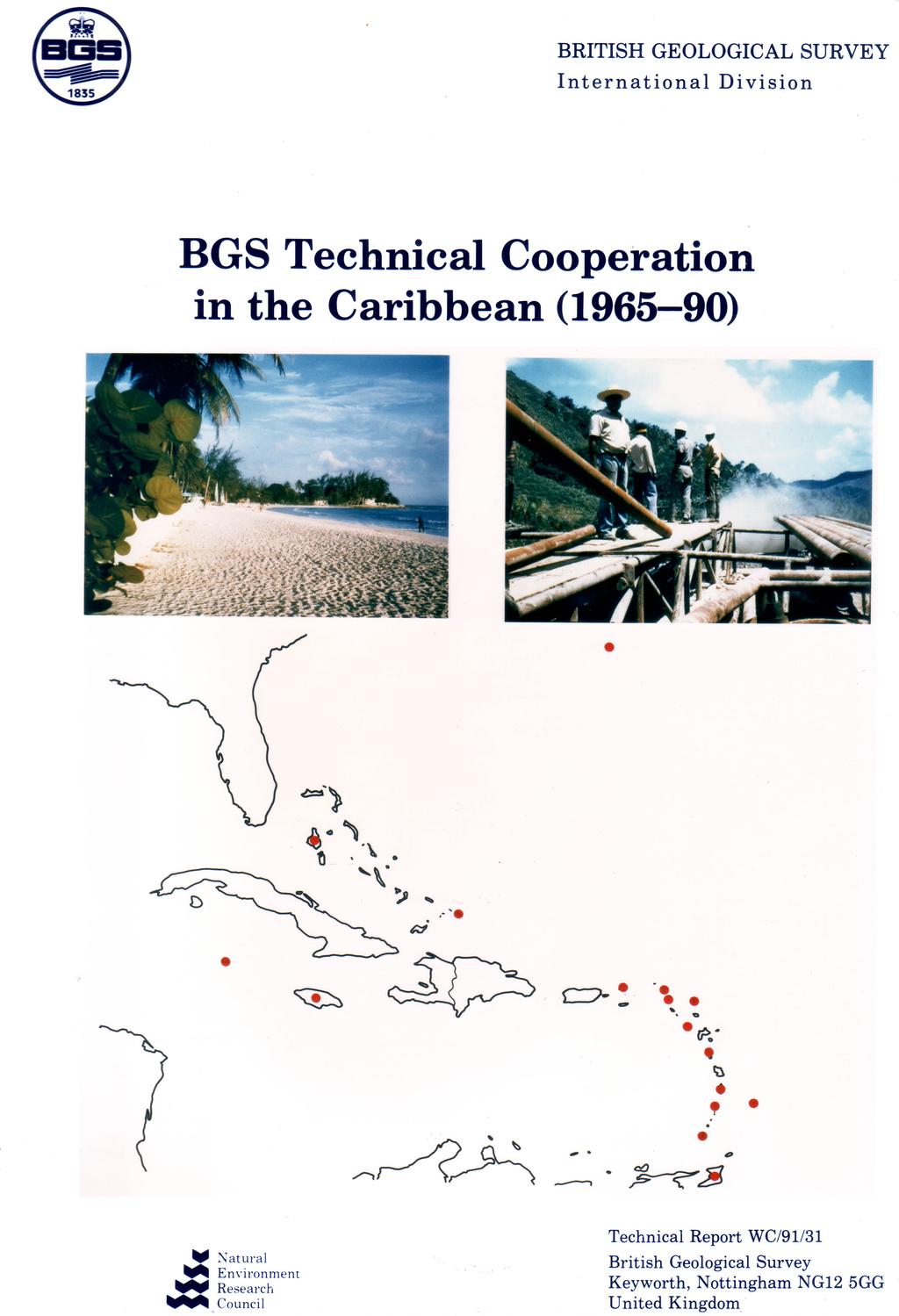
2 British Geological Survey Natural Environment Research Council Technical Report WC/91/31 International Geology Series BGS Technical Cooperation in the Caribbean ( ) S J Mathers (Compiler) International Division Cover illustration Top left, a typical Caribbean beach scene; Top right, drilling to investigate geothermal resources on St Lucia; Bottom, map of the Caribbean, red dots indicate locations of host countries. Bibliographic reference British Geological Survey BGS Technical Cooperation in the Caribbean ( ). British Geological Survey Technical Report WC/91/31. NERC copyright 1991 British Geological Survey Keyworth Nottingham 1991
3 PROJECT LIST BY COUNTRY COUNTRY PROJECT NO. TITLE DATE ANGUILLA 10 UNESCO Hydrogeological Atlas Small Hydrogeological Studies Various ANTIGUA & BARBUDA 11 Construction Materials Small Hydrogeological Studies Various BAHAMAS 1 Hydrogeology of the Bahamian Islands BARBADOS 2 Geological Surveying of Barbados Small Hydrogeological Studies Various BERMUDA 12 Small Hydrogeological Studies Various BRITISH VIRGIN ISLANDS 10 UNESCO Hydrogeological Atlas Construction Materials Small Hydrogeological Studies Various CAYMAN ISLANDS 12 Small Hydrogeological Studies Various DOMINICA 3 Dominica Minerals Study Geotechnical Study of Freshwater Lake, Dominica Construction Materials 1980 GRENADA 10 UNESCO Hydrogeological Atlas
4 JAMAICA 5 Geological Surveying of Jamaica Geochemical mapping of the CARICOM countries 1987 On-going 7 Geophysical Investigations for Groundwater Small Hydrogeological Studies Various MONTSERRAT 9 Geothermal Energy Studies Construction Materials 1980 ST KITTS & NEVIS 10 UNESCO Hydrogeological Atlas ST LUCIA 9 Geothermal Energy Studies ST VINCENT & GRENADINES 10 UNESCO Hydrogeological Atlas Construction Materials Small Hydrogeological Studies Various TRINIDAD & TOBAGO 8 Porcellanite Study, Trinidad 1968 TURKS & CAICOS ISLANDS 10 UNESCO Hydrogeological Atlas Small Hydrogeological Studies Various
5 Introduction This report summarizes work undertaken by the British Geological Survey (BGS); formerly the Institute of Geological Sciences (IGS); in the Caribbean Basin during the period The work was carried out as bilateral cooperation between the UK and the various host countries and was mainly funded by the Overseas Development Administration (ODA) as part of the UK overseas aid programme. The politically fragmented nature of the Caribbean coupled with the small size of many of the constituent island nations means that the projects mounted were relatively small. The emphasis has naturally been towards countries which have historical links with Britain and those islands that still remain Crown Colonies. An index of the countries involved in the programme, together with details of their political status and the projects with which they were concerned, is given at the end of this report. Bermuda, which lies in the Atlantic Ocean off the coast of North America has been included in this review. The work undertaken has comprised geological surveying, identification of mineral and energy resource potential and, in particular, assessment of water resources. There are about 25 countries within the Caribbean Basin and some 16 of these, including Bermuda, have benefitted from cooperation with the BGS (and IGS) since 1965 (Fig.1). The work undertaken can conveniently be summarized in twelve individual projects, eight of which were country specific and four comprised regional initiatives involving several countries. The information contained in this report is also stored in a BGS database of international activities. Review of Projects The eight country-specific projects are as follows:- Bahamas The hydrogeology of several of the Bahamian Islands was studied utilizing existing records, geophysics and drilling. Important lenses of usable freshwater were detected on each of the twelve islands studied; guidelines were developed for safe abstraction rates in order to avoid over-exploitation and the attendant problem of saline intrusion. Barbados Geological Surveying of the Island of Barbados was accomplished at 1: scale; a new generalized geological map of the whole Island and a more detailed map of the complex Scotland District were published together with descriptions of the geology. During the survey materials that had potential use as industrial minerals were identified and preliminary "characterization" tests were performed enabling advice on potential applications to be provided. Dominica The potential of the island of Dominica as a source of bauxite was investigated in 1966 taking advantage of fresh roadside cuttings produced by highway construction. Unfortunately no economic reserves were identified, the clay deposits proving suitable only for ceramic uses. Systematic sampling of stream sediments on the island was also carried out revealing several geochemical anomalies worthy of further investigation for metallic minerals. A short consulting visit was made to Dominica in 1981 by an Engineering Geologist to assess the feasibility of upgrading the storage capacity of Freshwater Lake Reservoir. The study reported favourably on plans to develop the reservoir and recommended the types of specific work that would be required.
6
7 Jamaica Geological surveying and interpretation of remotely sensed data were undertaken for selected parts of Jamaica, and a series of geological maps produced at 1: scale, covering much of the island, together with an inventory of the islands mineral resources. Special attention was paid to the urban geology and associated geotechnical problems of Kingston. An on-going EC-funded regional study of geochemical mapping in the Caribbean has initially focused on gathering data in Jamaica. Geochemical anomalies suggesting potentially valuable deposits of gold and platinum have been identified and the chemical data also provide useful background information for the selection of sources of agrominerals. It is hoped to extend the studies througout the CARICOM region with continued funding. Seismic, resistivity and gravity surveys were undertaken in support of an UN-sponsored groundwater project in Jamaica. The seismic studies helped locate fault zones which have a high water yielding capacity. Trinidad and Tobago Field and laboratory investigations were carried out on a porcellanite deposit in Trinidad with a view to its use as a pozzolan in cement manufacture. Extensive reserves were identified by the study and the laboratory tests revealed that 80% of the material satisfied the ASTM (American) specifications for this application. The four studies which have involved more than one Caribbean nation are as follows:- The geothermal energy potential of hot spring systems was investigated on St Lucia and Montserrat. The studies involved geological surveying, drilling, geophysics and geochemical analysis. Recommendations were made for continued exploration of the systems which were subsequently implemented by the UN. BGS has recently completed a contribution to a United Nations Education and Science Council (UNESCO) hydrogeological atlas of the Caribbean. The atlas which is "in press" will include data provided by BGS in conjunction with the local authorities in six Caribbean countries, Anguilla, British Virgin Islands, Grenada, St Christopher & Nevis, St Vincent & Grenadines and the Turks and Caicos Islands. Construction materials were the focus of an exploratory visit to several of the Windward and Leeward Islands in Advice on the suitability and quality of existing materials was provided whilst new sources of some materials were identified. Numerous small hydrogeological studies concerned mainly with water supply and the problems of pollution and saline intrusion have been carried out. In addition to the studies in the Bahamas, described separately above, some nine other Caribbean nations have benefitted from these investigations over the last 25 years.
8 NOTE ON PROJECT SIZE On the Project Summary Forms the size of individual projects is given on a scale of 1 (very large) - 5 (small). Broad descriptions of these five categories are as follows Size 1 Large multidisciplinary studies carried out by sizeable residential teams with considerable specialist support; usually running for 5-10 years; making a major contribution to the development of geological knowledge and potential of the host country. Size 2 Important regional studies carried out by residential teams with specialist support usually upto 5 years in duration, making a significant contribution to geological knowledge of the host country. Size 3 Residential projects undertaken by 2-3 staff with some specialist support, generally about 3 years duration often concerned with particular themes or topics Size 4 Size 5 Small projects on specific topics usually involving non-residential input from a small groups of specialists or an individual. Short minor consultancies, training and advisory visits carried out by 1-2 staff usually with specific objectives.
9 ODA/BRITISH GEOLOGICAL SURVEY FORM A3 PROJECT COMPLETION FORM PROJECT NO: 1 TITLE: HYDROGEOLOGY OF BAHAMIAN ISLANDS LOCATIONS: Bahamas PROJECT SIZE: 4 DATES: COLLABORATING ORGANISATIONS Land Resources Division ODA (LRD) Bahamas Ministry of Works, Public Works Department PROJECT OBJECTIVES Studies of Groundwater Resources on many Bahamian Islands (Abaco, Acklins, Andros, Cat, Crooked, Eleuthera, Grand Bahama, Great Exuma, Inagua, Little Exuma, Long, Mayaguana) PROJECT RESULTS Lenses of usable freshwater were detected by drilling and geophysics, on all the islands studied, guidelines have been developed for safe abstraction rates. This was the first water resource evaluation of the Bahamian Islands and their freshwater lens reserves.
10 OUTPUT (Reports, Papers, & etc) Land Resources of the Commonwealth of the Bahama Islands: (eight volumes) as follows 1970 Vol 1 Abaco 1970 Vol 2 Eleuthera 1972 Vol 3 Cat Island 1973 Vol 4 Andros 1975 Vol 5 Grand Bahama 1975 Vol 6 Great Exuma, Little Exuma, Long Island 1975 Vol 7 Crooked Island, Acklins 1975 Vol 8 Mayaguana, Inagua Little, B G, Buckley, D K, Cant, R, Young, R N Land resources of the Bahamas: a summary. LRD publication pp. WORKSHOPS AND PRESENTATIONS PROJECT STAFF D A Gray Dr J D Mather Dr D K Buckley FUNDING ODA Technical Cooperation
11 ODA/BRITISH GEOLOGICAL SURVEY FORM A3 PROJECT COMPLETION FORM PROJECT NO: 2 TITLE: GEOLOGICAL SURVEYING OF BARBADOS LOCATIONS: Barbados PROJECT SIZE: 4 DATES: COLLABORATING ORGANISATIONS Ministry of Trade and Industry, Government of Barbados PROJECT OBJECTIVES Geological surveying and the preparation of a new geological map of Barbados and a more detailed map of the complex Scotland District of the island. Brief associated studies of mineral deposits of the island. PROJECT RESULTS Geological studies enabled new geological maps of Barbados to be prepared together with a detailed map of the Scotland District. They were published by the Directorate of Overseas Surveys (DOS) Various industrial minerals including clays and glass sand were tested and advice was given on their possible uses.
12 OUTPUT (Reports, Papers, & etc) Maps 18 1: detailed geological maps covering the whole island (DOS 1227 dyeline series) A 1: detailed geological map of the Scotland District Barbados, DOS 1982 A 1: geological map of Barbados with explanatory text, DOS 1983 Reports Barker, L H and Poole, E G The geology and mineral assessment of the Island of Barbados. Report published by the Barbados Government. Morgan, D J, Wilmot, R D and Bain, J A Technical evaluation of clays from Barbados. IGS Applied Mineralogy Unit Report No 261. WORKSHOPS AND PRESENTATIONS PROJECT STAFF E G Poole FUNDING ODA Technical Cooperation
13 ODA/BRITISH GEOLOGICAL SURVEY FORM A3 PROJECT COMPLETION FORM PROJECT NO: 3 TITLE: DOMINICA MINERALS STUDY LOCATIONS: Dominica PROJECT SIZE: 4 DATES: 1966 COLLABORATING ORGANISATIONS PROJECT OBJECTIVES To examine and sample new road exposures on Dominica to investigate the possibility of Bauxite reserves. Systematic panning of Dominica's rivers for geochemical analysis. Investigation of Islands' mineral potential PROJECT RESULTS The results of chemical tests indicate that there is little prospect of finding commercial bauxite deposits in the accessible parts of the island. The clay deposits examined however could be suitable for use in ceramics. Several areas with anomalously high values of Cu, Pb and Zr have been detected which give hope that economic deposits of these minerals might be encountered by more detailed follow-up studies. Adequate reserves of accessible pumice are available to meet the long-term requirements for the lightweight aggregate industry in the Caribbean.
14 OUTPUT (Reports, Papers, & etc) Dawson, J Mineral Survey reconnaissance of Dominica, British West Indies. Institute of Geological Sciences. Overseas Division Report No 15. WORKSHOPS AND PRESENTATIONS PROJECT STAFF J Dawson FUNDING ODA Technical Cooperation
15 ODA/BRITISH GEOLOGICAL SURVEY FORM A3 PROJECT COMPLETION FORM PROJECT NO: 4 TITLE: GEOTECHNICAL STUDY OF FRESHWATER LAKE, DOMINICA LOCATIONS: Dominica PROJECT SIZE: 5 DATES: 1981 COLLABORATING ORGANISATIONS PROJECT OBJECTIVES The Dominican Electricity service and the Commonwealth Development Corporation planned to upgrade the storage capacity of Freshwater Lake for the Trafalgar Falls hydroelectric power station. A request to ODA was made for an engineering geologist to make a preliminary examination of the lake and surrounding area with the following terms of reference: To examine the area around the existing lake which would be inundated by raising the water level 40 feet and assessing any problems which might arise. To examine possible dam sites and assess the technical feasibility of constructing a dam of the required size and height having regard to existing foundation conditions; If the construction of a dam to impound an additional 40 feet depth of water was not thought to be technically feasible to advise on the maximum height and location of a feasible dam (if any); If the construction of the dam was thought to be technically feasible, drawing up terms of reference for any geological investigations required to prove the feasibility of construction and to allow consulting engineers to prepare designs for the project. PROJECT RESULTS This preliminary study confirmed that the main site is topographically suitable for dam construction, certainly up to 40' in height. An additional structure in the vicinity of the 'saddle' may also be required to prevent leakage towards the north west. Foundation conditions in both areas seem reasonable, but a further subsurface investigation will be required before alternative designs for the main structure can be finalised. The chief geological uncertainty of the reservoir site concerns seismic and volcanic activity, but this problem would need to be carefully investigated for any major civil engineering structure on the island.
16 OUTPUT (Reports, Papers, & etc) Gostelow, T P Geological study of Freshwater Lake, Dominica West Indies. IGS Report. WORKSHOPS AND PRESENTATIONS PROJECT STAFF T P Gostelow FUNDING ODA Technical Cooperation
17 ODA/BRITISH GEOLOGICAL SURVEY FORM A3 PROJECT COMPLETION FORM PROJECT NO: 5 TITLE: GEOLOGICAL SURVEYING OF JAMAICA LOCATIONS: Jamaica PROJECT SIZE: 3 DATES: COLLABORATING ORGANISATIONS Geological Survey Department, Jamaica PROJECT OBJECTIVES Geological mapping and interpretation of remote sensing data of selected parts of Jamaica as a basis for the construction of tunnels for water supply and the development of mineral resources. Production of a series of 1: geological maps covering the island. Production of an inventory of the mineral resources of Jamaica as a guide for industry and government. Detailed investigation of the geology of the urban area around the capital city Kingston. PROJECT RESULTS Geological mapping of the Blue Mountains and Kingston area was accomplished and detailed geological maps were produced. Geological information was reviewed for the compilation of a series of 1: geological maps of Jamaica. An inventory of mineral resources was published.
18 OUTPUT (Reports, Papers, & etc) Green, G W and Holliday, D W The Cretaceous rocks of the Blue Mountain Peak, Jamaica. Journal Geological Society of Jamaica (Geonotes), 11, pp Holliday, D W Field excursion to the Brooks and Bito gypsum quarries, eastern St Andrew. Journal Geological Society of Jamaica, Vol 11, Holliday, D W Origin of Lower Eocene gypsum - anlydirte rocks. SE St Andrew, Jamaica. Transactions of the Institue of Mining and Metallurgy, Vol 80 B Green, G W The structure and stratigraphy of the Wagwater Belt in the vicinity of Kingston, Jamaica. Overseas Geology and Mineral Resources, No 48. Black, C D G and Green, G W and Nawrocki, P E Preliminary investigation of the Castleton copper prospect. Economic Geology Report, Geological Survey of Jamaica, 4, 26 pp JGS Pub 115. Hughes, I G The Mineral Resources of Jamaica. Bulletin Geological Survey of Jamaicia, No 8, 89 pp. Bateson, J H Nomenclature of the Cretaceous rocks of the Central Inlier. Journal Geological Society of Jamaica Vol 13, Bateson, J H Notes on the geology of the Bath area and their relationship to the Cretaceous rocks of the Blue Mountains. Journal Geological Society of Jamaica Vol 15, : Geological Maps of Jamaica with explanatory text (20 Sheets, 2 / 3 island covered) WORKSHOPS AND PRESENTATIONS 6th Caribbean Geological Conference, Margarita, Venezuela 1971 PROJECT STAFF I G Hughes G W Green Dr D W Holliday J E G W Greenwood J H Bateson C R Cratchley Dr B Denness FUNDING ODA Technical Cooperation
19 ODA/BRITISH GEOLOGICAL SURVEY FORM A3 PROJECT COMPLETION FORM PROJECT NO: 6 TITLE: GEOCHEMICAL MAPPING OF THE CARICOM COUNTRIES LOCATIONS: Jamaica (to-date) PROJECT SIZE: 4 DATES: 1987-On-going COLLABORATING ORGANISATIONS Centre for Nuclear Sciences, University of West Indies PROJECT OBJECTIVES To develop regional geochemical mapping methods in the Caribbean region appropriate for economic development, including agriculture and the minerals industry, environmental geochemistry and health. To work with local counterparts to develop this programme as an ongoing project based at the Centre for Nuclear Sciences, University of West Indies. PROJECT RESULTS Geochemical data gathered have helped pin-point potentially valuable deposits of gold and platinum in Jamaica and provide a database useful for the selection of agrominerals. The results to data are summarised in the seven publication and one confidential consultants report listed below.
20 OUTPUT (Reports, Papers, & etc) Simpson, P R, Hurdley, J and Plant, J A Technical Assistance Geochemical Mapping Phase 1: Orientation Study and Training, Final Report on the Field Survey and Laboratory Studies University of the West Indies, Technical Assistance Contract. Simpson, P R, Lalor, G C, Robotham, H, Hurdley, J, Milodowski, A E, Plant, J A and Smith, T K New evidence of epithermal gold potential in andesitic volcanics of the Central Inlier, Jamaica. Transactions of the Institute of Mining and Metallurgy, B: 87, B Lalor, G C, Miller, J, Robotham, H and Simpson, P R Gamma radiometric survey of Jamaica. Transactions of the Institute of Mining and Metallurgy B: 98 B Simpson, P R, Hurdley, J, Plant, J A, Lalor, G C and Robotham, H Geochemistry for Agromineral Studies in the Caribbean Region. Abstracts, 28th International Geological Congress, Washington, DC USA, July 1989, Simpson, P R, Hurdley, J, Lalor, G C, Plant, J A, Robotham, H and Thompson, C Orientation Studies in Jamaica for multipurpose geochemical mapping of the Caribbean Region. In Proceedings of IGCP 259, International Geochemical Mapping at the 28th International Geological Congress, Washington, DC USA, July Transactions of the Institute of Mining and Metallurgy. Simpson, P R, Robotham, H and Hall, G E M Regional Geochemical Orientation Studies for Platinum in Jamaica. Transactions of the Institute of Mining and Metallurgy Simpson, P R, Lalor, G C, Robotham, H, Hurdley, J A and Plant, J A Geochemical techniques for agromineral and related studies in Jamaica. In Geosciences in Development Proceedings of an international conference on the application of the geosciences in developing countries, Nottingham, September 1988, Stow, D A V and Laming D J C. eds., AGID Report Series No 14, Balkema, Rotterdam, Simpson, P R. In press. Orientation studies for Regional Geochemical Surveys in Jamaica. In Proceedings of Recent Advances in Caribbean Geology, an international conference to mark the 40th year of the University of the West Indies, Nov Journal of the Geological Society of Jamaica. WORKSHOPS AND PRESENTATIONS Presentations at: 40th anniversary conference of University of West Indies 1988 Geosciences in Development, AGID, Nottingham th International Geological Congress, Washington DC, USA 1989 PROJECT STAFF Dr P R Simpson M Williams J Hurdley Dr J A Plant FUNDING EC European Aid
21 ODA/BRITISH GEOLOGICAL SURVEY FORM A3 PROJECT COMPLETION FORM PROJECT NO: 7 TITLE: GEOPHYSICAL INVESTIGATIONS FOR GROUNDWATER LOCATIONS: Jamaica PROJECT SIZE: 4 DATES: COLLABORATING ORGANISATIONS PROJECT OBJECTIVES Geophysical studies (seismic, resistivity and gravity) were required to assist in a UN-sponsored groundwater project in Jamaica. Three areas of interest were defined - the Pedro Plains, the Queen of Spain's Valley and the Moneague Basin. PROJECT RESULTS Detailed seismic, resistivity and gravity surveys were carried out at the three sites of interest. Seismic velocities were found to be very variable and their relation to the geology was unclear possibly suggesting that the seismic layers do not correspond to geological beds. Zones of faulting which can be expected to have a high water yield were detected. Low resistivities in the surface layers made the resistivity surveys of limited value and more sensitive instruments than those available would be required to assess the extent of saline intrusion in the areas studied. A single gravity profile failed to reveal the position of the zones of faulting indicated by the seismic studies and this approach was thus abandoned.
22 OUTPUT (Reports, Papers, & etc) Andrew, E M and Greenwood, P G Geophysical Investigations for UNSF FAO Groundwater Project, Jamaica. IGS Overseas Division Geophysical Report No p. WORKSHOPS AND PRESENTATIONS PROJECT STAFF E M Andrew P G Greenwood FUNDING United Nations - Food and Agriculture Organisation
23 ODA/BRITISH GEOLOGICAL SURVEY FORM A3 PROJECT COMPLETION FORM PROJECT NO: 8 TITLE: PORCELLANITE STUDY, TRINIDAD LOCATIONS: Trinidad and Tobago PROJECT SIZE: 5 DATES: 1968 COLLABORATING ORGANISATIONS Ministry of Petroleum and Mines, Trinidad and Tobago PROJECT OBJECTIVES Field and Laboratory Investigations of Porcellanite in Trinidad to determine its reserves and economic applications. PROJECT RESULTS Laboratory studies show the porcellanite, when finely ground, has excellent pozzolanic properties enabling its use in concretes which need good resistance to attack by acidic groundwater and seawater. The field investigations, involving surveying, drilling and systematic sampling covered about 33% of the porcellanite body and proved extensive reserves of over 700 Million Tonnes. Detailed follow-up tests show that over 80% of the porcellanite meets the ASTM (American) Standards for construction materials. This should enable the production of pozzolanic cement at about half the cost of traditional 'Portland' cement.
24 OUTPUT (Reports, Papers, & etc) Bristow, C R Detailed Survey of Part of the Trinidad Porcellanite Deposits. IGS Overseas Division Report No p. WORKSHOPS AND PRESENTATIONS PROJECT STAFF Dr C R Bristow FUNDING ODA Technical Cooperation
25 ODA/BRITISH GEOLOGICAL SURVEY FORM A3 PROJECT COMPLETION FORM PROJECT NO: 9 TITLE: GEOTHERMAL ENERGY STUDIES LOCATIONS: Montserrat, St Lucia PROJECT SIZE: 4 DATES: 1974/5 COLLABORATING ORGANISATIONS Merz and McLellan Consulting Engineering Newcastle-upon-Tyne, UK (St Lucia Studies) University of the West Indies (Seismic Research Unit) PROJECT OBJECTIVES To investigate the possibility of using high enthalpy water and steam resources on St Lucia and Montserrat to provide steam for electric power. PROJECT RESULTS Geological surveying, exploratory drilling, geophysics and geochemical sampling of the geothermal hot springs on St Lucia and Montserrat was accomplished. Recommendations were made for continued exploration of the systems. Several deep wells were drilled in St Lucia; those that produced steam were tested for yield, reservoir conditions, water chemistry and gas composition. Further drilling by Italian consultants was funded by the UN, but BGS had no involvemnt in this later phase of development and the results are not known.
26 OUTPUT (Reports, Papers, & etc) Morgan-Jones, M and Edmunds, W M The Hydrochemistry of the Sulphur Springs. Soufriere, St Lucia IGS Report WD/74/6. Buckley, D K The St Lucia Geothermal Project. Interim Report Oct IGS Report WD/OS/75/9. Williamson, K H Preliminary report on geothermal well measurements; application to St Lucia Project IGS Report WD/OS/75/10. Murray, K H Report on the use of the Atlas Copco Craelius D75 drilling rig in Montserrat, W Indies. IGS Report WD/OS/76/11. Merz and McLellan Geothermal Prospect at Soufriere. Results of Exploratory Holes 1-5. Report for Govt. of St Lucia, under assignment from Min. of Overseas Dev., UK. (2 Vols) Bath, A H Investigations of quality of output from steam wells at Sulphur Springs, St Lucia, W Indies. IGS Report WD/OS/76/6. Bath, A H and Edmunds, W M The design, installation and operation of a steam-water cyclone separator for sampling at a steam-producing well in St Lucia, W Indies. IGS Report WD/OS/76/7. Williamson, K H Investigation of physical characteristics of output from steam wells at Sulphur Springs, St Lucia, W Indies. IGS Report WD/OS/76/9. Williamson, K H Steam production tests on geothermal wells at Sulphur Springs, St Lucia. IGS Report WD/OS/76/22. Bath, A H Summary of hydrochemical data for the geothermal area in Montserrat, W Indies. IGS Report WD/OS/77/2. Williamson, K H and Wright, E P St Lucia Geothermal Project in Proceedings of the Symposium on Geothermal Energy, Ankara, Turkey 1977, p Bath, A H Chemical Interaction in a geothermal System in St Lucia, W Indies. Proceedings of 2nd International Symposium on Water-Rock Interaction. Strassbourg France. Williamson, K H A model for the Sulphur Springs, Geothermal Field, St Lucia. Geothermics Vol 8 p Williamson, K H Tentative model for the Sulphur Springs, Geothermal System, St Lucia. IGS Report WD/OS/79/2. WORKSHOPS AND PRESENTATIONS Geothermal Energy Seminar, St Lucia Symposium on Geothermal Energy, Ankara, Turkey nd International Symposium on Water-Rock Interaction, Strasbourg, France 1977.
27 PROJECT STAFF Dr A H Bath Dr K H Williamson Dr E P Wright J H Bateson D R Giddings M Morgan-Jones Dr W M Edmunds D K Buckley K H Murray FUNDING ODA Technical Cooperation
28 ODA/BRITISH GEOLOGICAL SURVEY FORM A3 PROJECT COMPLETION FORM PROJECT NO: 10 TITLE: UNESCO HYDROGEOLOGICAL ATLAS LOCATIONS: Anguilla, British Virgin Islands, Grenada, St Christopher & Nevis, St Vincent & Grenadines, Turks & Caicos Islands PROJECT SIZE: 5 DATES: COLLABORATING ORGANISATIONS United Nations Education and Science Council (UNESCO) Department of Water & Electricity, Anguilla Department of Water & Sewerage, British Virgin Islands Central Water Commission, Grenada Water Department & British Development Divisions, St Christopher & Nevis Central Water & Sewerage Authority, St Vincent & Grenadines Public Works Department, Turks and Caicos Islands PROJECT OBJECTIVES Preparation of summary reports and maps on the Hydrogeology of six Caribbean Island Nations for inclusion in a forthcoming UNESCO Atlas. The work involved reviewing existing documentation coupled with limited water sampling and testing to provide the information required for the atlas. PROJECT RESULTS The objective was achieved satisfactorily and the documentation forwarded to UNESCO, the contribution has also been published as a BGS report. The UNESCO Atlas is scheduled for publication in 1993.
29 OUTPUT (Reports, Papers, & etc) BGS 1988 Contributions to the UNESCO Hydrogeological Atlas of the Caribbean Islands. BGS Technical Report WD/88/30 (6 Volumes, as follows) Volume 1 Turks and Caicos by A C Cripps 2 British Virgin Islands by G J Penn & N S Robins 3 Anguilla by B Howarth & N S Robins 4 St Christopher & Nevis by T B Kennedy & N S Robins 5 St Vincent & Grenadines by D Cummings & A R Lawrence 6 Grenada by W Ferguson & A R Lawrence Robins, N S, Lawrence, A R and Cripps, A C Problems of groundwater development in small volcanic islands in the eastern Caribbean. International Symposium on Tropical Hydrology and Fourth Caribbean Islands Water Resources Congress, AWRA. p WORKSHOPS AND PRESENTATIONS Workshop on the Hydrogeological Atlas of the Caribbean Islands. Santa Domingo Workshop on the Hydrogeological Atlas of the Caribbean. Caracas, Venezuela Tropical Hydrology and Caribbean Water Resources Conference. Puerto Rico PROJECT STAFF A C Cripps Dr R A Downing N S Robins A R Lawrence FUNDING ODA Technical Cooperation
30 ODA/BRITISH GEOLOGICAL SURVEY FORM A3 PROJECT COMPLETION FORM PROJECT NO: 11 TITLE: CONSTRUCTION MATERIALS LOCATIONS: Antigua & Barbuda, British Virgin Islands, Dominica, Montserrat, St Vincent & Grenadines PROJECT SIZE: 5 DATES: 1980 COLLABORATING ORGANISATIONS PROJECT OBJECTIVES An advisory visit to several of the Windward and Leeward Islands in connection with materials for construction. PROJECT RESULTS Detailed field inspections enabled new sources of construction materials to be located on several islands, additionally some materials were identified as unsuitable. Advice on other uses for industrial minerals was given. In Antigua a search failed to locate needed additional reserves of building sand. The Brick Clays being extracted were found to be bentonitic and advice was given on mitigating shrinkage problems on firing. Additional bentonite deposits were located. Barytes veins were located but proved uneconomic. In the British Virgin Islands a source of good roadstone aggregate was located. In Dominica brick and pottery clay, beach gravel and pumice were examined. In Montserrat large supplies of uniform grade aggregate were located. On St Vincent dry river deposits were found to be unsuitable for use as a pozzolan.
31 OUTPUT (Reports, Papers, & etc) WORKSHOPS AND PRESENTATIONS PROJECT STAFF E G Poole FUNDING ODA Technical Cooperation
32 ODA/BRITISH GEOLOGICAL SURVEY FORM A3 PROJECT COMPLETION FORM PROJECT NO: 12 TITLE: SMALL HYDROGEOLOGICAL STUDIES LOCATIONS: Anguilla, Antigua & Barbuda, Barbados, Bermuda, British Virgin Islands, Cayman Islands, Jamaica, St Vincent & Grenadines, Turks & Caicos Islands PROJECT SIZE: 4/5 DATES: Various COLLABORATING ORGANISATIONS The Public Works and Health Departments of the various islands PROJECT OBJECTIVES Principally the objective of the studies was to identify new groundwater resources required by development of the region; this was carried out on many islands. A principal problem that is encountered is that of saline intrusion from the sea making groundwater resources of low-lying coastal regions unsuitable for use. Such intrusion is commonly exacerbated in areas with a long history of groundwater extraction and careful studies are needed to advise on safe extraction ratios to avoid worsening the problem. PROJECT RESULTS 1968 Brief Consulting visits to Jamaica, Barbados and Cayman Islands to advise on Ground-water Resources Survey of Saline Intrusion in the Miocene Limestone Aquifer of Anguilla involving drilling and borehole logging. Survey of Groundwater Resources in the Tertiary Limestone Aquifer of the Cayman Islands; proved resources sufficient for existing needs. Survey of Groundwater Resources in Turks & Caicos Islands gave mixed results showing some to be islands without freshwater resources. Survey of Barbuda identified extensive groundwater resources close to the capital Codrington. Survey of Carriacou, St Vincent and Grenadines showed adequate groundwater resources are lacking. Survey of Tortola, British Virgin Islands proved adequate long-term resources Collaborative Studies with ODA-funded Water Engineer in Anguilla involving modelling of the freshwater lens of the island and the development of a coastal aquifer model by BGS Study of pollution risks on Bermuda with local authorities, Recommendations made to maintain viable water resources.
33 OUTPUT (Reports, Papers, & etc) Wright, E P The Water Resources of Anguilla with particular reference to groundwater development. IGS Report WD/70/3. Wright, E P Anguilla Water Resources Study. BGS Technical Report WD/OS/83/1. Lawrence, A R The Groundwater Resources of St Helena. BGS Technical Report WD/OS/83/12. Wright, E P Hydrogeology and Groundwater Resources of Anguilla. BGS Technical Report WD/OS/85/28. Barker, J A and Williams, A T Experiences in modelling the freshwater lens of Anguilla BGS Technical Report WD/OS/85/26. Also Description of the model. BGS Technical Report WD/OS/85/27, and Review of hydrogeology. BGS Technical Report WD/OS/85/28. Thomson, J A M and Foster, S S D Groundwater Pollution Risks on Limestone Islands: An analysis of the Bermuda case. BGS Technical Report WD/OS/85/24. Lawrence, A R A review of the Groundwater Investigation Programme on St Helena. BGS Technical Report WD/OS/87/13. Thomson, J A M and Foster, S S D Effects of urbanisation on groundwater in limestone islands: an analysis of the Bermuda case. Journal Institute Water Engineers and Scientists 40, p WORKSHOPS AND PRESENTATIONS Presentation at: International Association of Hydrogeologists 21st Congress Guilim, China, PROJECT STAFF Dr E P Wright Dr J A Barker Dr S S D Foster B Adams A R Lawrence FUNDING ODA Technical Cooperation
THE UNIVERSITY OF THE WEST INDIES MONA CAMPUS TOTAL NUMBER OF GRADUATES - OFF-CAMPUS BY FACULTY, COUNTRY AND SEX, 2007
 TABLE 49 TOTAL NUMBER OF - OFF-CAMPUS ANGUILLA M F T M F T M F T M F T M F T M F T 0 0 0 0 1 1 0 0 0 0 0 0 0 0 0 0 1 1 ANTIGUA & BARBUDA 0 0 0 0 0 0 0 0 0 0 1 1 0 0 0 0 1 1 BAHAMAS 1 0 1 0 0 0 0 0 0 0
GEONETCast Future Plans at CIMH
 GEONETCast Future Plans at CIMH Operations, Training, Climate Monitoring and Disaster Preparedness WORLD METEOROLOGICAL ORGANIZATION COORDINATION GROUP ON SATELLITE DATA REQUIREMENTS FOR REGION III AND
Summary of geothermal setting in Geo-Caraïbes target islands
 Summary of geothermal setting in Geo-Caraïbes target islands Dr Simon R Young Consultant to OAS Presentation made at the Guadeloupe workshop, 27 April 2004 St Lucia - overview Only one broad target area
Disaster Risk Assessment: Opportunities for GIS and data management with Open DRI
 Disaster Risk Assessment: Opportunities for GIS and data management with Open DRI Jacob Opadeyi Department of Geomatics Engineering and Land Management, The University of the West Indies, St. Augustine,
INTERNATIONAL HYDROGRAPHIC ORGANIZATION MESO AMERICAN & CARIBBEAN SEA HYDROGRAPHIC COMMISSION
 INTERNATIONAL HYDROGRAPHIC ORGANIZATION MESO AMERICAN & CARIBBEAN SEA HYDROGRAPHIC COMMISSION CAPACITY BUILDING PLAN Programme document for the period 2010-2012 1. INTRODUCTION 1.1. Rationale It is estimated
Tuesday 6 June 2017 Afternoon
 Oxford Cambridge and RSA Tuesday 6 June 2017 Afternoon A2 GCE GEOLOGY F794/01 Environmental Geology *6783378785* Candidates answer on the Question Paper. OCR supplied materials: None Other materials required:
ASSOCIATION OF CARIBBEAN STATES (ACS / AEC)
") ASSOCIATION OF CARIBBEAN STATES (ACS / AEC) 1 SHOCS (Strengthening Hydrometorological Operations and Services in Caribbean SIDS) The ACS/Finnish Government response to Hydrometorological risk in Caribbean
ASSOCIATION OF CARIBBEAN STATES (ACS / AEC) 1 SHOCS (Strengthening Hydrometorological Operations and Services in Caribbean SIDS) The ACS/Finnish Government response to Hydrometorological risk in Caribbean
Mineral investment opportunities in the UAE
 Mineral investment opportunities in the UAE Clive Mitchell Industrial Minerals Specialist British Geological Survey Outline of presentation Intro & BGS work in the UAE Ministry of Energy (MoE) UAE geology
1978 MSc Geology, South Dakota School of Mines and Technology Introduction to Groundwater Vistas (Groundwater Modeling) Albuquerque, New Mexico
 Albuquerque, New Mexico") Clyde Yancey, BSc, MSc, PGeo Vice President of Exploration Education 1978 MSc Geology, South Dakota School of Mines and Technology 1975 BA Geology Trinity University 1999 Introduction to Groundwater Vistas
Clyde Yancey, BSc, MSc, PGeo Vice President of Exploration Education 1978 MSc Geology, South Dakota School of Mines and Technology 1975 BA Geology Trinity University 1999 Introduction to Groundwater Vistas
James Francis Natukunda
 James Francis Natukunda Department of Geological Surveys and Mines Ministry of Energy and Mineral Development, Uganda Regional stakeholders workshop for EARS countries and partners Nairobo, Kenya 15-17
An Environmental Profile of the Island of Jost Van Dyke, British Virgin Islands
 An Environmental Profile of the Island of Jost Van Dyke, British Virgin Islands Executive Summary including Little Jost Van Dyke, Sandy Cay, Green Cay and Sandy Spit This publication was made possible
STATUS OF HAZARD MAPS VULNERABILITY ASSESSMENTS AND DIGITAL MAPS
 JapanInternational Cooperation Agency STATUS OF HAZARD MAPS VULNERABILITY ASSESSMENTS AND DIGITAL MAPS ANGUILLA REPORT THE CARIBBEAN DISASTER EMERGENCY RESPONSE AGENCY () Table of Contents Page Preface
INFORMATION RESOURCES FOR MARINE AND AQUATIC SCIENCES RESEARCH IN TRINIDAD AND TOBAGO
 INFORMATION RESOURCES FOR MARINE AND AQUATIC SCIENCES RESEARCH IN TRINIDAD AND TOBAGO Introduction Sharida Hosein The University of the West Indies Campus Libraries St Augustine, Trinidad and Tobago. West
Monday 2 June 2014 Morning
 Monday 2 June 2014 Morning A2 GCE GEOLOGY F794/01 Environmental Geology *3076922876* Candidates answer on the Question Paper. OCR supplied materials: None Other materials required: Electronic calculator
GEOTHERMAL EXPLORATION
 GEOTHERMAL EXPLORATION IN BURUNDI Country s location Burundi is a landlocked country in Central Africa, Its area is 27834 km², It is boarded with RDC in the West, Rwanda in the North and Tanzania in the
Does the SDCP need inputs from geology?
 The British Geological Survey s Experience and Expertise in Supporting Projects such as the Sirte Depression Connection Project David Ovadia Director of International Kingsley Dunham Centre Keyworth Nottingham
Global Environment Facility - Integrating Watershed & Coastal Areas Management (GEF-IWCAM): Andros Demonstration Site
: Andros Demonstration Site") Global Environment Facility - Integrating Watershed & Coastal Areas Management (GEF-IWCAM): Andros Demonstration Site Coastal Aquifer Management in Small Island Developing States of the Caribbean: Challenges
Global Environment Facility - Integrating Watershed & Coastal Areas Management (GEF-IWCAM): Andros Demonstration Site Coastal Aquifer Management in Small Island Developing States of the Caribbean: Challenges
Licensed Science Officer Benchmark
 POSITION EVALUATION RATIONALE POSITION TITLE Senior Project Geologist MINISTRY AND DIVISION Energy, Mines and Petroleum Resources: Geological Division BRANCH AND SECTION Mineral Resources UNIT OR PROGRAM
B. T. Brady, M. S. Bedinger, John Mikels, William H. Langer, and Deborah A. Mulvihill
 DEPARTMENT OF THE INTERIOR UNITED STATES GEOLOGICAL SURVEY TO ACCOMPANY WRI REPORT 83-4121-B MAP SHOWING GROUND-WATER LEVELS, SPRINGS. AND DEPTH TO GROUND WATER, BASIN AND RANGE PROVINCE, TEXAS by B. T.
Geology and the Aggregate Industry: The Role of Geologists
 Geology and the Aggregate Industry: The Role of Geologists Donald G. Mikulic Illinois State Geological Survey Prairie Research Institute University of Illinois at Urbana-Champaign Outline Importance of
FOUNDATION DESIGN AND CASE STUDIES
 The University of the West Indies Organization of American States PROFESSIONAL DEVELOPMENT PROGRAMME: COASTAL INFRASTRUCTURE DESIGN, CONSTRUCTION AND MAINTENANCE A COURSE IN DESIGN OF MARINE STRUCTURES
Report on visit to Morne Prosper, Dominica
 THE UNIVERSITY OF THE WEST INDIES SEISMIC RESEARCH CENTRE Report on visit to Morne Prosper, Dominica 19-20 May 2014 Prepared by Erouscilla P. Joseph and Frederic Dondin St. Augustine, Trinidad and Tobago,
Ontario Ministry of Northern Development and Mines Submission to the Joint Review Panel Public Hearing Proposed Bruce Deep Geological Repository
 Ontario Ministry of Northern Development and Mines Submission to the Joint Review Panel Public Hearing Proposed Bruce Deep Geological Repository August 27, 2013 Background and Scope June 18, 2013, the
Climate Change Impacts and Adaptation for Coastal Transport Infrastructure in Caribbean SIDS
 UNCTAD National Workshop Saint Lucia 24 26 May 2017, Rodney Bay, Saint Lucia Climate Change Impacts and Adaptation for Coastal Transport Infrastructure in Caribbean SIDS Impacts of Natural Hazards on the
THIS IS A NEW SPECIFICATION
 THIS IS A NEW SPECIFICATION ADVANCED GCE GEOLOGY Environmental Geology F794 * OCE / 12441* Candidates answer on the Question Paper OCR Supplied Materials: None Other Materials Required: Electronic calculator
The Wind Speeds in Selected Islands During Hurricanes Irma and Maria in 2017 compiled by Tony Gibbs FREng
 The Wind Speeds in Selected Islands During Hurricanes Irma and Maria in 2017 compiled by Tony Gibbs FREng Structural failures leading to serious damage or collapse, or those severely affecting the use
Licensed Science Officer Benchmark
 POSITION EVALUATION RATIONALE POSITION TITLE MINISTRY AND DIVISION Energy, Mines and Petroleum Resources: Geology Division BRANCH AND SECTION Mineral Resources Branch, Applied Geology Section UNIT OR PROGRAM
1.0 Introduction 1.1 Geographic Location 1.2 Topography 1.3 Climate and Rainfall 1.4 Geology and Hydrogeology 1.5 Water Availability 1.
 1.0 1.1 Geographic Location 1.2 Topography 1.3 Climate and Rainfall 1.4 Geology and Hydrogeology 1.5 Water Availability 1.6 Demography 1.0 1.1 Geographic Location St. Lucia forms part of an archipelago
Geo-hazard Potential Mapping Using GIS and Artificial Intelligence
 Geo-hazard Potential Mapping Using GIS and Artificial Intelligence Theoretical Background and Uses Case from Namibia Andreas Knobloch 1, Dr Andreas Barth 1, Ellen Dickmayer 1, Israel Hasheela 2, Andreas
ANN ROBERTSON TAIT PRESENT POSITION. Business Development Manager / Senior Geologist EXPERTISE
 ANN ROBERTSON TAIT PRESENT POSITION Business Development Manager / Senior Geologist EXPERTISE Integration of geoscientific and engineering analyses to solve resource development and management problems
GEOTHERMAL POTENTIAL OF ST. KITTS AND NEVIS ISLANDS
 GEOTHERMAL POTENTIAL OF ST. KITTS AND NEVIS ISLANDS By Gerald W. Huttrer Geothermal Management Company, Inc. For the Eastern Caribbean Geothermal Energy Project ( Geo- Caraibes ; G-C ) Presented Using
Initial Borehole Drilling and Testing in or Near Ignace
 JUNE 2016 PRELIMINARY ASSESSMENT OF POTENTIAL SUITABILITY Initial Borehole Drilling and Testing in or Near Ignace DRAFT FOR DISCUSSION WITH COMMUNITIES In 2010, the Nuclear Waste Management Organization
THIS IS A NEW SPECIFICATION
 THIS IS A NEW SPECIFICATION ADVANCED GCE GEOLOGY Environmental Geology F794 * OCE / 12353* Candidates answer on the Question Paper OCR Supplied Materials: None Other Materials Required: Ruler (cm/mm) Thursday
WHAT IS MINERAL EXPLORATION?
 INDABA PRESENTATION CAPE TOWN FEBRUARY 2017 AIM:SAV WHAT IS MINERAL EXPLORATION? AIM:SAV What is mineral exploration? 2 Exploration is the term used to describe a wide range of activities aimed at searching
An Introduction to Field Explorations for Foundations
 An Introduction to Field Explorations for Foundations J. Paul Guyer, P.E., R.A. Paul Guyer is a registered mechanical engineer, civil engineer, fire protection engineer and architect with over 35 years
Geothermal Resource Prospecting in the Qualibou Caldera, Saint Lucia
 Geothermal Resource Prospecting in the Qualibou Caldera, Saint Lucia By Frank Dale Morgan Geo-Caraibes Technical Team & Massachusetts Institute of Technology March 2006 Outline History Summary Brief Review
resource and vulnerability Robineau & Join, nov
 Groundwater in tropical islands resource and vulnerability Robineau & Join, nov 2007 1 Diversity of hydrogeological environments in coastal areas of tropical islands : Hydrologic conditions (surface waters)
Technical Requirements of Geothermal Exploration in the RSM DADI THORBJORNSON, RSM CONSULTANT WORKSHOP SWISS HOTEL IZMIR 5 JULY 2018
 Technical Requirements of Geothermal Exploration in the RSM DADI THORBJORNSON, RSM CONSULTANT WORKSHOP SWISS HOTEL IZMIR 5 JULY 2018 JV Partners Engineering firm with hundred twenty years of experience
LAND DEGRADATION IN THE CARIBBEAN: QUATERNARY GEOLOGICAL PROCESSES. RAFI AHMAD
 EXTENDED TASK FORCE MEETING OF PARTICIPATING AGENCIES AND LATIN AMERICAN COUNTRIES FOR ENHANCING SOUTH-SOUTH COOPERATION BETWEEN LAC-CARIBBEAN SIDS PARTNERSHIP INITIATIVE ON LAND DEGRADATION AND SUSTAINABLE
ASX Announcement. 28 January Drill results indicate large Porphyry Copper Gold System at Peenam
 ASX Announcement 28 January 2010 Drill results indicate large Porphyry Copper Gold System at Peenam Highlights: 270 metres of visible copper (gold) mineralisation in first diamond core hole at Peenam Prospect
Country s location
 GEOTHERMAL EXPLORATION IN BURUNDI Short course III on Exploration for Geothermal Resources organized by UNU-GTP and KenGen Naivasha, Kenya, 24th October - 17 November, 2008 Presented by HUREGE Déogratias
MOAG Copper Gold Resources Inc. World Class Moly Opportunity
 World Class Moly Opportunity MOAG has two large exploration projects with a land base of over 135 square kilometres in politically stable mine friendly jurisdictions, British Columbia, Canada and Ireland.
Initial Borehole Drilling and Testing in Central Huron,
 JULY 2016 PRELIMINARY ASSESSMENT OF POTENTIAL SUITABILITY Initial Borehole Drilling and Testing in Central Huron, Huron-Kinloss and South Bruce DRAFT FOR DISCUSSION WITH COMMUNITIES In 2012, at the request
Weather Observing and Forecasting and the Hurricane Warning System in the Caribbean
 T.W. Sutherland: Weather Observing and Forecasting and the Hurricane Warning System in the Caribbean 6 ISSN 1000 7924 The Journal of the Association of Professional Engineers of Trinidad and Tobago Vol.42,
Blox, Inc. Announces New Drilling Target Defined at Mansounia Gold Project.
 Blox, Inc. Announces New Drilling Target Defined at Mansounia Gold Project. Vancouver, British Columbia, July 6, 2018 Blox, Inc. (OTCQB: BLXX), ( Blox or the Company ) is pleased to announce that a new
For personal use only
 L4 66 Kings Park Road West Perth WA 6005 P: +61 8 6141 3585 F: +61 8 6141 3599 E: info@drakeresources.com.au ASX Announcement 16 th September 2014 Seimana Gold Project Technical Update and Next Steps Geophysical
A pluralistic approach to EBM implementation in the Caribbean.
 A pluralistic approach to EBM implementation in the Caribbean. Lucia Fanning Marine Affairs Program Dalhousie University AORAC-SA FAO workshop: Making the ecosystem approach operational 20-22 January 2016
SURVEY OF CLOSED AND ABANDONED MINES IN BRITISH COLUMBIA FOR ACID ROCK DRAINAGE I: REGIONAL PERSPECTIVE ABSTRACT
 SURVEY OF CLOSED AND ABANDONED MINES IN BRITISH COLUMBIA FOR ACID ROCK DRAINAGE I: REGIONAL PERSPECTIVE Stephen J. Day 1 and David P. Harpley 2 1 Norecol Environmental Consultants Ltd. 700-1090 West Fender
Geologic Resources. Geologic Resources and Society. Geologic Resources and Society
 Geologic Resources Our entire society rests upon - and is dependent upon - our water, our land, our forests, and our minerals. How we use these resources influences our health, security, economy, and well-being.
Initial Borehole Drilling in the Hornepayne and Manitouwadge Area
 MAY 2017 PRELIMINARY ASSESSMENT OF POTENTIAL SUITABILITY Initial Borehole Drilling in the Hornepayne and Manitouwadge Area In 2010, the Nuclear Waste Management Organization (NWMO) began technical and
Silver City Minerals
 ABN 68 130 933 309 ASX Code: SCI Silver City Minerals Annual General Meeting 15 November 2016 1 Important Disclaimer This presentation is provided to you for the sole purpose of providing background technical,
Experiences on Data and Observational Requirements in the Caribbean
 Experiences on Data and Observational Requirements in the Caribbean UNFCCC Expert Workshop on Methods & Tools and on Data & Observations under the NWP on Impacts, Vulnerability & Adaptation to Climate
Taller de Geotermica en Mexico Geothermal Energy Current Technologies
 Taller de Geotermica en Mexico Geothermal Energy Current Technologies presented by Paul Brophy, President/CEO EGS Inc. Mexico City October 10 th 2011 Presentation Topics General Geothermal Discussion Exploration
Climate Change Impacts and Adaptation for Coastal Transport Infrastructure in Caribbean SIDS
 UNCTAD National Workshop Jamaica 30 May 1 June 2017, Kingston, Jamaica Climate Change Impacts and Adaptation for Coastal Transport Infrastructure in Caribbean SIDS Impacts of Natural Hazards on the Transport
Harvey Thorleifson, Director, Minnesota Geological Survey. Status of geological mapping needed for groundwater protection in Minnesota
 Harvey Thorleifson, Director, Minnesota Geological Survey Status of geological mapping needed for groundwater protection in Minnesota Minnesota is located between the Dakotas and Wisconsin, north of Iowa,
Valuation Early Stage Exploration Projects
 Valuation Early Stage Exploration Projects Presented By: Tracey Laight Date: 20 January 2016 Location: AMA London SRK Exploration Services Ltd 2016. All rights reserved. Everything has a value Every project
Hurricane Matthew Page 1 Location Forecast Analysis Summary Report - Advanced Wind Estimation On
 Page 1 Current NHC Forecast Predictions Maximum Sustained Winds / Storm Category: 138 MPH / Category 4 Forward motion: 9 mph towards the North Hurricane Force winds extend from the center: 46 miles Tropical
CARIBBEAN TOURISM CLIMATIC BULLETIN
 A Joint Bulletin of the CTO, the CHTA and the CIMH CARIBBEAN TOURISM CLIMATIC BULLETIN for Tourism Businesses and Policymakers Sept-Oct-Nov 2018 I Vol 2 I Issue 3 Photo Credit: Cayman Islands Department
Climate Change and Water: What s the future of Caribbean Agriculture?
 Climate Change and Water: What s the future of Caribbean Agriculture? Presented by: Adrian Trotman CAMI Project Manager Chief, Applied Meteorology and Climatology Caribbean Institute for Meteorology and
KANSAS GEOLOGICAL SURVEY Open File Report LAND SUBSIDENCE KIOWA COUNTY, KANSAS. May 2, 2007
 KANSAS GEOLOGICAL SURVEY Open File Report 2007-22 LAND SUBSIDENCE KIOWA COUNTY, KANSAS Prepared by Michael T. Dealy L.G., Manager, Wichita Operations SITE LOCATION The site was approximately four miles
NT RESOURCES LIMITED QUARTERLY ACTIVITIES REPORT FOR THE PERIOD ENDED 30 JUNE 2010 ASX CODE: NTR
 NT RESOURCES LIMITED QUARTERLY ACTIVITIES REPORT FOR THE PERIOD ENDED 30 JUNE 2010 ASX CODE: NTR Activities Report Background NT Resources Limited ( NT Resources or the Company ) holds six granted Exploration
RESISTIVITY IMAGING AND BOREHOLE INVESTIGATION OF THE BANTING AREA AQUIFER, SELANGOR, MALAYSIA. A.N. Ibrahim Z.Z.T. Harith M.N.M.
 JOURNAL OF ENVIRONMENTAL HYDROLOGY The Electronic Journal of the International Association for Environmental Hydrology On the World Wide Web at http://www.hydroweb.com VOLUME 11 2003 RESISTIVITY IMAGING
GEOTHERMAL EXPLORATION PHASE
 Presented at Short Course on Geothermal Project Management and Development, organized by UNU-GTP, KenGen and MEMD-DGSM, at the Imperial Botanical Beach Hotel, Entebbe, Uganda, November 20-22, 2008. GEOTHERMAL
GEOTECHNICAL ENGINEERING II. Subject Code : 06CV64 Internal Assessment Marks : 25 PART A UNIT 1
 GEOTECHNICAL ENGINEERING II Subject Code : 06CV64 Internal Assessment Marks : 25 PART A UNIT 1 1. SUBSURFACE EXPLORATION 1.1 Importance, Exploration Program 1.2 Methods of exploration, Boring, Sounding
Fletcher Junction Project Technical Update December 18, 2008
 Fletcher Junction Project Technical Update December 18, 2008 Disclaimer Warning! The business of Gold Exploration can be FUN, but it can also be hazardous to your physical, emotional, spiritual and financial
The Geological Potential of Central America and the Caribbean: A USGS Report
 The Geological Potential of Central America and the Caribbean: A USGS Report World Bank Workshop Recent Developments in Mining and Sustainable Development in Latin America March 5, 2014 Jane Hammarstrom
GOULAMINA DRILLING AND GENERAL PROGRESS UPDATE
 21 November 2017 GOULAMINA DRILLING AND GENERAL PROGRESS UPDATE HIGHLIGHTS RC drilling at Danaya and Yando completed. RC drilling at Danaya intersects very wide (>117m) spodumene bearing pegmatite zone.
Lalor Project Disclaimer
 Lalor Project Disclaimer HudBay's production decision with respect to Lalor was not based on the results of a pre-feasibility study or feasibility study of mineral resources demonstrating economic or technical
Earth resource investment opportunities in Victoria, Australia
 Your Logo here Earth resource investment opportunities in Victoria, Australia ADELE SEYMON GeoScience Victoria Department of Primary Industries Victorian earth resources diverse and rich Gold world-class
For personal use only
 ASX:LEG 10 July 2014 Fraser Range Aeromagnetic Survey Identifies Targets Seven priority targets considered prospective for nickel-copper Targets interpreted to relate to intrusive mafic/ultramafic bodies
Tropical Storm Isaac. INFORMATION NOTE No. 3 AS OF 8:00 PM (AST) ON SEPTEMBER 12, Synopsis of Tropical Storm Isaac
 ON SEPTEMBER 12, Synopsis of Tropical Storm Isaac") Synopsis of Tropical Storm Isaac LOCATION: 260 MILES EAST NORTH EAST OF MARTINIQUE PRESENT MOVEMENT: WEST AT 20 MPH MAXIMUM SUSTAINED WINDS: 60 MPH MINIMUM CENTRAL PRESSURE: 1003 MB WATCHES AND WARNINGS
Synopsis of Tropical Storm Isaac LOCATION: 260 MILES EAST NORTH EAST OF MARTINIQUE PRESENT MOVEMENT: WEST AT 20 MPH MAXIMUM SUSTAINED WINDS: 60 MPH MINIMUM CENTRAL PRESSURE: 1003 MB WATCHES AND WARNINGS
For personal use only
 ANNOUNCEMENT TO THE AUSTRALIAN SECURITIES EXCHANGE: 28 NOVEMBER 2012 DRILLING UPDATE MABILO PROJECT The Directors of Sierra Mining Limited ( Sierra ) are pleased to announce further results from reconnaissance
SILVER CITY MINERALS LIMITED ABN Silver City Minerals
 ABN 68 130 933 309 ASX Code: SCI Silver City Minerals Annual General Meeting 20 November 2014 SILVER CITY MINERALS SNAPSHOT BROKEN HILL (Ag-Pb-Zn) Project Review and Prioritization: Focus and Plan Razorback
Disaster Risk Management in India. Kamal Kishore New Delhi, 27 October 2016
 Disaster Risk Management in India Kamal Kishore New Delhi, 27 October 2016 Hazard, Exposure and Vulnerability Disaster Prevention Mitigation Hurricane Matthew: Cuba & Haiti Emergency Response Coordination
ASSESSMENT OF GROUNDWATER POTENTIAL IN ARUJO- RODI KOPANY AREA, HOMA BAY COUNTY, KENYA. NAME: AYETE DAVID OMAJILONG
 ASSESSMENT OF GROUNDWATER POTENTIAL IN ARUJO- RODI KOPANY AREA, HOMA BAY COUNTY, KENYA. NAME: AYETE DAVID OMAJILONG SUMMARY. Groundwater development for portable water supply in Kenya for rural people
Covered Area Rainfall Event (18-19 September 2017) Hurricane Maria Excess Rainfall
 Hurricane Maria Excess Rainfall") Covered Area Rainfall Event (18-19 September 2017) Hurricane Maria Excess Rainfall Event Briefing Barbados 28 September 2017 Registered Office: CCRIF SPC c/o Sagicor Insurance Managers Ltd., 198 North
Covered Area Rainfall Event (18-19 September 2017) Hurricane Maria Excess Rainfall Event Briefing Barbados 28 September 2017 Registered Office: CCRIF SPC c/o Sagicor Insurance Managers Ltd., 198 North
The Urban Sea and Coastal Zone Management
 The Urban Sea and Coastal Zone Management David NEALE, Trinidad and Tobago Key words: hydrography, Caribbean, coastal zone management, land use. SUMMARY Within the coastal zone of Eastern Caribbean States,
UN-GGIM:Americas Regional Report
 UN-GGIM:Americas Regional Report 2016-2017 Seventh Session of UN-GGIM 2-4 August 2017, United Nations Headquarters, New York. Rolando Ocampo President of UN-GGIM: Americas Content Activities, Areas of
For personal use only
 12 September 2012 ASX RELEASE ASX Code: WAC FIRST PASS FIELD WORK COMPLETED AT PERU IOCG TARGETS Site visits and reconnaissance sampling has been completed at the Yauca and Chaparra Iron Oxide Copper Gold
ASX Code: ORN Compelling Nickel-Copper Targets Defined at Fraser Range Project
 ASX Code: ORN www.oriongold.com.au Compelling Nickel-Copper Targets Defined at Fraser Range Project 1 Disclaimer and Forward-Looking Statements Certain statements contained in this presentation, including
Alligator Energy Uranium Projects. 6 September 18 NT RESOURCES WEEK Greg Hall, CEO
 Alligator Energy Uranium Projects 6 September 18 NT RESOURCES WEEK Greg Hall, CEO Disclaimer & Competent Person s Statement 2 Disclaimer This presentation contains projections and forward looking information
Guidelines for Site-Specific Seismic Hazard Reports for Essential and Hazardous Facilities and Major and Special-Occupancy Structures in Oregon
 Guidelines for Site-Specific Seismic Hazard Reports for Essential and Hazardous Facilities and Major and Special-Occupancy Structures in Oregon By the Oregon Board of Geologist Examiners and the Oregon
The Need for Regional Geological Datasets
 The Need for Regional Geological Datasets Dr. Eibhlín Doyle PGeo Geological Survey of Ireland Regional Data Why What Who Future 2006 Why? Place developments in context Land use decision making Assist policy
Incorporation of the Caribbean to the Geocentric Reference System for the Americas SIRGAS
 Incorporation of the Caribbean to the Geocentric Reference System for the Americas SIRGAS W. Martínez M. V. Mackern V. Cioce R. Rodino S.R. De Freitas UN-GGIM: Americas Third Session, October 5 2016, Mexico
INAUGURAL FARM IN DRILL RESULTS AT CALARIE PROJECT
 March 1, 2012 INAUGURAL FARM IN DRILL RESULTS AT CALARIE PROJECT TriAusMin Limited (ASX: TRO) (TSX: TOR) ( TriAusMin or the Company ) is pleased to present the attached announcement of drill results by
Diamond and RC Drilling Completed, RAB drilling extended - RAB holes show important geology continues to the south west at the Sorpresa Project
 23 rd May 2013 Company Announcements Platform Australian Securities Exchange Diamond and RC Drilling Completed, RAB drilling extended - RAB holes show important geology continues to the south west at the
THE MINISTRY OF ENERGY AND ENERGY INDUSTRIES MINERALS DIVISION MINE DESIGN TEMPLATE OPERATOR NAME: OPERATOR ADDRESS: PHONE NUMBER: FACSIMILE:
 THE MINISTRY OF ENERGY AND ENERGY INDUSTRIES MINERALS DIVISION MINE DESIGN TEMPLATE 1.0 GENERAL INFORMATION OPERATOR NAME: OPERATOR ADDRESS: PHONE NUMBER: FACSIMILE: NAME OF CONTACT: CELLULAR PHONE: EMAIL
2018 Drilling Underway at Juruena Gold Project
 2018 Drilling Underway at Juruena Gold Project Crusader Resources (ASX:CAS) ( Crusader ) is pleased to announce the commencement of its initial 2018 exploration program over its highly prospective and
Covered Area Rainfall Event (29-30 September 2016) Tropical Cyclone Matthew Excess Rainfall
 Tropical Cyclone Matthew Excess Rainfall") Covered Area Rainfall Event (29-30 September 2016) Tropical Cyclone Matthew Excess Rainfall Event Briefing Dominica 11 October 2016 Registered Office: c/o Sagicor Insurance Managers Ltd., 103 South Church
Covered Area Rainfall Event (29-30 September 2016) Tropical Cyclone Matthew Excess Rainfall Event Briefing Dominica 11 October 2016 Registered Office: c/o Sagicor Insurance Managers Ltd., 103 South Church
Savo Island Inferred Geothermal Resource Assessment
 10 April 2013 Savo Island Inferred Geothermal Resource Assessment Median Initial Inferred Geothermal Resource of 269 PJth estimated to be capable of supporting in excess of 30 MWe of generation capacity
GeothermEx, Inc. GEOTHERMAL RESERVOIR ASSESSMENT METHODOLOGY FOR THE SCIENTIFIC OBSERVATION HOLE PROGRAM, KILAUEA EAST RIFT ZONE, HAWAII TASK 1 REPORT
 (415) 527 9876 CABLE ADDRESS- GEOTHERMEX TELEX 709152 STEAM UD FAX (415) 527-8164 Geotherm Ex, Inc. RICHMOND. CALIFORNIA 94804-5829 GEOTHERMAL RESERVOIR ASSESSMENT METHODOLOGY FOR THE SCIENTIFIC OBSERVATION
about GCC
 about GCC Bldg 234, Flat 11, Al Barakat Street, Hail Al Janaubiyah P.O Box: 94, Postal Code: 123, Al Khaudh, Sultante of Oman Fax : +968 24543188 Mobile :+968 96666445 info@gcc-oman.com www.gcc-oman.com
Magnus Copper Project exploration update
 ASX ANNOUNCEMENT 30 SEPTEMBER 2011 CODE: ALY BOARD OF DIRECTORS Mr Warwick Davies Non-Executive Chairman Mr Robert Brierley Managing Director Mr John Arbuckle Non-Executive Director Mr Jeffrey Moore Non-Executive
For personal use only
 22 April 2013 Drilling to commence at Majada, Copper-Gold Prospect, Chile. Red Gum Resources Limited (ASX: RGX, Red Gum or the Company ) is pleased to announce that drilling of its Majada Copper-Gold Prospect,
ADVANCING A PROSPECTIVE PORTFOLIO TO DISCOVERY SUCCESS. Copper - Gold - Silver SAN VALENTINO. COPPER-GOLD-MOLY Northern Chile.
 ADVANCING A PROSPECTIVE PORTFOLIO TO DISCOVERY SUCCESS Copper - Gold - Silver SAN VALENTINO COPPER-GOLD-MOLY Northern Chile Project Summary March 2018 Cautionary Statement Certain statements contained
3.0 GEOLOGY AND HYDROGEOLOGY
 3.0 GEOLOGY AND HYDROGEOLOGY 3.1 Methodology The Geological Survey of Ireland (GSI) publication Geology of South Cork was consulted to establish the nature of the bedrock lithology and Quaternary sediments.
Geothermal Energy in the UK
 Geothermal Energy in the UK Jon Busby British Geological Survey Outline Geothermal energy in the UK Background to geothermal in the UK context UK geothermal resources Engineered geothermal systems Direct
Quarterly Report Quarter ended 30 June 2010
 28 July 2010 The Company Announcement Officer Australian Securities Exchange Ltd via electronic lodgement Quarterly Report Quarter ended 30 June 2010 Highlights PhosEnergy - Uranium Extraction Technology
PRELIMINARY WORKING DRAFT Work in Progress
 IV. ENVIRONMENTAL IMPACT ANALYSIS H. MINERAL RESOURCES 1.0 INTRODUCTION This section addresses the potential impacts of the Proposed Project on mineral resources (i.e., sand, gravel and petroleum). The
Drought and Precipitation Monitoring in the Caribbean
 Drought and Precipitation Monitoring in the Caribbean SARI BLAKELEY, ADRIAN TROTMAN CARIBBEAN INSTITUTE FOR METEOROLOGY AND HYDROLOGY (CIMH) Caribbean l Water INTRODUCTION The Caribbean is highly susceptible