DIRECTORY OF COAL MINES IN ILLINOIS 7.5-MINUTE QUADRANGLE SERIES NIANTIC QUADRANGLE MACON COUNTY. Cheri Chenoweth & Andrew Louchios
|
|
|
- Esther Lyons
- 5 years ago
- Views:
Transcription
1
2

3 DIRECTORY OF COAL MINES IN ILLINOIS 7.5-MINUTE QUADRANGLE SERIES NIANTIC QUADRANGLE MACON COUNTY Cheri Chenoweth & Andrew Louchios Department of Natural Resources ILLINOIS STATE GEOLOGICAL SURVEY 2004
4
5 DIRECTORY OF COAL MINES IN ILLINOIS 7.5-MINUTE QUADRANGLE SERIES NIANTIC QUADRANGLE MACON COUNTY 2004 ILLINOIS STATE GEOLOGICAL SURVEY William Shilts, Chief Natural Resources Building 615 East Peabody Drive Champaign, Illinois Phone Fax
6 Cover photo Track-mounted duckbill loading machine at a Peabody Coal Company mine, ca DISCLAIMER: The accuracy and completeness of mine maps and directories vary with the availability of reliable information. Maps and other information used to compile this mine map and directory were obtained from a variety of sources and the accuracy of some of the original information cannot be verified. Consequently, the Illinois State Geological Survey (ISGS) cannot guarantee the mine maps are free of errors and disclaims any responsibility for damages that may result from actions or decisions based on them. The ISGS updates the maps and directories periodically, and welcomes any new information or corrections. Please contact the Coal Section of the ISGS at the address shown on the title page of this directory, or telephone (217) Printed by authority of the State of Illinois/2004
7 CONTENTS INTRODUCTION... 1 MINING IN THE NIANTIC QUADRANGLE... 1 PART I EXPLANATION OF MAP AND MINE SUMMARY SHEET... 2 INTERPRETING THE MAP... 2 Mine Type and Mining Method... 2 SOURCE MAPS... 3 POINTS AND LABELS... 3 INTERPRETING A MINE SUMMARY SHEET... 6 REFERENCES... 8 PART II DIRECTORY OF MINES IN THE NIANTIC QUADRANGLE... 9 MINE SUMMARY SHEETS... 9 Mine Index 41 Niantic Carbon Coal Company, Niantic Mine... 9 INDEX OF MINES IN THE NIANTIC QUADRANGLE... 10
8
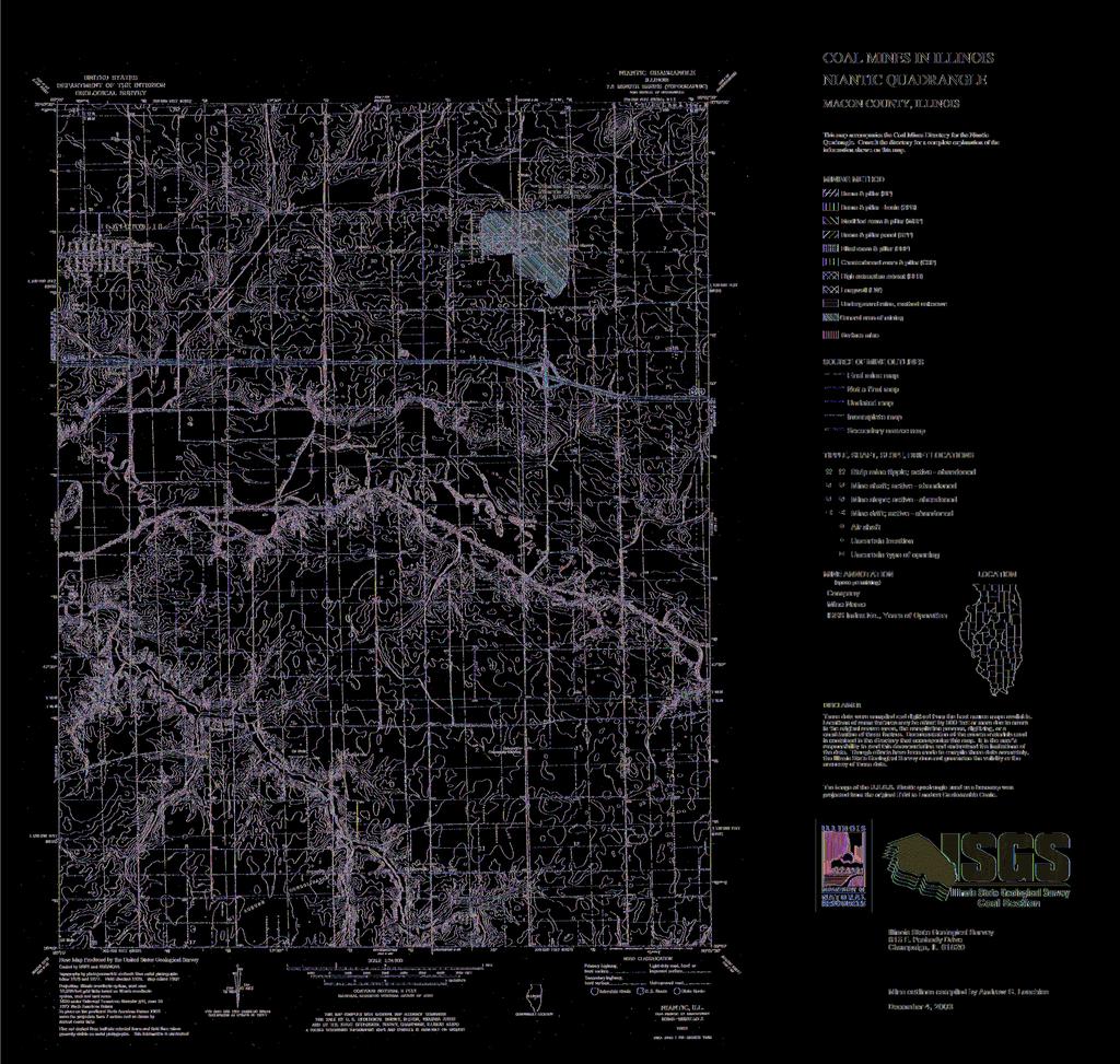
9 INTRODUCTION Coal has been mined in 73 counties of Illinois. More than 4,500 coal mines have operated since commercial mining began in Illinois about 1810; fewer than 30 are currently active. To detail the extent and location of coal mining in Illinois, the Illinois State Geological Survey (ISGS) has compiled maps and directories of known coal mines. The ISGS offers maps at a scale of 1:100,000 and accompanying directories for each county in which coal mining is known to have occurred. Maps at a scale of 1:24,000 and accompanying directories such as this are available for selected quadrangles. Contact the ISGS for a list of these quadrangles. These larger scale maps show the approximate positions of mines in relation to surface features such as roads and water bodies, and indicate the mining method used and the accuracy of the mine boundaries. The maps are useful for locating mine boundaries relative to specific properties and for assessing the potential for subsidence in an area. Mine boundaries compiled from final mine surveys are generally shown within 200 feet of their true position. As a result of poor cartographic quality and inaccuracies in the original mine surveys, boundaries of some older mines may be mislocated on the map by 500 feet or more. Original mine maps should be consulted in situations that require precise delineation of mine boundaries or internal workings of mined areas. The directory serves as a key to the accompanying mine map and provides basic information on the coal mines. The directory is composed of two parts. Part I explains the symbols and patterns used on the accompanying map and the summary data presented for each mine. Part II numerically lists the mines in the quadrangle and summarizes the geology and production history of each mine. MINING IN THE NIANTIC QUADRANGLE The Springfield Coal was mined in Niantic, and it exhibited the characteristics typical of the Springfield Coal characteristics namely, numerous horsebacks and high sulfur content. From the ISGS mine notes, The clay veins are very plentiful in this mine and the cost of mining is so greatly increased that the mine is losing out in competition. Mining generally costs 11 to 22 cents [per ton]. One horseback made the coal cost $4 per ton. In addition, the operators had to contend with thick underclay that tended to heave. The miners went out on strike in 1899, insisting on the mine becoming a union mine with the attendant conditions. The company disagreed, stating that it would be impossible to continue operating the mine in the union s more expensive manner. After the mine was idled 9 months by the strike, the mine re-opened with machines, having installed electricity in the interim. The mine survived to operate for a total of about 40 years, a notable accomplishment when competing with the large mines in Decatur and Springfield, the principal local markets. 1
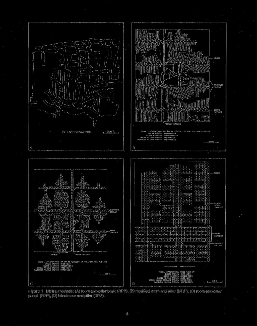
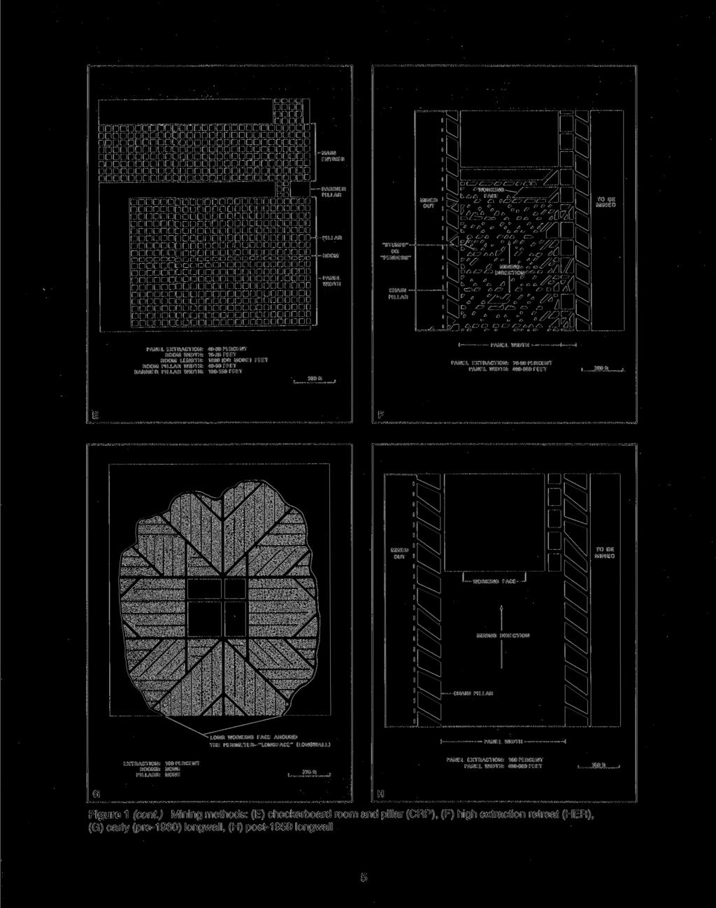
10 PART I EXPLANATION OF MAP AND MINE SUMMARY SHEET INTERPRETING THE MAP The map accompanying this directory shows the location of coal mines known to be present in the quadrangle. The map, corresponding to a U.S. Geological Survey (USGS) 7.5-minute quadrangle, covers an area bounded by lines of latitude and longitude 7.5-minutes apart. In Illinois, a quadrangle is approximately 6.5 miles east to west and 8.5 miles north to south, an area of about 56 square miles. The ISGS generally offers one map of mines per quadrangle. In some areas where extensive mining occurred in two or more overlapping seams, separate maps are compiled for mines in each seam to maintain readability of the map. Mine Type and Mining Method The mine type is indicated on the map by pattern color: green represents surface mines; red and yellow represent underground mines. The red patterns are used for areas of underground mining that are documented by a primary or secondary source map. A yellow pattern is used for cases where no map of the mine workings is available, but a general area of mining can be inferred from property maps or production figures. The patterns indicate the main mining methods used in underground mines. The methods are (1) room and pillar and (2) high extraction. The method used gives some indication of the amount and pattern of coal extraction within each mined area, and has some influence on the timing and type of subsidence that can occur over a mine. The following discussion and illustrations of mining methods are based on Guither et al. (1984). In room-and-pillar mines, coal is removed from haulage-ways (entries) and selected areas called rooms. Pillars of unmined coal are left between the rooms to support the roof. Depending on the size of rooms and pillars, the amount of coal removed from the production areas will range from 40% to 70%. Room and Pillar - mining is divided into six categories: room-and-pillar basic (RPB, fig. 1A), an early method that did not follow a preset mining plan and therefore resulted in very irregular designs; modified room and pillar (MRP, fig. 1B); room-and-pillar panel (RPP, fig. 1C); blind room and pillar (BRP, fig. 1D); checkerboard room and pillar (CRP, fig. 1E); room and pillar (RP), a classification used when the specific type of room-and-pillar mining is unknown. Blind and checkerboard are the most common types of room-and-pillar mining used in Illinois today. The knowledge of room-and-pillar mining methods gives a trained engineer information on the nature of subsidence that may occur. A more extensive discussion of subsidence can be found in Bauer et al. (1993). High-extraction These mining methods are subdivided into high-extraction retreat (HER, Fig 1F) and longwall (LW, Fig 1G, 1H). In these methods, much of the coal is removed within well defined areas of the mine. Subsidence of the surface above these areas occurs within weeks. Once the subsidence activity ceases, the potential for further movement over these areas is low; however, subsidence may continue for several years after mining. High-extraction retreat mining is a form of room-and-pillar mining that extracts most of the coal. Rooms and pillars are developed in the panels, and the pillars are then systematically removed (fig. 1F). In early (pre-1960) longwall mines, mining advanced in multiple directions from a central shaft (fig. 1G). Large pillars of coal were left around the shaft, but all coal was removed beyond these pillars. Miners placed rock and wooden props and cribs in the mined-out areas to support the mine roof. The overlying rock gradually settled onto these supports, thus producing subsidence at the surface. In post-1959 longwall mines, roomand-pillar methods have been used to develop the main entries of the mine and panel areas. Modern longwall methods extract 100 percent of the coal in the panel areas (fig. 1H). 2
11 SOURCE MAPS Mine outlines depicted on the map are, whenever possible, based on maps made from original mine surveys. The process of compiling and digitizing the quadrangle map may produce errors of less than 200 feet in the location of mine boundaries. Larger errors of 500 feet or more are possible for mines that have incomplete or inaccurate source maps. Because of the extreme complexity of some mine maps, detailed features of mined areas have been omitted. The digitized mine boundary includes the exterior boundary of all rooms or entries that were at least 80 feet wide or protruded 500 feet from the main mining area. Unmined areas between mines are shown if they are at least 80 feet wide; unmined blocks of coal within mines are shown if they are at least 400 feet on each side. Original source maps should be consulted when precise information on mine boundaries or interior features is needed. The mine summary sheet lists the source maps used to determine each mine outline. The completeness of map sources is indicated on the map by a line symbol at the mine boundary. Source maps are organized in five categories. Final mine map The mine outline was digitized from an original map made from mine surveys conducted within a few months after production ceased. The date of the map and the last reported production are listed on the summary sheet. Not a final map The mine is currently active or the mine outline was made from a map based on mine surveys conducted more than few months before production ceased. This implies the actual mined-out area is probably larger than the outline on the map. The mine summary sheet indicated the dates of source maps and the last reported production, as well as the approximate tonnage mined between these two dates (if the mine is abandoned). The summary sheet also lists the approximate acreage mined since the date of the map and, in some cases, indicates the area where additional mining may have taken place. This latter information is determined by locating on the map the active faces relative to probable boundaries of the mine property. Undated map The source map was undated, so it may or may not be based on a final mine survey. When sufficient data are available, the probable acreage of the mined area is estimated from reported production, average seam thickness and a recovery rate comparable to other mines in the area. This information is listed in the summary sheet for the mine. Incomplete map The source map did not show the entire mine. The summary sheet indicates the missing part of the mine map and the acreage of the unmapped area, which is estimated from the amount of coal known to have been produced from the mine. Secondary source map The original mine map was not found so the outline shown was determined from secondary sources (e.g., outlines from small-scale regional maps published in other reports). The summary sheet describes the secondary sources. POINTS AND LABELS The locations of all known mine openings (shafts, slopes, and drifts) and surface mine tipples are plotted on the map. Tipples are areas where coal was cleaned, stockpiled, and loaded for shipping. Only openings or tipples are plotted for mines without source maps. If the precise locations of these features are unknown, a special symbol is used to indicate the approximate location of the mine. Each mine on the map is labeled with the names of the mine and operating company, ISGS mine index number, and years of operation (if known) if space permits. A seam designation is given on maps where more than one seam was mined. For a mine that operated under more than one name, only the most recent name is generally given. When a mine changed names or ownership shortly before closing, an earlier name is listed. All company and mine names are listed on the mine summary sheet in the directory, under the production history segment. 3
12
13
14 INTERPRETING A MINE SUMMARY SHEET The mine summary sheet is arranged numerically by mine index number. Index numbers are shown on the map and in the mine listing. The mine summary sheet provides the following information (if available). Company and mine name The last company or owner of the mine is used, unless no production was recorded for the last owner. In that case, the penultimate owner is listed. Mines often have no specific name; in these cases, the company name is also used as the mine name. Type Underground denotes a subsurface mine in which the coal was reached through a shaft, slope, or a drift entry. Surface denotes a surface, open pit or strip mine. Total mined-out acreage shown The total acreage of the mined area mapped, including any acreage mined on adjacent quadrangles, is calculated from the digitized outline of the mine. The acreage of large barrier pillars depicted on the map is excluded from the minedout acreage. Small pillars not digitized are included in the acreage calculation. If the mine outline is not based on a final mine map, the acreage is followed by an estimate of additional acres that may have been mined. The estimate is determined from reported mine production, approximate thickness of the coal, and recovery rates calculated from nearby mines that used similar mining methods. SHAFT, SLOPE, DRIFT OR TIPPLE LOCATIONS Figure 2 Generalized stratigraphic section, showing approximate vertical relations of coals in Illinois. Shaft, slope, drift, or tipple locations Locations of all known former entry points to underground mines or the location of coal cleaning, tipple, and shipping equipment used by the mine s facility are listed. The location is described in terms of county, township and range (Twp-Rge), section, and location within the section by quarters. NE SW NW, for instance, would describe the location in the northeast quarter of the southwest quarter of the northwest quarter. When sections are irregular in size, the quarters remain the same size and are oriented (or registered ) from the southeast corner of the section. Approximate footage from the section lines (FEL = from east line, FNL = from north line, for example) is given when that information is known; this indicates a surveyed location and is not derived from maps. Entry points are also plotted on the map and coded for the type of entry or tipple. A mine opening may have had many purposes during the life of the mine. Old hoist shafts are often later used for air and escape shafts; this information is included in the directory when known. The tipple for underground mines was generally located near the main shaft or slope. At surface mines, coal was sometimes hauled to a central tipple several miles from the mine pit. GEOLOGY Seam(s) mined The name of the coal seam(s) mined is listed if known. If multiple seams were mined, they are all listed, although the mined-out area for each seam may be shown on separate maps. Figure 2 shows the stratigraphic section for the Illinois coal measures and the vertical relations among the coals. Depth The depth to the top of the seam in the vicinity of the shaft is listed if known. The depth is determined from notes made by geologists who visited the mine during its operation or from drill hole data in ISGS files. Depth generally varies little over the extent of a mine; however, reported depths for an individual mine may vary. Depth for surface-mined coals varies, and is usually represented as a range. 6
15 Thickness The approximate thickness of the mined seam is shown, if known. Thickness also comes from notes of geologists who visited the mine during its operation or from borehole data in ISGS files. Minimum, maximum, and average thicknesses are given when this information is available. Mining method The principal mining method used at the mine (figs. 1A-H) is listed. See the mining methods section at the beginning of this directory for a discussion of this parameter. Geologic problems reported Any known geologic problems, such as faults, water seepage, floor heaving, and unstable roof, encountered in the mine are reported. This information is from notes made by ISGS geologists who visited the mine, or from reports by mine inspectors published by the Illinois Department of Mines and Minerals, or from the source map(s). Geologic problems are not reported for active mines. PRODUCTION HISTORY Production history Tons of coal produced from the mine by each mine owner are totaled. When the source map used for the mine outline is not a final mine map, the tonnage produced since the date of the map is identified. For mines that extend into adjacent quadrangles, the tonnage reported includes areas mined in adjacent quadrangles. SOURCE OF DATA Source map This section lists information about the map(s) used to compile the mine outline and the locations of tipples and mine openings. In some cases more than one source map was used. For example, a map drawn before the mine closed may provide better information on original areas of the mine than a later map. When more than one map was used, the bibliography section explains what information was taken from each source. Date The date of the most recent mine survey listed on the source map is reported. Original scale The original scale of the source map is listed. Many maps are photo-reductions and are no longer at their original scale. The original scale gives some indication of the level of detail of the mine outline and the accuracy of the mine boundary relative to surface features. Generally, the larger the scale, the greater the accuracy and detail of the mine map. Mine outlines taken from source maps at scales smaller than 1:24,000 may be highly generalized and may well be inaccurately located with respect to surface features. Digitized scale The scale of the digitized map is reported. The scale may be different from that of the original source map. In many cases the digitized map was made from a photo-reduction of the original source map, or the source map was not in a condition suitable for digitizing and the mine boundaries were transferred to another base map. Map type Source maps are classified into five categories to indicate the probable completeness of the map. See discussion of source maps in the previous section. Annotated bibliography Sources that provide information about the mine are listed, with the data taken from each source. Some commonly used sources are described below. Full bibliographic references are given for all other sources. Unless otherwise noted, all sources are available for public inspection at the ISGS. Coal Reports Published since 1881, these reports contain tabular data on mine ownership, production, employment, and accidents. Some volumes include short descriptions made by mine inspectors of physical features and conditions in selected mines. Directory of Illinois Coal Mines This source is a compilation of basic data about Illinois coal mines, originally gathered by ISGS staff in the early 1950s. Sources used for this directory are undocumented, but they are primarily Illinois Department of Mines and Minerals annual reports, ISGS mine notes, and coal company officials. ENR Document 85/01, Guither, H. D., J. K. Hines, and R. A. Bauer, 1985 The Economic Effect of Underground Mining Upon Land Used for Illinois Agriculture: Illinois Department of Energy and Natural Resources Document 85/01, 185 p. Microfilm map The U.S. Bureau of Mines maintains a microfilm archive of mine maps. A microfilm file for Illinois is available for public viewing at the ISGS. 7
16 Mine notes ISGS geologists have visited mines or contacted mine officials throughout the state since the early 1900s. Notes made during these visits range from brief descriptions of the mine location to long narratives (including sketches) of mining conditions and geology. Federal Land Bank of St. Louis, Preliminary Reports on Subsidence Investigations Mining engineers working for the Federal Land Bank of St. Louis mapped areas of subsidence due to coal mining in the early 1930s. These reports often include county maps of mine properties with mined-out areas including shaft locations, as well as subsidence areas. REFERENCES Bauer, R. A., B. A. Trent, and P. B. Dumontelle, 1993, Mine Subsidence in Illinois: Facts for the Homeowner Considering Insurance: Illinois State Geological Survey, Environmental Geology Note 144, 16p. Guither, H. D., J. K. Hines, and R. A. Bauer, 1985, The Economic Effects of Underground Mining Upon Land Used for Illinois Agriculture: Illinois Department of Energy and Natural Resources Document 85/01, 185p. 8
17 PART II DIRECTORY OF MINES IN THE NIANTIC QUADRANGLE MINE SUMMARY SHEETS A summary sheet on the geology and production history of each mine in the Niantic Quadrangle is provided. The summary is arranged numerically by mine index number, which is shown on the map and in the mine listing. Consult Part I for a complete explanation of the data listed in the summary sheet. Mine Index 41 Niantic Carbon Coal Company, Niantic Mine Type: Underground Total mined-out acreage shown: 340 SHAFT, SLOPE, DRIFT or TIPPLE LOCATIONS Type County Township-Range Section Quarters-Footage Main shaft Macon 16N 1W 12 SW SW NW Air shaft Macon 16N 1W 12 SW SW NW GEOLOGY Thickness (ft) Mining Seam(s) Mined Depth (ft) Min Max Ave Method Springfield RP, some LW ( ) Geologic Problems Reported: Some gas problems were noted in 1884, but increased ventilation remedied the situation. The roof was 3 to 5 inches of black and blue-gray shale, overlain by 2 to 18 inches of limestone cap rock, with 40 feet of gray shale above the limestone. Horsebacks ranged from common to abundant and some were quite large. This increased the cost of mining so that the mine was sometimes not economically competitive. Clay veins were present in the coal, and the upper part of the seam contained small pyrite streaks and many pyrite concretions. The floor clay was 4.5 feet thick and heaved badly when wet. PRODUCTION HISTORY Production Company Mine Name Years (tons) Niantic Coal & Mining Company Niantic * 46,670 City Coal Company Niantic ,286 Niantic Coal Company Niantic ,618 Decatur Coal Company Niantic, Decatur No ** 713,312 Niantic Mining Company Niantic ,962 Niantic Carbon Coal Company Niantic ,416 Farmer s Coal & Supply Company Niantic ,000 Niantic Carbon Coal Company Niantic ,873 1,484,137 * Idle 1886 ** Abandoned 1914, although the mine was later re-opened by another company Last reported production: November 1924 SOURCES OF DATA Original Digitized Source Map Date Scale Scale Map Type WPA, T16N-R1W : :12000 Secondary source Microfilm, document *** :2400 1:414 Secondary source *** The microfilm map was only used to match up with WPA. The microfilm was of very poor quality and almost impossible to read. Annotated Bibliography (data source, brief description of information) Coal Reports - Production, ownership, years of operation. Directory of Illinois Coal Mines (Macon County) - Mine names, mine index, ownership, years of operation. ENR Document 85/01 - Mining method. Mine notes (Macon County) - Mine type, shaft location, seam, depth, thickness. WPA map, T16N-R1W - Mine outline, shaft locations. Microfilm map, document , reel 03138, frame Shaft locations, mine outline, mining method. 9
18 INDEX OF MINES IN THE NIANTIC QUADRANGLE City Coal Company... 9 Decatur Coal Company, No. 3 Mine... 9 Farmer s Coal & Supply Company... 9 Niantic Carbon Coal Company... 9 Niantic Coal & Mining Company... 9 Niantic Coal Company... 9 Niantic Mining Company
19 Funding for this project was supplied by the Illinois Department of Transportation.
DIRECTORY OF COAL MINES IN ILLINOIS 7.5-MINUTE QUADRANGLE SERIES BROADWELL QUADRANGLE LOGAN COUNTY. Margaret H. Bargh
 DIRECTORY OF COAL MINES IN ILLINOIS 7.5-MINUTE QUADRANGLE SERIES BROADWELL QUADRANGLE LOGAN COUNTY Margaret H. Bargh Department of Natural Resources ILLINOIS STATE GEOLOGICAL SURVEY 1994 REVISED 2009 DIRECTORY
DIRECTORY OF COAL MINES IN ILLINOIS 7.5-MINUTE QUADRANGLE SERIES MAZON QUADRANGLE GRUNDY COUNTY. Jennifer M. Obrad
 DIRECTORY OF COAL MINES IN ILLINOIS 7.5-MINUTE QUADRANGLE SERIES MAZON QUADRANGLE GRUNDY COUNTY Jennifer M. Obrad Department of Natural Resources ILLINOIS STATE GEOLOGICAL SURVEY 2006 DIRECTORY OF COAL
DIRECTORY OF COAL MINES IN ILLINOIS 7.5-MINUTE QUADRANGLE SERIES MT. PULASKI QUADRANGLE LOGAN COUNTY. G. K. Coats M. H. Bargh C. G.
 DIRECTORY OF COAL MINES IN ILLINOIS 7.5-MINUTE QUADRANGLE SERIES MT. PULASKI QUADRANGLE LOGAN COUNTY G. K. Coats M. H. Bargh C. G. Treworgy Department of Natural Resources ILLINOIS STATE GEOLOGICAL SURVEY
DIRECTORY OF COAL MINES IN ILLINOIS 7.5-MINUTE QUADRANGLE SERIES SORENTO SOUTH QUADRANGLE BOND & MONTGOMERY COUNTIES
 DIRECTORY OF COAL MINES IN ILLINOIS 7.5-MINUTE QUADRANGLE SERIES SORENTO SOUTH QUADRANGLE BOND & MONTGOMERY COUNTIES Jennifer M. Obrad 2013 Prairie Research Institute William W. Shilts, Executive Director
DIRECTORY OF COAL MINES IN ILLINOIS 7.5-MINUTE QUADRANGLE SERIES WOOD RIVER QUADRANGLE MADISON COUNTY Cheri Chenoweth & Melony E.
 DIRECTORY OF COAL MINES IN ILLINOIS 7.5-MINUTE QUADRANGLE SERIES WOOD RIVER QUADRANGLE MADISON COUNTY Cheri Chenoweth & Melony E. Barrett Department of Natural Resources ILLINOIS STATE GEOLOGICAL SURVEY
DIRECTORY OF COAL MINES IN ILLINOIS 7.5-MINUTE QUADRANGLE SERIES KINSMAN QUADRANGLE GRUNDY & LASALLE COUNTIES. Jennifer M. Obrad
 DIRECTORY OF COAL MINES IN ILLINOIS 7.5-MINUTE QUADRANGLE SERIES KINSMAN QUADRANGLE GRUNDY & LASALLE COUNTIES Jennifer M. Obrad Department of Natural Resources ILLINOIS STATE GEOLOGICAL SURVEY 2006 DIRECTORY
DIRECTORY OF COAL MINES IN ILLINOIS 7.5-MINUTE QUADRANGLE SERIES PRAIRIETOWN QUADRANGLE MADISON COUNTY. Cheri Chenoweth & Andrew Louchios
 DIRECTORY OF COAL MINES IN ILLINOIS 7.5-MINUTE QUADRANGLE SERIES PRAIRIETOWN QUADRANGLE MADISON COUNTY Cheri Chenoweth & Andrew Louchios Department of Natural Resources ILLINOIS STATE GEOLOGICAL SURVEY
DIRECTORY OF COAL MINES IN ILLINOIS 7.5-MINUTE QUADRANGLE SERIES OLNEY QUADRANGLE RICHLAND COUNTY
 DIRECTORY OF COAL MINES IN ILLINOIS 7.5-MINUTE QUADRANGLE SERIES OLNEY QUADRANGLE RICHLAND COUNTY Alan R. Myers 2011 Prairie Research Institute William W. Shilts, Executive Director ILLINOIS STATE GEOLOGICAL
DIRECTORY OF COAL MINES IN ILLINOIS 7.5-MINUTE QUADRANGLE SERIES TONICA QUADRANGLE LA SALLE COUNTY. Jennifer M. Obrad & C.
 DIRECTORY OF COAL MINES IN ILLINOIS 7.5-MINUTE QUADRANGLE SERIES TONICA QUADRANGLE LA SALLE COUNTY Jennifer M. Obrad & C. Chenoweth Department of Natural Resources ILLINOIS STATE GEOLOGICAL SURVEY 2007
DIRECTORY OF COAL MINES IN ILLINOIS 7.5-MINUTE QUADRANGLE SERIES NOKOMIS QUADRANGLE MONTGOMERY & CHRISTIAN COUNTIES
 DIRECTORY OF COAL MINES IN ILLINOIS 7.5-MINUTE QUADRANGLE SERIES NOKOMIS QUADRANGLE MONTGOMERY & CHRISTIAN COUNTIES Jennifer M. Obrad 2011 Prairie Research Institute William W. Shilts, Executive Director
DIRECTORY OF COAL MINES IN ILLINOIS 7.5-MINUTE QUADRANGLE SERIES HILLSBORO QUADRANGLE MONTGOMERY COUNTY
 DIRECTORY OF COAL MINES IN ILLINOIS 7.5-MINUTE QUADRANGLE SERIES HILLSBORO QUADRANGLE MONTGOMERY COUNTY C. Chenoweth 2015 Prairie Research Institute Mark Ryan, Executive Director ILLINOIS STATE GEOLOGICAL
DIRECTORY OF COAL MINES IN ILLINOIS 7.5-MINUTE QUADRANGLE SERIES MOUNT VERNON QUADRANGLE JEFFERSON COUNTY
 DIRECTORY OF COAL MINES IN ILLINOIS 7.5-MINUTE QUADRANGLE SERIES MOUNT VERNON QUADRANGLE JEFFERSON COUNTY Alan R. Myers 2009 Institute of Natural Resource Sustainability William W. Shilts, Executive Director
DIRECTORY OF COAL MINES IN ILLINOIS 7.5-MINUTE QUADRANGLE SERIES FARMINGDALE QUADRANGLE SANGAMON COUNTY
 DIRECTORY OF COAL MINES IN ILLINOIS 7.5-MINUTE QUADRANGLE SERIES FARMINGDALE QUADRANGLE SANGAMON COUNTY C. Chenoweth 2016 Prairie Research Institute Mark Ryan, Executive Director ILLINOIS STATE GEOLOGICAL
DIRECTORY OF COAL MINES IN ILLINOIS 7.5-MINUTE QUADRANGLE SERIES COLFAX QUADRANGLE McLEAN & LIVINGSTON COUNTIES. Alan R. Myers
 DIRECTORY OF COAL MINES IN ILLINOIS 7.5-MINUTE QUADRANGLE SERIES COLFAX QUADRANGLE McLEAN & LIVINGSTON COUNTIES Alan R. Myers Department of Natural Resources ILLINOIS STATE GEOLOGICAL SURVEY 2006 REVISED
DIRECTORY OF COAL MINES IN ILLINOIS 7.5-MINUTE QUADRANGLE SERIES TAYLORVILLE QUADRANGLE CHRISTIAN COUNTY. Jennifer M. Obrad
 DIRECTORY OF COAL MINES IN ILLINOIS 7.5-MINUTE QUADRANGLE SERIES TAYLORVILLE QUADRANGLE CHRISTIAN COUNTY Jennifer M. Obrad Department of Natural Resources ILLINOIS STATE GEOLOGICAL SURVEY 2007 DIRECTORY
DIRECTORY OF COAL MINES IN ILLINOIS 7.5-MINUTE QUADRANGLE SERIES BLOOMINGTON WEST QUADRANGLE MCLEAN COUNTY. Cheri Chenoweth & Andrew Louchios
 DIRECTORY OF COAL MINES IN ILLINOIS 7.5-MINUTE QUADRANGLE SERIES BLOOMINGTON WEST QUADRANGLE MCLEAN COUNTY Cheri Chenoweth & Andrew Louchios Department of Natural Resources ILLINOIS STATE GEOLOGICAL SURVEY
DIRECTORY OF COAL MINES IN ILLINOIS 7.5-MINUTE QUADRANGLE SERIES COLUMBIA QUADRANGLE MONROE & ST. CLAIR COUNTIES
 DIRECTORY OF COAL MINES IN ILLINOIS 7.5-MINUTE QUADRANGLE SERIES COLUMBIA QUADRANGLE MONROE & ST. CLAIR COUNTIES Alan R. Myers 2013 Prairie Research Institute William W. Shilts, Executive Director ILLINOIS
DIRECTORY OF COAL MINES IN ILLINOIS 7.5-MINUTE QUADRANGLE SERIES KEENSBURG QUADRANGLE WABASH COUNTY
 DIRECTORY OF COAL MINES IN ILLINOIS 7.5-MINUTE QUADRANGLE SERIES KEENSBURG QUADRANGLE WABASH COUNTY Alan R. Myers & C. Chenoweth 2012 Prairie Research Institute William W. Shilts, Executive Director ILLINOIS
DIRECTORY OF COAL MINES IN ILLINOIS 7.5-MINUTE QUADRANGLE SERIES PAWNEE QUADRANGLE CHRISTIAN, SANGAMON & MONTGOMERY COUNTIES
 DIRECTORY OF COAL MINES IN ILLINOIS 7.5-MINUTE QUADRANGLE SERIES PAWNEE QUADRANGLE CHRISTIAN, SANGAMON & MONTGOMERY COUNTIES Alan R. Myers & C. Chenoweth Department of Natural Resources ILLINOIS STATE
DIRECTORY OF COAL MINES IN ILLINOIS 7.5-MINUTE QUADRANGLE SERIES BRUSSELS QUADRANGLE & portions of KAMPVILLE QUADRANGLE, CALHOUN COUNTY
 DIRECTORY OF COAL MINES IN ILLINOIS 7.5-MINUTE QUADRANGLE SERIES BRUSSELS QUADRANGLE & portions of KAMPVILLE QUADRANGLE, CALHOUN COUNTY Alan R. Myers & C. Chenoweth 2010 Institute of Natural Resource Sustainability
DIRECTORY OF COAL MINES IN ILLINOIS 7.5-MINUTE QUADRANGLE SERIES NEW DOUGLAS QUADRANGLE MADISON & MACOUPIN COUNTIES Cheri Chenoweth & Melisa L.
 DIRECTORY OF COAL MINES IN ILLINOIS 7.5-MINUTE QUADRANGLE SERIES NEW DOUGLAS QUADRANGLE MADISON & MACOUPIN COUNTIES Cheri Chenoweth & Melisa L. Borino Department of Natural Resources ILLINOIS STATE GEOLOGICAL
DIRECTORY OF COAL MINES IN ILLINOIS 7.5-MINUTE QUADRANGLE SERIES COFFEEN QUADRANGLE MONTGOMERY & BOND COUNTIES
 DIRECTORY OF COAL MINES IN ILLINOIS 7.5-MINUTE QUADRANGLE SERIES COFFEEN QUADRANGLE MONTGOMERY & BOND COUNTIES Jennifer M. Obrad 2011 Prairie Research Institute William W. Shilts, Executive Director ILLINOIS
DIRECTORY OF COAL MINES IN ILLINOIS 7.5-MINUTE QUADRANGLE SERIES WORDEN QUADRANGLE MADISON & MACOUPIN COUNTIES Cheri Chenoweth & Melisa L.
 DIRECTORY OF COAL MINES IN ILLINOIS 7.5-MINUTE QUADRANGLE SERIES WORDEN QUADRANGLE MADISON & MACOUPIN COUNTIES Cheri Chenoweth & Melisa L. Borino Department of Natural Resources ILLINOIS STATE GEOLOGICAL
DIRECTORY OF COAL MINES IN ILLINOIS 7.5-MINUTE QUADRANGLE SERIES PONTIAC NW QUADRANGLE LIVINGSTON COUNTY. Jennifer M. Obrad & C.
 DIRECTORY OF COAL MINES IN ILLINOIS 7.5-MINUTE QUADRANGLE SERIES PONTIAC NW QUADRANGLE LIVINGSTON COUNTY Jennifer M. Obrad & C. Chenoweth Department of Natural Resources ILLINOIS STATE GEOLOGICAL SURVEY
DIRECTORY OF COAL MINES IN ILLINOIS 7.5-MINUTE QUADRANGLE SERIES SPRING GARDEN QUADRANGLE JEFFERSON & FRANKLIN COUNTIES
 COAL MINES IN ILLINOIS SPRING GARDEN QUADRANGLE FRANKLIN & JEFFERSON COUNTIES, ILLINOIS This map accompanies the Coal Mines Directory for the SPRING GARDEN Quadrangle. Consult the directory for a complete
Coal Mines in Illinois WOODHULL QUADRANGLE HENRY & KNOX COUNTIES Colchester & Rock Island Coals
 THIS MAP ACCOMPANIES THE COAL MINES DIRECTORY FOR THE WOODHULL QUADRANGLE. CONSULT THE DIRECTORY FOR A COMPLETE EXPLANATION OF THE INFORMATION SHOWN ON THIS MAP. Coal Mines in Illinois WOODHULL QUADRANGLE
DIRECTORY OF COAL MINES IN ILLINOIS 7.5-MINUTE QUADRANGLE SERIES SILVIS QUADRANGLE ROCK ISLAND COUNTY. Jennifer M. Obrad & C.
 DIRECTORY OF COAL MINES IN ILLINOIS 7.5-MINUTE QUADRANGLE SERIES SILVIS QUADRANGLE ROCK ISLAND COUNTY Jennifer M. Obrad & C. Chenoweth Institute of Natural Resources Sustainability ILLINOIS STATE GEOLOGICAL
DIRECTORY OF COAL MINES IN ILLINOIS 7.5-MINUTE QUADRANGLE SERIES LEBANON QUADRANGLE ST. CLAIR COUNTY. Cheri Chenoweth & Melony E.
 DIRECTORY OF COAL MINES IN ILLINOIS 7.5-MINUTE QUADRANGLE SERIES LEBANON QUADRANGLE ST. CLAIR COUNTY Cheri Chenoweth & Melony E. Barrett Department of Natural Resources ILLINOIS STATE GEOLOGICAL SURVEY
DIRECTORY OF COAL MINES IN ILLINOIS 7.5-MINUTE QUADRANGLE SERIES DEPUE QUADRANGLE BUREAU & PUTNAM COUNTIES
 DIRECTORY OF COAL MINES IN ILLINOIS 7.5-MINUTE QUADRANGLE SERIES DEPUE QUADRANGLE BUREAU & PUTNAM COUNTIES Jennifer M. Obrad & C. Chenoweth 2009 Institute of Natural Resource Sustainability William W.
Coal Mines in Illinois SANDFORD QUADRANGLE EDGAR COUNTY Danville Coal
 THIS MAP ACCOMPANIES THE COAL MINES DIRECTORY FOR THE QUADRANGLE. CONSULT THE DIRECTORY FOR A COMPLETE EXPLANATION OF THE INFORMATION SHOWN ON THIS MAP. Coal Mines in Illinois QUADRANGLE Danville Coal
DIRECTORY OF COAL MINES IN ILLINOIS 7.5-MINUTE QUADRANGLE SERIES GILLESPIE NORTH QUADRANGLE MACOUPIN COUNTY. Melisa L. Borino & Cheri Chenoweth
 DIRECTORY OF COAL MINES IN ILLINOIS 7.5-MINUTE QUADRANGLE SERIES GILLESPIE NORTH QUADRANGLE MACOUPIN COUNTY Melisa L. Borino & Cheri Chenoweth Department of Natural Resources ILLINOIS STATE GEOLOGICAL
DIRECTORY OF COAL MINES IN ILLINOIS 7.5-MINUTE QUADRANGLE SERIES THOMPSONVILLE QUADRANGLE FRANKLIN & WILLIAMSON COUNTIES. Alan R.
 DIRECTORY OF COAL MINES IN ILLINOIS 7.5-MINUTE QUADRANGLE SERIES THOMPSONVILLE QUADRANGLE FRANKLIN & WILLIAMSON COUNTIES Alan R. Myers Department of Natural Resources ILLINOIS STATE GEOLOGICAL SURVEY 2007
DIRECTORY OF COAL MINES IN ILLINOIS 7.5-MINUTE QUADRANGLE SERIES DIVERNON QUADRANGLE SANGAMON, MACOUPIN & MONTGOMERY COUNTIES
 DIRECTORY OF COAL MINES IN ILLINOIS 7.5-MINUTE QUADRANGLE SERIES DIVERNON QUADRANGLE SANGAMON, MACOUPIN & MONTGOMERY COUNTIES Jennifer M. Obrad & C. Chenoweth Institute of Natural Resources Sustainability
DIRECTORY OF COAL MINES IN ILLINOIS 7.5-MINUTE QUADRANGLE SERIES CHRISTOPHER QUADRANGLE FRANKLIN COUNTY. Alan R. Myers
 DIRECTORY OF COAL MINES IN ILLINOIS 7.5-MINUTE QUADRANGLE SERIES CHRISTOPHER QUADRANGLE FRANKLIN COUNTY Alan R. Myers Department of Natural Resources ILLINOIS STATE GEOLOGICAL SURVEY 2008 DIRECTORY OF
DIRECTORY OF COAL MINES IN ILLINOIS 7.5-MINUTE QUADRANGLE SERIES ORAVILLE QUADRANGLE JACKSON COUNTY. Alan R. Myers
 COAL MINES IN ILLINOIS ORAVILLE QUADRANGLE JACKSON COUNTY, ILLINOIS This map accompanies the Coal Mines Directory for the ORAVILLE Quadrangle. Consult the directory for a complete explanation of the information
DIRECTORY OF COAL MINES IN ILLINOIS 7.5-MINUTE QUADRANGLE SERIES ST. LIBORY QUADRANGLE WASHINGTON & ST. CLAIR COUNTIES
 DIRECTORY OF COAL MINES IN ILLINOIS 7.5-MINUTE QUADRANGLE SERIES ST. LIBORY QUADRANGLE WASHINGTON & ST. CLAIR COUNTIES Alan R. Myers & C. Chenoweth 2012 Prairie Research Institute William W. Shilts, Executive
DIRECTORY OF COAL MINES IN ILLINOIS 7.5-MINUTE QUADRANGLE SERIES MOUNT OLIVE QUADRANGLE MACOUPIN COUNTY. Melisa L. Borino & Cheri Chenoweth
 DIRECTORY OF COAL MINES IN ILLINOIS 7.5-MINUTE QUADRANGLE SERIES MOUNT OLIVE QUADRANGLE MACOUPIN COUNTY Melisa L. Borino & Cheri Chenoweth Department of Natural Resources ILLINOIS STATE GEOLOGICAL SURVEY
DIRECTORY OF COAL MINES IN ILLINOIS 7.5-MINUTE QUADRANGLE SERIES MARSEILLES QUADRANGLE LA SALLE COUNTY. Jennifer M. Obrad
 DIRECTORY OF COAL MINES IN ILLINOIS 7.5-MINUTE QUADRANGLE SERIES MARSEILLES QUADRANGLE LA SALLE COUNTY Jennifer M. Obrad Department of Natural Resources ILLINOIS STATE GEOLOGICAL SURVEY 2007 DIRECTORY
DIRECTORY OF COAL MINES IN ILLINOIS 7.5-MINUTE QUADRANGLE SERIES ELDORADO QUADRANGLE SALINE COUNTY. Jennifer M. Obrad and Cheri Chenoweth
 DIRECTORY OF COAL MINES IN ILLINOIS 7.5-MINUTE QUADRANGLE SERIES ELDORADO QUADRANGLE SALINE COUNTY Jennifer M. Obrad and Cheri Chenoweth Department of Natural Resources ILLINOIS STATE GEOLOGICAL SURVEY
DIRECTORY OF COAL MINES IN ILLINOIS 7.5-MINUTE QUADRANGLE SERIES SPRINGFIELD EAST & WEST QUADRANGLES SANGAMON COUNTY
 Coal Mines in Illinois SPRINGFIELD EAST/WEST QUADRANGLE SANGAMON COUNTY Springfield Seam For further information contact: Prairie Research Institute Illinois State Geological Survey University of Illinois
DIRECTORY OF COAL MINES IN ILLINOIS 7.5-MINUTE QUADRANGLE SERIES MARQUETTE HEIGHTS QUADRANGLE TAZEWELL COUNTY
 DIRECTORY OF COAL MINES IN ILLINOIS 7.5-MINUTE QUADRANGLE SERIES MARQUETTE HEIGHTS QUADRANGLE TAZEWELL COUNTY Jennifer M. Obrad & C. Chenoweth 2010 Institute of Natural Resource Sustainability William
DIRECTORY OF COAL MINES IN ILLINOIS 7.5-MINUTE QUADRANGLE SERIES GARDNER QUADRANGLE GRUNDY COUNTY. Alan R. Myers & Jennifer M.
 DIRECTORY OF COAL MINES IN ILLINOIS 7.5-MINUTE QUADRANGLE SERIES GARDNER QUADRANGLE GRUNDY COUNTY Alan R. Myers & Jennifer M. Obrad Department of Natural Resources ILLINOIS STATE GEOLOGICAL SURVEY 2005
DIRECTORY OF COAL MINES IN ILLINOIS 7.5-MINUTE QUADRANGLE SERIES WEST FRANKFORT QUADRANGLE FRANKLIN COUNTY. Cheri Chenoweth & Alan R.
 DIRECTORY OF COAL MINES IN ILLINOIS 7.5-MINUTE QUADRANGLE SERIES WEST FRANKFORT QUADRANGLE FRANKLIN COUNTY Cheri Chenoweth & Alan R. Myers Department of Natural Resources ILLINOIS STATE GEOLOGICAL SURVEY
DIRECTORY OF COAL MINES IN ILLINOIS 7.5-MINUTE QUADRANGLE SERIES GILLESPIE SOUTH QUADRANGLE MACOUPIN COUNTY. Cheri Chenoweth & Melisa L.
 DIRECTORY OF COAL MINES IN ILLINOIS 7.5-MINUTE QUADRANGLE SERIES GILLESPIE SOUTH QUADRANGLE MACOUPIN COUNTY Cheri Chenoweth & Melisa L. Borino Department of Natural Resources ILLINOIS STATE GEOLOGICAL
DIRECTORY OF COAL MINES IN ILLINOIS
 DIRECTORY OF COAL MINES IN ILLINOIS Champaign County This directory accompanies the Illinois Coal Mines map or maps for this County. August 2018 Prairie Research Institute Illinois State Geological Survey
COAL MINES IN ILLINOIS HARCO QUADRANGLE FRANKLIN, SALINE, & WILLIAMSON COUNTIES, ILLINOIS Womac & Danville Coals
 COAL MINES IN ILLINOIS HARCO QUADRANGLE FRANKLIN, SALINE, & WILLIAMSON COUNTIES, ILLINOIS Womac & Danville Coals This map accompanies the Coal Mines Directory for the HARCO Quadrangle and maps of mines
DIRECTORY OF COAL MINES IN ILLINOIS 7.5-MINUTE QUADRANGLE SERIES PETERSBURG QUADRANGLE MENARD AND MASON COUNTIES. Margaret Bargh
 DIRECTORY OF COAL MINES IN ILLINOIS 7.5-MINUTE QUADRANGLE SERIES PETERSBURG QUADRANGLE MENARD AND MASON COUNTIES Margaret Bargh Department of Natural Resources ILLINOIS STATE GEOLOGICAL SURVEY 1994 REVISED
DIRECTORY OF COAL MINES IN ILLINOIS 7.5-MINUTE QUADRANGLE SERIES MILLSTADT QUADRANGLE ST. CLAIR COUNTY. Cheri Chenoweth & Andrew Louchios
 DIRECTORY OF COAL MINES IN ILLINOIS 7.5-MINUTE QUADRANGLE SERIES MILLSTADT QUADRANGLE ST. CLAIR COUNTY Cheri Chenoweth & Andrew Louchios Department of Natural Resources ILLINOIS STATE GEOLOGICAL SURVEY
DIRECTORY OF COAL MINES IN ILLINOIS 7.5-MINUTE QUADRANGLE SERIES COLLINSVILLE QUADRANGLE MADISON & ST. CLAIR COUNTIES
 DIRECTORY OF COAL MINES IN ILLINOIS 7.5-MINUTE QUADRANGLE SERIES COLLINSVILLE QUADRANGLE MADISON & ST. CLAIR COUNTIES Cheri Chenoweth, Scott D. Elrick, Melony E. Barrett Department of Natural Resources
DIRECTORY OF COAL MINES IN ILLINOIS
 DIRECTORY OF COAL MINES IN ILLINOIS Hamilton County This directory accompanies the Illinois Coal Mines map or maps for this County. August 2017 Prairie Research Institute Illinois State Geological Survey
DIRECTORY OF COAL MINES IN ILLINOIS 7.5-MINUTE QUADRANGLE SERIES WALSH QUADRANGLE RANDOLPH COUNTY
 DIRECTORY OF COAL MINES IN ILLINOIS 7.5-MINUTE QUADRANGLE SERIES WALSH QUADRANGLE RANDOLPH COUNTY Alan R. Myers & C. Chenoweth 2013 Prairie Research Institute William W. Shilts, Executive Director ILLINOIS
DIRECTORY OF COAL MINES IN ILLINOIS
 DIRECTORY OF COAL MINES IN ILLINOIS Marion County This directory accompanies the Illinois Coal Mines map or maps for this County. August 2018 Prairie Research Institute Illinois State Geological Survey
DIRECTORY OF COAL MINES IN ILLINOIS
 DIRECTORY OF COAL MINES IN ILLINOIS Pope County This directory accompanies the Illinois Coal Mines map or maps for this County. August 2018 Prairie Research Institute Illinois State Geological Survey 615
DIRECTORY OF COAL MINES IN ILLINOIS 7.5-MINUTE QUADRANGLE SERIES PYATTS QUADRANGLE PERRY COUNTY
 DIRECTORY OF COAL MINES IN ILLINOIS 7.5-MINUTE QUADRANGLE SERIES PYATTS QUADRANGLE PERRY COUNTY Jennifer M. Obrad & C. Chenoweth 2010 Institute of Natural Resource Sustainability William W. Shilts, Executive
DIRECTORY OF COAL MINES IN ILLINOIS 7.5-MINUTE QUADRANGLE SERIES GEORGETOWN QUADRANGLE VERMILION & EDGAR COUNTIES
 DIRECTORY OF COAL MINES IN ILLINOIS 7.5-MINUTE QUADRANGLE SERIES GEORGETOWN QUADRANGLE VERMILION & EDGAR COUNTIES Jennifer M. Obrad & C. Chenoweth 2010 Institute of Natural Resource Sustainability William
DIRECTORY OF COAL MINES IN ILLINOIS 7.5-MINUTE QUADRANGLE SERIES OAKWOOD QUADRANGLE VERMILION COUNTY. Melisa L. Borino and John J.
 DIRECTORY OF COAL MINES IN ILLINOIS 7.5-MINUTE QUADRANGLE SERIES OAKWOOD QUADRANGLE VERMILION COUNTY Melisa L. Borino and John J. Le Golvan Department of Natural Resources ILLINOIS STATE GEOLOGICAL SURVEY
DIRECTORY OF COAL MINES IN ILLINOIS
 DIRECTORY OF COAL MINES IN ILLINOIS Edgar County This directory accompanies the Illinois Coal Mines map or maps for this County. August 2018 Prairie Research Institute Illinois State Geological Survey
DIRECTORY OF COAL MINES IN ILLINOIS
 DIRECTORY OF COAL MINES IN ILLINOIS Brown County This directory accompanies the Illinois Coal Mines map or maps for this County. August 2018 Prairie Research Institute Illinois State Geological Survey
Coal Mines in Illinois NEW WINDSOR QUADRANGLE HENRY, KNOX, & MERCER COUNTIES
 THIS MAP ACCOMPANIES THE COAL MINES DIRECTORY FOR THE NEW WINDSOR QUADRANGLE. CONSULT THE DIRECTORY FOR A COMPLETE EXPLANATION OF THE INFORMATION SHOWN ON THIS MAP. Coal Mines in Illinois NEW WINDSOR QUADRANGLE
DIRECTORY OF COAL MINES IN ILLINOIS 7.5-MINUTE QUADRANGLE SERIES STREATOR NORTH QUADRANGLE LA SALLE COUNTY. C. Chenoweth & Alan R.
 THIS MAP ACCOMPANIES THE COAL MINES DIRECTORY FOR THE STREATOR NORTH QUADRANGLE. CONSULT THE DIRECTORY FOR A COMPLETE EXPLANATION OF THE INFORMATION SHOWN ON THIS MAP. Coal Mines in Illinois STREATOR NORTH
DIRECTORY OF COAL MINES IN ILLINOIS 7.5-MINUTE QUADRANGLE SERIES ELKVILLE QUADRANGLE JACKSON, PERRY & FRANKLIN COUNTIES
 DIRECTORY OF COAL MINES IN ILLINOIS 7.5-MINUTE QUADRANGLE SERIES ELKVILLE QUADRANGLE JACKSON, PERRY & FRANKLIN COUNTIES Jennifer M. Obrad & C. Chenoweth 2009 Institute of Natural Resource Sustainability
DIRECTORY OF COAL MINES IN ILLINOIS 7.5-MINUTE QUADRANGLE SERIES FREEBURG QUADRANGLE ST. CLAIR COUNTY
 DIRECTORY OF COAL MINES IN ILLINOIS 7.5-MINUTE QUADRANGLE SERIES FREEBURG QUADRANGLE ST. CLAIR COUNTY Cheri Chenoweth, Melony E. Barrett, Scott D. Elrick Department of Natural Resources ILLINOIS STATE
DIRECTORY OF COAL MINES IN ILLINOIS 7.5-MINUTE QUADRANGLE SERIES TILDEN QUADRANGLE RANDOLPH, WASHINGTON & ST. CLAIR COUNTIES
 DIRECTORY OF COAL MINES IN ILLINOIS 7.5-MINUTE QUADRANGLE SERIES TILDEN QUADRANGLE RANDOLPH, WASHINGTON & ST. CLAIR COUNTIES Alan R. Myers & C. Chenoweth 2010 Institute of Natural Resource Sustainability
DIRECTORY OF COAL MINES IN ILLINOIS 7.5-MINUTE QUADRANGLE SERIES GREEN ROCK QUADRANGLE HENRY & ROCK ISLAND COUNTIES
 DIRECTORY OF COAL MINES IN ILLINOIS 7.5-MINUTE QUADRANGLE SERIES GREEN ROCK QUADRANGLE HENRY & ROCK ISLAND COUNTIES Jennifer M. Obrad & C. Chenoweth 2012 Prairie Research Institute William W. Shilts, Executive
DIRECTORY OF COAL MINES IN ILLINOIS 7.5-MINUTE QUADRANGLE SERIES STEELEVILLE QUADRANGLE RANDOLPH COUNTY
 COAL MINES IN ILLINOIS STEELEVILLE QUADRANGLE RANDOLPH COUNTY, ILLINOIS Herrin Coal This map accompanies the Coal Mines Directory for the Steeleville Quadrangle and map of mines in the Springfield & Colchester
DIRECTORY OF COAL MINES IN ILLINOIS 7.5-MINUTE QUADRANGLE SERIES SHAWNEETOWN QUADRANGLE GALLATIN COUNTY. Jennifer M. Obrad
 DIRECTORY OF COAL MINES IN ILLINOIS 7.5-MINUTE QUADRANGLE SERIES SHAWNEETOWN QUADRANGLE GALLATIN COUNTY Jennifer M. Obrad Department of Natural Resources ILLINOIS STATE GEOLOGICAL SURVEY 2006 DIRECTORY
DIRECTORY OF COAL MINES IN ILLINOIS 7.5-MINUTE QUADRANGLE SERIES PINCKNEYVILLE QUADRANGLE PERRY COUNTY
 DIRECTORY OF COAL MINES IN ILLINOIS 7.5-MINUTE QUADRANGLE SERIES PINCKNEYVILLE QUADRANGLE PERRY COUNTY Alan R. Myers & C. Chenoweth 2009 Institute of Natural Resource Sustainability William W. Shilts,
DIRECTORY OF COAL MINES IN ILLINOIS
 DIRECTORY OF COAL MINES IN ILLINOIS Mercer County This directory accompanies the Illinois Coal Mines map or maps for this County. June 2018 Prairie Research Institute Illinois State Geological Survey 615
DIRECTORY OF COAL MINES IN ILLINOIS 7.5-MINUTE QUADRANGLE SERIES LONDON MILLS QUADRANGLE FULTON & KNOX COUNTIES
 DIRECTORY OF COAL MINES IN ILLINOIS 7.5-MINUTE QUADRANGLE SERIES LONDON MILLS QUADRANGLE FULTON & KNOX COUNTIES C. Chenoweth 2016 Prairie Research Institute Mark Ryan, Executive Director ILLINOIS STATE
DIRECTORY OF COAL MINES IN ILLINOIS 7.5-MINUTE QUADRANGLE SERIES OTTAWA QUADRANGLE LA SALLE COUNTY. Jennifer M. Obrad
 DIRECTORY OF COAL MINES IN ILLINOIS 7.5-MINUTE QUADRANGLE SERIES OTTAWA QUADRANGLE LA SALLE COUNTY Jennifer M. Obrad Department of Natural Resources ILLINOIS STATE GEOLOGICAL SURVEY 2007 DIRECTORY OF
Brief History of Longwall Coal Mining in Illinois By Robert A. Bauer, Illinois State Geological Survey (7-2015)
") Brief History of Longwall Coal Mining in Illinois By Robert A. Bauer, Illinois State Geological Survey (7-2015) Introduction The first longwall coal mining started in the late 1600s in Great Britain and
Brief History of Longwall Coal Mining in Illinois By Robert A. Bauer, Illinois State Geological Survey (7-2015) Introduction The first longwall coal mining started in the late 1600s in Great Britain and
Coal Mines in Livingston County
 Coal Mines in Livingston County Accuracy of map Map of coal mines Directory of coal mines Use Acrobat bookmarks to navigate this document. DIRECTORY OF COAL MINES IN ILLINOIS Livingston County This directory
Glassy Rock Perlite Mine, Bristol Mountains, San Bernardino County, California
 Glassy Rock Perlite Mine, Bristol Mountains, San Bernardino County, California Gregg Wilkerson 2017 Acknowledgement and Disclaimer The information in this paper is taken largely from published sources.
Coal Mining Methods. Underground Mining. Longwall & Room and Pillar Mining. Fig. 1: Longwall Mining
 Coal Mining Methods Underground Mining Longwall & Room and Pillar Mining Longwall mining and room-and-pillar mining are the two basic methods of mining coal underground, with room-and-pillar being the
KANSAS GEOLOGICAL SURVEY Open File Report LAND SUBSIDENCE KIOWA COUNTY, KANSAS. May 2, 2007
 KANSAS GEOLOGICAL SURVEY Open File Report 2007-22 LAND SUBSIDENCE KIOWA COUNTY, KANSAS Prepared by Michael T. Dealy L.G., Manager, Wichita Operations SITE LOCATION The site was approximately four miles
WEIR INTERNATIONAL, INC. Mining, Geology and Energy Consultants
 WEIR INTERNATIONAL, INC. Mining, Geology and Energy Consultants Introduction to Coal Mining History of Coal in the United States Coal was one of man s earliest sources of heat and light Coal was first
Geology and the Aggregate Industry: The Role of Geologists
 Geology and the Aggregate Industry: The Role of Geologists Donald G. Mikulic Illinois State Geological Survey Prairie Research Institute University of Illinois at Urbana-Champaign Outline Importance of
SL GEOLOGY AND MINING. Coal bearing strata in the project area are referable primarily to the Allegheny Group of
 SL-145-1 GEOLOGY AND MINING Coal bearing strata in the project area are referable primarily to the Allegheny Group of Pennsylvania age. These rocks occur as dissected remnants overlying the ridge-forming
Prospect Resources completes rehabilitation and mine construction at the Prestwood Gold Mine - moving into production mode
 Prospect Resources completes rehabilitation and mine construction at the Prestwood Gold Mine - moving into production mode Summary The main shaft at the Prestwood mine has been fully rehabilitated to 4
An Introduction to Field Explorations for Foundations
 An Introduction to Field Explorations for Foundations J. Paul Guyer, P.E., R.A. Paul Guyer is a registered mechanical engineer, civil engineer, fire protection engineer and architect with over 35 years
Availability of Coal Resources for Mining in Illinois
 OFS 1998-1 Availability of Coal Resources for Mining in Illinois Albion South, Peoria West, Snyder-West Union, Springerton, and Tallula Quadrangles, Clark, Edwards, Hamilton, Menard, Peoria, Sangamon,
Lab Topographic Maps. Name: Partner: Purpose. Background Information
 Lab Topographic Maps Name: Partner: Purpose The purpose of this lab is to familiarize you with graphic representations of the Earth s surface primarily maps. Simple line maps show the spatial relationship
25th International Conference on Ground Control in Mining
 ANALYTICAL INVESTIGATION OF SHAFT DAMAGES AT WEST ELK MINE Tim Ross, Senior Associate Agapito Associates, Inc. Golden, CO, USA Bo Yu, Senior Engineer Agapito Associates, Inc. Grand Junction, CO, USA Chris
Resource Classification Systems by Dan Alexander
 Resource Classification Systems by Dan Alexander EIA US Coal Reserves: 1997 Update SME Working Party #79, 1992 USGS Geologic Survey Circular 891, 1983 USBM/USGS Circular 831, 1980 SEC Securities Act of
Availability of Coal Resources for Mining in Illinois
 OFS 1999-7 Availability of Coal Resources for Mining in Illinois Shawneetown Quadrangle, Gallatin County, Illinois and Union County, Kentucky Colin G. Treworgy and Daniel L. North Open File Series 1999-7
Availability of Coal Resources for Mining in Illinois
 OFS 1997-10 Availability of Coal Resources for Mining in Illinois Augusta, Kewanee North, Mascoutah, Pinckneyville, and Roodhouse East Quadrangles, Adams, Brown, Greene, Henry, Perry, Schuyler, and St.
B. Topographic maps are also called. contour maps
 Topographic Maps Introduction A. Topographic maps are essential tools in geologic and engineering studies because they show the configuration of Earth's surface in remarkable detail and permit one to measure
THE MINISTRY OF ENERGY AND ENERGY INDUSTRIES MINERALS DIVISION MINE DESIGN TEMPLATE OPERATOR NAME: OPERATOR ADDRESS: PHONE NUMBER: FACSIMILE:
 THE MINISTRY OF ENERGY AND ENERGY INDUSTRIES MINERALS DIVISION MINE DESIGN TEMPLATE 1.0 GENERAL INFORMATION OPERATOR NAME: OPERATOR ADDRESS: PHONE NUMBER: FACSIMILE: NAME OF CONTACT: CELLULAR PHONE: EMAIL
'!lill[ flinii]i^,e. isfsv. 0G,c *'- SURVEY
!['!lill[ flinii]i^,e. isfsv. 0G,c *'- SURVEY](/thumbs/89/99050466.jpg "'!lill[ flinii]i^,e. isfsv. 0G,c *'- SURVEY") '!lill[ flinii]i^,e isfsv 0G,c *'- SURVEY 3 3051 00005 8770 ' ILLINOIS GEOLOGICAL SURVEY LIBRARY OCT 24 1357 r \ ILLINOIS STATE GEOLOGICAL SURVEY / i Urbana, Illinois John C. Frye, Chief \lllinois INDUSTRIAL
'!lill[ flinii]i^,e isfsv 0G,c *'- SURVEY 3 3051 00005 8770 ' ILLINOIS GEOLOGICAL SURVEY LIBRARY OCT 24 1357 r \ ILLINOIS STATE GEOLOGICAL SURVEY / i Urbana, Illinois John C. Frye, Chief \lllinois INDUSTRIAL
ENGINEERING EVALUATION OF THE STANLEY MINE ADVENTURE PARK AREA CLEAR CREEK COUNTY, COLORADO. Prepared for:
 braun Braun Consulting Engineers ENGINEERING EVALUATION OF THE STANLEY MINE ADVENTURE PARK AREA CLEAR CREEK COUNTY, COLORADO Prepared for: STANLEY MINES ADENTURE PARK 3375 W. POWERS CIRCLE LITTLETON, COLORADO
Current Functions (Enter categories from instructions) Materials (Enter categories from instructions)
 Materials (Enter categories from instructions)") Site Inventory Form State Inventory No. 92-00490 New Supplemental State Historical Society of Iowa Part of a district with known boundaries (enter inventory no.) 92-00349 (November 2005) Relationship:
Site Inventory Form State Inventory No. 92-00490 New Supplemental State Historical Society of Iowa Part of a district with known boundaries (enter inventory no.) 92-00349 (November 2005) Relationship:
UNIT 1C. USING TOPOGRAPHIC MAPS WHERE IN THE WORLD... ARE YOU?
 UNIT 1C. USING TOPOGRAPHIC MAPS WHERE IN THE WORLD... ARE YOU? TIME 60-90 minutes LEVEL All BENCHMARKS Next Generation Science Standards MS-LS1.D Science & Engineering Practices Developing and Using Models
5.11 MINERAL RESOURCES
 5.11 This section of the Draft PEIR evaluates the potential impacts to mineral resources in the Plan Area from implementation of the Clovis General Plan and Development Code Update (proposed project).
Curriculum Support Maps for the Study of Indiana Coal
 Curriculum Support Maps for the Study of Indiana Coal By Walt Gray Targeted Age: High School/Middle School Activity Structure: Individual Assignment or Group Project Indiana Standards and Objectives: E.S.
PENNSYLVANIA BITUMINOUS COAL PRODUCTION
 Background During 1997 over 73 million tons of bituminous coal was mined in Pennsylvania. More than 75% of the total production came from underground mines. The ratio of underground production versus total
T Boli Gold Mine Exploration Update
 NEWS RELEASE Symbol: RZL-TSX.V T Boli Gold Mine Exploration Update March 28 2018 - Vancouver, British Columbia: Rizal Resources Corporation (TSXV: RZL) ( Rizal or the Company ) announces that it has filed
ENGINEER S CERTIFICATION OF FAULT AREA DEMONSTRATION (40 CFR )
") PLATTE RIVER POWER AUTHORITY RAWHIDE ENERGY STATION BOTTOM ASH TRANSFER (BAT) IMPOUNDMENTS LARIMER COUNTY, CO ENGINEER S CERTIFICATION OF FAULT AREA DEMONSTRATION (40 CFR 257.62) FOR COAL COMBUSTION RESIDUALS
PLATTE RIVER POWER AUTHORITY RAWHIDE ENERGY STATION BOTTOM ASH TRANSFER (BAT) IMPOUNDMENTS LARIMER COUNTY, CO ENGINEER S CERTIFICATION OF FAULT AREA DEMONSTRATION (40 CFR 257.62) FOR COAL COMBUSTION RESIDUALS
Pershing Gold Reports a 2.24 Ounce per Ton Gold Intercept Along With Other High-Grade Gold Intercepts at Relief Canyon
 February 4, 2015 Pershing Gold Reports a 2.24 Ounce per Ton Gold Intercept Along With Other High-Grade Gold Intercepts at Relief Canyon LAKEWOOD, Colo., February 4, 2015 (PR NEWSWIRE) Pershing Gold Corporation
MARKET UPDATE ON URANIUM AND GOLD PROJECTS
 ASX Announcement 1 March 2011 MARKET UPDATE ON URANIUM AND GOLD PROJECTS HIGHLIGHTS 5,000 metre drilling programme to commence at Rio Puerco uranium project within the next two weeks. Drilling to commence
Oposura Scoping Study Nearing Completion
 20 AUGUST 2018 KEY POINTS: Oposura Scoping Study Nearing Completion Mining study with open pit optimisations and underground mine designs completed High grade massive sulphide mineralisation occurs near