Toodoggone. model for the entire district
|
|
|
- Angelica Lyons
- 5 years ago
- Views:
Transcription
 Ag) Deposits in the Toodoggone District, North-Central B.C. Stephen M.")


1 Key Geological Concepts on the Distribution of Jurassic Porphyry Au-Cu (Mo) and Epithermal (Au-Ag) Ag) Deposits in the Toodoggone District, North-Central B.C. Stephen M. Rowins*, Paul Duuring, Bradley McKinley, & Jenni M. Dickinson Dept. of Earth & Ocean Sciences, University of British Columbia Larry J. Diakow British Columbia Geological Survey Robert A. Creaser Dept. of Earth & Atmospheric Sciences, University of Alberta * Now at the British Columbia Geological Survey (Stephen.Rowins@gov.bc.ca) Sponsors :
2 The Toodoggone Team - Acknowledgements UBC Dr. Stephen Rowins Principal Investigator Dr. Paul Duuring Post-Doctoral Research Fellow Bradley McKinley M.Sc. Student Jenni Dickinson M.Sc. Student Dr. Richard Friedman (Pine Geochronology) BCGS Dr. Larry Diakow U Alberta Dr. Robert A. Creaser Northgate Minerals Carl Edmunds, Chris Rockingham, Brian O Connor Connor, Ron Konst, Brian Kay Stealth Minerals Bill McWilliam, Dave Kuran, Dave Blann Sable Resources Mel Rahal GSC Rob Shives
3 Toodoggone NSERC-CRD CRD Project Two papers just out this summer Duuring et al. (2009) Magmatic and structural controls on porphyry-style Cu-Au Au-Mo mineralization at Kemess South, Toodoggone district of British Columbia, Canada. Mineralium Deposita, v. 44, p Duuring et al. (2009) Examining potential genetic links between Jurassic porphyry Cu-Au±Mo and epithermal Au±Ag Ag mineralization in the Toodoggone district of North-Central British Columbia, Canada. Mineralium Deposita, v. 44, p Dickinson et al. on the Pine Porphyry Au-Cu and McKinley et al. on Kemess North submitted shortly.


4 Toodoggone geology 100 km long by 30 km wide, NNW-trending belt of volcano-sedimentary rocks that hosts porphyry and epithermal deposits Project aims : Construct detailed deposit models for porphyry p y and epithermal systems and investigate possible linkages Use the factual deposit models to develop a predictive Au-Cu exploration model for the entire district
 Close temporal overlap between porphyry intrusion")
. HS ages (ca.")

 only overlap poorest quality HS ages and")
5 Summary of Geochronological Data (Duuring et al. 2009) Close temporal overlap between porphyry intrusion ages (ca Ma) and porphyry-style mineralization (ca Ma). HS ages (ca Ma) overlap proximal porphyry intrusions and the youngest porphyry-style mineralization in the district at Pine (194 Ma). LS ages (ca Ma) only overlap poorest quality HS ages and none of the porphyry intrusion ages. (several dykes at Griz- Sickle & Brenda do overlap).


 &")

6 The Kemess South Mine - structure E-striking fault Cut by later NW- and NE-striking faults Contact between MLG & Takla is intrusive Contact between MLG & Asitka is tectonic (fault) Contact between MLG & Hazelton Gr. is nonconformable


7 E-striking fault N Fault S Asitka Group siltstone monzonite


8 NW- and NE-striking faults W E Hazelton Grp volcaniclastic Mafic dike Asitka Group siltstone


9 Au-Cu Cu-Mo distribution Alteration ti Cu values at 1200 mrl


10 Tectono-magmatic Evolution of Kemess South i: Emplacement of MLG ii: NBF iii: Erosion, uplift, deposition of TD Fm. Rocks iv: Reactivation of NBF v: Horst-and-graben faults vi: Present-day

 Qtz-Py- Bt")
")

")
11 Kemess South Fluid Inclusion Petrography i & ii: Early Stage (Stage 1) Qtz-Py- Bt vein iii & iv: Early Stage (Stage 2) Qtz-Py-Cpy-Mo- Mag-Bis vein v&vi:mainv & vi: Main stage (Stage 3) Py-Qtz-Cpy-Ser- Cal-Mo vein
12 Kemess South Microthermometry: Early-stage veins (Stage 1) P-T diagram of the H2O-NaCl system with halite liquidii and isochores for fluid inclusions from Kemess South. Pressures of 0.6 to 1.8 kb correspond dto depths of vein formation from 2.0 km to 5.9 km assuming lithostatic conditions and 1 kb = 3.33 km. (Bodnar and Vityk, 1994)
13 Kemess South: Early-stage veins (Stage 2) P-T diagram of the H2O-NaCl system with halite liquidii and isochores for fluid inclusions from Kemess South. Pressures of 1.2 to 2.6 kb correspond to depths of vein formation from 4.0 km to 8.6 km assuming lithostatic conditions and 1 kb = 3.3 km. The deeper estimates may be unreliable, although h Butte has roots to 9 km. (Bodnar and Vityk, 1994)
14 Kemess South: Main-stage veins (Stage 3) P-T diagram of the H2O-NaCl system with halite liquidii and isochores for fluid inclusions from Kemess South. Pressures of 1.0 to 3.0 kb correspond to depths of vein formation from 3.3 km to 9.9 km assuming lithostatic conditions and 1 kb = 3.3 km. The deeper estimates are unreliable. Greater pressure variation may be expected in Mainstage veins (longer event and more widely distributed).


 Kemess")
 Basalt (Takla")

. Hosted in ca.")

15 Duncan pluton The Kemess North Deposit N Toodoggone Formation A 1800 m 1600 m S 0 N N N N N B N 1400 m S Takla Group basalt 1200 m??? meters Looking S at Kemess North 1000 m??? Legend? Andesite (Toodoggone Group) Kemess North Diorite Fault Felsic dyke Drill hole (red=au, green=cu) Basalt (Takla Group) Gypsum-anhydrite alteration transition Proven & probable reserve of 424 Mt containing 0.30 g/t Au and 0.16% Cu (Gray, 2005). Hosted in ca. 202 Ma diorite and overlying Takla Gr. basalt. Toodoggone Fm. Volcaniclastic rocks are ca. 199 Ma and crop out as prominent N- trending ridges
 wrench fault (defined, approximate, inferred) 6327000 mn Au (ppm) 0 LITHOLOGIES EARLY JURASSIC HAZELTON GROUP LOWER TOODOGGONE")


 RL, Au values are continuous across Takla Gr. C.")

16 mn me me me me me me me me me SYMBOLS geological contact unconformity normal fault (ball on dropped down side, defined, approximate, inferred) wrench fault (defined, approximate, inferred) mn Au (ppm) 0 LITHOLOGIES EARLY JURASSIC HAZELTON GROUP LOWER TOODOGGONE FORMATION mn andesite EARLY JURASSIC BLACK LAKE INTRUSIVE SUITE MIDDLE TRIASSIC TAKLA GROUP mn mn mn Duncan diorite Sovereign diorite sub-alkaline basalt kilometers N A 1640 m Elevation A C Kemess North: Gridded Au concentrations from 216 ddh s. A. Two discrete near-surface b di i T kl G b lt ore bodies in Takla Gr. basalt separated by unmineralized TD Fm. B. 150 m below the 1640 m me E me E m me me E me E me E me E m me E me E mn SYMBOLS N A geological contact unconformity normal fault (ball on dropped down side, defined, approximate, inferred) wrench fault (defined, approximate, inferred) mn Au (ppm) RL, Au values are continuous across Takla Gr. C. Block model demonstrating the disruption of a laterally B the disruption of a laterally Mineralization 0 LITHOLOGIES EARLY JURASSIC HAZELTON GROUP LOWER TOODOGGONE FORMATION mn andesite EARLY JURASSIC BLACK LAKE INTRUSIVE SUITE MIDDLE TRIASSIC TAKLA GROUP mn mn Duncan diorite Sovereign diorite sub-alkaline basalt 0.9 B continuous orebody by horst-and-graben normal faulting. Unmineralized TD Fm rocks down-dropped in the graben thereby lying adjacent to mineralized Takla Gr mn kilometers 1490 m Elevation B
17 N 0 km Takla Group basalt 0 km Sovereign dioriteit mineralization 3 KN diorite 8 A. Sovereign diorite intrudes the Takla Group basalt at ± 1.9 Ma (Diakow 2001) D. North-south directed extension results in a steeply dipping, E-W striking normal fault that truncates the diorite and Takla Group basalt, and Toodoggone Formation rocks. Kemess North diorite intrudes at ca. 202 Ma (Diakow 2006b). 0 km Au-Cu-Mo mineralization associated with the Kemess North diorite occurs at ± 1.2 Ma (Re-Os on molybdenite) 3 0 km 3 unconformity B. Erosion and uplift occurs at an estimate rate of 1.7 km/my E. North-south directed shortening results in the formation of shallow, S-dipping reverse faults that truncate the Kemess North diorite. Younger Toodoggone Formation rocks are displaced beneath the Kemess North diorite This results in the exposure of the Sovereign diorite Toodoggone volcaniclastic rock 0 km 3 Duncan diorite km C. Toodoggone Formation rocks (Duncan Member) are deposited at ± 0.3 Ma (Diakow 2001) The Duncan diorite pluton intrudes the Toodoggone Formation volcaniclastic rocks and Takla Group basalt at ± 1.1/0.9 Ma (Diakow 2001) 0 km 1 F. NW directed extension results in horst-and-graben style block shuffling of the stratigraphy G. Finally, uplift and erosion results in the present-day exposure at Kemess North. Reverse Fault Model
18 0 km Takla Group basalt 0 km Sovereign diorite mineralization KN diorite A. Sovereign diorite intrudes the Takla Group basalt at t2027±19m Ma (Diakow 2001) Kemess North diorite intrudes at ca. 202 Ma (Diakow 2006b). Au-Cu-Mo mineralization associated with the Kemess North diorite occurs at ±12Ma(ReOsonmolybdenite) 1.2 (Re-Os E. Period of extension producing a large deep seated normal fault North side of the EW-trending normal lfault is down 0 km 3 0 km 3 unconformity B. Erosion and uplift occurs at an estimate rate of 1.7 km/ma This results in the exposure of the Sovereign diorite 0 km 1 F. NW directed extension results in horst-and-graben style block shuffling of the stratigraphy km Toodoggone volcaniclastic rock Duncan diorite + + G. Finally, uplift and erosion results in the present-day exposure at Kemess North. 5 C. Toodoggone Formation (Duncan Member) rocks Fissure-style style Eruption are deposited at 199.1± 0.3 Ma (Diakow 2001) via a fissure-style eruption, with the volcanic vent truncating the Kemess North pluton Toodoggone Formation rocks contain clasts of Takla Group basalt and Sovereign diorite D. Duncan diorite intrudes the Toodoggone Formation volcaniclastic rocks and Takla Group basalt at ± 1.1/0.9 Ma (Diakow 2001)

")

")
 liquid Kemess North:")


19 A chalcopyrite carbonate liquid opaque vapour halite C 20 um 25 um liquid quartz Type I (brine-rich) quartz chalcopyrite Type II (a) (vapour-rich) vapour B D vapour liquidid opaque 20 um 25 um liquid halite carbonate vapour vapour halite quartz Type I (brine-rich) opaque quartz Type II (b) (vapour-rich) liquid Kemess North: Fluid Inclusion Petrography A: Early-stage vein B: Main-stage vein C: Early-stage vein D: Main-stage vein E: Early-stage vein F: Main-stage vein E Type I opaque halite F quartz vapour quartz vapour Type II liquid secondary inclusions 1.6 mm Type II liquid vapour secondary inclusions 1.6 mm vapour liquid
20 A Th halite o Th liquid ( C) Th liquidid All brines are halite homogenizers Early-stage vein B 550 Th halite n=27 Th liquid 600 Kemess North Microthermometry Early-stage veins (biotite) kb corresponding to depths of vein formation at 50t 5.0 to 66k 6.6 km (using 1 kb = 3.3 km at lithostatic conditions). Corresponding temperatures range from 250 to 400 C. Main-stage veins (sericite) kb corresponding to depths of vein formation at 4.0 to 8.2 km (using 1 kb = 3.3 km at lithostatic conditions). Corresponding temperatures range from 225 to 400 C Main-stage vein n= KN depths of 4 to 5 km just slightly deeper than KS depths of 2 to 4 km
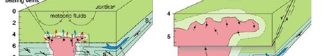
21 Salinity-Th (total) diagram for primary fluid inclusions from LS epithermal veins Excluding Baker, all inclusions are primary 2-phase, liquid-rich, aqueous inclusions. Baker is anomalous with primary inclusions including high-temperature, brine-rich and vapour-rich varieties.
22 The Baker B vein - Fluid Inclusions Halite- homogenizers 2.0 to 5.6 km depth assuming lithostatic load. Same depths as KS Sand KN! These are porphyry related LS-IS veins.
23 Conclusions 1: Porphyry-Epithermal Linkages Porphyry-style ore fluids are directly involved in the formation of LS (IS) Au (Ag) epithermal veins at the Baker mine. Baker is deep, consistent t with its formation in the favourable Takla Gr. basalt, which hosts KS and KN. A genetic link between porphyry systems and LS Ag (Au) deposits at Shasta, Lawyers, and Griz- Sickle is not established. Two varieties of LS (IS) epithermal deposits in the Toodoggone. (1) Basin & Range types localized along the NNW-trending basin-bounding bounding faults with no direct link to Cu-Au porphyries; and (2) Peripheral halo around porphyry systems.
24 Conclusions 2: Porphyry Formation Models Porphyry systems are simple (thus relatively small) and relatively deep (3-5 km). Slow-boiling pressure cooker release. Limited hypogene upgrading of Cu-Au ores = low grades. KS & KN are porphyry cousins. Same far-field field stress fields affected both deposits after formation. Similar structural controls (horst-and and- graben). Similar vein-types and alteration styles (common magmatic systems). Local variations due to host-rock compositions.
25 Conclusions 3: Exploration Targeting Normal faulting has structurally offset orebodies. They are not the result of deposits having multiple porphyry centres. Step across inferred faults and drill deep. Point source porphyry model with concentric zonation of alteration-mineralization is not likely very effective in the faulted & lithologically diverse Toodoggone. Host-rock important control over whether biotite (chl) or Kspar (ser) is dominant potassic alteration mineral. Not caused by different magma types (diorite vs. monzonite) No favourable intrusions recognized. Porphyries are relatively deep systems and unlikley to produce large LS epithermal systems (Baker?). Uplift and erosion o is greatest in the south and any epithermal systems likely removed. Better epithermal preservation potential in the north, especially in wndows of exposed Takla Group (Baker). The discovery of porphyry-style mineralization in 194 Ma felsic dykes at Pine confirms temporal overlap with LS epithermal mineralization in the Toodoggone.
Geological & Geophysical Interpretation of ZTEM EM and Magnetic Survey. Kemess Project, BC. for AuRico Metals Inc. September, 2016 Nicole Pendrigh
 Geological & Geophysical Interpretation of ZTEM EM and Magnetic Survey Kemess Project, BC for AuRico Metals Inc. September, 2016 Nicole Pendrigh SUMMARY REPORT Regional setting Located in North central
BCGold Corp. Discovery Driven
 BCGold Corp. Discovery Driven Sickle-Sofia Property Copper-Gold Porphyry Discovery in the Toodoggone Camp! Cautionary Statement This presentation does not constitute an offer to sell or solicitation of
KEMESS SOUTH MAGNETIC MODELING. CONDOR CONSULTING, INC. OCTOBER 2017
 KEMESS SOUTH MAGNETIC MODELING. CONDOR CONSULTING, INC. OCTOBER 2017 INTRODUCTION Magnetic data in the vicinity of the Kemess South Mine in the Yukon has been analyzed and modeled in order to try to explain
Evaluating the Intrusion-Related Model for the Archean Low-Grade, High- Tonnage Côté Gold Au(-Cu) Deposit
 Deposit") Evaluating the Intrusion-Related Model for the Archean Low-Grade, High- Tonnage Côté Gold Au(-Cu) Deposit L.R. Katz, D.J. Kontak, Laurentian University, B. Dubé, V. McNicoll, Geological Survey of Canada
Evaluating the Intrusion-Related Model for the Archean Low-Grade, High- Tonnage Côté Gold Au(-Cu) Deposit L.R. Katz, D.J. Kontak, Laurentian University, B. Dubé, V. McNicoll, Geological Survey of Canada
Magmatic-Hydrothermal Gold Systems in the Archean of Northern Ontario, Canada: Examples of Syenite-Associated and Porphyry-Type Au-(Cu) Deposits
 Deposits") Magmatic-Hydrothermal Gold Systems in the Archean of Northern Ontario, Canada: Examples of Syenite-Associated and Porphyry-Type Au-(Cu) Deposits By Dr. Daniel J. Kontak Department of Earth Sciences Laurentian
Magmatic-Hydrothermal Gold Systems in the Archean of Northern Ontario, Canada: Examples of Syenite-Associated and Porphyry-Type Au-(Cu) Deposits By Dr. Daniel J. Kontak Department of Earth Sciences Laurentian
Drill locations for the 2015 program are highlighted in the geology map below.
 2015 Exploration Program The exploration program plan at KSM for 2015 was designed to improve the understanding of block cave targets and support engineering/environmental aspects of development scenarios.
Helicopter ZTEM-Magnetic-Radiometric Surveys FOR EPITHERMAL SULPHIDATION GOLD over BAKER-SHASTA PROPERTY, Toodoggone Region, North-Central BC.
 Helicopter ZTEM-Magnetic-Radiometric Surveys FOR EPITHERMAL SULPHIDATION GOLD over BAKER-SHASTA PROPERTY, Toodoggone Region, North-Central BC. By J.M. Legault (Geotech) and Bill Yeomans (Sables Resources
What is Mt Carlton? Fredrik Sahlström, Zhaoshan Chang, Paul Dirks, Antonio Arribas, Isaac Corral. GSQ seminar Townsville, 7 December 2017
 Fredrik Sahlström, Zhaoshan Chang, Paul Dirks, Antonio Arribas, Isaac Corral GSQ seminar Townsville, 7 December 2017 What is Mt Carlton? An Early Permian high sulfidation epithermal (HS) deposit in NE
Exploring in the last frontier: Skarn mineralisation, Attunga District, NSW
 BROVEY MAPPING SERVICES Exploring in the last frontier: Skarn mineralisation, Attunga District, NSW Latest exploration findings and interpretations Nancy Vickery, Joshua Leigh and Michael Oates Outline
The 2740 Ma Côté Gold Au(-Cu) deposit, Canada: Example of porphyry-type magmatic-hydrothermal ore-forming processes in the Archean
 deposit, Canada: Example of porphyry-type magmatic-hydrothermal ore-forming processes in the Archean") The 2740 Ma Côté Gold Au(-Cu) deposit, Canada: Example of porphyry-type magmatic-hydrothermal ore-forming processes in the Archean Daniel J. Kontak, Laura Katz, Laurentian University Benoit Dubé, Geological
The 2740 Ma Côté Gold Au(-Cu) deposit, Canada: Example of porphyry-type magmatic-hydrothermal ore-forming processes in the Archean Daniel J. Kontak, Laura Katz, Laurentian University Benoit Dubé, Geological
Using 3D/4D modeling tools in exploration of gold-polymetallic potential areas in Greece
 Using 3D/4D modeling tools in exploration of gold-polymetallic potential areas in Greece Arvanitidis N.D., Michael C., Weihed P., Gaál l G., Royer J.J., Perantonis G., Bakalis V., Ballas D. and Christidis
Ore deposits related to intermediate to felsic intrusions Porphyry Base Metal (Cu-Mo) Deposits. - GLY 361 Lecture 7
 Deposits. - GLY 361 Lecture 7") Ore deposits related to intermediate to felsic intrusions Porphyry Base Metal (Cu-Mo) Deposits - GLY 361 Lecture 7 Ore deposits related to intermediate to felsic intrusions Deposits associated with the
Ore deposits related to intermediate to felsic intrusions Porphyry Base Metal (Cu-Mo) Deposits - GLY 361 Lecture 7 Ore deposits related to intermediate to felsic intrusions Deposits associated with the
A New Direction. Copper-Gold Deposit at Thor TSX.V:COL. August 11, May 2013
 A New Direction Copper-Gold Deposit at Thor August 11, 2016 May 2013 TSX.V:COL FORWARD LOOKING STATEMENTS This presentation includes certain forward-looking information or forward-looking statements for
Geology of Quesnel and Stikine terranes and associated porphyry deposits. Jim Logan Paul Schiarizza
 Geology of Quesnel and Stikine terranes and associated porphyry deposits Jim Logan Paul Schiarizza Quesnel and Stikine terranes Major cordilleran terranes characterized by similar Late Triassic Early Jurassic
Bulyanhulu: Anomalous gold mineralisation in the Archaean of Tanzania. Claire Chamberlain, Jamie Wilkinson, Richard Herrington, Ettienne du Plessis
 Bulyanhulu: Anomalous gold mineralisation in the Archaean of Tanzania Claire Chamberlain, Jamie Wilkinson, Richard Herrington, Ettienne du Plessis Atypical Archaean gold deposits Groves et al., 2003 Regional
EXISTING GEOLOGICAL INFORMATION
 CHAPER 3 EXISTING GEOLOGICAL INFORMATION 3-1 General Geology of the Surrounding Area (1) General geology and ore deposits in Mongolia Geographically, Mongolia is a country located between Russia to the
Dianne Mitchinson Mira Geoscience Exploration Undercover Geoscience BC/BC Geophysical Society shortcourse Vancouver, BC Oct 12-14, 2011
 Insights for Porphyry Exploration from Rock Properties Data: Examples from the QUEST and QUEST-West Project Areas Dianne Mitchinson Mira Geoscience Exploration Undercover Geoscience BC/BC Geophysical Society
it AUSIMM COBAR MINING SEMINAR
 Straits Resources Limited it AUSIMM COBAR MINING SEMINAR Brownfields Exploration at Girilambone: Understanding the Mineralised Systems August 2010 Phil Shields / Phil Jones LOCATION TRITTON OPERATIONS
Geology 12 FINAL EXAM PREP. Possible Written Response Exam Questions
 Geology 12 FINAL EXAM PREP Possible Written Response Exam Questions Use this study guide to prepare for the written response portion of the final exam. Name FINAL EXAM - POSSIBLE WRITTEN RESPONSE QUESTIONS
PLEASE DO NOT WRITE ON THIS QUIZ! Relative Dating and Stratigraphic Principles Quiz
 PLEASE DO NOT WRITE ON THIS QUIZ! Relative Dating and Stratigraphic Principles Quiz TEST NO A Multiple Choice Identify the letter of the choice that best completes the statement or answers the question.
MCB Copper-Gold Project. MCB Copper-Gold Project. MCB Copper-Gold Project. MCB Copper-Gold Project. MCB Copper-Gold Project.
 Maalinao-Caigutan-Biyog (MCB), a very young porphyry - high sulfidation epithermal Cu-Au deposit in the northern Luzon Central Cordillera, Philippines Introduction The MCB Project at Batong Buhay, Kalinga,
Amador Canyon Silver Mining Property Lander County, NV
 Amador Canyon Silver Mining Property Lander County, NV Over $1 million worth of exploration and evaluation work performed Favorable drill results including a return of 286 g/ton silver over 12.2 meters
Uncovering The Riches of the Abitibi Greenstone Belt of Canada
 1 TSX.V: ALZ June 2016 Uncovering The Riches of the Abitibi Greenstone Belt of Canada The Haultain Gold Discovery The Abitibi Greenstone Belt & Gold 170+ million oz of gold produced to date from more than
ALPHA GOLD PROJECT 1
 ALPHA GOLD PROJECT 1 Alpha Gold Project Over 1,000 acre property targeting the intersection of the 50 Moz Cortez Gold Trend and the regional scale Pine Valley Garden Valley anticline Anticlinal Crest preserved
JV Project Portfolio Executive Summary: Bruce Smith
 JV Project Portfolio Executive Summary: Bruce Smith September 5, 2012 Disclaimer Forward-Looking Statements This presentation contains forward-looking statements, including but not limited to comments
Interpretation of Multi-Element Geochemistry
 Interpretation of Multi-Element Geochemistry Gregg Morrison & Terra Search Project Team December 2017 Metallogenic classification using ME data A lot of 46 element ICP data resides in company files with
Sombrero Butte Copper Project Arizona, USA
 Sombrero Butte Copper Project Arizona, USA January 2017 Sombrero Butte Project Location COPPER CREEK DEPOSIT (7.75 Billion Lbs Cu) SAN MANUEL KALAMAZOO MINE (BHP) (10.4 Billion Lbs Cu) SOMBRERO BUTTE EXPLORATION
Interpretation of Multi Element Geochemistry in the Charters Towers Region
 Interpretation of Multi Element Geochemistry in the Charters Towers Region Gregg Morrison & Simon Beams & Terra Search Project Team CT MM geochem: Introduction Terra Search/GSQ Explorer 3 database is a
Magmatism in Western Cascades Arc. Early Tertiary Magmatism Part II. Washington Magmatism. Western Oregon. Southern Oregon
 Early Tertiary Magmatism Part II Reference: DNAG v. 3, Ch. 7, pp 294-314 Magmatism in Western Cascades Arc Active from 38 to 17 Ma New volcanic activity west of Clarno Fm and south into Oregon Western
For personal use only
 ANNOUNCEMENT TO THE AUSTRALIAN SECURITIES EXCHANGE: 28 NOVEMBER 2012 DRILLING UPDATE MABILO PROJECT The Directors of Sierra Mining Limited ( Sierra ) are pleased to announce further results from reconnaissance
Blackwater Project Exploration Update Nechako Plateau, British Columbia, Canada
 Project Exploration Update Nechako Plateau, British Columbia, Canada New Gold Exploration Robin Whiteaker Presenter April 14, 2015 2015 Annual KEG Conference Kamloops, BC 1 Topics Location & Physiographic
Exploring the Mande Batholith. November 15, 2017
 Exploring the Mande Batholith November 15, 2017 Minera Cobre de Colombia (MCC) MCC controls a highly prospective porphyry Cu portfolio covering 3,300 km 2 in 145 mineral concessions within 200 km strike
The structure of the Mt Carlton Cu-Au deposit
 Dirks, P.H.G.M., The structure of the Mt Carlton Cu-Au deposit. SYMPOSIUM: New technologies and approaches in mineral exploration. FUTORES II, 4-7 June 2017, Townsville, Qld, Australia. 2017 The structure
CAMBRIAN INTRUSION-RELATED COPPER MINERALISATION AT THE THOMAS CREEK PROSPECT, SOUTHWESTERN TASMANIA
 CAMBRIAN INTRUSION-RELATED COPPER MINERALISATION AT THE THOMAS CREEK PROSPECT, SOUTHWESTERN TASMANIA UN I VF.RS TTY OF TASMANIA By Robert Reid (B.Sc. Hons) A thesis submitted in partial fulfillment of
 19 00' N 70 20' W Loma La Cuaba volcanic edifice 70 00' W Pueblo Viejo District (location of Fig. 2) Loma Navisa volcanic edifice 69 40' W & S a m a n á B a y 0 10 20 Kilometers 18 50' N Guaimarote Hatillo
The McPhillamys Gold Deposit, Discovery History & Geology. Presenter: Tara French
 The McPhillamys Gold Deposit, Discovery History & Geology. Presenter: Tara French Forward-Looking Statements This presentation contains forward-looking statements. without limitation: Estimates of future
Characterization, evolution and IOCG-potential of the of the Iron Range iron oxide mineralization, Belt-Purcell basin, BC
 Characterization, evolution and IOCG-potential of the of the Iron Range iron oxide mineralization, Belt-Purcell basin, BC Galicki, M. and Marshall, D. (SFU) Anderson, B. and Enkin, R. (GSC) Downie, C.
Lands Parcels in IOL CO-20
 Lands Parcels in IOL CO-20 1 CO-20 The Izok Corridor Lupin - multi-million ounce past gold production (3.6 million oz of gold at average grade of 9.3 g/t Au) Approximately 1 million ounces of undeveloped
THE FORMATION OF THE PANGUNA PORPHYRY COPPER DEPOSIT, with an appendix on the. Frieda porphyry copper prospect, New Guinea.
 THE FORMATION OF THE PANGUNA PORPHYRY COPPER DEPOSIT, BOUGAINVILLE, PAPUA NEW GUINEA. with an appendix on the Frieda porphyry copper prospect, New Guinea. by C. J. EASTOE, B.Sc.(Hons.) Submitted in partial
The Cobalt Rainbow. Airborne geophysical maps show that a north trending aeromagnetic high suggests further undiscovered mineralisation.
 The Cobalt Rainbow The property is located on Greenstone Creek, approximately 4.8 kilometres south west of the creek mouth. The property is located about 24 km due west of Campbell River, in the east-central
Geochemical exploration on the Tareek Darreh Gold deposit, north of Torbat-e Jaam, east Iran
 Geochemical exploration on the Tareek Darreh Gold deposit, north of Torbat-e Jaam, east Iran Kourosh Shabani, M.Sc. Student of Economic Geology, Islamic Azad University, Science and Research Branch, Tehran,
Yukon Presentation. October 2012
 Yukon Presentation October 2012 Disclaimer This presentation contains forward looking statements. All statements, other than statements of historical fact, included herein, including without limitation,
SHIFTING FOCUS To MINING POTENTIAL. November 2017
 SHIFTING FOCUS To MARMATO s UNDERGROUND MINING POTENTIAL November 2017 2 MARMATO GOLD DEPOSIT Property Location La Maruja mine operated by Mineros Nacionales Caldas Dept. 3 MARMATO GOLD DEPOSIT Mining
R E F I N I N G T H E A R T O F M I N E R A L E X P L O R A T I O N
 Jupiter Project R E F I N I N G T H E A R T O F M I N E R A L E X P L O R A T I O N Overview A large Carlin-style Au system, at least 4.5 km long and 3.5 km wide, occurs in early Paleozoic limestones and
Alteration and Mineralization at Daralu Porphyry Copper Deposit, South of Kerman, Southeast Iran
 Alteration and Mineralization at Daralu Porphyry Copper Deposit, South of Kerman, Southeast Iran Mosayeb Salehian* and Majid Ghaderi Department of Geology, Tarbiat Modares University, Tehran, Iran *Email
Cowal Gold Corridor Opening Other Doors
 Cowal Gold Corridor Opening Other Doors 1 Objectives The Doors of the Corridor local geology of Cowal Gold Corridor Styles and controls on mineralisation within the Corridor Vein paragenesis Summary of
2017 Geophysical Survey Report
 2017 Geophysical Survey Report Copperstone Resources AB Synopsis Copperstone Resources AB (publ) ( Copperstone or the Company ) has recently completed an extensive geophysical survey on the 100% owned
POTENTIAL FOR SIGNIFICANT UNDISCOVERED METALLIC ORE DEPOSITS IN MAINE. John F. Slack U.S. Geological Survey (Emeritus), Farmington, ME 04938
, Farmington, ME 04938") POTENTIAL FOR SIGNIFICANT UNDISCOVERED METALLIC ORE DEPOSITS IN MAINE John F. Slack U.S. Geological Survey (Emeritus), Farmington, ME 098 Geological Society of Maine, Augusta, 7 November 207 Outline Important
POTENTIAL FOR SIGNIFICANT UNDISCOVERED METALLIC ORE DEPOSITS IN MAINE John F. Slack U.S. Geological Survey (Emeritus), Farmington, ME 098 Geological Society of Maine, Augusta, 7 November 207 Outline Important
Mountain Maid Gold System Displays Major Size Potential
 29 July 2008 The Manager, Companies Australian Securities Exchange Ltd Electronic Announcement System Dear Sir, AXIOM MINING LIMITED (ASX CODE: AVQ) ASX Announcement Mountain Maid Gold System Displays
SUPPLEMENT DR1: SAMPLE DESCRIPTION
 GSA DATA REPOSITORY 2013218 Yunxing Xue et al. SUPPLEMENT DR1: SAMPLE DESCRIPTION Three gold deposits from the EGST and one from Abitibi belt have been selected for this study. Bellerophon, Wallaby, and
CHAMPION BEAR RESOURCES
 CHAMPION BEAR RESOURCES EXPLORING ADVANCED STAGE PRECIOUS METAL PROPERTIES IN ONTARIO Exploration Update January 2011 Forward Looking Statements This exploration update contains forward looking statements
Beekeeper Property The Geology South of Mint Lake. Cariboo Mining Division
 Beekeeper Property The Geology South of Mint Lake NTS: 93A/6 Cariboo Mining Division Claims: Beekeeper 1 #I2055 Beekeeper 2 #3892 Beekeeper 3 #7895 Beekeeper 4 #8503 Latitude: Longitude: 52 degrees 24
predictive mineral discovery*cooperative Research Centre A legacy for mineral exploration science Mineral Systems Q3 Fluid reservoirs
 Mineral Systems Q3 Fluid reservoirs 1 Key Parameter Mineral System Exploration is reflected in scale-dependent translation A. Gradient in hydraulic potential B. Permeability C. Solubility sensitivity to
JOSH LEIGH Project Exploration Geologist June ASX Code AIV
 COALSTOUN AND BOOUBYJAN Porphyry Copper-Gold Complexes, their structural setting, geology and geochemistry Joshua Leigh 1, Doug Young 2, Jose Veracruz 3, Paul Ashley 3 - ( 1 ActivEX Limited, 2 Consultant,
Igneous and Metamorphic Rock Forming Minerals. Department of Geology Mr. Victor Tibane SGM 210_2013
 Igneous and Metamorphic Rock Forming Minerals Department of Geology Mr. Victor Tibane 1 SGM 210_2013 Grotzinger Jordan Understanding Earth Sixth Edition Chapter 4: IGNEOUS ROCKS Solids from Melts 2011
SPL 1452 NAMOLI & WAINIVAU GOLD AND COPPER PROSPECTS
 SPL 1452 NAMOLI & WAINIVAU GOLD AND COPPER PROSPECTS (Multiple Namosi-like Exploration Targets) SPL1452 being contiguous with the Namosi SPL1420 owned by the Newcrest Joint Venture and with the same type
In late 2014, a report by Jeff Kyba and JoAnne Nelson of the British Columbia Geological Survey, Ministry of Energy and Mines was published entitled:
 KYBA / NELSON REPORT In late 2014, a report by Jeff Kyba and JoAnne Nelson of the British Columbia Geological Survey, Ministry of Energy and Mines was published entitled: Structural and stratigraphic control
Active and fossil geothermal systems in Iceland
 Active and fossil geothermal systems in Iceland Exploration for epithermal deposits Hjalti Franzson Iceland GeoSurvey Main points Geological framework Geological structures Geothermal systems Exploration
Azerbaijan International Mining Company Limited
 Updated Mineral Resources Gedabek Mineral Deposit, Republic of Azerbaijan Azerbaijan International Mining Company Limited Prepared by CAE Mining CAE Mining 8585 Cote-de-Liesse Saint-Laurent Quebec H4T
MIOCENE MAGMATISM AND RELATED PORPHYRY AND POLYMETALLIC MINERALIZATION IN THE MOROCOCHA DISTRICT, CENTRAL PERU
 MIOCENE MAGMATISM AND RELATED PORPHYRY AND POLYMETALLIC MINERALIZATION IN THE MOROCOCHA DISTRICT, CENTRAL PERU Bendezú Aldo*, Catchpole Honza*, Kouzmanov Kalin*, Fontboté Lluís* & Astorga Carlos** *University
Rich Saddle North Au-Cu-Ag Porphyry Expands by 275m Along Strike and 250m Down-Dip
 GT Gold Drills 281 Metres of 0.65 g/t Au, 0.38% Cu, 1.38 g/t Ag (1.24 g/t AuEq 1 ) Within 685 Metres 2 of 0.40 g/t Au, 0.26% Cu, 1.03 g/t Ag (0.81 g/t AuEq) in Step-out Hole TTD098 Rich Saddle North Au-Cu-Ag
LINGIG PORPHYRY COPPER DISCOVERY
 MEDUSA MINING LIMITED ABN: 60 099 377 849 Unit 7, 11 Preston Street Como WA 6152 PO Box 860 Canning Bridge WA 6153 Telephone: 618-9367 0601 Facsimile: 618-9367 0602 Email: admin@medusamining.com.au Internet:
CSA Mine Observations Applied to the Development of Regional Exploration Models
 CSA Mine Observations Applied to the Development of Regional Exploration Models 1 Introduction Recent work completed by the geology team has resulted in an improved understanding of the CSA mine system
General Geology Lab #7: Geologic Time & Relative Dating
 General Geology 89.101 Name: General Geology Lab #7: Geologic Time & Relative Dating Purpose: To use relative dating techniques to interpret geological cross sections. Procedure: Today we will be interpreting
Section 7. Reading the Geologic History of Your Community. What Do You See? Think About It. Investigate. Learning Outcomes
 Chapter 3 Minerals, Rocks, and Structures Section 7 Reading the Geologic History of Your Community What Do You See? Learning Outcomes In this section, you will Goals Text Learning Outcomes In this section,
Linking structure & mineralisation in Laverton, with specific reference to Sunrise Dam & Wallaby John Miller
 Linking structure & mineralisation in Laverton, with specific reference to Sunrise Dam & Wallaby John Miller Centre for Exploration Targeting University of Western Australia W Swager (1997) regional D
The Mungana porphyryrelated. deposit, North Queensland. KZL EXPLORATION Mines and Wines, September 2007
 The Mungana porphyryrelated polymetallic deposit, North Queensland KZL EXPLORATION Mines and Wines, September 2007 AIG NQEM 2004 TOWNSVILLE 27-28th May 2004 LOCATION TOPICS History Regional geological
Copper and Zinc Production, Disciplined Growth. S I T E V I S I T O C T O B E R % Owned Projects
 Copper and Zinc Production, Disciplined Growth. S I T E V I S I T O C T O B E R 2 0 1 6 100% Owned Projects Serbia assets Timok Magmatic Complex Rakita Joint Venture 4 exploration permits in the Bor region,
Alteration and mineralisation settings in the Olympic Cu-Au province, Gawler Craton,, South Australia. Roger Skirrow Evgeniy Bastrakov Ollie Raymond
 Alteration and mineralisation settings in the Olympic Cu-Au province, Gawler Craton,, South Australia Roger Skirrow Evgeniy Bastrakov Ollie Raymond Outline Where and what is the Olympic Cu-Au province?
ESKAY CREEK MINE. Rob Boyce, P. Geo. G\GROUP\GEOLOGY\EXPLORE\EXPL2001\BUDSAN1
 ESKAY CREEK MINE Rob Boyce, P. Geo. G\GROUP\GEOLOGY\EXPLORE\EXPL2001\BUDSAN1 Outline Location Geology Production Recent Exploration Future of Eskay Creek Location and Transportation From Kitwanga Ore and
SAN LUCAS PROJECT Technical Data
 SAN LUCAS PROJECT Technical Data 1 San Lucas Overview 3km long mineralized Main Shear zone with 2 parallel vein structures identified 79 historical RC holes, ranging from about 32m-259m and averaging 158m
3. GEOLOGY. 3.1 Introduction. 3.2 Results and Discussion Regional Geology Surficial Geology Mine Study Area
 3. GEOLOGY 3.1 Introduction This chapter discusses the baseline study of the geology and mineralization characteristics of the mine study area. The study consolidates existing geological data and exploration
IVANHOE DISCOVERS IMPORTANT NEW GOLD-COPPER PORPHYRY DISTRICT IN SOUTHERN MONGOLIA NEW PORPHYRY DISTRICT NOW NAMED BRONZE FOX
 November 29, 2004 IVANHOE DISCOVERS IMPORTANT NEW GOLD-COPPER PORPHYRY DISTRICT IN SOUTHERN MONGOLIA NEW PORPHYRY DISTRICT NOW NAMED BRONZE FOX ULAANBAATAR, MONGOLIA Ivanhoe Mines Chairman Robert Friedland
SUMBA EXPLORATION UPDATE
 ASX RELEASE Tuesday, 23 November 2010 SUMBA EXPLORATION UPDATE Hillgrove Resources Limited (ASX:HGO) today announces a planned airborne geophysical survey, Pelitalira prospect progress and final results
The geology, genesis and exploration context of the Cadia gold-copper porphyry deposits, New South Wales, Australia
 The geology, genesis and exploration context of the Cadia gold-copper porphyry deposits, New South Wales, Australia by Alan J. Wilson (M.Sc.) Submitted in fulfillment of the requirements for the degree
Summary of Rover Metals Geologic Mapping Program at the Up Town Gold Project, Northwest Territories
 October 13, 2017 Summary of Rover Metals Geologic Mapping Program at the Up Town Gold Project, Northwest Territories Vancouver, British Columbia, Canada - Rover Metals Corp., Rover, is pleased to provide
RESULTS OF OPERATIONS Semi Annual Exploration Report BANLUNG EXPLORATION LICENSE, CAMBODIA FOR THE PERIOD 2015:06:30 TO 2015:12:31
 RESULTS OF OPERATIONS BANLUNG EXPLORATION LICENSE, CAMBODIA FOR THE PERIOD 2015:06:30 TO 2015:12:31 Introduction Work over the period has included the completion of a detailed induced polarization geophysical
FIRST YEAR ASSESSMENT REPORT PROSPECTING LICENCE 16512M MARYSTOWN AREA, BURIN PENINSULA NTS 1M/3
 FIRST YEAR ASSESSMENT REPORT OF PROSPECTING ON LICENCE 16512M MARYSTOWN AREA, BURIN PENINSULA NTS 1M/3 BY NATHANIEL NOEL MSc. FOR E. MICHELE NOEL MINERAL LICENCES: 16512 M WORK CONDUCTED: MID-SEPTEMBER
DISCOVERY OF MINERALISED PORPHYRY & MAGNETITE-COPPER-GOLD AT KAMARANGAN
 MEDUSA MINING LIMITED ABN: 60 099 377 849 Unit 7, 11 Preston Street Como WA 6152 PO Box 860 Canning Bridge WA 6153 Telephone: +618-9367 0601 Facsimile: +618-9367 0602 Email: admin@medusamining.com.au Internet:
Geologic Mapping Regional Tournament Trial Event
 Geologic Mapping Regional Tournament Trial Event A TEAM OF UP TO: 2 Team Name AVAILABLE TIME: 50 min Required Materials: Each team MUST have a protractor, ruler, non-programmable calculator, colored pencils,
Late Tertiary Volcanism. North Washington. Other Andesite Volcanoes. Southern Washington. High Cascades. High Cascades. Mid-Miocene Miocene to present
 Miocene to Present Late Tertiary Volcanism Mid-Miocene Miocene to present Reading: DNAG volume G3, Ch. 7 High Cascade Range Columbia River Snake River Plain Basin and Range Southwestern California Sierra
GEOLOGY OF THE NICOLA GROUP BETWEEN MISSEZULA LAKE AND ALLISON LAKE
 GEOLOGY OF THE NICOLA GROUP BETWEEN MISSEZULA LAKE AND ALLISON LAKE (92H/15E. 10E1 By V. A. Preto INTRODUCTION Mapping was continued southward from the area covered in 1973 and an additional 55 square
GLY 155 Introduction to Physical Geology, W. Altermann. Grotzinger Jordan. Understanding Earth. Sixth Edition
 Grotzinger Jordan Understanding Earth Sixth Edition Chapter 4: IGNEOUS ROCKS Solids from Melts 2011 by W. H. Freeman and Company Chapter 4: Igneous Rocks: Solids from Melts 1 About Igneous Rocks Igneous
IVANHOE S EXPLORATION TEAM AWARDED THE THAYER LINDSLEY INTERNATIONAL DISCOVERY AWARD BY PDAC FOR DISCOVERY OF THE HUGO DUMMETT DEPOSIT IN MONGOLIA.
 March 08, 2004 IVANHOE S EXPLORATION TEAM AWARDED THE THAYER LINDSLEY INTERNATIONAL DISCOVERY AWARD BY PDAC FOR DISCOVERY OF THE HUGO DUMMETT DEPOSIT IN MONGOLIA. RECENT HUGO DEPOSIT DRILLING FURTHER EXPANDS
High Grade Gold Intercepts at Bangaba
 20th March 2012 ASX Announcement High Grade Gold Intercepts at Bangaba Level 2, 9 Colin Street West Perth WA 6005 ABN 11 127 171 877 p (08) 9216 1000 f (08) 9481 7939 w www.predictivediscovery.com e info@predictivediscovery.com
OYUT ULAAN COPPER GOLD PROJECT RECONNAISSANCE DRILLING RESULTS
 ASX / MEDIA RELEASE Manager Company Announcements By Electronic Lodgement 7 pages Company Announcements Office 6 June 2013 Australian Securities Exchange 4th Floor, 20 Bridge Street SYDNEY NSW 2001 OYUT
Figure 1: Location of principal shallow conductors at Alpala (anomalies C0-C10; 5 Ohm/m surfaces, red) and shallow zones of electrical chargeability
 and shallow zones of electrical chargeability") Figure 1: Location of principal shallow conductors at Alpala (anomalies C0-C10; 5 Ohm/m surfaces, red) and shallow zones of electrical chargeability (85 msecs, yellow-green) shown on iso-surfaces of MVI
Figure 1: Location of principal shallow conductors at Alpala (anomalies C0-C10; 5 Ohm/m surfaces, red) and shallow zones of electrical chargeability (85 msecs, yellow-green) shown on iso-surfaces of MVI
Exploration and Discovery of the Caspiche Porphyry Gold-Copper Deposit, Maricunga Belt, Region III, Chile
 Exploration and Discovery of the Caspiche Porphyry Gold-Copper Deposit, Maricunga Belt, Region III, Chile Presenter - Glen van Kerkvoort Cautionary Statement Cautionary Note to U.S. Investors The United
For personal use only
 ASX ANNOUNCEMENT ASX: IVG Date: 30 April 2012 Number: 030_300412 MARCH 2012 QUARTERLY REPORT SUMMARY Market Cap A$2.23m ($0.062 p/s) Issued Capital 36,006,006 Assay data and mineral alteration studies
For personal use only
 22 April 2013 Drilling to commence at Majada, Copper-Gold Prospect, Chile. Red Gum Resources Limited (ASX: RGX, Red Gum or the Company ) is pleased to announce that drilling of its Majada Copper-Gold Prospect,
December 2017 Quarter Activities Report
 December 2017 Quarter Activities Report ABOUT ARC EXPLORATION LIMITED Arc Exploration Limited (ASX Code: ARX) is an Australian-listed company focused on gold and base metal exploration in Indonesia and
Chapter 4 Rocks & Igneous Rocks
 Chapter 4 Rocks & Igneous Rocks Rock Definition A naturally occurring consolidated mixture of one or more minerals e.g, marble, granite, sandstone, limestone Rock Definition Must naturally occur in nature,
Corporate Presentation
 Corporate Presentation September 2016 1 Swift Katie Project, British Columbia Cu Au Ag Alkaline Porphyry / Epithermal Targets Large Property: 19 claims over > 8,350ha & in good standing to 2025. Great
ASX Announcement. 28 January Drill results indicate large Porphyry Copper Gold System at Peenam
 ASX Announcement 28 January 2010 Drill results indicate large Porphyry Copper Gold System at Peenam Highlights: 270 metres of visible copper (gold) mineralisation in first diamond core hole at Peenam Prospect
REPORT. on the. Omineca Mining Division, British Columbia. Latitude N., Longitude W. NTS map sheet 93F/7E. James W. McLeod, P.Geo.
 REPORT on the CHU MOLYBDENUM PROPERTY Omineca Mining Division, British Columbia Latitude 53 21 N., Longitude 124 37 W. NTS map sheet 93F/7E James W. McLeod, P.Geo. on behalf of Mr. Chris Delorme TABLE
The 3 types of rocks:
 Igneous Rocks and Intrusive Igneous Activity The 3 types of rocks:! Sedimentary! Igneous! Metamorphic Marble 1 10/7/15 SEDIMENTARY ROCKS Come from rocks sediments (rock fragments, sand, silt, etc.) Fossils
Anthill Resources Yukon - An Update on the Einarson Project
 Anthill Resources Yukon - An Update on the Einarson Project The Eastern Extension of a Carlin-type Gold Trend in the Selwyn Basin Anthill Resources Ltd Yukon Claim Holdings Over 2400 km 2 Property Location
Answers: Internal Processes and Structures (Isostasy)
") Answers: Internal Processes and Structures (Isostasy) 1. Analyse the adjustment of the crust to changes in loads associated with volcanism, mountain building, erosion, and glaciation by using the concept
Answers: Internal Processes and Structures (Isostasy) 1. Analyse the adjustment of the crust to changes in loads associated with volcanism, mountain building, erosion, and glaciation by using the concept
Epithermal Deposits Related to Caldera Development in Newly- Identified Graben, Oaxaca, Mexico
 Rocky Mountain Section 68th Annual Meeting Epithermal Deposits Related to Caldera Development in Newly- Identified Graben, Oaxaca, Mexico BARRY D. DEVLIN Vice President, Exploration May 18, 2016 1 Mexico
Topics Laramide Orogeny: Late Cretaceous to Early Eocene Reading: GSA DNAG volume 3, Ch. 6
 Topics Laramide Orogeny: Late Cretaceous to Early Eocene Reading: GSA DNAG volume 3, Ch. 6 Late Cretaceous to early Eocene New patterns developed 5 main regions Tectonic interpretations Post-Laramide events