Genetic models of structural traps related to normal faults in the Putaohua Oilfield, Songliao Basin
|
|
|
- Elvin Bailey
- 5 years ago
- Views:
Transcription
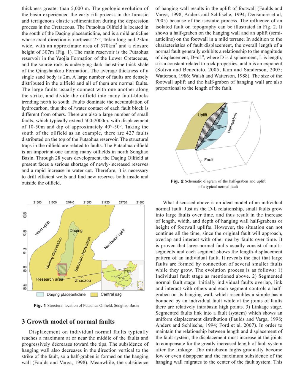
1 302 DOI /s Genetic models of structural traps related to normal faults in the Putaohua Oilfield, Songliao Basin Sun Simin 1, Wu Xinsong 1, Liu Hongtao 2 and Wang Changsheng 2 1 School of Resources and Information Technology, China University of Petroleum, Beijing , China 2 Oil Recovery Plant No.7, Daqing Oilfield Company, PetroChina, Daqing, Heilongjiang , China Abstract: The Putaohua Oilfield is a fault-prolific area and the faults have close relation with structural traps. The genetic models of the structural traps in the Putaohua Oilfield can be divided into two types: individual fault model and multi-fault interaction model. This is based on the description of displacement distribution of typical individual normal faults, the geometry of the footwall and hanging wall, and the analysis of the interaction between faults and the corresponding change in geometry when the faults grow. The individual fault model is that the displacement reaches a maximum at or near the center of fault and decreases toward the fault tips, so a half-graben is formed on the hanging wall of the fault and a halfanticline is formed on the footwall because of the isostatic process. The multi-fault interaction model is that during the growth of faults, they overlap and interact with each other, and accommodation zones are formed in the overlapping segments. The accommodation zones are favorable targets for hydrocarbon exploration, and the trap characteristics are dependent on the extent of overlap and occurrence of faults. The multi-fault interaction model can be subdivided into three types: synthetic accommodation zone, convergent accommodation zone and divergent accommodation zone. Hydrocarbon migration and accumulation models of each type have been developed. The hydrocarbon migration and accumulation models of the traps with different genetic models have their own characteristics in the different stages of fault growth. Key words: Songliao Basin, Putaohua Oilfield, accommodation zone, normal fault growth, structural trap 1 Introduction Structural traps are closely tied to normal faults in extensional basins. Many geologists have presented several genetic models of structural traps related to normal faults. However, their researches were primarily on the characteristics of fault surface orthogonal to strike (Shelton, 1984; Dula, 1991; Xiao and Suppe, 1992) or fault-blocks due to fault intersecting (Wang et al, 1994; Li, 2004; Wang, 1995; Xie et al, 1997). In recent years, great advances have been made in the geometry and kinematics of normal faults based on the research on the East Africa Rift, Viking Graben of North Sea and the Basin and Range Province in the United States (Rosendahl, 1987; Scott and Rosendahl, 1989; Morley et al, 1990; Faulds and Varga, 1998; Varga et al, 2004). The influence of variations of fault characteristics along the strike on the basin pattern has been noticed and the concepts, types and genetic models of normal fault growth and accommodation zone have been presented, which are very helpful in the development of structural analysis from 2D to 3D. The researches show that the length and displacement of faults are closely related to each other. When normal faults grow laterally (displacement increases), they approach, *Corresponding author. sunsimin@gmail.com Received March 21, 2008 overlap and interact with other faults and then form a variety of accommodation zones and structural traps (Morley et al, 1990; Faulds and Varga, 1998; Anders and Schlische, 1994; Cowie and Scholz, 1992). In the study area of this paper, a great number of faults and related structural traps have been found because of new 3D seismic acquisition in 2006 covering the whole oilfield and fine interpretation. It is proven that faults apparently dominate the local accumulation of hydrocarbon. Though almost all the proven structural traps are fault-related, there is no clear genetic relation acquired between them for a long time, especially between a large number of small newlyfound faults and structural traps. This paper tries to construct genetic models of structural traps related to normal faults, hydrocarbon migration and accumulation models and their relations with normal fault growth and accommodation zones based on the accurate description of structural features by 3D seismic data. They are instructive for future hydrocarbon exploration and development in this oilfield. 2 Geological background Located in the northeast of China, the Songliao Basin is a large Mesozoic-Cenozoic non-marine sedimentary basin, with an area of approximately 260,000 km 2. The Cretaceous system is the main hydrocarbon-bearing formation, with a
2 303
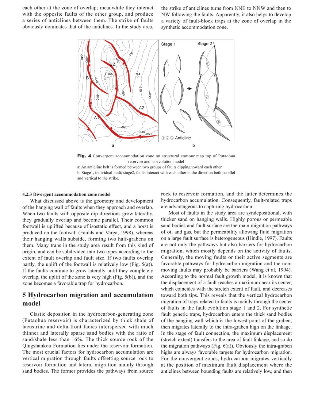
3 304 is a complete evolution cycle of a large fault (system), and reveals the general regularities of fault development. The local stress field of different faults interact at the zone of merger, and produce groups of structures known as accommodation (or transfer) zones, whose geometries are dependent on the extent of overlap, the scale and occurrence of faults (Morley et al, 1990; Faulds and Varga, 1998; Bonson et al, 2007). The accommodation zones are usually favorable structural trap development areas. Many faults in the study area show the characteristics of fault evolution of different stages. Normal faults approach, overlap and interact with others during their growth in the lateral and vertical directions, and consequently produce various structural traps. 4 Genetic models of traps related to normal faults 4.1 Individual fault genetic model The structural map of this type is shown in Fig. 2. A halfgraben (or syncline) on the hanging wall and an uplift (semianticline) on the footwall. Many traps in the study area result from individual normal faults. Fig. 3 shows a typical instance. It can be seen that there are three small faults, A, B and C, which are about 500m, 550m and 700m long respectively, and each controls a half-graben on its hanging wall, which is the local low, and a semi-anticline on its footwall, which is the local high. The semi-anticlines are obviously smaller than the half-grabens and the area and the height of uplifts or the extent of subsidence of half-grabens are related to the length of the faults. Semi-anticlines generally could not be found on the usual map with contour interval of 10m for the small fault, such as A and B. It is proven by hydrocarbon production practice in this area that the small half-grabens are often highly water-flooded, and the uplifts on the hanging wall are favorable for the enrichment of remaining oil in the middle and late phases of oilfield development. Over 300 small faults with the length of approximately m have been found in the study area by fine 3D seismic data interpretation, many of which coincide with the above fault model, but most are neglected on the usual map with contour interval of 10m or more. Under the instruction of the trap model mentioned above, we plotted a structural map with a contour interval of 2-5m to find the small traps (structural high) and locate the half-grabens (structural low), and successful wells were drilled on the semi-anticline of the footwall of the small faults. This method avoids the structural lows of the hanging wall, which are usually highly water-flooded and the fault surfaces, which often result in casing wear. 4.2 Accommodation zone by fault interaction genetic model Originally individual normal faults interact and form accommodation zones, when they overlap and connect with each other as a result of lateral and vertical growth. They exhibit different types and features because of different occurrences and overlap extents of the faults. They are often favorable structural traps. A C Fig. 3 Structural contour map top of Putaohua reservoir (Yaojia Formation). Normal fault A, B, and C show similar features to Fig. 2. Fault A and B overlap slightly, develop relay ramp and nose structure in or near the overlap areas p p205-6 Nose Relay ramp Scale m Synthetic accommodation zone model Synthetic accommodation zones develop between normal faults with similar strike and dip when they approach, overlap and interact. There are two kinds of growth models. 1) Two collinear faults with each controlling a half-graben (similar to individual normal fault) grow laterally and connect together without strike variation at the fault tips (Fig. 6(a)). The newly connected fault consists of several segments and each exhibits similar displacement distribution to that of an individual fault. As a result, broken noses develop at the fault joints on the hanging wall while semi-anticlines are formed at the midsegments of the fault and structural lows at the joints on the footwall (Fig. 6(a)). Apparently, this situation happens at the beginning of fault linkage. Many traps in the study area belong to this kind. 2) Two parallel faults overlap when they grow laterally over time, and result in a relay ramp structure in the zone of overlap. Fig. 3 shows that relay ramps connect the hanging wall of one fault to the footwall of the other fault. It realizes the transition of footwall to hanging wall, and effectively transfer strain between two faults. There is also an apparent nose-like structure between two half-grabens on the hanging wall corresponding to the relay ramp. Minor oblique or transverse normal faults will develop on the relay ramp, which helps to produce fault-block traps if the two faults overlap further over time Convergent accommodation zone model When two faults dip toward each other, the strata on the common hanging wall exhibit the graben features, and form an anticline. However, if each fault system consists of several faults with uniform dip, there will be great complexity. The accommodation zones are actually the superposition of synthetic accommodation zones and convergent accommodation zones, as shown in Fig. 4(a). Generally, an anticline belt develops between the two fault systems. The evolution process of this type is as follows (Fig. 4(b)): 1) Two groups of normal faults with similar dip keep no interaction in the direction both parallel and vertical to the strike. 2) Faults overlap along the strike and interact with B
4 305
5 306
6 307 References And ers M H and Schlische R W. Overlapping faults, intrabasin highs and the growth of normal faults. Journal of Geology (2): Bon son C G, Childs C, Walsh J J, et al. Geometric and kinematic controls on the internal structure of a large normal fault in massive limestones: The Maghlaq Fault, Malta. Journal of Structural Geology (2): Cow ie P A and Scholz C H. Growth of faults by accumulation of seismic slip. Journal of Geophysical Research (B7): Den smore A L, Dawers N H, Gupta S, et al. What sets topographic relief in extensional footwalls? Geology (6): Du la W F. Geometric models of listric normal faults and rollover folds. AAPG Bulletin (10): Fau lds J E and Varga R J. The role of accommodation zones and transfer zones in the regional segmentation of extended terranes. Geological Society of America Special Paper : 1-45 For d M, de Veslud C Le C and Bourgeois O. Kinematic and geometric analysis of fault-related folds in a rift setting: The Dannemarie Basin, Upper Rhine Graben, France. Journal of Structural Geology (11): Hin dle A D. Petroleum migration pathways and charge concentration: a three-dimensional model. AAPG Bulletin (9): Kim Y S and Sanderson D J. The relationship between displacement and length of faults: a review. Earth-Science Reviews (3-4): Li X. Model for hydrocarbon accumulation of Dongxin Oil Field in the Dongying Sag. Journal of Basic Science and Engineering (2): (in Chinese) Mor ley C K, Nelson R A, Patton T L, et al. Transfer zones in East African Rift system and their relevance to hydrocarbon exploration in rifts. AAPG Bulletin (8): Ros endahl B R. Architecture of continental rifts with special reference to East Africa. Annual Review of Earth and Planetary Sciences : Sco tt D L and Rosendahl B R. North Viking Graben: an East African perspective. AAPG Bulletin (2): Shelton J W. Listric normal faults: an illustrated summary. AAPG Bulletin (7): Sol iva R and Benedicto A. Geometry, scaling relations and spacing of vertically restricted normal faults. Journal of Structural Geology (2): Var ga R J, Faulds J E, Snee L W, et al. Miocene extension and extensional folding in an anticlinal segment of the Black Mountains accommodation zone, Colorado River extensional corridor, southwestern United States. Tectonics (1): 1-19 Wal sh J J and Watterson J. Analysis of the relationship between displacement and dimensions of faults. Journal of Structural Geology : Wan g P, Li J F and Li Y Q. Fine exploration and development of complex fault-blocks. Beijing: Petroleum Industry Press (in Chinese) Wan g Y K. Preliminary investigation on the geological features and oil bearing regularity of Dongxin Oil Field in Shengli oil area. Journal of Xi an Petroleum Institute (1): (in Chinese) Wat terson J. Fault dimensions, displacements and growth. Pure and Applied Geophysics (1-2): Xia o H B and Suppe J. Origin of rollover. AAPG Bulletin (4): Xie X Y, Deng J G and Xin Q L. Fault-block models and hydrocarbon accumulation in Dongxin Oilfield. Petroleum Exploration and Development (2): (in Chinese) (Edited by Hao Jie)
Fault growth & linkage
 Fault growth & linkage Important to understand fault growth, interaction & linkage Continental extension and basin formation Controls on subsurface fluid flow Hydrocarbon exploration & production Minerals
Types and Briyfly Origins of the Extensional Fault-Related Folds
 IOSR Journal of Engineering (IOSRJEN) ISSN (e): 2250-3021, ISSN (p): 2278-8719 Vol. 06, Issue 01 (January. 2016), V2 PP 39-43 www.iosrjen.org Types and Briyfly Origins of the Extensional Fault-Related
Constrained Fault Construction
 Constrained Fault Construction Providing realistic interpretations of faults is critical in hydrocarbon and mineral exploration. Faults can act as conduits or barriers to subsurface fluid migration and
Main controlling factors of hydrocarbon accumulation in Sujiatun oilfield of Lishu rift and its regularity in enrichment
 35 3 2016 9 GLOBAL GEOLOGY Vol. 35 No. 3 Sept. 2016 1004 5589 2016 03 0785 05 130062 P618. 130. 2 A doi 10. 3969 /j. issn. 1004-5589. 2016. 03. 019 Main controlling factors of hydrocarbon accumulation
The characteristics of fracture dense belt and its effect on hydrocarbon. accumulation in the Putaohua reservoir, Xingnan oilfield, Daqing
 The characteristics of fracture dense belt and its effect on hydrocarbon accumulation in the Putaohua reservoir, Xingnan oilfield, Daqing 1 Y.Y. YIN,2 Zh. Luo, 3Q. Li, 4X.R. Wang 1 School of Energy Resources,
Elliptical Fault Flow
 Elliptical Fault Flow Elliptical Fault Flow provides a new way to model and restore faults with variable offsets using Move. This new kinematic algorithm was created by Midland Valley, and is accessed
Reservoir Type and Main Controlling Factors of Reservoir Forming in Block T of South Buir Sag
 Reservoir Type and Main Controlling Factors of Reservoir Forming in Block T21-7-3 of South Buir Sag Xinyao Wang College of earth science of Northeast Petroleum University, Daqing, Heilongjiang, China Abstract
Earth Science, (Tarbuck/Lutgens) Chapter 10: Mountain Building
 Chapter 10: Mountain Building") Earth Science, (Tarbuck/Lutgens) Chapter 10: Mountain Building 1) A(n) fault has little or no vertical movements of the two blocks. A) stick slip B) oblique slip C) strike slip D) dip slip 2) In a(n) fault,
Earth Science, (Tarbuck/Lutgens) Chapter 10: Mountain Building 1) A(n) fault has little or no vertical movements of the two blocks. A) stick slip B) oblique slip C) strike slip D) dip slip 2) In a(n) fault,
Fault History analysis in Move
 Fault History analysis in Move The new Fault History plot in Move provides a method to conduct a quick-look analysis of the evolution of faults through time. By restoring the vertical displacement of a
Case Study of the Structural and Depositional-Evolution Interpretation from Seismic Data*
 Case Study of the Structural and Depositional-Evolution Interpretation from Seismic Data* Yun Ling 1, Xiangyu Guo 1, Jixiang Lin 1, and Desheng Sun 1 Search and Discovery Article #20143 (2012) Posted April
Study on the characteristics of fault in PuTaohua oil layer of GuLong Oilfield
 IOSR Journal of Engineering (IOSRJEN) ISSN (e): 2250-3021, ISSN (p): 2278-8719 Vol. 04, Issue 01 (January. 2014), V1 PP 29-34 www.iosrjen.org Study on the characteristics of fault in PuTaohua oil layer
KEY CHAPTER 12 TAKE-HOME QUIZ INTERNAL STRUCTURES AND PROCESSES Score Part B = / 55 PART B
 GEOLOGY 12 KEY CHAPTER 12 TAKE-HOME QUIZ INTERNAL STRUCTURES AND PROCESSES Score Part B = / 55 PART B CHAPTER 12 Isostacy and Structural Geology 1. Using the terms below, label the following diagrams and
Lecture Outline Friday March 2 thru Wednesday March 7, 2018
 Lecture Outline Friday March 2 thru Wednesday March 7, 2018 Questions? Lecture Exam Friday March 9, 2018 Same time, Same room Bring Pencils and WSU ID 50 question Multiple Choice, Computer Graded Interlude
11.1 Rock Deformation
 Tarbuck Lutgens Mountain Building 11.1 Rock Deformation Factors Affecting Deformation Factors that influence the strength of a rock and how it will deform include temperature, confining pressure, rock
Course Title: Discipline: Geology Level: Basic-Intermediate Duration: 5 Days Instructor: Prof. Charles Kluth. About the course: Audience: Agenda:
 Course Title: Structural Geology Discipline: Geology Level: Basic-Intermediate Duration: 5 Days Instructor: Prof. Charles Kluth About the course: This course covers the basic ideas of structural geometry
STRAIN AND SCALING RELATIONSHIPS OF FAULTS AND VEINS AT KILVE, SOMERSET
 Read at the Annual Conference of the Ussher Society, January 1995 STRAIN AND SCALING RELATIONSHIPS OF FAULTS AND VEINS AT KILVE, SOMERSET M. O'N. BOWYER AND P. G. KELLY Bowyer, M. O'N. and Kelly, P.G.
Deformation of Rocks. Orientation of Deformed Rocks
 Deformation of Rocks Folds and faults are geologic structures caused by deformation. Structural geology is the study of the deformation of rocks and its effects. Fig. 7.1 Orientation of Deformed Rocks
Stress and Strain. Stress is a force per unit area. Strain is a change in size or shape in response to stress
 Geologic Structures Geologic structures are dynamically-produced patterns or arrangements of rock or sediment that result from, and give information about, forces within the Earth Produced as rocks change
Chapter 16. Mountain Building. Mountain Building. Mountains and Plate Tectonics. what s the connection?
 Chapter 16 Mountains and Plate Tectonics what s the connection? Mountain Building Most crustal deformation occurs along plate margins. S.2 Active Margin Passive Margin Mountain Building Factors Affecting
THE HETEROGENEOUS STRUCTURE OF FAULT ZONES WITHIN CARBONATE ROCKS: EVIDENCE FROM OUTCROP STUDIES AND IMPLICATIONS FOR FLUID FLOW
 THE HETEROGENEOUS STRUCTURE OF FAULT ZONES WITHIN CARBONATE ROCKS: EVIDENCE FROM OUTCROP STUDIES AND IMPLICATIONS FOR FLUID FLOW C.G. Bonson*, J.J. Walsh, C. Childs, M.P.J. Schöpfer & V. Carboni Fault
Classification of fault condensed belt and faults development characteristics in Xingbei Region, Daqing placanticline
 IOSR Journal of Engineering (IOSRJEN) ISSN (e): 2250-3021, ISSN (p): 2278-8719 Vol. 05, Issue 07 (July. 2015), V3 PP 29-33 www.iosrjen.org Classification of fault condensed belt and faults development
Deformation along oblique and lateral ramps in listric normal faults: Insights from experimental models
 GEOLOGIC NOTE Deformation along oblique and lateral ramps in listric normal faults: Insights from experimental models Shamik Bose and Shankar Mitra ABSTRACT Listric growth faults in passive margin settings
Evaluation on source rocks and the oil-source correlation in Bayanhushu sag of Hailaer Basin
 30 2 2011 6 GLOBAL GEOLOGY Vol. 30 No. 2 Jun. 2011 1004-5589 2011 02-0231 - 07 163712 3 7 Ⅰ Ⅱ1 3 - - P618. 130 A doi 10. 3969 /j. issn. 1004-5589. 2011. 02. 011 Evaluation on source rocks and the oil-source
Using structural validation and balancing tools to aid interpretation
 Using structural validation and balancing tools to aid interpretation Creating a balanced interpretation is the first step in reducing the uncertainty in your geological model. Balancing is based on the
Chapter 15 Structures
 Chapter 15 Structures Plummer/McGeary/Carlson (c) The McGraw-Hill Companies, Inc. TECTONIC FORCES AT WORK Stress & Strain Stress Strain Compressive stress Shortening strain Tensional stress stretching
Learning Objectives (LO) What we ll learn today:!
 What we ll learn today:!") Learning Objectives (LO) Lecture 13: Mountain Building Read: Chapter 10 Homework #11 due Tuesday 12pm What we ll learn today:! 1. Define the types of stress that are present in the crust! 2. Define the
Learning Objectives (LO) Lecture 13: Mountain Building Read: Chapter 10 Homework #11 due Tuesday 12pm What we ll learn today:! 1. Define the types of stress that are present in the crust! 2. Define the
entered a rapid development phase. Annual increased proven reserves are above 500 billion cubic meters (bcm) from 2003, and annual natural gas product
 from 2003, and annual natural gas product") (), entered a rapid development phase. Annual increased proven reserves are above 500 billion cubic meters (bcm) from 2003, and annual natural gas production has increased from 50bcm in 2000 to nearly
(), entered a rapid development phase. Annual increased proven reserves are above 500 billion cubic meters (bcm) from 2003, and annual natural gas production has increased from 50bcm in 2000 to nearly
Geologic Structures. Changes in the shape and/or orientation of rocks in response to applied stress
 Geologic Structures Changes in the shape and/or orientation of rocks in response to applied stress Figure 15.19 Can be as big as a breadbox Or much bigger than a breadbox Three basic types Fractures >>>
Quantitative discrimination of normal fault segment growth and its geological significance: example from the Tanan Depression, Tamtsag Basin, Mongolia
 Australian Journal of Earth Sciences An International Geoscience Journal of the Geological Society of Australia ISSN: 0812-0099 (Print) 1440-0952 (Online) Journal homepage: http://www.tandfonline.com/loi/taje20
Main controlling factors of remaining oil and favorable area prediction of Xinli oilfield VI block
 IOSR Journal of Engineering (IOSRJEN) ISSN (e): 2250-3021, ISSN (p): 2278-8719 Vol. 05, Issue 03 (March. 2015), V1 PP 06-10 www.iosrjen.org Main controlling factors of remaining oil and favorable area
Application of the Combination of Well and Earthquake in Reservoir Prediction of AoNan Area
 IOSR Journal of Engineering (IOSRJEN) ISSN (e): 2250-3021, ISSN (p): 2278-8719 Vol. 06, Issue 03 (March. 2016), V2 PP 36-40 www.iosrjen.org Application of the Combination of Well and Earthquake in Reservoir
3.3. Tectonics of Rifting and Drifting: Pangea Breakup
 N.B., FOR BEST RESULTS, PRINT AT 85% Previous Next 3.3. Tectonics of Rifting and Drifting: Pangea Breakup 3.3.2. Extracting Tectonic Information from Cores in Rift Basins Roy W. Schlische Department of
Technique of fault interpretation
 IOSR Journal of Engineering (IOSRJEN) ISSN (e): 2250-3021, ISSN (p): 2278-8719 Vol. 05, Issue 11 (November. 2015), V1 PP 20-24 www.iosrjen.org Technique of fault interpretation LI Zhiyang, MA Shizhong
Kinematic structural forward modeling for fault trajectory prediction in seismic interpretation
 Fault prediction by forward modeling Kinematic structural forward modeling for fault trajectory prediction in seismic interpretation Mohammed Alarfaj and Don C. Lawton ABSTRACT The unique relationship
Meandering Miocene Deep Sea Channel Systems Offshore Congo, West Africa
 Meandering Miocene Deep Sea Channel Systems Offshore Congo, West Africa S. Baer* (PGS), J. E. Comstock (PGS), K. Vrålstad (PGS), R. Borsato (PGS), M. Martin (PGS), J.P. Saba (SNPC), B. Débi-Obambé (SNPC)
Structural Style and Tectonic Evolution of the Nakhon Basin, Gulf of Thailand
 Structural Style and Tectonic Evolution of the Nakhon Basin, Gulf of Thailand Piyaphong Chenrai Petroleum Geoscience Program, Department of Geology, Faculty of Science, Chulalongkorn University, Bangkok
Geophysical methods for the study of sedimentary cycles
 DOI 10.1007/s12182-009-0041-9 259 Geophysical methods for the study of sedimentary cycles Xu Jingling 1, 2, Liu Luofu 1, 2, Wang Guiwen 1, 2, Shen Jinsong 1, 2 and Zhang Chunhua 3 1 School of Resources
Description of faults
 GLG310 Structural Geology Description of faults Horizontal stretch Crustal thickness Regional elevation Regional character Issues Normal Thrust/reverse Strike-slip >1 1 in one direction and < 1 in
surface uplift of fault-related folds rely primarily on their limbs and associated
 Finite and Quaternary shortening calculation Finite shortening Models commonly used to constrain the structural evolution, shortening, and surface uplift of fault-related folds rely primarily on their
What Causes Rock to Deform?
 Crustal Deformation Earth, Chapter 10 Chapter 10 Crustal Deformation What Causes Rock to Deform? Deformation is a general term that refers to all changes in the shape or position of a rock body in response
Answers: Internal Processes and Structures (Isostasy)
") Answers: Internal Processes and Structures (Isostasy) 1. Analyse the adjustment of the crust to changes in loads associated with volcanism, mountain building, erosion, and glaciation by using the concept
Answers: Internal Processes and Structures (Isostasy) 1. Analyse the adjustment of the crust to changes in loads associated with volcanism, mountain building, erosion, and glaciation by using the concept
Wide/narrow azimuth acquisition footprints and their effects on seismic imaging
 308 DOI 10.1007/s12182-008-0052-y Wide/narrow azimuth acquisition footprints and their effects on seismic imaging Di Bangrang 1, 2, 3, Xu Xiucang 1, 2, 3 1, 2, 3 and Wei Jianxin 1 Key Laboratory of CNPC
Development of Crestal Collapse Structures above Dissolving Salt Anticlines: Application to Seismic Interpretation within Salt-Controlled Basins*
 Development of Crestal Collapse Structures above Dissolving Salt Anticlines: Application to Seismic Interpretation within Salt-Controlled Basins* Tom Randles 1, Stuart Clarke 1, and Phil Richards 2 Search
Characteristics of the Sedimentary Microfacies of Fuyu Reservoir in Yushulin Oilfield, Songliao Basin
 IOSR Journal of Engineering (IOSRJEN) ISSN (e): 2250-3021, ISSN (p): 2278-8719 Vol. 06, Issue 03 (March. 2016), V3 PP 01-05 www.iosrjen.org Characteristics of the Sedimentary Microfacies of Fuyu Reservoir
6162 Upper Rhine Graben: 3D Seismic - A New Approach to Geothermal Exploration in a Structurally Complex Tectonic Enviroment
 6162 Upper Rhine Graben: 3D Seismic - A New Approach to Geothermal Exploration in a Structurally Complex Tectonic Enviroment C. G. Eichkitz* (Joanneum Research), M.G. Schreilechner (Joanneum Research),
How mountains are made. We will talk about valleys (erosion and weathering later)
") How mountains are made We will talk about valleys (erosion and weathering later) http://www.ilike2learn.com/ilike2learn/mountainmaps/mountainranges.html Continent-continent plate convergence Less dense,
How mountains are made We will talk about valleys (erosion and weathering later) http://www.ilike2learn.com/ilike2learn/mountainmaps/mountainranges.html Continent-continent plate convergence Less dense,
Crustal Deformation Earth - Chapter Pearson Education, Inc.
 Crustal Deformation Earth - Chapter 10 Structural Geology Structural geologists study the architecture and processes responsible for deformation of Earth s crust. A working knowledge of rock structures
December 21, Chapter 11 mountain building E.notebook. Feb 19 8:19 AM. Feb 19 9:28 AM
 Mountains form along convergent plate boundaries. Typically (usually) if you look at a mountain range, you know that it is at a plate boundary (active continental margin) or has been some time in the past
Crustal Deformation. (Building Earth s Surface, Part 1) Science 330 Summer Mapping geologic structures
 Science 330 Summer Mapping geologic structures") Crustal Deformation (Building Earth s Surface, Part 1) Science 330 Summer 2005 Mapping geologic structures When conducting a study of a region, a geologist identifies and describes the dominant rock structures
Crustal Deformation (Building Earth s Surface, Part 1) Science 330 Summer 2005 Mapping geologic structures When conducting a study of a region, a geologist identifies and describes the dominant rock structures
Logging characteristic analysis of basalt in eastern depression of Liaohe Oilfield
 35 4 2016 12 GLOBAL GEOLOGY Vol. 35 No. 4 Dec. 2016 1004 5589 2016 04 1095 06 1 2 3 1 1. 130026 2. 330002 3. 163412 4 P588. 145 P631. 321 A doi 10. 3969 /j. issn. 1004-5589. 2016. 04. 020 Logging characteristic
Structural Modelling of Inversion Structures: A case study on South Cambay Basin
 10 th Biennial International Conference & Exposition P 065 Structural Modelling of Inversion Structures: A case study on South Cambay Basin Dr. Mayadhar Sahoo & S.K Chakrabarti Summary The inversion in
Serial Cross-Section Trishear Modeling: Reconstructing 3-D Kinematic Evolution of the Perdido Fold Belt*
 Serial Cross-Section Trishear Modeling: Reconstructing 3-D Kinematic Evolution of the Perdido Fold Belt* Dian He 1 and John Paul Brandenburg 2 Search and Discovery Article #30313 (2014)** Posted January
How to Build a Mountain and other Geologic Structures. But first a short review
 How to Build a Mountain and other Geologic Structures But first a short review Where do we see deep earthquakes? What is happening there? What can happen at a plate boundary? 1. Plates can move apart
Crags, Cracks, and Crumples: Crustal Deformation and Mountain Building
 Crags, Cracks, and Crumples: Crustal Deformation and Mountain Building Updated by: Rick Oches, Professor of Geology & Environmental Sciences Bentley University Waltham, Massachusetts Based on slides prepared
Exploration, Drilling & Production
 Nontechnical Guide to PETMOLEUM Geology, Exploration, Drilling & Production Third Edition Norman J. Hyne, Ph.D. Contents Preface *i Introduction 1 The Nature of Gas and Oil 1 Petroleum 1 The Chemistry
Application of Fault Response Modelling Fault Response Modelling theory
 Application of Fault Response Modelling The Fault Response Modelling module in Move TM provides a geomechanical method for modelling fault-related deformation. The module calculates stress, strain and
Chapter. Mountain Building
 Chapter Mountain Building 11.1 Rock Deformation Factors Affecting Deformation Factors that influence the strength of a rock and how it will deform include temperature, confining pressure, rock type, and
Transtensional tectonism and its effects on the distribution of sandbodies in the Paleogene Baiyun Sag, Pearl River Mouth Basin, China
 Mar Geophys Res (2013) 34:195 207 DOI 10.1007/s11001-013-9200-x ORIGINAL RESEARCH PAPER Transtensional tectonism and its effects on the distribution of sandbodies in the Paleogene Baiyun Sag, Pearl River
CRUSTAL DEFORMATION. Chapter 10
 CRUSTAL DEFORMATION and dgeologic Structures t Chapter 10 Deformation Df Deformation involves: Stress the amount of force applied to a given area. Types of Stress: Confining Stress stress applied equally
Genetic types and distribution of shallow-buried natural gases
 Pet.Sci.(2010)7:347-354 DOI 10.1007/s12182-010-0076-y 347 Genetic types and distribution of shallow-buried natural gases Gao Yang 1, Jin Qiang 1 and Zhu Guangyou 2 1 College of Geo-resources and Information,
UNIT 10 MOUNTAIN BUILDING AND EVOLUTION OF CONTINENTS
 UNIT 10 MOUNTAIN BUILDING AND EVOLUTION OF CONTINENTS ROCK DEFORMATION Tectonic forces exert different types of stress on rocks in different geologic environments. STRESS The first, called confining stress
The chapters in part I provide new and valuable
 PART I TECTONICS AND STRUCTURE OF SUPERCONTINENT BREAKUP 2 Introduction Martha Oliver Withjack and Roy W. Schlische The chapters in part I provide new and valuable information about the tectonic and structural
Downloaded 01/06/15 to Redistribution subject to SEG license or copyright; see Terms of Use at
 Application of wide-azimuth 3D seismic attributes to predict the microfractures in Block MA area for shale gas exploration in South China Yusheng Zhang* 1, Gang Yu 1, Ximing Wang 1, Xing Liang 2, and Li
Orphan Basin, Offshore Newfoundland: New seismic data and hydrocarbon plays for a dormant Frontier Basin
 Orphan Basin, Offshore Newfoundland: New seismic data and hydrocarbon plays for a dormant Frontier Basin Jerry Smee* G&G Exploration Consulting, 301 400-3rd Avenue SW, Calgary, AB, T2P 4H2 Sam Nader, Paul
Quantitative evaluation of fault lateral sealing
 IOSR Journal of Engineering (IOSRJEN) ISSN (e): 2250-3021, ISSN (p): 2278-8719 Vol. 06, Issue 03 (March. 2016), V1 PP 29-33 www.iosrjen.org Jianan Zhu 1, Yue Gong 1 1 (College of Earth Sciences, Northeast
Tu D Understanding the Interplay of Fractures, Stresses & Facies in Unconventional Reservoirs - Case Study from Chad Granites
 Tu D201 04 Understanding the Interplay of Fractures, Stresses & Facies in Unconventional Reservoirs - Case Study from Chad Granites D. Lirong (Chinese National Petroleum Company Ltd. (Chad)), C. Shrivastava*
Lab 7: STRUCTURAL GEOLOGY FOLDS AND FAULTS
 Lab 7: STRUCTURAL GEOLOGY FOLDS AND FAULTS This set of labs will focus on the structures that result from deformation in earth s crust, namely folds and faults. By the end of these labs you should be able
Assignment #5-7: Geology
 Assignment #5-7: Geology Name: 1. "Geological processes operating at the present time are the same processes that have operated in the past" is a statement of: A. the Principle of Cross-cutting Relationships
Carboniferous Stoddart Group: An integrated approach
 Carboniferous Stoddart Group: An integrated approach Abu Yousuf*, Department of Geoscience, University of Calgary, Calgary, Alberta yousufabu@hotmail.com and Charles M. Henderson, Department of Geoscience,
Petroleum geology framework, West Coast offshore region
 Petroleum geology framework, West Coast offshore region James W. Haggart* Geological Survey of Canada, Vancouver, BC jhaggart@nrcan.gc.ca James R. Dietrich Geological Survey of Canada, Calgary, AB and
Fractured Volcanic Reservoir Characterization: A Case Study in the Deep Songliao Basin*
 Fractured Volcanic Reservoir Characterization: A Case Study in the Deep Songliao Basin* Desheng Sun 1, Ling Yun 1, Gao Jun 1, Xiaoyu Xi 1, and Jixiang Lin 1 Search and Discovery Article #10584 (2014) Posted
Application of seismic hydrocarbon detection technique to natural gas exploration-take Yingshan rift volcanic in the Yingcheng Groups as an instance
 IOSR Journal of Engineering (IOSRJEN) ISSN (e): 2250-3021, ISSN (p): 2278-8719 Vol. 05, Issue 10 (October. 2015), V1 PP 21-25 www.iosrjen.org Application of seismic hydrocarbon detection technique to natural
Salt tectonic styles in the spreading basin: Yucatan, Offshore Mexico Purnima Bhowmik*, Rodolfo Hernandez and Katarina Rothe, TGS
 1 Purnima Bhowmik*, Rodolfo Hernandez and Katarina Rothe, TGS Summary The TGS Gigante project is comprised of 188,497 km of 2D seismic data acquired in 2016 and primarily covering the offshore Mexican
Crustal Deformation. Earth Systems 3209
 Crustal Deformation Earth Systems 3209 Crustal Deformation pg. 415 Refers to all changes in the original form and/or size of a rock body. May also produce changes in the location and orientation of rocks.
Answer sheet for question 1 Answer question 1 as soon as the sample arrives at your desk.
 EAS 233 Geologic structures. Final test. April 2012. 3 hours. Answer question 1 and 2 and three other questions. If you start more than the required number of questions, clearly delete the answers you
Improved Interpretability via Dual-sensor Towed Streamer 3D Seismic - A Case Study from East China Sea
 Improved Interpretability via Dual-sensor Towed Streamer 3D Seismic - A Case Study from East China Sea S. Rongfu (CNOOC Shanghai), C. Hua (CNOOC Shanghai), W. Yun (CNOOC Shanghai), Z. Yabin (CNOOC Shanghai),
Sedimentary System Characteristics of Deng-3 Section on Paleo-central. Uplift Belt in Northern Songliao Basin. Siyang Li1,a*
 Sedimentary System Characteristics of Deng-3 Section on Paleo-central Uplift Belt in Northern Songliao Basin Siyang Li1,a* 1 School of Earth Sciences and Resources, China University of Geosciences, Beijing,
Seismogenic structure of 1935 Hsinchu-Taichung (M GR =7.1) earthquake, Miaoli, western Taiwan 1935 (M GR =7.1)
 earthquake, Miaoli, western Taiwan 1935 (M GR =7.1)") Seismogenic structure of 1935 Hsinchu-Taichung (M GR =7.1) earthquake, Miaoli, western Taiwan 1935 (M GR =7.1) Y.N. Nina Lin; Y.G. Chen; Y.M. Wu (Inst. of Geosciences, NTU); K.M. Yang (Exploration and
Seismogenic structure of 1935 Hsinchu-Taichung (M GR =7.1) earthquake, Miaoli, western Taiwan 1935 (M GR =7.1) Y.N. Nina Lin; Y.G. Chen; Y.M. Wu (Inst. of Geosciences, NTU); K.M. Yang (Exploration and
Outline 16: The Mesozoic World: Formation of Oil Deposits (with a side trip to the Devonian Marcellus Shale)
") Outline 16: The Mesozoic World: Formation of Oil Deposits (with a side trip to the Devonian Marcellus Shale) The first commercial oil well was drilled by Colonel Edwin Drake in Titusville, Pennsylvania,
Outline 16: The Mesozoic World: Formation of Oil Deposits (with a side trip to the Devonian Marcellus Shale) The first commercial oil well was drilled by Colonel Edwin Drake in Titusville, Pennsylvania,
Downloaded 09/15/16 to Redistribution subject to SEG license or copyright; see Terms of Use at
 A Full Field Static Model of the RG-oil Field, Central Sirte Basin, Libya Abdalla Abdelnabi*, Kelly H. Liu, and Stephen Gao Missouri University of Science and Technology Summary Cambrian-Ordovician and
GEOL 321 Structural Geology and Tectonics
 GEOL 321 Structural Geology and Tectonics Geology 321 Structure and Tectonics will be given in Spring 2017. The course provides a general coverage of the structures produced by brittle and ductile rock
Chinese Petroleum Resources / Reserves Classification System
 Chinese Petroleum Resources / Reserves Classification System By Yundong Hu Petroleum Reserves Office Ministry of Land and Resources, PRC 30/10/2003 Chinese Petroleum Resources / Reserves Classification
Hydrocarbon generation conditions and exploration potential of the Taoudeni Basin, Mauritania
 A t l a n t i c Pet.Sci.(29)6:29-37 DOI 1.17/s12182-9-6-z 29 Hydrocarbon generation conditions and exploration potential of the Taoudeni Basin, Mauritania Gang Wenzhe Key Laboratory of Hydrocarbon Accumulation
Open Access Study on Reservoir-caprock Assemblage by Dual Logging Parameter Method
 Send Orders for Reprints to reprints@benthamscience.ae 282 The Open Petroleum Engineering Journal, 2015, 8, (Suppl 1: M4) 282-287 Open Access Study on Reservoir-caprock Assemblage by Dual Logging Parameter
Mountains are then built by deforming crust: Deformation & Mountain Building. Mountains form where stresses are high!
 Deformation & Mountain Building Where are mountains located? Deformation and Folding Mountain building Mountains form where stresses are high! Mountains form at all three types of plate boundaries where
T-z profiles can elucidate the kinematic history of normal faults (i.e. fault nucleation, growth, and/or
 GSA Data Repository 2018026 Phillips et al., 2018, Determining the three-dimensional geometry of a dike swarm and its impact on later rift geometry using seismic reflection data: Geology, https://doi.org/10.1130/g39672.1.
Sequence Stratigraphy. Historical Perspective
 Sequence Stratigraphy Historical Perspective Sequence Stratigraphy Sequence Stratigraphy is the subdivision of sedimentary basin fills into genetic packages bounded by unconformities and their correlative
EAS 233 Geologic Structures and Maps Winter Miscellaneous practice map exercises. 1. Fault and separation:
 Miscellaneous practice map exercises 1. Fault and separation: With respect to Map 1, what are (a) the orientation of the fault, and (b) the orientation of bedding in the units cut by the fault. (c) Mark
SouthWest Energy (HK) Ltd.
 Ltd.") SouthWest Energy (HK) Ltd. Investor Presentation Cape Town October 2012 Why Are We Searching Oil in SWE Blocks? Similar geological g setting with Yemen s producing fields Oil seeps and oil show in the
SouthWest Energy (HK) Ltd. Investor Presentation Cape Town October 2012 Why Are We Searching Oil in SWE Blocks? Similar geological g setting with Yemen s producing fields Oil seeps and oil show in the
COMPAGNIE MINIÈRE CONGOLAISE S.P.R.L. - CoMiCo
 COMPAGNIE MINIÈRE CONGOLAISE S.P.R.L. - CoMiCo assets in the Cuvette Centrale (Busira and Lokoro Sub-Basins) of the Democratic Republic of Congo March 2008 Prepared by HRT - HIGH RESOLUTION TECHNOLOGY
Stratigraphic effects and tectonic implications of the growth of normal faults and extensional basins
 Geological Society of America Special Paper 303 1996 Stratigraphic effects and tectonic implications of the growth of normal faults and extensional basins Roy W. Schlische Department of Geological Sciences,
Bulletin of Earth Sciences of Thailand
 Quantitative Seismic Geomorphology of Early Miocene to Pleistocene Fluvial System of Northern Songkhla Basin, Gulf of Thailand Oanh Thi Tran Petroleum Geoscience Program, Department of Geology, Faculty
Characteristics of stratigraphic structure and oil-gas-water distribution by logging data in Arys oilfield
 31 1 2012 3 GLOBAL GEOLOGY Vol. 31 No. 1 Mar. 2012 1004 5589 2012 01 0162 09 100101 4 P618. 130. 2 P631. 8 A doi 10. 3969 /j. issn. 1004-5589. 2012. 01. 020 Characteristics of stratigraphic structure and
Analysis of micro amplitude structure along faults based on Fault Segmented Growth Pattern
 Analysis of micro along faults based on Fault Segmented Growth Pattern Guipu Jiang 1, Yanfang Lu 2, Quan Bai 2, Siduo Chen 2, Xiaolong Han 3, Wenbo Han 2 1 No. 4 Oil Production Company, PetroChina Daqing
Essentials of Geology, 11e
 Essentials of Geology, 11e Crustal Deformation and Mountain Building Chapter 17 Instructor Jennifer Barson Spokane Falls Community College Geology 101 Stanley Hatfield Southwestern Illinois College Jennifer
HYDROCARBON EXPLORATION IN THE ALBERTINE GRABEN OF THE EAST AFRICAN RIFT SYSTEM
 IN THE ALBERTINE GRABEN OF THE EAST AFRICAN RIFT SYSTEM GEOPRISM; EAST AFRICAN RIFT SYSTEM PLANNING WORKSHOP By: Dozith Abeinomugisha Ministry of Energy and Mineral Development, Entebbe, Uganda 1 BACKGROUND
A comparison between the displacement geometries of veins and normal faults at Kilve, Somerset
 363 Read at the Annual Conference of the Ussher Society, January 1991 A comparison between the displacement geometries of veins and normal faults at Kilve, Somerset D.C.P. PEACOCK Peacock, D.C.P. 1991.
Instantaneous Spectral Analysis Applied to Reservoir Imaging and Producibility Characterization
 Instantaneous Spectral Analysis Applied to Reservoir Imaging and Producibility Characterization Feng Shen 1* and Gary C. Robinson 1, Tao jiang 2 1 EP Tech, Centennial, CO, 80112, 2 PetroChina Oil Company,
NATURAL ENVIRONMENT. Geophysics
 NATURAL ENVIRONMENT Geophysics Geodynamics Alpine, Carpathian and Dinaric mountain belts surround the Pannonian (Carpathian) Basin, of Neogene through Quaternary in age. The Cenozoic evolution of the Alpine-Pannonian
APPENDIX C GEOLOGICAL CHANCE OF SUCCESS RYDER SCOTT COMPANY PETROLEUM CONSULTANTS
 APPENDIX C GEOLOGICAL CHANCE OF SUCCESS Page 2 The Geological Chance of Success is intended to evaluate the probability that a functioning petroleum system is in place for each prospective reservoir. The