EEOS 465 / 627 Environmental Modeling with Raster GIS. David Tenenbaum EEOS 465 / 627 UMass Boston
|
|
|
- Monica Harvey
- 5 years ago
- Views:
Transcription

1 EEOS 465 / 627 Environmental Modeling with Raster GIS
2 EEOS 465 / 627 Environmental Modeling with Raster GIS Course Description: This course consists of three parts: In the first four weeks, we will focus on raster data models, their structure and function, and in particular on their use in a modeling context. In other words, we will first study what modeling capabilities the GIS provides. This will be accomplished primarily through readings, discussion and laboratory exercises.
3 EEOS 465 / 627 Environmental Modeling with Raster GIS Course Description Continued: Once a more thorough knowledge of GIS capabilities is attained, we will proceed to the design, modeling and implementation phase of the course. From the fifth to eighth week, we will introduce the design of GIS projects and spatial interactive modeling.
4 EEOS 465 / 627 Environmental Modeling with Raster GIS Course Description Continued: In the final seven weeks, the class will be used to conduct a final project. Upon completion of the course, students will be in a position to participate (most likely as a junior GIS analyst) in studies utilizing these techniques and, as a user of GIS technology or as an organizational manager concerned with GIS, to intelligently deal with the results of such investigations.
5 EEOS 465 / 627 Environmental Modeling with Raster GIS Course Description Continued: The course will include lectures, laboratory exercises, and a final project (7 weeks). In the final project, you will design your own project as a real-world experience. This will give you an opportunity to employ your knowledge within a real design scenario.
6 EEOS 465 / 627 Environmental Modeling with Raster GIS Students will be expected to read reference materials and be prepared to discuss them each week Class meetings will begin by focusing on the key concepts from the reference materials (from the course text in the first half, and various materials pertaining to the projects in the second half) In the first half of the course, this will be followed by weekly lab exercises designed to augment the readings and to sequentially build capability and understanding in the application of raster GIS approaches to environmental modeling applications In the second half of the course, lab time will be devoted to project development and execution

7 EEOS 465 / 627 Environmental Modeling with Raster GIS Text: Michael N. DeMers. GIS Modeling in Raster. Wiley, ISBN
8 EEOS 465 / 627 Environmental Modeling with Raster GIS Course Web Page: Lab Exercises: Instructions are online, linked from the course web page Data will sit in a course directory on the s:\ drive There be will an exercise each week, throughout the first half of the course These are due 1 week later at the beginning of the class meeting Lateness Penalty: -10% of total mark per weekday Approach your instructor/ta for extenuating circumstances Exercises more than a week overdue will not be accepted
9 Date 01/28/09 02/04/09 02/11/09 02/18/09 02/25/09 03/04/09 03/11/09 03/18/09 Topic Course Intro. Raster Data and ArcGIS Spatial Analyst Raster Representations and Calculations Raster Analysis and Functions Building Spatial Models Building Spatial Models II Raster Analysis and Functions II Model Design and Evaluation Spring Vacation Background Material AN INTRODUCTION TO ENVIRONMENTAL MODELING WITH RASTER GIS Chapter 1: Introduction, pp Chapter 2: Nature of the Data, pp Chapter 3: Map Algebra, pp Chapter 4: Characterizing the Functional Operations, pp Chapter 5: Modeling Essentials, pp Chapter 6: Conceptualizing the Model, pp Chapter 7: Model Formulation, Flowcharting, and Implementation, pp Chapter 4: Characterizing the Functional Operations, pp Chapter 8: Conflict Resolution and Prescriptive Modeling, pp Chapter 9: Model Verification, Validation, and Acceptability, pp N/A Lab / Project Work Exercise 1 Explore Class Data Exercise 2 Raster Concepts Exercise 3A Build A Raster Database Exercise 3B Georeference a Raster Exercise 4A Use Objects, Operators, and Commands Exercise 4B Build Expressions with Functions Exercise 5 Raster Processing Tools Exercise 7 Analyze Topography Exercise 8A Surface Hydrology Tools Exercise 8B Groundwater Hydrology Tools Exercise 10A Modeling Techniques and Tools Exercise 10B ModelBuilder and Weighted Suitability N/A
10 EEOS 465 / 627 Environmental Modeling with Raster GIS Project: The final project will simulate a real-world setting by establishing a GIS consulting firm. The CEO of the firm is the instructor, who will be responsible for helping the project teams complete their work in a timely and professional manner. The CEO will also review team performance and the quality of their output.
11 EEOS 465 / 627 Environmental Modeling with Raster GIS Project, Continued: Students may conduct the project in a team consisting of no more than 3 members. Each team will have an elected team leader. This team leader is responsible for communications between the CEO and individual team members. In other words, the team leader is the point person for project management.
12 EEOS 465 / 627 Environmental Modeling with Raster GIS Project, Continued : The classroom time allocated for lab sessions will provide a common time for project teams to meet each week. During certain phases of the project, additional team meetings will need to be scheduled. From the 9th week, each team or individual will give a 5-to-10 minute report on that week's progress either to the entire class or to the instructor.
13 EEOS 465 / 627 Environmental Modeling with Raster GIS Project, Continued : Team members will take turns to presenting your project progress each week. This staff meeting will allow everyone to follow the progress of the group as a whole, and should eliminate duplication of effort during the data collection phase of the project. All members should feel free to offer comments and suggestions to other teams.
14 Date Topic Background Material Lab / Project Work 03/25/09 PROJECTS USING ENVIRONMENTAL MODELING WITH RASTER GIS Group Formation and Proposal Creation Project Outline Preliminary Project Work 04/01/09 Project Design and Document Preparation Project Implementation Progress Report 1, Discussion, and Collaboration 04/08/09 Formulation and Implementation I Graduate Reading Assignments Graduate Presentations 04/15/09 Formulation and Implementation II N/A Progress Report 2, Discussion, and Collaboration 04/22/09 Verification and Validation N/A Progress Report 3, Discussion, and Collaboration 04/29/09 Document and Presentation Preparation I N/A Progress Report 4, Discussion, and Collaboration 05/06/09 Document and Presentation Preparation II N/A Progress Report 5, Discussion, and Collaboration 05/13/09 Project Presentations N/A Project Presentations
15 EEOS 465 / 627 Environmental Modeling with Raster GIS Course Evaluation: Lab exercises 40% (30% Grads) Graduate presentations (10% Grads) Class participation 10% Team self-evaluation 10% Progress reports 10% Final project presentation 10% Final project report 20%
16 EEOS 465 / 627 Environmental Modeling with Raster GIS Class Meetings: McCormack , moving to S for lab Wednesdays from 5:30-8:00 PM Lab Availability: S when open and not used by a class S-3-34 anytime 24/7 when not used by a class Instructor Office Hours: S Mondays and Wednesdays from 1:00-2:30 PM


17 David Tenenbaum Hon. B.Sc. at the University of Toronto Majors: Physical and Environmental Geography & Environment in Society M.Sc. at the University of Toronto Thesis: RHESSys-ArcView Integrated Modelling Environment Ph.D. at the University of North Carolina at Chapel Hill Dissertation: Surface Moisture Patterns in Urbanizing Landscapes Canadian Government Lab Visiting Fellow at the Water & Climate Impacts Research Centre Research: NAESI - In-Stream Flow Needs

18 How to Reach Me David E. Tenenbaum, Ph.D. Assistant Professor EEOS, UMass Boston Office: Science Building S Tel:
19 Teaching Assistant Jun Zhu Ph.D. Candidate: Environmental Science TA experience: EEOS 370 and EEOS Office Hours: Wednesdays 11:00 AM 2:30 PM S Wednesdays 4:00 PM 5:30 PM S-3-020
20 Course Objectives To develop students capability to use GIS in raster spatial modeling. To develop students capability to use GIS in a modeling context (that is, to be able to implement mathematical models in GIS). To examine GIS modeling from the point of view of a system analyst toward the design and implementation of GIS projects.
21 Student Introductions Name Department and Pursuing Degree Research interests (for grad. students) Expectation from this course GIS and math (stats.) background Computer background Work experience?
22 Chapter 1 Introduction: Environmental Modeling The term modeling is used in a few senses in the context of GIS, but we can generalize their meaning somewhat: Modeling in the context of GIS occurs whenever the operations of the GIS attempt to emulate geographic processes in the world (environmental systems), at one point in time or over an extended period. This can range from simple representation, to evaluation, to very involved prediction We must be aware of the roles of scale, complexity, and accuracy
23 The Role of GIS Modeling A key application of GIS to solve geographic problems, of a variety of sorts: As a tool for decision-making To render explanations of distributional patterns (people, plants, animals, places, things) To predict new distributions and arrangements As a laboratory for exploration of theories from which GIS derived To allow scientists to challenge hypotheses Practitioners, theoreticians and programmers all participate in this endeavor (and frequently a single person is more than one of these)
24 Three Activities Practiced by GIS Professionals Theoreticians Practitioners GIS Programmers
25 Practitioners Must learn how to employ models Solve problems Provide justifications for decisions Theoreticians How GIS Professionals Operate in These Roles Seek repeatable, quantifiable explanations through simplification and abstraction Develop a framework for more detailed modeling
26 Realizing GIS Capabilities Geographic problems to be solved can be: Simple, repetitive, computationally exhaustive Complex, computationally elaborate Problems may have no solutions at all No theoretical basis yet A GIS can be viewed as an automated laboratory for hypothesis formulation and testing
27 GIS Primary Purpose: Analyzing Geographically-referenced Data This is often done using formal models: Represent some aspects of the human or physical environment, using: Aggregate or disaggregate mapped data: Aggregate data Data that have been combined from data for components. Disaggregate data Data that are separated into units, not combined. Predict new distributions of phenomena Define the locations of selected activities Describe the results of patterns of one variable on itself or on other variables
28 A Primary Purpose Now Applied in a Wide Variety of Disciplines Crime Wildlife Mapping Management Land Use Study Spill Mitigation Dump Monitoring Facilities Management IFORANALYS S Urban Planning Wildlife Management GISDATA Resource Management Precision Agriculture Military Planning Healthcare Management Fire Fighting Habitat Restoration Aerosol Dispersion Geospatial data and products, including maps, simulations, and databases, are invaluable tools in the effective management of utility infrastructure, transportation, energy, emergency management and response, natural resource management, climate analysis, disaster recovery, homeland defense, law enforcement, protection planning and other civilian or military strategic issues
29 Understanding the Modeling Process What is the model supposed to do / what is it for? A database allowing me to ask questions about what and where things are? A model quantifying existing patterns for better understanding? A model examining multiple relationships from different maps? A model showing how things change through time? A model predicting something? Locating the best places, routes, or scenarios for some form of activity?
30 Application Software ArcMap, ArcCatalog, ArcToolbox, and ModelBuilder: ArcMap - for cartography, map analysis, and editing ArcCatalog - organizes and manages all GIS information: maps, data sets, models, metadata, and services. including Browse and find geographic information Record, view, and manage metadata Define, export, and import geodatabase schemas and designs Search and browse GIS data on local networks and the Web ArcToolbox - geoprocessing functions including tools for Data management Data conversion Vector analysis Geocoding Statistical analysis ModelBuilder for building models!

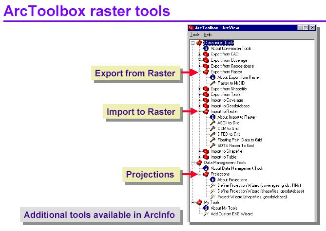
31 ArcCatalog Raster Tools
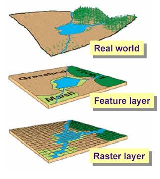
32 Data Formats in Arc Products ArcView 3.x Shapefile ArcInfo Coverage GRID ArcGIS GeoDatabase (.mdb) (.gdb)
33
34 ArcGIS Extensions Spatial Analyst Geostatistical Analyst 3D Analyst (includes ArcGlobe) Survey Analyst Tracking Analyst Network Analyst Schematics
35 Next Topic: Raster Data and ArcGIS Spatial Analyst
EEOS 281 Introduction to Geographic Information Systems
 EEOS 281 Introduction to Geographic Information Systems EEOS 281 Introduction to Geographic Information Systems Course Description: This course is an introductory course in geographic information systems
UNIT 4: USING ArcGIS. Instructor: Emmanuel K. Appiah-Adjei (PhD) Department of Geological Engineering KNUST, Kumasi
 Department of Geological Engineering KNUST, Kumasi") UNIT 4: USING ArcGIS Instructor: Emmanuel K. Appiah-Adjei (PhD) Department of Geological Engineering KNUST, Kumasi Getting to Know ArcGIS ArcGIS is an integrated collection of GIS software products ArcGIS
UNIT 4: USING ArcGIS Instructor: Emmanuel K. Appiah-Adjei (PhD) Department of Geological Engineering KNUST, Kumasi Getting to Know ArcGIS ArcGIS is an integrated collection of GIS software products ArcGIS
Course overview. Grading and Evaluation. Final project. Where and When? Welcome to REM402 Applied Spatial Analysis in Natural Resources.
 Welcome to REM402 Applied Spatial Analysis in Natural Resources Eva Strand, University of Idaho Map of the Pacific Northwest from http://www.or.blm.gov/gis/ Where and When? Lectures Monday & Wednesday
CAS GE 365 Introduction to Geographical Information Systems. The Applications of GIS are endless
 Spring 2007 CAS GE 365 Introduction to Geographical Information Systems Boston University Department of Geography and Environment The Applications of GIS are endless images from www.esri.com CAS GE 365
Welcome to NR502 GIS Applications in Natural Resources. You can take this course for 1 or 2 credits. There is also an option for 3 credits.
 Welcome to NR502 GIS Applications in Natural Resources. You can take this course for 1 or 2 credits. There is also an option for 3 credits. The 1st credit consists of a series of readings, demonstration,
NR402 GIS Applications in Natural Resources
 NR402 GIS Applications in Natural Resources Lesson 1 Introduction to GIS Eva Strand, University of Idaho Map of the Pacific Northwest from http://www.or.blm.gov/gis/ Welcome to NR402 GIS Applications in
INTRODUCTION TO ARCGIS Version 10.*
 Week 3 INTRODUCTION TO ARCGIS Version 10.* topics of the week Overview of ArcGIS Using ArcCatalog Overview of ArcGIS Desktop ArcGIS Overview Scalable desktop applications ArcView ArcEditor ArcInfo ArcGIS
Introduction to GIS (GEOG 401) Spring 2014, 3 credit hours
 Spring 2014, 3 credit hours") Introduction to GIS (GEOG 401) Spring 2014, 3 credit hours Instructors: Guangxing Wang, Ph.D. Email: gxwang@siu.edu Phone: (618) 453-6017 Office: 4442 Faner Hall Office hours: M& W&F 9:00am-11:00am or
Introduction to GIS (GEOG 401) Spring 2014, 3 credit hours Instructors: Guangxing Wang, Ph.D. Email: gxwang@siu.edu Phone: (618) 453-6017 Office: 4442 Faner Hall Office hours: M& W&F 9:00am-11:00am or
SAULT COLLEGE OF APPLIED ARTS AND TECHNOLOGY SAULT STE. MARIE, ONTARIO COURSE OUTLINE
 SAULT COLLEGE OF APPLIED ARTS AND TECHNOLOGY SAULT STE. MARIE, ONTARIO COURSE OUTLINE COURSE TITLE: GIS Applications CODE NO. : SEMESTER: 10W PROGRAM: AUTHOR: Geographic Information Systems Applications
GEOG 508 GEOGRAPHIC INFORMATION SYSTEMS I KANSAS STATE UNIVERSITY DEPARTMENT OF GEOGRAPHY FALL SEMESTER, 2002
 GEOG 508 GEOGRAPHIC INFORMATION SYSTEMS I KANSAS STATE UNIVERSITY DEPARTMENT OF GEOGRAPHY FALL SEMESTER, 2002 Course Reference #: 13210 Meeting Time: TU 2:05pm - 3:20 pm Meeting Place: Ackert 221 Remote
Labs: Chelsea Ackroyd Office Location: FMAB 005 Office Hours: M 08:45 11:45 AM or by appointment
 Introduction to Geographic Information Systems (GEOG 3140 and 314) & GIS Fundamentals (GEOG 6139) Fall 2017 Section 002 M 01:25 02:45 PM Section 003 M 03:00 4:20 PM Section 004 W 01:25 02:45 PM M Lib 1150
GIS Boot Camp for Education June th, 2011 Day 1. Instructor: Sabah Jabbouri Phone: (253) x 4854 Office: TC 136
 x 4854 Office: TC 136") GIS Boot Camp for Education June 27-30 th, 2011 Day 1 Instructor: Sabah Jabbouri Phone: (253) 833-9111 x 4854 Office: TC 136 Email: sjabbouri@greenriver.edu http://www.instruction.greenriver.edu/gis/ Summer
GIS Boot Camp for Education June 27-30 th, 2011 Day 1 Instructor: Sabah Jabbouri Phone: (253) 833-9111 x 4854 Office: TC 136 Email: sjabbouri@greenriver.edu http://www.instruction.greenriver.edu/gis/ Summer
Geog418: Introduction to GIS Fall 2011 Course Syllabus. Textbook: Introduction to Geographic Information Systems edited by Chang (6th ed.
 Geog418: Introduction to GIS Fall 2011 Course Syllabus AH 1320 3:30 4:45 p.m.tr Instructor: Dr. Shunfu Hu Office: AH1413 Telephone 650-2281 Office hours: 10:00 11:00 a.m. TR or by appointment (shu@siue.edu)
HISTORY 1XX/ DH 1XX. Introduction to Geospatial Humanities. Instructor: Zephyr Frank, Associate Professor, History Department Office: Building
 HISTORY 1XX/ DH 1XX Introduction to Geospatial Humanities Instructor: Zephyr Frank, Associate Professor, History Department Office: Building 200-332 Course Description This course introduces undergraduate
David Tenenbaum GEOG 070 UNC-CH Spring 2005
 GEOG 070 Introduction to Geographic Information GEOG 070 Introduction to Geographic Information Course Description: There is a spatial component to all that occurs on our planet. Everything happens somewhere
ENV208/ENV508 Applied GIS. Week 1: What is GIS?
 ENV208/ENV508 Applied GIS Week 1: What is GIS? 1 WHAT IS GIS? A GIS integrates hardware, software, and data for capturing, managing, analyzing, and displaying all forms of geographically referenced information.
Introduction to Coastal GIS
 Held on Tues, 1/8/13 through Thurs, 1/10/13 Location: Roger Williams University, Bristol, RI Audience: The intended audiences for this course are federal and state personnel, municipal staff and officials,
ARCGIS TRAINING AT KU GIS LABS: INTRODUCTION TO GIS: EXPLORING ARCCATALOG AND ARCGIS TOOLS
 PHASE 1_4 th SESSION ARCGIS TRAINING AT KU GIS LABS: INTRODUCTION TO GIS: EXPLORING ARCCATALOG AND ARCGIS TOOLS 4 th SESSION REPORT: 30 TH JUNE - 2 ND JULY SCHOOL OF ENVIRONMENTAL STUDIES COMPUTER LAB
https://sites.google.com/a/pdx.edu/gis-2-applications/home
 Page 1 of 5 GIS 2: APPLICATIONS Search this site GEOG 492/592: GIS 2 Syllabus Academic Guidelines Rubrics Presentation Rubric Project Poster Project Proposal Syllabus (PDF) Sitemap GEOG 492/592: GIS 2
Introduction to Geographic Information Systems
 Geog 58 Introduction to Geographic Information Systems, Fall, 2003 Page 1/8 Geography 58 Introduction to Geographic Information Systems Instructor: Lecture Hours: Lab Hours: X-period: Office Hours: Classroom:
Lab Assistant: Kathy Tang Office: SSC 2208 Phone: ext
 The University of Western Ontario Department of Geography GEOGRAPHY 9110B: Introduction to Geographic Information Systems Lecture: Thursday 11:30 1:30pm, SSC #1004 Lab: Thursday 2:30 4:30pm, SSC #1316A
Geospatial Intelligence
 Geospatial Intelligence Geospatial analysis has existed as long as humans have made and studied maps but its importance to the intelligence community has skyrocketed in the past several years, with Unmanned
Introduction to the 176A labs and ArcGIS
 Introduction to the 176A labs and ArcGIS Acknowledgement: Slides by David Maidment, U Texas-Austin and Francisco Olivera (TAMU) Purpose of the labs Hands-on experience with one software pakage Introduction
GIS FOR PLANNING. Course Overview. Schedule. Instructor. Prerequisites. Urban Planning 792 Thursday s 5:30-8:10pm SARUP 158
 GIS FOR PLANNING Urban Planning 792 Thursday s 5:30-8:10pm SARUP 158 Schedule Class/Lab - SARUP 158 Thursdays 5:30pm - 8:10pm Office Hours - By Appointment Project Ideas - Week 4 Final - 5/10/2018 Instructor
Geographic Systems and Analysis
 Geographic Systems and Analysis New York University Robert F. Wagner Graduate School of Public Service Instructor Stephanie Rosoff Contact: stephanie.rosoff@nyu.edu Office hours: Mondays by appointment
GIS CONCEPTS ARCGIS METHODS AND. 3 rd Edition, July David M. Theobald, Ph.D. Warner College of Natural Resources Colorado State University
 GIS CONCEPTS AND ARCGIS METHODS 3 rd Edition, July 2007 David M. Theobald, Ph.D. Warner College of Natural Resources Colorado State University Copyright Copyright 2007 by David M. Theobald. All rights
94-802Z: Geographic Information Systems Summer 2018
 94-802Z: Geographic Information Systems Summer 2018 Instructor: Professor Kristen Kurland Teaching Assistant(s): (Office hours to be posted on Canvas) TBA Class Web Site: http:/www.cmu.edu/canvas
GIS and Forest Engineering Applications FE 357 Lecture: 2 hours Lab: 2 hours 3 credits
 GIS and Forest Engineering Applications FE 357 Lecture: 2 hours Lab: 2 hours 3 credits Instructor: Michael Wing Assistant Professor Forest Engineering Department Oregon State University Peavy Hall 275
Lecture 2. Introduction to ESRI s ArcGIS Desktop and ArcMap
 Lecture 2 Introduction to ESRI s ArcGIS Desktop and ArcMap Outline ESRI What is ArcGIS? ArcGIS Desktop ArcMap Overview Views Layers Attribute Tables Help! Scale Tips and Tricks ESRI Environmental Systems
Environmental Systems Research Institute
 Introduction to ArcGIS ESRI Environmental Systems Research Institute Redlands, California 2 ESRI GIS Development Arc/Info (coverage model) Versions 1-7 from 1980 1999 Arc Macro Language (AML) ArcView (shapefile
Hydrologic and Hydraulic Analyses Using ArcGIS
 Hydrologic and Hydraulic Analyses Using ArcGIS Two day training class Overview ArcGIS and Arc Hydro provide strong foundation for support of hydrologic and hydraulic (H&H) analyses. This two-day course
GIST 4302/5302: Spatial Analysis and Modeling
 GIST 4302/5302: Spatial Analysis and Modeling Spring 2016 Lectures: Tuesdays & Thursdays 12:30pm-1:20pm, Science 234 Labs: GIST 4302: Monday 1:00-2:50pm or Tuesday 2:00-3:50pm GIST 5302: Wednesday 2:00-3:50pm
Lecture 9: Geocoding & Network Analysis
 Massachusetts Institute of Technology - Department of Urban Studies and Planning 11.520: A Workshop on Geographic Information Systems 11.188: Urban Planning and Social Science Laboratory Lecture 9: Geocoding
Introduction to the 176A labs and ArcGIS Purpose of the labs
 Introduction to the 176A labs and ArcGIS Purpose of the labs Acknowledgement: Slides by David Maidment, U Texas-Austin and Francisco Olivera (TAMU) Hands-on experience with a leading software package Introduction
ENVIRONMENT AND NATURAL RESOURCES 3700 Introduction to Spatial Information for Environment and Natural Resources. (2 Credit Hours) Semester Syllabus
 Semester Syllabus") ENVIRONMENT AND NATURAL RESOURCES 3700 Introduction to Spatial Information for Environment and Natural Resources COURSE INSTRUCTOR: Dr. Kris Jaeger Assistant Professor 359 Kottman Hall (Mondays and Tuesdays)
ENVIRONMENT AND NATURAL RESOURCES 3700 Introduction to Spatial Information for Environment and Natural Resources COURSE INSTRUCTOR: Dr. Kris Jaeger Assistant Professor 359 Kottman Hall (Mondays and Tuesdays)
ARCGIS COURSE, ADVANCED LEVEL ONLINE TRAINING
 ARC COURSE, ADVANCED LEVEL ONLINE TRAINING Training Course.com TYC TRAINING OVERVIEW This course will qualify students in Arc Desktop 10.x and in particular in the usage of ArcMap, ArcCatalog and ArcTool
Lecture 1 Introduction to GIS. Dr. Zhang Spring, 2017
 Lecture 1 Introduction to GIS Dr. Zhang Spring, 2017 Topics of the course Using and making maps Navigating GIS Map design Working with spatial data Geoprocessing Spatial data infrastructure Digitizing
GIST 4302/5302: Spatial Analysis and Modeling
 GIST 4302/5302: Spatial Analysis and Modeling Spring 2014 Lectures: Tuesdays & Thursdays 2:00pm-2:50pm, Holden Hall 00038 Lab sessions: Tuesdays or Thursdays 3:00pm-4:50pm or Wednesday 1:00pm-2:50pm, Holden
Fundamentals of ArcGIS Desktop Pathway
 Fundamentals of ArcGIS Desktop Pathway Table of Contents ArcGIS Desktop I: Getting Started with GIS 3 ArcGIS Desktop II: Tools and Functionality 5 Understanding Geographic Data 8 Understanding Map Projections
SAULT COLLEGE OF APPLIED ARTS AND TECHNOLOGY SAULT STE. MARIE, ONTARIO COURSE OUTLINE
 SAULT COLLEGE OF APPLIED ARTS AND TECHNOLOGY SAULT STE. MARIE, ONTARIO COURSE OUTLINE COURSE TITLE: GIS Applications CODE NO. : SEMESTER: 12W PROGRAM: AUTHOR: Geographic Information Systems Applications
SCHOOL OF ENGINEERING AND TECHNOLOGY COMPUTER LAB
 PHASE 1_6 TH SESSION ARCGIS TRAINING AT KU GIS LABS: INTRODUCTION TO GIS: EXPLORING ARCCATALOG AND ARCGIS TOOLS 6 TH SESSION REPORT: 3 RD -5 TH SEPTEMBER 2014 SCHOOL OF ENGINEERING AND TECHNOLOGY COMPUTER
GIScience in Urban Planning Education - Experience from University of Maryland
 GIScience in Urban Planning Education - Experience from University of Maryland February 3, 2007 University of Tokyo Qing Shen Professor of Urban Studies and Planning School of Architecture,
90-834: Health Geographic Information Systems Spring Semester 2017
 90-834: Health Geographic Information Systems Spring Semester 2017 Prerequisite: 90-728 (Introduction to Database Management Systems), or 91-802 (Information Systems for Managers), or equivalent course
PHASE 1_7 TH SESSION ARCGIS TRAINING AT KU GIS LABS: INTRODUCTION TO GIS: EXPLORING ARCCATALOG AND ARCGIS TOOLS
 PHASE 1_7 TH SESSION ARCGIS TRAINING AT KU GIS LABS: INTRODUCTION TO GIS: EXPLORING ARCCATALOG AND ARCGIS TOOLS 7 TH SESSION REPORT: 10 TH - 12 TH SEPTEMBER 2014 SCHOOL OF ENGINEERING AND TECHNOLOGY COMPUTER
FUNDAMENTALS OF GEOGRAPHIC INFORMATION SYSTEMS
 NUTR 231 FUNDAMENTALS OF GEOGRAPHIC INFORMATION SYSTEMS Syllabus for Spring 2018 This syllabus is subject to change. Check the course Canvas site for latest version. Graduate course: Class Time: Location:
Cartographic Workshop
 http://lazarus.elte.hu/cet/ Cartographic Workshop One of the roles of the ICA, Commission on Education and Training is to provide member nations with cartographic workshop experiences that enhance the
Introduction to Coastal GIS
 Introduction to Coastal GIS Event was held on Tues, 1/8/13 - Thurs, 1/10/13 Time: 9:00 am to 5:00 pm Location: Roger Williams University, Bristol, RI Audience: The intended audiences for this course are
ARCGIS TRAINING AT KU GIS LABS: INTRODUCTION TO GIS: EXPLORING ARCCATALOG AND ARCGIS TOOLS
 PHASE 1_3 rd SESSION ARCGIS TRAINING AT KU GIS LABS: INTRODUCTION TO GIS: EXPLORING ARCCATALOG AND ARCGIS TOOLS 3 rd SESSION REPORT: 25 TH -27 TH JUNE 2014 SCHOOL OF ENVIRONMENTAL STUDIES COMPUTER LAB
DP Project Development Pvt. Ltd.
 Dear Sir/Madam, Greetings!!! Thanks for contacting DP Project Development for your training requirement. DP Project Development is leading professional training provider in GIS technologies and GIS application
ArcGIS Tools for Professional Cartography
 ArcGIS Tools for Professional Cartography By Makram Murad-al-shaikh M.S. Cartography Senior instructor ESRI Educational Services ICC - A Coruña - Spain, 9-16 July, 2005 Overview Overview of the ArcGIS
GIS = Geographic Information Systems;
 What is GIS GIS = Geographic Information Systems; What Information are we talking about? Information about anything that has a place (e.g. locations of features, address of people) on Earth s surface,
Lecture 2. A Review: Geographic Information Systems & ArcGIS Basics
 Lecture 2 A Review: Geographic Information Systems & ArcGIS Basics GIS Overview Types of Maps Symbolization & Classification Map Elements GIS Data Models Coordinate Systems and Projections Scale Geodatabases
DRAFT SYLLABUS. Please use Blackboard to send messages.
 SYLLABUS Course Title: Geographic Information Systems and Spatial Analysis for Public Policy Academic Department/Course Number: PUBP 754 Semester/Year: Fall 2017 Building/Room: FH 307 Days/Time: W 4:30
GTECH 380/722 Analytical and Computer Cartography Hunter College, CUNY Department of Geography
 GTECH 380/722 Analytical and Computer Cartography Hunter College, CUNY Department of Geography Spring 2010 Wednesdays 5:35PM to 9:15PM Instructor: Doug Williamson, PhD Email: Douglas.Williamson@hunter.cuny.edu
Task 1: Open ArcMap and activate the Spatial Analyst extension.
 Exercise 10 Spatial Analyst The following steps describe the general process that you will follow to complete the exercise. Specific steps will be provided later in the step-by-step instructions component
GEOGRAPHIC INFORMATION SYSTEMS
 GEOGRAPHIC INFORMATION SYSTEMS 4-H Round-Up Community Transitions Workshop Daniel Hanselka June 14, 2011 Goals of the Workshop Answer the question: What is GIS? Uses of GIS. Some of the Common Terminology
GIS CONCEPTS ARCGIS METHODS AND. 2 nd Edition, July David M. Theobald, Ph.D. Natural Resource Ecology Laboratory Colorado State University
 GIS CONCEPTS AND ARCGIS METHODS 2 nd Edition, July 2005 David M. Theobald, Ph.D. Natural Resource Ecology Laboratory Colorado State University Copyright Copyright 2005 by David M. Theobald. All rights
Popular Mechanics, 1954
 Introduction to GIS Popular Mechanics, 1954 1986 $2,599 1 MB of RAM 2017, $750, 128 GB memory, 2 GB of RAM Computing power has increased exponentially over the past 30 years, Allowing the existence of
Application of Geospatial Technology in an Emergency Management Academic Program
 Application of Geospatial Technology in an Emergency Management Academic Program Author Edwin Leachman Visiting Assistant Professor Department of Emergency Administration and Management Arkansas Tech University
COURSE SCHEDULE, GRADING, and READINGS
 COURSE SCHEDULE, GRADING, and READINGS Note: All academic classes will be held in the GIS lab at Royal Thimphu College. These dates are listed here. Other days will involve travel or days off, and the
GEG 5810 Geographic Information Systems I
 Eastern Illinois University NEW COURSE PROPOSAL CGS Agenda Item: 08-01 Proposal Effective Date: Fall 2008 GEG 5810 Geographic Information Systems I Please check one: X New course Revised course PART I:
ArcGIS. for Server. Understanding our World
 ArcGIS for Server Understanding our World ArcGIS for Server Create, Distribute, and Manage GIS Services You can use ArcGIS for Server to create services from your mapping and geographic information system
Steve Pietersen Office Telephone No
 Steve Pietersen Steve.Pieterson@durban.gov.za Office Telephone No. 031 311 8655 Overview Why geography matters The power of GIS EWS GIS water stats EWS GIS sanitation stats How to build a GIS system EWS
Geodatabase Management Pathway
 Geodatabase Management Pathway Table of Contents ArcGIS Desktop II: Tools and Functionality 3 ArcGIS Desktop III: GIS Workflows and Analysis 6 Building Geodatabases 8 Data Management in the Multiuser Geodatabase
GIST 4302/5302: Spatial Analysis and Modeling
 GIST 4302/5302: Spatial Analysis and Modeling Fall 2015 Lectures: Tuesdays & Thursdays 2:00pm-2:50pm, Science 234 Lab sessions: Tuesdays or Thursdays 3:00pm-4:50pm or Friday 9:00am-10:50am, Holden 204
Migrating Defense Workflows from ArcMap to ArcGIS Pro. Renee Bernstein and Jared Sellers
 Migrating Defense Workflows from ArcMap to ArcGIS Pro Renee Bernstein and Jared Sellers ArcGIS Desktop Desktop Web Device ArcMap ArcCatalog ArcScene ArcGlobe ArcGIS Pro portal Server Online Content and
1. Omit Human and Physical Geography electives (6 credits) 2. Add GEOG 677:Internet GIS (3 credits) 3. Add 3 credits to GEOG 797: Final Project
 2. Add GEOG 677:Internet GIS (3 credits) 3. Add 3 credits to GEOG 797: Final Project") The Department of Geography and the Office of Professional Studies propose to modify the Master of Professional Studies in Geospatial Information Sciences (GIS) as follows: 1. Omit Human and Physical Geography
The Department of Geography and the Office of Professional Studies propose to modify the Master of Professional Studies in Geospatial Information Sciences (GIS) as follows: 1. Omit Human and Physical Geography
Workshop and Session Descriptions
 MONDAY, SEPTEMBER 14 Workshops (Full-day) Workshop and Session Descriptions 1. Bridging the surveyed gap: How land surveying data works with GIS GIS professionals use a myriad of data to construct their
ArcGIS for Desktop. ArcGIS for Desktop is the primary authoring tool for the ArcGIS platform.
 ArcGIS for Desktop ArcGIS for Desktop ArcGIS for Desktop is the primary authoring tool for the ArcGIS platform. Beyond showing your data as points on a map, ArcGIS for Desktop gives you the power to manage
Monday May 12, :00 to 1:30 AM
 ASTRONOMY 108: Descriptive Astronomy Spring 2008 Instructor: Hugh Gallagher Office: Physical Science Building 130 Phone, Email: 436-3177, gallagha@oneonta.edu Office Hours: M 2:00-3:00 PM, Th 10:00-11:00
GENERALIZATION IN THE NEW GENERATION OF GIS. Dan Lee ESRI, Inc. 380 New York Street Redlands, CA USA Fax:
 GENERALIZATION IN THE NEW GENERATION OF GIS Dan Lee ESRI, Inc. 380 New York Street Redlands, CA 92373 USA dlee@esri.com Fax: 909-793-5953 Abstract In the research and development of automated map generalization,
Delineation of Watersheds
 Delineation of Watersheds Adirondack Park, New York by Introduction Problem Watershed boundaries are increasingly being used in land and water management, separating the direction of water flow such that
EEOS 381 -Spatial Databases and GIS Applications
 EEOS 381 -Spatial Databases and GIS Applications Lecture 5 Geodatabases What is a Geodatabase? Geographic Database ESRI-coined term A standard RDBMS that stores and manages geographic data A modern object-relational
Spatial Analysis and Modeling (GIST 4302/5302) Guofeng Cao Department of Geosciences Texas Tech University
 Guofeng Cao Department of Geosciences Texas Tech University") Spatial Analysis and Modeling (GIST 4302/5302) Guofeng Cao Department of Geosciences Texas Tech University TTU Graduate Certificate Geographic Information Science and Technology (GIST) 3 Core Courses and
Spatial Analysis and Modeling (GIST 4302/5302) Guofeng Cao Department of Geosciences Texas Tech University TTU Graduate Certificate Geographic Information Science and Technology (GIST) 3 Core Courses and
(THIS IS AN OPTIONAL BUT WORTHWHILE EXERCISE)
") PART 2: Analysis in ArcGIS (THIS IS AN OPTIONAL BUT WORTHWHILE EXERCISE) Step 1: Start ArcCatalog and open a geodatabase If you have a shortcut icon for ArcCatalog on your desktop, double-click it to start
PART 2: Analysis in ArcGIS (THIS IS AN OPTIONAL BUT WORTHWHILE EXERCISE) Step 1: Start ArcCatalog and open a geodatabase If you have a shortcut icon for ArcCatalog on your desktop, double-click it to start
Introduction to GIS. Geol 4048 Geological Applications of Remote Sensing
 Introduction to GIS Geol 4048 Geological Applications of Remote Sensing GIS History: Before Computers GIS History Using maps for a long time Dr. Roger F. Tomlinson Father of GIS He was an English geographer
GEOGRAPHIC INFORMATION SYSTEMS Session 8
 GEOGRAPHIC INFORMATION SYSTEMS Session 8 Introduction Geography underpins all activities associated with a census Census geography is essential to plan and manage fieldwork as well as to report results
Hydrologic Engineering Applications of Geographic Information Systems
 Hydrologic Engineering Applications of Geographic Information Systems Davis, California Objectives: The participant will acquire practical knowledge and skills in the application of GIS technologies for
GEOGRAPHIC INFORMATION SYSTEMS AND IT SOLUTIONS FOR THE ENVIRONMENT
 GEOGRAPHIC INFORMATION SYSTEMS AND IT SOLUTIONS FOR THE ENVIRONMENT Mission We focus on Solutions is a worldwide operating business offering Geographic Information Systems and IT solutions to assist environmental
GIS certificate; 24th 28th September and 3rd 7th December University of Venda
 ;, TARGET Delegates; Town planners. Geologist, Hydrologist, Hydro-Geologists Botanists Conservationists Land Surveyors, Educators, Researchers, Undergraduate and post-graduate students, companies, Local
GIST 4302/5302: Spatial Analysis and Modeling Lecture 1: Overview
 GIST 4302/5302: Spatial Analysis and Modeling Lecture 1: Overview Guofeng Cao www.myweb.ttu.edu/gucao Department of Geosciences Texas Tech University guofeng.cao@ttu.edu Fall 2017 Texas Tech GIS Graduate
Statewide Topographic Mapping Program
 Statewide Topographic Mapping Program February 28, 2018 www.dotd.la.gov Outline Purpose of the Statewide Topographic Mapping Program History Breakdown of R.S. 48:36 - Topographic Mapping Statewide Topographic
GIS and Forest Engineering Applications FE 257 Lecture and laboratory, 3 credits
 GIS and Forest Engineering Applications FE 257 Lecture and laboratory, 3 credits Instructor: Michael Wing Associate Professor Forest Engineering, Resources, and Management Oregon State University Crop
GEOG 377 Introduction to Geographic Information Systems, Spring, 2002 Page: 1/6
 GEOG 377 Introduction to Geographic Information Systems, Spring, 2002 Page: 1/6 GEOG 377: An Introduction to Geographic Information Systems Date: Feb. 26, 2002 Instructor: A-Xing Zhu, 421 Science Hall,
Geospatial Intelligence
 Geospatial Intelligence Geospatial analysis has existed as long as humans have made and studied maps but its importance to the intelligence community has skyrocketed in the past several years, with Unmanned
Introduction INTRODUCTION TO GIS GIS - GIS GIS 1/12/2015. New York Association of Professional Land Surveyors January 22, 2015
 New York Association of Professional Land Surveyors January 22, 2015 INTRODUCTION TO GIS Introduction GIS - GIS GIS 1 2 What is a GIS Geographic of or relating to geography the study of the physical features
geographic patterns and processes are captured and represented using computer technologies
 Proposed Certificate in Geographic Information Science Department of Geographical and Sustainability Sciences Submitted: November 9, 2016 Geographic information systems (GIS) capture the complex spatial
Stellar Astronomy 1401 Spring 2009
 Stellar Astronomy 1401 Spring 2009 Instructor: Ron Wilhelm Office: Science Building Room 9 Contact information: Office Hours: 742-4707 or ron.wilhelm@ttu.edu MWF 10:00-11:00 PM T & Th 11:30-12:30 AM Or
How does ArcGIS Server integrate into an Enterprise Environment? Willy Lynch Mining Industry Specialist ESRI, Denver, Colorado USA
 How does ArcGIS Server integrate into an Enterprise Environment? Willy Lynch Mining Industry Specialist ESRI, Denver, Colorado USA wlynch@esri.com ArcGIS Server Technology Transfer 1 Agenda Who is ESRI?
HGP 470 GIS and Advanced Cartography for Social Science
 HGP 470 GIS and Advanced Cartography for Social Science Winter 2014 Instructor: Office: Tory 3-115 Telephone: 780-248-5758 E-mail: vukicevi@ualberta.ca Office hours: By appointment LECTURES AND LABS Lectures/Labs:
HGP 470 GIS and Advanced Cartography in Social Science
 HGP 470 GIS and Advanced Cartography in Social Science Fall 2012 Instructor: Dr Sinisa J. Vukicevic Office: Tory 3-115 Telephone: 780-248-5758 E-mail: vukicevi@ualberta.ca Office hours: Wednesday 10:00
SYLLABUS SEFS 540 / ESRM 490 B Optimization Techniques for Natural Resources Spring 2017
 SYLLABUS SEFS 540 / ESRM 490 B Optimization Techniques for Natural Resources Spring 2017 Lectures: Winkenwerder Hall 107, 4:50-5:50pm, MW Labs: Mary Gates Hall 030, 1:30-2:50pm, Th Course Web Site: http://faculty.washington.edu/toths/course.shtml
Introduction to ArcGIS Server - Creating and Using GIS Services. Mark Ho Instructor Washington, DC
 Introduction to ArcGIS Server - Creating and Using GIS Services Mark Ho Instructor Washington, DC Technical Workshop Road Map Product overview Building server applications GIS services Developer Help resources
GIS Software. Evolution of GIS Software
 GIS Software The geoprocessing engines of GIS Major functions Collect, store, mange, query, analyze and present Key terms Program collections of instructions to manipulate data Package integrated collection
Syllabus Reminders. Geographic Information Systems. Components of GIS. Lecture 1 Outline. Lecture 1 Introduction to Geographic Information Systems
 Syllabus Reminders Geographic Information s Lecture Introduction to Geographic Information s. Class Info: www.saigis.com/class/ 2. Office T / TH (8:00-9:30 a.m.) and (2:30 3:30pm) or Appt 3. Email: burgerpr@unk.edu
Health and Medical Geography (GEOG 222)
") Spring 2019 Class meets: Tuesdays and Thursdays 12:30-1:45pm Carolina Hall Room 220 Instructor: Michael Emch Email: emch@unc.edu Course Objectives Health and Medical Geography (GEOG 222) This course is
Spring 2019 Class meets: Tuesdays and Thursdays 12:30-1:45pm Carolina Hall Room 220 Instructor: Michael Emch Email: emch@unc.edu Course Objectives Health and Medical Geography (GEOG 222) This course is
Ministry of Health and Long-Term Care Geographic Information System (GIS) Strategy An Overview of the Strategy Implementation Plan November 2009
 Strategy An Overview of the Strategy Implementation Plan November 2009") Ministry of Health and Long-Term Care Geographic Information System (GIS) Strategy An Overview of the Strategy Implementation Plan November 2009 John Hill, Health Analytics Branch Health System Information
Ministry of Health and Long-Term Care Geographic Information System (GIS) Strategy An Overview of the Strategy Implementation Plan November 2009 John Hill, Health Analytics Branch Health System Information
Geography 4203 GIS 2: Modeling Applications
 Geography 4203 GIS 2: Modeling Applications Lectures: M/W/F 11-11:50pm, Gugg 6 (KESDA) Labs: M 1-3:50 or F 8-10:50am, Gugg 6 (KESDA) Instructor: Galen Maclaurin TA: Jessie Hong galen.maclaurin@colorado.edu
GIS Applications on Environmental Education in Taiwan
 GIS Applications on Environmental Education in Taiwan Track: Education Authors: Yu-Chen Lai, Mei-Ling Yeh, Tien-Yin Chou Abstract GIS is a perfect vehicle to deliver environmental knowledge and spatial
Analysis of Regional Fundamental Datasets Questionnaire
 Permanent Committee on GIS Infrastructure for Asia and the Pacific Working Group 2 Regional Fundamental Data Summary Report on Analysis of Regional Fundamental Datasets Questionnaire ABBAS RAJABIFARD and