Case Study : Application of Simple Spatial Sampling Method (S3M) Niger National CMAM coverage and IYCF practices survey October 2011 to February 2012
|
|
|
- Shanon Booker
- 5 years ago
- Views:
Transcription
1 Case Study : Application of Simple Spatial Sampling Method (S3M) Niger National CMAM coverage and IYCF practices survey October 2011 to February 2012
2
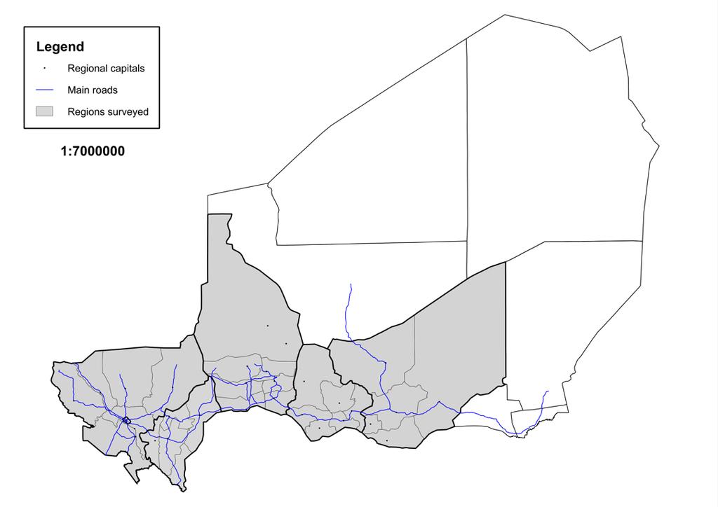
3 Step 1 : Find a map The first step in a S3M survey is to find a map of the survey area. For a survey over a very large area such as for five regions of Niger, it will be practical and useful to have instead: A small-scale map of the entire survey area. This map does not need to show the location of all towns and villages in the survey area. A collection of larger scale maps of each of the five regions of Niger showing the locations of all towns and villages. The small-scale map will be useful for identifying initial sampling locations. The large-scale maps will be useful for identifying the precise location of sampling points and for selecting the communities to be sampled.
4 Small-scale map of five regions of Niger
5 Large-scale map of Maradi region
6 Step 2: Decide area represented by sampling point The easiest way of thinking about this is as a function of the intended maximum distance (d) of any community from the nearest sampling point.
7 What value of d to use? The value of d should be small enough that homogeneity of the area defined can be assumed. For the Niger survey, a d of 15 km was judged to be small enough to assume homogeneity. This will mean that no child will live more than 15 km away from a sampling point. The distance between each sampling point is: The area of the area formed: 292 km 2 The area of the area formed: 584 km 2
8 Step 2 : Draw a grid over the maps The next step is to draw a grid over the maps. The size of the grid is determined by the distance (d) decided in Step 2. In this case, d = 15 km. The grid is rectangular. The width of the grid in the east-west (x) direction is calculated using The height of the grid in the north-south (y) direction can be calculated using For the case of the Niger survey with d = 15 km:
9 Small-scale map with 22.5 x 13 km grid
10 Large-scale map of Maradi region with 22.5 x 13 km grid

 and")
11 Niger survey technical team composed of representatives from the Nutrition Department, Institute of National Statistics and UNICEF drawing grids on a largescale map of Dosso region (above) and Tillaberi region (right).
12 Step 4 : Create an even spread of sampling points Sampling points are located at the intersections of the rectangular grid in a staggered fashion. Alternate intersections of the grid are used such as that shown below:

13 Identified sampling points based on small-scale map
14 Corresponding sampling points for Maradi region
 of the survey area.")
15 Survey technical team identifying and labelling sampling points on large scale map of Tillaberi making sure that sample points go right to the edge (or even over the edge) of the survey area.
16 Step 5 : Select communities to sample Select the communities closest to the sampling points identified in Step 4. About three (3) communities per sampling point were selected. The position of the sampling point was moved into the middle of the three (3) communities selected.

17 Moving sampling points based on location of selected villages / communities
18 Step 6 : Label each sampling point Gave each sampling point a unique identifying label: The label may be a number or a name. The label must be unique. The label was used to identify which community belongs to which sampling point. The label was used when collecting, organising, and analysing data.
19 Sampling points labeled and triangles drawn
20 Step 7 : Within-community sampling Two within-community sampling strategies were used to select a sample from the selected communities Coverage Survey active and adaptive case finding was done in most communities selected. Door- to-door screening was used were in very small rural communities and in urban communities. IYCF practices QTR + EPI3, a variant of standard EPI withincommunity household sampling method The first step in the method, QTR, divides the community into four (quarters hence QTR) areas each of which have roughly equal volumes. The second step utilises the standard EPI strategy to select the first household in each of the quarters and selecting the third nearest house in a random direction (third nearest house hence EPI3).

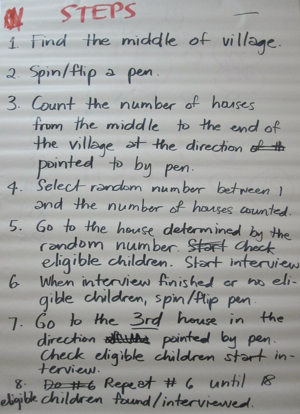
21 EPI3
22 Survey Implementation
23 Step 1 : Identify and train supervisors Thirty persons were initially hired as surveyors and underwent training phase for the survey. After training, 20 trainees were retained and seven (7) teams were formed. The training of surveyors was done through learning-by-doing approach. Some classroom sessions conducted but on-the-job training was given emphasis during this phase. There was no separate training period per se as the survey started alongside the training phase. However, the training phase of the survey was done slower to allow for the surveyors to be trained and learn the survey skills and process.

24 Step 2: Identify the region to start the survey The training phase was conducted in Dosso region because it had the least number of sampling points. The smallest region was chosen to begin with so that the teams can be closely supervised during the training It also allowed for end-ofday debriefs of the teams with the lead trainer and surveyors (right).
25 Step 3: Adjust, adapt, revise and re-train The survey mechanics were adjusted as appropriate during the early stages based on learnings from the training phase Adapted and refined the case-finding question for active and adaptive case finding (right) Shifted from EPI3 to QTR + EPI3 approach Door-to-door approach added as a sampling method for very small villages Team structure and hierarchy changed based on optimal team composition based on surveyor dynamics Re-training and refresher training for surveyors done routinely

26 Mind-mapping exercise with surveyors to refine the case-finding question for active and adaptive case finding

27 Step 4: Segmentation of regions Segmentation done similar to that described in the SLEAC session Regions segmented into 7 by route accessible by road. Each segment assigned to 1 team List of sampling communities in each segment listed and provided to the team covering that segment Teams started out in the farthest sampling point in the segment and then worked their way back to the regional capital


28 Above: Technical team segmenting and planning routes for Dosso region. Top and bottom right: Technical team members explaining to team leader the route and providing the list of sampling points and communities within that route.

29 Step 5: Select the next region and continue the survey The choice of the next region to survey was made based on the following principle:
30 Results
31
32 Barriers to service uptake and access - Maradi Others Access issues Rejection Lack of knowledge about malnutrition Lack of awareness of programme and how it works Screening and referral problems Difficulties / challenges faced by mother or caregiver Service problems
33
34 ICFI : Infant and Child Feeding Index Based on an index devised by Mary Arimond and Marie Ruel of the International Food Policy Research Institute for the 2000 DHS survey of Ethiopia and developed by FANTA as a KPC2000+ indicator : Breastfed (24 Hours) Food groups (24 Hours) Meals (24 Hours) Age-group (months) Value Score Value Score Value Score Value Score Yes + 2 Yes + 2 Yes + 1 Yes or or or or The ICFI score is a measure of appropriate child feeding practices ICFI = Breastfeeding + Dietary diversity + Meal frequency using age-speci,c weighting for each item. All children are scored 0 6 results presented as a numerical summary (e.g. median) or in a histogram. Requires only simple and standardised question sets and small sample sizes.
35
36 Learnings from S3M pilot S3M produces: high resolution maps of indicator of interest over very wide area S3M can: serve as a base mapping method for the assessment of other indicators infant and young child feeding (IYCF) prevalence of childhood illnesses water, sanitation and hygiene (WASH) other typical indicators assessed through standard large-scale surveys like the Multiple Indicator Cluster Survey (MICS)
A4. Methodology Annex: Sampling Design (2008) Methodology Annex: Sampling design 1
 Methodology Annex: Sampling design 1") A4. Methodology Annex: Sampling Design (2008) Methodology Annex: Sampling design 1 Introduction The evaluation strategy for the One Million Initiative is based on a panel survey. In a programme such as
A4. Methodology Annex: Sampling Design (2008) Methodology Annex: Sampling design 1 Introduction The evaluation strategy for the One Million Initiative is based on a panel survey. In a programme such as
MEADOWS PRIMARY SCHOOL and NURSERY GEOGRAPHY POLICY
 MEADOWS PRIMARY SCHOOL and NURSERY GEOGRAPHY POLICY Purpose of study The teaching of Geography at Meadows is done by following the 2014 National Curriculum. The planning and teaching of the subject aims
Children needing support to achieve key skills. Children surpassing key skills. Geography Progression in Skills Key Stage One. Locational Knowledge
 Skills Locational Knowledge Geography Progression in Skills Key Stage One Children needing support to achieve key skills Children surpassing key skills To understand that the world extends outside their
St Joseph s R.C. Primary School. Policy for Geography
 St Joseph s R.C. Primary School Policy for Geography 2016-2017 This policy is written with consideration to our school commitment to the Rights of the Child and our achievement of becoming a Rights Respecting
Measuring access and practice. KristofBOSTOEN
 Measuring access Measuring access Measuring access and practice Kristof BOSTOEN List Measuring access and practice KristofBOSTOEN Acronyms, Abbreviation Measuring access and practice Kristof BOSTOEN 1
Geography Policy 2014
 Geography Policy 2014 DEFINITION Geography education should inspire in pupils a curiosity and fascination about the world and its people that will remain with them for the rest of their lives. Teaching
Chapter 6 Group Activity - SOLUTIONS
 Chapter 6 Group Activity - SOLUTIONS Group Activity Summarizing a Distribution 1. The following data are the number of credit hours taken by Math 105 students during a summer term. You will be analyzing
Developing a Community Geographical Information System (GIS) in Rural India
 in Rural India") Developing a Community Geographical Information System (GIS) in Rural India Before rushing off and describing the unique challenges of developing a small scale GIS system India I better first describe
Developing a Community Geographical Information System (GIS) in Rural India Before rushing off and describing the unique challenges of developing a small scale GIS system India I better first describe
DATA DISAGGREGATION BY GEOGRAPHIC
 PROGRAM CYCLE ADS 201 Additional Help DATA DISAGGREGATION BY GEOGRAPHIC LOCATION Introduction This document provides supplemental guidance to ADS 201.3.5.7.G Indicator Disaggregation, and discusses concepts
ST AMBROSE CATHOLIC PRIMARY SCHOOL Geography Policy
 ST AMBROSE CATHOLIC PRIMARY SCHOOL Geography Policy 2017-2018 Our school policy is developed in accordance with the National Curriculum for Geography and Foundation Stage Curriculum for Understanding of
Further Mathematics 2018 CORE: Data analysis Chapter 2 Summarising numerical data
 Chapter 2: Summarising numerical data Further Mathematics 2018 CORE: Data analysis Chapter 2 Summarising numerical data Extract from Study Design Key knowledge Types of data: categorical (nominal and ordinal)
GEOGRAPHY POLICY. Date: March Signed: Review: March 2019
 GEOGRAPHY POLICY Date: March 2018 Signed: Review: March 2019 Aims At Hayton C of E Primary School we believe that Geography is an essential part of the curriculum and teachers ensure that the children
INTRODUCTION. In March 1998, the tender for project CT.98.EP.04 was awarded to the Department of Medicines Management, Keele University, UK.
 INTRODUCTION In many areas of Europe patterns of drug use are changing. The mechanisms of diffusion are diverse: introduction of new practices by new users, tourism and migration, cross-border contact,
Jakarta, Indonesia,29 Sep-10 October 2014.
 Regional Training Course on Sampling Methods for Producing Core Data Items for Agricultural and Rural Statistics Jakarta, Indonesia,29 Sep-0 October 204. LEARNING OBJECTIVES At the end of this session
1/7
 Chapter 4 (8415642) Due: Thu Jan 18 2018 11:59 PM PST Question 1 2 3 4 5 6 7 1. Question Details UWAPreCalc1 4.P.001. [3944514] This exercise emphasizes the "mechanical aspects" of working with linear
1/7
 Chapter 4 (13383714) Due: Tue Oct 9 2018 11:59 PM PDT Question 1 2 3 4 5 6 7 1. Question Details UWAPreCalc1 4.P.001. [3944514] This exercise emphasizes the "mechanical aspects" of working with linear
STRAND E: STATISTICS E2 Data Presentation
 STRAND E: STATISTICS E2 Data Presentation Text Contents * * Section E2.1 Pie Charts E2.2 Line Graphs E2.3 Stem and Leaf Plots E2.4 Graphs: Histograms E2 Data Presentation E2.1 Pie Charts Pie charts, which
Solving Word Problems
 Bonus Activity (online only) Solving Word Problems Why Learning skills: defining the problem, defining knowns and validating Mathematical word problems (or story problems) require you to take real-life
Innovation in the Measurement of Place: Systematic Social Observation in a Rural Setting
 Innovation in the Measurement of Place: Systematic Social Observation in a Rural Setting Barbara Entwisle Heather Edelblute Brian Frizzelle Phil McDaniel September 21, 2009 Background Hundreds of studies
St John s Catholic Primary School. Geography Policy. Mission Statement
 St John s Catholic Primary School Geography Policy Mission Statement We at St John s strive for excellence in education by providing a safe, secure and caring family environment where individuals are valued
MEP Y7 Practice Book B
 8 Quantitative Data 8. Presentation In this section we look at how vertical line diagrams can be used to display discrete quantitative data. (Remember that discrete data can only take specific numerical
Tuition, Medical and Behaviour Support Service
 Tuition, Medical and Behaviour Support Service Curriculum Policy - Primary Geography Reviewed: October 2018 Next Review: October 2019 Responsibility: Andrea Snow AIMS AND PRINCIPLES The national curriculum
GEOGRAPHY POLICY STATEMENT. The study of geography helps our pupils to make sense of the world around them.
 GEOGRAPHY POLICY STATEMENT We believe that the study of geography is concerned with people, place, space and the environment and explores the relationships between the earth and its peoples. The study
Facilitating Survey Sampling in Low- and Middle-Income Contexts Through Satellite Maps and Basic Mobile Computing Technology
 Facilitating Survey Sampling in Low- and Middle-Income Contexts Through Satellite Maps and Basic Mobile Computing Technology 6 th European Survey Association Conference Survey Research in Developing Countries
The World Bank Health System Performance Reinforcement Project (P156679)
") Public Disclosure Authorized AFRICA Cameroon Health, Nutrition & Population Global Practice IBRD/IDA Investment Project Financing FY 2016 Seq No: 3 ARCHIVED on 14-Apr-2017 ISR27518 Implementing Agencies:
Public Disclosure Authorized AFRICA Cameroon Health, Nutrition & Population Global Practice IBRD/IDA Investment Project Financing FY 2016 Seq No: 3 ARCHIVED on 14-Apr-2017 ISR27518 Implementing Agencies:
Cambridge Assessment International Education Cambridge International Advanced Subsidiary and Advanced Level. Published
 Cambridge Assessment International Education Cambridge International Advanced Subsidiary and Advanced Level PHYSICS 9702/3 Paper 3 Advanced Practical Skills MARK SCHEME Maximum Mark: 40 Published This
St. James C of E Primary School
 St. James C of E Primary School Geography Policy St. James C of E Primary School Geography Policy Written by: Lisa Harford Written: April 2016 Reviewed: April 2018 1. Introduction Geography is concerned
Willmar Public Schools Curriculum Map
 Subject Area Grade First Grade Date June 2005, reviewed June 2009 Unit Content Standards Addressed Skills/Benchmarks Essential Questions Assessments Unit 1 Here We Are and Our Class Our School Our Families
Diploma Part 2. Quantitative Methods. Examiners Suggested Answers
 Diploma Part 2 Quantitative Methods Examiners Suggested Answers Q1 (a) A frequency distribution is a table or graph (i.e. a histogram) that shows the total number of measurements that fall in each of a
Digitization in a Census
 Topics Connectivity of Geographic Data Sketch Maps Data Organization and Geodatabases Managing a Digitization Project Quality and Control Topology Metadata 1 Topics (continued) Interactive Selection Snapping
Foundations 5 Curriculum Guide
 1. Review: Natural Numbers...3 2. Reading and Writing Natural Numbers...6 3. Lines, Rays, and Line Segments...8 4. Comparing Natural Numbers... 12 5. Rounding Numbers... 15 6. Adding Natural Numbers...
Unit 1, Activity 1, Rational Number Line Cards - Student 1 Grade 8 Mathematics
 Unit, Activity, Rational Number Line Cards - Student Grade 8 Mathematics Blackline Masters, Mathematics, Grade 8 Page - Unit, Activity, Rational Number Line Cards - Student Blackline Masters, Mathematics,
Vocabulary: Samples and Populations
 Vocabulary: Samples and Populations Concept Different types of data Categorical data results when the question asked in a survey or sample can be answered with a nonnumerical answer. For example if we
Ticketed Sessions 1 Information in this list current as of August 2008
 Ticketed Sessions in this list current as of August 2008 1 2011 Annual Conference and Exhibit Show Ticketed Sessions Ticketed Sessions Saturday, March 26 8:00 9:00 a.m. 1101T Achievement Is Not Just a
HOLY CROSS CATHOLIC PRIMARY SCHOOL
 HOLY CROSS CATHOLIC PRIMARY SCHOOL Geography Policy Date Implemented Jan 17 Review Date Jan 22 Mission Statement Holy Cross Primary School is a Catholic School. We seek to provide a broad, balanced Christian
Policy Note 6. Measuring Unemployment by Location and Transport: StepSA s Access Envelope Technologies
 6 Measuring Unemployment by Location and Transport: StepSA s Access Envelope Technologies Introduction Increasing emphasis is coming onto spatial planning as government in South Africa moves to address
Pilot to Improve the Development and Nutrition of Young Children in Poor Rural Areas in Guatemala
 Public Disclosure Authorized Pilot to Improve the Development and Nutrition of Young Children in Poor Rural Areas in Guatemala (P145410) LATIN AMERICA AND CARIBBEAN Guatemala Social Protection & Labor
Sampling: What you don t know can hurt you. Juan Muñoz
 Sampling: What you don t know can hurt you Juan Muñoz Outline of presentation Basic concepts Scientific Sampling Simple Random Sampling Sampling Errors and Confidence Intervals Sampling error and sample
GRE Quantitative Reasoning Practice Questions
 GRE Quantitative Reasoning Practice Questions y O x 7. The figure above shows the graph of the function f in the xy-plane. What is the value of f (f( ))? A B C 0 D E Explanation Note that to find f (f(
Geography Policy. Introduction
 Geography Policy Introduction Geography at St. Aloysius Federation School teaches an understanding of places and environments and aims to inspire a curiosity and fascination about the world and its people.
Family and Consumer Science: Childcare and Guidance Crosswalk to AZ Math Standards
 East Page 1 of 1 August 1998 2M-P1 Construct & draw inferences including measures of central tendency, from charts, tables, graphs & data plots that summarize data from real-world situations. 1.0 Demonstrate
Class 4J Autumn Term St. Lucia Adapted from QCA Geography Unit 10 incorporating some elements of Unit 25
 Class 4J Autumn Term 2002 Geography St. Lucia Geography Unit 10 incorporating some elements of Unit 25 ABOUT THE UNIT In this unit children develop ideas about a less economically developed country. When
Year 1 name and locate the four countries and capital cities of the United Kingdom and its surrounding seas
 Long Term Objective Organisation for Geography Please note that only statutory requirements should be included in this document; any supplementary guidance and information should be retained by Subject
Social Studies Grade 2 - Building a Society
 Social Studies Grade 2 - Building a Society Description The second grade curriculum provides students with a broad view of the political units around them, specifically their town, state, and country.
QUIZ PAGE 7 KS3, KS4, Non-Calculator, with Answers/Solutions A. 0 B. -1 C. 2 D. 3 E. 1
 QUIZ PAGE 7 KS3, KS4, Non-Calculator, with Answers/Solutions 1. The integer (whole number) closest to A. 0 B. -1 C. 2 D. 3 E. 1 2. If n is an integer, which of the following must be an odd number? A. 3.
Subject: Geography Scheme of Work: B1 to B6 Mastery tiles. Term: Autumn/Spring/Summer
 Subject: Geography Scheme of Work: B1 to B6 Mastery tiles Term: Autumn/Spring/Summer Topic / Unit(s) Overview / Context Introduction to geography. An introduction to geography including basic map skills
Integrated I Final Exam Review
 Name: Integrated I Final Exam Review The questions below represent the types of questions you will see on your final exam. Your final will be all multiple choice however, so if you are able to answer the
Nutrition Stakeholder Mapping in Ethiopia. Federal Ministry of Health / REACH
 Nutrition Stakeholder Mapping in Ethiopia Federal Ministry of Health / REACH NNP Costing exercise Method Examined for costing NNP were MBB; One health and Activity based tool The recommended was activity-based
Gedney Church End and Lutton St Nicholas Federated Primary Schools. Geography Policy
 Gedney Church End and Lutton St Nicholas Federated Primary Schools Geography Policy Contents: Introduction Expectations in Key Stage 1 Expectations in Key Stage 2 Aims Teaching and Learning Key Skills
Geographical knowledge and understanding scope and sequence: Foundation to Year 10
 Geographical knowledge and understanding scope and sequence: Foundation to Year 10 Foundation Year 1 Year 2 Year 3 Year 4 Year 5 Year 6 Year level focus People live in places Places have distinctive features
BROOKINGS May
 Appendix 1. Technical Methodology This study combines detailed data on transit systems, demographics, and employment to determine the accessibility of jobs via transit within and across the country s 100
Summary and Implications for Policy
 Summary and Implications for Policy 1 Introduction This is the report on a background study for the National Spatial Strategy (NSS) regarding the Irish Rural Structure. The main objective of the study
IB Questionbank Mathematical Studies 3rd edition. Grouped discrete. 184 min 183 marks
 IB Questionbank Mathematical Studies 3rd edition Grouped discrete 184 min 183 marks 1. The weights in kg, of 80 adult males, were collected and are summarized in the box and whisker plot shown below. Write
Mapping Welsh Neighbourhood Types. Dr Scott Orford Wales Institute for Social and Economic Research, Data and Methods WISERD
 Mapping Welsh Neighbourhood Types Dr Scott Orford Wales Institute for Social and Economic Research, Data and Methods WISERD orfords@cardiff.ac.uk WISERD Established in 2008 and funded by the ESRC and HEFCW
Mathematics Second Practice Test 1 Levels 6-8 Calculator not allowed
 Mathematics Second Practice Test 1 Levels 6-8 Calculator not allowed Please read this page, but do not open your booklet until your teacher tells you to start. Write your name and the name of your school
Riocan Centre Study Area Frontenac Mall Study Area Kingston Centre Study Area
 OVERVIEW the biggest challenge of the next century (Dunham Jones, 2011). New books are continually adding methods and case studies to a growing body of literature focused on tackling this massive task.
2004 Washington State Math Championship. Individual Test - Grade 5
 004 Washington State Math Championship Unless a particular problem directs otherwise, give an exact answer or one rounded to the nearest thousandth. Individual Test - Grade 5 The first 0 problems are multiple
STAG LANE JUNIOR SCHOOL GEOGRAPHY POLICY
 Status-Recommended Prepared by: Megha Visavadia Date written January 2017 Shared with staff: Spring 2017 STAG LANE JUNIOR SCHOOL GEOGRAPHY POLICY Shared with governors: Spring 2018 Date for review: July
The World Bank TOGO Community Development and Safety Nets Project (P127200)
") Public Disclosure Authorized AFRICA Togo Social Protection & Labor Global Practice IBRD/IDA Specific Investment Loan FY 2012 Seq No: 9 ARCHIVED on 16-Sep-2016 ISR25166 Implementing Agencies: Technical
Public Disclosure Authorized AFRICA Togo Social Protection & Labor Global Practice IBRD/IDA Specific Investment Loan FY 2012 Seq No: 9 ARCHIVED on 16-Sep-2016 ISR25166 Implementing Agencies: Technical
STRAND E: STATISTICS. UNIT E4 Measures of Variation: Text * * Contents. Section. E4.1 Cumulative Frequency. E4.2 Box and Whisker Plots
 STRAND E: STATISTICS E4 Measures of Variation Text Contents * * Section E4.1 E4.2 Box and Whisker Plots E4 Measures of Variation E4.1 * frequencies are useful if more detailed information is required about
IGCSE Geography Unit 2: Types of Settlement
 IGCSE Geography Unit 2: Types of Settlement Recommended Prior Knowledge An understanding of the factors that affect the nature, location, growth and structure of settlements. A good general knowledge,
Granite School District Parent Guides Utah Core State Standards for Mathematics Grades K-6
 Granite School District Parent Guides Grades K-6 GSD Parents Guide for Kindergarten The addresses Standards for Mathematical Practice and Standards for Mathematical Content. The standards stress not only
Mathematics Transition Mathematics for Seniors
 Mathematics Transition Mathematics for Seniors All West Virginia teachers are responsible for classroom instruction that integrates content standards and mathematical habits of mind. Transition Mathematics
ARCGIS TRAINING AT KU GIS LABS: INTRODUCTION TO GIS: EXPLORING ARCCATALOG AND ARCGIS TOOLS
 PHASE 1_3 rd SESSION ARCGIS TRAINING AT KU GIS LABS: INTRODUCTION TO GIS: EXPLORING ARCCATALOG AND ARCGIS TOOLS 3 rd SESSION REPORT: 25 TH -27 TH JUNE 2014 SCHOOL OF ENVIRONMENTAL STUDIES COMPUTER LAB
Geography. Programmes of study for Key Stages 1-3
 Geography Programmes of study for Key Stages 1-3 February 2013 Contents Purpose of study 3 Aims 3 Attainment targets 3 Subject content 4 Key Stage 1 4 Key Stage 2 5 Key Stage 3 6 2 Purpose of study A high-quality
Period: Date: Lesson 3B: Properties of Dilations and Equations of lines
 Name: Period: Date: : Properties of Dilations and Equations of lines Learning Targets I can identify the properties of dilation mentioned as followed: dilation takes a line not passing through the center
Using Dice to Introduce Sampling Distributions Written by: Mary Richardson Grand Valley State University
 Using Dice to Introduce Sampling Distributions Written by: Mary Richardson Grand Valley State University richamar@gvsu.edu Overview of Lesson In this activity students explore the properties of the distribution
A Note on Methods. ARC Project DP The Demand for Higher Density Housing in Sydney and Melbourne Working Paper 3. City Futures Research Centre
 A Note on Methods ARC Project DP0773388 The Demand for Higher Density Housing in Sydney and Melbourne Working Paper 3 City Futures Research Centre February 2009 A NOTE ON METHODS Dr Raymond Bunker, Mr
1-2 Line Segments and Distance. Find the measurement of each segment. Assume that each figure is not drawn to scale. ANSWER: 3.8 in. ANSWER: 2.
 1. Find the measurement of each segment. Assume that each figure is not drawn to scale. TIME CAPSULE Graduating classes have buried time capsules on the campus of East Side High School for over twenty
Project Name: Income Generation Project 4 Pouk District, Siem Reap Province Implementing Partner: Farmer Livelihood Development (FLD)
") Grant Category: Micro Finance Project Name: Income Generation Project 4 Pouk District, Siem Reap Province Implementing Partner: Farmer Livelihood Development (FLD) Status: Ongoing Start Date: 1 April 2012
Grant Category: Micro Finance Project Name: Income Generation Project 4 Pouk District, Siem Reap Province Implementing Partner: Farmer Livelihood Development (FLD) Status: Ongoing Start Date: 1 April 2012
Geography Policy. for Hertsmere Jewish Primary School
 Geography Policy for Hertsmere Jewish Primary School Reviewed by: L Rubin Reviewed on: September 2017 Date of Next Review: September 2018 Policy Review This policy will be reviewed in full by the Governing
of places Key stage 1 Key stage 2 describe places
 Unit 25 Geography and numbers ABOUT THE UNIT This continuous unit aims to show how geographical enquiry can provide a meaningful context for the teaching and reinforcement of many aspects of the framework
Geography. Geography A. Curriculum Planner and Skills Mapping Grid GCSE Version 1 October 2012
 Geography GCSE 2012 Geography A Curriculum Planner and Skills Mapping Grid Version 1 October 2012 www.ocr.org.uk/gcse2012 Year 10 Exam work Controlled Assessment Autumn 1 Autumn 2 Spring 1 Spring 2 Summer
CHAPTER 14 STATISTICS Introduction
 238 MATHEMATICS STATISTICS CHAPTER 14 14.1 Introduction Everyday we come across a wide variety of informations in the form of facts, numerical figures, tables, graphs, etc. These are provided by newspapers,
Key Issue 1: Where Are Services Distributed? INTRODUCING SERVICES AND SETTLEMENTS LEARNING OUTCOME DESCRIBE THE THREE TYPES OF SERVICES
 Revised 2017 NAME: PERIOD: Rubenstein: The Cultural Landscape (12 th edition) Chapter Twelve Services and Settlements (pages 430 thru 457) This is the primary means by which you will be taking notes this
Number of fillings Frequency q 4 1. (a) Find the value of q. (2)
 Find the value of q. (2)") 1. The table below shows the frequency distribution of the number of dental fillings for a group of 25 children. Number of fillings 0 1 2 3 4 5 Frequency 4 3 8 q 4 1 Find the value of q. Use your graphic
1. The table below shows the frequency distribution of the number of dental fillings for a group of 25 children. Number of fillings 0 1 2 3 4 5 Frequency 4 3 8 q 4 1 Find the value of q. Use your graphic
Milford Public Schools Curriculum
 Milford Public Schools Curriculum Department: Social Studies Grade 3 Course Name: Communities Course Description In third grade, students will engage in a yearlong study of communities and specifically
Be able to define the following terms and answer basic questions about them:
 CS440/ECE448 Section Q Fall 2017 Final Review Be able to define the following terms and answer basic questions about them: Probability o Random variables, axioms of probability o Joint, marginal, conditional
The David P. Weikart Center for Youth Program Quality, Bringing together over fifty years of experience and the latest research,
 The David P. Weikart Center for Youth Program Quality,! " " " # $ $ " $ " % " & & " & " ' ( ) * +!!,! % " & ' )! " " "! -!. " & &! % " & &! ' Bringing together over fifty years of experience and the latest
Section 2.1 Exercises
 Section. Linear Functions 47 Section. Exercises. A town's population has been growing linearly. In 00, the population was 45,000, and the population has been growing by 700 people each year. Write an equation
Design of 2 nd survey in Cambodia WHO workshop on Repeat prevalence surveys in Asia: design and analysis 8-11 Feb 2012 Cambodia
 Design of 2 nd survey in Cambodia WHO workshop on Repeat prevalence surveys in Asia: design and analysis 8-11 Feb 2012 Cambodia Norio Yamada RIT/JATA Primary Objectives 1. To determine the prevalence of
Understanding Your Community A Guide to Data
 Understanding Your Community A Guide to Data Alex Lea September 2013 Research and Insight Team LeicestershireCounty Council Understanding Geographies Important to understand the various geographies that
AP STATISTICS: Summer Math Packet
 Name AP STATISTICS: Summer Math Packet DIRECTIONS: Complete all problems on this packet. Packet due by the end of the first week of classes. Attach additional paper if needed. Calculator may be used. 1.
A Level Geography Cambridge International Content Programme For teaching from September 2016
 A Level Geography Cambridge International Content Programme For teaching from September 2016 is located on the Start Bay coast in South Devon and is surrounded by Slapton Ley National Nature Reserve. The
ARC Implementation in Residential Care
 ARC Implementation in The First Two Years: Refining the of Care & Building ARC Fidelity Emily Neal, LCSW, Clinical Director Jeremy Karpen, MA, LCPC, Director of Learning & Development 1 Session Objectives
Scout Skills Mapping QUALITY TRAINING FOR QUALITY SCOUTING INFORMATION SHEET
 Scout Skills Mapping INFORMATION SHEET A map is a picture of a given area of what the ground looks like from directly above. When undertaking a journey, we need to be able to find our way around competently,
Accessibility as an Instrument in Planning Practice. Derek Halden DHC 2 Dean Path, Edinburgh EH4 3BA
 Accessibility as an Instrument in Planning Practice Derek Halden DHC 2 Dean Path, Edinburgh EH4 3BA derek.halden@dhc1.co.uk www.dhc1.co.uk Theory to practice a starting point Shared goals for access to
the different kinds of houses.
 STANDARD II GENERAL KNOWLEDGE Month Unit Expected learning Activities/Assignments Value Skills June WORLD AROUND US Health and Hygiene To understand common Make a list of Do's and Don'ts of Cleanliness
Linear Functions, Equations, and Inequalities
 CHAPTER Linear Functions, Equations, and Inequalities Inventory is the list of items that businesses stock in stores and warehouses to supply customers. Businesses in the United States keep about.5 trillion
Latitude & Longitude. Worksheets & activities to teach latitude & longitude. Includes notes, activities, review & all answer keys. 11 pages!
 Latitude & Longitude Worksheets & activities to teach latitude & longitude. Includes notes, activities, review & all answer keys. 11 pages! Lines of Latitude & Longitude Name: Lines of latitude and longitude
Copy person or duplicate who weighs a line 100 pounds on Earth would weigh only about 40 pounds on
 A Let s Trip Move! to the Moon Using Translating Tables and to Represent Equivalent Constructing Ratios Line Segments.. LEARNING GOALS KEY TERMS KEY TERM CONSTRUCTIONS In this lesson, you will: Distance
Paper Reference. Statistics S1 Advanced/Advanced Subsidiary. Friday 5 June 2015 Morning Time: 1 hour 30 minutes
 Centre No. Candidate No. Paper Reference(s) 6683/01 Edexcel GCE Statistics S1 Advanced/Advanced Subsidiary Friday 5 June 2015 Morning Time: 1 hour 30 minutes Materials required for examination Mathematical
MATHEMATICS NUMERACY UNIT 1: NON-CALCULATOR HIGHER TIER
 Surname Centre Number Candidate Number Other Names 0 GCSE NEW 3310U50-1 S17-3310U50-1 MATHEMATICS NUMERACY UNIT 1: NON-CALCULATOR HIGHER TIER THURSDAY, 25 MAY 2017 MORNING 1 hour 45 minutes ADDITIONAL
APPENDIX A SAMPLE DESIGN
 APPENDIX A SAMPLE DESIGN APPENDIX A SAMPLE DESIGN Thanh U A.1 Introduction The Kazakstan Demographic and Health Survey (KDHS) employed a nationally representative probability sample of women age 15-49.
New Prospects for Peripheral Rural Regions Helmut Hiess Glasgow, 19th of May 2010
 New Prospects for Peripheral Rural Regions Helmut Hiess Glasgow, 19th of May 2010 ÖROK: Organisation & Tasks Austrian Conference on Spatial Planning (ÖROK, since 1971): Joint organisation by Federal level,
Map Reading: Grades 4 & 5
 Map Reading: Grades 4 & 5 Grades: 4,5 Team Size: 1-2 competitors Duration: 25 minutes Supervisors: Sriram Garapati, Rebecca Neill-Totsuka Summary Description Students will solve a mystery using different
11-19 PROGRESSION. Sample material. Edexcel GCSE (9-1) Mathematics. Access to Foundation
 Mathematics. Access to Foundation") 11-19 PROGRESSION Edexcel GCSE (9-1) Mathematics Access to Foundation Sample material Introduction Introduction Helping you prepare for for Edexcel GCSE GCSE (9-1) (9-1) Mathematics Foundation, Foundation,
11-19 PROGRESSION Edexcel GCSE (9-1) Mathematics Access to Foundation Sample material Introduction Introduction Helping you prepare for for Edexcel GCSE GCSE (9-1) (9-1) Mathematics Foundation, Foundation,
COSC 341 Human Computer Interaction. Dr. Bowen Hui University of British Columbia Okanagan
 COSC 341 Human Computer Interaction Dr. Bowen Hui University of British Columbia Okanagan 1 Last Class Introduced hypothesis testing Core logic behind it Determining results significance in scenario when:
Range of Opportunities
 Geograhy Curriculum Cropwell Bishop Primary School Range of Opportunities Year 1 Year 2 Year 3 Year 4 Year 5 Year 6 All Key Stage 1 Key Stage 2 Investigate the countries and capitals of the United Kingdom.
3. If a coordinate is zero the point must be on an axis. If the x-coordinate is zero, where will the point be?
 Chapter 2: Equations and Inequalities Section 1: The Rectangular Coordinate Systems and Graphs 1. Cartesian Coordinate System. 2. Plot the points ( 3, 5), (4, 3), (3, 4), ( 3, 0) 3. If a coordinate is