Development of a GIS Based Information and Management System for Cultural Heritage Site; Case Study of Safranbolu
|
|
|
- Erick Nelson
- 5 years ago
- Views:
Transcription
1 Development of a GIS Based Information and Management System for Cultural Heritage Site; Case Study of Safranbolu Dursun Zafer SEKER Mehmet ALKAN Hakan KUTOGLU Hakan AKCIN Yegan KAHYA Sydney, Australia, April 2010 Introduction Documentation of the cultural heritage sites is extremely important for monitoring and preserving, Turkey has many cultural heritage sites originating from the first human settlements in Catalhoyuk and Alacahoyuk and civilizations such as Byzantine, Seljuk and Ottoman. The nine cultural sites in Turkey are included in the protection list of UNESCO as cultural heritage and one of them is the city of Safranbolu. 3D modeling and digital recording of historical buildings in several locations of Turkey have been conducted and still continuing. In this presentation, outcomes and further studies of a research project supported by TUBITAK (The Scientific and Research Council of Turkey) will be discussed. Sydney, Australia, April

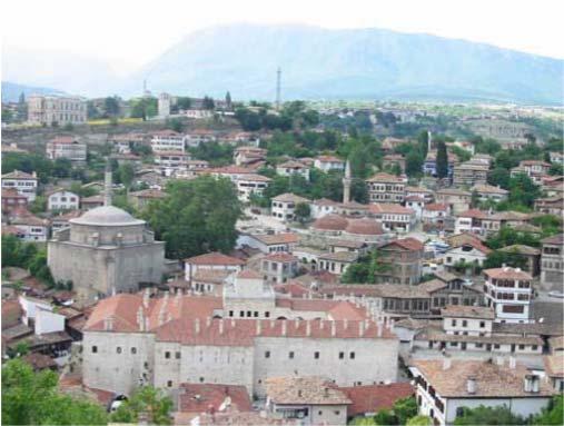
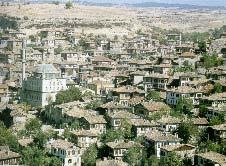
2 The Study Area The Study Area Sydney, Australia, April

3 USED DATA AND METHODOLOGY In this study, 1/1000 scale digital cadastral maps of Safranbolu obtained from the city municipality is used as the main topographic data. Stereo pair of IKONOS satellite sensor data used to extract the height information of the the study area. The vector map of the old city part and contour lines of the same part of the city. Sydney, Australia, April
 information of the building were collected and stored.")
4 A realistic 3D textured model of study area with IKONOS pan sharpened image. In the relational database established, historical structures and all related (current and historical) information of the building were collected and stored. Selections from the collected large amounts of data were added to the database. The database was designed as flexible format for the possibility of the new types of data might be gathered during the study. Apart from historical structures, old roads were also considered. Sydney, Australia, April


5 Building layer classified according to registration status Building layer classified according to indented usage. Sydney, Australia, April
6 Photogrammetric modelling of Roman aqueduct Sydney, Australia, April
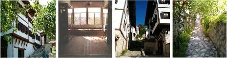
7 Photogrammetric modelling of a historical street Photogrammetric modelling of a historical street Sydney, Australia, April
8 Photogrammetric modelling of a historical street Photogrammetric modelling of a historical street Sydney, Australia, April

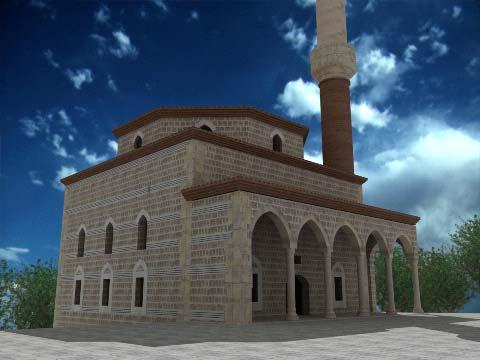
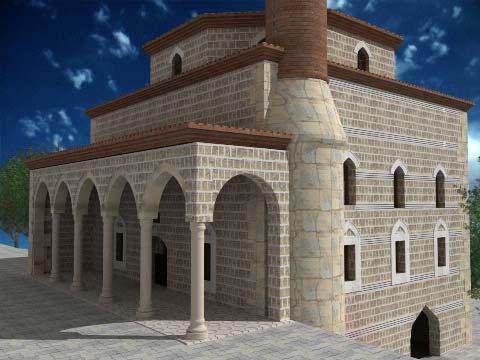
9 Photogrammetric modelling of a historical street CAD drawings of the four facades of the Dagdelen Mosque Sydney, Australia, April

10 Sydney, Australia, April
11 Sydney, Australia, April
12 Conclusions Turkey has a lot of historical sites which are under different threats and they should be retrofitted as soon as possible. Safranbolu was included in the "World Heritage List" by UNESCO in 1994 and as a world city because of its success in protecting its natural heritage is just an example in Turkey. Recording analysis, protection and revitalization of cultural heritage sites are being undertaken by different approaches. In this study, some outcomes of the project of a case study for digital recording and 3D modeling were given. The 3D models of the structures are significantly important for both obtaining sufficient information about the buildings and better visualization. Especially a realistic model determined by texturing will be helpful for the users to better understand the structures. Conclusions The related height information of the historical structures will be produced using a stereo pair of the high resolution satellite imagery and obtained data will be helpful for the modeling and presenting of the whole selected building in 3D via internet using established GIS. In the next step of the project, all data (photos, videos, architectural drawings etc.) and models (3D and VRLM) related to selected historical building will be accessible via the internet. By this way many visitors will have a chance all over the world to visit one of the cultural heritages of Turkey and they will also have the opportunity to make different queries about the Safranbolu. Similar studies oriented for modeling and preserving of the cultural heritage sites should be encouraged and supported by the decision makers. Based on the extracted results, development of an information and management system for documentation, protection and revitalization of cultural heritage sites was successfully undertaken and integrated to the GIS environment. Sydney, Australia, April

13 Sydney, Australia, April
INVESTIGATION LAND USE CHANGES IN MEGACITY ISTANBUL BETWEEN THE YEARS BY USING DIFFERENT TYPES OF SPATIAL DATA
 INVESTIGATION LAND USE CHANGES IN MEGACITY ISTANBUL BETWEEN THE YEARS 1903-2010 BY USING DIFFERENT TYPES OF SPATIAL DATA T. Murat Celikoyan, Elif Sertel, Dursun Zafer Seker, Sinasi Kaya, Uğur Alganci ITU,
USING GIS CARTOGRAPHIC MODELING TO ANALYSIS SPATIAL DISTRIBUTION OF LANDSLIDE SENSITIVE AREAS IN YANGMINGSHAN NATIONAL PARK, TAIWAN
 CO-145 USING GIS CARTOGRAPHIC MODELING TO ANALYSIS SPATIAL DISTRIBUTION OF LANDSLIDE SENSITIVE AREAS IN YANGMINGSHAN NATIONAL PARK, TAIWAN DING Y.C. Chinese Culture University., TAIPEI, TAIWAN, PROVINCE
GIS AND THE ARCHITECTURAL HERITAGE OF DUBROVNIK A BASIS FOR THE CONTINUOUS EXPANSION OF OTHER DATABASE SYSTEMS
 GIS and the architectural heritage of Dubrovnik a basis for the continuous expansion of other database systems. Croatian Information Technology Association GIS Forum, University of Silesia, Zagreb, 477-487.
Economic and Social Council
 United Nations Economic and Social Council Distr.: General 23 May 2012 Original: English E/CONF.101/100 Tenth United Nations Conference on the Standardization of Geographical Names New York, 31 July 9
Geographic information for Strasbourg : from historical land register to 3D GIS city modelling 09/07/2017
 Geographic information for Strasbourg : from historical land register to 3D GIS city modelling 09/07/2017 Table of contents 1. Introduction of Strasbourg 2. A century of land surveying and cadastre 3.
A Case Study of Using Remote Sensing Data and GIS for Land Management; Catalca Region
 A Case Study of Using Remote Sensing Data and GIS for Land Management; Catalca Region Dr. Nebiye MUSAOGLU, Dr. Sinasi KAYA, Dr. Dursun Z. SEKER and Dr. Cigdem GOKSEL, Turkey Key words: Satellite data,
GENERATION OF 3D CITY MODELS FROM TERRESTRIAL LASER SCANNING AND AERIAL PHOTOGRAPHY: A CASE STUDY
 GENERATION OF 3D CITY MODELS FROM TERRESTRIAL LASER SCANNING AND AERIAL PHOTOGRAPHY: A CASE STUDY Hakan KARABORK 1, Fatih SARI 1 1 Selcuk University in Konya, Faculty of Engineering and Architecture Konya,
Techniques for Science Teachers: Using GIS in Science Classrooms.
 Techniques for Science Teachers: Using GIS in Science Classrooms. After ESRI, 2008 GIS A Geographic Information System A collection of computer hardware, software, and geographic data used together for
Use of Corona, Landsat TM, Spot 5 images to assess 40 years of land use/cover changes in Cavusbasi
 New Strategies for European Remote Sensing, Olui (ed.) 2005 Millpress, Rotterdam, ISBN 90 5966 003 X Use of Corona, Landsat TM, Spot 5 images to assess 40 years of land use/cover changes in Cavusbasi N.
GEO-VISUALIZATION TOOLS IN CULTURAL HERITAGE MANAGEMENT
 GEO-VISUALIZATION TOOLS IN CULTURAL HERITAGE MANAGEMENT Elias Grammatikogiannis School of Rural and Surveying Engineering, National Technical University of Athens, 9, Iroon Polytechniou str., 15773 Athens,
A Digital Atlas for the Byzantine and Post Byzantine Churches of Troodos Region (central Cyprus)
") CAA'2010 Fusion of Cultures Francisco Contreras & Fco. Javier Melero (Editors) A Digital Atlas for the Byzantine and Post Byzantine Churches of Troodos Region (central Cyprus) Agapiou A. 1, Georgopoulos
CAA'2010 Fusion of Cultures Francisco Contreras & Fco. Javier Melero (Editors) A Digital Atlas for the Byzantine and Post Byzantine Churches of Troodos Region (central Cyprus) Agapiou A. 1, Georgopoulos
VISUALIZING THE SMART CITY 3D SPATIAL INFRASTRUCTURE GEOSMART ASIA- 30 SEP, 2015
 www.aamgroup.com VISUALIZING THE SMART CITY 3D SPATIAL INFRASTRUCTURE GEOSMART ASIA- 30 SEP, 2015 Agenda AAM What is a Smart City? Data Acquisition 3D Modelling Benefits Questions AAM AAM is a Geospatial
UNITED NATIONS E/CONF.96/CRP. 5
 UNITED NATIONS E/CONF.96/CRP. 5 ECONOMIC AND SOCIAL COUNCIL Eighth United Nations Regional Cartographic Conference for the Americas New York, 27 June -1 July 2005 Item 5 of the provisional agenda* COUNTRY
SOLUTIONS ADVANCED GIS. TekMindz are developing innovative solutions that integrate geographic information with niche business applications.
 ADVANCED GIS SOLUTIONS TekMindz are developing innovative solutions that integrate geographic information with niche business applications. TEK INDZ TM GIS Services Overview At the leading edge of geospatial
3D Laser Scanning for Digital Preservation and Dissemination of Cultural Heritage
 3D Laser Scanning for Digital Preservation and Dissemination of Cultural Heritage Main scanned objects - Four Temples of Different Religions in Sofia Eng. Zlatan Zlatanov, Eng. Milush Blagoev, Irina Nikoevska
inovitas be on site with infra3d
 inovitas be on site with infra3d be inspired... Infrastructure has an immense property value and is a prerequisite for a functioning competitive economy. In this context, the modes of transport such as
CENSUS MAPPING WITH GIS IN NAMIBIA. BY Mrs. Ottilie Mwazi Central Bureau of Statistics Tel: October 2007
 CENSUS MAPPING WITH GIS IN NAMIBIA BY Mrs. Ottilie Mwazi Central Bureau of Statistics E-mail: omwazi@npc.gov.na Tel: + 264 61 283 4060 October 2007 Content of Presentation HISTORICAL BACKGROUND OF CENSUS
Study Visit University of Applied Sciences Utrecht Netherlands
 Study Visit University of Applied Sciences Utrecht Netherlands Directorate-General for Territorial Development Lisbon 1 April 2014 1 Agenda Presentation Cadastre Department Surveying / Geodesy Department
A Distributed GIS Architecture for Research in Baalbek Based on CISAR
 234 Frank Henze A Distributed GIS Architecture for Research in Baalbek Based on CISAR Abstract: Research underway in Baalbek extends from the immediate vicinity of the excavation areas to the monumental
GIS and Remote Sensing
 Spring School Land use and the vulnerability of socio-ecosystems to climate change: remote sensing and modelling techniques GIS and Remote Sensing Katerina Tzavella Project Researcher PhD candidate Technology
THE CADASTRAL INFORMATION SYSTEM IN THE REPUBLIC OP SOUTH AFRICA
 I $:? Distr.: LIMITED ECA/NRD/CART.9/ORG.27 November 1996 Original: ENGLISH Ninth United Nations Regional Cartographic Conference for Africa Addis Ababa, Ethiopia 11-15 November 1996 THE CADASTRAL INFORMATION
Gis for Land Management: An Overview on Italy
 Gis for Land Management: An Overview on Italy Paola RONZINO, Italy Key words: Cartography, Land Management, Spatial Planning, Urban Renewal, Spatial Information, Environment SUMMARY The introduction of
3D MODELS FOR A SUSTAINABLE DEVELOPMENT OF CULTURAL HERITAGE
 Procedia Environmental Science, Engineering and Management http://www.procedia_esem.eu Procedia Environmental Science, Engineering and Management 2 (2015) (2) 157-160 International U.A.B. B.EN.A. Conference
Business Model for sustainable regional development by tourism
 Business Model for sustainable regional development by tourism Why EuroVeloPark Banat? Steps to Success Action proposal 1. Drawing of the Basis Map 2. Data Acquisition, POIs, etc. 3. Printed Map and Distribution
Bentley Map V8i (SELECTseries 3)
") Bentley Map V8i (SELECTseries 3) A quick overview Why Bentley Map Viewing and editing of geospatial data from file based GIS formats, spatial databases and raster Assembling geospatial/non-geospatial data
Bentley Map V8i (SELECTseries 3) A quick overview Why Bentley Map Viewing and editing of geospatial data from file based GIS formats, spatial databases and raster Assembling geospatial/non-geospatial data
DEVELOPPING A LAND INFORMATION SYSTEM FOR THE UNIFICATION OF THE ARCHAEOLOGICAL SITES OF ATHENS. Efi Dimopoulou, Vasso Nikolaidou, Panagiotis Zendelis
 DEVELOPPING A LAND INFORMATION SYSTEM FOR THE UNIFICATION OF THE ARCHAEOLOGICAL SITES OF ATHENS Efi Dimopoulou, Vasso Nikolaidou, Panagiotis Zendelis Laboratory of Photogrammetry, Faculty of Surveying
Features and Benefits
 Autodesk LandXplorer Features and Benefits Use the Autodesk LandXplorer software family to help improve decision making, lower costs, view and share changes, and avoid the expense of creating physical
"GIS-Sofia" Ltd. geospatial data integration in SOFCAR geographic information system and providing services March 2018, Sofia
 "GIS-Sofia" Ltd. geospatial data integration in SOFCAR geographic information system and providing services Geographical Information System Sofia " Ltd....the beginning... Established in 1999, as a Sofia
National Cartographic Center
 National Cartographic Center NCC activities and accomplishments Activities of national organizations, institutions and universities in field of geomatics Large scale maps Medium scale maps Small scale
GIS in Community & Regional Planning
 GIS in Community & Regional Planning The The role role of of GIS GIS in in Re-writing the the Zoning Bylaw for for the the City City of of Vernon LandInfo Technologies Presentation Overview The GIS Initiative
Town of Taos Request for Proposal Historic Preservation GIS Geodatabase Project April 2007
 Town of Taos Request for Proposal Historic Preservation GIS Geodatabase Project April 2007 1. Background The Town of Taos is requesting proposals from qualified firms or a team of firms who can develop
Contents. Introduction Study area Data and Methodology Results Conclusions
 Modelling Spatial Changes in Suburban Areas of Istanbul Using Landsat 5 TM Data Şinasi Kaya(Assoc. Prof. Dr. ITU) Elif Sertel(Assoc. Prof. Dr. ITU) Dursun Z. Şeker(Prof. Dr. ITU) 1 Contents Introduction
USER PARTICIPATION IN HOUSING REGENERATION PROJECTS
 USER PARTICIPATION IN HOUSING REGENERATION PROJECTS Dr. Hatice Sadıkoğlu Bahçeşehir University, Faculty of Architecture and Design Prof. Dr. Ahsen Özsoy Istanbul Technical University, Faculty of Architecture
PNC 2004 Annual Conference Taipei, October 2004
 Towards an Integrated Monitoring System for Angkor: Applications of GIS, Remote Sensing and TimeMap for Managing World Heritage Sites PNC 2004 Annual Conference Taipei, October 2004 Damian Evans & Spatial
INSPIRE in the context of EC Directive 2002/49/EC on Environmental Noise
 INSPIRE in the context of EC Directive 2002/49/EC on Environmental Noise Simon Shilton Acustica Ltd, United Kingdom Nigel Jones Extrium Ltd, United Kingdom About the Authors www.acustica.co.uk Acoustics
THE SPATIAL DATA WAREHOUSE OF SEOUL
 THE SPATIAL DATA WAREHOUSE OF SEOUL Jae-Ho Han The Seoul Metropolitan Government Seoul City Hall, Taepyeongno 1(il)-ga, Jung-gu, Seoul 100-744, Korea djhjha@hanmail.net Impyeong Lee Dept. of Geoinformatics,
INTEGRATION OF HIGH RESOLUTION QUICKBIRD IMAGES TO GOOGLEEARTH
 INTEGRATION OF HIGH RESOLUTION QUICKBIRD IMAGES TO GOOGLEEARTH M. Alkan a, *, U.G. Sefercik a, M. Oruç a a ZKU, Engineering Faculty, 67100 Zonguldak, Turkey - (mehmetalkan44@yahoo.com) Interactive Sessions,
Mapping Landscape Change: Space Time Dynamics and Historical Periods.
 Mapping Landscape Change: Space Time Dynamics and Historical Periods. Bess Moylan, Masters Candidate, University of Sydney, School of Geosciences and Archaeological Computing Laboratory e-mail address:
Dynamic Maps and Historical Context
 Dynamic Maps and Historical Context Jeanette Zerneke International Joint GIS-IDEAS and PNC/ECAI Conference December 2008 Dynamic Maps Roles and Functions of Dynamic Maps in Cultural Collections and Atlases
Case Studies on Mega Cities
 Case Studies on Mega Cities Paul Kelly Director, Spatial Strategies Pty Ltd Vice Chair FIG Commission 3 The Case Study Cities Hong Kong SAR, China (Q) Tokyo, Japan (Q) Seoul, Korea (Q) Istanbul, Turkey
Abstract: About the Author:
 REMOTE SENSING AND GIS IN LAND USE PLANNING Sathees kumar P 1, Nisha Radhakrishnan 2 1 1 Ph.D Research Scholar, Department of Civil Engineering, National Institute of Technology, Tiruchirappalli- 620015,
3D Analysis of Makkah
 3D Analysis of Makkah Ernst, Fred, Director of GIS Center, Development Commission of Makkah, Madinah and the Holy Sites, P.O.Box 55255, Jeddah 21534, Kingdom of Saudi Arabia, fred.ernst@gtz.de Bedr Mostafa,
APAN24. Xi an. Digital Silk Road. National Institute of Informatics
 APAN24 Xi an an, e-culture Digital Silk Road K. Ono, A.Kitamoto, M.Onishi, Y.Tanaka National Institute of Informatics 1 Digital Silk Road Project The Digital Silk Road Project extends the UNESCO s s 10-year
Identifying Audit, Evidence Methodology and Audit Design Matrix (ADM)
") 11 Identifying Audit, Evidence Methodology and Audit Design Matrix (ADM) 27/10/2012 Exercise XXX 2 LEARNING OBJECTIVES At the end of this session participants will be able to: 1. Identify types and sources
11 Identifying Audit, Evidence Methodology and Audit Design Matrix (ADM) 27/10/2012 Exercise XXX 2 LEARNING OBJECTIVES At the end of this session participants will be able to: 1. Identify types and sources
A 3D Model of the Inner City of Beijing
 A 3D Model of the Inner City of Beijing CHAN Chiu-Shui 1, DANG Anrong 2 and TONG Ziyu 3 1 Department of Architecture / VRAC, Iowa State University, USA 2 School of Architecture, Tsinghua University, China
PROJECT FOR THE PRODUCTION OF 1/1000 SCALE BASE MAPS FROM COLOUR IMAGES USING DIGITAL CAMERAS IN BURSA METROPOLITAN AREA (BMA) IN TURKEY
 IN TURKEY") PROJECT FOR THE PRODUCTION OF 1/1000 SCALE BASE MAPS FROM COLOUR IMAGES USING DIGITAL CAMERAS IN BURSA METROPOLITAN AREA (BMA) IN TURKEY Şenol KUŞCU, M.Sait AYIK, Eray CAN, Hasan Yasar ARKAYIN, Turkey
PROJECT FOR THE PRODUCTION OF 1/1000 SCALE BASE MAPS FROM COLOUR IMAGES USING DIGITAL CAMERAS IN BURSA METROPOLITAN AREA (BMA) IN TURKEY Şenol KUŞCU, M.Sait AYIK, Eray CAN, Hasan Yasar ARKAYIN, Turkey
Coupling GIS and Photogrammetry for the Development of Large-Scale Land Information System (LIS)
") Journal of Geosciences and Geomatics, 2014, Vol. 2, No. 1, 1-10 Available online at http://pubs.sciepub.com/jgg/2/1/1 Science and Education Publishing DOI:10.12691/jgg-2-1-1 Coupling GIS and Photogrammetry
Journal of Geosciences and Geomatics, 2014, Vol. 2, No. 1, 1-10 Available online at http://pubs.sciepub.com/jgg/2/1/1 Science and Education Publishing DOI:10.12691/jgg-2-1-1 Coupling GIS and Photogrammetry
Preparation of Database for Urban Development
 Preparation of Database for Urban Development By PunyaP OLI, 1. Chairman, ERMC (P) Ltd., Kathmandu, Nepal. Email: punyaoli@ermcnepal.com 2. Coordinator, Himalayan College of Geomatic Engineering and Land
Design and Development of a Large Scale Archaeological Information System A Pilot Study for the City of Sparti
 INTERNATIONAL SYMPOSIUM ON APPLICATION OF GEODETIC AND INFORMATION TECHNOLOGIES IN THE PHYSICAL PLANNING OF TERRITORIES Sofia, 09 10 November, 2000 Design and Development of a Large Scale Archaeological
Teacher s Resource Pack
 Teacher s Resource Pack Stage 4 & Stage 5 Geography Book your excursion today! Call (02) 8251 7801 Welcome to SEA LIFE Sydney Aquarium s Geography Student Resources Teacher Notes A trip to SEA LIFE Sydney
Aboriginal communities strengthen governance with location-based tools in the 21st century
 Aboriginal communities strengthen governance with location-based tools in the 21st century Today, Aboriginal communities are taking advantage of the geomatics technologies that underpin popular online
THE 3D SIMULATION INFORMATION SYSTEM FOR ASSESSING THE FLOODING LOST IN KEELUNG RIVER BASIN
 THE 3D SIMULATION INFORMATION SYSTEM FOR ASSESSING THE FLOODING LOST IN KEELUNG RIVER BASIN Kuo-Chung Wen *, Tsung-Hsing Huang ** * Associate Professor, Chinese Culture University, Taipei **Master, Chinese
Photo-realistic Visualisation of 3D City Models
 Photo-realistic Visualisation of 3D City Models Dirk Hermsmeyer*, Markus Guretzki (Phoenics GmbH), Jürgen Rüffer, and Siegfried Krüger (ALLSAT GmbH) * corresponding author, dhermsmeyer@phoenics.de Phoenics
Introduction and Project Overview
 Greater New Orleans Regional Land Use Modeling GIS Techniques in a P olitical C ontext Louisiana Remote Sensing and GIS Workshop Wednesday, April 24, 2013 Working Towards a Shared Regional Vision Introduction
From BIM to GIS at the Smithsonian Institution
 From BIM to GIS at the Smithsonian Institution Detlef Günther-Diringer a a University of Applied Sciences, Karlsruhe, Germany; Smithsonian Fellow March August 2016; detlef.guenther-diringer@hskarlsruhe.de
Determination of flood risks in the yeniçiftlik stream basin by using remote sensing and GIS techniques
 Determination of flood risks in the yeniçiftlik stream basin by using remote sensing and GIS techniques İrfan Akar University of Atatürk, Institute of Social Sciences, Erzurum, Turkey D. Maktav & C. Uysal
STEREO ANALYST FOR ERDAS IMAGINE Stereo Feature Collection for the GIS Professional
 STEREO ANALYST FOR ERDAS IMAGINE Stereo Feature Collection for the GIS Professional STEREO ANALYST FOR ERDAS IMAGINE Has Your GIS Gone Flat? Hexagon Geospatial takes three-dimensional geographic imaging
OBJECT BASED IMAGE ANALYSIS FOR URBAN MAPPING AND CITY PLANNING IN BELGIUM. P. Lemenkova
 Fig. 3 The fragment of 3D view of Tambov spatial model References 1. Nemtinov,V.A. Information technology in development of spatial-temporal models of the cultural heritage objects: monograph / V.A. Nemtinov,
CURRICULUM VITAE Mthobeli Vaaltyn
 CURRICULUM VITAE Mthobeli Vaaltyn 2880 Dwarhane Street Browns Farm Philippi 7785 Cell: 071 3720 456 E-Mail: mvaaltyn4@gmail.com PERSONAL DETAILS Surname First Name(s) : Vaaltyn : Mthobeli Date of Birth
Tutorial: Urban Trajectory Visualization. Case Studies. Ye Zhao
 Case Studies Ye Zhao Use Cases We show examples of the web-based visual analytics system TrajAnalytics The case study information and videos are available at http://vis.cs.kent.edu/trajanalytics/ Porto
Chapter 6: Conclusion
 Chapter 6: Conclusion As stated in Chapter 1, the aim of this study is to determine to what extent GIS software can be implemented in order to manage, analyze and visually illustrate an IT-network between
Instituto de Pesquisas Meteorológicas - IPMet Universidade Estadual Paulista - Unesp
 IPMET WEB GIS APPLICATION FOR SEVERE WEATHER ALERT AND DECISION SUPPORT Jaqueline Murakami Kokitsu Instituto de Pesquisas Meteorológicas - IPMet Universidade Estadual Paulista - Unesp IPMet/Unesp Meteorological
Landuse and Landcover change analysis in Selaiyur village, Tambaram taluk, Chennai
 Landuse and Landcover change analysis in Selaiyur village, Tambaram taluk, Chennai K. Ilayaraja Department of Civil Engineering BIST, Bharath University Selaiyur, Chennai 73 ABSTRACT The synoptic picture
GIS INTEGRATION OF DATA COLLECTED BY MOBILE GPSSIT
 GIS INTEGRATION OF DATA COLLECTED BY MOBILE GPSSIT S.Savaş DURDURAN, Özşen ÇORUMLUOĞLU, Đbrahim KALAYCI and Fatih GÜL Selcuk University, Geodesy and Photogrammetry Dept. Konya-TURKĐYE ABSTRACT: Rapid developments
OPTIMIZATION OF GEOGRAPHIC DATA USING ENTROPY
 CO-052 OPTIMIZATION OF GEOGRAPHIC DATA USING ENTROPY BILGI S., IPBUKER C. Istanbul technical university, ISTANBUL, TURKEY ABSTRACT Maps have been used as a medium for presenting the geographical information.
APPLICATION OF GIS IN COMPULSORY LAND ACQUISITION PROCESS. CASE STUDY: PARTS OF KAJIADO COUNTY SECTION OF THE STANDARD GAUGE RAILWAY
 APPLICATION OF GIS IN COMPULSORY LAND ACQUISITION PROCESS. CASE STUDY: PARTS OF KAJIADO COUNTY SECTION OF THE STANDARD GAUGE RAILWAY MUSYOKA SOLOMON NTHAMA F19/1456/2010 PROJECT SUPERVISOR : J.N. MWENDA
CITY MODELLING FOR LARGE-SCALE URBAN REDEVELOPMENT METHODOLOGY AND IMPLEMENTATION
 CITY MODELLING FOR LARGE-SCALE URBAN REDEVELOPMENT METHODOLOGY AND IMPLEMENTATION MAO-LIN CHIU 1, JU-HUNG LAN 2 1 Department of Architecture, National Cheng Kung University, Taiwan. mc2p@mail.ncku.edu.tw
Yrd. Doç. Dr. Saygın ABDİKAN Öğretim Yılı Güz Dönemi
 Yabancı Dil III (YDL285) Introduction to Geomatics Yrd. Doç. Dr. Saygın ABDİKAN 2017-2018 Öğretim Yılı Güz Dönemi 1 géomatique Geo (Earth) + informatics Geodesy + Geoinformatics Geomatics: The mathematics
Information theoretical approach for domain ontology exploration in large Earth observation image archives
 Information theoretical approach for domain ontology exploration in large Earth observation image archives Mihai Datcu, Mariana Ciucu DLR Oberpfaffenhofen IGARSS 2004 KIM - Knowledge driven Information
Application of high-resolution (10 m) DEM on Flood Disaster in 3D-GIS
 DEM on Flood Disaster in 3D-GIS") Risk Analysis V: Simulation and Hazard Mitigation 263 Application of high-resolution (10 m) DEM on Flood Disaster in 3D-GIS M. Mori Department of Information and Computer Science, Kinki University, Japan
Risk Analysis V: Simulation and Hazard Mitigation 263 Application of high-resolution (10 m) DEM on Flood Disaster in 3D-GIS M. Mori Department of Information and Computer Science, Kinki University, Japan
Quality Assessment of Geospatial Data
 Quality Assessment of Geospatial Data Bouhadjar MEGUENNI* * Center of Spatial Techniques. 1, Av de la Palestine BP13 Arzew- Algeria Abstract. According to application needs, the spatial data issued from
Developing a Community Geographical Information System (GIS) in Rural India
 in Rural India") Developing a Community Geographical Information System (GIS) in Rural India Before rushing off and describing the unique challenges of developing a small scale GIS system India I better first describe
Developing a Community Geographical Information System (GIS) in Rural India Before rushing off and describing the unique challenges of developing a small scale GIS system India I better first describe
The Impact of GIS Implementation on Increasing Business Efficiency
 The Impact of GIS Implementation on Increasing Business Efficiency Marko Maric Vladimir Stojanovic 1 July 15, 2014 San Diego Convention Center 2014 ESRI International User Conference Introduction GIS Implementation
Development of the Portal of Cultural Heritage Objects the Kingdom of Poland
 Evgeny KOVALEV, Natalia KOVALEVA Sholokhov Moscow State University for the Humanities, Russia Hadi SALEH Vladimir State University Named After Alexander and Nikolay Stoletovs, Russia Development of the
Data Aggregation with InfraWorks and ArcGIS for Visualization, Analysis, and Planning
 Data Aggregation with InfraWorks and ArcGIS for Visualization, Analysis, and Planning Stephen Brockwell President, Brockwell IT Consulting, Inc. Join the conversation #AU2017 KEYWORD Class Summary Silos
AUTOMATIC GENERATION OF 3D CITY MODELS AND RELATED APPLICATIONS
 International Archives of the Photogrammetry, Remote Sensing and Spatial Information Sciences, Vol. XXXIV-5/W10 AUTOMATIC GENERATION OF 3D CITY MODELS AND RELATED APPLICATIONS Y. Takase a, *, N. Sho a,
3D Visualization for Urban Earthquake Risk
 Proceedings Geohazards Engineering Conferences International Year 2006 3D Visualization for Urban Earthquake Risk S. Kemec S. Duzgun METU, Graduate School of Natural and Applied Sciences, Geodetic and
An Automated Object-Oriented Satellite Image Classification Method Integrating the FAO Land Cover Classification System (LCCS).
.") An Automated Object-Oriented Satellite Image Classification Method Integrating the FAO Land Cover Classification System (LCCS). Ruvimbo Gamanya Sibanda Prof. Dr. Philippe De Maeyer Prof. Dr. Morgan De
An Automated Object-Oriented Satellite Image Classification Method Integrating the FAO Land Cover Classification System (LCCS). Ruvimbo Gamanya Sibanda Prof. Dr. Philippe De Maeyer Prof. Dr. Morgan De
Development of a Web Based Land Information System (LIS) using Integrated Remote Sensing and GIS Technology for Guwahati City, India
 using Integrated Remote Sensing and GIS Technology for Guwahati City, India") Development of a Web Based Land Information System (LIS) using Integrated Remote Sensing and GIS Technology for Guwahati City, India Biswajit Sarma, Buragohain, S.*, Dhanunjaya Reddy, Y.*, Venkata Rao,
Development of a Web Based Land Information System (LIS) using Integrated Remote Sensing and GIS Technology for Guwahati City, India Biswajit Sarma, Buragohain, S.*, Dhanunjaya Reddy, Y.*, Venkata Rao,
INDUSTRIAL PARK EVALUATION BASED ON GEOGRAPHICAL INFORMATION SYSTEM TEHNOLOGY AND 3D MODELLING
 Abstract INDUSTRIAL PARK EVALUATION BASED ON GEOGRAPHICAL INFORMATION SYSTEM TEHNOLOGY AND 3D MODELLING Andreea CALUGARU University of Agronomic Sciences and Veterinary Medicine of Bucharest, Romania Corresponding
Estimation of the area of sealed soil using GIS technology and remote sensing
 From the SelectedWorks of Przemysław Kupidura 2010 Estimation of the area of sealed soil using GIS technology and remote sensing Stanisław Białousz Przemysław Kupidura Available at: https://works.bepress.com/przemyslaw_kupidura/14/
Chapter 5 LiDAR Survey and Analysis in
 Chapter 5 LiDAR Survey and Analysis in 2010-2011 Christopher Fennell A surveyor s plat and town plan filed in 1836 set out an intended grid of blocks, lots, alleys, and streets for New Philadelphia. Geophysical,
a system for input, storage, manipulation, and output of geographic information. GIS combines software with hardware,
 Introduction to GIS Dr. Pranjit Kr. Sarma Assistant Professor Department of Geography Mangaldi College Mobile: +91 94357 04398 What is a GIS a system for input, storage, manipulation, and output of geographic
IHP-WINS will make water-related information available online, allowing countries and stakeholders to access reliable data on an open source platform.
 United Nations Educational, Scientific and Cultural Organization International Hydrological Programme International Hydrological Programme Water Information Network System INTERNATIONAL HYDROLOGICAL PROGRAMME
Country Report On Sdi Activities In Singapore ( )
") UNITED NATIONS E/CONF.102/IP.4 ECONOMIC AND SOCIAL COUNCIL Nineteenth United Nations Regional Cartographic Conference for Asia and the Pacific Bangkok, 29 October 1 November 2012 Item 6(b) of the provisional
UNITED NATIONS E/CONF.102/IP.4 ECONOMIC AND SOCIAL COUNCIL Nineteenth United Nations Regional Cartographic Conference for Asia and the Pacific Bangkok, 29 October 1 November 2012 Item 6(b) of the provisional
THE ESTABLISHMENT OF DIGITAL HIGH RESOLUTION GEODATABASES FOR WEBGIS: FROM DIGITAL CAMPUS TO DIGITAL NATIONAL PARK
 THE ESTABLISHMENT OF DIGITAL HIGH RESOLUTION GEODATABASES FOR WEBGIS: FROM DIGITAL CAMPUS TO DIGITAL NATIONAL PARK Y. C. Ding a, *, C. C. Huang a a Digital Earth Research Center (DERC), Chinese Culture
Aerial Photography and Imagery Resources Guide
 Aerial Photography and Imagery Resources Guide Cheyenne and Laramie County Cooperative GIS Created and Maintained by the GIS Coordinator for the Cooperative GIS Program May 2016 CHEYENNE / LARAMIE COUNTY
Heritage and Cultural Tourism Management
 Unit 34: Heritage and Cultural Tourism Management Unit code: L/601/1757 QCF level: 4 Credit value: 15 Aim The aim of this unit is to enable learners to gain understanding of the heritage and cultural,
Auckland Transport. Auckland Council. Statement of Evidence of Simon John Ferneyhough
 Under the Resource Management Act 1991 In the matter of Notices of Requirement to enable the construction, operation and maintenance of the City Rail Link Between Auckland Transport Requiring Authority
Integration of Historic Building Information Modeling (HBIM) and 3D GIS for Recording and Managing Cultural Heritage Sites
 and 3D GIS for Recording and Managing Cultural Heritage Sites") Dublin Institute of Technology ARROW@DIT Conference papers School of Surveying and Construction Management 2012 Integration of Historic Building Information Modeling (HBIM) and 3D GIS for Recording and
Dublin Institute of Technology ARROW@DIT Conference papers School of Surveying and Construction Management 2012 Integration of Historic Building Information Modeling (HBIM) and 3D GIS for Recording and
Illustrator: Vector base Each line/point store some sort of information Mapping Representation of the world
 Illustrator: Vector base Each line/point store some sort of information Mapping Representation of the world Photoshop Raster base Images can be overlaid Pixel vector data model: [data models] A representation
Country Report on SDI Activities in Singapore *
 UNITED NATIONS E/CONF.100/CRP.9 ECONOMIC AND SOCIAL COUNCIL Eighteenth United Nations Regional Cartographic Conference for Asia and the Pacific Bangkok, 26-29 October 2009 Item 7(a) of the provisional
Part : General Situation of Surveying and Mapping. The Development of Surveying and Mapping in China. The contents
 The Development of Surveying and Mapping in China Dr. Ping Xiao China.P.R The contents Part : General Situation of Surveying and Mapping 1. The legal systems of surveying and mapping 2. The technologies
Inlets to Outlets: You May Be Surprised at What You Find
 Inlets to Outlets: You May Be Surprised at What You Find TFMA Annual Conference March 10, 2016 Presented by Mike Keenum, PE, CFM Jennifer Davidson, PE Steven Nelson, PE, CFM Erin Atkinson, PE, CFM, GISP
Imagery and the Location-enabled Platform in State and Local Government
 Imagery and the Location-enabled Platform in State and Local Government Fred Limp, Director, CAST Jim Farley, Vice President, Leica Geosystems Oracle Spatial Users Group Denver, March 10, 2005 TM TM Discussion
THE USE OF GEOMATICS IN CULTURAL HERITAGE AND ARCHAEOLOGY FOR VARIOUS PURPOSES
 THE USE OF GEOMATICS IN CULTURAL HERITAGE AND ARCHAEOLOGY FOR VARIOUS PURPOSES FEBRUARY 2013 AL BEIDA GEOPLAN CONTENT Company Profile Concept Objectives and Strategies Data Production Methods Data Samples
Potential and limitations of remote sensing for cadastre and land management
 Potential and limitations of remote sensing for cadastre and land management Potentiel et limites de la télédétection pour les applications foncières Laurent Polidori École Supérieure des Géomètres et
for Effective Land Administration
 Role of Geospatial Technology in Land Information System(LIS) for Effective Land Administration Dr. Deb Jyoti Pal Sections Role of GIS in Land Records Proposed Work Flow Case Studies Role of GIS Creating
Module - 3 GIS MAPPING, MIS AND GIS UNDER RAY
 Module - 3 1 GIS MAPPING, MIS AND GIS MIS INTEGRATION UNDER RAY Role of GIS & MIS under RAY Under the scheme, two step implementation strategy has been adopted i.e. preparation of SFCPoAs on whole city
GIS BASED OPTIMAL ROUTE ANALYSIS FOR THE TRANSPORTATION OF SOLID WASTE- A CASE STUDY FROM HYDERABAD CITY
 GIS BASED OPTIMAL ROUTE ANALYSIS FOR THE TRANSPORTATION OF SOLID WASTE- A CASE STUDY FROM HYDERABAD CITY Ramesh Kumar.R 1, Prof. Ch. Ramakrishna 2 1,2 Department of Environmental Studies, GITAM University,