Utilization of Global Map for Asia and the Pacific Region *
|
|
|
- Garey Stanley
- 5 years ago
- Views:
Transcription
1 UNITED NATIONS E/CONF.100/CRP.6 ECONOMIC AND SOCIAL COUNCIL Eighteenth United Nations Regional Cartographic Conference for Asia and the Pacific Bangkok, October 2009 Item 7(a) of the provisional agenda Country Reports Utilization of Global Map for Asia and the Pacific Region * * Prepared by Kazuo Komaki, Yoshikazu Fukushima, Tsuneo Tanaka, Takayuki Nakamura, Hidehisa Takahashi, Noriko Kishimoto, Seiichi Oomiya and Shuhei Kojima, Geographical Survey Institute (GSI), Ministry of Land, Infrastructure, Transport and Tourism Basara Miyahara Policy Bureau, Ministry of Land, Infrastructure and Transport and Tourism (MLIT)
2 Utilization of Global Map for Asia and the Pacific Region Kazuo Komaki, Yoshikazu Fukushima, Tsuneo Tanaka, Takayuki Nakamura, Hidehisa Takahashi, Noriko Kishimoto, Seiichi Oomiya and Shuhei Kojima Geographical Survey Institute (GSI), Ministry of Land, Infrastructure, Transport and Tourism Basara Miyahara Policy Bureau, Ministry of Land, Infrastructure and Transport and Tourism (MLIT) Keywords: Global Mapping, ISCGM, NMO, GLCNMO, Percent Tree Cover Summary Global Mapping Project aims to develop digital geo-information framework datasets of the whole land area of the globe through international cooperation of National Mapping Organizations (NMOs) of the world. Steered by the International Steering Committee for Global Mapping (ISCGM), the Project completed the development of Global Map version 1 in It is now making efforts to revise specifications for Global Map version 2 and to promote further use of Global Map to build Geospatial Infrastructure. Acronyms GLCNMO: Global Land Cover by National Mapping Organizations GML: Geography Markup Language GSI: Geographical Survey Institute of Japan IPCC: Intergovernmental Panel on Climate Change ISCGM: International Steering Committee for Global Mapping ISO: International Organization for Standardization JICA: Japan International Cooperation Agency KML: Keyhole Markup Language LCCS:LandCoverClassificationSystem LULUCF: Land use, Land-use change and Forestry MLIT: Ministry of Land, Infrastructure, Transport and Tourism of Japan MODIS: MODerate resolution Imaging Spectroradiometer NMO: National Mapping Organization PCGIAP: Permanent Committee on GIS Infrastructure for Asia and the Pacific PDF: Portable Document Format SDI: Spatial Data Infrastructure TICAD: Tokyo International Conference on African Development TIFF: Tagged Image File Format UNFCCC: United Nations Framework Convention on Climate Change UNCED: United Nations Conference on Environment and Development WMS: Web Map Service WSSD: World Summit on Sustainable Development 2
3 OUTLINE OF GLOBAL MAPPING PROJECT 1.1 Introduction Global Mapping Project is an international cooperation initiative through voluntary participation of National Mapping Organizations (NMOs) in the world, aiming to develop digital geo-information framework datasets ensuring spatial resolution at 1 km. Primary objective of the Project is to contribute to sustainable development, environmental conservation and natural disaster mitigation through provision of basic geo-information framework datasets. The Project was initially proposed by Ministry of Construction of Japan (present Ministry of Land, Infrastructure, Transport and Tourism of Japan) in 1992, in conjunction with the adoption of Agenda 21 at United Nations Conference on Environment and Development (UNCED) in Rio de Janeiro. Preparatory works for concretization of the proposal thereafter eventually resulted in the establishment of the International Steering Committee for Global Mapping (ISCGM) in In 1998, ISCGM sent a letter to all NMOs in the world with recommendation of Mr. Habermann, the Director of the United Nations Statistic Division, to invite them to participate in the Global Mapping project. As a result, there was a big increase of participating organizations in the project, and the development of the Global Map was started. Being chaired by Prof. D. R. F. Taylor of Carlton University, Canada, the Committee consists of twenty members (as of October 2009) representing NMOs and regional geographic information organizations. The secretariat of ISCGM has been served by Geographical Survey Institute (GSI), the National Mapping Organization of Japan. Global Mapping was notably referred to in paragraph 132 of the Plan of Implementation adopted at World Summit on Sustainable Development (WSSD) in Johannesburg in 2002 (United Nations, 2002). The project was registered as a WSSD Type 2 initiative with the goal of completion of global coverage by the year With the effort of participating NMOs and supporting stakeholders, the first global coverage was achieved by releasing Global Map version 1 on the occasion of Global Mapping Forum in Tokyo in June GLCNMO and Global Percent Tree Cover The highlight of Global Map version 1 is the completion of global coverage of land cover layer and vegetation layer. The datasets are named as Global Land Cover by National Mapping Organizations (GLCNMO) for the former and Global Percent Tree Cover for the latter. GLCNMO has twenty land cover classes, based on land cover classification system (LCCS) (Figure 1). Meanwhile Global Percent Tree Cover describes the tree coverage ratio ranging from 0 to 100% (Figure 2). Under the ISCGM initiative, two datasets derived from MODIS data obtained in 2003 were developed by GSI and the Center for Environmental Remote Sensing (CEReS), Chiba University with the contribution of several tens of NMOs for training data identification and data verification. 3

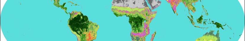


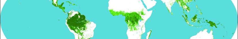

4 GSI, Chiba University, Collaborating Organizations Figure 1: GLCNMO Image Figure2: Global Percent Tree Cover Image GSI, Chiba University, Collaborating Organizations 4
 has been serving as the secretariat of ISCGM and tackling various activities energetically as follows. 2.")


5 2 UNDERTAKINGS OF JAPANESE GOVERNMENT Japanese government has been promoting this project with the primary objectives mentioned above. As one of the governmental agencies of Japan, Geographical Survey Institute (GSI) has been serving as the secretariat of ISCGM and tackling various activities energetically as follows. 2.1 Fourteenth Session of the Conference of the Parties (COP14) of UNFCCC in Pozna, Poland COP14 of United Nations Framework Convention on Climate Change (UNFCCC) took place in Pozna, Poland from 1 to 12 December 2008 to discuss international policy framework to cope with climate change. More than 9,000 people from governments, international organizations, NGOs, researchers and press attended the Conference. MLIT and the ISCGM secretariat jointly participated in the Conference to promote the use of Global Map version 1 to Figure 3:Pozna International Fair, Pozna facilitate the discussions on measures against climate change. At the side seminar on 9 December hosted by the Japanese Government, one of the authors of this report, Takayuki Nakamura made a presentation entitled Utilizing Global Map for Addressing Climate Change. The presentation drew interest of an audience of 150 not only about the outline of Global Map, but also on the possibility of use of Global Map in climate change fields. Figure 4: Global Map presentation These fields include formulating adaptation measures in response to adverse effects of climate change such as sea level rise; grasping forestareasandforestdistributioninanefforttoreducingemissionsfromdeforestationandforest Degradation in Developing Countries (REDD); and calculation of greenhouse gases (GHGs) emissions and removals from Land Use, Land-Use Change and Forestry sector (LULUCF). Their interests in Global Map in COP 14 indicate their big demand for the geographic information in environmental problem solution, which is also an encouraging message that both National Mapping Organizations and ISCGM have more and more room to assist in climate change policy formulation at national and international levels through distributing necessary geo-information, up to and beyond Seventh Workshop on Greenhouse Gas Inventories in Asia (WGIA) The 7th WGIA was held in Seoul, Republic of Korea from 7 to 10 July 2009 hosted by the Ministry of the Environment of Japan (MoEJ) and the National Institute for Environmental Studies (NIES). The workshop was attended by 100 participants in total, including representatives of government and research institutes of eleven countries: Cambodia, Indonesia, Japan, Lao, P.D.R., Malaysia, Mongolia, Myanmar, Philippines, Republic of Korea, Thailand, and Vietnam, in addition to Figure 5: Participants of the 7th WGIA two international organizations: UNFCCC, IPCC. GSI made a presentation on the Global Mapping project at the working group of LULUCF sector. At the presentation, GSI introduced how to interpret Land Cover classes defined in Global Map into 5


 2.")
 for the producers and users of Global Map to discuss the expansion of users of Global Map data.")
6 LULUCF and how to calculate each area of land cover 6 classes of LULUCF concretely. The participants learned the existing global scale GIS datasets such as Global Map and its usability. They become aware of and recognized the importance of cooperation between GIS or Remote sensing experts, including officials at National Mapping Organizations, and people in charge of climate change especially GHG inventories. GSI expects to build relationship between GIS or Remote Sensing experts, including officials at National Mapping Organizations, and people in charge of climate change especially GHG inventories; to improve skills of relevant people; and to utilize Global Map into promoting GHG inventories in the countries of Asia and the Pacific Region. 2.3 Side Event in G8 Hokkaido Toyako Summit The G8 Hokkaido Toyako Summit was held from 7 to 9 July In conjunction with the summit, various events under the theme of environment took place at many places in the host country of the Summit, Japan. Among the events, Integrated Exhibition of the Environment in celebration of the Hokkaido Toyako Summit was held form 18 to 21 June 2008, where Global Map booth was set to introduce the purpose, the role and the application of Global Map in global environmental field with panel display, video presentation and PC demonstration. Figure 6: Integrated Exhibition of the Environment in Celebration of the Hokkaido Toyako Summit (at Sapporo Dome) 2.4 Global Mapping Forum 2008 "Global Mapping Forum 2008," a three-day-long forum was held in Tokyo and Yokohama, Japan from 5 to 7 June The forum was jointly organized by the GSI, ISCGM, and the United Nations University (UNU) for the producers and users of Global Map to discuss the expansion of users of Global Map data. It was attended by 346 participants from 26 countries who are mainly heads of National Mapping Organizations of the world and experts of the global Figure 7; Presentation by Dr.Yoshio Tsukio, environmental field. Professor Emeritus of The University of Tokyo At this forum, a panel discussion was held titled as Discussion towards the Development of Global Map Version 2 and adopted Global Map Tokyo Declaration. The Tokyo Declaration states that producers and users of Global Map should further strengthen coordination, including capacity building, so that Global Map can be made more user-friendly to the people of the worldtohelptobetterdecision-making. Figure 8:Global Map School As part of this Forum, Global Map School was held at Keio Futsubu School with students of Princess Chulabhorn s College Nakhon Si Thammarat (secondary and tertiary education level). They communicated 6

 World Water Forum was held in Istanbul, from 16 to 22 March 2009 to discuss the importance of water on the political agenda.")
.")
7 each other by exchanging ideas on topics like national characteristics and global environmental problems by using Global Map datasets supported by internet-based video conferencing systems. The objective of this program is to provide a scheme for nurturing international understanding supported by the effective use of geographic information. So far, three sessions have been carried out. One session was between Japan and the Philippines and the remaining two were between Japan and Thailand. Figure 9;Global Map School 2.5 Fifth World Water Forum The fifth (5th) World Water Forum was held in Istanbul, from 16 to 22 March 2009 to discuss the importance of water on the political agenda. The Figure 10 was exhibited at the event, which shows the current land cover of the whole land of the globe (background) and the future change in the annual maximum of daily precipitation projected by the global warming simulation with a high resolution climate model. This was created in collaboration between GSI and Meteorological Research Institute (MRI). Figure 10: Global Land Cover and Predicted Change in Daily Maximum Precipitation 7

8 2.6 Fourth International Conference on African Development (TICAD IV) The Fourth (4th) Tokyo International Conference on African Development (TICAD IV) was held in Tokyo, from 28 to 30 May 2008 to promote high-level policy dialogue between African leaders and development partners. The Global Map of the African Region was displayed on the screen during the conference. The Global Map was also mentioned in the TICAD IV Yokohama Action Plan as promote technical assistance such as establishing and updating the Global Map data for the Africa, describing the status of its environment in five years in the actions to be taken in the next 5 years under the TICAD process (chapter 2 of Addressing Environmental / Climate Change issues section). 2.7 Global Mapping Seminars in Africa As a part of Global Mapping Partnership Program (GMPP) inviting people of National Mapping Organizations (NMOs) to promote the development of Global Map in the developing and other countries, Global Mapping Seminars in Africa were held with the cooperation of Survey of Kenya and Direction des Travaux Geographiques et Cartographiques (DTGC), in Kenya and Senegal since 2002 to These seminars were organized by MLIT, ISCGM and SOK/DTGC Figure11:Global Map Seminar with the support of the Japan International Cooperation Agency (JICA). It has been held in Nairobi, Kenya from and in Dakar, Senegal from , annually and respectively. The objectives of these seminars are as follows: To enlighten the significance of the Global Mapping project and facilitate the project participation Technological transfer for creating Global Map data and facilitation of the data development Promotion of the development of National Spatial Data Infrastructure (NSDI) started from developing Global Map data. Information exchange among NMOs in the African Region 2.8 JICA Training Course Since 1994 and sponsored by JICA, GSI was conducting a group training course on Global Mapping for technology transfer to developing countries. This course was attended by 94 participants from 57 countries in 15 years from 1994 to CONCLUSIONS Global Mapping Project is to develop geographic information of the whole land area of the globe with consistent specifications through international cooperation of respective NMOs. The project has completed the first goal of Global Map version 1, including GLCNMO and Global Percent Tree Cover. Global Map version 1 is expected to accelerate the use of Global Map. Global Mapping Project is collaborating in the broad range of cooperative frameworks as global geospatial infrastructure. At the same time, it is revising the specification and diversifying data formats for the benefit of producers and users of Global Map. Promotion of Global Map has steadily advanced in global environmental field internationally. Practical use in different fields such as greenhouse-gases inventories surveillance is also progressing. Another undertakings such as general publicity activity, applications in education and capacity building in developing countries have advanced steadily. Through these approaches, it is expected that the use of Global Map will be further enhanced to address Global Challenges in the broader range including the field of disaster prevention and management. 8
9 REFERENCES Katsuto Nakagawa, Secretariat of ISCGM. Global Mapping Forum Global Mapping News Letter, Vol.50, June 2008 Purnawan, B., Xu, Z., Ebener S. and Hong, S. (2008). Working Group 2, Fundamental Data, Report for the 14 th PCGIAP Meeting, Kuala Lumpur, Malaysia, August 2008 Secretariat of ISCGM (2008). Global Map of the Central District of Union of Myanmar, at M&cc=mmr, and at M&cc=mmr [accessed 10 May 2009]. Takayuki Nakamura, Ministry of Land, Infrastructure, Transport and Tourism of Japan (MLIT) Toru Nagayama, Secretariat of ISCGM. Global Map Presentation at 14th Session of the Conference of the Parties (COP14) of UNFCCC in Pozna, Poland. Global Mapping News Letter, Vol.52, December 2008 Takayuki Nakamura, Ministry of Land, Infrastructure, Transport and Tourism of Japan (MLIT) TICAD and Global Map. Global Mapping News Letter, Vol.50, June 2008 Takayuki Nakamura, Ministry of Land, Infrastructure, Transport and Tourism, Japan. The Third Global Mapping Seminar in Dakar. Global Mapping News Letter, Vol.49, March 2008 Toru Nagayama, Yoshikazu Fukushima, Shozo Kajikawa, Junichi Kisanuki, Toshihiro Tutui, Seiichi Oomiya, Futoshi Akatsuka, Taro Ubukawa and Shuhei Kojima, Secretariat of the International Steering Committee for Global Mapping (ISCGM). Contribution of Global Mapping Project to Building SDI for Addressing Global Challenges. United Nations (2002). Plan of Implementation of the World Summit on Sustainable Development, at [accessed 10 May 2009]. Yoshikazu Fukushima, Katsuto Nakagawa, Junichi Kisanuki, Shozo Kajikawa, Toshihiro Tsutsui, Futoshi Akatsuka, Seiichi Oomiya, Osamu Akutsu, Taro Ubukawa and Shuhei Kojima, Global Mapping Forum 2008, Bulletin of the Geographical Survey Institute, Vol.56 December
RELEASE OF THE GLOBAL MAP DATA SET VERSION 1.
 RELEASE OF THE GLOBAL MAP DATA SET VERSION 1 K. Nakagawa a, S. Kajikawa a, H.fujimura a, S. Sakabe b a Geographical Survey Institute, 1 Kitasato Tsukuba Ibaraki 305-0811, Japan (k-nakagawa, kajikawa, hfu)@gsi.go.jp
Economic and Social Council
 United Nation E/C.20/2012/4/Add.1 Economic and Social Council Distr.: General 2 July 2012 Original: English Committee of Experts on Global Geospatial Information Management Second session New York, 13-15
WGIA7 9th July, Noriko KISHIMOTO
 Utilizing Global Map for addressing Climate Change WGIA7 9th July, 2009 Seoul, Republic of Korea Noriko KISHIMOTO n-kishimoto@gsi.go.jp Geographic Survey Institute, JAPAN Outline of the Global Map What
Development and Applications of the Global Map. Taro UBUKAWA
 Development and Applications of the Global Map 11 Development and Applications of the Global Map Taro UBUKAWA Abstract The Geographical Survey Institute of Japan has been implementing the Global Mapping
Development of Global Map for GEOSS SBAs US-09-03a
 Development of Global Map for GEOSS SBAs US-09-03a UIC User Engagement Session 2 November, 2010 Yoshikazu FUKUSHIMA Secretariat General of International Steering Committee for Global Mapping Geospatial
ISCGM Informal Meeting in Malaysia
 NEWSLETTER 51 International Steering Committee for Global Mapping GLOBAL MAPPING ISCGM Informal Meeting in Malaysia Shozo Kajikawa ISCGM Secretariat The 14th Meeting of PCGIAP was held in Kuala Lumpur,
Summary of Global Mapping Forum 2003 in Okinawa and its Outcomes
 Summary of Global Mapping Forum 2003 in Okinawa and its Outcomes 1 Summary of Global Mapping Forum 2003 in Okinawa and its Outcomes Hidetoshi NAKAJIMA Abstract Global Mapping Forum 2003 in Okinawa was
Utilization of Global Map for Societal Benefit Areas
 Utilization of Global Map for Societal Benefit Areas The Fourth GEOSS AP Symposium Bali Indonesia, 11th March 2010 Shuhei Kojima Geographical Survey Institute Ministry of Land, Infrastructure, Transport
The Sixteenth Meeting of ISCGM Secretariat of ISCGM
 International Steering Committee for Global Mapping GLOBAL MAPPING NEWSLETTER The Sixteenth Meeting of ISCGM Secretariat of ISCGM 56 The Sixteenth Meeting of the International Steering Committee for Global
ECONOMIC AND SOCIAL COUNCIL
 UNITED NATIONS E/CONF.102/3 ECONOMIC AND SOCIAL COUNCIL Nineteenth United Nations Regional Cartographic Conference for Asia and the Pacific Bangkok, 29 October 1 November 2012 Item 4 of the provisional
Economic and Social Council
 United Nations Economic and Social Council Distr.: General 2 July 2012 E/C.20/2012/10/Add.1 Original: English Committee of Experts on Global Geospatial Information Management Second session New York, 13-15
Steering Global Mapping Project and Developing Global Map Version 2
 Steering Global Mapping Project and Developing Global Map Version 2 1 Steering Global Mapping Project and Developing Global Map Version 2 Taro UBUKAWA, Akifumi ANDO, Toshinobu SAITO, Maya UEDA, Akiko YAMADA
Global Mapping: A Tool for Disaster Mitigation
 Global Mapping: A Tool for Disaster Mitigation D. R. Fraser Taylor Chair, International Steering Committee for Global Mapping (ISCGM) fraser_taylor@carleton.ca www. United Nations Regional Cartographic
Background Document: Report of the Regional Committee of United Nations Global Geospatial Information Management for Asia and the Pacific
 Background Document: Report of the Regional Committee of United Nations Global Geospatial Information Management for Asia and the Pacific 1. Summary 1. This report highlights the activities carried out
Global Mapping Forum 2008
 Yoshikazu FUKUSHIMA, Katsuto NAKAGAWA, Junichi KISANUKI, Shozo KAJIKAWA, Toshihiro TSUTSUI, Futoshi AKATSUKA, Seiichi OOMIYA, Osamu AKUTSU, Taro UBUKAWA* and Syuhei KOJIMA Abstract was held from June 5-7
Report of the Regional Committee of UN-GGIM for Asia and the Pacific (UN-GGIM-AP)
") Report of the Regional Committee of UN-GGIM for Asia and the Pacific (UN-GGIM-AP) At the Eighth Session of UN-GGIM UN Headquarters, New York, 1 3 August 2018 About UN-GGIM-AP One of the five regional committees
Report of the Regional Committee of UN-GGIM for Asia and the Pacific (UN-GGIM-AP) At the Eighth Session of UN-GGIM UN Headquarters, New York, 1 3 August 2018 About UN-GGIM-AP One of the five regional committees
From PCGIAP to UN GGIM AP: A Regional Perspective on GGIM
 Regional Committee of United Nations Global Geospatial Information Management for Asia and the Pacific (UN-GGIM-AP) Established by a United Nations Resolution From PCGIAP to UN GGIM AP: A Regional Perspective
Inventory of United Nations Resolutions on Cartography Coordination, Geographic Information and SDI 1
 Inventory of United Nations Resolutions on Cartography Coordination, Geographic Information and SDI I. Resolutions on Cartography Coordination and Establishment of United Nations Regional Cartographic
Global Map: A Tool for Disaster Mitigation for the Asia and Pacific Region
 Global Map: A Tool for Disaster Mitigation for the Asia and Pacific Region D. R. Fraser Taylor Chair, International Steering Committee for Global Mapping (ISCGM) fraser_taylor@carleton.ca www. 18 th United
Economic and Social Council
 United Nations Economic and Social Council Distr.: General 18 July 2016 Original: English Committee of Experts on Global Geospatial Information Management Sixth session New York, 3-5 August 2016 Item 2
What is the PCGIAP? Overview on PCGIAP Activities and the Asia/Pacific Region. Membership. Background. Aims. Asia-Pacific SDI
 3rd FIG Regional Conference for Asia and the Pacific Jakarta, Indonesia, 3-7th October 2004 Overview on PCGIAP Activities and the Asia/Pacific Region What is the PCGIAP? Haji Matusin Matasan Surveyor General,
Implementing the Sustainable Development Goals: The Role of Geospatial Technology and Innovation
 Fifth High Level Forum on UN Global Geospatial Information Management Implementing the Sustainable Development Goals: The Role of Geospatial Technology and Innovation 28-30 November 2017 Sheraton Maria
Economic and Social Council 2 July 2015
 ADVANCE UNEDITED VERSION UNITED NATIONS E/C.20/2015/11/Add.1 Economic and Social Council 2 July 2015 Committee of Experts on Global Geospatial Information Management Fifth session New York, 5-7 August
Report on the Actions Taken on Resolutions of the Eighteenth United Nations Regional Cartographic Conference for Asia and the Pacific
 UNITED NATIONS E/CONF.102/7 ECONOMIC AND SOCIAL COUNCIL Nineteenth United Nations Regional Cartographic Conference for Asia and the Pacific Bangkok, 29 October 1 November 2012 Item 4 of the provisional
NEWSLETTER. No.33 - Mar. 25, 2004 GLOBAL MAPPING. 11 th Meeting of the International Steering Committee for Global Mapping
 No.33 - Mar. 25, 2004 International Steering Committee for Global Mapping GLOBAL MAPPING NEWSLETTER 11 th Meeting of the International Steering Committee for Global Mapping Karen D. Kline Assistant Secretary
ALBANIA IN THE GLOBAL MAP. Milot LUBISHTANI, Bashkim IDRIZI
 ALBANIA IN THE GLOBAL MAP Milot LUBISHTANI, Bashkim IDRIZI Overview: Introduction GSDI Global Mapping Introduction Standards Participating Utilization Data structure Albanian Global Map Dataset Process
UN GGIM and National SDI Strategy
 MSDI Open Forum on 26 th January 2016 Contributing to the successful delivery of MSDI UN GGIM and National SDI Strategy Hiroshi Murakami Deputy Administrator Geospatial Information Authority of Japan Geospatial
RESAP Progress Report
 RESAP Progress Report December 2016 to October 2017 Presentation to the Twenty-first session of the Intergovernmental Consultative Committee on the Regional Space Applications Programme for Sustainable
Working Group 1. Geodetic Reference Frame. Activity Report. for. The UN-GGIM-AP Plenary Meeting
 Regional Committee of United Nations Global Geospatial Information Management for Asia and the Pacific (UN-GGIM-AP) Established by a United Nations Resolution Working Group 1 Geodetic Reference Frame Activity
2018/1 The integration of statistical and geospatial information. The Regional Committee of UN-GGIM: Americas:
 The following are the conclusions and recommendations of the Regional Committee of the United Nations on Global Geospatial Information Management for the Americas, during its Fifth Session, Thursday 8
CONFERENCE STATEMENT
 CONFERENCE STATEMENT We, the elected representatives from Canada, Denmark/Greenland, Finland, Iceland, Norway, Russia, Sweden and the United States of America; In collaboration with the indigenous peoples
Promotion of Global Mapping Project
 41 Activities of the ISCGM Secretariat and Japanese Government Yoshihisa HOSHINO*, Hiromichi MARUYAMA*, Hiroshi MASAHARU*, Mitsuo IWASE*, Toru NAGAYAMA**, Otohiko SHIMIZU* and Hidenori FUJIMURA* Abstract
Cooperation is the key, FIG can facilitate
 Cooperation is the key, FIG can facilitate Mikael Lilje Vice President 2017-2020 Head, Geodetic infrastructure, Swedish mapping, cadastral and land registration authority Presented at the GIS/RS Conference
Report of the Working Group 2 Data Sharing and Integration for Disaster Management *
 UNITED NATIONS E/CONF.104/6 ECONOMIC AND SOCIAL COUNCIL Twentieth United Nations Regional Cartographic Conference for Asia and the Pacific Jeju, 6-9 October 2015 Item 5 of the provisional agenda Report
Joint RA II/V Workshop on WIGOS for DRR - The Jakarta Declaration - (12-14 October, Jakarta, Indonesia) NMSC/KMA
 NMSC/KMA") Joint RA II/V Workshop on WIGOS for DRR - The Jakarta Declaration - (12-14 October, Jakarta, Indonesia) /KMA dolong@korea.kr Background Enhancement of Member s capabilities for weather forecasts and warnings
Joint RA II/V Workshop on WIGOS for DRR - The Jakarta Declaration - (12-14 October, Jakarta, Indonesia) /KMA dolong@korea.kr Background Enhancement of Member s capabilities for weather forecasts and warnings
E/CONF.105/158/CRP.158
 E/CONF.105/158/CRP.158 14 July 2017 Original: English Eleventh United Nations Conference on the Standardization of Geographical Names New York, 8-17 August 2017 Item 8 of the provisional agenda* Measures
Briefing. H.E. Mr. Gyan Chandra Acharya
 Briefing by H.E. Mr. Gyan Chandra Acharya Under-Secretary-General and High Representative for the Least Developed Countries, Landlocked Developing Countries and Small Island Developing States Briefing
GENERAL RECOMMENDATIONS. Session 7. Breakout discussion. discuss on regional and interregional. proposals 1. COLLABORATION BETWEEN PROGRAMMES
 Session 7 24 July 2016, 9.00-11.00 Breakout discussion on regional and interregional joint project proposals Mr Shahbaz Khan summarized the two days of presentations and exchanges and requested the participants
Bengt Kjellson Chair of the Executive Committee UN-GGIM: Europe. 2 nd Joint UN-GGIM: Europe ESS Meeting 11 th March 2016, Luxembourg
 Bengt Kjellson Chair of the Executive Committee UN-GGIM: Europe 2 nd Joint UN-GGIM: Europe ESS Meeting 11 th March 2016, Luxembourg A global geospatial mandate At its 47th plenary in July 2011, ECOSOC,
Economic and Social Council
 United Nations E/CN.3/2019/31 Economic and Social Council Distr.: General 19 December 2018 Original: English Statistical Commission Fiftieth session 5-8 March 2019 Item 4(i) of the provisional agenda*
Geographical Names Activities in Africa The Gaborone Action Plan
 United Nations Group of Experts on Geographical Names Geographical Names Activities in Africa The Gaborone Action Plan 6 th Meeting of the Committee of Director -Generals of National Statistics Offices
FIG Asia Pacific Capacity Development Network
 FIG Asia Pacific Capacity Development Network Report to the 41th General Assembly FIG Congress 2018, Istanbul - Turkey Rob Sarib Chair FIG Asia Pacific Capacity Development Network (AP CDN) Story of the
Global Mapping: A Tool for Natural Disaster Mitigation for Asia and the Pacific Region *
 UNITED NATIONS E/CONF.100/IP.2 ECONOMIC AND SOCIAL COUNCIL Eighteenth United Nations Regional Cartographic Conference for Asia and the Pacific Bangkok, 26-29 October 2009 Item 7(b) of the provisional agenda
Space Applications for Disaster Risk Reduction and Sustainable Development
 Space Applications for Disaster Risk Reduction and Sustainable Development Space Applications Section (SAS) ICT and Disaster Risk Reduction Division (IDD) UNESCAP Contents I. RESAP Activities 2016-2017
ECONOMIC AND SOCIAL COUNCIL 13 July 2007
 UNITED NATIONS E/CONF.98/CRP.34 ECONOMIC AND SOCIAL COUNCIL 13 July 2007 Ninth United Nations Conference on the Standardization of Geographical Names New York, 21-30 August 2007 Item 17(b) of the provisional
Report of PCGIAP to the 18 th United Nations Regional Cartographic Conference for Asia and the Pacific (UNRCC-AP) for the period
 for the period") Permanent Committee on GIS Infrastructure for Asia and the Pacific (PCGIAP) Established in 1995 by a United Nations Resolution Report of PCGIAP to the 18 th United Nations Regional Cartographic Conference
Permanent Committee on GIS Infrastructure for Asia and the Pacific (PCGIAP) Established in 1995 by a United Nations Resolution Report of PCGIAP to the 18 th United Nations Regional Cartographic Conference
Concept Formulation of Geospatial Infrastructure. Hidenori FUJIMURA*
 Concept Formulation of Geospatial Infrastructure 1 Concept Formulation of Geospatial Infrastructure Hidenori FUJIMURA* (Published online: 28 December 2016) Abstract Technical trends in the field of surveying
UN-GGIM: An Overview Stefan Schweinfest, Director (UNSD) Bangkok, 27 March 2015
 Bangkok, 27 March 2015") UN-GGIM: An Overview Stefan Schweinfest, Director (UNSD) Bangkok, 27 March 2015 ggim.un.org UN-GGIM: A global initiative Formal inter-governmental UN Committee of Experts to: Discuss, enhance and coordinate
UN-GGIM: An Overview Stefan Schweinfest, Director (UNSD) Bangkok, 27 March 2015 ggim.un.org UN-GGIM: A global initiative Formal inter-governmental UN Committee of Experts to: Discuss, enhance and coordinate
1) United Nations Committee of Experts on Global Geospatial Information Management (UN-GGIM)
 United Nations Committee of Experts on Global Geospatial Information Management (UN-GGIM)") International Workshop on Legal and Policy Frameworks for Geospatial Information Management Licensing of Geospatial Information 7 9 November 2017 Tianjin Zhengxie Club Hotel Tianjin, China Outline of presentation
International Workshop on Legal and Policy Frameworks for Geospatial Information Management Licensing of Geospatial Information 7 9 November 2017 Tianjin Zhengxie Club Hotel Tianjin, China Outline of presentation
The Integration of Land and Marine Spatial Data Set As Part of Indonesian Spatial Data Infrastructure Development
 UNITED NATIONS E/CONF.97/6/IP. 46 ECONOMIC AND SOCIAL COUNCIL Seventeenth United Nations Regional Cartographic Conference for Asia and the Pacific Bangkok, 18-22 September 2006 Item 7 of the provisional
REGIONAL SDI DEVELOPMENT
 REGIONAL SDI DEVELOPMENT Abbas Rajabifard 1 and Ian P. Williamson 2 1 Deputy Director and Senior Research Fellow Email: abbas.r@unimelb.edu.au 2 Director, Professor of Surveying and Land Information, Email:
CONFERENCE STATEMENT
 Final draft CONFERENCE STATEMENT We, the elected representatives of Canada, Denmark/Greenland, the European Parliament, Finland, Iceland, Norway, Russia, Sweden and the United States of America; In collaboration
Earth Observations as a Tool To Achieve Sustainable Development Goals
 The image part with relationship ID rid3 was not found in the file. 16/10/2017 Earth Observations as a Tool To Achieve Sustainable Development Goals LI Jing, China GEO On behalf of the Group on Earth Observations
Spatially Enabled Society
 International Seminar on Land Administration Trends and Issues in Asia and the Pacific Region Spatially Enabled Society Abbas Rajabifard Vice Chair PCGIAP-WG3 Vice-President (President Elect), GSDI Association
KUNMING FORUM ON UNITED NATIONS GLOBAL GEOSPATIAL INFORMATION MANAGEMENT CITIES OF THE FUTURE: SMART, RESILIENT
 KUNMING FORUM ON UNITED NATIONS GLOBAL GEOSPATIAL INFORMATION MANAGEMENT CITIES OF THE FUTURE: SMART, RESILIENT and SUSTAINABLE Yunnan Zhenzhuang Guest House, Kunming, China 10 12 May 2017 BACKGROUND CONCEPT
Green Chemistry Education
 Green Chemistry Education Poster presented at the IUPAC Congress/General Assembly July 2001 GREEN CHEMISTRY IN THE SCIENTIFIC CONTEXT The science of chemistry is central to addressing the problems facing
Geospatial Information and Services for Disasters (GIS4D)
") Geospatial Information and Services for Disasters (GIS4D) 31 July 2017 Tae Hyung KIM ICT and Disaster Risk Reduction Division (IDD) UNESCAP 1 About ESCAP Who is ESCAP? United Nations Economic and Social
Geospatial Information and Services for Disasters (GIS4D) 31 July 2017 Tae Hyung KIM ICT and Disaster Risk Reduction Division (IDD) UNESCAP 1 About ESCAP Who is ESCAP? United Nations Economic and Social
Spatial Data Infrastructure Concepts and Components. Douglas Nebert U.S. Federal Geographic Data Committee Secretariat
 Spatial Data Infrastructure Concepts and Components Douglas Nebert U.S. Federal Geographic Data Committee Secretariat August 2009 What is a Spatial Data Infrastructure (SDI)? The SDI provides a basis for
Training on national land cover classification systems. Toward the integration of forest and other land use mapping activities.
 Training on national land cover classification systems Toward the integration of forest and other land use mapping activities. Guiana Shield 9 to 13 March 2015, Paramaribo, Suriname Background Sustainable
UNITED NATIONS E/CONF.97/5/CRP. 7
 UNITED NATIONS E/CONF.97/5/CRP. 7 ECONOMIC AND SOCIAL COUNCIL Seventeenth United Nations Regional Cartographic Conference for Asia and the Pacific Bangkok, 18-22 September 2006 Item 6 (b) of the provisional
ESCAP Promotes Geo-referenced Information System for Disaster Risk Management in Asia and the Pacific
 Third High Level Forum on UNGGIM 22-24 October 2014 Beijing, China ESCAP Promotes Geo-referenced Information System for Disaster Risk Management in Asia and the Pacific Keran Wang Space Applications Section,
UNITED NATIONS E/CONF.97/6/IP. 8
 UNITED NATIONS E/CONF.97/6/IP. 8 ECONOMIC AND SOCIAL COUNCIL Seventeenth United Nations Regional Cartographic Conference for Asia and the Pacific Bangkok, 18-22 September 2006 Item 7 of the provisional
FINDINGS OF THE ARCTIC METEOROLOGY SUMMIT
 FINDINGS OF THE ARCTIC METEOROLOGY SUMMIT 2018 WWW.FMI.FI CHAIR S SUMMARY: 1 2 3 We need to be curious to explore the known unknowns. Meteorology is an elemental part of international collaboration in
Spatial Enablement Current Activities and Future Directions Abbas Rajabifard, Jude Wallace and Andrew Binns
 Spatial Enablement Current Activities and Future Directions Abbas Rajabifard, Jude Wallace and Andrew Binns This chapter presents and summarises the outcomes of the two major events which have been recently
Non-Governmental Organizations for Spatial Data Infrastructure. Environmental Democracy Case
 Non-Governmental Organizations for Spatial Data Infrastructure Environmental Democracy Case L.Jovičić, S.Vrečar, V.Cetl, K.Ristovski GSDI Small Grant Program Award 2011-2012 Non-Governmental Organisations
The Global Statistical Geospatial Framework and the Global Fundamental Geospatial Themes
 The Global Statistical Geospatial Framework and the Global Fundamental Geospatial Themes Sub-regional workshop on integration of administrative data, big data and geospatial information for the compilation
Analysis of Regional Fundamental Datasets Questionnaire
 Permanent Committee on GIS Infrastructure for Asia and the Pacific Working Group 2 Regional Fundamental Data Summary Report on Analysis of Regional Fundamental Datasets Questionnaire ABBAS RAJABIFARD and
Resolution adopted by the General Assembly. [on the report of the Second Committee (A/67/440/Add.2)]
![Resolution adopted by the General Assembly. [on the report of the Second Committee (A/67/440/Add.2)]](/thumbs/94/121301610.jpg "Resolution adopted by the General Assembly. [on the report of the Second Committee (A/67/440/Add.2)]") United Nations General Assembly Distr.: General 3 April 2013 Sixty-seventh session Agenda item 23 (b) Resolution adopted by the General Assembly [on the report of the Second Committee (A/67/440/Add.2)]
United Nations General Assembly Distr.: General 3 April 2013 Sixty-seventh session Agenda item 23 (b) Resolution adopted by the General Assembly [on the report of the Second Committee (A/67/440/Add.2)]
Publicity Activities of Global Mapping at Johannesburg Summit and Outcomes of the Summit
 59 Publicity Activities of Global Mapping at Johannesburg Summit and Outcomes of the Summit Hiroshi MASAHARU and Minoru AKIYAMA Abstract The World Summit on Sustainable Development (WSSD; Johannesburg
Challenges and Potentials of Place Based Information Management in Nepal"
 Nineteenth United Nations Regional Cartographic Conference for Asia and the Pacific, Bangkok, Thailand, 29 October 1 November 2012 Challenges and Potentials of Place Based Information Management in Nepal"
Economic and Social Council
 United Nations Economic and Social Council Distr.: Limited 28 September 2015 Original: English Twentieth United Nations Regional Cartographic Conference for Asia and the Pacific Jeju Island, 6-9 October
Arctic Spatial Data Infrastructure Enabling Access to Arctic Location-Based Information
 Arctic Spatial Data Infrastructure Enabling Access to Arctic Location-Based Information Arctic SDI Side Event Co-Chairs: Arvo Kokkonen Arctic SDI Board Chair & Director General, National Land Survey of
The Integrated Ge spatial Information Framework to the strengthening of NSDI, Mongolia
 Young Geospatial Professionals Summit 21 NOV 2018 The Integrated Ge spatial Information Framework to the strengthening of NSDI, Mongolia BAYARMAA ENKHTUR Geospatial information and technology department
UN-GGIM:Americas Regional Report
 UN-GGIM:Americas Regional Report 2016-2017 Seventh Session of UN-GGIM 2-4 August 2017, United Nations Headquarters, New York. Rolando Ocampo President of UN-GGIM: Americas Content Activities, Areas of
Global Geodetic Reference Frame GGRF & Implications for GNSS
 Global Geodetic Reference Frame GGRF & Implications for GNSS On behalf of Gary Johnston Chair GIAC, Ruth Neilan Vice Chair, Global Geodetic Observing System ICG-9 Prague, 10 November 2014 UN GGRF Working
Economic and Social Council
 United Nations Economic and Social Council 28 December 2000 Original: English E/CN.3/2001/2 Statistical Commission Thirty-second session 6-9 March 2001 Item 3 (a) of the provisional agenda * Demographic
Introduction of the Asia-Oceania Global Earth Observation System of Systems (AOGEOSS) GEO Initiative(GI-22 )
 GEO Initiative(GI-22 )") Introduction of the Asia-Oceania Global Earth Observation System of Systems (AOGEOSS) GEO Initiative(GI-22 ) Prof. Xiang ZHOU Institute of Remote Sensing and Digital Earth, CAS 11 May 2017 Kunming, China
Introduction of the Asia-Oceania Global Earth Observation System of Systems (AOGEOSS) GEO Initiative(GI-22 ) Prof. Xiang ZHOU Institute of Remote Sensing and Digital Earth, CAS 11 May 2017 Kunming, China
Utilization and Provision of Geographical Name Information on the Basic Map of Japan*
 UNITED NATIONS WORKING PAPER GROUP OF EXPERTS NO. 1/9 ON GEOGRAPHICAL NAMES Twenty-eight session 28 April 2 May 2014 Item 9 of the Provisional Agenda Activities relating to the Working Group on Toponymic
Urban Climate Resilience
 Urban Climate Resilience in Southeast Asia Partnership Project Introduction Planning for climate change is a daunting challenge for governments in the Mekong Region. Limited capacity at the municipal level,
Resolutions from the Tenth United Nations Conference on the Standardization of Geographical Names, 2012, New York*
 UNITED NATIONS GROUP OF EXPERTS ON GEOGRAPHICAL NAMES Twenty-eighth session New York, 28 April 2 May 2014 GEGN/28/9 English Resolutions from the Tenth United Nations Conference on the Standardization of
KENYA NATIONAL BUREAU OF STATISTICS Workshop on
 KENYA NATIONAL BUREAU OF STATISTICS Workshop on Capacity Building in Environment Statistics: the Framework for the Development of Environment Statistics (FDES 2013) Coordination with Sector Ministries
Economic and Social Council
 United Nations Economic and Social Council Distr.: General 23 May 2012 Original: English E/CONF.101/100 Tenth United Nations Conference on the Standardization of Geographical Names New York, 31 July 9
GIS (GEOGRAPHICAL INFORMATION SYSTEMS) AS A FACILITATION TOOL FOR SUSTAINABLE DEVELOPMENT IN AFRICA
 AS A FACILITATION TOOL FOR SUSTAINABLE DEVELOPMENT IN AFRICA") GIS (GEOGRAPHICAL INFORMATION SYSTEMS) AS A FACILITATION TOOL FOR SUSTAINABLE DEVELOPMENT IN AFRICA a presentation by Elizabeth Hicken GDEST Conference on Geospatial Sciences for Sustainable Development
GIS (GEOGRAPHICAL INFORMATION SYSTEMS) AS A FACILITATION TOOL FOR SUSTAINABLE DEVELOPMENT IN AFRICA a presentation by Elizabeth Hicken GDEST Conference on Geospatial Sciences for Sustainable Development
COEX CONVENTION AND EXHIBITION CENTRE SEOUL REPUBLIC OF KOREA
 REPUBLIC OF NAMIBIA SPEECH BY ALPHEUS G.!NARUSEB, (MP) MINISTER OF LANDS AND RESETTLEMENT IN THE REPUBLIC OF NAMIBIA AT THE HIGH LEVEL GLOBAL GEOSPATIAL INFORMATION MANAGEMENT FORUM ORGANISED BY THE UNITED
AAG Partnerships for. Sustainable Development in Africa: Geospatial Science & Technology for. Partnerships and Applications
 AAG Partnerships for Sustainable Development in Africa Geospatial Science & Technology for Sustainable Development in Africa: Partnerships and Applications Harvard University John F. Kennedy School of
Activities relating to the Working Group on Toponymic Data Files and Gazetteers*
 UNITED NATIONS WORKING PAPER GROUP OF EXPERTS NO. 10 ON GEOGRAPHICAL NAMES Twenty-seventh session 30 July and 10 August 2012, New York Item 3 of the Provisional Agenda Reports of the working groups Activities
Nineteenth SPREP Meeting
 Page 1 SECRETARIAT OF THE PACIFIC REGIONAL ENVIRONMENT PROGRAMME Nineteenth SPREP Meeting Pohnpei, Federated States of Micronesia 04 12 September 2008 Agenda Item 9.2.5: Regional Meteorological Services
COOPERATION IN SURVEYING AND MAPPING BETWEEN AFRICAN COUNTRIES AND JAPAN
 COOPERATION IN SURVEYING AND MAPPING BETWEEN AFRICAN COUNTRIES AND JAPAN Une, H. 1 and Shimoyama, Y. 2 1 Kenya Institute of Surveying and Mapping / Survey of Kenya 2 Geographical Survey Institute, Japan
Challenges and Successes in Sharing Geospatial Data in Africa
 Challenges and Successes in Sharing Geospatial Data in Africa 2018 GeoNode Summit Torino, Italy March 26-28, 2018 Bernard Justus Muhwezi Manager, Geo-Information Services Uganda Bureau of Statistics, Kampala,
Status of interoperability issues in the Chilean SDI. Álvaro Monett Pablo Morales Executive Secretariat NSDI-Chile
 Status of interoperability issues in the Chilean SDI Álvaro Monett Pablo Morales Executive Secretariat NSDI-Chile Outline Background - Chilean SDI working areas Background Interoperability, standards and
Journey of supporting CSNs to establish Geo-DRM
 Regional Workshop on Geo-referenced Information Systems for Disaster Risk Management (Geo-DRM) 26-27 June 2014 Bangkok, Thailand Journey of supporting CSNs to establish Geo-DRM Keran Wang Chief, Space
Chris Rizos (IAG), Chair William Cartwright (ICA), immediate past Chair
, Chair William Cartwright (ICA), immediate past Chair") Chris Rizos (IAG), Chair William Cartwright (ICA), immediate past Chair Global Spatial Data Infrastructure (GSDI) Association IEEE Geoscience & Remote Sensing Society (IEEE-GRSS) International Association
Chris Rizos (IAG), Chair William Cartwright (ICA), immediate past Chair Global Spatial Data Infrastructure (GSDI) Association IEEE Geoscience & Remote Sensing Society (IEEE-GRSS) International Association
PAN AMERICAN INSTITUTE OF GEOGRAPHY AND HISTORY Specialized Organization of the OAS
 PAN AMERICAN INSTITUTE OF GEOGRAPHY AND HISTORY Specialized Organization of the OAS 10 th UNRCC Americas United Nations, New York, 20 August 2013 PAIGH, SIRGAS, PC-IDEA and GeoSUR 2013-2015 Joint Action
National Spatial Data Infrastructures (NSDIs): North American Experience
: North American Experience") National Spatial Data Infrastructures (NSDIs): North American Experience Henry Tom International Symposium on NSDI (National Spatial Data Infrastructure) Center for Spatial Information Science University
National Spatial Data Infrastructures (NSDIs): North American Experience Henry Tom International Symposium on NSDI (National Spatial Data Infrastructure) Center for Spatial Information Science University
Spatially enabling e-government through geo-services
 Spatially enabling e-government through geo-services Mauro Salvemini EUROGI PRESIDENT Professor at Sapienza Università di Roma (IT) 1 About the presentation Few information about Eurogi ; Some essential
Country Report on SDI Activities in Singapore *
 UNITED NATIONS E/CONF.100/CRP.9 ECONOMIC AND SOCIAL COUNCIL Eighteenth United Nations Regional Cartographic Conference for Asia and the Pacific Bangkok, 26-29 October 2009 Item 7(a) of the provisional
Toponymy workshop of Tunis: A road map to orient the activities of the national committee of toponymy
 UNITED NATIONS GROUP OF EXPERTS WORKING PAPER ON GEOGRAPHICAL NAMES NO. 33/8 Twenty-ninth session Bangkok, Thailand, 25 29 April 2016 Item 8 of the Provisional Agenda Activities relating to the Working
National Remote Sensing Center of China. Space Technology for Sustainable Development in China Status, Achievements and Futures.
 National Remote Sensing Center of China Space Technology for Sustainable Development in China Status, Achievements and Futures Jing Li National Remote Sensing Center of China Ministry of Science and Technology,
Areas Beyond National Jurisdiction (ABNJ) 2016 Regional Leaders Program. March 22 to April 1, 2016 United Nations, New York
 2016 Regional Leaders Program. March 22 to April 1, 2016 United Nations, New York") Areas Beyond National Jurisdiction (ABNJ) 2016 Regional Leaders Program March 22 to April 1, 2016 United Nations, New York Welcome and Introductions Biliana Cicin-Sain President, Global Ocean Forum Vladimir
Areas Beyond National Jurisdiction (ABNJ) 2016 Regional Leaders Program March 22 to April 1, 2016 United Nations, New York Welcome and Introductions Biliana Cicin-Sain President, Global Ocean Forum Vladimir
UNESCO Man and the Biosphere (MAB) Programme International Coordinating Council 29th Session, Paris, 12 to 15 June National Report of Japan
 Programme International Coordinating Council 29th Session, Paris, 12 to 15 June National Report of Japan") UNESCO Man and the Biosphere (MAB) Programme International Coordinating Council 29th Session, Paris, 12 to 15 June 2017 National Report of Japan There are seven Biosphere Reserves (BR) in Japan: Mount
UNESCO Man and the Biosphere (MAB) Programme International Coordinating Council 29th Session, Paris, 12 to 15 June 2017 National Report of Japan There are seven Biosphere Reserves (BR) in Japan: Mount