Grade 5 Lesson 3. Lesson Plan Page 2. Page 6. Student Activity Handout 1 Map Practice. Student Activity Handout 2 Marlins Park Maps.
|
|
|
- Dorthy Houston
- 5 years ago
- Views:
Transcription

1 Grade 5 Lesson 3 Item Page Lesson Plan Page 2 Student Activity Handout 1 Map Practice Page 6 Student Activity Handout 2 Marlins Park Maps Page 10
2 DETERMINING METHODS VISION-SETTING Marlins Think Tank: Fifth Grade Social Studies Lesson Plan #3 OBJECTIVE. What is your objective? Student will be able to: SS.5.G.1.4: Construct maps, charts, and graphs to display geographic information. SS.5.G.1.2: Use latitude and longitude to locate places. KEY POINTS. What knowledge and skills are embedded in the objective? 1. A map is a representation, usually on a flat surface, of the earth and its features. 2. Maps have keys that explain the symbols that exist on the map (i.e. symbols for state capitals, rivers, major highways, hospitals, airports). 3. Latitude measurements are the horizontal lines on a map that run east to west, but measure north to south. Latitude measurements begin at the Equator. 4. Longitude measurements are the vertical lines on a map that run north to south, but measure east to west. Longitude measurements begin at the Prime Meridian. ASSESSMENT. Describe, briefly, what students will do to show you that they have mastered (or made progress toward) the objective. Students will create a map of our school, including a map key. Student will also complete a song based on longitude and latitude lines. OPENING (10 min.) How will you communicate what is about to happen? How will you communicate how it will happen? How will you communicate its importance? How will you communicate connections to previous lessons? How will you engage students and capture their interest? Students will enter class and immediately respond to the following prompt on the board: Have you ever used a map? If so, when? What were you trying to achieve? If not, what do you think the purpose of maps is? Explain in no fewer than four sentences. After students have been given five minutes to write, the teacher will begin: Okay, all, what do you think? Would anyone like to share? (Calls hands) Today we are going to learn a little bit about maps, and latitude and longitude! Has anyone ever heard of or seen latitude and longitude lines before? Yes, that s right they help measure locations on a map. Maps have all sorts of symbols on them to explain the world. MATERIALS. Student notebooks
3 INTRODUCTION OF NEW MATERIAL (15 min.) How will you explain/demonstrate all knowledge/skills required of the objective, so that students begin to actively internalize key points? Which potential misunderstandings do you anticipate? How will you proactively mitigate them? How will students interact with the material? Students will respond to the lecture by filling in their guided notes and answering questions when prompted. What is a map? A representation, usually on a flat surface, of the earth and its features. There are several types of maps, including physical maps, resource maps, climate maps, and political maps. How do we use maps in our daily lives? Many people use Google Maps and MapQuest to get from one place to the next. Maps help us understand the world, and they make sure that we do not get lost! Student notebooks Marlins Think Tank: Fifth Grade Map Practice Handouts What is a map key? A table of symbols used on a map. Every symbol on a map key has a meaning. Quick response: What other symbols may appear on a map? Draw and label those symbols on your notes. There could be symbols for state capitals, rivers, major highways, hospitals, and airports. (Discuss the different symbols which students came up with) What are latitude and longitude? Latitude: The horizontal lines on a map (aka rungs on a ladder analogy) Latitude lines measure North-South, but run East-West (side to side) Start point: Equator (0 degrees) Measures from 0 to 90 degrees in both directions (90 degrees north is the North Pole; 90 degrees south is the South Pole) in 15 degree increments Longitude: The vertical lines on a map Measure East-West, but run North-South 0 degrees longitude Greenwich, England (aka Prime Meridian) Measurements run East-West, 180 degrees in each direction Students should analyze both the map key sample and the latitude and longitude graphic before guided practice. GUIDED PRACTICE (10 min.) How will students practice all knowledge/skills required of the objective, with your support, such that they continue to internalize the key points? How will you ensure that students have multiple opportunities to practice, with exercises scaffolded from easy to hard? Students will watch The Latitude and Longitude Song ( all the while singing along, filling in the blanks, and solidifying their understanding of latitude and longitude. Marlins Think Tank: Fifth Grade Map Practice Handouts The Latitude and Longitude Song
4 (Chorus) Longitude and latitude Are easy if you have the right attitude Your teacher will show you gratitude If you learn longitude and latitude (2 X) Latitude measures south and north Up and down from the Equator they sally forth They're the lines that run from east to west Like the rungs of a ladder you'll pass the test Just don't forget they go both ways North is up, south is down, so look both ways Like a number line or a football field To the cardinal directions latitude yields (Chorus X2) The Prime Meridian is where the longitude's counted from Zero at Greenwich is where to get your bearings from To measure west and east the lines are drawn from north to south If it seems too confusing just keep listening to my mouth Just don't forget they go both ways East is right, west is left, just look both ways Like a number line or a football field To the cardinal directions latitude yields (Chorus) Have the right attitude Teacher show you gratitude Lines are going up down Gotta be a class clown Left, right, don't fight Study each and every night Number line, football Read a map, stand tall North, south, east, west Formula for success Have yourself a nice day Don't forget both ways Have a better attitude The Latitude and Longitude Song
 How will students independently practice the knowledge and skills required of the objective, such that they solidify their internalization of the key points prior to the lesson assessment?")
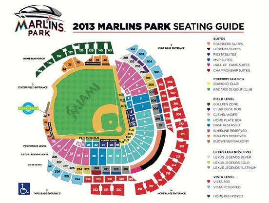
5 INDEPENDENT PRACTICE (15 min.) How will students independently practice the knowledge and skills required of the objective, such that they solidify their internalization of the key points prior to the lesson assessment? Before students get a chance to complete their independent practice, students will analyze The United Countries of Baseball map, present on their Marlins Think Tank: Fifth Grade Map Practice handouts. They will answer the following questions, as a class. According to the map, how many countries of baseball exist? What is this map missing? Marlins Think Tank: Fifth Grade Map Practice Handouts Students will have ten minutes to create their own map of our school (or of their home, if they prefer). Their map must include a key with at least four symbols. They should complete this assignment silently and individually; it should be completed in the blank space on their Marlins Think Tank: Fifth Grade Map Practice handouts. Lesson Assessment: Once students have had an opportunity to practice independently, how will they attempt to demonstrate mastery of the knowledge/skills required of the objective? The lesson assessment will be the product of the time utilized during independent practice. CLOSING (5 min.) How will students summarize and state the significance of what they learned? If we have time, at least three students will share their maps. What we learned today can help us think about how our world is organized, and how we can travel and understand where we are on our planet! Great job!
6 Marlins Think Tank: Fifth Grade Map Practice Name: What is a map? A, usually on a flat surface, of the earth and its features. There are several types of maps, including physical maps, resource maps, climate maps, and political maps. How do we use maps in our daily lives? Many people use Google Maps and MapQuest to get from one place to the next. Maps help us the world, and they make sure that we do not get lost! What is a map? A table of symbols used on a map. Every symbol on a map key has a meaning. Quick response: What other symbols may appear on a map? Draw and label those symbols below. There could be symbols for state capitals, rivers, major highways, hospitals, and airports. POSSIBLE MAP KEY SYMBOLS:
7 What are latitude and longitude? Latitude: The lines on a map (aka rungs on a ladder analogy) Latitude lines measure North-South, but run East-West (side to side) Start point: (0 degrees) Measures from 0 to 90 degrees in both directions (90 degrees north is the North Pole; 90 degrees south is the South Pole) in 15 degree increments Longitude: The lines on a map Measure East-West, but run North-South 0 degrees longitude Greenwich, England (aka Prime Meridian) Measurements run East-West, 180 degrees in each direction
8 Latitude and Longitude Song: Sing Along and Fill in the Blanks! (Chorus) Longitude and latitude Are easy if you have the right Your teacher will show you gratitude If you learn longitude and latitude (2 X) Latitude measures south and Up and down from the Equator they sally forth They're the lines that run from to west Like the rungs of a ladder you'll pass the test Just don't forget they go both ways North is up, south is down, so look both ways Like a number line or a football To the cardinal directions latitude yields (Chorus X2) The Prime Meridian is where the longitude's counted from Zero at Greenwich is where to get your bearings from To measure west and east the lines are drawn from north to south If it seems too confusing just keep to my mouth Just don't forget they go both ways East is right, west is left, just look both ways Like a number line or a football field To the cardinal directions latitude yields (Chorus) Have the right attitude Teacher show you Lines are going up down Gotta be a class clown Left, right, don't fight Study each and every night Number line, football Read a, stand tall North, south, east, west Formula for success Have yourself a nice day Don't forget both ways Have a better attitude

9 Your Own Map Goes Here!
10
Grade 6 Lesson 1. Lesson Plan Page 2. Student Activity Handout 1 Page 5
 Grade 6 Lesson 1 Item Page Lesson Plan Page 2 Student Activity Handout 1 Page 5 DETERMINING METHODS VISION-SETTING Marlins Think Tank: Sixth Grade Science Lesson Plan #1 OBJECTIVE. What is your objective?
Where in the World? Plotting Latitude & Longitude
 Where in the World? Plotting Latitude & Longitude Background Because our planet is a sphere, we need two types of reference lines to locate positions on the Earth and to make accurate maps. These imaginary
Geography 101: The Basics
 Geography 101: The Basics What is Geography? Geography is the study of the HUMAN and NON- HUMAN features of the Earth.! Geographers study where things are located why they are located in a specific place.!
World Geography. Teacher s Guide
 World Geography Teacher s Guide WALCH PUBLISHING Table of Contents To the Teacher.......................................................... vi Classroom Management.................................................
Meridian Circle through Zenith, North Celestial Pole, Zenith Direction Straight Up from Observer. South Celestial Pole
 Chapter 3 How Earth and Sky Work- Effects of Latitude In chapters 3 and 4we will learn why our view of the heavens depends on our position on the Earth, the time of day, and the day of the year. We will
Map Skills Lesson 1. Materials: maps, pencils, Lesson 1 Worksheet, strips of paper, grid paper
 Map Skills Lesson 1 Use cardinal directions, map grids, scales, and titles to locate places on a map. Interpret a map using information from its title, compass rose, scale, and legend. Vocabulary: map,
Mapping Earth. How are Earth s surface features measured and modeled?
 Name Mapping Earth How are Earth s surface features measured and modeled? Before You Read Before you read the chapter, think about what you know about maps Record your thoughts in the first column Pair
Latitude and Longitude Pre Test
 Name Date Latitude and Longitude Pre Test Multiple Choice Directions: For questions, 1 10 circle the answer that letter that best answers the question. Each question is worth 1 point each. 1. To locate
Latitude and Longitude
 Latitude and Longitude Finding Your Location on a Sphere Coordinate Systems n When you are locating a point on a flat surface you can use Cartesian coordinates of x and y. n The point 2, 3 is plotted on
netw rks Guided Reading Activity Essential Question: How does geography influence the way people live? What Is Geography?
 Guided Reading Activity What Is Geography? Lesson 1 Thinking Like a Geographer Essential Question: How does geography influence the way people live? Directions: Read the lesson and use your textbook to
LET S GO ON A ROAD TRIP
 Partner School News June 2016 In this issue: Education Children Around the World www.opportunityeducation.org Road Trip Start Writing Right Now Teaching Tip of the Month Focus on Schools LET S GO ON A
HOW TO TRAVEL ON EARTH WITHOUT GETTING LOST
 HOW TO TRAVEL ON EARTH WITHOUT GETTING LOST Using a globe to learn how a position on Earth can be described. Rui Dilão, Instituto Superior Técnico Curriculum topic latitude, longitude, coordinate system
Map Skills Unit. Note taking unit
 Map Skills Unit Note taking unit Introduction To learn about the Earth, we are going to learn about two geographic tools you can use.globes and maps. Globe A globe is a round model of the planet Earth
About places and/or important events Landmarks Maps How the land is, hills or flat or mountain range Connected to maps World Different countries
 What do you think you know about geography? About places and/or important events Landmarks Maps How the land is, hills or flat or mountain range Connected to maps World Different countries What do you
Latitude and Longitude:
 Latitude and Longitude: Finding Locations on Planet Earth. With thanks and credit to Step.com Typical Graph This is an example of a typical graph. It is made up of points that are connected by a line.
Earth Science Announcements
 Daily Routine Sit in your appropriate seat quietly Have all necessary materials out All back packs on the floor All cell phones on silent and away in backpacks All music devices off and headphones out
Title of Activity: Let there be Light! Introduction to Ohm's Law and basic series circuits.
 Title of Activity: Let there be Light! Introduction to Ohm's Law and basic series circuits. Concepts Covered: Circuitry is in all of our electronics. This circuits must be asembled in specific ways to
Name: Date: Period: #: Chapter 1: Outline Notes What Does a Historian Do?
 Name: Date: Period: #: Chapter 1: Outline Notes What Does a Historian Do? Lesson 1.1 What is History? I. Why Study History? A. History is the study of the of the past. History considers both the way things
Multiple Representations: Equations to Tables and Graphs Transcript
 Algebra l Teacher: It s good to see you again. Last time we talked about multiple representations. If we could, I would like to continue and discuss the subtle differences of multiple representations between
Suggested Activities. Pre-planning. Session One
 Suggested Activities Pre-planning Locate ball Assemble equipment In preparation for introducing the notion of geographic coordinates, bring to class in Session One a large ball (e.g., basketball, volleyball
Grade 6 Social Studies
 Unit Title: Africa : Movement Location Place Human Region : Subject/Course: 6 th Grade Social Studies Essential Questions: peoples, cultures and ideas of the world? How is a location identified using map
DRAWING YOUR CONTINENT
 CONTINENT PROJECT PART I On the attached sheet, you will draw your own continent. Use your creativity to create a continent that is uniquely your own. Give the continent a name. When you are finished with
locate the world s countries, using maps to focus on Europe (including the location of
 Year 3 and 4 Geography study- Autumn 2 2017 National curriculum: Locational knowledge locate the world s countries, using maps to focus on Europe (including the location of Russia) and North and South
Mathematics Success Grade 6
 T632 Mathematics Success Grade 6 [OBJECTIVE] The students will draw polygons in the coordinate plane given the coordinates for the vertices and use the coordinates to find the length of the sides in mathematical
Chapter 3 Models of the Earth. 3.1 Finding Locations on the Earth. 3.1 Objectives
 Chapter 3 Models of the Earth 3.1 Finding Locations on the Earth 3.1 Objectives Explain latitude and longitude. How can latitude and longitude be used to find locations on Earth? How can a magnetic compass
Nebraska s Place in the World
 Geographic Educators of Nebraska Advocating geographic education for all Nebraskans Nebraska s Place in the World Students will use lines of latitude and longitude to locate cities within the state and
USING YOUR FIELD GUIDE AND STAR CHARTS PRELAB
 USING YOUR FIELD GUIDE AND STAR CHARTS PRELAB 1. Explain the main differences between using a star wheel and a star chart to find things in the night sky. 2. Explain the terms Hour Angle, Meridian and
GRADE 6 GEOGRAPHY TERM 1 LATITUDE AND LONGITUDE (degrees)
") 1 GRADE 6 GEOGRAPHY TERM 1 LATITUDE AND LONGITUDE (degrees) Contents Lines of Latitude... 2 Lines of Longitude... 3 The hemispheres of The Earth... 4 Finding countries and cities on a map using latitude
1 GRADE 6 GEOGRAPHY TERM 1 LATITUDE AND LONGITUDE (degrees) Contents Lines of Latitude... 2 Lines of Longitude... 3 The hemispheres of The Earth... 4 Finding countries and cities on a map using latitude
Some of these parallels are very important. In the Northern Hemisphere, there is the Tropic of Cancer and the Arctic Circle.
 PDF 2 Geographic coordinates 1 The geographic coordinates system is network of imaginary horizontal and vertical lines that are drawn on globes or maps. These lines are called parallels (lines of latitude)
Map Reading: Grades 4 & 5
 Map Reading: Grades 4 & 5 Grades: 4,5 Team Size: 1-2 competitors Duration: 25 minutes Supervisors: Sriram Garapati, Rebecca Neill-Totsuka Summary Description Students will solve a mystery using different
Objective: Recognize halves within a circular clock face and tell time to the half hour.
 Lesson 13 1 5 Lesson 13 Objective: Recognize halves within a circular clock face and tell time to the half Suggested Lesson Structure Fluency Practice Application Problem Concept Development Student Debrief
Chapter 1 Test on Geography Skills
 Name Score Chapter 1 Test on Geography Skills Part 1 Matching (14 pts.) Match each term in Column B with its correct definition in Column A by clearly writing the number in the blank space provided. Two
What Is a Globe? Hemispheres. Main Idea Globes and maps provide different ways of showing features of the earth. Terms to Know
 r Main Idea Globes and maps provide different ways of showing features of the earth. Terms to Know hemisphere latitude longitude scale bar scale relief elevation contour line What Is a Globe? A globe is
5 Themes of Geography. Understanding Our World
 5 Themes of Geography Understanding Our World 1) Please fill in your name and class period on the top of foldable title flap! 2) Then label the remaining tabs with the 5 themes Theme #1: Location Theme
Social Studies Tools (Maps & Sources) Test Study Guide
 Test Study Guide") Social Studies Tools (Maps & Sources) Test Study Guide Name: ANSWER KEY Date: Period: Directions: Complete this study guide as a way to prepare for your test on our Social Studies Tools unit about maps
Social Studies Tools (Maps & Sources) Test Study Guide Name: ANSWER KEY Date: Period: Directions: Complete this study guide as a way to prepare for your test on our Social Studies Tools unit about maps
Lesson Plan by: Stephanie Miller
 Lesson: Pythagorean Theorem and Distance Formula Length: 45 minutes Grade: Geometry Academic Standards: MA.G.1.1 2000 Find the lengths and midpoints of line segments in one- or two-dimensional coordinate
Introduction to Geography
 Introduction to Geography What is geography? Geography comes from the Greek word Geographia. Geo means earth and graphia means to describe or chart. Geographers study the earth in relation to space and
Science4. Student s book. Natural
 Science4 Student s book Natural Contents LESSON Page VALUES COMMUNICATION AND CRITICAL SPIRIT COMPETENCES AND MULTIPLE INTELLIGENCES 1. The Earth 4 to 17 Taking care of our planet. Explaining the Solar
Looking Ahead to Chapter 10
 Looking Ahead to Chapter Focus In Chapter, you will learn about polynomials, including how to add, subtract, multiply, and divide polynomials. You will also learn about polynomial and rational functions.
Recall: The scale transformation
 Recall: The scale transformation Geography 12: Maps and Spatial Reasoning Lecture 3: Map Projection Basics Professor Keith Clarke 1:400M The real world A representation of the world A cartographic problem
FIND PLACES ON GLOBES USING LATITUDE
 GLOBES, MAPS & GRAPHS FIND PLACES ON GLOBES USING LATITUDE AND LONGITUDE LINES FIND PLACES ON MAPS USING A GRID SYSTEM NAME SEVERAL TYPES OF MAP PROJECTIONS AND EXPLAIN THEIR BENEFITS AND SHORTCOMINGS
STUDY GUIDE. Exploring Geography. Chapter 1, Section 1. Terms to Know DRAWING FROM EXPERIENCE ORGANIZING YOUR THOUGHTS
 For use with textbook pages 19 22. Exploring Geography Terms to Know location A specific place on the earth (page 20) absolute location The exact spot at which a place is found on the globe (page 20) hemisphere
Sample file. Teacher Guide ... Before You Teach. Our resource has been created for ease of use by both TEACHERS and STUDENTS alike.
 8 7 9 10 12 13 14 11 Introduction T his resource provides ready-to-use information and activities for remedial students in grades five to eight. Written to grade and using simplified language and vocabulary,
Map Skills and Geographic Tools
 Name: Period: Map Skills and Geographic Tools TEKS: 8.9C interpret topographic maps and satellite views to identify land and erosional features and predict how these features may be reshaped by weathering
GEOGRAPHY. Map Skills. Mrs. Pere ~ 2013
 GEOGRAPHY Map Skills Mrs. Pere ~ 2013 WHAT IS A GLOBE? A globe is a model of the Earth. North Pole Equator South Pole WHAT IS A MAP? A map is a flat drawing of a place. THE IMPORTANT PARTS OF A MAP 1.
UNIT 1 THE BASICS OF GEOGRAPHY
 UNIT 1 THE BASICS OF GEOGRAPHY CHAPTER 1 LOOKING AT THE EARTH 1 Section 1.1: The 5 Themes of Geography.Geography comes from a Greek word meaning writing about or describing the earth. Geography is: Geographers
Name Date Class. a. High elevation and high relief b. High elevation and level surface c. Flat land and low relief
 Exploring Earth s Surface (pp. 21 27) This section describes factors that determine the shape of Earth s land surface. The section also describes how scientists divide Earth into four spheres. Use Target
GPS Measurement Protocol
 GPS Measurement Protocol Purpose To determine the latitude, longitude, and elevation of your school and of all your GLOBE sites Overview The GPS receiver will be used to determine the latitude, longitude
2275 Speedway, Mail Code C9000 Austin, TX (512) Planet Fun
 Planet Fun") Lesson Plan for Grades: Middle School Length of Lesson: 70 min Authored by: UT Environmental Science Institute Date created: 12/03/2016 Subject area/course: Mathematics, Astronomy, and Space Materials:
Lesson Plan for Grades: Middle School Length of Lesson: 70 min Authored by: UT Environmental Science Institute Date created: 12/03/2016 Subject area/course: Mathematics, Astronomy, and Space Materials:
Unit 1 The Basics of Geography. Chapter 1 The Five Themes of Geography Page 5
 Unit 1 The Basics of Geography Chapter 1 The Five Themes of Geography Page 5 Geography comes from the Greek word geographia, which means to describe the earth. Geography is the study of the distribution
Key Issue #1. How do geographers describe where things are? 2014 Pearson Education, Inc.
 Key Issue #1 How do geographers describe where things are? Learning Outcomes 1.1.1: Explain differences between early maps and contemporary maps. 1.1.2: Describe the role of map scale and projections and
2275 Speedway, Mail Code C9000 Austin, TX (512) Weather and Climate
 Weather and Climate") Lesson Plan for Grades: Middle School Length of Lesson: 90 minutes Authored by: UT Environmental Science Institute Date created: 05/10/2017 Subject area/course: Mathematics Materials: Fun size bags of
Lesson Plan for Grades: Middle School Length of Lesson: 90 minutes Authored by: UT Environmental Science Institute Date created: 05/10/2017 Subject area/course: Mathematics Materials: Fun size bags of
MR. GOFF S WORLD HISTORY UNIT ONE: GEOGRAPHY 5 THEMES OF GEOGRAPHY
 MR. GOFF S WORLD HISTORY UNIT ONE: GEOGRAPHY 5 THEMES OF GEOGRAPHY BYOD BRING YOUR OWN DEVICE IN SMALL GROUPS (3-4), USE YOUR ELECTRONIC DEVICE(S) AND DEFINE THE FOLLOWING VOCAB. WORDS 1. GEOGRAPHY 2.
1. Study the following Vocabulary Words to be defined: Prehistory, History, Geography, 5 Themes of Geography, Legacy
 Social Studies Mr. Poirier Introduction Test - Study Guide Study Guide given in class on Monday September 18, 2017 Introduction Unit Test - Thursday September 21, 2017 1. Study the following Vocabulary
Your web browser (Safari 7) is out of date. For more security, comfort and. the best experience on this site: Update your browser Ignore
 is out of date. For more security, comfort and. the best experience on this site: Update your browser Ignore") Your web browser (Safari 7) is out of date. For more security, comfort and lesson the best experience on this site: Update your browser Ignore Political Borders Why are the borders of countries located
Your web browser (Safari 7) is out of date. For more security, comfort and lesson the best experience on this site: Update your browser Ignore Political Borders Why are the borders of countries located
Latitude, Longitude, and Time Zones
 Latitude, Longitude, and Time Zones Typical Graph This is an example of a typical graph. It is made up of points that are connected by a line. Y axis Typical Graph (4,7) Each point has two values: An X
1 Need Help? or Call
 Course: US History/Ms. Brown Homeroom: 7th Grade US History Standard #7H106 Do Now Day #8 Aims: SWBAT use latitude and longitude measurements to precisely locate places on a map SWBAT differentiate between
Willmar Public Schools Curriculum Map
 Subject Area Grade First Grade Date June 2005, reviewed June 2009 Unit Content Standards Addressed Skills/Benchmarks Essential Questions Assessments Unit 1 Here We Are and Our Class Our School Our Families
GEOL 309 Laboratory Activity: Euler Poles. Name
 GEOL 309 Laboratory Activity: Euler Poles Name Instructions: Follow the directions given. Take a picture (with your phone) of your work showing final pole locations on the globe. Print pictures and turn
Assignment #0 Using Stellarium
 Name: Class: Date: Assignment #0 Using Stellarium The purpose of this exercise is to familiarize yourself with the Stellarium program and its many capabilities and features. Stellarium is a visually beautiful
page - 1 Laboratory Exercise #1 - Introduction to Latitude and Longitude Northern Hemisphere Southern Hemisphere
 page - 1 Laboratory Exercise #1 - Introduction to Latitude and Longitude A. Introduction There are many methods that can be used to locate ones position on the surface of the earth. A common method for
Section. 1 Our Planet, Earth. Prepare to Read
 1 Section Step-by-Step Instruction Objectives Social Studies 1. Learn about Earth s movement in relation to the sun. 2. Explore seasons and latitude. Reading/Language Arts Use context clues from surrounding
Module 2: Mapping Topic 2 Content: Determining Latitude and Longitude Notes
 Introduction In order to more easily locate points on a globe or map, cartographers designed a system of imaginary vertical lines (also called parallels) and horizontal lines (also called meridians) that
APPENDIX A GLOSSARY. Appendix A.1
 APPENDIX A GLOSSARY Appendix A.1 Appendix A.2 Back Bearing A back bearing is measured from the object to your position. It is the exact opposite of a direct bearing. Base Line An imaginary line on the
1. Origins of Geography
 II. ORIGINS AND BRANCHES OF GEOGRAPHY My Notes A. Origins of Geography Unit One 6 Before carefully examining the tools of the geographer, it would be useful to examine the origins and roots of this ancient
2 Mapping Earth Reading Essentials. 2. Contrast What is the difference between a map view and a profile view?
 Mapping Earth Maps What do you think? Read the three statements below and decide whether you agree or disagree with them. Place an A in the Before column if you agree with the statement or a D if you disagree.
Map Master Skills Handbook
 1 Map Master Skills Handbook Five Themes of Geography Understanding Globes How To Use A Map Human Migration Notebook Number Mr. Graver Old World Cultures Name Period 2 In this chapter, you ll be introduced
Mathematics. Standards Plus. Grade COMMON CORE INTERVENTION SAMPLER
 Mathematics Standards Plus COMMON CORE INTERVENTION Grade 7 SAMPLER Standards Plus COMMON CORE INTERVENTION Available for Grades 1-8 Language Arts and Math Standards Plus COMMON CORE INTERVENTION Mathematics
Mapping Earth s Surface Chapter 2 Section 3
 Mapping Earth s Surface Chapter 2 Section 3 Day 1 Objective I will understand maps can be used to find locations on Earth and to represent information about features on Earth s Surface I will understand
Objective: Construct a paper clock by partitioning a circle into halves and quarters, and tell time to the half hour or quarter hour.
 Lesson 13 Objective: Suggested Lesson Structure Fluency Practice Concept Development Student Debrief Total Time (10 minutes) (40 minutes) (10 minutes) (60 minutes) Fluency Practice (10 minutes) Rename
AREA Judo Math Inc.
 AREA 2013 Judo Math Inc. 7 th grade Geometry Discipline: Blue Belt Training Order of Mastery: Area 1. Square units/area overview 2. Circle Vocab (7G4) 3. What is Pi? (7G4) 4. Circumference of a circle
Understanding and Using Variables
 Algebra is a powerful tool for understanding the world. You can represent ideas and relationships using symbols, tables and graphs. In this section you will learn about Understanding and Using Variables
Chapter 2 - Lessons 1 & 2 Studying Geography, Economics
 Chapter 2 - Lessons 1 & 2 Studying Geography, Economics How does geography influence the way people live? Why do people trade? Why do people form governments? Lesson 1 - How Does Geography Influence the
REVISION: MAPWORK 18 SEPTEMBER 2014
 REVISION: MAPWORK 18 SEPTEMBER 2014 Lesson Description In this lesson we revise: Various mapwork calculations Summary Relative Position Bearing is the angular (angle) distance between two points True Bearing
The University of Texas at Austin. Build an Atom
 UTeach Outreach The University of Texas at Austin Build an Atom Content Standards Addressed in Lesson: TEKS8.5A describe the structure of atoms, including the masses, electrical charges, and locations,
1. Match the words in the first column to the meaning in the second column. [5]
![1. Match the words in the first column to the meaning in the second column. [5]](/thumbs/96/126839765.jpg "1. Match the words in the first column to the meaning in the second column. [5]") Exercise 1: [40 POINTS] 1. Match the words in the first column to the meaning in the second column. [5] Equator Around earth between the Equator and the Poles. Greenwich meridian Half of earth. Longitude
Exercise 1: [40 POINTS] 1. Match the words in the first column to the meaning in the second column. [5] Equator Around earth between the Equator and the Poles. Greenwich meridian Half of earth. Longitude
Earth s Time Zones. Time Zones In The United States
 Name: Mr. DeLeo Date: Period: Earth s Time Zones Goal: Students will understand why humans have developed time zones on Earth, and how to figure out time at different positions on Earth. Background: One
Elementary Social Studies Content Area Assessment Task. Winter 2010 EDUC 203
 1 Elementary Social Studies Content Area Assessment Task Winter 2010 EDUC 203 Students: Fourth grade class in Watsonville, CA. Approximately 90% Latino, primarily of Mexicandescent. About 80% participate
Unit 1 Part 2. Concepts Underlying The Geographic Perspective
 Unit 1 Part 2 Concepts Underlying The Geographic Perspective Unit Expectations 1.B Enduring Understanding: Students will be able to.. Know that Geography offers asset of concepts, skills, and tools that
Geography involves the study of places: their locations, their characteristics, and how humans use and move around them.
 Physical Geography Looking at the Earth Geography involves the study of places: their locations, their characteristics, and how humans use and move around them. NEXT Physical Geography Looking at the Earth
Relative and Absolute Directions
 Relative and Absolute Directions Purpose Learning about latitude and longitude Developing math skills Overview Students begin by asking the simple question: Where Am I? Then they learn about the magnetic
The Magic School Bus on the Ocean Floor
 A Guide for Using The Magic School Bus on the Ocean Floor in the Classroom Based on the book written by Joanna Cole This guide written by Ruth M. Young, M.S. Ed. Teacher Created Resources, Inc. 6421 Industry
Objective: Recognize halves within a circular clock face and tell time to the half hour. (60 minutes) (2 minutes) (5 minutes)
 (2 minutes) (5 minutes)") Lesson 11 1 Lesson 11 Objective: Recognize halves within a circular clock face and tell time to the half Suggested Lesson Structure Fluency Practice Application Problem Concept Development Student Debrief
Lesson 11 1 Lesson 11 Objective: Recognize halves within a circular clock face and tell time to the half Suggested Lesson Structure Fluency Practice Application Problem Concept Development Student Debrief
How Geographers View the World: Human Geography. ESSENTIAL QUESTION: How does geography influence the way people live?
 How Geographers View the World: Human Geography ESSENTIAL QUESTION: How does geography influence the way people live? Geographers Think Spatially Gefffffdgfhfjgjp Guiding Question: What does it mean to
Latitude and Longitude. Begin
 Latitude and Longitude Begin The Earth is divided in two halves, the top half is called the northern hemisphere, and the bottom half is called the southern hemisphere. The dividing line between the two
The Earth-Moon-Sun System
 chapter 7 The Earth-Moon-Sun System section 2 Time and Seasons What You ll Learn how to calculate time and date in different time zones how to distinguish rotation and revolution what causes seasons Before
Student Instruction Sheet: Unit 2, Lesson 2. Equations of Lines, Part 2
 Student Instruction Sheet: Unit 2, Lesson 2 Suggested Time: 50 minutes What s important in this lesson: Equations of Lines, Part 2 In this lesson, you will learn how to write equations of lines, given
ENGAGE. Daily Routines Common Core. Essential Question
 LESSON 7. Time to the Hour and Half Hour FOCUS COHERENCE RIGOR LESSON AT A GLANCE F C R Focus: Common Core State Standards Learning Objective.MD.C.7 Tell and write time from analog and digital clocks to
Two-Digit Number Times Two-Digit Number
 Lesson Two-Digit Number Times Two-Digit Number Common Core State Standards 4.NBT.B.5 Multiply a whole number of up to four digits by a one-digit whole number, and multiply two two-digit numbers, using
THE EARTH AND ITS REPRESENTATION
 UNIT 7 THE EARTH AND ITS REPRESENTATION TABLE OF CONTENTS 1 THE EARTH AND THE SOLAR SYSTEM... 2 2 THE EARTH S MOVEMENTS... 2 2.1 Rotation.... 2 2.2 The revolution of the Earth: seasons of the year....
Saskatchewan s Early Trade Routes: The Impact of Geography on Trade
 Saskatchewan s Early Trade Routes: The Impact of Geography on Trade Lesson Overview In this lesson, students will compare and contrast prehistoric First Nations trade routes and trade goods with the routes
Fifth Grade Lesson Plans for Camp Security
 Fifth Grade Lesson Plans for Camp Security Lesson 1: Archaeology Lesson 2: Camp Security History Camp Security Lesson Part I: Archaeology CORE STANDARD: Grade 5: 3.1.5.A9 Science as Inquiry: Understanding
EOS 102: Dynamic Oceans Exercise 1: Navigating Planet Earth
 EOS 102: Dynamic Oceans Exercise 1: Navigating Planet Earth YOU MUST READ THROUGH THIS CAREFULLY! This exercise is designed to familiarize yourself with Google Earth and some of its basic functions while
Lab 1: Earthquake Resources & Plotting Epicenters
 Name Geophysics of Earthquakes Lab 1: Earthquake Resources & Plotting Epicenters Your Mission: (1) Learn how to use an Internet earthquake database to access important information about earthquakes from
AST101: Our Corner of the Universe Take Home Lab: Observing the Moon and the Sun
 AST101: Our Corner of the Universe Take Home Lab: Observing the Moon and the Sun Name: NetID: Lab section number: 1 Introduction Objectives This lab is designed to help you understand the motion of the
ALL WORK WILL BE DONE IN YOUR NOTEBOOK
 Page 1 DO NOT WRITE ON THIS PAPER.. Conservation of Energy at the Skate Park Part A: Energy Changes in the Skate Park System Learning Objectives: 1. Differentiate between total energy and various forms
Teacher Guide. Our resource has been created for ease of use by both TEACHERS and STUDENTS alike. Sample file NAME: A on Mount Olympus, Greece
 Introduction his resource provides ready-to-use information and activities for remedial students in grades five to eight. Written to grade and using simplified language and vocabulary, geography concepts
ESSENTIAL QUESTION How can we use the Mars Map and photographs of Mars to learn about the geologic history of the planet?
 GRADE LEVEL(S) 4 6 LENGTH 60 minutes MATERIALS Giant Destination Mars Map Mars Mapping Student Sheet Colored Markers (red, green, blue) VOCABULARY Crater Erode Ejecta Channel Sun Angle Sequence ESSENTIAL
Northwestern Consolidated Schools of Shelby County. Curriculum. World Studies (Eastern Hemisphere) Prepared by. Rich Ballard
 Prepared by. Rich Ballard") Northwestern Consolidated Schools of Shelby County Curriculum World Studies (Eastern Hemisphere) 7th Grade Prepared by Rich Ballard 2012-2013 1 Triton Central Middle School Vision Statement We are committed
Northwestern Consolidated Schools of Shelby County Curriculum World Studies (Eastern Hemisphere) 7th Grade Prepared by Rich Ballard 2012-2013 1 Triton Central Middle School Vision Statement We are committed
a division of Teacher Created Materials
 Sample Pages from a division of Teacher Created Materials Thanks for checking us out. Please call us at 877-777-3450 with questions or feedback, or to order this product. You can also order this product