METHODOLOGIES FOR ANALYZING IMPACT OF URBANIZATION ON IRRIGATION DISTRICTS
|
|
|
- Laurel Weaver
- 5 years ago
- Views:
Transcription
1 METHODOLOGIES FOR ANALYZING IMPACT OF URBANIZATION ON IRRIGATION DISTRICTS USCID Water Management Conference Irrigated Agriculture Responds to Water Use Challenges Strategies for Success Austin, Texas April 3-6, 2012
2 Gabriele Bonaiti Extension Associate Guy Fipps Professor and Director Texas AgriLife Extension Service Department of Biological and Agricultural Engineering Texas A&M University, College Station Project based upon work supported by the Cooperative State Research, Education, and Extension Service, U.S. Department of Agriculture, under Agreement No For program information, see
3 AREA OF STUDY


4 Hidalgo, Willacy, and Cameron Irrigation districts (ID): 29 ID area: 760,000 acres Delivery network: 3,200 miles
5 Water rights Individual irrigators and irrigation districts hold more than 80% of total water rights along the Texas Rio Grande, when hydroelectric is excluded Irrigation districts hold 70% of agricultural water right
6 Urban growth Texas is predicted to have the fastest population growth in the USA between 2010 and 2060 The Rio Grande Regional Water Planning Area (Region M), which is one of the 16 Texas Water Planning Regions established by Senate Bill 1 in 1997, is predicted to have the highest growth in Texas, with +182% (Texas Water Development Board, 2012) Within Region M, Hidalgo and Cameron are the most populated counties, with an expected growth of +103 and +164%, respectively between 2010 and 2060 (Rio Grande Regional Water Planning Group, 2010) The main growing sectors are industrial, commercial and retirement community development
7 Potential impacts on districts Access to network and structures Transfer of water rights from agricultural to other uses Increasing liability for canal breaks and flooding Fragmentation and shrinking of irrigation area
8 PREVIOUS ANALYSIS
9 Urban area identification
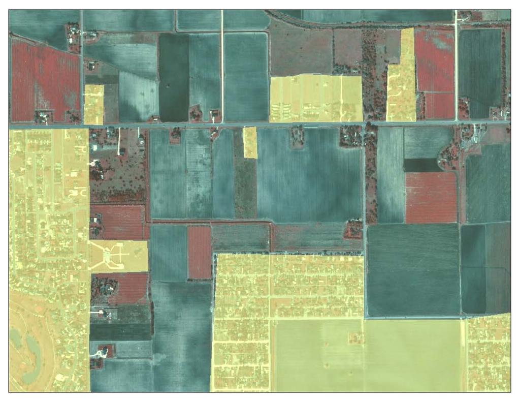
10 1996
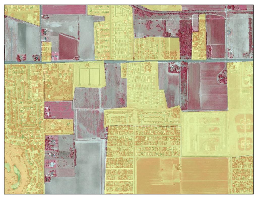
11 2006

12 Urbanization growth in irrigation Irrigation districts districts
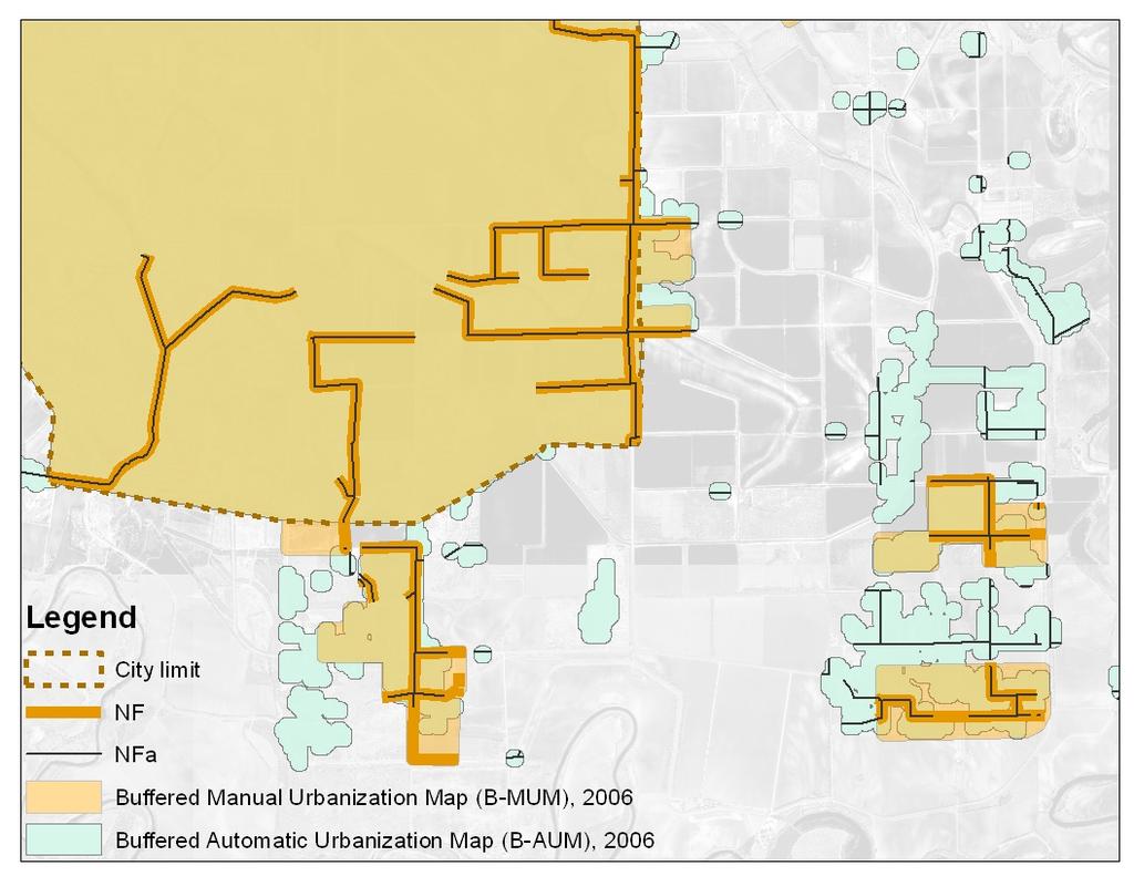
13 Overlap of urban area with water distribution network
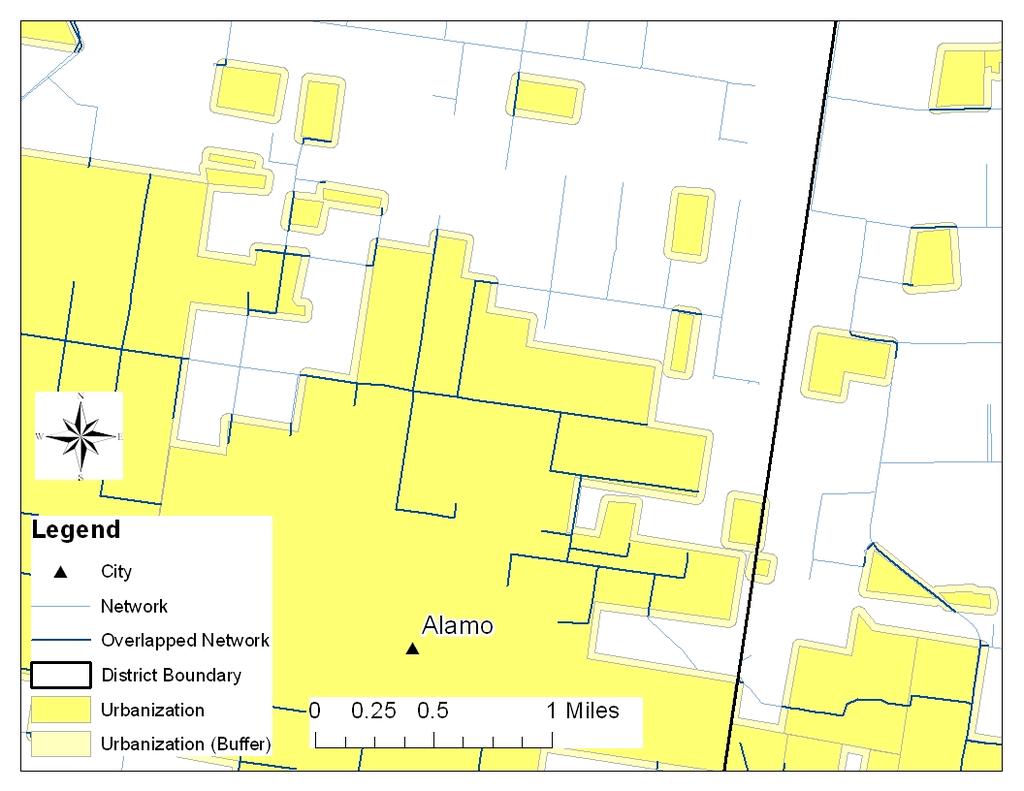
14

15 Overlap with water distribution network By county
16 Calculation of a Network Fragmentation Index

17 Overlap with water distribution network in 1996 and 2006, in the McAllen area
 17 fragments Normalization (NFI): 2.4/7.")
18 Network Fragmentation Index (NFI) Cell size: 0.2 mi Search radius: 1.5 mi (Search area: 7.1 mi 2 ) 17 fragments Normalization (NFI): 2.4/7.3 = 0.34

19 NFI and District Fragmentation Index (DFI) in 2006, in the Cameron, Hidalgo, and Willacy Counties
20 NEW METHODOLOGIES ANALYSIS
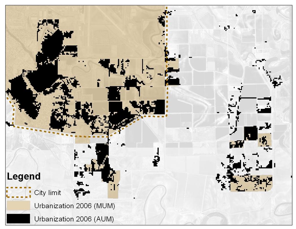
21 ANALYSIS - 1 Urban area identification with automatic procedures The most utilized automatic approaches in literature are Pixel-Oriented (PO) and Object- Oriented (OO) analysis In the last decade, several studies demonstrated that the OO method can give more accurate results We used the ecognition software
22
23
 using Automatic Urbanization maps")
24 Network Fragmentation Index (NFI) using Manual Urbanization maps (MUM) Network Fragmentation Index (NFIa) using Automatic Urbanization maps (AUM)
25 ANALYSIS - 2 Urban area categorization with the Morphological Segmentation Method The categories that are defined by the procedure are: Core, Edge, Perforation, Bridge, Loop, Branch, Islet We used the GUIDOS 1.3 software (Vogt, 2010)
26
 using")
27 Categorization map Adding weights to categories Network Fragmentation Index (NFIc) using Categorization maps
28 Network Fragmentation Index (NFIc) using Categorized Manual Urbanization Maps Network Fragmentation Index (NFI) using Manual Urbanization Maps
29 ANALYSIS - 3 Calculation of a NFI with a simplified procedure based on a probable number of Network Fragments (NF) We created an Urban Fragments Density Map by calculating the density of urban fragments We created a Network Density Map by calculating the density of canals and pipelines We combined the results to obtain the Network Potential Fragmentation Index and the District Potential Fragmentation Index

30 Urban Fragments Density Map using MUM Network Density Map Network Potential Fragmentation Index (NPFI)

31 Network Fragmentation Index (NFI) using Manual Urbanization Maps Network Potential Fragmentation Index (NPFI)

32 NPFI for different elements of the water distribution network in the year Circles show examples of differences Open canals and pipelines Only open canals
33 CONCLUSIONS
34 The two methodologies proposed for urban areas identification, manual and automatic, accurately identify urbanization. While the manual procedure required weeks of processing, the automatic one took only few days Interpretation of urban fragmentation dynamics was improved by using categories defining the type of urbanization. By assigning weights to such categories, we obtained a Network Fragmentation Index comparable to the one obtained from manual or automatic urbanization maps The set up of a simplified procedure to calculate impact of urbanization showed potential for application, even if analysis was based on probability of fragmentation rather than observations
35 RECOMMENDATIONS FOR FUTURE WORK Identify correlation between analysis results and observed impact on district operation, especially when applying weights to urbanization categories Identify which elements of the distribution network have more impact on district operation when fragmented (i.e. open canals, pipelines) Further evaluate the advantages in term of computation of automatic analysis Statistically evaluate goodness of predictions on urbanized area and network fragmentation
Methodologies for Analyzing Impact of Urbanization on Irrigation Districts Rio Grande Basin Initiative
 COLLEGE OF AGRICULTURE AND LIFE SCIENCES TR-419 2011 Methodologies for Analyzing Impact of Urbanization on Irrigation Districts Rio Grande Basin Initiative By Gabriele Bonaiti, Guy Fipps, P.E. Texas AgriLife
Rapid Intervention Program (RIP) to Improve Operational Management and Efficiencies in Irrigation Districts in Iraq
 to Improve Operational Management and Efficiencies in Irrigation Districts in Iraq") Rapid Intervention Program (RIP) to Improve Operational Management and Efficiencies in Irrigation Districts in Iraq USCID Water Management Conference Phoenix, Arizona April 17, 2013 Gabriele Bonaiti Extension
Rapid Intervention Program (RIP) to Improve Operational Management and Efficiencies in Irrigation Districts in Iraq USCID Water Management Conference Phoenix, Arizona April 17, 2013 Gabriele Bonaiti Extension
Yanbo Huang and Guy Fipps, P.E. 2. August 25, 2006
 Landsat Satellite Multi-Spectral Image Classification of Land Cover Change for GIS-Based Urbanization Analysis in Irrigation Districts: Evaluation in Low Rio Grande Valley 1 by Yanbo Huang and Guy Fipps,
The TexasET Network and Website User s Manual
 The TexasET Network and Website http://texaset.tamu.edu User s Manual By Charles Swanson and Guy Fipps 1 September 2013 Texas AgriLIFE Extension Service Texas A&M System 1 Extension Program Specialist;
Development of a Web-Based GIS Management System for Agricultural Authorities in Iraq
 Development of a Web-Based GIS Management System for Agricultural Authorities in Iraq USCID Water Management Conference Phoenix, Arizona April 18, 2013 Gabriele Bonaiti Extension Program Specialist David
HAZUS-MH: Earthquake Event Report
 HAZUS-MH: Earthquake Event Report Region Name: El Paso County Earthquake Scenario: El Paso County Random EQ Print Date: February 08, 2006 Disclaimer: The estimates of social and economic impacts contained
ISSUES AND APPROACHES TO COUPLING GIS TO AN IRRIGATION DISTRIBUTION NETWORK AND SEEPAGE LOSS MODELS ABSTRACT
 ISSUES AND APPROACHES TO COUPLING GIS TO AN IRRIGATION DISTRIBUTION NETWORK AND SEEPAGE LOSS MODELS Yanbo Huang 1, Milton Henry 2, David Flahive 3, Guy Fipps 4 ABSTRACT Geographic Information Systems (GIS)
ISSUES AND APPROACHES TO COUPLING GIS TO IRRIGATION DISTRIBUTION NETWORK AND SEEPAGE LOSS MODELS
 ISSUES AND APPROACHES TO COUPLING GIS TO IRRIGATION DISTRIBUTION NETWORK AND SEEPAGE LOSS MODELS Yanbo Huang 1 Milton Henry 2 David Flahive 3 Guy Fipps 4 ABSTRACT There are several possible approaches
The Road to Data in Baltimore
 Creating a parcel level database from high resolution imagery By Austin Troy and Weiqi Zhou University of Vermont, Rubenstein School of Natural Resources State and local planning agencies are increasingly
Schuyler County Idle Farmland Analysis. Conducted by Cornell Cooperative Extension of Schuyler County
 Schuyler County Idle Farmland Analysis Conducted by Cornell Cooperative Extension of Schuyler County June 15, 2010 Schuyler County Idle Farmland Analysis Purpose: The purpose of this analysis is to approximate
Butte County Board of Supervisors Agenda Transmittal
 Butte County Board of Supervisors Agenda Transmittal Clerk of the Board Use Only Agenda Item: 3.38 Subject: Resolution to Establish the Butte County Groundwater Sustainability Agency in the West Butte
Section B - Chapter 13 Neuse River Subbasin Bay River and Pamlico Sound
 Section B - Chapter 13 Neuse River Subbasin 3-4-13 Bay River and Pamlico Sound 13.1 Subbasin Overview Subbasin 3-4-13 at a Glance Land and Water Area Total area: 277 mi 2 Land area: 145 mi 2 Water area:
Developed new methodologies for mapping and characterizing suburban sprawl in the Northeastern Forests
 Development of Functional Ecological Indicators of Suburban Sprawl for the Northeastern Forest Landscape Principal Investigator: Austin Troy UVM, Rubenstein School of Environment and Natural Resources
TFMA Spring Conference Houston, Texas March 10, 2016 PROJECT TEAM:
 TFMA Spring Conference Houston, Texas March 10, 2016 PROJECT TEAM: Brown, Leal & Associates R. Gutierrez Engineering ERO Architects Administered by the Texas Water Development Board History of the Study
Borah Peak Earthquake HAZUS Scenario Project Executive Summary Idaho Bureau of Homeland Security Idaho Geological Survey Western States Seismic
 Borah Peak Earthquake HAZUS Scenario Project Executive Summary Idaho Bureau of Homeland Security Idaho Geological Survey Western States Seismic Policy Council 12/30/2008 The HAZUS-MH analysis of the Borah
Applying GIS to Hydraulic Analysis
 Texas A&M University Department of Civil Engineering CVEN689 Applications of GIS to Civil Engineering Instructor: Francisco Olivera, Ph.D., P.E. Applying GIS to Hydraulic Analysis Lim, Chae Kwan April
Final Group Project Paper. Where Should I Move: The Big Apple or The Lone Star State
 Final Group Project Paper Where Should I Move: The Big Apple or The Lone Star State By: Nathan Binder, Shannon Scolforo, Kristina Conste, Madison Quinones Main Goal: Determine whether New York or Texas
Wheat Outlook July 24, 2017 Volume 26, Number 44
 Today s Newsletter Market Situation Crop Progress 1 Weather 1 Grain Use 5 Market Situation Crop Progress. The U.S. spring wheat crop condition index this week is down only one point to 277 with 96% of
Victor Valley Community College District
 When beginning a redistricting process, one of the initial steps is to identify the communities of interest. As discussed in our earlier presentation, these can include characteristics of the population
If you aren t familiar with Geographical Information Systems (GIS), you. GIS, when combined with a database that stores response information,
, you. GIS, when combined with a database that stores response information,") Geographical Information Systems in EMS By William E. Ott If you aren t familiar with Geographical Information Systems (GIS), you should take a look at what GIS can offer you as an EMS manager. GIS, when
Geographical Information Systems in EMS By William E. Ott If you aren t familiar with Geographical Information Systems (GIS), you should take a look at what GIS can offer you as an EMS manager. GIS, when
KENTUCKY HAZARD MITIGATION PLAN RISK ASSESSMENT
 KENTUCKY HAZARD MITIGATION PLAN RISK ASSESSMENT Presentation Outline Development of the 2013 State Hazard Mitigation Plan Risk Assessment Determining risk assessment scale Census Data Aggregation Levels
NC Streambed Mapping Project Issue Paper
 ISSUE 1: The Western North Carolina Drainage Area Requirement Issue Several inquiries and discussions in regard to the determination of the 6-acre drainage area requirement as the upstream limit have been
TWINNING CONTRACT. Development of New Statistical Methodologies and Indicators in Selected Areas of Statistics in line with EU Statistical Standards
 TWINNING CONTRACT Development of New Statistical Methodologies and Indicators in Selected Areas of Statistics in line with EU Statistical Standards Ukraine MISSION REPORT on participation in the study
Descriptions and Performance
 LSU AgCenter Coastal Plants Program Smooth Cordgrass Varieties: Descriptions and Performance Smooth cordgrass (Spartina alterniflora Loisel.) is a perennial grass native to intertidal saline marshes along
Numerical processing of sunspot images using the digitized Royal Greenwich Observatory Archive
 Numerical processing of sunspot images using the digitized Royal Greenwich Observatory Archive Andrey Tlatov 1 and Vladimir Ershov 2 1 Kislovodsk Mountain Solar Station,Pulkovo observatory 2 Mullard Space
MAPPING AND ANALYSIS OF FRAGMENTATION IN SOUTHEASTERN NEW HAMPSHIRE
 MAPPING AND ANALYSIS OF FRAGMENTATION IN SOUTHEASTERN NEW HAMPSHIRE Meghan Graham MacLean, PhD Student Dr. Russell G. Congalton, Professor Department of Natural Resources & the Environment, University
INTRODUCTION TO GEOGRAPHIC INFORMATION SYSTEM By Reshma H. Patil
 INTRODUCTION TO GEOGRAPHIC INFORMATION SYSTEM By Reshma H. Patil ABSTRACT:- The geographical information system (GIS) is Computer system for capturing, storing, querying analyzing, and displaying geospatial
Request for Empanelment
 Request for Empanelment (Empanelment is method/procedure/way to seek technical & financial or financial quotation from eligible firm/organization/academic institute to short list eligible contender for
OREGON POPULATION FORECAST PROGRAM
 OREGON POPULATION FORECAST PROGRAM PROGRAM OVERVIEW BACKGROUND Beginning in 1973 with the passage of Senate Bill (SB) 100, Oregon s growth management system has relied on population forecasts as the primary
Cripps Ranch 76+/- Acres Orchard Development Opportunity Dixon, CA. Presented By:
 Cripps Ranch 76+/- Acres Orchard Development Opportunity Dixon, CA Presented By: Cripps Ranch 76+/- Acres Orchard Development Opportunity Dixon, CA Location: This property is located at 5663 Dally Road
Development of wind rose diagrams for Kadapa region of Rayalaseema
 International Journal of ChemTech Research CODEN (USA): IJCRGG ISSN: 0974-4290 Vol.9, No.02 pp 60-64, 2016 Development of wind rose diagrams for Kadapa region of Rayalaseema Anil Kumar Reddy ChammiReddy
Department Mission: Non-Mandated Services: TITLE 33
 Department: Veterans FY 2019 Proposed Budget Department Mission: To give aid and assistance to any veteran, the spouse or dependents of the veteran or the survivors of the veteran in applying for all benefits
Seismic Hazard Analysis along the State Water Project California Department of Water Resources
 Seismic Hazard Analysis along the State Water Project California Department of Water Resources ATC-USGS NSHMP User-Needs Workshop September 21-22, 2015 USGS Menlo Park Don Hoirup, CEG 2270 Senior Engineering
Summary Description Municipality of Anchorage. Anchorage Coastal Resource Atlas Project
 Summary Description Municipality of Anchorage Anchorage Coastal Resource Atlas Project By: Thede Tobish, MOA Planner; and Charlie Barnwell, MOA GIS Manager Introduction Local governments often struggle
Automated Identification and Characterization of Landforms on Mars
 Automated Identification and Characterization of Landforms on Mars Tomasz F. Stepinski Lunar and Planetary Institute Collaborators: Wei Luo Students: Brain Bue Ian Molloy Erik Urbach Michael Mendenhall
Chippewa County Natural Hazards Mitigation Plan
 2014 Chippewa County Natural Hazards Mitigation Plan Prepared for: Chippewa County Office of Emergency Management With the Assistance of: Eastern U.P. Regional Planning & Development Commission April,
GIS Adoption. Obstacles and Challenges
 GIS Adoption in Saudi Arabia: Obstacles and Challenges By Dr. Baqer Al-Ramadan, Chairman, Architectural Engineering Department King Fahd University of Petroleum and Minerals Dhahran, Saudi Arabia E-mail:
Estimation of Average Daily Traffic (ADT) Using Short - Duration Volume Counts
 Using Short - Duration Volume Counts") Estimation of Average Daily Traffic (ADT) Using Short - Duration Volume Counts M.D.D.V. Meegahapola 1, R.D.S.M. Ranamuka 1 and I.M.S. Sathyaprasad 1 1 Department of Civil Engineering Faculty of Engineering
Estimation of Average Daily Traffic (ADT) Using Short - Duration Volume Counts M.D.D.V. Meegahapola 1, R.D.S.M. Ranamuka 1 and I.M.S. Sathyaprasad 1 1 Department of Civil Engineering Faculty of Engineering
Drought Monitoring Capability of the Oklahoma Mesonet. Gary McManus Oklahoma Climatological Survey Oklahoma Mesonet
 Drought Monitoring Capability of the Oklahoma Mesonet Gary McManus Oklahoma Climatological Survey Oklahoma Mesonet Mesonet History Commissioned in 1994 Atmospheric measurements with 5-minute resolution,
NCTCOG GIS File Locations
 Boundaries Area Codes k:\bnd\region\area_codes.shp Area Type k:\bnd\region\areatype.shp Ciry Centroids (World) k:\bnd\usa_world\cities.shp City Centroids (NCTCOG Region) k:\bnd\region\city_point.shp vector.vector.bnd_city_point
Esri Image & Mapping Forum 9 July 2017 Geiger-Mode for Conservation Planning & Design by USDA NRCS NGCE
 Esri Image & Mapping Forum 9 July 2017 Geiger-Mode for Conservation Planning & Design by USDA NRCS NGCE For over 75 years, the Natural Resources Conservation Service has been a pioneer in conservation,
LiDAR User Data Needs Survey Results
 LiDAR User Data Needs Survey Results June 2012 Introduction The Minnesota Geospatial Information Office (MnGeo) is working with the Minnesota Department of Natural Resources (DNR) to develop a data distribution
Quarterly Report April 1 - June 30, By: Shirley P. Dutton. Work Performed Under Contract No.: DE-FC22-95BC14936
 DE-FC22-95BC14936--18 Application of Advanced Reservoir Characterization, Simulation, and Production Optimization Strategies to Maximize Recovery in Slope, and Basin Clastic Reservoirs, West Texas (Delaware
Assessing and planning the human settlement system in Slovenia: a preliminary report Dr. David Bole, Dr. Janez Nared, Dr.
 Assessing and planning the human settlement system in Slovenia: a preliminary report Dr. David Bole, Dr. Janez Nared, Dr. Jani Kozina Research center of the Slovenian Academy of Sciences and Arts Anton
Graphs. COMPSCI 355 Fall 2016
 Graphs COMPSCI 355 Fall 26 Bridges of Königsberg Four Color Problem Graph A set of objects called nodes or vertices. A binary relation (edges) on nodes. Adjacent nodes are related by an edge. 3 4 A path
Smart City Governance for effective urban governance. David Ludlow Assoc. Professor European Smart Cities University of the West of England, Bristol
 Smart City Governance for effective urban governance David Ludlow Assoc. Professor European Smart Cities University of the West of England, Bristol Complexities of urban territorial governance Complexities
Information System Design IT60105
 Information System Design IT60105 Lecture 19 Project Planning Lecture #19 ISD Project Planning SPMP Documentation System Design Models 2 Why Planning Information System Design? Program vs. Software Size
Traffic Impact Study
 Traffic Impact Study Statham DRI One University Parkway Prepared for: Barrow County Prepared by: October 2012 Table of Contents Executive Summary i Section 1. Introduction 1 Project Description 1 Methodology
Strategic Mapping Program (StratMap)
") Capital Area Orthoimagery Interest Meeting GeoMap to StratMap GIS Planning Council Friday, Apr 28, 2017 Strategic Mapping Program (StratMap) Geographic Data Acquisition Solutions for Texas Strategic Mapping
Capital Area Orthoimagery Interest Meeting GeoMap to StratMap GIS Planning Council Friday, Apr 28, 2017 Strategic Mapping Program (StratMap) Geographic Data Acquisition Solutions for Texas Strategic Mapping
Planning for Sea Level Rise in the Matanzas Basin
 Planning for Sea Level Rise in the Matanzas Basin Appendix E: Matanzas Future Development Scenarios June, 2015 Prepared by: Dr. Paul Zwick University of Florida Department of Urban and Regional Planning
Weather Modification Activities in the Colorado River Basin. Mohammed Mahmoud
 Weather Modification Activities in the Colorado River Basin Mohammed Mahmoud Historical Information Authorized by 1968 Basin Project Act Substantially completed in 1993 Responsible for repaying reimbursable
TXWARN Tabletop Exercise: Hurricane Helen
 TXWARN Tabletop Exercise: Hurricane Helen July 31, 2015 Administrative Details In-studio participants and remote participants Situation manual Evaluations Training hours 1 In Studio: Welcome and Introductions
THE COMMUNITY COLLABORATIVE RAIN, HAIL AND SNOW NETWORK (COCORAHS) A GREAT WAY TO LEARN AND TEACH ABOUT OUR CLIMATE
 A GREAT WAY TO LEARN AND TEACH ABOUT OUR CLIMATE") J2.2 THE COMMUNITY COLLABORATIVE RAIN, HAIL AND SNOW NETWORK (COCORAHS) A GREAT WAY TO LEARN AND TEACH ABOUT OUR CLIMATE Henry W. Reges*, Robert C. Cifelli, and Nolan J. Doesken. CoCoRaHS/Colorado State
J2.2 THE COMMUNITY COLLABORATIVE RAIN, HAIL AND SNOW NETWORK (COCORAHS) A GREAT WAY TO LEARN AND TEACH ABOUT OUR CLIMATE Henry W. Reges*, Robert C. Cifelli, and Nolan J. Doesken. CoCoRaHS/Colorado State
Drought. Jeffrey Lindner Meteorologist Harris County Flood Control District September 20, 2011
 2010-2011 Drought Jeffrey Lindner Meteorologist Harris County Flood Control District September 20, 2011 Texas Annual Rainfall Texas Annual Rainfall 1895-2010 Texas Annual Temperature 1895-2010 Notice Any
Customer Premise Information Lookup Mapping With ArcGIS Online Jamie Patterson Senior GIS Technician
 Customer Premise Information Lookup Mapping With ArcGIS Online Jamie Patterson Senior GIS Technician January 19, 2016 Bio Jamie Patterson: ASU M.A. in Geography, 2008 10 years in the GIS industry Sr.
Introduction. Project Summary In 2014 multiple local Otsego county agencies, Otsego County Soil and Water
 Introduction Project Summary In 2014 multiple local Otsego county agencies, Otsego County Soil and Water Conservation District (SWCD), the Otsego County Planning Department (OPD), and the Otsego County
REMOTE SENSING AND GEOSPATIAL APPLICATIONS FOR WATERSHED DELINEATION
 REMOTE SENSING AND GEOSPATIAL APPLICATIONS FOR WATERSHED DELINEATION Gaurav Savant (gaurav@engr.msstate.edu) Research Assistant, Department of Civil Engineering, Lei Wang (lw4@ra.msstate.edu) Research
Reminder that we update the website: with new information, project updates, etc.
 1 Reminder that we update the website: http://www.njfishandwildlife.com/ensp/connectivity_proj.htm with new information, project updates, etc. regularly. Any suggestions are welcome on how to make the
APPLICATION OF SIMULATION MODELING TO EMERGENCY POPULATION EVACUATION. Kambiz Farahmand
 APPLICATION OF SIMULATION MODELING TO EMERGENCY POPULATION EVACUATION Kambiz Farahmand Texas A&M University-Kingsville Department of Mechanical & Industrial Engineering Campus Box 191 Kingsville, Texas
THE TRINITY RIVER VISION/ GATEWAY PARK / PANTHER ISLAND
 Quarterly Project Status Report May 2018 THE TRINITY RIVER VISION/ GATEWAY PARK / PANTHER ISLAND Flood Control Project Update Construction of North Main Street Bridge by TxDOT s bridge contractor, Texas
Template for Sediment and Erosion Control Plan General Instructions. Section Instructions
 Template for Sediment and Erosion Control Plan General Instructions Introduction: Soil erosion and sediment deposition from farmlands can contribute to degraded surface water quality. Sediment delivery
Weather versus Climate: What is the difference? Sources of Weather Information
 Joel O. Paz, Extension Agrometerologist and Gerrit Hoogenboom, Professor & REI Coordinator Department of Biological and Agricultural Engineering Weather versus Climate: What is the difference? The difference
RECENT DECLINE IN WATER BODIES IN KOLKATA AND SURROUNDINGS Subhanil Guha Department of Geography, Dinabandhu Andrews College, Kolkata, West Bengal
 International Journal of Science, Environment and Technology, Vol. 5, No 3, 2016, 1083 1091 ISSN 2278-3687 (O) 2277-663X (P) RECENT DECLINE IN WATER BODIES IN KOLKATA AND SURROUNDINGS Subhanil Guha Department
Agricultural Land Use Projections for the Pacific Northwest: A Summary and Review
 ) 5.2 19 7C Agricultural Land Use Projections for the Pacific Northwest: A Summary and Review Special Report 579 April 1980 Oregon State University Extension Service AGRICULTURAL LAND USE PROJECTIONS FOR
RURAL SETTLEMENT PATTERNS AND ACCESS TO DEVELOPMENT LAND: DEVELOPING THE EVIDENCE BASE
 School of Planning, Architecture and Civil Engineering RURAL SETTLEMENT PATTERNS AND ACCESS TO DEVELOPMENT LAND: DEVELOPING THE EVIDENCE BASE Prepared for Friends of the Earth Northern Ireland 18 th April
Trip Distribution Review and Recommendations
 Trip Distribution Review and Recommendations presented to MTF Model Advancement Committee presented by Ken Kaltenbach The Corradino Group November 9, 2009 1 Purpose Review trip distribution procedures
REQUEST FOR PROPOSALS CLOSING DATE:
 Request for Proposals 110 Westlake Drive City of West Lake Hills 110 Westlake Drive REQUEST FOR PROPOSALS CLOSING DATE: Tuesday, October 23, 2018 City of West Lake Hills Request for Proposals 1 I. INTRODUCTION
Urban Growth Analysis: Calculating Metrics to Quantify Urban Sprawl
 Urban Growth Analysis: Calculating Metrics to Quantify Urban Sprawl Jason Parent jason.parent@uconn.edu Academic Assistant GIS Analyst Daniel Civco Professor of Geomatics Center for Land Use Education
Hunter Water S170 Register
 SHI No.: 3630118 Location Name: No address Description: is an open canal cut into the surrounding pasture land with earthen embankments at the sides. It connects to the Williams River through concrete
THE TRINITY RIVER VISION/ GATEWAY PARK / PANTHER ISLAND Flood Control Project Update
 Quarterly Project Status Report September 2018 THE TRINITY RIVER VISION/ GATEWAY PARK / PANTHER ISLAND Flood Control Project Update TxDot s contractor has nearly completed the superstructure false work
Regional Performance Measures
 G Performance Measures Regional Performance Measures Introduction This appendix highlights the performance of the MTP/SCS for 2035. The performance of the Revenue Constrained network also is compared to
GROUNDWATER CONFIGURATION IN THE UPPER CATCHMENT OF MEGHADRIGEDDA RESERVOIR, VISAKHAPATNAM DISTRICT, ANDHRA PRADESH
 GROUNDWATER CONFIGURATION IN THE UPPER CATCHMENT OF MEGHADRIGEDDA RESERVOIR, VISAKHAPATNAM DISTRICT, ANDHRA PRADESH Prof.P.Jagadeesara Rao Department of Geo-Engineering and Centre for Remote Sensing, College
DESIGN AND IMPLEMENTATION OF OBJECT-ORIENTED COMPUTER SOFTWARE TO SOLVE SECOND ORDER ORDINARY DIFFERENTIAL EQUATIONS WITH CONSTANT COEFFICIENTS
 DESIGN AND IMPLEMENTATION OF OBJECT-ORIENTED COMPUTER SOFTWARE TO SOLVE SECOND ORDER ORDINARY DIFFERENTIAL EQUATIONS WITH CONSTANT COEFFICIENTS Atsa am, D. D., Department of Mathematics/Statistics/Computer
An Internet-Based Integrated Resource Management System (IRMS)
") An Internet-Based Integrated Resource Management System (IRMS) Third Quarter Report, Year II 4/1/2000 6/30/2000 Prepared for Missouri Department of Natural Resources Missouri Department of Conservation
An Internet-Based Integrated Resource Management System (IRMS) Third Quarter Report, Year II 4/1/2000 6/30/2000 Prepared for Missouri Department of Natural Resources Missouri Department of Conservation
Noel M. Estwick College of Agriculture and Human Sciences, Prairie View A&M University, Prairie View, Texas
 Exploring the use of GIS as a tool for rainfall analysis Noel M. Estwick College of Agriculture and Human Sciences, Prairie View A&M University, Prairie View, Texas Abstract This paper examines and evaluates
IncuCyte ZOOM NeuroTrack Fluorescent Processing
 IncuCyte ZOOM NeuroTrack Fluorescent Processing The NeuroTrack TM Software Module (Cat No 9600-0011) is used to measure the processes of neurons in monoculture or with fluorescent labeling in co-culture.
Analysis of Meteorological drought condition for Bijapur region in the lower Bhima basin, India
 Analysis of Meteorological drought condition for Bijapur region in the lower Bhima basin, India Mamatha.K PG Student Department of WLM branch VTU, Belagavi Dr. Nagaraj Patil Professor and Head of the Department
New Land Cover & Land Use Data for the Chesapeake Bay Watershed
 New Land Cover & Land Use Data for the Chesapeake Bay Watershed Why? The Chesapeake Bay Program (CBP) partnership is in the process of improving and refining the Phase 6 suite of models used to inform
IDAWRA: Groundwater-flow model for the Wood River Valley aquifer system, south-central Idaho February 1, 2017, 11:30-1:00
 Idaho Section of the American Water Resources Association IDAWRA: Groundwater-flow model for the Wood River Valley aquifer system, south-central Idaho A three-dimensional numerical model of groundwater
SORT ORDER: SUBOBJ within CATEGORY within KEY within DEPTMNT within FUND SELECT DEPARTMENT: 2930,3450 ; BUDG CATEGORY:
 **IFAS - SOLANO COUNTY** 01/31/14 M O N T H L Y D E T A I L 58% of Fiscal Year Page 1 001 GENERAL FUND 2930 LAFCO 2930 LAFCO Dept Total - Revenue 0.00 0.00 0.00 0.00 0.00 Dept Total - Expense 0.00 0.00
Smooth Cordgrass Varieties. Description and Performance
 Smooth Cordgrass Varieties Description and Performance Smooth cordgrass (Spartina alterniflora Loisel.) is a perennial grass native to intertidal saline marshes along the Gulf of Mexico and Atlantic coasts.
DRAFT. REVISED Draft. Paso Robles Subbasin Groundwater Sustainability Plan Chapter 6
 REVISED Draft Paso Robles Subbasin Groundwater Sustainability Plan Chapter 6 Prepared for the Paso Robles Subbasin Cooperative Committee and the Groundwater Sustainability Agencies February 14, 2019 Paso
Forecasts for the Reston/Dulles Rail Corridor and Route 28 Corridor 2010 to 2050
 George Mason University Center for Regional Analysis Forecasts for the Reston/Dulles Rail Corridor and Route 28 Corridor 21 to 25 Prepared for the Fairfax County Department of Planning and Zoning Lisa
Environmental Geology Lab 6 Coastal Hazards. Tropical cyclones are classified based on substained wind speed as indicated below.
 Environmental Geology Lab 6 Coastal Hazards page - 1 In the continental United States there are two fundamental types of shorelines. Tectonically passive margins that have low relief and consist of smooth
Test 2 Review Math 1111 College Algebra
 Test 2 Review Math 1111 College Algebra 1. Begin by graphing the standard quadratic function f(x) = x 2. Then use transformations of this graph to graph the given function. g(x) = x 2 + 2 *a. b. c. d.
Excel Geomatics. Rajesh Paul Excel Geomatics Pvt. Ltd., Noida February, 2015 India Geospatial Forum, Hyderabad
 Excel Geomatics Geo-marketing for Product Sales and Customer Services Rajesh Paul Excel Geomatics Pvt. Ltd., Noida 10-12 February, 2015 India Geospatial Forum, Hyderabad Presentation Outline About Excel
Road Surface Condition Analysis from Web Camera Images and Weather data. Torgeir Vaa (SVV), Terje Moen (SINTEF), Junyong You (CMR), Jeremy Cook (CMR)
, Terje Moen (SINTEF), Junyong You (CMR), Jeremy Cook (CMR)") Road Surface Condition Analysis from Web Camera Images and Weather data Torgeir Vaa (SVV), Terje Moen (SINTEF), Junyong You (CMR), Jeremy Cook (CMR) Motivation Cameras installed along roads for surface
Road Surface Condition Analysis from Web Camera Images and Weather data Torgeir Vaa (SVV), Terje Moen (SINTEF), Junyong You (CMR), Jeremy Cook (CMR) Motivation Cameras installed along roads for surface
KING FAHD UNIVERSITY OF PETROLEUM & MINERALS
 KING FAHD UNIVERSITY OF PETROLEUM & MINERALS Department of City & Regional Planning Introduction To GIS (CRP 514) Identifying & Planning Public School Facility In California Using GIS Presented to Dr.
ICIMOD Responding to Mountain Challenges in the Hindu Kush- Himalayas
 ICIMOD Responding to Mountain Challenges in the Hindu Kush- Himalayas Eklabya Sharma International Centre for Integrated Mountain Development Kathmandu, Nepal Regional Intergovernmental Learning and Knowledge
GIS BASED ANALYSIS OF EXPRESS VS LOCAL STATIONS ON SURROUNDING LAND USES IN NEW YORK CITY
 GIS BASED ANALYSIS OF EXPRESS VS LOCAL STATIONS ON SURROUNDING LAND USES IN NEW YORK CITY GIS in Transit Conference, Washington D.C Date: September 2, 2015 1 Subrina Rahman Supervised by Dr. Candace Brakewood
Producing Chandler Walnut Orchard
 AG-LAND Investment Brokers 275 Sale Lane Red Bluff, CA 96080 530-529-4400 Fax 530-527-5042 Producing Chandler Walnut Orchard West Sacramento Avenue - Chico, CA AG-LAND INVESTMENT BROKERS 275 Sale Lane
President s Day Weekend Storm Community Meeting and Workshop April 17, 2017
 President s Day Weekend Storm Community Meeting and Workshop April 17, 2017 Meeting outline 1. Progress update on the City of San Jose s recovery efforts 2. Water district presentation on: Weather situation
Chapter 5 CALIBRATION AND VERIFICATION
 Chapter 5 CALIBRATION AND VERIFICATION This chapter contains the calibration procedure and data used for the LSC existing conditions model. The goal of the calibration effort was to develop a hydraulic
GEOGRAPHY. Parts/Units Topics Marks. Part A Fundamentals of Human Geography 35. Map Work 5. Part B India: People and Economy 35
 GEOGRAPHY Course Structure Parts/Units Topics Marks Part A Fundamentals of Human Geography 35 Unit 1 Unit 2 Unit 3 Unit 4 Unit 5 Human Geography People Human Activities Transport, Communication & Trade
SIXTEENTH CONFERENCE ON CLIMATE VARIABILITY AND CHANGE
 SIXTEENTH CONFERENCE ON CLIMATE VARIABILITY AND CHANGE P1.23 CENTRAL CALIFORNIA: OPPOSING TEMPERATURE TRENDS VALLEY VS. MOUNTAINS John R. Christy and William B. Norris University of Alabama in Huntsville,
The MRCC and Monitoring Drought in the Midwest
 The and Monitoring Drought in the Midwest Steve Hilberg Director, Illinois State Water Survey Prairie Research Institute, University of Illinois The A partner of a national climate service program that
Flood Event Analysis to Estimate the Avoided Damages Due to Flood Improvement Projects & Voluntary Buyout Program
 Flood Event Analysis to Estimate the Avoided Damages Due to Flood Improvement Projects & Voluntary Buyout Program Ataul Hannan, P.E., CFM Planning Division Director Harris County Flood Control District
2007 Area Source Emissions Inventory Methodology 670 RANGE IMPROVEMENT
 San Joaquin Valley AIR POLLUTION CONTROL DISTRICT 2007 Area Source Emissions Inventory Methodology 670 RANGE IMPROVEMENT I. Purpose This document describes the Area Source Methodology used to estimate
An Internet-based Agricultural Land Use Trends Visualization System (AgLuT)
") An Internet-based Agricultural Land Use Trends Visualization System (AgLuT) Prepared for Missouri Department of Natural Resources Missouri Department of Conservation 07-01-2000-12-31-2001 Submitted by
An Internet-based Agricultural Land Use Trends Visualization System (AgLuT) Prepared for Missouri Department of Natural Resources Missouri Department of Conservation 07-01-2000-12-31-2001 Submitted by
Lower Tuolumne River Accretion (La Grange to Modesto) Estimated daily flows ( ) for the Operations Model Don Pedro Project Relicensing
 Estimated daily flows ( ) for the Operations Model Don Pedro Project Relicensing") Lower Tuolumne River Accretion (La Grange to Modesto) Estimated daily flows (1970-2010) for the Operations Model Don Pedro Project Relicensing 1.0 Objective Using available data, develop a daily time series
Lower Tuolumne River Accretion (La Grange to Modesto) Estimated daily flows (1970-2010) for the Operations Model Don Pedro Project Relicensing 1.0 Objective Using available data, develop a daily time series