Disaster Risk Reduction in UNESCO
|
|
|
- Clinton Summers
- 5 years ago
- Views:
Transcription
1 APAN 44, MasterClass on Disaster Mitigation (30 August 2017, Dalian, China) Disaster Risk Reduction in UNESCO Dr Ai Sugiura Programme Specialist in Science Policy and Capacity Building UNESCO Office, Jakarta 1
2 Overview 1. Definition of DRR 2. Disasters in Asia and the Pacific Region 3. The Global context for DRR 4. UNESCO Regional Science Bureau for Asia and the Pacific mandate 5. UNESCO programmes in DRR 2
 aims to reduce the damage caused by natural hazards like earthquakes, floods, droughts and cyclones, through an ethic of prevention.")

3 1. Definition of DRR Risk = f( Hazard, Exposure, Vulnerability) DISASTER RISK REDUCTION (DRR) There is no such thing as a 'natural' disaster, only natural hazards. Disaster Risk Reduction (DRR) aims to reduce the damage caused by natural hazards like earthquakes, floods, droughts and cyclones, through an ethic of prevention. Disaster risk reduction is the concept and practice of reducing disaster risks through systematic efforts to analyse and reduce the causal factors of disasters. Reducing exposure to hazards, lessening vulnerability of people and property, wise management of land and the environment, and improving preparedness and early warning for adverse events are all examples of disaster risk reduction. ( 3

4 2. Disasters in AP region FACTS BETWEEN 2005 TO Over 40% of the 3,979 disasters that occurred globally occurred in the AP region. - Resulting in the loss of half a million people - Representing almost 60% of the total global deaths related to disasters - More than 1.4billion people were affected by these disasters - Constituting 80% of those affected globally - Severe economic damage of more than half a trillion USD over the same period. Source: Disasters without Border Regional Resilience for SD, UNESCAP,


5 3. The Global Context


6 3. The Global Context

7 3. The Global Context

8 Sustainable Development Goals ENABLERS The logical flow 169 proposed targets 304 proposed indicators 10 Goals related to DRR Life resources The absolute needs Condition number 1 for development Issues to be solved Global issues SDGs Logical Flow, Prof. Kamarulazizi Ibrahim (USM, Malaysia)


9 4. UNESCO Regional Science Bureau for Asia and the Pacific Linking Global and Regional Medium Term Strategic Objectives R&D, Capacity Building, Training, Networking, and Policy Advice
10 MISSION as the regional sciences bureau for Asia and the Pacific The Bureau will carry out the following mission: To work with Member States on key issues and problems in Asia-Pacific region, in order to engage sciences in the service of human needs and improve both environment and quality of life of the region s people. To mobilize science, technology, innovation and policy, for enabling Member States in the region on addressing new and emerging challenges that could facilitate to set a course for a sustainable future.
11 5. UNESCO DRR related Programmes A. Geohazard Risk Reduction (IGGP) B. Water-related Hazards (IHP) C. Tsunami Programme (IOC) D. School Safety (DRR) E. Disaster Risk Reduction in UNESCO designated sites (MAB, WH) F. Crisis and Transition Responses 11

12 Natural Hazards in UNESCO designated sites (2015 survey) 89% of all Biosphere Reserves, 82% of UNESCO Global Geoparks and 96% of World Heritage sites are potentially exposed to at least one type of natural hazard that may turn into a disaster and threaten a site s integrity (2015) 12


13 Natural Sciences Programmes International Science Programmes and Initiatives + UNESCO s initiatives International Geoparks and Geoscience Programme Sustainability Science 13

14 A. Geohazard Risk Reduction International Geoparks and Geosciences Programme : UNESCO Global Geopark Geopark : single, unified geographical areas where sites and landscapes of international geological significance are managed with a holistic concept of protection, education and sustainable development. Their bottom-up approach of combining conservation with sustainable development while involving local communities is becoming increasingly popular. Natural Resources Geological Hazards Geopark is a territorial entity focusing Climate on : Change Natural Education Resources Geological Science Hazards (volcanoes, earthquake, Culture water-related) Climate Change WomenSustainable Development Education Science Local and indigenous Knowledge Geo-conservation Culture Women Sustainable Development Local and indigenous Knowledge Geo-conservation 14
 3. Partnership for Environment and Disaster Risk Reduction (PEDRR) 4. Reducing Earthquake Losses (REL) 5.")
15 International Geoparks and Geoscience Programme Networks in geoharzard risk reduction: 35 UNESCO Global Geoparks in China 1. International Consortium on Landslides (ICL) 2. International Platform for Reducing Earthquake Disaster (IPRED) 3. Partnership for Environment and Disaster Risk Reduction (PEDRR) 4. Reducing Earthquake Losses (REL) 5. Global Alliance for Disaster Risk Reduction and Resilience in the Education Sector (GADRRRES) Geoparks (50 in 7 countries in the region) Aspiring Geopark (in CA, SA) UNESCO Category 2 centre (2 in China) 15


16 B. Water-related Hazards (IHP) UNESCO s Intergovernmental Scientific Cooperative Programme in Hydrology and Water Resources since 1975 UNESCO INTERNATIONAL HYDROLOGICAL PROGRAMME EIGHT PHASE ( ) UNESCO-IHP-VIII: WATER SECURITY Responses to Local, Regional, and Global Challenges Risk management as adaptation to global changes Understanding coupled human and natural processes Benefiting from global and local earth observation systems Addressing uncertainty and improving its communication Improving the scientific basis to extreme hydrological events 16


17 UNESCO-IHP in the Asia Pacific Region 27 IHP National Committees 6 UNESCO Water Centres among 15 Science Centres 6 UNESCO Water Chairs among 28 Science Chairs in the Asia Pacific Region. Regional Steering Committee for Southeast Asia and the Pacific. International Flood Initiative Secretariat International Drought Initiative Secretariat Ecohydrology Regulation of biota by altering hydrology and regulation of hydrology by shaping biota (Zawleski approach) HELP river basins RESEARCH POLICY ADVICE IWRM spiral approach CAPACITY BUILDING 17

 affected Introduction of Mr Aziz Aimaq,")


18 Ongoing JICA funded project Strategic Strengthening of Flood Warning and Management Capacity of Pakistan- Phase 2 64% of the territory flooded 1/9 of the pop (20million) affected Introduction of Mr Aziz Aimaq, director ANDMA and Mr Farhad Nayyer, Modeller MEW Afghanistan to Mr Riaz, Chief Meteorologist, FFD in presence of ICHARM (Mr Iwami, Dr Tsuda), 22 April weebly.com/ A. Establishment of the technical foundation for sustainable capacity development on the flood management, forecasting, early warning and flood hazard analysis in Pakistan agencies B. Technical studies to promote strengthening of cooperation with Indus river basin countries for transboundary flood management and transboundary data sharing C. Capacity building and education to community on flood management for proper utilization of flood hazard information and tools
19 C. Tsunami Programme (IOC) The IOC Tsunami Programme aims at reducing the loss of lives and livelihoods that could be produced worldwide by tsunamis. In order to accomplish this, the IOC Tsunami Unit supports IOC Member States in assessing tsunami risk, implementing Tsunami Early Warning Systems (EWS) and in educating communities at risk about preparedness measures. In order to implement effective preventive measures, communities need to be aware of the risk they face. Tsunami risk assessment includes the evaluation of the hazard and the levels of vulnerability of coastal communities. Hazard assessment encompasses the identification of the probability of occurrence of a tsunami based on the identification of possible tsunami sources and the evaluation of historical data. On the other hand, vulnerability assessment aims at identifying the pre-existing physical, social, economical and environmental conditions that make a zone susceptible of suffering important losses and damages. This information is essential for setting up disaster management strategies. Session 3 : Water-disaster Related Initiatives in UNESCO - IFI and IDI Tsunami IOC: Remote Presentation Ardito Kodijat, Intergovernmental Oceanographic Commission of UNESCO Jakarta (IOC-UNESCO), Indonesia 19


,")
20 D. School Safety (DRR) VISUS (Visual Inspection for defining the Safety Upgrading Strategies). Multi-hazard school safety assessment methodology and tools through science-based information The VISUS methodology is based on a technical engineering approach that can be used by engineering students and building construction vocational students to assist the government Session 4 : to UNESCO better prioritize disaster safer risk school reduction programs initiativestsunami IOC: Remote Presentation their region. VISUS methodology The method (Visual aims Inspection to help for policy defining makers the Safety Upgrading Strategies) for school safety in (Remote deciding Presentation) where to focus their risk Ardito Kodijat, Intergovernmental reduction efforts Oceanographic and interventions Commission of UNESCO Jakarta (IOC-UNESCO), Indonesia based on available resources and scientific-evidence information.
21 E. Disaster Risk Reduction in UNESCO designated sites (MAB, WH) 21


22 Man and the Biosphere Programme China Biosphere Reserve Network (CBRN) 33 registered Biosphere Reserves
23 Man and the Biosphere Programme Lima Action Plan ( ) Strategic Action Area A. The World Network of Biosphere Reserves consisting of effectively functioning models for sustainable Development A1.4. Use BRs as priority sites/observatories for climate change research, monitoring, mitigation and adaptation, including in support of the UNFCCC COP21 Paris Agreement
 142 BRs in 24 countries (2016) 4 Networks: EABRN SACAM SeaBRnet")
24 Man and the Biosphere MAB Programme Asia Pacific Biosphere Reserves Network (APBRN) 142 BRs in 24 countries (2016) 4 Networks: EABRN SACAM SeaBRnet PacMAB

25 World Cultural and Natural Heritage Heritage is our legacy from the past, what we live with today, what we pass on to future generations. UNESCO seeks to encourage the identification, protection and preservation of cultural and natural heritage around the world considered to be of outstanding value to humanity. Embodied in an international treaty called the Convention concerning the Protection of the World Cultural and Natural Heritage, adopted by UNESCO in Outstanding Universal Value (OUV) is the basis for a site s inscription on the World Heritage List. 3 pillars: Criteria, Integrity, Protection & Management World Heritage List: 1052 Properties in 165 State Parties
 Outstanding Universal Value (OUV) is the basis for a site s inscription on the")


26 World Cultural and Natural Heritage (cont.) Outstanding Universal Value (OUV) is the basis for a site s inscription on the World Heritage List. 3 pillars: Criteria, Integrity, Protection & Management Natural WH properties vii. Superlative natural phenomena and exceptional natural beauty viii. Major stages of earth's history ix. Representing ecological and biological processes x. Natural habitats for threatened species World Heritage List 2016: 1052 Properties in 165 Countries!
27 F. Crisis and Transition Responses with Education and Culture Sectors i. UNESCO in Post-Crisis situations ii. Post-Crisis coordination mechanisms iii. Supporting transition in the MENA region iv. Education in Emergencies v. Promotion of Gender Equality in Crisis Situations vi. Media in Post-Conflict and Natural Disaster Situations vii. Culture in Emergency Situations 27
28 Emergency Psychosocial Support for Secondary School-aged Students Affected by Typhoon Yolanda in the Philippines Education also enhances people s resilience to climate-related risks.

29 Jakarta Office Staff Retreat, Lombok, Dec 2016 Thank you very much, 29
Disaster Risk Reduction UNESCO s contribution to a global challenge
 Educational, Scientific Cultural Organization Disaster Risk Reduction UNESCO s contribution to a global challenge aming gas crater known as the Door to Hell in Darvaza, Turkmenistan. Shutterstock / Lockenes
GENERAL RECOMMENDATIONS. Session 7. Breakout discussion. discuss on regional and interregional. proposals 1. COLLABORATION BETWEEN PROGRAMMES
 Session 7 24 July 2016, 9.00-11.00 Breakout discussion on regional and interregional joint project proposals Mr Shahbaz Khan summarized the two days of presentations and exchanges and requested the participants
Making the SDGs work for the Lake Chad Basin
 Making the SDGs work for the Lake Chad Basin SIDE EVENT ON THE MARGINS OF THE 2018 HIGH LEVEL POLITICAL FORUM 16 JULY 2018, 18.30 20.00 CONFERENCE ROOM 11, UN CONFERENCE BUILDING, UNITED NATIONS HEADQUARTERS,
Coastal Inundation Forecasting Demonstration Project CIFDP. Flood Forecasting Initiative-Advisory Group (FFI-AG 3), Geneva, 5-7 Dec, 2017
, Geneva, 5-7 Dec, 2017") Coastal Inundation Forecasting Demonstration Project CIFDP Flood Forecasting Initiative-Advisory Group (FFI-AG 3), Geneva, 5-7 Dec, 2017 Coastal Flooding & Vulnerable Populations Coastal populations are
Coastal Inundation Forecasting Demonstration Project CIFDP Flood Forecasting Initiative-Advisory Group (FFI-AG 3), Geneva, 5-7 Dec, 2017 Coastal Flooding & Vulnerable Populations Coastal populations are
Measuring Disaster Risk for Urban areas in Asia-Pacific
 Measuring Disaster Risk for Urban areas in Asia-Pacific Acknowledgement: Trevor Clifford, Intl Consultant 1 SDG 11 Make cities and human settlements inclusive, safe, resilient and sustainable 11.1: By
ACTION PLAN FOR WORLD HERITAGE IN LATIN AMERICA AND THE CARIBBEAN ( )
") Annex ACTION PLAN FOR WORLD HERITAGE IN LATIN AMERICA AND THE CARIBBEAN (2014-2024) The current Regional Action Plan for Latin America and the Caribbean for 2014-2024 has been elaborated by the State Parties
Annex ACTION PLAN FOR WORLD HERITAGE IN LATIN AMERICA AND THE CARIBBEAN (2014-2024) The current Regional Action Plan for Latin America and the Caribbean for 2014-2024 has been elaborated by the State Parties
Dr Ozlem Adiyaman Earth Sciences and Geo-hazards Risk Reduction Section Division of Ecological and Earth Sciences ( ) NATURAL SCIENCES
 NATURAL SCIENCES") Earth Sciences and Geo-hazards Risk Reduction Section Earth observation with COPERNICUS to : protect, monitor, document, present and share our common heritage, our cultural and natural UNESCO World Heritage
Earth Sciences and Geo-hazards Risk Reduction Section Earth observation with COPERNICUS to : protect, monitor, document, present and share our common heritage, our cultural and natural UNESCO World Heritage
Geographic Information Infrastructure and Policy Framework for Sustainable Mountain Development in the Hindu Kush-Himalayas
 Geo SMART ASIA 2017 22-24 August, Kualalampur Geographic Information Infrastructure and Policy Framework for Sustainable Mountain Development in the Hindu Kush-Himalayas Basanta Shrestha, Director Strategic
Space Applications for Disaster Risk Reduction and Sustainable Development
 Space Applications for Disaster Risk Reduction and Sustainable Development Space Applications Section (SAS) ICT and Disaster Risk Reduction Division (IDD) UNESCAP Contents I. RESAP Activities 2016-2017
JCOMM-CHy Coastal Inundation Forecasting Demonstration Project (CIFDP)
") WMO World Meteorological Organization Working together in weather, climate and water JCOMM-CHy Coastal Inundation Forecasting Demonstration Project (CIFDP) Coastal Flooding & Vulnerable Populations Coastal
WMO World Meteorological Organization Working together in weather, climate and water JCOMM-CHy Coastal Inundation Forecasting Demonstration Project (CIFDP) Coastal Flooding & Vulnerable Populations Coastal
Geospatial Information for Disaster Risk Management in Asia-Pacific Region
 Geospatial Information for Disaster Risk Management in Asia-Pacific Region Ram S. Tiwaree, Dr.Eng. Space Applications Section Information and Communications Technology and Disaster Risk Reduction Division
St. Christopher (St. Kitts) and Nevis speech for the 37 th Session of the UNESCO
 and Nevis speech for the 37 th Session of the UNESCO") St. Christopher (St. Kitts) and Nevis speech for the 37 th Session of the UNESCO General Conference 7 th November 2013 Mr. President of the General Conference, Chairman of the Executive Board, Honorable
St. Christopher (St. Kitts) and Nevis speech for the 37 th Session of the UNESCO General Conference 7 th November 2013 Mr. President of the General Conference, Chairman of the Executive Board, Honorable
RESAP Progress Report
 RESAP Progress Report December 2016 to October 2017 Presentation to the Twenty-first session of the Intergovernmental Consultative Committee on the Regional Space Applications Programme for Sustainable
GEO Geohazards Community of Practice
 GEO Geohazards Community of Practice 1) Co-Chair of GHCP With input from: Stuart Marsh, GHCP Co-Chair Francesco Gaetani, GEO Secretariat and many GHCP contributors 1) Nevada Bureau of Mines and Geology
Presentation outline
 Man And The Biosphere Programme a short overview Managers workshop in the preparation of the Management Manual for UNESCO biosphere reserves in Africa Noeline Raondry Rakotoarisoa, Senior Programme Specialist
THE SEVILLE STRATEGY ON BIOSPHERE RESERVES
 THE SEVILLE STRATEGY ON BIOSPHERE RESERVES 1 VISION FOR BIOSPHERE RESERVES IN THE 21 ST CENTURY The international Seville Conference on Biosphere Reserves, organised by UNESCO, adopted a two-pronged approach,
CONCEPT NOTE. UNESCO s International Science School 29 May - 1 June 2018, Havana, Cuba
 CONCEPT NOTE UNESCO s International Science School 29 May - 1 June 2018, Havana, Cuba Building resilient societies through the links between research, disaster risk reduction and climate change adaptation
World Meteorological Organization
 Appendix VI Presentation on disaster risk reduction brainstorming session (1) World Meteorological Organization WMO DRR Programme Dieter C. Schiessl Director, Weather and Disaster Risk Reduction Services
Global Map: A Tool for Disaster Mitigation for the Asia and Pacific Region
 Global Map: A Tool for Disaster Mitigation for the Asia and Pacific Region D. R. Fraser Taylor Chair, International Steering Committee for Global Mapping (ISCGM) fraser_taylor@carleton.ca www. 18 th United
Urban Climate Resilience
 Urban Climate Resilience in Southeast Asia Partnership Project Introduction Planning for climate change is a daunting challenge for governments in the Mekong Region. Limited capacity at the municipal level,
Building Institutional Capacity for Multi-Hazard Early Warning in Asia and the Pacific Subtitle
 Building Institutional Capacity for Multi-Hazard Early Warning in Asia and the Pacific Subtitle Title Keran Wang Chief, Space Applications Section ICT and Disaster Risk Reduction Division 22 May 2018 Pillar
Jordan's Strategic Research Agenda in cultural heritage
 Jordan's Strategic Research Agenda in cultural heritage Analysis of main results Alessandra Gandini Amman, Jordan 3 rd November 2013 Main objectives The work performed had the main objective of giving
Geospatial Information and Services for Disasters (GIS4D)
") Geospatial Information and Services for Disasters (GIS4D) 31 July 2017 Tae Hyung KIM ICT and Disaster Risk Reduction Division (IDD) UNESCAP 1 About ESCAP Who is ESCAP? United Nations Economic and Social
Geospatial Information and Services for Disasters (GIS4D) 31 July 2017 Tae Hyung KIM ICT and Disaster Risk Reduction Division (IDD) UNESCAP 1 About ESCAP Who is ESCAP? United Nations Economic and Social
Use of geo-referenced data for DRM in Central Asia, problems and prospective
 Use of geo-referenced data for DRM in Central Asia, problems and prospective Dr. Akylbek Chymyrov Director, Kyrgyz Center of Geoinformation Systems Member of the Public Supervisory Board MES KR KSUCTA,
ACTION PLAN FOR WORLD HERITAGE IN LATIN AMERICA AND THE CARIBBEAN
 Final version-to send to the ACTION PLAN FOR WORLD HERITAGE IN LATIN AMERICA AND THE CARIBBEAN 2014-2024 The current Regional Action Plan for Latin America and the Caribbean has been elaborated by the
World Meteorological Organization
 World Meteorological Organization Opportunities and Challenges for Development of Weather-based Insurance and Derivatives Markets in Developing Countries By Maryam Golnaraghi, Ph.D. Head of WMO Disaster
Geospatial Technologies for Resources Planning & Management
 Geospatial Technologies for Resources Planning & Management Lal Samarakoon, PhD Director, Geoinformatics Center Asian Institute of Technology, Thailand Content Geoinformatics for SDG Information Integration
Assessing Hazards and Risk
 Page 1 of 6 EENS 204 Tulane University Natural Disasters Prof. Stephen A. Nelson Assessing Hazards and Risk This page last updated on 07-Jan-2004 As discussed before, natural disasters are produced by
ICIMOD Responding to Mountain Challenges in the Hindu Kush- Himalayas
 ICIMOD Responding to Mountain Challenges in the Hindu Kush- Himalayas Eklabya Sharma International Centre for Integrated Mountain Development Kathmandu, Nepal Regional Intergovernmental Learning and Knowledge
Badaoui ROUHBAN Director Unit for Natural Disasters UNESCO, Paris
 Natural Disasters reported1900-2011 Badaoui ROUHBAN Director Unit for Natural Disasters UNESCO, Paris EM-DAT: The OFDA/CRED International Disaster Database - www.emdat.be - Université catholique de Louvain
Ontario s Niagara Escarpment A UNESCO World Biosphere Reserve
 UNESCO Biosphere Reserves Biosphere Reserves should strive to be sites of excellence to explore and demonstrate approaches to conservation and sustainable development on a regional scale. Statutory Framework
Applied Geoscience and Technology Division SOPAC. Joy Papao, Risk Information Systems Officer
 Joy Papao, Risk Information Systems Officer Secretariat of the Pacific Community SPC 22 Pacific Island States Head office in Noumea, New Caledonia 2 Regional offices (Pohnpei and Honiara) 600 staff 9 Technical
WELCOME & INTRODUCTION
 MPA Management Capacity Building Training Module 1: WELCOME & INTRODUCTION Participants Distinguished Guests Welcome Site Overviews of MPAs represented Overview of Training Program What are Today s Objectives?
APEC Research Center for Typhoon and Society (ACTS) 2013 Activity Plan: Asia-Pacific Weather Radar Data Exchange and Network for Landfall Typhoons
 2013 Activity Plan: Asia-Pacific Weather Radar Data Exchange and Network for Landfall Typhoons") 01/ISTWG/01 Agenda Item: Sub Group D APEC Research Center for Typhoon and Society (ACTS) 01 Activity Plan: Asia-Pacific Weather Radar Data Exchange and Network for Landfall Typhoons Purpose: Information
01/ISTWG/01 Agenda Item: Sub Group D APEC Research Center for Typhoon and Society (ACTS) 01 Activity Plan: Asia-Pacific Weather Radar Data Exchange and Network for Landfall Typhoons Purpose: Information
West-Estonian Archipelago Biosphere Reserve and Lima Action Plan
 West-Estonian Archipelago Biosphere Reserve and Lima Action Plan Lia Rosenberg, BR co ordinaator Toomas Kokovkin, MAB Focal Point ESTONIA 15.03.2016 LIMA Location on the globe and Europe The West-Estonian
UK National Commission for UNESCO Wider Value
 UK National Commission for UNESCO Wider Value Helen Maclagan, Culture Director, the UK National Commission for UNESCO Introducing UNESCO ABOUT UNESCO UNESCO: Building peace in the minds of men and women
Improving global coastal inundation forecasting WMO Panel, UR2014, London, 2 July 2014
 Improving global coastal inundation forecasting WMO Panel, UR2014, London, 2 July 2014 Cyclone Sidr, November 2007 Hurricane Katrina, 2005 Prof. Kevin Horsburgh Head of marine physics, UK National Oceanography
Enhancing Preparedness and Early Warning in Disaster Risk Reduction
 Enhancing Preparedness and Early Warning in Disaster Risk Reduction Fifth Technical Conference on Management of Meteorological and Hydrological Services in Regional Association V at PETALING JAYA, MALAYSIA
International Union of Geodesy and Geophysics. Resolutions
 International Union of Geodesy and Geophysics Resolutions ADOPTED BY THE COUNCIL AT THE XXVI GENERAL ASSEMBLY PRAGUE, CZECH REPUBLIC (22 JUNE 2 JULY 2015) 0 Page Resolution 1: Role of Ocean in Climate
Integrated approaches to the implementation of the Convention on Biological Diversity
 Integrated approaches to the implementation of the Convention on Biological Diversity Actions on ABS in the context of UNESCO Biosphere Reserves Vibeke Jensen, Director UNESCO Liaison Office in New York
The Southeast Asia and Pacific Biosphere Reserves Network SeaBRnet and PacMAB
 WORKSHOPS ON THE MAB REGIONAL NETWORKS The Southeast Asia and Pacific Biosphere Reserves Network SeaBRnet and PacMAB Tuesday 15 March 2016 Armatambo Room Shahbaz Khan Director UNESCO Office, Jakarta Southeast
CapacityAssessmentofNational MeteorologicalandHydrological ServicesinSupportof DisasterRiskReduction
 CapacityAssessmentofNational MeteorologicalandHydrological ServicesinSupportof DisasterRiskReduction Analysisofthe2006WMO DisasterRiskReduction Country-levelSurvey Capacity Assessment of National Meteorological
Theme 4. Disaster Mitigation and Risk Management
 Theme 4 Disaster Mitigation and Risk Management World Flood Map in 2002 Released by WMO as of August 29 Over 17 million were affected (in more than 80 countries) 3,000 were killed Total damage of over
EABRN, 20 years of History and its Future (East Asia Biosphere Reserve Network)
") EABRN, 20 years of History and its Future (East Asia Biosphere Reserve Network) Choi Jongwon Director, MoE, Republic of Korea Contents 1 Overview and History 2 Key Activities (1) Regional Network Meetings
EABRN, 20 years of History and its Future (East Asia Biosphere Reserve Network) Choi Jongwon Director, MoE, Republic of Korea Contents 1 Overview and History 2 Key Activities (1) Regional Network Meetings
Economic and Social Council
 United Nation E/C.20/2012/4/Add.1 Economic and Social Council Distr.: General 2 July 2012 Original: English Committee of Experts on Global Geospatial Information Management Second session New York, 13-15
The UN-GGIM: Europe core data initiative to encourage Geographic information supporting Sustainable Development Goals Dominique Laurent, France
 INSPIRE conference Strasbourg 6 September 2017 The UN-GGIM: Europe core data initiative to encourage Geographic information supporting Sustainable Development Goals Dominique Laurent, France Introduction
SEISMIC RISK ASSESSMENT IN ARMENIA
 SEISMIC RISK ASSESSMENT IN ARMENIA Hovhannes Khangeldyan Head of National Crisis Management Center Rescue Service Ministry of Emergency Situations of the Republic of Armenia Tokyo, 2016 ARMENIA: GEOGRAPHICAL
TOWARDS CLIMATE-RESILIENT COASTAL MANAGEMENT: OPPORTUNITIES FOR IMPROVED ICZM IN BELIZE
 TOWARDS CLIMATE-RESILIENT COASTAL MANAGEMENT: OPPORTUNITIES FOR IMPROVED ICZM IN BELIZE CHANTALLE SAMUELS Coastal Zone Management Authority and Institute The Caribbean Community Climate Change Centre VULNERABILITY
Weather Climate Science to Service Partnership South Africa
 PROJECTS UNDERWAY Title of the Weather Climate Science to Service Partnership South Africa Together, building on an existing strong partnership, South African Weather Service and the Met Office will build
OUR COASTAL FUTURES. A Strategy for the Sustainable Development of the World s Coasts.
 OUR COASTAL FUTURES A Strategy for the Sustainable Development of the World s Coasts www.futureearthcoasts.org Iqaluit, Nunavut, Canada. Photo by Don Forbes Coastal zones are the frontline in our global
Model for Environmental Sustainability: A Case of Langkawi UNESCO Global Geopark
 Model for Environmental Sustainability: A Case of Langkawi UNESCO Global Geopark Ibrahim Komoo Vice Chair, UNESCO Global Geoparks Council Vice President, Global Geoparks Network Association Coordinator,
Space Application in Support of Land Management for SDG Implementation
 Space Application in Support of Land Management for SDG Implementation Regional Expert Workshop on Land Accounting for SDG Monitoring and Reporting 26 September 2017 Space Application Section Information
ESCAP Promotes Geo-referenced Information System for Disaster Risk Management in Asia and the Pacific
 Third High Level Forum on UNGGIM 22-24 October 2014 Beijing, China ESCAP Promotes Geo-referenced Information System for Disaster Risk Management in Asia and the Pacific Keran Wang Space Applications Section,
JOINT BRIEFING TO THE MEMBERS. El Niño 2018/19 Likelihood and potential impact
 JOINT BRIEFING TO THE MEMBERS El Niño 2018/19 Likelihood and potential impact CURRENT EL NIÑO OUTLOOK (SEPTEMBER 2018) CPC/IRI ENSO Forecast from September. Red bars denote probability of an El Nino developing
Disaster Risk Reduction in Survey for Seismic Protection of MES
 Survey for Seismic Protection Ministry of Emergency Situations of Republic of Armenia Disaster Risk Reduction in Survey for Seismic Protection of MES Syuzanna Kakoyan Leading specialist at the Department
UNESCO Man and the Biosphere (MAB) Programme International Coordinating Council 29th Session, Paris, 12 to 15 June National Report of Japan
 Programme International Coordinating Council 29th Session, Paris, 12 to 15 June National Report of Japan") UNESCO Man and the Biosphere (MAB) Programme International Coordinating Council 29th Session, Paris, 12 to 15 June 2017 National Report of Japan There are seven Biosphere Reserves (BR) in Japan: Mount
UNESCO Man and the Biosphere (MAB) Programme International Coordinating Council 29th Session, Paris, 12 to 15 June 2017 National Report of Japan There are seven Biosphere Reserves (BR) in Japan: Mount
Journey of supporting CSNs to establish Geo-DRM
 Regional Workshop on Geo-referenced Information Systems for Disaster Risk Management (Geo-DRM) 26-27 June 2014 Bangkok, Thailand Journey of supporting CSNs to establish Geo-DRM Keran Wang Chief, Space
Seabed knowledge In support of UN SDGs
 Seabed knowledge In support of UN SDGs Evert Flier Fiskerifaglig forum 2. november 2017 Hydrography & small scale fishing Hydrography in Transition Serving the Maritime Community Hydrography in Transition
UNESCO World Heritage Centre - Arab States Unit
 UNESCO World Heritage Centre - Arab States Unit Post-Conflict Reconstruction in the Middle East Context and in the Old City of Aleppo in Particular UNESCO Headquarter, 18-19 June 2015 ACTION PLAN resulting
Bhutan Country Report for JPTM 2010 (July, 2010) Department of Disaster Management Ministry of Home & Cultural Affairs Royal Government of Bhutan
 Department of Disaster Management Ministry of Home & Cultural Affairs Royal Government of Bhutan") Bhutan Country Report for JPTM 2010 (July, 2010) Department of Disaster Management Ministry of Home & Cultural Affairs Royal Government of Bhutan 1 Contents of Presentation 1. Disaster Hazards and Underlying
Bhutan Country Report for JPTM 2010 (July, 2010) Department of Disaster Management Ministry of Home & Cultural Affairs Royal Government of Bhutan 1 Contents of Presentation 1. Disaster Hazards and Underlying
Geo-information and Disaster Risk Reduction in the Hindu Kush-Himalayan region
 Geo-information and Disaster Risk Reduction in the Hindu Kush-Himalayan region Basanta Shrestha, Division Head MENRIS, International Centre for Integrated Mountain Development Kathmandu, Nepal The International
Asia Protected Areas Charter
 資料 3-1 Asia Protected Areas Charter The Asia Challenge Asia is the world s most rapidly growing region as well as one of the most bio-diverse. This dynamic development has led to unprecedented growth,
The Third UN-GGIM-AP Plenary Meeting. Use of Geospatial Information in Disaster and Coordination among NDMA and Relevant Organizations/Stakeholders
 The Third UN-GGIM-AP Plenary Meeting Use of Geospatial Information in Disaster and Coordination among NDMA and Relevant Organizations/Stakeholders Bali Indonesia 10 November 2014 Bernardus Wisnu Widjaja
CONFERENCE STATEMENT
 CONFERENCE STATEMENT We, the elected representatives from Canada, Denmark/Greenland, Finland, Iceland, Norway, Russia, Sweden and the United States of America; In collaboration with the indigenous peoples
PACIFIC ISLANDS REGIONAL OCEAN POLICY. A healthy Ocean that sustains the livelihoods and aspirations of Pacific Island communities.
 PACIFIC ISLANDS REGIONAL OCEAN POLICY VISION A healthy Ocean that sustains the livelihoods and aspirations of Pacific Island communities. THIS IS OUR OCEAN 1. The care of the ocean is the responsibility
DRRM in the Philippines: DRRM Projects, Geoportals and Socio-Economic Integration
 Regional workshop on Geo-referenced information system for improving disaster risk preparedness and management in Asia and the Pacific 26-27 June 2014, UNCC, Bangkok, Thailand DRRM in the Philippines:
EUSAIR on sea topics from Slovenian perspective
 MINISTRY OF FOREIGN AFFAIRS REPUBLIC OF SLOVENIA EUSAIR on sea topics from Slovenian perspective Mag. Andreja Jerina National Coordinator 4 EU MRS: 270 millions of population 19 MS 12 non MS Sea basin
CONFERENCE STATEMENT
 Final draft CONFERENCE STATEMENT We, the elected representatives of Canada, Denmark/Greenland, the European Parliament, Finland, Iceland, Norway, Russia, Sweden and the United States of America; In collaboration
ANNEX II DRAFT PROPOSED OPERATIONAL GUIDELINES FOR UNESCO GLOBAL GEOPARKS
 Annex II ANNEX II DRAFT PROPOSED OPERATIONAL GUIDELINES FOR UNESCO GLOBAL GEOPARKS 1. INTRODUCTION The Geopark concept arose in the mid-1990s as a response to the need to conserve and enhance the value
M. Mikoš. Faculty of Civil and Geodetic Engineering, University of Ljubljana, Ljubljana, Slovenia
 Proceedings of the Mediterranean Meeting on Monitoring, modelling and early warning of extreme events triggered by heavy rainfalls. PON 01_01503 - MED-FRIEND project University of Calabria, Cosenza (Italy),
Australia Government Geospatial Capacity Building Efforts in Asia and the Pacific. Dr John Dawson
 Australia Government Geospatial Capacity Building Efforts in Asia and the Pacific Dr John Dawson Presentation Overview About Geoscience Australia Examples of Geospatial Capacity Building Activity Geodesy
Risk-based land use and spatial planning
 Risk-based land use and spatial planning Miho OHARA International Centre for Water Hazards and Risk Management (ICHARM) Public Works Research Institute PWRI), Japan Under the auspices of UNESCO Introduction
Sustainable development of the rural area in geoparks in Japan and other asian nations. Mahito Watanabe Geological Survey of Japan, AIST
 Sustainable development of the rural area in geoparks in Japan and other asian nations Mahito Watanabe Geological Survey of Japan, AIST Who am I? Geologist working for the Geological Survey of Japan Have
UNESCO, 12 February 2008
 Address by Mr Koïchiro Matsuura, Director-General of UNESCO, on the occasion of the opening ceremony of the Global Launch Event of the International Year of Planet Earth UNESCO, 12 February 2008 Distinguished
Statutory framework of the world network of biosphere reserves UNESCO General Conference 1996
 Statutory framework of the world network of biosphere reserves UNESCO General Conference 1996 Keywords: conservation, protected areas, biosphere reserves, policies, strategies. For the Mountain Forum's
Disaster Management & Recovery Framework: The Surveyors Response
 Disaster Management & Recovery Framework: The Surveyors Response Greg Scott Inter-Regional Advisor Global Geospatial Information Management United Nations Statistics Division Department of Economic and
- facilitate the preparation of landslide inventory and landslide hazard zonation maps for the city, - development of precipitation thresholds,
 Date of Submission 29.03.2012 IPL Project Proposal Form 2012 (MAXIMUM: 3 PAGES IN LENGTH) 1. Project Title: (2 lines maximum)-introducing Community-based Early Warning System for Landslide Hazard Management
ISSUES BRIEF Plenary A Risk-informed Approach to Sustainable Development and Resilience for Countries in Special Situations
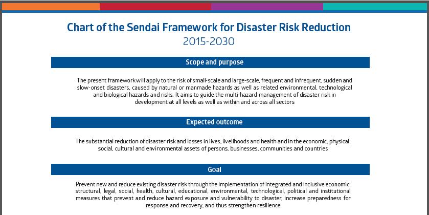
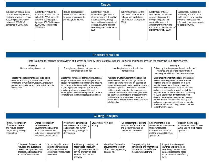
 ISSUES BRIEF Plenary A Risk-informed Approach to Sustainable Development and Resilience for Countries in Special Situations Rationale All recent international agreements, including the Sendai Framework
PUBLIC WEATHER SERVICES
 WMO AGENDA ITEM 2.1(1) PUBLIC WEATHER SERVICES Gerald Fleming Chair, OPAG/PWS (Paraguay 8-12 September 2014) WMO - Public Weather Services, WDS WMO Summary CBS requested to make decisions on: Adopt Draft
Natura 2000 and spatial planning. Executive summary
 Natura 2000 and spatial planning Executive summary DISCLAIMER The information and views set out in this study are those of the author(s) and do not necessarily reflect the official opinion of the Commission.
Integrated and Multi-Hazard Disaster Management
 GeoSmart Asia 2016: GI for Disaster Preparedness and Risk Reduction Bandung, Indonesia 12 October 2016 Integrated and Multi-Hazard Disaster Management Lim Choun Sian & Nurfashareena Muhamad Centre for
GLOBAL NETWORK OF NATIONAL GEOPARKS. Patrick J Mc Keever
 Patrick J Mc Keever A GEOPARK is an area with. geological heritage of international significance but also with. a sustainable development strategy or plan involving local communities. IS A GEOPARK JUST
Disaster Prevention and Management in Asia: The Context of Human Security and Its Relevance to Infrastructure Planning and Management
 Disaster Prevention and Management in Asia: The Context of Human Security and Its Relevance to Infrastructure Planning and Management Rajib Shaw http://www.iedm.ges.kyoto-u.ac.jp/ Contents Background and
National Disaster Management Centre (NDMC) Republic of Maldives. Location
 Republic of Maldives. Location") National Disaster Management Centre (NDMC) Republic of Maldives Location Country Profile 1,190 islands. 198 Inhabited Islands. Total land area 300 sq km Islands range b/w 0.2 5 sq km Population approx.
National Disaster Management Centre (NDMC) Republic of Maldives Location Country Profile 1,190 islands. 198 Inhabited Islands. Total land area 300 sq km Islands range b/w 0.2 5 sq km Population approx.
COUNCIL OF THE EUROPEAN UNION. Brussels, 2 May /14 CULT 68
 COUNCIL OF THE EUROPEAN UNION Brussels, 2 May 2014 9129/14 CULT 68 NOTE from: General Secretariat of the Council to: Permanent Representatives Committee (Part 1) / Council No. prev. doc.: 8892/14 CULT
Public Disclosure Copy
 Public Disclosure Authorized EAST ASIA AND PACIFIC Vanuatu Social, Urban, Rural and Resilience Global Practice Global Practice Recipient Executed Activities Technical Assistance Loan FY 2013 Seq No: 7
FIG Asia Pacific Capacity Development Network
 FIG Asia Pacific Capacity Development Network Report to the 41th General Assembly FIG Congress 2018, Istanbul - Turkey Rob Sarib Chair FIG Asia Pacific Capacity Development Network (AP CDN) Story of the
Sub-regional Training on development of Geo-referenced Disaster Risk Management Information Systems for SAARC countries
 Sub-regional Training on development of Geo-referenced Disaster Risk Management Information Systems for SAARC countries Jointly organized by Economic and Social Commission for Asia and the Pacific and
Geological Survey of Canada Lands and Minerals Sector Natural Resources Canada OneGeology, June 2018
 Geological Survey of Canada Lands and Minerals Sector Natural Resources Canada OneGeology, June 2018 Geological Survey of Canada Mission The Geological Survey of Canada provides public geoscience knowledge
Meeting Report. Mitigating the Impact of Natural Risks in Africa and Ninth UNESCO-IPRED Annual Session From 24 th 27 th October 2017/ Cairo, Egypt.
 Meeting Report Mitigating the Impact of Natural Risks in Africa and Ninth UNESCO-IPRED Annual Session From 24 th 27 th October 2017/ Cairo, Egypt. A 4 day Partnership Meeting was attended with the aim
Monaco, 3 March Your Serene Highness, Professor Jean Malaurie, Eminent experts, Excellencies, Ladies and gentlemen,
 Address by Mr Koïchiro Matsuura, Director-General of UNESCO, on the occasion of the international expert meeting: Climate change and sustainable development of the Arctic region scientific, social, cultural
Overview of Early Warning Systems and the role of National Meteorological and Hydrological Services
 Overview of Early Warning Systems and the role of National Meteorological and Hydrological Services South Africa Second Experts Symposium on Multi-Hazard Early Warning Systems With focus on the Role of
Inventory of United Nations Resolutions on Cartography Coordination, Geographic Information and SDI 1
 Inventory of United Nations Resolutions on Cartography Coordination, Geographic Information and SDI I. Resolutions on Cartography Coordination and Establishment of United Nations Regional Cartographic
Geospatial framework for monitoring SDGs/Sendai targets By Shimonti Paul Sr. Assistant Editor Geospatial Media & Communications
 Geospatial framework for monitoring SDGs/Sendai targets By Shimonti Paul Sr. Assistant Editor Geospatial Media & Communications Outline 1. Introduction to Geospatial Media and Communications 2. Geospatial
Areas Beyond National Jurisdiction (ABNJ) 2016 Regional Leaders Program. March 22 to April 1, 2016 United Nations, New York
 2016 Regional Leaders Program. March 22 to April 1, 2016 United Nations, New York") Areas Beyond National Jurisdiction (ABNJ) 2016 Regional Leaders Program March 22 to April 1, 2016 United Nations, New York Welcome and Introductions Biliana Cicin-Sain President, Global Ocean Forum Vladimir
Areas Beyond National Jurisdiction (ABNJ) 2016 Regional Leaders Program March 22 to April 1, 2016 United Nations, New York Welcome and Introductions Biliana Cicin-Sain President, Global Ocean Forum Vladimir
Statutory Framework of Biosphere Reserves. The Statutory Framework of the World Network of Biosphere Reserves
 Page 1 of 5 The Statutory Framework of the World Network of Biosphere Reserves Introduction Article 1 - Definition Article 2 - World Network of Biosphere Reserves Article 3 - Functions Article 4 - Criteria
Coastal Inundation Forecasting Demonstration Project (CIFDP)
") WMO World Meteorological Organization Working together in weather, climate and water Coastal Inundation Forecasting Demonstration Project (CIFDP) WMO Technical Commission for Oceanography and Marine Meteorology
WMO World Meteorological Organization Working together in weather, climate and water Coastal Inundation Forecasting Demonstration Project (CIFDP) WMO Technical Commission for Oceanography and Marine Meteorology
2018 REVIEW OF DISASTER EVENTS
 2018 REVIEW OF DISASTER EVENTS Supplementary Information* BRUSSELS, 24 January, 2019 In 2018, there were 281 climate-related and geophysical events recorded in the EM-DAT (International Disaster Database)
5. Principles. 1. Malaysia is not free from. Kuala Teriang, Langkawi
 5. Principles 1. Malaysia is not free from seismic-induced geohazards. However, the degree and magnitude of the geohazards are relatively small or minor because Malaysia is located in a stable tectonic