ESSENTIALS of GEOGRAPHY. Physical Geography (Geog. 300) Prof. Hugh Howard American River College
|
|
|
- Samuel Todd
- 5 years ago
- Views:
Transcription
1 ESSENTIALS of GEOGRAPHY Physical Geography (Geog. 300) Prof. Hugh Howard American River College
2 GEOGRAPHY
3 GEOGRAPHY Earth description, or study of Earth Describes the natural environment and human interaction with it Spatial science, having to do with physical space Deals with spatial distributions and spatial relationships of Earth features and phenomena
4 GEOGRAPHY Ancient Greeks didn t invent geography, but they formalized it as a field of study Organized all knowledge into Geography and Cosmography Eratosthenes coined the term geography in the 3 rd century BCE He was the first person to calculate the circumference of Earth (using geometry) Geographic library at Alexandria
5 GEOGRAPHY Geography has two major subfields Physical Weather, climate, geology, hydrology, soils, etc. The emphasis of this course Human Cultural, economic, political

6 Major Subfields of Geography
7 GEOGRAPHY Synthesizes other fields of study Geology, hydrology, meteorology, etc. Geography acts to bring specialized fields together to find relationships between them
8 THE SCIENTIFIC METHOD
9 SCIENTIFIC METHOD Method for investigating phenomena and acquiring new knowledge A hypothesis is formed A proposed explanation for something Is formed by making a general statement from specific observations Mt. Shasta is a volcano. It is made of lava. Therefore, all volcanoes are made of lava.
10 SCIENTIFIC METHOD Hypotheses are based on inductive reasoning Generalizing from specific observations Allows for the conclusion to be false Mt. Shasta is a volcano. It is very large. Therefore, all volcanoes are very large. Hypotheses can be supported or rejected on a case-by-case basis
11 SCIENTIFIC METHOD Hypotheses are tested using deductive reasoning Reasoning from a general statement to a logical conclusion Mt. Shasta is a volcano. It is formed from lava. Therefore, all volcanoes are formed from lava. The hypothesis is accepted Experiments performed on all known volcanoes show that they are all made of lava.
12 SCIENTIFIC METHOD Hypotheses are tested using deductive reasoning Reasoning from a general statement to a logical conclusion Mt. Shasta is a volcano. It is very large. Therefore, all volcanoes are very large. The hypothesis is rejected Experiments performed on all known volcanoes show that they vary in size.

13 The Scientific Method A Theory Is a well-substantiated explanation acquired through the scientific method, and repeatedly confirmed through observation and experimentation. There is a very high probability that it is true.
14 SYSTEMS and MODELS
15 SYSTEM Set of related objects or events Useful in identifying relationships and interactions between components Used by geographers to organize information Open System Allows exchange of energy and matter (a tree)

16 Open System

17 Earth SYSTEM Is an open system all components interact

18 Earth SYSTEM Is a closed system in the context of space Allows exchange of energy only (really?)
19 MODEL Simplified, idealized representation of reality Maps and globes as models Physical or computer Allow us to see the most prominent, or important aspects of a system

20 Models of Earth
21 EARTH as a SYSTEM: The FOUR SPHERES
22 Atmosphere The FOUR SPHERES Extends up 300 miles Uneven solar heating keep it in constant motion, causing weather Lithosphere The rock layer Earth s outer shell, including the continents and ocean floors
23 The FOUR SPHERES Hydrosphere All water on and in the lithosphere Oceans constitute the largest component: 71% of Earth s surface Biosphere Life Layer - all living things We ll focus less on the biosphere than on the first three spheres

24 REGIONAL SUB-SYSTEMS: All four spheres can be studied within a particular geographic region Earth s Four Spheres
25 The SPHERICAL EARTH
26 SHAPE of EARTH Ancient Greeks believed that Earth was a sphere Ships disappeared over the horizon Lunar eclipses provided clues They believed the sphere to be a perfect form, appropriate for Earth Earth is not a perfect sphere It is spherical

27 The Spherical Earth
28 Half of a sphere HEMISPHERES Earth can be divided in many ways Northern and Southern Defined by the equator 70% of land is in the northern 90% of the human population is in the northern
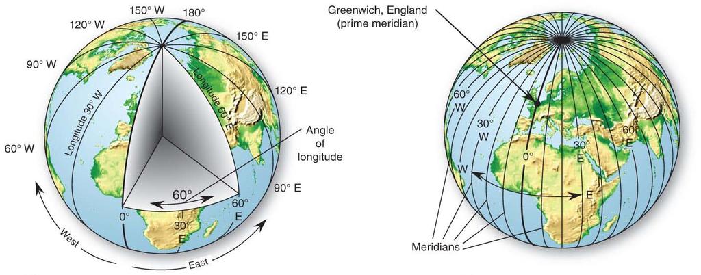
29 HEMISPHERES Eastern and Western Defined by humans, rather than by physical principles International Meridian Conference, 1884, Washington, D.C. The Prime Meridian (0 degrees longitude) passes through Greenwich, England
30 The Four Hemispheres
31

32 Land and Water HEMISPHERES Land hemisphere centered on Africa Water centered on the Pacific The Water Hemisphere
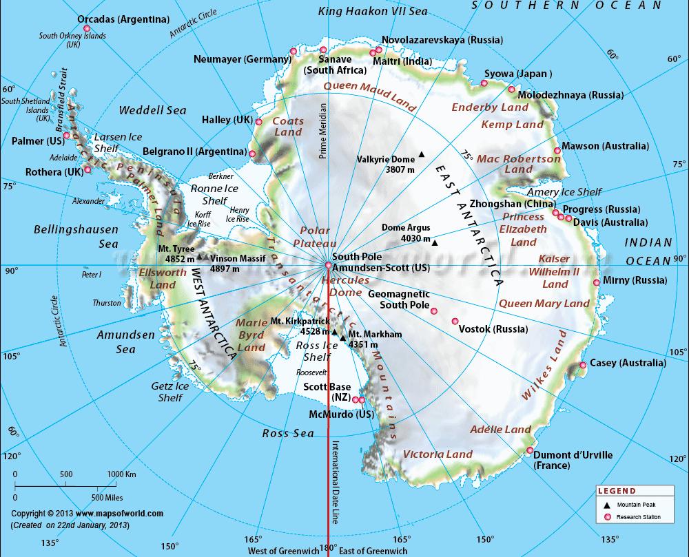
33 CONTINENTS and OCEANS
34 CONTINENTS Continents Large, continuous, discrete masses of land Six continents Africa, Antarctica, Australia, N. America, S. America, Eurasia Europe is not a continent, but part of Eurasia It can be considered a sub-continent, or cultural region
35 Oceans OCEANS Large bodies of saline water Five oceans Arctic, Atlantic, Indian, Pacific, Southern Further subdivisions are made N. Atlantic and S. Atlantic, etc. Really only one global ocean

36 Continents and Oceans
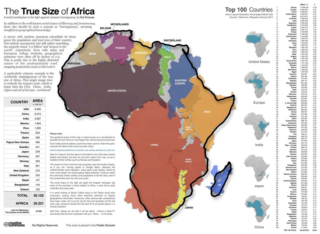
37 AFRICA The mother continent for humans Second largest ( 20% of land area) Center of land hemisphere Straddles equator Plateau continent Much is over 3,000 ft, but large mountain ranges are uncommon
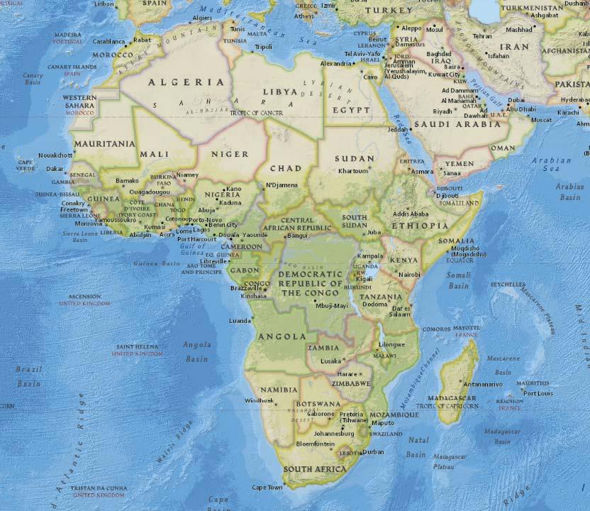
38 Africa
39
40 ANTARCTICA Home to the South Pole Second smallest ( 9% of land area) Surrounded by the Southern Ocean World s largest ice sheet Population 1,000-4,000 Scientists and support workers
41 Antarctica
42 AUSTRALIA Smallest ( 6% of land area) Great Dividing Range Lowest and flattest continent Highest point is only 7,316 ft Interior is almost completely uninhabited
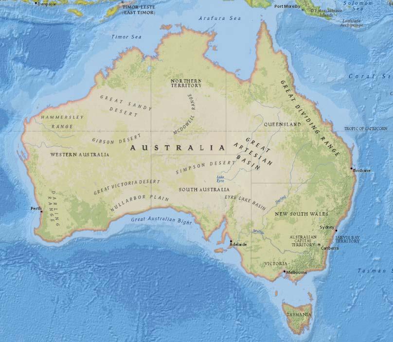
43 Australia

44 Australia 2% of total population lives in yellow area
45 NORTH AMERICA Home! 17% of land area Great Mountain Ranges Rocky Mountains, Sierra Nevada, Cascade, Appalachians Great Plains Mississippi/Missouri Rivers and basins

46 North America
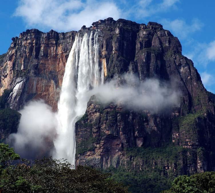
47 SOUTH AMERICA Last continent to be settled by humans 12% of land area Andes Earth s longest mountain range Amazon Earth s longest river Angel Falls Earth s highest waterfall

48 South America
49 EURASIA Largest ( 36% of land area) Himalaya Earth s tallest mountain range Almost 5.5 miles high, >29,000ft Alps Europe s greatest mountain range Densely populated river plains Ganges, Yellow, Yangzi
50 Eurasia
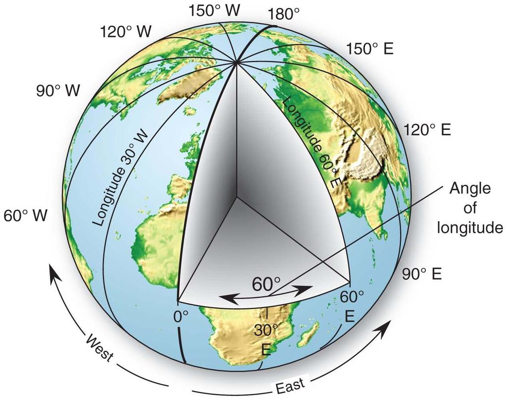
51 THE GEOGRAPHIC GRID
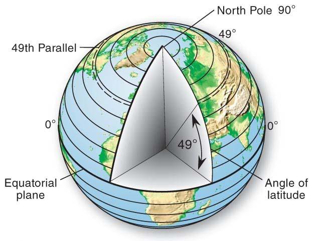
52 The GEOGRAPHIC GRID System for locating places on Earth Meridians Lines that stretch from north to south pole Prime Meridian passes through Greenwich Parallels Circles that intersect meridians at right angles, but are parallel to themselves Equator is a parallel
53 Meridians
54 Parallels
55 DEGREES Ancient Babylonians divided the circle into 360 equal parts Degrees! This system was applied to meridians and parallels Allows us to describe any location on Earth
56 DEGREES Degrees are too coarse to allow precise descriptions of location, so refinements were made Degrees, Minutes, and Seconds Angles, not units of time 60 (minutes) in 1 (degree) 60 (seconds) in 1 (minute) 3,600 (seconds) in 1 (degree)
57 LONGITUDE A measurement, in degrees, E or W of the Prime Meridian (Greenwich) East or West One degree of longitude is 69 mi (111 km) at the equator and 0 mi at the poles. Sacramento: W
58 Longitude
59 LATITUDE A measurement, in degrees, north or south of the equator (a parallel) 0-90 North or South One degree of latitude is 69 mi (111 km) anywhere on Earth Latitude: ladder, or lattice Sacramento: N
60 Latitude
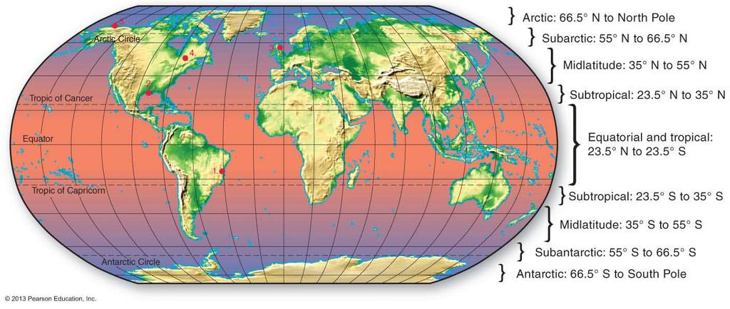
61 Latitudinal Zones
62 GLOBAL TIME
63 TIME and the GRID Earth completes one rotation every day, or every 24 hours Because Earth is composed of 360 degrees of longitude One hour of time corresponds with 15 degrees of longitude (360 /24 hours = 15 /hour)
64 TIME and the GRID Standard Meridians divide Earth into one hour zones The sun moves 15 in the sky every hour
65 SOLAR NOON Time when the sun reaches its highest point above a particular place on Earth Actual noon (differs from clock noon) Different for every longitude Earlier for Sacramento than for San Francisco But our clocks tell us that noon is at the same time in both places
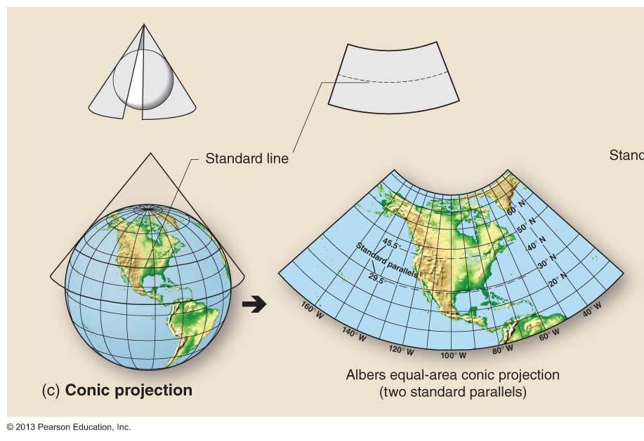
66 TIME ZONES Regions 15 wide that share a common Standard Time Solar noon of the center of each zone is used throughout the zone Simplifies time scheduling Zones are actually irregular due to political and natural boundaries

67 Time Zones International Date Line: If traveling westward, you advance to the next day. If traveling eastward, you repeat the same day.
68 DAYLIGHT SAVING TIME The advancement of local times by one hour in spring and summer Gains more daylight in the evenings Designed to reduce energy consumption after dark (artificial lighting used to be a primary energy drain) Second Sunday in March First Sunday in November (8 months)

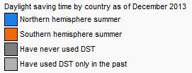
69 Daylight Saving Time
70 MAPS and MAP PROJECTIONS
71 MAPS Reduced, simplified version of geographic reality Allow us to communicate geographic information Predate written language Maps represent the spherical Earth on a flat surface, or plane
72 Maps
73 MAP PROJECTION The arrangement of Earth s spherical surface on a plane Projections can be classified according to geometric properties Planar Cylindrical Conic

74 Planar Map Projection

75 Cylindrical Map Projection
76 Conic Map Projection
77 MAP PROJECTION The projection process always distorts the continents and oceans Orange peel example The map maker can choose a specific type of projection that will be appropriate for a particular map Equal Area Conformal
78 MAP PROJECTION Equal Area Projection Retains the property of area Areas are shown at their correct sizes in relation to other areas (shape is distorted) Conformal Projection Retains the property of shape Shapes of areas and lines are correct (area is distorted)

79 Equal Area Map Projection (Eckert IV)

80 Equal Area Map Projection (Sinusoidal)

81 Conformal Map Projection (Mercator)

82 Conformal Map Projection (Lambert)
83 MAP SCALE
84 MAP SCALE A ratio (fraction) of map distance over Earth distance The representative fraction M a p d i s t a n c e E a r t h d i s t a n c e 1 24, 000 o r 1 : 2 4, Unitless: any unit of measure can be inserted
85 MAP SCALE THE REPRESENTATIVE FRACTION (R.F.) 1:5,000,000 1:5,000,000 (larger scale) 1:20,000,000 1:20,000,000 (smaller scale) O R E G O N Smaller Area Greater Detail Greater Detail Larger Area Lesser Detail Larger Area Lesser Detail
86 GEOGRAPHIC TECHNOLOGIES
87 GEOGRAPHIC TECHNOLOGIES Technologies that allow us to examine and analyze geography Global Positioning System (GPS) Remote Sensing Geographic Information Systems (GIS) Computer-based fields that offer career paths

88 Global Positioning System (GPS)

89 Remote Sensing

90 Geographic Information Systems (GIS)
91 Geographic Information Systems (GIS)

92 Geographic Information Systems (GIS)

93 Geographic Information Systems (GIS)

94 Geographic Information Systems (GIS)
95 ESSENTIALS of GEOGRAPHY Physical Geography (Geog. 300) Prof. Hugh Howard American River College
Introduction to Geography
 Introduction to Geography ropic of Cancer 3½ N Arctic Circle 90 N Prime Meridian 0 Arctic Ocean Mississippi R. Appalachian Mts. Europe Rocky Mountains N. America Atlantic Gulf of Ocean Mexico Caribbean
Maps and Globes. By Kennedy s Korner
 Maps and Globes By Kennedy s Korner Map Key or Symbols Maps use symbols to show places and things on Earth. Symbols are drawings that stand for something real. A map key tells you what each symbol stands
Exploring Geography. Chapter 1
 Exploring Geography Chapter 1 The Study of Geography Geography is the study of where people, places, and things are located and how they relate to each other. Greek meaning writing about or describing
Tonight. {01} The map. Relative space. What does a map do? Types of maps GEOG 201 2/17/2010. Instructor: Pesses 1
 Tonight {01} The map What makes a map Measuring the Earth Map Interpretation & GPS Spring 2010 M. Pesses What does a map do? Shows where things are Shows spatial (topological) relationships Shows patterns,
Unit 1: Geography and Social Studies Skills
 Unit 1: Geography and Social Studies Skills Standard(s) of Learning: WHI.1 The student will improve skills in historical research and geographical analysis by a) Identifying, analyzing, and interpreting
Cartesian Coordinates Need two dimensional system 2 number lines perpendicular to each other X-axis is horizontal Y-axis is vertical Position relative
 General Physical Science Chapter 15 Place and Time Space and Time Einstein Space and time related Single entity Time is the 4 th dimension! Cartesian Coordinates Need some system to tell us where something
The World of Geography Pre-Test/Study Guide Chapter 1 Test
 Read each statement or question. On the lines below write the letter of the best answer. 1. Geographers look at the Earth 5. What are the two specific A. by studying cities first. measurements of Earth
Chapter 1 Section 2. Land, Water, and Climate
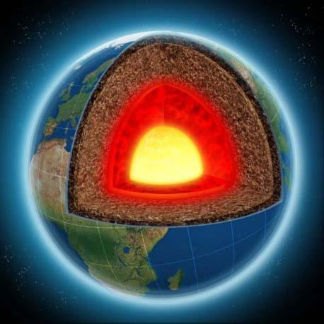
 Chapter 1 Section 2 Land, Water, and Climate Vocabulary 1. Landforms- natural features of the Earth s land surface 2. Elevation- height above sea level 3. Relief- changes in height 4. Core- most inner
Send Completed HW to:
 Section 1.1 What Is Earth Science? This section explains what Earth science is and what Earth scientists study. Reading Strategy Categorizing As you read about the different branches of Earth science,
Chapter 1 Introduction to the Earth
 Chapter 1 Introduction to the Earth What is Geography? The study of the earth as the home of humankind. Greek - Eratosthenes Father of Geography Geo means Earth Graphy means to write Study how things are
... Asia. Based on Bloom s Taxonomy. Human & Movement. Location Place. Regions. Environment. Interactions
 ... Asia Location Place Human & Environment Interactions Movement Regions LEVEL 1 Knowledge Match Show or Label List Information Recall Details (5Ws + H) Find Information LEVEL 2 Comprehension LEVEL 3
THE EARTH AND ITS REPRESENTATION
 UNIT 7 THE EARTH AND ITS REPRESENTATION TABLE OF CONTENTS 1 THE EARTH AND THE SOLAR SYSTEM... 2 2 THE EARTH S MOVEMENTS... 2 2.1 Rotation.... 2 2.2 The revolution of the Earth: seasons of the year....
Word Cards. 2 map. 1 geographic representation. a description or portrayal of the Earth or parts of the Earth. a visual representation of an area
 Name: Date: Hour: Word Cards 1 geographic representation a description or portrayal of the Earth or parts of the Earth Example: A map is a representation of an actual location or place. 2 map a visual
Module 2: Mapping Topic 2 Content: Determining Latitude and Longitude Notes
 Introduction In order to more easily locate points on a globe or map, cartographers designed a system of imaginary vertical lines (also called parallels) and horizontal lines (also called meridians) that
2. What does the map scale tell the map reader? a ratio between the actual distance on the ground and the length given to that distance on a map
 AP Human Geography - Damon Name Unit 1 - Intro to Human Geography Hour Map and Globe Skills Review Note: All links in this packet are found on our Wikispace under Map and Globe Skills Review First, read
Map Skills Unit. Note taking unit
 Map Skills Unit Note taking unit Introduction To learn about the Earth, we are going to learn about two geographic tools you can use.globes and maps. Globe A globe is a round model of the planet Earth
FIND PLACES ON GLOBES USING LATITUDE
 GLOBES, MAPS & GRAPHS FIND PLACES ON GLOBES USING LATITUDE AND LONGITUDE LINES FIND PLACES ON MAPS USING A GRID SYSTEM NAME SEVERAL TYPES OF MAP PROJECTIONS AND EXPLAIN THEIR BENEFITS AND SHORTCOMINGS
Unit 1: Geography. For additional information, refer to this website: 1 G e o g r a p h y
 Unit 1: Geography For additional information, refer to this website: http://mryoungtms.weebly.com/ 1 G e o g r a p h y Continents and Oceans SOL USI. 2a Essential Understanding: Continents are large land
EARTH SCIENCE KEY UNIT 2-H
 EARTH SCIENCE KEY UNIT 2-H UNIT 2 MODELS & DIMENSIONS OF EARTH I. Model = ANYTHING THAT REPRESENTS THE PROPERTIES OF AN OBJECT OR SYSTEM A. Types and examples of models: 1. PHYSICAL Provides us with information
What is Geography? Lecture 1 The Earth As A Rotating Planet. What is Geography? What is geography? Subfields of Geography?
 Lecture 1 The Earth As A Rotating Planet Geog210 Physical Geography What is Geography? Much more than place names and locations The study of spatial variation How and why things differ from place to place
Downloaded from
 I II III IV V VI Define the following terms:- a) Orbitb) Meteoroids c) Celestial bodies GEOGRAPHY ASSIGNMENTS The Earth In The Solar System d) Satellite e) Comets Give one word answers:- a) Blue planet
Pool Canvas. Add. Creation Settings. Chapter 1--Objectives and Tools of World Regional Geography. Description Instructions.
 1 of 6 TEST BANK > CONTROL PANEL > POOL MANAGER > POOL CANVAS Pool Canvas Add, modify, and remove questions. Select a question type from the Add Question drop-down list and click Go to add questions. Use
The structure of the Earth and how its motion creates the seasons. The landforms of the earth and the forces that shape the land.
 The structure of the Earth and how its motion creates the seasons. The landforms of the earth and the forces that shape the land. The role of wind and water in creating climate. The different climate and
Major Domain of the Earth
 Major Domain of the Earth The surface of the earth is a complex zone in which three main components of the environment meet, overlap and interact. The solid portion of the earth on which we live is called
PHYSICAL GEOGRAPHY. By Brett Lucas
 PHYSICAL GEOGRAPHY By Brett Lucas INTRODUCTION Introduction to Earth Geography as a Field of Learning Geography is from two Greek words, Geo Earth, and Graphien to write. Elements/Branches of Geography
Introduction to Geography
 Introduction to Geography What is geography? Geography comes from the Greek word Geographia. Geo means earth and graphia means to describe or chart. Geographers study the earth in relation to space and
Map Skills Test. 1. What do we call a person who makes maps? a. mapographer b. cartographer c. geologist d. archaeologist
 Map Skills Test 1. What do we call a person who makes maps? a. mapographer b. cartographer c. geologist d. archaeologist 2. What is the name of the 0 latitude line? a. Equator b. Arctic Circle c. First
ELEMENTS OF BASIC WORLD GEOGRAPHY TABLE OF CONTENTS UNIT 1 THE BASICS OF GEOGRAPHY AND NORTH AMERICA
 TABLE OF CONTENTS UNIT 1 THE BASICS OF GEOGRAPHY AND NORTH AMERICA IMPORTANT WORDS TO KNOW... 1 CHAPTER 1 THE BASICS OF GEOGRAPHY GEOGRAPHY... 2 TOOLS OF GEOGRAPHY... 3 EARTH...4 SEASONS, CLIMATE, AND
Unit 1: Basics of Geography Test Review
 Name Date Period Unit 1: Basics of Geography Test Review Directions: Reading the following sections and complete the questions, charts, and diagrams. Types of Maps Maps that have a particular theme are
GEOGRAPHY. Map Skills. Mrs. Pere ~ 2013
 GEOGRAPHY Map Skills Mrs. Pere ~ 2013 WHAT IS A GLOBE? A globe is a model of the Earth. North Pole Equator South Pole WHAT IS A MAP? A map is a flat drawing of a place. THE IMPORTANT PARTS OF A MAP 1.
Some of these parallels are very important. In the Northern Hemisphere, there is the Tropic of Cancer and the Arctic Circle.
 PDF 2 Geographic coordinates 1 The geographic coordinates system is network of imaginary horizontal and vertical lines that are drawn on globes or maps. These lines are called parallels (lines of latitude)
MR. JOHNSON S. Geography OHIO COUNTY MIDDLE SCHOOL
 MR. JOHNSON S Geography OHIO COUNTY MIDDLE SCHOOL CHAPTER 1 Geography The science of geography is likely the oldest of all sciences. Geography is the answer to the question that the earliest humans asked,
Name Date Class. a. High elevation and high relief b. High elevation and level surface c. Flat land and low relief
 Exploring Earth s Surface (pp. 21 27) This section describes factors that determine the shape of Earth s land surface. The section also describes how scientists divide Earth into four spheres. Use Target
Understanding Projections
 GEOGRAPHY SKILLS 1 Understanding Projections The earth is a sphere and is best shown as a globe. For books and posters, though, the earth has to be represented as a flat object. To do this, mapmakers create
2. Environmental issues in the relationship of humankind to the environment
 Course Goals to Understand 1. Processes operating on the earth s surface Atmosphere Lithosphere Hydrosphere Biosphere 2. Environmental issues in the relationship of humankind to the environment 3. Science
MR. GOFF S WORLD HISTORY UNIT ONE: GEOGRAPHY 5 THEMES OF GEOGRAPHY
 MR. GOFF S WORLD HISTORY UNIT ONE: GEOGRAPHY 5 THEMES OF GEOGRAPHY BYOD BRING YOUR OWN DEVICE IN SMALL GROUPS (3-4), USE YOUR ELECTRONIC DEVICE(S) AND DEFINE THE FOLLOWING VOCAB. WORDS 1. GEOGRAPHY 2.
The position of the Sun on the celestial sphere at the solstices and the equinoxes.
 1 2 3 4 5 6 7 8 9 10 11 12 13 EARTH IN SPACE Tillery, Chapter 18 Artist's concept of the solar system. Shown are the orbits of the planets, Earth being the third planet from the Sun, and the other planets
WHERE ARE YOU? Maps & Geospatial Concepts Fall 2015
 WHERE ARE YOU? Maps & Geospatial Concepts Fall 2015 Where are you? Relative location I m at school Absolute Location 45 26 18.07 122 43 50.78 Where is Boston? Introducing Geodesy, Ellipsoids & Geoids Geodesy
What Is a Globe? Hemispheres. Main Idea Globes and maps provide different ways of showing features of the earth. Terms to Know
 r Main Idea Globes and maps provide different ways of showing features of the earth. Terms to Know hemisphere latitude longitude scale bar scale relief elevation contour line What Is a Globe? A globe is
page - 1 Laboratory Exercise #1 - Introduction to Latitude and Longitude Northern Hemisphere Southern Hemisphere
 page - 1 Laboratory Exercise #1 - Introduction to Latitude and Longitude A. Introduction There are many methods that can be used to locate ones position on the surface of the earth. A common method for
Cardinal and Intermediate Directions:
 Name Period Parent Signature Due Date: (TBA) Geography/Map Skills Study Guide Continents and Oceans of the World: Label the continents (7) and oceans (4) on the lines below the map. 1 11 3 5 4 8 2 9 10
Time and Diurnal Motion. 1a. The Earth Is Flat. 1c. Aristotle ( BC) 1b. The Earth Is Round. Time and Diurnal Motion
 1b. The Earth Is Round. Time and Diurnal Motion") Time and Diurnal Motion Time and Diurnal Motion A. Geography: mapping the earth 2 B. Equatorial Coordinates C. Local Horizon System A. Geography: mapping the earth Geometry: measure the earth! 1) The earth
Time and Diurnal Motion Time and Diurnal Motion A. Geography: mapping the earth 2 B. Equatorial Coordinates C. Local Horizon System A. Geography: mapping the earth Geometry: measure the earth! 1) The earth
A. Spatial Sense (Working with Maps, Globes, and Other Geographic Tools)
") A. Spatial Sense (Working with Maps, Globes, and Other Geographic Tools) Measuring Distance Using Map Scale All maps are drawn to scale; that is, they are smaller than the things they represent. Scale
A. Spatial Sense (Working with Maps, Globes, and Other Geographic Tools) Measuring Distance Using Map Scale All maps are drawn to scale; that is, they are smaller than the things they represent. Scale
Section 1.1 What Is Earth Science? This section explains what Earth science is and what Earth scientists study.
 Section 1.1 What Is Earth Science? This section explains what Earth science is and what Earth scientists study. Reading Strategy Categorizing As you read about the different branches of Earth science,
... Europe. Based on Bloom s Taxonomy. Environment Interactions Movement. Human & Location. Regions. Place
 ... Europe Location Place Human & Environment Interactions Movement Regions LEVEL 1 Knowledge Match Show or Label List Information Recall Details (5Ws + H) Find Information LEVEL 2 Comprehension Describe
Geographic Grid. Locations Feature 1 Feature 2 Feature 3
 Geographic Grid Name The geographic grid refers to the internationally-recognized system of latitude and longitude used to location positions on Earth's surface. Accurate use of this coordinate system
Key Issue #1. How do geographers describe where things are? 2014 Pearson Education, Inc.
 Key Issue #1 How do geographers describe where things are? Learning Outcomes 1.1.1: Explain differences between early maps and contemporary maps. 1.1.2: Describe the role of map scale and projections and
CHAPTER 2 SKILL SHEET 2: CELESTIAL NAVIGATION
 CHAPTER 2 SKILL SHEET 2: CELESTIAL NAVIGATION Before the invention of GPS technology, how were people on ships far at sea, out of the sight of land, able to tell where they were? For thousands of years
Simple Solutions Social Studies Level 2. Level 2. Social Studies. Help Pages
 Level 2 Social Studies 147 148 adobe houses with bricks made of clay and straw ancestor a family member who lived before us appoint choose; leaders can appoint others barter trading one thing for another
INTERNATIONAL INDIAN SCHOOL, RIYADH HALF YEARLY
 INTERNATIONAL INDIAN SCHOOL, RIYADH HALF YEARLY 2018-19 STD V Fill in the blanks: WORKSHEET LESSON - 1 KNOW YOUR PLANET SOCIAL STUDIES 1 A book containing maps is called an _ 2 A Flemish map maker, collection
Sample file. Teacher Guide ... Before You Teach. Our resource has been created for ease of use by both TEACHERS and STUDENTS alike.
 8 7 9 10 12 13 14 11 Introduction T his resource provides ready-to-use information and activities for remedial students in grades five to eight. Written to grade and using simplified language and vocabulary,
Chapter. Introduction to Earth Science
 EARTH SCIENCE Chapter 1 Introduction to Earth Science 1.1 What Is Earth Science? Overview of Earth Science Encompasses all sciences that seek to understand Earth Earth's neighbors in space 1.1 What Is
TIME. Astronomical time Time is defined by astronomical cycles. The day is the average time from noon to noon (the solar day).
.") ASTRONOMY READER TIME 2.1 TIME Astronomical time Time is defined by astronomical cycles. The day is the average time from noon to noon (the solar day). The month was originally based on the average time
ASTRONOMY READER TIME 2.1 TIME Astronomical time Time is defined by astronomical cycles. The day is the average time from noon to noon (the solar day). The month was originally based on the average time
Unit 2 Study Guide: The World in Spatial Terms
 Name Date Hour Unit 2 Study Guide: The World in Spatial Terms TEST is WEDNESDAY, DECEMBER 19 TH This study guide contains all the concepts that will be on your test. Vocabulary words and concepts will
WHERE ARE YOU? Maps & Geospatial Concepts Fall 2012
 WHERE ARE YOU? Maps & Geospatial Concepts Fall 2012 Where are you? Relative location I m at school Absolute Location 45 26 18.07 122 43 50.78 Datums Datums A reference surface of the Earth Used as the
Scientists observe the environment around them using their five senses.
 Earth Science Notes Topics 1: Observation and Measurement Topic 2: The Changing Environment Review book pages 1-38 Scientists observe the environment around them using their five senses. When scientists
Dr. M.K.K. Arya Model School Class-V, Social Science Assignment Ch-1, Globe The Model of the Earth Answer the following:- Q.1.
 Class-V, Social Science Assignment Ch-1, Globe The Model of the Earth - Q.1. What are the disadvantages/demerits of a globe? Ans. Some disadvantages of globe are: a) It is difficult to carry. b) It cannot
Introduction to Earth Science
 Introduction to Earth Science Overview of Earth Science Encompasses all sciences that seek to understand Earth Earth's neighbors in space Overview of Earth Science Earth science includes 1. geology, the
Chapter 3 Models of the Earth. 3.1 Finding Locations on the Earth. 3.1 Objectives
 Chapter 3 Models of the Earth 3.1 Finding Locations on the Earth 3.1 Objectives Explain latitude and longitude. How can latitude and longitude be used to find locations on Earth? How can a magnetic compass
Globes, Maps, and Atlases. Plus, A Whole Bunch of Other Way Cool Geographic Information!!!
 Globes, Maps, and Atlases Plus, A Whole Bunch of Other Way Cool Geographic Information!!! Globes Are the Most Accurate Portrayal of the Earth The earth is about 24,900 miles in circumference, and about
The Earth and its representation
 GEOGRAPHY UNIT 1 The Earth and its representation THE SOLAR SYSTEM AND THE EARTH THE SOLAR SYSTEM The solar system is a planetary system. Is a group of astronomical objects who surround a star, in this
What is a map? A Map is a two or three-dimensional model or representation of the Earth s surface. 2-Dimensional map
 What is a map? A Map is a two or three-dimensional model or representation of the Earth s surface. 2-Dimensional map What is a Map Projection? Planar Projection Projection A Projection is a mathematical
Time and Diurnal Motion. 1a. The Earth Is Flat. 1c. Aristotle ( BC) 1b. The Earth Is Round. Time and Diurnal Motion
 1b. The Earth Is Round. Time and Diurnal Motion") Time and Diurnal Motion Time and Diurnal Motion A. Geography: mapping the earth 2 B. Equatorial Coordinates C. Local Horizon System Updated April 12, 2006 A. Geography: mapping the earth Geometry: measure
Time and Diurnal Motion Time and Diurnal Motion A. Geography: mapping the earth 2 B. Equatorial Coordinates C. Local Horizon System Updated April 12, 2006 A. Geography: mapping the earth Geometry: measure
Complete the following: a. Lines of latitude are parallel to the equator. Name:
 Name: Date: Social Studies Introduction: Basic Geography Period: Latitude Latitude is defined as a measurement of distance in degrees north and south of the equator. The word latitude is derived from the
Ch2&3 Test. Multiple Choice Identify the choice that best completes the statement or answers the question.
 Ch2&3 Test Multiple Choice Identify the choice that best completes the statement or answers the question. 1. Earth s circumference is about 40,000 km, and its shape is a. an oval. c. a perfect sphere.
Seasons & Time.
 Seasons & Time Earth s Movements Rotation Movement of Earth Around the Sun Elliptical Orbit Revolution 24 Hours (1 Day) 365 Days (1 Year) The Earth s Revolution & the Tilt of the axis cause variations
1. Geospatial technology rarely links geospatial data to nonspatial data. a. True *b. False
 Chapter 2 Where in the Geospatial World Are You? 1. Geospatial technology rarely links geospatial data to nonspatial data. 2. For geospatial technology to work, every location on Earth must be: a. inhabited
The Earth is a Rotating Sphere
 The Earth is a Rotating Sphere The Shape of the Earth Earth s Rotation ( and relative movement of the Sun and Moon) The Geographic Grid Map Projections Global Time The Earth s Revolution around the Sun
AP Human Geography Chapter 1: Thinking Geographically Key Issue 1: How do Geographers describe where things are?
 AP Human Geography Chapter 1: Thinking Geographically Key Issue 1: How do Geographers describe where things are? Studying Human Geography Physical Geography Physical geography deals with Earth s natural
Time and Diurnal Motion
 Time and Diurnal Motion Time and Diurnal Motion A. Geography: mapping the earth 2 B. Equatorial Coordinates C. Local Horizon System Updated Sep 30, 2012 A. Geography: mapping the earth Geometry: measure
Why does Earth rotate and what s the evidence? (besides watching it from space ships or satellites) Week 18 January 5, 2015
 Week 18 January 5, 2015") Why does Earth rotate and what s the evidence? (besides watching it from space ships or satellites) Week 18 January 5, 2015 The sun determines our solar time everywhere on earth as Earth rotates. Can you
Why does Earth rotate and what s the evidence? (besides watching it from space ships or satellites) Week 18 January 5, 2015 The sun determines our solar time everywhere on earth as Earth rotates. Can you
Chapter 1: The World of Geography
 Chapter 1: The World of Geography Chapter 1: What is Geography? *It is the study of our earth; our home. OR *Anything that can be mapped! *Geography mixes up the physical and human aspects of our world
CHAPTER 1: EXPLORING GEOGRAPHY
 CHAPTER 1: EXPLORING GEOGRAPHY Please Do Now: In your PDN section of your binder answer the following with one or two sentences: What is Geography? What is Geography? The study of where people, places,
UNIT 1: THE PLANET EARTH
 UNIT 1: THE PLANET EARTH How many planets are there in our Solar System? What is the Equator? Why does life exist in our planet? Does The Earth move? What is a map? 1. Planet Earth TOPICS 2. Movements
Map Skills and Geographic Tools
 Name: Period: Map Skills and Geographic Tools TEKS: 8.9C interpret topographic maps and satellite views to identify land and erosional features and predict how these features may be reshaped by weathering
Map Skills Lesson 1. Materials: maps, pencils, Lesson 1 Worksheet, strips of paper, grid paper
 Map Skills Lesson 1 Use cardinal directions, map grids, scales, and titles to locate places on a map. Interpret a map using information from its title, compass rose, scale, and legend. Vocabulary: map,
4. Which object best represents a true scale model of the shape of the Earth? A) a Ping-Pong ball B) a football C) an egg D) a pear
 a Ping-Pong ball B) a football C) an egg D) a pear") Name Test on Friday 1. Which diagram most accurately shows the cross-sectional shape of the Earth? A) B) C) D) Date Review Sheet 4. Which object best represents a true scale model of the shape of the Earth?
Name Test on Friday 1. Which diagram most accurately shows the cross-sectional shape of the Earth? A) B) C) D) Date Review Sheet 4. Which object best represents a true scale model of the shape of the Earth?
Time and Diurnal Motion
 Time and Diurnal Motion Time and Diurnal Motion A. Geography: mapping the earth 2 B. Equatorial Coordinates C. Local Horizon System Updated 2014Jan11 A. Geography: mapping the earth Geometry: measure the
Prentice Hall EARTH SCIENCE
 Prentice Hall EARTH SCIENCE Tarbuck Lutgens Chapter 1 Introduction to Earth Science 1.1 What Is Earth Science? Overview of Earth Science Encompasses all sciences that seek to understand Earth Earth's neighbors
Module 11: Meteorology Topic 3 Content: Climate Zones Notes
 Introduction Latitude is such an important climate factor that you can make generalizations about a location's climate based on its latitude. Areas near the equator or the low latitudes are generally hot
FIRST GRADE 1 WEEK LESSON PLANS AND ACTIVITIES
 FIRST GRADE 1 WEEK LESSON PLANS AND ACTIVITIES UNIVERSE CYCLE OVERVIEW OF FIRST GRADE UNIVERSE WEEK 1. PRE: Describing the Universe. LAB: Comparing and contrasting bodies that reflect light. POST: Exploring
 Name Period Parent Signature Geography/Map Skills Study Guide *For extra practice with these skills, check out Mr. Kath s website: http://rkath.weebly.com/activities--links.html Continents and Oceans of
discussion of North America s physical features, including its landforms and bodies of
 Chapter 7 Natural Environments of North America Chapter 7 focuses on the natural environments of North America. The chapter opens with a discussion of North America s physical features, including its landforms
4th Grade Social Studies First Nine Weeks
 4th Grade Social Studies First Nine Weeks Multiple Choice Identify the choice that best completes the statement or answers the question. 1 Name the mountains that are located in the eastern United States.
2 Mapping Earth Reading Essentials. 2. Contrast What is the difference between a map view and a profile view?
 Mapping Earth Maps What do you think? Read the three statements below and decide whether you agree or disagree with them. Place an A in the Before column if you agree with the statement or a D if you disagree.
NR402 GIS Applications in Natural Resources Lesson 4 Map Projections
 NR402 GIS Applications in Natural Resources Lesson 4 Map Projections From http://www.or.blm.gov/gis/ 1 Geographic coordinates Coordinates are expressed as Latitude and Longitude in Degrees, Minutes, Seconds
Which Earth latitude receives the greatest intensity of insolation when Earth is at the position shown in the diagram? A) 0 B) 23 N C) 55 N D) 90 N
 0 B) 23 N C) 55 N D) 90 N") 1. In which list are the forms of electromagnetic energy arranged in order from longest to shortest wavelengths? A) gamma rays, x-rays, ultraviolet rays, visible light B) radio waves, infrared rays, visible
1. In which list are the forms of electromagnetic energy arranged in order from longest to shortest wavelengths? A) gamma rays, x-rays, ultraviolet rays, visible light B) radio waves, infrared rays, visible
Time Zones. Doug Fischer Geog 106 LRS
 Time Zones Doug Fischer Geog 106 LRS Learning goals Students should be able to Explain time zones as a function of longitude Calculate time differences between different locations Demonstrate corrections
Geographers Perspectives on the World
 What is Geography? Geography is not just about city and country names Geography is not just about population and growth Geography is not just about rivers and mountains Geography is a broad field that
Test Bank Introduction to Geography People, Places & Environment 6th Edition Carl H. Dahlman, William H. Renwick
 Test Bank Introduction to Geography People, Places & Environment 6th Edition Carl H. Dahlman, William H. Renwick Instant download and all chapters TESK BANK Introduction to Geography People, Places & Environment
Chapter 2 - Lessons 1 & 2 Studying Geography, Economics
 Chapter 2 - Lessons 1 & 2 Studying Geography, Economics How does geography influence the way people live? Why do people trade? Why do people form governments? Lesson 1 - How Does Geography Influence the
Shape e o f f the e Earth
 1 Coordinate Systems & Projections Coordinate Systems Two map layers are not going to register spatially unless they are based on the same coordinate system. 2 Contents Shape of the earth Datum Projections
Chapter 1. Essentials of Geography Pearson Education, Inc.
 Chapter 1. Essentials of Geography Learning Objectives Define geography in general and physical geography in particular. Discuss human activities and human population growth as they relate to geographic
CHAPTER EXIT CHAPTER. Models of Earth. 3.1 Modeling the Planet. 3.2 Mapmaking and Technology. 3.3 Topographic Maps CHAPTER OUTLINE
 EXIT CHAPTER.1 Modeling the Planet.2 Mapmaking and Technology. Topographic Maps CHAPTER OUTLINE CHAPTER.1 Modeling the Planet A flat of Earth is a convenient tool, but it can distort the shape, distance,
Welcome to Lesson 4. It is important for a GIS analyst to have a thorough understanding of map projections and coordinate systems.
 Welcome to Lesson 4. It is important for a GIS analyst to have a thorough understanding of map projections and coordinate systems. A GIS without coordinates would simply be a database like Microsoft Excel
STUDY GUIDE. Exploring Geography. Chapter 1, Section 1. Terms to Know DRAWING FROM EXPERIENCE ORGANIZING YOUR THOUGHTS
 For use with textbook pages 19 22. Exploring Geography Terms to Know location A specific place on the earth (page 20) absolute location The exact spot at which a place is found on the globe (page 20) hemisphere
A Living Planet. The Earth Inside and Out
 A Living Planet The Earth Inside and Out Planet Earth Earth s Rotation, Revolution, and Tilt Most of Earth s energy comes from the Sun, which we call solar energy. Imagine that the Earth has an imaginary
Lesson 20: The Earth in its Orbit
 291 Lesson 20: The Earth in its Orbit Recall that the Earth s orbit around the un is an ellipse which is almost a perfect circle. The average distance from the un to the Earth is 152,100,000 km (to the
CHAPTER 1. Geo Challenges 1A to 1D. & World Map Activity
 CHAPTER 1 Geo Challenges 1A to 1D & World Map Activity SELECT YOUR CHALLENGE World Map Activity Challenge 1A Challenge 1B Challenge 1C Challenge 1D Challenge 1A WS PG. 2 STEP #1 Label the largest continent
Location and Distance on Earth (Chapter 22 part 1)
") GEOLOGY 306 Laboratory Instructor: TERRY J. BOROUGHS NAME: Location and Distance on Earth (Chapter 22 part 1) For this assignment you will require: a calculator, protractor, and a metric ruler, and an
GEOLOGY 306 Laboratory Instructor: TERRY J. BOROUGHS NAME: Location and Distance on Earth (Chapter 22 part 1) For this assignment you will require: a calculator, protractor, and a metric ruler, and an