DEVELOPING FLOOD RISK MAP FOR GAMA. Cephas Kagblor
|
|
|
- Justin Tucker
- 6 years ago
- Views:
Transcription
1 DEVELOPING FLOOD RISK MAP FOR GAMA Cephas Kagblor
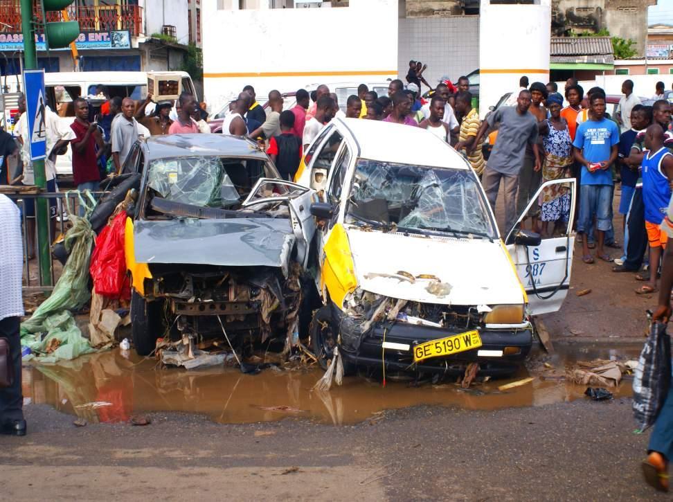
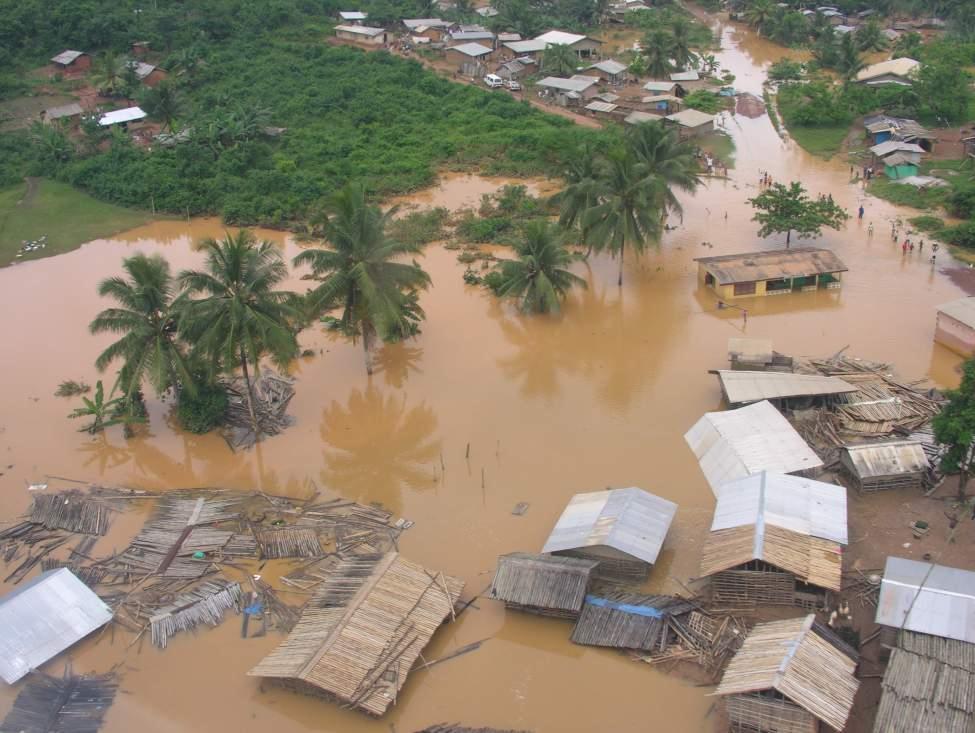
2 Introduction Flooding- A major environmental problem in GAMA Annual event since 1995 Devastating effects on both life and property. Floods in June-August (2009) left six dead, 15,616 displaced and GH 1,777, worth of items destroyed in Accra (NADMO, 2009) Urgent need to address it and reverse losses
3
4
5 Objectives Develop a robust method of identifying broadscale flood risk zones for GAMA Flood risk mapping based on certain defined factors; topography, soil, rainfall, drainage and landuse A flood map showing current flood situation in GAMA
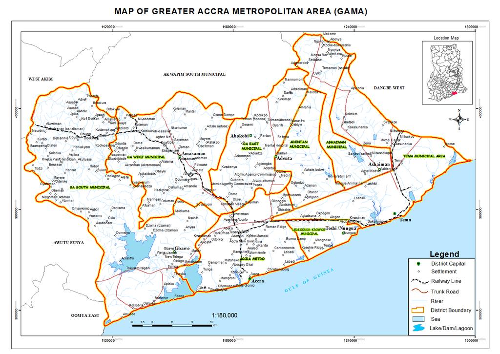
6 Study Area Accra forms part of a large built-up area called the Greater Accra Metropolitan Area (GAMA) in the Greater Accra Region. GAMA - Eight administrative districts namely; Accra Metro (AMA), Tema Metro (TMA), Ashaiman (AshMA), Ledzokuku-Krowor (LekMA), Adentan (AdMA), Ga-East (GEMA), Ga-West (GWMA) and Ga-South (GSMA).
7
: www.pubmencentral.nih.")
8 Methodology Geographic Information Systems (GIS) Approach Figure 1: The GIS Model Source: Ward et al. (2004):
9 Flood Risk Mapping Data Input (Defined-factors) Landuse/landcover (Vegetation and builtup/bare ground) for landuse mapping (Landsat ETM +) taken on 30/12/2005. Topography (Elevation and Slope) using Digital Elevation Model (DEM) taken in Rainfall Soil formation Drainage (rivers and other water bodies)
10 PROCEDURE Landsat ETM+ image processing into landuse/ landcover classes (built-up/bare, vegetation and water bodies) using Erdas Imagine 9.2. Using point data to represent areas of spatial variability of specific parameters helps provide an understanding of interdependence and importance of factors (Poyry,2008; Nyarko, 2002). Assign score/weight to defined data setslanduse, topography/slope, rainfall, geology and drainage. See Table 1.
11 Table 1. Themes with assigned Score (weight) Layer Criteria Weight (Score) Landuse Forest/Agriculture 1 Built-up and bare 2 land/non-forest Topography Elevation 2 Slope 1 Geology Soil types 1 Rainfall Rainfall distribution 1 Drainage Distribution of water bodies 1
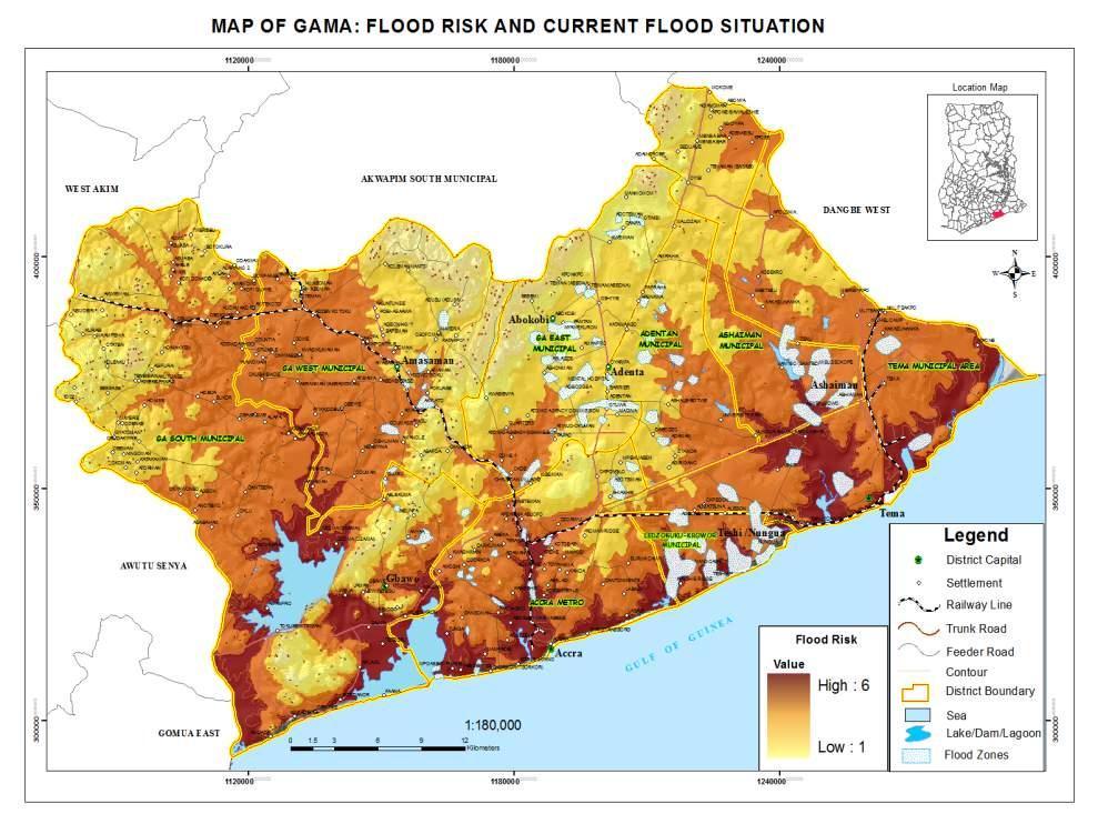
12 Weighted overlay analysis using the Spatial Analyst Tool (ArcGIS 9.3) A weighted layer derived from combination of defined data sets (landuse/landcover, topography/slope, rainfall, geology and drainage) Composition of flood risk map in ArcGIS 9.3 Recoding of flood risk zones into (5): - Very high, High, Medium, Low and Very Low.
13 Current Flood Situation Materials Base Map of GAMA Garmin GPSMAP 76CSx handheld GPS Current flood communities (NADMO,2011) Procedure Field survey to determine flood areas in affected communities Taking of point/areas using handheld GPS Development of flood database in Excel
14 Procedure cont. Import database into ArcGIS 9.3 On-screen digitizing of points taken from the field into polygons/areas Composition of map (Display, editing and analysis of layers) Final current Flood situation map
15 Results Flood Risk Map Current Flood Situation Map
16
17 Summary of results Significantly large area of High risk zone. Low-lying areas of GAMA relatively more likely to get flooded than areas on relatively higher elevations. Many areas of GAMA situated in the Very High flood risk zones are found to also have elevations of below 50m above sea level ( eg. Alajo, Glefe and part of Lashibi)
18 Results- Flood risk map Similarly, significant areas of the High Risk zone lie in the range of 50m to 150m contours. For the Medium Risk zone, many areas have elevations of 150m 250m above sea level. The Low and Very Low zones also fall significantly in the range 300m-400m and above 400m contours respectively on the map.
19
20 Observations Flood areas in GAMA mostly found in low lying areas. Flood areas in most instances closely associated with drainage systems. Some natural waterlogged areas encroached upon by human settlements (eg, South of Pentecost University College, Sowutuom). Poor drainage systems hence inability of run-off to flow easily to safe grounds (eg, Middle East, Ashaiman).
21 Observations Flood areas have elevation ranging between -7.3 m below sea level m above sea level. About 99.9% have elevation of less that 100m above sea level Similarly, 74% of the flood areas lie below 50m contour. Current flood areas mostly situated in the Ashaiman, Ledzokuku-Krowor, Ga-East and Ga- South than in the AMA, Ga-West District, Adentan Municipal and Tema Metro.
22
23 THE END THANK YOU
DROUGHT RISK EVALUATION USING REMOTE SENSING AND GIS : A CASE STUDY IN LOP BURI PROVINCE
 DROUGHT RISK EVALUATION USING REMOTE SENSING AND GIS : A CASE STUDY IN LOP BURI PROVINCE K. Prathumchai, Kiyoshi Honda, Kaew Nualchawee Asian Centre for Research on Remote Sensing STAR Program, Asian Institute
RESEARCH METHODOLOGY
 III. RESEARCH METHODOLOGY 3.1. Time and Research Area The field work was taken place in primary forest around Toro village in Lore Lindu National Park, Indonesia. The study area located in 120 o 2 53 120
Urban Growth Analysis: Calculating Metrics to Quantify Urban Sprawl
 Urban Growth Analysis: Calculating Metrics to Quantify Urban Sprawl Jason Parent jason.parent@uconn.edu Academic Assistant GIS Analyst Daniel Civco Professor of Geomatics Center for Land Use Education
Monitoring and Temporal Study of Mining Area of Jodhpur City Using Remote Sensing and GIS
 Monitoring and Temporal Study of Mining Area of Jodhpur City Using Remote Sensing and GIS S. K Yadav 1, S. L Borana 2 1,2 Scientist, Remote Sensing Group, DL, Jodhpur-342011, Rajasthan, India ---------------------------------------------------------------------***---------------------------------------------------------------------
IMPACTS OF SEA LEVEL RISE in Bangkok, Thailand
 IMPACTS OF SEA LEVEL RISE in Bangkok, Thailand Hiroaki KAKIUCHI Chuo Mapping Co., Ltd Takekazu AKAGIRI, Takahito KUROKI, Tohru NAGAYAMA Geographic Survey Institute, Min. of Construction, JAPAN Shunji MURAI,
Review Using the Geographical Information System and Remote Sensing Techniques for Soil Erosion Assessment
 Polish J. of Environ. Stud. Vol. 19, No. 5 (2010), 881-886 Review Using the Geographical Information System and Remote Sensing Techniques for Soil Erosion Assessment Nuket Benzer* Landscape Architecture
GIS Based Delineation of Micro-watershed and its Applications: Mahendergarh District, Haryana
 Kamla-Raj 2012 J Hum Ecol, 38(2): 155-164 (2012) GIS Based Delineation of Micro-watershed and its Applications: Mahendergarh District, Haryana Gulshan Mehra and Rajeshwari * Department of Geography, Kurukshetra
International Journal of Intellectual Advancements and Research in Engineering Computations
 ISSN:2348-2079 Volume-5 Issue-2 International Journal of Intellectual Advancements and Research in Engineering Computations Agricultural land investigation and change detection in Coimbatore district by
Shalaby, A. & Gad, A.
 Urban Sprawl Impact Assessment on the Fertile Agricultural Land of Egypt Using Remote Sensing and Digital Soil Database, Case study: Qalubiya Governorate Shalaby, A. & Gad, A. National Authority for Remote
Determination of flood risks in the yeniçiftlik stream basin by using remote sensing and GIS techniques
 Determination of flood risks in the yeniçiftlik stream basin by using remote sensing and GIS techniques İrfan Akar University of Atatürk, Institute of Social Sciences, Erzurum, Turkey D. Maktav & C. Uysal
Determine the flooded area based on elevation information and the current water level
 Identifying Data Needs Identifying Data Needs Purpose Before looking for data, the methodology needs to be analyzed to establish what data is needed The most important question that needs to be answered
Display data in a map-like format so that geographic patterns and interrelationships are visible
 Vilmaliz Rodríguez Guzmán M.S. Student, Department of Geology University of Puerto Rico at Mayagüez Remote Sensing and Geographic Information Systems (GIS) Reference: James B. Campbell. Introduction to
Applying Hazard Maps to Urban Planning
 Applying Hazard Maps to Urban Planning September 10th, 2014 SAKAI Yuko Disaster Management Expert JICA Study Team for the Metro Cebu Roadmap Study on the Sustainable Urban Development 1 Contents 1. Outline
Application of Remote Sensing Techniques for Change Detection in Land Use/ Land Cover of Ratnagiri District, Maharashtra
 IOSR Journal of Applied Geology and Geophysics (IOSR-JAGG) e-issn: 2321 0990, p-issn: 2321 0982.Volume 3, Issue 6 Ver. II (Nov. - Dec. 2015), PP 55-60 www.iosrjournals.org Application of Remote Sensing
INTERNATIONAL JOURNAL OF ENVIRONMENTAL SCIENCES Volume 5, No 6, Copyright by the authors - Licensee IPA- Under Creative Commons license 3.
 INTERNATIONAL JOURNAL OF ENVIRONMENTAL SCIENCES Volume 5, No 6, 2015 Copyright by the authors - Licensee IPA- Under Creative Commons license 3.0 Research article ISSN 0976 4402 Flood hazard zonation of
FLOODS AND THEİR LİKELY İMPACTS ON ECOLOGİCAL ENVİRONMENT İN THE BOLAMAN RİVER BASİN (ORDU, TURKEY)
") FLOODS AND THEİR LİKELY İMPACTS ON ECOLOGİCAL ENVİRONMENT İN THE BOLAMAN RİVER BASİN (ORDU, TURKEY) Hüseyin TUROĞLU1, İskender DÖLEK2 1 Istanbul University, Letter Faculty, Department of Geography Laleli
FLOODS AND THEİR LİKELY İMPACTS ON ECOLOGİCAL ENVİRONMENT İN THE BOLAMAN RİVER BASİN (ORDU, TURKEY) Hüseyin TUROĞLU1, İskender DÖLEK2 1 Istanbul University, Letter Faculty, Department of Geography Laleli
DEVELOPMENT OF FLOOD HAZARD VULNERABILITY MAP FOR ALAPPUZHA DISTRICT
 DEVELOPMENT OF FLOOD HAZARD VULNERABILITY MAP FOR ALAPPUZHA DISTRICT Ciya Maria Roy 1, Elsa Manoj 2, Harsha Joy 3, Sarin Ravi 4, Abhinanda Roy 5 1,2,3,4 U.G. Student, Department of Civil Engineering, MITS
Remote Sensing and GIS Application in Change Detection Study Using Multi Temporal Satellite
 Cloud Publications International Journal of Advanced Remote Sensing and GIS 2013, Volume 2, Issue 1, pp. 374-378, Article ID Tech-181 ISSN 2320-0243 Case Study Open Access Remote Sensing and GIS Application
Geospatial Technologies for the Agricultural Sciences
 Geospatial Technologies for the Agricultural Sciences Maggi Kelly Assoc. Cooperative Extension Specialist Department of Environmental Science, Policy & Management Director, GIIF UC Berkeley Karin Tuxen
Alaska, USA. Sam Robbins
 Using ArcGIS to determine erosion susceptibility within Denali National Park, Alaska, USA Sam Robbins Introduction Denali National Park is six million acres of wild land with only one road and one road
The Development of the Slope Failure Management System
 FANG Ji, Akiyuki KAWASAKI, Satoru SADOHARA The Development of the Slope Failure Management System There are many incidents of slope failure across Japan. The measures are required. Recently soft-measures
2013 Esri Europe, Middle East and Africa User Conference October 23-25, 2013 Munich, Germany
 2013 Esri Europe, Middle East and Africa User Conference October 23-25, 2013 Munich, Germany Environmental and Disaster Management System in the Valles Altos Region in Carabobo / NW-Venezuela Prof.Dr.habil.Barbara
Determination of Urban Runoff Using ILLUDAS and GIS
 Texas A&M University Department of Civil Engineering Instructor: Dr. Francisco Olivera CVEN689 Applications of GIS to Civil Engineering Determination of Urban Runoff Using ILLUDAS and GIS Tae Jin Kim 03.
EFFECT OF WATERSHED DEVELOPMENT PROGRAMME IN GUDHA GOKALPURA VILLAGE, BUNDI DISTRICT, RAJASTHAN - A REMOTE SENSING STUDY
 EFFECT OF WATERSHED DEVELOPMENT PROGRAMME IN GUDHA GOKALPURA VILLAGE, BUNDI DISTRICT, RAJASTHAN - A REMOTE SENSING STUDY G. Sajeevan, C. P. Johnson, D. J. Pal and B. K. Kakade* C-DAC, Pune University Campus,
Introduction INTRODUCTION TO GIS GIS - GIS GIS 1/12/2015. New York Association of Professional Land Surveyors January 22, 2015
 New York Association of Professional Land Surveyors January 22, 2015 INTRODUCTION TO GIS Introduction GIS - GIS GIS 1 2 What is a GIS Geographic of or relating to geography the study of the physical features
Classification of Erosion Susceptibility
 GEO327G: GIS & GPS Applications in Earth Sciences Classification of Erosion Susceptibility Denali National Park, Alaska Zehao Xue 12 3 2015 2 TABLE OF CONTENTS 1 Abstract... 3 2 Introduction... 3 2.1 Universal
2014 Summer Training Courses on Slope Land Disaster Reduction Hydrotech Research Institute, National Taiwan University, Taiwan August 04-15, 2014
 Final Project Report 2014 Summer Training Courses on Slope Land Disaster Reduction Hydrotech Research Institute, National Taiwan University, Taiwan August 04-15, 2014 Landslides in Mt. Umyeon Susceptibility
Remote Sensing and GIS Applications for Hilly Watersheds SUBASHISA DUTTA DEPARTMENT OF CIVIL ENGINEERING IIT GUWAHATI
 Remote Sensing and GIS Applications for Hilly Watersheds SUBASHISA DUTTA DEPARTMENT OF CIVIL ENGINEERING IIT GUWAHATI Deciding Alternative Land Use Options in a Watershed Using GIS Source: Anita Prakash
Eagle Creek Post Fire Erosion Hazard Analysis Using the WEPP Model. John Rogers & Lauren McKinney
 Eagle Creek Post Fire Erosion Hazard Analysis Using the WEPP Model John Rogers & Lauren McKinney Columbia River Gorge at Risk: Using LiDAR and GIS-based predictive modeling for regional-scale erosion susceptibility
Monitoring and Change Detection along the Eastern Side of Qena Bend, Nile Valley, Egypt Using GIS and Remote Sensing
 Advances in Remote Sensing, 2013, 2, 276-281 http://dx.doi.org/10.4236/ars.2013.23030 Published Online September 2013 (http://www.scirp.org/journal/ars) Monitoring and Change Detection along the Eastern
Remote Sensing / GIS Conference. The Louisiana Proposed Elevation for the Nation Business Plan Components
 Remote Sensing / GIS Conference 08 April 2008 The Louisiana Proposed Elevation for the Nation Business Plan Components David Gisclair, Louisiana Oil Spill Coordinators Office, Office of the Governor david.gisclair@la.gov
Existing NWS Flash Flood Guidance
 Introduction The Flash Flood Potential Index (FFPI) incorporates physiographic characteristics of an individual drainage basin to determine its hydrologic response. In flash flood situations, the hydrologic
INTERNATIONAL JOURNAL OF CIVIL ENGINEERING AND TECHNOLOGY (IJCIET) GIS SPATIAL ANALYSIS FOR DIGITAL ELEVATION MODEL (DEM) APPLICATION
 GIS SPATIAL ANALYSIS FOR DIGITAL ELEVATION MODEL (DEM) APPLICATION") INTERNATIONAL JOURNAL OF CIVIL ENGINEERING AND TECHNOLOGY (IJCIET) International Journal of Civil Engineering and Technology (IJCIET), ISSN 0976 6308 ISSN 0976 6308 (Print) ISSN 0976 6316(Online) Volume
INTERNATIONAL JOURNAL OF CIVIL ENGINEERING AND TECHNOLOGY (IJCIET) International Journal of Civil Engineering and Technology (IJCIET), ISSN 0976 6308 ISSN 0976 6308 (Print) ISSN 0976 6316(Online) Volume
Effect of land use/land cover changes on runoff in a river basin: a case study
 Water Resources Management VI 139 Effect of land use/land cover changes on runoff in a river basin: a case study J. Letha, B. Thulasidharan Nair & B. Amruth Chand College of Engineering, Trivandrum, Kerala,
Geographic Information Systems (GIS) in Environmental Studies ENVS Winter 2003 Session III
 in Environmental Studies ENVS Winter 2003 Session III") Geographic Information Systems (GIS) in Environmental Studies ENVS 6189 3.0 Winter 2003 Session III John Sorrell York University sorrell@yorku.ca Session Purpose: To discuss the various concepts of space,
Geographic Information Systems (GIS) in Environmental Studies ENVS 6189 3.0 Winter 2003 Session III John Sorrell York University sorrell@yorku.ca Session Purpose: To discuss the various concepts of space,
USING LIDAR MEASUREMENTS FOR IMPROVING OR UP-DATING A DEM
 JAES_1(14)_3_2011 VAIS M. et. all, pp.123-128 SECTION Geodesic Engineering USING LIDAR MEASUREMENTS FOR IMPROVING OR UP-DATING A DEM VAIS Manuel*, IOSIF Gheorghe, Bucharest University, *e-mail: manuel.vais@sipg.ro
Summary Description Municipality of Anchorage. Anchorage Coastal Resource Atlas Project
 Summary Description Municipality of Anchorage Anchorage Coastal Resource Atlas Project By: Thede Tobish, MOA Planner; and Charlie Barnwell, MOA GIS Manager Introduction Local governments often struggle
MAPPING LAND USE/ LAND COVER OF WEST GODAVARI DISTRICT USING NDVI TECHNIQUES AND GIS Anusha. B 1, Sridhar. P 2
 MAPPING LAND USE/ LAND COVER OF WEST GODAVARI DISTRICT USING NDVI TECHNIQUES AND GIS Anusha. B 1, Sridhar. P 2 1 M. Tech. Student, Department of Geoinformatics, SVECW, Bhimavaram, A.P, India 2 Assistant
Urban Sprawl Prediction and Change Detection Analysis in and around Thiruvannamalai Town Using Remote Sensing and GIS
 Urban Sprawl Prediction and Change Detection Analysis in and around Thiruvannamalai Town Using Remote Sensing and GIS Hemanandhini.S 1, Suresh babu.s 2, Vinay.M.S 3 Department of Remote Sensing, Adhiyamaan
INTERNATIONAL JOURNAL OF GEOMATICS AND GEOSCIENCES Volume 2, No 1, 2011
 INTERNATIONAL JOURNAL OF GEOMATICS AND GEOSCIENCES Volume 2, No 1, 2011 Copyright 2010 All rights reserved Integrated Publishing services Research article ISSN 0976 4380 Land Use / Land cover change detection
Climatic Change Implications for Hydrologic Systems in the Sierra Nevada
 Climatic Change Implications for Hydrologic Systems in the Sierra Nevada Part Two: The HSPF Model: Basis For Watershed Yield Calculator Part two presents an an overview of why the hydrologic yield calculator
Pierce Cedar Creek Institute GIS Development Final Report. Grand Valley State University
 Pierce Cedar Creek Institute GIS Development Final Report Grand Valley State University Major Goals of Project The two primary goals of the project were to provide Matt VanPortfliet, GVSU student, the
Integrated Remote Sensing and GIS Approach for Groundwater Exploration using Analytic Hierarchy Process (AHP) Technique.
 Technique.") ISSN (Online) : 2319-8753 ISSN (Print) : 2347-6710 International Journal of Innovative Research in Science, Engineering and Technology An ISO 3297: 2007 Certified Organization, Volume 2, Special Issue
ISSN (Online) : 2319-8753 ISSN (Print) : 2347-6710 International Journal of Innovative Research in Science, Engineering and Technology An ISO 3297: 2007 Certified Organization, Volume 2, Special Issue
MORPHOMETRIC ANALYSIS OF WATERSHEDS IN THE KUNIGAL AREA OF TUMKUR DISTRICT, SOUTH INDIA USING REMOTE SENSING AND GIS TECHNOLOGY
 MORPHOMETRIC ANALYSIS OF WATERSHEDS IN THE KUNIGAL AREA OF TUMKUR DISTRICT, SOUTH INDIA USING REMOTE SENSING AND GIS TECHNOLOGY PROJECT REFERENCE NO. : 37S1170 COLLEGE : SIDDAGANGA INSTITUTE OF TECHNOLOGY,
Using the Stock Hydrology Tools in ArcGIS
 Using the Stock Hydrology Tools in ArcGIS This lab exercise contains a homework assignment, detailed at the bottom, which is due Wednesday, October 6th. Several hydrology tools are part of the basic ArcGIS
ABSTRACT The first chapter Chapter two Chapter three Chapter four
 ABSTRACT The researches regarding this doctoral dissertation have been focused on the use of modern techniques and technologies of topography for the inventory and record keeping of land reclamation. The
Calculating Land Values by Using Advanced Statistical Approaches in Pendik
 Presented at the FIG Congress 2018, May 6-11, 2018 in Istanbul, Turkey Calculating Land Values by Using Advanced Statistical Approaches in Pendik Prof. Dr. Arif Cagdas AYDINOGLU Ress. Asst. Rabia BOVKIR
THE REVISION OF 1:50000 TOPOGRAPHIC MAP OF ONITSHA METROPOLIS, ANAMBRA STATE, NIGERIA USING NIGERIASAT-1 IMAGERY
 I.J.E.M.S., VOL.5 (4) 2014: 235-240 ISSN 2229-600X THE REVISION OF 1:50000 TOPOGRAPHIC MAP OF ONITSHA METROPOLIS, ANAMBRA STATE, NIGERIA USING NIGERIASAT-1 IMAGERY 1* Ejikeme, J.O. 1 Igbokwe, J.I. 1 Igbokwe,
Abstract: Contents. Literature review. 2 Methodology.. 2 Applications, results and discussion.. 2 Conclusions 12. Introduction
 Abstract: Landfill is one of the primary methods for municipal solid waste disposal. In order to reduce the environmental damage and to protect the public health and welfare, choosing the site for landfill
IDENTIFICATION OF LANDSLIDE-PRONE AREAS USING REMOTE SENSING TECHNIQUES IN SILLAHALLAWATERSHED, NILGIRIS DISTRICT,TAMILNADU,INDIA
 IDENTIFICATION OF LANDSLIDE-PRONE AREAS USING REMOTE SENSING TECHNIQUES IN SILLAHALLAWATERSHED, NILGIRIS DISTRICT,TAMILNADU,INDIA J.Jayanthi 1, T.Naveen Raj 2, M.Suresh Gandhi 3, 1 Research Scholar, Department
UNITED NATIONS E/CONF.96/CRP. 5
 UNITED NATIONS E/CONF.96/CRP. 5 ECONOMIC AND SOCIAL COUNCIL Eighth United Nations Regional Cartographic Conference for the Americas New York, 27 June -1 July 2005 Item 5 of the provisional agenda* COUNTRY
Introduction to Geographic Information Systems (GIS): Environmental Science Focus
: Environmental Science Focus") Introduction to Geographic Information Systems (GIS): Environmental Science Focus September 9, 2013 We will begin at 9:10 AM. Login info: Username:!cnrguest Password: gocal_bears Instructor: Domain: CAMPUS
Introduction to Geographic Information Systems (GIS): Environmental Science Focus September 9, 2013 We will begin at 9:10 AM. Login info: Username:!cnrguest Password: gocal_bears Instructor: Domain: CAMPUS
Name Class Date. For each pair of terms, explain how the meanings of the terms differ.
 Skills Worksheet Chapter Review USING KEY TERMS For each pair of terms, explain how the meanings of the terms differ. 1. true north and magnetic north 2. latitude and longitude 3. equator and prime meridian
Remote Sensing and GIS Contribution to. Tsunami Risk Sites Detection. of Coastal Areas in the Mediterranean
 The Third International Conference on Early Warning (EWC III), 26.-29.March 2006 in Bonn Remote Sensing and GIS Contribution to Tsunami Risk Sites Detection of Coastal Areas in the Mediterranean BARBARA
Data Quality and Uncertainty. Accuracy, Precision, Data quality and Errors
 Data Quality and Uncertainty The power of GIS analysis is based on the assembly of layers of data, but as data layers increase, errors multiply (and quality decreases). Garbage in, garbage out. High quality
GIS ANALYSIS OF DRIVERS OF EROSION AND GULLYING IN SOUTHEAST NIGERIA
 GIS ANALYSIS OF DRIVERS OF EROSION AND GULLYING IN SOUTHEAST NIGERIA Mayowa FASONA & Ademola OMOJOLA Department of Geography University of Lagos, Nigeria mfasona@unilag.edu.ng Outline Background Methodology
Mitigating Flood Losses: An Introduction to Implementing a Basin-wide Approach Using Remote Sensing and Geographic Information Systems (GIS)
") Vol. 1 No. 1 January 2011 ISSN: 2094-9251 pp. 103-113 International Peer Reviewed Journal Mitigating Flood Losses: An Introduction to Implementing a Basin-wide Approach Using Remote Sensing and Geographic
Vol. 1 No. 1 January 2011 ISSN: 2094-9251 pp. 103-113 International Peer Reviewed Journal Mitigating Flood Losses: An Introduction to Implementing a Basin-wide Approach Using Remote Sensing and Geographic
INTERNATIONAL JOURNAL OF GEOMATICS AND GEOSCIENCES Volume 1, No 1, 2010
 Delineation of Areas for Water Conservation in Peruvamba River basin, Kannur district, Kerala, Using Remote Sensing and GIS. Sampad Kumar Panda, B. Sukumar M.Tech Remote Sensing and GIS, SRM University,
Data Quality and Uncertainty
 Data Quality and Uncertainty The power of GIS analysis is based on the assembly of layers of data, but as data layers increase, errors multiply - quality decreases. Garbage in, garbage out. High quality
Archaeological Predictive Modeling within the context of Paleo-river Terraces in the City of Prince George
 Archaeological Predictive Modeling within the context of Paleo-river Terraces in the City of Prince George Background The documented pre-contact archaeological record of the Interior Plateau of B.C. is
Effect of land cover / use change on soil erosion assessment in Dubračina catchment (Croatia)
") European Water 57: 171-177, 2017. 2017 E.W. Publications Effect of land cover / use change on soil erosion assessment in Dubračina catchment (Croatia) N. Dragičević *, B. Karleuša and N. Ožanić Faculty
European Water 57: 171-177, 2017. 2017 E.W. Publications Effect of land cover / use change on soil erosion assessment in Dubračina catchment (Croatia) N. Dragičević *, B. Karleuša and N. Ožanić Faculty
Landslide Susceptibility Mapping Using Logistic Regression in Garut District, West Java, Indonesia
 Landslide Susceptibility Mapping Using Logistic Regression in Garut District, West Java, Indonesia N. Lakmal Deshapriya 1, Udhi Catur Nugroho 2, Sesa Wiguna 3, Manzul Hazarika 1, Lal Samarakoon 1 1 Geoinformatics
1. Introduction. Jai Kumar, Paras Talwar and Krishna A.P. Department of Remote Sensing, Birla Institute of Technology, Ranchi, Jharkhand, India
 Cloud Publications International Journal of Advanced Remote Sensing and GIS 2015, Volume 4, Issue 1, pp. 1026-1032, Article ID Tech-393 ISSN 2320-0243 Research Article Open Access Forest Canopy Density
Welcome to NetMap Portal Tutorial
 Welcome to NetMap Portal Tutorial Potential Applications What Can you do with the Portal? At least 25 things! 1) Locate the best potential fish habitats. 2) Identify biological hotspots. 3) Map floodplain
Evaluation of groundwater potential zones in Krishnagiri District, Tamil Nadu using MIF Technique
 Evaluation of groundwater potential zones in Krishnagiri District, Tamil Nadu using MIF Technique Manikandan.J 1, Kiruthika.A.M 2, S.Sureshbabu 3 Student, M.Tech Remote sensing, Adhiyamaan College Of Engineering,
VISUALIZATION URBAN SPATIAL GROWTH OF DESERT CITIES FROM SATELLITE IMAGERY: A PRELIMINARY STUDY
 CO-439 VISUALIZATION URBAN SPATIAL GROWTH OF DESERT CITIES FROM SATELLITE IMAGERY: A PRELIMINARY STUDY YANG X. Florida State University, TALLAHASSEE, FLORIDA, UNITED STATES ABSTRACT Desert cities, particularly
Land Cover and Soil Properties of the San Marcos Subbasin
 Land Cover and Soil Properties of the San Marcos Subbasin Cody McCann EWRE Graduate Studies December 6, 2012 Table of Contents Project Background............................................................
Hydrologic Modelling of the Upper Malaprabha Catchment using ArcView SWAT
 Hydrologic Modelling of the Upper Malaprabha Catchment using ArcView SWAT Technical briefs are short summaries of the models used in the project aimed at nontechnical readers. The aim of the PES India
![)UDQFR54XHQWLQ(DQG'tD]'HOJDGR&](/thumbs/95/125846872.jpg ")UDQFR54XHQWLQ(DQG'tD]'HOJDGR&") &21&(37,21$1',03/(0(17$7,212)$1+
&21&(37,21$1',03/(0(17$7,212)$1+ Floodplain modeling. Ovidius University of Constanta (P4) Romania & Technological Educational Institute of Serres, Greece
 Romania & Technological Educational Institute of Serres, Greece") Floodplain modeling Ovidius University of Constanta (P4) Romania & Technological Educational Institute of Serres, Greece Scientific Staff: Dr Carmen Maftei, Professor, Civil Engineering Dept. Dr Konstantinos
Floodplain modeling Ovidius University of Constanta (P4) Romania & Technological Educational Institute of Serres, Greece Scientific Staff: Dr Carmen Maftei, Professor, Civil Engineering Dept. Dr Konstantinos
THE 3D SIMULATION INFORMATION SYSTEM FOR ASSESSING THE FLOODING LOST IN KEELUNG RIVER BASIN
 THE 3D SIMULATION INFORMATION SYSTEM FOR ASSESSING THE FLOODING LOST IN KEELUNG RIVER BASIN Kuo-Chung Wen *, Tsung-Hsing Huang ** * Associate Professor, Chinese Culture University, Taipei **Master, Chinese
Progress and Land-Use Characteristics of Urban Sprawl in Busan Metropolitan City using Remote sensing and GIS
 Progress and Land-Use Characteristics of Urban Sprawl in Busan Metropolitan City using Remote sensing and GIS Homyung Park, Taekyung Baek, Yongeun Shin, Hungkwan Kim ABSTRACT Satellite image is very usefully
EMERGENCY PLANNING IN NORTHERN ALGERIA BASED ON REMOTE SENSING DATA IN RESPECT TO TSUNAMI HAZARD PREPAREDNESS
 EMERGENCY PLANNING IN NORTHERN ALGERIA BASED ON REMOTE SENSING DATA IN RESPECT TO TSUNAMI HAZARD PREPAREDNESS Barbara Theilen-Willige Technical University of Berlin, Institute of Applied Geosciences Department
GIS-based Food Hazard Mapping: A case study in Krishnai river basin, India
 Research Journal of Recent Sciences E-ISSN 2277-2502 GIS-based Food Hazard Mapping: A case study in Krishnai river basin, India Abstract Thakuriah Gitika 1* and Saikia Ranjan 2 1 Cotton College State University,
INTERNATIONAL JOURNAL OF GEOMATICS AND GEOSCIENCES Volume 2, No 1, 2011
 INTERNATIONAL JOURNAL OF GEOMATICS AND GEOSCIENCES Volume 2, No 1, 2011 Copyright 2010 All rights reserved Integrated Publishing services Research article ISSN 0976 4380 Spatio-Temporal changes of Land
Outcrop suitability analysis of blueschists within the Dry Lakes region of the Condrey Mountain Window, North-central Klamaths, Northern California
 Outcrop suitability analysis of blueschists within the Dry Lakes region of the Condrey Mountain Window, North-central Klamaths, Northern California (1) Introduction: This project proposes to assess the
International Journal of Research in Advent Technology, Vol.2, No.10, October 2014 E-ISSN:
 Monitoring of Land Use Land Cover Change over the Years Due to River Course Shifting: A Case Study on Ganga River Basin near Malda District, West Bengal Using Geo-informatices Techniques Somnath maiti
Vulnerability of Flood Hazard in Selected Ayeyarwady Delta Region, Myanmar
 Vulnerability of Flood Hazard in Selected Ayeyarwady Delta Region, Myanmar Khin Thandar Win Department of Civil Engineering Nilar Aye Department of Civil Engineering Kyaw Zaya Htun Department of Remote
Urban Erosion Potential Risk Mapping with GIS
 Urban Erosion Potential Risk Mapping with GIS ESRI Water Conference San Diego, CA Jan 29-Feb 1, 2018 Dr. Randy Dymond, PE, F.ASCE, D.WRE Co-investigators: Amanda Weikmann, MS Student Dr. Clay Hodges, PE
Flood Level Simulation Modeling And Vulnerability Of Slums Along Musiriver, Hyderabad
 International Journal of Humanities and Social Science Invention (IJHSSI) ISSN (Online): 2319 7722, ISSN (Print): 2319 7714 Volume 7 Issue 05 Ver. I May. 2018 PP.51-56 Flood Level Simulation Modeling And
GIS BASED ANALYSIS ON ENVIRONMENTAL SENSITIVE AREAS AND IDENTIFICATION OF THE POTENTIAL DISASTER HAZARDOUS LOCATIONS IN SOUTHERN SRI LANKA
 International Journal of Civil & Environmental Engineering IJCEE Vol: 9 No: 9-311 - GIS BASED ANALYSIS ON ENVIRONMENTAL SENSITIVE AREAS AND IDENTIFICATION OF THE POTENTIAL DISASTER HAZARDOUS LOCATIONS
MAP STUDY: INTERPRETATION OF SURVEY MAPS
 MAP STUDY: INTERPRETATION OF SURVEY MAPS Types and Elements of Maps Maps are drawn to represent the Earth on a piece of paper. Maps are used widely to represent the Earth. Maps use signs and symbols in
Pipeline Routing Using Geospatial Information System Analysis
 Pipeline Routing Using Geospatial Information System Analysis Mahmoud Reza 1 Delavar and Fereydoon 2 Naghibi 1-Assistance Professor, Dept. of Surveying and Geomatic Eng., Eng. Faculty, University of Tehran,
Accuracy Assessment of Land Cover Classification in Jodhpur City Using Remote Sensing and GIS
 Accuracy Assessment of Land Cover Classification in Jodhpur City Using Remote Sensing and GIS S.L. Borana 1, S.K.Yadav 1 Scientist, RSG, DL, Jodhpur, Rajasthan, India 1 Abstract: A This study examines
Utilization of Global Map for Societal Benefit Areas
 Utilization of Global Map for Societal Benefit Areas The Fourth GEOSS AP Symposium Bali Indonesia, 11th March 2010 Shuhei Kojima Geographical Survey Institute Ministry of Land, Infrastructure, Transport
Flood hazard mapping in Urban Council limit, Vavuniya District, Sri Lanka- A GIS approach
 International Research Journal of Environment Sciences E-ISSN 2319 1414 Flood hazard mapping in Urban Council limit, Vavuniya District, Sri Lanka- A GIS approach Abstract M.S.R. Akther* and G. Tharani
Creating Watersheds from a DEM
 Creating Watersheds from a DEM These instructions enable you to create watersheds of specified area using a good quality Digital Elevation Model (DEM) in ArcGIS 8.1. The modeling is performed in ArcMap
SITE SELECTION FOR NEW DESALINATION PLANT AND PLANNING AN OPTIMAL WATER DISTRIBUTION NETWORK IN TUTICORIN TALUK
 SITE SELECTION FOR NEW DESALINATION PLANT AND PLANNING AN OPTIMAL WATER DISTRIBUTION NETWORK IN TUTICORIN TALUK *Miss.V.Sahana Devi, **Mrs.G.Devi. *PG student: Department of Civil Engineering, **Assistant
International Symposium on Natural Disaster Mitigation. Local vulnerability assessment of landslides and debris flows
 International Symposium on Natural Disaster Mitigation of landslides and debris flows Lessons learnt from Cam Pha town and Van Don district, Quang Ninh province, Vietnam Nguyen Quoc Phi Faculty of Environment
Delineation of Groundwater Potential Zone on Brantas Groundwater Basin
 Delineation of Groundwater Potential Zone on Brantas Groundwater Basin Andi Rachman Putra 1, Ali Masduqi 2 1,2 Departement of Environmental Engineering, Sepuluh Nopember Institute of Technology, Indonesia
GIS Geographic Information System
 GIS Geographic Information System Andrea Petroselli Tuscia University, Italy petro@unitus.it SUMMARY Part 1: Part 2: Part 3: Part 4: What is a GIS? Why do we need a GIS? Which are the possibilities of
Natural Terrain Risk Management in Hong Kong
 Natural Terrain Risk Management in Hong Kong Nick Koor Senior Lecturer in Engineering Geology School of Earth and Environmental Sciences Slope failures in Hong Kong Man-made Slope Failure - 300 landslides
Geospatial Approach for Delineation of Landslide Susceptible Areas in Karnaprayag, Chamoli district, Uttrakhand, India
 Geospatial Approach for Delineation of Landslide Susceptible Areas in Karnaprayag, Chamoli district, Uttrakhand, India Ajay Kumar Sharma & Anand Mohan Singh Overview Landslide - movement of a mass of rock,
1 Introduction: 2 Data Processing:
 Darren Janzen University of Northern British Columbia Student Number 230001222 Major: Forestry Minor: GIS/Remote Sensing Produced for: Geography 413 (Advanced GIS) Fall Semester Creation Date: November
Use of Geospatial data for disaster managements
 Use of Geospatial data for disaster managements Source: http://alertsystemsgroup.com Instructor : Professor Dr. Yuji Murayama Teaching Assistant : Manjula Ranagalage What is GIS? A powerful set of tools
Assessment of Urban Geomorphological Hazard in the North-East of Cairo City, Using Remote Sensing and GIS Techniques. G. Albayomi
 Assessment of Urban Geomorphological Hazard in the North-East of Cairo City, Using Remote Sensing and GIS Techniques G. Albayomi Geography Department, Faculty of Arts, Helwan University, Cairo, Egypt Gehan_albayomi@arts.helwan.edu.eg
Description of Simandou Archaeological Potential Model. 12A.1 Overview
 12A Description of Simandou Archaeological Potential Model 12A.1 Overview The most accurate and reliable way of establishing archaeological baseline conditions in an area is by conventional methods of
Research Themes The development of GIS based methodology for the identification of potential wet grassland restoration sites
 Catchment and Coastal Environments Research Group Research Themes The development of GIS based methodology for the identification of potential wet grassland restoration sites Dr Andrew Williams email a.williams@plymouth.ac.uk
Abstract: About the Author:
 REMOTE SENSING AND GIS IN LAND USE PLANNING Sathees kumar P 1, Nisha Radhakrishnan 2 1 1 Ph.D Research Scholar, Department of Civil Engineering, National Institute of Technology, Tiruchirappalli- 620015,
08/01/2012. LiDAR. LiDAR Benefits. LiDAR-BASED DELINEATION OF WETLAND BORDERS. CCFFR-2012 Society for Canadian Limnologists:
 LiDAR CCFFR-2012 Society for Canadian Limnologists: Science for Wetland Policy and Management LiDAR-BASED DELINEATION OF WETLAND BORDERS Distance from laser to ground and back again: Determined as laser-pulse