ROLE OF SINDH AGRICULTURE UNIVERSITY TANDOJAM IN AGRICULTURE INFORMATION SYSTEM
|
|
|
- Anne Horton
- 6 years ago
- Views:
Transcription

 Arable area: 5.")
 Population: 42.")
1 ROLE OF SINDH AGRICULTURE UNIVERSITY TANDOJAM IN AGRICULTURE INFORMATION SYSTEM PROF. DR. ALTAF ALI SIYAL CHAIRMAN DEPARTMENT OF LAND AND WATER MANAGEMENT SINDH FACTS ABOUT SINDH Total Geographical area: km 2 (14.09 M ha) Arable area: 5.45 M ha (38.7% of total area) Irrigated area: 2.1 M ha (38.5% of arable land) Population: 42.4 Millions Major Crops: Wheat, Rice, Cotton, Sugarcane Major Fruits: Mango, Guava, Banana, dates, Barrages: 03 Canals: 14 1
 31.4% SUGARCANE 0.226 13.7 24.")
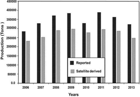
2 AGRICULTURAL PRODUCTION IN SINDH ( ) CROP AREA (M ha) PRODUCTION (M Tons) PERCENT PRODUCTION WHEAT % RICE % COTTON (bales) 31.4% SUGARCANE SINDH AGRICULTURE UNIVERSITY TANDOJAM 2014 Faculties 05 Institutes 02 Departments 35 Constituent Colleges 02 2
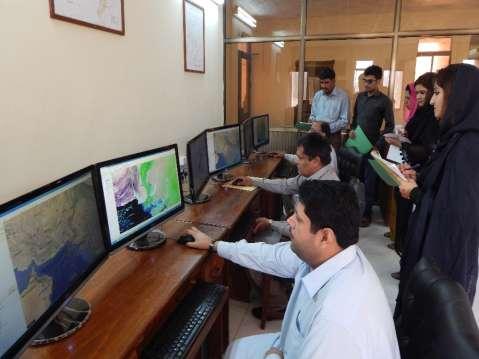
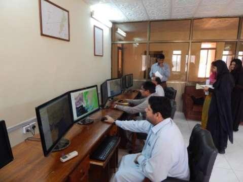
3 WORKING GROUPS 1. MANAGEMENT GROUP i. Prof. Dr. Muhammad Safar Mirjat, Dean, Faculty of Agricultural Engineering ii. Prof. Dr. Altaf Ali Siyal, Professor & Focal Person of FAO Project iii. Dr. Abdul Ghafoor Siyal, Associate Professor (Irrigation Specialist) 2. TECHNICAL GROUP i. Prof. Dr. Altaf Ali Siyal, Focal Person (Hydrologist) ii. iii. iv. Dr. Abdul Ghafoor Siyal (Irrigation Specialist) Dr. Abdul Samad Chandio (Irrigation Specialist) Syed Baig Shah (IT Expert) Three meetings are held regarding planning and implementation of project objectives and expected outcomes. ESTABLISHMENT OF REMOTE SENSING AND GIS LAB RS and GIS Laboratory was established at Sindh Agriculture University Tandojam in April, 2014 in collaboration with USDA and FAO For building capacity of teacher and taught. S# Item Quantity 1 a) Dell PowerEdge T620 Server b) 19 inch Monitors 2 a) Dell precision T3500 Workstations (Intel Xeon Processor) 03 b) 24 monitors 06 3 APC Symmetra UPS 6KAV 01 4 HP A3 Color laser Printer- CP552dn 01 5 Networking Equipment (Switch 28 ports) 01 6 Samsung Glaxy Note PTCL Evo Nitro (9.3 Mb)
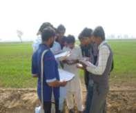
4 USAGE OF RS AND GIS LAB The laboratory is being extensively used by the undergraduate and postgraduate students as well as teaching faculty. Lab focuses on real time crop monitoring, area estimation and yield forecasting as well as Monitoring of other natural resources and disasters in Sindh. USAGE OF RS AND GIS IN LAB & FIELD Following targets have so far been achieved: Hundred students were trained in application of RS & GIS in Agriculture Twenty faculty members have been given orientation on application of RS & GIS Farmer s Desk has been established to support, guide and disseminate crop and land use information for future practices Continuously consultative discussions have been made with CRS Sindh, UMD, UAF and SUPARCO GIS techniques have been used in field for acquiring geo-referenced Data Poster Presentations, pamphlet distribution and social media have been intensively used to propagate and disseminate the information 4
 of undergraduate students and three postgraduate students were engaged to work on crop area estimation")
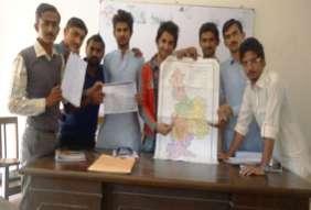
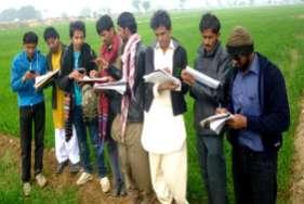
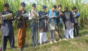
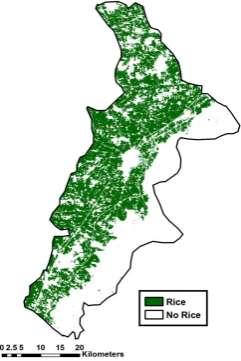
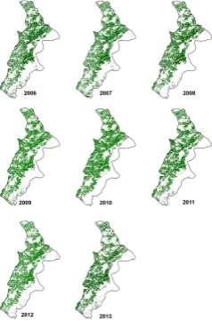
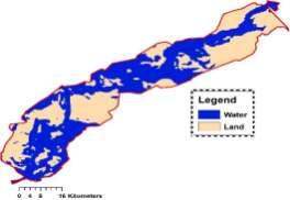
5 USAGE OF RS AND GIS IN LAB & FIELD Since establishment of Lab in April, 2014 and in the period of six months, out 28 districts, 05 districts (Hyderabad, Matiari, Tando Allahyar, Umerkot and Larkana) were selected for crop area and yield estimation using RS & GIS Two groups (10 students in each) of undergraduate students and three postgraduate students were engaged to work on crop area estimation and yield forecast using RS & GIS 5
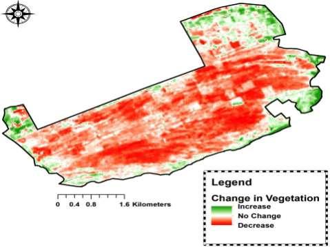
6 6
7 7

8 8
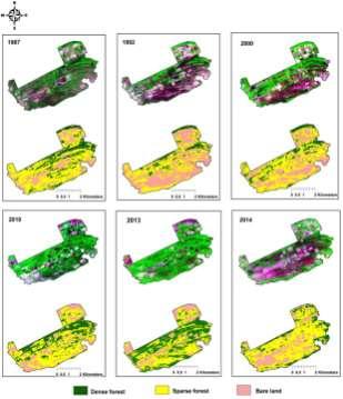
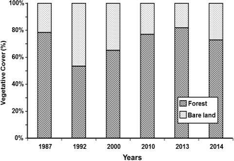
9 FUTURE PLAN FOR EFFECTIVE USAGE OF RS & GIS All the students will be trained in application of RS & GIS in Agro-informatics All the faculty members will be given orientation on application of RS & GIS Trainings will be offered to the identified Farmers Associations to support, guide and disseminate crop and land use information for future practices Efforts for the structural collaboration will be taken with CRS Sindh, UMD, UAF, FAO, USDA & SUPARCO Series of poster Presentations, pamphlet distribution and social media interaction will be managed to propagate and disseminate the information Print and electronic media will specially be focused for the said purpose by writing articles, TV talk-shows etc. FUTURE PLAN FOR EFFECTIVE USAGE OF RS & GIS Remaining districts of the Sindh are targeted for crop area and yield estimation using RS & GIS CRS Sindh will be asked for the training in the areas: Crop monitoring, area estimation and yield prediction using RS and GIS tools Preparation of crop masks of all major crops grown in Sindh Preparation of area frames and NDVI calculations and interpretations for different crops Use of GLAM, CROP INFORMATION and GEONETWORK web portals Development of statistical yield forecasting models and preparation of Crop News Bulletins 9
10 APPLICATION OF RS & GIS IN ACADEMIC RESEARCH Research Papers = 03 Presentations = 01 BE Projects = 02 ME Thesis = Paper Presentation on Floods 2010 and 2011 in Sindh: Climate Change or Bad Governance in 10 th Annual Fulbright & Humphrey Alumni Conference, November 22-24, 2013, Lahore Pakistan 2. A research paper entitled Remote Sensing and GIS Based wheat Crop Acreage and Yield Estimation of District Hyderabad, Pakistan accepted for publishing in Mehran University Research Journal of Engineering & Technology (HEC Recognised in X Category) 3. A research paper entitled Rice yield estimation using Landsat ETM+ Data. Jan Dempewolf and Inbal Becker-Reshef from UMD are co-authors of paper. The paper is ready for submission to Cambridge Journal The Journal of Agricultural Science. 4. A research paper entitled Spatial and temporal vegetation dynamics of Pai Forest, Sindh, Pakistan using Remote Sensing and GIS is under Review in Journal of Forestry Research. APPLICATION OF RS & GIS IN ACADEMIC RESEARCH 1. A post-graduate thesis entitled, Estimation of area under major crops and corresponding irrigation requirements in district Tando Allahyar using field, historical and satellite data. 2. A post-graduate thesis entitled, Estimation of area under major crops and corresponding irrigation requirements in district Umerkot using field, historical and satellite data. 3. A post-graduate thesis entitled, Study of soil, water and cropping pattern of Danstar Wah (Manchhar Lake) command area using field and Landsat 8 imagery/data. 4. An undergraduate research project entitled, A Geo-referenced Survey of trees at Sindh Agriculture University Campus. 5. An undergraduate project on Estimation of area under major crops in district Hyderabad using geo-referenced field and satellite data 6. An undergraduate project on Estimation of area under major crops in district Matiari using geo-referenced field and satellite data 10


11 APPLICATION OF RS & GIS IN ACADEMIC RESEARCH 1. Spatial and Temporal vegetation dynamics of Kot Dhingana Forest, Sindh, Pakistan using Remote Sensing and GIS. 2. Spatial and Temporal assessment of impact of sea water intrusion on Indus Delta using Space Technology. 3. Development of hydraulic model based on relationship between Indus flood discharge and flooded Riverine area between Guddu-Sukkur reach using Remote sensing and GIS. 11
12 12
13 13
14 14
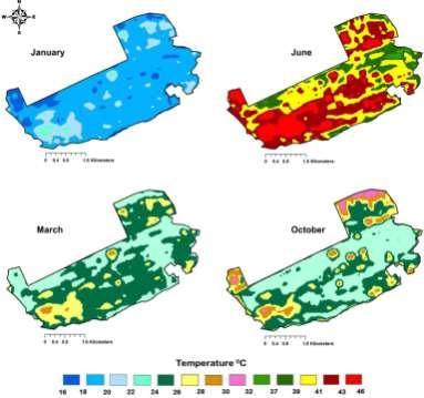
15 15


16 THANK YOU FOR YOUR KIND ATTENTION 16
Land Cover Atlas of Pakistan The Sindh Province
 Land Cover By District Land Cover Atlas of Pakistan The Sindh Province Shikarpur Shikarpur district borders Larkana, Jacobabad, Khairpur and Sukkur. Shikarpur was a forted city with seven gates,hathi Gate,
Existing GIS Resources on the Indus Basin
 Existing GIS Resources on the Indus Basin Workshop on Spatial Information Analysis for the Sustainable Management of the Indus Basin in Pakistan May 26-27, 2003 Elements of Existing GIS Resources Data
DROUGHT RISK EVALUATION USING REMOTE SENSING AND GIS : A CASE STUDY IN LOP BURI PROVINCE
 DROUGHT RISK EVALUATION USING REMOTE SENSING AND GIS : A CASE STUDY IN LOP BURI PROVINCE K. Prathumchai, Kiyoshi Honda, Kaew Nualchawee Asian Centre for Research on Remote Sensing STAR Program, Asian Institute
UNITED NATIONS E/CONF.96/CRP. 5
 UNITED NATIONS E/CONF.96/CRP. 5 ECONOMIC AND SOCIAL COUNCIL Eighth United Nations Regional Cartographic Conference for the Americas New York, 27 June -1 July 2005 Item 5 of the provisional agenda* COUNTRY
Remote Sensing and EO activities at the University of Turku
 Remote Sensing and EO activities at the University of Turku Niina Käyhkö Associate Professor Department of Geography and Geology GEO meeting/syke May 23rd, 2018 Geospatial competence at the University
Teaching experience. Education and training. International Water Management Institute, Chowk Thokar Niaz Baig, Lahore, Pakistan
 Name and address of employer Type of business or sector International Water Management Institute, Chowk Thokar Niaz Baig, 53700 Lahore, Pakistan Research Institute Dates October 1996 - September 2003 Occupation
DROUGHT ASSESSMENT USING SATELLITE DERIVED METEOROLOGICAL PARAMETERS AND NDVI IN POTOHAR REGION
 DROUGHT ASSESSMENT USING SATELLITE DERIVED METEOROLOGICAL PARAMETERS AND NDVI IN POTOHAR REGION Researcher: Saad-ul-Haque Supervisor: Dr. Badar Ghauri Department of RS & GISc Institute of Space Technology
Transboundary water management with Remote Sensing. Oluf Jessen DHI Head of Projects, Water Resources Technical overview
 Transboundary water management with Remote Sensing Oluf Jessen DHI Head of Projects, Water Resources Technical overview ozj@dhigroup.com Transboundary water management Water management across national
REMOTELY SENSED INFORMATION FOR CROP MONITORING AND FOOD SECURITY
 LEARNING OBJECTIVES Lesson 4 Methods and Analysis 2: Rainfall and NDVI Seasonal Graphs At the end of the lesson, you will be able to: understand seasonal graphs for rainfall and NDVI; describe the concept
Historical background
 Space Technology for Disaster Management in Sri Lanka: Country profile, national perspectives & vision. Professor Ranjith Premalal De Silva Vice Chancellor Uva Wellassa University of Sri Lanka October
Socio-Economic Benefits of Weather, Water & Climate Services
 Socio-Economic Benefits of Weather, Water & Climate Services A Case Study of Pakistan Dr. Qamar-uz-Zaman Chaudhry Director General Pakistan Meteorological Department http://www.pakmet.com.pk Economic benefits
Drought risk assessment using GIS and remote sensing: A case study of District Khushab, Pakistan
 15 th International Conference on Environmental Science and Technology Rhodes, Greece, 31 August to 2 September 2017 Drought risk assessment using GIS and remote sensing: A case study of District Khushab,
Teaching GIS Technology at UW-Superior. Volume 9, Number 8: May 23, 2003
 Teaching GIS Technology at UW-Superior Volume 9, Number 8: May 23, 2003 William Bajjali University of Wisconsin, department of Biology and Earth Science, Superior, WI 54880 Abstract As educators, it is
Florida International University Library-Based GIS Center and Digital Scholarship
 Florida International University Library-Based GIS Center and Digital Scholarship Presenters: Zhaohui Jennifer Fu, Head of FIU GIS Center Jamie Rogers, Assistant Director of Digital Collection Center Outline
CHANGE DETECTION USING REMOTE SENSING- LAND COVER CHANGE ANALYSIS OF THE TEBA CATCHMENT IN SPAIN (A CASE STUDY)
") CHANGE DETECTION USING REMOTE SENSING- LAND COVER CHANGE ANALYSIS OF THE TEBA CATCHMENT IN SPAIN (A CASE STUDY) Sharda Singh, Professor & Programme Director CENTRE FOR GEO-INFORMATICS RESEARCH AND TRAINING
CHANGE DETECTION USING REMOTE SENSING- LAND COVER CHANGE ANALYSIS OF THE TEBA CATCHMENT IN SPAIN (A CASE STUDY) Sharda Singh, Professor & Programme Director CENTRE FOR GEO-INFORMATICS RESEARCH AND TRAINING
Development of Global Map for GEOSS SBAs US-09-03a
 Development of Global Map for GEOSS SBAs US-09-03a UIC User Engagement Session 2 November, 2010 Yoshikazu FUKUSHIMA Secretariat General of International Steering Committee for Global Mapping Geospatial
Regional Centre for Mapping of Resources for Development (RCMRD), Nairobi, Kenya. Introduction GIS (2 weeks: 10 days)
, Nairobi, Kenya. Introduction GIS (2 weeks: 10 days)") Regional Centre for Mapping of Resources for Development (RCMRD), Nairobi, Kenya Introduction GIS (: 10 days) Intake Dates: 9 th Jan, 6 th Feb, 6 th Mar, 3 rd April, 8 th May, 5 th June, 3 rd July, 2017
Regional Centre for Mapping of Resources for Development (RCMRD), Nairobi, Kenya Introduction GIS (: 10 days) Intake Dates: 9 th Jan, 6 th Feb, 6 th Mar, 3 rd April, 8 th May, 5 th June, 3 rd July, 2017
Capacity Building on Geoportals. Geoinformatics Centre, AIT, Thailand
 Capacity Building on Geoportals in PIC Geoinformatics Centre, AIT, Thailand Content 1. About Geoinformatics Centre, AIT, Thailand 2. Introduction to Project and Our Contribution 3. Web Maps and Geonode
Regional Centre for Mapping of Resources for Development (RCMRD), Nairobi, Kenya
, Nairobi, Kenya") Regional Centre for Mapping of Resources for Development (RCMRD), Nairobi, Kenya Introduction GIS ( 2 weeks: 10 days) Intakes: 7 th Jan, 4 th Feb,4 th March, 1 st April 6 th May, 3 rd June, 1 st July,
Regional Centre for Mapping of Resources for Development (RCMRD), Nairobi, Kenya Introduction GIS ( 2 weeks: 10 days) Intakes: 7 th Jan, 4 th Feb,4 th March, 1 st April 6 th May, 3 rd June, 1 st July,
Request for the use of the Doppler on Wheels (DOW) NSF Facility for Education DOW Observations of Lake-Effects
 NSF Facility for Education DOW Observations of Lake-Effects") Request for the use of the Doppler on Wheels (DOW) NSF Facility for Education DOW Observations of Lake-Effects Scott M. Steiger Department of Earth Sciences The State University of New York at Oswego Oswego,
Request for the use of the Doppler on Wheels (DOW) NSF Facility for Education DOW Observations of Lake-Effects Scott M. Steiger Department of Earth Sciences The State University of New York at Oswego Oswego,
Remote Sensing. RS Study in RS&GIS FoS
 AT 76.03 Remote Sensing Prof. Kiyoshi Honda, Chubu University Dr. Nobuya Watanabe, Chubu University Supported by Japanese Government s Short Time Visiting Faculty Scheme RS&GIS School of Engineering and
Land Cover Atlas of Pakistan The Punjab Province
 Land Cover By District Land Cover Atlas of Pakistan The Punjab Province Rahim Yar Khan Rahim Yar Khan district is known for its main crops like cotton, sugarcane and wheat. Most of the orchards are of
Leveraging Sentinel-1 time-series data for mapping agricultural land cover and land use in the tropics
 Leveraging Sentinel-1 time-series data for mapping agricultural land cover and land use in the tropics Caitlin Kontgis caitlin@descarteslabs.com @caitlinkontgis Descartes Labs Overview What is Descartes
Regional Centre for Mapping of Resources for Development (RCMRD), Nairobi, Kenya. Introduction GIS ( 2 weeks: 10 days)
, Nairobi, Kenya. Introduction GIS ( 2 weeks: 10 days)") Regional Centre for Mapping of Resources for Development (RCMRD), Nairobi, Kenya Introduction GIS ( 2 weeks: 10 days) Intakes: 8 th Jan, 6 th Feb,5 th March, 3 rd April 9 th, May 7 th, June 4 th, July
Regional Centre for Mapping of Resources for Development (RCMRD), Nairobi, Kenya Introduction GIS ( 2 weeks: 10 days) Intakes: 8 th Jan, 6 th Feb,5 th March, 3 rd April 9 th, May 7 th, June 4 th, July
GEOMATICS. Shaping our world. A company of
 GEOMATICS Shaping our world A company of OUR EXPERTISE Geomatics Geomatics plays a mayor role in hydropower, land and water resources, urban development, transport & mobility, renewable energy, and infrastructure
NATIONAL HYDROPOWER ASSOCIATION MEETING. December 3, 2008 Birmingham Alabama. Roger McNeil Service Hydrologist NWS Birmingham Alabama
 NATIONAL HYDROPOWER ASSOCIATION MEETING December 3, 2008 Birmingham Alabama Roger McNeil Service Hydrologist NWS Birmingham Alabama There are three commonly described types of Drought: Meteorological drought
Mission Statement. Program outcomes
 Department: Geology Assessment coordinator: Sue DeBari During the 2009-2010 academic year, faculty and staff of the Geology Department engaged themselves in a review of our assessment procedures and materials,
CONTENT. 2 Subject Aims 2. 6 Assessment Strategies 5. 7 Maintaining Standards 5. 9 Annexes 8
 CONTENT Page No Foreword III 1 Introduction 1 1.1 Subject Benchmark statement 1 1.2 Nature and Extent of the Subject 2 2 Subject Aims 2 3 Subject Knowledge and Understanding 3 4 Skills and Attitudes 4
Data challenges in Trans-boundary River Basins: Case Study of the Upper Indus Basin
 Data challenges in Trans-boundary River Basins: Case Study of the Upper Indus Basin Asif Khan Lead Author (Water chapter- AR6 IPCC) Post Doctorate (Water-Energy-Food-Climate Change, IIASA, Austria) PhD
Crowdsourcing approach for large scale mapping of built-up land
 Crowdsourcing approach for large scale mapping of built-up land Kavinda Gunasekara Kavinda@ait.asia Geoinformatics Center Asian Institute of Technology, Thailand. Regional expert workshop on land accounting
Request for Empanelment
 Request for Empanelment (Empanelment is method/procedure/way to seek technical & financial or financial quotation from eligible firm/organization/academic institute to short list eligible contender for
The Relationship between Vegetation Changes and Cut-offs in the Lower Yellow River Based on Satellite and Ground Data
 Journal of Natural Disaster Science, Volume 27, Number 1, 2005, pp1-7 The Relationship between Vegetation Changes and Cut-offs in the Lower Yellow River Based on Satellite and Ground Data Xiufeng WANG
Remote Sensing for Ecosystems
 MODULE GUIDE MSc ENR Remote Sensing for Ecosystems Semester 01 Modul coordinator Lecturers Michael Döring Pascal Ochsner, Diego Tonolla, Diane Whited, Michael Döring Martin Geilhausen Latest update August
HANDBOOK OF PRECISION AGRICULTURE PRINCIPLES AND APPLICATIONS
 http://agrobiol.sggw.waw.pl/cbcs Communications in Biometry and Crop Science Vol. 2, No. 2, 2007, pp. 90 94 International Journal of the Faculty of Agriculture and Biology, Warsaw University of Life Sciences,
Information Needs & Information Seeking in Internet Era: A Case Study of Geographers in Maharashtra
 International Journal of Research in Library Science ISSN: 2455-104X Indexed in: IIJIF, ijindex, SJIF,ISI Volume 2,Issue 1 (January-June) 2016,99-108 Received: 7 May 2016 ; Accepted: 12 May 2016 ; Published:
Regional Centre for Mapping of Resources for Development (RCMRD), Nairobi, Kenya
, Nairobi, Kenya") Regional Centre for Mapping of Resources for Development (RCMRD), Nairobi, Kenya Introduction to GIS (2 weeks: 10 days) Intakes: 8 th January, 6 th February, 5th March, 3 rd. April 9 th, May 7 th, June
Regional Centre for Mapping of Resources for Development (RCMRD), Nairobi, Kenya Introduction to GIS (2 weeks: 10 days) Intakes: 8 th January, 6 th February, 5th March, 3 rd. April 9 th, May 7 th, June
ENVIRONMENT AND NATURAL RESOURCES 3700 Introduction to Spatial Information for Environment and Natural Resources. (2 Credit Hours) Semester Syllabus
 Semester Syllabus") ENVIRONMENT AND NATURAL RESOURCES 3700 Introduction to Spatial Information for Environment and Natural Resources COURSE INSTRUCTOR: Dr. Kris Jaeger Assistant Professor 359 Kottman Hall (Mondays and Tuesdays)
ENVIRONMENT AND NATURAL RESOURCES 3700 Introduction to Spatial Information for Environment and Natural Resources COURSE INSTRUCTOR: Dr. Kris Jaeger Assistant Professor 359 Kottman Hall (Mondays and Tuesdays)
An Internet-based Agricultural Land Use Trends Visualization System (AgLuT)
") An Internet-based Agricultural Land Use Trends Visualization System (AgLuT) Prepared for Missouri Department of Natural Resources Missouri Department of Conservation 07-01-2000-12-31-2001 Submitted by
An Internet-based Agricultural Land Use Trends Visualization System (AgLuT) Prepared for Missouri Department of Natural Resources Missouri Department of Conservation 07-01-2000-12-31-2001 Submitted by
Extreme Flooding Events Assessment Using Remote Sensing and GIS.
 Extreme Flooding Events Assessment Using Remote Sensing and GIS. MS Thesis Remote Sensing and GIS Presented By Syed Hammad Shabbir CIIT\FA13-RRG-010\ISB Supervisor: Dr Aqeel Ahmed Kidwai COMSATS Institute
SEQUENCE OF PRESENTATION
 17 TH SESSION OF THE INTERGOVERNMENTAL CONSULTATIVE COMMITTEE MEETING ON THE REGIONAL SPACE APPLICATIONS PROGRAMME FOR SUSTAINABLE DEVELOPMENT 24-27 November 2013, Bangkok, Thailand ACHIEVEMENTS OF APPLICATIONS
March 2007 The Survey Department of Sri Lanka
 Contribution of Survey Department of Sri Lanka for Mitigation of Disasters in Sri Lanka K.A.U.N.Kasthuri Deputy Surveyor General (Information Technology) March 2007 The Survey Department of Sri Lanka 1
Application of Remote Sensing Techniques for Change Detection in Land Use/ Land Cover of Ratnagiri District, Maharashtra
 IOSR Journal of Applied Geology and Geophysics (IOSR-JAGG) e-issn: 2321 0990, p-issn: 2321 0982.Volume 3, Issue 6 Ver. II (Nov. - Dec. 2015), PP 55-60 www.iosrjournals.org Application of Remote Sensing
Application of remote sensing for agricultural disasters
 Application of remote sensing for agricultural disasters Bingfang Wu, Sheng Chang Institute of Remote Sensing and Digital Earth (RADI) Chinese Academy of Sciences (CAS) wubf@radi.ac.cn, changsheng@radi.ac.cn
Course Syllabus. Geospatial Data & Spatial Digital Technologies: Assessing Land Use/Land Cover Change in the Ecuadorian Amazon.
 Course Syllabus Geospatial Data & Spatial Digital Technologies: Assessing Land Use/Land Cover Change in the Ecuadorian Amazon Co- Instructors Dr. Carlos F. Mena, Universidad San Francisco de Quito, Ecuador
REVIEW MAPWORK EXAM QUESTIONS 31 JULY 2014
 REVIEW MAPWORK EXAM QUESTIONS 31 JULY 2014 Lesson Description In this lesson we: Focus on key concepts and exam questions relating to GIS. Question 1 Test Yourself The most important component of a GIS
ISSUES AND APPROACHES TO COUPLING GIS TO AN IRRIGATION DISTRIBUTION NETWORK AND SEEPAGE LOSS MODELS ABSTRACT
 ISSUES AND APPROACHES TO COUPLING GIS TO AN IRRIGATION DISTRIBUTION NETWORK AND SEEPAGE LOSS MODELS Yanbo Huang 1, Milton Henry 2, David Flahive 3, Guy Fipps 4 ABSTRACT Geographic Information Systems (GIS)
Session 2.1: Terminology, Concepts and Definitions
 Second Regional Training Course on Sampling Methods for Producing Core Data Items for Agricultural and Rural Statistics Module 2: Review of Basics of Sampling Methods Session 2.1: Terminology, Concepts
Land Use / Land Cover Mapping in
 Land Use / Land Cover Mapping in Eastern and Southern African Regions RCMRD Experience by 6/24/2013, Nairobi Kenya Dr. Tesfaye Korme Director of RS, GIS and Mapping, RCMRD I. About RCMRD, Its Vision and
Capacity Building Activities at CRECTEALC. Ing. Jerjes Molina Blancas Professor and Developer.
 Capacity Building Activities at CRECTEALC Ing. Jerjes Molina Blancas Professor and Developer. Centro Regional de Enseñanza de Ciencia y Tecnología del Espacio para América Latina y el Caribe (CRECTEALC)
Dr. Qamar-uz-Zaman Chaudhry Director General
 Dr. Qamar-uz-Zaman Chaudhry Director General Pakistan Meteorological Department http://www.pakmet.com.pk Economic benefits of Hydrological And Meteorological Services Effective Hydrological And Meteorological
VENUS INTERNATIONAL COLLEGE OF TECHNOLOGY
 VENUS INTERNATIONAL COLLEGE OF TECHNOLOGY DEPARTMENT OF E&C ENGINEERING A REPORT ON INDUSTRIAL VISIT AT BISAG, GANDHINAGAR PROFILE: BISAG provides specialized services and solutions in implementing mapbased
Punjab & Sindh Pakistan 20/14. RABI Crop MASK WHEAT and AUTUMN POTATO
 Punjab & Sindh Pakistan 20/14 13 RABI Crop MASK WHEAT and AUTUMN POTATO Punjab & Sindh Pakistan 20/14 13 RABI Crop MASK WHEAT and AUTUMN POTATO Food and Agriculture Organization of the United Nations
Use of Geospatial data for disaster managements
 Use of Geospatial data for disaster managements Source: http://alertsystemsgroup.com Instructor : Professor Dr. Yuji Murayama Teaching Assistant : Manjula Ranagalage What is GIS? A powerful set of tools
Progress and Land-Use Characteristics of Urban Sprawl in Busan Metropolitan City using Remote sensing and GIS
 Progress and Land-Use Characteristics of Urban Sprawl in Busan Metropolitan City using Remote sensing and GIS Homyung Park, Taekyung Baek, Yongeun Shin, Hungkwan Kim ABSTRACT Satellite image is very usefully
RECTAS
 RECTAS www.rectas.org RECTAS: Capacity Building in Space Technology and Geospatial Data Applications Isi A. Ikhuoria Executive Director, RECTAS, Ile-Ife, Nigeria e-mail: edrectas@rectas.org +234 803 373
Land cover/land use mapping and cha Mongolian plateau using remote sens. Title. Author(s) Bagan, Hasi; Yamagata, Yoshiki. Citation Japan.
 Bagan, Hasi; Yamagata, Yoshiki. Citation Japan.") Title Land cover/land use mapping and cha Mongolian plateau using remote sens Author(s) Bagan, Hasi; Yamagata, Yoshiki International Symposium on "The Imp Citation Region Specific Systems". 6 Nove Japan.
Title Land cover/land use mapping and cha Mongolian plateau using remote sens Author(s) Bagan, Hasi; Yamagata, Yoshiki International Symposium on "The Imp Citation Region Specific Systems". 6 Nove Japan.
ESRI educational site license in Bahir Dar University. Tegegn Molla Abebe Mengaw Geospatial Data and Technology Center, BDU
 ESRI educational site license in Bahir Dar University Tegegn Molla Abebe Mengaw Geospatial Data and Technology Center, BDU September, 2016 Mission, Vision Purpose and Values of the GDTC Mission of GDTC
Satellite remote sensing and GIS used to quantify water input for rice cultivation (Rhône delta, France)
") 446 Remote Sensing and Hydrology 2000 (Proceedings of a symposium held at Sanla Fe, New Mexico, USA, April 2000). IAHS Publ. no. 267, 2001. Satellite remote sensing and GIS used to quantify water input
446 Remote Sensing and Hydrology 2000 (Proceedings of a symposium held at Sanla Fe, New Mexico, USA, April 2000). IAHS Publ. no. 267, 2001. Satellite remote sensing and GIS used to quantify water input
Barnabas Chipindu, Department of Physics, University of Zimbabwe
 DEFICIENCIES IN THE OPERATIONAL APPLICATIONS OF LONG - RANGE WEATHER PREDICTIONS FOR AGRICULTURE - RECOMMENDATIONS FOR IMPROVING THE TECHNOLOGY FOR THE BENEFIT OF AGRICULTURE AT THE NATIONAL AND REGIONAL
Spatial Disaggregation of Land Cover and Cropping Information: Current Results and Further steps
 CAPRI CAPRI Spatial Disaggregation of Land Cover and Cropping Information: Current Results and Further steps Renate Koeble, Adrian Leip (Joint Research Centre) Markus Kempen (Universitaet Bonn) JRC-AL
Minnesota K-12 Academic Standards in Social Studies. Grade 4: Geography of North America
 Minnesota K-12 Academic s in Social Studies Grade 4: Geography of North America 4 Describe how people take 1. Democratic government action to influence a depends on informed and decision on a specific
Short Term Course GEOINFORMATION SCIENCE AND TECHNOLOGY REMOTE SENSING, GPS, & GIS APPLICATIONS. Duration: 20 Weeks Two Batches in an year
 Short Term Course on GEOINFORMATION SCIENCE AND TECHNOLOGY REMOTE SENSING, GPS, & GIS APPLICATIONS Duration: 20 Weeks Two Batches in an year Information Brochure Dr. R. Satheesh Centre for Remote Sensing
Soil Erosion Calculation using Remote Sensing and GIS in Río Grande de Arecibo Watershed, Puerto Rico
 Soil Erosion Calculation using Remote Sensing and GIS in Río Grande de Arecibo Watershed, Puerto Rico Alejandra M. Rojas González Department of Civil Engineering University of Puerto Rico at Mayaguez.
SPACE & UPPER ATMOSPHERE RESEARCH COMMISSION (SUPARCO)
") SPACE & UPPER ATMOSPHERE RESEARCH COMMISSION (SUPARCO) Pakistan Space & Upper Atmosphere Research Commission (SUPARCO) is the national space agency, responsible for execution of space technology ad applications
SPACE & UPPER ATMOSPHERE RESEARCH COMMISSION (SUPARCO) Pakistan Space & Upper Atmosphere Research Commission (SUPARCO) is the national space agency, responsible for execution of space technology ad applications
Development of a Regional Land Cover Monitoring System In the Lower Mekong Region a Joint Effort Between SERVIR-Mekong and Partners -
 Mekong Development of a Regional Land Cover Monitoring System In the Lower Mekong Region a Joint Effort Between SERVIR-Mekong and Partners - Aekkapol Aekakkararungroj SERVIR-Mekong Asian Disaster Preparedness
Curriculum. Vitae. Personal Information:
 Curriculum Vitae Personal Information: Name Date of Birth Place of Birth Marital Status Position Address Communication Abdullah Ahmed Al-Taher 13, April,1955 Al-Mubarraz Al_Hassa Married, (6 Children)
Droughts are normal recurring climatic phenomena that vary in space, time, and intensity. They may affect people and agriculture at local scales for
 I. INTRODUCTION 1.1. Background Droughts are normal recurring climatic phenomena that vary in space, time, and intensity. They may affect people and agriculture at local scales for short periods or cover
Use of Climate information in Disaster Risk Management in Zimbabwe
 Use of Climate information in Disaster Risk Management in Zimbabwe WMO Regional Technical Meeting & User/CONOPS Workshop, 28 th October 2015 Lameck Betera Department of Civil Protection Institutional Arrangements
Strategic Plan for the Geospatial Teaching, Research, and Outreach in CNR. The CNR Geospatial Steering Committee, March 31, 2008
 Strategic Plan for the Geospatial Teaching, Research, and Outreach in CNR The CNR Geospatial Steering Committee, March 31, 2008 Current Mission for the Geospatial Learning Center Established in 1995, the
DEVELOPMENT OF LAND SUITABILITY EVALUATION SYSTEM FOR COASTAL AQUACULTURE USING ARTIFICIAL NEURAL NETWORK AND GEOGRAPHICAL INFORMATION SYSTEMS
 DEVELOPMENT OF LAND SUITABILITY EVALUATION SYSTEM FOR COASTAL AQUACULTURE USING ARTIFICIAL NEURAL NETWORK AND GEOGRAPHICAL INFORMATION SYSTEMS Case Study: Mahakam Delta, East Kalimantan I KETUT SUTARGA
URBAN CHANGE DETECTION OF LAHORE (PAKISTAN) USING A TIME SERIES OF SATELLITE IMAGES SINCE 1972
 USING A TIME SERIES OF SATELLITE IMAGES SINCE 1972") URBAN CHANGE DETECTION OF LAHORE (PAKISTAN) USING A TIME SERIES OF SATELLITE IMAGES SINCE 1972 Omar Riaz Department of Earth Sciences, University of Sargodha, Sargodha, PAKISTAN. omarriazpk@gmail.com ABSTRACT
URBAN CHANGE DETECTION OF LAHORE (PAKISTAN) USING A TIME SERIES OF SATELLITE IMAGES SINCE 1972 Omar Riaz Department of Earth Sciences, University of Sargodha, Sargodha, PAKISTAN. omarriazpk@gmail.com ABSTRACT
GIS AND REMOTE SENSING FOR WATER RESOURCE MANAGEMENT
 GIS AND REMOTE SENSING FOR WATER RESOURCE MANAGEMENT G. GHIANNI, G. ADDEO, P. TANO CO.T.IR. Extension and experimental station for irrigation technique - Vasto (Ch) Italy. E-mail : ghianni@cotir.it, addeo@cotir.it,
MAPPING LAND USE/ LAND COVER OF WEST GODAVARI DISTRICT USING NDVI TECHNIQUES AND GIS Anusha. B 1, Sridhar. P 2
 MAPPING LAND USE/ LAND COVER OF WEST GODAVARI DISTRICT USING NDVI TECHNIQUES AND GIS Anusha. B 1, Sridhar. P 2 1 M. Tech. Student, Department of Geoinformatics, SVECW, Bhimavaram, A.P, India 2 Assistant
An Internet-based Agricultural Land Use Trends Visualization System (AgLuT)
") An Internet-based Agricultural Land Use Trends Visualization System (AgLuT) Second half yearly report 01-01-2001-06-30-2001 Prepared for Missouri Department of Natural Resources Missouri Department of
An Internet-based Agricultural Land Use Trends Visualization System (AgLuT) Second half yearly report 01-01-2001-06-30-2001 Prepared for Missouri Department of Natural Resources Missouri Department of
CURICULUM VITAE. 5. Computer applications in Geotechnical Engineering for Masters Students in the evening program.
 CURICULUM VITAE Dr. AMANULLAH MARRI Office Tel. No. (92-21) 99261261-8 ext. 2613 Cell: 03333512240 Email: amanmuri@neduet.edu.pk, amanmarri@yahoo.com Home C-24 Block-C NED University Staff colony Cell:
Agricultural land-use from space. David Pairman and Heather North
 Agricultural land-use from space David Pairman and Heather North Talk Outline Motivation Challenges Different approach Paddock boundaries Classifications Examples Accuracy Issues Data sources Future possibilities
INDIANA ACADEMIC STANDARDS FOR SOCIAL STUDIES, WORLD GEOGRAPHY. PAGE(S) WHERE TAUGHT (If submission is not a book, cite appropriate location(s))
 WHERE TAUGHT (If submission is not a book, cite appropriate location(s))") Prentice Hall: The Cultural Landscape, An Introduction to Human Geography 2002 Indiana Academic Standards for Social Studies, World Geography (Grades 9-12) STANDARD 1: THE WORLD IN SPATIAL TERMS Students
Prentice Hall: The Cultural Landscape, An Introduction to Human Geography 2002 Indiana Academic Standards for Social Studies, World Geography (Grades 9-12) STANDARD 1: THE WORLD IN SPATIAL TERMS Students
2014 Arizona State University, School of Geographical Sciences and Urban Planning Lounsbury Travel Award. $350
 Heather A. Fischer Arizona State University School of Geographical Sciences and Urban Planning P.O. Box 875302 Tempe, AZ 85287-5302 (801) 870-3365 heather.fischer@asu.edu https://sites.google.com/a/asu.edu/heatherafischer/
ISSUES AND APPROACHES TO COUPLING GIS TO IRRIGATION DISTRIBUTION NETWORK AND SEEPAGE LOSS MODELS
 ISSUES AND APPROACHES TO COUPLING GIS TO IRRIGATION DISTRIBUTION NETWORK AND SEEPAGE LOSS MODELS Yanbo Huang 1 Milton Henry 2 David Flahive 3 Guy Fipps 4 ABSTRACT There are several possible approaches
Diffusion of GIS in Public Policy Doctoral Program
 Diffusion of GIS in Public Policy Doctoral Program By Fulbert Namwamba PhD Southern University This presentation demonstrate how GIS was introduced in the Public Policy Doctoral Program at Southern University,
E XTREME D ROUGHT An oppressive, long-term
 E XTREME D ROUGHT 2006-2008 An oppressive, long-term drought lasting from late March of 2006 until late August of 2008 impacted the entire state of Florida, with costly consequences in residential water
Space Application in Support of Land Management for SDG Implementation
 Space Application in Support of Land Management for SDG Implementation Regional Expert Workshop on Land Accounting for SDG Monitoring and Reporting 26 September 2017 Space Application Section Information
Rapid Intervention Program (RIP) to Improve Operational Management and Efficiencies in Irrigation Districts in Iraq
 to Improve Operational Management and Efficiencies in Irrigation Districts in Iraq") Rapid Intervention Program (RIP) to Improve Operational Management and Efficiencies in Irrigation Districts in Iraq USCID Water Management Conference Phoenix, Arizona April 17, 2013 Gabriele Bonaiti Extension
Rapid Intervention Program (RIP) to Improve Operational Management and Efficiencies in Irrigation Districts in Iraq USCID Water Management Conference Phoenix, Arizona April 17, 2013 Gabriele Bonaiti Extension
COUNTRY PRESENTATION ON MR JAYNAL ABEDIN JOINT SECRETARY ( WORKS & DEVELOPMENT ) MINISTRY OF DEFENCE
 MINISTRY OF DEFENCE") COUNTRY PRESENTATION ON By MR JAYNAL ABEDIN JOINT SECRETARY ( WORKS & DEVELOPMENT ) MINISTRY OF DEFENCE Bangladesh Geographical Location of Bangladesh Bangladesh Country at a Glance Physical Features 1,230
COUNTRY PRESENTATION ON By MR JAYNAL ABEDIN JOINT SECRETARY ( WORKS & DEVELOPMENT ) MINISTRY OF DEFENCE Bangladesh Geographical Location of Bangladesh Bangladesh Country at a Glance Physical Features 1,230
RiskCity Training package on the Application of GIS for multi- hazard risk assessment in an urban environment.
 RiskCity Training package on the Application of GIS for multi- hazard risk assessment in an urban environment. Cees van Westen (Westen@itc.nl) & Nanette C. Kingma (Kingma@itc.nl) ITC: Training & Research
The agroclimatic resource change in Mongolia
 The agroclimatic resource change in Mongolia Azzaya D, Gantsetseg B, Munkhzul D Institute of Meteorology and Hydrology,Juulchny gudamj-5, Ulaanbaatar-46, Mongolia, 210646, meteoins@magicnet.mn, azzaya23@yahoo.com
National Remote Sensing Center of China. Space Technology for Sustainable Development in China Status, Achievements and Futures.
 National Remote Sensing Center of China Space Technology for Sustainable Development in China Status, Achievements and Futures Jing Li National Remote Sensing Center of China Ministry of Science and Technology,
Land Administration and Cadastre
 Geomatics play a major role in hydropower, land and water resources and other infrastructure projects. Lahmeyer International s (LI) worldwide projects require a wide range of approaches to the integration
Title: Earthquake Pre-Loss Estimation for Pakistan: Towards Development of GIS-based Analytical Framework
 Muhammad Ahmed HOUSE # 4/A TAJ MENSION NEAR SHOE MARKET, KARACHI POSTAL CODE: 74400 +92-321-2447473 muhammadahmed@neduet.edu.pk, ahmed.geographer@gmail.com Professional Profile Eager to bring university
How Irrigation Affected the Geography of Northeast Oregon
 Delia Wallis How Irrigation Affected the Geography of Northeast Oregon Grade Levels: 4 (with ability to move up or down) Time: two x 45-minute sessions Overview: Students are going to study topographical
Shalaby, A. & Gad, A.
 Urban Sprawl Impact Assessment on the Fertile Agricultural Land of Egypt Using Remote Sensing and Digital Soil Database, Case study: Qalubiya Governorate Shalaby, A. & Gad, A. National Authority for Remote
Yrd. Doç. Dr. Saygın ABDİKAN Öğretim Yılı Güz Dönemi
 Yabancı Dil III (YDL285) Introduction to Geomatics Yrd. Doç. Dr. Saygın ABDİKAN 2017-2018 Öğretim Yılı Güz Dönemi 1 géomatique Geo (Earth) + informatics Geodesy + Geoinformatics Geomatics: The mathematics
Module 3, Investigation 1: Briefing 2 The ENSO game: Predicting and managing for El Niño and La Niña
 Part 5. The ENSO game How can prediction help avoid ENSO s tragic human consequences? Scientists from around the world are involved in forecasting, with computer models and sophisticated measurements,
Investigation of the Effect of Transportation Network on Urban Growth by Using Satellite Images and Geographic Information Systems
 Presented at the FIG Congress 2018, May 6-11, 2018 in Istanbul, Turkey Investigation of the Effect of Transportation Network on Urban Growth by Using Satellite Images and Geographic Information Systems
(Refer Slide Time: 3:48)
") Introduction to Remote Sensing Dr. Arun K Saraf Department of Earth Sciences Indian Institute of Technology Roorkee Lecture 01 What is Satellite based Remote Sensing Hello, hello everyone this is Arun
Introduction to Remote Sensing Dr. Arun K Saraf Department of Earth Sciences Indian Institute of Technology Roorkee Lecture 01 What is Satellite based Remote Sensing Hello, hello everyone this is Arun
CURRICULUM VITAE OF SAMUEL ADU-PRAH
 CURRICULUM VITAE OF SAMUEL ADU-PRAH I. PROFESSIONAL AFFILIATION AND CONTACT INFORMATION A. Lecturer GIS Lab Director-Environmental GIS & Advanced Geospatial Analysis Labs Southern Illinois University Carbondale
Flood Inundation Mapping under different climate change scenarios in the upper Indus River Basin, Pakistan
 Flood Inundation Mapping under different climate change scenarios in the upper Indus River Basin, Pakistan Sohaib Baig (doctoral student) 16 November 2017 Disaster Prevention Research Institute 1 Kyoto
The City School. Pakistan Studies 2059/02 Paper 2 The Environment of Pakistan Class 9
 The City School Prep + Senior -1Section Pakistan Studies 2059/02 Paper 2 The Environment of Pakistan Class 9 Name: Class: The City School /PAF Chapter / Prep + Senior I Section / Worksheet for Intervention
Department of Geosciences. Geology Meteorology Oceanography
 Department of Geosciences Geology Meteorology Oceanography Geoscientists study the earth Rivers Soils Lake sediments Evidence of ancient oceans Maps Volcanoes Fence offset by San Andreas fault Water quality
Sources of Imagery and GIS Data Layers (Last updated October 2005)
") Sources of Imagery and GIS Data Layers (Last updated October 2005) The question of where to find data is one often asked by beginners in precision agriculture and other geospatial projects. The following
Sources of Imagery and GIS Data Layers (Last updated October 2005) The question of where to find data is one often asked by beginners in precision agriculture and other geospatial projects. The following