Hydrologic and Hydraulic Modeling with ArcGIS. Dean Djokic
|
|
|
- Elinor French
- 6 years ago
- Views:
Transcription


1 Hydrologic and Hydraulic Modeling with ArcGIS Dean Djokic
2 Content Water resources issues Core GIS tools for surface water analysis DEM data and processing Arc Hydro Application tools for Hydrologic and Hydraulic Modeling Q&A HH Modeling With GIS 2


3 Water Resources Issues
4 Water Resources Issues Not enough (droughts) Too much (floods) Of wrong kind (water quality) In a wrong place (spatial distribution) At the wrong time (temporal distribution) HH Modeling With GIS 4
5 Focus on Surface Water Quantity How much water is there? - Hydrologic modeling (precipitation-runoff modeling), determines for a given storm on a landscape, how much water will become runoff. Where will it go? - Hydraulic modeling takes the quantity of water and the shape of the landscape and stream channel and determines how deep and fast the water will be, and what area it will cover. HH Modeling With GIS 5
6 Hydrologic Modeling Goal: Find stream discharge, Q, at a location for a given precipitation event. There are many ways to calculate Q. - Statistical methods - USGS regression equations (NFF, StreamStats) - Physical modeling (rainfall-runoff models) - HEC-HMS, SMS, etc. GIS is used to summarize terrain and hydrologic characteristics of the watershed for input to a model. HH Modeling With GIS 6
7 Hydraulic Modeling Goal: Predict water surface elevations and velocities for a given discharge. Input: Terrain geometry with hydraulic characteristics, plus discharge Q and initial water surface level. GIS is used to summarize terrain and hydraulic characteristics of the channel for input to a model and post process hydraulic modeling results (water surface determination). HH Modeling With GIS 7
8 GIS Data for Hydrologic and Hydraulic Modeling Check out Esri s Living Atlas (AGOL) Digital Elevation Model and land cover Watershed boundaries - Hydrography - Soils - HH Modeling With GIS 8
9 GIS Data for Hydrologic and Hydraulic Modeling Current and historic water records Climate and precipitation Channel geometry (cross sections) H&H data are very local - You have to be there when it rains! HH Modeling With GIS 9
10 Core GIS Tools for Surface Water Analysis
11 Drainage System Watershed (Basin, Catchment, Contributing area) Watershed Boundaries (Drainage Divides) Pour Points (Outlets) HH Modeling With GIS 11

12 GIS Tools for Describing Surface Water Movement Dendritic morphology simple process DEM FLOW ACCUMULATION FLOW DIRECTION SINK Apply Threshold STREAM ORDER STREAM LINE STREAM LINK Are there any sinks? Yes No Depressionless DEM FLOWLENGTH FILL SNAP POUR HH Modeling With GIS 12 WATERSHED
13 Flow Direction Elevation Flow Direction HH Modeling With GIS Direction Coding
14 Flow Accumulation HH Modeling With GIS 14 Direction Coding
15 Creating Vector Streams Value = No Data StreamToFeature NET_GRID RasterToFeature HH Modeling With GIS 15
16 Stream Link Assign a unique value to each stream segment. - Can be used as input to Watershed tool HH Modeling With GIS 16

17 Watershed, subwatershed, drainage area Delineate the contributing area to a cell or group of cells. HH Modeling With GIS 17


18 Summarizing Watershed Characteristics Using Zonal Statistics Slope Mean Slope per Watershed Watersheds HH Modeling With GIS 18

19 Using the Tools in the Model Builder HH Modeling With GIS 19
20 DEM Data and Processing
 - DSM: Digital")

21 Elevation Data Key Dataset Types - DEM: Digital Elevation Model (bare Earth) - DSM: Digital Surface Model (with buildings and trees) Data Structure - Raster - TIN - Terrain dataset HH Modeling With GIS 21
22 Where Do You Get DEM Data? Sources - Existing data: USGS DEM, NED, DTED, ETOPO30, SRTM - LiDAR, IfSAR - Generated photogrammetrically - Interpolated from points and lines What cell size and accuracy? - Horizontal and Vertical resolution must be appropriate for the landscape and scale being modeled. HH Modeling With GIS 22
23 DEM Construction Considerations Resolution and extent Projection (for hydrology use equal area) Source elevation data Interpolation techniques - For hydrologic applications, use TopoToRaster. - Avoids problems with contour input - Creates hydrologically correct DEM - Or specialized packages such as ANUDEM HH Modeling With GIS 23
24 DEM Errors Sinks and Spikes Sinks: when sinks are (or are not) sinks lakes, depressions, - Global fill - Dealing with internal basins - Selective fill - Depth - Area - Volume - you just know it Filled Sink sink HH Modeling With GIS 24
25 DEM Editing Streams: When streams are not where they should be - Flat areas Difficulty in determining the flow pattern - Barriers (roads) diverting the flow paths - How to model bridges and culverts in DEM - How to model dams - Imposing the flow pattern - to burn or not to burn (beware of the scale issues and artifacts Saunders, 2000.) - Simple burn - AGREE - OMNR HH Modeling With GIS 25
26 DEM Editing (cont.) Watersheds When watershed boundaries are not where they should be - To fence or not to fence - Ineffective flow areas HH Modeling With GIS 26
27 What If You Do Not Have Dendritic Morphology? Arc Hydro tools for terrain preprocessing: - Modified dendritic process - Burning streams - Fencing boundaries - Bowling lakes - Flow splits - Deranged terrains - Selective filling of sinks - Streams draining into sinks - Combined dendritic/deranged HH Modeling With GIS 27
28 Workflows, Workflows, Workflows Basic dendritic preprocessing Start Burning streams Alternative Processing Start 1 DEM grid Fill sinks HydroDEM (1) grid Flow direction Flow direction grid Flow accumulation Flow accumulation grid Stream definition Stream segmentation Stream link grid Catchment grid delineation Catchment grid Catchment polygon processing Catchment feature class Drainage line processing Drainage line feature class Legend Grid datasset Feature class dataset Function Alternative Processing DEM grid Fill sinks HydroDEM (1) grid River DEM feature class Fill sinks Reconditioning Alternative Processing Start DEM grid HydroDEM (2) HydroDEM (1) grid grid Alternative Processing Start DEM grid Fill sinks Fill sinks (2) HydroDEM (1) grid HydroDEM (3) grid DEM Reconditioning Flow direction HydroDEM (2) grid Flow direction grid DEM Reconditioning Legend Grid datasset HydroDEM (2) grid Feature class dataset Fill sinks (2) Inner wall Function feature class HydroDEM (3) grid Optional Function Outer wall feature class Flow direction River feature class Flow direction grid Adjust flow direction in lakes Bowling lakes River feature class Fill sinks (2) HydroDEM (3) grid Build walls HydroDEM (4) grid Flow direction Flow direction grid Fencing Legend Grid datasset Feature class dataset Function Optional Function Legend Grid datasset Feature class dataset Function Optional Function Stream grid Adjoint catchment processing Continue dendritic processing with flow accumulation function Flow direction Grid (2) Adjust flow direction in lakes 1 Adjoint catchment feature class Continue dendritic processing with flow accumulation function Flow direction Grid (2) HH Modeling With GIS 28 End Continue dendritic processing with flow accumulation function
29 Where is this functionality? ArcGIS Spatial Analyst - Tools in the Spatial Analyst Toolbox - Sample Toolbar on ArcObjects Online - HydrologyOp containing ArcObjects methods - Example ModelBuilder model on the Geoprocessing Center Web site Arc Hydro - Tools in the Arc Hydro Toolbox - Arc Hydro Toolbar HH Modeling With GIS 29
30 Arc Hydro
31 Arc Hydro Extension of geodatabase model for support of water resources applications (template data model) Culmination of a three-year process ( ) led by D. R. Maidment through GIS in Water Resources Consortium (Arc Hydro book) Collection of tools for support of Arc Hydro geodatabase design and basic water resources functions Starting point for water resources database and application development HH Modeling With GIS 31
32 Data Model Purpose Target audience: Water resources community interested in quick start in ArcGIS implementation Starting point for project model design Not a do all design Not implementation/application specific, but provides the key components to develop on top of - The user needs to add additional data structures for their specific requirements there s still work to be done! HH Modeling With GIS 32

33 What makes Arc Hydro different? ArcGIS: All features are labeled with a unique ObjectID within a feature layer. Arc Hydro: All features are labeled with a unique HydroID across the geodatabase. HydroID to ID relationships link neighboring features and help to trace water movement. Arc Hydro is a unique flavor or style of doing GIS. HH Modeling With GIS 33


34 What makes Arc Hydro different? Arc Hydro connects space and time: HydroFeatures are linked to time series. Flow HydroID Time HH Modeling With GIS 34 HydroFeatures FeatureID Time Series

35 Arc Hydro Data Model HH Modeling With GIS 35

36 Arc Hydro Data Model Details HH Modeling With GIS 36


.")
37 Integration of Surface Water and Groundwater Data Describe the relationship between surface water features (e.g., streams and water bodies) with groundwater features (aquifers, wells). Hydro network Aquifers HH Modeling With GIS 37
38 What are Arc Hydro Tools? A set of freely available tools that are a companion to the Arc Hydro data model Developed and maintained by ESRI Water Resources Team (not a core product or a sample) Hundred (230) + tools organized in one main and several supporting toolbars in ArcMap - Geoprocessing (toolbox) implementation of most of the existing tools. All new tools are developed in gp environment. HH Modeling With GIS 38
39 What do Arc Hydro Tools do? Exercise Arc Hydro data model (manage key identifiers HydroID, JunctionID, Next DownID, etc.) Provide functionality common to water resources analyses - Terrain analysis - Watershed delineation and characterization - Tracing and accumulation through networks - Schema (node-link) development - Specialized data I/O (XML, Excel, etc.) - Customizable HH Modeling With GIS 39
40 Why Should I Care about Arc Hydro Tools? Economy of development - Why reinvent the wheel? - Established configuration methodology - Established development framework Industry standard - Established techniques rolled into a publicly available utility Training and support Free maintenance ESRI s commitment to the water resources community - Bug fixes - Performance optimization - Release updates HH Modeling With GIS 40
41 Arc Hydro Tools Documentation Online help Tutorial Various how-to documents Instructor-led training HH Modeling With GIS 41
42 Demo Arc Hydro

43 Demo World Watershed Delineation and Tracing Services
44 Hydrologic and Hydraulic Modeling Support with GIS
45 How Things Build Up Database design Data preparation Terrain preparation Watershed delineation Watershed characterization Generic (Arc Hydro) Parameterization Semigeneric Model pre- and post- processing Model Specific HH Modeling With GIS 45
46 Section Overview Stream statistics Hydrologic modeling (HEC-HMS, GeoHMS) Hydraulic modeling (HEC-RAS, GeoRAS) H&H integration considerations Integrated H&H modeling HH Modeling With GIS 46
47 Hydrology: Stream Statistics
48 Regression Equations Used to estimate streamflow statistics, both high and low flows, for ungaged sites (in uncontrolled flow environment) Relate streamflow statistics to measured basin characteristics Developed by all 48 USGS districts on a state-by-state basis through the cooperative program (usually sponsored by DOT) HH Modeling With GIS 48
49 Example Regression Equation Regression equations take the form: Q 100 = 0.471A E SH Where A E SH is drainage area, in square miles is mean basin elevation, in feet is a shape factor, dimensionless HH Modeling With GIS 49
50 Basin Characteristics Used for Peak Flows Basin characteristic # of States using this (including PR) Drainage area or contributing drainage area (square miles) 51 HH Modeling With GIS 50 Main-channel slope (feet per mile) 27 Mean annual precipitation (inches) 19 Surface water storage (Lakes, ponds, swamps) 16 Rainfall amount for a given duration (inches) 14 Elevation of watershed 13 Forest cover (percent) 8 Channel length (miles) 6 Minimum mean January temperature (degrees F) 4 Basin shape ((length) 2 per drainage area) 4 Soils characteristics 3 Mean basin slope (feet per foot or feet per mile) 2 Mean annual snowfall (inches) 2 Area of stratified drift (percent) 1 Runoff coefficient 1 Drainage frequency (number of first order streams per sq. mi.) 1 Mean annual runoff (inches) 1 Normal daily May-March temp (degrees F) 1 Impervious Cover (percent) 1 Annual PET (inches) 1... and many others
51 Role of GIS Speed up the process (instead of hours, minutes). Provide a common (single) access to the methodology (for users and maintenance). Systematize methodology and datasets used in the process (repeatability). Provide better tools for deriving characteristics for regression equation determination. Provide a map-based user interface. Web and desktop implementation are based on Arc Hydro. HH Modeling With GIS 51
52 Arc Hydro Tools Role StreamStats fully implemented within Arc Hydro environment - Terrain preprocessing - Local and global watershed delineation - Extracting local characteristics - Assembly of global characteristics Characteristics developed for StreamStats available to wider audience (e.g., hydrologic modeling support) Desktop and Web implementations HH Modeling With GIS 52


53 StreamStats Implementation Activities USGS lead effort State-based ArcGIS Server technology Hosted in Denver Extended functionality July 2013 July 2014 July 2015 Source: HH Modeling With GIS 53

54 Demo Streamstats HH Modeling With GIS
55 H&H Integration Overview (HMS-RAS Focus)
56 Role of GIS Develop hydrologically correct DEM and derivatives. Develop integrated drainage system. Summarize terrain and hydrologic characteristics of the watershed for input to a model. Summarize terrain and hydraulic characteristics of the channel for input to a model. Post process hydraulic modeling results (water surface determination). Visualization and mapping. HH Modeling With GIS 60

57 HEC-GeoHMS HEC-HMS: Hydrologic Engineering Center Hydrologic Modeling System: allows modeling of precipitation runoff processes. HEC-GeoHMS: - ArcGIS preprocessor for HMS - Transforms the drainage paths and watershed boundaries based on DEM into a hydrologic data structure that can be used to model the watershed response to precipitation HH Modeling With GIS 61

58 HEC-GeoRAS HEC-RAS: Hydrologic Engineering Center River Analysis System: allows performing onedimensional open channel steady and unsteady flow calculations. HEC-GeoRAS: - Prepare geometric data for import into HEC-RAS - Processes simulation results exported from HEC- RAS HH Modeling With GIS 62
59 Integration Approach Mix of planning, GIS, and H&H modeling operations (not a push-button operation) Types of integration - Modeling support (preparing data for model input) - (e.g., land use/soils/cn or rainfall processing Arc Hydro or general GIS data processing - Linked - GeoHMS - GeoRAS - Integrated - DSS HH Modeling With GIS 63
.")
60 Integration Planning Identify where outputs from one model (HMS) become input to the second one (RAS). - Flow exchange points HH Modeling With GIS 64

61 Precipitation Sources Identify sources of precipitation input into the hydrologic model and techniques for their incorporation into the dataset. - Point (rain gauge) - Polygon (Nexrad cells) - Surface (TIN/GRID) HH Modeling With GIS 65

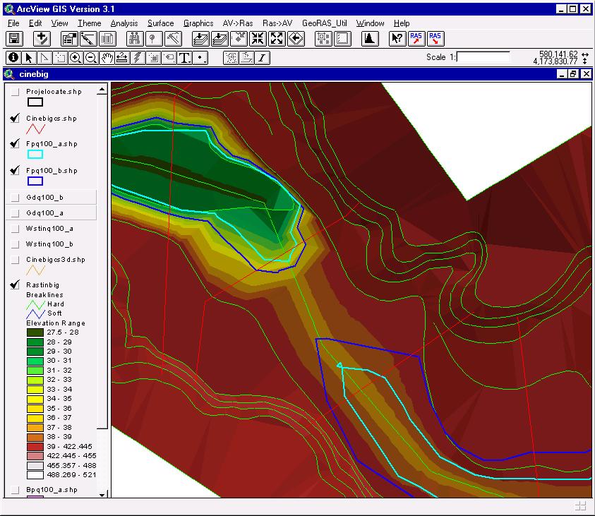
62 Develop GeoHMS Model Follow all principles in development of a hydrologic model. In addition, take into consideration integration planning aspects developed earlier. - Placement of flow exchange points - Naming conventions HH Modeling With GIS 66


63 Meteorological Component Develop a custom rain gauge for each subbasin or for each rainfall observation element with corresponding weights for subbasins. Arc Hydro Arc Hydro to DSS transfer HH Modeling With GIS 67 DSS


64 Finalize and Run HMS Complete HMS model with any additional parameters including meteorological model and control specifications. HH Modeling With GIS 68
 Do the")


65 Finalize and Run HMS (2) Do the final run and generate results (DSS). HMS View DSS View HH Modeling With GIS 69
. In addition, take into consideration integration planning aspects developed earlier.")
66 Develop GeoRAS Model (preprocessing) Follow all principles in development of a hydraulic model for element placement (confluences, structures, ). In addition, take into consideration integration planning aspects developed earlier. HH Modeling With GIS 70


67 Finalize and Run RAS Complete RAS model with any additional parameters including initial and boundary conditions. HH Modeling With GIS 71
 Do the")

.")
68 Finalize and Run RAS (2) Do the final run and generate results (export to.sdf file). HH Modeling With GIS 72


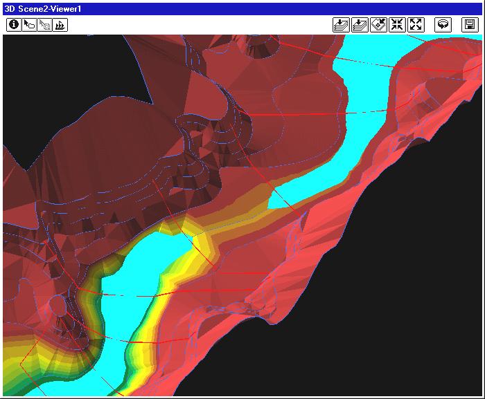
69 Process RAS Results in GeoRAS Construct the floodplain based on the results in the.sdf. Review the results with respect to spatial integrity (extents of cross sections, ineffective flow areas, disconnected flood areas, etc.). Clean results. Revisit RAS. HH Modeling With GIS 73
70 GIS HMS RAS Feedback At present, it is manual and at the discretion of the modeler. - GIS H&H interaction - H H interaction Visualization in both pre- and postprocessing is not just a pretty picture. - Flyover in preprocessing (GeoHMS and GeoRAS) - Identification of data problems - Modeling element placement - Postprocessing (GeoRAS) - Validity of element placement HH Modeling With GIS 74
71 Floodplain Discontinuity HH Modeling With GIS 75
72 Floodplain Discontinuity (cont.) Dry Water surface profile Terrain Cross sections HH Modeling With GIS 76
73 Cross-Section Interpolation TIN-interpolated cross sections RAS-interpolated cross sections RAS-assumed terrain Terrain Original cross sections HH Modeling With GIS 77
 Model for flood")


74 Map2Map (rainfall to floodplain) Model for flood flow HMS Flood map as output FLO ODP LAIN MAP Nexrad rainfall map as input Model for flood depth HH Modeling With GIS 78
75 Integrated H&H (ICPR 4G - shape of the things to come)
76 ICPR 4G interface Transition from ICPR 3 (1-D, node-link model) to full 2.5-D, spatially distributed, process integrated, H&H model. Interface fully integrated within AH. Model structure and results I/O (XML for model structure, TBD for results). HH Modeling With GIS 80

77 1D/2D Interface (Storm Inlets) 1D Nodes (Pond, Manholes) HH Modeling With GIS , Streamline Technologies, Inc.
78 1D Weir Link 1D Drop Structure Link HH Modeling With GIS 82 1D Pipe Link 2013, Streamline Technologies, Inc.

79 2D Honeycomb with 1D Elements HH Modeling With GIS , Streamline Technologies, Inc.


80 Flood Depths, Existing Condition HH Modeling With GIS , Streamline Technologies, Inc.


81 Flood Depths, Alternative 4 HH Modeling With GIS , Streamline Technologies, Inc.

82 Flow Vectors, Existing Conditions HH Modeling With GIS , Streamline Technologies, Inc.

83 Flow Vectors with Labels, Existing Conditions HH Modeling With GIS , Streamline Technologies, Inc.
84 Overview of GIS techniques for H&H modeling support data simplification
85 Schematization 1D Node link representation Wireframe representation HH Modeling With GIS 89


86 Schematization 2D Thiessen polygon TIN Fish Net HH Modeling With GIS 90 Can get tricky need to understand solvers for optimal tessellation!


87 Schematization 2D Topology to ensure spatial consistency within and across layers HH Modeling With GIS 91

88 Lumping /characterization Push-pin (not much to do unless it needs vertical aggregation) Lumping /characterization - Zonal stats operations - Can do interpolation first, then stats HH Modeling With GIS 92


89 Weeding /VIP identification 2D (terrain/surface) - Terrain dataset (terrain pyramids) - Window size - Z-tolerance HH Modeling With GIS 93

90 Weeding /VIP identification 1D HH Modeling With GIS 94

91 Simplified Floodplain DelineationTools Support for floodplain analysis - Real-time (observed, forecasted flows) - Planning (flood frequency) Facilitate landscape characterization for floodplain analysis - Streams - Cross-sections - Floodplain Floodplain delineation - Points - Cross-sections - From models HH Modeling With GIS 95


92 Tools Organized in several AH toolsets (most in H & H Modeling and Utility ) ~ 35 tools HH Modeling With GIS 96
93 Sample Implementation Use Cases DEM only: - Create synthetic streams from DEM - Flood out WSE along streams in incremental steps DEM + cross-sections: - Use TIN technique for WSE at c-s in incremental steps DEM + stream + observed points: - Flood out observed WSE along streams DEM + stream + modeled Q at points: - Build c-s and develop synthetic rating curve at modeled points - Use synthetic rating curve to get WSE from modeled Q - Alt 1 use flood out technique at points - Alt 2 use TIN technique at c-s HH Modeling With GIS 97
94 Summary
95 Summary GIS provides many capabilities for support of H&H Integrated, multi-purpose database for storage of H&H and related data. Consistent methodology for spatial data processing and analytical functionality, such as terrain processing, watershed delineation and characterization. Pre- and post-processing for H&H models significantly reduces time for data preparation for modeling support. Needs approach to GIS as an analytical technology HH Modeling With GIS 99
96 Summary Easy evaluation of alternatives H&H model integration and automation - Operational and change in conditions Environment for integrated solution management: - Emergency management - Design - Decision support Leverage existing online templates for information augmentation and result publishing - E.g. identify affected people in a floodplain and present the information through operations dashboard or story map HH Modeling With GIS 100
97 Q & A


98 Thank you Please fill out the session survey in your mobile app Select Hydrologic and Hydraulic Modeling in the Mobile App - Use the Search Feature to quickly find this title Click Technical Workshop Survey Answer a few short questions and enter any comments


99
Creating Watersheds and Stream Networks. Steve Kopp
 Creating Watersheds and Stream Networks Steve Kopp Workshop Overview Demo Data Understanding the tools Elevation Data Types DEM : Digital Elevation Model bare Earth DSM : Digital Surface Model Data Structure
Hydrologic and Hydraulic Analyses Using ArcGIS
 Hydrologic and Hydraulic Analyses Using ArcGIS Two day training class Overview ArcGIS and Arc Hydro provide strong foundation for support of hydrologic and hydraulic (H&H) analyses. This two-day course
StreamStats: Delivering Streamflow Information to the Public. By Kernell Ries
 StreamStats: Delivering Streamflow Information to the Public By Kernell Ries U.S. Department of the Interior U.S. Geological Survey MD-DE-DC District 410-238-4317 kries@usgs.gov StreamStats Web Application
GIS Techniques for Floodplain Delineation. Dean Djokic
 GIS Techniques for Floodplain Delineation Dean Djokic (ddjokic@esri.com) Content What is a floodplain? How to get a floodplain? What can GIS do for floodplain modeling? Simple GIS techniques for floodplain
GIS for integrated 2D H&H modeling support. Dean Djokic and Lori Armstrong, Esri Inc.
 GIS for integrated 2D H&H modeling support Dean Djokic and Lori Armstrong, Esri Inc. Overview GIS for H&H modeling support 1D vs. 2D modeling with GIS GIS techniques for data simplification Schematization
A GIS-based Approach to Watershed Analysis in Texas Author: Allison Guettner
 Texas A&M University Zachry Department of Civil Engineering CVEN 658 Civil Engineering Applications of GIS Instructor: Dr. Francisco Olivera A GIS-based Approach to Watershed Analysis in Texas Author:
Introduction to HEC-GeoHMS. Watershed boundary delineation. Assembling Hydrologic Modeling System
 Introduction to HEC-GeoHMS Watershed boundary delineation Assembling Hydrologic Modeling System HEC-GeoHMS GIS tool set supporting HEC-HMS modeling S Developed by USACE S ArcView 3.x extension v1.1 supported
Hydrologic Engineering Applications of Geographic Information Systems
 Hydrologic Engineering Applications of Geographic Information Systems Davis, California Objectives: The participant will acquire practical knowledge and skills in the application of GIS technologies for
Workshop: Build a Basic HEC-HMS Model from Scratch
 Workshop: Build a Basic HEC-HMS Model from Scratch This workshop is designed to help new users of HEC-HMS learn how to apply the software. Not all the capabilities in HEC-HMS are demonstrated in the workshop
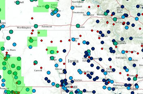
Introducing Iowa StreamStats Version 4, a Redesign of the USGS Application for Estimating Streamflow Stats
 Introducing Iowa StreamStats Version 4, a Redesign of the USGS Application for Estimating Streamflow Stats Presented at the 2016 Iowa Water Conference Ames, IA March 24, 2016 by David Eash U.S. Geological
MODULE 7 LECTURE NOTES 5 DRAINAGE PATTERN AND CATCHMENT AREA DELINEATION
 MODULE 7 LECTURE NOTES 5 DRAINAGE PATTERN AND CATCHMENT AREA DELINEATION 1. Introduction Topography of the river basin plays an important role in hydrologic modelling, by providing information on different
Leveraging ArcGIS Online Elevation and Hydrology Services. Steve Kopp, Jian Lange
 Leveraging ArcGIS Online Elevation and Hydrology Services Steve Kopp, Jian Lange Topics An overview of ArcGIS Online Elevation Analysis Using Elevation Analysis Services in ArcGIS for Desktop Using Elevation
CONVERTING A NEXRAD MAP TO A FLOODPLAIN MAP. Oscar Robayo, Tim Whiteaker, and David Maidment*
 CONVERTING A NEXRAD MAP TO A FLOODPLAIN MAP Oscar Robayo, Tim Whiteaker, and David Maidment* ABSTRACT: Using ArcGIS 9.0 ArcObjects and the new ModelBuilder environment, a methodology for converting a NEXRAD
GRAPEVINE LAKE MODELING & WATERSHED CHARACTERISTICS
 GRAPEVINE LAKE MODELING & WATERSHED CHARACTERISTICS Photo Credit: Lake Grapevine Boat Ramps Nash Mock GIS in Water Resources Fall 2016 Table of Contents Figures and Tables... 2 Introduction... 3 Objectives...
Watershed Analysis of the Blue Ridge Mountains in Northwestern Virginia
 Watershed Analysis of the Blue Ridge Mountains in Northwestern Virginia Mason Fredericks December 6, 2018 Purpose The Blue Ridge Mountain range is one of the most popular mountain ranges in the United
CATCHMENT AND OVERLAND FLOW PATHWAY DELINEATION USING LIDAR AND GIS GRID BASED APPROACH IN URBAN STORMWATER AND SEWER NETWORK MODELS
 CATCHMENT AND OVERLAND FLOW PATHWAY DELINEATION USING LIDAR AND GIS GRID BASED APPROACH IN URBAN STORMWATER AND SEWER NETWORK MODELS Thomas Joseph (AWT) ABSTRACT This paper presents specific examples comparing
Within this document, the term NHDPlus is used when referring to NHDPlus Version 2.1 (unless otherwise noted).
.") Exercise 7 Watershed Delineation Using ArcGIS Spatial Analyst Last Updated 4/6/2017 Within this document, the term NHDPlus is used when referring to NHDPlus Version 2.1 (unless otherwise noted). There
Exercise 7 Watershed Delineation Using ArcGIS Spatial Analyst Last Updated 4/6/2017 Within this document, the term NHDPlus is used when referring to NHDPlus Version 2.1 (unless otherwise noted). There
Designing a Dam for Blockhouse Ranch. Haley Born
 Designing a Dam for Blockhouse Ranch Haley Born CE 394K GIS in Water Resources Term Paper Fall 2011 Table of Contents Introduction... 1 Data Sources... 2 Precipitation Data... 2 Elevation Data... 3 Geographic
INTRODUCTION TO HEC-HMS
 INTRODUCTION TO HEC-HMS Hydrologic Engineering Center- Hydrologic Modeling System US Army Corps of Engineers Hydrologic Engineering Center HEC-HMS Uses Schematics Enter properties: watershed, rivers (reaches),
Automatic Watershed Delineation using ArcSWAT/Arc GIS
 Automatic Watershed Delineation using ArcSWAT/Arc GIS By: - Endager G. and Yalelet.F 1. Watershed Delineation This tool allows the user to delineate sub watersheds based on an automatic procedure using
A Cloud-Based Flood Warning System For Forecasting Impacts to Transportation Infrastructure Systems
 A Cloud-Based Flood Warning System For Forecasting Impacts to Transportation Infrastructure Systems Jon Goodall Associate Professor, Civil and Environmental Engineering Associate Director, Link Lab April
![)UDQFR54XHQWLQ(DQG'tD]'HOJDGR&](/thumbs/95/125846872.jpg ")UDQFR54XHQWLQ(DQG'tD]'HOJDGR&") &21&(37,21$1',03/(0(17$7,212)$1+
&21&(37,21$1',03/(0(17$7,212)$1+ Determination of Urban Runoff Using ILLUDAS and GIS
 Texas A&M University Department of Civil Engineering Instructor: Dr. Francisco Olivera CVEN689 Applications of GIS to Civil Engineering Determination of Urban Runoff Using ILLUDAS and GIS Tae Jin Kim 03.
Automated Hydrologic and Hydraulic Modeling of a Hydroelectric System UC1131 July 2012
 Automated Hydrologic and Hydraulic Modeling of a Hydroelectric System UC1131 July 2012 Author: Eok Ngo, Integrated Spatial Solutions, Inc. Contact: engo@issi-gis.com ABSTRACT Balancing the needs of regulatory
software, just as word processors or databases are. GIS was originally developed and cartographic capabilities have been augmented by analysis tools.
 1. INTRODUCTION 1.1Background A GIS is a Geographic Information System, a software package for creating, viewing, and analyzing geographic information or spatial data. GIS is a class of software, just
ArcGIS Data Reviewer: Quality Assessment for Elevation Raster Datasets. Roslyn Dunn
 ArcGIS Data Reviewer: Quality Assessment for Elevation Raster Datasets Roslyn Dunn What is ArcGIS Data Reviewer? Data Quality Management for ArcGIS Provides - Rule-based validation - Interactive tools
Base Level Engineering FEMA Region 6
 Base Level Engineering Over the past five years, has been evaluating its investment approach and data preparation work flow to establish an efficient and effective change in operation, generating an approach
Exercise 4. Watershed and Stream Network Delineation
 Exercise 4. Watershed and Stream Network Delineation GIS in Water Resources, Fall 2014 Prepared by David G Tarboton and David R. Maidment Purpose The purpose of this exercise is to illustrate watershed
Using GIS to Delineate Watersheds Ed Poyer NRS 509, Fall 2010
 Using GIS to Delineate Watersheds Ed Poyer NRS 509, Fall 2010 A watershed is an area that contributes flow to a point on the landscape. (Bolstad, 2005). Watersheds are an important focus of study because
Esri Defense Mapping: Cartographic Production. Bo King
 Esri Defense Mapping: Cartographic Production Bo King Agenda Esri Defense Mapping: Cartographic Production Solution Overview Desktop Cartographic Production Workflow - Create Rapid Graphic Product On Demand
Using the Stock Hydrology Tools in ArcGIS
 Using the Stock Hydrology Tools in ArcGIS This lab exercise contains a homework assignment, detailed at the bottom, which is due Wednesday, October 6th. Several hydrology tools are part of the basic ArcGIS
BSEN 6220 GIS LAB #5
 BSEN 6220 GIS LAB #5 Dustin Till 10/29/2014 INTRODUCTION: ArcGIS is a geographic information system for working with maps and geographic information. It is used for creating and using maps, compiling geographic
June 2018 WORKSHOP SECTION 2 MANUAL: RUNNING PTMAPP-DESKTOP AN INNOVATIVE SOLUTION BY:
 June 2018 WORKSHOP SECTION 2 MANUAL: RUNNING PTMAPP-DESKTOP AN INNOVATIVE SOLUTION BY: TABLE OF CONTENTS 1 PURPOSE... 3 2 SET UP DATA PATHS... 4 2.1 BASE DATA SETUP... 4 3 INGEST DATA... 6 3.1 CLIP WATERSHED...
HYDROLOGIC AND WATER RESOURCES EVALUATIONS FOR SG. LUI WATERSHED
 HYDROLOGIC AND WATER RESOURCES EVALUATIONS FOR SG. LUI WATERSHED 1.0 Introduction The Sg. Lui watershed is the upper part of Langat River Basin, in the state of Selangor which located approximately 20
QGIS FLO-2D Integration
 EPiC Series in Engineering Volume 3, 2018, Pages 1575 1583 Engineering HIC 2018. 13th International Conference on Hydroinformatics Karen O Brien, BSc. 1, Noemi Gonzalez-Ramirez, Ph. D. 1 and Fernando Nardi,
Applying GIS to Hydraulic Analysis
 Texas A&M University Department of Civil Engineering CVEN689 Applications of GIS to Civil Engineering Instructor: Francisco Olivera, Ph.D., P.E. Applying GIS to Hydraulic Analysis Lim, Chae Kwan April
Watershed and Stream Network Delineation
 Watershed and Stream Network Delineation GIS in Water Resources, Fall 2011 Prepared by David Tarboton, Utah State University Purpose The purpose of this exercise is to illustrate watershed and stream network
Section 4: Model Development and Application
 Section 4: Model Development and Application The hydrologic model for the Wissahickon Act 167 study was built using GIS layers of land use, hydrologic soil groups, terrain and orthophotography. Within
Delineation of Watersheds
 Delineation of Watersheds Adirondack Park, New York by Introduction Problem Watershed boundaries are increasingly being used in land and water management, separating the direction of water flow such that
ENGRG Introduction to GIS
 ENGRG 59910 Introduction to GIS Michael Piasecki March 17, 2014 Lecture 08: Terrain Analysis Outline: Terrain Analysis Earth Surface Representation Contour TIN Mass Points Digital Elevation Models Slope
GIS in Water Resources Midterm Exam Fall 2008 There are 4 questions on this exam. Please do all 4.
 Page 1 of 8 Name: GIS in Water Resources Midterm Exam Fall 2008 There are 4 questions on this exam. Please do all 4. 1. Basic Concepts [20 points] Find the letter with the best answer for each term: 1.
4. GIS Implementation of the TxDOT Hydrology Extensions
 4. GIS Implementation of the TxDOT Hydrology Extensions A Geographic Information System (GIS) is a computer-assisted system for the capture, storage, retrieval, analysis and display of spatial data. It
George Mason University Department of Civil, Environmental and Infrastructure Engineering
 George Mason University Department of Civil, Environmental and Infrastructure Engineering Dr. Celso Ferreira Prepared by Lora Baumgartner December 2015 Revised by Brian Ross July 2016 Exercise Topic: Getting
NR402 GIS Applications in Natural Resources
 NR402 GIS Applications in Natural Resources Lesson 1 Introduction to GIS Eva Strand, University of Idaho Map of the Pacific Northwest from http://www.or.blm.gov/gis/ Welcome to NR402 GIS Applications in
Exercise 4. Watershed and Stream Network Delineation
 Exercise 4. Watershed and Stream Network Delineation GIS in Water Resources, Fall 2015 Prepared by David G Tarboton and David R. Maidment Purpose The purpose of this exercise is to illustrate watershed
Watershed Modeling With DEMs
 Watershed Modeling With DEMs Lesson 6 6-1 Objectives Use DEMs for watershed delineation. Explain the relationship between DEMs and feature objects. Use WMS to compute geometric basin data from a delineated
13 Watershed Delineation & Modeling
 Module 4 (L12 - L18): Watershed Modeling Standard modeling approaches and classifications, system concept for watershed modeling, overall description of different hydrologic processes, modeling of rainfall,
Hydrologic Modelling of the Upper Malaprabha Catchment using ArcView SWAT
 Hydrologic Modelling of the Upper Malaprabha Catchment using ArcView SWAT Technical briefs are short summaries of the models used in the project aimed at nontechnical readers. The aim of the PES India
A Simple Drainage Enforcement Procedure for Estimating Catchment Area Using DEM Data
 A Simple Drainage Enforcement Procedure for Estimating Catchment Area Using DEM Data David Nagel, John M. Buffington, and Charles Luce U.S. Forest Service, Rocky Mountain Research Station Boise Aquatic
Steve Pietersen Office Telephone No
 Steve Pietersen Steve.Pieterson@durban.gov.za Office Telephone No. 031 311 8655 Overview Why geography matters The power of GIS EWS GIS water stats EWS GIS sanitation stats How to build a GIS system EWS
Exercise 4. Watershed and Stream Network Delineation
 Exercise 4. Watershed and Stream Network Delineation GIS in Water Resources, Fall 2018 Prepared by David G Tarboton and David R. Maidment Revised 9 October, 2018 Purpose The purpose of this exercise is
Workshops funded by the Minnesota Environment and Natural Resources Trust Fund
 Workshops funded by the Minnesota Environment and Natural Resources Trust Fund Conservation Applications of LiDAR Data Workshops funded by: Minnesota Environment and Natural Resources Trust Fund Presented
ArcGIS Data Reviewer: Assessing Positional Accuracy. Roslyn Dunn
 ArcGIS Data Reviewer: Assessing Positional Accuracy Roslyn Dunn What is ArcGIS Data Reviewer? Data Quality Management for ArcGIS Provides - Rule-based validation - Interactive tools - Track errors Validate
ESTIMATING PROBABLE PEAK RUNOFF FOR GREATER COLOMBO RIVER BASIN SRI LANKA
 ESTIMATING PROBABLE PEAK RUNOFF FOR GREATER COLOMBO RIVER BASIN SRI LANKA Halpegamage Nadeeka Thushari GIS Officer Urban Development Authority Sri Lanka INTRODUCTION Rainfall Excess = Total Rainfall (rain
HEC & GIS Modeling of the Brushy Creek HEC & GIS Watershed Modeling of the
 HEC & GIS Modeling of the Brushy Creek HEC & GIS Watershed Modeling of the By Cassandra Fagan 5, December 2014 http://ubcwatershedstudy.ursokr.com/images/ Contents Introduction... 3 Figure 1: 24-hour rainfall
Exelis and Esri Technologies for Defense and National Security. Cherie Muleh
 Exelis and Esri Technologies for Defense and National Security Cherie Muleh Cherie.Muleh@exelisinc.com ENVI IMAGERY AND DATA BECOME KNOWLEDGE > Add information from imagery to your GIS > Automated workflows
CWMS Modeling for Real-Time Water Management
 Hydrologic Engineering Center Training Course on CWMS Modeling for Real-Time Water Management August 2018 Davis, California The Corps Water Management System (CWMS) is a software and hardware system to
CE 394K.3 GIS in Water Resources Midterm Quiz Fall There are 5 questions on this exam. Please do all 5. They are of equal credit.
 Name: CE 394K.3 GIS in Water Resources Midterm Quiz Fall 2000 There are 5 questions on this exam. Please do all 5. They are of equal credit. 1. The ArcView Geographic Information System can display different
ENGRG Introduction to GIS
 ENGRG 59910 Introduction to GIS Michael Piasecki November 17, 2017 Lecture 11: Terrain Analysis Outline: Terrain Analysis Earth Surface Representation Contour TIN Mass Points Digital Elevation Models Slope
Using ArcGIS for Hydrology and Watershed Analysis:
 Using ArcGIS 10.2.2 for Hydrology and Watershed Analysis: A guide for running hydrologic analysis using elevation and a suite of ArcGIS tools Anna Nakae Feb. 10, 2015 Introduction Hydrology and watershed
Pompton Lakes Dam Downstream Effects of the Floodgate Facility. Joseph Ruggeri Brian Cahill Michael Mak Andy Bonner
 Pompton Lakes Dam Downstream Effects of the Joseph Ruggeri Brian Cahill Michael Mak Andy Bonner ASFPM 2013: Overview Page 2 Overview Page 3 Overview Page 4 Overview Page 5 Overview - Historical Pompton
IMPERIAL COUNTY PLANNING AND DEVELOPMENT
 IMPERIAL COUNTY PLANNING AND DEVELOPMENT GEODATABASE USER MANUAL FOR COUNTY BUSINESS DEVELOPMENT GIS June 2010 Prepared for: Prepared by: County of Imperial Planning and Development 801 Main Street El
Assessment of a Rapid Approach for Estimating Catchment Areas for Surface Drainage Lines
 Assessment of a Rapid Approach for Estimating Catchment Areas for Surface Drainage Lines U.S. Geological Survey Center of Excellence for Geospatial Information Science 1400 Independence Road, Rolla Missouri,
Troubleshooting Replication and Geodata Services. Liz Parrish & Ben Lin
 Troubleshooting Replication and Geodata Services Liz Parrish & Ben Lin AGENDA: Troubleshooting Replication and Geodata Services Overview Demo Troubleshooting Q & A Overview of Replication Liz Parrish What
Dr. S.SURIYA. Assistant professor. Department of Civil Engineering. B. S. Abdur Rahman University. Chennai
 Hydrograph simulation for a rural watershed using SCS curve number and Geographic Information System Dr. S.SURIYA Assistant professor Department of Civil Engineering B. S. Abdur Rahman University Chennai
What s New in Topographic Information - USGS National Map
 + What s New in Topographic Information - USGS National Map SARGIS Workshop November 14, 2016 Rob Dollison, 703-648-5724 rdollison@usgs.gov + USGS 2 National Geospatial Program The National Geospatial
Geographic Information Systems. Introduction to Data and Data Sources
 Geographic Information Systems Introduction to Data and Data Sources Presented by John Showler, NJDA-SSCC NJ SCD GIS Training Session December 10, 209 The Objectives of this session are 3-fold: 1. Introduce
Creating Watersheds from a DEM
 Creating Watersheds from a DEM These instructions enable you to create watersheds of specified area using a good quality Digital Elevation Model (DEM) in ArcGIS 8.1. The modeling is performed in ArcMap
The National Hydrography Dataset in the Pacific Region. U.S. Department of the Interior U.S. Geological Survey
 The National Hydrography Dataset in the Pacific Region U.S. Department of the Interior U.S. Geological Survey The National Map The National Map is built on partnerships and standards The National Map consists
Current and Future Plans. R. Srinivasan
 Current and Future Plans R. Srinivasan Contents 1 The ArcSWAT Interface 2 VizSWAT: Output Visualization 3 User online support 4 MapWindows SWAT interface 5 ArcGIS SWAT/APEX interfaces 6 Radar Rainfall
Floodplain Mapping & Flood Warning Applications in North Carolina
 Floodplain Mapping & Flood Warning Applications in North Carolina Marc Stanard, IT Project Manager Ken Ashe, Assistant Director David Herlong, Flood Warning Program Manager NC Crime Control & Public Safety
Chapter 10 - Sacramento Method Examples
 Chapter 10 Sacramento Method Examples Introduction Overview This chapter presents two example problems to demonstrate the use of the Sacramento method. These example problems use the SACPRE and HEC-1 computer
Application of Geographical Information System (GIS) tools in watershed analysis
 tools in watershed analysis") Application of Geographical Information System (GIS) tools in watershed analysis Paritosh Gupta 1, Damanjit S Minhas 2, Rajendra M Tamhane 1, A K Mookerjee 2 1.ESRI India New Delhi 2. LEA Associates South
Application of Geographical Information System (GIS) tools in watershed analysis Paritosh Gupta 1, Damanjit S Minhas 2, Rajendra M Tamhane 1, A K Mookerjee 2 1.ESRI India New Delhi 2. LEA Associates South
Welcome to NR502 GIS Applications in Natural Resources. You can take this course for 1 or 2 credits. There is also an option for 3 credits.
 Welcome to NR502 GIS Applications in Natural Resources. You can take this course for 1 or 2 credits. There is also an option for 3 credits. The 1st credit consists of a series of readings, demonstration,
Rick Faber CE 513 Watershed and Streamwork Delineation Lab # 3 4/24/2006
 Rick Faber CE 513 Watershed and Streamwork Delineation Lab # 3 4/24/2006 1. Objective & Discussion: 2 To learn to use the ArcHydro tools to produce hydrologically descriptive data sets starting from a
Exercise 4. Watershed and Stream Network Delineation
 Exercise 4. Watershed and Stream Network Delineation GIS in Water Resources, Fall 2017 Prepared by David G Tarboton and David R. Maidment Updated to ArcGIS Pro by Paul Ruess Purpose The purpose of this
Watershed Modeling Orange County Hydrology Using GIS Data
 v. 10.0 WMS 10.0 Tutorial Watershed Modeling Orange County Hydrology Using GIS Data Learn how to delineate sub-basins and compute soil losses for Orange County (California) hydrologic modeling Objectives
Introduction to ArcGIS Spatial Analyst
 Esri International User Conference San Diego, California Technical Workshops July 2011 Introduction to ArcGIS Spatial Analyst Steve Kopp Elizabeth Graham ArcGIS Spatial Analyst Integrated raster and vector
Delineation of the Watersheds Basin in the Konya City and Modelling by Geographical Information System
 Delineation of the Watersheds Basin in the Konya City and Modelling by Geographical Information System Nahida Hameed Hamza Alqaysi a,b,, Mushtaq Abdulameer Alwan Almuslehi a a Environmental Engineering
The Geodatabase Working with Spatial Analyst. Calculating Elevation and Slope Values for Forested Roads, Streams, and Stands.
 GIS LAB 7 The Geodatabase Working with Spatial Analyst. Calculating Elevation and Slope Values for Forested Roads, Streams, and Stands. This lab will ask you to work with the Spatial Analyst extension.
Digital Elevation Models. Using elevation data in raster format in a GIS
 Digital Elevation Models Using elevation data in raster format in a GIS What is a Digital Elevation Model (DEM)? Digital representation of topography Model based on scale of original data Commonly a raster
DP Project Development Pvt. Ltd.
 Dear Sir/Madam, Greetings!!! Thanks for contacting DP Project Development for your training requirement. DP Project Development is leading professional training provider in GIS technologies and GIS application
Floodplain and Flood Probability Mapping Using Geodatabases
 Brigham Young University BYU ScholarsArchive All Theses and Dissertations 2005-03-16 Floodplain and Flood Probability Mapping Using Geodatabases Douglas J. Gallup Brigham Young University - Provo Follow
Exercise 4. Watershed and Stream Network Delineation
 Exercise 4. Watershed and Stream Network Delineation GIS in Water Resources, Fall 2016 Prepared by David G Tarboton and David R. Maidment Updated to ArcGIS Pro by Paul Ruess [9/29/16 Further updated to
ArcHYDRO: GIS for Water Resources
 SOCRATES ERASMUS Intensive Programme ArcHYDRO: GIS for Water Resources Source: Center for Research in Water Resources, University of Texas at Austin Tutorial: Watershed and Stream Network Delineation Goals
San Antonio River Authority. San Antonio River Authority Floodworks implementation in the San Antonio River Basin. Nefi Garza, PE, CFM
 San Antonio River Authority Floodworks implementation in the San Antonio River Basin Nefi Garza, PE, CFM San Antonio River Authority Michael Crenshaw, PE, CFM Anthony J. Henry Wallingford Software, Inc
Geo-spatial Analysis for Prediction of River Floods
 Geo-spatial Analysis for Prediction of River Floods Abstract. Due to the serious climate change, severe weather conditions constantly change the environment s phenomena. Floods turned out to be one of
Management and Sharing of Hydrologic Information of Cache County
 Geographic Information System in Water Resources CEE6440 Fall Semester 2012 Management and Sharing of Hydrologic Information of Cache County To: Dr. David Tarboton Instructor By: Tian Gan Dec.7, 2012 I.
GeoWEPP Tutorial Appendix
 GeoWEPP Tutorial Appendix Chris S. Renschler University at Buffalo - The State University of New York Department of Geography, 116 Wilkeson Quad Buffalo, New York 14261, USA Prepared for use at the WEPP/GeoWEPP
DEMs Downloading and projecting and using Digital Elevation Models (DEM)
") DEMs Downloading and projecting and using Digital Elevation Models (DEM) Introduction In this exercise, you will work with Digital Elevation Models (DEM). You will download a DEM in geographic coordinates
DEMs Downloading and projecting and using Digital Elevation Models (DEM) Introduction In this exercise, you will work with Digital Elevation Models (DEM). You will download a DEM in geographic coordinates
Chapter 6. Fundamentals of GIS-Based Data Analysis for Decision Support. Table 6.1. Spatial Data Transformations by Geospatial Data Types
 Chapter 6 Fundamentals of GIS-Based Data Analysis for Decision Support FROM: Points Lines Polygons Fields Table 6.1. Spatial Data Transformations by Geospatial Data Types TO: Points Lines Polygons Fields
Development of GIS Tools to Optimize Identification of Road Segments Prone to Flood Damage
 A Report from the University of Vermont Transportation Research Center Development of GIS Tools to Optimize Identification of Road Segments Prone to Flood Damage Final Report TRC Report 15-005 September
Geospatial Data, Services, and Products. National Surveying, mapping and geospatial conference
 Geospatial Data, Services, and Products Federal Programs -- USDA NRCS National Surveying, mapping and geospatial conference March 15, 2016 NRCS Applications using Geosaptial Products & Services Field
Evaluation of gvsig and SEXTANTE Tools for Hydrological Analysis Schröder Dietrich a, Mudogah Hildah b and Franz David b
 Evaluation of gvsig and SEXTANTE Tools for Hydrological Analysis Schröder Dietrich a, Mudogah Hildah b and Franz David b ab Photogrammetry and Geo-informatics Masters Programme, Stuttgart University of
Hydrography Webinar Series
 Hydrography Webinar Series Session 2 May 21, 2015 U.S. Department of the Interior U.S. Geological Survey U.S. GEOLOGICAL SURVEY HYDROGRAPHY WEBINAR SERIES Hosted by: Jeff Simley Al Rea Hydrography Webinar
International Journal of Advance Engineering and Research Development
 Scientific Journal of Impact Factor (SJIF): 4.72 International Journal of Advance Engineering and Research Development Volume 4, Issue 5, May -2017 Watershed Delineation of Purna River using Geographical
IJESRT INTERNATIONAL JOURNAL OF ENGINEERING SCIENCES & RESEARCH TECHNOLOGY
 IJESRT INTERNATIONAL JOURNAL OF ENGINEERING SCIENCES & RESEARCH TECHNOLOGY Use of Digital Elevation Model to compute Storm Water Drainage Network Manisha Desai *1, Dr. J. N. Patel 2 *1 Ph. D. Student of
SWAMP GIS: A spatial decision support system for predicting and treating stormwater runoff. Michael G. Wing 1 * and Derek Godwin
 Journal of Spatial Hydrology Vol. 11, No. 2 Fall 2011 SWAMP GIS: A spatial decision support system for predicting and treating stormwater runoff Michael G. Wing 1 * and Derek Godwin Abstract SWAMP GIS
Floodplain Modeling and Mapping Using The Geographical Information Systems (GIS) and Hec-RAS/Hec-GeoRAS Applications. Case of Edirne, Turkey.
 and Hec-RAS/Hec-GeoRAS Applications. Case of Edirne, Turkey.") Floodplain Modeling and Mapping Using The Geographical Information Systems (GIS) and Hec-RAS/Hec-GeoRAS Applications. Case of Edirne, Turkey. Fuad Hajibayov *1, Basak Demires Ozkul 1, Fatih Terzi 1 1 Istanbul
Floodplain Modeling and Mapping Using The Geographical Information Systems (GIS) and Hec-RAS/Hec-GeoRAS Applications. Case of Edirne, Turkey. Fuad Hajibayov *1, Basak Demires Ozkul 1, Fatih Terzi 1 1 Istanbul
INTRODUCTION TO HYDROLOGIC MODELING USING HEC-HMS
 INTRODUCTION TO HYDROLOGIC MODELING USING HEC-HMS By Thomas T. Burke, Jr., PhD, PE Luke J. Sherry, PE, CFM Christopher B. Burke Engineering, Ltd. October 8, 2014 1 SEMINAR OUTLINE Overview of hydrologic