Anjana Dewanji, Anindita Chatterjee & Achyut Kumar Banerjee. Agricultural & Ecological Research Unit Indian Statistical Institute Kolkata, India
|
|
|
- Kellie Cross
- 5 years ago
- Views:
Transcription


1 Anjana Dewanji, Anindita Chatterjee & Achyut Kumar Banerjee Agricultural & Ecological Research Unit Indian Statistical Institute Kolkata, India

2 World wide distribution Distribution in India Present scenario in India Establishment or spread? Detecting presence in Kolkata Soil analysis and thematic moisture map Presence of infestation along transport networks Remote sensing and supervised LULC classification Conclusions

 J. Aquat.")
3 Predicted distributions of alligator weed in 1995 Continents / Regions Nature Main Countries EPPO region invasive France, Italy North America invasive Mexico, USA Central America invasive Honduras South America native Argentina, Bolivia, Brazil, Colombia, Paraguay, Peru, Uruguay, Venezuela Asia invasive China, India, Myanmar, Singapore, Sri Lanka, Taiwan, Thailand, Vietnam Caribbean invasive Puero Rico Oceania invasive Australia, New Zealand, Indonesia, Papua New Guinea Legends Areas of circles are proportional to the suitability of the location for the weed. Hatches are locations with known distributions of the weed Crosses indicate unfavourable locations for growth of the weed Figure Source: Julien MH, Skarratt B and Maywald GF (1995) J. Aquat. Plant Manage 33: 57. Table source: accessed on April 9, 2010

4 INDIA now INDIA Legends Areas of circles are proportional to the suitability of the location for the weed. Hatches are locations with known distributions of the weed Crosses indicate unfavorable locations for growth of the weed Reported presence in India
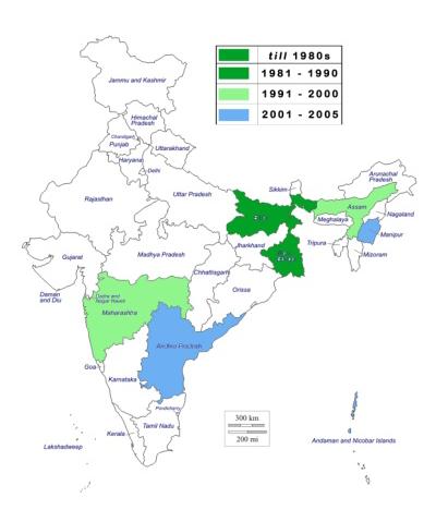

5


6 Total no. of reports on Alternanthera philoxeroides in India


7 Figures: Alternanthera philoxeroides growing at local sites

8 STUDY SITE: Kolkata Metropolitan Area or Greater Kolkata Lat-Long: 88º 30'E - 22º 33' N. Population: One of the most densely populated cities of world INDIA STUDY AREA:1, km 2 24,000/sq km within the city and 9,000/sq km in suburbs STUDY DURATION: 3 months -4 th Jan, 2012 to 5 th Mar, 2012 KOLKATA West Bengal

9 Greater Kolkata map Map georeferencing Map Digitisation 5kmx5km grid generation Centroid generation
/absence (25) recorded Soil Analysis TEXTURE")
")
10 Gridded Map with Centroids Field survey to 78 centroid points Alternanthera presence (53)/absence (25) recorded Soil Analysis TEXTURE Clay Silt Sand Soil sampling WATER HOLDING CAPACITY (WHC) MOISTURE Observations: 70 % sites had moderate infestations Terrestrial sites (25) Aquatic sites (28)
 30.34 ±15.")

11 Soil Parameters Mean ±SD Clay (%) 24.62±11.05 Silt (%) 24.87±9.01 Total Sand (%) 50.49±16.8 Water Holding Capacity (%) ±8.99 Moisture (%) ±15.89 Figure: Box plots of Clay, Silt and Total Sand percent in soil with Alternanthera infestation; values indicate medians Inference: Terrestrial infestation of Alternanthera show preference for sandy loam soils soils with more than 50% WHC and soils with atleast 30% moisture content. Figure: Different soil textural class with Alternanthera infestation


12 Remote Sensing GIS LISS III image LULC Classification Accuracy assessment C. Thematic classified map generation Field survey at centroid points Plant infestation categorized into 2 habitats:- Aquatic & Terrestrial Soil analysis for the terrestrial Alternanthera infestation Georeferenced map A. Transport map generation B. Soil moisture thematic map generation


13 Based on soil moisture percent, 10 equal classes were generated Vernoi polygon was used to create thematic map Observations: Inference: Soil moisture of atleast 25 to 30% suitable for growth of terrestrial plant Large areas (brown) present in the study area denoting potential for spread


14 Major and minor roads digitized on map using Google earth image as reference and points imported Observations: Inference: More than 60% of presence for both types along major roads showing disturbance to be an important factor
15 Satellite image used: LISS (Linear Imaging Self Scanning Sensor) III Satellite IRS P6 (ResourceSat 1) Sensor LISS III Approach to Classification: Spectral band Spectral coverage (nm) Spatial resolution (m) Radiometric resolution (bits) Swath width (km) 141 Band Band Band Band Some training areas were marked on the image to identify LULC classes Spectral separability analysis between classes were checked usingtransformed Divergence value for all band combinations Band ratio 3:4 (Red: Infrared) found most suitable for classifying image Supervised classification using Maximum Likelihood algorithm overall accuracy 94.23% Satellite image Class Producer s accuracy User s accuracy Deep water 98.96% 100% Shallow water 99.40% 99.86% LISS III Dense vegetation 92.14% 81.46% Sparse vegetation 85.15% 94.28% Built up land 97.64% 95.47% Barren land 99.5% 77.52%


16 Inference Aquatic infestations mostly correctly classified Terrestrial infestations occurred around built up land and sparse vegetation (species poor habitats) Both these areas are maximally present in the study area again showing concern for spread!!
17 Reported presence of Alternanthera philoxeroides increasing over years Results indicate high potential for spread in urban areas Infestations are more prone near major roads re emphasizing disturbance to be an important factor associated with spread. Terrestrial infestations occur in areas with sparse vegetation as well as around built up land a common aftermath of urbanization! Mapping important for creation of baseline data and monitoring spread to sound an early warning for intervention if needed.

18 Thank you!
Developing a global, peoplebased definition of cities and settlements
 Developing a global, peoplebased definition of cities and settlements By Lewis Dijkstra, Lewis.Dijkstra@ec.europa.eu Head of the Economic Analysis Sector DG for Regional and Urban Policy, Regional & Urban
Geospatial Information for Urban Sprawl Planning and Policies Implementation in Developing Country s NCR Region: A Study of NOIDA City, India
 Geospatial Information for Urban Sprawl Planning and Policies Implementation in Developing Country s NCR Region: A Study of NOIDA City, India Dr. Madan Mohan Assistant Professor & Principal Investigator,
Landuse and Landcover change analysis in Selaiyur village, Tambaram taluk, Chennai
 Landuse and Landcover change analysis in Selaiyur village, Tambaram taluk, Chennai K. Ilayaraja Department of Civil Engineering BIST, Bharath University Selaiyur, Chennai 73 ABSTRACT The synoptic picture
Abstract: About the Author:
 REMOTE SENSING AND GIS IN LAND USE PLANNING Sathees kumar P 1, Nisha Radhakrishnan 2 1 1 Ph.D Research Scholar, Department of Civil Engineering, National Institute of Technology, Tiruchirappalli- 620015,
MAPPING LAND USE/ LAND COVER OF WEST GODAVARI DISTRICT USING NDVI TECHNIQUES AND GIS Anusha. B 1, Sridhar. P 2
 MAPPING LAND USE/ LAND COVER OF WEST GODAVARI DISTRICT USING NDVI TECHNIQUES AND GIS Anusha. B 1, Sridhar. P 2 1 M. Tech. Student, Department of Geoinformatics, SVECW, Bhimavaram, A.P, India 2 Assistant
About the Authors Geography and Tourism: The Attraction of Place p. 1 The Elements of Geography p. 2 Themes of Geography p. 4 Location: The Where of
 Preface p. ix About the Authors p. xi Geography and Tourism: The Attraction of Place p. 1 The Elements of Geography p. 2 Themes of Geography p. 4 Location: The Where of Geography p. 4 Place and Space:
CHARACTERIZATION OF THE LAND-COVER AND LAND-USE BY SHAPE DESCRITORS IN TWO AREAS IN PONTA GROSSA, PR, BR. S. R. Ribeiro¹*, T. M.
 CHARACTERIZATION OF THE LAND-COVER AND LAND-USE BY SHAPE DESCRITORS IN TWO AREAS IN PONTA GROSSA, PR, BR S. R. Ribeiro¹*, T. M. Hamulak 1 1 Department of Geography, State University of Ponta Grossa, Brazil
Critical Assessment of Land Use Land Cover Dynamics Using Multi-Temporal Satellite Images
 Environments 2015, 2, 61-90; doi:10.3390/environments2010061 OPEN ACCESS environments ISSN 2076-3298 www.mdpi.com/journal/environments Article Critical Assessment of Land Use Land Cover Dynamics Using
Do Policy-Related Shocks Affect Real Exchange Rates? An Empirical Analysis Using Sign Restrictions and a Penalty-Function Approach
 ISSN 1440-771X Australia Department of Econometrics and Business Statistics http://www.buseco.monash.edu.au/depts/ebs/pubs/wpapers/ Do Policy-Related Shocks Affect Real Exchange Rates? An Empirical Analysis
M.C.PALIWAL. Department of Civil Engineering NATIONAL INSTITUTE OF TECHNICAL TEACHERS TRAINING & RESEARCH, BHOPAL (M.P.), INDIA
, INDIA") INVESTIGATIONS ON THE ACCURACY ASPECTS IN THE LAND USE/LAND COVER MAPPING USING REMOTE SENSING SATELLITE IMAGERY By M.C.PALIWAL Department of Civil Engineering NATIONAL INSTITUTE OF TECHNICAL TEACHERS
INVESTIGATIONS ON THE ACCURACY ASPECTS IN THE LAND USE/LAND COVER MAPPING USING REMOTE SENSING SATELLITE IMAGERY By M.C.PALIWAL Department of Civil Engineering NATIONAL INSTITUTE OF TECHNICAL TEACHERS
UNITED NATIONS E/CONF.96/CRP. 5
 UNITED NATIONS E/CONF.96/CRP. 5 ECONOMIC AND SOCIAL COUNCIL Eighth United Nations Regional Cartographic Conference for the Americas New York, 27 June -1 July 2005 Item 5 of the provisional agenda* COUNTRY
2017 Source of Foreign Income Earned By Fund
 2017 Source of Foreign Income Earned By Fund Putnam Emerging Markets Equity Fund EIN: 26-2670607 FYE: 08/31/2017 Statement Pursuant to 1.853-4: The fund is hereby electing to apply code section 853 for
International Student Enrollment Fall 2018 By CIP Code, Country of Citizenship, and Education Level Harpur College of Arts and Sciences
 International Student Enrollment Fall 2018 By CIP Code, Country of Citizenship, and Education Level Harpur College of Arts and Sciences CIP Code Description Citizenship Graduate Undergrad Total 00.0000
How Well Are Recessions and Recoveries Forecast? Prakash Loungani, Herman Stekler and Natalia Tamirisa
 How Well Are Recessions and Recoveries Forecast? Prakash Loungani, Herman Stekler and Natalia Tamirisa 1 Outline Focus of the study Data Dispersion and forecast errors during turning points Testing efficiency
RiskCity Training package on the Application of GIS for multi- hazard risk assessment in an urban environment.
 RiskCity Training package on the Application of GIS for multi- hazard risk assessment in an urban environment. Cees van Westen (Westen@itc.nl) & Nanette C. Kingma (Kingma@itc.nl) ITC: Training & Research
READY TO SCRAP: HOW MANY VESSELS AT DEMOLITION VALUE?
 READY TO SCRAP: HOW MANY VESSELS AT DEMOLITION VALUE? August 206 VesselsValue Global number of vessels at demolition value At scrap value 7,27 6 Above scrap value,8 84 Number of vessels at demolition value
10 emergency observation requests were successfully processed during the period
 ISRO s Inputs for the Sentinel Asia DPN and JPT meeting being held during 13-16, 16, November 2012 November 2012 Sentinel Asia Activity Spectrum - A dedicated Sentinel Asia server established at NRSC,
1. Impacts of Natural Disasters by Region, 2008
 1. Impacts of Natural Disasters by Region, 2008 Among all regions across the world in 2008, Asia not only ranks first but also dominates in all natural disaster s impact categories occurrence, killed,
Environmental Impact Assessment Land Use and Land Cover CISMHE 7.1 INTRODUCTION
 7 LAND USE AND LAND COVER 7.1 INTRODUCTION The knowledge of land use and land cover is important for many planning and management activities as it is considered an essential element for modeling and understanding
C N E S, U M R I R I S A
 M O N I T O R I N G U R B A N A R E A S W I T H S E N T I N E L - 2. APPLICATION TO THE UPDATE OF THE COPERNICUS HIGH RESOLUTION LAYER IMPERVIOUSNESS DEGREE O c t o b e r 2 5 th 2016, Brussels A n t o
Supplementary Appendix for. Version: February 3, 2014
 Supplementary Appendix for When Do Governments Resort to Election Violence? Version: February 3, 2014 This appendix provides supplementary information not included in the published draft. Supplementary
Wastelands Analysis and Mapping of Bhiwani District, Haryana
 Wastelands Analysis and Mapping of Bhiwani District, Haryana Virender Sihag Research Scholar, Department of Geography, OPJS University, Churu, Rajasthan ABSTRACT This study aimed at monitoring, mapping,
National Remote Sensing Center of China. Space Technology for Sustainable Development in China Status, Achievements and Futures.
 National Remote Sensing Center of China Space Technology for Sustainable Development in China Status, Achievements and Futures Jing Li National Remote Sensing Center of China Ministry of Science and Technology,
Deriving Uncertainty of Area Estimates from Satellite Imagery using Fuzzy Land-cover Classification
 International Journal of Information and Computation Technology. ISSN 0974-2239 Volume 3, Number 10 (2013), pp. 1059-1066 International Research Publications House http://www. irphouse.com /ijict.htm Deriving
MOCK EXAMINATION 1. Name Class Date INSTRUCTIONS
 Name Class Date PRIMARY 2 mathematics MOCK EXAMINATION 1 INSTRUCTIONS Total time for Section A, Section B and Section C: 1 hour 45 minutes The use of calculators is not allowed. SECTION A : Multiple Choice
Application of Remote Sensing Techniques for Change Detection in Land Use/ Land Cover of Ratnagiri District, Maharashtra
 IOSR Journal of Applied Geology and Geophysics (IOSR-JAGG) e-issn: 2321 0990, p-issn: 2321 0982.Volume 3, Issue 6 Ver. II (Nov. - Dec. 2015), PP 55-60 www.iosrjournals.org Application of Remote Sensing
7.1 INTRODUCTION 7.2 OBJECTIVE
 7 LAND USE AND LAND COVER 7.1 INTRODUCTION The knowledge of land use and land cover is important for many planning and management activities as it is considered as an essential element for modeling and
KNOWLEDGE-BASED CLASSIFICATION OF LAND COVER FOR THE QUALITY ASSESSEMENT OF GIS DATABASE. Israel -
 KNOWLEDGE-BASED CLASSIFICATION OF LAND COVER FOR THE QUALITY ASSESSEMENT OF GIS DATABASE Ammatzia Peled a,*, Michael Gilichinsky b a University of Haifa, Department of Geography and Environmental Studies,
1. Introduction. Chaithanya, V.V. 1, Binoy, B.V. 2, Vinod, T.R. 2. Publication Date: 8 April DOI: https://doi.org/ /cloud.ijarsg.
 Cloud Publications International Journal of Advanced Remote Sensing and GIS 2017, Volume 6, Issue 1, pp. 2088-2096 ISSN 2320 0243, Crossref: 10.23953/cloud.ijarsg.112 Research Article Open Access Estimation
Spatiotemporal Analysis of Noida, Greater Noida and Surrounding Areas (India) Using Remote Sensing and GIS Approaches
 Using Remote Sensing and GIS Approaches") Spatiotemporal Analysis of Noida, Greater Noida and Surrounding Areas (India) Using Remote Sensing and GIS Approaches Gopal Krishna* Indian Agricultural Research Institute, New Delhi, India ABSTRACT Spatiotemporal
Spatiotemporal Analysis of Noida, Greater Noida and Surrounding Areas (India) Using Remote Sensing and GIS Approaches Gopal Krishna* Indian Agricultural Research Institute, New Delhi, India ABSTRACT Spatiotemporal
This is trial version
 Journal of Rangeland Science, 2012, Vol. 2, No. 2 J. Barkhordari and T. Vardanian/ 459 Contents available at ISC and SID Journal homepage: www.rangeland.ir Full Paper Article: Using Post-Classification
Geospatial technology for land cover analysis
 Home Articles Application Environment & Climate Conservation & monitoring Published in : Middle East & Africa Geospatial Digest November 2013 Lemenkova Polina Charles University in Prague, Faculty of Science,
Application of remote sensing for agricultural disasters
 Application of remote sensing for agricultural disasters Bingfang Wu, Sheng Chang Institute of Remote Sensing and Digital Earth (RADI) Chinese Academy of Sciences (CAS) wubf@radi.ac.cn, changsheng@radi.ac.cn
Global Data Catalog initiative Christophe Charpentier ArcGIS Content Product Manager
 Global Data Catalog initiative Christophe Charpentier ArcGIS Content Product Manager ccharpentier@esri.com We are in a global economy Global Economy Business and Operations are now global Strategic need
CHAPTER VII FULLY DISTRIBUTED RAINFALL-RUNOFF MODEL USING GIS
 80 CHAPTER VII FULLY DISTRIBUTED RAINFALL-RUNOFF MODEL USING GIS 7.1GENERAL This chapter is discussed in six parts. Introduction to Runoff estimation using fully Distributed model is discussed in first
Space Applications for Disaster Risk Reduction and Sustainable Development
 Space Applications for Disaster Risk Reduction and Sustainable Development Space Applications Section (SAS) ICT and Disaster Risk Reduction Division (IDD) UNESCAP Contents I. RESAP Activities 2016-2017
CONTINENT WISE ANALYSIS OF ZOOLOGICAL SCIENCE PERIODICALS: A SCIENTOMETRIC STUDY
 CONTINENT WISE ANALYSIS OF ZOOLOGICAL SCIENCE PERIODICALS: A SCIENTOMETRIC STUDY Mr.Chopkar Hemraj D. Librarian NKSPT S Arts, Science & Commerce College, Badnapur. (MS) India Mr. Phatak Anil Shahaji Research
Biodiversity: Facts and figures (tables from the report)
") Vascular plant * Country Number Australia 15,638 Brazil 56,215 China 8,200 Colombia 32,200 Congo, Democratic Republic 11,007 Costa Rica 12,119 Ecuador 19,362 India 18,664 Indonesia 29,375 Madagascar 9,505
Vascular plant * Country Number Australia 15,638 Brazil 56,215 China 8,200 Colombia 32,200 Congo, Democratic Republic 11,007 Costa Rica 12,119 Ecuador 19,362 India 18,664 Indonesia 29,375 Madagascar 9,505
LAND SUITABILITY STUDY IN LAND DEGRADED AREA DUE TO MINING IN DHANBAD DISTRICT, JHARKHAND.
 LAND SUITABILITY STUDY IN LAND DEGRADED AREA DUE TO MINING IN DHANBAD DISTRICT, JHARKHAND. Saranathan, E a*, Loveson, V.J b. and Victor Rajamanickam, G c a School of Civil Engineering, SASTRA, Thanjavur
By Geri Flanary To accompany AP Human Geography: A Study Guide 3 rd edition By Ethel Wood
 Session 1 By Geri Flanary To accompany AP Human Geography: A Study Guide 3 rd edition By Ethel Wood WHAT IS DEMOGRAPHY? It is the scientific or statistical study of population. It comes from the Greek
Investigation of the Effect of Transportation Network on Urban Growth by Using Satellite Images and Geographic Information Systems
 Presented at the FIG Congress 2018, May 6-11, 2018 in Istanbul, Turkey Investigation of the Effect of Transportation Network on Urban Growth by Using Satellite Images and Geographic Information Systems
DISTILLED SPIRITS - EXPORTS BY VALUE DECEMBER 2017
 DISTILLED SPIRITS - EXPORTS BY VALUE DECEMBER 2017 U.S. COMMERCIAL EXPORTS OF DISTILLED SPIRITS - DECEMBER 2017 (U.S. DOLLARS) Da-Value-17-12 SUMMARY BY CLASS CLASS DECEMBER DECEMBER DOLLAR YTD YTD DOLLAR
Canadian Imports of Honey
 of 0409000029 - Honey, natural, in containers of a weight > 5 kg, nes (Kilogram) Argentina 236,716 663,087 2,160,216 761,990 35.27% 202.09% /0 76,819 212,038 717,834 257,569 35.88% 205.69% /0 United States
Integrating Remote Sensing and Observations into Decision Support Systems for Invasive Weeds
 Integrating Remote Sensing and Observations into Decision Support Systems for Invasive Weeds E. Raymond Hunt, Jr. USDA-ARS Hydrology and Remote Sensing Laboratory Beltsville, Maryland, USA Objectives Predict
Abstract. TECHNOFAME- A Journal of Multidisciplinary Advance Research. Vol.2 No. 2, (2013) Received: Feb.2013; Accepted Oct.
 Received: Feb.2013; Accepted Oct.") Vol.2 No. 2, 83-87 (2013) Received: Feb.2013; Accepted Oct. 2013 Landuse Pattern Analysis Using Remote Sensing: A Case Study of Morar Block, of Gwalior District, M.P. Subhash Thakur 1 Akhilesh Singh 2
Vol.2 No. 2, 83-87 (2013) Received: Feb.2013; Accepted Oct. 2013 Landuse Pattern Analysis Using Remote Sensing: A Case Study of Morar Block, of Gwalior District, M.P. Subhash Thakur 1 Akhilesh Singh 2
International Journal of Intellectual Advancements and Research in Engineering Computations
 ISSN:2348-2079 Volume-5 Issue-2 International Journal of Intellectual Advancements and Research in Engineering Computations Agricultural land investigation and change detection in Coimbatore district by
Urban Hydrology - A Case Study On Water Supply And Sewage Network For Madurai Region, Using Remote Sensing & GIS Techniques
 RESEARCH INVENTY: International Journal of Engineering and Science ISBN: 2319-6483, ISSN: 2278-4721, Vol. 1, Issue 8 (November 2012), PP 07-12 www.researchinventy.com Urban Hydrology - A Case Study On
Land Use and Land Cover Mapping and Change Detection in Jind District of Haryana Using Multi-Temporal Satellite Data
 Land Use and Land Cover Mapping and Change Detection in Jind District of Haryana Using Multi-Temporal Satellite Data Ravindra Prawasi, M.P. Sharma, T. P. Babu, Om Pal, Saroj, Kirti Yadav, R.S.Hooda Abstract
GIS and Remote Sensing Applications in Invasive Plant Monitoring
 Matt Wallace NRS 509 Written Overview & Annotated Bibliography 12/17/2013 GIS and Remote Sensing Applications in Invasive Plant Monitoring Exotic invasive plants can cause severe ecological damage to native
A Baseline Mapping of Aquaculture and Coastal Habitats in Myanmar
 Aquaculture and Coastal Habitats Report No. 3 A Baseline Mapping of Aquaculture and Coastal Habitats in Myanmar J. Ronald Eastman, James Toledano, Stefano Crema Clark Labs, Clark University Introduction
GlobalSoilMap.net. a new digital soil map of the world. Alfred Hartemink (on behalf of the global consortium) ISRIC World Soil Information Wageningen
 ISRIC World Soil Information Wageningen") GlobalSoilMap.net a new digital soil map of the world Alfred Hartemink (on behalf of the global consortium) ISRIC World Soil Information Wageningen The use of soil information GlobalSoilMap.net A digital
GlobalSoilMap.net a new digital soil map of the world Alfred Hartemink (on behalf of the global consortium) ISRIC World Soil Information Wageningen The use of soil information GlobalSoilMap.net A digital
APPLICATION OF REMOTE SENSING & GIS ON LANDSLIDE HAZARD ZONE IDENTIFICATION & MANAGEMENT
 APPLICATION OF REMOTE SENSING & GIS ON LANDSLIDE HAZARD ZONE IDENTIFICATION & MANAGEMENT PRESENTED BY SUPRITI PRAMANIK M.TECH IN ENVIRONMENTAL SCIENCE AND TECHNOLOGY NIT,DURGAPUR 25-04-2015 1 INTRODUCTION
The potential of GIS in mapping soil health. Tim Brewer 19/11/2104
 The potential of GIS in mapping soil health Tim Brewer 19/11/2104 Horizon Depth (cm) Sand % Silt % Clay % ph Organic Carbon (wt%) Bulk Density (g/cm3) Particle Density (g/cm3) Total Porosity (%) Water
Crowdsourcing approach for large scale mapping of built-up land
 Crowdsourcing approach for large scale mapping of built-up land Kavinda Gunasekara Kavinda@ait.asia Geoinformatics Center Asian Institute of Technology, Thailand. Regional expert workshop on land accounting
2001 Environmental Sustainability Index
 2001 Environmental Sustainability Index Annex 6: Variable Descriptions and Data An Initiative of the Global Leaders of Tomorrow Environment Task Force, World Economic Forum Annual Meeting 2001 Davos, Switzerland
Joint RA II/V Workshop on WIGOS for DRR - The Jakarta Declaration - (12-14 October, Jakarta, Indonesia) NMSC/KMA
 NMSC/KMA") Joint RA II/V Workshop on WIGOS for DRR - The Jakarta Declaration - (12-14 October, Jakarta, Indonesia) /KMA dolong@korea.kr Background Enhancement of Member s capabilities for weather forecasts and warnings
Joint RA II/V Workshop on WIGOS for DRR - The Jakarta Declaration - (12-14 October, Jakarta, Indonesia) /KMA dolong@korea.kr Background Enhancement of Member s capabilities for weather forecasts and warnings
Ryuji Yamada Tokyo Climate Center Japan Meteorological Agency E mail: URL:
 Ryuji Yamada Tokyo Center Japan Meteorological Agency E mail: tcc@met.kishou.go.jp URL: http://ds.data.jma.go.jp/tcc/tcc/index.html Tokyo Center (TCC) Established in April 2002 at JMA to support climate
Effect of land use/land cover changes on runoff in a river basin: a case study
 Water Resources Management VI 139 Effect of land use/land cover changes on runoff in a river basin: a case study J. Letha, B. Thulasidharan Nair & B. Amruth Chand College of Engineering, Trivandrum, Kerala,
Delineating Climate Relevant Structures for the Beijing Metropolitan Area
 Delineating Climate Relevant Structures for the Beijing Metropolitan Area 1,2 3,4 1 Austrian Academy of Sciences GIScience, Salzburg 2 Insitute for Geography, University of Bamberg, Germany 3 ispace, Austrian
SPACE TECHNOLOGY INSTITUTE, VNREDSat-1 and DATA PROVIDER NODE (DPN) REPORT
 REPORT") 4th Joint Project Team Meeting for Sentinel Asia STEP3 (JPTM2017) 8-9 March 2017 SPACE TECHNOLOGY INSTITUTE, VNREDSat-1 and DATA PROVIDER NODE (DPN) REPORT www.sti.vast.ac.vn CONTENT 1. Overview of Space
4th Joint Project Team Meeting for Sentinel Asia STEP3 (JPTM2017) 8-9 March 2017 SPACE TECHNOLOGY INSTITUTE, VNREDSat-1 and DATA PROVIDER NODE (DPN) REPORT www.sti.vast.ac.vn CONTENT 1. Overview of Space
Soil Erosion Calculation using Remote Sensing and GIS in Río Grande de Arecibo Watershed, Puerto Rico
 Soil Erosion Calculation using Remote Sensing and GIS in Río Grande de Arecibo Watershed, Puerto Rico Alejandra M. Rojas González Department of Civil Engineering University of Puerto Rico at Mayaguez.
Land Use/Land Cover Mapping in and around South Chennai Using Remote Sensing and GIS Techniques ABSTRACT
 Land Use/Land Cover Mapping in and around South Chennai Using Remote Sensing and GIS Techniques *K. Ilayaraja, Abhishek Singh, Dhiraj Jha, Kriezo Kiso, Amson Bharath institute of Science and Technology
Remote sensing Based Assessment of Urban Heat Island Phenomenon in Nagpur Metropolitan Area
 International Journal of Information & Computation Technology. ISSN 0974-2239 Volume 4, Number 11 (2014), pp. 1069-1074 International Research Publications House http://www. irphouse.com Remote sensing
Hazard and Vulnerability of Moderate Seismicity Regions
 Hazard and Vulnerability of Moderate Seismicity Regions presented by Professor Tso-Chien PAN Dean, College of Engineering Director, 25 October 2010 DRM GDLN Session on Earthquake Vulnerability Reduction
Building Institutional Capacity for Multi-Hazard Early Warning in Asia and the Pacific Subtitle
 Building Institutional Capacity for Multi-Hazard Early Warning in Asia and the Pacific Subtitle Title Keran Wang Chief, Space Applications Section ICT and Disaster Risk Reduction Division 22 May 2018 Pillar
Urban Growth Analysis: Calculating Metrics to Quantify Urban Sprawl
 Urban Growth Analysis: Calculating Metrics to Quantify Urban Sprawl Jason Parent jason.parent@uconn.edu Academic Assistant GIS Analyst Daniel Civco Professor of Geomatics Center for Land Use Education
Cambridge International Examinations Cambridge International General Certificate of Secondary Education
 Cambridge International Examinations Cambridge International General Certificate of Secondary Education *4298138811* ENVIRONMENTAL MANAGEMENT 0680/23 Paper 2 October/November 2014 1 hour 45 minutes Candidates
Appendix B: Detailed tables showing overall figures by country and measure
 44 country and measure % who report that they are very happy Source: World Values Survey, 2010-2014 except United States, Pew Research Center 2012 Gender and Generations survey and Argentina 32% 32% 36%
Garlic Mustard Distribution
 Garlic Mustard Distribution Brian Adair Solye Brown Alliaria Petiolata (garlic mustard) Biennial Brought to North America as a culinary and medicinal herb (useful treating skin ulcers, throat infections,
Preparation of LULC map from GE images for GIS based Urban Hydrological Modeling
 International Conference on Modeling Tools for Sustainable Water Resources Management Department of Civil Engineering, Indian Institute of Technology Hyderabad: 28-29 December 2014 Abstract Preparation
HIGH RESOLUTION SATELLITE DATA FOR LAND USE/LAND COVER MAPPING IN ROHTAK DISTRICT HARYANA, INDIA
 HIGH RESOLUTION SATELLITE DATA FOR LAND USE/LAND COVER MAPPING IN ROHTAK DISTRICT HARYANA, INDIA MR. MUKESH KUMAR 1 AND MR.SANDEEP KUMAR 2 1. M.tech. Student, Department of Geography, M.D.University Rohtak,
STUDY OF NORMALIZED DIFFERENCE BUILT-UP (NDBI) INDEX IN AUTOMATICALLY MAPPING URBAN AREAS FROM LANDSAT TM IMAGERY
 INDEX IN AUTOMATICALLY MAPPING URBAN AREAS FROM LANDSAT TM IMAGERY") STUDY OF NORMALIZED DIFFERENCE BUILT-UP (NDBI) INDEX IN AUTOMATICALLY MAPPING URBAN AREAS FROM LANDSAT TM IMAGERY Dr. Hari Krishna Karanam Professor, Civil Engineering, Dadi Institute of Engineering &
STUDY OF NORMALIZED DIFFERENCE BUILT-UP (NDBI) INDEX IN AUTOMATICALLY MAPPING URBAN AREAS FROM LANDSAT TM IMAGERY Dr. Hari Krishna Karanam Professor, Civil Engineering, Dadi Institute of Engineering &
APPLICATION OF LAND CHANGE MODELER FOR PREDICTION OF FUTURE LAND USE LAND COVER A CASE STUDY OF VIJAYAWADA CITY
 APPLICATION OF LAND CHANGE MODELER FOR PREDICTION OF FUTURE LAND USE LAND COVER A CASE STUDY OF VIJAYAWADA CITY K. Sundara Kumar 1, Dr. P. Udaya Bhaskar 2, Dr. K. Padmakumari 3 1 Research Scholar, 2,3
The Spatial Information Corridor Contributes to UNISPACE+50. JIANG HUI Director of Internation Cooperation Department
 The Spatial Information Corridor Contributes to UNISPACE+50 JIANG HUI Director of Internation Cooperation Department 01 02 03 What is Belt & Road Spatial Information Corridor? China put forward the "Belt
El Nino: Outlook 2018
 El Nino: Outlook 2018 VAM-WFP HQ December 2018 WFP VAM Food Security Analysis El Nino Outlook December 2018 2015-16 El Nino Peak Possible evolution of an El Nino indicator (Pacific sea surface temperature
Motorization in Asia: 14 countries and three metropolitan areas. Metin Senbil COE Researcher COE Seminar
 Motorization in Asia: 14 countries and three metropolitan areas Metin Senbil COE Researcher COE Seminar - 2006.10.20 1 Outline Background Motorization in Asia: 14 countries Kuala Lumpur, Manila, Jabotabek
TMM UPDATE TRANS DAY OF REMEMBRANCE 2017
 TMM UPDATE TRANS DAY OF REMEMBRANCE 2017 2,609 reported murders of trans and gender-diverse people between 1 January 2008 and 30 September 2017 World Regions/Countries All regions Africa South Africa 1
Remote Sensing and Geographic Information System (GIS) Based Analysis of Historic Resources
 Based Analysis of Historic Resources") World War II Additional Material Remote Sensing and Geographic Information System (GIS) Based Analysis of Historic Resources By Nicole Vernon and Patrick O Day, GANDA Remote Sensing and Geographic Information
World War II Additional Material Remote Sensing and Geographic Information System (GIS) Based Analysis of Historic Resources By Nicole Vernon and Patrick O Day, GANDA Remote Sensing and Geographic Information
Mapping forests in monsoon Asia with ALOS PALSAR 50-m mosaic images and MODIS
 1 Supplementary Information 2 3 Mapping forests in monsoon Asia with ALOS PALSAR 50-m mosaic images and MODIS imagery in 2010 4 5 6 7 8 9 10 11 Yuanwei Qin, Xiangming Xiao, Jinwei Dong, Geli Zhang, Partha
Chiang Rai Province CC Threat overview AAS1109 Mekong ARCC
 Chiang Rai Province CC Threat overview AAS1109 Mekong ARCC This threat overview relies on projections of future climate change in the Mekong Basin for the period 2045-2069 compared to a baseline of 1980-2005.
Unit 1 Test - Version A
 Unit 1 Test - Version A 1. Approximately, how many degrees of longitude equal one time zone change? a. 5 b. 10 c. 15 d. 20 e. 25 2. The city of Lewisville has a population of 1,000 people living in 100
Eric. W. Harmsen 1, John Mecikalski 2, Pedro Tosado Cruz 1 Ariel Mercado Vargas 1
 Estimating Evapotranspiration using Satellite Remote Sensing in Puerto Rico, Haiti and the Dominican Republic Eric. W. Harmsen 1, John Mecikalski 2, Pedro Tosado Cruz 1 Ariel Mercado Vargas 1 1. University
79 International Journal of Scientific & Engineering Research, Volume 4, Issue 12, December-2013 ISSN
 79 International Journal of Scientific & Engineering Research, Volume 4, Issue 12, December-2013 Approach to Assessment tor RS Image Classification Techniques Pravada S. Bharatkar1 and Rahila Patel1 ABSTRACT
GLOBAL/CONTINENTAL LAND COVER MAPPING AND MONITORING
 GLOBAL/CONTINENTAL LAND COVER MAPPING AND MONITORING Ryutaro Tateishi, Cheng Gang Wen, and Jong-Geol Park Center for Environmental Remote Sensing (CEReS), Chiba University 1-33 Yayoi-cho Inage-ku Chiba
USING HYPERSPECTRAL IMAGERY
 USING HYPERSPECTRAL IMAGERY AND LIDAR DATA TO DETECT PLANT INVASIONS 2016 ESRI CANADA SCHOLARSHIP APPLICATION CURTIS CHANCE M.SC. CANDIDATE FACULTY OF FORESTRY UNIVERSITY OF BRITISH COLUMBIA CURTIS.CHANCE@ALUMNI.UBC.CA
ESTIMATION OF LANDFORM CLASSIFICATION BASED ON LAND USE AND ITS CHANGE - Use of Object-based Classification and Altitude Data -
 ESTIMATION OF LANDFORM CLASSIFICATION BASED ON LAND USE AND ITS CHANGE - Use of Object-based Classification and Altitude Data - Shoichi NAKAI 1 and Jaegyu BAE 2 1 Professor, Chiba University, Chiba, Japan.
IMPACT OF URBAN EVOLUTION ON LAND-USE CHANGE OF SARGODHA CITY, PAKISTAN
 Impact of Urban Evolution on Land-Use Change of Sargodha City in Pakistan J. Sc. & Tech. Univ. Peshawar, 2015, 39 (2), 29-36. IMPACT OF URBAN EVOLUTION ON LAND-USE CHANGE OF SARGODHA CITY, PAKISTAN SAJJAD
Queries of Agricultural Areas Falling into Cadastral Parcels and Organizing and Analyzing Them with Python Programming Language
 Queries of Agricultural Areas Falling into Cadastral Parcels and Organizing and Analyzing Them with Python Programming Language Ekrem SARALIOGLU, Deniz YILDIRIM and Oguz GUNGOR Keywords: Geographic Information
Indian Earth Observation Programme
 Indian Earth Observation Programme Dr. Jai Singh Parihar Dy. Director Remote Sensing Applications Area (RESA) Space Applications Centre (ISRO) Ahmedabad 380 015 India jsparihar@sac.isro.gov.in Presentation
SATELLITE REMOTE SENSING
 SATELLITE REMOTE SENSING of NATURAL RESOURCES David L. Verbyla LEWIS PUBLISHERS Boca Raton New York London Tokyo Contents CHAPTER 1. SATELLITE IMAGES 1 Raster Image Data 2 Remote Sensing Detectors 2 Analog
PROJECT LIST BY COUNTRY
 PROJECT LIST BY COUNTRY COUNTRY PROJECT NO. TITLE DATE BANGLADESH 16 HYDROGEOLOGY Well Design 36 GEOPHYSICAL STUDIES Digitisation and interpretation of BGS overseas gravity and aeromagnetic data 04/1982
Stochastic Analysis and Forecasts of the Patterns of Speed, Acceleration, and Levels of Material Stock Accumulation in Society
 Stochastic Analysis and Forecasts of the Patterns of Speed, Acceleration, and Levels of Material Stock Accumulation in Society Supporting information Tomer Fishman a,*, Heinz Schandl a,b, and Hiroki Tanikawa
Dr. S.SURIYA. Assistant professor. Department of Civil Engineering. B. S. Abdur Rahman University. Chennai
 Hydrograph simulation for a rural watershed using SCS curve number and Geographic Information System Dr. S.SURIYA Assistant professor Department of Civil Engineering B. S. Abdur Rahman University Chennai
U.S. Sugar Monthly Import and Re-Exports
 U.S. Sugar Monthly Import and Re-Exports Fiscal Year (FY) 2018 Report July 2018 The July WASDE report shows FY 2018 WTO raw sugar tariff-rate quota (TRQ) shortfall projected at 99,208 short tons raw value
Georeferencing and Satellite Image Support: Lessons learned, Challenges and Opportunities
 Georeferencing and Satellite Image Support: Lessons learned, Challenges and Opportunities Shirish Ravan shirish.ravan@unoosa.org UN-SPIDER United Nations Office for Outer Space Affairs (UNOOSA) UN-SPIDER
Table 4.1 Images used for the Study. Spatial Resolution (Meter) Resolution (Bits) 30 (For 6th band 120)
 Resolution (Bits) 30 (For 6th band 120)")
Modeling the Change of Mangrove Forests in Irrawaddy Delta, South Myanmar
 International Journal of Sciences: Basic and Applied Research (IJSBAR) ISSN 2307-4531 (Print & Online) http://gssrr.org/index.php?journal=journalofbasicandapplied ---------------------------------------------------------------------------------------------------------------------------
Seek of Specific Soils in Puerto Rico using IKONOS
 Geological Aplication of Remote Sensing Copyright 2004 Department of Geology University of Puerto Rico, Mayagüez Seek of Specific Soils in Puerto Rico using IKONOS D. HERNÁNDEZ University of Puerto Rico
Delineation of Groundwater Potential Zone on Brantas Groundwater Basin
 Delineation of Groundwater Potential Zone on Brantas Groundwater Basin Andi Rachman Putra 1, Ali Masduqi 2 1,2 Departement of Environmental Engineering, Sepuluh Nopember Institute of Technology, Indonesia
Overview of the global FFGS
 Overview of the global FFGS 1 Definition of the Problem While there are several types of floods, flash floods are the most dangerous. Flash Flood is: a flood of short duration with a relatively high peak