Preparing for STAAR Success in Social Studies
|
|
|
- Barrie Dalton
- 5 years ago
- Views:
Transcription

1 Preparing for STAAR Success in Social Studies
2 Century- a period of 100 years (ex ) Decade- a period of 10 years (ex ) Era-a period of time Millennium-a period of 1,000 years (ex ) Absolute Chronology-the order of events by date Relative Chronology-the order of events in relation to other events HISTORY GOVERNMENT GEOGRAPHY ECONOMICS SCIENCE, TECHNOLOGY & SOCIETY CITIZENSHIP CULTURE SOCIAL STUDIES SKILLS Time and chronology, years and dates. How the past has helped to shape our lives. People create systems of government as well as structures of power and authority to provide order and stability. Location, place, maps, and more. People and environments surround us and are ever changing. People organize economic systems to produce, distribute, and consume goods and services. Inventions, computers, and ideas. Technology has changed the way people live together in the world. Rights, responsibilities, pride, and hope, being a good neighbor and caring about others. Holidays, traditions, foods, and stories. We learn about ourselves through the customs we celebrate. Many special skills are needed to better understand the world around you.


3 Physical Map 1. Plain- an area of high, flat land with steep sides 2. River- large stream of water that flows across the land 3. Lake- a body of water with land on all sides 4. Bay- part of a large body of water that extends into a coastline 5. Ocean- large body of salt water 6. Coastal Plain-a flat area of land along a sea or ocean 7. Mountain- land with steep sides that rise sharply from surrounding land 8. Plateau- an area of high, flat land with steep sides 9. Desert- dry and hot land with little vegetation Shows major physical features Political Map Shows major boundaries Historical Map Shows political boundaries from the past Thematic Map Shows information relating to a specific topic such as religion Population Density Map Shows where people live in a specific area Resource or Product Map Shows natural resources and products of an area


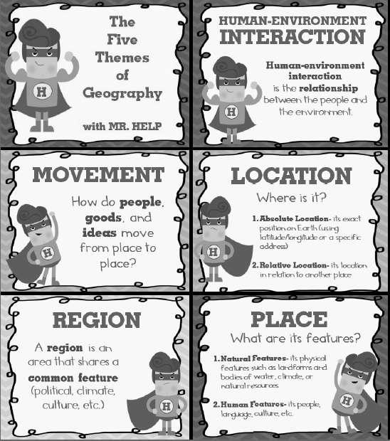
4 MOVEMENT REGION HUMAN ENVIRONMENT-INTERACTION LOCATION PLACE


5 Latitude-lines that run from east to west but measure distance north and south of the Equator Parallels-refers to lines of latitude Equator-line of latitude that measures 0 degrees Scale Title-subject of the map Compass Rose-shows the 4 principal directions Legend-explains what the symbols on the map represent Scale-used to represent the distances between points on a map Longitude-lines that run from north to south but measure distance east and west of the Prime Meridian Meridians-refers to lines of longitude Prime Meridian-line of longitude that measures 0 degrees
6 RIVERS OF TEXAS

7 PHYSICAL MAP
8 REGIONS OF TEXAS
9 SUB-REGIONS OF TEXAS
10


11 Important years in TEXAS history Mapping of the Texas coast & first mainland Spanish settlement Founding of San Antonio Mexico wins independence from Spain Texas independence Annexation of Texas Civil War begins Adoption of current state constitution Discovery of oil at Spindletop

 Alvar Nunez")
 Hernando")

 La Salle explores the")

12 Exploration of texas Alonso Alvarez de Pineda (maps the Texas coast) Alvar Nunez Cabeza de Vaca (explores & lives among natives) Hernando de Soto (Luis de Moscoso) Don Juan de Onate (established settlements on the upper Rio Grande) La Salle explores the Mississippi River La Salle established Ft. St. Louis (1 st French settlement in Texas)


13 Road to the texas revolution Fredonian Rebellion Mier y Teran Report Law of April 6, 1830 First skirmish at Anahuac Turtle Bayou Resolutions Convention of 1832 Convention of 1833 Stephen F. Austin is arrested
 Grass Fight (Nov. 26) San Antonio de Bexar (Dec.")
 Fannin s surrender (March 20) Goliad Massacre (March 27) Battle of San Jacinto (April 21) *Texas")
14 the texas revolution Battle of Gonzales (October 2) *1 st Battle Battle at Goliad (October 9) Grass Fight (Nov. 26) San Antonio de Bexar (Dec. 5-9) Convention of 1836 *Texas Independence (March 2) *Texas Constitution (March 16) Battle of the Alamo (March 6) Fannin s surrender (March 20) Goliad Massacre (March 27) Battle of San Jacinto (April 21) *Texas wins independence Treaty of Velasco
15 New England Massachusetts, New Hampshire. Connecticut, Rhode Island Middle Pennsylvania, Delaware, New Jersey, New York Southern Virginia, Maryland, North Carolina, South Carolina, Georgia
16 expansion of the u.s


17 Important years in american history Jamestown was established. Pilgrims arrive in America; Mayflower Compact is written Declaration of Independence was written U.S. Constitution was written Louisiana Purchase Civil War
A. Geography Students know the location of places, geographic features, and patterns of the environment.
 Learning Targets Elementary Social Studies Grade 5 2014-2015 A. Geography Students know the location of places, geographic features, and patterns of the environment. A.5.1. A.5.2. A.5.3. A.5.4. Label North
Warmup. geography compass rose culture longitude
 Warmup geography compass rose culture longitude ecosystem latitude 1. study of the special physical and human characteristics of a place or region 2. learned system of shared beliefs, traits, and values
3 rd Grade Social Studies Pacing Guide Arkansas Frameworks
 3 rd Grade Social Studies Pacing Guide Arkansas Frameworks 1st Nine Weeks Strand1: Geography Standard 1: Physical and Spatial Students shall develop an understanding of the physical and spatial characteristics
Texas Geography. Understanding the physical and human characteristics of our state
 Texas Geography Understanding the physical and human characteristics of our state To understand Texas you must first learn about its Geography. Geography- The study of the world, its people, and the interaction
Social Studies Curriculum Document Grade 3 Alignment with Common Core Unit 1 Student Learning Expectation
 Social Studies Curriculum Document Grade 3 Alignment with Common Core Unit 1 Student Learning Enduring Understanding: Good citizenship should be evident by observing proper etiquette of the American flag.
Locate places on contemporary maps using cardinal and intermediate directions, map scales, legends, and t
 Subject Grade Level 3 Social Studies G.1.3.1 G.1.3.10 G.1.3.11 G.1.3.12 G.1.3.13 G.1.3.14 G.1.3.15 G.1.3.2 G.1.3.3 G.1.3.4 G.1.3.5 G.1.3.6 G.1.3.7 G.1.3.8 G.1.3.9 Define absolute location Describe how
Warm up: (8 min) Use the Map, On the Prom (Color) Paper (Blk/White) and answer the questions on your paper
 Use the Map, On the Prom (Color) Paper (Blk/White) and answer the questions on your paper") Warm up: (8 min) Use the Map, On the Prom (Color) Paper (Blk/White) and answer the questions on your paper TX History: Mapping and Geography of Texas: We will discuss some slides and write notes on others
Warm up: (8 min) Use the Map, On the Prom (Color) Paper (Blk/White) and answer the questions on your paper TX History: Mapping and Geography of Texas: We will discuss some slides and write notes on others
Office of Curriculum, Instruction, and Technology. Social Studies. Grade 4 ABSTRACT
 Office of Curriculum, Instruction, and Technology Social Studies Grade 4 ABSTRACT At the fourth grade level, students learn about the state of New. Various aspects of the state are investigated including
4th Grade Social Studies First Nine Weeks
 4th Grade Social Studies First Nine Weeks Multiple Choice Identify the choice that best completes the statement or answers the question. 1 Name the mountains that are located in the eastern United States.
LOUISIANA STUDENT STANDARDS FOR SOCIAL STUDIES THAT CORRELATE WITH A FIELD TRIP TO DESTREHAN PLANTATION KINDERGARTEN
 LOUISIANA STUDENT STANDARDS FOR SOCIAL STUDIES THAT CORRELATE WITH A FIELD TRIP TO DESTREHAN PLANTATION KINDERGARTEN Standard 2 Historical Thinking Skills Students distinguish between events, people, and
Fifth Grade Social Studies
 AASD SOCIAL STUDIES CURRICULUM Fifth Grade Social Studies Description The fifth grade survey of American History course provides a general overview of our nation from colonization into the Twenty-First
Preview: Making a Mental Map of the Region
 Preview: Making a Mental Map of the Region Draw an outline map of Canada and the United States on the next page or on a separate sheet of paper. Add a compass rose to your map, showing where north, south,
[ 1.2 ] Texas Geography
![[ 1.2 ] Texas Geography](/thumbs/78/78091378.jpg "[ 1.2 ] Texas Geography") [ 1.2 ] Texas Geography [ 1.2 ] Texas Geography Learning Objectives Identify how geography helps people understand and organize information about a place. Compare the physical and human characteristics
[ 1.2 ] Texas Geography [ 1.2 ] Texas Geography Learning Objectives Identify how geography helps people understand and organize information about a place. Compare the physical and human characteristics
Stillwater Area Schools Curriculum Guide for Elementary Social Studies
 Stillwater Area Schools Curriculum Guide for Elementary Social Studies Grade Four Draft March 21, 2006 Minnesota and the St. Croix Valley I. Historical Skills A. The student will acquire skills of chronological
MARS AREA SCHOOL DISTRICT CURRICULUM GRADE: Grade 4
 MARS AREA SCHOOL DISTRICT CURRICULUM GRADE: Grade 4 Course Title: Social Studies Brief Description Overview: Students will explore the history, geography, government, and economy of the United States with
Social Studies Continuum
 Historical Skills chronological thinking understand that we can learn about the past from different sorts of evidence begin to use historical resources apply research skills by investigating a topic in
Scope & Sequence Grade: Four Subject: Social Studies Revised 3/30/ st Quarter (44 Days)
") 1 st Quarter (44 Days) Describe some of the major landforms and waterways in. Describe 4.7 B, 4.9 B, 4.6 A, 4.6 B, 4.22 B, Week 1 Chapter1: The geography of the ways people collect water from the Earth.
1 st Quarter (44 Days) Describe some of the major landforms and waterways in. Describe 4.7 B, 4.9 B, 4.6 A, 4.6 B, 4.22 B, Week 1 Chapter1: The geography of the ways people collect water from the Earth.
About places and/or important events Landmarks Maps How the land is, hills or flat or mountain range Connected to maps World Different countries
 What do you think you know about geography? About places and/or important events Landmarks Maps How the land is, hills or flat or mountain range Connected to maps World Different countries What do you
4th Grade Social Studies GLEs
 4th Grade Social Studies GLEs Geography The World in Spatial Terms 1. Interpret different kinds of maps using a map key/legend, compass rose, cardinal and intermediate directions, and distance scale (G-1A-E1)
2 Georgia: Its Heritage and Its Promise
 TERMS region, erosion, fault, elevation, Fall Line, aquifer, marsh, climate, weather, precipitation, drought, tornado, hurricane, wetland, estuary, barrier island, swamp PLACES Appalachian Mountains, Appalachian
Reading for Information Grade 2 Correlations to Alabama State Curriculum
 Grade 2 Correlations to Alabama State Curriculum Science Strand Life Science Earth Science Physical Science Grade 2 Leveled Plants Live and Grow Plants: Alive and Growing Plants: Living and Growing All
Scope & Sequence Grade:4 Subject:Social Studies
 1 st Quarter (43 Days) 1 st : Aug 10-14 2 nd : Aug 17-21 3 rd : Aug 24-28 4 th : Aug 31- Sep 4 5 th : Sept 8-11 6 th : Sept 14-18 7 th : Sept 28- Oct 2 8 th : Oct 5-9 Chapter1: The geography of the Lesson
Social Studies K 6 Scope and Sequence
 K September October November December January February March April May June Our Classroom/ Wear and Wear and Wear and How do We How do We Needs and Wants Living Things in Our Living Things in Our We Grow
3 rd Grade Social Studies
 3 rd Grade Social Studies UNITED STATES HISTORY Year 1: American Indian Cultures through Colonization In third grade, students begin a three-year study of United States history in which all four strands
Standard Indicator That s the Latitude! Students will use latitude and longitude to locate places in Indiana and other parts of the world.
 Standard Indicator 4.3.1 That s the Latitude! Purpose Students will use latitude and longitude to locate places in Indiana and other parts of the world. Materials For the teacher: graph paper, globe showing
Third Grade United States History
 Third Grade United States History Year 1: American Indian Cultures through Colonization In third grade, students begin a three-year study of United States history in which all four strands (history, geography,
SUBJECT: Social Studies GRADE: K
 GRADE: K GOALS: Students will. 1. Demonstrate that a good citizen takes turns, shares, takes responsibility for daily chores, cares for personal belongings, and shows respect for what belongs to others.
CHAPTER 1. Geo Challenges 1A to 1D. & World Map Activity
 CHAPTER 1 Geo Challenges 1A to 1D & World Map Activity SELECT YOUR CHALLENGE World Map Activity Challenge 1A Challenge 1B Challenge 1C Challenge 1D Challenge 1A WS PG. 2 STEP #1 Label the largest continent
WS/FCS Unit Planning Organizer
 WS/FCS Unit Planning Organizer Subject(s) Social Studies Conceptual Lenses Grade/Course 6 th Geography Unit of Study Unit 1: Human Geography Civilization Unit Title Social Studies 101 Culture Pacing 12
4th Grade U.S. Regional Geography
 4th Grade U.S. Regional Geography Multiple Choice Identify the choice that best completes the statement or answers the question. What does the term mainland mean in the sentence above? A the continent
What Is a Globe? Hemispheres. Main Idea Globes and maps provide different ways of showing features of the earth. Terms to Know
 r Main Idea Globes and maps provide different ways of showing features of the earth. Terms to Know hemisphere latitude longitude scale bar scale relief elevation contour line What Is a Globe? A globe is
Passwords. Social Studies Vocabulary. Texas: Grade 7
 Passwords Social Studies Vocabulary Texas: Grade 7 To the Student What is federalism? How are independence and interdependence different? What does an anthropologist do? Passwords: Social Studies Vocabulary
Montgomery County Schools
 (Daily Learning ) SS-07-4.1.1 use a variety of geographic tools (maps, photographs, charts, graphs, databases) to interpret patterns and locations on Earth s surface in early A.D. 1 LT1: I can identify
MAP SET. BrITAIN S & EXCERPTS. Norman B. Leventhal Map Center Digital Collections leventhalmap.org
 MAP SET BrITAIN S NORTH AMERICAN EMPIRE 1607 1764 Worksheets & EXCERPTS Norman B. Leventhal Map Center Digital Collections leventhalmap.org MAP 1 New england 1675 MAP Inquiry WORKSHEET Circle which of
Unit 1: Geography. For additional information, refer to this website: 1 G e o g r a p h y
 Unit 1: Geography For additional information, refer to this website: http://mryoungtms.weebly.com/ 1 G e o g r a p h y Continents and Oceans SOL USI. 2a Essential Understanding: Continents are large land
Unit 1: Basics of Geography Test Review
 Name Date Period Unit 1: Basics of Geography Test Review Directions: Reading the following sections and complete the questions, charts, and diagrams. Types of Maps Maps that have a particular theme are
Geography Test Unit 1 Study Guide. democracy profit citizenship Bill of Rights consumers federal government political process values
 Geography Test Unit 1 Study Guide Skills Identify Longitude and Latitude Identify Continents of the World Identify Time Zones Equator Prime Meridian Hemispheres Map Requirements Oceans Compare US/Mexico/Canada
Witchampton CofE First School Geography Curriculum Map
 2016-2017 Autumn People and : 30-50 Show interest in the lives of people who are familiar to them. Shows interest in different occupations. Remembers and talks significant events in their own experience.
4th Grade US Regional Geography First Nine Weeks
 4th Grade US Regional Geography First Nine Weeks 2014-2015 Identify the choice that best completes the statement or answers the question. 1 The line identified as 0 runs west and east on the globe and
Side-by-Side Comparison of the Texas Educational Knowledge and Skills (TEKS) and Louisiana Grade Level Expectations (GLEs) SOCIAL STUDIES: Grade 4
 and Louisiana Grade Level Expectations (GLEs) SOCIAL STUDIES: Grade 4") Side-by-Side Comparison of the Texas Educational Knowledge and Skills (TEKS) and Louisiana Grade Level Expectations (GLEs) (4.1) History. The student understands the similarities and differences of Native-American
Side-by-Side Comparison of the Texas Educational Knowledge and Skills (TEKS) and Louisiana Grade Level Expectations (GLEs) (4.1) History. The student understands the similarities and differences of Native-American
Map Skills Unit. Note taking unit
 Map Skills Unit Note taking unit Introduction To learn about the Earth, we are going to learn about two geographic tools you can use.globes and maps. Globe A globe is a round model of the planet Earth
August 19 students first day of class (M1-M17) Place. Movement. Human- Environment Interaction. Cartography. Elevation
 Place. Movement. Human- Environment Interaction. Cartography. Elevation") Month August 2010 6 th Grade Western Hemisphere 2010-2011 Curriculum Map Pacing Vocabulary Assessment Resources Content Skills Mapmaster 7. Location August 19 Skills students first Handbook 7.6.1 Region
Month August 2010 6 th Grade Western Hemisphere 2010-2011 Curriculum Map Pacing Vocabulary Assessment Resources Content Skills Mapmaster 7. Location August 19 Skills students first Handbook 7.6.1 Region
Social Studies (4) Social Science
 Social Science") Scope And Sequence Timeframe Unit Instructional Topics 8 Day(s) Course Overview Students will learn about the regions of the United States with emphasis on local and state history, geography, government,
Scope And Sequence Timeframe Unit Instructional Topics 8 Day(s) Course Overview Students will learn about the regions of the United States with emphasis on local and state history, geography, government,
LEARNING OUTCOMES SST (G1-G12)
") LEARNING OUTCOMES SST (G1-G12) Grade 1 Learning Outcomes Students will be expected to: - demonstrate an understanding of the importance of interactions between people - demonstrate an understanding of
LEARNING OUTCOMES SST (G1-G12) Grade 1 Learning Outcomes Students will be expected to: - demonstrate an understanding of the importance of interactions between people - demonstrate an understanding of
Fourth Grade Social Studies
 AASD SOCIAL STUDIES CURRICULUM Fourth Grade Social Studies Description Fourth Grade Social Studies explores the regions of the United States with particular emphasis on the where students will spotlight
Unit 1: Geography and Social Studies Skills
 Unit 1: Geography and Social Studies Skills Standard(s) of Learning: WHI.1 The student will improve skills in historical research and geographical analysis by a) Identifying, analyzing, and interpreting
WS/FCS Unit Planning Organizer
 WS/FCS Unit Planning Organizer Subject(s) Social Studies Conceptual Lenses Grade/Course 6 th Geography Unit of Study Unit 1: Human Geography Civilization Unit Title Social Studies 101 Culture Pacing 12
Unit 1: Geography GeoTrekkers in the Western Hemisphere. Illustrated Glossary
 Unit 1: Geography GeoTrekkers in the Western Hemisphere Illustrated Glossary adapt to change in order to fit new condi/ons archipelago a group or chain of islands clustered together in a sea or ocean bodies
Did You Ever Wonder? Landforms, C52. Slow Changes on Land, C58. Fast Changes on Land, C68
 \ - i -Vt1 t _ 9 \ "» y \R Landforms, C52 Slow Changes on Land, C58 Fast Changes on Land, C68 w -4 Did You Ever Wonder? What forces shaped these rocks? Wind and rain shaped them over thousands of years.
Learning Target : Describe the purposes and uses of different types of maps.
 Learning Target : Describe the purposes and uses of different types of maps. Directions: 1. Below, place a where you think you are located. 2. In which continent are you located? 3. In which country are
The World of Geography Pre-Test/Study Guide Chapter 1 Test
 Read each statement or question. On the lines below write the letter of the best answer. 1. Geographers look at the Earth 5. What are the two specific A. by studying cities first. measurements of Earth
Geography Can Be Cool. Seriously
 Geography Can Be Cool Seriously Why does geography matter? Geography: the study of looking at every aspect of the Earth s systems, such as human economies, societies, cultures, plants, animals, & climate.
Social Studies Curriculum Sixth Grade
 Social Studies Curriculum Sixth Grade A. History Students will examine the key historic movements, events, and figures that contributed to the development of modern Europe and American nations from early
Semester 1 2 nd Grade Concept Performance Objective Resources PO 1. Place important life events in chronological order on a timeline.
 Semester 1 2 nd Grade PO 1. Place important life events in chronological order on a timeline. Strand 1: American History Concept 1: Research Skills for History PO 2. Place historical events from content
Why Geography Matters
 Why Geography Matters Vocabulary words geography relative location absolute location physical feature human feature region modify adapt cause effect geography: The study of the Earth s physical and human
MR. JOHNSON S. Geography OHIO COUNTY MIDDLE SCHOOL
 MR. JOHNSON S Geography OHIO COUNTY MIDDLE SCHOOL CHAPTER 1 Geography The science of geography is likely the oldest of all sciences. Geography is the answer to the question that the earliest humans asked,
Challenge 1: Learning About the Physical Geography of Canada and the United States
 60ºN S T U D E N T H A N D O U T Challenge 1: Learning About the Physical Geography of Canada and the United States 170ºE 10ºW 180º 20ºW 60ºN 30ºW 1 40ºW 160ºW 50ºW 150ºW 60ºW 140ºW N W S E 0 500 1,000
3 rd Grading Cycle TEKS: 2.A,B,C,D,E, 6.B, 8.A,B,C, 12.A,B,C,14.B,14.B,16.A,17D,19.C,20.A,21.A,B 22.D
 SISD Year At A Glance Curriculum Calendar- 4 th Grade Social Studies 1st Grading Cycle 2 nd Grading Cycle 3 rd Grading Cycle 4 th Grading Cycle Celebrating Freedom Our Land and Regions Research Skills:
Parts of a Map. Map Skills. The Title. There are 4 main parts of a map: The Title The Compass Rose The Map Key The Scale
 Map Skills Parts of a Map There are 4 main parts of a map: The Title The Compass Rose The Map Key The Scale The Title The title of the map is usually at the top and describes the topic of the map Example:
What are the geographic tools and how are they used to identify phisical and human features of a location?
 Teacher / Team Name: 4th Grade - Social Studies Topic: 1 - Geography 2011 Social Studies Days: 25 4th Key Learning: Geographic tools help us identify physical and human features of the world in which we
5 Themes of Geography Review Video Notes What is Geography?
 Name PG # 5 Themes of Geography Review Video Notes What is Geography? The study of, their, and their Main Idea or Topic Continents Notes about Main Idea or Topic There are 7 Continents or in the world:
New Mexico Public Education Department. 7th Grade Social Studies End-of-Course (EoC) Exam
 Exam") New Mexico Public Education Department Assessment Blueprint 7th Grade Social Studies End-of-Course (EoC) Exam Version 001 Spring 2015 Purpose Statement 7th Grade Social Studies The 7 th Grade Social Studies
New Mexico Public Education Department Assessment Blueprint 7th Grade Social Studies End-of-Course (EoC) Exam Version 001 Spring 2015 Purpose Statement 7th Grade Social Studies The 7 th Grade Social Studies
TRIBUNE MODEL SCHOOL Syllabus for Session Subject: Social Science CLASS IV
 TRIBUNE MODEL SCHOOL Syllabus for Session 2017-18 Subject: Social Science CLASS IV Text Books 1. Candid New Trends in Social Science 4 2. Candid New Trends in Social Science (Worksheets) 4 Term I (Chapters
Ganado Unified School District (Social Studies/1 st Grade)
") Ganado Unified School District (/1 st Grade) PACING Guide SY 2016-17 1 st Quarter (11 Performance Objectives) Strand 1: American History, Strand 2: World History, Strand 3: Civics/Government, Strand 4:
Ganado Unified School District (/1 st Grade) PACING Guide SY 2016-17 1 st Quarter (11 Performance Objectives) Strand 1: American History, Strand 2: World History, Strand 3: Civics/Government, Strand 4:
Milford Public Schools Curriculum
 Milford Public Schools Curriculum Department: Social Studies Grade 3 Course Name: Communities Course Description In third grade, students will engage in a yearlong study of communities and specifically
Lesson Quizzes (Individual assessments for each lesson) Social Studies Alive! Our Community and Beyond Lesson 1-6
 Social Studies Alive! Our Community and Beyond Lesson 1-6") 7.1 Basic Geographic Literacy 7.1.3.A-Identigy how basic geographic tools are used to organize and interpret information about people, places and environment. 7.3 Human Characteristics of Places and Regions
7.1 Basic Geographic Literacy 7.1.3.A-Identigy how basic geographic tools are used to organize and interpret information about people, places and environment. 7.3 Human Characteristics of Places and Regions
Grade 7 History Mr. Norton
 Grade 7 History Mr. Norton Section 1: Thinking Geographically Section 2: Land and Climates of the United States Section 3: The Tools of History Section 4: Economics and Other Social Sciences Grade 7 History
Unit 2 Study Guide: The World in Spatial Terms
 Name Date Hour Unit 2 Study Guide: The World in Spatial Terms TEST is WEDNESDAY, DECEMBER 19 TH This study guide contains all the concepts that will be on your test. Vocabulary words and concepts will
Course Title: Social Studies People We Know Grade: 2
 Course Title: People We Know Grade: 2 Credits: 1.0 Lessons per week: 2/3 (total 36 weeks) Subject Philosophy: Course Summary: is a vehicle for examining and developing our own biblical worldview and exploring
Utah Core Standards Science Grade: 2 - Adopted: 2010
 Main Criteria: Utah Core Standards Secondary Criteria: Subjects: Science, Social Studies Grade: 2 Correlation Options: Show Correlated UT.2. Utah Core Standards Science Grade: 2 - Adopted: 2010 Earth and
Simple Solutions Social Studies Level 2. Level 2. Social Studies. Help Pages
 Level 2 Social Studies 147 148 adobe houses with bricks made of clay and straw ancestor a family member who lived before us appoint choose; leaders can appoint others barter trading one thing for another
Welcome Survey getting to know you Collect & log Supplies received Classroom Rules Curriculum overview. 1 : Aug 810. (3 days) 2nd: Aug (5 days)
 2nd: Aug (5 days)") 1st Quarter (41Days) st 1 : Aug 810 (3 days) 2nd: Aug 13-17 Reporting Categories (TEKS SEs) Skill Create and write a postcard about your favorite community activity Review 2nd Grade Vocabulary Chapter
1st Quarter (41Days) st 1 : Aug 810 (3 days) 2nd: Aug 13-17 Reporting Categories (TEKS SEs) Skill Create and write a postcard about your favorite community activity Review 2nd Grade Vocabulary Chapter
Different types of maps and how to read them.
 Different types of maps and how to read them. A map is a picture or representation of the Earth's surface, showing how things are related to each other by distance, direction, and size. Maps have been
Critical Thinking. about. GeoGRAPHY. United States, Canada, and Greenland. Jayne Freeman
 Critical Thinking about GeoGRAPHY United States, Canada, and Greenland Jayne Freeman WALCH EDUCATION Contents Introduction............................................................... v National Geography
Five Themes of Geography. By PresenterMed
 Five Themes of Geography By PresenterMed Geography Geography: the study of the Earth Where are things located? Why are they there? Location Location: where a place is Cardinal Directions: North, South,
EC-6 Core Subjects Social Studies. Domain III Social Studies. Social Studies Competencies
 EC-6 Core Subjects Social Studies TExES #291Review Domain III Social Studies Approximately 16% of the test Approximately 41 Items 35 minutes Averages 51 seconds per question Social Studies Competencies
POLITICAL SYSTEMS. (ps ) Evaluate positions taken regarding the necessity of government and the purposes of government.
 Evaluate positions taken regarding the necessity of government and the purposes of government.") Baltimore City Public School System Social Studies Content Standards (Grade 8) POLITICAL SYSTEMS In the context of U.S. History through 1877, at the end of grade 8, students know and are able to do everything
Baltimore City Public School System Social Studies Content Standards (Grade 8) POLITICAL SYSTEMS In the context of U.S. History through 1877, at the end of grade 8, students know and are able to do everything
Globes, Maps, and Atlases. Plus, A Whole Bunch of Other Way Cool Geographic Information!!!
 Globes, Maps, and Atlases Plus, A Whole Bunch of Other Way Cool Geographic Information!!! Globes Are the Most Accurate Portrayal of the Earth The earth is about 24,900 miles in circumference, and about
Massachusetts Curriculum Frameworks Science Grade: 4 - Adopted: 2016
 Main Criteria: Massachusetts Curriculum Frameworks Secondary Criteria: Subjects: Science, Social Studies Grade: 4 Correlation Options: Show Correlated Massachusetts Curriculum Frameworks Science Grade:
New York State Learning Standards and Core Curriculum Science Grade: 5 - Adopted: Matter and Energy in Organisms and Ecosystems
 Main Criteria: New York State Learning Standards and Core Curriculum Secondary Criteria: Subjects: Science, Social Studies Grade: 5 Correlation Options: Show Correlated New York State Learning Standards
Essential Questions What are the major physical components of the world, and how are they represented on a map? 3.4
 Third Grade Social Studies Unit One Six Weeks GEOGRAPHY Originally compiled by Russellville In order for students to understand that geography influences the development of a region as well as the interactions
Content Area: Social Studies Standard: 1. History Prepared Graduates: Develop an understanding of how people view, construct, and interpret history
 Standard: 1. History Develop an understanding of how people view, construct, and interpret history 1. Organize and sequence events to understand the concepts of chronology and cause and effect in the history
Tennessee Department of Education Social Studies Curriculum Standards Grades 1 8
 Tennessee Department of Education Social Studies Curriculum Standards Grades 1 8 Correlated to TEST READY Social Studies Social Studies - First Grade TEST READY Social Studies Book 1 Culture Content Standard:
What is Geography? *Mixes up the physical and human aspects of our world into one field of study.
 World Geography What is Geography? *It is the study of the earth *Mixes up the physical and human aspects of our world into one field of study. *Shows the relationship between people and the environment.
Chapter 1: The World of Geography
 Chapter 1: The World of Geography Chapter 1: What is Geography? *It is the study of our earth; our home. OR *Anything that can be mapped! *Geography mixes up the physical and human aspects of our world
Great Native American Nations
 Great Native American Nations Episode 1 Episode 2 Episode 3 Episode 4 Episode 5 Episode 6 Cheyenne: Indians of the Plains Iroquois: Indians of the Northeast Lakota Sioux: Indians of the Plains Navajo:
SOCIAL STUDIES Grade 6 Standard: History
 Standard: History Chronology A. Interpret relationships between events shown on multipletier 1. Construct a multiple-tier time line from a list of events time lines. and interpret the relationships between
Year At A Glance. 5th Grade Social Studies. UNIT 4 America s Fight for Independence and the Creation of a New Nation. UNIT 2 Early Explorers
 5th Grade Social Studies Year At A Glance UNIT 1 Introduction to Social Studies and the Pre-Columbian Societies and Tribes (9 Weeks) UNIT 2 Early Explorers (9 Weeks) UNIT 3 Becoming a new nation: Colonization
The Five Themes of Geography How Do We View the World Around Us?
 The Five Themes of Geography How Do We View the World Around Us? By Nicole Copeland What is Geography? Geography is the study of the earth''s surface; includes people''s responses to topography and climate
Natural Texas. Regions and Climates
 Natural Texas Regions and Climates Two Kinds: Physical geography Climate, vegetation, rivers, lakes, oceans, plateaus, plains, and mountain ranges Human geography Economic activities How we earn a living
Fourth Grade Social Studies Crosswalk
 Fourth Grade Social Studies Crosswalk This crosswalk document compares the 2010 K-12 Social Studies Essential Standards and the 2006 North Carolina Social Studies Standard Course of Study (SCOS) and provides
Nursery. Reception. Year 1
 Nursery Geography Overview Autumn Spring Summer Notices detailed features of objects in their environment. Comments and asks questions about aspects of their familiar world such as the place where they
PBL: Colonial Life. Create a Brochure Attracting People to Come to your Region
 PBL: Colonial Life Create a Brochure Attracting People to Come to your Region Project Idea: Brochure Working in partners, students will create a brochure attracting people to one of the three regions:
The Hemet Unified School District HISTORY/SOCIAL SCIENCE Content Standards In the Classroom
 The Hemet Unified School District HISTORY/SOCIAL SCIENCE Content Standards In the Classroom By the end of fourth grade students will: Demonstrate an understanding of the physical and human geographic features
2015 Curriculum Catalog
 2015 Curriculum Catalog History and Geography 2015 Glynlyon, Inc. Released 4/1/15 History and Geography 2015 Table of Contents COURSE OVERVIEW... 1 UNIT 1: WHAT IS HISTORY?... 1 UNIT 2: WHAT IS GEOGRAPHY?...
Curriculum Catalog
 2017-2018 Curriculum Catalog 2017 Glynlyon, Inc. Table of Contents HISTORY AND GEOGRAPHY 700 COURSE OVERVIEW... 1 UNIT 1: WHAT IS HISTORY?... 1 UNIT 2: WHAT IS GEOGRAPHY?... 2 UNIT 3: THE UNITED STATES...
Grade 3 Social Studies
 Grade 3 Social Studies Social Studies Grade(s) 3rd Course Overview Students will learn about a variety of communities. Students will learn about the geography and resources of communities. Students will
Geography Long Term Plan 2018
 Geography Long Term Plan 2018 Geography Co-ordinator: Megan Frost A high-quality geography education should inspire in pupils a curiosity and fascination about the world and its people that will remain
Proposed AKS for 6 th Grade Social Studies
 Proposed AKS for 6 th Grade Social Studies A. Map and Globe Skills 1. use cardinal directions 2. use intermediate directions 3. use a letter/number grid system to determine location 4. compare and contrast
GEOGRAPHY. Map Skills. Mrs. Pere ~ 2013
 GEOGRAPHY Map Skills Mrs. Pere ~ 2013 WHAT IS A GLOBE? A globe is a model of the Earth. North Pole Equator South Pole WHAT IS A MAP? A map is a flat drawing of a place. THE IMPORTANT PARTS OF A MAP 1.