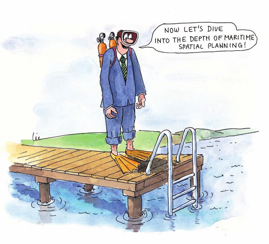
maritime spatial planning in the baltic sea
|
|
|
- Clarence Garrett
- 5 years ago
- Views:
Transcription


1 maritime spatial planning in the baltic sea
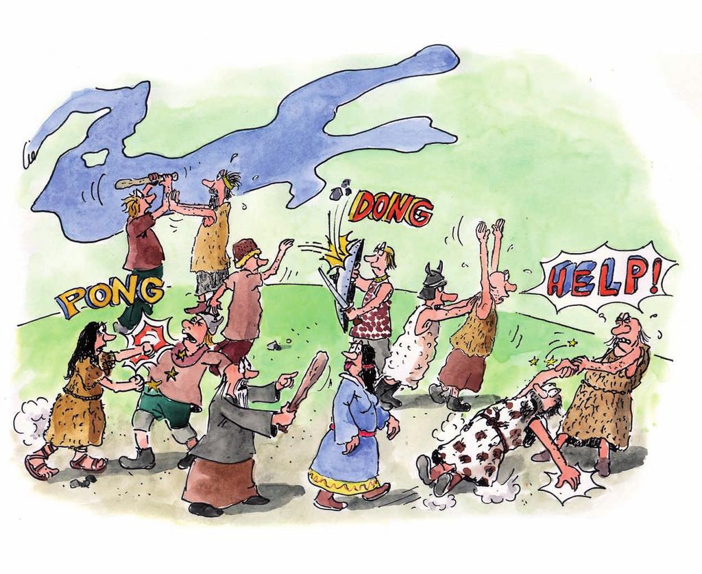
2 it starts with chaos
3
4 the chaos goes on
5
6 and on
7
8 how did we do it before?
9
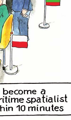
10 but what if this was not an option?
11
12 what should the tribes do instead?
13
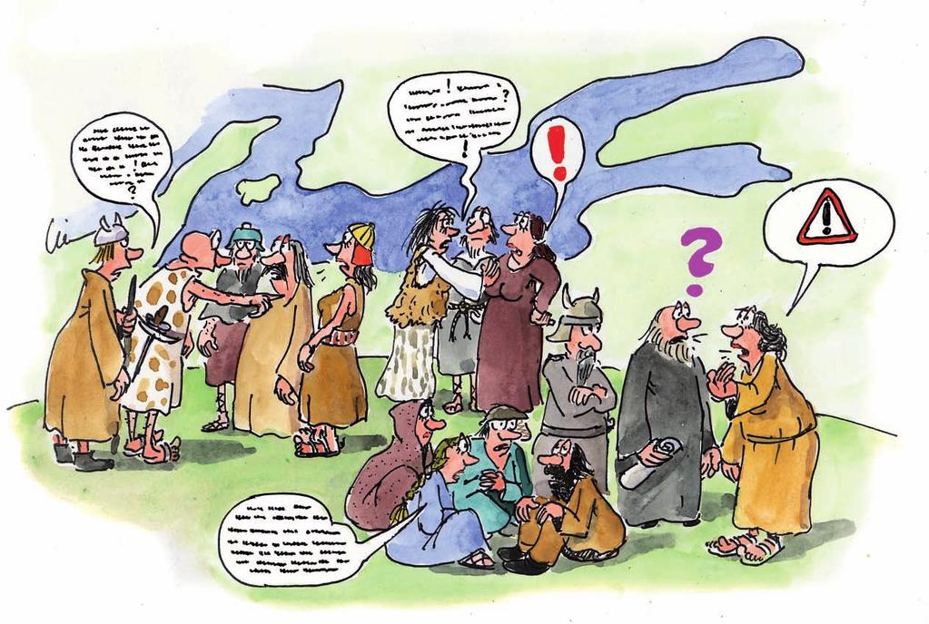
14 how would they have sorted it out?
15
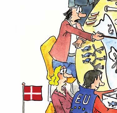
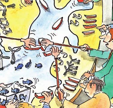
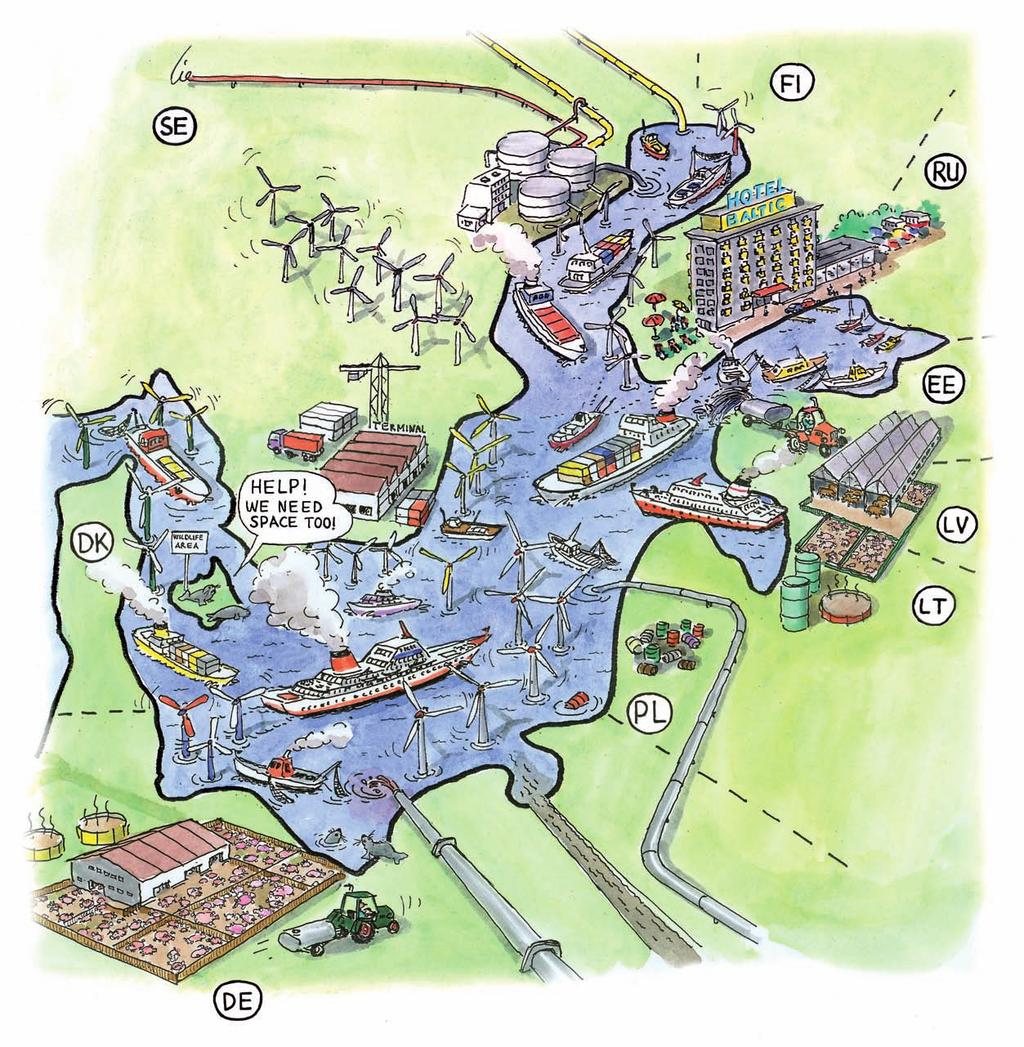
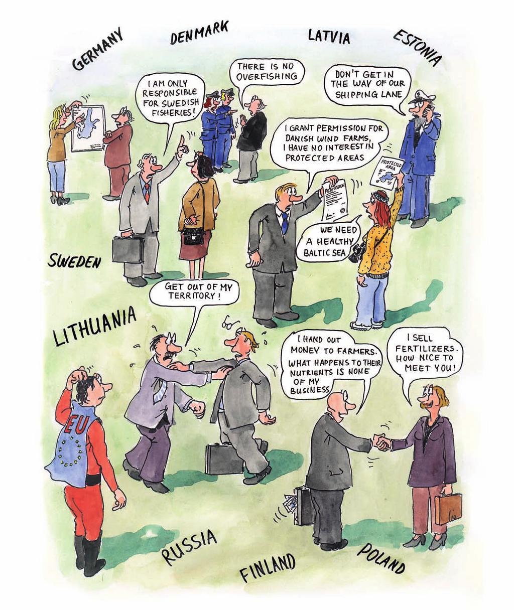
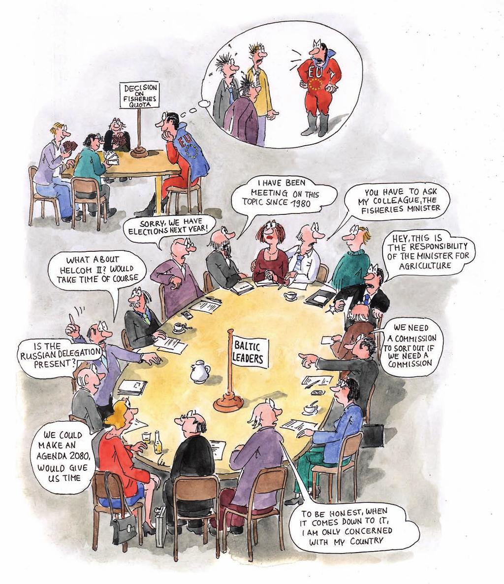
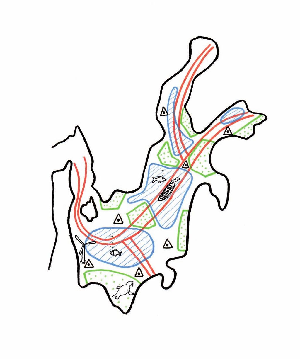
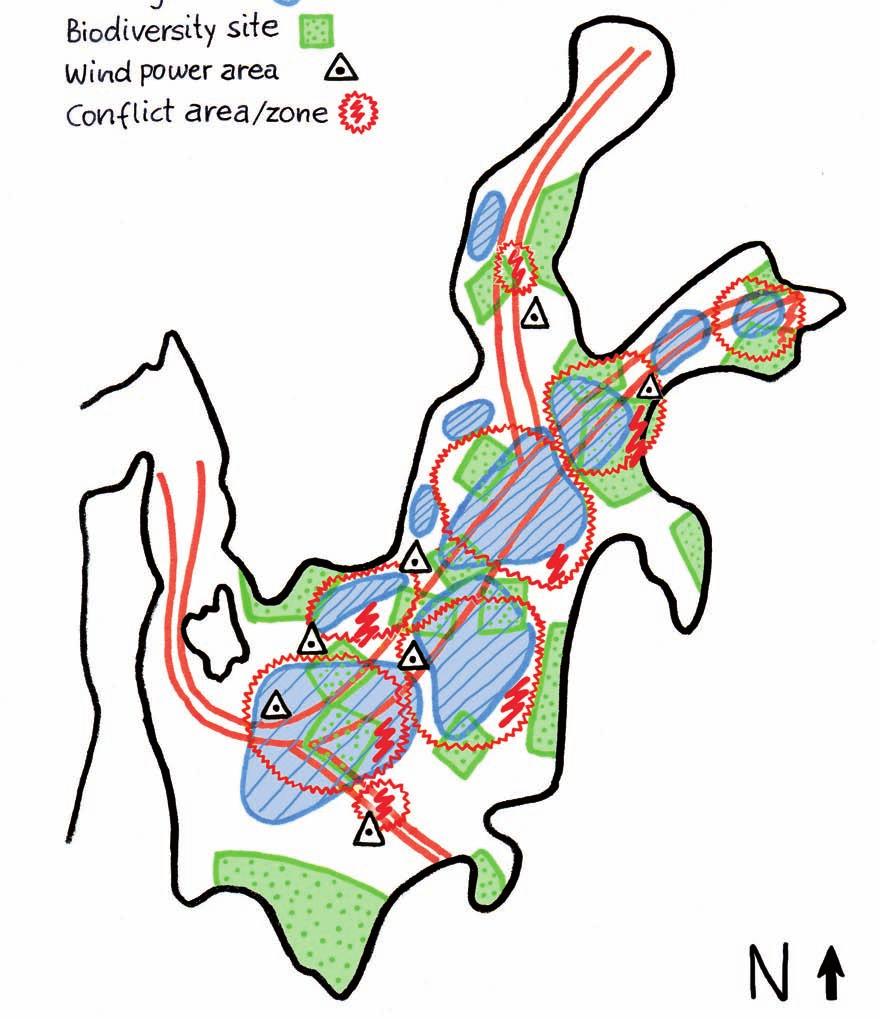
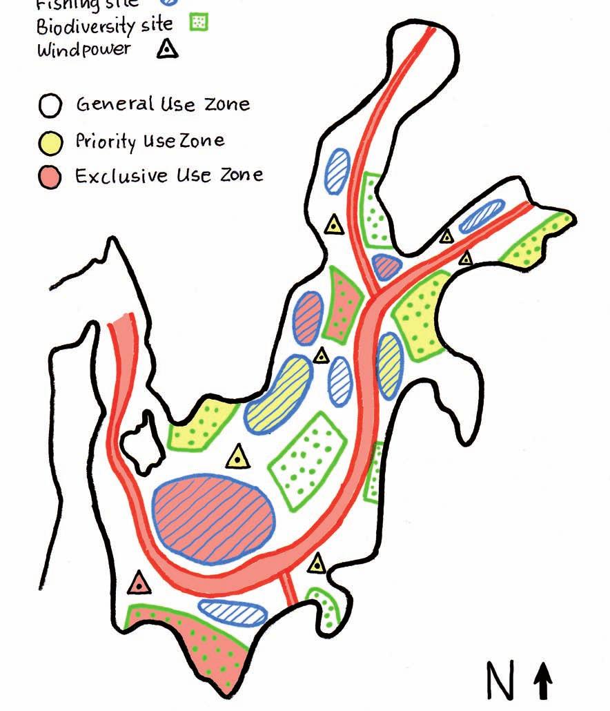
16 That s how smart leaders sorted it out, back when the problems were comparatively simple and understandable. Nowadays, the number of different uses and their intensity has grown enormously and continues to do so. The good news is that the same methodology applies as much today as it did back then: how should we do it now? MSP must be a high priority issue (in this case, effective governance at a regional level) MSP requires guiding principles (mainly an ecosystem-based approach) MSP needs a participatory approach (all uses must be considered, all user groups must be heard and involved) A zoning approach is essential Today s management of the Baltic Sea does not look so very different. However, today there are more people living around the sea and it has been regarded as a free resource to be used by everybody with few restrictions. This has meant that the Baltic Sea has become too small to meet all the demands for space. On land, we use spatial planning to solve these problems. There are many restrictions on the use of land, which are no longer recognised as limitations because life on land would not be possible without them. When we have a growing need to use the sea for shipping, offshore wind farms, fisheries and nature conservation, we need a similar spatial planning system for managing these uses. The Baltic Sea is a sea shared by many countries, with different languages and different systems of governance. We need a tool to sort out the sometimes conflicting uses Happily, Maritime Spatial Planning offers us this very tool. The Baltic Sea Region can be the first region in the world to implement successful Maritime Spatial Planning based on sound evaluation of uses and suitability of areas for particular uses, integration of users interests and ideas, as well as the need for a healthy ecosystem. In this way, the Baltic Sea can make history by demonstrating how different nations manage joint resources in an ecosystem-based, participatory and coordinated manner. Maritime Spatial Planning is the tool that can help sort out complex challenges on a crowded planet. Maritime Spatial Planning sounds awfully complicated, but in fact it isn t...
17
18 some definitions and explanations
19
20 what it could look like (1)
21
22 what it could look like (2)

23
24 what it could look like (3)
25
26 now it s your turn... +
27 Copyright WWF Germany, Frankfurt (2010) All rights reserved. This brochure was produced by WWF in the Framework of the BaltSeaPlan project. Impressum: Text and Idea: Jochen Lamp and Michèle Stoltz, WWF Germany; Karl Wagner Illustration: Erik Liebermann Coordination: Heike Mühldorfer, WWF Germany Layout: Judith Uhlemann, Production: Rainer Litty, WWF Print: medialogik, Karlsruhe Printed on recycled paper
28 The BaltSeaPlan project ( ) is jointly carried out by 14 partners from Germany, Poland, Denmark, Sweden, Latvia, Lithuania and Estonia. Together they are working towards bringing Maritime Spatial Planning in the Baltic Sea region to reality: involving maritime stakeholders, analysing current and future maritime trends, drawing up pilot maritime spatial plans and trying to infl u- ence national regulations in favour of a wise-proactive integrated sea management, which takes into account the cumulative impacts of the various uses. More information and results of the project can be found under Copyright and Trademark by WWF International Printed on 100% recycled paper BaltSeaPlan is part-fi nanced by the Baltic Sea Region Programme , which promotes regional development through transnational cooperation. This publication has been produced with the assistance of the European Union ( The content of this publication is the sole responsibility of WWF and can in no way be taken to refl ect the views of the European Union. WWF is one of the world s largest and most experienced independent conservation organisations, with almost 5 million members and supporters and a global network active in some 100 countries. WWF s mission is to stop the degradation of the planet s natural environment to build a future in which humans live in harmony with nature, by: conserving the world s biological diversity ensuring that the use of renewable natural resources is sustainable promoting the reduction of pollution and wasteful consumption. WWF Germany Coastal & Marine Division Baltic Sea Project Offi ce Beghinenhaus Knieperwall 1 D Stralsund Tel Fax stralsund@wwf.de
Maritime Spatial Planning in the Baltic Sea Region
 Maritime Spatial Planning in the Baltic Sea Region Talis Linkaits Head of VASAB Secretariat 20 May 2015 Helsinki A cooperation of ministers of the 11 Baltic Sea Region countries responsible for spatial
Towards coherent maritime spatial planning in the Baltic Sea Region, transnational and project perspective Talis Linkaits Head of VASAB Secretariat
 3 June 2013 Riga PartiSEApate Workshop MSP as Tool for Underwater Cultural Heritage Management in the Baltic Sea Towards coherent maritime spatial planning in the Baltic Sea Region, transnational and project
Marine Spatial Planning in the Baltic Sea Region
 Marine Spatial Planning in the Baltic Sea Region Towards coherence and cross-border solutions in Baltic Maritime Spatial Plans Coordinator & Project manager Dr Ingela Isaksson Swedish Agency for Marine
Baltic Sea Region cooperation in Maritime Spatial Planning - HELCOM/VASAB
 Baltic Sea Region cooperation in Maritime Spatial Planning - HELCOM/VASAB Sten Jerdenius Swedish Ministry of the Environment HELCOM/VASAB MSP Group Baltic Sea Region subregional workshop Espoo 31 March
1. Baltic SCOPE Towards coherence and cross-border solutions in Baltic Maritime Spatial Plans
 NSHC 32th Conference Explanatory Note Dublin, Ireland Item E.2 MSP 21-23 June 2016 Germany Cross border MSP for the EEZ, a case study from the Baltic Sea The Federal Maritime and Hydrographic Agency of
Country Fiche Estonia
 Country Fiche Estonia Updated October 2017 1. General information Size of internal waters (to the baseline) and territorial sea (12-nm zone from the baseline) approximately 25 200 km 2. Exclusive economic
Maritime Spatial Planning: Transboundary Cooperation in the Celtic Seas Looking Ahead
 Maritime Spatial Planning: Transboundary Cooperation in the Celtic Seas Looking Ahead Looking ahead MSP in the context of the European Maritime and Fisheries Fund (EMFF) and beyond SIMCelt Final Conference
Country Fiche Estonia
 Country Fiche Estonia Deleted: October Updated May 2018 Deleted: 7 1. General information Size of internal waters (to the baseline) and territorial sea (12-nm zone from the baseline) approximately 25 200
Country Fiche Latvia Updated October 2016
 Country Fiche Latvia Updated October 2016 1. General information Marine area under Latvian jurisdiction includes inland sea waters, Territorial sea (12 nautical miles from the baseline) and exclusive economic
PartiSEApate: Multi-Level-Governance in Maritime Spatial Planning
 PartiSEApate: Multi-Level-Governance in Maritime Spatial Planning Establish a dialogue amongst MSP actors at ALL LEVELS and develop a proposal for a pan- Bal>c MSP governance structure Angela Schultz Zehden,
Identification of maritime spatial planning best practices in the Baltic Sea Region and other EU maritime regions
 Identification of maritime spatial planning best practices in the Baltic Sea Region and other EU maritime regions PLAN BOTHNIA Baltic Sea Region Stakeholder Meeting Jacek Zaucha, Magdalena Matczak Two
Tackling MSP integration challenges in the BSR
 Towards sustainable governance of Baltic marine space 2015 2018 BALTSPACE Towards sustainable governance of Baltic marine space Tackling MSP integration challenges in the BSR Michael Gilek, Södertörn University,
Country Fiche Lithuania
 Country Fiche Lithuania Updated June 2018 1. General information The Lithuanian maritime space is delimited by the Decree of the Government of the Republic of Lithuania of 6 December, 2004, No. 1597 and
Marine Spatial Planning as an important tool for implementing the MSFD
 Marine Spatial Planning as an important tool for implementing the MSFD Risto Kalliola Tallinn, Nov. 16 th 2012 DEPARTMENT OF GEOGRAPHY AND GEOLOGY University of Turku, Finland Ten principles to provide
Marine Spatial Planning (MSP): A practical approach to ecosystembased
: A practical approach to ecosystembased") Marine Spatial Planning (MSP): A practical approach to ecosystembased management Erik Olsen, Institute of Marine Research, Norway Fanny Douvere, International Oceanographic Commission Overview Why we need
Marine Spatial Planning (MSP): A practical approach to ecosystembased management Erik Olsen, Institute of Marine Research, Norway Fanny Douvere, International Oceanographic Commission Overview Why we need
Education in Maritime Spatial Planning European Maritime Days May 22, 2012 Gothenburg
 Education in Maritime Spatial Planning European Maritime Days May 22, 2012 Gothenburg Paula Lindroos, director Baltic Centre for Sustainable Development Uppsala University BUP in Summary A regional university
MODELS AND TOOLS FOR GOVERNANCE OF
 Working Papers Collection No. 1/2015 MODELS AND TOOLS FOR GOVERNANCE OF THE ADRIATIC AND IONIAN SEAS www.unimc.it/maremap NATIONAL POLITICS AND EU POLITICS: THE MARITIME SPATIAL PLANNING AND INTEGRATED
Maritime Spatial Planning
 Maritime Spatial Planning The Dutch experience Kopenhagen 28 november 2012 Lodewijk.Abspoel@minienm.nl North Sea 2 Outline History of MSP in the Netherlands Spatial Plan for the Dutch EEZ, principles and
Outline National legislative & policy context Regional history with ESSIM ESSIM Evaluation Phase Government Integration via RCCOM Regional ICOM Framew
 What MSP Implementation could change in the Maritimes Region Tim Hall, Regional Manager Oceans and Coastal Management Division Ecosystem Management Branch Fisheries and Oceans Canada Maritimes Region BIO
The HELCOM Baltic Sea Action Plan and Marine Spatial Planning
 The HELCOM Baltic Sea Action Plan and Marine Spatial Planning Anne Christine Brusendorff Executive Secretary HELCOM The Baltic Sea Our common responsibility. Workshop on Integrated Sea Use management Stockholm
Maritime Spatial Planning in the Baltic Sea Region
 Maritime Spatial Planning in the Baltic Sea Region Past, present, perspective Talis Linkaits VASAB Secretariat XIX International Environmental Forum 22 March 2018, Saint Petersburg A cooperation of ministers
Natura 2000 in the marine environment: state of implementation and next steps
 Life on the blue planet: biodiversity research and the new European marine policies EPBRS European Platform on Biodiversity Research Strategy Porto, Portugal 7-9 November 2007 Natura 2000 in the marine
ICZM and MSP in the Black Sea Region
 ICZM and MSP in the Black Sea Region Drd. Claudia Coman, Environmental engineer AG ICZM Focal Point, Romania Black Sea Commission Black Sea Commission on the Protection of the Black Sea against Pollution
Ecosystem-Based Approach in MSP
 Ecosystem-Based Approach in MSP 16th Meeting of the joint HELCOM-VASAB Maritime Spatial Planning Working Group Ministry of Environment Aleksanterinkatu 7, Helsinki 8.-9. May 2018 Prof. Dr. jur. Gerold
Implementation of the Political Declaration on energy cooperation between the North Seas Countries. Support Group 1 on Maritime Spatial Planning
 Implementation of the Political Declaration on energy cooperation between the North Seas Countries Support Group 1 on Maritime Spatial Planning Work Programme 1. Work area as outlined in Annex I to the
Baltic 2030: Bumps on the Road
 Sven Beyersdorff June 14th 2018 Baltic 2030: Bumps on the Road - How the Baltic Sea States are performing on the SDGs Aims of report Why did we do this? Understand performance of 11 countries in the Baltic
Towards international cooperation in the development of Marine Spatial Plans for the North Pacific: economic, social, and environmental dimensions
 Towards international cooperation in the development of Marine Spatial Plans for the North Pacific: economic, social, and environmental dimensions A.V. Sereda, V.B. Lobanov V.I. Il ichev Pacific Oceanological
DELIVERING ECOSYSTEM- BASED MARINE SPATIAL PLANNING IN PRACTICE
 DELIVERING ECOSYSTEM- BASED MARINE SPATIAL PLANNING IN PRACTICE A first assessment for the UK and Ireland January 08 GLOBAL WARMING IMAGES / WWF ABOUT WWF WWF is the world s leading independent conservation
Coastal data for Integrated Maritime Policies
 Coastal data for Integrated Maritime Policies LOCHET Corine Shom Name of presentation Protection against erosion and marine flood Name presenter Link between different data scales and Name of presentation
MR. George ALEXAKIS, parallel session 3. "Mediterranean Sea Region. laying the conditions. for sustainable growth and jobs"
 parallel session 3 "Mediterranean Sea Region laying the conditions for sustainable growth and jobs" MR. George ALEXAKIS, elected Regional Councillor of Crete, Greece and representative of Crete in CRPM.
Council conclusions on Arctic issues. 2985th FOREIGN AFFAIRS Council meeting Brussels, 8 December 2009
 COU CIL OF THE EUROPEA U IO EN Council conclusions on Arctic issues 2985th FOREIGN AFFAIRS Council meeting Brussels, 8 December 2009 The Council adopted the following conclusions: The Council recalls its
Offshore Energy and Maritime Spatial Planning in the German EEZ
 Offshore Energy and Maritime Spatial Planning in the German EEZ Bettina Käppeler, BSH Federal Maritime and Hydrographic Agency On Duty for Shipping and Seas German Exclusive Economic Zone EEZ not part
Advancing Geoscientific Capability. Geological Survey of Finland
 Advancing Geoscientific Capability Geological Survey of Finland GTK in brief The Geological Survey of Finland (GTK) is one of the largest European centres of excellence in assessment, research and the
Marine/Maritime Spatial Planning Andrej Abramić
 Marine/Maritime Spatial Planning Andrej Abramić EcoAqua SUMMER SCHOOL: Ecosystem approach to aquaculture 26-29th of October 2015 Research and Technology to enhance excellence in Aquaculture development
Marine Spatial Planning Experience from Mecklenburg-Vorpommern (Germany) By Susan Toben
 By Susan Toben") Marine Spatial Planning Experience from Mecklenburg-Vorpommern (Germany) By Susan Toben Ministry of Transport, Building and Regional Development Mecklenburg Vorpommern PlanCoast Lead Partner Administrative
Marine Spatial Planning Experience from Mecklenburg-Vorpommern (Germany) By Susan Toben Ministry of Transport, Building and Regional Development Mecklenburg Vorpommern PlanCoast Lead Partner Administrative
HELSINKI COMMISSION Baltic Marine Environment Protection Commission
 HELSINKI COMMISSION Baltic Marine Environment Protection Commission HELCOM RECOMMENDATION 24/10 Adopted 25 June 2003, having regard to Article 20, Paragraph 1 b) of the 1992 Helsinki Convention IMPLEMENTATION
Necessary common minimum requirements for Maritime Spatial Planning (MSP) in the Baltic Sea
 in the Baltic Sea") www.planbothnia.org Co-financed under European Integrated Maritime Policy Necessary common minimum requirements for Maritime Spatial Planning (MSP) in the Baltic Sea Contribution to the PLAN BOTHNIA work
www.planbothnia.org Co-financed under European Integrated Maritime Policy Necessary common minimum requirements for Maritime Spatial Planning (MSP) in the Baltic Sea Contribution to the PLAN BOTHNIA work
MSP Process drawings and descriptions
 MSP Process drawings and descriptions 12 December 2016 2 Table of Contents 1. Belgium... 3 2. The Netherlands... 5 3. Germany... 7 4. Denmark... 9 5. Scotland... 11 6. Sweden... 13 7. Norway... 15 1. Belgium
PACIFIC ISLANDS REGIONAL OCEAN POLICY. A healthy Ocean that sustains the livelihoods and aspirations of Pacific Island communities.
 PACIFIC ISLANDS REGIONAL OCEAN POLICY VISION A healthy Ocean that sustains the livelihoods and aspirations of Pacific Island communities. THIS IS OUR OCEAN 1. The care of the ocean is the responsibility
Maritime Spatial Planning Framework Directive Supported by INSPIRE
 Maritime Spatial Planning Framework Directive Supported by INSPIRE Andrej Abramić, Vanda Nunes de Lima, Paul Smits, Emanuele Bigagli, Chris Schubert European Commission Joint Research Centre Institute
2SEA. Requirements Report SOILS2SEA DELIVERABLE NO. 1.2
 SOILS2SEA DELIVERABLE NO. 1.2 Requirements Report 2SEA Reducing nutrient loadings from agricultural soils to the Baltic Sea via groundwater and streams 3.5 Baltic Sea Basin 3.5.1 Description The Baltic
National Polish services using regional products
 Oceanographic services for the European regions - session organized by EuroGOOS European Maritime Day, Gdańsk, 20th May 2011 Polish Baltic Frédéric Chopin Philharmonic, Chamber Green Hall National Polish
Navigable maritime and river waterways in the seaside - Danube Delta area and the connected rural development
 SUMMARY OF Ph-D Thesis, with title RESEARCH STUDIES ON MANAGEMENT IMPROVEMENT OF MARITIME AND RIVER TRANSPORT ACTIVITY IN THE COASTAL AND DANUBE DELTA AREA FROM AN ENVIROMENTAL, ECONOMIC AND SOCIAL PERSPECTIVE
Evaluation Model for the Sustainable Development of European Coastal Zones
 Evaluation Model for the Sustainable Development of European Coastal Zones SUMMARY Interreg IIIC - South 2 INDEX 1.- INTRODUCTION... 3 2.- CONTEXT OF DEDUCE... 4 3.- CURRENT SITUATION AND CHALLENGES...
West-Estonian Archipelago Biosphere Reserve and Lima Action Plan
 West-Estonian Archipelago Biosphere Reserve and Lima Action Plan Lia Rosenberg, BR co ordinaator Toomas Kokovkin, MAB Focal Point ESTONIA 15.03.2016 LIMA Location on the globe and Europe The West-Estonian
This document has been verified by the responsible MSP authority (or representative) of Lithuania on
 of Lithuania on") Contact MSP in general Ms. Algimantė Treinienė Head of Spatial Planning Urban Development and Architecture Division Construction and Territorial Planning Department Ministry of Environment A. Jakšto 4
Contact MSP in general Ms. Algimantė Treinienė Head of Spatial Planning Urban Development and Architecture Division Construction and Territorial Planning Department Ministry of Environment A. Jakšto 4
MARINE PLANNING IN THE NETHERLANDS
 MARINE PLANNING IN THE NETHERLANDS Hermien Busschbach Ministry of Transport, Public Works and Water Management (DG Water) Bremen, 2 May 2007 Marine Planning in the Netherlands OUTLINE policy context; international
An Environmental Profile of the Island of Jost Van Dyke, British Virgin Islands
 An Environmental Profile of the Island of Jost Van Dyke, British Virgin Islands Executive Summary including Little Jost Van Dyke, Sandy Cay, Green Cay and Sandy Spit This publication was made possible
Additional information (material for interactions and analysis chapter) to document 3/1, the PLAN BOTHNIA MSP Assessment
 to document 3/1, the PLAN BOTHNIA MSP Assessment") Co-Financed Under European Integrated Maritime Policy PLAN BOTHNIA MSP 2/2011 MSP Assessment Add 1 PLAN BOTHNIA MSP 2 Uppsala, Sweden June 14-15 2011 Agenda Item 3 PLAN BOTHNIA MSP Assessment Document
Co-Financed Under European Integrated Maritime Policy PLAN BOTHNIA MSP 2/2011 MSP Assessment Add 1 PLAN BOTHNIA MSP 2 Uppsala, Sweden June 14-15 2011 Agenda Item 3 PLAN BOTHNIA MSP Assessment Document
Marine Spatial Planning: A Tool for Implementing Ecosystem-Based Management
 Marine Spatial Planning: A Tool for Implementing Ecosystem-Based Management Steven Murawski, Ph.D., Ecosystem Goal Team Lead National Oceanic and Atmospheric Administration NOAA November 16, 2009 1 To
Country Fiche Latvia.
 Country Fiche Latvia 1. General information Marine waters under Latvian jurisdiction include inland sea waters, territorial sea (12 nautical miles from the baseline) and exclusive economic zone (EEZ) waters.
Stepping into the sea - New evidence on territorial development and the opportunities and risks for European seas and maritime regions
 ESPON 2013 Programme Workshop Stepping into the sea - New evidence on territorial development and the opportunities and risks for European seas and maritime regions 15 May 2013 9h00 16h30 Venue The Norwegian
Findings and recommendations from Central Baltic case
 W 1/1 Recommendations on transboundary planning from Baltic SCOPE Findings and recommendations from Central Baltic case Ingūna Urtāne Director of Spatial Planning Department of the Ministry of Environmental
MESMA: An integrated tool box to support an ecosystem based spatial management of marine areas
 MESMA: An integrated tool box to support an ecosystem based spatial management of marine areas Stelzenmüller, V., Stamford, T., Vassilopoulou, V., Kastanevakis, S., Vincx, M, Vanaverbeke, J., Rabaut, M.,
What is Spatial Planning?
 Spatial Planning in the context of the Responsible Governance of Tenure What is Spatial Planning? Text-only version This course is funded by the European Union through the EU-FAO Improved Global Governance
The Danish Maritime Spatial Data Infrastructure (MSDI) Geodata of the Sea
 Geodata of the Sea") MSDI/MSP The Danish Maritime Spatial Data Infrastructure (MSDI) Geodata of the Sea Components of an infrastructure: DATA - metadata, datasets FUNCTIONALITY - spatial data services, web services and other
MSDI/MSP The Danish Maritime Spatial Data Infrastructure (MSDI) Geodata of the Sea Components of an infrastructure: DATA - metadata, datasets FUNCTIONALITY - spatial data services, web services and other
Cross-border Maritime Spatial Plan for the Black sea - Romania and Bulgaria project
 Cross-border Maritime Spatial Plan for the Black sea - Romania and Bulgaria project in Romania and Bulgaria Plan Presentation A first step in the management of the marine areas of Romania and Bulgaria
Introduction to IMP: need and added value
 Introduction to IMP: need and added value Christophe Le Visage Consultant Stratégies Mer et Littoral 1 Summary IMP : Why? The case for integration 1 What is IMP? 2 Content, process IMP: Added Value 3 2
POLISH LAW ON MSP. Andrzej Cieślak Maritime Office in Gdynia
 POLISH LAW ON MSP Andrzej Cieślak Maritime Office in Gdynia Preconditions Ownership/management of allsea areas (internal sea waters, territorial sea, EEZ): the State, and in its name the Minister responsible
MARITIME SPATIAL PLANNING FOR SUSTAINABLE BLUE ECONOMIES
 MARITIME SPATIAL PLANNING FOR SUSTAINABLE BLUE ECONOMIES Content of newsletter Alternative scenarios for Blue Growth (p. 4) Map based platform to help communication (p. 5) Booklets of marine nature and
Rail Baltica Growth Corridor Driver of Change
 Rail Baltica Growth Corridor Driver of Change Malla Paajanen, Aalto University CEMAT Railway Engineering 2011 Paris, May 16, 2011 Rail Baltica in 2011 In 1935, steam train from Tallinn to Berlin travelled
FINDINGS OF THE ARCTIC METEOROLOGY SUMMIT
 FINDINGS OF THE ARCTIC METEOROLOGY SUMMIT 2018 WWW.FMI.FI CHAIR S SUMMARY: 1 2 3 We need to be curious to explore the known unknowns. Meteorology is an elemental part of international collaboration in
Geological information for Europe : Towards a pan-european Geological Data Infrastructure
 Geological information for Europe : Towards a pan-european Geological Data Infrastructure Integrating geoscientific information for EU competitiveness Co-funded by the European Union European societal
Country Fiche Sweden Updated May 2018
 Country Fiche Sweden Updated May 2018 1. General information 2 the territorial sea (12-nm zone) 70,000 km2 the Exclusive Economic Zone 60,000 km2 the EEZ is limited to the central line between adjacent
The Socio Economic Development of the Marine Sector in the Atlantic Area. Stephen Hynes
 The Socio Economic Development of the Marine Sector in the Atlantic Area Stephen Hynes Overview SEMRU and its role in Marine Socioeconomic analysis Defining Ocean and Coastal Economies in the Atlantic
Aquaculture Spatial Planning: The case of Greece
 Aquaculture Spatial Planning: The case of Greece Nikos Anagnopoulos Panhellenic Association for Small-Medium sized Aquaculture Enterprises Panhellenic Association for Small-Medium sized Aquaculture Enterprises
Mediterranean Sea and Territorial Development, Opportunities and Risks
 EESC Hearing Towards an EU Macro-Regional Strategy for the Mediterranean Mediterranean Sea and Territorial Development, Opportunities and Risks Michaela Gensheimer Structure of Intervention Part I: What
Digital Mariner s Routeing Guide An Exploration of the Standardization and Online Delivery of Marine Information
 Digital Mariner s Routeing Guide An Exploration of the Standardization and Online Delivery of Marine Information Raphael M MALYANKAR, USA Jeppesen Topic: Poster; (D,E) INTRODUCTION Maritime data is produced
Coastal Mapping Follow on? Bruno Frachon Corine Lochet Gaël Morvan
 Coastal Mapping Follow on? Bruno Frachon Corine Lochet Gaël Morvan Shared objectives; IHO DG MARE CPMR Development of a Joint European Coastal Mapping Programme (JECMaP) within the IHO EU network with
CLLD Cooperation OFFER
 Title of the proposed project (English) CLLD Cooperation OFFER PARKS PROTECTION III - Management, Protection and Economic Development in Protected Areas Type of project (select as many as you want) Cooperation
Maritime Law, vol. XXXIV ISSN Dorota Pyć*
 Maritime Law, vol. XXXIV ISSN 0860-7338 Dorota Pyć* Report Of The 7 th maritime law conference marine spatial planning From 11 to 12 April 2018 at the Faculty of Law and Administration of University of
Marine Spatial Planning Leslie-Ann McGee Battelle Memorial Institute
 Marine Spatial Planning Leslie-Ann McGee Battelle Memorial Institute Rev061708 1 Marine Spatial Planning What is it? Why is it different? Where is it currently being employed? What is happening in the
Mapping and Assessment of Ecosystems and their Services
 Mapping and Assessment of Ecosystems and their Services ALTER-Net Conference 2013: Science underpinning the EU 2020 Biodiversity Strategy. April 2013 Gent Joachim MAES 1 This presentation is based on the
Vision Towardsthe sustainableplanning
 Vision 2030 Towards Towardsthe the sustainable sustainableplanning planningof of Baltic BalticSea Seaspace space content 5 1. Introduction 11 2. The mindset of the vision 17 3. Key principles for allocating
Implementation of the ESPON 2020 cooperation program. 16 January 2017 Anneloes van Noordt
 Implementation of the ESPON 2020 cooperation program 16 January 2017 Anneloes van Noordt Outline! ESPON Cooperation Program! Specific Objectives! Applied Research! Targeted Analysis! Database & Tools!
IHO STAKEHOLDERS FORUM. Hydrographic data and its role in MSDI. Thursday 27 September Jens Peter Hartmann KMS
 IHO STAKEHOLDERS FORUM Hydrographic data and its role in MSDI Thursday 27 September Jens Peter Hartmann KMS Agenda Traditional approach to hydrographic data Expectations within the marine / maritime field
HELCOM-VASAB Maritime Spatial Planning Working Group Twelfth Meeting Gdansk, Poland, February 2016
 HELCOM-VASAB Maritime Spatial Planning Working Group Twelfth Meeting Gdansk, Poland, 24-25 February 2016 Document title HELCOM database for the coastal and marine Baltic Sea protected areas (HELCOM MPAs).
Arctic ecosystem services: TEEB Arctic Scoping study. Alexander Shestakov WWF Global Arctic Programme 3 December Arctic Biodiversity Congress
 Arctic ecosystem services: TEEB Arctic Scoping study Alexander Shestakov WWF Global Arctic Programme 3 December 20143 Arctic Biodiversity Congress Content 1. Project design 2. Approach 3. Challenges and
r i l:!n::5 ] F i n a l Repo rt Coas ta l Zon e Managemen t ( I CZM )
![r i l:!n::5 ] F i n a l Repo rt Coas ta l Zon e Managemen t ( I CZM )](/thumbs/94/122218329.jpg "r i l:!n::5 ] F i n a l Repo rt Coas ta l Zon e Managemen t ( I CZM )") C l i e n t : Eu ropean Com m iss ion - DG Env i ron men t S u bj e ct : An a lys is of Mem be r Sta tes p rog ress repo rts on I n teg rated Coas ta l Zon e Managemen t ( I CZM ) D o c. t i t l e : F
C l i e n t : Eu ropean Com m iss ion - DG Env i ron men t S u bj e ct : An a lys is of Mem be r Sta tes p rog ress repo rts on I n teg rated Coas ta l Zon e Managemen t ( I CZM ) D o c. t i t l e : F
National Perspectives - Portugal. Margarida Almodovar
 National Perspectives - Portugal Margarida Almodovar margarida.almodovar@mam.gov.pt from base line to the external limit of the continental shelf behind 200 miles and according to UNCLOS definitions Economic
Poland, European Territory, ESPON Programme Warsaw, 2 July 2007 STRATEGY OF THE ESPON 2013 PROGRAMME
 Poland, European Territory, ESPON Programme 2007-2013 Warsaw, 2 July 2007 STRATEGY OF THE ESPON 2013 PROGRAMME Territory matters Regional diversity as asset Territorial potentials increasing in importance
Maritime Spatial Planning in a CCB s context Mikhail Durkin MSP Seminar, 22 November 2016 Riga, Latvia
 Maritime Spatial Planning in a CCB s context Mikhail Durkin MSP Seminar, 22 November 2016 Riga, Latvia co-funded by EU LIFE Programme Maritime Spatial Planning "a public process of analyzing and allocating
HELCOM-VASAB Maritime Spatial Planning Working Group Twelfth Meeting Gdansk, Poland, February 2016
 HELCOM-VASAB Maritime Spatial Planning Working Group Twelfth Meeting Gdansk, Poland, 24-25 February 2016 Document title MSP exhibition stands at the European Maritime Day 2016 Code 7-3-Add.1 Category INF
PROPOSED UNESCO FUNDY BIOSPHERE RESERVE
 OVERVIEW PROPOSED UNESCO FUNDY BIOSPHERE RESERVE NEW BRUNSWICK, CANADA NOMINATION DOCUMENT April 10, 2007 The United Nations Educational, Scientific and Cultural Organization (UNESCO) Man and the Biosphere
Applying GIS to Coastal Management in Cork Harbour: the Corepoint experience
 Applying GIS to Coastal Management in Cork Harbour: the Corepoint experience Kathrin Köpke University College Cork, Ireland Thematic Conference: THE WATERFRONT MANAGEMENT AND GI (IT), 14 th -18 th November
LA POLÍTICA MARÍTIMA INTEGRADA
 LA POLÍTICA MARÍTIMA INTEGRADA Ministerio de Agricultura, Alimentación y Medio Ambiente Juan Luís Suárez de Vivero 2 4 de abril de 2014, Madrid INTEGRATED MARINE POLICY 1. PLANES, MARCO JURÍDICO-ADMINISTRATIVO,
Bathymetry. EMODnet Stakeholder Conference & Sea-basin Workshops February Bathymetry
 EMODnet Stakeholder Conference & Sea-basin Workshops 14-15 February 2017 Arctic checkpoint Belinda Kater On behalf of all Checkpoints http://www.emodnet.eu 1 ? is the study of the "beds" or "floors" of
PARC NATUREL DE LA MER DE CORAIL. The planned management project. with 15 objectives. Jean-Michel Boré - IRD
 Jean-Michel Boré - IRD PARC NATUREL DE LA MER DE CORAIL The planned management project with 15 objectives 1 CHAPTER 1 Protected natural and cultural heritage OBJECTIVE 1 Carefully protect the ecosystems
International Guidelines for Ecosystem-based, Marine Spatial Management
 International Guidelines for Ecosystem-based, Marine Spatial Management Charles Ehler and Fanny Douvere, Consultants Intergovernmental Oceanographic Commission and Man and the Biosphere Programme UNESCO
WINTER MAINTENANCE MANAGEMENT IN ESTONIA. Kuno Männik Director of Tartu Road Office Estonian Road Administration
 WINTER MAINTENANCE MANAGEMENT IN ESTONIA Kuno Männik Director of Tartu Road Office Estonian Road Administration Kuno.Mannik@tartutv.mnt.ee Location Estonia is a small northern member-state of the European
Finnish Maritime Administration BULLETIN 5/
 Finnish Maritime Administration BULLETIN 5/23.5.2008 VOLUNTARY BALLAST WATER EXCHANGE IN THE NORTH-EAST ATLANTIC AND THE BALTIC SEA Invasive non-indigenous species, contained in ships ballast water, may
Ecologically or Biologically Significant Areas (EBSAs) in the Convention on Biological Diversity Arctic EBSA workshop as an example
 in the Convention on Biological Diversity Arctic EBSA workshop as an example") Ecologically or Biologically Significant Areas (EBSAs) in the Convention on Biological Diversity Arctic EBSA workshop as an example Ville Karvinen / SYKE HELCOM STATE & CONSERVATION 3-2015 12.11.2015 CBD
Ecologically or Biologically Significant Areas (EBSAs) in the Convention on Biological Diversity Arctic EBSA workshop as an example Ville Karvinen / SYKE HELCOM STATE & CONSERVATION 3-2015 12.11.2015 CBD
Baltic Marine Environment Protection Commission
 Baltic Marine Environment Protection Commission Maritime Group Klaipeda, Lithuania, 23-25 November 2015 MARITIME 15-2015 Document title FAMOS Finalising Surveys for the Baltic Motorways of the Sea Code
Central Baltic Programme
 Central Baltic Programme 2014-2020 About the Central Baltic Programme 2014-2020 Builds on the Central Baltic INTERREG IV A Programme 2007-2013 Cross-border cooperation projects in the central Baltic Sea
Mapping of marine habitats in shallow coastal areas in Denmark
 6 th Workshop Seabed Acoustics, Rostock, November 14/15, 2013 P11-1 Mapping of marine habitats in shallow coastal areas in Denmark Dr. Zyad Al-Hamdani Geological Survey of Denmark and Greenland - GEUS
The Added Value of Geospatial Data in a Statistical Office. Pedro Diaz Munoz Director Sectoral and Regional Statistics EUROSTAT European Commission
 The Added Value of Geospatial Data in a Statistical Office Pedro Diaz Munoz Director Sectoral and Regional Statistics EUROSTAT European Commission Why integrate Responsibility of all the information we
Baltic SCOPE collaboration. Towards coherence and cross-border solutions in Baltic Maritime Spatial Plans March 2015 March 2017
 Baltic SCOPE collaboration Towards coherence and cross-border solutions in Baltic Maritime Spatial Plans March 2015 March 2017 Project manager Dr. Ingela Isaksson Swedish Agency for Marine and Water Management
TRANS-NZOIA COUNTY JOINT EVALUATION EXAMINATION-2014 Kenya Certificate of Secondary Education
 312/2 GEOGRAPHY PAPER 2 JULY/AUGUST 2014 TIME: 2¾ HOURS TRANS-NZOIA COUNTY JOINT EVALUATION EXAMINATION-2014 Kenya Certificate of Secondary Education GEOGRAPHY PAPER 2 TIME: 2¾ HOURS INSTRUCTIONS TO CANDIDATES:
Possibilities for applying ES assessment results in spatial planning in Latvia
 Possibilities for applying ES assessment results in spatial planning in Latvia Inga Hoņavko LIFE EcosystemServices project manager LIFE Viva Grass seminar, Sigulda, 17.05.2018 Projekts LIFE EcosystemServices,
1. Demand for property on the coast
 1. Demand for property on the coast Key message Irrespective of density and location, population in Europe in general tends to concentrate in coastal areas. Detailed spatial elaboration of processes shows