Vision Towardsthe sustainableplanning
|
|
|
- Mitchell Cox
- 5 years ago
- Views:
Transcription

1 Vision 2030 Towards Towardsthe the sustainable sustainableplanning planningof of Baltic BalticSea Seaspace space

2 content 5 1. Introduction The mindset of the vision Key principles for allocating sea space Key transnational topics MSP as a tool and process Key messages
3 BaltSeaPlan Vision 2030 Towards the sustainable planning of Baltic Sea space 1
4 Summary Towards the sustainable planning of Baltic Sea space The Baltic Sea is a special environment that requires extra care. As a result, Baltic Sea space is a valuable asset deser ving our special attention. The more users compete for a share of Baltic Sea space, the scarcer and more valuable this space becomes. Since sea space cannot be multiplied, we must plan for its use in a systematic and coordinated way, not only accounting for existing uses, but also anticipating future needs. In doing so, the natural conditions and needs set by the environment need to be respected as well as goals set by the political decision making bodies for the wellbeing of society. Using Baltic Sea space sustainably requires that this space is organized in an integrated and coordinated manner across the entire Baltic, in a way that transcends national borders and takes into account the hinterland. Planning this jointly is a way for Baltic countries to positively influence future developments. Guiding principles The BaltSeaPlan Vision 2030 sets out the following guiding principles, which should apply to all decisions about Baltic Sea space: Sustainability: Maritime spatial planning seeks to secure economic prosperity, social well-being and a healthy and resilient Baltic Sea ecosystem at the same time. Planners protect the integrity of the ecosystem by minimizing the impacts of sea uses on the wider Baltic and use space frugally by keeping back as much space as possible. Pan-Baltic thinking: Planners regard the Baltic Sea as ONE planning space and ecosystem at all stages of the MSP process. Planners base their decisions on commonly agreed environmental, economic and social quality objectives and targets developed for the whole Baltic Sea and ensure that these are not compromised by short-term gains. Planners also acknowledge that different priorities may make sense in different areas of the Baltic. Spatial efficiency: Baltic Sea space is a valuable public good, and the Baltic Sea is no repository for problematic land uses. Uses have to prove their maritime dependence and will only be considered if they can demonstrate good reasons for being placed in the sea. Baltic Sea space is used sparingly: Uses are concentrated as much as possible to keep other areas free, and co-uses, synergies and multiple spatial use are promoted. Immovable sea uses and functions such as existing infrastructure or habitats have priority in the allocation and designation of sea space and are an automatic consideration for priority status. Connectivity thinking: Implementing these principles means planners engage in connectivity thinking. Planners connect the different elements of a system across space and time, such as shipping lanes and ports, or habitats and breeding areas, or the present situation and potential future change. Spatially, connectivity thinking means thinking in linear infrastructure, corridors and patches. Transnational linear structures and patches are planned at the pan-baltic level and are given due regard in national maritime spatial plans Key transnational topics Four topics have been identified as particularly important for the sustainable development of the Baltic Sea. They are at the heart of the pan-baltic MSP approach since they cannot be achieved at a national or sub-national level alone. a healthy marine environment a coherent pan-baltic energy policy safe, clean and efficient maritime transport sustainable fisheries and aquaculture Objectives and targets have been set for these four topics. Baltic Sea space is allocated to each of these based on a Baltic Sea wide environmental assessment and, where applicable, a socio-economic cost-benefit analysis in order to identify the most suitable areas. 2BaltSeaPlan Vision 2030

5 Maritime Spatial Planning (MSP) has become a widely acknowledged and necessary tool for co-ordinating spatial use in the sea. Currently, however, this tool is far from being established practice. In order to change this 14 partners around the Baltic Sea worked together in within the 3.7 million project BaltSeaPlan part-financed by the ERDF Baltic Sea Region Programme. The BaltSeaPlan Vision 2030 was developed jointly by all partners, making it a reflection of a broad range of different backgrounds and perspectives. It shows how MSP could ideally have been translated into practice by Key elements of implementing MSP Implementation of the above relies on the following: Data management and monitoring: Good knowledge of the sea and the trends and pressures it faces is essential for MSP to be delivered successfully. Trends are monitored in the environment, the economy, in society and technology and this data is translated into spatially relevant information. Cooperation among data networks ensures that information is easily accessible when needed. Spatial subsidiarity: MSP is understood as a cooperative practice that involves several spatial and administrative levels. Facilitated by appropriate structures and processes at the national and international level, this enables spatial challenges to be dealt with at the lowest most appropriate spatial level. A transnational approach to transnational issues: A pan- Baltic approach guides transnational topics such as shipping, energy, fisheries and functions such as nature conservation. General objectives and targets are not set nationally, but for the BSR as a whole, allowing Baltic countries to contribute more or less to a particular policy target as long as the overall objective is guaranteed. Transnational MSP solutions are developed based on these. International cooperation at the institutional level A transnational coordinating body: To facilitate the practical transnational MSP process, a transnational coordinating body for MSP has been established that brings together re presentatives from the national planning authorities plus other relevant institutions and stakeholders. The transnational coordinating body is a technical body responsible for drafting the common vision and developing appropriate MSP methods and contents including requirements for tailored monitoring. A formal decision-making body: By 2030, ministers responsible for spatial planning in the Baltic (including Russia) have been brought together in a formal body responsible for endorsing pan-baltic MSP. The task of this ministerial body is to formally endorse the common principles for Baltic Sea space, to agree on the common objectives and targets and if necessary adapt the common vision based on the results of socio-economic and ecological monitoring. National and sub-national maritime spatial plans as key implementation tools: The vision 2030 is implemented by means of national and sub-national maritime spatial plans which translate the commonly agreed objectives and targets for Baltic Sea space into a tangible spatial framework. All Baltic Sea states take account of these transnationally agreed principles when drafting and implementing national and sub-national maritime spatial plans. A prerequisite is that all Baltic Sea states have established the structures that allow them to successfully use MSP as a tool for sustainable management of human activities in the Baltic Sea. 3
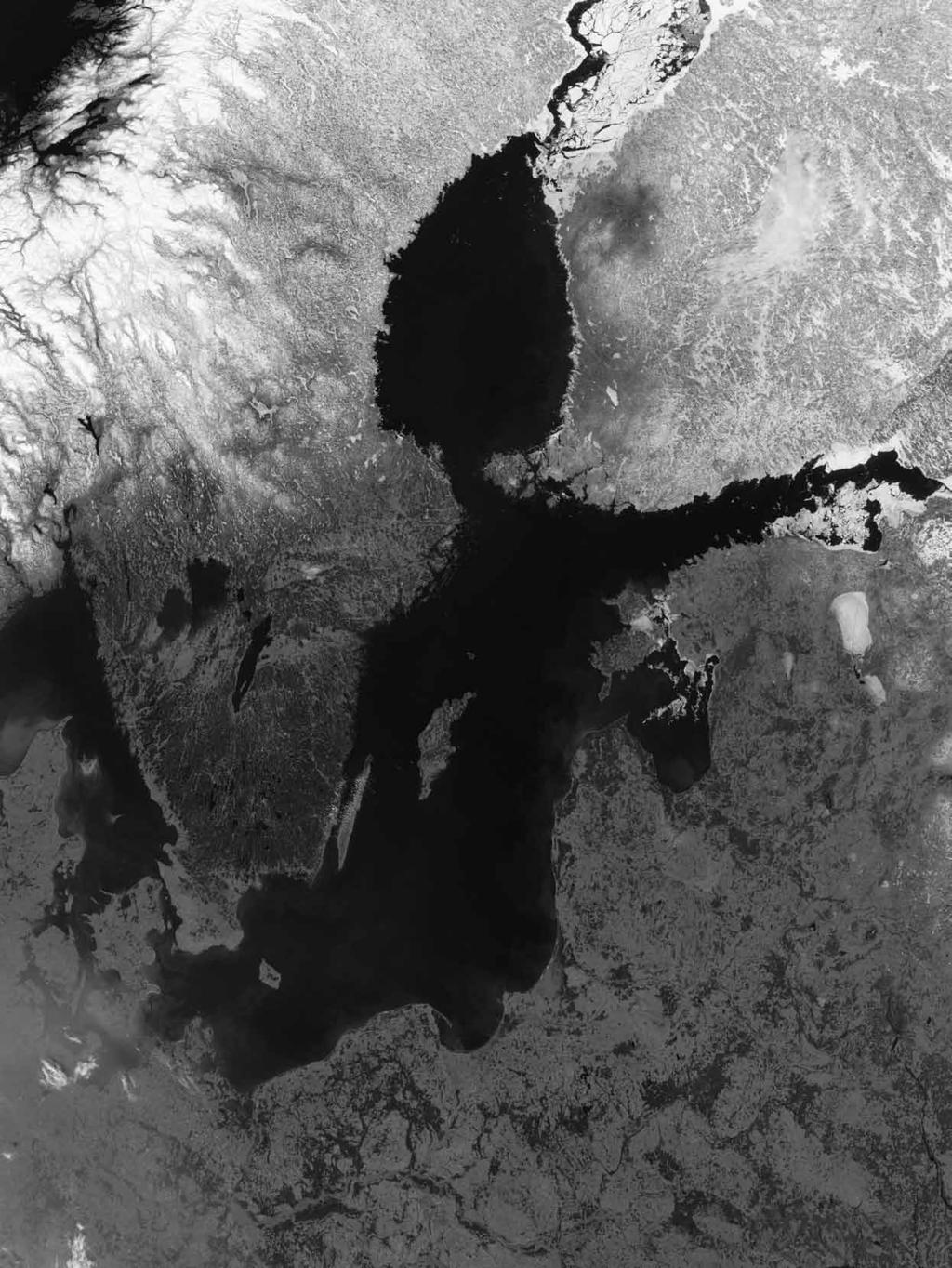
6 01 copyright: NASA 4
7 Introduction 1.1 The Baltic Sea a dynamic picture 1.2 Why the Vision? 1.3 What the Vision can help with 1.4 How the Vision was developed 1.5 How to read the BaltSeaPlan Vision 2030 Maritime Spatial Planning (MSP) has become a widely acknowledged and necessary tool for co-ordinating spatial use in the sea. Currently, however, this tool is far from being established practice. The BaltSeaPlan Vision anticipates that this will be the case in It looks back from that year showing how MSP would ideally have been translated into practice between 2011 and MSP seeks to shape and guide future developments rather than passively react to them. It promotes systematic, integrative and forward-looking planning based on common objectives and a shared understanding of common values. MSP thus serves the sustainable development of the Baltic Sea by balancing interests and by acknowledging the underlying natural processes and values in the sea. The vision in a nutshell The vision takes an integrated perspective of sea uses and the Baltic Sea ecosystem. The vision deals with spatial aspects, complementing existing visions and policies for the Baltic. Grounded in existing trends and policy objectives, it tries to anticipate future developments and changes. The vision aims to provide more coherence and certainty to all users of Baltic Sea space. It is also there to secure all those processes that guarantee the well-being of the Baltic Sea as a living and healthy ecosystem. The vision is transnational, but linked to national MSP. It is part of a holistic approach to MSP across scales. 5
8 There has been a mentality change in the Baltic Sea region towards a less consumerist and more responsible attitude. The Baltic Sea region has developed a smart (maritime) economy. A Baltic spirit has developed. Maritime Spatial Planning 1.1 The Baltic Sea region a dynamic picture The Baltic Sea is a unique environment governed by special hydrographic and climatic conditions. Connected to the North Sea by only a narrow stretch of water, it is a self-contained sea that is brackish on average, fairly shallow, and covered by ice in some areas in winter. These environmental conditions give rise to unique flora and fauna, and many habitats and species are protected as a result. But those same special qualities also make the Baltic Sea vulnerable, in particular to overuse and pollution. At one point, the Baltic came to be regarded as one of the most polluted seas in the world. Recognizing the particular sensitivity of the Baltic, HELCOM has worked for the last three decades to eliminate pollution and other threats. This has culminated in the Baltic Sea Action Plan of 2007 which aims to restore the good ecological status of the Baltic marine environment by Apart from its significance as a natural environment, the Baltic Sea is also a dynamic economic and cultural space. It lends identity to an entire region and has given rise to longstanding traditions. As a transport space the Baltic offers connections to other nations within the region and beyond, and more recently it has also become an energy space, through offshore wind farming, or oil and gas extraction, or LNG ports and associated facilities. Old and new marinedependent industries are an important source of jobs; moreover, they represent the cornerstones of a competitive maritime economy which has become a key policy focus for the EU and Baltic Sea states. This is reflected by the EU Baltic Sea Region Strategy which presents an integrated framework to address the challenges and opportunities of the Baltic Sea Region. As the world is becoming ever more connected, global trends will increasingly influence the Baltic Sea region. Climate change is one example, leading to temperature change, salinity change or acidification in the Baltic Sea ecosystem. Other trends are the liberalisation of markets and trade, the growing political role of regions, increased competition for natural resources, or the need for renewable forms of energy. Despite the opportunities these may bring, we cannot be sure what impacts these will really have on Some areas of activity might be regulated jointly those where the EU has more competence and ambition and where strong drivers exist. the natural environment or the socio-economic development of the region. Already today, new economic demands are putting growing pressure on tight marine resources. Changing views of the benefits we can obtain from the Baltic Sea are likely to increase this pressure further. As a result of these trends, the Baltic is changing as a planning space. Sea space is already much in demand, and the more users compete for it, the scarcer and the more valuable this space becomes. Since sea space cannot be multiplied, it is vital that we plan for its use in a systematic and co-ordinated way. Wise planning needs to anticipate future needs and also deal with existing objectives for space. It needs to make sure the future mix of uses is compatible with ecological objectives, for instance biodiversity, the protection of key habitats and water quality. It needs to consider what use is best suited where, in the sense of both economic viability and environmental sustainability in the long term. VASAB was the first to lay the foundation for MSP in the Baltic Sea when it published its VASAB Spatial Development Action Programme in Natural phenomena such as demographic change, globalization and climate change will remain hard to predict and prevent. 6 BaltSeaPlan Vision Introduction
9 The Baltic Sea region a dynamic picture 7
10 Maritime and coastal ecosystems are protected and well managed. A clean-water strategy for the Baltic Sea has been implemented and acts as a backbone for an integrated approach to sustainable development. A sustainable pan-baltic energy policy is in place which acts as a model for the rest of the EU. 1.2 Why the vision? There will be attempts to follow the drivers and mechanisms of globalization (competition between the EU and China, India and the USA). If individual countries or sub-regions act and plan jointly as a macro-region, they can increase their influence on international trends and developments. As a result, they can become better prepared for the unexpected that may arise in a globalized world. Extending pro-active decision-making to ensure efficient spatial planning sphere of influence* sphere of active control and decision-making sphere of concern** MSP is a way of taking the initiative and expanding our thinking beyond the actual circumstances. MSP extends our planning horizon, allowing us to actively influence developments rather than wait for things to happen. MSP also forces us to be more integrated and less sectoral in our thinking, both within our national borders and beyond them. Given the small size and sensitivity of the Baltic, joined-up thinking based on shared values is essential if we are to achieve the balanced and sustainable use of Baltic Sea resources. This means thinking in larger contexts and wider connections: connections between the various Baltic Sea uses, between the hinterland and the sea, or between the various Baltic Sea countries and the people living and working in the region. The role of the vision is to help this process of joined-up forward thinking. It starts by setting out common goals, values and priorities and asking what the Baltic Sea region could or should be like in It then goes on to ask what spatial governance framework is necessary in order to achieve this. Because it is an international vision, it focuses on the larger pan-baltic context, always looking at the whole Baltic Sea as a planning space. As such, it takes account of the existing environmental and socio-economic objectives that have already been agreed for the Baltic Sea region under the umbrella of the EU, VASAB or HELCOM. *sphere of influence: Managers cannot control the near environment, but they can influence it. **sphere of concern: Factors that can be neither controlled nor influenced by decision-makers. 8 BaltSeaPlan Vision Introduction
11 I would like to see the Baltic Sea in 2030 in good environmental and ecological status, and from the perspective of society as clean bathing water and a source of sea food. There is mutual respect for other sea uses the recognition that other stakeholders have a legitimate interest in Baltic Sea resources and a right to use them. The situation regarding Baltic Sea space in 2030 should look different because of clearly set priorities, coordination, cooperation, an altered attitude of societies towards the Baltic Sea and long-term planning. These issues are closely interlinked. International policy developments and estimates by BaltSeaPlan partners: What are the most important targets, trends and demands in the Baltic? By 2020 good environmental status will need to be achieved for the Baltic Sea (EU Marine Strategy Framework Directive). The HELCOM Baltic Sea Action plan tackles all major environmental problems with the aim of restoring good ecological status by Additionally, more protected habitats are likely to be designated as more data becomes available. These will form a network of well managed areas. The VASAB Long Term Perspective for the territorial development of the Baltic Sea Region plays an important role towards better territorial integration within the Baltic Sea Region and its integration with other areas of Europe. Significant growth is expected in the total megawatts produced by offshore wind farms. This goes with an increase in the total sea area dedicated to offshore wind farming. National renewable energy targets will likely lead to a favourable climate for investment and growth up until 2020 and beyond based on EU wide targets for renewable energy. Continuous growth in transport is expected. The number of cargo ships, overall shipping frequency and the volumes transported (bulk and container) are also likely to increase although shipping will become more expensive due to higher fuel costs. This goes along with increased safety standards for shipping and environmental protection rules for shipborne emissions. In all ports, investment in port infrastructure is planned as part of national strategies, such as deeper channels and landward cargo handling facilities. Connections to the hinterland will become increasingly important for ports. Some ports already have plans for extension (e.g. Szczecin, Gdansk, Klaipeda, Kaliningrad), including the construction of LNG terminals. These developments are aligned within a European strategy. Recreational boating will increase in line with further growth in tourism. 1.3 What the vision can help with Although the vision is a practical hands-on vision, it is not a panacea that will solve every problem once and for all. Also, the vision is not set in stone, but a living entity that can and should be revisited regularly. The vision needs to be turned into reality by spatial plans: forward-looking instruments that allocate space in a balanced way and take account of ecological, economic and social considerations. Spatial plans, in turn, need to be complemented by matching operational objectives within the respective sectors as well as non-spatial management approaches. How we see Baltic Sea space, and how we think it should be used for human activities, The vision can make clear why forward-looking thinking is important and why it pays to take action now rather than later. The vision can provide a holistic cross-sectoral view on issues that are often regarded separately. The vision can help to communicate the benefit of the entire BaltSeaPlan approach. The vision can be used to facilitate stakeholder dialogue. The vision can help to achieve transnationality in MSP and cooperation between Baltic Sea states on matters of sea use. 9
12 02
13 The mindset of the vision Striking a balance between the environment, the economy and the social sphere 2.1 The Baltic Sea ecosystem requires special care 2.2 Three dimensions that interact 2.3 Implications for MSP: Some theory 2.4. and some practice How we see Baltic Sea space, and how we think it should be used for human activities, is crucial for developing general rules for MSP. This section explains the mindset of the vision 2030 for thinking about Baltic Sea space the wider environment that is needed for the vision to work. 11
14 2.1 The Baltic Sea ecosystem requires special care In the marine environment, everything is connected. Although we like to divide the Baltic into sea basins and administrative areas, we are really dealing with one large ecosystem consisting of a number of bioregions. In the water there are no hard barriers, so that species, larvae, nutrients literally go with the flow, ensuring that benthic biotope complexes and distinct habitats are interlinked. These same qualities make it difficult to contain the impacts of human activities. Pollution and noise can travel freely, and although some impacts may not be obvious at first, we can be sure that all human activities will make themselves felt in some way further down the line. Also, the more activities take place in the sea, the greater the likeliness of cumulative effects. The multiple potential reactions of the ecosystem to multiple uses are difficult to predict and must be monitored in order to be able to take appropriate remedial action. If we are serious about sustainable development and management, we need to acknowledge that there are limits to using the Baltic Sea. The sea is vulnerable to pollution, to climate change and to overuse, and care has to be taken not to overstretch its capacity to cope with human impacts. At the same time, humans are part of the Baltic Sea ecosystem. We depend on marine goods and services for our economic and social wellbeing, which is why we have good reason to be interested in a resilient ecosystem. 2.2 Three dimensions that belong together Sustainable development brings together the environment, the economy and the social sphere. Today the functioning of the ecosystem is more closely interwoven with social and economic aspects in the Baltic Sea region than ever before. Sustainable development calls on planners to consider each angle of the sustainability triangle at the same time, in line with the goals set by the political decision making bodies for the wellbeing of society and within the needs and natural conditions set by the environment. Looking at the requirements of sustainability there are three general objectives to be achieved: For the environment it is a healthy and resilient Baltic Sea ecosystem that is able to cope with a range of human impacts. For the economy it is a Baltic Sea providing a wide range of goods and services. For the social sphere it is a Baltic Sea region as an attractive place to live and work. It is a key condition for the BaltSeaPlan Vision 2030 that all corners of the triangle are considered important and integrated in the planning process in order to achieve sustainable development. 12 BaltSeaPlan Vision The mindset of the vision
15 Sustainable development brings together the environmental, socio-cultural and economic vision for the Baltic. The visions outlined here show that all three are interdependent and influence each other. Environmental vision: The Baltic Sea is a healthy ecosystem that is resilient to human impacts and climate-related change. A network of well-managed Marine Protected Areas is one of the backbones of this resilience. People and the ecosystem depend on one another in that a healthy, resilient marine ecosystem forms the basis for the sustainable use of ecosystem goods and services across the Baltic. It is understood that environmental assets such as clean water or healthy marine resources (e.g. fish) have economic benefits, and a range of ecosystem services payment schemes have been introduced to acknowledge this. Socio-cultural vision: The Baltic Sea region is an attractive place to live and work, with a healthy Baltic Sea a source of enjoyment, inspiration and employment. The Baltic Sea connects people, lending the region a distinct Baltic identity. Innovations are developed based on traditions, and there is close inter change between the Baltic Sea states. There is a general culture of cooperation and solidarity, and marine assets and sea space are shared fairly in the sense that advantages and disadvantages are shared evenly. Healthy Baltic Sea Economic vision: The Baltic Sea generates high quality employment. Both green and blue technologies are pursued. Port locations benefit from new offshore uses and offer a wide range of industrial production facilities. The Baltic Sea is important for safe, efficient and environmentally friendly interregional transport and connects the entire region to the outside world; as such it makes an essential contribution to the region s competitiveness. Tourism based on a healthy Baltic Sea is a key sector of the economy, creating jobs and income along the entire Baltic Sea coast. 13
16 2.3 Implications for MSP: Some theory There has been much debate on how such a balance between human uses and the ecosystem requirements can be achieved. There are also different expectations of the specific role of MSP in this context, reflecting the expectations of the various stakeholders. The BaltSeaPlan Vision 2030 considers MSP to be critical in bringing together the differing but interlinked demands of use, development and conservation. This has to be done in a sustainable way, using the ecosystem approach as an underlying principle. If we are to foster the development of maritime activities and at the same time protect the marine environment, an integrated approach is needed where the healthy ecosystem Baltic Sea as the planning area represents the basis of the overall MSP framework. The ecosystem approach is instrumental in illustrating the environmental principle upon which MSP is based. Put very simply, the message is that the ecosystem must be seen as a whole, and that ecosystem structures and functions must not be unduly compromised by human use if we want to ensure the long-term integrity and resilience of the system. Achieving this requires that any decision taken on sea use must be integrated and looked at for cross-sectoral aspects, including the potential harm that could come to natural systems and services. This is an ongoing task, and not something that can be achieved as a one-off. Here are some examples to illustrate this: [The ecosystem approach is] the comprehensive integrated management of human activities based on the best available scientific knowledge about the ecosystem and its dynamics, in order to identify and take action on influences which are critical to the health of marine ecosystems, thereby achieving sustainable use of ecosystem goods and services and maintenance of ecosystem integrity. (Joint HELCOM/ OSPAR Ministerial Meeting, Bremen 2003) The Marine Strategy Framework Directive (2008/56/EC) defines the ecosystem-based approach to the management of human activities as ensuring that the collective pressure of such activities is kept within levels compatible with the achievement of good environmental status and that the capacity of marine ecosystems to respond to human-induced changes is not compromised, while enabling the sustainable use of marine goods and services by present and future generations (Article 1 (3) MSFD). MSP comes into play as a means to achieving the integrated management of human activities. The task of MSP is to secure the intelligent and responsible use of Baltic Sea space, which means optimising sea use and ensuring the integrity of the ecosystem at the same time. The role of the ecosystem approach within MSP is illustrated by the following considerations: The primary goal of maritime spatial planning is to set the framework for sustainable development by balancing economic, ecological and social aspects, but it can also contribute to reaching the environmental goals (...).(HELCOM HOLAS Report (BSEP No. 122), p. 48) MSP is a key tool for sustainable management by balancing economic, environmental, social and other interests ( ), by managing specific uses and coherently integrating sectoral planning, and by applying the ecosystem approach ( ). (HELCOM-VASAB MSP WG 1/2010) The ecosystem approach, calling for a cross-sectoral and sustainable management of human activities, is an overarching principle for Maritime Spatial Planning which aims at achieving a Baltic Sea ecosystem in good status: a healthy, productive and resilient condition so that it can provide the services humans want and need. The entire regional Baltic Sea ecosystem as well as sub-regional systems and all human activities taking place within it should be considered in this contex. MSP must seek to protect and enhance the marine environment and thus should contribute to achieving Good Environmental Status according to MSFD and HELCOM Baltic Sea Action Plan. (HELCOM-VASAB MSP WG 1/2010) MSP can play an important part in maintaining the quality, structure and functioning of marine ecosystems. It can ensure that coherent networks exist between ecosystems 14 BaltSeaPlan Vision The mindset of the vision
17 2.4 and some practice and habitats, or curb negative impacts on sensitive areas or species by taking reasonable siting decisions. MSP can even contribute to achieving Good Environmental Status as spatial and temporal distribution controls can be part of a programme of measures under the EU Marine Strategy Framework Directive. MSP also forms part of a wider, holistic planning environment that has several spatial scales (see diagram). The outermost framework is the Baltic Sea region, where principles such as territorial cohesion play an important role and where spatial planning might take account of elements such as supranational infrastructure as a facilitator of sustainable development. The Baltic Sea is essential for the sustainable development for the Baltic Sea region both as an ecosystem and as space, with MSP securing optimum use of that space for the benefit of the ecosystem and of the people. Baltic Sea space is part of a wider planning area Environmental vision Sea space optimum use of space in the sea The wider Baltic Sea Region Economic vision territorial cohesion on land Socio-cultural vision Sea space So what does this mean for MSP in practice? The question remains how MSP can achieve this balance in practice. Ultimately, MSP is concerned with analysing and allocating the spatial and temporal distribution of human activities in marine areas, in such a way that environmental, economic and social objectives are achieved. This process should be based on a holistic vision for the planning area at stake, taking into account the sectoral targets set at the political level as well as the natural limits set by the marine environment. MSP is proactive and future-oriented. It delivers the desired outcome of sustainable socio-economic development within a healthy marine environment by balancing all relevant interests in a fair and unbiased manner. This must always be based on the specific conditions offered by the planning area, both in terms of the human activities that take place there and the marine environment concerned. Where space is limited, and where future development needs are still unknown, MSP can thus help to identify the most effective solution for satisfying societal demands. This best possible solution must be found individually for each planning area by running through the MSP process. Various publications set out how to organise these practical steps of MSP, for example the PlanCoast handbook on Integrated Maritime Spatial Planning and the UNESCO handbook on Marine Spatial Planning. < Guiding principles: territorial cohesion on land optimum use of space in the sea 15

18 03 16
19 Key principles for allocating sea space 3.1 Pan-Baltic thinking 3.2 Spatial Efficiency 3.3 Connectivity thinking The previous chapter set out a combined view of the Baltic Sea both as an environment and as a planning space. This chapter outlines three key principles that are instrumental in ensuring that Baltic Sea space, and through this the Baltic Sea environment, is planned sustainably. 17
20 3.1 Pan-Baltic thinking: Think Baltic, act regionally The first guiding principle in taking decisions about space is pan-baltic thinking. Pan-Baltic thinking regards the Baltic Sea as ONE planning space and ecosystem at all stages of the MSP process. Pan-Baltic thinking also has a temporal dimension, meaning that long-term implications are considered just as much as the short-term impacts of planning decisions. Pan-Baltic thinking translates into the following spatial planning principles: Taking a holistic Baltic Sea view Planners think about the ecosystem as a whole and Baltic Sea space as a whole. They do so every time an MSP decision is taken, whether at the national or sub-national or any other level. This means considering the further-reaching impacts of uses or changes of use, both in a spatial and temporal sense (e.g. cumulative impacts over time) Fairness as an important consideration Nevertheless, the advantages and disadvantages resulting from human use of the sea should be distributed fairly among Baltic Sea regions. Pan-Baltic uses of Baltic Sea space and resources support the development of the Baltic Sea area as a whole, as well as individual Baltic Sea states and sub-regions. Integration of land and sea uses Pan-Baltic thinking is applied to fully harmonise the planning and management of Baltic Sea space with the planning and management of the adjoining terrestrial areas. Siting decisions in the sea are taken with the main land in mind and vice versa, always seeking to make use of existing infrastructure and maximising the benefits of used space on both sides. At the same time, infrastructure is implemented in such a way that no region is a priori precluded from being able to develop its potential in a sustainable way. Putting long-term objectives first Planners focus on the long-term sustainability objectives that have been specified for the environment, the economy and the social sphere. They ensure that these are not compromised by short-term gains. Using objectives and targets as a guide Planners base their decisions on commonly agreed environmental, economic and social quality objectives developed in a fully participative process for the whole Baltic Sea. Quantitative objectives are agreed among sectors and among governments of the Baltic Sea states taking into account the carrying capacity of the sea. Using spatial differences to their best advantage Planners also acknowledge the inherent differences between different Baltic Sea regions. MSP is about intelligent use of available space, which means that different priorities may make sense in different places and areas of the Baltic. 18 BaltSeaPlan Vision Key principles for allocating sea space
21 Transnational Connectivity 19
22 3.2 Spatial efficiency In line with the sustainability paradigm, spatial efficiency is the second guiding principle in taking decisions about space. Sea space is understood as a valuable public good that must be used sparingly, both to minimize the impacts of sea uses on the wider Baltic and to keep back as much space as possible for future sea uses. Another guiding principle is that ecological functions must not be jeopardized, such as water exchange, currents and other functions essential for environmental services in the Baltic. Some spaces have therefore been declared no-go areas to be kept free of all uses, which can be for environmental, cultural and resourcerelated reasons. Any sea space that does come to be used is utilized as efficiently as possible. This means co-use is promoted wherever possible and appropriate. Where necessary, spatial efficiency is also given priority over the costefficiency of a project. designation of sea space and are an automatic consideration for priority status. Any decisions affecting immovables must be based on a thorough impact assessment, and there must be very good reasons at the societal level to justify interference with immovables. Co-use is actively encouraged. Rather than breaking fresh ground, planners do their best to promote the use of used sea space. This means making good use of synergies and considering options for multiple use of sea space wherever this is possible. Sea uses do not preclude the existence of other sea uses or functions Sea uses are always placed in such a way that they respect areas important for other sea uses or functions (e.g. no offshore wind farms to be placed in priority corridors for shipping, or in conservation areas where wind turbines are incompatible with protection goals. In order to implement the spatial efficiency principle, planners adhere to a number of general rules when allocating sea space. All prospective sea uses have to make a good case for receiving sea space in the first place. There must also be good reasons for placing sea uses in particular locations and not elsewhere. The following apply in this order to deal with all applications for sea use: The sea is no repository for problematic land uses. Uses have to prove their distinct maritime dependence and will only be considered if they can demonstrate good reasons for being placed in the sea (such as inherent dependence on marine resources, reasons of efficiency). These reasons need to be more than just avoiding problems of acceptance on land. Wind energy is a good example for sea use because it can generate much more electricity offshore than onshore. Immovable sea uses and functions have priority. Immovable sea uses and functions such as existing infrastructure or habitats have priority in the allocation and 20 BaltSeaPlan Vision Key principles for allocating sea space
23 Spatial efficiency 21
24 3.3 Connectivity thinking across Baltic Sea space: The third key principle in taking decisions about space is connectivity thinking. Connectivity thinking applies to longterm planning and siting decisions and is particularly important for sea uses of transnational significance. Connectivity thinking means that planners not only think in their own backyard, but focus on connections that exist to other areas or uses. In the case of shipping for instance, there is obvious connectivity between shipping lanes and ports, and both need to be thought of together to make sense as integrated and spatially efficient transport infrastructure. Connectivity thinking is adapted to the specific topic areas planners are dealing with. For the natural environment and for fish for example, connectivity means that habitats, breeding and feeding grounds must be identified in order to specify the important connections between them (e.g. migration routes and blue corridors). On top of the spatial dimensions in the sea (the sea bed, the water column, the water surface and even air space over the sea), connectivity thinking also takes account of the temporal variability of (mostly environmental) conditions. Connectivity thinking in practice: Thinking in linear elements Linear elements are at the heart of transnational MSP thinking in that they truly connect the Baltic Sea states across national borders. Infrastructure such as cables and pipelines represent obvious linear elements, as do shipping lanes and blue corridors for living species. The latter are instrumental in ensuring connectivity and coherence between habitats, making sure that nursery areas, feeding areas or spawning grounds are linked to one another and that degraded habitats can recover helped by neighbouring areas. Shipping corridors are defined by transport needs and hydrographic conditions, and ports with good hinterland connections will act as centres of gravity for this type of linear structure. Environmental corridors, including blue corridors for fish or larvae, are defined by relevant environmental parameters. Considerable spatial advantage is gained by bundling linear structures. Baltic Sea states have therefore delineated trans national corridors for cables and pipelines and for shipping. Where possible, corridors reflect the existing EU concepts (TEN-T, TEN-E), but these have been further refined according to Baltic Sea region needs. Transnational linear structures are planned for the entire Baltic Sea region, and the respective corridors are given priority in national maritime spatial plans. A common procedure for planning and approval has been established. A legal basis has been created for financing these structures (or sharing resulting financial implications), and agreements for joint management and supervision exist within the Baltic Sea region. These mechanisms ensure that (linear) infrastructure is not only spatially efficient, but also serves to strengthen equitable distribution of benefits among countries and sub-national regions around the Baltic Sea. 22 BaltSeaPlan Vision
25 A starting point for planning linear structures is to first look at the relevant coastal connection points, which are then used to guide the placement of linear infrastructures or corridors in the sea. For cables for example, it is the exist - ing connections to the land-based grid that help guide the placement of sea-based infrastructure. For transport, it is ports that connect population centres or key distribution nodes to the hinterland markets. Between the distribution nodes, spatial planning is used to make sure that the necessary infrastructure is in place to provide develop - ment opportunities for areas not directly linked to centres of gravity. and in patches Patches are areas with a particular type of use, such as offshore wind farm areas or mixed use areas, or functions, such as nature conservation areas or spawning grounds. Pan-Baltic policy objectives in sectors such as electricity generation, fisheries and marine conservation imply that patches are gaining considerable transnational importance. In order to achieve sectoral aims, enough space has been allocated to these uses and functions across the entire Baltic Sea. This is particularly obvious for energy and protected areas, where a patch can be of considerable significance to countries or regions some distance away from the actual location. Patches often extend beyond administrative borders, which is why international thinking is important. In order to facilitate the planning of patches, non-spatial sectoral plans including sectoral objectives have been drawn up. A pan-baltic approach has been developed to targets such as energy, allowing countries to contribute more or less to a particular policy target as long as the overall objective is guaranteed across the Baltic. A mechanism has been created to ensure that countries shoulder an equal overall burden, and that a lesser contribution in one policy area can be offset by a larger contribution in another. 23

26 04 24
27 Key transnational topics 4.1 Why these topics? 4.2 A healthy marine environment 4.3 A coherent pan-baltic energy policy 4.4 Safe, clean and efficient maritime transport 4.5 Sustainable fisheries and aquaculture The previous chapter set out why pan-baltic, connective thinking is important for sustainable planning of Baltic Sea space. The next aspect to consider is how this affects the organization of Baltic Sea space. Four topic areas are presented. Their common denominator is that a transnational approach is needed and that they play a key role in the sustainable development of the wider Baltic Sea region. 25
28 4.1 Why these topics? The Vision 2030 focuses on four topics which have been identified as particularly important for the sustainable development of the Baltic Sea region. They were chosen for two reasons. Firstly, there is little doubt that all or several Baltic Sea states will be affected by future developments in these topic areas. National and international policy targets in these topic areas are often binding, which translates into priorities for allocating Baltic Sea space. Secondly, the impacts of siting decisions go beyond the boundaries of national waters. This makes them truly pan-baltic in that they cannot be achieved without cooperation between Baltic Sea states. the national or cross-border level. Although some leisure activities such as boating can affect the sea, these impacts are localized and best placed at the national or sub-national level of MSP. A vision is now presented for each of these topics in turn. At the top of the list is a healthy marine environment, which is a value in itself and prerequisite for many uses. A number of specific and timed targets have been drawn up by the EU and HELCOM which set out the desired state to be achieved, either for the ecosystem as a whole or more specifically for certain species and habitats. MSP must play its part to make sure these targets are achieved. Next are a coherent pan-baltic energy policy and safe, clean and efficient maritime transport. Both are showing dynamic development on account of sectoral policy objectives and because they play a significant role in national economic development. There is much potential for knock-on effects or cumulative impacts, so that wise and integrated planning is of particular importance as far as the infrastructure for these uses is concerned. Another topic is sustainable fisheries and aquaculture. Fisheries are linked to the good environmental status of the Baltic Sea, and require concerted efforts by all Baltic Sea states to put it back on a sustainable footing. It is also of economic significance and a source of local identity and pride. Aquaculture is a related emerging sea use which is set to gain in significance as demand is growing for high quality food from the sea. In terms of its sheer economic importance for Baltic Sea countries, tourism should also be considered as a key topic. Unlike the other four, however, tourism is best dealt with at 26 BaltSeaPlan Vision Key transnational topics
29 + 4.2 A healthy marine environment 2030 In 2030 the Baltic Sea is a healthy marine environment in which high biodiversity and dynamic natural processes sustain a resilient ecosystem. Appropriate measures have been taken to deal with pollution and dumped chemical weapons, and Baltic Sea states have achieved the targets set out in the Baltic Sea Action Plan. Good environmental status has been achieved as set out in EU Marine Strategy Framework Directive. The capacity of the marine ecosystem to respond to human-induced changes is not compromised. Degraded habitats have been restored as set out by the HELCOM BSAP. Pollution and nutrient inputs from rivers into the Baltic Sea have been substantially reduced and good water quality has been achieved. The necessary reductions have been fairly shared by all Baltic Sea countries. For this purpose, a clear water strategy including the river catchments has been agreed and implemented by Baltic Sea countries. Important biota and habitats are protected according to criteria agreed at a transnational level. A representative network of well managed Marine Protected Areas is in place. This goes beyond the stipulations of the Habitats Directive, in the sense that environmental status of valuable fauna, flora and habitats not covered by the Habi tats Directive has also improved. Additional measures have been taken to foster biodiversity, which has made sure that marine food chains are healthy and resilient. Transnationally agreed targets have been set for environmental quality and species/habitats, which are coherent with other policy targets and widely accepted by society. Transnationally agreed criteria are applied to protect key cultural assets in the sea, such as marine archaeology or immaterial values (e.g. beauty of the seascape). The good water quality status achieved supports a diverse range of ecosystem services including fisheries and recreation. Spatial planning implications: The ecosystem approach is used as a basis for dealing with the environmental aspects of spatial planning within and outside protected areas. This means: Good Environmental Status (GES) has been translated into measurable quantitative and qualitative targets and values which are regularly monitored, Environmental data is regularly translated into spatial information (e.g. impact indices that facilitate decision-making), Coherent and regularly revised environmental, economic and social quality objectives have been drawn up for the sea, which are based on social and natural science research, developed with broad participation of relevant stakeholder groups, and widely communicated and publicly debated. Within protected areas, uses are avoided that constitute a threat to the respective protection goal. Certain uses may be possible within protected areas if their impact is not significant. Criteria have been developed for evaluating significant loss at the transnational level, which take account of representativeness at the Baltic Sea scale. Habitat connectivity is ensured, as is coherence of protec tion for the same asset (e.g. protection of migratory birds during migration AND breeding, protection of different life stages of marine species). These measures are also used to strengthen biodiversity. The impact of uses on natural habitats (landscape types) and species (marine mammals, migrating fish, birds) is evaluated across borders. Common standards for spatial regulation have been developed for uses (includes cumulative effects of various uses). Research is more spatially focused, and makes use of modelling where possible (e.g. the interconnections between species and their habitats across time and different environmental conditions) 27
30 4.3 A coherent pan-baltic energy policy 2030 In 2030, growth in renewable energies is proceeding as countries are striving to reach the EU-wide and national renewable energy targets. The Baltic Sea states aim to produce as much as possible of their electricity demand from renewable resources, and some sub-regions even export electricity from renewables to areas outside the Baltic Sea region. Efficient energy use has become a key focus of policy, and the energy mix has considerably changed in all Baltic countries. Renewables, in particular hydropower and wind energy play a major role in the context of electricity generation, but gas and coal also continue to be relevant in some countries. Key elements of the EU energy infrastructure have been implemented, or are in the process of being further developed. In 2030 the Baltic Sea region has established a pan-baltic energy policy with the following key elements: The Baltic Sea region relies on as much renewable energy as possible and is striving to become self-sufficient in terms of renewable electricity. A balance has been achieved between BSR countries in terms of which renewables are to be given priority where. This is based on the notion that different types of renewables and different total outputs make sense for different countries. Some countries are therefore net importers of renewable electricity, others are net exporters. Some countries have phased out nuclear power as a source of electricity. A stable legal framework for renewables is ensured including political commitment from all political actors. A functioning energy market and level playing field exists for the Baltic Sea region (eventually as part of a European market) based on harmonised tariff structures and necessary trade-offs between countries. Most countries have maximised the contribution of offshore wind farming to renewable energy production. Ships use clean fuel, e.g. CNG, and there is development of LNG terminals. Ports have adapted to this, and CNG as well as LNG terminals contribute to overall port development. Spatial planning implications: In response to the above, Baltic Sea states have put a pan-baltic energy infrastructure (SuperGrid) into place. This ensures the exchange of energy between countries, the storing and balancing out of fluctuations (e.g. offshore wind and hydroelectric power), and also allows for export (including non-eu countries). Land- and sea-based grid infrastructure is well integrated, meaning that infrastructure in the sea (e.g. offshore wind farms, cable connections) and on land (e.g. feed-in points, capacity of the land- based electricity grid) form a coherent whole. Cable connections from offshore wind farms to the mainland and the SuperGrid are bundled together in suitable corridors. Gas pipelines are bundled together in suitable corridors, where possible together with cables and other forms of linear infrastructure, in order to keep as much Baltic Sea space unused as possible. Enough total Baltic Sea space has been set aside to achieve the renewable energy aims set out above. Offshore wind farms, and marine grid infrastructure are located outside reserved areas for other sensitive uses (i.e. shipping lanes, Natura 2000 sites that conflict with wind turbines such as bird areas). Offshore wind farms are in sufficient distance to important tourism areas (free horizon policy). There is environmental prescreening and risk assessment of suitable sites to ensure that shipping accidents are avoided or have no negative consequences. Co-use of offshore wind farms is actively promoted. 28 BaltSeaPlan Vision Key transnational topics
31 4.4 Safe, clean and efficient maritime transport 2030 Shipping is already intense within the Baltic Sea, and forecasts predict further growth. Compared to 2010, shipping in 2030 has grown significantly in terms of frequencies and the volumes transported, which increases the threat of accidents. Separation schemes have therefore been put into place to ensure that ships carrying dangerous goods and large ships can travel unimpeded through the whole Baltic Sea. Access routes to the main Baltic Sea ports are also kept clear to minimise any potential collision risks. In particular: Sea transport has become an integral part of a wider Baltic Region transport policy. Well-planned sustainable hinterland connections exist between Baltic Sea Ports and the Adriatic and Russia. This makes the Baltic Sea well connected to other parts of the world. Sea transport has been established as a more efficient, less polluting alternative to land-based transport where appropriate, making use of the best available technologies. The Baltic Sea is an effective Emission Control Area (NOx, SOx). Clean fuel such as natural gas is commonly used for ship fuel. Shipping functions efficiently in the Baltic Sea along designated routes. It is not impeded by any fixed infrastructure along its main corridors. While designated corridors allow for safe shipping, it is commonly accepted that graded restrictions according to risk are necessary for areas outside these corridors to avoid accidents and to ensure safe transport. Where necessary and possible from natural and tech ni cal conditions, shipping routes have been changed to take account of environmentally sensitive areas and to avoid accidents with permanent structures. IMO has taken associated preventive measures to make sure shipping routes avoid sensitive sites. Ports serve as key distribution centres and transport nodes, and act as an economic centre of gravity for the wider coastal region and hinterland. Policies are in place to attract suppliers, technology, research and service providers. A Baltic Sea wide port development strategy has been set up dealing with the different requirements and potentials of ports. In order to avoid the transport of dangerous goods (oil, chemicals) by ship, some pipelines have been built on land. Spatial planning implications: Baltic Sea states have jointly agreed on a spatial shipping strategy. This strategy takes an integrated view of ports and shipping lanes, and takes account of other spatial needs in the sea. As an implication resulting from other uses, it has become accepted that shipping lanes may be rearranged. Intelligent corridors and designated routes have been established for the most intensively used navigation areas to ensure safe transport. Where necessary these routes have been defined as traffic separation schemes by the competent authority IMO. Areas have been defined and designated by IMO that have to be avoided by shipping in order to protect other important goods and functions (e.g. wind farms, nature conservation areas). Port development areas have been identified and designated, so that the function of ports as key distri bution centres and transport nodes is ensured for the future. High risk areas have been identified, and compulsory pilotage systems have been put in place with IMO regulations. Safety zones are designated around areas with obstacles for shipping (e.g. offshore wind farms). Best technologies are used to support safe navigation (e.g. double hull tankers, new clean fuel, electronic developments etc). Transnational response contingency planning and a system of ports of refuge have been jointly agreed by Baltic Sea states. 29
32 4.5 Sustainable fisheries and aquaculture 2030 Fishing in the Baltic Sea is intense, and there are a number of problems associated with it such as habitat destruction by bottom trawling and overfishing. At the same time, fishing contributes to the economy and represents important cultural heritage in the Baltic. In 2030 fisheries have become sustainable in the sense that they are ecologically sound (based on maximum capacity of fish stocks to sustain themselves), in line with Good Environmental Status, and nondestructive. Fisheries are relevant for local communities, providing economic benefits and immaterial value as Baltic Sea culture. Marine aquaculture forms a new economic sector with local relevance for employment and income, and a range of new products is obtained from different types of marine aquaculture. In particular: Baltic Sea fisheries and mariculture deliver high quality food. Baltic Sea fisheries are managed in such a way that sustainable stocks are secured and the integrity of ecosystems is preserved. Sustainable fishing gear has been introduced across the entire Baltic Sea. Established fishing practices in the Baltic are supplemented by extensive sea ranching schemes co-managed by licensed fishing communities in cooperation with national and transnational experts and guided by transparent social, cultural, economic and ecological objectives and mechanisms. Management practices take into account the dynamic nature of the resource and respond flexibly should there be any change. This may include economic trade-offs and offering alternatives for local fishermen who are requested to stop fishing for a certain period due to stock changes. Marine aquaculture producing high quality and healthy products has gained in relevance as a result of more sustainable fishing practices and consumer demand for sustainable local fish and seafood. Marine aquaculture is environmentally sound. The cultivation of algae is gradually developing as an economic activity for pharmaceutical and other industries. Algae are also grown for bioenergy and contribute to nutrient reduction in parts of the Baltic Sea. 30 BaltSeaPlan Vision Key transnational topics
33 Spatial planning implications: Blue corridors for fish are guaranteed (including rivers) that ensure connectivity of habitats necessary for species survival and adaptation to change (e.g. climate change). Where appropriate, sea ranching is carried out for particular fish species as an addition to the existing system. Spawning and nursery areas are adequately protected by means of permanent or temporary zoning. No-take rules and management practices have been implemented alongside spatial protection measures for certain conditions or in certain areas. Areas for marine aquaculture have been carefully selected to avoid negative impacts on water quality and natural fish stocks. Site specific regulations accompany aquaculture licenses. Where possible from environ mental and safety points of view the principle of spatial efficiency is in place, e.g. placing aquaculture sites as co-use within already used areas such as wind farms. Fisheries management legislation has been revised to allow spatial management regulations and zoning of fisheries activities to be fully integrated into the spatial planning framework. 31
34 05 32
35 MSP as a tool and process 5.1 Introductory thoughts for implementing the vision 5.2 Data and information as a key to success 5.3 Maritime spatial plans as tools of implementation 5.4 The MSP process 5.5 Transnational cross-border cooperation and governance No matter how good the principles, they do not turn into reality on their own. Structures and processes are needed for their implementation. This chapter sets out the vision for implementing MSP across the Baltic Sea region. 33
36 5.1 Introductory thoughts for implementing the vision A pan-baltic approach to implementation relies on contentbased and process-oriented dimensions. In 2030 these have come to be thought of as essential success factors. The first is data management and monitoring. The best laid plans for managing Baltic Sea space will come to nothing if we do not track what is going on in the sea. Apart from knowing the state of the ecosystem and the pressures and ecological impacts it faces, we also need to keep an eye on trends in the economy and society, as well as technological innovation, since these are the driving forces that will shape the sea use requirements of the future. A key point is that such data has to be translated into spatially relevant information. Available data needs to be provided in a coordinated manner and accessible free of charge through a Baltic-wide network of databases. The second is appropriate structures and processes to channel engagement in MSP. This is embedded in a culture of communication and cooperation. In 2030, MSP is understood as a cooperative practice that involves several spatial and administrative levels. This is linked to the third factor, which is spatial subsidiarity. This means that spatial challenges are dealt with at the lowest most appropriate spatial level. Previous chapters have shown which objectives for Baltic Sea space can only be achieved by action at the transnational level; other issues are best dealt with at national levels and within national boundaries. National maritime spatial plans remain the primary means of implementing the common vision and principles. Nevertheless, it is widely recognized that the national and international level rely on one another. Drawing up national maritime spatial plans involves a process of international concertation and negotiation; likewise, a pan-baltic spatial vision can only be drawn up if national stakeholders contribute their knowledge. In 2030, an interconnected planning framework has therefore been created that extends from the sub-regional all the way to the pan-baltic level. Whilst this MSP system is based on commonly agreed principles, it is recognised there is no single best practice for maritime spatial planning in the Baltic Sea region. Institutions, contexts and issues around the Baltic are different, and the framework is flexible enough to enable tailor-made solutions to be drawn up. MSP takes place in a wider context of existing policies and EU Directives. By 2030, the BSAP and key EU Environmental Directives (in particular the MSFD with its target of good environmental status) have been successfully implemented. The goals and objectives of the EU Baltic Sea Region Strategy and of the EU 2020 strategy have been achieved and further refined. Generally a broad-based move has thus taken place from sectoral to integrated decision-making. In achieving the sustain able use of Baltic Sea space, the BaltSeaPlan vision 2030 endorses the ten EU principles for maritime spatial planning published by the European Commission (Nov. 2008): 01. Use MSP according to area and type of activity 02. Define objectives to guide MSP 03. Develop MSP in a transparent manner 04. Ensure stakeholder participation 05. Ensure coordination with Member States and simplify decision processes 06. Ensure the legal effect of national MSP 07. Engage in crossborder cooperation and consultation 08. Incorporate monitoring and evaluation in the planning process 09. Achieve coherence between marine and terrestrial spatial planning - establish a relation with ICZM 10. A strong data and knowledge base 34 BaltSeaPlan Vision MSP as a tool and process
37 5.2 Data and information as a key to success In 2030, integrated decisions are based on the best available knowledge and science, taking into account the cumulative impacts and respecting the integrity of the Baltic Sea ecosystem as a limit to development. Implementing a spatial vision through MSP requires regular monitoring of political, socio-economic as well as natural processes. More importantly though, such data need to be translated into spatially relevant information. In 2030 national data are publicly available so that they can be used by all stakeholders for the MSP process. As far as data have been generated with public funding, they are available free of charge in connected Baltic-wide databases. A network of data networks ensures data quality by agreeing joint standards and comparability of data at different scales. An agreement has been reached on a baseline scale in order to map at Baltic Sea-wide level and data gaps (ecological, social, economic data) are jointly identified and filled. In particular Human activities and uses are mapped, and these maps are constantly updated Ecosystem services have been described in a spatial context and mapped in order to show what values exist where (including intangible values). Information of lifecycles and demands of species (nursery areas, spawning sites) and the interrelationship with other spatial claims is available to enable this issue to be dealt with at transnational level. An information base has been created, bringing together data on uses, pressures and their impacts as well as environmental information and habitat maps. A compendium of pressures and impacts has been drawn up according to MSFD Annex III. Indicators for good environmental status are in place and implemented in full. A sensitivity index has been developed for the Baltic Sea, and knowledge gaps have been identified and filled accordingly. The economic value of ecosystem benefits has been described. This requires the following: Baltic Sea countries have agreed on systematic information exchange. They have formalized national data flows and created a regularly updated coastal and maritime information infrastructure, which pulls together data from different sources and acts as the basis for spatial planning decisions. For case-specific transnational planning, data is drawn together on the most acute spatial problems first (e.g. infrastructure corridors). In each country, coastal and marine data collection has been brought together and goes through a single gateway. Relevant data is collected nationally for monitoring sea use developments and related trends. Data is also collected regularly on environmental and socio-economic parameters in order to monitor changes in the state of the marine environment, demography, income, economic growth etc. Where quantitative data are not available, qualitative targets or descriptive arguments are used. Regular and effective monitoring is in place across the Baltic Sea in order to guarantee fair competition for space and identify unforeseen and cumulated risks as early as possible. Cumulated effects of adjacent sites and across different sea uses are evaluated at transnational scale with focus on transnational policy targets and risks that extend beyond national boundaries. Tailored monitoring Monitoring takes place to trace human activities, their impacts on Baltic Sea space and the success of management measures. In 2030, tailored monitoring schemes have been instituted that take account of the quality objectives agreed for the entire Baltic Sea region. Data analysis and monitoring schemes are internationally coherent and are being continuously developed in international collaboration between research and practice. Social and natural science research and evaluation act as a basis for a pro-active analysis of trends and policy developments. 35
38 5.3 Maritime spatial plans as tools of implementation in the transnational context The vision 2030 is implemented by means of maritime spatial plans which translate the commonly agreed objectives and targets for Baltic Sea space into a tangible spatial framework. In 2030, a series of integrated transnational, national and sub-national maritime spatial plans has been drawn up, which are embedded in a common spatial vision for the Baltic Sea. Maritime spatial plans are developed based on the following: Transnational prerequisites: Transnational issues have been identified, discussed and translated both into general objectives and specific targets. Based on these, transnational MSP solutions have been developed. A pan-baltic approach guides transnational uses such as shipping, energy, fisheries or functions such as nature conservation (meaning that targets are not set nationally, but for the BSR as a whole. Example: Natura 2000 objectives achieved at the BSR level rather than having a national quota for each country; the same applies to energy.) Transnational linear infrastructure (i.e. submarine cables, pipelines) a core element of pan Baltic MSP is planned as a whole. The necessary joint procedures for planning and approval are in place. They include environmental and socio-economic assessments for transnational linear infrastructure using commonly agreed criteria. National prerequisites: All Baltic Sea states have established the necessary national structures to successfully use MSP as a tool for managing human maritime activities in the sea. This has been done in accordance with the relevant international regulations and in line with binding commitments (e.g. IMO, UNCLOS, EU, HELCOM). All Baltic Sea countries follow the same approach to MSP, which consists of the following: National maritime spatial plans cover all areas of the Baltic Sea where sea use conflicts need to be prevented. National maritime spatial plans have been drawn up in a transparent and open process and are publicly available. All Baltic Sea states think Baltic when drafting and implementing national maritime spatial plans and take account of transnationally agreed principles. Strategic Environmental Assessments (SEA) and Environmental Impact Assessments (EIA) are carried out in accordance with EU Directives. These Directives are of special importance since they ensure that ecological aspects have their due place in the planning process. For maritime spatial plans assessments according to the EU Habitats and Birds Directive are carried out as well. Additionally, socio-economic impact assessments are carried out to reveal the full picture. It is attempted to integrate these into existing procedures. National maritime spatial plans make use of four main types of areas: priority areas, where no use is allowed that would significantly constrain the use that is given priority in this area. Priority areas could be shipping lanes, nature protection areas, offshore wind farm sites, fish spawning and nursery areas, raw material resources, marine archaeological sites, or areas important for tourism. reserved areas, where a certain use is given special weight in the process of balancing the competing interests in the area. The difference to priority areas is that it is not certain that the use receiving specific attention has absolute priority. no go areas, where certain (e.g. wind farms, shipping, fishing) or all uses are prohibited. open use areas, where no use has priority and all uses are allowed. Suitable areas combine the legal effects of priority areas (within suitable areas) and no go areas (outside suitable areas). This is an additional option that is particularly useful for the placement of wind farms. 36 BaltSeaPlan Vision MSP as a tool and process
39 37
40 The relationship between EIA, TIA and SEA Environmental socio-economic in future: at the PLAN / programme level SEA Strategic Environmental Assessment SEA + socioeconomic Assessment at the individual project level EIA Environmental Impact Assessment TIA Territorial Impact Assessment sphere sphere Designating areas Areas are designated based on the non-static principle: Adaptation may be necessary to changing framework conditions (demographic, economic and/or climate change) or the arrival of new forms of use. This means that the designation of areas and any subsequent management measures: are periodically revisited based on regular socio-economic and ecological monitoring using suitable indicators. may be temporary, e.g. the closure of an area to particular uses during a spawning period or other seasonal or fixed term closures. Dealing with projects Large scale projects which are not already regulated in an existing maritime spatial plan are subject to a Territorial Impact Assessment or similar form of assessment. This extends the statutory EIA to include an assessment of the socioeconomic effects of the project. All Baltic Sea states complement MSP by subsequent operational management approaches where needed (e.g. in conservation areas, for the management of natural assets such as fish stocks). Fixed structures come with a plan for being decommissioned, unless decommissioning is more environmentally harmful than leaving them in place. This is assessed on a case-by-case basis. 38 BaltSeaPlan Vision MSP as a tool and process
41 5.4 The MSP process The MSP planning cycle is well known and has been set out before in various handbooks. What is important is the transnational element that needs to be included in the key phases of preparing a maritime spatial plan. In 2030, the following transnational or cross-border activities form part of the key phases of preparing a maritime spatial plan: Steps in preparing national and subnational maritime spatial plans Transnational or cross border activities 1. Preparation phase Assessing needs based on environmental requirements and user interests and stocktaking where required. National and sub-national planning authorities announce their planning intents and inform all relevant counter-parts whenever envisaged spatial plans can be expected to have cross-border impacts. If this is the case, the relevant planning authority organises an information exchange between all same relevant authorities on cross-border user interests and environmental requirements. The relevant planning authority organises an exchange of available data on the ecosystem, on existing uses and planned projects. This information exchange includes consultation with public authorities (environmental authorities, all other concerned authorities at national and sub-national level), plus NGOs and other private stakeholders and users (the same for the other phases) 2. Drafting and consultation phase Working out the draft spatial plan (MSP) and completing the environmental report (SEA) Consultation of all relevant stakeholders Amending draft MSP Second consultation Approval of the final MSP 3. Post-approval phase Application of MSP regulations (e.g. for permits) Regular monitoring Revision in due course The relevant planning authority works with its counterparts across the border where necessary (e.g. in the case of cross-border linear infrastructure) Coordination and reconciliation takes place of planned area designations and all those regulations in the plan that have possible transnational or cross border effects. Before the plan can be approved, feedback is given and received from the international level. The relevant permitting authority carries out consultation on any permits with possible transnational or cross-border effects The relevant planning authority organises a regular information exchange for monitoring. The relevant planning authority informs other stakeholders of the intention to revise the MSP. 39
42 5.5 Transnational cross-border cooperation and governance In the pan-baltic approach to MSP, the main responsibility for the MSP process thus remains with the relevant national planning authorities who draw up national plans that take into account common principles. They also organise the required transnational consultation processes. Depending on the national legislation, regional or local planning authorities might draw up plans for their plans for their area of competence. These take into account national requirements as well as the common principles for MSP at the Baltic scale. Concertation is an essential part of the process. It consists of two levels: Where sea uses are concerned in national plans that have an effect on one or more neighbouring countries, national MSP has gone through a process of transnational consultation. Where national spatial plans refer directly to transnational elements, e.g. designated infrastructure corridors, these have been commonly agreed at transnational scale. In all Baltic Sea countries, the legal basis for cross-border and transnational concertation procedures has therefore been created. Levels of cooperation Transnational cooperation has already been touched upon as an essential prerequisite for effective MSP at the pan- Baltic scale. Cooperation takes place at several levels: the methodological level (agreeing on a joint vision, joint principles for MSP, joint objectives and targets, as well as common methods), the strategic level (cross-sectoral spatial planning) the operational/implementation level (project planning and implementation of transnational infra-structure, information and data exchange). The former two are more concerned with long-term aims and processes, whilst the latter is more concerned with implementing the decisions taken at the first two levels, although feedback is ensured between them. Different author ities and institutions take on different shares of these tasks. The institutional level In 2030 agreements have been reached between the national bodies responsible for MSP on how the operational level is to be coordinated across borders. Agreements have been reached on how to exchange information, what processes to use for drawing up joint plans (consultation, concertation, working together and the common elaboration of plans), and whether to draw up actual transnational plans as an output of these processes. In this process, each Baltic Sea country speaks with one voice and designates one delegate to attend any relevant meetings. Russia has been made a partner or party to the process. Since cross-border cooperation in MSP is facilitated by political commitment, strong links have been forged between the practical planning level described above and the relevant political levels. In 2030, the Ministers responsible for spatial planning in the Baltic (including Russia) are brought together in a formal body responsible for endorsing pan-baltic MSP. At present, the national Ministers for spatial planning are brought together under VASAB. The task of this ministerial body is to approve (updates of) the common vision, to review the results of socio-economic and ecological monitoring, and to 40 BaltSeaPlan Vision MSP as a tool and process
43 formally agree the common principles and common targets for Baltic Sea space. Once endorsed, these same principles are directly taken on by the national organisations responsible for implementing MSP to ensure coherence of policy and strategies. To facilitate the practical transnational MSP process, a transnational coordinating body for MSP has been established. Reporting to the ministerial body, the transnational coordinating body brings together representatives from the national planning authorities plus other relevant institutions and stakeholders. At the intersection between policy and practice, the transnational coordinating body is a technical body responsible for drafting the common vision and developing appropriate MSP methods and contents. In line with recommendations made by the national bodies, and in reconcilement with the EU Commission, the transnational coordinating body also reviews the spatial targets for the Baltic Sea set out for specific topic areas, and revises these as necessary. Based on this work, the transnational coordinating body is to draft pan-baltic agreements on: the common spatial vision, the common principles to be applied, common methods, jointly agreed contents for maritime spatial plans (e.g. topics, a common legend) based on an assessment of needs. These are signed by the formal ministerial body for pan- Baltic MSP, in close cooperation with HELCOM, as well as all concerned parties including NGOs to secure the necessary broad commitment. The pan-baltic agreements are endorsed by the Council of Baltic Sea States, the EU Commission, and IMO. The process level In 2030, the pan-baltic approach has become normal thinking for all institutions and bodies engaged in spatial planning and management. International corridors for linear infrastructure are one example of a practical planning topic that ensures pan-baltic thinking is implemented. At the process level, the following have been agreed: There is a periodic routine for national bodies to update their stocktakes and for the international coordinating body to draw together this information for the international level. There is a mechanism to call for a review of the vision based on actual needs, e.g. if the regular review shows up some significant changes. A timetable has been drawn up for reviewing, updating and agreeing on transnational planning issues and when necessary the common vision, e.g. every five to ten years. In particular, this also refers to any specific targets that have been set for BS space. The implementation of transnational planning is facilitated by making it as easy as possible for other authorities and institutions to put its resolutions into practice. At the wider political level, mechanisms have been found to reach agreements on pan-baltic MSP with Russia. In all countries concerned, the legal basis has been established for dealing with the four key topics and any attendant infrastructure, management and supervision needs. To accompany the work of the transnational coordinating body, clear responsibilities have been assigned to existing institutions and bodies to ensure the Baltic Sea-wide spatial planning framework is implemented and continued. 41
44 Process Qualities: Living with uncertainty means flexibility Despite the best available knowledge, the future can never be entirely predicted. In order to achieve the sustainability objectives for the Baltic, flexible, adaptive management approaches have been developed both to complement and to implement MSP. Adaptive planning makes it possible to learn from experiences and to react to unforeseen risks and opportunities and to develop solutions on a case by case basis. In 2030, the MSP process is characterised by openness, transparency, legitimacy, and the inclusion of all relevant stakeholders. The process focuses on interests rather than positions. The process of developing solutions is an open one, and solutions may break with long-held do s and don ts (e.g. it may be decided to allow fishing within offshore wind farms). The MSP process looks for custom-made solutions and is not fixed on static targets. The MSP process may benefit from an extended review process since decisions often have to be taken in the absence of hard scientific facts. The MSP process recognizes that there will always be gaps in knowledge, and that human-nature relationships are extremely complex. Rather than dismiss contradictory perspectives of the world, the MSP process incorporates multiple view-points into the same problem-solving process, focusing on quality of information and subjective value judgements as much as on hard scientific fact. 42 BaltSeaPlan Vision MSP as a tool and process
45 Importantly, MSP is a learning process that requires learn ing institutions. Rather than spending too much time on designing the perfect system or process, learning by doing and doing by learning is the key. Learning at the content level means regular assessment of the national and international policy context in which the common spatial vision is placed, and to take note of the results of socio-economic and ecological monitoring when drawing up new MSP content. Learning at the process level means applying indicators for progress in MSP in line with EU requirements. These should yield better results as the system matures. The MSP process relies on informed stakeholders. Mechanisms exist for regular stakeholder involvement and for public information and debate, which aim to discuss and define not only technical objectives, but also the mutual relation-ship between people s economic, social and cultural needs and the environmental requirements. 43

46 06 44
47 Key messages Think Baltic, Act Regionally Successful MSP for the Baltic Sea relies on the following: Sustainability: Spatial planning addresses economic prosperity, social well-being and environmental targets at the same time and balances their respective needs. Pan-Baltic thinking: Planners need to be engaged in holistic, pan-baltic thinking. Integrated decision-making means considering the whole Baltic Sea ecosystem and the whole Baltic Sea as a planning space. Pan-Baltic topics: The following cannot be achieved at a national or sub-national level alone: a healthy marine environment a coherent pan-baltic energy policy safe, clean and efficient maritime transport sustainable fisheries Pan-Baltic approach: A pan-baltic approach must be achieved for these four topics, and any others whose spatial dimension transcends national borders. This requires a transnational MSP coordinating body, which is tasked with organising transnational cooperation and agreements. Spatial allocation: Space is allocated to the key topics of marine environment, energy, maritime transport and fisheries based on a Baltic Sea wide environmental assessment and - where applicable - a socio-economic cost-benefit analysis in order to identify the most suitable areas. Spatial connectivity: When dealing with transnational topics, planners need to think connectively in terms of linear infrastructure, corridors and patches. These structures, which are planned at the pan-baltic level, form the backbone of national maritime spatial plans. Spatial efficiency: Baltic Sea space is a valuable public good, and the Baltic Sea is no repository for problematic land uses. Baltic Sea space is used sparingly: Uses are concentrated as much as possible to keep other areas free, and co-uses, synergies and multiple spatial use are promoted. Spatial subsidiarity: Spatial challenges are dealt with at the lowest most appropriate spatial level. National prerequisites: All Baltic Sea states need to establish the structures that allow them to successfully use MSP as a tool for managing human activities in the Baltic Sea. International prerequisites: Coherence is needed between the overall aims and targets for Baltic Sea space, transnationally planned infrastructure, corridors and patches, and national or sub-national maritime spatial plans. Planners ensure this coherence by means of international consultation and concertation during the preparation of national and sub-national maritime spatial plans. A transnational MSP coordinating body: A trans national MSP coordinating body has been set up tasked with organising transnational cooperation and agreements. The coordinating body is responsible for drawing up trans - national objectives and targets for Baltic Sea space, as well as requirements for tailored monitoring. 45


48 The BaltSeaPlan project in general Activities BaltSeaPlan activities were designed to support all major aspects of maritime spatial planning within the Baltic Sea region: > Improving the joint information base/stocktaking for maritime spatial planning: A forum for dialogue bringing together spatial planners and scientists and identify sources of data / information. Compiling current uses, conflicts and natural values of the Baltic Sea. Filling data gaps, exchange of data, improve integration of ecological and socio-eco nomic data sets, identify relevant modelling methods, clarify MSP data needs. > Including Spatial Planning in National Maritime Strategies Assessment of national frameworks, methodologies and sectoral strategies that influence the use of sea space (e.g. energy, fishery, transport, tourism, as well as nature conservation) Developing draft national visions for dealing with the Baltic Sea space recommendations on spatial issues within National Maritime Strategies. Exploiting the visions to foster a national cross-sectoral debate, discussing goals & targets for dealing with space and filling gaps in national sectoral policies & strategies > Develop a Vision for Maritime Spatial Planning in the Baltic Sea 2030 based on the national visions, taking into account transnational interdependencies and cumulative impacts initiate a Baltic Sea region wide campaign as to discuss the BaltSeaPlan Vision 2030 > Demonstrate MSP in 8 pilot areas Danish Straights/T-Route (DK) Pomeranian Bight (DE/DK/SE/PL) Western Gulf of Gdansk (PL) Middle Bank (SE/PL) Lithuanian Sea (LT) Latvian Sea (LV) Pärnu Bay (EE) Hiiumaa and Saaremaa Islands (EE) > Lobbying and capacity building for MSP stakeholder involvement & participative planning methods BaltSeaPlan series of guidelines & policy recommendations workshops & conferences for decision-makers 46 BaltSeaPlan Siemens pressphoto

49 Partners Germany Federal Maritime and Hydrographic Agency (BSH), Lead Partner Ministry of Transport, Building and Regional Development of Mecklenburg-Vorpommern WWF Germany, Baltic Sea Unit BaltSeaPlan Publications This report is part of a whole series of BaltSeaPlan outputs & reports, which is already available or will be made available as freely accessible downloads on the BaltSeaPlan website ( Poland Maritime Office in Szczecin Maritime Office in Gdynia Maritime Institute in Gdańsk Denmark National Environmental Research Institute (NERI) Aarhus University Sweden Royal Institute of Technology (KTH) Swedish Environmental Protection Agency Estonia Estonian Marine Institute of University of Tartu Baltic Environmental Forum Estonia Lithuania Klaipėda University Coastal Research and Planning Institute (CORPI) Baltic Environmental Forum Lithuania Latvia Baltic Environmental Forum Latvia 47
1. Baltic SCOPE Towards coherence and cross-border solutions in Baltic Maritime Spatial Plans
 NSHC 32th Conference Explanatory Note Dublin, Ireland Item E.2 MSP 21-23 June 2016 Germany Cross border MSP for the EEZ, a case study from the Baltic Sea The Federal Maritime and Hydrographic Agency of
Maritime Spatial Planning in the Baltic Sea Region
 Maritime Spatial Planning in the Baltic Sea Region Talis Linkaits Head of VASAB Secretariat 20 May 2015 Helsinki A cooperation of ministers of the 11 Baltic Sea Region countries responsible for spatial
MODELS AND TOOLS FOR GOVERNANCE OF
 Working Papers Collection No. 1/2015 MODELS AND TOOLS FOR GOVERNANCE OF THE ADRIATIC AND IONIAN SEAS www.unimc.it/maremap NATIONAL POLITICS AND EU POLITICS: THE MARITIME SPATIAL PLANNING AND INTEGRATED
Marine Spatial Planning in the Baltic Sea Region
 Marine Spatial Planning in the Baltic Sea Region Towards coherence and cross-border solutions in Baltic Maritime Spatial Plans Coordinator & Project manager Dr Ingela Isaksson Swedish Agency for Marine
Towards coherent maritime spatial planning in the Baltic Sea Region, transnational and project perspective Talis Linkaits Head of VASAB Secretariat
 3 June 2013 Riga PartiSEApate Workshop MSP as Tool for Underwater Cultural Heritage Management in the Baltic Sea Towards coherent maritime spatial planning in the Baltic Sea Region, transnational and project
Marine/Maritime Spatial Planning Andrej Abramić
 Marine/Maritime Spatial Planning Andrej Abramić EcoAqua SUMMER SCHOOL: Ecosystem approach to aquaculture 26-29th of October 2015 Research and Technology to enhance excellence in Aquaculture development
16540/14 EE/cm 1 DG E 1A
 Council of the European Union Brussels, 5 December 2014 (OR. en) 16540/14 ENV 965 CULT 139 NOTE From: To: Subject: General Secretariat of the Council Delegations Charter of Rome on Natural and Cultural
Maritime Spatial Planning: Transboundary Cooperation in the Celtic Seas Looking Ahead
 Maritime Spatial Planning: Transboundary Cooperation in the Celtic Seas Looking Ahead Looking ahead MSP in the context of the European Maritime and Fisheries Fund (EMFF) and beyond SIMCelt Final Conference
Country Fiche Lithuania
 Country Fiche Lithuania Updated June 2018 1. General information The Lithuanian maritime space is delimited by the Decree of the Government of the Republic of Lithuania of 6 December, 2004, No. 1597 and
EUSAIR on sea topics from Slovenian perspective
 MINISTRY OF FOREIGN AFFAIRS REPUBLIC OF SLOVENIA EUSAIR on sea topics from Slovenian perspective Mag. Andreja Jerina National Coordinator 4 EU MRS: 270 millions of population 19 MS 12 non MS Sea basin
Identification of maritime spatial planning best practices in the Baltic Sea Region and other EU maritime regions
 Identification of maritime spatial planning best practices in the Baltic Sea Region and other EU maritime regions PLAN BOTHNIA Baltic Sea Region Stakeholder Meeting Jacek Zaucha, Magdalena Matczak Two
Shetland Islands Council
 Shetland Islands Council Response to EU Green Paper on Territorial Cohesion Shetland Islands Council is strongly in favour of a territorial dimension to cohesion policy and welcomes the Commission s consultation
Necessary common minimum requirements for Maritime Spatial Planning (MSP) in the Baltic Sea
 in the Baltic Sea") www.planbothnia.org Co-financed under European Integrated Maritime Policy Necessary common minimum requirements for Maritime Spatial Planning (MSP) in the Baltic Sea Contribution to the PLAN BOTHNIA work
www.planbothnia.org Co-financed under European Integrated Maritime Policy Necessary common minimum requirements for Maritime Spatial Planning (MSP) in the Baltic Sea Contribution to the PLAN BOTHNIA work
HELSINKI COMMISSION Baltic Marine Environment Protection Commission
 HELSINKI COMMISSION Baltic Marine Environment Protection Commission HELCOM RECOMMENDATION 24/10 Adopted 25 June 2003, having regard to Article 20, Paragraph 1 b) of the 1992 Helsinki Convention IMPLEMENTATION
Policy framework The Netherlands and the Polar Regions, Summary and priorities
 Policy framework The Netherlands and the Polar Regions, 2011-2015 Summary and priorities The policy outlined in this Policy Framework for the Polar Regions (2011-2015) is part of the government s orientation
MR. George ALEXAKIS, parallel session 3. "Mediterranean Sea Region. laying the conditions. for sustainable growth and jobs"
 parallel session 3 "Mediterranean Sea Region laying the conditions for sustainable growth and jobs" MR. George ALEXAKIS, elected Regional Councillor of Crete, Greece and representative of Crete in CRPM.
Marine Spatial Planning Leslie-Ann McGee Battelle Memorial Institute
 Marine Spatial Planning Leslie-Ann McGee Battelle Memorial Institute Rev061708 1 Marine Spatial Planning What is it? Why is it different? Where is it currently being employed? What is happening in the
DELIVERING ECOSYSTEM- BASED MARINE SPATIAL PLANNING IN PRACTICE
 DELIVERING ECOSYSTEM- BASED MARINE SPATIAL PLANNING IN PRACTICE A first assessment for the UK and Ireland January 08 GLOBAL WARMING IMAGES / WWF ABOUT WWF WWF is the world s leading independent conservation
Outline National legislative & policy context Regional history with ESSIM ESSIM Evaluation Phase Government Integration via RCCOM Regional ICOM Framew
 What MSP Implementation could change in the Maritimes Region Tim Hall, Regional Manager Oceans and Coastal Management Division Ecosystem Management Branch Fisheries and Oceans Canada Maritimes Region BIO
SPLAN-Natura Towards an integrated spatial planning approach for Natura th January, 2017 Brussels. Commissioned by DG Environment
 SPLAN-Natura 2000 Towards an integrated spatial planning approach for Natura 2000 Commissioned by DG Environment 17 th January, 2017 Brussels V. Simeonova (Ph.D.) Drivers towards integrating Biodiversity
Findings and recommendations from Central Baltic case
 W 1/1 Recommendations on transboundary planning from Baltic SCOPE Findings and recommendations from Central Baltic case Ingūna Urtāne Director of Spatial Planning Department of the Ministry of Environmental
The National Spatial Strategy
 Purpose of this Consultation Paper This paper seeks the views of a wide range of bodies, interests and members of the public on the issues which the National Spatial Strategy should address. These views
CONFERENCE STATEMENT
 CONFERENCE STATEMENT We, the elected representatives from Canada, Denmark/Greenland, Finland, Iceland, Norway, Russia, Sweden and the United States of America; In collaboration with the indigenous peoples
Marine Spatial Planning as an important tool for implementing the MSFD
 Marine Spatial Planning as an important tool for implementing the MSFD Risto Kalliola Tallinn, Nov. 16 th 2012 DEPARTMENT OF GEOGRAPHY AND GEOLOGY University of Turku, Finland Ten principles to provide
PACIFIC ISLANDS REGIONAL OCEAN POLICY. A healthy Ocean that sustains the livelihoods and aspirations of Pacific Island communities.
 PACIFIC ISLANDS REGIONAL OCEAN POLICY VISION A healthy Ocean that sustains the livelihoods and aspirations of Pacific Island communities. THIS IS OUR OCEAN 1. The care of the ocean is the responsibility
Tackling MSP integration challenges in the BSR
 Towards sustainable governance of Baltic marine space 2015 2018 BALTSPACE Towards sustainable governance of Baltic marine space Tackling MSP integration challenges in the BSR Michael Gilek, Södertörn University,
CONFERENCE STATEMENT
 Final draft CONFERENCE STATEMENT We, the elected representatives of Canada, Denmark/Greenland, the European Parliament, Finland, Iceland, Norway, Russia, Sweden and the United States of America; In collaboration
National Land Use Policy and National Integrated Planning Framework for Land Resource Development
 Title National Land Use Policy and National Integrated Planning Framework for Land Resource Development Duration: 32 Weeks Objective: Adoption of appropriate land use planning approaches to: Maintain the
Key Indicators for Territorial Cohesion & Spatial Planning Stakeholder Workshop - Project Update. 13 th December 2012 San Sebastián, Basque Country
 Key Indicators for Territorial Cohesion & Spatial Planning Stakeholder Workshop - Project Update 13 th December 2012 San Sebastián, Basque Country Key Aims Explore the use of territorial data in developing
COUNCIL OF THE EUROPEAN UNION. Brussels, 2 May /14 CULT 68
 COUNCIL OF THE EUROPEAN UNION Brussels, 2 May 2014 9129/14 CULT 68 NOTE from: General Secretariat of the Council to: Permanent Representatives Committee (Part 1) / Council No. prev. doc.: 8892/14 CULT
Multinational Spatial Planning Experience
 POLAND Multinational Spatial Planning Experience of the Baltic Sea Region Competitiveness and territorial cohesion in Eastern and South-Eastern Europe Magdalena Zagrzejewska-Fiedorowicz VASAB 2010 Visions
Implementation of the Political Declaration on energy cooperation between the North Seas Countries. Support Group 1 on Maritime Spatial Planning
 Implementation of the Political Declaration on energy cooperation between the North Seas Countries Support Group 1 on Maritime Spatial Planning Work Programme 1. Work area as outlined in Annex I to the
November 29, World Urban Forum 6. Prosperity of Cities: Balancing Ecology, Economy and Equity. Concept Note
 November 29, 2010 World Urban Forum 6 Prosperity of Cities: Balancing Ecology, Economy and Equity Concept Note 1 CONTENT Thematic Continuity Conceptualizing the Theme The 6 Domains of Prosperity The WUF
MESMA: An integrated tool box to support an ecosystem based spatial management of marine areas
 MESMA: An integrated tool box to support an ecosystem based spatial management of marine areas Stelzenmüller, V., Stamford, T., Vassilopoulou, V., Kastanevakis, S., Vincx, M, Vanaverbeke, J., Rabaut, M.,
Aquaculture Spatial Planning: The case of Greece
 Aquaculture Spatial Planning: The case of Greece Nikos Anagnopoulos Panhellenic Association for Small-Medium sized Aquaculture Enterprises Panhellenic Association for Small-Medium sized Aquaculture Enterprises
THE SEVILLE STRATEGY ON BIOSPHERE RESERVES
 THE SEVILLE STRATEGY ON BIOSPHERE RESERVES 1 VISION FOR BIOSPHERE RESERVES IN THE 21 ST CENTURY The international Seville Conference on Biosphere Reserves, organised by UNESCO, adopted a two-pronged approach,
Country Fiche Estonia
 Country Fiche Estonia Deleted: October Updated May 2018 Deleted: 7 1. General information Size of internal waters (to the baseline) and territorial sea (12-nm zone from the baseline) approximately 25 200
Asia Protected Areas Charter
 資料 3-1 Asia Protected Areas Charter The Asia Challenge Asia is the world s most rapidly growing region as well as one of the most bio-diverse. This dynamic development has led to unprecedented growth,
Marine Spatial Planning (MSP): A practical approach to ecosystembased
: A practical approach to ecosystembased") Marine Spatial Planning (MSP): A practical approach to ecosystembased management Erik Olsen, Institute of Marine Research, Norway Fanny Douvere, International Oceanographic Commission Overview Why we need
Marine Spatial Planning (MSP): A practical approach to ecosystembased management Erik Olsen, Institute of Marine Research, Norway Fanny Douvere, International Oceanographic Commission Overview Why we need
Ecosystem-Based Approach in MSP
 Ecosystem-Based Approach in MSP 16th Meeting of the joint HELCOM-VASAB Maritime Spatial Planning Working Group Ministry of Environment Aleksanterinkatu 7, Helsinki 8.-9. May 2018 Prof. Dr. jur. Gerold
THE ROLE OF SPATIAL PLANNING IN INTEGRATED COASTAL ZONE MANAGEMENT RECOMMENDATIONS FROM THE INTERREG III B BALTCOAST PROJECT
 THE ROLE OF SPATIAL PLANNING IN INTEGRATED COASTAL ZONE MANAGEMENT RECOMMENDATIONS FROM THE INTERREG III B BALTCOAST PROJECT DISCUSSION PAPER FOR THE TRANSNATIONAL WORKING GROUP DECEMBER 2004 CONTENT 1.
Developing Quality of Life and Urban- Rural Interactions in BSR
 Developing Quality of Life and Urban- Rural Interactions in BSR Sakari Saarinen Union of the Baltic Cities, Commission on Environment Seminar on Quality of Life in Small Communities, 27 May 2010, Kärdla,
Land Use in the context of sustainable, smart and inclusive growth
 Land Use in the context of sustainable, smart and inclusive growth François Salgé Ministry of sustainable development France facilitator EUROGI vice president AFIGéO board member 1 Introduction e-content+
The view of Europaforum Northern Sweden concerning the future of EU cohesion policy
 Northern Sweden 2008-01-31 The view of Europaforum Northern Sweden concerning the future of EU cohesion policy Europaforum Northern Sweden Europaforum Northern Sweden is a partnership and network for councillors
Maritime Spatial Planning in the Baltic Sea Region
 Maritime Spatial Planning in the Baltic Sea Region Past, present, perspective Talis Linkaits VASAB Secretariat XIX International Environmental Forum 22 March 2018, Saint Petersburg A cooperation of ministers
Declaration Population and culture
 Declaration Population and culture The ministers of the parties to the Alpine Convention regard the socio-economic and socio-cultural aspects mentioned in Article 2, Paragraph 2, Item a., as being central
Strengthening the cooperation in the region: Carpathian, Tisa,, Danube and Black Sea areas
 Strengthening the cooperation in the region: Carpathian, Tisa,, Danube and Black Sea areas 14th October 2009 SEE Annual Conference Advancing development through transnational cooperation in South East
Tackling urban sprawl: towards a compact model of cities? David Ludlow University of the West of England (UWE) 19 June 2014
 19 June 2014") Tackling urban sprawl: towards a compact model of cities? David Ludlow University of the West of England (UWE) 19 June 2014 Impacts on Natural & Protected Areas why sprawl matters? Sprawl creates environmental,
Tackling urban sprawl: towards a compact model of cities? David Ludlow University of the West of England (UWE) 19 June 2014 Impacts on Natural & Protected Areas why sprawl matters? Sprawl creates environmental,
Natura 2000 and spatial planning. Executive summary
 Natura 2000 and spatial planning Executive summary DISCLAIMER The information and views set out in this study are those of the author(s) and do not necessarily reflect the official opinion of the Commission.
Country Fiche Estonia
 Country Fiche Estonia Updated October 2017 1. General information Size of internal waters (to the baseline) and territorial sea (12-nm zone from the baseline) approximately 25 200 km 2. Exclusive economic
Greenland: Balancing the need for development and environmental protection. Arctic Frontiers 2016 Industry and Environment
 Greenland: Balancing the need for development and environmental protection Arctic Frontiers 2016 Industry and Environment Speech by Minister for Finance, Mineral Resources and Foreign Affairs Mr. Vittus
2. Defining fisheries areas
 What does fisheries area mean in the context of the EFF? Axis 4 of the European Fisheries Fund (EFF) is different from the other three Axes in that it targets fisheries areas (it is titled Sustainable
Emerging tensions between blue growth and good environmental status
 Emerging tensions between blue growth and good environmental status Dr Peter Jones, Reader in Environmental Governance, Dept of Geography, University College London www.bnycharters.com Slides @PJSJones
National Perspectives - Portugal. Margarida Almodovar
 National Perspectives - Portugal Margarida Almodovar margarida.almodovar@mam.gov.pt from base line to the external limit of the continental shelf behind 200 miles and according to UNCLOS definitions Economic
CHAPTER 4 HIGH LEVEL SPATIAL DEVELOPMENT FRAMEWORK (SDF) Page 95
 Page 95") CHAPTER 4 HIGH LEVEL SPATIAL DEVELOPMENT FRAMEWORK (SDF) Page 95 CHAPTER 4 HIGH LEVEL SPATIAL DEVELOPMENT FRAMEWORK 4.1 INTRODUCTION This chapter provides a high level overview of George Municipality s
CHAPTER 4 HIGH LEVEL SPATIAL DEVELOPMENT FRAMEWORK (SDF) Page 95 CHAPTER 4 HIGH LEVEL SPATIAL DEVELOPMENT FRAMEWORK 4.1 INTRODUCTION This chapter provides a high level overview of George Municipality s
PartiSEApate: Multi-Level-Governance in Maritime Spatial Planning
 PartiSEApate: Multi-Level-Governance in Maritime Spatial Planning Establish a dialogue amongst MSP actors at ALL LEVELS and develop a proposal for a pan- Bal>c MSP governance structure Angela Schultz Zehden,
Cross-border Maritime Spatial Plan for the Black sea - Romania and Bulgaria project
 Cross-border Maritime Spatial Plan for the Black sea - Romania and Bulgaria project in Romania and Bulgaria Plan Presentation A first step in the management of the marine areas of Romania and Bulgaria
Maritime Spatial Planning
 Maritime Spatial Planning The Dutch experience Kopenhagen 28 november 2012 Lodewijk.Abspoel@minienm.nl North Sea 2 Outline History of MSP in the Netherlands Spatial Plan for the Dutch EEZ, principles and
Evaluation of Spatial Planning as a Tool for Integrated Marine Management Status, Obstacles and Research Gaps
 Evaluation of Spatial Planning as a Tool for Integrated Marine Management Status, Obstacles and Research Gaps Baltic MSP Forum Riga 17.-18. June 2014 A. Morf & A. Grimvall: Swedish Institute for the Marine
UN-GGIM: Strengthening Geospatial Capability
 Fifth Plenary Meeting of UN-GGIM: Europe Brussels, 6-7 June 2018 UN-GGIM: Strengthening Geospatial Capability Walking the talk to leave no one behind Greg Scott, UN-GGIM Secretariat Environmental Statistics
POLISH LAW ON MSP. Andrzej Cieślak Maritime Office in Gdynia
 POLISH LAW ON MSP Andrzej Cieślak Maritime Office in Gdynia Preconditions Ownership/management of allsea areas (internal sea waters, territorial sea, EEZ): the State, and in its name the Minister responsible
INTERNATIONAL CULTURAL TOURISM CHARTER Managing Tourism at Places of Heritage Significance (1999)
") INTERNATIONAL CULTURAL TOURISM CHARTER Managing Tourism at Places of Heritage Significance (1999) Adopted by ICOMOS at the 12th General Assembly in Mexico, October 1999. INTRODUCTION The Charter Ethos
INTERNATIONAL CULTURAL TOURISM CHARTER Managing Tourism at Places of Heritage Significance (1999) Adopted by ICOMOS at the 12th General Assembly in Mexico, October 1999. INTRODUCTION The Charter Ethos
Marine Spatial Planning Experience from Mecklenburg-Vorpommern (Germany) By Susan Toben
 By Susan Toben") Marine Spatial Planning Experience from Mecklenburg-Vorpommern (Germany) By Susan Toben Ministry of Transport, Building and Regional Development Mecklenburg Vorpommern PlanCoast Lead Partner Administrative
Marine Spatial Planning Experience from Mecklenburg-Vorpommern (Germany) By Susan Toben Ministry of Transport, Building and Regional Development Mecklenburg Vorpommern PlanCoast Lead Partner Administrative
Advancing Geoscientific Capability. Geological Survey of Finland
 Advancing Geoscientific Capability Geological Survey of Finland GTK in brief The Geological Survey of Finland (GTK) is one of the largest European centres of excellence in assessment, research and the
The HELCOM Baltic Sea Action Plan and Marine Spatial Planning
 The HELCOM Baltic Sea Action Plan and Marine Spatial Planning Anne Christine Brusendorff Executive Secretary HELCOM The Baltic Sea Our common responsibility. Workshop on Integrated Sea Use management Stockholm
Arctic ecosystem services: TEEB Arctic Scoping study. Alexander Shestakov WWF Global Arctic Programme 3 December Arctic Biodiversity Congress
 Arctic ecosystem services: TEEB Arctic Scoping study Alexander Shestakov WWF Global Arctic Programme 3 December 20143 Arctic Biodiversity Congress Content 1. Project design 2. Approach 3. Challenges and
Territorial Cooperation within the Northern Periphery and the Arctic
 Territorial Cooperation within the Northern Periphery and the Arctic 12 March 2013 / By Silvia Curbelo Betancort North charr project, Landösjön lake, Sweden. Source: North Periphery Programme Today we
The Euroregion, which puts into practice the determination for active cooperation, has led to concrete actions such as:
 Contribution of the Euroregion Pyrenees-Mediterranean to the conclusions of the 5th report on economic, social and territorial cohesion: the future of the cohesion policy A. Introduction The Euroregion
Navigable maritime and river waterways in the seaside - Danube Delta area and the connected rural development
 SUMMARY OF Ph-D Thesis, with title RESEARCH STUDIES ON MANAGEMENT IMPROVEMENT OF MARITIME AND RIVER TRANSPORT ACTIVITY IN THE COASTAL AND DANUBE DELTA AREA FROM AN ENVIROMENTAL, ECONOMIC AND SOCIAL PERSPECTIVE
National Spatial Development Perspective (NSDP) Policy Coordination and Advisory Service
 Policy Coordination and Advisory Service") National Spatial Development Perspective (NSDP) Policy Coordination and Advisory Service 1 BACKGROUND The advances made in the First Decade by far supersede the weaknesses. Yet, if all indicators were
National Spatial Development Perspective (NSDP) Policy Coordination and Advisory Service 1 BACKGROUND The advances made in the First Decade by far supersede the weaknesses. Yet, if all indicators were
Introduction to IMP: need and added value
 Introduction to IMP: need and added value Christophe Le Visage Consultant Stratégies Mer et Littoral 1 Summary IMP : Why? The case for integration 1 What is IMP? 2 Content, process IMP: Added Value 3 2
Maritime Spatial Planning in a CCB s context Mikhail Durkin MSP Seminar, 22 November 2016 Riga, Latvia
 Maritime Spatial Planning in a CCB s context Mikhail Durkin MSP Seminar, 22 November 2016 Riga, Latvia co-funded by EU LIFE Programme Maritime Spatial Planning "a public process of analyzing and allocating
Baltic Sea Region cooperation in Maritime Spatial Planning - HELCOM/VASAB
 Baltic Sea Region cooperation in Maritime Spatial Planning - HELCOM/VASAB Sten Jerdenius Swedish Ministry of the Environment HELCOM/VASAB MSP Group Baltic Sea Region subregional workshop Espoo 31 March
Governance and Urban Nexus: Closing the gaps
 Governance and Urban Nexus: Closing the gaps Donovan Storey Chief, Sustainable Urban Development, Environment & Development Division National Dialogue on Urban Nexus in Thailand Bangkok, UNCC, 19 March
Key Indicators for Territorial Cohesion and Spatial Planning in Preparing Territorial Development Strategies
 ESPON Evidence in a North European Context Challenges and Opportunities for Territorial Development and Cohesion in a North European Macro Region, 10-11 April, 2014, Vilnius, Lithuania Key Indicators for
The National Policy Strategy for Infrastructure and Spatial Planning CODE24 CONFERENCE. Emiel Reiding
 The National Policy Strategy for Infrastructure and Spatial Planning Emiel Reiding Structure of presentation 1. Spatial planning in the Netherlands 2. National Policy Strategy Aims National interests 3.
Marine Spatial Planning: A Tool for Implementing Ecosystem-Based Management
 Marine Spatial Planning: A Tool for Implementing Ecosystem-Based Management Steven Murawski, Ph.D., Ecosystem Goal Team Lead National Oceanic and Atmospheric Administration NOAA November 16, 2009 1 To
Concept note. High-Level Seminar: Accelerating Sustainable Energy for All in Landlocked Developing Countries through Innovative Partnerships
 Concept note High-Level Seminar: Accelerating Sustainable Energy for All in Landlocked Developing Countries through Innovative Partnerships Date: 24 and 25 October 2016 Venue: Conference Room C3, Vienna
Mapping and Assessment of Ecosystems and their Services
 Mapping and Assessment of Ecosystems and their Services ALTER-Net Conference 2013: Science underpinning the EU 2020 Biodiversity Strategy. April 2013 Gent Joachim MAES 1 This presentation is based on the
Alps Results from the ESPON Project. Common spatial perspectives for the Alpine area. Towards a common vision
 Results from the ESPON Project Alps 2050 Common spatial perspectives for the Alpine area. Towards a common vision Tobias Chilla, University of Erlangen Cooperation Alps 2020+ 1 & 2 October 2018 Salzburg
Mediterranean Sea and Territorial Development, Opportunities and Risks
 EESC Hearing Towards an EU Macro-Regional Strategy for the Mediterranean Mediterranean Sea and Territorial Development, Opportunities and Risks Michaela Gensheimer Structure of Intervention Part I: What
Haida Gwaii Queen Charlotte Islands
 Haida Gwaii Queen Charlotte Islands H E R I T A G E T O U R I S M STRATE GY January 2003 Haida Gwaii/Queen Charlotte Islands Heritage Tourism Strategy Working Group The Haida Gwaii/Queen Charlotte Islands
The Development of Trade Transit Corridors in Africa s Landlocked Countries
 The Development of Trade Transit Corridors in Africa s Landlocked Countries I. Introduction Africa has 15 landlocked countries that face specific challenges. Botswana, Burkina Faso, Burundi, Chad, Central
Towards international cooperation in the development of Marine Spatial Plans for the North Pacific: economic, social, and environmental dimensions
 Towards international cooperation in the development of Marine Spatial Plans for the North Pacific: economic, social, and environmental dimensions A.V. Sereda, V.B. Lobanov V.I. Il ichev Pacific Oceanological
DEVELOPMENT FOR THE PEOPLE OF THE NORTH. Results achieved during
 DEVELOPMENT FOR THE PEOPLE OF THE NORTH Results achieved during Learn more about the work and the activities of the Arctic Council by visiting the Council s website and connecting on social media: www.arctic-council.org
Dr. Biliana Cicin-Sain President, Global Ocean Forum 1
 Towards a Sustainable Development Goal on Oceans and Seas: Healthy, Productive and Resilient Oceans and Seas- Prosperous and Resilient Peoples and Communities Dr. Biliana Cicin-Sain President, Global Ocean
Regional Plan 4: Integrating Ecosystem Services Mapping into Regional Land Use Planning
 Rural-Urban Outlooks: Unlocking Synergies (ROBUST) ROBUST receives funding from the European Union s Horizon 2020 research and innovation programme under grant agreement No 727988.* October 2018 Natural
Pacific Oceanscape Vision:
 Oceania is vast, Oceania is expanding, Oceania is hospitable and generous, Oceania is humanity rising from the depths of brine and regions of fire deeper still, Oceania is us. We are the sea, we are the
maritime spatial planning in the baltic sea
 maritime spatial planning in the baltic sea it starts with chaos the chaos goes on and on how did we do it before? but what if this was not an option? what should the tribes do instead? how would
Oceans in transition
 Oceans governance Oceans in transition OECD: Ocean industry value-added projected to double by 2030 from ~USD 1.5 to 3.0 trillion However, meeting anticipated demand for ocean space and resources will
Natura 2000 in the marine environment: state of implementation and next steps
 Life on the blue planet: biodiversity research and the new European marine policies EPBRS European Platform on Biodiversity Research Strategy Porto, Portugal 7-9 November 2007 Natura 2000 in the marine
REGIONAL SDI DEVELOPMENT
 REGIONAL SDI DEVELOPMENT Abbas Rajabifard 1 and Ian P. Williamson 2 1 Deputy Director and Senior Research Fellow Email: abbas.r@unimelb.edu.au 2 Director, Professor of Surveying and Land Information, Email:
BURGAS CASE STUDY: LAND-SEA INTERACTIONS. Dr. Margarita Stancheva
 BURGAS CASE STUDY: LAND-SEA INTERACTIONS Dr. Margarita Stancheva Name of presentation NEED FOR COHERENCE BETWEEN LAND AND SEA ACTIVITIES Name presenter Burgas is the fourth largest city in Bulgaria and
Summary Report. 7-8 November, 2013 Sports Complex of the Central Sports Club of the Army, Severnyi mol 7 Baltiysk, Kaliningrad Oblast Region, Russia
 RU LT Transnational stakeholders meeting on the concept for maritime spatial planning in the Lithuanian Sea and its potential impacts on sea use in Russia 7-8 November, 2013 Sports Complex of the Central
REPUBLIC OF ZAMBIA STATEMENT THE HONOURABLE LUCKY MULUSA, M.P., MINISTER OF NATIONAL DEVELOPMENT PLANNING,
 REPUBLIC OF ZAMBIA Permanent Mi$sion of Zambia to the United Nations, 237 East 52nd Street, New York, NY 10022 Tex: (212) 888-5770 Fax: (212) 888-5213 E-mail: zambia@un.int Please check against delivery
Country Fiche Latvia Updated October 2016
 Country Fiche Latvia Updated October 2016 1. General information Marine area under Latvian jurisdiction includes inland sea waters, Territorial sea (12 nautical miles from the baseline) and exclusive economic
PROGRAM OF THE RUSSIAN FEDERATION CHAIRMANSHIP OF THE ARCTIC COUNCIL IN
 PROGRAM OF THE RUSSIAN FEDERATION CHAIRMANSHIP OF THE ARCTIC COUNCIL IN 2004-2006 The Arctic Council is a unique forum for interaction between the governments of the Arctic States, the Permanent Participants
KUNMING FORUM ON UNITED NATIONS GLOBAL GEOSPATIAL INFORMATION MANAGEMENT CITIES OF THE FUTURE: SMART, RESILIENT
 KUNMING FORUM ON UNITED NATIONS GLOBAL GEOSPATIAL INFORMATION MANAGEMENT CITIES OF THE FUTURE: SMART, RESILIENT and SUSTAINABLE Yunnan Zhenzhuang Guest House, Kunming, China 10 12 May 2017 BACKGROUND CONCEPT
Norway s Integrated Ocean Management (IOM) Policies and Plans - A Brief Presentation
 Policies and Plans - A Brief Presentation") OGS/- 20.08.2014. Paper based on an up-dated version of the author's presentation at the seminar "Økosystembasert tilnærming i Norge" ("Ecosystems-based Approach in Norway"), organized by the Tromsø University,
OGS/- 20.08.2014. Paper based on an up-dated version of the author's presentation at the seminar "Økosystembasert tilnærming i Norge" ("Ecosystems-based Approach in Norway"), organized by the Tromsø University,
Framework on reducing diffuse pollution from agriculture perspectives from catchment managers
 Framework on reducing diffuse pollution from agriculture perspectives from catchment managers Photo: River Eden catchment, Sim Reaney, Durham University Introduction This framework has arisen from a series