INTEGRATING NASA DATA AND MODEL PRODUCTS IN HSPF AND SWAT HYDROLOGIC SIMULATION MODELS
|
|
|
- Joanna May
- 5 years ago
- Views:
Transcription
1 Rapid Prototyping Experiment: INTEGRATING NASA DATA AND MODEL PRODUCTS IN HSPF AND SWAT HYDROLOGIC SIMULATION MODELS Charles G. O Hara 1, Vladimir J. Alarcon 1, Ted Engman 2, Joe Nigro 2, David Toll 2, Roland Viger 3 1 GeoResources Institute, Mississippi State University 2 NASA Goddard Space Center 3 US Geological Survey
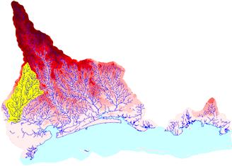
2 Major Objectives Evaluate NASA Existing Data, Simulated Future Data Streams, and Model (LIS) Data Products to Provide Enhancements to Watershed Modeling Programs/DSTs HSPF (Hydrologic Simulation Program - FORTRAN SWAT (Soil and Water Assessment Tool) Study area Two main river catchments in Saint Louis Bay watershed at the Mississippi Gulf Coast were the focus of most of the experiments One experiment focuses on the Luxapallila watershed (located in Northeast Mississippi).
3 Standard Dataset Inputs for Watershed Modeling Dataset Provider Limitations Topography DEM: 300 m resolution, NED: 30 m resolution Land use, land cover GIRAS: 400 m resolution, NLCD: 30 m resolution USGS Depending on the size of the watershed under study DEM could result a coarse approximation to actual relief USGS Both datasets are outdated. The most current dataset is NLCD-2001, based in land use information collected during the 1990's NCDC Several stations have incomplete timeseries Precipitation Gage station records at hourly, daily frequencies Potential Evapotranspiration Calculated internally in watershed models. Simple algorithms.
4 NASA Datasets Evaluated for Watershed Modeling Satellite/Model Sensor System Operator Shuttle Radar Topography Mission RADAR: two radar antennas located in the shuttle's payload bay, and the other on the end of a 60-meter mast NASA, NGA Product SRTM 30-meter resolution digital elevation model TERRA/AQUA Moderate Resolution Spectroradiometer (MODIS) NASA MODIS 12Q1 land use land cover, 1000 m resolution LIS NASA GODDARD Precipitation and Evapotranspiration time-series
5 Methodology Several experiments were performed to assess the effectiveness of NASA datasets for watershed hydrology modeling. The exploration was done using individual NASA products as well as combining inputs in factorial fashion with other datasets used in watershed modeling. Experiments can be grouped into the following types: topography, land use, land use and topography, forcings, and land use dynamics.
6 Topography Experiment Watershed delineation: hydrologic division of a watershed into sub-watersheds Topography is used as the primary reference. Shuttle Radar Topography Mission (SRTM) data are used to delineate selected regions of the Saint Louis Bay watershed (Mississippi). Topographical indicators were computed. Comparison of topographical indicators obtained using SRTM against those obtained using: Interferometric Synthetic Aperture Radar (IFSAR), National Elevation Dataset (NED) and USGS digital elevation models (DEM). Science Question: How does SRTM perform for watershed delineation?
 IFSAR C) SRTM - 1")


7 Topography Experiment A) USGS-DEM B) IFSAR C) SRTM - 1 Crabgrass Creek White Cypress Crabgrass Creek White Cypress Crabgrass Creek White Cypress Dead Tiger Dead Tiger Dead Tiger E) SRTM - 2 F) NED G) STUDY AREA White Cypress White Cypress Crabgrass Creek Crabgrass Creek Dead Tiger Dead Tiger
8 Results: SRTM, NED and USGS-DEM produce equivalent, smooth and continuous demarcation of sub-basins. The experiment determined that the use of SRTM provides equivalent delineation results and topographical parameterized information. Area and river length measurements are highly correlated for all data sets excepts IFSAR for area measurements Hickory Creek White Cypress Creek Catahoula Creek Crane Pond Branch Jourdan River Crabgrass Creek Dead Tiger Creek Jourdan River Sub-basin USGS-DEM IFSAR SRTM-1 SRTM-2 A R E A (ha) Hickory Creek White Cypress Creek Catahoula Creek Crane Pond Branch Jourdan River Crabgrass Creek Dead Tiger Creek Jourdan River Topography Experiment Sub-basin RIVER LENGTH (m)
9 Land Use Experiment This experiment explored the impact of land use/land cover (LU/LC) data quality to simulate watershed processes at hill slope scale and at the watershed outlet of the Luxapallila Creek basin, located in Alabama and Mississippi. Simulated values of flow and sediments were obtained after swapping three land use databases. Science Questions: Does land use dataset swapping affects HSPF s stream flow and sediment estimations? How does MODIS MOD12Q 1 LU/LC dataset perform?
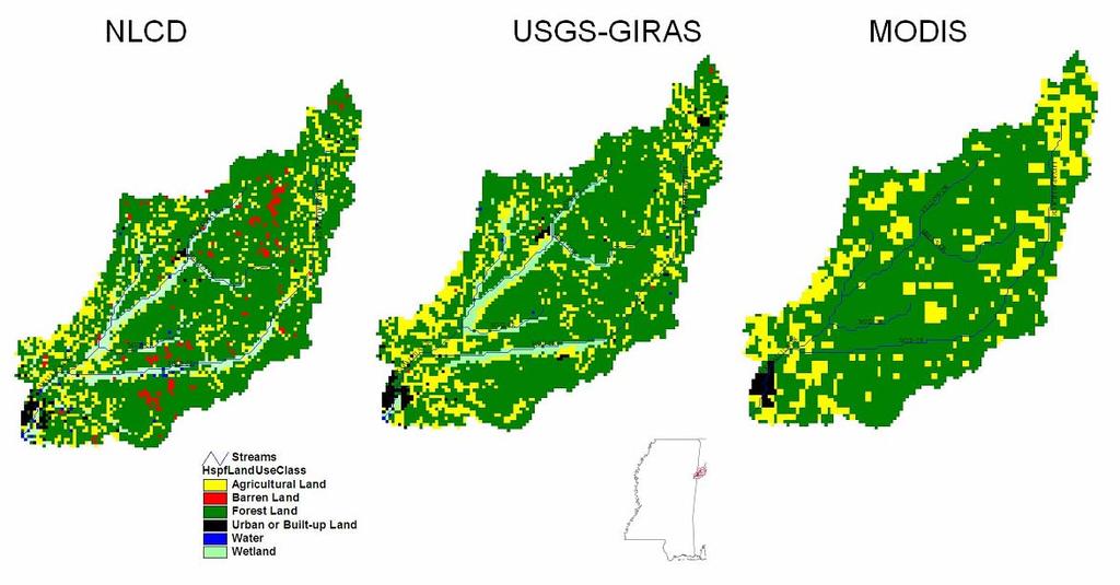
10 Land Use Experiment
11 Land Use Experiment After swapping land use datasets, the HSPF model estimations did not show substantial changes on the water balance components (evapo-transpiration, total runoff, and deep groundwater) and stream flow. At the hill slope scale, the LU/LC datasets generated noticeable differences in simulated values of total fraction of sediments when swapping LU/LC datasets. The HSPF simulation that used NLCD as LU/LC data produced sediment fraction values 8.7% smaller than sediment fraction values calculated using GIRAS. Conversely, MODIS produced values 8.6% bigger. In sediment modeling, agricultural land was the main source of sediment export (i.e., between 70% and 80% of total sediments). Larger differences in agricultural areas were calculated: -18.9% and 10% for NLCD and MODIS, respectively.
12 Land Use and Topography (Combined) Experiment This experiment explored the effects of swapping several topographical and land use datasets of different spatial resolution and scale in hydrological estimations of stream flow. Science Question: Is the combination of MODIS and SRTM useful for hydrological modeling? A factorial design with several different LULC and topography datasets was performed (see Table 3). Twelve concurrent scenarios of Topographical/LULC cases were generated for HSPF ingestion. Science Question: Can we use advanced approaches to data exploration in modeling to determine the best combinations of input datasets for a give hydrologic modeling activity? Science Question: Do geography, scale, and temporal considerations mean there is no ideal universal set of rules for what data works best?
")

 B NED (30 m)")
 D IFSAR")
13 Land Use and Topography (Combined) Experiment TOPOGRAPHICAL datasets A USGS-DEM (300m) B NED (30 m) LANDUSE datasets C SRTM (30 m) D IFSAR (5 m) NLCD USGS-GIRAS BASE CASE MODIS
 NLCD (30 m) IFSAR (5m) SRTM (30m) NED (30m) DEM (300m) 0.745 0.74 0.735 0.73 0.725 0.72 0.745-0.75 0.74-0.745 0.735-0.74 0.73-0.735 0.725-0.73 0.72-0.")
14 Land Use and Topography (Combined) Experiment Jourdan River Watershed Nash-Sutcliff (NS) model fit efficiency Coefficient of determination (R^2) 0.75 MODIS (1000 m) NLCD (30 m) IFSAR (5m) SRTM (30m) NED (30m) DEM (300m) MODIS (1000 m) GIRAS (400 m) NLCD (30 m) IFSAR (5m) SRTM (30m) NED (30m) DEM (300m) Wolf River Watershed MODIS (1000 m) GIRAS (400 m) NLCD (30 m) Nash-Sutcliff, NS, model fit efficiency IFSAR (5m) SRTM (30m) NED (30m) DEM (300m) MODIS (1000 m) Coefficient of determination (R^2) DEM GIRAS (400 m) NED (300m) SRTM (30m) NLCD (30 m) IFSAR (30m) (5m) The combination of moderate resolution topographical datasets (such as SRTM, 30 m) and low resolution land use datasets (such as MODIS, 1000 m) produce good statistical fit between simulated and measured stream flow hydrographs. Model fit coefficients (R 2 and NS) for the MODIS-SRTM combination range between 0.73 and 0.81 (perfect fit is 1.00).
15 Land Cover Dynamics and Forcings Experiment MODIS 12Q1 land use products from 2001 up to 2004 were introduced in a calibrated HSPF model application for Wolf River watershed. Meteorological data only existed for the period 1970 to Precipitation and evapo-transpiration time-series from 1996 to the present for the area were produced by NASA-LIS (GSFC). NASA-LIS data was re-formatted to update the original Wolf watershed HSPF application (that previously run from 1970 to 1996) up to The introduction of yearly land use information generated four different HSPF models for the Wolf River watershed. Each of the models was run from 1997 to Simulated daily hydrographs at the outlet (Landon Station) were compared against measured hydrographs at the same outlet (USGS gage station ). Model fit efficiencies were evaluated for each combination of HSPF model for the Wolf River Watershed using LIS Data and the time-series Land Cover Dynamics Data. Science Question: Can Land Cover Dynamics be used in conjunction with model-derived meteorological data to fill gaps in data for hydrologic simulation? Science Question: In many areas where detailed land cover or meteorological stations are not available or time-series data are interrupted, what data and methods may be used to create reliable models?


16 Land Cover Dynamics and Forcings Experiment NASA: MODIS MOD12Q1 Urban Agricultural Rangeland Forest Water Wetlands Barren land NASA-LIS: Time-series LANDUSE/LANDCOVER PRECIPITATION EVAPO-TRANSPIRATION BASE CASE
17 Land Cover Dynamics and Forcings Experiment Hydrographs for models using 2001 and 2004 land use MODIS datasets (for brevity, output for years 2002 and 2003 is not shown). Hydrographs exhibit only minor differences. Scatter-plots of observed vs. simulated daily stream flow rates are also very similar. Correlation for 2001 and 2004 models are R= and R=0.845 respectively (corresponding to a common R 2 =0.71).
18 Forcings Experiment (SWAT & LIS) Although the Land Cover Dynamics Experiment incorporated NASA-LIS forcings (precipitation and evapo-transpiration) in calibrated HSPF models, the models were calibrated and validated with measured gage station data from USGS and NCDC. Science Question: In the absence of ground station meteorological data can NASA-LIS data be utilized to generate (independently) a calibrated watershed model? In this experiment, that validity is assessed by introducing NASA-LIS precipitation and potential evapo-transpiration data into a SWAT model application for the Wolf River watershed.
19 Forcings Experiment This figure presents the SWAT model for the Wolf River Watershed. The NLDAS grid is also shown.


20 Forcings Experiment The calibration and validation of the SWAT application to Wolf River Watershed is equivalent to the calibration of a watershed model for the same location using HSPF. A correlation coefficient of 0.79, a coefficient of determination R 2 =0.62 and a model fit efficiency of NS= 0.61 were achieved. This experiment support the valid use of NASA-LIS precipitation and potential evapo-transpiration data for generating a fully calibrated watershed model in the absence of weather-gage-station data.
21 Geoprocessing Experiment While there are several interfaces designed to handle geo-processing for providing parameterized information to HSPF and SWAT, an experiment was performed to assess an alternative geoprocessing tool: GEOLEM. The Geospatial Object Library for Environmental Modeling (GEOLEM) was used to pre-process topographical and land use datasets for generation of topographical and land use parameters for (HSPF). The export of those tables to the HSPF input file (UCI file) for creation of a new HSPF project is performed outside from the GEOLEM framework but those and other enhancements are part of current efforts of the core developers (USGS) and will be reported by that research team.
22 Geoprocessing Experiment Standard GIS geoprocessing software (BASINS) and GEOLEM output for geographical parameters is compared. For brevity, only slope and land use area parameter values are shown in the comparison. Slope ratio BASINS/NED GEOLEM/NED GEOLEM/DEM GEOLEM/SRTM GEOLEM/IFSAR GEOLEM and BASINS produce exactly the same values of slope using NED and land use area. Therefore, the customized GEOLEM framework is equivalent to standard methodologies for obtaining parameterized geographical data. Results for other datasets show the usefulness of the new system in rapidly obtaining the same geographical parameters from different sources. Area km Sub-basin BASIN/GIRAS GEOLEM/NLCD GEOLEM/GIRAS GEOLEM/MODIS Sub-basin
23 Conclusions The Topography Experiment: Determined that the use of SRTM provides equivalent delineation results and topographical parameterized information for input into hydrological models. The Land Use Experiment: Showed the usefulness of MODIS 12Q1 for providing insight in the modeling of flow and sediments in an inland watershed using HSPF. The Combined Land Use and Topography Experiment: The combination of moderate resolution topographical datasets (such as SRTM, 30 m) and low resolution land use datasets (such as MODIS, 1000 m) produce good statistical fit between HSPF-simulated and measured stream flow hydrographs. Model fit coefficients (R 2 and NS) for the MODIS-SRTM combination range between 0.73 and 0.81 (perfect fit is 1.00). Therefore, MODIS 12Q1 and SRTM datasets can be used successfully for calibration and validation of coastal watersheds such as Wolf and Jourdan rivers catchments.
24 Conclusions Land Cover Dynamics Experiment: When hydrographs are compared for the whole period of simulation ( ) model fit efficiency for the four models was calculated as NS=0.61 and coefficient of determination resulted in R 2 =0.71. Long-term simulation using MODIS 12Q1 land use products and NASA-LIS forcings provide good results. Forcings Experiment: The calibration and validation of the SWAT application to Wolf River Watershed was shown to be equivalent to the calibration of a watershed model for the same location using HSPF. A correlation coefficient of 0.79, a coefficient of determination R 2 =0.62 and a model fit efficiency of NS= 0.61 were achieved. This shows the validity of using NASA-LIS precipitation and potential evapo-transpiration data for generating a fully calibrated SWAT watershed model without requiring gage station data. Geoprocessing Experiment: GEOLEM and BASINS produce exactly the same values of slope and land use area. Therefore, the customized GEOLEM framework is equivalent to standard methodologies for obtaining parameterized geographical data.
25 Final Comments Gaps in meeting DST needs: The only limitation identified in these experiments is the spatial resolution of the MODIS 12Q1 dataset (1000 m) for short-span hydrological simulation. However, when long periods of hydrological simulation are required, the land use information contained by MODIS MOD 12Q1 seems to be equivalent to finer datasets. Recommendations NASA should consider the feasibility of generating land use datasets of finer spatial resolution than 1000 m. A 500-m resolution dataset would impact greatly on the use of this type of NASA product. This could be tested with the up-coming VIIRS implementation. Next Steps Introduce improved precipitation data in current HSPF and SWAT model applications. Expand the land use experiment to SWAT. Assess the combined effects of topographical and land use in SWAT simulations. Expand the exploration to water quality simulations (sediments, nutrients). Apply the know-how developed in the experiments to simulate watersheds abroad. Expand the experiments detailed in this report to watersheds that cover bigger geographical areas.
26 Papers and Proceedings Published Publications Alarcon, V. J., O Hara, C.G., Viger, R., Shrestha, B., and Mali, P., 2007c. Using and interoperable geoprocessing system for hydrological simulation. In: Computation in Modern Science and Engineering (Simos, T. E. and Maroulis, G., Eds.). American Institute of Physics, Diaz, J.N., Alarcon, V.J., Duan, Z., Tagert, M. L., McAnally, W. H., Martin, J. L. and C.G. O Hara, Impacts of land use characterization in modeling hydrology and sediments for the Luxapallila Creek watershed, Alabama/Mississippi. Transactions ASAE. (Accepted). Alarcon, V. J. and O Hara, G. G., 2007a. Advanced Techniques for Watershed Visualization. Proceedings Applied Imagery and Pattern Recognition Conference, AIPR 2006, p 30. Alarcon, V. J. Zwaag, J, Moorhead, R.J., 2007b. Estimation of Estuary Phytoplankton Using a Web-Based Tool for Visualization of Hyper-Spectral Images, Proceedings Applied Imagery and Pattern Recognition, AIPR 2006, p 25. Alarcon, V. J. and O Hara, G. G., Using IFSAR and SRTM elevation data for watershed delineation of a coastal watershed. Proceedings American Society Photogrammetry and Remote Sensing (ASPRS-MAPPS) 2006 Fall Conference. San Antonio, Texas, November 6-10, Alarcon, V. J., O'Hara, C. G., McAnally, W., Martin, J., Diaz, J., Duan, Z., 2006.a HSPF-estimated flowrate sensitivity to topographical parameter values for three watersheds in Mississippi. Proceedings AWRA 2006 Spring Specialty Conference GIS & Water Resources IV, Houston, Texas, May 8-10, Alarcon, V. J., O'Hara, C. G., McAnally, W., Martin, J., Diaz, J., Duan, Z., 2006b. Influence of elevation dataset on watershed delineation of three catchments in Mississippi. Proceedings AWRA 2006 Spring Specialty Conference GIS & Water Resources IV, Houston, Texas, May 8-10, Posters Alarcon, V.J., C. G. O'Hara, R.Viger, B. Shrestha1, P. Mali1, D. Toll, T. Engman, Interoperable Geoprocessing for Rapid Prototyping of Landuse/Landcover, Topographical and Meteorological Datasets for Hydrological Simulation. AGU Fall 2007 Conference, December San Francisco, CA. Alarcon, V.J., O' Hara, C. G., Viger, R., Toll, D., Diaz, J., Tagert, M. L., McAnally, W., Martin, Rapid Prototyping Capabilities for Evaluating Current and Future NASA Data in Multi-Scale Sensitivity Analysis in Watershed Hydrology Modeling. American Geophysical Union (AGU) Fall 2006 Meeting December 2006, San Francisco, California
27 Questions? THANK YOU! Chuck O Hara cgohara@gri.msstate.edu
USING IFSAR AND SRTM ELEVATION DATA FOR WATERSHED DELINEATION OF A COASTAL WATERSHED INTRODUCTION
 USING AND SRTM ELEVATION DATA FOR WATERSHED DELINEATION OF A COASTAL WATERSHED Vladimir J. Alarcon, Research Associate Chuck O Hara, Research Professor GeoResources Institute Mississippi State University
Hydrologic Modelling of the Upper Malaprabha Catchment using ArcView SWAT
 Hydrologic Modelling of the Upper Malaprabha Catchment using ArcView SWAT Technical briefs are short summaries of the models used in the project aimed at nontechnical readers. The aim of the PES India
Near Real-Time Runoff Estimation Using Spatially Distributed Radar Rainfall Data. Jennifer Hadley 22 April 2003
 Near Real-Time Runoff Estimation Using Spatially Distributed Radar Rainfall Data Jennifer Hadley 22 April 2003 Introduction Water availability has become a major issue in Texas in the last several years,
A Near Real-time Flood Prediction using Hourly NEXRAD Rainfall for the State of Texas Bakkiyalakshmi Palanisamy
 A Near Real-time Flood Prediction using Hourly NEXRAD for the State of Texas Bakkiyalakshmi Palanisamy Introduction Radar derived precipitation data is becoming the driving force for hydrological modeling.
MODULE 8 LECTURE NOTES 2 REMOTE SENSING APPLICATIONS IN RAINFALL-RUNOFF MODELLING
 MODULE 8 LECTURE NOTES 2 REMOTE SENSING APPLICATIONS IN RAINFALL-RUNOFF MODELLING 1. Introduction The most common application of the remote sensing techniques in the rainfall-runoff studies is the estimation
REMOTE SENSING AND GEOSPATIAL APPLICATIONS FOR WATERSHED DELINEATION
 REMOTE SENSING AND GEOSPATIAL APPLICATIONS FOR WATERSHED DELINEATION Gaurav Savant (gaurav@engr.msstate.edu) Research Assistant, Department of Civil Engineering, Lei Wang (lw4@ra.msstate.edu) Research
INTEGRATING NASA DATA AND MODEL PRODUCTS FOR CROP SURVEILLANCE AND PRODUCTIVITY ESTIMATION TO PROVIDE ENHANCED INPUTS TO USDA FAS PECAD/CADRE DST
 Rapid Prototyping Experiment: INTEGRATING NASA DATA AND MODEL PRODUCTS FOR CROP SURVEILLANCE AND PRODUCTIVITY ESTIMATION TO PROVIDE ENHANCED INPUTS TO USDA FAS PECAD/CADRE DST Charles O Hara Preeti Mali
Liliana Pagliero June, 15 th 2011
 Liliana Pagliero liliana.pagliero@jrc.ec.europa.eu June, 15 th 2011 2/18 SWAT MODELLING AT PAN EUROPEAN SCALE: THE DANUBE BASIN PILOT STUDY Introduction The Danube Model Available databases Model set up
Lecture 3. Data Sources for GIS in Water Resources
 Lecture 3 Data Sources for GIS in Water Resources GIS in Water Resources Spring 2015 http://www.data.gov/ 1 USGS GIS data for Water http://water.usgs.gov/maps.html Watersheds of the US 2-digit water resource
Uncertainty in the SWAT Model Simulations due to Different Spatial Resolution of Gridded Precipitation Data
 Uncertainty in the SWAT Model Simulations due to Different Spatial Resolution of Gridded Precipitation Data Vamsi Krishna Vema 1, Jobin Thomas 2, Jayaprathiga Mahalingam 1, P. Athira 4, Cicily Kurian 1,
Modeling the Effects of Climate and Land Cover Change in the Stoney Brook Subbasin of the St. Louis River Watershed
 Modeling the Effects of Climate and Land Cover Change in the Stoney Brook Subbasin of the St. Louis River Watershed Joe Johnson and Jesse Pruette 214 NASA Research Internship Geospatial Technologies Program
Digital Elevation Models. Using elevation data in raster format in a GIS
 Digital Elevation Models Using elevation data in raster format in a GIS What is a Digital Elevation Model (DEM)? Digital representation of topography Model based on scale of original data Commonly a raster
A GIS-based Approach to Watershed Analysis in Texas Author: Allison Guettner
 Texas A&M University Zachry Department of Civil Engineering CVEN 658 Civil Engineering Applications of GIS Instructor: Dr. Francisco Olivera A GIS-based Approach to Watershed Analysis in Texas Author:
GIS and Remote Sensing
 Spring School Land use and the vulnerability of socio-ecosystems to climate change: remote sensing and modelling techniques GIS and Remote Sensing Katerina Tzavella Project Researcher PhD candidate Technology
URBAN WATERSHED RUNOFF MODELING USING GEOSPATIAL TECHNIQUES
 URBAN WATERSHED RUNOFF MODELING USING GEOSPATIAL TECHNIQUES DST Sponsored Research Project (NRDMS Division) By Prof. M. GOPAL NAIK Professor & Chairman, Board of Studies Email: mgnaikc@gmail.com Department
Impact of different types of meteorological data inputs on predicted hydrological and erosive responses to projected land use change
 Impact of different types of meteorological data inputs on predicted hydrological and erosive responses to projected land use change Suman Bhattacharyya 1 & Joy Sanyal * 1 2 1 Department of Geography,
Current and Future Plans. R. Srinivasan
 Current and Future Plans R. Srinivasan Contents 1 The ArcSWAT Interface 2 VizSWAT: Output Visualization 3 User online support 4 MapWindows SWAT interface 5 ArcGIS SWAT/APEX interfaces 6 Radar Rainfall
Development of the Hydrologic Model
 Kick-off meeting on enhancing hydrological data management and exchange procedures Water and Climate Adaptation Plan (WATCAP) for Sava River Basin Development of the Hydrologic Model David Heywood Team
Building a European-wide hydrological model
 Building a European-wide hydrological model 2010 International SWAT Conference, Seoul - South Korea Christine Kuendig Eawag: Swiss Federal Institute of Aquatic Science and Technology Contribution to GENESIS
Watershed Application of WEPP and Geospatial Interfaces. Dennis C. Flanagan
 Watershed Application of WEPP and Geospatial Interfaces Dennis C. Flanagan Research Agricultural Engineer USDA-Agricultural Research Service Adjunct Professor Purdue Univ., Dept. of Agric. & Biol. Eng.
Water & Climate; Floods & Droughts (The yin & yang of water availablilty) Water & Climate; Floods & Droughts (The yin & yang of water availablilty)
 Water & Climate; Floods & Droughts (The yin & yang of water availablilty)") (Acknowledgment: This presentation was developed in collaboration with ESA, NEON and NCEAS, federal agencies and academic team members from minority serving institutions.) Water & Climate; Floods & Droughts
(Acknowledgment: This presentation was developed in collaboration with ESA, NEON and NCEAS, federal agencies and academic team members from minority serving institutions.) Water & Climate; Floods & Droughts
Dr. S.SURIYA. Assistant professor. Department of Civil Engineering. B. S. Abdur Rahman University. Chennai
 Hydrograph simulation for a rural watershed using SCS curve number and Geographic Information System Dr. S.SURIYA Assistant professor Department of Civil Engineering B. S. Abdur Rahman University Chennai
GeoSUR SRTM 30-m / TPS
 GeoSUR SRTM 30-m / TPS Wm Matthew Cushing (USGS) 16 May 2013 U.S. Department of the Interior U.S. Geological Survey SRTM Mission Shuttle Radar Topography Mission (SRTM) Space Shuttle Endeavour during the
The Delaware Environmental Monitoring & Analysis Center
 The Delaware Environmental Monitoring & Analysis Center Tina Callahan Delaware Estuary Science & Environmental Summit 2013 January 27-30, 2013 What is DEMAC? Delaware Environmental Monitoring & Analysis
Analyzing spatial and temporal variation of water balance components in La Vi catchment, Binh Dinh province, Vietnam
 Analyzing spatial and temporal variation of water balance components in La Vi catchment, Binh Dinh province, Vietnam Nguyen Duy Liem, Vo Ngoc Quynh Tram, Nguyen Le Tan Dat, Nguyen Kim Loi Nong Lam University-
Understanding the role of land cover / land use nexus in malaria transmission under changing socio-economic climate in Myanmar
 Annual Report for Year 1 June, 2017 January, 2018 NASA Land Cover Land Use Change Program Funded under grant # NNX17AI06G: Understanding the role of land cover / land use nexus in malaria transmission
What s New in Topographic Information - USGS National Map
 + What s New in Topographic Information - USGS National Map SARGIS Workshop November 14, 2016 Rob Dollison, 703-648-5724 rdollison@usgs.gov + USGS 2 National Geospatial Program The National Geospatial
Comparison of Intermap 5 m DTM with SRTM 1 second DEM. Jenet Austin and John Gallant. May Report to the Murray Darling Basin Authority
 Comparison of Intermap 5 m DTM with SRTM 1 second DEM Jenet Austin and John Gallant May 2010 Report to the Murray Darling Basin Authority Water for a Healthy Country Flagship Report series ISSN: 1835-095X
KINEROS2/AGWA. Fig. 1. Schematic view (Woolhiser et al., 1990).
.") KINEROS2/AGWA Introduction Kineros2 (KINematic runoff and EROSion) (K2) model was originated at the USDA-ARS in late 1960s and released until 1990 (Smith et al., 1995; Woolhiser et al., 1990). The spatial
KINEROS2/AGWA Introduction Kineros2 (KINematic runoff and EROSion) (K2) model was originated at the USDA-ARS in late 1960s and released until 1990 (Smith et al., 1995; Woolhiser et al., 1990). The spatial
GRAPEVINE LAKE MODELING & WATERSHED CHARACTERISTICS
 GRAPEVINE LAKE MODELING & WATERSHED CHARACTERISTICS Photo Credit: Lake Grapevine Boat Ramps Nash Mock GIS in Water Resources Fall 2016 Table of Contents Figures and Tables... 2 Introduction... 3 Objectives...
River Modeling as Big as Texas. Cédric H. David David R. Maidment, Zong-Liang Yang
 River Modeling as Big as Texas Cédric H. David David R. Maidment, Zong-Liang Yang First Water Forum Austin, TX 13 February 2012 1 Atmospheric modeling Equations of fluid mechanics and thermodynamics of
EMERGENCY PLANNING IN NORTHERN ALGERIA BASED ON REMOTE SENSING DATA IN RESPECT TO TSUNAMI HAZARD PREPAREDNESS
 EMERGENCY PLANNING IN NORTHERN ALGERIA BASED ON REMOTE SENSING DATA IN RESPECT TO TSUNAMI HAZARD PREPAREDNESS Barbara Theilen-Willige Technical University of Berlin, Institute of Applied Geosciences Department
ENGRG Introduction to GIS
 ENGRG 59910 Introduction to GIS Michael Piasecki March 17, 2014 Lecture 08: Terrain Analysis Outline: Terrain Analysis Earth Surface Representation Contour TIN Mass Points Digital Elevation Models Slope
Transactions on Information and Communications Technologies vol 18, 1998 WIT Press, ISSN
 STREAM, spatial tools for river basins, environment and analysis of management options Menno Schepel Resource Analysis, Zuiderstraat 110, 2611 SJDelft, the Netherlands; e-mail: menno.schepel@resource.nl
CHAPTER VII FULLY DISTRIBUTED RAINFALL-RUNOFF MODEL USING GIS
 80 CHAPTER VII FULLY DISTRIBUTED RAINFALL-RUNOFF MODEL USING GIS 7.1GENERAL This chapter is discussed in six parts. Introduction to Runoff estimation using fully Distributed model is discussed in first
Spatial Downscaling of TRMM Precipitation Using DEM. and NDVI in the Yarlung Zangbo River Basin
 Spatial Downscaling of TRMM Precipitation Using DEM and NDVI in the Yarlung Zangbo River Basin Yang Lu 1,2, Mingyong Cai 1,2, Qiuwen Zhou 1,2, Shengtian Yang 1,2 1 State Key Laboratory of Remote Sensing
Basin characteristics
 Basin characteristics From hydrological processes at the point scale to hydrological processes throughout the space continuum: point scale à river basin The watershed characteristics (shape, length, topography,
Assessment of solid load and siltation potential of dams reservoirs in the High Atlas of Marrakech (Moorcco) using SWAT Model
 using SWAT Model") Assessment of solid load and siltation potential of dams reservoirs in the High Atlas of Marrakech (Moorcco) using SWAT Model Amal Markhi: Phd Student Supervisor: Pr :N.Laftrouhi Contextualization Facing
Assessment of solid load and siltation potential of dams reservoirs in the High Atlas of Marrakech (Moorcco) using SWAT Model Amal Markhi: Phd Student Supervisor: Pr :N.Laftrouhi Contextualization Facing
Determination of Urban Runoff Using ILLUDAS and GIS
 Texas A&M University Department of Civil Engineering Instructor: Dr. Francisco Olivera CVEN689 Applications of GIS to Civil Engineering Determination of Urban Runoff Using ILLUDAS and GIS Tae Jin Kim 03.
GeoWEPP Tutorial Appendix
 GeoWEPP Tutorial Appendix Chris S. Renschler University at Buffalo - The State University of New York Department of Geography, 116 Wilkeson Quad Buffalo, New York 14261, USA Prepared for use at the WEPP/GeoWEPP
Geospatial Data, Services, and Products. National Surveying, mapping and geospatial conference
 Geospatial Data, Services, and Products Federal Programs -- USDA NRCS National Surveying, mapping and geospatial conference March 15, 2016 NRCS Applications using Geosaptial Products & Services Field
CONVERTING A NEXRAD MAP TO A FLOODPLAIN MAP. Oscar Robayo, Tim Whiteaker, and David Maidment*
 CONVERTING A NEXRAD MAP TO A FLOODPLAIN MAP Oscar Robayo, Tim Whiteaker, and David Maidment* ABSTRACT: Using ArcGIS 9.0 ArcObjects and the new ModelBuilder environment, a methodology for converting a NEXRAD
Remote Sensing and GIS Applications for Hilly Watersheds SUBASHISA DUTTA DEPARTMENT OF CIVIL ENGINEERING IIT GUWAHATI
 Remote Sensing and GIS Applications for Hilly Watersheds SUBASHISA DUTTA DEPARTMENT OF CIVIL ENGINEERING IIT GUWAHATI Deciding Alternative Land Use Options in a Watershed Using GIS Source: Anita Prakash
ENGRG Introduction to GIS
 ENGRG 59910 Introduction to GIS Michael Piasecki November 17, 2017 Lecture 11: Terrain Analysis Outline: Terrain Analysis Earth Surface Representation Contour TIN Mass Points Digital Elevation Models Slope
Lake Tahoe Watershed Model. Lessons Learned through the Model Development Process
 Lake Tahoe Watershed Model Lessons Learned through the Model Development Process Presentation Outline Discussion of Project Objectives Model Configuration/Special Considerations Data and Research Integration
Delineation of Groundwater Potential Zone on Brantas Groundwater Basin
 Delineation of Groundwater Potential Zone on Brantas Groundwater Basin Andi Rachman Putra 1, Ali Masduqi 2 1,2 Departement of Environmental Engineering, Sepuluh Nopember Institute of Technology, Indonesia
Evaluation of gvsig and SEXTANTE Tools for Hydrological Analysis
 Evaluation of gvsig and SEXTANTE Tools for Hydrological Analysis 6th gvsig Conference, Valencia, SPAIN Prof. Dr-Ing Dietrich Schrödera Mudogah Hildahb and Franz Davidb Stuttgart University of Applied Sciences
4. GIS Implementation of the TxDOT Hydrology Extensions
 4. GIS Implementation of the TxDOT Hydrology Extensions A Geographic Information System (GIS) is a computer-assisted system for the capture, storage, retrieval, analysis and display of spatial data. It
Floodplain modeling. Ovidius University of Constanta (P4) Romania & Technological Educational Institute of Serres, Greece
 Romania & Technological Educational Institute of Serres, Greece") Floodplain modeling Ovidius University of Constanta (P4) Romania & Technological Educational Institute of Serres, Greece Scientific Staff: Dr Carmen Maftei, Professor, Civil Engineering Dept. Dr Konstantinos
Floodplain modeling Ovidius University of Constanta (P4) Romania & Technological Educational Institute of Serres, Greece Scientific Staff: Dr Carmen Maftei, Professor, Civil Engineering Dept. Dr Konstantinos
MODULE 7 LECTURE NOTES 5 DRAINAGE PATTERN AND CATCHMENT AREA DELINEATION
 MODULE 7 LECTURE NOTES 5 DRAINAGE PATTERN AND CATCHMENT AREA DELINEATION 1. Introduction Topography of the river basin plays an important role in hydrologic modelling, by providing information on different
HYDROLOGIC AND WATER RESOURCES EVALUATIONS FOR SG. LUI WATERSHED
 HYDROLOGIC AND WATER RESOURCES EVALUATIONS FOR SG. LUI WATERSHED 1.0 Introduction The Sg. Lui watershed is the upper part of Langat River Basin, in the state of Selangor which located approximately 20
Xiaojun Yang a a Department of Geography, Florida State University, Tallahassee, FL32306, USA Available online: 22 Feb 2007
 This article was downloaded by: [USGS Libraries Program] On: 29 May 2012, At: 15:41 Publisher: Taylor & Francis Informa Ltd Registered in England and Wales Registered Number: 1072954 Registered office:
RHOAPS. Real-time Hydrology Ocean Atmosphere Prediction System. Pronunciation: Ropes Motto: More than just THREDDS
 RHOAPS Real-time Hydrology Ocean Atmosphere Prediction System Pronunciation: Ropes Motto: More than just THREDDS Key Aspects Integrated real-time data systems Atmospheric Hydrologic Coastal oceans Societal
USGS Hydrography Overview. May 9, 2018
 + 1 USGS Hydrography Overview May 9, 2018 + 2 The National Geospatial Program Provides the geospatial baseline of the Nation s topography, natural landscape and built environment through The National Map,
Height Above Nearest Drainage in Houston THE UNIVERSITY OF TEXAS AT AUSTIN
 Height Above Nearest Drainage in Houston THE UNIVERSITY OF TEXAS AT AUSTIN Jeff Yuanhe Zheng GIS in Water Resources December 2 nd, 2016 Table of Contents 1.0 Introduction... 1 2.0 Project Objective...
Overview of Data for CREST Model
 Overview of Data for CREST Model Xianwu Xue April 2 nd 2012 CREST V2.0 CREST V2.0 Real-Time Mode Forcasting Mode Data Assimilation Precipitation PET DEM, FDR, FAC, Slope Observed Discharge a-priori parameter
Kimberly J. Mueller Risk Management Solutions, Newark, CA. Dr. Auguste Boissonade Risk Management Solutions, Newark, CA
 1.3 The Utility of Surface Roughness Datasets in the Modeling of United States Hurricane Property Losses Kimberly J. Mueller Risk Management Solutions, Newark, CA Dr. Auguste Boissonade Risk Management
The BASINS Watershed Analysis System -- Evolving to Embrace New Data and Techniques. PH (404) ; author
 ; author") The BASINS Watershed Analysis System -- Evolving to Embrace New Data and Techniques Paul B. Duda 1, John L. Kittle, Jr. 1, Paul R. Hummel 1, Mark H. Gray 1, Russell S. Kinerson, Ph.D. 2 1 AQUA TERRA Consultants,
The BASINS Watershed Analysis System -- Evolving to Embrace New Data and Techniques Paul B. Duda 1, John L. Kittle, Jr. 1, Paul R. Hummel 1, Mark H. Gray 1, Russell S. Kinerson, Ph.D. 2 1 AQUA TERRA Consultants,
Utility of National Spatial Data for Conservation Design Projects
 Utility of National Spatial Data for Conservation Design Projects Steve Williams Biodiversity and Spatial Information Center North Carolina State University PIF CDW St. Louis, MO April 11, 2006 Types of
Workshop: Build a Basic HEC-HMS Model from Scratch
 Workshop: Build a Basic HEC-HMS Model from Scratch This workshop is designed to help new users of HEC-HMS learn how to apply the software. Not all the capabilities in HEC-HMS are demonstrated in the workshop
Advanced Image Analysis in Disaster Response
 Advanced Image Analysis in Disaster Response Creating Geographic Knowledge Thomas Harris ITT The information contained in this document pertains to software products and services that are subject to the
StreamStats: Delivering Streamflow Information to the Public. By Kernell Ries
 StreamStats: Delivering Streamflow Information to the Public By Kernell Ries U.S. Department of the Interior U.S. Geological Survey MD-DE-DC District 410-238-4317 kries@usgs.gov StreamStats Web Application
THE RAINWATER HARVESTING SYMPOSIUM 2015
 THE RAINWATER HARVESTING SYMPOSIUM 2015 Remote Sensing for Rainwater Harvesting and Recharge Estimation under Data Scarce Conditions Taye Alemayehu Ethiopian Institute of Water Resources, Metameta Research
ACCURACY ASSESSMENT OF ASTER GLOBAL DEM OVER TURKEY
 ACCURACY ASSESSMENT OF ASTER GLOBAL DEM OVER TURKEY E. Sertel a a ITU, Civil Engineering Faculty, Geomatic Engineering Department, 34469 Maslak Istanbul, Turkey sertele@itu.edu.tr Commission IV, WG IV/6
Tracy Fuller U. S. Geological Survey. February 24, 2016
 U. S. Geological Survey Arctic Elevation Data Involvement Statewide Alaska IfSAR Radar Collection Program Pan-Arctic Digital Elevation Map International Coordination Tracy Fuller U. S. Geological Survey
WaterBase: SWAT in an Open Source GIS
 WaterBase: SWAT in an Open Source GIS C. George 1 and L.F. Leon*,2 The Open Hydrology Journal, 2008, 2, 1-6 1 1 International Institute for Software Technology, United Nations University, Macao, China
Digitization in a Census
 Topics Connectivity of Geographic Data Sketch Maps Data Organization and Geodatabases Managing a Digitization Project Quality and Control Topology Metadata 1 Topics (continued) Interactive Selection Snapping
Hydrological modelling of the Lena River using SWIM
 Hydrological modelling of the Lena River using SWIM Michel Wortmann 1 1 Potsdam Institute for Climate Impact Research (PIK), Germany July 8, 214 Contents 1 The Lena catchment and data used 1 1.1 Discharge
Simulation of sedimentation rates using the SWAT model A case study of the Tarbela Dam, Upper Indus Basin
 Simulation of sedimentation rates using the SWAT model A case study of the Tarbela Dam, Upper Indus Basin Ahammad, H. I 1., Crosato A 2,3., Maskey, S 2., Masih, I 2,*, McClain, M 2. 1 Punjab Irrigation
Civil Engineering 394K: Topic 3 Geographic Information Systems (GIS) in Water Resources Engineering FALL 2014
 in Water Resources Engineering FALL 2014") Civil Engineering 394K: Topic 3 Geographic Information Systems (GIS) in Water Resources Engineering TERM PROJECT REPORT Reinvestigation of the Halloween Flood and Hydrologic Modeling of the Onion Creek
Civil Engineering 394K: Topic 3 Geographic Information Systems (GIS) in Water Resources Engineering TERM PROJECT REPORT Reinvestigation of the Halloween Flood and Hydrologic Modeling of the Onion Creek
Amita Mehta and Ana Prados
 Building Capacity in Utilizing NASA Remote Sensing Observations in SWAT for Water Resources and Agricultural Management Applications Amita Mehta and Ana Prados NASA - University of Maryland Baltimore County
Development and Land Use Change in the Central Potomac River Watershed. Rebecca Posa. GIS for Water Resources, Fall 2014 University of Texas
 Development and Land Use Change in the Central Potomac River Watershed Rebecca Posa GIS for Water Resources, Fall 2014 University of Texas December 5, 2014 Table of Contents I. Introduction and Motivation..4
Interaction of North American Land Data Assimilation System and National Soil Moisture Network: Soil Products and Beyond
 Interaction of North American Land Data Assimilation System and National Soil Moisture Network: Soil Products and Beyond Youlong Xia 1,2, Michael B. Ek 1, Yihua Wu 1,2, Christa Peters-Lidard 3, David M.
An Overview of Operations at the West Gulf River Forecast Center Gregory Waller Service Coordination Hydrologist NWS - West Gulf River Forecast Center
 National Weather Service West Gulf River Forecast Center An Overview of Operations at the West Gulf River Forecast Center Gregory Waller Service Coordination Hydrologist NWS - West Gulf River Forecast
Designing a Dam for Blockhouse Ranch. Haley Born
 Designing a Dam for Blockhouse Ranch Haley Born CE 394K GIS in Water Resources Term Paper Fall 2011 Table of Contents Introduction... 1 Data Sources... 2 Precipitation Data... 2 Elevation Data... 3 Geographic
THE ROLE OF GEOCOMPUTATION IN THE HYDROLOGICAL SCIENCES
 INTERNATIONAL SYMPOSIUM ON GEOCOMPUTATION AND ANALYSIS THE ROLE OF GEOCOMPUTATION IN THE HYDROLOGICAL SCIENCES JOHN P. WILSON UNIVERSITY OF SOUTHERN CALIFORNIA GIS RESEARCH LABORATORY Outline Background
Assessing the Hydrologic Implications of Land Use Change for the Upper Neuse River Basin. Kelly Conaghan Dr. Dean Urban, Advisor May 2010
 Assessing the Hydrologic Implications of Land Use Change for the Upper Neuse River Basin By Kelly Conaghan Dr. Dean Urban, Advisor May 2010 Masters project submitted in partial fulfillment of the requirements
Positional accuracy of the drainage networks extracted from ASTER and SRTM for the Gorongosa National Park region - Comparative analysis
 Positional accuracy of the drainage networks extracted from ASTER and SRTM for the Gorongosa National Park region - Comparative analysis Tiago CARMO 1, Cidália C. FONTE 1,2 1 Departamento de Matemática,
Using Remote Sensing to Analyze River Geomorphology
 Using Remote Sensing to Analyze River Geomorphology Seeing Water from Space Workshop August 11 th, 2015 George Allen geoallen@unc.edu Rivers impact: Geology Ecology Humans The atmosphere River Geomorphology
Methodological Chain for Hydrological Management with Web-GIS Applications
 Advances in Geosciences Konstantinos Perakis & Athanasios Moysiadis, Editors EARSeL, 2012 Methodological Chain for Hydrological Management with Web-GIS Applications Alexandros Konstantinidis 1, Eleni Tzanou
Delineation of high landslide risk areas as a result of land cover, slope, and geology in San Mateo County, California
 Delineation of high landslide risk areas as a result of land cover, slope, and geology in San Mateo County, California Introduction Problem Overview This project attempts to delineate the high-risk areas
Characterization of Catchments Extracted From. Multiscale Digital Elevation Models
 Applied Mathematical Sciences, Vol. 1, 2007, no. 20, 963-974 Characterization of Catchments Extracted From Multiscale Digital Elevation Models S. Dinesh Science and Technology Research Institute for Defence
Susquehanna River Basin A Research Community Hydrologic Observatory. NSF-Funded Infrastructure Proposal in Support of River Basin Hydrologic Sciences
 Susquehanna River Basin A Research Community Hydrologic Observatory NSF-Funded Infrastructure Proposal in Support of River Basin Hydrologic Sciences Fundamental Problem: How Do Humans and Climate Impact
VILLAGE INFORMATION SYSTEM (V.I.S) FOR WATERSHED MANAGEMENT IN THE NORTH AHMADNAGAR DISTRICT, MAHARASHTRA
 FOR WATERSHED MANAGEMENT IN THE NORTH AHMADNAGAR DISTRICT, MAHARASHTRA") VILLAGE INFORMATION SYSTEM (V.I.S) FOR WATERSHED MANAGEMENT IN THE NORTH AHMADNAGAR DISTRICT, MAHARASHTRA Abstract: The drought prone zone in the Western Maharashtra is not in position to achieve the agricultural
VILLAGE INFORMATION SYSTEM (V.I.S) FOR WATERSHED MANAGEMENT IN THE NORTH AHMADNAGAR DISTRICT, MAHARASHTRA Abstract: The drought prone zone in the Western Maharashtra is not in position to achieve the agricultural
Streams in the Ranching Country of South Texas
 Streams in the Ranching Country of South Texas Watershed Analysis of HUC 12110207 Sandranell Moerbe CE GIS in Water Resources Fall 2015 INTRODUCTION This project investigates the portion of South Texas
Geo-spatial Analysis for Prediction of River Floods
 Geo-spatial Analysis for Prediction of River Floods Abstract. Due to the serious climate change, severe weather conditions constantly change the environment s phenomena. Floods turned out to be one of
Implementation of CLIMAP and GIS for Mapping the Climatic Dataset of Northern Iraq
 Implementation of CLIMAP and GIS for Mapping the Climatic Dataset of Northern Iraq Sabah Hussein Ali University of Mosul/Remote sensing Center KEYWORDS: CLIMAP, GIS, DEM, Climatic, IRAQ ABSTRACT The main
EVALUATION AND MONITORING OF SNOWCOVER WATER RESOURCES IN CARPATHIAN BASINS USING GEOGRAPHIC INFORMATION AND SATELLITE DATA
 EVALUATION AND MONITORING OF SNOWCOVER WATER RESOURCES IN CARPATHIAN BASINS USING GEOGRAPHIC INFORMATION AND SATELLITE DATA Gheorghe Stancalie, Simona Catana, Anisoara Iordache National Institute of Meteorology
Appendix D. Model Setup, Calibration, and Validation
 . Model Setup, Calibration, and Validation Lower Grand River Watershed TMDL January 1 1. Model Selection and Setup The Loading Simulation Program in C++ (LSPC) was selected to address the modeling needs
Flood Forecasting Tools for Ungauged Streams in Alberta: Status and Lessons from the Flood of 2013
 Flood Forecasting Tools for Ungauged Streams in Alberta: Status and Lessons from the Flood of 2013 John Pomeroy, Xing Fang, Kevin Shook, Tom Brown Centre for Hydrology, University of Saskatchewan, Saskatoon
University of Florida Department of Geography GEO 3280 Assignment 3
 G E O 3 2 8 A s s i g n m e n t # 3 Page 1 University of Florida Department of Geography GEO 328 Assignment 3 Modeling Precipitation and Elevation Solar Radiation Precipitation Evapo- Transpiration Vegetation
Assessment of Lake Forest Lake Sediment Trapping Efficiency and Capacity. Marlon R. Cook Groundwater Assessment Program Geological Survey of Alabama
 Assessment of Lake Forest Lake Sediment Trapping Efficiency and Capacity Marlon R. Cook Groundwater Assessment Program Geological Survey of Alabama Impacts of the Lake at Lake Forest on the connectivity
GERSVIEW: A New Database for Web Mapping
 GERSVIEW: A New Database for Web Mapping William J. Hernández, M.S. Graduate Student Department of Marine Sciences-UPRM Fernando Gilbes, Ph.D. Associate Professor Department of Geology-UPRM Overview Introduction
Watershed concepts for community environmental planning
 Purpose and Objectives Watershed concepts for community environmental planning Dale Bruns, Wilkes University USDA Rural GIS Consortium May 2007 Provide background on basic concepts in watershed, stream,
Vol.3,No.3,September2017
 Vol.3,No.3,September2017 Int. J. of Geol. & Earth Sci., 2017 Abiodun O Adebola et al., 2017 Research Paper ISSN 2395-647X www.ijges.com Vol. 3, No. 3, September 2017 2017 IJGES. All Rights Reserved MORPHOMETRIC
Model Calibration and Forecast Error for NFIE-Hydro
 Corey Van Dyk C E 397 Flood Forecasting 5/8/15 Model Calibration and Forecast Error for NFIE-Hydro Introduction The forecasting component of the National Flood Interoperability Experiment (NFIE), like
Services for Inland Marine Data Integration. USGS Center for Integrated
 Services for Inland Marine Data Integration USGS Center for Integrated Data Analytics Outline GeoDataPortal Tools Coastal Use Cases Beach hhealth lthmodeling Distributed Rainfall Analysis for Integration
Influence of spatial variation in precipitation on artificial neural network rainfall-runoff model
 Hydrology Days 212 Influence of spatial variation in precipitation on artificial neural network rainfall-runoff model André Dozier 1 Department of Civil and Environmental Engineering, Colorado State University
Manitoba s Elevation (LiDAR) & Imagery Datasets. Acquisition Plans & Opportunities for Collaboration
 & Imagery Datasets. Acquisition Plans & Opportunities for Collaboration") Manitoba s Elevation (LiDAR) & Imagery Datasets Acquisition Plans & Opportunities for Collaboration Manitoba Planning Conference May 2017 Presentation Outline Manitoba s Elevation (LiDAR) and Imagery Datasets
Manitoba s Elevation (LiDAR) & Imagery Datasets Acquisition Plans & Opportunities for Collaboration Manitoba Planning Conference May 2017 Presentation Outline Manitoba s Elevation (LiDAR) and Imagery Datasets
Hydrological modeling and flood simulation of the Fuji River basin in Japan
 Hydrological modeling and flood simulation of the Fuji River basin in Japan H. A. P. Hapuarachchi *, A. S. Kiem, K. Takeuchi, H. Ishidaira, J. Magome and A. Tianqi T 400-8511, Takeuchi-Ishidaira Lab, Department