Better ice information onboard ships ECDIS S-411
|
|
|
- Hubert Alexander
- 5 years ago
- Views:
Transcription

1 Better ice information onboard ships ECDIS S411 DeMarine User Workshop Dr. Jürgen Holfort Head of German ice service at the Bundesamt für Seeschifffahrt und Hydrographie Vicechair of the JCOMM Expert team on sea ice January 2015


2 Ice characteristics relevant for shipping Pictures: Mikhail Dobrynin, Niels Fuchs Ice concentration Ice thickness Floe size Convergence / divergence Snow cover 2


3 Data transmission Data transmission to ship far up north is not possible with Inmarsat. It is possible using Iridium, but transmission is slow and more expensive. Iridium claims 10 kbit/sec but actual rates for compressed files are more like 2300 to 2400 bit/sec. Inmarsat coverage (Wikipedia) Iridium coverage (Wikipedia) 3


4 SAR Data Size: 200 to 900 MB About 200kb as small scale JPEG 4

5 Ice charts Size: 200 to 900 KB as vector PDF About 100 to 200kb as JPEG S411 starting at ~20kb, typical ~60kb

6 Model Ice charts Size: 200 to 900 KB as vector PDF About 100 to 200kb as JPEG S411 starting at ~20kb, typical ~60kb

 and can be found in the ICE domain of the IHO Registry. The full schema as XML Schema File included in Annex B Data Product format (encoding).")
7 S411 Ice Information Product Specification summary Development was led by the BSH as a part of JCOMM/ETSI. It was adopted as version 1.0 by JCOMM ETSI5, March 2014 with the latest version (June 2014) The S411 is fully based on the IHO S100 framework specification, Geography Markup Language (GML), Encoding Standard and the ISO series of standards. It is a vector product specification that is primarily intended for encoding the extent and nature of Sea Ice for navigational purpose. The application schema of ice information product contains 28 feature types with their attributes, enumerations, is based on the Ice Objects Catalogue (Version 5.1) and can be found in the ICE domain of the IHO Registry. The full schema as XML Schema File included in Annex B Data Product format (encoding). Ice information datasets use S100 Level 3a geometry which supports 0, 1, and 2 dimentional objects (points, line strings, polygons) The portrayal specification is based on Styled Layer Descriptors (SLD), follows OGC standards and supports 3 polygon portrayals, one according to the vessels ice capabilities, the second and third one being the WMO ice concentration/stages of development colour codes. Portrayals for line and point objects follow the WMO symbology and are implemented using SVGgraphics. Besides future ECDIS SDKs, the S411 data could actually be read and presented using open source GIS software (e.g. QGis) with python scripts from the national ice services available to convert shapefiles, specially SIGRID3 files, into the S411 format. From ETSI report to IHO


8 A simple way to read and portray S411. A short, 4 page long document describes how to read and portray S411 ice information in Quantum GIS (Version 2.0 or newer).

9 Qgis QGIS is an OpenSource Geographic Information System available at no cost for Linux, Windows, Mac OsX, BSD and Android at


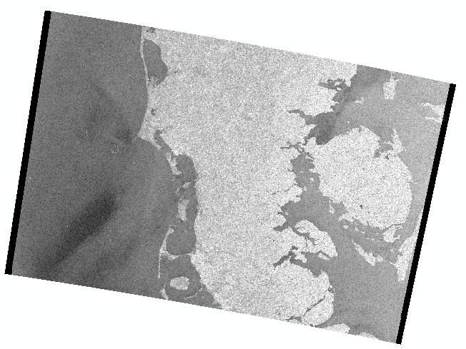
10 An example of S411 data in Qgis Example of an S411 ice chart represented in Qgis using the respective S411 In the upper right the total ice concentration, in the lower right the stage of development. In the lower left is a concentration chart with additional symbols for pressure ridges, cracks, and rafted ice..
.")

11 S411 BSH ice charts available in S411, as well as some charts from other ice services ( ftp://ftp.bsh.de/outgoing/eisbericht/s411/). It is planned to incorporate charts in S411 format into the JCOMM Ice Logistics Portals Climatological data (e.g. ice atlas) should also become available.
 User defined color scheme: * Drift velocity * Divergence and convergence *")
12 Different presentation of one S411 dataset WMO/IHO standard color scheme: * Concentration * Stage of development * (Ship capability) User defined color scheme: * Drift velocity * Divergence and convergence * (any other) 12
13 S411 parameters A whole set of ice parameters are defined in the IHO/WMO ice objects catalog. Used model parameters: Concentration Thickness/Stage of development Drift speed and direction Divergence and convergence Needed/nice to have parameters: Ridging strength and orientation Rafting Compacting strength Floe size Snow cover.

14 Route optimisation In the IRO2 project a fine resolution oceansea iceatmosphere model was embedded in an Arctic wide oceansea ice model with data assimilation. The model results were used for a ship specific ice route optimisation. Routes and model ice charts were directly presented on an ECDIS system.
 B) changing portrayal according to scale: change colors to whitegrey at larger scales group together same symbols if the overlap join different")
15 Further development of S411 A) better iceberg objects (points lines and polygones?) B) changing portrayal according to scale: change colors to whitegrey at larger scales group together same symbols if the overlap join different overlapping symbols (e.g. rafted and ridged ice into a symbol denoting heavy ice.
16 S4112: ice from far away

17 S411 + S4112 close by: ice concentration
18 S411 + S4112 close by: ice stage of development
19 Ice characteristics relevant for shipping Pictures: Mikhail Dobrynin, Niels Fuchs Ice concentration Ice thickness Floe size Convergence / divergence Snow cover 19


20 Ice in SARdata Spatial resolution or temporal coverage? Envisat ASAR WSM, ~150m spatial resolution TerraSARX ScanSAR, ~18m spatial resolution 12th Polish German Seminar 20


21 SAR image classification sliding window to calculate texture values 1st and 2nd order texture parameters variance, entropy, GLCM Gulf of Riga, edges GLCM entropy Ice concentration published in BSH ice chart variance 12th Polish German Seminar 21


22 SAR image classification TerraSARX AMSR/E / AMSR2 (ARTIST Sea Ice ASI) TerraSARX ScanSAR, Bering Strait, result of inital image segmentation ice concentration derived from AMSRdata ice concentration of the image regions


 position and")
23 SAR image classification inital image segmentation second segmentation step classification using additional informations derived from segments (shape, size, neighborhood) position and orientation of leads and cracks


24 Ice in SARdata Visual image interpretation water surface affected by wind new ice formation 24


25 Ice in SARdata: caveats frost flowers histogram of water surfaces depending on incidence angle (ENVISAT ASAR WSM) Atmospheric effects 25


26 Icebergs in SAR (Sentinel1) 26
 ongoing From an DLR presentation by Gottwald to the polar space task group,")
27 Iceberg detection (TerraSARX) section of a TerraSARX Stripmap image (Disko Bay / 23rd April 2013) comparison of TerraSARX images taken over the Grand Banks with detections of airborne International Ice Patrol (IIP) ongoing From an DLR presentation by Gottwald to the polar space task group, 2014

28 Iceberg detection: caveats Detecting large icebergs (>100m) with SAR is a maturing science although significant challenges remain relative to: Detecting small icebergs, bergy bits and growlers Detecting icebergs in sea ice Detecting icebergs in differing sea states Differentiating icebergs from small vessels From Satellite Observational Requirements for Floating Ice Focusing on SAR by John Falkingham. From Astrium price list


29 Thanks for your attention
INTERNATIONAL SYSTEM OF SEA-ICE SYMBOLS
 TABLE OF CONTENTS 1. Use 2. Main elements 3. Main symbol 3.1 Concentration (C) 3.2 Stage of development (S) 3.3 Form of ice (F) 4. Symbols for dynamic processes 5. Symbols for water openings 6. Symbols
Report of ETSI Chair
 ETSI-6/GDSIDB-14/Doc. 2.2 Report of ETSI Chair Dr Vasily Smolyanitsky Arctic and Antarctic Research Institute (AARI) St.Petersburg, Russia EXPERT TEAM ON SEA ICE (ETSI) Sixth Session STEERING GROUP FOR
The Importance of Microwave Remote Sensing for Operational Sea Ice Services And Challenges
 The Importance of Microwave Remote Sensing for Operational Sea Ice Services And Challenges Wolfgang Dierking January 2015 (1) Why is microwave remote sensing important (=useful) for sea ice mapping? Problems
Floating Ice. Susanne Lehner DLR EOC
 Floating Ice Susanne Lehner DLR EOC DLR Research Lab Maritime Safety and Security in Bremen Team SAR Oceanography Relocated from Oberpfaffenhofen to Bremen Cooperation with NRT Services (Neustrelitz) and
Floating Ice: Progress in Addressing Science Goals
 Polar Floating Ice: Progress in Addressing Science Goals Stephen Howell 1, Leif Toudal Pedersen 2 and Roberto Saldo 3 1 Environment Canada, Climate Research Division, Toronto, Canada 2 Danish Meteorological
Proposal to Include a Grid Referencing System in S-100
 1 st IHO-HSSC Meeting The Regent Hotel, Singapore, 22-24 October 2009 Paper for consideration by HSSC Proposal to Include a Grid Referencing System in S-100 Submitted by: Executive Summary: Related Documents:
Wave processes in Arctic Seas, observed from TerraSAR-X
 DISTRIBUTION STATEMENT A. Approved for public release; distribution is unlimited. Wave processes in Arctic Seas, observed from TerraSAR-X Susanne Lehner DLR German Air and Space Research Center Earth Observation
Sea ice charts and SAR for sea ice classification. Patrick Eriksson Juha Karvonen Jouni Vainio
 Sea ice charts and SAR for sea ice classification Patrick Eriksson Juha Karvonen Jouni Vainio ECMWF Ocean Workshop, 22-25 January 2018 Ice service from past to present Finland has long experience in ice
Wave processes in Arctic Seas, observed from TerraSAR-X
 DISTRIBUTION STATEMENT A. Approved for public release; distribution is unlimited. Wave processes in Arctic Seas, observed from TerraSAR-X Susanne Lehner DLR German Air and Space Research Center Earth Observation
gvsig a real tool for GIS technicians
 gvsig a real tool for GIS technicians Jorge Gaspar Sanz Salinas jsanz@prodevelop.es International Geodetic Students Meeting 05/05/08 Valencia Agenda of the project OK, but what can gvsig do for me now?
D4.5 Operational METOC service D4.10 Operational Ice Chart service
 D4.5 Operational METOC service D4.10 Operational Ice Chart service Project no. 636329 Project acronym: EfficienSea2 EFFICIENSEA2 efficient, safe and sustainable traffic at sea Funding scheme: Innovation
Sentinel-1 Mission Status
 Sentinel-1 Mission Status Pierre Potin, Sentinel-1 Mission Manager, ESA Luca Martino, Technical Support Engineer, ESA... and the Sentinel-1 operations team PSTG SAR Coordination Working Group 14 December
Digital Mariner s Routeing Guide An Exploration of the Standardization and Online Delivery of Marine Information
 Digital Mariner s Routeing Guide An Exploration of the Standardization and Online Delivery of Marine Information Raphael M MALYANKAR, USA Jeppesen Topic: Poster; (D,E) INTRODUCTION Maritime data is produced
DLR-EOC Contributions to Spaceborne Polar Observing Systems
 DLR-EOC Contributions to Spaceborne Polar Observing Systems M. Gottwald DLR-IMF Polar Space Task Group, GSFC, 29 September 1 October 2014 Slide 2 Slide 3 Slide 4 Polar Activities status GARS O Higgins
A Met/Ocean Wish List for Feature & Coverage Portrayal using SLD/SE
 A Met/Ocean Wish List for Feature & Coverage Portrayal using SLD/SE Ilkka Rinne, Marko Pietarinen Finnish Meteorological Institute OGC SLDSE Standards Working Group Meeting Frascati, Italy, 10th March
Monitoring Sea Ice with Space-borne Synthetic Aperture Radar
 Monitoring Sea Ice with Space-borne Synthetic Aperture Radar Torbjørn Eltoft UiT- the Arctic University of Norway CIRFA A Centre for Research-based Innovation cirfa.uit.no Sea ice & climate Some basic
SDI Standards at work
 SDI Standards at work Jan Juul Jensen Senior Technology Strategist Informi GIS Denmark Informi GIS Private held Limited Company Specialized in GIS 100+ employees HQ in Charlottenlund, Copenhagen Regional
Ice surveys, meteorological and oceanographic data What is available and up-to-date?
 Ice surveys, meteorological and oceanographic data What is available and up-to-date? Leader of the Norwegian Ice Service +47 77 62 13 15 - nick.hughes@met.no Norwegian Meteorological Institute met.no 1
Charter for the. Information Transfer and Services Architecture Focus Group
 for the Information Transfer and Services Architecture Focus Group 1. PURPOSE 1.1. The purpose of this charter is to establish the Information Transfer and Services Architecture Focus Group (ITSAFG) as
Think Local - Act Global a Nordic Perspective
 Think Local - Act Global a Nordic Perspective OGC Nordic Forum Jari Reini 20-21.5.2014 OGC Nordic Forum? OGC Nordic Forum addresses OGC outreach and education needs of government, academic, research and
Overview of Geospatial Open Source Software which is Robust, Feature Rich and Standards Compliant
 Overview of Geospatial Open Source Software which is Robust, Feature Rich and Standards Compliant Cameron SHORTER, Australia Key words: Open Source Geospatial Foundation, OSGeo, Open Standards, Open Geospatial
CARTOGRAPHIC WEB SERVICES AND CARTOGRAPHIC RULES A NEW APPROACH FOR WEB CARTOGRAPHY
 CARTOGRAPHIC WEB SERVICES AND CARTOGRAPHIC RULES A NEW APPROACH FOR WEB CARTOGRAPHY 1. Introduction Ionut Iosifescu, Marco Hugentobler, Lorenz Hurni ETH Zurich, Institute of Cartography Wolfgang-Pauli-Str.
Investigating Coastal Polynya Thin Sea Ice State in the Laptev Sea Using TerraSAR-X Dual-Pol Stripmap Data
 Investigating Coastal Polynya Thin Sea Ice State in the Laptev Sea Using TerraSAR-X Dual-Pol Stripmap Data Thomas Busche (1), Irena Hajnsek (1), Thomas Krumpen (2), Lasse Rabenstein (2), Jens Hoelemann
S-100 the geospatial standard for Hydrographic Data
 International Hydrographic Organisation S-100 the geospatial standard for Hydrographic Data John G Pepper Head of GI Strategy & Policy United Kingdom Hydrographic Office www.iho.org About the IHO The IHO
Cadastral Standards & Interoperability
 Cadastral Standards & Interoperability Some Considerations Black Hills Digital Mapping Association September 18, 2007 Jeanne Foust ESRI Spatial Data Infrastructure Global Manager jfoust@esri.com Why is
EONav Satellite data in support of maritime route optimization
 EONav Satellite data in support of maritime route optimization Leif Eriksson Department of Space, Earth and Environment Chalmers University of Technology Outline Why is maritime navigation support needed?
If you are looking for the ebook by Tobias H. Ppner;Tobias Hoppner Google Earth - NASA World Wind - MS Virtual Earth: Ein Wissenschaftlicher
 Google Earth - NASA World Wind - MS Virtual Earth: Ein Wissenschaftlicher Vergleich Aus Sicht Der Geodasie Und Geoinformatik (German Edition) By Tobias H. Ppner;Tobias Hoppner READ ONLINE If you are looking
NGGPS Community Sea Ice Model Recommendation Workshop. Rebecca Heim / Gene Petrescu NOAA/NWS Alaska Region
 NGGPS Community Sea Ice Model Recommendation Workshop Rebecca Heim / Gene Petrescu NOAA/NWS Alaska Region NWS Alaska Region Ice Services Excerpts from NOAAs Arctic Action Plan NOAA s National Weather Service
Spatial Data Infrastructure Concepts and Components. Douglas Nebert U.S. Federal Geographic Data Committee Secretariat
 Spatial Data Infrastructure Concepts and Components Douglas Nebert U.S. Federal Geographic Data Committee Secretariat August 2009 What is a Spatial Data Infrastructure (SDI)? The SDI provides a basis for
The Information System in ECDIS
 The Information System in ECDIS Bjørn Åge Hjøllo Product Manager Weather/Routing/Piracy Jeppesen, Norway Nordic Institute of Navigation (NNF); Seminar on enavigation Bergen, May 2011 19 May 2011-1 - enavigation
Service improvement through integration of AIM, MET and ATM Information Services
 Service improvement through integration of AIM, MET and ATM Information Services B0-DATM EANPG COG AIM Task Force implementation practice Dr. Vadims Tumarkins Chairman of the EANPG COG AIM Task Force Head
DGIWG 200. Defence Geospatial Information Framework (DGIF) Overview
 Overview") DGIWG 200 Defence Geospatial Information Framework (DGIF) Overview Document type: Standard Document date: 28 November 2017 Edition: 2.0.0 Responsible Party: Audience: Abstract: Copyright: Defence Geospatial
DGIWG 200 Defence Geospatial Information Framework (DGIF) Overview Document type: Standard Document date: 28 November 2017 Edition: 2.0.0 Responsible Party: Audience: Abstract: Copyright: Defence Geospatial
Time Series Analysis with SAR & Optical Satellite Data
 Time Series Analysis with SAR & Optical Satellite Data Thomas Bahr ESRI European User Conference Thursday October 2015 harris.com Motivation Changes in land surface characteristics mirror a multitude of
ISO INTERNATIONAL STANDARD. Geographic information Metadata Part 2: Extensions for imagery and gridded data
 INTERNATIONAL STANDARD ISO 19115-2 First edition 2009-02-15 Geographic information Metadata Part 2: Extensions for imagery and gridded data Information géographique Métadonnées Partie 2: Extensions pour
Selecting the optimal opensource GIS software for local authorities by combining the ISO 9126 standard and AHP approach
 Selecting the optimal opensource GIS software for local authorities by combining the ISO 9126 standard and AHP approach D. Jankovic * and R. Milidragovic ** * Municipality Trebinje, Trebinje, Bosnia and
Using the File Geodatabase API. Lance Shipman David Sousa
 Using the File Geodatabase API Lance Shipman David Sousa Overview File Geodatabase API - Introduction - Supported Tasks - API Overview - What s not supported - Updates - Demo File Geodatabase API Provide
Sea-Ice Information Services in the World
 Sea-Ice Information Services in the World Edition 2017 (last revision 2017-08-02) WMO-No. 574 2017, World Meteorological Organization, Geneva ISBN 92-63-13574-6 NOTE The designations employed and the presentation
Safe to Save? Archive Options for Geodatabases. Jeff Essic North Carolina State University Libraries
 Safe to Save? Archive Options for Geodatabases Jeff Essic North Carolina State University Libraries 2011 ESRI International Users Conference July 13, 2011 GeoMAPP Geospatial Multistate Archive and Preservation
C-BAND MULTIPLE POLARIZATION SAR FOR ICE MONITORING WHAT CAN IT DO FOR THE CANADIAN ICE SERVICE
 C-BAND MULTIPLE POLARIZATION SAR FOR ICE MONITORING WHAT CAN IT DO FOR THE CANADIAN ICE SERVICE Matt Arkett, Dean Flett, and Roger De Abreu Canadian Ice Service, Meteorological Service of Canada, Environment
VIDEO/LASER HELICOPTER SENSOR TO COLLECT PACK ICE PROPERTIES FOR VALIDATION OF RADARSAT SAR BACKSCATTER VALUES
 VIDEO/LASER HELICOPTER SENSOR TO COLLECT PACK ICE PROPERTIES FOR VALIDATION OF RADARSAT SAR BACKSCATTER VALUES S.J. Prinsenberg 1, I.K. Peterson 1 and L. Lalumiere 2 1 Bedford Institute of Oceanography,
Open Access Geospatial Data
 Open Access Geospatial Data Tuesday, Oct. 25, 2016 Hannah Hamalainen Geospatial & Earth Sciences Librarian Geospatial Services Center Using Open Access Data to Make Maps is Easy Open source Geospatial
Among various open-source GIS programs, QGIS can be the best suitable option which can be used across partners for reasons outlined below.
 Comparison of Geographic Information Systems (GIS) software As of January 2018, WHO has reached an agreement with ESRI (an international supplier of GIS software) for an unlimited use of ArcGIS Desktop
Near Real Time Applications for Maritime Situational Awareness
 Near Real Time Applications for Maritime Situational Awareness Egbert Schwarz Maritime Security Lab Neustrelitz (DFD) ATLAS MEETS SCIENCE Bremen, 12.-13. October 2016 Presentation Outline Background Earth
ISO and CEN Standardization work Trond Hovland NPRA. Norwegian Public Roads Administration
 ISO and CEN Standardization work Trond Hovland NPRA Agenda Short general information on NRDB ISO TC211 and TC204 CEN and domestic standards Status and Summing-Up Agenda Short general information on NRDB
Extension of Electronical Nautical Charts for 3D interactive Visualization via CityGML
 Extension of Electronical Nautical Charts for 3D interactive Visualization via CityGML Kristine HAASE und Reinhard KOCH Multimedia Information Processing Group, Department of Computer Science Christian-Albrechts-University
Sea ice forecasting for optimised Arctic ship routing. Björn Hendrik Fock*
 Sea ice forecasting for optimised Arctic ship routing Björn Hendrik Fock* YOPP-UK, Exeter, 09 Nov 2015 * Previously Sea at ice University forecasting of for Hamburg, ship routing now at Met Office bjoern.fock@metoffice.gov.uk
A New Global Ice Analysis System
 A New Global Ice Analysis System Seminar CMC, Dorval Alain Caya and Mark Buehner Meteorological Research Division Manon Lajoie Prediction Development Branch Tom Carrieres and Lynn Pogson Marine and Ice
Recent Topics regarding ISO/TC 211 in Japan
 Recent Topics regarding ISO/TC 211 in Japan KAWASE, Kazushige Geographical Survey Institute Ministry of Land, Infrastructure and Transport, Japan ISO/TC 211 Workshop on standards in action, Riyadh, Saudi
2nd Joint SIG 3D and OGC Workshop - CityGML EnergyADE for building energy calculation. Working group metadata
 2nd Joint SIG 3D and OGC Workshop - CityGML EnergyADE for building energy calculation Working group metadata TOC Metadata standards for spatial data CityGML Metadata discussion at SIG3D and OGC Closer
Investigation of Arctic ice cover variance using XX century historical ice charts information and last decades microwave data
 Investigation of Arctic ice cover variance using XX century historical ice charts information and last decades microwave data Vasily Smolyanitsky, Arctic and Antarctic Research Institute & JCOMM Expert
EO-Based Ice and Iceberg Monitoring in Support of Offshore Engineering Design and Tactical Operations
 EO-Based Ice and Iceberg Monitoring in Support of Offshore Engineering Design and Tactical Operations Desmond Power, C-CORE ESA Industry Workshop on Satellite EO for the Oil and Gas Sector Overview Operations
These modules are covered with a brief information and practical in ArcGIS Software and open source software also like QGIS, ILWIS.
 Online GIS Training and training modules covered are: 1. ArcGIS, Analysis, Fundamentals and Implementation 2. ArcGIS Web Data Sharing 3. ArcGIS for Desktop 4. ArcGIS for Server These modules are covered
Currents and Objects
 SAR Marine Applications Currents and Objects Martin Gade Uni Hamburg, Institut für Meereskunde martin.gade@uni-hamburg.de SAR Maritime Applications Friday, 9 Sep, Morning: 1 - History & Basics Introduction
Maritime Standards. Rafael Ponce Tom De Puyt
 Maritime Standards Rafael Ponce Tom De Puyt Content The International Hydrographic Organization - Overview - Existing Support - Committees and Working Groups - Technology - Runtime - MCS Next Generation
GIS CONCEPTS ARCGIS METHODS AND. 3 rd Edition, July David M. Theobald, Ph.D. Warner College of Natural Resources Colorado State University
 GIS CONCEPTS AND ARCGIS METHODS 3 rd Edition, July 2007 David M. Theobald, Ph.D. Warner College of Natural Resources Colorado State University Copyright Copyright 2007 by David M. Theobald. All rights
Oceanography from Space
 Why study the ocean? Oceanography from Space Paolo Cipollini National Oceanography Centre, Southampton, U.K. LOCAL drivers: fisheries, shipping, transportation, coastal erosion, leisure Norwegians know
Spatial Data Infrastructure for Marine Environnement Ifremer initiatives in France and in Europe
 E. Quimbert, M. Bellouis, F. Lecuy, M. Treguer Centre de Bretagne BP 70, Plouzané 29280 France E-mail: sextant@ifremer.fr Spatial Data Infrastructure for Marine Environnement Ifremer initiatives in France
Applied Cartography and Introduction to GIS GEOG 2017 EL. Lecture-2 Chapters 3 and 4
 Applied Cartography and Introduction to GIS GEOG 2017 EL Lecture-2 Chapters 3 and 4 Vector Data Modeling To prepare spatial data for computer processing: Use x,y coordinates to represent spatial features
RESULTS OF DEVELOPMENT AND APPLICATION GEOGRAPHIC INFORMATION STANDARDS IN VIETNAM. Dr. Tran Bach Giang Vietnam
 RESULTS OF DEVELOPMENT AND APPLICATION GEOGRAPHIC INFORMATION STANDARDS IN VIETNAM Dr. Tran Bach Giang Vietnam Shibu lijack Contents 1. BACKGROUND 2. BASIC GEOGRAPHIC INFORMATION STANDARDS (BGIS) Background
Data Aggregation with InfraWorks and ArcGIS for Visualization, Analysis, and Planning
 Data Aggregation with InfraWorks and ArcGIS for Visualization, Analysis, and Planning Stephen Brockwell President, Brockwell IT Consulting, Inc. Join the conversation #AU2017 KEYWORD Class Summary Silos
GIS Functions and Integration. Tyler Pauley Associate Consultant
 GIS Functions and Integration Tyler Pauley Associate Consultant Contents GIS in AgileAssets products Displaying data within AMS Symbolizing the map display Display on Bing Maps Demo- Displaying a map in
Operational ice charting in mid-latitudes using Near-Real-Time SAR imagery
 Operational ice charting in mid-latitudes using Near-Real-Time SAR imagery Sergey Vernyayev Ice Engineer ICEMAN.KZ Carles Debart Project Manager Energy, Environment and Security Yevgeniy Kadranov Ice charting
Estonian approach to implementation of INSPIRE directive. Sulev Õitspuu Head of Bureau of Geoinfosystems Estonian Land Board
 Estonian approach to implementation of INSPIRE directive Sulev Õitspuu Head of Bureau of Geoinfosystems Estonian Land Board 13.06.2016 Contents - INSPIRE coordination in Estonia - INSPIRE implementation
ISO Series Standards in a Model Driven Architecture for Landmanagement. Jürgen Ebbinghaus, AED-SICAD
 ISO 19100 Series Standards in a Model Driven Architecture for Landmanagement Jürgen Ebbinghaus, AED-SICAD 29.10.2003 The Company 100% SIEMENS PTD SIEMENS Business Services Shareholder & Strategic Business
WEB MAP SERVICE (WMS) FOR GEOLOGICAL DATA GEORGE TUDOR
 FOR GEOLOGICAL DATA GEORGE TUDOR") WEB MAP SERVICE (WMS) FOR GEOLOGICAL DATA GEORGE TUDOR WEB MAP SERVICE (WMS) - GENERALITIES Projects with data from different sources Geological data are in different GIS software format Large amount of
WEB MAP SERVICE (WMS) FOR GEOLOGICAL DATA GEORGE TUDOR WEB MAP SERVICE (WMS) - GENERALITIES Projects with data from different sources Geological data are in different GIS software format Large amount of
S. Nativi*, J. Caron^ and B. Domenico^ * University of Florence at Prato Piazza Ciardi, Prato Italy
 NcML-G ML : encoding NetCDF datasets using GML S. Nativi*, J. Caron^ and B. Domenico^ * University of Florence at Prato Piazza Ciardi, 25 59100 Prato Italy stefano.nativi@pin.unifi.it ^ Unidata Program
Forecast Predictions of Winds, Waves and Storm Surge during Hurricane Arthur (2014)
") Forecast Predictions of Winds, Waves and Storm Surge during Hurricane Arthur (2014) R Cyriac 1, JC Dietrich 1, JG Fleming 2, BO Blanton 3, RA Luettich Jr 4, C Kaiser 5 1 Dept. of Civil, Construction, and
Forecast Predictions of Winds, Waves and Storm Surge during Hurricane Arthur (2014) R Cyriac 1, JC Dietrich 1, JG Fleming 2, BO Blanton 3, RA Luettich Jr 4, C Kaiser 5 1 Dept. of Civil, Construction, and
Communicating Geospatial Information across Communities and Technologies. Presentation to IHO Marine Spatial Data Infrastructure Forum
 Communicating Geospatial Information across Communities and Technologies Presentation to IHO Marine Spatial Data Infrastructure Forum George Percivall OGC Chief Engineer 4 February 2014 OGC Copyright 2014
Innovation. The Push and Pull at ESRI. September Kevin Daugherty Cadastral/Land Records Industry Solutions Manager
 Innovation The Push and Pull at ESRI September 2004 Kevin Daugherty Cadastral/Land Records Industry Solutions Manager The Push and The Pull The Push is the information technology that drives research and
Improved sea-ice monitoring for the Baltic Sea Project summary
 Improved sea-ice monitoring for the Baltic Sea Project summary Leif E.B. Eriksson (1), Karin Borenäs (2), Wolfgang Dierking (3), Anders Berg (1) and Per Pemberton (2) (1) Chalmers University of Technology,
Annex VI-1. Draft National Report on Ocean Remote Sensing in China. (Reviewed by the Second Meeting of NOWPAP WG4)
") UNEP/NOWPAP/CEARAC/WG4 2/9 Page1 Draft National Report on Ocean Remote Sensing in China (Reviewed by the Second Meeting of NOWPAP WG4) UNEP/NOWPAP/CEARAC/WG4 2/9 Page1 1. Status of RS utilization in marine
UNEP/NOWPAP/CEARAC/WG4 2/9 Page1 Draft National Report on Ocean Remote Sensing in China (Reviewed by the Second Meeting of NOWPAP WG4) UNEP/NOWPAP/CEARAC/WG4 2/9 Page1 1. Status of RS utilization in marine
GIS-based Smart Campus System using 3D Modeling
 GIS-based Smart Campus System using 3D Modeling Smita Sengupta GISE Advance Research Lab. IIT Bombay, Powai Mumbai 400 076, India smitas@cse.iitb.ac.in Concept of Smart Campus System Overview of IITB Campus
Ocean and sea ice modeling for Arctic shipping
 Ocean and sea ice modeling for Arctic shipping Mads H. Ribergaard, Till A. S. Rasmussen, Kristine S. Madsen, Ida M. Ringgaard Danish Meteorological Institute Lyngbyvej 100, Copenhagen, Denmark Ocean modelling
INSPIREd solutions for Air Quality problems Alexander Kotsev
 INSPIREd solutions for Air Quality problems Alexander Kotsev www.jrc.ec.europa.eu Serving society Stimulating innovation Supporting legislation The European data puzzle The European data puzzle 24 official
ISO Canadian Drought Monitor Data Product Specifications
 ISO 19131 Canadian Drought Monitor Data Product Specifications Revision: A Page 1 of 14 Data product specifications: Canadian Drought Monitor - Table of Contents- 1. Overview... 3 1.1. Informal description...
Popular Mechanics, 1954
 Introduction to GIS Popular Mechanics, 1954 1986 $2,599 1 MB of RAM 2017, $750, 128 GB memory, 2 GB of RAM Computing power has increased exponentially over the past 30 years, Allowing the existence of
Leveraging the OGC Capabilities of ArcGIS Server
 Leveraging the OGC Capabilities of ArcGIS Server Satish Sankaran Interoperability and Standards Team Yingqi Tang Server Team Jessica Parteno Geodatabase Team ArcGIS Server is Open & Interoperable Using
Open Contextual Cartographic Visualization
 J. Kozel 223 Open Contextual Cartographic Visualization Jiří Kozel Laboratory on Geoinformatics and Cartography, Insitute of Geography, Faculty of Science, Masaryk University, Czech Republic jirikozel@centrum.cz
TECHNICAL REPORT ISO/TR Geographic information Functional standards. Information géographique Normes fonctionnelles. First edition
 TECHNICAL REPORT ISO/TR 19120 First edition 2001-07-01 Geographic information Functional standards Information géographique Normes fonctionnelles Reference number ISO 2001 Provläsningsexemplar / Preview
OSGIS Platform. Storing and distributing PostGIS, Deegree, UMN Map Server Desktop visualization JUMP, QGIS, Thuban, udig, gvsig
 GIS groups of tasks Geodata collecting, updating Geodata storing and distributing Geodata analysis Geodata visualization: Desktop, Internet, Printing Geodata describing: metadata management Geodata converting:
Jo Daviess County Geographic Information System
 Introduction The Jo Daviess County Geographic Information System (GIS) offers a wide variety of products and services. The GIS program has a cost recovery policy in place to help maintain and continue
Developing 3D Geoportal for Wilayah Persekutuan Iskandar
 Developing 3D Geoportal for Wilayah Persekutuan Iskandar Dionnald Beh BoonHeng and Alias Abdul Rahman Department of Geoinformatics, Faculty of Geoinformation Engineering and Sciences, Universiti Teknologi
Hosted by Esri Official Distributor
 Hosted by Esri Official Distributor Esri European User Conference October 15-17, 2012 Oslo, Norway Hosted by Esri Official Distributor Interoperability and Standards Support in ArcGIS 10.1 Roberto Lucchi
ISO Plant Hardiness Zones Data Product Specification
 ISO 19131 Plant Hardiness Zones Data Product Specification Revision: A Page 1 of 12 Data specification: Plant Hardiness Zones - Table of Contents - 1. OVERVIEW...3 1.1. Informal description...3 1.2. Data
Product Validation Report Polar Ocean
 Product Validation Report Polar Ocean Lars Stenseng PVR, Version 1.0 July 24, 2014 Product Validation Report - Polar Ocean Lars Stenseng National Space Institute PVR, Version 1.0, Kgs. Lyngby, July 24,
European Space Agency
 Guidelines - Guidelines how/when to interact during the WebEx session: - Due to the number of attendees, please keep always your webcam and microphone switched-off - You can use anytime the chat to all
GIS CONCEPTS ARCGIS METHODS AND. 2 nd Edition, July David M. Theobald, Ph.D. Natural Resource Ecology Laboratory Colorado State University
 GIS CONCEPTS AND ARCGIS METHODS 2 nd Edition, July 2005 David M. Theobald, Ph.D. Natural Resource Ecology Laboratory Colorado State University Copyright Copyright 2005 by David M. Theobald. All rights
ISO INTERNATIONAL STANDARD. Geographic information Metadata Part 2: Extensions for imagery and gridded data
 INTERNATIONAL STANDARD ISO 19115-2 First edition 2009-02-15 Geographic information Metadata Part 2: Extensions for imagery and gridded data Information géographique Métadonnées Partie 2: Extensions pour
Newcastle City Council - Migration to QGIS and Open Source GIS
 Newcastle City Council - Migration to QGIS and Open Source GIS Brian Williams & Saber Razmjooei 13 April 2016 Outline I Why Open Source? Rational What we did How we did it Benefits Discussion Points QGIS
Linking Different Spatial Scales For Retrieval Of Sea Ice Conditions From SAR Images
 Linking Different Spatial Scales For Retrieval Of Sea Ice Conditions From SAR Images Matt Arkett 2, Wolfgang Dierking 1, Jakob Griebel 1, Thomas Hollands 1, Stefanie Linow 1, Eero Rinne 3, Markku Similä
All About Spatial Data. Find it, Manage it, Use it
 All About Spatial Data Find it, Manage it, Use it Workshop Outline Define spatial data Spatial data formats Data Sources Metadata Evaluating Spatial Data Data Management Activities: define spatial data,
Applying Open Standards in Oil Spill Responses
 Applying Open Standards in Oil Spill Responses George Percivall, OGC Chief Engineer Bart de Lathouwer, OGC Director Interoperability Program Athina Trakas, OGC Director European Services SLC Paris 18th
Geospatial data and analysis fundamentals applied to renewable energies potential assessment
 Geospatial data and analysis fundamentals applied to renewable energies potential assessment Network analysis: Do we go to Perugia by car? Guideline Introduction renewable energy and Geospatial Technologies
Carson J. Q. Farmer National Centre for Geocomputation National University of Ireland Maynooth
 introduction to open source geospatial software Carson J. Q. Farmer National Centre for Geocomputation National University of Ireland Maynooth Outline from the source what is open source? what are open
P r o d u c t p o r t f o l i o a n d d a t a a c c e s s
 P r o d u c t p o r t f o l i o a n d d a t a a c c e s s Copernicus Environment Service Copernicus EU Copernicus EU Copernicus EU www.copernicus.eu I N T R O D U C T I O N O F U S E C A S E User Uptake
Sea Ice Advisories for Indian Research & Supply Vessels
 Sea Ice Advisories for Indian Research & Supply Vessels D. Ram Rajak, R. K. Kamaljit Singh, Jayaprasad P., Sandip R. Oza, M. Javed Beg* Space Applications Centre, ISRO, Ahmedabad, India. *National Centre
Evaluating the Discrete Element Method as a Tool for Predicting the Seasonal Evolution of the MIZ
 DISTRIBUTION STATEMENT A. Approved for public release; distribution is unlimited. Evaluating the Discrete Element Method as a Tool for Predicting the Seasonal Evolution of the MIZ Arnold J. Song Cold Regions
5A.10 A GEOSPATIAL DATABASE AND CLIMATOLOGY OF SEVERE WEATHER DATA
 5A.10 A GEOSPATIAL DATABASE AND CLIMATOLOGY OF SEVERE WEATHER DATA Steve Ansari * and Stephen Del Greco NOAA National Climatic Data Center, Asheville, North Carolina Mark Phillips University of North Carolina
Regional Outlook for the Bering-Chukchi-Beaufort Seas Contribution to the 2018 Sea Ice Outlook
 Regional Outlook for the Bering-Chukchi-Beaufort Seas Contribution to the 2018 Sea Ice Outlook 25 July 2018 Matthew Druckenmiller (National Snow and Ice Data Center, Univ. Colorado Boulder) & Hajo Eicken
NATIONAL REPORT OF POLAND
 NATIONAL REPORT OF Executive summary This report summarizes activities of the Hydrographic Office/Service in the field of hydrography since the previous Baltic Sea Hydrographic Commission 18th Conference