Latitude and Longitude. Finding your location throughout the world!
|
|
|
- Owen Burns
- 6 years ago
- Views:
Transcription

1 Latitude and Longitude Finding your location throughout the world!

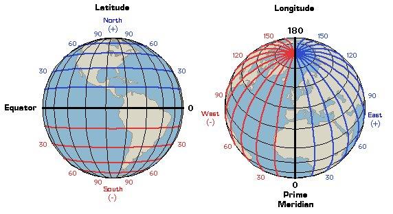
2 What is Latitude? Latitude is defined as a measurement of distance in degrees north and south of the equator The word latitude is derived from the Latin word, latus, meaning wide.
3 What is Latitude There are 90 degrees of latitude from the equator to each of the poles, north and south. Latitude lines are parallel, that is they are the same distance apart These lines are sometimes refered to as parallels.
.")
4 The Equator The equator is the longest of all lines of latitude It divides the earth in half and is measured as 0 (Zero degrees).

5 North and South Latitudes Positions on latitude lines above the equator are called north and are in the northern hemisphere. Positions on latitude lines below the equator are called south and are in the southern hemisphere.
6 Let s take a quiz Pull out your white boards
7 Lines of latitude are Parallel to the equator
8 90 There are degrees of latitude north and south of the equator.
9 The equator is 0 degrees.
10 Another name for latitude lines Parallels is.
11 The equator divides the earth into 2 equal parts.
12 Great Job!!! Lets Continue!

13 What is Longitude? Longitude is defined as measurement of distance in degrees east or west of the prime meridian. The word longitude is derived from the Latin word, longus, meaning length.
14 What is Longitude? The Prime Meridian, as do all other lines of longitude, pass through the north and south pole. They make the earth look like a peeled orange.

15 The Prime Meridian The Prime meridian divides the earth in half too. It is also 0. It passes through the community of Greenwich, England.

16 The International Date Line

17 The International Date Line There are 180 lines of longitude on each side of the prime meridian. But on the opposite side, the primer meridian is not zero degrees but 180. It is called the International Date Line.

18 East and West Longitudes Longitude lines to the left of the prime meridian give locations west, in the western hemisphere. Longitude lines to the right of the primer meridian give locations east, in the eastern hemisphere.

19 Here s another quiz! Pull out your whiteboards again!
20 Longitude lines connect the North pole with the South pole.
21 The line of 0 longitude is called Prime Meridian the.
22 Longitude lines give directions and West East of the prime meridian.
23 180 There are degrees of longitude on each side of the prime meridian.
24 Longitude lines are not Parallel like latitude lines.
25 Great Job! Let s Continue
26
27 Using Latitude and Longitude To fine your exact location on a map, you need to determine which latitude line and which longitude line meet where you are standing. When writing locations, the latitude is given first. For example Miami, Florida, has a location of 25 North and 80 West. This is usually written in a short form as 25 N 80 W
28 Lets Practice Give the Latitude and Longitude of each of the following shapes. Viking Ship 15 N 5 W Hurricane 10 S 5 E Tourist 15 N 15 E Rafter 25 S 10 W Whale 0 N 5 W Canoeists 5 S 20 E Flying Bird 25 N 5 E
29 Do you know what Longitude, Latitude, Longitude, Do you know what Longitude Latitude Mean? Longitude, Latitude, Longitude, Latitude, Yes I know what Longitude Latitude mean. Latitude is the angular distance measured in degrees. It tells how far from the equator anyplace happens to be. North or South from the equator wherever a place may be. Latitude gives the angular distance, scientifically. Do you know what Longitude, Latitude, Longitude. Do you know what Longitude, Latitude Mean? Longitude, Latitude, Longitude, Latitude, Yes, I know what Longitude, Latitude mean. Longitude is the angular distance measured in degrees. It tells how far from Greenwich England anyplace happens to be. East or West from Greenwich England, wherever a place may be, Longitude gives the angular distance, scientifically. Do you know what Longitude, Latitude, Longitude. Do you know what Longitude, Latitude Mean? Longitude, Latitude, Longitude, Latitude, Yes we know what Longitude, Latitude mean.

30 Let s take a another quiz! Do you know what Longitude and Latitude Mean?
31 Name the City located at 30 North and 90 West. New Orleans
32 Name the state that is located entirely between North and West. Iowa
33 The line at 0 Longitude is called what? The Prime Meridian
34 Longitude and Latitude are measured in what? Degrees
35 What is the degrees latitude of the equator? 0
36 Which Picture shows lines of Longitude?
37 Which picture shows the Western Hemisphere?
38 Which picture shows the Southern Hemisphere?

39 The measure that shows how far North of South a place is from the equator is shown in which picture?
40 Great Job!!!!
Complete the following: a. Lines of latitude are parallel to the equator. Name:
 Name: Date: Social Studies Introduction: Basic Geography Period: Latitude Latitude is defined as a measurement of distance in degrees north and south of the equator. The word latitude is derived from the
Latitude and Longitude
 Latitude and Longitude Finding Your Location on a Sphere Coordinate Systems n When you are locating a point on a flat surface you can use Cartesian coordinates of x and y. n The point 2, 3 is plotted on
What are Latitude and Longitude?
 What are Latitude and Longitude? By Encyclopaedia Britannica, adapted by Newsela staff on 08.29.17 Word Count 959 Level 950L A few miles from Quito, Ecuador's capital, is the equator line. It is located
Module 2: Mapping Topic 2 Content: Determining Latitude and Longitude Notes
 Introduction In order to more easily locate points on a globe or map, cartographers designed a system of imaginary vertical lines (also called parallels) and horizontal lines (also called meridians) that
Fundamentals of Satellite technology
 Fundamentals of Satellite technology Prepared by A.Kaviyarasu Assistant Professor Department of Aerospace Engineering Madras Institute Of Technology Chromepet, Chennai Orbital Plane All of the planets,
7a LATITUDE LONGITUDE.notebook. September 19, 2017
 1 PANGEA Add a pangea link to here 2 There are 4 hemispheres Hemispheres are divided using the Equator (north and south) and Prime Meridian (west and east) 3 4 Northern Hemisphere Equator SOUTHERN OCEAN
Maps and Globes. By Kennedy s Korner
 Maps and Globes By Kennedy s Korner Map Key or Symbols Maps use symbols to show places and things on Earth. Symbols are drawings that stand for something real. A map key tells you what each symbol stands
Map Skills Unit. Note taking unit
 Map Skills Unit Note taking unit Introduction To learn about the Earth, we are going to learn about two geographic tools you can use.globes and maps. Globe A globe is a round model of the planet Earth
Latitude and Longitude. Begin
 Latitude and Longitude Begin The Earth is divided in two halves, the top half is called the northern hemisphere, and the bottom half is called the southern hemisphere. The dividing line between the two
Introduction to Geography
 Introduction to Geography What is geography? Geography comes from the Greek word Geographia. Geo means earth and graphia means to describe or chart. Geographers study the earth in relation to space and
... Europe. Based on Bloom s Taxonomy. Environment Interactions Movement. Human & Location. Regions. Place
 ... Europe Location Place Human & Environment Interactions Movement Regions LEVEL 1 Knowledge Match Show or Label List Information Recall Details (5Ws + H) Find Information LEVEL 2 Comprehension Describe
The Coordinate System
 5 The Coordinate System Key Words: latitude, degrees, longitude, prime meridian, absolute location You can locate any place on Earth by using a special set of numbers. These numbers are part of a set of
Introduction to Geography
 Introduction to Geography ropic of Cancer 3½ N Arctic Circle 90 N Prime Meridian 0 Arctic Ocean Mississippi R. Appalachian Mts. Europe Rocky Mountains N. America Atlantic Gulf of Ocean Mexico Caribbean
Latitude and Longitude Pre Test
 Name Date Latitude and Longitude Pre Test Multiple Choice Directions: For questions, 1 10 circle the answer that letter that best answers the question. Each question is worth 1 point each. 1. To locate
CHAPTER 2 SKILL SHEET 2: CELESTIAL NAVIGATION
 CHAPTER 2 SKILL SHEET 2: CELESTIAL NAVIGATION Before the invention of GPS technology, how were people on ships far at sea, out of the sight of land, able to tell where they were? For thousands of years
Standard Indicator That s the Latitude! Students will use latitude and longitude to locate places in Indiana and other parts of the world.
 Standard Indicator 4.3.1 That s the Latitude! Purpose Students will use latitude and longitude to locate places in Indiana and other parts of the world. Materials For the teacher: graph paper, globe showing
page - 1 Laboratory Exercise #1 - Introduction to Latitude and Longitude Northern Hemisphere Southern Hemisphere
 page - 1 Laboratory Exercise #1 - Introduction to Latitude and Longitude A. Introduction There are many methods that can be used to locate ones position on the surface of the earth. A common method for
Latitude. Longitude. Cartography. -Latus wide. -Longus length. Greek Carto meaning "map Graphein meaning "write the study and practice of making maps
 Cartography Greek Carto meaning "map Graphein meaning "write the study and practice of making maps Lines of longitude only Equator added Cross-section through line of longitude Other lines of latitude
Map Skills Lesson 1. Materials: maps, pencils, Lesson 1 Worksheet, strips of paper, grid paper
 Map Skills Lesson 1 Use cardinal directions, map grids, scales, and titles to locate places on a map. Interpret a map using information from its title, compass rose, scale, and legend. Vocabulary: map,
THE EARTH. MERIDIANS AND PARALLELS
 THE EARTH. MERIDIANS AND PARALLELS 1=Circle of latitude 2=Meridian (geography) A circle of latitude, on the Earth, is an imaginary east-west circle connecting all locations (not taking into account elevation)
Earth s Time Zones. Time Zones In The United States
 Name: Mr. DeLeo Date: Period: Earth s Time Zones Goal: Students will understand why humans have developed time zones on Earth, and how to figure out time at different positions on Earth. Background: One
Mapping Earth s Surface Chapter 2 Section 3
 Mapping Earth s Surface Chapter 2 Section 3 Day 1 Objective I will understand maps can be used to find locations on Earth and to represent information about features on Earth s Surface I will understand
Map Making. Chapter 2 Section 1
 Map Making Chapter 2 Section 1 Latitude and Longitude Objectives Compare and contrast latitude and longitude. Describe how time zones vary. Vocabulary cartography equator latitude longitude prime meridian
Stamp Area. Earth Science - Note Packet #6. The shape of the Earth. The Earth is in shape.
 Name: Earth Science - Note Packet #6 Mr. LaFranca s - Period Date: Aim: What are Latitude and Longitude? Do Now: Using the map, where is this location? Stamp Area X The shape of the Earth The Earth is
Five Themes of Geography. By PresenterMed
 Five Themes of Geography By PresenterMed Geography Geography: the study of the Earth Where are things located? Why are they there? Location Location: where a place is Cardinal Directions: North, South,
Unit 1: Geography and Social Studies Skills
 Unit 1: Geography and Social Studies Skills Standard(s) of Learning: WHI.1 The student will improve skills in historical research and geographical analysis by a) Identifying, analyzing, and interpreting
Aerial Photograhy. Brief history of aerial photography
 MAPWORK TOPIC ONE Why do we use maps? Maps are very important tools for geographers because they enable them to record, display and analyse information about people and the environment around them. Maps
1. Write down the term 2. Write down the book definition 3. Put the definition in your own words 4. Draw an image and/or put a Real Life Example
 Unit 1 Vocabulary 1. Write down the term 2. Write down the book definition 3. Put the definition in your own words 4. Draw an image and/or put a Real Life Example Absolute Location Where Is It EXACTLY?
2 Mapping Earth Reading Essentials. 2. Contrast What is the difference between a map view and a profile view?
 Mapping Earth Maps What do you think? Read the three statements below and decide whether you agree or disagree with them. Place an A in the Before column if you agree with the statement or a D if you disagree.
2. What does the map scale tell the map reader? a ratio between the actual distance on the ground and the length given to that distance on a map
 AP Human Geography - Damon Name Unit 1 - Intro to Human Geography Hour Map and Globe Skills Review Note: All links in this packet are found on our Wikispace under Map and Globe Skills Review First, read
CHAPTER EXIT CHAPTER. Models of Earth. 3.1 Modeling the Planet. 3.2 Mapmaking and Technology. 3.3 Topographic Maps CHAPTER OUTLINE
 EXIT CHAPTER.1 Modeling the Planet.2 Mapmaking and Technology. Topographic Maps CHAPTER OUTLINE CHAPTER.1 Modeling the Planet A flat of Earth is a convenient tool, but it can distort the shape, distance,
WHERE ARE YOU? Maps & Geospatial Concepts Fall 2012
 WHERE ARE YOU? Maps & Geospatial Concepts Fall 2012 Where are you? Relative location I m at school Absolute Location 45 26 18.07 122 43 50.78 Datums Datums A reference surface of the Earth Used as the
UNIT 1 THE BASICS OF GEOGRAPHY
 UNIT 1 THE BASICS OF GEOGRAPHY CHAPTER 1 LOOKING AT THE EARTH 1 Section 1.1: The 5 Themes of Geography.Geography comes from a Greek word meaning writing about or describing the earth. Geography is: Geographers
Cartography the art of making maps
 Cartography the art of making maps A map is a drawing or a picture of the earths surface, showing how things are related to each other by distance, direction and size. Maps are used for: Navigation Distance
Meridian Circle through Zenith, North Celestial Pole, Zenith Direction Straight Up from Observer. South Celestial Pole
 Chapter 3 How Earth and Sky Work- Effects of Latitude In chapters 3 and 4we will learn why our view of the heavens depends on our position on the Earth, the time of day, and the day of the year. We will
Name Date Class. a. High elevation and high relief b. High elevation and level surface c. Flat land and low relief
 Exploring Earth s Surface (pp. 21 27) This section describes factors that determine the shape of Earth s land surface. The section also describes how scientists divide Earth into four spheres. Use Target
1. Label a few examples of lines of latitude and lines of longitude on the globe above left.
 Oceanography 2 Location, Direction, and Distance on Nautical Charts Please read Appendix III in the textbook for reference. Learning Objectives for the first nautical chart Lab 1. Use the latitude-longitude
Geographic Grid -Latitudes and Longitudes
 GEOGRAPHY STD 9 Geographic Grid -Latitudes and Longitudes 2018-2019 Q1. Define Geographic Grid. The network of latitudes and longitudes are known as Geographic Grid. They help us to locate places on the
Appearance of the Sky Orientation Motion of sky Seasons Precession (?)
") Today Appearance of the Sky Orientation Motion of sky Seasons Precession (?) The Celestial Sphere Stars at different distances all appear to lie on the celestial sphere. The ecliptic is the Sun s apparent
Today Appearance of the Sky Orientation Motion of sky Seasons Precession (?) The Celestial Sphere Stars at different distances all appear to lie on the celestial sphere. The ecliptic is the Sun s apparent
+ 35º 53ʹ 16ʺ 84º 09ʹ 35ʺ
 + 35º 53ʹ 16ʺ 84º 09ʹ 35ʺ 35º 53ʹ 16ʺ N 84º 09ʹ 35ʺ W (the precise location of Farragut High School!) Spherical Coordinates Mapping a Sphere The student will be able to: HW: 1 Utilize and convert SI units
The World of Geography Pre-Test/Study Guide Chapter 1 Test
 Read each statement or question. On the lines below write the letter of the best answer. 1. Geographers look at the Earth 5. What are the two specific A. by studying cities first. measurements of Earth
Appearance of the Sky Orientation Motion of sky Seasons Precession (?)
") Today Appearance of the Sky Orientation Motion of sky Seasons Precession (?) The Celestial Sphere Stars at different distances all appear to lie on the celestial sphere. The ecliptic is the Sun s apparent
Today Appearance of the Sky Orientation Motion of sky Seasons Precession (?) The Celestial Sphere Stars at different distances all appear to lie on the celestial sphere. The ecliptic is the Sun s apparent
Stamp Area. Earth Science - Note Packet #7. The shape of the Earth. The Earth is shaped like a ball or a. To go completely around the Earth,.
 Name: Earth Science - Note Packet #7 Mr. LaFranca s - Period Aim: What are time zones and why are they important? Date: Stamp Area Do Now: Why do you think East Coast football games start at 1:00 and West
Latitudes and Longitudes
 Latitudes and Longitudes Angles are used to label latitudes and longitudes in order to locate points on our planet. It is a known fact that the earth is approximately a big sphere with a radius that is
What is a map? A Map is a two or three-dimensional model or representation of the Earth s surface. 2-Dimensional map
 What is a map? A Map is a two or three-dimensional model or representation of the Earth s surface. 2-Dimensional map What is a Map Projection? Planar Projection Projection A Projection is a mathematical
Geography Can Be Cool. Seriously
 Geography Can Be Cool Seriously Why does geography matter? Geography: the study of looking at every aspect of the Earth s systems, such as human economies, societies, cultures, plants, animals, & climate.
GEOGRAPHY STD.9 LATITUDE & LONGITUDE
 GEOGRAPHY STD.9 LATITUDE & LONGITUDE 1. What is the Earth Grid? A. The complete network of meridians & parallels is called the earth Grid. 2. What is Latitude? A. The latitude of a place is the distance
GRADE 6 GEOGRAPHY TERM 1 LATITUDE AND LONGITUDE (degrees)
") 1 GRADE 6 GEOGRAPHY TERM 1 LATITUDE AND LONGITUDE (degrees) Contents Lines of Latitude... 2 Lines of Longitude... 3 The hemispheres of The Earth... 4 Finding countries and cities on a map using latitude
1 GRADE 6 GEOGRAPHY TERM 1 LATITUDE AND LONGITUDE (degrees) Contents Lines of Latitude... 2 Lines of Longitude... 3 The hemispheres of The Earth... 4 Finding countries and cities on a map using latitude
1. Geospatial technology rarely links geospatial data to nonspatial data. a. True *b. False
 Chapter 2 Where in the Geospatial World Are You? 1. Geospatial technology rarely links geospatial data to nonspatial data. 2. For geospatial technology to work, every location on Earth must be: a. inhabited
Earth Science Announcements
 Daily Routine Sit in your appropriate seat quietly Have all necessary materials out All back packs on the floor All cell phones on silent and away in backpacks All music devices off and headphones out
Chapter 1 Test on Geography Skills
 Name Score Chapter 1 Test on Geography Skills Part 1 Matching (14 pts.) Match each term in Column B with its correct definition in Column A by clearly writing the number in the blank space provided. Two
FIND PLACES ON GLOBES USING LATITUDE
 GLOBES, MAPS & GRAPHS FIND PLACES ON GLOBES USING LATITUDE AND LONGITUDE LINES FIND PLACES ON MAPS USING A GRID SYSTEM NAME SEVERAL TYPES OF MAP PROJECTIONS AND EXPLAIN THEIR BENEFITS AND SHORTCOMINGS
What Is a Globe? Hemispheres. Main Idea Globes and maps provide different ways of showing features of the earth. Terms to Know
 r Main Idea Globes and maps provide different ways of showing features of the earth. Terms to Know hemisphere latitude longitude scale bar scale relief elevation contour line What Is a Globe? A globe is
Observing the Night Sky: Locating Objects
 Observing the Night Sky: Locating Objects As I left the house this morning, there was a bright bluish light above and to the left of my neighbors house (approximately East) and a big very bright object
Downloaded from
 Geo Globe : Latitudes and Longitudes 1.Suppose the time at 30 east is 2 p.m. then what is the time at Greenwich? (A) 2 p.m. (B) 12 p.m. (C) 1 p.m. (D) Cannot find 2.What does the term 'Grid' mean
THE EARTH AND ITS REPRESENTATION
 UNIT 7 THE EARTH AND ITS REPRESENTATION TABLE OF CONTENTS 1 THE EARTH AND THE SOLAR SYSTEM... 2 2 THE EARTH S MOVEMENTS... 2 2.1 Rotation.... 2 2.2 The revolution of the Earth: seasons of the year....
Lecture #03. January 20, 2010, Wednesday
 Lecture #03 January 20, 2010, Wednesday Causes of Earth s Seasons Earth-Sun geometry Day length Solar angle (beam spread) Atmospheric beam depletion Shape and Size of the Earth North Pole E Geoid: not
Word Cards. 2 map. 1 geographic representation. a description or portrayal of the Earth or parts of the Earth. a visual representation of an area
 Name: Date: Hour: Word Cards 1 geographic representation a description or portrayal of the Earth or parts of the Earth Example: A map is a representation of an actual location or place. 2 map a visual
Where in the World? Plotting Latitude & Longitude
 Where in the World? Plotting Latitude & Longitude Background Because our planet is a sphere, we need two types of reference lines to locate positions on the Earth and to make accurate maps. These imaginary
Latitude & Longitude. Worksheets & activities to teach latitude & longitude. Includes notes, activities, review & all answer keys. 11 pages!
 Latitude & Longitude Worksheets & activities to teach latitude & longitude. Includes notes, activities, review & all answer keys. 11 pages! Lines of Latitude & Longitude Name: Lines of latitude and longitude
1. Match the words in the first column to the meaning in the second column. [5]
![1. Match the words in the first column to the meaning in the second column. [5]](/thumbs/96/126839765.jpg "1. Match the words in the first column to the meaning in the second column. [5]") Exercise 1: [40 POINTS] 1. Match the words in the first column to the meaning in the second column. [5] Equator Around earth between the Equator and the Poles. Greenwich meridian Half of earth. Longitude
Exercise 1: [40 POINTS] 1. Match the words in the first column to the meaning in the second column. [5] Equator Around earth between the Equator and the Poles. Greenwich meridian Half of earth. Longitude
Using Maps. Using Maps. Using Maps. Using Maps
 A is a visual representation, or model, of part or all of the earth. lines are imaginary lines that run east to west around the globe; they are also known as parallels. They show distances in degrees north
GEOL 309 Laboratory Activity: Euler Poles. Name
 GEOL 309 Laboratory Activity: Euler Poles Name Instructions: Follow the directions given. Take a picture (with your phone) of your work showing final pole locations on the globe. Print pictures and turn
Cardinal and Intermediate Directions:
 Name Period Parent Signature Due Date: (TBA) Geography/Map Skills Study Guide Continents and Oceans of the World: Label the continents (7) and oceans (4) on the lines below the map. 1 11 3 5 4 8 2 9 10
MAPPING THE EARTH HOW DO YOU FIND A LOCATION ON THE EARTH?
 MAPPING THE EARTH HOW DO YOU FIND A LOCATION ON THE EARTH? UNIT TOPICS TOPIC 1: LATITUDE & LONGITUDE TOPIC 2: FIELD MAPS TOPIC 3: TOPOGRAPHIC MAPS TOPIC 4: NYS LANDSCAPES TOPIC 1: LATITUDE & LONGITUDE
SAMPLE. Succeeding in Social Studies 5 6 TH IN A SERIES OF 7. Years 5 9. Written by Valerie Marett. CORONEOS PUBLICATIONS Item No 508
 AUSTRALIAN HOMESCHOOLING SERIES Succeeding in Social Studies 5 6 TH IN A SERIES OF 7 Years 5 9 Written by Valerie Marett CORONEOS PUBLICATIONS Item No 508 Contents Notes to Parents.2 Latitude and Longitude...3
Why does Earth rotate and what s the evidence? (besides watching it from space ships or satellites) Week 18 January 5, 2015
 Week 18 January 5, 2015") Why does Earth rotate and what s the evidence? (besides watching it from space ships or satellites) Week 18 January 5, 2015 The sun determines our solar time everywhere on earth as Earth rotates. Can you
Why does Earth rotate and what s the evidence? (besides watching it from space ships or satellites) Week 18 January 5, 2015 The sun determines our solar time everywhere on earth as Earth rotates. Can you
Chapter 3 SECTION 1 OBJECTIVES
 Chapter 3 SECTION 1 OBJECTIVES Distinguish between latitude and longitude and locate coordinates on maps. Explain how latitude and longitude can be used to locate places on Earth s surface. Explain the
Lesson 20: The Earth in its Orbit
 291 Lesson 20: The Earth in its Orbit Recall that the Earth s orbit around the un is an ellipse which is almost a perfect circle. The average distance from the un to the Earth is 152,100,000 km (to the
Lesson found on
 Katarzyna Sieminska Terrabagga Activity Using a Magnetometer Lesson found on http://www.windows.ucar.edu/tour/link=/teacher_resources/magnetism/teach_terrabagga.html Grade Level: 8 th grade Time allotted
Coordinate Systems. Location on earth is defined by coordinates
 Coordinate Systems We think of the earth as a sphere It is actually a spheroid (ellipsoid), slightly larger in radius at the equator than at the poles Shape of the Earth Location on earth is defined by
1. Which graph best represents the altitude of Polaris observed at northern latitude positions on the Earth's surface?
 1. Which graph best represents the altitude of Polaris observed at northern latitude positions on the Earth's surface? A) 4. The diagram below shows an observer measuring the altitude of Polaris. B) C)
Global Weather Trade Winds etc.notebook February 17, 2017
 Global Weather 1 north pole northern hemisphere equator southern hemisphere south pole 2 We have seasons because of the Earth's tilt The seasons are opposite in the northern and southern hemispheres winter
Time Zones. Doug Fischer Geog 106 LRS
 Time Zones Doug Fischer Geog 106 LRS Learning goals Students should be able to Explain time zones as a function of longitude Calculate time differences between different locations Demonstrate corrections
Chapter 3 Models of the Earth. 3.1 Finding Locations on the Earth. 3.1 Objectives
 Chapter 3 Models of the Earth 3.1 Finding Locations on the Earth 3.1 Objectives Explain latitude and longitude. How can latitude and longitude be used to find locations on Earth? How can a magnetic compass
Latitude and Longitude:
 Latitude and Longitude: Finding Locations on Planet Earth. With thanks and credit to Step.com Typical Graph This is an example of a typical graph. It is made up of points that are connected by a line.
ASTRONOMY. Chapter 4 EARTH, MOON, AND SKY PowerPoint Image Slideshow
 ASTRONOMY Chapter 4 EARTH, MOON, AND SKY PowerPoint Image Slideshow FIGURE 4.1 Southern Summer. As captured with a fish-eye lens aboard the Atlantis Space Shuttle on December 9, 1993, Earth hangs above
Local Coordinates. These are centered upon you, the observer.
 Astronomy 30, Observing #3 Name: Lab Partners: Date: Materials: This lab, with the star chart completed from the pre-lab. Some sheets of paper for sketches. A pencil with eraser. A small flashlight, ideally
 Name Period Parent Signature Geography/Map Skills Study Guide *For extra practice with these skills, check out Mr. Kath s website: http://rkath.weebly.com/activities--links.html Continents and Oceans of
LONGITUDE AND LATITUDE. Semi great circles joining the true or geographic poles of the earth (true meridians).
.") MERIDIANS OF LONGITUDE LONGITUDE AND LATITUDE Semi great circles joining the true or geographic poles of the earth (true meridians). They are measured from 0 to 180 degrees East and West of the PRIME MERIDIAN,
MERIDIANS OF LONGITUDE LONGITUDE AND LATITUDE Semi great circles joining the true or geographic poles of the earth (true meridians). They are measured from 0 to 180 degrees East and West of the PRIME MERIDIAN,
2017LearnedLessons. Mapping Skills
 Mapping Skills Geography Mapsà Flat representation of the earth Globeà round representation of the earth, truer representation Types of Maps & Uses General Purpose Mapsà show a wide range of information
Shape of Earth, Cycles, Distribution of Water
 Shape of Earth, Cycles, Distribution of Water What is the shape of Earth? A. Spherical B. Apple-shaped C. Pear-shaped Shape of the Earth It should be spherical: Earth condensed under gravity, thus everything
Shape of Earth, Cycles, Distribution of Water
 Shape of Earth, Cycles, Distribution of Water What is the shape of Earth? A. Spherical B. Apple-shaped C. Pear-shaped Shape of the Earth It should be spherical: Earth condensed under gravity, thus everything
2010 Teacher Created Resources, Inc.
 Editor Sara Connolly Illustrators Kevin McCarthy Mark Mason Cover Artist Brenda DiAntonis Editor in Chief Ina Massler Levin, M.A. Creative Director Karen J. Goldfluss, M.S. Ed. Art Coordinator Renée Christine
Period: Name: Astronomy Part 3A. Earth s Rotation: Video Notes Sheets. Earth Science with Mr. Sammartano Hommocks Middle School, Team 8-3
 Name: Period: Astronomy Part 3A Earth s Rotation: Video Notes Sheets Earth Science with Mr. Sammartano Hommocks Middle School, Team 8-3 PROOF #1 What is the Shape of the Earth? How do we know the Earth
Spherical Geometry HSC. Name:
 Spherical Geometry HSC Name: C:\Documents and Settings\tracey_h-butters\Desktop\mathematics\year_levels\math_stage6\General\hsc\spherical_geometry\spherical_geo_notes.doc 1 HSC CAPACITY MATRIX GENERAL
Section 2. Locating Astronomical Objects in the Night Sky What Do You See? What Do You See? Think About It. Investigate.
 Section 2 Locating Astronomical Objects in the Night Sky Section 2 Locating Astronomical Objects in the Night Sky What Do You See? What Do You See? Learning Outcomes In this section, you will Construct
CHAPTER II THE COORDINATES SYSTEM AND FORMULARIES
 CHAPTER II THE COORDINATES SYSTEM AND FORMULARIES www.loxodrome.org/ Introduction to Celestial Navigation/Chapter II THE CO-ORDINATES SYSTEMS AND FORMULARIES In previous section we had a purely geometrical
The Spinning Earth Key Stage 2
 The Spinning Earth Key Stage 2 Topics covered: Earth, Sun, day and night, time, angles, fractions Teacher s Notes In this activity pupils are introduced to the rotating Earth and the concept of longitude.
Unit 1: Mapping and Astronomy
 Unit 1: Mapping and Astronomy 1 Do Now In your notebook, write your thoughts on the following: -What do you know about the beginning location and trajectory of the most recent hurricanes (Harvey or Irma)?
What is the shape of Earth?
 Shape of Earth, Cycles, Distribution of Water 1 What is the shape of Earth? A. Spherical B. Apple-shaped C. Pear-shaped 2 Draw shape of the Earth 3 1 Shape of the Earth It should be spherical: Earth condensed
GLOBE : LATITUDES AND LONGITUDES
 2 Figure 2.1 : Globe Let s Do Take a big round potato or a ball. Pierce a knitting needle through it. The needle resembles the axis shown in a globe. You can now move the potato or the ball around this
TIME. Astronomical time Time is defined by astronomical cycles. The day is the average time from noon to noon (the solar day).
.") ASTRONOMY READER TIME 2.1 TIME Astronomical time Time is defined by astronomical cycles. The day is the average time from noon to noon (the solar day). The month was originally based on the average time
ASTRONOMY READER TIME 2.1 TIME Astronomical time Time is defined by astronomical cycles. The day is the average time from noon to noon (the solar day). The month was originally based on the average time
EARTHS SHAPE AND POLARIS PRACTICE 2017
 1. In the diagram below, letters A through D represent the locations of four observers on the Earth's surface. Each observer has the same mass. 3. Which diagram most accurately shows the cross-sectional
COMPUTER ACTIVITY 3: THE SEASONS: LENGTH OF THE DAY
 NAME ASTRONOMY 20 SECTION DAY/ S. V. LLOYD COMPUTER ACTIVITY 3: THE SEASONS: LENGTH OF THE DAY Overview Software Configuration The seasonal variation in temperature is due to two changes in the Sun's path
IR-4: Classroom Grid Region 4 Education Service Center Geography by Design, Volume 1
 IR-4: Classroom Grid 2013 Region 4 Education Service Center Geography by Design, Volume 1 IR-5: Latitude/Longitude Coordinates Location Latitude Longitude 35 N 139 E 11 N 104 E 1 N 103 E 18 N 72 E 59 N
Map Skills Test. 1. What do we call a person who makes maps? a. mapographer b. cartographer c. geologist d. archaeologist
 Map Skills Test 1. What do we call a person who makes maps? a. mapographer b. cartographer c. geologist d. archaeologist 2. What is the name of the 0 latitude line? a. Equator b. Arctic Circle c. First
6/17. Universe from Smallest to Largest:
 6/17 Universe from Smallest to Largest: 1. Quarks and Leptons fundamental building blocks of the universe size about 0 (?) importance: quarks combine together to form neutrons and protons. One of the leptons
What do we call someone who makes maps? CARTOGRAPHER
 What do we call someone who makes maps? CARTOGRAPHER 1 Maps Political Maps - show boundaries of states, countries, counties, etc... - These are man made boundaries Physical Maps - show landforms (volcanoes,
Chapter 2 - Lessons 1 & 2 Studying Geography, Economics
 Chapter 2 - Lessons 1 & 2 Studying Geography, Economics How does geography influence the way people live? Why do people trade? Why do people form governments? Lesson 1 - How Does Geography Influence the