INDONESIA S S UPDATE: GEOSPATIAL INFORMATION FOR SUSTAINABLE DEVELOPMENT RELATED TO INA SDI Dr. Asep Karsidi, M.Sc
|
|
|
- Monica Booth
- 6 years ago
- Views:
Transcription


1 INDONESIA S S UPDATE: GEOSPATIAL INFORMATION FOR SUSTAINABLE DEVELOPMENT RELATED TO INA SDI Dr. Asep Karsidi, M.Sc GEOSPATIAL INFORMATION AGENCY 08 August, 2012
2 OUTLINE 1. Transformation Bakosurtanal into The Geospatial Information Agency; 2. Indonesian Spatial Data Infrastructure (Ina SDI) Development 3. Indonesian Geoportal Development and Initial Activity to Setup collaboration between BIG, CSIRO and UNSDI to develop gazetteer application for Social Protection

3 GEOSPATIALLY PROBLEMS FOOD SECURITY SMALL ISLANDS DEVELOPMENT GOOD GOVERNANCE DEVELOPMENT MONITORING CLIMATE CHANGE POVERTY ERADICATION BORDER MONITORING IMPLEMENTATION OF LAW OF GEOSPATIAL INFORMATION DEMOGRAPHY CORRUPTION IMPLEMENTATION OF PUBLIC INFORMATION TRANSPARENCY SOCIAL CONFLICT POLITICS INFRASTRUCTURE DEFICIENCY FARMING DEFORESTATION AND LAND DEGRADATION DEFENSE SARS TERORISM FINANCIAL CRISES RESPONSES FUNDING OPTIMALIZATION ENVIRONMENT ISSUES DISASTER MANAGEMENT COLLABORATION AND SINERGY FROM ALL STAKEHOLDERS IS A MUST! OPPORTUNITY FOR GOVERNMENT AND INDUSTRY TO FORM PUBLIC PRIVATE PARTNERSHIP INDONESIAN UPDATE: DEVELOPMENT OF GEOSPATIAL INFORMATION ASEP KARSIDI Page 3
4 GEOSPATIAL DATA FOR SUSTAINABLE DEVELOPMENT ± 90% of Government Activities has Geospatial Element HYDROGRAPHIC BUILDING AND PUBLIC FACILITY TRANSPORTATION LAND COVER HYPSOGRAPHIC ADMIN BOUNDARY COAST LINE GEOSPATIAL REFERENCE TOPONYM/ GAZETTEERS GEOSPATIAL DATABASE GEOLOGY DEMOGRAPHY VEGETATION SOIL BIODIVERSITY METEOROLOGY DISASTER SPATIAL PLANNING etc. ± 65% of Government Activities use Geospatial Element as Primary Identifier SDGs 11 PRIORITIES OF NATIONAL DEVELOPMENT MDGs POST Gazetteers: Indexes of spatial identifiers; Can be used to achieve interoperability INDONESIAN UPDATE: DEVELOPMENT OF GEOSPATIAL INFORMATION ASEP KARSIDI Page 4


5 POLICY UPDATE: RULE OF LAW LAW NO. 4 YEAR 2011 GEOSPATIAL INFORMATION AGENCY BADAN INFORMASI GEOSPASIAL (BIG) INDONESIAN UPDATE: DEVELOPMENT OF GEOSPATIAL INFORMATION ASEP KARSIDI Page 5

6 INSTITUTIONAL TRANSFORMATION BAKOSURTANAL THE NATIONAL BODY OF TRUSTEE IN THE FIELD OF SURVEYS, MAPPING AND SDI GEOSPATIAL INFORMATION AGENCY (BIG) THE NATIONAL ORGANIZER IN THE FIELD OF THE TOPOGRAPHIC SURVEY, BASE MAPPING,, AND SPATIAL DATA INFRASTRUCTURE NATIONAL COORDINATING BODY FOR DEVELOPMENT OF THEMATIC MAPPING PING INDONESIAN UPDATE: DEVELOPMENT OF GEOSPATIAL INFORMATION ASEP KARSIDI Page 6


7 POLICY UPDATE: OUTSTANDING SUPPORTS FROM OUR LEADER President S.B. Yudoyono...Geospatial data are needed by all government institutions and communities to improve quality of decisions making in all aspects of national developments.
")


8 POLICY UPDATE: PRINCIPLES OF INDONESIAN SDI (ina-sdi) INTEGRATION OF: INSTITUTIONAL ARRANGEMENT, POLICY, TECHNOLOGY, STANDARDIZED DATA, AND HUMAN RESOURCES TO FORM SUPPORTIVE ENVIRONMENT FOR USERS. INA SDI FACILITATING DISCOVERY, ACCESS, EVALUATION AND USAGE ACCURATE AND ACCOUNTABLE GEOSPATIAL INFORMATION EASILY AND ECONOMICALLY. INDONESIAN UPDATE: DEVELOPMENT OF GEOSPATIAL INFORMATION ASEP KARSIDI Page 8

")


")


9 POLICY UPDATE: MILESTONE OF INDONESIAN SDI (ina ina-sdi) NSDI DEVELOPMENT KICK OFF PRESIDEN DECREE No. 85/2007 GEOSPATIAL LAW (4/2011) INA-GEOPORTAL SOFT LAUNCH INA-SDI IMPROVEMENT BUSINESS CONTINUITY BAKOSURTANAL PERMANTE KAARTERINGS-COMMISSIE GEOSPATIAL INFORMATION AGENCY INDONESIAN UPDATE: DEVELOPMENT OF GEOSPATIAL INFORMATION ASEP KARSIDI Page 9


10 SDI UPDATE: TYPICAL STRUCTURE 57 MINISTRIES/AGENCIES, 33 PROVINCES, & 500 MUNICIPALITIES PROVINCE CUSTODIAN SPATIAL DATA CENTER DATA CENTER CLEARING- HOUSE UNIT GEONAMES AUTHORITY SECRETARIAT NATIONAL GEONAMES DATABASE METADATA CATALOG PORTAL CUSTODIAN CUSTODIAN DATA CENTER GEOPORTAL NASIONAL DATA CENTER UNIT AGENCY BEAUREAU MUNICIPAL (NODE) METADATA CATALOG PORTAL CITY (NODE) METADATA CATALOG PORTAL METADATA CATALOG PORTAL DATA CENTER CUSTODIAN CUSTODIAN OFFICE INDONESIAN UPDATE: DEVELOPMENT OF GEOSPATIAL INFORMATION ASEP KARSIDI Page 10


11 ELEMENTS OF NETWORK NODE 57 MINISTRIES/AGENCIES, 33 PROVINCES, & 500 MUNICIPALITIES COMPETENCE SERTIFICATION FUNCTIONAL CAPACITY BUILDING FORMAL EDUCATION INSTITUTIONAL ARRANGEMENT NETWORK NODE THEMATIC MAPPING SPECIALIZATION GEODESY & GEOMATICS GIS INFORMATION TECH REMOTE SENSING RULE OF LAWS LAW NO. 4/2011 PRES DECREE NO.85/2007 LOCAL GOV T RULES CLEARINGHOUSE UNIT DISTRIBUTION & ACCESS DATA SHARING STANDARDIZATION DATA METADATA ACCESS DEVELOPING AN SDI IS MORE THAN TO SETUP INFORMATION TECHNOLOGY INDONESIAN UPDATE: DEVELOPMENT OF GEOSPATIAL INFORMATION ASEP KARSIDI Page 11
12 SDI UPDATE: INA GEOPORTAL ONE MAP, ONE GATE, ONE SOLUTION sdi.or.id : MAIN FUNCTIONS: SEARCH & DISCOVER INTEGRATE SHARE DATA AND APPS PRODUCE THE MAPS PUBLISH MAPS ACCESS VIA MOBILE DEVICE EMPOWER CITIZENS TO USE ACCOUNTABLE GEOSPATIAL INFORMATION HOSTING PILOT PROJECT OF UNSDI


;")


")

13 SDI UPDATE: INA GEOPORTAL EXAMPLE IN SUSTAINABLE DEVELOPMENT sdi.or.id: Power Plant MW Phase I (ESDM); Spatial Planning BAPPENAS State Border; Provincial Border; Land Cover; Gazetteer sdi.or.id Poverty Line (BPS) Road Network sdi.or.id: Environment Ecoregion
14 INDONESIA UPDATE: INA GEOPORTAL EXAMPLE IN DISASTER MANAGEMENT FACILITATING ALL LEVEL OF DECISION MAKINGS TO COLLABORATE FOR DISASTER RESPONSES WITH ACCURATE AND ACCOUNTABLE GEOSPATIAL INFORMATION INDONESIAN UPDATE: DEVELOPMENT OF GEOSPATIAL INFORMATION ASEP KARSIDI Page 14


15 SDI UPDATE: CLOUD EXPANSION SERVICING GEOSPATIAL INFORMATION TO LOCAL GOVERNMENTS Overcoming Variety of Indonesia s Data Communication Infrastructure Minimum Client s Resources Requirement Desktop Mobile Web Clients (RIAs) Bandwidth Consolidation Feeding Mobile GIS Cloud Computing Desktop Server INDONESIAN UPDATE: DEVELOPMENT OF GEOSPATIAL INFORMATION ASEP KARSIDI Page 15


16 GEONAMES UPDATE: UNSDI NATIONAL GAZETTEER SDI GAZETTEER FRAMEWORK PRIMARY IDENTIFIER FOR WHERE REGISTRATION AND IDENTITY OF SPATIAL REFERENCES SPATIAL BOOKMARKS STABILITY PREDICTABILITY PERSISTENCE FOR USE TO REFERENCE OTHER INFORMATION SUPPORTS INDONESIAN SDI EFFORTS UN SCOPE BUILD UNSDI

17 GEONAMES UPDATE: UNSDI NATIONAL GAZETTEER SDI GAZETTEER FRAMEWORK FOR SOCIAL PROTECTION SOCIAL PROTECTION PREVENTING, MANAGING, AND OVERCOMING SITUATIONS THAT ADVERSELY AFFECT PEOPLE S WELL BEING. [1] POLICIES AND PROGRAMS TO REDUCE POVERTY AND VULNERABILITY REDUCING EXPOSURE, ENHANCING CAPACITY TO MANAGE RISKS MULTI SECTORAL INFORMATION ACCURATE UP TO DATE TIMELY INTEGRATED PRESENTED IN MEANINGFUL WAYS 1 United Nations Research Institute For Social Development INDONESIAN UPDATE: DEVELOPMENT OF GEOSPATIAL INFORMATION ASEP KARSIDI Page 17


18 INDONESIA UPDATE: GAZETTEER GAZETTEER FOR SOCIAL PROTECTION User BIG CSIRO UNSDI SDI Geoportal Gazetteer framework Access and Use Discovery ArcGIS Social Protection Applications User CUSTODIAN WFS (G) DATA GAZETTEERS INA SDI UNSDI PCGIAP SDI INFRASTRUCTURE THE GAZETTEER FRAMEWORK Set of Integrated Index to Spatial Data Across SDIs INDONESIAN UPDATE: DEVELOPMENT OF GEOSPATIAL INFORMATION ASEP KARSIDI Page 18


19 INDONESIA UPDATE: INA SDI AND SOCIAL PROTECTION GAZETTEER data & framework national library imagery ina-sdi Cloud Computing national SDI geoportal Geo-ICT cloud computing NAMING MAPPING global effort social media MAPPING DELIVERY USAGE OF GAZETTEER FRAMEWORK WILL SUPPORT NATIONAL S S PROBLEM SOLVING! INDONESIAN UPDATE: DEVELOPMENT OF GEOSPATIAL INFORMATION ASEP KARSIDI Page 19
20 SUMMARY
21 THANK YOU
SDI DEVELOPMENT UPDATES OF INDONESIA
 SDI DEVELOPMENT UPDATES OF INDONESIA DR. ANTONIUS B. WIJANARTO Center For Management And Dissemination Of Geospatial Information GEOSPATIAL INFORMATION AUTHORITY GOVERNMENT OF THE REPUBLIC OF INDONESIA
One Map Policy to Support National Development in Indonesia
 One Map Policy to Support National Development in Indonesia Dr. Nurwadjedi Sarbini Deputy of Thematic Geospatial Information Geospatial Information Agency (BIG) Geosmart Asia, September 29 October 1, 2015
Strengthening Geospatial Information Management in Indonesia
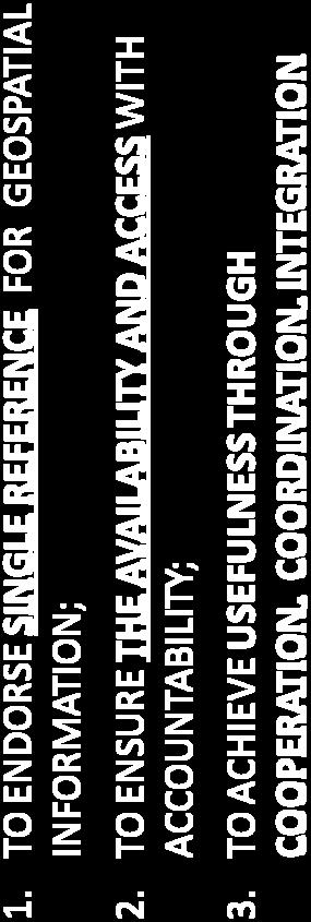
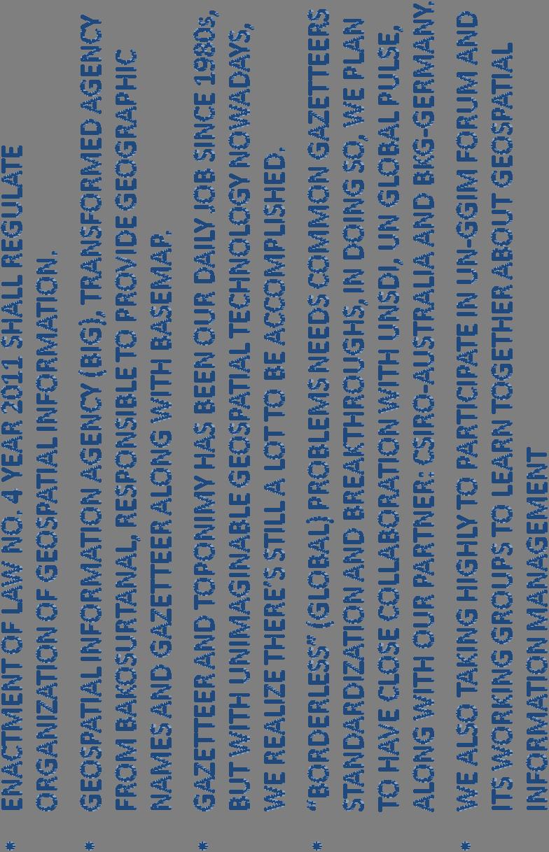
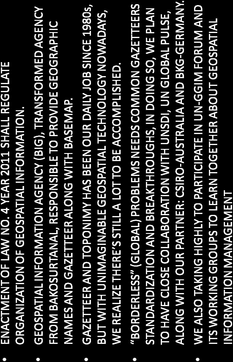
 b Strengthening Geospatial Information Management in Indonesia Prof. Dr. Hasanuddin Z. Abidin Head (President) Geospatial Information Agency of Indonesia The 5 th High Level Forum United Nations Global
Voices from Private Sector: Insights for Future NSDI Development in Indonesia
 Voices from Private Sector: Insights for Future NSDI Development in Indonesia Ta n d a n g Yu l i a d i D w i P u t ra, Ryosuke S h i b a s a k i I n st i t u t e o f I n d u st r i a l S c i e n c e,
Realizing benefits of Spatial Data Infrastructure A user s perspective from Environment Agency - Abu Dhabi
 Realizing benefits of Spatial Data Infrastructure A user s perspective from Environment Agency - Abu Dhabi Anil Kumar Director, Environment Information Management 26 April 2012 Geospatial World Forum,
The Role Of Ina-SDI For Disaster Management
 The Second UN-GGIM-AP Plenary Meeting The Role Of Ina-SDI For Disaster Management Indonesia Tehran - Iran 28 October 2013 Dodi Sukmayadi Geospatial Information Authority of Indonesia (BIG) COMPONENT FOR
Building a National Data Repository
 Building a National Data Repository Mladen Stojic, Vice President - Geospatial 1/30/2013 2012 Intergraph Corporation 1 Information has meaning and gives power only when shared and distributed. Information,
GIS Building Communities beyond National Borders (Building Successful Spatial Data Infrastructures) Nick Land, ESRI Europe
 Nick Land, ESRI Europe") GIS Building Communities beyond National Borders (Building Successful Spatial Data Infrastructures) Nick Land, ESRI Europe UK worst flooding in the last 60 years 350,000 households without drinking water
GIS Building Communities beyond National Borders (Building Successful Spatial Data Infrastructures) Nick Land, ESRI Europe UK worst flooding in the last 60 years 350,000 households without drinking water
Key Points Sharing fosters participation and collaboration Metadata has a big role in sharing Sharing is not always easy
 Sharing Resources Geoff Mortson esri, Inc. SDI Solutions Team Key Points Sharing fosters participation and collaboration Metadata has a big role in sharing Sharing is not always easy Data Sharing is Good
US National Spatial Data Infrastructure A Spatial Framework for Governance and Policy Development to Enable a Location-Based Digital Ecosystem
 GeoPlatform Workshop 7 Dec 2016, Department of the Interior Washington, D.C. US National Spatial Infrastructure A Spatial Framework for Governance and Policy Development to Enable a Location-Based Digital
Land Account : Indonesia
 Land Account : Indonesia Outline Environmental concerns Approach in compiling land account Results: Sumatera Land Account, Experimental Estimates Challenges Policy applications Further work Environmental
CLICK HERE TO KNOW MORE
 CLICK HERE TO KNOW MORE GeoSpace for Singapore s Whole-of-Government Data Sharing Asia GeoSpatial Forum 17 19 Oct 2011 Lee Kim Haw Singapore Land Authority Introducing Singapore Land Authority Limited
Ministry of ICT of I.R.IRAN
 The ECO 8/6 mill km 2 10 Slamic countries ~330 mill people Oil, Gas, Industries,Tourism 2 Issue transformation in last decade Problem solving needs more integrated approach More interaction &complexity
Proposal for a DIRECTIVE OF THE EUROPEAN PARLIAMENT AND OF THE COUNCIL. establishing an infrastructure for spatial information in the Community
 Proposal for a DIRECTIVE OF THE EUROPEAN PARLIAMENT AND OF THE COUNCIL establishing an infrastructure for spatial information in the Community INSPIRE http://inspire.jrc.it/ Alessandro Annoni 1 EU Commission
Development of Geospatial Information in Indonesia: Progress & Challenge
 Development of Geospatial Information in Indonesia: Progress & Challenge Dr. Nurwadjedi Sarbini Deputy of Thematic Geospatial Information Geospatial Information Agency (BIG) Geosmart Asia, September 29
Spatial Data Infrastructure Concepts and Components. Douglas Nebert U.S. Federal Geographic Data Committee Secretariat
 Spatial Data Infrastructure Concepts and Components Douglas Nebert U.S. Federal Geographic Data Committee Secretariat August 2009 What is a Spatial Data Infrastructure (SDI)? The SDI provides a basis for
GIS (GEOGRAPHICAL INFORMATION SYSTEMS) AS A FACILITATION TOOL FOR SUSTAINABLE DEVELOPMENT IN AFRICA
 AS A FACILITATION TOOL FOR SUSTAINABLE DEVELOPMENT IN AFRICA") GIS (GEOGRAPHICAL INFORMATION SYSTEMS) AS A FACILITATION TOOL FOR SUSTAINABLE DEVELOPMENT IN AFRICA a presentation by Elizabeth Hicken GDEST Conference on Geospatial Sciences for Sustainable Development
GIS (GEOGRAPHICAL INFORMATION SYSTEMS) AS A FACILITATION TOOL FOR SUSTAINABLE DEVELOPMENT IN AFRICA a presentation by Elizabeth Hicken GDEST Conference on Geospatial Sciences for Sustainable Development
UN GGIM and National SDI Strategy
 MSDI Open Forum on 26 th January 2016 Contributing to the successful delivery of MSDI UN GGIM and National SDI Strategy Hiroshi Murakami Deputy Administrator Geospatial Information Authority of Japan Geospatial
SDI Development in Georgia. Mari Khardziani Head of International Relations Unit National Agency of Public Registry
 SDI Development in Georgia Mari Khardziani Head of International Relations Unit National Agency of Public Registry Kehl, Germany September 5, 2017 2 National Agency of Public Registry Legal Entity of Public
Brazil Paper for the. Second Preparatory Meeting of the Proposed United Nations Committee of Experts on Global Geographic Information Management
 Brazil Paper for the Second Preparatory Meeting of the Proposed United Nations Committee of Experts on Global Geographic Information Management on Data Integration Introduction The quick development of
Arctic Spatial Data Infrastructure Enabling Access to Arctic Location-Based Information
 Arctic Spatial Data Infrastructure Enabling Access to Arctic Location-Based Information Arctic SDI Side Event Co-Chairs: Arvo Kokkonen Arctic SDI Board Chair & Director General, National Land Survey of
INSPIRE Basics. Vlado Cetl European Commission Joint Research Centre. https://ec.europa.eu/jrc/
 INSPIRE Basics Vlado Cetl European Commission Joint Research Centre https://ec.europa.eu/jrc/ Serving society Stimulating innovation Supporting legislation Outline SDI? Why European SDI? INSPIRE Policy
Disaster Management & Recovery Framework: The Surveyors Response
 Disaster Management & Recovery Framework: The Surveyors Response Greg Scott Inter-Regional Advisor Global Geospatial Information Management United Nations Statistics Division Department of Economic and
INSPIREd solutions for Air Quality problems Alexander Kotsev
 INSPIREd solutions for Air Quality problems Alexander Kotsev www.jrc.ec.europa.eu Serving society Stimulating innovation Supporting legislation The European data puzzle The European data puzzle 24 official
The GIS Path Forward Saskatchewan s Geomatics Strategic Plan
 The GIS Path Forward Saskatchewan s Geomatics Strategic Plan John Potter, SK Ministry of Central Services Office of Geomatics Coordination Sept.17/13 Table of Contents 1. 2011-2016, Geomatics Strategic
Building Institutional Capacity for Multi-Hazard Early Warning in Pacific Countries Subtitle
 Building Institutional Capacity for Multi-Hazard Early Warning in Pacific Countries Subtitle Title Keran Wang Chief, Space Applications Section ICT and Disaster Risk Reduction Division 30 March 2018 Slide
2007 / 2008 GeoNOVA Secretariat Annual Report
 2007 / 2008 GeoNOVA Secretariat Annual Report Prepared for: Assistant Deputy Minister and Deputy Minister of Service Nova Scotia and Municipal Relations BACKGROUND This report reflects GeoNOVA s ongoing
COUNTRY REPORT THE SEVENTEENTH PERMANENT COMMITTEE ON GIS INFRASTRUCTURE FOR ASIA AND THE PACIFIC (PCGIAP) MEETING JULY 21 22, 2011,
 MEETING JULY 21 22, 2011,") COUNTRY REPORT INDONESIA ACTIVITIES IN 2010 THE SEVENTEENTH PERMANENT COMMITTEE ON GIS INFRASTRUCTURE FOR ASIA AND THE PACIFIC (PCGIAP) MEETING JULY 21 22, 2011, CHINGGIS KHAAN HOTEL, ULAANBAATAR CITY,
COUNTRY REPORT INDONESIA ACTIVITIES IN 2010 THE SEVENTEENTH PERMANENT COMMITTEE ON GIS INFRASTRUCTURE FOR ASIA AND THE PACIFIC (PCGIAP) MEETING JULY 21 22, 2011, CHINGGIS KHAAN HOTEL, ULAANBAATAR CITY,
THE ROLE OF GEOSPATIAL AT THE WORLD BANK
 THE ROLE OF GEOSPATIAL AT THE WORLD BANK INSPIRE Conference Barcelona, Spain September 26, 2016 Kathrine Kelm Senior Land Administration Specialist Global Land and Geospatial Unit The World Bank Group
ArcGIS for INSPIRE. Marten Hogeweg
 ArcGIS for INSPIRE Marten Hogeweg Please Take Our Survey on the App Download the Esri Events app and find your event Select the session you attended Scroll down to find the feedback section Complete answers
a national geological survey perspective François ROBIDA BRGM (French Geological Survey)
") a national geological survey perspective François ROBIDA BRGM (French Geological Survey) Pre-Conference Seminar on Socio-Economic Value of Geospatial for National and Regional Development 21 August 2017,
a national geological survey perspective François ROBIDA BRGM (French Geological Survey) Pre-Conference Seminar on Socio-Economic Value of Geospatial for National and Regional Development 21 August 2017,
Spatially Enabled Society
 International Seminar on Land Administration Trends and Issues in Asia and the Pacific Region Spatially Enabled Society Abbas Rajabifard Vice Chair PCGIAP-WG3 Vice-President (President Elect), GSDI Association
Welcome. C o n n e c t i n g
 Welcome C o n n e c t i n g YOU D i s c i p l i n e s Why is This Meeting......So Important Now? OUR WORLD Is Increasingly Challenged The Evidence Is Clear We Need Better Understanding and More Collaboration
Norwegian spatial data infrastructure supporting disaster risk management Norwegian Mapping Authority
 Norwegian spatial data infrastructure supporting disaster risk management Norwegian Mapping Authority Arvid Lillethun, Norwegian Mapping Authority Land and Poverty 2018 Conference, World Bank 19.-23. March
Building Institutional Capacity for Multi-Hazard Early Warning in Asia and the Pacific Subtitle
 Building Institutional Capacity for Multi-Hazard Early Warning in Asia and the Pacific Subtitle Title Keran Wang Chief, Space Applications Section ICT and Disaster Risk Reduction Division 22 May 2018 Pillar
INSPIRE - A Legal framework for environmental and land administration data in Europe
 INSPIRE - A Legal framework for environmental and land administration data in Europe Dr. Markus Seifert Bavarian Administration for Surveying and Cadastre Head of the SDI Office Bavaria Delegate of Germany
Upgrade the Datasets in NSDI for Smarter Services with the Cases of China
 Upgrade the Datasets in NSDI for Smarter Services with the Cases of China By Dr. JIANG Jie Dept of GeoInformaiton Service Platform National Geomatics Center of China October 7, 2015 Jeju, Republic of Korea
The Integrated Ge spatial Information Framework to the strengthening of NSDI, Mongolia
 Young Geospatial Professionals Summit 21 NOV 2018 The Integrated Ge spatial Information Framework to the strengthening of NSDI, Mongolia BAYARMAA ENKHTUR Geospatial information and technology department
Oman NSDI Business Values and Future Directions. Hassan Alawi Alghazali Acting Director General National Spatial Data Infrastructure
 Oman NSDI Business Values and Future Directions Hassan Alawi Alghazali Acting Director General National Spatial Data Infrastructure Presentation Outline Geospatial Maturity Current Challenges NCSI s Role
IDEBarcelona: Cooperating for a Smart Region Infrastructure
 IDEBarcelona: Cooperating for a Smart Region Infrastructure Marta Codinachs Serra Diputació de Barcelona Territory and Sustainability Area Territorial Information Systems Department SMART CITY EXPO WORLD
Land Board, NW Services and SDI Tambet Tiits, FRICS
 Land Board, NW Services and SDI Tambet Tiits, FRICS 07.09.2016 200th anniversary of the Struve Geodetic Arc Friedrich Georg Wilhelm Struve and Carl Friedrich Tenner Struve Geodetic Arc The Struve Geodetic
Global Geospatial Information Management Country Report Finland. Submitted by Director General Jarmo Ratia, National Land Survey
 Global Geospatial Information Management Country Report Finland Submitted by Director General Jarmo Ratia, National Land Survey Global Geospatial Information Management Country Report Finland Background
The Third UN-GGIM-AP Plenary Meeting. Use of Geospatial Information in Disaster and Coordination among NDMA and Relevant Organizations/Stakeholders
 The Third UN-GGIM-AP Plenary Meeting Use of Geospatial Information in Disaster and Coordination among NDMA and Relevant Organizations/Stakeholders Bali Indonesia 10 November 2014 Bernardus Wisnu Widjaja
Climate Resilience Decision Making Framework in the Caribbean. A case of Spatial Data Management
 Climate Resilience Decision Making Framework in the Caribbean A case of Spatial Data Management Bishwa Pandey Sr. Data Management Specialist The World Bank Background The mission of The World Bank s Latin
UN-GGIM: Strengthening Geospatial Capability
 Fifth Plenary Meeting of UN-GGIM: Europe Brussels, 6-7 June 2018 UN-GGIM: Strengthening Geospatial Capability Walking the talk to leave no one behind Greg Scott, UN-GGIM Secretariat Environmental Statistics
REGION AND STATES INTERCONNEXIONS : CRIGE PACA, SWISSTOPO AND FRENCH PORTALS. Dr. C. Giger (swisstopo) S. Maffren (CRIGE PACA) D.
 S. Maffren (CRIGE PACA) D.") REGION AND STATES INTERCONNEXIONS : CRIGE PACA, SWISSTOPO AND FRENCH PORTALS Dr. C. Giger (swisstopo) S. Maffren (CRIGE PACA) D. Richard (IGN) Components to connect PACA portal French Geoportal Local datasets
REGION AND STATES INTERCONNEXIONS : CRIGE PACA, SWISSTOPO AND FRENCH PORTALS Dr. C. Giger (swisstopo) S. Maffren (CRIGE PACA) D. Richard (IGN) Components to connect PACA portal French Geoportal Local datasets
The Efforts of Building GIS Infrastructure in a Newly Independent State: The case of Timor Leste *
 UNITED NATIONS E/CONF.100/IP.12 ECONOMIC AND SOCIAL COUNCIL Eighteenth United Nations Regional Cartographic Conference for Asia and the Pacific Bangkok, 26-29 October 2009 Item 7(b) of the provisional
Discovery and Access of Geospatial Resources using the Geoportal Extension. Marten Hogeweg Geoportal Extension Product Manager
 Discovery and Access of Geospatial Resources using the Geoportal Extension Marten Hogeweg Geoportal Extension Product Manager DISCOVERY AND ACCESS USING THE GEOPORTAL EXTENSION Geospatial Data Is Very
Maritime Continent of Indonesia
 The Application of for Natural Resources Management in Indonesia Prof. Dr. Hasanuddin Z. Abidin Head Agency of Indonesia (BIG) Presented at the United Nations World Congress (UNWGIC) Deqing, Zhejiang Province,
Geography for the 2020 Round of Census
 Boundaries Key Census Data EA Id Population Male Female EA Id Area EA Id Num HH Avg HH size Geography for the 2020 Round of Census Linda Peters, Esri lpeters@esri.com Integration of Statistical and Geospatial
Establishing the National Spatial Data Infrastructure (NSDI) for Norway a joint effort by many stakeholders SPATIAL DATA FOR BENEFIT OF THE SOCIETY
 for Norway a joint effort by many stakeholders SPATIAL DATA FOR BENEFIT OF THE SOCIETY") Establishing the National Spatial Data Infrastructure (NSDI) for Norway a joint effort by many stakeholders SPATIAL DATA FOR THE BENEFIT OF SOCIETY OUTLINE Political background Norway digital - The Norwegian
Establishing the National Spatial Data Infrastructure (NSDI) for Norway a joint effort by many stakeholders SPATIAL DATA FOR THE BENEFIT OF SOCIETY OUTLINE Political background Norway digital - The Norwegian
Economic and Social Council
 United Nations Economic and Social Council Distr.: General 2 July 2012 E/C.20/2012/10/Add.1 Original: English Committee of Experts on Global Geospatial Information Management Second session New York, 13-15
Turkey s National SDI Implementation
 Onur PAŞAOĞULLARI Head of Department Turkey s National SDI Implementation Presentation Plan NSDI Background General Directorate of Geographic Information Systems NSDI Project INSPIRE Directive Urban Information
EuroGEOSS Protected Areas Pilot
 EuroGEOSS Protected Areas Pilot Max Craglia European Commission Joint Research Centre Part 1: the present MyNatura2000 Mobile app. Awareness raising & volunteered data collection. Natura2000 covers 18%
Exploring GIS Potential for Northwestern Ontario Land Information Ontario
 Exploring GIS Potential for Northwestern Ontario Land Information Ontario May 13, 2015 The LIO Vision LIO Vision: That all geographic information about Ontario is fully integrated and accessible LIO Goal:
INSPIRing Geospatial Framework For Local Administrations
 This project is financed by the European Union and the Republic of Turkey Presented at the FIG Congress 2018, May 6-11, 2018 in Istanbul, Turkey National Programme for Turkey 2010 Instrument for Pre-Accession
ADDRESSING THE DATA AND INFORMATION NEEDS FOR GOOD GOVERNANCE, SHARING EXPERIENCES FROM COTE D IVOIRE. 20 April 2016 to 22 April 2016 ADDIS ABABA
 20 April 2016 to 22 April 2016 ADDIS ABABA ADDRESSING THE DATA AND INFORMATION NEEDS FOR GOOD GOVERNANCE, SHARING EXPERIENCES FROM COTE D IVOIRE Dr. Edouard FONH-GBEI Director General of CNTIG, General
The UN-GGIM: Europe core data initiative to encourage Geographic information supporting Sustainable Development Goals Dominique Laurent, France
 INSPIRE conference Strasbourg 6 September 2017 The UN-GGIM: Europe core data initiative to encourage Geographic information supporting Sustainable Development Goals Dominique Laurent, France Introduction
Space Technology for Implementation of SDGs in the Pacific Region
 Space Technology for Implementation of SDGs in the Pacific Region 13 15 September 2016, Nadi, Fiji Tae Hyung KIM ICT and Disaster Risk Reduction Division (IDD) UNESCAP 1 Contents 1. What are SDGs? How
The Global Statistical Geospatial Framework and the Global Fundamental Geospatial Themes
 The Global Statistical Geospatial Framework and the Global Fundamental Geospatial Themes Sub-regional workshop on integration of administrative data, big data and geospatial information for the compilation
NSDI as a tool for Secure land tenure
 NSDI as a tool for Secure land tenure General Overview To look at the progress in SDI development and its application in policy formulation and impact on land tenure. INTEGRATION OF INFORMATION POLICIES
Oman NSDI Supporting Economic Development. Saud Al-Nofli Director of Spatial Data Directorate General of NSDI, NCSI
 Oman NSDI Supporting Economic Development 2017 Saud Al-Nofli Director of Spatial Data Directorate General of NSDI, NCSI "It s critical to make correct decisions the first time to optimize the Investments
ArcGIS for INSPIRE. Marten Hogeweg Satish Sankaran
 ArcGIS for INSPIRE Marten Hogeweg Satish Sankaran Outline What is ArcGIS ArcGIS for INSPIRE Web GIS Case Studies Roadmap Q&A What is INSPIRE? INSPIRE is the legal framework for a European Spatial Data
Disaster Management in Mongolia
 The Third UN-GGIM-AP Plenary Meeting Disaster Management in Mongolia ~Coordination among NGIA & Other Related Organizations and Recommendations~ Bali Indonesia 10 November 2014 Khurelshagai Ayurzana, Director
Sharing Good Practices on Systems for Information Exchange and Sharing
 Sharing Good Practices on Systems for Information Exchange and Sharing Seventh Session of the Committee of Experts on Global Geospatial Information Management NIA-WG Side Event 01 August 2017 Lim Liyang
Geospatial Policy Development and Institutional Arrangements *
 HIGH LEVEL FORUM ON GLOBAL GEOSPATIAL MANAGEMENT INFORMATION WORKING PAPER No. 13 First Forum Seoul, Republic of Korea, 24-26 October 2011 Geospatial Policy Development and Institutional Arrangements *
Standards in Action: The Canadian Geospatial Data Infrastructure (CGDI)
") Standards in Action: The Canadian Geospatial Data Infrastructure (CGDI) Craig Stewart ISO/TC211 Standards in Action Workshop, September 14, 2005 Presentation Outline Overview of SDIs Overview of Canada
Standards in Action: The Canadian Geospatial Data Infrastructure (CGDI) Craig Stewart ISO/TC211 Standards in Action Workshop, September 14, 2005 Presentation Outline Overview of SDIs Overview of Canada
INSPIRATION results and benefits for the Agency for Real Estate Cadastre
 JOINT RESEARCH CENTER - E&I WORKSHOP INSPIRATION results and benefits for the Agency for Real Estate Cadastre Sonja Dimova, state advisor AGENCY FOR REAL ESTATE CADASTRE REPUBLIC OF MACEDONIA Wednesday,
Esri and GIS Education
 Esri and GIS Education Organizations Esri Users 1,200 National Government Agencies 11,500 States & Regional Agencies 30,800 Cities & Local Governments 32,000 Businesses 8,500 Utilities 12,600 NGOs 11,000
ONSDI Services Enabling GeoSmart Oman
 ONSDI Services Enabling GeoSmart Oman Oman National Spatial Data Infrastructure Enabling GeoSmart Oman Majid AlBusaidi Section Head Technology & Operations, Directorate General of National Spatial Data
Geo-portal as a Data Sharing Platform for Early Warning System in the Pacific
 EXPERT SEMINAR ON INTEGRATED STATISTICS FOR THE SDGS Geo-portal as a Data Sharing Platform for Early Warning System in the Pacific 11-13 DECEMBER 2017 BANGKOK, THAILAND Youjin Choe Natural disasters and
Project based approach developing National Spatial Data Infrastructure in Lithuania
 Project based approach developing National Spatial Data Infrastructure in Lithuania National Land Service under the Ministry of Agriculture of The Republic of Lithuania Cadastres & Geodesy Department Director
GSDI: Towards a Spatially Enabled Society
 GSDI: Towards a Spatially Enabled Society Dr. David J. Coleman, President Global Spatial Data Infrastructure Association UN Regional Cartographic Conference for the Americas, United Nations, New York,
ESTABLISHMENT OF KARNATAKA GEOPORTAL AND ITS ROLE IN PLANNING
 ESTABLISHMENT OF KARNATAKA GEOPORTAL AND ITS ROLE IN PLANNING By H. Hemanth Kumar Karnataka State Council for Science & Technology (KSCST), Indian Institute of Science, Bangalore, India Abstract Natural
Spatially enabling e-government through geo-services
 Spatially enabling e-government through geo-services Mauro Salvemini EUROGI PRESIDENT Professor at Sapienza Università di Roma (IT) 1 About the presentation Few information about Eurogi ; Some essential
Geospatial Information and Services for Disasters (GIS4D)
") Geospatial Information and Services for Disasters (GIS4D) 31 July 2017 Tae Hyung KIM ICT and Disaster Risk Reduction Division (IDD) UNESCAP 1 About ESCAP Who is ESCAP? United Nations Economic and Social
Geospatial Information and Services for Disasters (GIS4D) 31 July 2017 Tae Hyung KIM ICT and Disaster Risk Reduction Division (IDD) UNESCAP 1 About ESCAP Who is ESCAP? United Nations Economic and Social
European Location Framework data in the ArcGIS platform
 European Location Framework data in the ArcGIS platform Presentation to: Author: Date: INSPIRE Conference 2016 Clemens Portele 26 September 2016 Why ELF? Global (e.g. UN GGIM) Regional Europe (INSPIRE
ESCAP Promotes Geo-referenced Information System for Disaster Risk Management in Asia and the Pacific
 Third High Level Forum on UNGGIM 22-24 October 2014 Beijing, China ESCAP Promotes Geo-referenced Information System for Disaster Risk Management in Asia and the Pacific Keran Wang Space Applications Section,
Demonstration of a local SDI solution with several stakeholders in pilot areas in line with EU best practices
 EU Twinning project for the Agency of Land Relations and Cadaster (ALRC)- Organization, Streamlining and Computerization Process in Mapping in the Republic of Moldova. Demonstration of a local SDI solution
Spatial Data Infrastructure in the Pacific
 Spatial Data Infrastructure in the Pacific. Sachindra Singh Senior Geospatial Systems Architect ICT for Development, Geoscience Division Pacific Community (SPC) OrganisationalBackground SPC - The Pacific
June 19 Huntsville, Alabama 1
 June 19 Huntsville, Alabama 1 Real-Time Geospatial Data: The Fusion of PI and ArcGIS Enabling Smarter Facilities Management OSIsoft and Esri Mapping and Location Analytics Platform Supporting Your Use
Disaster Management in Republic of Korea
 The Third UN-GGIM-AP Plenary Meeting Disaster Management in Republic of Korea ~Coordination among NGIA & Other Related Organizations and Recommendations~ Bali Indonesia 10 November 2014 Sanghoon Lee, Ph.D.
Status of implementation of the INSPIRE Directive 2016 Country Fiches. COUNTRY FICHE Ireland
 Status of implementation of the INSPIRE Directive 2016 Country Fiches COUNTRY FICHE Ireland Introduction... 1 1. State of Play... 2 1.1 Coordination... 2 1.2 Functioning and coordination of the infrastructure...
SITMUN: Cooperating to Build Local SDIs in the Barcelona Region
 SITMUN: Cooperating to Build Local SDIs in the Barcelona Region Diputació de Barcelona Territory and Sustainability Area Territorial Information Systems Department INSPIRE CONFERENCE Barcelona, September
Introduction. Elevation Data Strategy. Status and Next Steps
 1 2 Introduction Elevation Data Strategy Status and Next Steps 3 Canada is the 2nd largest country in the world - 9.9 million sq km Surrounded by 3 oceans with 202 000 km of coastline Population over 35
Economic and Social Council
 United Nations Economic and Social Council Distr.: General 18 July 2016 Original: English Committee of Experts on Global Geospatial Information Management Sixth session New York, 3-5 August 2016 Item 2
Empowered lives. Resilient nations. Data for People and Planet. powered by
 Empowered lives. Resilient nations. Data for People and Planet powered by Overview As we enter the fourth industrial revolution, technology is revolutionizing our ability to map nature. Satellite data
Spatial Data Availability Energizes Florida s Citizens
 NASCIO 2016 Recognition Awards Nomination Spatial Data Availability Energizes Florida s Citizens State of Florida Agency for State Technology & Department of Environmental Protection Category: ICT Innovations
National Cartographic Center
 National Cartographic Center NCC activities and accomplishments Activities of national organizations, institutions and universities in field of geomatics Large scale maps Medium scale maps Small scale
Georeferencing and Satellite Image Support: Lessons learned, Challenges and Opportunities
 Georeferencing and Satellite Image Support: Lessons learned, Challenges and Opportunities Shirish Ravan shirish.ravan@unoosa.org UN-SPIDER United Nations Office for Outer Space Affairs (UNOOSA) UN-SPIDER
Spatial data interoperability and INSPIRE compliance the platform approach BAGIS
 Spatial data interoperability and INSPIRE compliance the platform approach BAGIS BAGIS Voluntary, independent, public, non-profit organization; Organization with main mission to promote the growth of the
Open Data meets Big Data
 Open Data meets Big Data Max Craglia, Sven Schade, Anders Friis European Commission Joint Research Centre www.jrc.ec.europa.eu Serving society Stimulating innovation Supporting legislation JRC is Technical
Systems (GIS) - with a focus on.
 - with a focus on.") Introduction to Geographic Information Systems (GIS) - with a focus on localizing the MDGs Carmelle J. Terborgh, Ph.D. ESRI www.esri.com Flying Blind Jul 24th 2003 The Economist We Live in Two Worlds Natural
Introduction to Geographic Information Systems (GIS) - with a focus on localizing the MDGs Carmelle J. Terborgh, Ph.D. ESRI www.esri.com Flying Blind Jul 24th 2003 The Economist We Live in Two Worlds Natural
The Process of Spatial Data Harmonization in Italy. Geom. Paola Ronzino
 The Process of Spatial Data Harmonization in Italy Geom. Paola Ronzino ISSUES Geospatial Information in Europe: lack of data harmonization the lack of data duplication of data CHALLENGES Challenge of INSPIRE:
Roadmap to interoperability of geoinformation
 Roadmap to interoperability of geoinformation and services in Europe Paul Smits, Alessandro Annoni European Commission Joint Research Centre Institute for Environment and Sustainability paul.smits@jrc.it
Implementing INSPIRE in Sweden
 Implementing INSPIRE in Sweden Christina Wasström NSDI-unit, Lantmäteriet Christina.wasstrom@lm.se Standards Cooperation Metadata Competence Infrastructure for Geodata Legal Framework Portal Services Geodata
The future of SDIs. Ian Masser
 The future of SDIs Ian Masser Presentation Considers two questions relating to the future development of SDIs throughout the world Where have we got to now? Where should we go from here? Identifies four
STATE GEOGRAPHIC INFORMATION DATABASE
 STATE GEOGRAPHIC INFORMATION DATABASE Data Information and Knowledge Management STATE GEOGRAPHIC INFORMATION DATABASE EXECUTIVE SUMMARY Utah has developed one of the most comprehensive statewide GIS resources
Egypt Public DSS. the right of access to information. Mohamed Ramadan, Ph.D. [R&D Advisor to the president of CAPMAS]
![Egypt Public DSS. the right of access to information. Mohamed Ramadan, Ph.D. [R&D Advisor to the president of CAPMAS]](/thumbs/89/98483713.jpg "Egypt Public DSS. the right of access to information. Mohamed Ramadan, Ph.D. [R&D Advisor to the president of CAPMAS]") Egypt Public DSS ì the right of access to information Central Agency for Public Mobilization and Statistics Arab Republic of Egypt Mohamed Ramadan, Ph.D. [R&D Advisor to the president of CAPMAS] Egypt
Egypt Public DSS ì the right of access to information Central Agency for Public Mobilization and Statistics Arab Republic of Egypt Mohamed Ramadan, Ph.D. [R&D Advisor to the president of CAPMAS] Egypt
Challenges and Successes in Sharing Geospatial Data in Africa
 Challenges and Successes in Sharing Geospatial Data in Africa 2018 GeoNode Summit Torino, Italy March 26-28, 2018 Bernard Justus Muhwezi Manager, Geo-Information Services Uganda Bureau of Statistics, Kampala,