A Guide to Understanding the Real Time Impact Forecasting System (RTFS)
|
|
|
- Augustus McKenzie
- 5 years ago
- Views:
Transcription
1
2 A Guide to Understanding the Real Time Impact Forecasting System (RTFS) A Question and Answer Booklet Published by: Caribbean Catastrophe Risk Insurance Facility Harbour Place, 1 st Floor, 103 South Church Street P.O. Box 1087, Grand Cayman, KY Cayman Islands June 2010 Design and Layout: Sustainability Managers, Communications Manager, CCRIF Printed by: MAPCO Printers Limited, Kingston, Jamaica
3 About this Booklet A Guide to Understanding the Real-Time Impact Forecasting System: A Question and Answer Booklet, has been produced by CCRIF to enable key officials such as disaster and emergency managers in our member countries to effectively utilise the real-time hurricane hazard and impact information that this tool provides during the hurricane season. By providing advanced knowledge of a hurricane s expected site-specific impacts, the Real-Time Impact Forecasting System (RTFS) can support effective hurricane preparedness, response and evacuation. This book provides a series of questions about the RTFS and answers to those questions in a user-friendly, easy to understand format. You will therefore find information on: the key features of the RTFS; how the RTFS data is made available; how to access the RTFS; the hazard and basic impact data provided; and using Google Earth to view RTFS outputs. We hope that you will find this information useful and helpful in enabling you to effectively use the RTFS tool. We also look forward to expanding the document to include answers to other questions as they emerge. This book also will be used as a resource document during the various training sessions offered by Caribbean Institute for Meteorology and Hydrology (CIMH) on the RTFS. This book is available on the CCRIF website at i

4 ii
5 List of Acronyms ASOS ATCF CCRIF CPU CDEMA CIMH GIS KAC NASA NOAA NHC OAS RAM TAOS RTFS USAID WMO Automated Surface Observatory System Automatic Tropical Cyclone Forecast Caribbean Catastrophe Risk Insurance Facility Central processing unit Caribbean Disaster Emergency Management Agency Caribbean Institute for Meteorology and Hydrology Geographical Information Systems Kinetic Analysis Corporation National Aeronautics and Space Administration National Oceanic and Atmospheric Administration National Hurricane Center Organisation of American States Random-access memory The Arbiter of Storms Real-Time Forecasting System United States Agency for International Development World Meteorological Organisation iii
6 Inside this Book About this Booklet i List of Acronyms iii Message from the Chairman, Mr. Milo Pearson vi CCRIF A Natural Catastrophe Risk Insurance Mechanism viii What is the TAOS Real-Time Forecasting System (RTFS)? 1 Benefits and Purpose of the RTFS 2 History of TAOS RTFS 3 Operational Steps 5 Key Features of the RTFS/Product Description 6 Definitions of the various TAOS RTFS hazards 10 RTFS Relevance to Earthquakes 11 Availability of RTFS 11 How often is the RTFS Feed Updated? 12 How are the RTFS Data made Available? 12 How are the Storm Hazard and Basic Impact Data Provided? 13 Using Google Earth to View RTFS Outputs 17 Google Earth System Requirements 18 How can users enable optimal viewing and use of the RTFS 19 iv
7 Training and Capacity Building Exercises in RTFS 21 Country Support in RTFS 22 How will Users be able to Access the RTFS Product? 23 Is my Access to the RTFS Automatic from Year to Year? 26 Main Users of the RTFS Product 27 RTFS and Emergency Preparedness/Evacuation Decisions 28 Policy Makers and Cabinet Ministers Use of RTFS 29 Selecting Locations to be Incorporated in the Product 29 Frequency of Use of RTFS during the Course of a Storm 30 Relationship Between RTFS and CCRIF Hurricane Policies 31 RTFS and the Triggering of a CCRIF Policy 32 RTFS and CCRIF s Second Generation Loss Model 32 RTFS and CCRIF s New Excess Rainfall Product 33 Role of CIMH in the Use of the RTFS 34 Special RTFS Product for Haiti 35 v
 newest publication, A Guide to Understanding the Real Time Impact Forecasting System (RTFS),")

8 Message from the Chairman, Mr. Milo Pearson I am very pleased to introduce the Caribbean Catastrophe Risk Insurance Facility s (CCRIF s) newest publication, A Guide to Understanding the Real Time Impact Forecasting System (RTFS), which is designed as a collection of questions and answers. This publication is timely given the forecasts for the 2010 hurricane season, which generally indicate an above average season. The NOAA forecast estimates an 85% chance of an above-normal season, a 10% chance of a near-normal season and a 5% chance of a below-normal season. The information provided through the RTFS is useful in informing decision-making in anticipation of a hurricane by allowing access to real-time estimates of the expected hazard levels and impacts on population and infrastructure for all tropical cyclones, thereby contributing to public safety. CCRIF provides the RTFS tool to its 16-member countries at the start of the Atlantic Hurricane Season on June 1 each year. This book has been designed as a reference resource to enable wider use of the RTFS and is intended for disaster and emergency managers and meteorological officers as well as other governmental and non-governmental agencies involved in hurricane risk management. The RTFS therefore supports users in their efforts in effective preparedness and response, evacuation decision making, planning for pre-positioning of equipment and supplies, activation of mutual assistance arrangements and asset management as well as in contingency planning to secure critical infrastructure and operations. vi

9 CCRIF is pleased to inform that the RTFS and the Facility s parametric hurricane policies are built on the same hazard and loss estimate modelling platform, which means that the hazard footprints from the final track of storms in the RTFS are the same as those used in the hazard loss estimate model which is used to underpin our policies. We continue to work on this initiative with one of our key partners in the region - the Caribbean Institute of Meteorology and Hydrology, to whom we have granted a sub-licence to access the RTFS for training and support purposes. One of the key capacity building exercises undertaken by the CIMH is the organisation of training workshops for Caribbean meteorological officers and disaster management agencies prior to the start of the hurricane season. As a novel idea nurtured by Caribbean governments into a successful and globally unique risk transfer solution, CCRIF will continue to work with its members to facilitate the implementation of comprehensive disaster management frameworks towards the sustainability of Caribbean nations. vii

10 CCRIF - A Natural Catastrophe Risk Insurance Mechanism for the Caribbean The Caribbean Catastrophe Risk Insurance Facility (CCRIF) is the first multi-country risk pool in the world, and is also the first insurance instrument to successfully develop parametric policies backed by both traditional and capital markets. It is a regional catastrophe fund for Caribbean governments designed to limit the financial impact of devastating hurricanes and earthquakes by quickly providing financial liquidity when a policy is triggered. CCRIF was developed through funding from the Japanese Government, and was capitalised through contributions to a multi-donor Trust Fund by the Government of Canada, the European Union, the World Bank, the governments of the UK and France, the Caribbean Development Bank and the governments of Ireland and Bermuda, as well as through membership fees paid by participating governments. Sixteen governments are currently members of the fund: Anguilla, Antigua & Barbuda, Bahamas, Barbados, Belize, Bermuda, Cayman Islands, Dominica, Grenada, Haiti, Jamaica, St. Kitts & Nevis, St. Lucia, St. Vincent & the Grenadines, Trinidad & Tobago and Turks & Caicos Islands. viii
 is a storm impact forecast tool which provides users with real-time hurricane hazard and impact information.")
11 Q. What is the TAOS Real-Time Impact Forecasting System (RTFS)? A. The Arbiter of Storms Real-Time Impact Forecasting System (TAOS RTFS) is a storm impact forecast tool which provides users with real-time hurricane hazard and impact information. TAOS-RTFS is an integrated, 3D highresolution modelling platform which is able to produce detailed information on the expected hazard levels and their impacts from tropical cyclones for the entire Caribbean region. For the CCRIF, the RTFS simulates all storms in the CCRIF Analysis Area (as shown in map above), which encompasses all CCRIF countries. The TAOS-RTFS therefore enables all active members of CCRIF to access real-time estimates of the expected hazard levels and impacts on population and infrastructure for all tropical cyclones during the hurricane season. 1
12 Q. What are the benefits of the TAOS Real Time Forecasting System? What is the purpose of the TAOS RTFS? Advanced knowledge of a hurricane s expected site-specific impacts can support effective preparedness and response, evacuation, decision making, planning for re-positioning of equipment and supplies, activation of mutual assistance arrangement and asset management in anticipation of a tropical storm or hurricane. This real-time service provides enhanced value to participants through improving their understanding of hurricane risks and also through providing valuable real-time information to emergency and disaster managers, meteorological officers and finance/economy officials. Some of the applications of the TAOS RTFS are outlined below: Contingency Planning Use the TAOS information to obtain a preview of what might happen if a given storm continues along its projected path, and activate appropriate contingency plans based on this insight Update country plans as needed with new information from latest forecast Shelter Management Identify impact areas and shelter locations to support shelter allocation decision Identify potential damage to shelters, and plan for alternatives Emergency Interventions Identify areas where population is at risk and issue warnings, plan for assistance 2
13 Q. What is the history of TAOS RTFS? A. TAOS was originally developed as a land planning tool in the late 1980s, and was first applied in disaster planning for Hilton Head Island in South Carolina in the United States. Numerous studies were undertaken between 1992 and 2000 by the USAID/OAS Caribbean Disaster Mitigation Project on the use of the RTFS in disaster planning and management, with TAOS RTFS eventually being approved by the World Meteorological Organisation (WMO) Region IV Committee for storm surge, wind, and wave hazard modelling in The tool has been used for hazard/loss studies in Florida, Hawaii, the Indian Ocean and also within the Caribbean as well as with commercial clients. An early version of the technology was used by the Caribbean Institute for Meteorology and Hydrology (CIMH) for production of storm surge envelopes. More specifically, TAOS is a proprietary modelling technology developed by Kinetic Analysis Corporation (KAC) that seamlessly integrates advanced numerical modelling, global data collection, statistical analysis and geographic information system technology to address a wide variety of issues of concern to both government and the private sector agencies. TAOS is used to produce all of the KAC tropical cyclone impact forecast products, including both a) real-time impact estimates and b) site-specific risk and loss assessments using all available historical storm information. The TAOS system incorporates wind, wave, surge and damage modelling 3
14 techniques that have been published in the scientific literature and have been widely tested (principal references available at For modelling of current events, TAOS uses the full array of real-time weather data for the Automated Tropical Cyclone Forecast (ATCF) system, NOAAPORT and other sources. KAC also makes extensive use of remote sensing data from orbital platforms developed by NASA and other agencies for compiling up-to-date environmental and land use information. For socio-economic sector-specific impact assessments KAC uses primary source information from international agencies (including the World Bank and the International Monetary Fund), the US Government and national/regional organisations and agencies responsible for sectoral data. 4
15 Q. What are the operational steps involved in producing detailed information on the expected hazard levels and their impacts from tropical storms? A. To forecast hazard intensities and their impact for each active storm, the following processes are active on a 24/7 basis: Gathering and processing of the National Hurricane Centre (NHC) and ATCF data: with each new storm advisory release, the current position, intensity data and forecast track are extracted. The storm model is then initiated with this information. If more than one storm is active at a time, separate job files are created and run for each new separate storm. Detailed modelling of expected land impact: the model simulates the active storm, producing forecasts for the intensity of wind, wave, storm surge and cumulative rainfall along the storm track, using global terrain models. Graphic and GIS dataset generation: upon completion of the model runs, the results are converted to graphical map form and datasets. The map images in Google Earth (kml) format will then be made available in the secure member area on the CCRIF website, where the GIS datasets can also be posted for download by members. Members will be alerted of the availability of the new maps and data by an automated message. 5
16 Q. What are the key features of the RTFS or what is the product description? A. For all active tropical storm systems, TAOS RTFS computes the intensities of the storm hazards along the forecasted track, and the potential impact of those hazards on affected territories. This information is updated with each storm advisory issued by the National Hurricane Center (NHC). The TAOS storm modelling platform to simulate the storm, uses as inputs the latest storm forecast information and other relevant weather data downloaded from the NOAAPORT satellite. From the analysis described above, the following map and tabular information for use by CCRIF countries is provided: maximum expected hazard intensity for wind speed, wave and storm surge height, and cumulative rainfall across the entire impact area of the storm; estimates of the impact on the territory by varying hazard levels; estimates of the operational impact of the storm on major ports and airports, and maximum expected hazard values from the current storm as forecast, for up to five user-selected locations. For the maximum wind speed values, the time at which the maximum will occur is also provided. CCRIF hazard and impact estimates are provided for areas between 55 W- 91 W longitude and 8 N-34 N latitude. 6


17 Figures 1, 2 and 3 below are footprint maps of wind speed, storm surge height (peak) and wave height (peak) for various storms. Figure 1: Wind Speeds (Maximum) 7


18 Figure 2: Storm Surge Heights (Peak) 8

 9")
19 Figure 3: Wave Heights (Peak) 9
. Wave height: measured from crest to trough. Storm surge: elevation above mean sea level or terrain height.")
20 Q. What are the definitions of the various TAOS-RTFS hazards? A. The TAOS RTFS definitions include the following: Wind speed: two-minute average wind speed at 10m above terrain. These wind speed estimates are compatible with the Automated Surface Observing System (ASOS). Wave height: measured from crest to trough. Storm surge: elevation above mean sea level or terrain height. Surge height includes astronomical tides, wind setup, pressure setup and wave setup, but not wave runup (see diagram below). 10


21 Q. Is the RTFS relevant to earthquakes? A. No. The RTFS is only relevant to tropical cyclones as it uses internationallyaccepted forecast products from NHC. No such forecasts are possible for earthquakes as there are no proven, reliable pre-cursor signals for earthquakes. Q. When is the RTFS made available? A. The RTFS is made available at the beginning of every Atlantic Hurricane Season which starts on 1 June or when a storm becomes active within the designated CCRIF monitoring region. 11
22 Q. How often is the RTFS feed updated? A. As soon as the latest storm fix (data on location, track, intensity) is received, KAC starts modelling the storm to produce hazard footprints and impact estimates. The RTFS feed is then updated by KAC with each storm advisory issued by the National Hurricane Center (NHC), which is generally every 6 hours. Modelling results are available within 30 minutes of latest NHC forecast. Q. How are the TAOS RTFS data made available? A. The RTFS data or results are provided in kml format, which can be displayed in Google Earth. This allows the user to display the map layers over the Google Earth background, which puts the hazard and impact data layers in an easy to visualise local geographic context. For best performance, users should install the latest version of Google Earth. Google Earth and tutorials on its use are available for free at earth.google.com. 12
23 Q. How are the storm hazard and basic impact data provided? A. Results are provided in a kml format which can be displayed in Google Earth, which allows for easy visualisation within a local geographic context. The map layers containing the hazard and impact data are made available in hazard and impact forecast files which are organised within three folders, each of which contains multiple map layers showing: Storm current position [folder name: taos_carib_ofcl_storms_kml] this folder contains three subfolders for each storm. These are: 1. Official track the storm track as forecasted by the NHC. Storm information, such as the storm name, date and time, wind speed and central pressure are made available; 2. Past positions locations occupied by the storm centre for each of the past forecast times; and 3. Forecast positions future positions as forecasted. For each position forecast details include the date and time of the forecast, the expected storm wind speed, and the hours out from current location. Storm hazard estimates [folder name: taos_carib_ofcl_hazards_kml] this folder contains five subfolders for each active storm. These are: 13
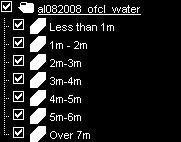
24 1. Wind speed maximum wind speed, grouped by Saffir- Simpson category; 2. Storm surge maximum storm surge height; over water, this height is measured above Mean Sea Level and over land it is measured above the terrain height; 3. Wave height maximum wave height, measured crest-totrough; 4. Total rainfall cumulative rainfall over the duration of the storm forecast, since the first forecast for this storm; and 5. Impact of wind forces qualitative wind effects, based on the Beaufort scale. It is important to note that the maximum hazard intensities shown in one map layer do not occur simultaneously; they are attained at different times during the progress of the storm along the track. Territory impact estimates [folder name: taos_carib_ofcl_impacts_kml] - this folder contains two subfolders for each active storm. These are 1. Impact on port and airport facilities operations downtime in number of days, and potential damage level; and 2. Impact on population tabular estimates of the population affected by the different levels of wind hazard, and by flooding. A sample population impact report is shown below. 14

25 Hazard and impact information is provided for all active storms in the Caribbean for which official forecasts are disseminated by the NHC. Names for individual map layers and folders within these three primary folders identify the map feature and the storm responsible for the hazards and impacts shown. KAC uses the unique ID assigned through the Automated Tropical Cyclone Forecasting (ATCF) system to indentify each storm. The ATCFID is in the form ALxxyyyy, where AL denotes the Atlantic basin, xx is the sequential number of the storm in the season, and yyyy the current year. 15

26 Should more than one storm be active in the Caribbean at one time, the separate storm-specific layers allow hazard and impact information for each storm to be displayed separately or simultaneously in Google Earth. The image below shows selected results from a sample storm, including the qualitative wind impacts and the current and forecast positions of the storm. 16
27 Q. How can countries use Google Earth to view TAOS RTFS outputs? A. The Google Earth platform enables users to display hazard and impact map layers over the Google Earth platform in an easy-to-visualise local geographic context which optimises the viewing of the TAOS RTFS results. Tutorials and reference information for Google Earth are available on the Google Earth online site. For best performance users should install the latest version of Google Earth available at earth.google.com. 17
28 Q. What are Google Earth System Requirements that are required to enable optimal viewing and use of the RTFS? A. The table below lists the minimum and recommended system configurations for running Google Earth [ver 4.3] for computer systems running MS Windows. Information on system requirements for other operating systems and video card support is available on earth.google.com Minimum Operating system Windows 2000, Windows XP, or Windows Vista [Source: Google Earth ver. 4.3 release notes, as of 15 Aug 2008] Recommended Windows XP or Windows Vista CPU Pentium 3, 500Mhz Pentium 4 2.4GHz+ or AMD 2400xp+ System memory (RAM) 256MB 512MB Hard disk 400MB free space 2GB free space Network speed 128 Kbits/sec 768 Kbits/sec Graphics card Screen 3D-capable with 16MB of VRAM 1024x768, "16-bit High Color" - DirectX 9 (to run in Direct X mode) 3D-capable with 32MB of VRAM 1280x1024, "32-bit True Color" 18
29 Q. How can users enable optimal viewing and use of the RTFS? A. For optimal viewing of the TAOS RTFS outputs in Google Earth, the following recommendations should be observed. Users are strongly encouraged to practice these recommendations to become fluent in maneuvering in Google Earth. Start with a clean slate. When ready to view the storm file produced for the latest NHC forecast, make sure that you delete all old storm files that may still reside under Temporary Places. In case you want to keep information on a prior storm, save the original downloaded file in an appropriate directory on your hard drive or other storage medium. Recognise the hierarchy in folders and subfolders, and proceed systematically. Develop a routine for viewing the contents of a storm file, and follow that routine. Only display one layer at a time. While it is possible to view multiple polygon map layers covering the same area simultaneously, it can be difficult to interpret the results. Instead, we recommend viewing layers individually. To do this, select the + sign next to the folder to view the folder contents, then select the check box next to the layer that you wish to view (with other layers turned off). Complete viewing of one folder at a time. When finished viewing the contents of a folder turn off the layers in the folder and close it by selecting the + sign next to it, before proceeding to the next folder. 19
30 Select the zoom level that is most appropriate for viewing the selected layer. Start by viewing wind fields, wave heights, and cumulative rainfall at the regional level, which allows one to view the entire hazard footprint. Zoom in as required to view more country-specific detail. The storm surge is more concentrated around the coastlines, and may require more zooming-in to observe the different surge height levels. Look at all levels closely. When the area affected by certain hazard level is not easily visible toggle the particular level within the layer on and off by checking the box next to it, to discover where that level applies. Capture what is seen on the screen. A user may want to capture a particular hazard or impact view for wider dissemination to government agencies, news media, or populations at risk. This can be in the form of a briefing paper, an attachment to an , or a simple hand-out. There are two ways to capture what is shown on the screen: 1. Use Printscreen to save an image of the entire screen (including the legend in the left hand column). This can then be pasted in a document and printed, or inserted in an Use File Save Save Image on the Google Earth menu to save the screen as an image in jpeg format (this only saves the map view, not the legend). 20
31 Q. Are there any training and other capacity building exercises that are available to enhance the understanding and use of the RTFS? A. CCRIF provides a sub-licence to the Caribbean Institute for Meteorology and Hydrology (CIMH) to access the TAOS RTFS and use it for training and support purposes. One of the goals of this initiative is to enhance the understanding and use of the RTFS within the region and this is supported by a number of activities undertaken by CIMH as follows: 1. Briefing the CDEMA country preparedness team(s) each time a storm is approaching one or more of the CDEMA member states; 2. Using TAOS RTFS as training material in its teaching programme for meteorology students; 3. Organising familiarisation and training workshops for Caribbean meteorological officers and disaster management agencies prior to the start of the hurricane season; and 4. Providing technical support to TAOS RTFS users upon request. Persons who are interested in any of these initiatives can contact the CIMH directly ( or CCRIF ( for further details. 21


32 Q. What support is provided to countries who subscribe to the RTFS? A. Apart from encouraging countries to participate in the training workshops which are held by the CIMH on the use of the RTFS, countries are also provided with a User s Manual which can be found on the CCRIF website at CIMH also provides technical advice on interpretation of hazard information from TAOS RTFS as well as conducting the activities mentioned above. 22

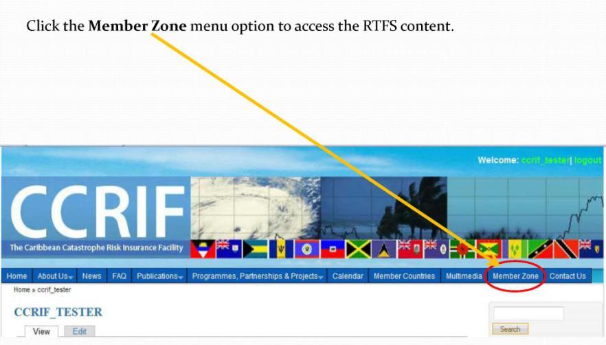
33 Q. How will users be able to access the RTFS product? A. Each year, prior to the start of the Atlantic Hurricane Season on June 1, CCRIF invites each of its member countries to designate a number of national agencies to receive TAOS RTFS outputs. CCRIF encourages the inclusion of personnel from the national meteorological organisations and national disaster management agencies for access to the RTFS. Each designated agency contact is issued with a username and password for access to the secure section of the CCRIF website ( by which the RTFS can be accessed. Automated s are also sent by CCRIF to designated contacts each time new output is available for their country. Output files are available as attachment to , and/or for download from the CCRIF secure website.in addition to this, the TAOS RTFS is made available to CDEMA though the CIMH on behalf of CCRIF. The five steps required to access the RTFS on the CCRIF website are presented in the figures below. Step 1 23

34 Step 2 Step 3 24

35 Step 4 Step 5 25
36 Q. Is my access to the RTFS automatic from year to year? CCRIF member countries are provided with the TAOS RTFS at no cost. Each year members are asked to reapply for access to the RTFS, after which they are provided with user names and passwords. The provision of this tool to member countries is part of the CCRIF s contribution to enhanced disaster management within member states. Countries which are non-members of the CCRIF may contact KAC ( for further details regarding access to the tool. 26
37 Q. Who are the main users of the RTFS product? A. The main users of the RTFS product include disaster and emergency managers and meteorological officers. Essentially, the TAOS RTFS outputs are for the exclusive use by governmental and non-governmental agencies involved in hurricane risk management. Outputs can be used to produce reports, maps, and other guidance documents in support of emergency management. TAOS RTFS files cannot be commercialised by the users. Emergency managers can use the RTFS information as triggers for preparedness and alert procedures. For example, shelter management can be informed of when the maximum wind speed is expected at that location. The decision to evacuate a low-lying area can be informed by the maximum storm surge height expected just off the coast at that location. 27


38 Q. How does the RTFS support countries in emergency preparedness and evacuation decisions? A. By providing advance knowledge of a hurricane s expected site-specific impacts, the RTFS can assist meteorological officers and disaster management coordinators to support effective preparedness and response, evacuation decision making, planning for prepositioning of equipment and supplies, activation of mutual assistance arrangements and asset management as well as for contingency planning to secure critical infrastructure and operations. 28
39 Q. Can policy makers and cabinet ministers make use of the RTFS and what kinds of information can they use? A. Yes. In fact the RTFS information can: Assist with contingency planning by providing a preview of what might happen if a given storm continues along a projected path, and activate appropriate contingency plans based on this insight; Assist with shelter management by identifying impact areas and shelter locations to support shelter allocation decisions; Identify potential damage to shelters, thereby aiding decision makers to plan for alternatives; and Assist with determining emergency interventions by identifying areas where populations are at risk so that decision makers can issue warnings and plan for assistance. The information provided through the RTFS is therefore useful in informing decision making at such critical times to ensure public safety. Q. Can member countries select locations to be incorporated in the product based on their own needs? A. Yes. Member countries have the option to choose up to five locations for which they would want to receive the maximum hazard values. 29
 is received, KAC starts modelling the storm to produce hazard footprints and impact estimates.")
40 Q. How frequently could the RTFS be used during the course of a storm? A. As soon as the latest storm fix (data on location, track, intensity) is received, KAC starts modelling the storm to produce hazard footprints and impact estimates. The RTFS feed is then updated by KAC with each storm advisory issued by the National Hurricane Center (NHC), which is generally every 6 hours. Modelling results are available within 30 minutes of the latest NHC forecast. Users can then access this information as frequently as they wish to. 30
41 Q. What is the relationship between the RTFS and CCRIF hurricane policies? A. There is no direct relationship between the RTFS and CCRIF hurricane policies, apart from the fact that they are both built on the same modelling platform. A benefit provided through this shared platform is the fact that the hazard footprints from the post-event storm run (an RTFS run using the FINAL track after a storm has run its course) will provide a good illustration of the hazard levels that were used in the Hazard Loss Estimation Model which underpins policies and estimates parametric losses. It is important to note that in the RTFS forecast mode there will always be some differences between the forecast track and the FINAL track used in the loss estimation and the post-event storm run. 31
42 Q. Can the use of the RTFS provide countries with information on whether their CCRIF policy is triggered during the passage of a storm? A. To some extent the RTFS can provide countries with an idea of whether their CCRIF policies have been triggered or not triggered, as the outputs utilised in the Hazard and Loss Estimation Model underpinning policies is consistent with the hazard outputs of the RTFS. It is however important to point out that the triggering of a policy is not only dependent on hazard information (such as shown through the RTFS) but is also contingent on the attachment point of the policy, which is a value of dollar loss, for which there is not direct representation in the RTFS. Q. Is there a relationship between the RTFS and CCRIF s second generation loss model? A. Both the RTFS and CCRIF s second generation loss model are built on the same Hazard Loss Modelling Platform. The CCRIF second generation model utilises the hazard outputs visualised through the RTFS and turns them into losses (once the final storm track is established), which are then used to inform the CCRIF policies. 32

43 Q. Will the RTFS be linked to CCRIF s new Excess Rainfall Product? A. The RTFS will not be linked to the CCRIF s new excess rainfall product for the policy year. CCRIF is currently working on making rainfall maps in kml format available all year round. It is anticipated that the CIMH will undertake the underlying hazard modelling for the excess rainfall product which will be linked to the recently launched regional rainfall model. The Hazard Loss Estimation Model used to underpin the RTFS and the CCRIF second generation model is a stand-alone system. 33
44 Q. What is the role of the Caribbean Institute for Meteorology and Hydrology in the use of the RTFS? A. CCRIF has granted the Caribbean Institute for Meteorology and Hydrology (CIMH) a sub-licence to access TAOS RTFS and use it for training and support purposes. The terms of this sub-licence include: Briefing the CDEMA country preparedness team(s) each time a storm is approaching one or more of the CDEMA member states; Using TAOS RTFS as training material in its teaching programme for meteorology students; Organising familiarisation and training workshops for Caribbean meteorological officers and disaster management agencies prior to the start of the hurricane season; and Providing technical support to TAOS RTFS users upon request KAC provides the necessary support to CIMH officers involved in the above activities, and maintains a website with online reference and technical support materials, accessible to the license holder and all sub-license holders. Matters related to the technical aspects of product transmission and display will be handled via direct communication between KAC and the license/sub-licence holders. 34

45 Q. Is there a special RTFS product for Haiti, given its current situation? A. As a result of the earthquake which occurred in Haiti on 12 January 2010, the vulnerabilities of the Haitian population to natural hazards have been especially heightened as a significant amount of the population remains displaced and without shelter. In light of these heightened exposures and risks, CCRIF has enhanced the sitespecific features of the RTFS for Haiti in order to support the ongoing management of displaced populations. CCRIF is currently working with the Civil Protection Directorate in the Ministry of the Interior and the Meteorological Centre in Haiti along with international relief agencies to provide them with relevant and actionable information for management of refugee tent-camps, safekeeping of their occupants, and for general displaced population planning purposes. For critical locations, such as aid operation centers, refugee camps and transportation hubs, TAOS RTFS will produce site-specific estimates of expected wind speed and coastal flooding heights during the approach of a storm. Information will be made available in various formats optimised for the required applications. 35
46 Notes on My Use of the RTFS 36
47 37

48 38
GEONETCast Future Plans at CIMH
 GEONETCast Future Plans at CIMH Operations, Training, Climate Monitoring and Disaster Preparedness WORLD METEOROLOGICAL ORGANIZATION COORDINATION GROUP ON SATELLITE DATA REQUIREMENTS FOR REGION III AND
ASSOCIATION OF CARIBBEAN STATES (ACS / AEC)
") ASSOCIATION OF CARIBBEAN STATES (ACS / AEC) 1 SHOCS (Strengthening Hydrometorological Operations and Services in Caribbean SIDS) The ACS/Finnish Government response to Hydrometorological risk in Caribbean
ASSOCIATION OF CARIBBEAN STATES (ACS / AEC) 1 SHOCS (Strengthening Hydrometorological Operations and Services in Caribbean SIDS) The ACS/Finnish Government response to Hydrometorological risk in Caribbean
Covered Area Rainfall Event (29-30 September 2016) Tropical Cyclone Matthew Excess Rainfall
 Tropical Cyclone Matthew Excess Rainfall") Covered Area Rainfall Event (29-30 September 2016) Tropical Cyclone Matthew Excess Rainfall Event Briefing Dominica 11 October 2016 Registered Office: c/o Sagicor Insurance Managers Ltd., 103 South Church
Covered Area Rainfall Event (29-30 September 2016) Tropical Cyclone Matthew Excess Rainfall Event Briefing Dominica 11 October 2016 Registered Office: c/o Sagicor Insurance Managers Ltd., 103 South Church
Haiti. Excess Rainfall. Covered Area Rainfall Events (19 & 23 September 2014)
") Haiti Excess Rainfall Covered Area Rainfall Events (19 & 23 September 2014) Event Briefing 17 October 2014 Registered Office: c/o Sagicor Insurance Managers Ltd., 103 South Church Street 1st Floor Harbour
Haiti Excess Rainfall Covered Area Rainfall Events (19 & 23 September 2014) Event Briefing 17 October 2014 Registered Office: c/o Sagicor Insurance Managers Ltd., 103 South Church Street 1st Floor Harbour
Covered Area Rainfall Event (28-30 September 2016) Tropical Cyclone Matthew Excess Rainfall
 Tropical Cyclone Matthew Excess Rainfall") Covered Area Rainfall Event (28-30 September 2016) Tropical Cyclone Matthew Excess Rainfall Event Briefing St. Vincent & the Grenadines 11 October 2016 Registered Office: c/o Sagicor Insurance Managers
Covered Area Rainfall Event (28-30 September 2016) Tropical Cyclone Matthew Excess Rainfall Event Briefing St. Vincent & the Grenadines 11 October 2016 Registered Office: c/o Sagicor Insurance Managers
Tropical Storm Isaac. INFORMATION NOTE No. 3 AS OF 8:00 PM (AST) ON SEPTEMBER 12, Synopsis of Tropical Storm Isaac
 ON SEPTEMBER 12, Synopsis of Tropical Storm Isaac") Synopsis of Tropical Storm Isaac LOCATION: 260 MILES EAST NORTH EAST OF MARTINIQUE PRESENT MOVEMENT: WEST AT 20 MPH MAXIMUM SUSTAINED WINDS: 60 MPH MINIMUM CENTRAL PRESSURE: 1003 MB WATCHES AND WARNINGS
Synopsis of Tropical Storm Isaac LOCATION: 260 MILES EAST NORTH EAST OF MARTINIQUE PRESENT MOVEMENT: WEST AT 20 MPH MAXIMUM SUSTAINED WINDS: 60 MPH MINIMUM CENTRAL PRESSURE: 1003 MB WATCHES AND WARNINGS
Covered Area Rainfall Event (18-19 September 2017) Hurricane Maria Excess Rainfall
 Hurricane Maria Excess Rainfall") Covered Area Rainfall Event (18-19 September 2017) Hurricane Maria Excess Rainfall Event Briefing Barbados 28 September 2017 Registered Office: CCRIF SPC c/o Sagicor Insurance Managers Ltd., 198 North
Covered Area Rainfall Event (18-19 September 2017) Hurricane Maria Excess Rainfall Event Briefing Barbados 28 September 2017 Registered Office: CCRIF SPC c/o Sagicor Insurance Managers Ltd., 198 North
WELCOME TO THE 2018 RA-IV WORKSHOP ON HURRICANE FORECASTING AND WARNING
 WELCOME TO THE 2018 RA-IV WORKSHOP ON HURRICANE FORECASTING AND WARNING Richard J. Pasch and Daniel P. Brown Senior Hurricane Specialists National Hurricane Center ORIENTATION Use of PCs NHC Facility Workshop
Disaster Risk Assessment: Opportunities for GIS and data management with Open DRI
 Disaster Risk Assessment: Opportunities for GIS and data management with Open DRI Jacob Opadeyi Department of Geomatics Engineering and Land Management, The University of the West Indies, St. Augustine,
Tropical Cyclone Harvey (AL092017)
") Tropical Cyclone Harvey (AL092017) Wind and Storm Surge Preliminary Event Briefing Windward Islands 20 August 2017 Registered Office: CCRIF SPC c/o Sagicor Insurance Managers Limited, 198 North Church
Tropical Cyclone Harvey (AL092017) Wind and Storm Surge Preliminary Event Briefing Windward Islands 20 August 2017 Registered Office: CCRIF SPC c/o Sagicor Insurance Managers Limited, 198 North Church
Tropical Cyclone Gonzalo (AL082014)
") Tropical Cyclone Gonzalo (AL082014) Event Briefing 20 October 2014 Registered Office: c/o Sagicor Insurance Managers Ltd., 103 South Church Street 1st Floor Harbour Place, P.O. Box 1087, Grand Cayman KY1-1102,
Tropical Cyclone Gonzalo (AL082014) Event Briefing 20 October 2014 Registered Office: c/o Sagicor Insurance Managers Ltd., 103 South Church Street 1st Floor Harbour Place, P.O. Box 1087, Grand Cayman KY1-1102,
User s Guide to Storm Hazard Maps and Data
 Storm Hazard Assessment for St. Lucia and San Pedro/Ambergris Caye, Belize User s Guide to Storm Hazard Maps and Data Prepared For: Caribbean Development Bank Advanced technology and analysis solving problems
Tropical Cyclone EARL (AL052016)
") Tropical Cyclone EARL (AL052016) Wind and Storm Surge Event Briefing 5 August 2016 Registered Office: c/o Sagicor Insurance Managers Ltd., 103 South Church Street 1st Floor Harbour Place, P.O. Box 1087,
Tropical Cyclone EARL (AL052016) Wind and Storm Surge Event Briefing 5 August 2016 Registered Office: c/o Sagicor Insurance Managers Ltd., 103 South Church Street 1st Floor Harbour Place, P.O. Box 1087,
Covered Area Rainfall Event (26 February 2016) Excess Rainfall
 Excess Rainfall") Covered Area Rainfall Event (26 February 2016) Excess Rainfall Event Briefing 15 March 2016 Registered Office: c/o Sagicor Insurance Managers Ltd., 103 South Church Street 1st Floor Harbour Place, P.O.
Covered Area Rainfall Event (26 February 2016) Excess Rainfall Event Briefing 15 March 2016 Registered Office: c/o Sagicor Insurance Managers Ltd., 103 South Church Street 1st Floor Harbour Place, P.O.
Careful, Cyclones Can Blow You Away!
 Title: Careful, Cyclones Can Blow You Away! (Meteorology) Grade(s): 6-8 Introduction: Most people associate twisters with tornadoes, but in fact tropical twisters come from hurricanes. Hurricanes are what
Applied Geoscience and Technology Division SOPAC. Joy Papao, Risk Information Systems Officer
 Joy Papao, Risk Information Systems Officer Secretariat of the Pacific Community SPC 22 Pacific Island States Head office in Noumea, New Caledonia 2 Regional offices (Pohnpei and Honiara) 600 staff 9 Technical
CCRIF. News. On September 16, the Caribbean Catastrophe Risk. CCRIF Pays Government of Anguilla US$4.28 Million following passage of Hurricane Earl
 1 CCRIF CCRIF, A NOT-FOR-PROFIT COMPANY, IS THE FIRST AND ONLY MULTI-COUNTRY RISK POOL IN THE WORLD VOLUME 2 #1 September 2010 News CCRIF Pays Government of Anguilla US$4.28 Million following passage of
JCOMM-CHy Coastal Inundation Forecasting Demonstration Project (CIFDP)
") WMO World Meteorological Organization Working together in weather, climate and water JCOMM-CHy Coastal Inundation Forecasting Demonstration Project (CIFDP) Coastal Flooding & Vulnerable Populations Coastal
WMO World Meteorological Organization Working together in weather, climate and water JCOMM-CHy Coastal Inundation Forecasting Demonstration Project (CIFDP) Coastal Flooding & Vulnerable Populations Coastal
Improving global coastal inundation forecasting WMO Panel, UR2014, London, 2 July 2014
 Improving global coastal inundation forecasting WMO Panel, UR2014, London, 2 July 2014 Cyclone Sidr, November 2007 Hurricane Katrina, 2005 Prof. Kevin Horsburgh Head of marine physics, UK National Oceanography
Tropical Cyclone Isaac (AL092012)
") Tropical Cyclone Isaac (AL092012) Event Briefing, Central Caribbean Impacts Caribbean Risk Managers Ltd Facility Supervisor 27 August 2012 Facility Supervisor: Caribbean Risk Managers Ltd Email: ccrif@ccrif.org
Tropical Cyclone Isaac (AL092012) Event Briefing, Central Caribbean Impacts Caribbean Risk Managers Ltd Facility Supervisor 27 August 2012 Facility Supervisor: Caribbean Risk Managers Ltd Email: ccrif@ccrif.org
"Outcomes of the storm surge and waves workshop in Dominican Republic and the questionnaire"
 "Outcomes of the storm surge and waves workshop in Dominican Republic and the questionnaire" Strengthening Regional Cooperation to Support Forecasting with Multi Hazard Approach in RA IV Ritz Carlton Grand
Progress on the Development of the Strategic Framework on Geospatial Information and Services for Disasters
 Progress on the Development of the Strategic Framework on Geospatial Information and Services for Disasters Dr. Peter N. Tiangco Administrator, NAMRIA, Philippines Co-chair, Working Group on Geospatial
The Wind Speeds in Selected Islands During Hurricanes Irma and Maria in 2017 compiled by Tony Gibbs FREng
 The Wind Speeds in Selected Islands During Hurricanes Irma and Maria in 2017 compiled by Tony Gibbs FREng Structural failures leading to serious damage or collapse, or those severely affecting the use
Tropical Update. 5 AM EDT Tuesday, September 12, 2017 Post-Tropical Cyclone Irma, Hurricane Jose, & Tropical Wave (10%)
") Tropical Update 5 AM EDT Tuesday, September 12, 2017 Post-Tropical Cyclone Irma, Hurricane Jose, & Tropical Wave (10%) This update is intended for government and emergency response officials, and is provided
Tropical Update 5 AM EDT Tuesday, September 12, 2017 Post-Tropical Cyclone Irma, Hurricane Jose, & Tropical Wave (10%) This update is intended for government and emergency response officials, and is provided
World Meteorological Organization
 World Meteorological Organization Opportunities and Challenges for Development of Weather-based Insurance and Derivatives Markets in Developing Countries By Maryam Golnaraghi, Ph.D. Head of WMO Disaster
Outline of Guideline for Development and Utilization of Tsunami Disaster Management Map
 Outline of Guideline for Development and Utilization of Tsunami Disaster Management Map Port and Airport Research Institute, Japan The Overseas Coastal Area Development Institute of Japan Ports and Harbours
Strategic Framework on Geospatial Information and Services for Disasters
 Strategic Framework on Geospatial Information and Services for Disasters Case Studies for the Caribbean and the Philippines --- Kunming Forum on United Nations Global Geospatial Information Management
Disaster Risk Management in India. Kamal Kishore New Delhi, 27 October 2016
 Disaster Risk Management in India Kamal Kishore New Delhi, 27 October 2016 Hazard, Exposure and Vulnerability Disaster Prevention Mitigation Hurricane Matthew: Cuba & Haiti Emergency Response Coordination
HURREVAC The software Tool used by emergency officials for hurricane evacuation assistance
 HURREVAC 2010 A Quick Reference enc e Guide The software Tool used by emergency officials for hurricane evacuation assistance www.hurrevac.com FinalHURREVAC2010Guide.indd 1 About HURREVAC HURREVAC is a
Use of Climate information in Disaster Risk Management in Zimbabwe
 Use of Climate information in Disaster Risk Management in Zimbabwe WMO Regional Technical Meeting & User/CONOPS Workshop, 28 th October 2015 Lameck Betera Department of Civil Protection Institutional Arrangements
Coastal Inundation Forecasting Demonstration Project CIFDP. Flood Forecasting Initiative-Advisory Group (FFI-AG 3), Geneva, 5-7 Dec, 2017
, Geneva, 5-7 Dec, 2017") Coastal Inundation Forecasting Demonstration Project CIFDP Flood Forecasting Initiative-Advisory Group (FFI-AG 3), Geneva, 5-7 Dec, 2017 Coastal Flooding & Vulnerable Populations Coastal populations are
Coastal Inundation Forecasting Demonstration Project CIFDP Flood Forecasting Initiative-Advisory Group (FFI-AG 3), Geneva, 5-7 Dec, 2017 Coastal Flooding & Vulnerable Populations Coastal populations are
National Public Weather and Warning Services in the Swaziland Meteorological Service Dennis S.Mkhonta /
 National Public Weather and Warning Services in the Swaziland Meteorological Service Dennis S.Mkhonta dennis.mkhonta@gmail.com / dennis@swazimet.gov.sz Introduction Swaziland s geographical position exposes
Covered Area Rainfall Event (18-20 October 2017) Excess Rainfall
 Excess Rainfall") Covered Area Rainfall Event (18-20 October 2017) Excess Rainfall Event Briefing Trinidad 29 October 2017 Registered Office: CCRIF SPC c/o Sagicor Insurance Managers Ltd., 198 North Church Street 2nd Floor
Covered Area Rainfall Event (18-20 October 2017) Excess Rainfall Event Briefing Trinidad 29 October 2017 Registered Office: CCRIF SPC c/o Sagicor Insurance Managers Ltd., 198 North Church Street 2nd Floor
RSMC-Miami Update Daniel Brown Warning Coordination Meteorologist
 RSMC-Miami Update 2016 Daniel Brown Warning Coordination Meteorologist L-0324 Emergency Management Hurricane Preparedness Training Course Funding provided by FEMA s National Hurricane Program - partnership
Copernicus Overview. Major Emergency Management Conference Athlone 2017
 Copernicus Overview Major Emergency Management Conference Athlone 2017 Copernicus is a European programme implemented by the European Commission. The services address six thematic areas: land, marine,
RCOF Review [Regional Climate Outlook Forum for the Gulf of Guinea region of Africa - PRESAGG] Status Report
![RCOF Review [Regional Climate Outlook Forum for the Gulf of Guinea region of Africa - PRESAGG] Status Report](/thumbs/78/77466191.jpg "RCOF Review [Regional Climate Outlook Forum for the Gulf of Guinea region of Africa - PRESAGG] Status Report") RCOF Review 2017 [Regional Climate Outlook Forum for the Gulf of Guinea region of Africa - PRESAGG] Status Report Specific Climate features of concerned region This region typically covers the area below
RCOF Review 2017 [Regional Climate Outlook Forum for the Gulf of Guinea region of Africa - PRESAGG] Status Report Specific Climate features of concerned region This region typically covers the area below
INTERNATIONAL HYDROGRAPHIC ORGANIZATION MESO AMERICAN & CARIBBEAN SEA HYDROGRAPHIC COMMISSION
 INTERNATIONAL HYDROGRAPHIC ORGANIZATION MESO AMERICAN & CARIBBEAN SEA HYDROGRAPHIC COMMISSION CAPACITY BUILDING PLAN Programme document for the period 2010-2012 1. INTRODUCTION 1.1. Rationale It is estimated
Nurture Nature Center Receives Grant From National Oceanic and Atmospheric Administration To Study Flood Forecast and Warning Tools
 Nurture Nature Center Receives Grant From National Oceanic and Atmospheric Administration To Study Flood Forecast and Warning Tools One of four national awards by National Weather Service to advance weather
By Lillian Ntshwarisang Department of Meteorological Services Phone:
 By Lillian Ntshwarisang Department of Meteorological Services Phone: +267 3612200 Email: lntshwarisang@gov.bw/ lntshwarisang@gmail.com Introduction Mandate of DMS Function of the Department Services to
The Wind Hazard: Messaging the Wind Threat & Corresponding Potential Impacts
 The Wind Hazard: Messaging the Wind Threat & Corresponding Potential Impacts Scott Spratt Warning Coordination Meteorologist NWS Melbourne, FL David Sharp Science & Operations Officer NWS Melbourne, FL
STATUS OF HAZARD MAPS VULNERABILITY ASSESSMENTS AND DIGITAL MAPS
 JapanInternational Cooperation Agency STATUS OF HAZARD MAPS VULNERABILITY ASSESSMENTS AND DIGITAL MAPS ANGUILLA REPORT THE CARIBBEAN DISASTER EMERGENCY RESPONSE AGENCY () Table of Contents Page Preface
Tropical Cyclone Sandy (AL182012)
") Tropical Cyclone Sandy (AL182012) Event Briefing Caribbean Risk Managers Ltd Facility Supervisor 29 October 2012 Facility Supervisor: Caribbean Risk Managers Ltd Email: ccrif@ccrif.org Tel (Barbados):
Tropical Cyclone Sandy (AL182012) Event Briefing Caribbean Risk Managers Ltd Facility Supervisor 29 October 2012 Facility Supervisor: Caribbean Risk Managers Ltd Email: ccrif@ccrif.org Tel (Barbados):
GC Briefing. Weather Sentinel Hurricane Florence. Status at 5 PM EDT (21 UTC) Today (NHC) Discussion. September 13, 2018
 Today (NHC) Discussion. September 13, 2018") GC Briefing September 13, 2018 Weather Sentinel Hurricane Florence Tropical storm conditions have been reported for areas of North Carolina and will continue to spread inland to the west and south. Hurricane
GC Briefing September 13, 2018 Weather Sentinel Hurricane Florence Tropical storm conditions have been reported for areas of North Carolina and will continue to spread inland to the west and south. Hurricane
1 Introduction. Station Type No. Synoptic/GTS 17 Principal 172 Ordinary 546 Precipitation
 Use of Automatic Weather Stations in Ethiopia Dula Shanko National Meteorological Agency(NMA), Addis Ababa, Ethiopia Phone: +251116639662, Mob +251911208024 Fax +251116625292, Email: Du_shanko@yahoo.com
Tropical Update. 5 AM EDT Thursday, September 7, 2017 Hurricane Irma, Hurricane Jose, and Hurricane Katia
 Tropical Update 5 AM EDT Thursday, September 7, 2017 Hurricane Irma, Hurricane Jose, and Hurricane Katia This update is intended for government and emergency response officials, and is provided for informational
Hurricane Readiness for Coastal Communities
 Hurricane Readiness for Participant Guide Developed for: Federal Emergency Management Agency Emergency Management Institute 16825 South Seton Avenue Emmitsburg, MD 21727-8998 Developed by: C² Technologies,
Unit 5: NWS Hazardous Weather Products. Hazardous Weather and Flooding Preparedness
 Unit 5: NWS Hazardous Weather Products Objectives Describe the mission of the NWS Describe the basic organizational structure of the NWS Explain the purpose of various NWS products Explain how Probability
Climate Resilience Decision Making Framework in the Caribbean. A case of Spatial Data Management
 Climate Resilience Decision Making Framework in the Caribbean A case of Spatial Data Management Bishwa Pandey Sr. Data Management Specialist The World Bank Background The mission of The World Bank s Latin
Landslide Hazard Assessment Methodologies in Romania
 A Scientific Network for Earthquake, Landslide and Flood Hazard Prevention SciNet NatHazPrev Landslide Hazard Assessment Methodologies in Romania In the literature the terms of susceptibility and landslide
Storm Hazard Assessment for San Pedro/Ambergris Caye, Belize. Statistical Estimation of Hazard Frequency and Intensity
 Storm Hazard Assessment for San Pedro/Ambergris Caye, Belize Statistical Estimation of Hazard Frequency and Intensity Prepared For: Caribbean Development Bank Advanced technology and analysis solving problems
Geospatial natural disaster management
 Geospatial natural disaster management disasters happen. are you ready? Natural disasters can strike almost anywhere at any time, with no regard to a municipality s financial resources. These extraordinarily
Progress Report. Flood Hazard Mapping in Thailand
 Progress Report Flood Hazard Mapping in Thailand Prepared By: Mr. PAITOON NAKTAE Chief of Safety Standard sub-beuro Disaster Prevention beuro Department of Disaster Prevention and Mitigation THAILAND E-mail:
Canadian Hurricane Center: How NHC Products are used to issue Warnings and Communicate Hazards
 Canadian Hurricane Center: How NHC Products are used to issue Warnings and Communicate Hazards Bob Robichaud Warning Preparedness Meteorologist Canadian Hurricane Centre Contents Brief background on the
Effectiveness of Disaster Risk Reduction (DRR) programs funded by ECHO in the Caribbean
 programs funded by ECHO in the Caribbean") Effectiveness of Disaster Risk Reduction (DRR) programs funded by ECHO in the Caribbean Evidence collected after hurricanes Irma and Maria 1 Introduction The 2017 hurricane season has been exceptionally
Effectiveness of Disaster Risk Reduction (DRR) programs funded by ECHO in the Caribbean Evidence collected after hurricanes Irma and Maria 1 Introduction The 2017 hurricane season has been exceptionally
Caribbean Early Warning System Workshop
 Caribbean Early Warning System Workshop Hamonization in Existing EWS April 14-16, 2016 Presenter: Shawn Boyce Caribbean Institute for Meteorology and Hydrology Husbands, St. James Barbados Background Between
Macroeconomic implications of natural disasters on small economies
 Macroeconomic implications of natural disasters on small economies Sebastian Acevedo IMF Western Hemisphere Department Central Bank of Curaçao and Sint Maarten March 22, 2018 Disclaimer: The views expressed
Table-Top Exercise for Emergency Preparedness Evaluation: Little Anse, Isle Madame
 Table-Top Exercise for Emergency Preparedness Evaluation: Little Anse, Isle Madame Alexander Chung, M.Sc. Candidate C-Change Student Research Associate May 2013 The Community of Little Anse Coastal community
Navigating the Hurricane Highway Understanding Hurricanes With Google Earth
 Navigating the Hurricane Highway Understanding Hurricanes With Google Earth 2008 Amato Evan, Kelda Hutson, Steve Kluge, Lindsey Kropuenke, Margaret Mooney, and Joe Turk Images and data courtesy hurricanetracking.com,
WEDNESDAY 30 TH AUGUST, :57 p.m. Tropical Storm Irma forms in the Atlantic. Don t let your guard down, always #Be Ready.
 Chapter 1 - The Set Up In the days leading up to Irma a series of composed and sobering text messages, presented in truncated form below, from Department of Disaster Management warned us of the pending
NOAA S2S Planning. Dave DeWitt Fred Toepfer
 NOAA S2S Planning Dave DeWitt Fred Toepfer 1 Agenda 1. Brief synopsis of The Weather Research and Forecasting Act of 2017 2. Report to Congress a. Timeline b. Process c. Document Outline 3. Some Preliminary
CLIMATE CHANGE ADAPTATION BY MEANS OF PUBLIC PRIVATE PARTNERSHIP TO ESTABLISH EARLY WARNING SYSTEM
 CLIMATE CHANGE ADAPTATION BY MEANS OF PUBLIC PRIVATE PARTNERSHIP TO ESTABLISH EARLY WARNING SYSTEM By: Dr Mamadou Lamine BAH, National Director Direction Nationale de la Meteorologie (DNM), Guinea President,
Why data? Climate Monitoring, Sectoral Applications and More
 Why data? Climate Monitoring, Sectoral Applications and More Part 2 Adrian R. Trotman Chief, Applied Meteorology and Climatology Caribbean Institute for Meteorology and Hydrology CAMI Funded by the European
Weather Observing and Forecasting and the Hurricane Warning System in the Caribbean
 T.W. Sutherland: Weather Observing and Forecasting and the Hurricane Warning System in the Caribbean 6 ISSN 1000 7924 The Journal of the Association of Professional Engineers of Trinidad and Tobago Vol.42,
National Report on Weather Forecasting Service
 MINISTRY OF WATER RESOURCES AND METEOROLOGY DEPARTMENT OF METEOROLOGY, CAMBODIA National Report on Weather Forecasting Service Tokyo, 11-15 March 2014 Department of Meteorology, Cambodia Presentation Outline
METEOROLOGICAL WARNINGS STUDY GROUP (METWSG)
") METWSG/4-SN No. 6 12/3/12 METEOROLOGICAL WARNINGS STUDY GROUP (METWSG) FOURTH MEETING Montréal, 15 to 18 May 2012 Agenda Item 6: Wind shear, turbulence and tsunami warnings TSUNAMI INFORMATION (Presented
METWSG/4-SN No. 6 12/3/12 METEOROLOGICAL WARNINGS STUDY GROUP (METWSG) FOURTH MEETING Montréal, 15 to 18 May 2012 Agenda Item 6: Wind shear, turbulence and tsunami warnings TSUNAMI INFORMATION (Presented
The Nuts and Bolts of These Community Preparedness Recognition Programs
 The Nuts and Bolts of These Community Preparedness Recognition Programs Bill Sammler Warning Coordination Meteorologist NOAA s National Weather Service, Wakefield VA http://weather.gov/akq Why is StormReady
2017 Hurricane Season and Beyond
 2017 Hurricane Season and Beyond Ken Graham National Hurricane Center Building a Weather-Ready Nation Much of U.S. Coast Saw Tropical Wind Watches or Warnings 2017 Hurricane Season Facts and Figures 7th
Training Courses 2018
 Caribbean Institute for Meteorology and Hydrology The Caribbean Institute for Meteorology and Hydrology The Caribbean Institute for Meteorology and Hydrology is the regional Institution mandated to conduct
City of Punta Gorda Community Emergency Management Plan 2013
 City of Punta Gorda Community Emergency Management Plan 2013 Hurricane Andrew- August 24, 1992 Category 5 hurricane. The second-most-destructive hurricane in U.S. history. The first named storm of the
The current status, functions, challenges and needs of South Sudan Meteorological Department (SSMD)
") The current status, functions, challenges and needs of South Sudan Meteorological Department (SSMD) Presented: by Mojwok Ogawi Modo, South Sudan Meteorological Department. Background The present SSMD was
The current status, functions, challenges and needs of South Sudan Meteorological Department (SSMD) Presented: by Mojwok Ogawi Modo, South Sudan Meteorological Department. Background The present SSMD was
The WMO Tropical Cyclone Programme(TCP)
") The WMO Tropical Cyclone Programme(TCP) Session 4: Insights into some WMO ProgrammeActivities to Support MHEWS at National, Regional and Global Levels UI-EAG MHEWS, 19-21 April 2016, Geneva Anne-Claire
The WMO Tropical Cyclone Programme(TCP) Session 4: Insights into some WMO ProgrammeActivities to Support MHEWS at National, Regional and Global Levels UI-EAG MHEWS, 19-21 April 2016, Geneva Anne-Claire
Climate Risk Visualization for Adaptation Planning and Emergency Response
 Climate Risk Visualization for Adaptation Planning and Emergency Response NCR Flood Fact Finding Workshop Ricardo Saavedra ricardo@vizonomy.com Social Media, Mobile, and Big Data St. Peter s Basilica,
Chantale Bijoux Meteorological Officer
 Chantale Bijoux Meteorological Officer Introduction The Seychelles s National Meteorological Services plays a vital role in providing weather and climate information including severe weather changes, therefore
GC Briefing. Weather Sentinel Tropical Storm Michael. Status at 8 AM EDT (12 UTC) Today (NHC) Discussion. October 11, 2018
 Today (NHC) Discussion. October 11, 2018") GC Briefing Weather Sentinel Tropical Storm Michael October 11, 2018 After making landfall as a high-end category-4 hurricane on the Florida Panhandle, Michael weakened to tropical storm status early this
GC Briefing Weather Sentinel Tropical Storm Michael October 11, 2018 After making landfall as a high-end category-4 hurricane on the Florida Panhandle, Michael weakened to tropical storm status early this
A Cloud-Based Flood Warning System For Forecasting Impacts to Transportation Infrastructure Systems
 A Cloud-Based Flood Warning System For Forecasting Impacts to Transportation Infrastructure Systems Jon Goodall Associate Professor, Civil and Environmental Engineering Associate Director, Link Lab April
Copernicus Overview and Emergency Management Service
 Copernicus Overview and Emergency Management Service Frédéric BASTIDE European Commission Open informal session of the United Nations Inter-Agency Meeting on Outer Space Activities 12 March 2013, Geneva
Storm Surge/Coastal Inundation State of the Union. Jamie Rhome Storm Surge Team Lead NOAA/National Hurricane Center
 Storm Surge/Coastal Inundation State of the Union Jamie Rhome Storm Surge Team Lead NOAA/National Hurricane Center 2 Tampa: Cat 5 Scenario 3 4 The Stakes are High Combination of SLR and increasing coastal
FOURTH INTERNATIONAL PORT METEOROLOGICAL OFFICERS WORKSHOP AND SUPPORT TO GLOBAL OCEAN OBSERVATIONS USING SHIP LOGISTICS
 FOURTH INTERNATIONAL PORT METEOROLOGICAL OFFICERS WORKSHOP AND SUPPORT TO GLOBAL OCEAN OBSERVATIONS USING SHIP LOGISTICS PMO-IV 8-10 DEC 2010, ORLANDO, FLORIDA, USA 1 This presentation is generally for
PUBLIC SAFETY POWER SHUTOFF POLICIES AND PROCEDURES
 PACIFIC GAS AND ELECTRIC COMPANY PUBLIC SAFETY POWER SHUTOFF POLICIES AND PROCEDURES SEPTEMBER 2018 1 PACIFIC GAS AND ELECTRIC COMPANY PUBLIC SAFETY POWER SHUTOFF POLICIES AND PROCEDURES SEPTEMBER 2018
Overview of the Tropical Cyclone Guidance Project
 Overview of the Tropical Cyclone Guidance Project Dr. Jonathan L. Vigh With thanks to Mahsa Mirzargar (Univ. of Miami) Shanghai Typhoon Institute 09 July 2018 NCAR is sponsored by the National Science
Tropical Update. 5 PM EDT Thursday, September 7, 2017 Hurricane Irma, Hurricane Jose, and Hurricane Katia
 Tropical Update 5 PM EDT Thursday, September 7, 2017 Hurricane Irma, Hurricane Jose, and Hurricane Katia This update is intended for government and emergency response officials, and is provided for informational
Public Disclosure Copy
 Public Disclosure Authorized EAST ASIA AND PACIFIC Vanuatu Social, Urban, Rural and Resilience Global Practice Global Practice Recipient Executed Activities Technical Assistance Loan FY 2013 Seq No: 7
[CLUB NAME] HURRICANE ACTIVATION PLAN [EXCERPT VERSION]
![[CLUB NAME] HURRICANE ACTIVATION PLAN [EXCERPT VERSION]](/thumbs/78/78180924.jpg "[CLUB NAME] HURRICANE ACTIVATION PLAN [EXCERPT VERSION]") [CLUB NAME] HURRICANE ACTIVATION PLAN [EXCERPT VERSION] Club Main Phone: [number] Club Email Address: [email] Date of last update: [date] Updated by: [Name] Template Developed By: The Burgee Program and
[CLUB NAME] HURRICANE ACTIVATION PLAN [EXCERPT VERSION] Club Main Phone: [number] Club Email Address: [email] Date of last update: [date] Updated by: [Name] Template Developed By: The Burgee Program and
THE IMPACT OF EL NIÑO AND LA NIÑA ON SOUTHEAST ASIA
 THE IMPACT OF EL NIÑO AND LA NIÑA ON SOUTHEAST ASIA 21st-23rd February 2000 WORKSHOP SUMMARY Organized by the Indochina Global Change Network Funded by the Asia-Pacific Network for Global Change Research
CATEX Hurricane Zachary
 CATEX Hurricane Zachary EXERCISE, EXERCISE,EXERCISE East Coast CATEX Power Restoration Functional Exercise 2013 This document was prepared under a grant from FEMA's Grants Programs Directorate, U.S. Department
National Disaster Management Centre (NDMC) Republic of Maldives. Location
 Republic of Maldives. Location") National Disaster Management Centre (NDMC) Republic of Maldives Location Country Profile 1,190 islands. 198 Inhabited Islands. Total land area 300 sq km Islands range b/w 0.2 5 sq km Population approx.
National Disaster Management Centre (NDMC) Republic of Maldives Location Country Profile 1,190 islands. 198 Inhabited Islands. Total land area 300 sq km Islands range b/w 0.2 5 sq km Population approx.
Understanding Weather and Climate Risk. Matthew Perry Sharing an Uncertain World Conference The Geological Society, 13 July 2017
 Understanding Weather and Climate Risk Matthew Perry Sharing an Uncertain World Conference The Geological Society, 13 July 2017 What is risk in a weather and climate context? Hazard: something with the
Module 7, Lesson 2 In the eye of the storm
 Module 7, Lesson 2 In the eye of the storm October 21, 1998 A tropical storm is brewing in the Atlantic Ocean. It began as a tropical wave a few weeks earlier, off the coast of western Africa. Today it
Climate Change and Water: What s the future of Caribbean Agriculture?
 Climate Change and Water: What s the future of Caribbean Agriculture? Presented by: Adrian Trotman CAMI Project Manager Chief, Applied Meteorology and Climatology Caribbean Institute for Meteorology and
THE INTEGRATED INFORMATION SYSTEM FOR NATURAL
 THE INTEGRATED INFORMATION SYSTEM FOR NATURAL DISASTER MITIGATION Junxiu Wu 1, Qiang Feng 2*, Bijun Liang 3, and Angsheng Wang 4 1 Department of Computer System, Technological Bureau of Xinhua News Agency,
Drought and Precipitation Monitoring in the Caribbean
 Drought and Precipitation Monitoring in the Caribbean SARI BLAKELEY, ADRIAN TROTMAN CARIBBEAN INSTITUTE FOR METEOROLOGY AND HYDROLOGY (CIMH) Caribbean l Water INTRODUCTION The Caribbean is highly susceptible
Prime Minister s Office- Meteorological Services
 15.3 METEOROLOGICAL SERVICES 15.3.1 The Mauritius Meteorological Services (MMS) operates under the aegis of the Prime Minister s Office. Its mission is to provide accurate, timely weather information and
Frank Revitte National Weather Service. Weather Forecast Office New Orleans/Baton Rouge
 Frank Revitte National Weather Service Weather Forecast Office New Orleans/Baton Rouge Above normal activity 17 Total Named Storms 7 Tropical Storms 4 Hurricanes 6 Major Hurricanes Not the most active,
Enhancing Weather Information with Probability Forecasts. An Information Statement of the American Meteorological Society
 Enhancing Weather Information with Probability Forecasts An Information Statement of the American Meteorological Society (Adopted by AMS Council on 12 May 2008) Bull. Amer. Meteor. Soc., 89 Summary This
SITUATION REPORT #7 September 8 th, 2017
 MCO AIRPORT EMERGENCY OPERATIONS CENTER SITUATION REPORT #7 September 8 th, 2017 STATE OF FLORIDA REGION V FEMA REGION IV GENERAL INFORMATION Local State of Emergency Declaration Number: 17-235 Dated:
Lorna V Inniss, Ph.D SAGE Workshop, New York City
 Lorna V Inniss, Ph.D SAGE Workshop, New York City 2014-05-21 Why me? The globally recognized success of the Barbados ICZM programme has generated requests for technical assistance and CD from many Governments
An Environmental Profile of the Island of Jost Van Dyke, British Virgin Islands
 An Environmental Profile of the Island of Jost Van Dyke, British Virgin Islands Executive Summary including Little Jost Van Dyke, Sandy Cay, Green Cay and Sandy Spit This publication was made possible
Miami-Dade County Overview
 Miami-Dade County Overview 2,000 square miles World s busiest cruise port 2.6 million residents Second busiest US airport for international travelers Gateway to the Caribbean and Latin America Natural
PRE MONSOON TROPICAL CYCLONE ALERT (LAILA)
") PRE MONSOON TROPICAL CYCLONE ALERT (LAILA) (Updated as on 19 th May, 2010, 10.00 AM) A pre-monsoon Tropical Cyclone alert has been issued for all the coastal districts of Orissa by the Special Relief Commissioner
PRE MONSOON TROPICAL CYCLONE ALERT (LAILA) (Updated as on 19 th May, 2010, 10.00 AM) A pre-monsoon Tropical Cyclone alert has been issued for all the coastal districts of Orissa by the Special Relief Commissioner
Pacific Catastrophe Risk Assessment And Financing Initiative
 Pacific Catastrophe Risk Assessment And Financing Initiative PALAU September is expected to incur, on average,.7 million USD per year in losses due to earthquakes and tropical cyclones. In the next 5 years,