Monmouthshire County Council Review of Landslips within the County December February 2014
|
|
|
- Nigel Woods
- 5 years ago
- Views:
Transcription
1 Monmouthshire County Council Review of Landslips within the County December February 2014
2 Introduction The County of Monmouthshire suffered a period of extreme weather between December 2013 and February These extreme conditions were experienced nationally and the recorded rainfall was widely reported as having exceeding all previous records. Within Monmouthshire the extreme rainfall gave rise to the flooding of dwellings, gardens, agricultural land and carriageways. Severely saturated ground became unstable and many embankment slips occurred which gave rise to either the closure or restricted use of the carriageways affected. Monmouthshire County Council had suffered similar difficulties in 2012/2103 and had applied to Welsh Government (WG) for assistance under the Emergency Financial Assistance Scheme (EFAS), however at that time WG could not provide any assistance. Affected Areas A photographic record of some of affected sites follows which provides an insight into the nature of the failures. Further more detailed information on all sites is listed in the appendices. Appendix 1 lists the sites affected by the extreme weather in 2013/14. Details of the sites affected in 2012/13 but still awaiting attention are also detailed in Appendix 2.

3 White House Cottage B4347 Near Grosmont View looking South This section of the B4347 has suffered from significant ground movements bought about by the extreme wet weather conditions experienced within the County. The road is closed to traffic. The retaining wall running parallel with the edge of the carriageway near the barn conversion in the background is also cause for concern.

4 View looking North The photograph shows detail of the failure present in the road. The road has been closed to traffic for safety reasons and the available diversions require the public to divert several miles. Repair cost estimates for this section of the B4347 are in the order of 62,000

5 Duffryn Cottages B4347 Near Grosmont View looking West On this section of the B4347 there has been settlement in excess of 1.0m. The ground movements have damaged the retaining wall causing shear failures at a number of locations along it. Edge support to the carriageway has been removed and there is tension cracking apparent in the surfacing. There is over 150m of retaining wall affected. Repair costs are in the order of 380,000

6 Further view of retaining wall damage View looking West

7 Detail of damage The extent of the ground movement can be clearly seen in this photograph

8 View of retaining wall showing extent of ground movement

9 Ground movement at carriageway edge

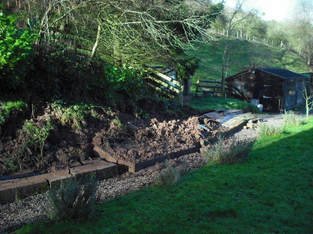
10 Forestry Area B4347 Near Grosmont This section of the B4347 lies between White House Cottage and Dyffryn Cottages and whilst not as dramatic a failure as the other two areas it will still require a significant investment to repair the failure. The route is currently closed to traffic.

11 View looking South The effect on the highway profile can clearly be seen with significant loss of support at the carriageway edge where the embankment has slipped away. Likely repair costs for this section of the B4347 are Circa 60,000

12 Ruthlin Mill Near Skenfrith Route R38 View looking North On the R38 at Ruthlin Mill the tension cracking is clearly evident. However the slip zone extends above and below the carriageway affecting orchards on the up slope and third party structures downslope. The route is closed to traffic.budget costing for the required works is 46,000

13 Close up of Tension cracking at Ruthlin Mill Views looking North

14 Effect on third party structure at Ruthlin Mill downslope of carriageway
15

16 Upper Cwm Farm Brynderi Route R35 View looking South An extensive slip area has formed on route R35 requiring the carriageway to be closed to traffic. The carriageway is affected over a length of some 20.0m and a shift in level approaching of 0.6m is present. Likely repair cost will be in the order of 71,000.

17 View looking North Detailed view of backscar highlighting vertical shift and exposure of the sub grade to weathering action

18 Pant Farm Bryn Deri Route C19.1 View looking West Gabion Basket retaining wall undercut by stream resulting in collapse of retaining wall structure and carriageway. Route closed awaiting permanent repair approximate cost 25,000

19 Near the Boat Inn Redbrook Route C48.1 View looking North The C48.1 local access road had to be closed when in excess of 750t of material including mature trees moved down slope. It was also necessary to close the popular Wye Valley walk which is a significant tourist attraction in order to protect the public. Both the road and footway remain closed. Repair costs are circa 32,000

20 View looking South along route

21 Near Chapel House Tintern Culvert on Route C 53.9 View looking East The damage to the third party wing wall of the culvert can clearly be seen. This damage is representative of the damage suffered directly by the culvert structure upstream. A temporary bridge access has needed to be installed prior to permanent works being implemented. Lilely costs Circa 130,000

22 Culvert on Route C59.3 Temporary Bridge Access View looking East

23 Near Livox Quarry Entrance A 466 View looking South Although the images are not dramatic the tension cracking that can be clearly seen within the carriageway extends for nearly 200m along the route and movement is

24 clearly taking place. The A466 has a history of ground movements due to the nature of the route construction and the geology of the area. View looking North Tension cracking can clearly be seen extending across the centreline of the A466. The scale of the potential problem and the probable method of repair indicates that some 535,000 may be required to effect a solution here.

25 Near Old Station Tintern A466 View looking South The image shows a typical failure of the carriageway footpath which runs intermittently for 130m over a length of some 280m. Budget costings for the repair works are Circa 263,000

26 The Hafod Llanelly Hill Route C View looking West The Tension cracking witihn the carriageway runs for some 50m and the movement of material downslope can be seen in the attitude of the adjacent fence line. Repair to the route may be in the order of 100,000
27 Appendix 1 Extreme Weather Sites 2013/14 Site Route Current Road Status Location Description Work Budget Cost 's Scheme totals Work Status Remarks 1 B4347 Closed Nr Whitehouse cottage NP7 8LR Carriageway Failure PB -GI/options 9, , Survey & GI complete. Design imminent survey 1, Ops 1, Site works 50, B4347 Closed Nr Duffryn Cottages / Forestry Slip NP7 8LG Embankment/ Road Failure PB -GI/options 15, , survey complete / GI at tender / sites GI 20, currently monitored survey 2, Ops 1, Site works - Duffryn 350, site works cost will depend on GI Site works - forestry 50, results 3 R38 Closed Bell Lane Skenfrith, Near Ruthlin Mill NP7 8UL Embankment Failure PB -GI/options 3, , Currently monitored survey 1, Ops 1, site works 40, Improved drainage only / No bank stabilisation in estimate 4 R35 Closed Near upper cwm farm Brynderi NP7 8TG Embankment/Wall Failure PB -GI/options 8, , GI works to be undertaken shortly GI 10, survey Ops 1, site works 50, Various Inspections by PB until end of March 5, , A4136 Open / Light Staunton Rd/Mayhill various locations - Uphill PB -GI/options 9, , all sites currently monitored controlled (1) and downhill (2) partial embankment GI 10, failure and partial wall failure (3) survey 1, Site works (1) 20, Site works (2) 15, Site works (3) 75, C19-1 Closed Near Pant Farm NP7 8PU Retaining Wall Failure Site works 25, , Embankment failure and partial 31, C48-1 Closed Near The Boat Inn Lone NP25 4AJ failure of retaining wall PB -Inspections 1, Site works 30, R61 Open / light controlled Near Brookside shed, Trostery court NP15 1JH Embankment Failure Site Works 25, , C53-9 Open Chapel House Culvert, Tintern Partial failure of culvert Temp Deck 5, , Temporary bridge/road in place. ALD 9, Ops 1, Culvert units 42, Hydrological study 1, Site works 70, Total Estimated Repair Cost's 963, (including estimate for design/supervision cost's)
28 Appendix 2 Extreme Weather Sites 2012/13 Site Route Current Road Status Location Description Work Budget Cost 's Scheme totals Work Status Remarks Works design and tendered, delayed 1 C53-3 Open Tintern Cross Partial failure of Wall Site works 16, , due to poor weather conditions and high river levels 2 A466 Open Old Station Tintern and Livox Quarry Potential failure of footway and road PB - GI/options 16, , Preliminary GI undertaken, full GI GI 50, programmed for 14/15 Ops 1, Site works -old station 230, site works - livox 500, off R91 Open Cleddon Blocked culvert which needed to be PB - Design 13, , Temporary road in place. Replacement dug out to remove blockage Ops 1, designed and programmed for 14/15 Siteworks 30, C272-2 Open The Hafod Lanelly Hill Embankment/Road Failure PB - GI/options 9, , GI programmed for 14/15 GI 10, Site works 80, Total Estimated Repair Cost's 958, (including estimate for design/supervision cost's)
PENNSYLVANIA DEPARTMENT OF TRANSPORTATION ENGINEERING DISTRICT 3-0
 PENNSYLVANIA DEPARTMENT OF TRANSPORTATION ENGINEERING DISTRICT 3-0 LYCOMING COUNTY S.R.15, SECTION C41 FINAL HYDROLOGIC AND HYDRAULIC REPORT STEAM VALLEY RUN STREAM RELOCATION DATE: June, 2006 REVISED:
Rock & Aggregate Drop Inlet Protection
 Rock & Aggregate Drop Inlet Protection SEDIMENT CONTROL TECHNIQUE Type 1 System Sheet Flow Sandy Soils Type 2 System [1] Concentrated Flow Clayey Soils Type 3 System Supplementary Trap Dispersive Soils
This report was prepared by Klohn Crippen Consultants Ltd. for Alberta Transportation Central Region under Contract No. CE053/2000.
 Alberta Transportation Central Region #401, 4902 51 Street Red Deer, Alberta T4N 6K8 June 7, 2002 Mr. Melvin Mayfield, P.Eng. Project Engineer Dear Mr. Mayfield: Central Region Landslide Assessment Site
June 9, R. D. Cook, P.Eng. Soils Engineer Special Services Western Region PUBLIC WORKS CANADA WESTERN REGION REPORT ON
 PUBLIC WORKS CANADA WESTERN REGION REPORT ON GEOTECHNICAL INVESTIGATION PROPOSED MARTIN RIVER BRIDGE MILE 306.7 MACKENZIE HIGHWAY Submitted by : R. D. Cook, P.Eng. Soils Engineer Special Services Western
PEACE REGION GRANDE PRAIRIE GEOHAZARD RISK ASSESSMENT SITE INSPECTION FORM NAD 83 COORDINATES N 6,178,811 E 403,309
 PEACE REGION GRANDE PRAIRIE GEOHAZARD RISK ASSESSMENT SITE INSPECTION FORM SITE NUMBER GP-4a LEGAL DESCRIPTION LSD 12-10-78-4-W6M SITE NAME Burnt River Bridge - West Approach Slide HIGHWAY & KM Hwy 49:06
Looking after Lyme Regis
 Looking after Lyme Regis Lyme Regis sits on one of the most unstable stretches of coastline in the country. The highly active and unstable nature of the land which Lyme Regis is built upon can easily be
The results of KCB s site inspection observations and our recommendations for further work are presented herein.
 July 14, 2015 Central Region 401, 4902 51 Street Red Deer, Alberta T4N 6K8 Mr. Tony Penney, P.Eng. Construction Engineer Dear Mr. Penney: June 25, 2015 Site Inspection Report The above site was visited
Instream Erosion Control General
 Instream Erosion Control General EROSION CONTROL TECHNIQUES Revegetation Temperate Climates Short-Term Non Vegetation Wet Tropics Long-Term Weed Control [1] Semi-Arid Zones Permanent [1] Weed control attributes
1. PROJECT BACKGROUND. July 18, Alberta Infrastructure & Transportation Central Region #401, Street Red Deer, Alberta T4N 6K8
 July 18, 2005 Alberta Infrastructure & Transportation Central Region #401, 4902 51 Street Red Deer, Alberta T4N 6K8 Mr. Alain Momedi, P.Eng. Project Engineer Dear Mr. Momedi: H11:04 km 11.1 Erosion along
1.0 INSPECTION ANNUAL INSPECTION, JUNE 29, 2011 CARMACKS COPPER PROJECT, CARMACKS, YUKON. Dear Mr. West-Sells,
 Doc. No. 162 Rev. 0 Mr. Paul West-Sells President & Chief Operating Officer Western Copper Corporation 2060-1111 West Georgia Street Vancouver, BC V6E 4M3 ANNUAL INSPECTION, JUNE 29, 2011 CARMACKS COPPER
TRAFFIC ALERT FOR WEEK OF February 4 8, 2008
 TRAFFIC ALERT FOR WEEK OF February 4 8, 2008 Highway work zones in the Staunton District The following is a list of highway work that might affect traffic in the Staunton transportation district during
PEACE RIVER EAST HILL - HWY 2:60 (PH2) SELECT PHOTOGRAPHS August 22, 2007 File: Photo E003. Station May 2007
 SELECT PHOTOGRAPHS August 22, 2007 File: Photo E003. Station May 2007") Photo E003 0+000 Viewing looking upslope at Site 4 from highway. Conditions unchanged from 2006. Photo E018 0+000 Localized erosion within road fill on upslope side of highway. Photo E022 0+250 Looking
Photo E003 0+000 Viewing looking upslope at Site 4 from highway. Conditions unchanged from 2006. Photo E018 0+000 Localized erosion within road fill on upslope side of highway. Photo E022 0+250 Looking
January 17, 2008 File:
 January 17, 2008 File: 15-85-73 Alberta Infrastructure and Transportation Room 301, Provincial Building 9621-96 Avenue Peace River, Alberta T8S 1T4 Attention: Mr. Ed Szmata PEACE REGION (SWAN HILLS AREA)
LANDSLIDES IN THE WHITE MOUNTAIN (GEOTECHNICAL STUDIES AND ENGINEERING TESTS)
") J. Al Azhar University Gaza 2004, Vol. 7, NO. 2 P 15-26 LANDSLIDES IN THE WHITE MOUNTAIN (GEOTECHNICAL STUDIES AND ENGINEERING TESTS) Isam G. Jardaneh (1), Jalal Al-Dabeek (2), Abdel hakeem Al-Jawhari
J. Al Azhar University Gaza 2004, Vol. 7, NO. 2 P 15-26 LANDSLIDES IN THE WHITE MOUNTAIN (GEOTECHNICAL STUDIES AND ENGINEERING TESTS) Isam G. Jardaneh (1), Jalal Al-Dabeek (2), Abdel hakeem Al-Jawhari
Gully Erosion Part 1 GULLY EROSION AND ITS CAUSES. Introduction. The mechanics of gully erosion
 Gully Erosion Part 1 GULLY EROSION AND ITS CAUSES Gully erosion A complex of processes whereby the removal of soil is characterised by incised channels in the landscape. NSW Soil Conservation Service,
Flood Scenario Worksheet
 Flood Scenario Worksheet Scenario adapted from: http://www.epa.gov/watersecurity/tools/trainingcd/simple/source/scenario-8/ssc8-0.pdf Simple Tabletop Exercise, Interdependency Natural Disaster Scenario,
CHRACTERISTICS OF LANDSLIDE OCCURRED IN LOPARE, BOSNIA AND HERZEGOVINA
 CHRACTERISTICS OF LANDSLIDE OCCURRED IN LOPARE, BOSNIA AND HERZEGOVINA Jun Sugawara 1 and Takao Aizawa 2 1 WorleyParsons, Australia 2 Suncoh Consultants, Japan ABSTRACT This paper presents results of detailed
Nipigon River Landslide, Ontario, Canada
 Nipigon River Landslide, Ontario, Canada A. Abdelaziz, S. Besner, R. Boger, B. Fu, J. Deng, and A. Farina Presenter: Jian Deng, Ph.D, P.Eng Centre of Excellence for Sustainable Mining and Exploration,
CHAPTER GEOLOGICALLY HAZARDOUS AREAS Applicability Regulations.
 CHAPTER 19.07 GEOLOGICALLY HAZARDOUS AREAS 19.07.010 Applicability. Geologically hazardous areas may pose a threat to the health and safety of citizens when incompatible development is sited in areas of
Use of Launched Soil Nails to Stabilize Landslides in Summit County, Ohio
 Use of Launched Soil Nails to Stabilize Landslides in Summit County, Ohio Mitchell W. Weber, P.G. Gannett Fleming Engineers & Architects, P.C. Greg Bachman, P.E., P.S. County of Summit Engineer Robert
PEACE REGION (PEACE RIVER- HIGH LEVEL AREA) GEOHAZARD ASSESSMENT CALL-OUT PH56: EMBANKMENT FAILURE ON HWY 35:08 SOUTHWEST OF MEIKLE RIVER CROSSING
 GEOHAZARD ASSESSMENT CALL-OUT PH56: EMBANKMENT FAILURE ON HWY 35:08 SOUTHWEST OF MEIKLE RIVER CROSSING") ( (/)...,. - (D
( (/)...,. - (D
Monitoring Scour Critical Bridges During Floods For Local Bridge Owners. Presented by
 Monitoring Scour Critical Bridges During Floods For Local Bridge Owners Presented by SAFETY FIRST DO NOT ENDANGER YOURSELF OR OTHERS WHILE MONITORING BRIDGES DO NOT ENTER FLOOD WATERS FLOOD WATERS INCLUDE
December 11, 2006 File:
 December 11, 2006 File: 15-85-38 Alberta Infrastructure and Transportation Room 301, Provincial Building 9621-96 Avenue Peace River, Alberta T8S 1T4 Attention: Mr. Ed Szmata PEACE REGION (SWAN HILLS AREA)
Landslide FE Stability Analysis
 Landslide FE Stability Analysis L. Kellezi Dept. of Geotechnical Engineering, GEO-Danish Geotechnical Institute, Denmark S. Allkja Altea & Geostudio 2000, Albania P. B. Hansen Dept. of Geotechnical Engineering,
PiXL Independence: Geography Answer Booklet KS4. AQA Style, UK Physical Landscapes. Contents: Answers
 PiXL Independence: Geography Answer Booklet KS4 AQA Style, UK Physical Landscapes Contents: Answers 1 I. Multiple Choice Questions 1 Where in the UK would you describe as having large areas of uplands?
The last three sections of the main body of this report consist of:
 Threatened and Endangered Species Geological Hazards Floodplains Cultural Resources Hazardous Materials A Cost Analysis section that provides comparative conceptual-level costs follows the Environmental
Managing Floods at Boscastle. Learning Objective: Examine the benefits of managing floods
 Managing Floods at Boscastle Learning Objective: Examine the benefits of managing floods Learning Outcomes: Describe how Boscastle has been affected by flooding Explain strategies to reduce the risk Evaluate
Best Management Practices for Coldwater Fisheries Enhancement and Restoration
 Best Management Practices for Coldwater Fisheries Enhancement and Restoration MACC Annual Environmental Conference 2017 March 3, 2017 Tim Dexter, MassDOT Highway Division 1 Leading the Nation in Transportation
PRELIMINARY ENGINEERING REPORT FOR SANITARY SEWER COLLECTION SYSTEM OSKALOOSA, IOWA 2017
 PRELIMINARY ENGINEERING REPORT FOR SANITARY SEWER COLLECTION SYSTEM OSKALOOSA, IOWA 2017 PRELIMINARY ENGINEERING REPORT FOR SANITARY SEWER COLLECTION SYSTEM OSKALOOSA, IOWA 2017 I hereby certify that this
Assessing Slope Instabilities. Victoria Leffel & Joey Franzino
 Assessing Slope Instabilities Victoria Leffel & Joey Franzino Slope Stability and Landslides Today s Presentation: Slope instability and landslide terms will be used interchangeably Landslide: downward
Need of Proper Development in Hilly Urban Areas to Avoid
 Need of Proper Development in Hilly Urban Areas to Avoid Landslide Hazard Dr. Arvind Phukan, P.E. Cosultant/Former Professor of Civil Engineering University of Alaska, Anchorage, USA RI District Governor
Case Study 14. Rocky Creek Vented Box Culvert Ford
 Case Study. Rocky Creek Vented Box Culvert Ford Location West Central Arkansas. Ouachita National Forest; Oden Ranger District. Rocky Creek crossing on Forest Road 887 (Muddy Gibbs Road). Crossing Description
MEDIA RELEASE FOR IMMEDIATE RELEASE March 17, 2014 Preparing for the Spring Thaw
 BRACEBRIDGE, ONT Springtime is fast approaching and flooding in low lying areas of the Town is a potential risk due to melting snow and spring rain fall. Flooding can also be experienced during extreme
R.M.HARW & ASSOCIATES LTD. GEOTECHNICAL INVESTIGATION PROPOSED BRIDGE SITE. HELAVA CREEKl MILE MACKENZIE HIGHWAY E-2510 OCTOBER 16, 1973
 El R.M.HARW & ASSOCIATES LTD. GEOTECHNICAL INVESTIGATION PROPOSED BRIDGE SITE HELAVA CREEKl MILE 616.4 MACKENZIE HIGHWAY E-2510 OCTOBER 16, 1973 R,M,HARDV & ASSOCIATES LTD. CONSULTING ENGINEERING & TESTING
Long Term Plan What is planned for Murchison?
 Long Term Plan 2018-2028 What is planned for Murchison? 1.0 Introduction The following information provides an overview of significant projects Council has planned for the Murchison settlement in the Long
3.12 Geology and Topography Affected Environment
 3 Affected Environment and Environmental Consequences 3.12 Geology and Topography 3.12.1 Affected Environment 3.12.1.1 Earthquakes Sterling Highway MP 45 60 Project Draft SEIS The Kenai Peninsula is predisposed
Glenridding, Patterdale and neighbouring valleys
 Glenridding, Patterdale and neighbouring valleys Flood Investigation Report Glenridding Village Centre, 6 th December Goldrill Bridge on 6 th December 2015 Flood Events 5 th -6 th, 9 th -10 th and 21 st
September 3, 2009 File: NORTH CENTRAL REGION GEOHAZARD ASSESSMENT HWY 40:28 NORTH OF CADOMIN (NC50) 2009 ANNUAL INSPECTION REPORT
 2009 ANNUAL INSPECTION REPORT") GEOTECHNICAL ENVIRONMENTAL MATERIALS September 3, 2009 File: 15-16-226 Alberta Transportation 2 nd Floor, Provincial Building 111 54 Street Edson, Alberta T7E 1T2 Attention: Mr. Cliff Corner NORTH CENTRAL
GEOTECHNICAL ENVIRONMENTAL MATERIALS September 3, 2009 File: 15-16-226 Alberta Transportation 2 nd Floor, Provincial Building 111 54 Street Edson, Alberta T7E 1T2 Attention: Mr. Cliff Corner NORTH CENTRAL
Challenge Statement: Earthwork Monitoring From Above. 5-Oct-16 / 1
 Challenge Statement: Earthwork Monitoring From Above 5-Oct-16 / 1 CAN WE REALLY MONITOR FROM ABOVE WITH SATELLITES? The geotechnical asset base of the mainline UK rail network is an incredibly diverse
Converse Consultants Geotechnical Engineering, Environmental & Groundwater Science, Inspection & Testing Services
 Converse Consultants Geotechnical Engineering, Environmental & Groundwater Science, Inspection & Testing Services July 27, 2017 Ms. Rebecca Mitchell Mt. San Antonio College Facilities Planning & Management
Local Flood Hazards. Click here for Real-time River Information
 Local Flood Hazards Floods of the White River and Killbuck Creek are caused by runoff from general, and/or intense rainfall. Other areas of flooding concern are from the Boland Ditch and Pittsford Ditch.
REDWOOD VALLEY SUBAREA
 Independent Science Review Panel Conceptual Model of Watershed Hydrology, Surface Water and Groundwater Interactions and Stream Ecology for the Russian River Watershed Appendices A-1 APPENDIX A A-2 REDWOOD
UNIVERSITY OF CAMBRIDGE INTERNATIONAL EXAMINATIONS International General Certificate of Secondary Education
 UNIVERSITY OF CAMBRIDGE INTERNATIONAL EXAMINATIONS International General Certificate of Secondary Education *8947474538* GEOGRAPHY 0460/22 Paper 2 May/June 2012 Candidates answer on the Question Paper.
Policy Title: Snow Removal & Ice Control Policy #: PW
 Village of Fruitvale Corporate Policy Manual Policy Title: Snow Removal & Ice Control Policy #: PW-2012-01 Section: PUBLIC WORKS Initially Approved: 2012 06 04 Last Reviewed: 2013 05 06 Council Approval:
3.18 GEOLOGY AND SOILS
 3.18 GEOLOGY AND SOILS This section discusses geologic resource concerns as they relate to the environment, public safety, and project design both during construction and after completion of the project.
PW 001 SNOW REMOVAL AND SANDING FOR ROADWAYS AND SIDEWALKS October 6, 2014 (#223-14) Original October 19, 2015; October 15, 2018 Public Works
 Original October 19, 2015; October 15, 2018 Public Works") Policy Statement: The Village of Kitscoty will provide snow and ice control on municipal streets and sidewalks according to determined priorities. Purpose: To provide direction and information to employees
Policy Statement: The Village of Kitscoty will provide snow and ice control on municipal streets and sidewalks according to determined priorities. Purpose: To provide direction and information to employees
CASE STUDIES. Introduction
 Introduction The City of Winston-Salem faces the challenge of maintaining public infrastructure (e.g., water and sewer lines, storm drains, roads, culverts and bridges) while minimizing the potential impacts
TABLE OF CONTENTS LIST OF TABLES. Page
 TABLE OF CONTENTS Page 11.0 EFFECTS OF THE ENVIRONMENT ON THE PROJECT... 11-1 11.1 Weather Conditions... 11-1 11.2 Flooding... 11-2 11.3 Forest Fires... 11-2 11.4 Permafrost and Subsidence Risk... 11-3
[1] Performance of the sediment trap depends on the type of outlet structure and the settling pond surface area.
![[1] Performance of the sediment trap depends on the type of outlet structure and the settling pond surface area.](/thumbs/76/74245181.jpg "[1] Performance of the sediment trap depends on the type of outlet structure and the settling pond surface area.") Sediment Trench SEDIMENT CONTROL TECHNIQUE Type 1 System Sheet Flow Sandy Soils Type 2 System [1] Concentrated Flow Clayey Soils Type 3 System [1] Supplementary Trap Dispersive Soils [1] Performance of
Sediment Trench SEDIMENT CONTROL TECHNIQUE Type 1 System Sheet Flow Sandy Soils Type 2 System [1] Concentrated Flow Clayey Soils Type 3 System [1] Supplementary Trap Dispersive Soils [1] Performance of
Prof. B V S Viswanadham, Department of Civil Engineering, IIT Bombay
 19 Module 5: Lecture -1 on Stability of Slopes Contents Stability analysis of a slope and finding critical slip surface; Sudden Draw down condition, effective stress and total stress analysis; Seismic
January 12, 2006 File:
 January 12, 2006 File: 15-85-13 Alberta Infrastructure and Transportation Room 301, Provincial Building 9621-96 Avenue Peace River, Alberta T8S 1T4 Attention: Mr. Ed Szmata PEACE REGION (PEACE HIGH LEVEL
Construction Exits Rock pads
 Construction Exits Rock pads SEDIMENT CONTROL TECHNIQUE Type 1 System Sheet Flow Sandy Soils Type 2 System Concentrated Flow [1] Clayey Soils Type 3 System Supplementary Trap Dispersive Soils [1] Minor
SEARCHING FOR SEDIMENT SOURCES IN SPRING CREEK
 SEARCHING FOR SEDIMENT SOURCES IN SPRING CREEK Christopher Frederick, Department of Earth Sciences, University of South Alabama, Mobile, AL 36688. E-mail: cjf702@jaguar1.usouthal.edu. Sediment deposition
Central Queensland Coal Project Appendix 4b Geotechnical Assessment. Environmental Impact Statement
 Central Queensland Coal Project Appendix 4b Geotechnical Assessment Environmental Impact Statement GEOTECHNICAL ASSESSMENT OF OPEN CUT MINING ADJACENT TO THE BRUCE HIGHWAY, CENTRAL QUEENSLAND COAL PROJECT
6.11 Naas River Management Unit
 6.11 Naas River Management Unit 6.11.1 Site 41 Issue: Bed and bank erosion Location: E 0685848 N 6058358 Waterway: Naas River Management Unit: Naas River Facing downstream from Bobeyan Rd bridge Facing
Chapter 11. Rivers: Shaping our landscape
 Chapter 11 Rivers: Shaping our landscape Learning outcomes In this presentation you will learn: Common terms associated with rivers About the three stages of a river About the processes of river erosion
GUIDE V DISASTER PREVENTION WORKS
 ROAD DISASTER PREVENTION MANAGEMENT MANUAL GUIDE V DISASTER PREVENTION WORKS CONTENTS GUIDE V DISASTER PREVENTION WORKS 1 BASIC CONCEPT 2 RECOMMENDABLE PREVENTION WORKS 3 DRAINAGE WORKS 4 RIVER REVETMENT
Road Controlling Authorities Forum 27 th April Network resilience: update on opening the Gorge
 Road Controlling Authorities Forum 27 th April 2012 Network resilience: update on opening the Gorge WHERE IS IT? OPOTIKI SLIP GISBORNE THE ISSUES WITH THE GORGE The gorge cuts through ranges of steep sided
Lornshill Academy Geography Department National Revision Physical Environments Limestone
 Lornshill Academy Geography Department National Revision Physical Environments Limestone Revision Notes for Rivers What you need to know: 1. How limestone is eroded 2. Formation of features 3. How people
The role of the ground model in design of low cost slip repairs on rural New Zealand roads
 Watson, J. (2013) Proc. 19 th NZGS Geotechnical Symposium. Ed. CY Chin, Queenstown The role of the ground model in design of low cost slip repairs on rural New Zealand roads J Watson Engineering Geologist,
Hurricane Florence Recovery Report 4:00 PM November 15, 2018
 Hurricane Florence Recovery Report 4:00 PM November 5, 208 SCDOT Operations Mode: Recovery Statewide Summary There are 9 road closures on primary and secondary routes due to damage or flooding throughout
APPENDIX E. GEOMORPHOLOGICAL MONTORING REPORT Prepared by Steve Vrooman, Keystone Restoration Ecology September 2013
 APPENDIX E GEOMORPHOLOGICAL MONTORING REPORT Prepared by Steve Vrooman, Keystone Restoration Ecology September 2 Introduction Keystone Restoration Ecology (KRE) conducted geomorphological monitoring in
Appin Colliery - Longwall 705
 REPORT: END OF PANEL SUBSIDENCE MONITORING REPORT BHP BILLITON ILLAWARRA COAL: Appin Colliery - Longwall 705 End of Panel Subsidence Monitoring Report for Appin Longwall 705 MSEC JUNE 2014 REPORT NUMBER:
CENTRAL REGION GEOHAZARDS RISK ASSESSMENT SITE INSPECTION FORM
 SITE NUMBER AND NAME C55 H861:02 Slide LEGAL DESCRIPTION NW 14-40-14-W4 CENTRAL REGION GEOHAZARDS RISK ASSESSMENT SITE INSPECTION FORM HIGHWAY & KM NAD 83 COORDINATES N 5811217 E 437291 PREVIOUS INSPECTION
OSACC 2018 Ontario Soybean Variety Trials
 OSACC 2018 Ontario Soybean Variety Trials MG00E (2200) New Liskeard New Liskeard Agricultural Research. From highway 11, turn onto Armstrong St. towards highway 65. Continue on Armstrong St, by going straight
SLOPE FAILURE SLOPES. Landslides, Mudflows, Earthflows, and other Mass Wasting Processes
 GEOL g406 Environmental Geology SLOPE FAILURE Landslides, Mudflows, Earthflows, and other Mass Wasting Processes Read Chapter 5 in your textbook (Keller, 2000) Gros Ventre landslide, Wyoming S. Hughes,
The key natural hazards relevant to the Project area relate to seismic activity and flood risk.
 21. NATURAL HAZARDS Overview The key natural hazards relevant to the Project area relate to seismic activity and flood risk. Seismic activity, including ground shaking and liquefaction, is a significant
An Introduction to Field Explorations for Foundations
 An Introduction to Field Explorations for Foundations J. Paul Guyer, P.E., R.A. Paul Guyer is a registered mechanical engineer, civil engineer, fire protection engineer and architect with over 35 years
Sediment Trap. A temporary runoff containment area, which promotes sedimentation prior to discharge of the runoff through a stabilized spillway.
 Sediment Trap SC-15 Source: Caltrans Construction Site Best Management Practices Manual, 2003. Description A temporary runoff containment area, which promotes sedimentation prior to discharge of the runoff
CHAPTER FIVE 5.0 STABILITY OF CUT SLOPES IN THE STUDY AREA. them limited by a thick canopy of vegetation and steep slope angles.
 CHAPTER FIVE 5.0 STABILITY OF CUT SLOPES IN THE STUDY AREA 5.1. Introduction Ukay Perdana area is a developing community with continuous building activities and road construction. There are thus only left
August 10, 2007 File:
 August 10, 2007 File: 15-85-72 Alberta Infrastructure and Transportation Room 301, Provincial Building 9621-96 Avenue Peace River, AB T8S 1T4 Attention: Mr. Ed Szmata PEACE REGION (PEACE HIGH LEVEL AREA)
SLOPE PROCESSES, LANDSLIDES, AND SUBSIDENCE
 CHAPTER 9 SLOPE PROCESSES, LANDSLIDES, AND SUBSIDENCE La Conchita slide January 10, 2005 Triggered by heavy rainfall, reactivation along an older landslide surface (35,000 years ago, 6000 years ago, and
GG101 Lecture 22: Mass Wasting. Soil, debris, sediment, and broken rock is called regolith.
 GG101 Lecture 22: Mass Wasting Mass Wasting is the movement of rock and soil down a slope due to the force of gravity. Soil, debris, sediment, and broken rock is called regolith. Mass wasting creates broad
GIS data classes used within the November 2013 Environmental Statement Engineering Maps
 LWM-HS2-EN-DAT-000-000001 P01 22 January 2014 GIS data classes used within the November 2013 Environmental Statement Engineering Maps Document No.:LWM-HS2-EN-DAT-000-000001 Revision Author Checked by Approved
FOR PROJECTS INITIATED AFTER NOVEMBER 1, 2008 ITEM 716 EMBANKMENT EARTH OUTLET SEDIMENT TRAP
 AFTER NOVEMBER 1, 2008 ITEM 716 EMBANKMENT EARTH OUTLET SEDIMENT TRAP 716.1 Description. This work shall consist of furnishing, installing, maintaining, and removing temporary erosion protection and sediment
Vetiver System for Stream Bank Stabilisation. Paul Truong
 Vetiver System for Stream Bank Stabilisation (With special references to the river and canal bank stabilisation in Australia and Vietnam) Paul Truong Director, The Vetiver Network International, Veticon
Lyttelton Port Company Limited Submitter 915 / FS Statement of evidence of Neil James Charters
 Before the Independent Hearings Panel at Christchurch under: in the matter of: and: the Resource Management Act 1991 and the Canterbury Earthquake (Christchurch Replacement District Plan) Order 2014 submissions
Hard Engineering: Lyme Regis
 Hard Engineering: Lyme Regis By The British Geographer Situation Lyme Regis, with a population of 4400 is located in the centre of the Heritage Jurassic Coast in Dorset, South England. It is exposed to
Black Gore Creek 2013 Sediment Source Monitoring and TMDL Sediment Budget
 Black Gore Creek 2013 Sediment Source Monitoring and TMDL Sediment Budget Prepared for: Prepared By: - I. Introduction The Black Gore Creek Total Maximum Daily Load (TMDL) was developed in collaboration
Physical landscapes River landscapes in the UK
 Physical landscapes River landscapes in the UK The shape of river valleys change s as rivers flow downstream - PROCESSES Erosion Abrasion or corrasion Attrition Hydraulic Action Solution or corrosion Deposition
Flooding in Dolgellau
 Flooding in Dolgellau Graham Hall MMath, PhD University of Wales, Bangor Background Flooding has historically been a cause for concern in Dolgellau. Following a serious flood in December 1964 when shops
OXFORD HEIGHTS SUBDIVISION EMERGENCY EVACUATION PLAN
 OXFORD HEIGHTS SUBDIVISION EMERGENCY EVACUATION PLAN March 27, 2007 Oxford Heights Overview and Historical Conditions Oxford Heights is a medium sized community located on the southern side of Elizabeth
Hydro-engineers.ch HEC-RAS ANALAYSIS. River: L Aïre Mesfin Tewolde. Hydro-engineers.ch 23 oct. 2017
 Hydro-engineers.ch HEC-RAS ANALAYSIS River: L Aïre Mesfin Tewolde 17 Hydro-engineers.ch 23 oct. 2017 PREPARED BY MESFIN TEWOLDE [TEMPORARY MISSION] Hydro-engineers.ch HEC-RAS ANALYSIS [January- March 2014]
Description of Wild Land Area Duirinish Wild Land Area
 22 Duirinish Wild Land Area 1 Context Duirinish is one of the 11 island Wild Land Areas (WLA), one of two on the Isle of Skye. At 43 km 2 it is one of the smallest nationally, located in the far north
PENNSYLVANIA DEPARTMENT OF TRANSPORTATION DISTRICT 6-0 HYDROLOGIC AND HYDRAULIC REPORT. for SR 3062, SECTION 29S STRASBURG ROAD.
 PENNSYLVANIA DEPARTMENT OF TRANSPORTATION DISTRICT 6-0 HYDROLOGIC AND HYDRAULIC REPORT for SR 3062, SECTION 29S STRASBURG ROAD over WEST BRANCH OF BRANDYWINE CREEK EAST FALLOWFIELD TOWNSHIP, CHESTER COUNTY
APPENDIX E. Photographs of Hazard Events in Broome County. DMA 2000 Hazard Mitigation Plan Broome County, New York E-1
 APPENDIX E Photographs of Hazard Events in Broome County DMA 2000 Hazard Mitigation Plan Broome County, New York E-1 Flood of June 2006 (FEMA DR 1650) Sources: Binghamton NWS Forecast Office / Press and
Illinois State Water Survey Division
 Illinois State Water Survey Division SURFACE WATER SECTION SWS Miscellaneous Publication 108 SEDIMENT YIELD AND ACCUMULATION IN THE LOWER CACHE RIVER by Misganaw Demissie Champaign, Illinois June 1989
Construction Exits Vibration grids
 Construction Exits Vibration grids SEDIMENT CONTROL TECHNIQUE Type 1 System Sheet Flow Sandy Soils Type 2 System Concentrated Flow Clayey Soils [1] Type 3 System Supplementary Trap Dispersive Soils [1]
Hurricane Florence Recovery Report 4:00 PM October 17, 2018
 Hurricane Florence Recovery Report 4:00 PM October 17, 2018 SCDOT Operations Mode: Recovery Statewide Summary There are 27 road closures on primary and secondary routes due to damage or flooding throughout
The Sunland Park flyover ramp is set to close the week of March 19 until early summer
 March 2, 2018 The Sunland Park flyover ramp is set to close the week of March 19 until early summer GO 10 is targeting the week of March 19 to close the Sunland Park Drive flyover entrance ramp to I 10
MAPPING BEDROCK: Verifying Depth to Bedrock in Calumet County using Seismic Refraction
 MAPPING BEDROCK: Verifying Depth to Bedrock in Calumet County using Seismic Refraction Revised December 13, 2011 Dave Hart Wisconsin Geological and Natural History Survey INTRODUCTION Seismic refraction
In-channel coarse sediment trap Best Management Practice
 In-channel coarse sediment trap Best Management Practice By Henry R. Hudson July 2002 Environmental Management Associates Ltd., Christchurch Complexity Environmental Value Cost Low Moderate High Low Moderate
Hydrologic hazards can be considered in three categories; An indication of flooding potential for areas located
 4.0 General Hydrologic Design Critera 4.1 Hydrologic Hazards Hydrologic hazards can be considered in three categories; flooding, channel migration, and tributary stajility. An indication of flooding potential
Landslide Mitigation (BYUI)
") Landslide Mitigation (BYUI) The general principle behind landslide mitigation is stabilization. Slopes that are too steep are shallowed or strengthened. Loose rocks can be bolted or cemented into place.
Landslide Mitigation (BYUI) The general principle behind landslide mitigation is stabilization. Slopes that are too steep are shallowed or strengthened. Loose rocks can be bolted or cemented into place.
Chapter 2: Landslides and Debris Flows
 Chapter 2: Landslides and Debris Flows Chapter 2: Landslides and Debris Flows Landslides and debris flows are among the major causes of flash floods in the Himalayan region as the rock, earth, debris,
Appendix E Guidance for Shallow Flooding Analyses and Mapping
 Appendix E Guidance for Shallow Flooding Analyses and Mapping E.1 Introduction Different types of shallow flooding commonly occur throughout the United States. Types of flows that result in shallow flooding
Mapping of Geothermal Streams and Springs
 Environment Waikato Technical Report 2007/10 Mapping of Geothermal Streams and Springs www.ew.govt.nz ISSN: 1172-4005 Prepared by: Nicholas Holwerda and Ian Blair For: Environment Waikato PO Box 4010 HAMILTON
Fukien Secondary School Monthly Vocabulary/Expression List for EMI Subjects Secondary Two. Subject: Geography
 Focus: General Specific : Section Two : Unit One 1 Landslide 2 Downslope movement 3 Rock 4 Soil 5 Gravity 6 Natural hazard 7 Rainwater 8 Friction 9 Hilly relief 10 Unstable 11 Season 12 Saturated 13 Construction
Waterbury Dam Disturbance Mike Fitzgerald Devin Rowland
 Waterbury Dam Disturbance Mike Fitzgerald Devin Rowland Abstract The Waterbury Dam was completed in October 1938 as a method of flood control in the Winooski Valley. The construction began in April1935
Mass Wasting. Requirements for Mass Wasting. Slope Stability. Geol 104: mass wasting
 Mass Wasting Movement of earth materials downslope, driven by Gravitational Forces. Landslides - general term for rock or soil movement. In U.S., on average, mass wasting causes 1 to 2 billion dollars