REPORT BY THE ACTION GROUPS. (Submitted by the Action Groups) Summary and purpose of the document
|
|
|
- Elwin Harrison
- 6 years ago
- Views:
Transcription
1 INTERGOVERNMENTAL OCEANOGRAPHIC COMMISSION (OF UNESCO) DATA BUOY COOPERATION PANEL TWENTY-SIXTH SESSION WORLD METEOROLOGICAL ORGANIZATION DBCP-XXVI/Doc. 7 rev 3 (30.IX.2010) ITEM: 7 OBAN, UNITED KINGDOM SEPTEMBER 2010 ENGLISH ONLY REPORT BY THE ACTION GROUPS (Submitted by the Action Groups) Summary and purpose of the document This documents includes in its appendices the reports from the DBCP Action Groups on their respective activities during the last intersessional period. ACTION PROPOSED The Panel will review the information contained in this report and comment and make decisions or recommendations as appropriate. See part A for the details of recommended actions. Appendices: A. Report by the Global Drifter Programme (GDP); B. Report by the Tropical Moored Buoy Implementation Panel (TIP); C. Report by the EUCOS Surface Marine Programme (E-SURFMAR); D. Report by the International Buoy Programme for the Indian Ocean (IBPIO); E. Report by the DBCP-PICES North Pacific Data Buoy Advisory Panel (NPDBAP) not included; F. Report by the International Arctic Buoy Programme (IABP); G. Report by the WCRP-SCAR International Programme for Antarctic Buoys (IPAB) not included; H. Report by the International South Atlantic Buoy Programme (ISABP); I. Report by the Ocean Sustained Interdisciplinary Timeseries Environment observation System (OceanSITES); J. Report by the International Tsunameter Partnership (ITP) not available
2 DBCP-26/Doc. 7 rev 3, p. 2 -A- DRAFT TEXT FOR INCLUSION IN THE FINAL REPORT 7.1 Under this agenda item, the Panel was presented with reports by its action groups, including: (i) Surface Marine programme of the Network of European Meteorological Services, EUMETNET (E-SURFMAR) (verbal presentation by Jon Turton United Kingdom, representing the E-SURFMAR officers); (ii) Global Drifter Programme (GDP) (verbal presentation by Rick Lumpkin USA on behalf of the GDP); (iii) International Arctic Buoy Programme (IABP) (verbal presentation by Mr Ed Hudson Canada, representing IABP); (iv) International Buoy Programme for the Indian Ocean (IBPIO) (verbal presentation by Mr Graeme Ball Australia, Chairperson of the IBPIO); (v) WCRP-SCAR International Programme for Antarctic Buoys (IPAB) (written report only); (vi) International South Atlantic Buoy Programme (ISABP) (verbal presentation by Ms Mayra Pazos USA, representing the ISABP); (vii) DBCP-PICES North Pacific Data Buoy Advisory Panel (verbal presentation by Mr Shaun Dolk USA, technical coordinator of the NPDBAP); (viii) OCEAN Sustained Interdisciplinary Timeseries Environment observation System (OceanSITES) (verbal presentation by Dr Robert Weller USA, representing OceanSITES project office); (ix) Tropical Moored Buoys Implementation Panel (TIP) (verbal presentation by Dr Mike McPhaden USA, representing the TIP) (x) International Tsunameter Partnership (ITP) (verbal presentation by Mr Ken Jarrott Australia representing the ITP). 7.2 Summaries of the presentations are reproduced in Appendices A to J. The full reports of the action groups will be reproduced in the Panel s Annual Report. Appendices: 10
3 APPENDIX A REPORT BY THE GLOBAL DRIFTER PROGRAMME (GDP) 1) Summary Name of Action Group The Global Drifter Programme (GDP) Date of report 31 July 2010 Overview and main requirements addressed Area of interest Type of platform and variables measured Targeted horizontal resolution Chairperson/Managers Coordinator The goals of the GDP are to: 1. Maintain a global 5x5 array of 1250 satellite-tracked surface drifting buoys to meet the need for an accurate and globally dense set of in-situ observations of mixed layer currents, sea surface temperature, atmospheric pressure, winds and salinity; and 2. Provide a data processing system for scientific use of these data. These data support shortterm (seasonal to interannual) climate predictions as well as climate research and monitoring. The global ocean Lagrangian drifters measuring the following variables: Basic: surface velocity, SST; Other: surface pressure, wind, salinity, sub-surface temperature profiles 5 degree x 5 degree (1250 units) Dr Rick Lumpkin, NOAA/AOML, USA Dr Peter Niiler, SIO, USA Operations Manager: Mr Shaun Dolk, NOAA/AOML, USA Participants Data centre(s) Website GDP Data Assembly Center (DAC) Manager: Ms Mayra Pazos, NOAA/AOML, USA Meetings Current status (mid-2010) Summary of plans for 2011 Annual size of array maintained close to 1250 drifters. Current size as of July 5, 2010 is 1388 drifters. Maintain array at ~1250 drifters; reevaluate drogue presence for historical data; begin incorporating salinity data into data stream; continue participation in Iridium and Argos 3 pilot projects; conduct ADB study of SVPB drifters.
4 DMCG-III/Doc. 7 rev 3, Appendix A, p. 4 2 Deployments in 2010 and plans for 2011 Deployments in the period 6 July 2009 through 7 July 2010 are shown in Fig. 1. Some unusual or outstanding deployments during this period: 35 across the Pacific Ocean during DART servicing cruise. 17 in the central Gulf of Guinea from the R/V Ronald H. Brown, CLIVAR line A13. ~40 drifters in the western Indian Ocean and 15 in the Gulf of Guinea from various US Navy vessels, as part of the African Partnership Station II program. 10 from the Argo-chartered Kaharoa along 45 S, from E. 36 from the R/Vs Walton Smith and Nancy Foster to monitor ocean currents in the Gulf of Mexico, in support of NOAA s response to the Deepwater Horizon oil spill. In the coming year, the GDP Deployment Plan is: Operational Buoy Deployments 800 Consortium Research Buoy Deployments 200 Total Deployments in Regional deployment opportunities in 2011 include the US Navy-led African Partnership Station program in the western Indian and eastern Atlantic, the possible NSF-funded Dynamo project in the tropical Indian Ocean, and the 2011 Argo charter of the Kaharoa in the South Pacific. As in previous years, cruises to service the global tropical moored array will be used opportunistically to seed drifters. 3 Data management 3.1 Distribution of the data The drifter Data Assembly Center (DAC) assembles, quality controls and interpolates data from approximately 1300 drifters per month from all GDP national and international partners, from all oceans of the world. These data are made available through the web with a delayed time of 3 4 months. As of the time of writing this report (July 2010), data are available through March These data can be accessed at Data policy The DAC, located at NOAA s Atlantic Oceanographic and Meteorological Laboratory (AOML) has access to drifters from GDP partners that have given Service Argos permission to make these data available to the DAC. In return the partners have access to all quality controlled and interpolated data available in the database via the World Wide Web. Non-interpolated quality controlled data and raw data are made available via ftp transfer upon request Real-time data exchange All data from drifters in the GDP s programs are disseminated via GTS as soon as drifters are deployed. The GDP monitors data going out on the GTS, and transmissions of sensors producing bad data or transmissions from grounded drifters are removed from the GTS data stream. As of July 5, 2010, there were 1,296 GDP drifters transmitting good quality data on the GTS. Other GDP partners are expected to distribute their drifter data on the GTS as soon as deployments have occurred. The GDP does not monitor GTS data timeliness and relies on operational centres to report on
5 DMCG-III/Doc. 7 rev 3, Appendix A, p. 5 these issues Delayed mode data exchange Drifter data (raw Argos data, edited non-interpolated and interpolated data) are archived at AOML. These datasets are also sent once or twice a year with a 6-month delay to Integrated Science Data Management (ISDM), the RNODC for drifter data, for permanent archival and further distribution. The DAC is currently preparing to send data through Dec 2009 to ISDM. Metadata for GDP drifters are received at the DAC directly from drifter manufacturers who send standardized specification sheets for batches of identical drifters prior of delivery of the instruments. Portions of this metadata are extracted and are made available on the deployment log at the DAC web page Specification sheets are archived at the DAC. Deployment date, date of last transmission, drogue off and cause of death metadata are determined during quality control of the dataset and are made available through the web at These web pages are interrogated by JCOMMOPS to gather information for their metadata systems. 3.2 Data quality As reported in earlier years DBCP reports, drogue detection was hampered for many years by extremely noisy submergence values, especially problematic for many Technocean drifters (Technocean is the largest single contributor to the array). Since the implementation of tether strain, complemented by adjustments to Technocean s submergence sensors that improved their behaviour, the GDP has been able to assess drogue presence more reliably. These improved drifters were deployed and represented a significant fraction of the global array by late During this same period of transition, the fraction of drifters identified as drogue on fell from around 70% to approximately 50% (Fig. 2). This suggests that a significant fraction of drifters in the pre-2008 period were misdiagnosed as drogue on, when in fact they had lost their drogues. Because drifters without drogues are more strongly affected by direct wind forcing, misdiagnosis has the potential to bias ocean currents derived from drifters. This problem is the subject of a three-year NOAA Climate Change Data and Detection-funded project starting in 2010 (Principal Investigators Rick Lumpkin, NOAA/AOML, and Jim Carton and Semyon Grodsky, Univ. Maryland). The fraction of drogue-on drifters by manufacturer is shown in Fig. 3. For reference, if a manufacturer is meeting the goal lifetime of 450 days for a drifter and 300 days for drogue attachment, approximately 67% of the drifters should have a drogue attached. Clearwater drifters, which have used the reliable tether strain method for many years, show a steady decline from 60 80% in to 30 50% in Technocean drifters appeared to be at 70 80% until 2008, but were particularly subject to misinterpretation. The fraction of Technocean drifters with drogues dropped precipitously to <40% with the implementation of more reliable drogue detection sensors. Around 60 80% of Pacific Gyre and Metocean drifters have drogues attached, although Pacific Gyre had delayed introduction of tether strain compared to the other manufacturers so interpretation of their drogue presence may be questionable. This year, the GDP also identified a large series of Clearwater SVP drifters (ID values ) that had an anomalously high failed on deploy rate and in many cases short lifetimes after deployment. A large fraction of these also quickly reported bad SST values (in many cases after only a few months in the water). This problem has been reported to the manufacturer. A large number of failed on deployment or significant lags (many days to months) between deployment and first data transmission was observed for Technocean drifters. This was reported to the manufacturer, as it suggested a possible problem with magnet separation after deployment. 4) Instrument practices
6 DMCG-III/Doc. 7 rev 3, Appendix A, p. 6 For the sixth consecutive year, AOML deployed drifters in clusters of four, at the same time and location and from four different manufacturers (Clearwater, Metocean, Technocean, Pacific Gyre), for comparison. In January and March 2010, four clusters of SVP drifters were deployed. We expect to deploy five more clusters of SVPB drifters from 5 different manufacturers during August/September. These clusters will include drifters manufactured by Marlin Yug Inc, purchased by the DBCP. At the end of June 2010, eleven drifters out of the sixteen deployed were still alive; only six have drogues still attached. Two Technocean drifters failed on deployment and one started to transmit 31 days after deployment, while all others in that cluster transmitted right away. Clearwater had one drifter that transmitted only for 6 days, and one had a delay of 17 hours with respect to all others in the cluster before starting to transmit. Only one has its drogue still attached at the end of June. All Metocean drifters were still active at the end of June, two with drogues still attached. Pacific Gyre had three drifters transmitting and with drogues attached, while one lasted only 90 days. However, Pacific Gyre had not implemented tether strain in time for the 2010 ADB study (they have now implemented tether strain), and thus we must rely on less reliable submergence to determine drogue presence. As of the end of June, all alive drifters were transmitting good SST measurements and were reporting on the GTS. 5) Evolution of the Global Drifter array, 6 July July 2010 The growth of the array through 5 July 2010 is shown in Fig. 4. For the most recent 365 days, the array had an average size of 1284 drifters. This period began with the array at its minimum of 1148 drifters, caused in part by a larger than normal death rate (see last year s DBCP report for more details). In response, the GDP increased the rate of deployments: 1181 drifters were deployed during 6 July July 2010 (Fig. 1). The array reached its maximum size of 1403 on June 21. Its current size as of 5 July 2010 is 1388 drifters.

7 DMCG-III/Doc. 7 rev 3, Appendix A, p. 7 Annex Status maps and graphics Fig. 1: Deployment locations during the year. A total of 1181 drifters were deployed. Fig. 2: Top: total number of drifters in array and number with drogues attached (from delayed mode quality-controlled data set), identified from submergence or tether strain values. Bottom: fraction of drifters with drogues attached.
8 DMCG-III/Doc. 7 rev 3, Appendix A, p. 8 Fig. 3: Fraction of drifters with drogues attached, by manufacturer, for the four largest contributors to the global array.
9 DMCG-III/Doc. 7 rev 3, Appendix A, p. 9 Fig. 4: Size of global drifter array in regions. Atlantic/Indian divided at 25 E in the Southern Ocean, Atlantic/Pacific at 70 W in the Southern Ocean, Indian/Pacific at 125 E south of Timor.
10 1) Summary APPENDIX B REPORT BY THE TROPICAL MOORED BUOY IMPLEMENTATION PANEL (TIP) Name of Action Group The Tropical Moored Buoy Implementation Panel (TIP) Date of report 31 July 2010 Overview and main requirements addressed The Tropical Moored Buoys Implementation Panel (TIP) oversees the design and implementation of the following components: The Tropical Atmosphere Ocean / Triangle Trans- Ocean Buoy Network (TAO / TRITON), a central component of the ENSO Observing System, deployed specifically for researc h and forecasting of El Niño and La Niña; The Prediction and Research Moored Array in the Tropical Atla ntic (PIRATA) The Research Moored Array for African-Asian- Australian Monsoon Analysis and Prediction (RAMA) Area of interest Type of platform and variables measured The tropical ocean regions as part of an integrated approach to observing the climate system to address the research needs of CLIVAR and the operational strategies of GOOS and GCOS. Pacific Ocean: 8 N to 8 S; Atlantic Ocean: 20 N to 10 S; Indian Ocean: 15 N to 25 S. Tropical moorings with surface meteorological and sub-surface oceanographic sensors measuring: Surface; wind, air temperature, relative humidity, SST and SSS on all surface moorings. Air pressure, precipitation, short wave radiation, long wave radiation on some surface moorings. Sub-surface; temperature profiles down to 500m on all surface moorings. Salinity profiles down to 120m on some surface moorings. Current velocity on some moorings. Subsurface ADCP moorings. Targeted horizontal resolution Chairperson/Managers Coordinator Participants Tropical Pacific Ocean: 72 moorings ; Tropical Atlantic Ocean: 18 moorings ; Tropical Indian Ocean: 46 moorings Dr. Mike McPhaden, PMEL, USA Mr H. Paul Freitag, PMEL, USA TAO/TRITON: NOAA National Data Buoy Center (NDBC),NOAA Pacific Marine Environmental Laboratory (PMEL), Japan Agency for Marine-Earth Science and Technology (JAMSTEC) PIRATA: NOAA PMEL, NOAA Atlantic Marine Oceanographic Laboratory (AOML), L'Institut de recherche pour le développement (IRD), Meteo-France, Instituto Nacional de Pesquisas Espaciais (INPE), Diretoria de Hidrografia e Navegacao (DHN)
11 DBCP-26/Doc. 7 rev 3, Appendix B, p. 11 RAMA: NOAA PMEL, JAMSTEC, Indian National Center for Ocean Information Services (INCOIS), National Institute of Oceanography (NOI), Agency for the Assessment and Application of Technology (BPPT), Ministry of Marine Affairs and Fisheries (DKP), First Institute of Oceanography (FIO), Agulhas and Somali Current Large Marine Ecosystems (ASCLME). Data centre(s) Website PMEL, NDBC,JAMSTEC, NIO Meetings Current status (mid- 2010) Summary of plans for 2011 PIRATA-15, 2-5 March 2010, Miami, Florida CLIVAR/GOOS Indian Ocean Panel 7th Session, July 2010, Perth, Australia TIP Workshop, 26 September 2010, Oban UK. TAO/TRITON: 60 of 67 surface moorings reporting. PIRATA: 15 of 17 surface moorings reporting. RAMA: 21 surface and 6 subsurface moorings deployed. 19 surface moorings reporting. TAO/TRITON: Maintain 72 mooring array. PIRATA: Maintain 18 mooring array RAMA: Increase number of sites deployed up to Deployment plans for 2011 TAO: PIRATA: RAMA: NDBC 7 cruises, JAMSTEC 1 cruise AOML/PMEL 1 cruise, IRD 1 cruise, INPE 1 cruise PMEL/INCOIS 3 cruises, JAMSTEC 1 cruise, NIO 1 cruise, PMEL/BPPT 2 cruises, FIO/BPPT 1 cruise, PMEL/ASCLME 1 cruise 3 Data management 3.1 Distribution of the data Most surface data are telemetered in real time via the Argos system and are placed on the GTS by the French Space Agency (CLS). These real time data plus delayed-mode data (data of higher temporal resolution than are available in real time and data from subsurface moorings) are available via web based distribution from PMEL ( NDBC (tao.noaa.gov), JAMSTEC ( ), and NIO ( One surface mooring (FIO) telemeters data via Iridium which are available via the web only. During the period July 2009 through June 2010 the PMEL web pages had more than 19.6M hits and delivered more than 214K data files in response to nearly 25K user requests Data policy Data are freely available on the web Real-time data exchange
12 DBCP-26/Doc. 7 rev 3, Appendix B, p. 12 Most surface moorings are Autonomous Temperature Line Acquisition System (ATLAS) moorings which place daily mean meteorological and oceanographic observations and some hourly meteorological observations on the GTS. TRITON buoys submit hourly mean meteorological and oceanographic data to the GTS every 3 hours. Compared to the volume of data received at PMEL, more than 90% is typically reported on the GTS by CLS. Most operational centers receive nearly all data placed on the GTS, with the exception of the ECMWF which typically reports volumes of about 75%, presumably due to stricter latency criteria. Daily average data return for the present fiscal year to date (1 October 2009 to 15 July 2010) was 85% for TAO/TRITON, 84% for PIRATA and 65% for RAMA. The primary reasons for lower data return in RAMA are a higher incident of vandalism coupled with longer mooring deployment periods. Intense fishing activity in some regions has lead to high vandalism rates. The survival rate for ATLAS moorings since the first deployments (2004) is 79%, compared to 90% for TAO (since 1980) and 93% for PIRATA (since 1997). Cancelled and delayed cruises have resulted in deployments much longer than the 12-month design lifetime of the moorings. Deployments of 16 to 20 months are not uncommon, and one mooring was recently recovered after 33 months Delayed mode data exchange Delayed mode data are archived at the web sites listed in 3.1 above. System metadata are available at the web sites listed in 3.2 and 4 below. 3.2 Data quality Data quality control procedures are described at for ATLAS moorings and at for TRITON moorings. 4) Instrument practices Sensor specifications and calibration procedures are described at for ATLAS moorings and at for TRITON moorings. RAMA mooring specifications from PMEL, JAMSTEC and NIOT are listed in the Supplement to RAMA: The Research Moored Array for African Asian Australian Monsoon Analysis and Prediction (McPhaden, et al., 2009) Several new mooring instrument systems are emerging or under development. JAMSTEC has replaced its TRITON moorings in RAMA with m-triton systems, which are based on TRITON technology, but use smaller mooring hardware. Two m-triton moorings telemeter data using the Argo3 PMT. NDBC has developed a refreshed ATLAS mooring which uses more commercially available electronic components with Iridium telemetry of high temporal resolution data for use in TAO. Several NDBC refresh systems are deployed next to ATLAS moorings. Comparison of data is underway and it is expected that refresh systems will begin to replace TAO ATLAS moorings in the coming year. China s FIO has developed a new mooring which was deployed in RAMA in February PMEL is developing a tropical mooring named TFlex which incorporates electronics first used on Ocean Climate Stations in higher latitudes. The system is being designed for use both in RAMA and the Indonesian Global Ocean Observing System (InaGOOS). TFlex will telemeter hourly surface and subsurface data via Iridium. First deployments, scheduled for the coming year, will be next to ATLAS moorings in RAMA. 5) Other issues
13 DBCP-26/Doc. 7 rev 3, Appendix B, p RAMA Implementation: As of July 2010 the number of RAMA sites implemented stands at 27 (59% complete). Five sites which were first occupied in the past year include: US ATLAS moorings at 12S 67E (September 2009), 4 S 67 E (September 2009), and 12 S 81 E (May 2010); a Japanese m-triton mooring at 8 S 95 E (November 2009); and a Chinese surface mooring at 8 S 100 E (February 2010). With sufficient ship time and security arrangements (see 5.6 below) the number of RAMA moorings may reach 34, or 74% completion of the IOP planned array, by June Between July 2009 and June 2010, 106 sea days (74 by India and 32 by Indonesia) were provided in support of ATLAS RAMA sites. Additional ship time was provided by India in support of their Deep Ocean moorings (~37 days), Japan in support of their m-triton moorings (14 days) and Indonesia in support of China s moorings (28 days). The University of Tasmania has proposed an investigation of transports in the subtropical Southeast Indian Ocean in 2012, during which a RAMA mooring would be deployed near 25 S 97 E. 5.2 Array enhancements: Meteo-France provided barometers in 2009 to initiate and maintain surface pressure measurements at 4 existing ATLAS sites in RAMA and 1 PIRATA site. Installation of the instruments has been established at 4 of 5 sites, with the 5 th scheduled for fall Biogeochemical measurements are made from several TAO moorings by PMEL ( and the Monterey Bay Aquarium Research Institute (MBARI) and on several PIRATA buoys by LOCEAN ( and the Leibniz Institute of Marine Sciences at the University of Kiel (IFM-GEOMAR). The first biogeochemical instrumentation in RAMA (provided by the University of Tasmania) was placed on a mooring in May Plans for additional measurements on other RAMA moorings are being proposed within the context of the Sustained Indian Ocean Biogeochemical and Ecosystem Research Program (SIBER). 5.3 International cooperation and capacity building: The number of sea days necessary to fully maintain the RAMA array when complete is estimated to be at least 200 days per year. Formal bilateral agreements have either been approved or are under development between NOAA and agencies of the various partner countries to help complete and sustain the array. To facilitate and coordinate resources that may be applied to the Indian Ocean Observing System, an IndOOS Resource Forum was established in The Forum held its first meeting on July 14, 2010, in Perth, Australia. JAMSTEC conducted a capacity building workshop for the transfer of surface buoy technology in Jakarta and Serpong, Indonesia, June 8-11, A goal of this collaboration is for Indonesia to assume responsibility for a TRITON site in PMEL will host a technical training session on mooring systems for 2 Indonesian scientists August 16-20, The Korean Ocean Research & Development Institute (KORDI) deployed a surface mooring near 10 N 150 E in May How this site may be included within TAO/TRITON Array will be discussed at the TIP Workshop in Oban, UK, September Research experiments:
14 DBCP-26/Doc. 7 rev 3, Appendix B, p. 14 The US is conducting a 3-year ( ) process study within RAMA with the addition of 9 subsurface ADCP moorings in the region spanning 2.5 N to 4 S and 78 E to 83 E. IFM-GEOMAR will conduct a process study in the Gulf of Guinea in May through July, 2011, including a glider swarm experiment making microstructure and tracer observations at the onset and peak of equatorial upwelling. The Cooperative Indian Ocean experiment on intraseasonal variability (CINDY) is a multi-national field and modeling study of the oceanic and atmospheric processes responsible for the initiation of the Madden-Julian Oscillation (MJO). Field work will be conducted from late 2011 to early As part of the US contribution to CINDY, Dynamics of the MJO (DYNAMO), Oregon State University will enhance several ATLAS moorings in RAMA with ocean turbulence and other sensors 5.5 Vandalism: Damage to buoys and theft of instrumentation continues to be a problem, especially at sites near areas of intense fishing activity such as the eastern equatorial Pacific, the Gulf of Guinea and equatorial Indian Ocean. Some ATLAS moorings in RAMA have been modified to inhibit vandals from boarding the buoy. While proving successful at keeping moorings in place (3 of 4 moorings were recovered and 2 are presently operating) and producing sustained subsurface measurements, an adequate method of inhibiting vandalism upon surface met sensors has not yet been found. 5.6 Piracy: Acts of piracy in the Indian basin, while primarily occurring off the Somali coast, have become more common farther offshore. Security concerns have resulted in the cancelation of 2 RAMA cruises in the past year. To address these concerns, ASCLME has arranged for a Seychelles Coast Guard escort on an October 2010 cruise while in the Seychelles EEZ. A security zone defined by Lloyds of London extends to other sites in the western portion of RAMA. Adequate solutions, such as that provided by ASCLME, will have to be provided before implementation can proceed in these areas.
15 DBCP-26/Doc. 7 rev 3, Appendix B, p. 15 Annex Status maps and graphics


16 DBCP-26/Doc. 7 rev 3, Appendix B, p. 16


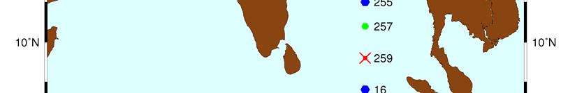
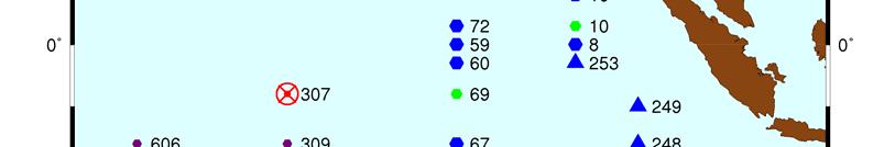
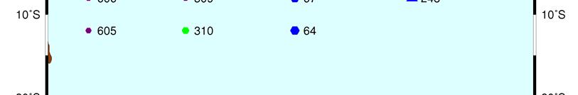
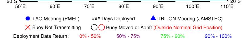
17 DBCP-26/Doc. 7 rev 3, Appendix B, p. 17 RAMA Implementation Status

18 DBCP-26/Doc. 7 rev 3, Appendix B, p. 18 Exclusion Zone as declared by Lloyds of London. Solid green dots show deployed RAMA moorings; open circles are RAMA sites not yet occupied. Red pointed symbols show hijacking; yellow pointed symbols are ships fired upon. Dates of attacks for March-May 2010 are next to symbols.
19 1) Summary APPENDIX C REPORT BY THE EUCOS SURFACE MARINE PROGRAMME (E-SURFMAR) Name of Action Group Surface Marine programme of the Network of European Meteorological Services, EUMETNET (E-SURFMAR) Date of report 31 July 2010 Overview and main The EUMETNET Composite Observing System (EUCOS) surface marine requirements (E-SURFMAR) programme is an optional programme involving 17 out of addressed the 26 EUMETNET members, who fund the activity on a GNI basis. Its main objectives are to coordinate, optimise and progressively integrate the European meteorological services activities for surface observations over the sea including drifting and moored buoys, and voluntary observing ships. E-SURFMAR is responsible for coordination of buoy activities carried out by the European meteorological services, and the programme supports a Data Buoy Manager (DBM) to manage these activities. The DBM is supported and advised by the E-SURFMAR Data Buoy Technical Advisory Group (DB-TAG) which is an action group of the DBCP. Area of interest Ocean areas potentially affecting NWP over European countries. This covers the North Atlantic Ocean North of 10 N and the Mediterranean Sea (90 N-10 N; 70 W - 40 E). Type of platform and variables measured Targeted horizontal resolution Drifting buoys: air pressure, SST, (wind) Moored buoys: air pressure, wind, air temperature, SST, waves (directional spectra), relative humidity. 250 km x 250 km, >150 drifting buoys, 4 moored buoys for satellite calibration/validation. Chairperson/Manager s Coordinator Manager E-SURFMAR: Mr Pierre Blouch, Météo-France Chairperson, Data Buoy Technical Advisory Group (DB-TAG): Mr Jon Turton, UK Met Office Data buoy Manager: Mr Jean Rolland, Météo-France Participants Belgium, Croatia, Cyprus, Denmark, Finland, France, Germany, Greece, Iceland, Ireland, Italy, The Netherlands, Norway, Portugal, Spain, Sweden, and the United Kingdom Data centre(s) Météo-France as SOC ISDM (Canada) as RNODC/DB Website under the heading EUCOS Public in EUCOS net works (restricted working area web site for E-SURFMAR participants) Meetings DB-TAG meets once a year. DB-TAG7 Madrid May 2010 Current status (mid- 2010) Summary of plans for drifting buoys in operation (48 Iridium, 61 Argos). 4 E-SURFMAR supported moored buoys in operation, plus a further 17 K-series buoys and 16 Oceanor buoys operated by members. Maintain a network of 100 drifting buoys, and the 4 reference moored buoys in operation.
20 DBCP-26/Doc. 7 rev 3, Appendix C, p Deployment plans for 2011 The drifting buoys will be deployed from various locations (Canada, Iceland, France, Norway, UK, USA,...) in the Atlantic Ocean. The drifters from GDP upgraded with barometers will be deployed by vessels plying from USA to Iceland and from USA to Europe. Within the allocated budget more than 100 buoys (including 30 upgrades) will deployed in the E-SURFMAR area of interest in the coming twelve months. New deployment routes will be investigated. E-SURFMAR will continue to deploy buoys in the Arctic Ocean through IABP. The main challenge with the ice buoys is their ability to survive after being released from frozen ice. At present, Cabo Silleiro (transmission through Inmarsat) is the only EUCOS moored buoy which reports directional wave spectra onto the GTS. Spectral data from K5 (transmission through Iridium) are still experimental. Lion moored buoy (transmission through Meteosat) reports omnidirectional spectra and M6 (transmission through Meteosat) is only reporting mean wave height and period. It is expected that a modified version of the system developed by the Met Office for K5 will be also installed on the Lion buoy with similar capability on M6 in due course. 3 Data management 3.1 Distribution of the data Data policy ESURFMAR encourages free and open access to data, in the spirit of WMO data exchange policy defined in WMO Congress Resolution 40 (Cg-XII). All basic meteorological and oceanographic data are coded in the appropriate WMO code form and disseminated on the WMO Global Telecommunication System (GTS) Real-time data exchange All the data are put on the GTS as quickly as possible. The developments on a processing chain at Météo-France producing GTS reports from Iridium SBD data were consolidated. The chain is able to produce FM13-SHIP, FM18-BUOY or FM94- BUFR messages. The distribution of BUFR messages should start during summer 2010 after the first drifters having a resolution of 0.01K for SST are deployed. The evaluation of the Iridium communication system was done as a contribution to the DBCP drifter Iridium Pilot Project. Half of the number of drifters operating are now using Iridium. This improves the data timeliness (see Annex). About 2,500 daily observations are carried out on to the GTS. The short term target (70%) of the percentage of data received within 50 minutes was reached. The long term target (90%) will be only reached if all the buoys move to Iridium SBD. NOAA buoys upgraded with barometers by ESURFMAR are still reporting through Argos. The mean lifetime (for Air Pressure) of the SVP-B drifters was approximately 12 months (351 days). Ninety eight buoys failed to report air pressure measurements. The availability of moored buoy data depends on the number of buoys operating. An average of 80 hourly observations per day have been reported from E-SURFMAR buoys to the GTS. Since buoy Cabo Silleiro was taken into account in the performance computations, the percentage of EUCOS moored buoys data available within 50 minutes dropped from 100% to 80% i.e. below
21 DBCP-26/Doc. 7 rev 3, Appendix C, p. 21 the target of 90% Delayed mode data exchange The raw data from drifters (Argos and Iridium) are archived at Centre de Meteorologie Marine (CMM) at Meteo-France. Data inserted onto the GTS are routinely archived by various centres (for drifting buoys ISDM, GDP, Coriolis, Meteorological Services for drifting and moored buoys). Archived data from drifters are also used to produce surface currents deduced from the buoys movement on a weekly basis The metadata collection system at JCOMMOPS is used for drifting buoys. E-SURFMAR will generate Moored Buoy Metadata, once a standard template is provided - this is still to be agreed by the DBCP Task Team on Moored Buoys in its metadata initiative. 3.2 Data quality The web page giving access to the Quality Control (QC) tools was enhanced in 2009 (see Monthly statistics and 14-day graphs are now available for all surface marine observations through the same interface. More parameters are considered in the statistics: humidity, wave height and direction, salinity have been added. Buoys reporting in BUFR are monitored as those reporting through BUOY or SHIP alphanumeric messages. The blacklists, automatically issued for air pressure every day, are used to identify and correct potential problems. For drifters the Air Pressure (AP) differences from the French model outputs showed that the target of 1% of Gross Errors was easily being achieved. The RMS of AP differences still has a seasonal variation, being higher in winter (0.8 hpa) than in summer (0.6 hpa). For moored buoys the Air Pressure (AP) differences with the French the target of 0.5% of Gross Errors was achieved. The RMS of AP differences are between 0.5 to 0.8 hpa. 4) Instrument practices ESURFMAR drifting buoys uses recommended DBCP formats (DBCP-M2 for Argos, formats published on Iridium PP website for Iridium). A draft technical document on E-SURFMAR moored buoys is under review. It is hoped to have a completed document for the next DBTAG meeting in May ) OSE experiment An OSE experiment has been carried out by ECMWF on surface marine data. The study showed a clear positive impact of buoy data, strongest at 1000hPa but lasting up to 500hPa. The impact is stronger and lasts longer when GPS Radio Occultation (GPSRO) data are used. The present density of additional buoys compared to the situation before ESURFMAR started- has a visible but moderate impact in terms of forecasts scores. The impact on storms Klaus and Xynthia was slightly positive for 24 h forecasts but remarkable for 48 h and 96 h.

 3000")


22 DBCP-26/Doc. 7 rev 3, Appendix C, p. 22 Annex Operating Buoys in E-SURFMAR area Drifting buoy trajectories and moored buoy positions (June 2010) 3000 Total 2500 < 100 min < 50 min Number of daily obs janv-02 janv-03 janv-04 janv-05 janv-06 janv-07 janv-08 janv-09 janv-10 Drifting buoys data availabilty
23 APPENDIX D REPORT BY THE INTERNATIONAL BUOY PROGRAMME FOR THE INDIAN OCEAN (IBPIO) 1) Summary Name of Action Group International Buoy Programme for the Indian Ocean (IBPIO) Date of report 31 July 2010 Overview and main requirements addressed The International Buoy Programme for the Indian Ocean (IBPIO) was formally established at a meeting in La Reunion in The primary objective of the IBPIO is to establish and maintain a network of platforms in the Indian Ocean to provide meteorological and oceanographic data for both real time and research purposes. More specifically, the IBPIO supports the World Weather Watch Programme (WWW); the Global Climate Observing System (GCOS); the World Climate Research Programme (WCRP); the Global Ocean Observing System (GOOS); tropical cyclone forecast and monitoring; as well as the research activities of the participating institutions. The programme is self-sustaining, supported by voluntary contributions from the participants in the form of equipment and services (such as communications, deployment, storage, archiving, co-ordination...). Area of interest Indian Ocean North of 55 S and between 25 E and 120 E Type of platform and variables measured Targeted horizontal resolution Chairperson/Managers Coordinator Participants Data centre(s) Website Meetings Current status (mid-2010) Summary of plans for 2011 Drifting buoys: Air pressure, SST, (wind) Moorings: air pressure, wind, air temperature, SST, waves, relative humidity, SSS, current 500 km x 500 km Mr Graeme Ball, BoM, Australia Mr Jean Rolland, Météo-France Australia (ABOM), France (Météo-France), India (NIO, NIOT, INCOIS), Kenya (KMD), South Africa (SAWS), Mozambique (EMU); USA (GDP, Navoceano), TIP (Tropical Moored Buoy Implementation Panel). ISDM (Canada) as RNODC/DB, Météo-France as SOC AOML, NOAA/PMEL Annual meetings in conjunction with DBCP meetings. IBPIO 13 in OBAN in September drifters (148 with Air Pressure) 39 moored buoys (27 for RAMA 59% of the planned 46 site array) Maintain a network of more than 150 drifters. Maintain the moored buoy arrays, reach 34 buoys deployed for RAMA
24 DBCP-26/Doc. 7 rev 3, Appendix D, p Deployment plans for 2011 IBPIO participants are regularly encouraged to maintain their contributions of buoys, or to fund barometers to equip SVP drifters provided by GDP. Météo-France, ABOM, SAWS, regularly, fund barometer upgrades in the Indian Ocean. More than 200 drifters are planned to be deployed during the next intersessional period, of which forty five will be equipped to transmit through Iridium (Action by BOM, GDP, Météo-France and DBCP) Efforts are aimed at filling data gaps in the tropical regions, primarily during the Tropical Cyclone season. In the southern tropical area the buoys are provided by NOAA/GDP and will include about 10 (Iridium) barometer upgrades funded by Météo-France and the DBCP. The ABOM plans to deploy 9 drifting buoys between the central Indian Ocean and the Australian coast. NIO plans to continue to provide and deploy drifters in the Arabian Sea and in the Bay of Bengal (about 20 in ). RAMA implementation and maintenance will continue in the coming year. MOUs between the US and Indian or Indonesia will provide 90 or more sea days annually to support US sites. JAMSTEC will maintain 4 RAMA sites on a RV Mirai cruise in January China intends to maintain their surface and subsurface mooring with annual cruises of about 15 days from Indonesian research vessels. An Implementing Arrangement (IA) being developed between the US and the United Nations Developing Programme (UNDP) will formalize efforts to maintain and expand moorings along 55 E. To address security concerns in the area, ASCLME (Agulhas and Somali Current Large Marine Ecosystems, a consortium of 9 African countries) has arranged for a Seychelles Coast Guard escort while in areas of piracy during a cruise in October The 4 th Météo-France supported barometer site will be deployed on this cruise. As security issues are addressed in other areas, further implementation may proceed. By June 2011 the number of RAMA moorings may reach 34, or 74% completion of the IOP planned array. PMEL is developing a replacement for the ATLAS system which will comprise more commercially available components, provide higher temporal resolution data in real time, and inhibit the theft of surface electronics. Under the terms of an IA between the US and Indonesia, this system will support both RAMA and the Indonesian Global Ocean Observing System (InaGOOS). First prototype deployments will be in the coming year. NIOT will maintain a network of 12 deep sea buoys, 5 in the Arabian Sea and 7 in the Bay of Bengal. In the Southern part of the Indian Ocean (South of 35S), the deployment of SVP-B drifters provided by GDC and upgraded by Météo-France (about 30 units, of which 20 will be Iridium buoys) should continue. The ABOM plans to deploy 13 SVP-B drifters in this area over the next 12 months including 8 upgrades. These deployments will be supported by the RV Marion Dufresne during her rotations between La Reunion, Crozet, Kerguelen and Amsterdam Islands. In addition to the drifters upgraded by Météo-France and ABOM, GDC plans to provide SVP-B drifters for deployment in the Southern Indian Ocean. In the sub-tropics (between the Tropic of Capricorn and 35S) the ABOM will deploy 6 SVP-B, including 2 near the Indian Ocean Gyre. The SAWS, through the PMO in Cape Town, will continue to coordinate the deployment of drifters on behalf of GDP, ABOM and Météo-France from voyages to Marion Island (4 voyages every year, March, April, August and November). The ABOM plans to provide 2 SVP-B buoys for deployment from the scheduled voyages in 2011.
25 DBCP-26/Doc. 7 rev 3, Appendix D, p. 25 As in previous years, the GDP remains the biggest contributor to the IBPIO, with more than 150 planned drifters deployments. Many of the drifters are standard SVP (60 planned deployments) that only measure SST in addition to the surface current deduced from their movement. 3 Data management 3.1 Distribution of the data Data policy IBPIO encourages free and open access to data, in the spirit of WMO data exchange policy defined in WMO Congress Resolution (Cg-XII). All basic meteorological and oceanographic data are coded in the appropriate WMO code form and inserted to the Global Telecommunication System (GTS) Real-time data exchange All the data are placed on the GTS as quickly as possible. The developments on a processing chain at Météo-France producing GTS reports from Iridium SBD data were consolidated. The chain is able to produce FM13-SHIP, FM18-BUOY or FM94- BUFR messages. The evaluation of the Iridium communication system was done as a contribution to the DBCP drifter Iridium Pilot Project. Only a few of the drifters are using Iridium. This improves the data timeliness. One hundred and forty drifting buoys were deployed of which about 73% measured air pressure (SVP-B). The number of daily observations (about 3500 in June 2010) carried out on to the GTS is increasing (see Annex). The percentage of data received within 50 minutes increased from 20% to more than 35%. By mid-2010, 13 of 17 ATLAS moorings were reporting on the GTS (WMO ID s 14040, 14043, 23001, 23002, 23003, 23004, 23005, 23006, 23008, 23009, 23010, 53005, 53006) Delayed mode data exchange Data are routinely archived by various centres (for drifting buoys ISDM, GDP, Coriolis, Meteorological Services for drifting and moored buoys). Archived data from drifters are also used to produce surface currents deduced from the buoys movement on a weekly basis The metadata collection system at JCOMMOPS is used for drifting buoys. PMEL s Tropical Moored Buoy website displays and distributes the RAMA data. 3.2 Data quality The Météo-France Quality Control (QC) website was enhanced in 2009 (see Monthly statistics and 14-day graphs are now available for all surface marine observations through the same interface. Additional parameters are now available, including humidity, wave height and direction, and salinity. Buoys reporting in BUFR are monitored along with those reporting in BUOY or SHIP messages. The blacklists, automatically issued for air pressure every day, are used to identify and correct potential problems.
26 DBCP-26/Doc. 7 rev 3, Appendix D, p. 26 For drifters the Air Pressure (AP) differences from the French model outputs were generally lower than 1% of Gross Errors. The RMS of AP differences still has a seasonal variation, being higher in winter (1.1 hpa) than in summer (0.8 hpa). 4) Instrument practices IBPIO drifting buoys uses recommended DBCP formats (DBCP-M2 for Argos, formats published on Iridium PP website for Iridium). 5) Issues: maintenance of RAMA moored buoys The combination of heavy vandalism and moorings being deployed for unusually long periods has resulted in data return rates significantly lower than those for the tropical moored buoy arrays in the Pacific and Atlantic Oceans. Bad weather and difficulty in obtaining timely and sufficient sea days has lead to many RAMA moorings being deployed longer than their intended 12 months. For example, a mooring deployed at 4 N 90 E in October 2007 and vandalized in January 2008 was not replaced until July 4, 2010 (33 months), resulting in a prolonged data gap. The loss of data emphasizes the need for sustained and regular ship support and for measures to combat vandalism. Damage to buoys and theft of instrumentation continues to be a problem, especially at sites near areas of intense fishing activity. Some ATLAS moorings have been modified to inhibit vandals from boarding the buoy. While proving successful at keeping moorings in place (3 of 4 moorings were recovered and 2 are presently operating) and producing sustained subsurface measurements, an adequate method of inhibiting vandalism upon surface met sensors has not yet been found. Between July 2009 and June 2010, 106 sea days (74 by India and 32 by Indonesia) were provided in support of ATLAS RAMA sites. Additional ship time was provided by India in support of their Deep Ocean moorings (~37 days), Japan in support of their m-triton moorings (14 days) and Indonesia in support of China s moorings (28 days). The number of sea days necessary to fully maintain the completed array is estimated to be at least 200 days per year. Formal bilateral agreements have either been approved or are under development between NOAA and agencies of the various partner countries to help complete and sustain the array. To facilitate and coordinate resources that may be applied to the Indian Ocean Observing System, an IndOOS Resource Forum was established in In addition to vandalism, recent well-publicized piracy events have resulted in the suspension of RAMA implementation off Africa and in the Arabian Sea

 3500")


27 DBCP-26/Doc. 7 rev 3, Appendix D, p. 27 Annex 4000 Drifting buoy trajectories (June 2010) 3500 Total <100 min < 50 min Number of daily obs janv-02 janv-03 janv-04 janv-05 janv-06 janv-07 janv-08 janv-09 janv-10 Drifting buoys data availability
28 APPENDIX E REPORT BY THE DBCP-PICES NORTH PACIFIC DATA BUOY ADVISORY PANEL (NPDBAP) 1) Summary Name of Action Group DBCP-PICES North Pacific Data Buoy Advisory Panel (NPDBAP) Date of report 31 July 2010 Overview and main requirements addressed The goals of the NPDBAP are to deploy 50 SVPB drifters a year, and maintain 75 active buoys in the region. Area of interest North Pacific Ocean and marginal seas generally north of 30 N Type of platform and variables measured Targeted horizontal resolution Chairperson/Managers Coordinator Participants Data centre(s) Website Meetings Current status (mid-2010) Summary of plans for 2011 Lagrangian drifters measuring sea level pressure, SST, and seasurface velocity 5 x 5 Co-Chairperson for the NE Pacific: Al Wallace, MSC, Canada Co-Chairperson for the NW Pacific: Position vacant and to be proposed by PICES Mr Shaun Dolk, NOAA / AOML Al Wallace, Chris Marshall, Joe Linguanti, Ignatius Rigor, and Shaun Dolk Global Drifter Assembly Centre (DAC) Integrated Science Data Management (ISDM), Canada Yearly meetings usually held in conjunction with DBCP meetings. Next meeting planned 26 September 2010 in Oban, UK From 01 September, 2009 to 27 July, 2010, 94 drifters have been deployed. 58 of these drifters were equipped with barometers, 22 were equipped with GPS, and one was equipped with a wind sensor (the remaining 13 drifters were basic SVP type units). The goal for 2011 is to reach 100 drifter deployments, of which, at least 60 drifters shall be barometer equipped. 2 Deployment plans for 2011 Both the GDP and Environment Canada will continue to utilize ships of opportunity for drifter deployments, while also looking for new possibilities within the Coast Guard. Through the tremendous help of Ignatius Rigor, a collaboration with JAMSTEC has been established, which allows for drifter deployments on Japanese vessels. 3 Data management
29 DBCP-26/Doc. 7 rev 3, Appendix E, p Distribution of the data The drifter Data Assembly Center (DAC) assembles, quality controls and interpolates data from approximately 1300 drifters per month from all GDP national and international partners, from all oceans of the world. These data are made available through the web with a delayed time of 3 4 months. As of the time of writing this report (July 2010), data are available through March These data can be accessed at Data policy The DAC, located at NOAA s Atlantic Oceanographic and Meteorological Laboratory (AOML) has access to drifters from GDP partners that have given Service Argos permission to make these data available to the DAC. In return the partners have access to all quality controlled and interpolated data available in the database via the World Wide Web. Non-interpolated quality controlled data and raw data are made available via ftp transfer upon request Real-time data exchange All data from drifters in the GDP s programs are disseminated via GTS as soon as drifters are deployed. The GDP monitors data going out on the GTS, and transmissions of sensors producing bad data or transmissions from grounded drifters are removed from the GTS data stream. The GDP does not monitor GTS data timeliness and relies on operational centres to report on these issues Delayed mode data exchange Drifter data (raw Argos data, edited non-interpolated and interpolated data) are archived at AOML. These datasets are also sent once or twice a year with a 6-month delay to Integrated Science Data Management (ISDM), the RNODC for drifter data, for permanent archival and further distribution. The DAC is currently preparing to send data through Dec 2009 to ISDM. Metadata for GDP drifters are received at the DAC directly from drifter manufacturers who send standardized specification sheets for batches of identical drifters prior of delivery of the instruments. Portions of this metadata are extracted and are made available on the deployment log at the DAC web page Specification sheets are archived at the DAC. Deployment date, date of last transmission, drogue off and cause of death metadata are determined during quality control of the dataset and are made available through the web at These web pages are interrogated by JCOMMOPS to gather information for their metadata systems. 3.2 Data quality 4) Instrument practices 5) Other issues as needed
30 DBCP-26/Doc. 7 rev 3, Appendix E, p. 30 Annex Status maps and graphics 5 Year Deployment Trend Total SVPB SVP SVPW SVPBW SVPG FY FY FY FY FY
31 1) Summary APPENDIX F REPORT BY THE INTERNATIONAL ARCTIC BUOY PROGRAMME (IABP) Name of Action Group International Arctic Buoy Programme (IABP) Date of report 25 August 2010 Overview and main Participants of the IABP continue to work together to maintain a requirements addressed network of drifting buoys on the ice of the Arctic Basin to provide meteorological and oceanographic data for real-time operational requirements and research purposes including support to the World Climate Research Programme (WCRP) and the World Weather Watch (WWW) Programme. Area of interest Central Arctic Ocean and its marginal seas, excepting Exclusive Economic Zones, where agreements of the Coastal States have not been obtained Type of platforms and variables measured Targeted horizontal resolution Chairperson/Managers Coordinator Participants Data centre(s) Website Meetings Buoys on ice and/or in water measuring: Basic meteorological variables such as atmospheric air pressure and air temperature Other variables such as: atmospheric pressure tendency, air chemistry (e.g. ozone), snow and sea-ice properties, as well as sub-surface oceanographic characteristics (e.g. temperature and salinity) 250 km x 250 km Christine Best, Meteorological Service Canada (MSC) Ignatius Rigor, Polar Science Center, University of Washington, USA Participants range from Science Institutions to Universities to Government Agencies. A listing of Participants and contact information is given on n/a Annual meetings in spring/early summer in the Northern Hemisphere Current status (mid-2010) Total of 72 buoys in the IABP array 23 August 2010 Summary of plans for 2011 Participants will deploy buoys ranging from SVP s providing surface air pressure to buoys providing air pressure and air temperature to Ice mass Balance buoys, Oceanographic profiling buoys measuring temperature and salinity to great depths and buoys that measure atmospheric air components such as ozone
32 DBCP-26/Doc. 7 rev 3, Appendix F, p Deployment plans for 2011 Specific details on deployment plans, and opportunities for next year are not known. As plans and opportunities for deployments become known Participants are encouraged to make then known to the IABP Coordinator Ignatius Rigor Ignatius@apl.washington.edu. Participants are also encouraged to share their plans and opportunities with Jenny Hutchings, IARC, jenny@iarc.uaf.edu for posting on the web page 3 Data management 3.1 Distribution of the data Most of the meteorological and oceanographic data is posted on the GTS. Much of the ice data is available from Participants web pages. Efforts continue to have those using Iridium communication to find means to post data to the GTS Data policy Data exchange policies of the Participants for data not getting onto the GTS has not been catalogued. However, most Participants have web sites that display data and/or graphs of the data Real-time data exchange The percentage of data from the buoys being distributed on GTS has not been calculated. Details on data timeliness (i.e. reception time at operational meteorological services minus observation time), including known problems, possible solutions, statistics, etc is not available Delayed mode data exchange Data are available from as well as ISDM. Data are also archived at the World Data Center for Glaciology ( and the U.S. National Science Foundation s Cooperative Arctic Data and Information Service ( Collection of - and distribution of - metadata is an ongoing task of the Coordinator. We plan to provide these through our web server ( and produce netcdf data files containing this information Details on the provision of discovery metadata about available data-sets using ISO standard are to be determined. 3.2 Data quality The Coordinator participates in the buoy QC forums of the DBCP and JCOMM and performs daytoday QC of the data. More thorough QC of the data is performed during the analysis and production of the research data bases. Feedback is ad hoc. Data is suppressed when noted to be questionable. 4) Instrument practices Data analyses procedures for the Arctic are documented in journal papers. As part of our efforts to collect and provide the metadata, details on instruments and other procedures will be provided through our web pages 5) Other issues 5.1 Challenges to sustain IABP network Increasing areas of First-Year Ice and Open Water during summer Deploying buoys in the Eurasian Arctic
33 DBCP-26/Doc. 7 rev 3, Appendix F, p Buoy data not getting onto GTS Argos Buoys - Yann Bernard, Service Argos, provided the IABP Coordinator a list of active Argos platforms in the IABP area north of 66N not yet being processed by Service Argos for the GTS. The IABP Coordinator will contact those on the list to see if they are wiling to share via having data posted to the GTS Iridium Buoys - Many researchers are using Iridium rather than Argos to get their data and that data is being posted to ftp sites and no further. Efforts are being made to have data flipped to the GTS. For example, Joubeh, Scotia Weather, and Environment Canada are collaboration for posting Iridium data on the GTS. 5.3 Obtaining data that did not get onto the GTS During the IPY in particular, there were buoys on ice whose data has yet to make it to GTS or IABP archives. Efforts are ongoing to get that data in GTS and IABP archives.
34 DBCP-26/Doc. 7 rev 3, Appendix F, p. 34 Annex Status maps and graphics IABP Program Buoy Status 23 August 2010 with comparisons back to August 1 August August August August Ocean Profiling POPS or ITP Ocean Profiling UpTempo 2 Arctic Ocean Flux Buoy Ice Mass Balance Near Surface Air 1 Chemistry O buoy Only Surface air temperature and surface air pressure Only Surface air temperature Only Surface air pressure Position only Russian manned station NP 35 NP 36 Nil NP37 established September 2009 and removed May 2010 Total Numbers of buoys The annual White Trident aerial deployment historically occurs early August and accounts for 7 to 12 buoys once it has occurred. The 2010 mid August buoy count is low as the annual WT exercise has not yet occurred. WT 2010 is scheduled for September and is expected to add up to 10 buoys to the array. 2 Not reflected in 2008 or 2009 editions of table 3 By design or because the surface air temperature and surface air temperature data has failed or become unreliable 4 Six buoys shown elsewhere in the table also provide both surface air temperature and surface air pressure.

35 DBCP-26/Doc. 7 rev 3, Appendix F, p. 35 Buoy map with 60-day buoy track and ice concentration 23August 2010 From International Arctic Buoy Programme web page daily map series
36 DBCP-26/Doc. 7 rev 3, Appendix F, p. 36 Buoy map with respect to instrumentation 10 August 2010 From International Arctic Buoy Programme web page monthly map series
37 DBCP-26/Doc. 7 rev 3, Appendix F, p. 37 Buoy map with respect to meteorological data provided 10 August 2010 From International Arctic Buoy Programme web page monthly map series

38 DBCP-26/Doc. 7 rev 3, Appendix F, p. 38 Buoy map highlighting ice mass balance buoys and automated drifting stations 23 August 2010 From International Arctic Buoy Programme web page daily map series

39 DBCP-26/Doc. 7 rev 3, Appendix F, p. 39 Buoy mapping showing ocean profiling buoys 23 August 2010 From International Arctic Buoy Programme web page
40 APPENDIX G REPORT BY THE WCRP-SCAR INTERNATIONAL PROGRAMME FOR ANTARCTIC BUOYS (IPAB) 1) Summary Name of Action Group WCRP-SCAR International Programme for Antarctic Buoys (IPAB) Date of report 31 July 2010 Overview and main requirements addressed Area of interest Type of platform and variables measured Targeted horizontal resolution Chairperson/Managers Coordinator Participants The Participants of the WCRP/SCAR International Programme for Antarctic Buoys (IPAB) work together to maintain a network of drifting buoys in the Southern Ocean, in particular over sea ice, to provide meteorological and oceanographic data for real-time operational requirements and research purposes. South of 55 S and that region of the Southern Ocean and Antarctic marginal seas within the maximum seasonal sea-ice extent Ice buoys measuring the following: Basic variables: Buoy position, atmospheric pressure and SST Other variables: air temperature, ice and / or snow temperature, atmospheric pressure tendency, wind, snow and sea-ice properties and oceanographic variables 500 km x 500 km Mr Shuki Ushio, NIPR, Japan Dr Christian Haas, University of Alberta, Canada - Alfred Wegener Institut, Germany - Australian Antarctic Division, Australia - Australian Bureau of Meteorology - British Antarctic Survey, UK - Finnish Institute for Marine Research, Finland - GI, University of Alaska Fairbanks, USA - IARC, University of Alaska Fairbanks, USA - Institut für Meteorologie und Klimaforschung, Universität Karlsruhe, Germany - National Ice Center, USA - National Snow and Ice Data Center, USA - Met. Service NZ LTD, New Zealand - Norwegian Polar Institute, Norway - NSF, USA - National Institute of Polar Research, Japan - JAMSTEC, Japan - Programma Nazionale di Ricerche in Antartide, Italy - DAMTP, UK - SAMS, UK - University of Alberta, Edmonton, Canada
41 DBCP-26/Doc. 7 rev 3, Appendix G, p CLS/Service Argos, France - South African Weather Service, South Africa - United Kingdom Meteorological Office, UK - CRREL, USA Data centre(s) Website Meetings Current status (mid-2010) Summary of plans for Biennial meetings An informal IPAB meeting was held at the International Antarctic Sea Ice Workshop on May 30, 2010, in Tromsoe, Norway, where all of the most active IPAB participants were present. There were no deployments performed on sea ice in the 2009/2010 season, although numerous SVPs were deployed in open water by the Meteorological Services of South Africa, Australia, and New Zealand. The Meteorological Services of South Africa, Australia, and New Zealand will continue to deploy SVPs in the open water zone during December 2010 to March In addition, 22 buoys will be deployed on ice during two research cruises in the Southern Pacific. Participants are encouraged to transmit their data to the GTS, and support by the coordinator has been offered. 2 Deployment plans for 2011 Buoys will be deployed during two research cruises to the Southern Pacific. 20 prototype ice mass balance buoys will be deployed by SAMS and BAS in the Bellingshausen Sea during a research cruise of RV James Clark Ross in November These buoys include GPS and thermistor chains through the snow and ice. 2 standard CRREL ice mass balance buoys will be deployed by the University of Texas San Antonio in the Bellingshausen and Amundsen Seas during a research cruise of IB Oden in November/December These buoys include GPS and thermistor chains through the snow and ice, as well as sonic rangefinders to measure changes of snow and ice thickness. Other nation s research cruises are generally available for opportunistic buoy deployments, however, cruise tracks are generally not favourable of sustained deployments on ice floes with a good chance of survival through the summer. 3 Data management 3.1 Distribution of the data Data policy Data are generally freely distributed among IPAB participants as part of general scientific collaboration. Participants are encouraged to submit their data to the IPAB coordinator upon completion of their own scientific analyses Real-time data exchange Participants are encouraged to transmit their data to the GTS. However, unfortunately only few
42 DBCP-26/Doc. 7 rev 3, Appendix G, p. 42 data are actually being transmitted. Many participants are overwhelmed by new requirements due to increased usage of Iridium transmission. 3.2 Data quality Data quality is an ongoing issue. QC is performed by the individual science groups, or by some national data centres and the DBCP is data are transmitted on GTS.
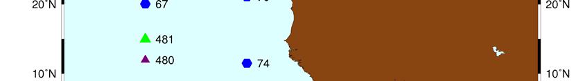
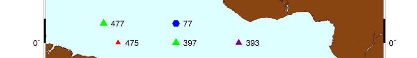
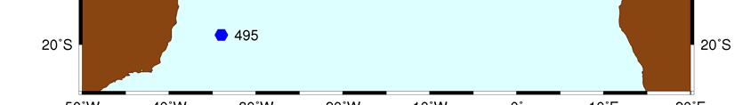
43 APPENDIX I REPORT BY THE INTERNATIONAL SOUTH ATLANTIC BUOY PROGRAMME (ISABP) 1) Summary Name of Action Group International South Atlantic Buoy Programme (ISABP) Date of report 31 July 2010 Overview and main requirements addressed Area of interest Type of platform and variables measured Targeted horizontal resolution Chairperson/Managers Coordinator Participants Data centre(s) Website Meetings Current status (mid-2010) Summary of plans for 2011 The main objective of ISABP is to establish and maintain a network of platforms in the Tropical and South Atlantic Ocean in order to provide meteorological and oceanographic data for both real-time and research purposes. The task includes support to the World Weather Watch Programme (WWW), the Global Climate Observing System (GCOS), the World Climate Research Programme (WCRP), and the Global Ocean Observing System (GOOS), as well as to the research activities of participating institutions. South Atlantic Ocean north of 55S plus Tropical Atlantic Ocean upto 20N Lagrangian drifters measuring sea level pressure, SST, and seasurface velocity 5 degrees x 5 degrees Mr Ariel Troisi, SHN, Argentina Mayra Pazos, AOML-NOAA, USA Lithakazi Mkatshwa, SAWS, South Africa Historical drifter data are assembled, quality controlled at AOML, Miami, then sent to ISDM for archival and further distribution. Real time data is also archived at ISDM Meetings are held every other year, normally in May-July. ISABP- 13 took place in Buenos Aires, Argentina, on April 19, 2010 As of July 19, 2010, there were a total of 296 drifters in the SA (160 SVP, 136 SVPB) surpassing the goal of 100 SVPB in the area. Continue to address observational gap areas specially in the Gulf of Guinea and Angola Basin; pursue recommendation of conducting studies and evaluate the impact of drifter pressure data and SST on the skills of numerical weather forecasting models for the region; increase number of SVPB in the region.
44 DBCP-26/Doc. 7 rev 3, Appendix H, p Deployments in 2010 and plans for 2011 Deployments during the last year (19-July 2009 through 19 July 2010) are shown in Figure 1. Efforts to populate hard to reach areas (i.e. Gulf of Guinea and Angola Basin) continued during the intersessional period, mainly with the help of the US Navy vessels(12). Other deployments were carried out by the Brazilian Navy (53), SA Agulhas(31) LM Gould(8), Argentinian Navy(7), and several other research vessels. Brazil will deploy a total of 95 drifters in 2010 (75 SVP provided by GDP and 20 SVPB upgraded by Brazil). Tristan da Cunha and the Falklands/Malvinas, participated actively in the deployment of drifters from their fisheries vessels, throughout the year. South Africa Weather Service acquired 5 Iridium drifters to be deployed as part of the Iridium Pilot Project, of which 2 have been deployed in the region (and one in the Indian Ocean sector). The remaining two will be deployed, again in the South Atlantic in September. Brazil expects to finish repairs to one moored buoy and have it deployed between Jul-Dec In 2011, the US Navy will continue its African Partnership Station program and will carry out more deployments in the area. SAWS is now actively finding deployment opportunities as well as increasing the VOS fleet, therefore they expect to be able to arrange for more deployments. It is expected that the Polarstern will be returning to the Atlantic sector in the 2010/2011 austral summer season. Argentina can now receive donations of instruments without paying any taxes, and will continue to deploy drifters in the area. There is also a center in Puerto Madryn that is very interested in participating in the program by deploying instruments. The GDP deployment plans from June 1, 2010 May 31, 2012 are as follows: Tropical Atlantic (20 0 S 30 0 N): SVP=335 SVPB=25 (upgraded by Brazilian Navy) Extra Tropical Atlantic (40 0 S 20 0 S): SVP=25 SVPB=75 Southern Atlantic (60 0 S 40 0 S): SVP=0 SVPB=225 Servicio de Oceanografia, Hidrografia & Meteorologia de la Armada, Uruguay, who recently joined ISABP agreed to provide deployment opportunities in Data management 3.1 Distribution of the data These data are assembled and quality controlled at the GDP Drifter Data Assembly Center, and available through the DAC web page ( and from ISDM web ( Data policy Following current standards, ISABP promotes timely, free and open data exchange Real-time data exchange All data from drifters are disseminated via GTS as soon as drifters are deployed. These data are monitored and taken off GTS when sensors stop giving good quality data. As of July 19 there were 296 surface drifters in the South Atlantic region transmitting good quality data on the GTS. Details on data timeliness (i.e. reception time at operational meteorological services minus observation time), including known problems, possible solutions, statistics, etc. Because of the less-than-ideal satellite coverage of the parts of the region, the South African
45 DBCP-26/Doc. 7 rev 3, Appendix H, p. 45 Weather Service wanted to re-install the Local User Terminals at its Island bases (Marion Island and Gough Island) in order to support the timely delivery of buoy data in the vast contiguous ocean areas. Unfortunately, recent global economic downturn put paid to the SAWS plans to reinstall and upgrade LUT s. Since then, CLS has revealed their plan to upgrade their IS antenna network to achieve greater coverage over the oceans. This network will extend to the Southern Hemisphere to ensure the timely delivery of buoy messages for inclusion in the synoptic analyses. This will be expanded on by CLS/Argos Delayed mode data exchange Updates of the raw, quality controlled and interpolated data sets are sent to ISDM, the RNODC for drifter data, twice a year for further archival and distribution. Metadata from GDP drifters are collected at the DAC directly from the manufacturers, archived and made available on the deployment log at the DAC web page Data quality A large number of drifters deployed by the Brazilian Navy this year failed on deployment. The manufacturer was contacted and it was determined that particular batch or drifters was manufactured more than 2 years prior to deployment and kept in storage for a long period of time and that may have been the cause of the early failures. 4) Instrument practices Details on instrument practices, followed standards and procedures, traceability to SI units, instrument inter-comparisons, etc. 5) Evolution of the South Atlantic Drifter array Status of the South Atlantic drifter array as of July 19, 2010 is shown in Figure 4. A total of 296 drifters (SVP: 160 and SVPB: 136) were transmitting at the time. The goal of 100 SVPB in the regions was surpassed, most of them found south of 20 0 S, and some north of 20 0 N. Figure 3 shows the number of deployments in the region by year since A moderate increase in the total number of drifters deployed per year is noticeable, except in , when deployment opportunities were scarce due to some ships breaking down, but were well averaged out by the large deployment increase in Also the number of SVPB has slowly increased throughout the years. At sharp increase in the number of SVPB can be seen in 2007, due to 40 iridium SVPB drifters from Brazil, deployed in the area and data processed at the DAC.

46 DBCP-26/Doc. 7 rev 3, Appendix H, p. 46 Annex Status maps and graphics Figure 1: Deployment locations. A total of 317 drifters were deployed.


47 DBCP-26/Doc. 7 rev 3, Appendix H, p. 47 Figure 2: Status of the South Atlantic Array. A total of 296 drifters in the region Figure 3: Number of Drifters Deployed in the South Atlantic per year
48 APPENDIX I REPORT BY THE OCEAN SUSTAINED INTERDISCIPLINARY TIMESERIES ENVIRONMENT OBSERVATION SYSTEM (OCEANSITES) Status and update on OceanSITES for DBCP-26 An update on OceanSITES had been prepared and provided only 5 months ago (April 2010) for the DBCP25 report, so not many additional new developments can be reported here. Most activities since DBCP25 were actually included in that report. Additional activities took place at the Data Management and Project Office level. The Data Management Team has continued its monthly conference calls, and arrived at an agreed update to the OceanSITES data format, which is now being implemented by the current data providers. Data is flowing from most of the participants in the original OceanSITES Steering Team, and in some cases that is starting to include biogeochemical data (e.g. for EuroSITES). Steve Diggs from CCHDO visited BIOS/Bermuda to resolve technical issues in getting the data from there into the OceanSITES system. The project office activities for OceanSITES continued to be carried out by Hester Viola together with some IT support, but Hester is leaving, and the funding for the project office is uncertain. Having the project office was the single most important factor that allowed OceanSITES to make real progress over the past 18months, and without this we will be thrown back into stagnation. Hester visited Kiel in August to meet with Uwe Send, Doug Wallace, and Johannes Karstensen, and established a remaining to-do list to help the OceanSITES project office survive a period of vacuum. Outreach, collaborations, and interfacing with other communities took place in various ways. Bob Weller represents the US OOI, is a member of OOPC, and attends many international meetings, building a connection to those. Uwe Send continues to inject OceanSITES into the OceanObs09 process, and it will be discussed whether OceanSITES could be a home for a global boundary current observing system. Uwe Send also represents OceanSITES in the Clivar GSOP panel, in US and international AMOC, and at other workshops/meetings (ASLO/AGU meeting in Portland 2010, POSTI International Symposium in Pohang 2010, OCB timeseries scoping workshop Honolulu 2010). Doug Wallace and Francisco Chavez continue to advocate the MOIN network of a subset of comparable minimal multidisciplinary sites in the SOLAS and OCB communities.
49 APPENDIX J REPORT BY THE INTERNATIONAL TSUNAMETER PARTNERSHIP (ITP) Summary Name of Action Group The International Tsunameter Partnership (ITP) Date of report 27 Sep 2010 Overview and main The International Tsunameter Partnership was established under the requirements auspices of the IOC Intergovernmental Coordination Group for the Indian addressed Ocean Tsunami Warning and Mitigation System (IGC/IOTWS). Its purpose is to support the establishment, effectiveness and on-going viability and enhancement of tsunami detection and warning systems using deep ocean monitoring stations (tsunameters). Its members are active in areas of tsunameter system development and qualification for moored and cabled systems; observation network establishment; data exchange and operational practices. Sustainability, including vandalism responses, will become an important focus. Area of interest All ocean basis or seas that are tsunami-vulnerable, with tsunami warning centres. There is a natural concentration on the Indian Ocean region because of the extent of new observation networks and the diversity of tsunameter product types in the IO and nearby east Asian seas. Type of platform and variables measured Targeted horizontal resolution Chairperson/Manager s Coordinator Moored Buoys: Sea Level (ocean column height): with some platforms also reporting met parameters and sub-surface parameters (product dependent) Cabled Systems: Sea `Level (ocean column height) plus wide variety of nodedependent ocean, seismic and biogeochemical parameters. Not applicable purpose-designed networks matched to threat sources and warning requirements Chair: Ken Jarrott, Australian Bureau of Meteorology Vice Chair: Ridwan Djamaluddin BPPT - Indonesia Not applicable Participants Data centre(s) Website Meetings Current status (mid- 2010) Summary of plans for 2011 Australia, Germany, India, Indonesia, Malaysia, USA, China, Korea, Thailand, with suppliers (USA, Italy, UK, Norway, and national R&D agencies). Expansion to new national network operators (Russia, Oman, Cyprus) to be welcomed in coming year. National operator agencies for buoys with restricted national data distribution. NOAA NDBC for Pacific Ocean, Caribbean and SW Atlantic DART TM stations. NDBC web site for the large network of DART TM and DART-derivative products with global GTS data distribution. National warning centre web sites where applicable. ITP meets once a year, recently in conjunction with DBCP. ITP-5: Paris, Sep 2009; Informal meeting Banda Aceh, Indonesia, Apr 2010; ITP-6: Oban, Scotland, 1-2 Oct tsunameters are operational across all ocean basins. The majority are in the Pacific Ocean, with12 in the Indian Ocean region. 6 new stations planned in Indian Ocean and east Asian seas (apart from restoration of stations at previously established sites). Global data exchange from non-dart platforms implemented. Sustaining activity for global networks across all basins ~ sites
 are: Indian network augmented with one (1) SAIC STB and is being")
50 DBCP-26/Doc. 7 rev 3, Appendix J, p Deployments in 2010 and plans for 2011 Network establishment activities during the last year (September 2009 September 2010) are: Indian network augmented with one (1) SAIC STB and is being re-seeded with updated Indian tsunameters Malaysia deployed 3rd (final) station Indonesia - 4 new stations deployed Australia deployed 7th station (experimental ETD in Fiji Basin) China - trial station deployment (Envirtech) June 2010 Cyprus - cabled TWERC ocean observing nodes (4) deployed (pre-operational), Sep 2010 See network maps below: Fig 1: Status of DART* Components of Global Tsunami Warning Networks *globally transmitting DART TM and ETD-DART stations from NOAA, and DART-derivative and ETD- DART products supplied by SAIC. Stations operated by USA, Chile, Australia, Thailand, Indonesia. Fig 2: Planned and Deployed Networks Indian Ocean and SE Asian Seas
 are: China two (2) test / trial stations to be deployed Russia to deploy one")
 India one (1) extra station to be deployed in the Makran Trench Cyprus to commission cabled system deployed in 2010 3 Data Management 3.")
51 DBCP-26/Doc. 7 rev 3, Appendix J, p. 51 Fig 3: Cabled Tsunameter Locations Oman and Cyprus Network Establishment plans for the next year (Sep 2010 Sep 2011) are: China two (2) test / trial stations to be deployed Russia to deploy one (1) station deployment end 2010 new network Australia and Indonesia to establish a joint trial ETD DART site in Indonesian waters Thailand to deploy (final) 2 stations by Dec 2010 Korea three (3) stations to be deployed (new network) India one (1) extra station to be deployed in the Makran Trench Cyprus to commission cabled system deployed in Data Management 3.1 Distribution of the data Data is currently stored and managed locally, by national operating agencies. There is not yet a global data repository or linked set of national repositories. Neither is there a global metadata repository or consistent set of nationally managed metadata. High resolution data sets for tsunami events (including seismic trigger events) are being provided to the US National Geophysical Data Center (NGDC) for access by researchers and

52 DBCP-26/Doc. 7 rev 3, Appendix J, p. 52 for post event analysis. 3.2 Real time data exchange Regional and global dissemination of data remains an imperative for Indian Ocean stations, especially in circumstances where networks are not yet fully populated, and are impacted by technical issues and vandalism. The map below indicates the stations currently operational and the smaller set of those transmitting global data via the GTS. Fig 3: Operational and Globally Transmitting Stations - IOTWS While global data transmission for non-dart products remains a significant weakness, the status of global data transmission and progress is: Over 50 DART-derivative stations are delivering data on GTS All Australian stations are reporting on GTS in standard BUFR format India is at an advanced state of tsunameter data encoding in standard BUFR format ready for a GTS transmission test SAIC has developed CREX data conversion for its tsunameter products. 3 Product Development and Instrument Practices Many countries and suppliers are still active in tsunameter product development. During the year, the following developments occurred: Development of cabled systems for the Mediterranean (Cyprus TWERC) Re-configuration of Indian tsunameters for battery operation German GITEWS tsunameters manufactured with bottom pressure sensors Transition of the ETD DART product to commercial supply
ESURFMAR Report to DBCP
 ESURFMAR Report to DBCP by Jean Rolland, Pierre Blouch, Michel Trémant DBCP 23 -Jeju 15-19 October ESURFMAR E-SURFMAR is an optional programme of the ground based EUMETNET Composite Observing System (EUCOS)
REPORTS BY THE DBCP ACTION GROUPS (Submitted by the Action Groups) Summary and purpose of the document
 Summary and purpose of the document") WORLD METEOROLOGICAL ORGANIZATION DATA BUOY COOPERATION PANEL TWENTY-NINTH SESSION INTERGOVERNMENTAL OCEANOGRAPHIC COMMISSION (OF UNESCO) DBCP-29/ Doc. 7 rev. 3 (16-Sep-13) ITEM: 7 PARIS, FRANCE 23-27
WORLD METEOROLOGICAL ORGANIZATION DATA BUOY COOPERATION PANEL TWENTY-NINTH SESSION INTERGOVERNMENTAL OCEANOGRAPHIC COMMISSION (OF UNESCO) DBCP-29/ Doc. 7 rev. 3 (16-Sep-13) ITEM: 7 PARIS, FRANCE 23-27
IBPIO 2012/13 Intersessional Report
 IBPIO 2012/13 Intersessional Report Graeme Ball & Jean Rolland DBCP-29 23-27 September 2013, Paris, France Outline Programme Overview Programme Review & Plans Status of the Networks Performance Monitoring
DBCP GTS STATUS AND HIGHLIGHTS (2010)
") 1. Present status of buoy platforms DBCP GTS STATUS AND HIGHLIGHTS (2010) 1.1 For drifting buoys, there was a peak of over 1600 operational buoys on the GTS this June and a peak in the number of Barometer
1. Present status of buoy platforms DBCP GTS STATUS AND HIGHLIGHTS (2010) 1.1 For drifting buoys, there was a peak of over 1600 operational buoys on the GTS this June and a peak in the number of Barometer
E-SURFMAR Report. Jean ROLLAND Michel TREMANT Pierre BLOUCH Jon TURTON
 E-SURFMAR Report Jean ROLLAND Michel TREMANT Pierre BLOUCH Jon TURTON DBCP 28-Fremantle 2nd-6th October 2012 E-SURFMAR EUMETNET Members 29 European Meteorological Services. Austria, Belgium, Croatia, Cyprus,
E-SURFMAR Report. Jean ROLLAND Gilbert EMZIVAT Pierre BLOUCH Jon TURTON
 E-SURFMAR Report Jean ROLLAND Gilbert EMZIVAT Pierre BLOUCH Jon TURTON DBCP 30 WEIHAI 27-31 October 2014 E-SURFMAR EUMETNET members 31 European Meteorological Services. Austria, Belgium, Croatia, Cyprus,
Global Drifter Program (GDP)
") Global Drifter Program (GDP) Drifting buoy measurements of Sea Surface Temperature, Mixed Layer Currents, Atmospheric Pressure and Winds http://www.aoml.noaa.gov/phod/dac/gdp.html Rick Lumpkin, NOAA/AOML
Global Drifter Program (GDP) Drifting buoy measurements of Sea Surface Temperature, Mixed Layer Currents, Atmospheric Pressure and Winds http://www.aoml.noaa.gov/phod/dac/gdp.html Rick Lumpkin, NOAA/AOML
E-SURFMAR Report. Jean ROLLAND Michel TREMANT Pierre BLOUCH Jon TURTON
 E-SURFMAR Report Jean ROLLAND Michel TREMANT Pierre BLOUCH Jon TURTON DBCP 29 PARIS 23-27 September 2013 E-SURFMAR EUMETNET Members 29 European Meteorological Services. Austria, Belgium, Croatia,Cyprus,
Australian National Report to DBCP. DBCP October, 2014 Weihai, China
 Australian National Report to DBCP DBCP-30 27-31 October, 2014 Weihai, China Outline Australian Bureau of Meteorology (ABOM) Drifting Buoys Background & Planning 2013/14 Deployments & Current Status 2014/15
Proper Data Management Responsibilities to Meet the Global Ocean Observing System (GOOS) Requirements
 Requirements") Data Buoy Cooperation Panel XXVI Oban, Scotland, UK 27 September 2010 Proper Data Management Responsibilities to Meet the Global Ocean Observing System (GOOS) Requirements William Burnett Data Management
Data Buoy Cooperation Panel XXVI Oban, Scotland, UK 27 September 2010 Proper Data Management Responsibilities to Meet the Global Ocean Observing System (GOOS) Requirements William Burnett Data Management
ACTION GROUP REPORTS
 ACTION GROUP REPORTS (Submitted by the Action Groups) Appendices: A. Report by the EUCOS Surface Marine Programme (E-SURFMAR); B. Report by the Global Drifter Programme (GDP); C. Report by the International
RAMA: Research Moored Array for African-Asian- Australian Monsoon Analysis and Prediction
 RAMA: Research Moored Array for African-Asian- Australian Monsoon Analysis and Prediction Mike McPhaden, NOAA/PMEL with Ravichandran, K. Ando, W. Yu. E. Schulz Status Successes & Challenges Recommendations
REPORT BY THE TECHNICAL CO-ORDINATOR. (Submitted by the former Technical Coordinator, Kelly Stroker, JCOMMOPS) SUMMARY AND PURPOSE OF DOCUMENT
 SUMMARY AND PURPOSE OF DOCUMENT") WORLD METEOROLOGICAL ORGANIZATION DATA BUOY COOPERATION PANEL THIRTIETH SESSION INTERGOVERNMENTAL OCEANOGRAPHIC COMMISSION (OF UNESCO) DBCP-30/ Doc. 5 (30-Sep-14) ITEM: 5 WEIHAI, CHINA 27-31 OCTOBER 2014
WORLD METEOROLOGICAL ORGANIZATION DATA BUOY COOPERATION PANEL THIRTIETH SESSION INTERGOVERNMENTAL OCEANOGRAPHIC COMMISSION (OF UNESCO) DBCP-30/ Doc. 5 (30-Sep-14) ITEM: 5 WEIHAI, CHINA 27-31 OCTOBER 2014
REGIONAL SPECIALIZED METEOROLOGICAL CENTRE (RSMC), EXETER, VOS MONITORING REPORT. (Submitted by Colin Parrett (United Kingdom), RSMC, Exeter)
, EXETER, VOS MONITORING REPORT. (Submitted by Colin Parrett (United Kingdom), RSMC, Exeter)") WORLD METEOROLOGICAL ORGANIZATION JOINT WMO/IOC TECHNICAL COMMISSION FOR OCEANOGRAPHY AND MARINE METEOROLOGY (JCOMM) SHIP OBSERVATIONS TEAM (SOT) EIGHTH SESSION CAPE TOWN, SOUTH AFRICA, 20-24 APRIL 2015
WORLD METEOROLOGICAL ORGANIZATION JOINT WMO/IOC TECHNICAL COMMISSION FOR OCEANOGRAPHY AND MARINE METEOROLOGY (JCOMM) SHIP OBSERVATIONS TEAM (SOT) EIGHTH SESSION CAPE TOWN, SOUTH AFRICA, 20-24 APRIL 2015
REGIONAL SPECIALISED METEOROLOGICAL CENTRE (RSMC), EXETER, VOS MONITORING REPORT. (Submitted by Colin Parrett (United Kingdom), RSMC Exeter)
, EXETER, VOS MONITORING REPORT. (Submitted by Colin Parrett (United Kingdom), RSMC Exeter)") WORLD METEOROLOGICAL ORGANIZATION JOINT WMO/IOC TECHNICAL COMMISSION FOR OCEANOGRAPHY AND MARINE METEOROLOGY (JCOMM) SHIP OBSERVATIONS TEAM (SOT) SEVENTH SESSION VICTORIA, CANADA, 22-26 APRIL 2013 INTERGOVERNMENTAL
WORLD METEOROLOGICAL ORGANIZATION JOINT WMO/IOC TECHNICAL COMMISSION FOR OCEANOGRAPHY AND MARINE METEOROLOGY (JCOMM) SHIP OBSERVATIONS TEAM (SOT) SEVENTH SESSION VICTORIA, CANADA, 22-26 APRIL 2013 INTERGOVERNMENTAL
Argo data management November 2nd, 2005 Ref : cordo/dti-rap/ Version 1.1 ARGO DATA MANAGEMENT REPORT FRENCH DAC
 Argo data management November 2nd, 2005 Ref : cordo/dti-rap/05-145 Version 1.1 ARGO DATA MANAGEMENT REPORT FRENCH DAC 2 Argo National Data Management Report of France November 2005 Introduction This document
Nil. ~ 200 active VOS and ~ 50 shipborne AWS within 3 years. VOS / p. 1. VOS and VOSClim Report for a. Programme description:
 VOS / p. 1 VOS and VOSClim Report for 2009 United Kingdom a. Programme description: Category No. of ships at 31 Dec 2009 Selected 335 Supplementary Nil Auxiliary Nil Other (specify) 23 Total National VOS
Data & Information Management in IIOE-2 IndOOS and sources of IO data
 Data & Information Management in IIOE-2 IndOOS and sources of IO data Louise Wicks IOC Perth Programme Office IOC/IIOE2-OTGA and IORA Joint Training Course: Research Data Management 22-26 May 2016: Kuala
REPORTS BY THE ACTION GROUPS. (Submitted by the DBCP Action Groups) Summary and purpose of document
 Summary and purpose of document") WORLD METEOROLOGICAL ORGANIZATION DATA BUOY COOPERATION PANEL INTERGOVERNMENTAL OCEANOGRAPHIC COMMISSION (OF UNESCO) DBCP-XXI/Doc. 2.2 (30.IX.2005) TWENTY FIRST SESSION BUENOS AIRES, ARGENTINA 17-21 OCTOBER
WORLD METEOROLOGICAL ORGANIZATION DATA BUOY COOPERATION PANEL INTERGOVERNMENTAL OCEANOGRAPHIC COMMISSION (OF UNESCO) DBCP-XXI/Doc. 2.2 (30.IX.2005) TWENTY FIRST SESSION BUENOS AIRES, ARGENTINA 17-21 OCTOBER
Air-Sea Interaction Study in the Tropics by JAMSTEC
 Air-Sea Interaction Study in the Tropics by JAMSTEC History : Major Activities related to Air-Sea Interaction Study 1987 JENEX-87 (Japanese El Niño Experiment - 87) * This was the first trial for El Niño
Identifying Drifter Deployment Values
 Identifying Drifter Deployment Values Presented by: Shaun Dolk Produced in Collaboration with: Dr. Rick Lumpkin NOAA/AOML/GDP Miami, Florida DBCP-29 - September 23-27, 2013 Paris, France Objectives & Direction
NOAA/OAR Observing Systems
 NOAA/OAR Observing Systems Dr. Christopher L. Sabine Director NOAA s Pacific Marine Environmental Laboratory Workshop on Hydroclimate Monitoring Systems and Measurement Needs June, 2014 Global Ocean Observing
Evaluating the impact on NWP of sea level atmospheric pressure data over the ocean from drifting boys
 Evaluating the impact on NWP of sea level atmospheric pressure data over the ocean from drifting boys By L.R. Centurioni (1) and R.F. Lumpkin (2) (1) PI of the Global Drifter Program CIMEC/Scripps Institution
Oceanology International, London, March 2012 Ocean Observation & Forecasting programme. An African Network of Offshore Real-Time Metocean Stations
 Oceanology International, London, March 2012 Ocean Observation & Forecasting programme An African Network of Offshore Real-Time Metocean Stations Valérie QUINIOU-RAMUS, Rémi ESTIVAL (TOTAL S.A., EP/DEV/TEC/GEO)
An Integrated Network of In situ and Remote Sensors to Characterize the Somali Current
 DISTRIBUTION STATEMENT A. Approved for public release; distribution is unlimited. An Integrated Network of In situ and Remote Sensors to Characterize the Somali Current Eric J. Terrill, Ph.D. Director,
The National Data Buoy Center: Strategic Ocean Observations and International Collaboration
 2011 International Union of Geodesy and Geophysics General Assembly July 1, 2011 The National Data Buoy Center: Strategic Ocean Observations and International Collaboration William Burnett, Richard Bouchard,
APPENDIX A. Report of the RNODC for Drifting Buoys Integrated Science Data Management (ISDM) (August 2008 to July 2009)
 (August 2008 to July 2009)") APPENDIX A Report of the RNODC for Drifting Buoys Integrated Science Data Management (ISDM) (August 2008 to July 2009) Submitted to the DBCP-XXV 28 September - 1 October 2009 IOC of UNESCO, Paris, France
APPENDIX A Report of the RNODC for Drifting Buoys Integrated Science Data Management (ISDM) (August 2008 to July 2009) Submitted to the DBCP-XXV 28 September - 1 October 2009 IOC of UNESCO, Paris, France
SAWS: Met-Ocean Data & Infrastructure in Support of Industry, Research & Public Good. South Africa-Norway Science Week, 2016
 SAWS: Met-Ocean Data & Infrastructure in Support of Industry, Research & Public Good South Africa-Norway Science Week, 2016 Marc de Vos, November 2016 South Africa: Context http://learn.mindset.co.za/sites/default/files/resourcelib/e
South Asian Climate Outlook Forum (SASCOF-6)
") Sixth Session of South Asian Climate Outlook Forum (SASCOF-6) Dhaka, Bangladesh, 19-22 April 2015 Consensus Statement Summary Below normal rainfall is most likely during the 2015 southwest monsoon season
Sixth Session of South Asian Climate Outlook Forum (SASCOF-6) Dhaka, Bangladesh, 19-22 April 2015 Consensus Statement Summary Below normal rainfall is most likely during the 2015 southwest monsoon season
Can buoys predict hurricanes? Objectives Students will be able to: track drifter buoys determine the course of the gulf stream current
 Drifters Can buoys predict hurricanes? Objectives Students will be able to: track drifter buoys determine the course of the gulf stream current Materials computers with Internet access Student Worksheet
Background to observing system assessment for the Indian Ocean
 Background to observing system assessment for the Indian Ocean Indian Ocean Modeling Workshop IPRC, Honolulu, November 2004 Gary Meyers Unique geography and physics (a unique heat engine) Unique social,
THEME: Seasonal forecast: Climate Service for better management of risks and opportunities
 CENTRE AFRICAIN POUR LES APPLICATIONS DE LA METEOROLOGIE AU DEVELOPPEMENT AFRICAN CENTRE OF METEOROLOGICAL APPLICATIONS FOR DEVELOPMENT Institution Africaine parrainée par la CEA et l OMM African Institution
How DBCP Data Contributes to Ocean Forecasting at the UK Met Office
 How DBCP Data Contributes to Ocean Forecasting at the UK Met Office Ed Blockley DBCP XXVI Science & Technical Workshop, 27 th September 2010 Contents This presentation covers the following areas Introduction
Preliminary Cruise Report PIRATA Northeast Extension 2006 / AMMA / Sahara Dust Cruise NOAA Ship Ronald H. Brown
 Preliminary Cruise Report PIRATA Northeast Extension 2006 / AMMA / Sahara Dust Cruise NOAA Ship Ronald H. Brown Leg 1: May 27-June 18, 2006 San Juan, Puerto Rico to Recife, Brazil Leg 2: June 22 - July
VOS AUTOMATION AND ELECTRONIC LOGBOOK SOFTWARE. (Submitted by Julie Fletcher, VOSP Chairperson) Summary and purpose of the document
 Summary and purpose of the document") WORLD METEOROLOGICAL ORGANIZATION JOINT WMO / IOC TECHNICAL COMMISSION FOR OCEANOGRAPHY AND MARINE METEOROLOGY (JCOMM) SHIP OBSERVATIONS TEAM INTERGOVERNMENTAL OCEANOGRAPHIC COMMISSION (OF UNESCO) SOTV/Doc.
WORLD METEOROLOGICAL ORGANIZATION JOINT WMO / IOC TECHNICAL COMMISSION FOR OCEANOGRAPHY AND MARINE METEOROLOGY (JCOMM) SHIP OBSERVATIONS TEAM INTERGOVERNMENTAL OCEANOGRAPHIC COMMISSION (OF UNESCO) SOTV/Doc.
OPAG on Integrated Observing Systems. Workshop to Improve the Usefulness of Operational Radiosonde Data. (Submitted by the Secretariat)
") WORLD METEOROLOGICAL ORGANIZATION COMMISSION FOR BASIC SYSTEMS CBS MANAGEMENT GROUP Fourth session Langen, Germany, 13-16 October 2003 Distr.: RESTRICTED CBS/MG-IV/Doc. 3.1(5) (24.IX.2003) ITEM: 3.1 ENGLISH
WORLD METEOROLOGICAL ORGANIZATION COMMISSION FOR BASIC SYSTEMS CBS MANAGEMENT GROUP Fourth session Langen, Germany, 13-16 October 2003 Distr.: RESTRICTED CBS/MG-IV/Doc. 3.1(5) (24.IX.2003) ITEM: 3.1 ENGLISH
The WMO Global Basic Observing Network (GBON)
") The WMO Global Basic Observing Network (GBON) A WIGOS approach to securing observational data for critical global weather and climate applications Robert Varley and Lars Peter Riishojgaard, WMO Secretariat,
The WMO Global Basic Observing Network (GBON) A WIGOS approach to securing observational data for critical global weather and climate applications Robert Varley and Lars Peter Riishojgaard, WMO Secretariat,
Jay Lawrimore NOAA National Climatic Data Center 9 October 2013
 Jay Lawrimore NOAA National Climatic Data Center 9 October 2013 Daily data GHCN-Daily as the GSN Archive Monthly data GHCN-Monthly and CLIMAT messages International Surface Temperature Initiative Global
South Asian Climate Outlook Forum (SASCOF-8)
") Eighth Session of South Asian Climate Outlook Forum (SASCOF-8) Colombo, Sri Lanka, 25-26 April 2016 Consensus Statement Summary Above-normal rainfall is most likely during the 2016 southwest monsoon season
Eighth Session of South Asian Climate Outlook Forum (SASCOF-8) Colombo, Sri Lanka, 25-26 April 2016 Consensus Statement Summary Above-normal rainfall is most likely during the 2016 southwest monsoon season
DBCP Pilot Project for High Resolution SST (PP-HRSST)
") DBCP Pilot Project for High Resolution SST (PP-HRSST) Monthly global area avg ARC - buoy diff and monthly number of ARC/buoy matchup pairs Distribution of ARC - buoy difference (2002-8) ARC: D3 SST 0.2m
DBCP Pilot Project for High Resolution SST (PP-HRSST) Monthly global area avg ARC - buoy diff and monthly number of ARC/buoy matchup pairs Distribution of ARC - buoy difference (2002-8) ARC: D3 SST 0.2m
Operational Monsoon Monitoring at NCEP
 Operational Monsoon Monitoring at NCEP Wassila M. Thiaw Climate Prediction Center National Centers for Environmental Predictions Operational Monsoon Monitoring at NCEP Wassila M. Thiaw Climate Prediction
EL NIÑO/LA NIÑA UPDATE
 World Meteorological Organization EL NIÑO/LA NIÑA UPDATE Current Situation and Outlook A mature and strong El Niño is now present in the tropical Pacific Ocean. The majority of international climate outlook
Establishment of Space Weather Information Service
 Establishment of Space Weather Information Service For International Air Navigation Raul Romero Technical Officer MET ICAO Headquarters, Montreal NAM/CAR/SAM Seminar on Space Weather and ICAO Weather Information
Climate Outlook for March August 2018
 The APEC CLIMATE CENTER Climate Outlook for March August 2018 BUSAN, 26 February 2018 The synthesis of the latest model forecasts for March to August 2018 (MAMJJA) from the APEC Climate Center (APCC),
JCOMM Overview. Val Swail Environment and Climate Change Canada JCOMM representative to IOGP Metocean Committee
 JCOMM Overview Val Swail Environment and Climate Change Canada JCOMM representative to IOGP Metocean Committee IOGP/JCOMM/WCRP Workshop Our Future Climate Understanding the spread of physical risk for
The WMO Global Basic Observing Network (GBON)
") The WMO Global Basic Observing Network (GBON) A WIGOS approach to securing observational data for critical global weather and climate applications Robert Varley and Lars Peter Riishojgaard, WMO Secretariat,
The WMO Global Basic Observing Network (GBON) A WIGOS approach to securing observational data for critical global weather and climate applications Robert Varley and Lars Peter Riishojgaard, WMO Secretariat,
D A T A B U O Y C O O P E R A T I O N P A N E L
 Intergovernmental Oceanographic Commission of UNESCO World Meteorological Organization D A T A B U O Y C O O P E R A T I O N P A N E L GLOBAL DATA BUOY OBSERVATIONS A DBCP Implementation Strategy Fifteenth
Coastal Ocean Circulation Experiment off Senegal (COCES)
") DISTRIBUTION STATEMENT A. Approved for public release; distribution is unlimited. Coastal Ocean Circulation Experiment off Senegal (COCES) Pierre-Marie Poulain Istituto Nazionale di Oceanografia e di Geofisica
DISTRIBUTION STATEMENT A. Approved for public release; distribution is unlimited. Coastal Ocean Circulation Experiment off Senegal (COCES) Pierre-Marie Poulain Istituto Nazionale di Oceanografia e di Geofisica
2013 ATLANTIC HURRICANE SEASON OUTLOOK. June RMS Cat Response
 2013 ATLANTIC HURRICANE SEASON OUTLOOK June 2013 - RMS Cat Response Season Outlook At the start of the 2013 Atlantic hurricane season, which officially runs from June 1 to November 30, seasonal forecasts
Table of Contents DBCP Buoy Monitoring Statistics... 1
 DBCP Buoy Monitoring Statistics Table of Contents DBCP Buoy Monitoring Statistics... 1 Introduction... 1 Standard format for the buoy monitoring statistics:... 4 Distribution of the statistics:... 4 Standard
South Asian Climate Outlook Forum (SASCOF-12)
") Twelfth Session of South Asian Climate Outlook Forum (SASCOF-12) Pune, India, 19-20 April 2018 Consensus Statement Summary Normal rainfall is most likely during the 2018 southwest monsoon season (June
Twelfth Session of South Asian Climate Outlook Forum (SASCOF-12) Pune, India, 19-20 April 2018 Consensus Statement Summary Normal rainfall is most likely during the 2018 southwest monsoon season (June
Executive Summary and Recommendations
 ANNEX I: EXECUTIVE SUMMARY AND RECOMMENDATIONS OF THE 12RMSD TWELFTH REGIONAL MEETING OF THE METEOROLOGICAL SERVICE DIRECTORS 30 -JUNE to 6 -JULY 2007 Rarotonga, Cook Islands Executive Summary and Recommendations
Ocean Monitoring and Forecasting core services,
 MY OCEAN Marine Core Service Ocean Monitoring and Forecasting core services, the MyOcean example Pierre BAHUREL MyOcean coordinator Mercator Ocean, France Session 5B "The way forward: delivering societal
Upper Ocean Mixing Processes and Circulation in the Arabian Sea during Monsoons using Remote Sensing, Hydrographic Observations and HYCOM Simulations
 DISTRIBUTION STATEMENT A. Approved for public release; distribution is unlimited. Upper Ocean Mixing Processes and Circulation in the Arabian Sea during Monsoons using Remote Sensing, Hydrographic Observations
REAL-TIME MONITORING CENTRE (RTMC) FOR THE VOSCLIM DATA. (Submitted by Colin Parrett (United Kingdom), RTMC) Summary and purpose of the document
 FOR THE VOSCLIM DATA. (Submitted by Colin Parrett (United Kingdom), RTMC) Summary and purpose of the document") WORLD METEOROLOGICAL ORGANIZATION JOINT WMO/IOC TECHNICAL COMMISSION FOR OCEANOGRAPHY AND MARINE METEOROLOGY (JCOMM) SHIP OBSERVATIONS TEAM (SOT) EIGHTH SESSION CAPE TOWN, SOUTH AFRICA, 20-24 APRIL 2015
WORLD METEOROLOGICAL ORGANIZATION JOINT WMO/IOC TECHNICAL COMMISSION FOR OCEANOGRAPHY AND MARINE METEOROLOGY (JCOMM) SHIP OBSERVATIONS TEAM (SOT) EIGHTH SESSION CAPE TOWN, SOUTH AFRICA, 20-24 APRIL 2015
COORDINATION WITH OTHER ACTIVITIES OF THE WMO TROPICAL CYCLONE PROGRAMME. (Submitted by the WMO Secretariat) Summary and Purpose of Document
 Summary and Purpose of Document") ESCAP/WMO TYPHOON COMMITTEE FORTY-NINTH SESSION 21-24 FEBRUARY 2017 YOKOHAMA, JAPAN FOR PARTICIPANTS ONLY WRD/TC.49/16 13 February 2017 ENGLISH ONLY COORDINATION WITH OTHER ACTIVITIES OF THE WMO TROPICAL
ESCAP/WMO TYPHOON COMMITTEE FORTY-NINTH SESSION 21-24 FEBRUARY 2017 YOKOHAMA, JAPAN FOR PARTICIPANTS ONLY WRD/TC.49/16 13 February 2017 ENGLISH ONLY COORDINATION WITH OTHER ACTIVITIES OF THE WMO TROPICAL
Atmospheric circulation analysis for seasonal forecasting
 Training Seminar on Application of Seasonal Forecast GPV Data to Seasonal Forecast Products 18 21 January 2011 Tokyo, Japan Atmospheric circulation analysis for seasonal forecasting Shotaro Tanaka Climate
Coastal Ocean Circulation Experiment off Senegal (COCES)
") DISTRIBUTION STATEMENT A: Approved for public release; distribution is unlimited. Coastal Ocean Circulation Experiment off Senegal (COCES) Pierre-Marie Poulain Istituto Nazionale di Oceanografia e di Geofisica
DISTRIBUTION STATEMENT A: Approved for public release; distribution is unlimited. Coastal Ocean Circulation Experiment off Senegal (COCES) Pierre-Marie Poulain Istituto Nazionale di Oceanografia e di Geofisica
EL NIÑO/LA NIÑA UPDATE
 World Meteorological Organization Monday 16 November 2015 EL NIÑO/LA NIÑA UPDATE Current Situation and Outlook A strong and mature El Niño continues in the tropical Pacific Ocean. The majority of international
Toward Environmental Predictions MFSTEP. Executive summary
 Research Project co-funded by the European Commission Research Directorate-General 5 th Framework Programme Energy, Environment and Sustainable Development Contract No. EVK3-CT-2002-00075 Project home
EL NIÑO/LA NIÑA UPDATE
 28 April 2017 World Meteorological Organization EL NIÑO/LA NIÑA UPDATE Current Situation and Outlook Neutral El Niño/Southern Oscillation (ENSO) conditions currently exist in the tropical Pacific Ocean.
DBCP National Report Germany. 28 th DBCP Fremantle, 6 st of October 2012 Kai Herklotz (BSH)
") DBCP National Report Germany 28 th DBCP Fremantle, 6 st of October 2012 Kai Herklotz (BSH) Outline BSH and its relation to the DBCP ARGO-Program Other activities MARNET Perspectives 06.10.2012 28th DBCP,
DBCP National Report Germany 28 th DBCP Fremantle, 6 st of October 2012 Kai Herklotz (BSH) Outline BSH and its relation to the DBCP ARGO-Program Other activities MARNET Perspectives 06.10.2012 28th DBCP,
The WMO Integrated Global Observing System (WIGOS), current status and planned regional activities
, current status and planned regional activities") The WMO Integrated Global Observing System (WIGOS), current status and planned regional activities Dr. Lars Peter Riishojgaard WMO Secretariat, Geneva Outline Introduction to WIGOS WMO The Rolling Review
The WMO Integrated Global Observing System (WIGOS), current status and planned regional activities Dr. Lars Peter Riishojgaard WMO Secretariat, Geneva Outline Introduction to WIGOS WMO The Rolling Review
International Arctic Buoy Programme Report
 International Arctic Buoy Programme Report Data Buoy Cooperation Panel 29 Paris, France September 25, 2013 Introduction Some Highlights Increased Russian Collaboration Arctic Observing Experiment Summary
REPORT ON CHINA NEAR-GOOS Delayed Mode DataBase (CDMDB)
") Sixteenth Session of the IOC/WESTPAC Coordinating Committee for the North-East Asian Regional-Global Ocean Observing System (NEAR-GOOS-CC-XVI) REPORT ON CHINA NEAR-GOOS Delayed Mode DataBase (CDMDB) Yu
Sixteenth Session of the IOC/WESTPAC Coordinating Committee for the North-East Asian Regional-Global Ocean Observing System (NEAR-GOOS-CC-XVI) REPORT ON CHINA NEAR-GOOS Delayed Mode DataBase (CDMDB) Yu
Development and deployment plan of ARGO type buoy in the Arctic Ocean
 1/16 Development and deployment plan of ARGO type buoy in the Arctic Ocean by T.Kikuchi, N.Shikama (JAMSTEC), D.Langevin, T.Monk, and O.Lebreton (MetOcean) 2/16 Ice-drifting buoy observation J-CAD ( JAMSTEC
FOURTH INTERNATIONAL PORT METEOROLOGICAL OFFICERS WORKSHOP AND SUPPORT TO GLOBAL OCEAN OBSERVATIONS USING SHIP LOGISTICS
 FOURTH INTERNATIONAL PORT METEOROLOGICAL OFFICERS WORKSHOP AND SUPPORT TO GLOBAL OCEAN OBSERVATIONS USING SHIP LOGISTICS PMO-IV 8-10 DEC 2010, ORLANDO, FLORIDA, USA 1 This presentation is generally for
ATMOSPHERIC MODELLING. GEOG/ENST 3331 Lecture 9 Ahrens: Chapter 13; A&B: Chapters 12 and 13
 ATMOSPHERIC MODELLING GEOG/ENST 3331 Lecture 9 Ahrens: Chapter 13; A&B: Chapters 12 and 13 Agenda for February 3 Assignment 3: Due on Friday Lecture Outline Numerical modelling Long-range forecasts Oscillations
June Current Situation and Outlook
 June 2018 Current Situation and Outlook Sea surface temperatures in the east-central tropical Pacific as well as most of the overlying atmospheric indicators suggest that ENSO-neutral conditions are prevailing;
Specific Sites Recently Implemented or Being Developed
 1 International Time Series Science Team Report for POGO Meeting January 2003 R.Weller/U. Send January 3, 2003 The Time Series Science Team met with POGO sponsorship on February 16-18, 2002 in Honolulu
PP HRSST Pilot Programme for High Resolution Sea Surface Temperature. Review objectives Review progress during year Next steps: workplan
 PP HRSST Pilot Programme for High Resolution Sea Surface Temperature Review objectives Review progress during year Next steps: workplan Collaboration between DBCP and GHRSST Drifter SST vital for satellite
PRMS WHITE PAPER 2014 NORTH ATLANTIC HURRICANE SEASON OUTLOOK. June RMS Event Response
 PRMS WHITE PAPER 2014 NORTH ATLANTIC HURRICANE SEASON OUTLOOK June 2014 - RMS Event Response 2014 SEASON OUTLOOK The 2013 North Atlantic hurricane season saw the fewest hurricanes in the Atlantic Basin
Rick Krishfield and John Toole Ice-Tethered Platform Workshop June 29, 2004 Woods Hole Oceanographic Institution
 Ice-tethered Instruments: History and Future Development Rick Krishfield and John Toole Ice-Tethered Platform Workshop June 29, 2004 Woods Hole Oceanographic Institution Since the 1980s, Arctic drifting
TOOLS AND DATA NEEDS FOR FORECASTING AND EARLY WARNING
 TOOLS AND DATA NEEDS FOR FORECASTING AND EARLY WARNING Professor Richard Samson Odingo Department of Geography and Environmental Studies University of Nairobi, Kenya THE NEED FOR ADEQUATE DATA AND APPROPRIATE
Climate Outlook for October 2017 March 2018
 The APEC CLIMATE CENTER Climate Outlook for October 2017 March 2018 BUSAN, 25 September 2017 The synthesis of the latest model forecasts for October 2017 to March 2018 (ONDJFM) from the APEC Climate Center
Challenges in forecasting the MJO
 Challenges in forecasting the MJO Augustin Vintzileos University of Maryland ESSIC/CICS-MD Jon Gottschalck NOAA/NCEP/CPC Outline Forecasting at the interface between weather and climate Multi-scale impacts
Seasonal Climate Outlook for South Asia (June to September) Issued in May 2014
 Issued in May 2014") Ministry of Earth Sciences Earth System Science Organization India Meteorological Department WMO Regional Climate Centre (Demonstration Phase) Pune, India Seasonal Climate Outlook for South Asia (June
Ministry of Earth Sciences Earth System Science Organization India Meteorological Department WMO Regional Climate Centre (Demonstration Phase) Pune, India Seasonal Climate Outlook for South Asia (June
EL NIÑO/LA NIÑA UPDATE
 July 2016 World Meteorological Organization EL NIÑO/LA NIÑA UPDATE Current Situation and Outlook The strong 2015-16 El Niño ended in May 2016. Since then, the El Niño/Southern Oscillation (ENSO) indicators
EL NIÑO/LA NIÑA UPDATE
 13 May 2016 World Meteorological Organization EL NIÑO/LA NIÑA UPDATE Current Situation and Outlook The previously strong 2015-16 El Niño is now weakening rapidly. However it is still likely to influence
Maritime Weather Information: Automatic Reporting, A New Paradigm
 Maritime Weather Information: Automatic Reporting, A New Paradigm Joe Sienkiewicz, NOAA/NWS Ocean Prediction Center Responsibilities under SOLAS Met Services Contracting governments Observations Limited
EL NIÑO/LA NIÑA UPDATE
 5 OCTOBER 2017 World Meteorological Organization EL NIÑO/LA NIÑA UPDATE Current Situation and Outlook Sea surface temperatures in the eastern tropical Pacific Ocean have recently cooled to below normal
MERSEA Marine Environment and Security for the European Area
 MERSEA Marine Environment and Security for the European Area Development of a European system for operational monitoring and forecasting of the ocean physics, biogeochemistry, and ecosystems, on global
Charles Magori. Status Report of GLOSS Tide Gauges in Kenya
 GLOSS Group of Experts Meeting February 2005 Charles Magori Introduction Status Report of GLOSS Tide Gauges in Kenya There is growing concern about the rise in mean sea level around the globe. To address
Meteorological instruments and observations methods: a key component of the Global Earth Observing System of Systems (GEOSS)
") GLOBAL OBSERVING SYSTEMS Instruments and Methods of Observation Programme Meteorological instruments and observations methods: a key component of the Global Earth Observing System of Systems (GEOSS) Dr.
GLOBAL OBSERVING SYSTEMS Instruments and Methods of Observation Programme Meteorological instruments and observations methods: a key component of the Global Earth Observing System of Systems (GEOSS) Dr.
Near surface temperature sampling from Apex floats
 Near surface temperature sampling from Apex floats AST-12, March 2011 Jon Turton, UK Met Office Diurnal variation of SST The Argo array of profiling floats provides profiles of temperature and salinity
 Page 1 of 5 Home research global climate enso effects Research Effects of El Niño on world weather Precipitation Temperature Tropical Cyclones El Niño affects the weather in large parts of the world. The
UK Argo. AST#16, Brest, France, March Crown copyright Met Office
 UK Argo AST#16, Brest, France, March 2015 UK Argo the beginning The original commitment made by Government CSA in 1999 was that the UK would contribute to Argo to at least a GNP-level based share at full
Evaluation of a Low cost Drifting Buoy equipped with a Sonic Anemometer
 Evaluation of a Low cost Drifting Buoy equipped with a Sonic Anemometer Chris Marshall Environment Canada National Manager of Marine Monitoring Findings first presented at CMOS Conference, Montreal by
Renellys C. Perez. 1. South Atlantic à Meridional Overturning Circulation ( SAMOC ) 2. Tropical Atlantic à Coupled ocean-atmospheric variability
 2. Tropical Atlantic à Coupled ocean-atmospheric variability") Renellys C. Perez CIMAS/UM, NOAA/AOML rperez@rsmas.miami.edu, Renellys.C.Perez@noaa.gov Improved understanding of the coupled ocean-climate system will depend on better knowledge of ocean dynamics and
Renellys C. Perez CIMAS/UM, NOAA/AOML rperez@rsmas.miami.edu, Renellys.C.Perez@noaa.gov Improved understanding of the coupled ocean-climate system will depend on better knowledge of ocean dynamics and
First results from a new observational system over the Indian seas
 PERSPECTIVES ON OCEAN RESEARCH IN INDIA First results from a new observational system over the Indian seas K. Premkumar, M. Ravichandran, S. R. Kalsi*, Debasis Sengupta** and Sulochana Gadgil**, National
Summary. peninsula. likely over. parts of. Asia has. have now. season. There is. season, s that the. declining. El Niño. affect the. monsoon.
 Eighth Session of South Asian Climate Outlook Forum (SASCOF-8) Colombo, Sri Lanka, 25-26 April 2016 Consensus Statement Summary Above-normal rainfalll is likely during the 2016 southwest monsoon season
Korean Arctic Research 2015 update
 FARO Annual Meeting, ASSW 2016 Fairbanks, Alaska, 12 March 2016 Korean Arctic Research 2015 update International Cooperation Department Korea Polar Research Institute Outline KOPRI and Korean Arctic research;
ENSO Cycle: Recent Evolution, Current Status and Predictions. Update prepared by Climate Prediction Center / NCEP 23 April 2012
 ENSO Cycle: Recent Evolution, Current Status and Predictions Update prepared by Climate Prediction Center / NCEP 23 April 2012 Outline Overview Recent Evolution and Current Conditions Oceanic Niño Index
Lab 12: El Nino Southern Oscillation
 Name: Date: OCN 104: Our Dynamic Ocean Lab 12: El Nino Southern Oscillation Part 1: Observations of the tropical Pacific Ocean during a normal year The National Oceanographic and Atmospheric Administration
International and regional network status
 WORLD METEOROLOGICAL ORGANIZATION JOINT MEETING OF CBS EXPERT TEAM ON SURFACE-BASED REMOTELY- SENSED OBSERVATIONS (Second Session) AND CIMO EXPERT TEAM ON OPERATIONAL REMOTE SENSING (First Session) CBS/ET-SBRSO-2
Chapter 1 Climate in 2016
 Chapter 1 Climate in 2016 1.1 Global climate summary Extremely high temperatures were frequently observed in many regions of the world, and in particular continued for most of the year in various places
Climate Services in Seychelles
 Climate Services in Seychelles Vincent Amelie Seychelles Met. Services Email: v.amelie@meteo.gov.sc Regional Consultation on Climate Services in the Indian Ocean Islands, Ebène, Mauritius, 14-16 March
DBCP-WMO workshop Evaluating impact of sea level atmospheric pressure data over the ocean from drifting boys
 DBCP-WMO workshop Evaluating impact of sea level atmospheric pressure data over the ocean from drifting boys 21 May 2012, Sedona, AZ Participants: Carla Cardinali 1,Luca Centurioni 2 (Chair) Ronald Errico
Current status of operations of Pacific Islands Climate Outlook Forum (PICOF) Alexander Montoro Technical Expert on Climate and Weather Services
 Alexander Montoro Technical Expert on Climate and Weather Services") Current status of operations of Pacific Islands Climate Outlook Forum (PICOF) Alexander Montoro Technical Expert on Climate and Weather Services Secretariat of the Pacific Regional Environment Programme
Current status of operations of Pacific Islands Climate Outlook Forum (PICOF) Alexander Montoro Technical Expert on Climate and Weather Services Secretariat of the Pacific Regional Environment Programme
World Meteorological Organization OMAR BADDOUR WMO
 World Meteorological Organization Working together in weather, climate and water Improving WMO operational climate monitoring in support of the GFCS OMAR BADDOUR WMO WMO www.wmo.int WMO WMO OMM Operational