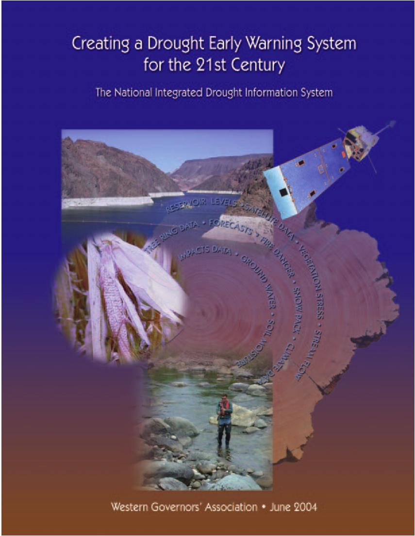
Funding provided by NOAA Sectoral Applications Research Project MONITORING DROUGHT. Basic Climatology Oklahoma Climatological Survey
|
|
|
- Noel Robbins
- 6 years ago
- Views:
Transcription
1 Funding provided by NOAA Sectoral Applications Research Project MONITORING DROUGHT Basic Climatology Oklahoma Climatological Survey
2 DEFINING DROUGHT
3 First off, just what is drought? Define a tornado Define a severe thunderstorm Define a hurricane Define a volcanic eruption When did it begin? Where was it? How bad was it? When did it end? Can you point to one on a map or radar display? Okay, do the same for drought
4 First off, just what is drought? Precipitation deficits? Soil moisture? Streamflow? Plants wilting? Wildfire? Famine? Other?
5 Drought defined by its impacts Meteorological Drought departures from normal precipitation Agricultural Drought soil / groundwater deficits that affect vegetation Hydrologic Drought deficiency of water in watersheds, rivers; often lags agriculture impacts Socio-Economic Drought shortage of some item (water, food, fish, natural values) that affects the balance of supply and demand Source: National Drought Mitigation Center
6 What is drought? Drought is the condition that occurs when water resources are insufficient to meet water needs. in other words Drought is a social phenomenon. It s what it does to people that counts! We read about droughts in the Sahel, but not the Sahara. Why? Because people live in the Sahel.
7 Multiple competing values, Multiple competing objectives Recreation Flood control Hydropower Agriculture Ecosystems health Consumptive use Source: Roger Pulwarty, NIDIS
8 What is Drought? Drought is a multi-faceted issue and requires a multifaceted assessment. Does a doctor take your temp, check a chart and say based on your temp, you are moderately-to-severely sick? Instead, she uses the results of several patient-appropriate and symptom-appropriate tests. i.e., well-chosen indicators in concert with each other. A responsible drought decision-maker (and those who supply her data) should take the same approach.
9 Why Monitor Drought Impacts? Drought is one of the most costly U.S. natural disasters Estimated annual losses at $6-8 billion (1995) 1988: $39 billion ($68B in 2007 $) 2002, 2003, 2004, 2005, 2006, 2007:??? Europe, 2003: US$13B Canada, : US$5.7B USDA/Risk Management Agency, 2006: US $1.71B indemnities Congress has appropriated approximately $30 billion in drought relief since 1988
10 Approximate Peak of 2006 Drought
11 50% of US in Drought Source: National Drought Mitigation Center

12 Economic Impacts of Drought Source: National Drought Mitigation Center
13 DROUGHT INDICATORS
14 Precipitation Departures Precipitation the key indicator for vegetation growth, water resources Temperature effects also important, but precipitation dominates Measured virtually everywhere Easy to calculate Can be done for points or over areas (such as a state or climate division)

15 Droughts are a part of Oklahoma

16 Lies, Darn Lies and Statistics Often, the raw statistics do not reveal the complete picture! 55% vs. 57% vs. 57% doesn t necessarily mean they re all in the same situation!
17 Palmer Drought Severity Index (PDSI) Developed in 1965 (first widely used soil moisture model) Uses temperature and precipitation departures to determine dryness Ranges from -4 (extreme drought) to +4 (extreme wet) Standardized to local climate Based on departures from local climate normals Good for measuring long-term drought in relatively uniform regions Not good for short-term drought / rapid changes Not good for variable terrain (i.e., mountains) May lag emerging drought conditions by several months

18 Palmer Drought Severity Index (PDSI)
19 Crop Moisture Index (CMI) Developed in 1968 Geared for agricultural drought Uses same categories as PDSI Responds more rapidly than PDSI Short-term dryness or wetness Starts and ends growing season at near zero Not good for long-term assessments May overestimate recovery resulting from shortterm rainfall

20 Crop Moisture Index (CMI)
21 Standardized Precipitation Index (SPI) Developed in 1990s Can be produced for a variety of time periods, depicting both short-term and long-term conditions Based on precipitation over an accumulation period compared to the station s historical distribution Statistical unusualness of a period PDSI uses a water-balance model to estimate evaporation based on temperature Values of -2 or less are extremely dry; +2 and greater are extremely wet

22 Standardized Precipitation Index (SPI)
23 Keetch-Byram Drought Index (KBDI) Estimates dryness of soil and dead vegetation Ranges from 0 (saturated soil) to 800 (dry soil) Based on combination of recent precipitation and estimated evaporation Soil may dry because of extended periods without precipitation or by high temperatures / strong winds Developed for fire management purposes, but also a good short-term drought indicator

24 Keetch-Byram Drought Index (KBDI) KBDI Value Interpretation No Drought-Slight Drought. Fuels and ground are quite moist Moderate Drought. Dry vegetation begins to contribute to fire Severe Drought. Escaped fire is difficult to control Extreme Drought. Fire suppression is a major problem.
25 Other Drought Tools Evaporation models Often the missing link in drought understanding Direct measurement difficult and disappearing (pan evap) ET models are getting more sophisticated Soil Moisture Integrates precipitation deficits over time Lagging indicator but strongly related to impacts Valuable for assessing recovery
26 DROUGHT MONITORING

27 The normal reaction to drought Source: Don Wilhite, National Drought Mitigation Center
28 NIDIS Drought Portal Drought Monitor Drought Impact Reporter Drought Outlook
29 NIDIS Drought Portal U.S. Drought Monitor D0 Abnormally Dry - Heads Up! D1 Drought Moderate - Some localized impacts D2 Drought Severe - Losses likely, water restrictions D3 Drought Extreme - Widespread & severe losses, water shortages D4 Drought Exceptional - Dust Bowl
30 The Drought Monitor Concept A consolidation of indicators into one comprehensive national drought map Trying to capture these characteristics: the drought s magnitude (duration + intensity) spatial extent (how widespread) how often similar conditions occur Impacts Rates drought intensity by percentile ranks An assessment not a forecast, not a declaration

31 From National to Local
32 Key Variables for Monitoring Drought climate data soil moisture stream flow ground water reservoir and lake levels snow pack short, medium, and long range forecasts vegetation health/stress and fire danger
33 Who Makes the Drought Monitor? A partnership between the National Drought Mitigation Center, USDA and NOAA s Climate Prediction Center and National Climatic Data Center (authors) Incorporate relevant information and products from all entities (and levels of government) dealing with drought (Regional Climate Centers, State Climatologists, federal/state agencies, etc.) (experts) The Drought Monitor is updated weekly and provides a general up-to-date summary of current drought conditions across the 50 states, Puerto Rico and the Pacific possessions
34 Monday (5 Days available) Draft map sent to local experts Tuesday (6 Days available) Local expert feedback Draft map(s) sent to local experts Draft text sent to local experts Wednesday (7 Days available; ending 12Z yesterday) Local expert feedback Draft map(s) sent to local experts Draft text(s) sent to local experts (Outlook) Final map and text sent to secured ftp server Thursday Final map & text released on NDMC Website
35 Why Does This Matter? Use of the DM in Decision-Making USDA Conservation Reserve Program Release hot spot trigger (D2) USDA Dried Milk Program Numerous states use as a drought trigger (Governor s declarations) 2006 USDA Livestock Assistance (D3) 2006 IRS (tax deferral on livestock losses)

36 Source: National Drought Mitigation Center

37 NIDIS Drought Portal Drought Impact Reporter

38 Drought Impact Reporter
39 What can you find in the Drought Impact Reporter? Individual and media reports of drought events Color-coded maps to show counties, states reporting many impacts Number of reports does not necessarily indicate severity Could have many reports from an organized community Could have few (or zero) reports from sparse areas Local chatter doesn t make it into the DIR unless somebody submits it
40 The Importance of Reporting A rancher submitted the following report: In Alfalfa County in NW Oklahoma for the month of June I recorded 1.3 inch of rainfall west of Manchester. Wells are running dry and we are drilling new wells. Most all farm ponds are dry and many streams are dry. Water is hauled to livestock from Manchester. We had two very short cuttings of alfalfa hay at 10 percent of average yield. There will not be a 3rd cutting in many fields. The 4th of July we received.35 inch rain. The Palmer Drought Index is off track once again. The extreme drought leads much farther east than is shown on their map clear into Grant County. Kansas is receiving beneficial rains. As close as 15 miles north and east 2 inches of rain was recorded in Anthony, Kansas, and east of Anthony. I would feed my cattle hay, if I had it or could afford to buy it. - Jack the Toad but nothing particularly unusual in Alfalfa County compared to neighbors at first glance

41 The Indicators Told Different Stories But the long-term revealed underlying problems The short-term didn t look so bad
42 Set off Discussion I often don't do such large, drastic changes but the last couple of weeks have made me think we need to step this up - that our precip-based indicators just aren't keeping up with impacts. It shows a rapidly deteriorating conditions pretty much statewide. With more 100s on the way, any moisture that's left in the soil is getting sucked out quickly. I'm giving up on rainfall as an indicator of drought - it just doesn't last long enough now to make a difference. And the most telling indicator of all - there are fewer campaign signs around this year even though we have some very contested races. It's tough to put those in the ground (especially the big signs).

43 We Listened! D0 D1 D2 D3 D4 D0 D1 D2 D3 D4 July 18, 2006 July 25, 2006

44 NIDIS Drought Portal Drought Outlook
45 What Does the Drought Outlook Tell Us? Shows expected changes from current Drought Monitor (D1- D4) Essentially a 3-month forecast Large-scale trends Seasonal forecasts usually lack skill on small scales Does not forecast impacts of a single event Subjective, based on models Forecasted development based on areas already depicted as abnormally dry (D0) Improvement may just be one category Not necessarily elimination of drought
46 NIDIS Drought Portal Drought Information Statements Feature Story / Report Map Viewer

47 NIDIS Drought Portal Map Viewer

48 NIDIS Drought Portal What about Oklahoma? Tell me more! I really, really want to know details
49 NIDIS


50 The Future of Drought?
51
52
53 Drought Information: NIDIS Early Warning (sub)systems Monitoring and forecasting subsystem National, regional and local levels Risk assessment sub-system Enable disaster management authorities to generate risk and impact scenarios, trigger and tools development Preparedness sub-system Outline and inform and coordinate actions required to reduce the loss and damage expected from an impending event and for post-event planning

54 NIDIS Pilot Projects The National Integrated Drought Information System (NIDIS) envisions several pilot projects, once of which will be Oklahoma/Missouri (2010 or later) Goals of the Pilots: Facilitate development of a drought coordinator network Coordinate collaborative development of critical indicators and triggers Help secure funding, develop evaluation criteria, and conduct post-drought assessments Drought exercises or drought simulations for risk scenarios and generation of alternative options Facilitate the improvement of organizational networks
55 NIDIS Pilots Upper Colorado River Basin Water management issues in a region with growing demand Arid region with long-term climate change threats Multi-year droughts recent occurrences (ongoing) First Pilot, launched in 2008 Federal Planning Meeting - NIDIS Pilot for the Colorado River Basin, Salt Lake City UT, May 2008 Scoping Workshop for the Upper Colorado River Basin NIDIS Pilot, Boulder CO, October 2008

56 NIDIS Pilots Southeast U.S. Institutional issues governing water management across state boundaries Southeast US Drought Workshop (Peachtree City, GA, April 2008) Overview of Federal Drought Products Overview of State Plans and Triggers: What Works & What is Needed Coastal and Estuarine Issues and Drought Current Long Range Forecast from NOAA Status: Fall 2009 scoping workshop

 Phase")
57 NIDIS Pilots Oklahoma / Missouri Transition area between semi-arid (west) to abundant precipitation (east) Rain-fed agriculture, aquifers, small reservoirs Technology transfer issues Surveys being conducted of drought management & communication How do they manage drought? What are their sources of information? How do they convey that information Phase I interviews of participants on drought management teams (partially completed) Phase II surveys of local water, agriculture, and emergency officials (Fall 2009)
58 NIDIS Pilots Montana / Northern Plains Tourism and Recreation Farming and Ranching in a semi-arid area Dependent upon rainfall, snowfall Short-term rapid-onset drought Trans-boundary issues (Canada) Status: Pending

59 NIDIS Pilots Chesapeake Bay Densely-populated urban environment Multiple environmental stressors Low water storage capacity Water quality issues Focus on instream flows Status: Pending
60 SOME CLOSING THOUGHTS
61 Even the wet years have dry-downs Soil Moisture (10 ) & rainfall for Norman, OK; June-Aug 2007

62 Are Drought Designations Purely Objective?
Funding provided by NOAA Sectoral Applications Research Project MONITORING DROUGHT. Basic Climatology Colorado Climate Center
 Funding provided by NOAA Sectoral Applications Research Project MONITORING DROUGHT Basic Climatology Colorado Climate Center DEFINING DROUGHT First off, just what is drought? Define a tornado Define a
The United States Drought Monitor How is it Made?
 The United States Drought Monitor How is it Made? Brian Fuchs, Climatologist National Drought Mitigation Center School of Natural Resources University of Nebraska-Lincoln September 14-17, 2009 Bamako,
The U.S. Drought Monitor: A Composite Indicator Approach
 The U.S. Drought Monitor: A Composite Indicator Approach Mark Svoboda, Climatologist Monitoring Program Area Leader National Drought Mitigation Center School of Natural Resources University of Nebraska-Lincoln
NIDIS Intermountain West Drought Early Warning System July 18, 2017
 NIDIS Drought and Water Assessment NIDIS Intermountain West Drought Early Warning System July 18, 2017 Precipitation The images above use daily precipitation statistics from NWS COOP, CoCoRaHS, and CoAgMet
The U.S. Drought Monitor: A Composite Indicator Approach
 The U.S. Drought Monitor: A Composite Indicator Approach Mark Svoboda, Climatologist Monitoring Program Area Leader National Drought Mitigation Center University of Nebraska-Lincoln NWS IN Climate Services
NIDIS Intermountain West Drought Early Warning System January 16, 2018
 NIDIS Drought and Water Assessment NIDIS Intermountain West Drought Early Warning System January 16, 2018 Precipitation The images above use daily precipitation statistics from NWS COOP, CoCoRaHS, and
NIDIS Intermountain West Drought Early Warning System August 8, 2017
 NIDIS Drought and Water Assessment 8/8/17, 4:43 PM NIDIS Intermountain West Drought Early Warning System August 8, 2017 Precipitation The images above use daily precipitation statistics from NWS COOP,
NIDIS Intermountain West Drought Early Warning System February 6, 2018
 NIDIS Intermountain West Drought Early Warning System February 6, 2018 Precipitation The images above use daily precipitation statistics from NWS COOP, CoCoRaHS, and CoAgMet stations. From top to bottom,
NIDIS Intermountain West Drought Early Warning System February 12, 2019
 NIDIS Intermountain West Drought Early Warning System February 12, 2019 Precipitation The images above use daily precipitation statistics from NWS COOP, CoCoRaHS, and CoAgMet stations. From top to bottom,
NIDIS Intermountain West Drought Early Warning System May 1, 2018
 NIDIS Intermountain West Drought Early Warning System May 1, 2018 Precipitation The images above use daily precipitation statistics from NWS COOP, CoCoRaHS, and CoAgMet stations. From top to bottom, and
NIDIS Intermountain West Drought Early Warning System May 23, 2017
 NIDIS Drought and Water Assessment NIDIS Intermountain West Drought Early Warning System May 23, 2017 Precipitation The images above use daily precipitation statistics from NWS COOP, CoCoRaHS, and CoAgMet
NIDIS Intermountain West Drought Early Warning System September 4, 2018
 NIDIS Drought and Water Assessment NIDIS Intermountain West Drought Early Warning System September 4, 2018 Precipitation The images above use daily precipitation statistics from NWS COOP, CoCoRaHS, and
NIDIS Intermountain West Drought Early Warning System October 17, 2017
 NIDIS Drought and Water Assessment NIDIS Intermountain West Drought Early Warning System October 17, 2017 Precipitation The images above use daily precipitation statistics from NWS COOP, CoCoRaHS, and
NIDIS Intermountain West Drought Early Warning System December 18, 2018
 NIDIS Intermountain West Drought Early Warning System December 18, 2018 Precipitation The images above use daily precipitation statistics from NWS COOP, CoCoRaHS, and CoAgMet stations. From top to bottom,
NIDIS Intermountain West Drought Early Warning System December 30, 2018
 1/2/2019 NIDIS Drought and Water Assessment NIDIS Intermountain West Drought Early Warning System December 30, 2018 Precipitation The images above use daily precipitation statistics from NWS COOP, CoCoRaHS,
NIDIS Intermountain West Drought Early Warning System November 13, 2018
 NIDIS Intermountain West Drought Early Warning System November 13, 2018 Precipitation The images above use daily precipitation statistics from NWS COOP, CoCoRaHS, and CoAgMet stations. From top to bottom,
NIDIS Intermountain West Drought Early Warning System April 16, 2019
 NIDIS Intermountain West Drought Early Warning System April 16, 2019 Precipitation The images above use daily precipitation statistics from NWS COOP, CoCoRaHS, and CoAgMet stations. From top to bottom,
NIDIS Intermountain West Drought Early Warning System November 14, 2017
 NIDIS Intermountain West Drought Early Warning System November 14, 2017 Precipitation The images above use daily precipitation statistics from NWS COOP, CoCoRaHS, and CoAgMet stations. From top to bottom,
NIDIS Intermountain West Drought Early Warning System December 11, 2018
 NIDIS Drought and Water Assessment NIDIS Intermountain West Drought Early Warning System December 11, 2018 Precipitation The images above use daily precipitation statistics from NWS COOP, CoCoRaHS, and
NIDIS Intermountain West Drought Early Warning System January 15, 2019
 NIDIS Drought and Water Assessment NIDIS Intermountain West Drought Early Warning System January 15, 2019 Precipitation The images above use daily precipitation statistics from NWS COOP, CoCoRaHS, and
Precipitation. Standardized Precipitation Index. NIDIS Intermountain West Drought Early Warning System September 5, 2017
 9/6/2017 NIDIS Drought and Water Assessment NIDIS Intermountain West Drought Early Warning System September 5, 2017 Precipitation The images above use daily precipitation statistics from NWS COOP, CoCoRaHS,
The U.S. Drought Monitor: Parameters, People, Process, Policy
 The U.S. Drought Monitor: Parameters, People, Process, Policy Mark Svoboda, Climatologist Monitoring Program Area Leader National Drought Mitigation Center School of Natural Resources University of Nebraska-Lincoln
NATIONAL HYDROPOWER ASSOCIATION MEETING. December 3, 2008 Birmingham Alabama. Roger McNeil Service Hydrologist NWS Birmingham Alabama
 NATIONAL HYDROPOWER ASSOCIATION MEETING December 3, 2008 Birmingham Alabama Roger McNeil Service Hydrologist NWS Birmingham Alabama There are three commonly described types of Drought: Meteorological drought
NIDIS Intermountain West Drought Early Warning System October 30, 2018
 10/30/2018 NIDIS Drought and Water Assessment NIDIS Intermountain West Drought Early Warning System October 30, 2018 Precipitation The images above use daily precipitation statistics from NWS COOP, CoCoRaHS,
NIDIS Intermountain West Drought Early Warning System January 22, 2019
 NIDIS Drought and Water Assessment NIDIS Intermountain West Drought Early Warning System January 22, 2019 Precipitation The images above use daily precipitation statistics from NWS COOP, CoCoRaHS, and
NIDIS Intermountain West Regional Drought Early Warning System February 7, 2017
 NIDIS Drought and Water Assessment NIDIS Intermountain West Regional Drought Early Warning System February 7, 2017 Precipitation The images above use daily precipitation statistics from NWS COOP, CoCoRaHS,
Precipitation. Standardized Precipitation Index. NIDIS Intermountain West Regional Drought Early Warning System January 3, 2017
 1/3/2017 NIDIS Drought and Water Assessment NIDIS Intermountain West Regional Drought Early Warning System January 3, 2017 Precipitation The images above use daily precipitation statistics from NWS COOP,
Oregon Water Conditions Report April 17, 2017
 Oregon Water Conditions Report April 17, 2017 Mountain snowpack continues to maintain significant levels for mid-april. By late March, statewide snowpack had declined to 118 percent of normal after starting
NIDIS Intermountain West Drought Early Warning System March 26, 2019
 NIDIS Intermountain West Drought Early Warning System March 26, 2019 The images above use daily precipitation statistics from NWS COOP, CoCoRaHS, and CoAgMet stations. From top to bottom, and left to right:
Drought Impacts in the Southern Great Plains. Mark Shafer University of Oklahoma Norman, OK
 Drought Impacts in the Southern Great Plains Mark Shafer University of Oklahoma Norman, OK Causes of Drought: Large-Scale, Stationary High Pressure Air rotates clockwise around high pressure steers storms
Water Availability in Alaska: Using and Understanding NOAA s Drought Monitor and Drought Outlook
 Water Availability in Alaska: Using and Understanding NOAA s Drought Monitor and Drought Outlook Douglas Le Comte,, Drought Specialist, NOAA/NWS/Climate Prediction Center June 10, 2008 Water is Important
The U.S. National Integrated Drought Information System. Roger S. Pulwarty National Oceanic and Atmospheric Administration USA
 The U.S. National Integrated Drought Information System Roger S. Pulwarty National Oceanic and Atmospheric Administration USA Drought: Weather-climate continuum and adaptation deficits 2010 2011 2012 2015
NIDIS Intermountain West Drought Early Warning System November 21, 2017
 NIDIS Drought and Water Assessment NIDIS Intermountain West Drought Early Warning System November 21, 2017 Precipitation The images above use daily precipitation statistics from NWS COOP, CoCoRaHS, and
The History and Making of the U.S. Drought Monitor
 The History and Making of the U.S. Drought Monitor Mike Hayes, Director Mark Svoboda, Climatologist/Monitoring Program Area Leader Kelly Smith, Communications Specialist National Drought Mitigation Center
NIDIS Intermountain West Drought Early Warning System February 19, 2019
 NIDIS Intermountain West Drought Early Warning System February 19, 2019 Precipitation The images above use daily precipitation statistics from NWS COOP, CoCoRaHS, and CoAgMet stations. From top to bottom,
An introduction to drought indices
 An introduction to drought indices WMO-ETSCI Workshop, Barbados 17 February 2015 Acacia Pepler Australian Bureau of Meteorology "Drought" by Tomas Castelazo - Own work. Licensed under CC BY 3.0 via Commons
NIDIS Intermountain West Drought Early Warning System April 24, 2018
 NIDIS Intermountain West Drought Early Warning System April 24, 2018 Precipitation The images above use daily precipitation statistics from NWS COOP, CoCoRaHS, and CoAgMet stations. From top to bottom,
COMPARISON OF DROUGHT INDICES AND SC DROUGHT ALERT PHASES
 COMPARISON OF DROUGHT INDICES AND SC DROUGHT ALERT PHASES Ekaterina Altman 1 AUTHORS : 1 Master of Environmental Resource Management Candidate, Environment and Sustainability Program, University of South
Indices and Indicators for Drought Early Warning
 Indices and Indicators for Drought Early Warning ADRIAN TROTMAN CHIEF, APPLIED METEOROLOGY AND CLIMATOLOGY CARIBBEAN INSTITUTE FOR METEOROLOGY AND HYDROLOGY IN COLLABORATION WITH THE NATIONAL DROUGHT MITIGATION
Condition Monitoring: A New System for Drought Impacts Reporting through CoCoRaHS
 Condition Monitoring: A New System for Drought Impacts Reporting through CoCoRaHS Amanda Farris Carolinas Integrated Sciences & Assessments (CISA) University of South Carolina WERA 1012 Annual Conference
NIDIS Intermountain West Drought Early Warning System April 18, 2017
 1 of 11 4/18/2017 3:42 PM Precipitation NIDIS Intermountain West Drought Early Warning System April 18, 2017 The images above use daily precipitation statistics from NWS COOP, CoCoRaHS, and CoAgMet stations.
Oregon Water Conditions Report May 1, 2017
 Oregon Water Conditions Report May 1, 2017 Mountain snowpack in the higher elevations has continued to increase over the last two weeks. Statewide, most low and mid elevation snow has melted so the basin
NIDIS Intermountain West Drought Early Warning System December 4, 2018
 12/4/2018 NIDIS Drought and Water Assessment NIDIS Intermountain West Drought Early Warning System December 4, 2018 Precipitation The images above use daily precipitation statistics from NWS COOP, CoCoRaHS,
The U.S. Drought Monitor and tools from the National Drought Mitigation Center
 The U.S. Drought Monitor and tools from the National Drought Mitigation Center Brian Fuchs, Climatologist National Drought Mitigation Center School of Natural Resources University of Nebraska-Lincoln Winter
Drought Indices in Decision-making Process of Drought Management
 Drought Indices in Decision-making Process of Drought Management Ekaterina Altman Master of Earth and Environmental Resources Management University of South Carolina Carolina Climate Resilience Conference
Drought Criteria. Richard J. Heggen Department of Civil Engineering University of New Mexico, USA Abstract
 Drought Criteria Richard J. Heggen Department of Civil Engineering University of New Mexico, USA rheggen@unm.edu Abstract Rainwater catchment is an anticipatory response to drought. Catchment design requires
National Drought Mitigation Center. Drought Services: Collaborative Efforts Towards Drought Early Warning and Information Systems
 National Drought Mitigation Center Drought Services: Collaborative Efforts Towards Drought Early Warning and Information Systems Mark Svoboda, Climatologist Monitoring Program Area Leader National Drought
United States Multi-Hazard Early Warning System
 United States Multi-Hazard Early Warning System Saving Lives Through Partnership Lynn Maximuk National Weather Service Director, Central Region Kansas City, Missouri America s s Weather Enterprise: Protecting
The National Integrated Drought Information System (NIDIS) Moving the Nation from Reactive to Proactive Drought Risk Management
 Moving the Nation from Reactive to Proactive Drought Risk Management") The National Integrated Drought Information System (NIDIS) Moving the Nation from Reactive to Proactive Drought Risk Management CSG-West Annual Meeting Agriculture & Water Committee Snowbird, UT September
The National Integrated Drought Information System (NIDIS) Moving the Nation from Reactive to Proactive Drought Risk Management CSG-West Annual Meeting Agriculture & Water Committee Snowbird, UT September
National Wildland Significant Fire Potential Outlook
 National Wildland Significant Fire Potential Outlook National Interagency Fire Center Predictive Services Issued: September, 2007 Wildland Fire Outlook September through December 2007 Significant fire
NOAA S2S Planning. Dave DeWitt Fred Toepfer
 NOAA S2S Planning Dave DeWitt Fred Toepfer 1 Agenda 1. Brief synopsis of The Weather Research and Forecasting Act of 2017 2. Report to Congress a. Timeline b. Process c. Document Outline 3. Some Preliminary
Precipitation. Standardized Precipitation Index. NIDIS Intermountain West Regional Drought Early Warning System December 6, 2016
 12/9/2016 NIDIS Drought and Water Assessment NIDIS Intermountain West Regional Drought Early Warning System December 6, 2016 Precipitation The images above use daily precipitation statistics from NWS COOP,
The North American Drought Monitor - The Canadian Perspective -
 The North American Drought Monitor - The Canadian Perspective - Trevor Hadwen National Agroclimate Information Service AAFC-PFRA, Regina Canmore, Alberta March 16-18, 2008 Background The NADM is a cooperative
NATIONAL WEATHER SERVICE
 January 2016 February 9, 2016 This was a dry month across the HSA despite one large and several smaller snowfalls. Most locations ended up 1-2 inches below normal for the month. The driest locations at
Drought and Climate Extremes Indices for the North American Drought Monitor and North America Climate Extremes Monitoring System. Richard R. Heim Jr.
 Drought and Climate Extremes Indices for the North American Drought Monitor and North America Climate Extremes Monitoring System Richard R. Heim Jr. NOAA/NESDIS/National Climatic Data Center Asheville,
Doug Kluck NOAA Kansas City, MO National Center for Environmental Information (NCEI) National Integrated Drought Information System (NIDIS)
 National Integrated Drought Information System (NIDIS)") National Integrated Drought Information System (NIDIS) for the Missouri River Basin Drought Early Warning Information System (DEWS) & Runoff Trends in the Missouri Basin & Latest Flood Outlook Doug Kluck
National Integrated Drought Information System (NIDIS) for the Missouri River Basin Drought Early Warning Information System (DEWS) & Runoff Trends in the Missouri Basin & Latest Flood Outlook Doug Kluck
National Wildland Significant Fire Potential Outlook
 National Wildland Significant Fire Potential Outlook National Interagency Fire Center Predictive Services Issued: April 1, 2008 Next Issue: May 1, 2008 Wildland Fire Outlook April 2008 through July 2008
NIDIS Weekly Climate, Water and Drought Assessment Summary. Upper Colorado River Basin
 NIDIS Weekly Climate, Water and Drought Assessment Summary Upper Colorado River Basin August 3, 2010 Precipitation and Snowpack Fig. 1: July precipitation in inches Fig. 2: July precip as percent of average
National Drought Summary August 14, 2018
 National Drought Summary August 14, 2018 The discussion in the Looking Ahead section is a description of what the official national guidance from the National Weather Service (NWS) National Centers for
Arizona Drought Monitoring Sensitivity and Verification Analyses
 Arizona Drought Monitoring Sensitivity and Verification Analyses A Water Sustainability Institute, Technology and Research Initiative Fund Project Christopher L. Castro, Francina Dominguez, Stephen Bieda
Brian McGurk, P.G. DEQ Office of Water Supply. Contents. Overview of Virginia s Drought Assessment & Response Plan
 Drought Preparedness in Virginia Or, Whatcha Gonna Do When the Well, Creek, River, or Reservoir (Might) Run Dry? Rappahannock-Rapidan Regional Commission Living Lands Workshop November 18, 2014 Brian McGurk,
NIDIS Drought and Water Assessment
 NIDIS Drought and Water Assessment PRECIPITATION The images above use daily precipitation statistics from NWS COOP, CoCoRaHS, and CoAgMet stations. From top to bottom, and left to right: most recent 7-days
High Resolution Indicators for Local Drought Monitoring
 High Resolution Indicators for Local Drought Monitoring REBECCA CUMBIE, STATE CLIMATE OFFICE OF NC, NCSU Monitoring Drought Multiple indicators, multiple sources Local detail important 1 Point-Based Climate-Division
Chapter 12 Monitoring Drought Using the Standardized Precipitation Index
 University of Nebraska - Lincoln DigitalCommons@University of Nebraska - Lincoln Drought Mitigation Center Faculty Publications Drought -- National Drought Mitigation Center 2000 Chapter 12 Monitoring
Minnesota s Climatic Conditions, Outlook, and Impacts on Agriculture. Today. 1. The weather and climate of 2017 to date
 Minnesota s Climatic Conditions, Outlook, and Impacts on Agriculture Kenny Blumenfeld, State Climatology Office Crop Insurance Conference, Sep 13, 2017 Today 1. The weather and climate of 2017 to date
NIDIS Drought and Water Assessment
 7/23/13 1:57 PM PRECIPITATION The images above use daily precipitation statistics from NWS COOP, CoCoRaHS, and CoAgMet stations. From top to bottom, and left to right: most recent 7-days of accumulated
PRECIPITATION. Last Week Precipitation:
 12/3/2014 NIDIS Drought and Water Assessment PRECIPITATION The images above use daily precipitation statistics from NWS COOP, CoCoRaHS, and CoAgMet stations. From top to bottom, and left to right: most
Midwest and Great Plains Drought and Climate Summary 20 February 2014
 Midwest and Great Plains Drought and Climate Summary 20 February 2014 Wendy Ryan Assistant State Climatologist Colorado Climate Center Colorado State University wendy.ryan@colostate.edu 970-491-8506 General
E XTREME D ROUGHT An oppressive, long-term
 E XTREME D ROUGHT 2006-2008 An oppressive, long-term drought lasting from late March of 2006 until late August of 2008 impacted the entire state of Florida, with costly consequences in residential water
NADM, NACEM, and Opportunities for Future Collaboration
 NADM, NACEM, and Opportunities for Future Collaboration Richard R. Heim Jr. NOAA/NESDIS/National Climatic Data Center Asheville, North Carolina, U.S.A. 4th Annual DRI Workshop 26-28 January 2009, Regina,
CoCoRaHS. Community Collaborative Rain, Hail, & Snow Network. Ashley Wolf Meteorologist NWS Green Bay Northeast Wisconsin CoCoRaHS Coordinator
 CoCoRaHS Community Collaborative Rain, Hail, & Snow Network Ashley Wolf Meteorologist NWS Green Bay Northeast Wisconsin CoCoRaHS Coordinator What is CoCoRaHS Who, What, Where and Whys of CoCoRaHS What?
DROUGHT ASSESSMENT USING SATELLITE DERIVED METEOROLOGICAL PARAMETERS AND NDVI IN POTOHAR REGION
 DROUGHT ASSESSMENT USING SATELLITE DERIVED METEOROLOGICAL PARAMETERS AND NDVI IN POTOHAR REGION Researcher: Saad-ul-Haque Supervisor: Dr. Badar Ghauri Department of RS & GISc Institute of Space Technology
Illinois Drought Update, December 1, 2005 DROUGHT RESPONSE TASK FORCE Illinois State Water Survey, Department of Natural Resources
 Illinois Drought Update, December 1, 2005 DROUGHT RESPONSE TASK FORCE Illinois State Water Survey, Department of Natural Resources For more drought information please go to http://www.sws.uiuc.edu/. SUMMARY.
What Can Citizen Scientists Tell Us about Drought?
 What Can Citizen Scientists Tell Us about Drought? Using CoCoRaHS to Improve the Monitoring and Reporting of Drought Impacts Amanda Farris, Kirsten Lackstrom Carolinas Integrated Sciences & Assessments
2011 National Seasonal Assessment Workshop for the Eastern, Southern, & Southwest Geographic Areas
 2011 National Seasonal Assessment Workshop for the Eastern, Southern, & Southwest Geographic Areas On January 11-13, 2011, wildland fire, weather, and climate met virtually for the ninth annual National
WSWC/NOAA Workshops on S2S Precipitation Forecasting
 WSWC/NOAA Workshops on S2S Precipitation Forecasting San Diego, May 2015 Salt Lake City at NWS Western Region HQ, October 2015 Las Vegas at Colorado River Water Users Association, December 2015 College
The Colorado Drought of 2002 in Perspective
 The Colorado Drought of 2002 in Perspective Colorado Climate Center Nolan Doesken and Roger Pielke, Sr. Prepared by Tara Green and Odie Bliss http://climate.atmos.colostate.edu Known Characteristics of
January 25, Summary
 January 25, 2013 Summary Precipitation since the December 17, 2012, Drought Update has been slightly below average in parts of central and northern Illinois and above average in southern Illinois. Soil
-Assessment of current water conditions. - Precipitation Forecast. - Recommendations for Drought Monitor
 2 May 1 st, 2012 -Assessment of current water conditions - Precipitation Forecast - Recommendations for Drought Monitor AHPS Water Year Precipitation as Percentage of Normal 7-day average
Drought History. for Southeast Oklahoma. Prepared by the South Central Climate Science Center in Norman, Oklahoma
 Drought History for Southeast Oklahoma Prepared by the South Central Climate Science Center in Norman, Oklahoma May 28, 2013 http://southcentralclimate.org/ info@southcentralclimate.org (This page left
Kentucky Weather Hazards: What is Your Risk?
 Kentucky Weather Hazards: What is Your Risk? Stuart A. Foster State Climatologist for Kentucky 2010 Kentucky Weather Conference Bowling Green, Kentucky January 16, 2010 Perspectives on Kentucky s Climate
Soil Moisture and the Drought in Texas
 Soil Moisture and the Drought in Texas Todd Caldwell Bridget Scanlon Michael Young Di Long Photo by TWDB Water Forum III: Droughts and Other Extreme Weather Events October 14, 2013 Photo by TPWD Soil Moisture
The Colorado Drought : 2003: A Growing Concern. Roger Pielke, Sr. Colorado Climate Center.
 The Colorado Drought 2001-2003: 2003: A Growing Concern Roger Pielke, Sr. Colorado Climate Center Prepared by Tara Green and Odie Bliss http://climate.atmos.colostate.edu 2 2002 Drought History in Colorado
SOUTHERN CLIMATE MONITOR
 SOUTHERN CLIMATE MONITOR MARCH 2011 VOLUME 1, ISSUE 3 IN THIS ISSUE: Page 2 to 4 Severe Thunderstorm Climatology in the SCIPP Region Page 4 Drought Update Page 5 Southern U.S. Precipitation Summary for
GIS Tools, Data, & Methods in the Weekly US Drought Monitor
 GIS Tools, Data, & Methods in the Weekly US Drought Monitor International Workshop on Agromet and GIS Applications for Agricultural Decision Making Jeju, South Korea December 5, 2016 Eric Luebehusen USDA/OCE/WAOB
TRINITY COUNTY. Board Item Request Form Phone
 County Contract No. Department Board of Supervisors TRINITY COUNTY 6.01 Board Item Request Form 2014-08-12 Contact Judy Pflueger Phone 623-1217 Requested Agenda Location County Matters Requested Board
Drought History. for the Oklahoma Panhandle. Prepared by the South Central Climate Science Center in Norman, Oklahoma
 Drought History for the Oklahoma Panhandle Prepared by the South Central Climate Science Center in Norman, Oklahoma May 28, 2013 http://southcentralclimate.org/ info@southcentralclimate.org (This page
Improving Understanding of Drought Impacts through Citizen Science
 Improving Understanding of Drought Impacts through Citizen Science Amanda Brennan, Janae Davis, Kirstin Dow, Kirsten Lackstrom, Sumi Selvaraj North Carolina Water Resources Research Institute Annual Meeting
EARLY WARNING IN SOUTHERN AFRICA:
 EARLY WARNING IN SOUTHERN AFRICA: Enhancing the Meteorological Early Warning System Eugene Poolman South African Weather Service OUTLINE OF PRESENTATION Impact of Climate Change Meteorological Early Warning
Monthly Long Range Weather Commentary Issued: APRIL 18, 2017 Steven A. Root, CCM, Chief Analytics Officer, Sr. VP,
 Monthly Long Range Weather Commentary Issued: APRIL 18, 2017 Steven A. Root, CCM, Chief Analytics Officer, Sr. VP, sroot@weatherbank.com MARCH 2017 Climate Highlights The Month in Review The average contiguous
Upper Missouri River Basin December 2017 Calendar Year Runoff Forecast December 5, 2017
 Upper Missouri River Basin December 2017 Calendar Year Runoff Forecast December 5, 2017 Calendar Year Runoff Forecast Explanation and Purpose of Forecast U.S. Army Corps of Engineers, Northwestern Division
SOUTHERN CLIMATE MONITOR
 SOUTHERN CLIMATE MONITOR DECEMBER 2011 VOLUME 1, ISSUE 12 IN THIS ISSUE: Page 2 to 3 Managing Drought in the Southern Plains Webinar Series Page 3 Drought Update Page 4 Southern U.S. Precipitation Summary
Montana. Drought Climate. Drought& &
 Montana & & Climate SPRING 218 MONITORING AND FORECASTING FOR AGRICULTURE PRODUCERS A SERVICE OF THE MONTANA CLIMATE OFFICE Rangeland south of Ekalaka near the Custer National Forest in Carter County,
Historical Drought Analysis for: Southwest Oklahoma, Climate Division 7
 Historical Drought Analysis for: Southwest Oklahoma, Climate Division 7 Irenea Lodangco, Rachel Riley & Gina Fujan University of Oklahoma Prepared by the Southern Climate Impacts Planning Program November
NOAA s National Weather Service. National Weather Service
 NOAA s National Weather Service Serving the Nation s Environmental Forecasting Needs Lynn Maximuk Regional Director National Weather Service Central Region Headquarters Kansas City, Missouri America s
Fire Weather Monitoring and Predictability in the Southeast
 Fire Weather Monitoring and Predictability in the Southeast Corey Davis October 9, 2014 Photo: Pains Bay fire in 2011 (courtesy Donnie Harris, NCFWS) Outline Fire risk monitoring Fire risk climatology
Historical Drought Analysis for: East Central Oklahoma, Climate Division 6
 Historical Drought Analysis for: East Central Oklahoma, Climate Division 6 Irenea Lodangco, Rachel Riley & Gina Fujan University of Oklahoma Prepared by the Southern Climate Impacts Planning Program November
4) At the end of this presentation we have an operator that will organize the Q & A s.
 At the end of this presentation we have an operator that will organize the Q & A s.") Hello and welcome to the next in a series of Missouri Basin specific climate outlook Webinars 2011-2012. My name is Dennis Todey and I am the State Climatologist for the State of South Dakota. We are taking
Hello and welcome to the next in a series of Missouri Basin specific climate outlook Webinars 2011-2012. My name is Dennis Todey and I am the State Climatologist for the State of South Dakota. We are taking
Current Water Conditions in Massachusetts January 11, 2008
 Current Water Conditions in Massachusetts January 11, 2008 December precipitation was above normal December streamflows were below normal and normal December ground-water levels were below normal and normal
Wind River Indian Reservation and Surrounding Area Climate and Drought Summary
 Northern Arapaho Tribe Wind River Indian Reservation and Surrounding Area Climate and Drought Summary Spring Events & Summer Outlook 2015 Spring Was Warm And Very Wet Across The Region The spring season