WORKING PAPER. First stage: Identification and mapping of gaps and needs related to MHEWS. 2-5 November 2010
|
|
|
- Sophia Moore
- 6 years ago
- Views:
Transcription
1 DOC. 4 WORKING PAPER Preliminary Draft Report of the Assessments of the Capacities, Gaps and Needs for the Development of the Caribbean Regional Programme on Multi-Hazard Early Warning Systems and Phase-I Project Priorities: Focus on Hydrometeorological hazards warning systems and possible linkages with other warning systems First stage: Identification and mapping of gaps and needs related to MHEWS 2-5 November 2010 Accra Beach Hotel & Spa Christ Church, Barbados PRELIMINARY DRAFT 22 October 2010
2 TABLE OF CONTENTS 1 Background Hazard vulnerability and History of natural disasters in the Caribbean region Weather related hazards Vulnerability Outcomes of the Costa Rica MHEWS Workshop on MHEWS (22-26 March 2010) Scope, objectives and approach for the development of the Caribbean Regional Programme in MHEWS Different stakeholders involved Participating Countries, Territories and Institutions National Institutions Regional institutional arrangements International stakeholders and donors Methodology of the assessment of capacities, gaps and needs in context of EWS Policies, legal frameworks and institutional arrangements supporting DRM and EWS Overall policies and legal framework to support DRR and EWS Institutional arrangements related to management of hydrometeorological and climate-related hazards Assessment of needs for strengthening operational cooperation on Multi-Hazard Early Warning Systems Relationship types between Meteorological Services and DRM agencies Operational linkages of Meteorological Services with EWS stakeholders and Meteorological Services capacities Operational cooperation between Meteorological Services and DRM agencies Highest priorities for operational cooperation between Meteorological Services and DRM agencies Product and service delivery of Meteorological Services to DRM Agencies to support EWS Stakeholders Data products Hazard analysis to support risk assessment and mapping Forecasts and warnings EWS expertise and advisory service Cooperation with other technical agencies for product and service development Dissemination of products and services Highest priorities with regard to product and service delivery Core capacities of the Meteorological Services to support EWS Monitoring and observations networks Operational forecasting Hydro-meteorological data management and exchange Product development in NMSs Information Technology and Telecommunication capacities Operational relationship with other technical agencies (e.g. Hydrological Services) Highest priorities with regards to the core capacities of the Meteorological Services Overarching capacities of the Meteorological Services to support EWS Comprehensive Quality Management Systems Human resources capacities and training
3 4.6.3 Highest priorities, with regard to overarching capacities of the Meteorological Services in support of DRM Agencies Public outreach and educational programmes in EWS Highest priorities with regards to public outreach and educational programmes in the context of MHEWS Watch and Warning Systems National aspects Regional coordination in WWS Highest priorities with regards to WWS Synthesis, conclusions and recommendations Synthesis and conclusions of the assessments and consultations Recommendations pertaining to the strengthening of the four components of EWS with national and regional considerations Other critical considerations Institutional mapping and linkages Opportunities in linking climate information and forecasting for disaster risk management in context of improved sectoral planning Building capacity for probabilistic risk analysis and modeling...39 TABLES...40 Table 1: Membership to different regional institutional arrangements...41 Table 2a: Regional assessments related to MHEWS and DRR in the islands of the Caribbean region...42 Table 2b: Consolidated list of regional programmes or projects relevant to MHEWS...43 Table 2c: List of missions and visits to the region...46 Table 3: Mapping of information provided in visits and assessments...48 Table 4: Overview of the overall policies and legal frameworks supporting DRR and EWS in the different countries in the region...51 Table 5: Disaster Management Agencies in the Caribbean and their respective capacities...53 Table 6: Outline of the different relationships and dependencies between DRM agencies and Meteorological Services...55 Table 7: List of public meteorological websites per country...57 Table 8:Operational cooperation between Meteorological Services and DRM agencies...58 Table 9a: National product and service delivery of the Meteorological Services to support EWS...59 Table 9b: Product and service delivery of the Meteorological Services to support EWS...65 Table 10a: Core capacities of the Meteorological Services to support EWS National aspects...68 Table 10b: Core capacities of the Meteorological Services to support EWS Regional aspects...72 Table 11: Overarching capacities of the Meteorological Services to support EWS...75 Table 12: Educational programmes in EWS...78 Table 13a: Watch and Warning Systems (National Aspects)...80 Table 13b: Watch and Warning Systems (Regional Aspects)...82 LIST OF ACRONYMS...83 ANNEXES ANNEX 1: DRR Country Profiles
4 1 Background Between 1980 and 2007, nearly 90% of events, 70% of casualties and 78% of economic losses related to natural hazards in the world were caused by meteorological-, hydrologicaland climate-related hazards such as tropical cyclones and storm surges, floods, extreme temperature, and droughts (source: EM-DAT) 1. Globally, over the last 50 years, while economic losses linked to extreme hydro-meteorological events have increased by nearly 50 times, loss of life caused by these hazards has decreased significantly. This has been attributed to early warning systems, linking information from monitoring and forecasting of hydro-meteorological hazards to emergency preparedness and response, especially in some of the most vulnerable countries. Effective early warning systems (EWS) have four components, including: (i) hazard detection, monitoring and forecasting; (ii) analysis of risks and incorporation of risk information in emergency planning and warnings; (iii) dissemination of timely and authoritative warnings; and, (iv) community emergency planning and preparedness and the ability to activate emergency plans to prepare and respond, with coordination across agencies involved in EWS, at national to local levels. These four components need to be coordinated across many agencies at the national to local levels. Failure in one component or lack of coordination across them would lead to the failure of the whole system. Over the past decade, there has been significant international attention to this topic, including three international EWS conferences (hosted by the government of Germany), 2 two international experts symposia on Multi-Hazard EWS (organized by the World Meteorological Organization WMO in collaboration with UN-International Strategy for Disaster Reduction system partners), 3 and the Global EWS Survey Report, requested by the former UN Secretary General, Kofi Annan, following the tragic 2004 tsunami in the Indian Ocean. 4 Despite this attention, there remain many challenges on legislative, financial, institutional, technical and operational aspects at national to local levels to ensure that EWS are implemented as an integral part of disaster risk reduction strategies in all countries. Furthermore, development and sustainability of these systems nationally can be enhanced through regional cooperation among countries to share data, information and exchange know-how. WMO in cooperation with other UN and international partners as well as its Members has developed a systematic process for documenting good practices in EWS. This has involved extensive consultations with EWS experts during two international symposia and various regional and national events. A standard template for documentation of good practices has been developed and used by countries to document their experiences consistently. To-date EM-DAT is the database of Université Catholique de Louvain - Brussels Belgium - The OFDA/CRED International Disaster Database - References to the three international EWS Conferences: First International Conference on Early Warning (Potsdan, 1998) Second International Conference on Early Warning (Bonn, 2003) Third International Conference on Early Warning (Bonn, 2006) ( ) References to the two international Experts Symposia on Multi-Hazard EWS: First Experts Symposium on Multi-Hazard Early Warning Systems (Geneva, 2006) ( ) Second Experts Symposium on Multi-Hazard Early Warning Systems (Toulouse, 2009) ( Global Early Warning Survey (2006) Sep2006.pdf?openelement. 3
5 seven good practices have been documented through a multi-agency process: (i) Bangladesh Cyclone Preparedness Programme, (ii) Tropical Cyclone Early Warning System of Cuba, (iii) French Vigilance System, (iv) Shanghai Multi-Hazard Early Warning and Emergency Preparedness Programme, v) Multi-Hazard Early Warning Systems in the USA: Institutional Coordination and Cooperation of the U.S. National Weather Service, vi) The Warning Management of the Deutscher Wetterdienst, and vii) Multi-Hazard Early Warning System in Japan. A detailed synthesis of these good practices has revealed ten principles common to their implementation, irrespective of the political, social, and institutional factors in each country. However, it should be noted that specific design and implementation of the EWS vary across the countries, according to their specific history, culture, socio-economic conditions, institutional structure and capacities and available resources for sustainability of the system. These ten principals are: (i) There is a strong political recognition of EWS reflected in harmonized national to local disaster risk management policies, planning, legislation and government budgeting; (ii) Effective EWS are built upon four components: (i) hazard detection, monitoring and forecasting; (ii) analysis of risks and incorporation of risk information in emergency planning and warnings; (iii) dissemination timely and authoritative warnings; and, (iv) community emergency planning and preparedness and the ability to activate emergency plans to prepare and respond, with coordination across agencies involved in EWS, at national to local levels; (iii) EWS stakeholders are identified and their roles and responsibilities clearly defined and documented within the national to local plans, legislation, directives, MOUs, etc., including those of the technical agencies such as the National Meteorological and Hydrological Services; (iv) EWS capacities are supported by adequate resources (e.g., human, financial, equipment, infrastructure) across national to local levels and the system is designed and implemented, accounting for long-term sustainability factors; (v) Hazard, exposure and vulnerability information are used to carry-out risk assessments at different levels, as critical input into emergency planning and development of warning messages; (vi) Warning messages are, (i) clear, consistent and include risk information, (ii) designed with consideration for linking threat levels to emergency preparedness and response actions (e.g. using color, flags) that are well-understood by the authorities and the population, (iii), issued from a single (or unified), recognized and authoritative source; (vii) Warning dissemination mechanisms are able to reach the authorities, other EWS stakeholders and the population at risk in a timely and reliable fashion; (viii) Emergency response plans are developed with consideration for hazard/risk levels, characteristics of the exposed communities (e.g., urban, rural, ethnic populations, tourists, and particularly vulnerable groups such as children, the elderly and the hospitalized), coordination mechanisms and roles and mandates of various EWS stakeholders; (ix) Training on risk awareness, hazard recognition and related emergency response actions are integrated in various formal and informal educational programmes and linked to regularly conducted drills and rehearsals across the system to test operational procedures; and, (x) Effective feedback and improvement mechanisms are in place at all levels of EWS to provide systematic evaluation and ensure system improvement over time. 4
6 Based on detailed synthesis of these documented good practices, a guideline entitled Institutional Partnerships and Coordination in Multi-Hazard Early Warning Systems, has been developed and a training workshop has been designed. 5 The first of such workshop, entitled, Training Workshop on Multi-Hazard Early Warning Systems (MHEWS) with Focus on Institutional Partnerships and Coordination, was held on March 2010 in San Jose, Costa Rica (See section 1.2 for details) 6. The Costa Rica MHEWS Workshop was participated by Directors of Disaster Risk Management Agencies and the NMHS of 36 countries and provided clear recommendations on capacities and gaps and needs for strengthening of Early Warning Systems with a multi-hazard Approach in both Central America and the Caribbean regions. The recommendations and follow up actions from this workshop are highlighted in the final report of the workshop which can be accessed on the webpage of the workshop and provide the foundation for pursuing consultations and follow ups for next steps. 1.1 Hazard vulnerability and History of natural disasters in the Caribbean region Weather related hazards All of the assessed countries and territories are vulnerable to a range of natural hazards among which weather-related hazards are the most recurrent. A country-level survey conducted by WMO in found that the hazards that affect most Caribbean countries are tropical cyclones, flash floods, thunderstorms or lightning, storm surges, coastal flooding, droughts, landslides or mudslides, strong winds, river flooding and earthquakes. Other hazards, though serious in some countries, are less widely experienced. 7 8 number of countries affected Tropical cyclone Flash flood Landslide or mudslide Coastal flooding Drought Thunderstorm or lightning Storm surge Strong winds Earthquakes River flooding Aviation Hazards Tornado Heat wave Smoke, Dust or Haze Forest or wild land fire Waterborne hazards Avalanche Tsunami Volcanic events Marine hazards Figure 1. Number of responding countries in the Caribbean who identified themselves as being affected by specified hazards. Risks associated with hazardous meteorological and tropical phenomena mostly results from strong winds, heavy rains and thunderstorms, and strong waves and storm surges. These can in turn cause slow on-set floods in continental areas, flash floods in mountainous islands, landslides, coastal inundation and more direct wind impacts. 5 These guidelines are included in an upcoming book entitled "Institutional Partnership in Multi-Hazard Early Warning Systems" and will be published at the end of 2010 by Springer-Verlag. 6 All background and documents of the Coata Rica MHEWS Workshop can be obtained at: 7 The report of the 2006 WMO Country-Level survey can be found at: 5
 in the Caribbean region between 1980 and 2009 For many years, most countries and territories in the Caribbean region have been focusing on tropical cyclones.")
.")
7 Figure 2. Major hurricanes tracks(cat 3, 4, 5) in the Caribbean region between 1980 and 2009 For many years, most countries and territories in the Caribbean region have been focusing on tropical cyclones. Historical records suggest that tropical cyclones annually from July to December - pose a real threat to many of the islands and countries in the Caribbean region. From 1980 to 2009, more than 30 major hurricanes 8 have crossed the Caribbean (see the above illustration). In the past ten years, 40 named tropical cyclones (tropical storms or hurricanes) have passed within less than 100km of at least one of the Caribbean islands. However, not all of the islands or countries are subject to the same extent of risks. The return period of a tropical cyclone or hurricane is very disparate across the region. For southernmost islands like Barbados, Curacao or Trinidad it is more than 20 years, while larger countries such as Cuba or Haiti are impacted more frequently, in some cases by even several tropical cyclones in the same season. 9 Guyana and Suriname are not affected by tropical cyclones due to their location near the equator; the main threats for these two South American continental countries are heavy and persistent equatorial-type rainfall over large river basins and coastal inundation. All Caribbean countries and territories are also very vulnerable to long and energetic cyclonic swell, which can cause substantial damage on coastlines even if the coast is several hundreds of kilometers outside of the track of the hurricane in question. An example is the impact of Hurricane Lenny in 1999, which caused large damage on the western coasts of all the Lesser Antilles as well as in the Dutch islands and the South American coast line. Since tropical cyclones are classified only by wind strength, it has to be noted that even weak tropical cyclones, with wind strength of less than 80km/h, can have major consequences in terms of heavy rain, floods and landslides or mudslides. The tropical storm Jeanne in 2004 which brought extreme rainfalls over Haiti and killed more than 3000 people is an illustration of this. 8 9 A major hurricane is defined as a hurricane of category 3, 4 or 5 on the Saffir-Simpson scale. For example, Fay, Gustav, Ike and Paloma all made landfall in Cuba in
8 Year Tropical Affected countries (casualties) Cyclone 2010 Earl Anguilla 2009 Erika Guadeloupe 2008 Fay Dominican Rep (5), Haiti (5) Gustav Dominican Rep (8), Haiti (77), Jamaica (15) Ike Bahamas, Dominican Rep (2), Haiti (74), Turks and Caicos Omar North Lesser Antilles Paloma Cuba, Cayman islands 2007 Dean Cuba, Cayman Islands, Jamaica, Martinique (3), Dominica (2) Noel Cuba (1), Dominican Republic (87), Haiti (73) Olga Dominican Rep (27) 2006 Ernesto Dominican Republic, Haiti (5), Jamaica (1) 2005 Dennis Cuba(16), Jamaica (1), Haiti (22) Emily Grenada (1), Jamaica (5) Wilma Bahamas (1), Cuba, Jamaica (1), Haiti (12) Alpha Dominican Rep (9), Haiti (17) Figure 3. Tropical cyclones that impacted islands in the Caribbean basin since 2005 Hazards such as heavy rains that are not related to tropical cyclones can also have farreaching consequences (the flash flood in St Maarten in August 2005) and can occur throughout the year (e.g. the flash flood in Martinique in early May 2009). Continental countries (Belize, Guyana, Suriname) may be affected by river flooding, originating from their large river systems. Northernmost islands may also experience, generally between January and April, very strong swell, originating from a mid-latitude intense storm system, situated thousands of kilometers north of the Caribbean. This very energetic swell can bring 4 to 6 meters high northerly waves with long period that are capable of causing heavy damage on the north coast of the Greater Antilles and the northern Lesser Antilles (St-Martin, Anguilla and Guadeloupe). An example of this was the significant Northerly swell of 17 March 2008 that caused damaging waves and reached the coastal areas of Guyana and Suriname. Longer duration hazards such as heat waves (Barbados in 2006) and droughts (2010 in the Lesser Antilles, 2006 in Cuba, 1997 in Guyana) may also occur on any island or country in the Caribbean region. Droughts are often related to ENSO, as there is a good relationship between El Nino and dryness in the Lesser Antilles. Thus, these countries/territories are recurrently affected by abnormal lack of rain, especially during the dry season. Drought and water resource management therefore need to be closely monitored. Tsunamis are generated by geological activity (usually earthquakes) and are not classified as a weather-related hazard. The consequences of a tsunami are however somewhat similar to storm surges Vulnerability Since the countries and territories in the region are not all exposed to the same extent and to the same meteorological hazards, they also do not have the same level of vulnerability. The potential for damage and losses depends on a wide range of factors. Whether or not a country has mountains or high altitude areas, for example, is a major variable in determining the vulnerability to heavy rains. The likelihood of landslides or flash flooding is different on 7
9 islands with steep slopes and torrential rivers like Dominica, Guadeloupe, and Hispaniola. Islands such as Anguilla, Antigua, Barbuda and Barbados are more flat, though still vulnerable to flooding because of low-lying areas. Sandy type islands such as the Bahamas, Turks and Caicos or Cayman islands are specially exposed to strong swells and winds and therefore very vulnerable to storm surges. Guyana and Suriname are specific cases in that 90% of the population lives in low-lying coastal areas below mean sea level, and are very sensitive to flooding from both river and ocean related hazards. Vulnerability also depends on human activities, town and country planning and on the overall capacities of the country/territory. The most evident example is Haiti, where a single heavy rainfall could lead to a catastrophic event such as tropical storm Jeanne in 2004, where more than 3000 deaths were reported as a consequence of its heavy rains. Finally, vulnerability is also related to preparedness and awareness. For areas that are impacted by frequent tropical cyclones, there is a strengthened preparedness and awareness for this particular hazard. However, for less frequent hazards, the cumulative impact of small recurrent disasters over decades has been shown to be greater than that from a one-century event Outcomes of the Costa Rica MHEWS Workshop on MHEWS (22-26 March 2010) A Training and Coordination Workshop on Multi-Hazard Early Warning Systems with Focus on Institutional Partnerships and Coordination, (MHEWS Workshop) was convened by the World Meteorological Organization (WMO) with the support of the United States National Oceanographic and Atmospheric Administration - National Weather Service (NOAA-NWS), the United Nations International Strategy for Disaster Risk Reduction (UN-ISDR), United Nations Development Programme (UNDP), the World Bank, International Federation of the Red Cross (IFRC), El Centro de Coordinación para la Prevención de los Desastres Naturales en América Central (CEPREDENAC), and the Caribbean Disaster Emergency Management Agency (CDEMA) on March 2010 in San Jose, Costa Rica. Participants included directors and high-level representatives from the National Meteorological and Hydrological Services (NMHS) and National Disaster Risk Management (DRM) Agencies of 36 Members from WMO Regional Association IV (North and Central America and the Caribbean), eight regional agencies and centers, six UN and international organizations, and representatives from eight development and bi-lateral donors. The participants of MHEWS Workshop: o Exchanged experiences and discussed lessons learnt from countries with good practices in MHEWS; o Discussed the existing regional initiatives in support of disaster risk reduction and particularly EWS; o Assessed national capacities and gaps related to planning, legislative, institutional and operational aspects of EWS; o Identified and prioritized concrete areas for development and cooperation at national and (sub) regional levels in EWS with multi-hazard approach. Building on the outcomes of the Costa Rica MHEWS Workshop and follow up consultations, a road map for the design of a Caribbean regional programme in MHEWS with national capacity development was developed. 10 EU (2010). Current actions and initiatives in the field of civil protection in order to promote and enhance the regional cooperation mechanism. Project implemented by SOGES. 8
10 1.3 Scope, objectives and approach for the development of the Caribbean Regional Programme in MHEWS This roadmap proposes to develop a Caribbean Regional Programme in MHEWS (with a 6-8 year vision) together with phase I project (with 2-year implementation cycle) with the following objectives: (i) To strengthen national and regional institutional capacities and cooperation among the National Meteorological and Hydrological Services (NMHS) and Disaster Risk Management (DRM) agencies through development/strengthening of components of early warning systems with a multi-hazard approach for hydro-meteorological hazards; (ii) To enhance coordination among hydro-meteorological warning systems (building on the existing regional coordination for tropical cyclones) other hazards (e.g., tsunamis). The development and implementation of this programme requires strong consultation and buy-in of the national and regional institutions and mechanisms engaged in the implementation of various aspects at regional, national and local levels. Thus, the development of such a programme and projects needs to be carried out based on identification of stakeholders, and consultation. WMO and its other international partners are working with the regional and national stakeholders to facilitate this process across all the countries/territories in the region that belong to different regional institutional coordination mechanisms. The development of programme is based on a phased approach engaging countries/territories and the regional mechanisms and agencies and other stakeholder supporting the region technically and/or financially, including: (i) early 2011:Development of programmatic and technical aspects based on extensive consultations with the stakeholders in the countries/territories, regional agencies and institutions, and other stakeholders; (ii) 2011: Identification of institutional partnerships, resource mobilization strategy and development of implementation, monitoring and evaluation processes founded in the regional processes in the Caribbean; and (iii) : Launch of the Programme and phase I project upon confirmation of available resources and funding. (iv) 2012 on wards: Implementation and systematic coordination for monitoring progress and evaluation and expansion planning. Based on concrete recommendations of the participants in the Costa Rica MHEWS Workshop, the Caribbean MHEWS Programme would be addressing the following issues: (i) Strengthening of disaster risk management and emergency preparedness coordination frameworks and governance as linked to hydrometeorological EWS; (ii) Strengthening, regional harmonization, and interoperability of the observing networks and data sharing as linked to these EWS; (iii) Capacity development in risk assessment and modeling for hydrometeorological hazards to support EWS and emergency management with considerations for risks associated with climate variability and change; (iv) Strengthening of operational forecasting capacities for hydro-meteorological and marine-related hazards and stronger coordination with the tsunami warning system; 9
11 (v) Strengthening of warning dissemination mechanisms, service delivery, operational cooperation and quality management systems engaging NMHS and DRM agencies; (vi) Building/improving national watch and warning systems, and exploring coordination in the region; (vii) Strengthening coordination and realize opportunities for interoperability of crosscutting activities across national and regional agencies, particularly noting the linkages of the hydrometeorological warning system with other such as tsunami; (viii) Educational programmes in hydrometeorological hazards and warning systems targeted at the public and officials. 1.4 Different stakeholders involved Participating Countries, Territories and Institutions The design of the Caribbean MHEWS Programme will consider countries and territories (islands) of the Caribbean with expressed interest. These include Antigua and Barbuda, the Bahamas, Barbados, Belize, the British Caribbean Territories, Cuba, Dominica, the Dominican Republic, the French West Indies, Grenada, Guyana, Haiti, Jamaica, the Netherland Antilles and Aruba, Saint Kitts and Nevis, Saint Lucia, Saint Vincent and the Grenadines, Suriname and Trinidad and Tobago. For more details on the DRR profile of these countries and territories, please refer to the country profiles in Annex National Institutions In these islands, the Caribbean MHEWS programme will be implemented with the Meteorological Services, the Hydrological Services, the Marine Services and the Disaster Risk Management Agencies. Other EWS national stakeholders were identified during the consultations carried out from July to September Regional institutional arrangements In the Caribbean, many regional institutions, networks or platforms have been identified as key stakeholders for and involved in the development and implementation of the Caribbean MHEWS programme. These include: o The Regional Centers and agencies of the Caribbean Community (CARICOM) such as the Caribbean Disaster Emergency Management Agency (CDEMA), the Caribbean Meteorological Organization (CMO) and its technical and training branch, the Caribbean Institute of Meteorology and Hydrology (CIMH); the Caribbean Community Climate Change Center (CCCCC); o WMO Regional association IV Management Group and its DRR Task Team and other related RA IV Task Tams, e.g. hydrological, WYGOS; WMO RA IV Hurricane Committee, WMO Regional Specialized Meteorological Center (RSMC) Miami Hurricane Center; o Regional institutions such as the Organization of American State (OAS) and the Association of the Caribbean States (ACS); and 11 The country profiles were compiled from the different documents and assessments listed in Table 3a, particularly the 2010 EU Consultation that was carried out in all the countries in the region (EU2010), the 2006 WMO survey on DRR (WMO2006), and the 2010 WMO questionnaire on EWS (WMO_EWS). Maps and figures were collected from the CIA World Factbook. 10
12 o Regional Development Banks and Donor institutions such as the Eastern Caribbean Donor Group, the Caribbean Development Bank (CDB) and the Inter-American Development Bank (IDB). Membership to the different regional institutional arrangements is described in Table 1. Other regional partners were identified during the consultations International stakeholders and donors As part of the resource mobilization strategy for the Caribbean MHEWS Programme and to avoid overlap and duplication, international agencies and donors interested in the development of Early Warning systems in the Caribbean have also been identified and involved in this process. These include: o United Nations and other international agencies such as the World Meteorological Organization (WMO), the United Nations Development Programme (UNDP), the UN International Strategy for Disaster Risk Reduction (UN-ISDR), UNICEF, UNESCO and its International Oceanographic Commission (IOC), the International Federation of Red Cross and Red Crescent Societies (IFRC); o Development banks and donors such as the World Bank, USAID/OFDA, the Canadian International Development Agency (CIDA), the Finnish Ministry of Foreign Affairs, the Norwegian Ministry of Foreign Affairs, the Spanish International Cooperation Agency and the Japan International Cooperation Agency (JICA), the UK Department for International Development (DFID), the European Commission. 2 Methodology of the assessment of capacities, gaps and needs in context of EWS The methodology for this report is primarily based on mapping and review of existing assessments and literature on projects and programmes relevant to EWS in the region, both on the DRM side as well as on the NMHS side. A number of assessments have been carried out in the region that contain relevant information for the development of a MHEWS project. These assessments take the form of surveys, consultation reports and benchmarking tools that were provided by different international and regional organizations. An overview of the documents relevant to MHEWS and DRR in the countries and territories in the Caribbean is presented in Table 2a. A number of EWS-related projects have already been carried out, or are currently being implemented in the Caribbean region. A selected list of regional MHEWS-related projects that have been identified in the region is shown in Table 2b. A project consultant was hired by the WMO to assess the available information and through in-country visits (during the period between July and September 2010) collect additional data on the specific capacities, gaps and needs of the different islands. Country visits took the form of meetings with Directors of the DRM agencies, Directors of the Meteorological Services and a representative of the hydrological institution or water resource authority. Regional bodies were also been visited and consulted to improve the understanding of the capacities, gaps, needs and challenges at the regional level. A list of consultations and people interviewed by the WMO is provided in Table 2c. The consultant was then charged with the task of compiling the available information into the present report. A detailed list of sources consulted per specific EWS categories can be found in Table 3. 11
13 3 Policies, legal frameworks and institutional arrangements supporting DRM and EWS A comprehensive and clearly defined policy and legal framework, as well as adequate overall capacity of DRM agencies to coordinate activities between DRM stakeholders, are the cornerstones for effective Disaster Risk Management. The extent to which these aspects have been developed in any given country depend on a large number of factors. Often they grow organically in response to previous experiences with natural hazards, which means that from a regional perspective, DRM legislation and capacities are not necessarily aligned. Some initiatives in parts of the Caribbean region, notably by CDEMA in its member states, have attempted to address this issue and make national institutional frameworks mutually compatible. This section gives an overview of the existing DRM agency capacity and the legal frameworks that support it per member states. The assessment shows that levels of legislation and overall DRM capacity remain very diverse between countries in the Caribbean. 3.1 Overall policies and legal framework to support DRR and EWS The assessment shows that all but one of the countries have a framework in place that gives legal authority to the DRM agency and that clearly defines the specific mandate of that agency. Other relevant legal acts identified in many islands include an act mandating powers in case of an emergency and acts establishing the succession of senior government and service executives. The substance of these institutions varies widely from country to country. In some cases the legal framework is clearly dated - some go as far back as and assessments point to the need for revision. For CDEMA members, a model legislation has been drafted. The implementation of this model is at different stages depending on the country, with legislation already assented in St. Lucia, the British Virgin Islands, Montserrat and St Kitts and Nevis. Only two out of seven islands for which documentation is available have legislation in place that clearly defines the role and mandate of the national meteorological service. Six out of seven respondents to the 2006 WMO survey 12 indicate that there is a need on behalf of the meteorological service for clearer and better defined policy and legislation. Table 4 gives an overview of the overall policies and legal frameworks supporting DRR and EWS in the different countries in the region. 3.2 Institutional arrangements related to management of hydrometeorological and climate-related hazards All reviewed countries and territories have a full-time Disaster Risk Management Agency with professional staff, with the exception of Bermuda, where disaster management falls under the responsibilities of the Bermuda Police Service and therefore of the Chief Police Inspector. In the other islands, the Disaster Management office is either a full government department or a unit within a parent ministry. Most often this is the Ministry for National Security (e.g. in Cuba, Grenada, St. Kitts, etc.), but it can also be the Ministry for Housing (Dominica) or the Ministry for Land and Environment (Jamaica). Given the small size of many of the countries, the amount of human resources available to these countries varies widely. The DRM Agencies of Aruba, Montserrat and Barbados, for example, are reported to have only two permanent professional staff, while the Cuban agency employs hundreds. All assessed islands for which information was available have a disaster coordination mechanism in place, in most but not all cases backed by a national disaster plan. Planning is mostly oriented toward frequently recurring hazards, mostly tropical cyclones. In many cases, however, these plans are not reviewed and updated regularly. In all countries, the Met Service is represented in the DRM coordinating mechanism. For many countries and territories it remains somewhat unclear how the linkages between the DRM agency and 12 WMO2006, please refer to Table 2a 12


 (left column in Figure 4 above) including: NMS I: Countries/territories with")


14 Meteorological Service are concretely shaped. Table 5 maps the different Disaster Management Agencies in the Caribbean and their respective capacities. 4 Assessment of needs for strengthening operational cooperation on Multi- Hazard Early Warning Systems 4.1 Relationship types between Meteorological Services and DRM agencies Efficiency of cooperation between Meteorological Services, DRM agencies and other stakeholders is crucial for preparedness as well as in the real-time management of weather related crisis. In the region, different types of relationships between the national DRM agencies and the Meteorological Services have been identified. These relationships are detailed out in Figure 4, while Table 6 details these relationships per assessed country. Regional agencies and centers such as RSMC Miami Hurricane Center, CMO/CIMH, etc. supporting NMSs Regional agencies and centers such as CDEMA and others supporting DRM agencies NMS III (No NMS) Relationship Type II: NMS 1 Supports a DRM agency in another island DRM Agency III NMS I Relationship Type I: NMS 1 Directly supports their own DRM agency DRM Agency I NMS II Relationship Type I: NMS 2 Directly supports their own DRM agency DRM Agency II Figure 4. Different relationships between Disaster Management Agencies and Meteorological Services in the Caribbean There are three categories of countries/territories with regard to Meteorological Services (NMS) (left column in Figure 4 above) including: NMS I: Countries/territories with Meteorological Service with full capacities to support DRM agencies NMS II: Countries/territories with national or local Meteorological Service, with limited capacities, (e.g. no forecast and warning office) that need support from another island to fulfill their mandate to support the DRM agency of their country NMS III: Countries/territories without Meteorological Service In this context, two types of relationships (blue arrows in Figure 4 above) between the DRM agency and the Meteorological Service have been identified, including: Relationship I: National or local DRM agency receives support from the meteorological service from the same country/territory Relationship II: National or local DRM agency receives support from the meteorological service located in another country/territory 13
15 Thus, with regard to operational cooperation between Meteorological Service and DRM agency a special attention has been paid on Meteorological Service that have to manage the two different types of relationships, one for their own territory and the other for DRM agencies in other territories. 4.2 Operational linkages of Meteorological Services with EWS stakeholders and Meteorological Services capacities A fundamental mission of Meteorological and Hydrological Services and the World Meteorological Organization (WMO) is to contribute to the protection of the lives and livelihoods of people by providing early warnings of meteorological and hydrological hazards and related information to reduce risks. They are crucial support for DRM agencies and EWS stakeholders with regard to disaster prevention and preparedness, mitigation of the impacts of disasters, emergency response, recovery and reconstruction. The schematic presented in Figure 5 is an illustration of the core aspects of the support that Meteorological Services provide to DRM agencies and EWS stakeholders. Starting from a user requirements perspective (blue column) the figure illustrates the products and services, core services required to develop these products and services, and the interface between the Meteorological Services and the EWS stakeholders. This interface comprises Public Outreach and Education, Service Delivery as well as Feedback. Other Technical Services Cooperating with NMSs and DRM Stakeholders (e.g. Hydrological Service, Ocean Services) National Meteorological Services Meteorological Services Core Components Observations and Operational Forecasting monitoring Products & Services Hazard data & metadata Hazard Analysis Public Outreach & Education EWS Stakeholders Public Real Time Data Historical Products data Real time Data Flow Software Forecasts, Warnings (non real Data & Advisories time) Expert DRM/EWS Services Infrastructure Data Management Systems Product Development Telecommunication Infrastructure Quality Management System (QMS) & Standard Operating Procedures (SOP) Human Resource Development & Training Service Delivery Feedback Dissemination Disaster Risk Reduction Stakeholders (e.g. DRM Agencies, Agriculture ministry, etc.) Figure 5. Schematic of linkages of Meteorological Services with EWS stakeholders and core capacities of Meteorological Services to support EWS and DRM stakeholders that were been analyzed in this assessment As identified in many countries of good practice in EWS (see Section 1), feedback mechanisms such as routine or post-event meetings, workshops, training and simulation exercises are crucial to increase bilateral and multi-sectoral understanding and for continual improvement of the service delivery on the Meteorological Service side. Meteorological Services must ensure that the interface between their activities and the EWS stakeholders are operational and efficient. Thus, the goal of the Meteorological Services is to provide and 14
16 deliver useful, usable and credible products and services such as forecast and warning products or hazard information to meet country or territory needs, especially when an extreme weather-related event occurs. The set of services and products not only comprises forecasting and warning products but also a wide variety of data products, of hazards information and analysis as well as services of expertise for specific EWS-oriented studies and research, for products design and to support decision-making. For this, it is critical that the Meteorological Service has adequate core capacities for observation, monitoring and operational forecasting. The forecasting system should enable accurate and timely forecasts via access to a wide variety of numerical weather products, monitoring information and integrated guidance systems with up-to-date tools, software and functionalities. Observation networks are essential in many dimensions in the MHEWS, in real-time hazard monitoring and models verification and adjustment but also for climatological matters and hazard analysis. Thus, Meteorological Services have to manage real-time and historical observation networks with sufficient space and time coverage. These basics capacities need essential supporting functions and activities such as data management, product development and the relevant information technology (IT) and telecommunication. Data management includes quality controls and also access and exchange at national and regional level. Product development capacities are essential to guarantee the provision of adequate products according to user needs and specifications. All these activities rely on robust and up to date IT and telecommunication with redundancy and back up procedures for internal aspects as well as for dissemination capacities to DRM agencies, other institutions or general public including the Media. For an effective management of these activities, overarching capacities such as human resources, training capacities, standard operational procedures (SOPs) or quality management systems (QMS) are essential. Multi-hazard Watch and Warning System is part of these sets of SOPs or QMS and serve as an umbrella for comprehensive warning delivery to DRM agencies, stakeholders and the general public. It frames all the relevant activities from forecasting and warning to dissemination and communication matters. All of this is possible only with a sufficient number of qualified and trained meteorologists, not only from a forecasting point of view but also for all the supporting activities like computer and network engineering, Web management, maintenance, communication, etc. Figure 5 highlights that other institutions, especially hydrological institutions, can play an essential role in many areas through direct input on the DRM side and through synergies and collaboration with the Meteorological Services in terms of forecasting, warning and data exchange. 15
17 4.3 Operational cooperation between Meteorological Services and DRM agencies In the past, the activities of most Meteorological Services in the region were based on aeronautical requirements. The orientation of Meteorological Services towards DRM agencies needs is somewhat new and not all mechanisms and challenges on both sides are well established and known. Some countries/territories would benefit from a clearer definition of the roles and responsibilities of the Meteorological Service and other EWS stakeholders with regard to different types of hazards, especially for hazards other than tropical cyclones. It emerged from the two WMO expert s symposiums (The First Expert s Symposium on Multi- Hazard EWS, in 2006 and the Second Experts Symposium on Multi-Hazard Early Warning, in 2009) that the operational roles of Meteorological Services in supporting the warning process, like those of other technical agencies with similar responsibilities such as hydrological or geophysical authorities, can be subdivided into three categories based on their mandates for specific hazards as illustrated in as seen in Figure 6: Increasing level of direct coordination of NM S with civil protection and risk management a gencies for issuance of warnings Type I Type II Type III Hazard fully under the mandate of NMS e.g. strong winds, strong rainfall, snow/ice, hail, tropical cyclone Hazard under joint mandate with another technical agency e.g. floods, landslides, heat/health etc. Hazard under mandate of other agencies but NMS contribute e.g. locust, epidemic, man - made hazards Increas ing level of coordination of NM S with technical agencies for early detection, monitoring and development of warnings Figure 6. Levels of coordination between NMSs with civil protection and risk management agencies and other technical agencies at national level. For Type I hazards, NMSs tend to have sole mandate to issue warnings for the hazard. For Type II hazards NMSs have a joint mandate with a specialized technical agency for the development of warning for the hazard. For type III hazards, NMSs provide data and products to other agencies that have the mandate for the development of the warnings for the hazard. In some countries National Meteorological and National Hydrological Services are separate agencies under different ministries. In such cases, development of flood warnings is only possible through collaboration between the two agencies. In all of the countries and territories, DRM agencies have contingency plans that indicate the role of the Meteorological Service in specific contexts, outlining the procedures and mechanisms of cooperation and coordination, and defining the expectations in terms of products and service delivery. However, the level of detail varies from island to island and is heavily dependent on the clarity of the legal framework and the level of implementation. Since tropical cyclones pose a recurring threat to most of the islands, contingency plans on the DRM side are usually based on the needs and requirements that are crucial to manage 16
18 this particular hazard. For other hazards such as heavy rain or damaging waves, the coordination between DRM agencies and Meteorological Services is not well defined. In the same way, several Meteorological Services in the region rely on SOPs. Most of the time, SOPs focus on procedures of coordination and cooperation with DRM agencies for specific cases like tropical cyclones or heavy rain only, and not in a comprehensive manner. It was identified during the consultations that SOPs could be improved (or implemented) and widened to include all potential hazards. They should also contain controlling mechanisms and ensure traceability in the context of operational cooperation Feedback from DRM agencies as the main user is crucial for continual improvement of the support that the Meteorological Services provide. Special attention should be given to countries or territories where the feedback procedures are more complex, namely in NMS categories II and III, as these encompass not only support to their own country/territory but also that of other islands. In the small islands of the region, there are few well organized mechanisms for feedback, while preference is given to informal means of institutional communication (i.e. through individual conversations or phone calls). There are a number of countries or territories however, where comprehensive post-event feedback with all DRM stakeholders is a systematic practice. This practice has sometimes led to major improvements in operational cooperation between Meteorological Services and key stakeholders. Tropical storm Debby, which brought heavy rain and caused several landslides, killing four people and injuring more than 600 in 1994, and the 1996 October floods in St-Lucia led to the implementation of coordination mechanisms between the DRM agency and the Meteorological Service. Damaging waves from Hurricane Lenny in 1999 highlighted the weaknesses of the procedures in the French islands and the resulting feedback from Civil Protection played an important role in the implementation of new procedures of coordination. After Hurricane Ivan impacted on Grenada and the Cayman Islands in 2004, major improvements were implemented that saved lives the following year when hurricane Emily made landfall in Grenada. However, according to both the DRM and meteorological point of view, it is clear that identification of weaknesses in operational cooperation through post-disaster feedback should be complemented with other procedures. Examples are annual exercises that are carried out in several islands (e.g. Cuba, Cayman Islands, French Islands) to identify the weaknesses in particular areas of the comprehensive EWS. Only two countries in the region, the French West Indies and the Dominican Republic have operational mechanisms and procedures in place (e.g. defined user needs, feedback process, continual improvement) that are well defined through comprehensive, ISO and QMS certification. There is a need for bilateral or regional cooperation for the sharing of good practices. There are workshops, conferences, and specialized training with DRM certification in some countries (e.g. Jamaica and Cuba) that bring together key DRM stakeholders and the Meteorological Services. These initiatives are highlighted as good practices in the region. During the consultation, it was identified that there is a need for improved cooperation mechanisms between the DRM agencies and the Meteorological Services, through the implementation of specific SOPs for real-time coordination and feedback. For countries or territories with a relationship type II, specific SOPs should be developed to frame the operational cooperation between the DRM agency of countries/territories without Meteorological Service and the responsible Meteorological Office in another island (i.e. Antigua, Guadeloupe, Curaçao and Bahamas). 17
19 In the islands without Meteorological Services, focal points have been established (generally air traffic controllers) to support the operational link between the responsible forecasting office of another island and the local DRM agency Highest priorities for operational cooperation between Meteorological Services and DRM agencies A detailed overview of the capacities, gaps and needs for operational cooperation between Meteorological Services and DRM agencies is shown in Table 8. The highest priorities as expressed by participating countries/territories, include: Strengthening of relationships and cooperation and coordination mechanisms to improve understanding of Meteorological Services and DRM agencies respective capacities needs and challenges with regards to MHEWS; Enhancing ongoing multi-ews stakeholders workshops and trainings at national or/and regional level; Strengthening of communication protocols among EWS stakeholders, including DRM agencies and Meteorological Services, to improve feedback mechanisms; Enhancing coordinated multi-ews stakeholder drills and exercises to improve feedback mechanisms, especially for relationship type II. 4.4 Product and service delivery of Meteorological Services to DRM Agencies to support EWS Stakeholders The quality and the effectiveness of product and service delivery is a requirement for Meteorological Services to meet the needs of DRM agencies, EWS stakeholders and the public. This assessment focuses on the capacities of the Meteorological Services in key areas of EWS-related products and services, and on the level of cooperation and interaction between the Meteorological Services and other technical institutions that support Disaster Risk Management (DRM). This section particularly deals with issues pertaining to product and service availability, usefulness and usability Data products Data products are central to many of the activities that support DRM agencies and EWSstakeholders. It is not only a matter of the delivery of raw data (e.g. observations, radar information), but also of the added value that Meteorological Services can bring, through data analysis and statistical methods, and through special filtering or formatting processes. An accurate identification of users needs with respect to data products that could be useful, would be beneficial for the relationship between the Meteorological Services, the DRM agency and other EWS stakeholders in most countries/territories in the Caribbean region. Several Meteorological Services expressed the need for access to technical capacities in order to implement automated or semi-automated data product servers (e.g. FTP client, web facilities), with the objective of giving DRM agencies and other stakeholders access to quality controlled and credible data products. This is currently somewhat rare in the region. Some Meteorological services reported that they could benefit from specific systems and tools to make data products more accessible and user-friendly. Ideally, this would be accompanied by training on statistical methodology and high-level data management. Since there is no complete, regional meteorological database, it is currently difficult for users to get access to regional data products for regional applications like climate change related risks Hazard analysis to support risk assessment and mapping Hazard assessment and mapping is a cross-cutting area of vulnerability and risk analysis. DRM agencies and other EWS stakeholders depend on the Meteorological Services for hydro-meteorological hazard information. Hazard analysis should not only focus on the synoptic scale, but also be downscaled to the associated hazards like strong winds, heavy 18
20 rains or damaging waves. This requires good cooperation with other technical agencies and the use of high resolution data on topography and altimetry, modeling capacities in-country or through shared center(s) of excellence and good observing networks with quality controlled data. It was identified through the assessment process that most countries and territories have access to hazard analyses through publication (e.g. Atlas of probable storm effects which focuses on storm surge hazard). This information, however, is coarse and static. Specific studies on hazard return periods are also available in many countries (e.g. Antigua, FWI and St-Kitts have information on return periods of high waves and storm surge associated with tropical cyclones). Statistical information on tropical cyclones is produced in several countries based on the RMSC hurricane database. Specialized regional or international bodies have the capacities to provide downscaled statistical information on tropical cyclone hazards. Jamaica, which has been identified through the assessment process as an island of good practice for risk assessment, has specific downscaled hazard analysis and mapping for several rivers and coastal hazards (Storm surge for Kingston and Montego Bay). In most countries and territories, DRM agencies and Meteorological Services stressed the need for additional information and for hazard analysis to be updated at a higher resolution and widened to cover the whole territory, or the main vulnerable areas in larger countries. It should also comprise hazards that are not related to tropical cyclones, including rainfall, swell and waves. Specifically, they identified the need for: High resolution data on topography and altimetry; currently, few islands or countries have GIS ground databases and when they exist, the resolution is often too low. A French campaign in progress with a lidar survey has been achieved in Martinique. Some countries expressed that this type of surveys could be extended to other islands or countries; Modeling capacities on the Meteorological Services side, at least at the regional level or through shared center(s) of excellence, especially for tropical cyclone initialization. CIMH can run a storm surge model that is often used for post-events assessments; A good observing network with quality controlled data to build the statistical approach and to verify models outputs (see chapter on observation networks). The French West Indies has carried out studies that go from hazard analysis to thresholds and criteria that are used in the warnings process, at different levels, and stands out as a good practice as identified during the assessment process Forecasts and warnings Forecasts and warning products are central to the real-time support to DRM agencies in the case of severe weather. It is important that these products meet the needs of both the DRM agencies and the general public. Combined products with text, illustrations and graphics are more and more appreciated since visual communication has a high impact. It is necessary that these products be formatted to fit the dissemination means (e.g. Fax, SMS, internet and ). In the context of EWS, it is useful when forecasting and warning products integrate meteorological, hydrological information, as well as recommendations for protecting life and property. It was revealed through the analysis that all countries and territories with forecasting capacities provide forecast bulletins, including special bulletins for severe weather, and warnings to their users and the public. For tropical cyclone watches and warnings, in some countries and territories, bulletins are taken directly from the RSMC Miami National 19
21 Hurricane Center (NHC) and forwarded to national users and the public, sometimes with light re-formatting. Most bulletins are text bulletins and are produced on single PCs with MS Office software. Except for where Meteorological Services have a special system for production (e.g. Meteofactory in the FWI, Smartmet in Jamaica and Trinidad and Tobago, Metlab in Bahamas, Cayman Islands and Curacao), no use is made of graphics such as pictograms, charts, maps, and diagrams. Several Meteorological Services in the region (Antigua, Bahamas, Barbados, Curaçao, Guadeloupe) provide forecast and warning services to other countries or territories (NMS categories II and III; see Table 6). Each country/territory with a Meteorological Service has a website (see Table 7) for display of forecasts and warnings. Graphical products (e.g. Tropical cyclone tracks) are often downloaded from other websites (especially USA) and then displayed on their website or distributed to users. It was highlighted by the forecast offices that there is a need for an endto-end system for the production of forecasts and warnings with integrated graphics for dissemination support, that has the flexibility for fine-tuning of products and that is sustainable EWS expertise and advisory service EWS experts play an important role to support DRM agencies and stakeholders in a large variety of activities to help with decision-making such as urban planning or real-time risk assessment or to help with mutual understanding and exchange. In most of the countries that have a Meteorological Service, the Director or his representative is the expert in the DRM framework. In some countries, the head of the forecast office has the mandate to assist with decision-making. The expert plays an important role in the crisis management committee, embodying the link between real-time hazard analysis, monitoring process and real-time risk assessment. It was expressed by some Meteorological Services that specific training on the activities and processes of the national DRM agency is needed for meteorologists serving as DRM focal points Cooperation with other technical agencies for product and service development Since most hazards in the region have hydrological consequences, input from the hydrological institution for forecast and warning product development is crucial. This enhances the ability of Meteorological Services to provide comprehensive watch and warning bulletins (e.g. heavy rainfall warning coupled with potential flooding information). Other technical agencies working in the field of environment or ocean surface can also play a role in this context. Product and service delivery could benefit from direct cooperation between Meteorological Services and other technical agencies, especially with Hydrological Services. In most of the small islands, the water resources of water sewage company has the hydrological mandate, which however is not always aligned with the priorities of the national DRM agency. In larger countries (e.g. Dominican Republic, Belize or Suriname), a separate hydrological institution generally exists and there is good relationship with the Meteorological Service, especially where hydrologists have been appointed to work in the meteorological office. Guyana and Belize each have one single institution that is in charge of both meteorological and hydrological matters, with qualified people on both sides. Under the Service Central d'hydrométéorologie et d'appui à la Prévision des Inondations (SCHAPI), work is in progress in the French islands to implement an organization similar to the one in France. This will establish a Cellule de Veille Hydrologique where meteorologists 20
22 and hydrologists work together, sharing data and building products and services for the DRM and stakeholders needs. As expressed during the consultations, interaction between Meteorological Services and other technical agencies in most countries/territories would benefit from a strengthening of collaboration and coordination with regard to forecast and warning development, real-time data exchange and joint communication Dissemination of products and services Dissemination mechanisms and principles Dissemination mechanisms and processes are crucial for product and service delivery. Even the best forecasts and the most valuable warning product could be useless if they are not delivered to the right users in timely manner. Meteorological Services should ensure that their capacities for delivery are sufficient, especially in case of dissemination of severe weather watches and warnings. As regards the dissemination of warning products, there are three basic processes adhered to in the region, including: (i) The Meteorological Service disseminates the warning information to all users as is the case in Antigua and Curaçao. Additionally, some islands also have to ensure dissemination effectiveness to several other islands; (ii) The Meteorological Service disseminates the warning products only to the DRM agency, which in turn has the mandate to ensure a wide dissemination to other stakeholders and the public. This is the case, for example, in Belize, Trinidad, Cuba or St-Lucia; (iii) The Meteorological Service and DRM agency provide warning products to their own users after coordination and agreement, as is the case in the FWI, the Bahamas, Jamaica or Suriname. Additionally, Meteorological Services also disseminates warning products to communities at the local level. In the context of dissemination principles, it has been stressed that the delivery system could benefit from an enhancement of the coordination between DRM agencies and Meteorological Services, especially for countries/territories with relationship type II. It was expressed during the country visits that there is a significant need for the development/enhancement of dissemination mechanisms at the national level for tsunami warnings issued through the Tsunami Warning Center. In those countries/territories that have a Meteorological Service, the primary dissemination process is through Fax, and the web. Dissemination is mostly based on PC (or PCs) with internet connection and ing lists. FTP connections are rarely used to feed userspecific dissemination systems automatically. Countries/territories could benefit from an integrated automated dissemination platform that is integrated with the production system, as is currently the case in the French West Indies. Answering machines are often used as a method for providing public information, especially in the case of severe weather. These systems are however not always free of charge for the public. Some countries/territories have also started to develop product dissemination through other, newer information and communication technology. SMS dissemination is used in Antigua, St-Lucia, Trinidad and the French islands and is based on private-public partnerships between the Meteorological Services and the mobile service providers. Trinidad has even started to use virtual social networking facilities like Facebook or Twitter to disseminate warning products 21
23 Other countries/territories are implementing the Common Alert Protocol (CAP) system as a tool for warning dissemination to the DRM agency. A pilot project in Anguilla has shown the benefit of extending the project to other islands with a regional approach. EWWIN systems have been installed in many countries in the region, in both Meteorological Services and DRM agencies but, according to the assessment, the system seems to be underutilized for meteorological warnings. Additional training and workshops could lead to a higher consideration for the potential benefits of these systems. Public websites are one of the primary means of dissemination in the region. All forecast and warning products from countries/territories are available on the internet (except for Turks and Caicos Islands). Some of the official national websites are hosted and managed within the country/territory itself, while others are managed remotely or shared (see Table 7). In this context, special consideration should be given to those countries/territories without Meteorological Services, to ensure that forecast and warning products on the internet meet their needs. For the countries/territories that share the regional web server in Curaçao, which is funded by the US National Weather Service through a WMO-RAIV regional programme, there is a particular concern as there are plans for the server to be shut down. For the affected countries/territories, a new solution will need to be found. It was highlighted during country visits that countries/territories could benefit from a regional approach to web server solutions, with standardized and harmonized specifications, allowing for country/territoryspecific flexibility and management. The availability of forecast and warning information on the internet is of high importance especially during intense hazardous events like tropical cyclones. In such events, the number of website hits can multiply by a factor of 10 to 100, and the most important websites may become inaccessible. It was stressed during the consultations that there is a need for server capacities and bandwidth to be improved in several countries/territories, with the possibility of mirror sites to ensure continued accessibility. It was highlighted by Meteorological Services that a strategy for improving public meteorological website capacities at the national level should prioritize technical training on website management, including back-up routines. Communication and media Communication through the media, especially live communication on radio or TV, is an essential component of dissemination. Simplicity, credibility and efficiency of the message are important to ensure the most impact. Messages could be delivered by meteorologists trained on media or journalists trained in meteorology. Visual information such as storm tracks or radar information are essential added values. In most of islands or countries, real-time media (TV and Radio) is considered to be of the highest priority to disseminate warning information directly to the public. In several countries and territories (e.g. the Bahamas, Cuba, Dominican Republic and French West Indies), warnings are perceived to carry more authority and credibility when the message is delivered by a meteorologist, especially when messages are illustrated with graphic animations of satellite, radar or tropical cyclone tracks. The Meteorological Service of Cuba has a specific system in place that enables direct broadcasting from the forecasting office on national TV channels. Accompanying illustrations are produced with a dedicated media Corobor workstation. To give more credibility to communication on severe weather forecasts and warnings, forecasters from the region have highlighted that the media would benefit from training on specific vocabulary, probabilistic approach and the challenges that come with meteorological 22
24 forecasting, as well as training on potential hazards and their impacts for their specific country or territory. It was also highlighted that meteorologists who are likely to appear on TV or talk on the radio would benefit from training on conveying scientific information to a lay public. With regard to information delivery, almost all the islands or countries would benefit from bilateral training and workshops involving both the Meteorological Services (and especially the forecasters) and the media. A regional approach could enable wider exchange throughout the region, particularly with countries of demonstrated good practice Highest priorities with regard to product and service delivery An overview of the capacities, gaps and needs for product and service delivery is given in Table 9a (national aspects) and Table 9b (regional aspects). The highest priorities as expressed by the participating countries include: o Improvement of hazard analysis products through: Access to hazard modeling capacities; Access to long time-series observations which should include meteorological and hydrological information, metadata and hazard information with sufficient spatial coverage; Access to high resolution topography and bathymetry; Regional training, sharing and transfer of tools, methodology and good practices through trainings and workshops. o Improvement of forecast and warning products through a user centered approach, including development/strengthening of methodologies and mechanisms for user feedback during product development and operational phases; o Strengthening real-time coordination mechanisms between among technical institutions and DRM agencies to provide input on forecasts and warnings products; o o Strengthening of dissemination mechanisms between Meteorological Services and DRM agencies through: Strengthening of regionally harmonized protocols; Integrated tools or systems with automated processes; Strengthening of back up systems and up to date means. Improvement of the capacities of the Meteorological services for a comprehensive management of their public web sites; o Enhancing the credibility and the impact of live communication on Media through : Bilateral workshops and training with forecasters and Media specialists and/or journalists; Specific integrated tools or systems dedicated for TV broadcast. 4.5 Core capacities of the Meteorological Services to support EWS For the Meteorological Services to achieve their mandate in support of DRM agencies and EWS stakeholders, it is essential that they have adequate core capacities for observation, monitoring and operational forecasting and sufficient technical support in terms of IT, telecommunication and product development. These capacities comprise different areas that 23
25 are related to the past (climatology, data management, data rescue), the present (observation networks and monitoring) and the future (operational forecasting, seasonal forecast). They rely on the support of IT and networks and on the efficiency of product development. It was highlighted that the region would benefit from the establishment of core minimum requirements for meteorological services Monitoring and observations networks Real-time observation networks are crucial to support monitoring of all the weather-related hazards, giving precious data that enable the forecaster to adapt and update his forecasting and warning information in a timely manner. They are also very important, when quality controls have been implemented, for the verification and the calibration of numerical models. Climatological networks complement real-time networks giving a better spatial coverage that is essential for hazard and risk assessments and for downscaling processes. Real-time networks comprise local or national observations and also regional observations with sharing and exchange processes. National or local ground-based observation networks rely on Automatic Weather Stations (AWS), of which the spatial coverage varies throughout the region. Coastal marine observation networks with wave riders around the French islands and moored buoys in the close Atlantic and the Caribbean Sea give accurate information on waves. Meteorological Services expressed that radar information through rainfall intensity, rain accumulation and radial wind is considered as essential and that they could be complemented by lightning networks data, from long range or regional high resolution networks. It was similarly highlighted that there is a need for support for maintenance, including for radar and marine equipment, as well as spare parts. Ground based observations All countries/territories that have Meteorological Services also have their own observation network, though the extent of spatial coverage varies widely between countries. With regards to real-time observations, some of them, especially in the Lesser Antilles, have a limited number of AWS (e.g. 1 AWS in St Vincent, 2 in Barbados, 2 in Dominica, 3 in Antigua & Barbuda, 9 in Guyana) while others have a larger number (e.g. 40 in Martinique). Even though the number of AWS is generally larger in the Greater Antilles (more than 80 in Cuba), this does not mean that coverage is sufficient for their needs and the wide range of activities of the Meteorological Services in the EWS context. The WMO is currently funding 6 AWS in Haiti, which are planned to be installed with the technical support of the Dominican Republic. Some countries/territories (e.g. Jamaica, Martinique and St-Lucia) have implemented special observation networks coupled with automated system for warnings of heavy rain and flooding through regional or national cooperation. Currently, there are no real-time AWS present in the countries/territories without Meteorological Services, except for St-Martin and St-Barthélémy, where there is one AWS at each airport that is monitored and maintained by Guadeloupe. This was identified as a major gap with regard to hazard monitoring in the region. Elsewhere, Meteorological Services mentioned that real-time conventional observation networks should be strengthened to achieve round-the-clock operations and increased spatial coverage. Several programmes and projects in the region (e.g. Carib-Hycos, CADM) have contributed, or will contribute, to the provision of meteorological equipment to the countries and territories. It was stated by the Meteorological Services that these programmes could benefit from better coordination and harmonization in order to ensure the optimization of real-time data collection and display, data management, cost sharing, etc. The RAIV-WIGOS demonstration project aims to help in addressing this issue. 24
26 Several Meteorological Services also manage non real-time observation networks that enable them to acquire data (e.g. rainfall, temperature) that is useful for climatology, hazard and risk analysis, post-event assessments and slow-onset hazards monitoring. It was expressed that there is a need for these networks to be strengthened, especially in the context of climate change and risk assessment. It was also identified that there is a need for increased efficiency and optimization with regards to the coordination between institutions that have implemented observation networks (real-time or otherwise) measuring the same type of meteorological data. (See chapter 4.5.3) Marine observations In terms of marine observations, the countries/territories currently benefit from a number of high sea moored buoys owned by the USA and France in the nearby Atlantic, and in the Caribbean Sea. Only the French West Indies have coastal sea observation from wave riders (three around Martinique, two around Guadeloupe) which enable accurate measurement of waves (e.g. height, frequency, energy, etc.) and swell. Some islands (e.g. Trinidad and Tobago, St-Lucia, Martinique) have installed tide gauges. There is a need for strengthening of the monitoring network for coastal marine hazards such as storm surge or swell. Radar Currently, the region has benefited from the implementation of several new radars (in Guyana, Trinidad, Barbados, and Belize), which has led to major improvements in regional and national monitoring capacities. The Caribbean Radar Project, which endeavors to ensure seamless radar coverage of the Caribbean region, will be completed soon. The next steps will target remaining gaps in regional radar coverage, by including existing radars from Curaçao and St-Maarten, Cuba, Jamaica and possibly the Cayman Islands, where a radar is in the process of being installed. Meteorological Services have highlighted the need or the improvement of radar data and information sharing, including higher frequency, rain accumulation data, and radial wind. Lightning Detection Currently, lightning information in provided by the World Wide Lightning Location Network, a private website from the University of Washington, or through the long range lightning network of the UK Met Office. The latter is not available to all countries and makes use of a dedicated system. However, all the lightning data and information is very coarse, with location uncertainties of 100km or more and a poor level of detection. It was highlighted that there is a need for a high-resolution lightning network for the region, through international and regional cooperation. Maintenance In most countries/territories, the Meteorological Services have expressed a need for additional resources for the maintenance of national observation sites and networks. These should comprise spare parts management (a financial issue in most countries) and staff training Operational forecasting For forecasters to produce quality products and services, several components need to be in place, including technical capacities of the forecasting office, qualified human resources and regional coordination mechanisms. With regard to technical capacities, it is essential that the forecaster has access to a wide variety of observation data, numerical model output (including global models, both deterministic and probabilistic and regional models for 25
27 atmosphere and waves) at the highest available resolution and frequency, and with multiple parameters, levels and verification times. Regional coordination and cooperation based on regional or sub-regional synoptic guidance can enable each forecasting office to focus on downscaling issues for its own territories and can also ensure coherency and credibility. Hazard forecasting With respect to EWS, the support from forecasting offices to DRM agencies should be considered as one of the highest priorities and should focus specifically on the main hazards that could directly affect the islands or the countries. Hazards can be classified as: o Primary Meteorological hazards including tropical cyclones, tropical waves, etc.; o Associated hazards, i.e. strong winds, heavy rain, damaging waves and storm surge; o Related hazard like flash floods, slow onset floods, landslides, coastal inundations. To meet the need of DRM agencies and other EWS stakeholders, operational forecasting should focus on hazards of the third level, at national to local scales. According to some Meteorological Services, coordination with DRM agencies should also take into account impact-related perspectives such as landslides or coastal flooding. Technical forecasting capacities Most countries/territories rely on specific workstations that receive information either directly from the GTS, or by way of special requests to NWP servers in the US or the UK. The French Islands have a dedicated link with France to receive a full package of information (satellite products and images and NWP from France and ECMWF) on integrated forecasting system Synergie. Some forecasting offices work with Corobor workstations (e.g. Antigua, Barbados, St-Lucia, Trinidad) while others utilize the Metlab system (e.g. Bahamas, Curaçao, Cayman Islands). Both systems are somehow limited in terms of upgrading capacity and overall functionality. The capacities of the forecasting system heavily depend on the information that is broadcasted by the GTS. Most forecasting offices expressed that the products available through the GTS should be updated both in number and variety, especially NWP (e.g. more parameters including thermo-dynamical parameters, more levels, ensemble products, wave models outputs, better resolution), in order to get the most out of numerical model outputs. It was identified that Cuba and the French islands are the only countries/territories that have the capacity to run a regional model. Other islands or countries have access to regional outputs from CIMH models (MM5 and WRF) through their website. Currently, most forecasting offices also rely on products and services from various public websites (most of the time these are US websites) for their expertise. Though much information is available through these channels, it is usually of low resolution and has limited functionality. Except for Haiti and Dominican Republic, it was identified that none of the countries/territories currently utilize specific forecasting guidance systems for severe weather or flood guidance. Haiti and Dominican Republic have access to the Flash Flood Guidance System through the Hydrological Research Center (San Diego USA) website. Meteorological Services stated that there is a need for them to have better access to a large variety of real-time information from numerical models or satellites in order to build their expertise, if possible, through a sole dedicated national or regional system. 26
28 To fulfill their mandate, forecasting offices would benefit from improved downscaling capacities, from national threats to potential local impacts. In this context, operational cooperation with other technical agencies such as hydrological institutes is essential (see chapter 4.5.6). Additionally, the DRM agencies expressed the need for improved lead times for hazards not related to tropical cyclones. Countries and territories also stressed a need for strengthening their capacities for downscaling regional information of monthly or seasonal forecasting to the national level of slow onset hazards like droughts or heat waves. Additionally, it was mentioned that specific methodologies that are developed could be shared throughout the region (e.g. drought index). Regional aspect and coordination issues RSMC Miami plays a crucial operational role in the region for analysis and forecasts over the north Atlantic at a synoptic scale. This is especially true for tropical cyclones. The Center coordinates with forecasting centers in the region for warning issuance at the national level, in the case when a tropical cyclone is forecasted to directly impact one of the islands. This, however, only concerns tropical cyclone at the regional scale. CIMH plays an essential role in the region as well. It supports forecasting capacities of CMO members and provides knowledge transfer, expertise, training and regional numerical weather output twice daily. Even though CIHM is not an operational center, it has in the past initiated web conferences for sharing and coordinating real-time expertise through the visit view system. These virtual, on-line meetings on forecasting and warning issuance are however not organized on a regular basis with all the forecast offices. The French forecasting coordination center in Martinique ensures real-time coordination and guidance for the French West Indies and French Guyana via specific guidance products and conference calls at least 3 times every 24 hours. Many islands or countries have expressed the need to strengthen real-time coordination based on consensus and guidance products, especially between neighboring forecasting offices. It was also noted that the role of the Caribbean Community Climate Change Centre (CCCCC) could be strengthened for monthly and seasonal forecasting outputs, for slowonset hazard forecasting such as droughts or heat waves. Training aspects It was expressed that there is a need for improvement of technical capacities for operational forecasting to be accompanied by ongoing training on new technologies (e.g. latest satellite products), numerical models, operational use of radar, new methodologies for consensus and guidance, marine forecast issues, etc. CIMH as the regional training center plays an important role for training on forecasting in the CMO member states. These are complemented by training courses, workshops or secondements by other institutions, especially NOAA. It was identified that the region could benefit from the sharing of good practices through training sessions, workshops and cross-training programmes for forecasters (e.g. bilateral exchange between Meteorological Services). It was highlighted that there is an expressed need for online training programmes (e.g. COMET) to be downscaled and adapted to the specific challenges of the Caribbean countries/territories and in particular those of the smallest islands Hydro-meteorological data management and exchange 27
29 Database management with well defined mechanisms for collection, exchange and sharing is essential at national level with cooperation and coordination between all the technical institutions involved in EWS data management (Water resource agencies, agriculture or forestry institutions) with the goal of having a unique GIS database. At regional level, it is also important to strengthen exchange and collection through official agreements, harmonized format and standard procedures, based on existing or projected databases (e.g. CIMH, Carib-Hycos programme). In most countries/territories, the Meteorological Service manages its own database for meteorological data. However, in the SIDS, it was highlighted that the capacities in terms of human resources, procedures and methodologies need to be strengthened and better defined. In several countries/territories, the database for meteorological data is isolated with no or little exchange between institutions. In other countries (e.g. Antigua, St-Lucia), work is being done on the establishment of a sole database at national level for all environmental data, including hazard, hydrological, meteorological and ground data. The need for a national GIS database with long-time series has been widely expressed in the region. Meteorological Services throughout the region would benefit from additional capacity to improve or implement a GIS database of meteorological data, associated metadata and hazard data with comprehensive quality control and harmonized protocols in order to facilitate regional exchange. They would also benefit from specific data rescue procedures to improve the reliability and durability of statistical and climatological information. Generally, data from WMO-referenced synoptic is disseminated and exchanged through the GTS. Other observations from national networks are normally not accessible from outside the country or even outside the Meteorological Service. Regional mechanisms for data exchange currently exist through CIMH, which collects and manages data from CMO members. However, processes could be improved and observation data that is exchanged could be expanded. Regional projects or programmes such as Carib-Hycos or RAIV-WIGOS could help to fill the gaps and to optimize regional database management and exchange Product development in NMSs For product development, it is essential to have a specific process that includes assessment of user needs, feedback, and capacity for production and dissemination. Integrated production systems which facilitate product development processes exist but are rare in the Caribbean region. It was identified through the consultations that user needs are often not clearly defined with regards to the type, content and format of products. Moreover, in most of the SDIS, capacities for product development would benefit from strengthening of human resources, tools, software or workstations. SOPs for product development activities exist in those countries/territories working with a comprehensive QMS (Dominican Republic, French islands). However, in other countries/territories there is an expressed need for the development of such SOPs. During the consultations, most of the Meteorological Services also expressed a need for the improvement or implementation of integrated production systems to facilitate product development, including website products. In this context, a regional umbrella could be useful for production systems at the national level, and could lead to the optimization of resources and the sharing of capacities, specifically for software training and the maintenance and upgrading of the system Information Technology and Telecommunication capacities The capacities of Meteorological Services to support DRM agencies heavily depend on their national capacities in terms of telecommunication and IT infrastructure and networks for 28
30 operational forecasting, dissemination and data collection. The regional aspect is also of great importance, especially with regard to the Regional Meteorological Telecommunication Network (GTS/RMTN) capacities and services as well as overall back-up procedures. It was noted that all countries/territories heavily rely on the regional GTS network for data and product exchange. They also rely on the internet for accessing data and products (e.g. observations from national networks, radar products, NWP) as well as for dissemination of forecasts and watches and warnings. In this regard, the Meteorological Services highlighted that there is a need for improved Internet access through higher bandwidth. With regard to the GTS, it was expressed that the region needs to anticipate potential changes within the RMTN dissemination process. A comprehensive assessment by the US for the WMO regions III and IV has recently been initiated and this should bring clear guidance on improvements needed for internal and external telecommunication systems throughout the Caribbean region. It was identified that some comprehensive telecommunication back-up systems appear to be in place to support cooperation between islands in case of an emergency, especially through agreements in the context of the hurricane operational plan of the WMO-RAIV. The French islands use specific networks and lines (MOU with a telecom company) between Toulouse and Martinique, Guadeloupe and French Guyana with full redundancy. Several countries/territories have specific agreements or MOUs with providers of mobile telecommunication. Most other countries/territories also indicated that they would benefit from the development of public/private partnerships for mobile phone dissemination of warnings (SMS, voice messages), as well as for data collection. With regard to data collection, the Carib-Hycos programme carried out a similar project at the regional level in cooperation with Digicel Company Operational relationship with other technical agencies (e.g. Hydrological Services) Operational relationships, especially with hydrological institutions, are crucial in the region because heavy rainfall and/or lack of rain are a real and common threat for all the countries/territories. Input from hydrological expertise in the forecasting process is valuable to support DRM agencies in more comprehensive way. A number of good practices were identified in the region, with regard to countries/territories that have a combined Meteorological and Hydrological Service (e.g. Guyana and Belize), or where there is strong collaboration and coordination between the separate services, namely in Cuba and Dominican Republic. In most of the other countries/territories, the national water resource authority is in charge of some hydrological aspects, including expertise and data networks. CIMH is the official institution for hydrology in Barbados. Additionally, CIMH has designated a regional advisor to support all CMO members, and the institution provides training and tools. As CIMH is not a 24/7 operational center, support can be limited for short lead-time hazards related to hydrology (e.g. flash flood). From the consultations, it appeared that Cuba and Dominican Republic have an effective relationship between the Meteorological and the Hydrological Services. In the Dominican Republic, a hydrologist is working within the Meteorological Service. Elsewhere, operational coordination (especially real-time) is often a challenge and is mostly facilitated by the DRM agency. The Meteorological Services expressed the need to strengthen coordination with hydrological experts for activities related to forecasting and warning. This would, for the 29
31 Meteorological Services, result in better access to hydrological information for real-time purposes, for batch processing or studies. It was highlighted that there is a need for integrated tools or workstations in the region that combine meteorological and hydrological data (i.e. with radar, rain gauges and limnimeters information), numerical model outputs (rainfall/river flow models) for expertise, monitoring and forecasting (especially nowcasting). The Flash Flood Guidance System (FFGS) that has recently been adapted for Haiti and Dominican Republic combines information on both the meteorological and hydrological side (as well as ground data) and can thus be used in realtime by meteorologists and hydrologists to support DRM agencies Highest priorities with regards to the core capacities of the Meteorological Services A detailed list of the capacities, gaps and needs of core capacities of Meteorological Services is presented in Table 10a (national aspects) and Table 10b (regional aspects). The highest priorities as expressed by the participating countries/territories include: Strengthening of the observation and monitoring capacities through: o Improvement of time and space coverage with a special attention to NMS III islands without real-time observation networks; o Coordination with technical agencies that manage their own hydrometeorological networks. Improvement of sharing of regional observation data that is crucial for severe weather monitoring, such as radar, wave rider or lightning data; Strengthening of the forecasting capacities through: o Upgrading the forecasting system (e.g. data flow, software, workstations), to facilitate easy and integrated access to a wider variety of numerical products, forecasting guidance systems and of monitoring observations (national and regional); o Strengthening of real-time coordination at national level with other technical agencies such as hydrological institutions; o Strengthening of real-time exchange and coordination at regional level, especially in the case of neighboring forecast offices and of NMS II countries/territories; o Training of forecasters in the latest methodologies and analysis techniques, including probabilistic and deterministic model outputs. Improvement of database management and sharing through: o Strengthening capacities for the implementation of quality controlled G.I.S databases with meta-data and long-time series (data rescue) and exchange mechanisms at national and regional levels; o Grouping of meteorological, hydrological, marine and other environmental data relevant to MHEWS. Increasing the capacities of Meteorological Services for product development by strengthening production systems; Strengthening of telecommunication networks through: o Implementation/enhancement of reliable systems for back-up and redundancy o Upgrade of internet capacities; o Strengthening of transmission systems for exchange and data collection at national to regional levels. 4.6 Overarching capacities of the Meteorological Services to support EWS Each Meteorological Service needs a clear framework to ensure efficiency and effectiveness in the management of its activities to support EWS, including the utilization of clearly defined SOPs as well as qualified and trained human resources. A comprehensive user-oriented QMS ensures that different processes within the Meteorological Service, including control mechanisms and feedback mechanisms are documented, coordinated and continually 30
32 improved over time. The implementation of a comprehensive QMS system within the Meteorological Services contributes to the efficiency of cooperation between NMSs, DRM Agencies and other EWS stakeholders. With regard to human resources, ongoing capacity training is essential, not only for forecasters but for all other meteorologists working in the domain of computer engineering, statistics, communication, management, etc. Multi-agency training and knowledge transfer between the DRM agencies, the Meteorological Services and the media are equally essential Comprehensive Quality Management Systems It has been identified during the assessment that the countries/territories would benefit from QMS that cover all aspects of the different relationships between Meteorological Services and DRM Agencies (see Section 4.1). Specifically for countries/territories with a type II relationship, the QMS should address the complexities associated with the NMS supporting one or multiple DRM Agencies in other territories and islands. In this case, each relationship should be documented with the involvement of all participating stakeholders. The Meteorological Services of the Dominican Republic and the French islands have a comprehensive QMS in place, and are also ISO certified. The Interregional Directorate of MeteoFrance has a QMS for all the French Islands and French Guyana. It was identified during the assessments that other countries/territories utilize some SOPs. However, in many cases they are incomplete and do not sufficiently document the processes within the organization. Some SOPs only focus on specific, technical aspects, e.g. only on tropical cyclone warnings. It was noted during the consultations that there is a strong tendency within the region to rely on informal rather than formal procedures and agreements, particularly in the smallest islands. Most of the Meteorological Services indicated that they have established contingency plans to ensure continuity of service in case of emergencies. DRM agencies indicated that they have disaster plans that define the roles and responsibilities of all the institutions and stakeholders involved in risk management, including the Meteorological Services. Through the assessment process, it became evident that Meteorological Services rely heavily on regional plans and regulations. For example, the Hurricane Operational Plan, which is managed under the RAIV hurricane committee, is utilized by all countries/territories as a basis for their operational activities related to tropical cyclones. They also rely on international requirements, regulations or recommendations, typically coming from the WMO and ICAO. Most of the Meteorological Services acknowledged that historically, the focus has been on aeronautical assistance, and that they are currently transitioning to align meteorological activities to DRM needs. In this context, Meteorological Services have expressed the need for continued efforts to improve cooperation in order to acquire a better knowledge of DRM existing needs and challenges. Currently, ICAO requires that all the Meteorological Services providing aeronautical assistance and information have a QMS and are ISO certified. Most countries have expressed a need for assistance with the implementation of a QMS for activities in this area. Some countries have also indicated the need for a wider QMS that would cover all EWSrelated activities. Meteorological Services with a mandate to support other islands have highlighted the need for a specific QMS that covers their relationships of type I and type II. 31
33 Finally, countries/territories that have good practices in QMS in the region indicated that they are willing to collaborate with other countries/territories to share their experiences, methodologies and results Human resources capacities and training Several Meteorological Services are well-staffed in relation to the activities they carry out and the size of the countries/territories. Others have expressed a critical need for more qualified meteorologists, especially those countries/territories with Meteorological Services but without official forecasting capacities, such as Dominica or St-Vincent and the Grenadines. In order to improve the efficiency and support in the context of EWS, some Meteorological Services highlighted that they need meteorologists with higher qualifications or masters degrees to work on research and development. With regard to training, many aspects have been described in previous sections. In summary, the highest priorities as indicated by the Meteorological Services are for: o Regular workshops and bilateral trainings at national or/and regional level between Meteorological Services, DRM agencies and other stakeholders; o Training and workshops for regional sharing and transfer of tools, methodologies and good practices with regard to hazard analysis; o Technical training for webmasters to improve the local or national capacities for website management; o Bilateral workshops and training between forecasters and the media to improve communication efficiency; o Up-to-date and regular training programmes on current forecasting methodologies, data, tools and products; o Regional training with exchange of good practices on QMS methodologies and tools Highest priorities, with regard to overarching capacities of the Meteorological Services in support of DRM Agencies An overview of the capacities, gaps and needs with regard to the overarching capacities of Meteorological Services is shown in Table 11. The highest priorities, as expressed by the participating countries/territories, include: Development and implementation of a comprehensive QMS that is centered on EWSuser needs, under a regional programme that ensures exchange of good practices, trainings and workshops on methodologies and tools; Strengthening of training programmes on all activities that support EWS, including cross-training programmes (e.g. bilateral exchange of forecasters). 4.7 Public outreach and educational programmes in EWS Public education on hazards and associated risks is essential for better understanding and awareness of the public to ensure effective response to weather-related hazards and warnings. Collaboration between technical institutions, DRM agencies and other regional or international partners can facilitate the development of specific education materials, with local input and illustrations. The tailoring of public education to the needs of different population groups was highlighted as a major need throughout the region, especially for countries/territories that have not been recently affected by a tropical cyclone or other weather-related hazards. However, risk culture is an important part of society in many of the islands and almost all countries have school programmes on meteorological (especially tropical cyclone) hazards, sometimes from kindergarten to university. In some islands (e.g. Cuba, Jamaica, Martinique, Trinidad and 32
34 Tobago), these school programmes have been developed in close collaboration between the Meteorological Service and the DRM agency, which has made it possible for teachers to address the topic in a comprehensive way (e.g. meteorological hazards, personal behavior, forecasting challenges, watch and warning systems and communication). Several Meteorological Services have stated that they could benefit from a list of existing educational programmes in the region. Meteorological Services have expressed the need for the development of programmes and dissemination mechanisms that are adapted to the needs of vulnerable groups in society (e.g. isolated families, the elderly, tourists). It was noted during consultations that international educational materials and programmes are utilized from other countries (e.g. UCAR/COMET programme) either through the internet or shared through CD/DVD. However, it was also noted that Meteorological Services as well as DRM agencies would benefit from the adaptation of these international educational programmes to local needs, by using examples from local events, places and culture to maximize their effect. According to several Meteorological Services, broadcasting of radio or TV campaigns focusing on hazards and risks should be enhanced to move beyond a focus on tropical cyclones to include other hazards that pose a significant threat. Additionally, since regional bodies (e.g. CDEMA) and international institutions (e.g. IFRC) play an important role in public awareness and education, some Meteorological Services expressed that partnerships with these organizations could be enhanced, at the regional or national level, in order to develop and produce multimedia materials (e.g. short TV programmes, DVDs, E- programmes) Highest priorities with regards to public outreach and educational programmes in the context of MHEWS Identified capacities, gaps and needs for public outreach and educational programmes in the context of MHEWS are listed in Table 12. The highest priorities, as expressed by the participating countries/territories, include: Development and/or adaptation of multimedia educational programmes on all hazards and risks, with specific attention to vulnerable groups in society and to local needs, and by making use of local examples; Development of partnerships with DRM agencies and other national and international organizations to facilitate the production of educational materials. 4.8 Watch and Warning Systems Watch and Warning Systems (WWS) can be considered as an umbrella, comprising all the operational mechanisms and the procedures to warn institutions, stakeholders and general public on weather-related hazards. It covers aspects from forecasting to feedback mechanisms and includes product delivery, dissemination and communication, and technical cooperation. Many countries/territories already have a multi-level system (though not for all weather-related hazards). Downscaling capacities are also critical for warning systems as well as criteria and thresholds for different levels of warnings. It also encompasses coordination aspects between neighboring countries/territories and regional centers (e.g. RSMC Miami and other regional institutions) National aspects It was expressed through the consultations that most countries/territories carry out monitoring and forecasting for the diversity of potential weather-related hazards. For some of 33
35 these hazards, specific procedures exist for the issuance of special advisories or warning bulletins. It was identified, however, that not all hazards are managed by making use of the same comprehensive WWS (e.g. aeronautical hazards, marine hazards such as storm surge). In most cases, the WWS is dedicated specifically to tropical cyclones (and sometimes heavy rain) and is linked, in all cases, to the WWS of RSMC Miami. Many Meteorological Services have noted that their WWS would benefit from incorporating the specific characteristics of their country/territory, including country size, topography, bathymetry, and local vulnerability. In this regard, many countries/territories indicated that they would also benefit from the implementation of a downscaled/tuned system of the regional WWS for tropical cyclones, for example by adapting lead-time to the needs of the DRM agencies and the hazard s features. Additionally, Meteorological Services also noted that they would benefit from managing different hazards under the same WWS framework. Some Meteorological Services also expressed the need to improve downscaling of Watches and Warnings on some hazards, such as coastal flooding, flash floods or heavy rains. Currently, countries and territories issue their Watches and Warnings for the entire country or provincial territory, without respect to local differences. It was identified during the consultation that most countries/territories do not use methods based on clear critera for their WWS. In most cases, the WWS is based on the location of the main feature (e.g. tropical storm), and taking into consideration the lead time. However, in some cases the countries/territories would benefit from the establishment of Watch and Warning thresholds (e.g. 150mm per 12 hours for rainfall or 3,5m height for the waves). As expressed by the Meteorological Services earlier in this assessment, it is critical to maintain close real-time collaboration with other technical agencies, especially during hazard events to coordinate Watch and Warning issuance. Following the recommendations of the Costa Rica meeting pertaining to experiences and opportunities for linking hydro-meteorological leveraging systems and NMS with other hazards such as tsunami, the opportunities for leveraging these capacities, needs to be explored systematically by: (i) Mapping of the institutions and their roles and mandates nationally and regionally (ii) Identification of key forums for exploring the opportunities along the four components of EWS (Monitoring and forecasting, risk analysis, communication and dissemination and emergency preparedness and response side). As recommended at the Costa Rica MHEWS Workshop, these issues need to be further explored through the hydro-meteorological waning mechanism coordination platforms such as the WMO Regional Association IV (RA IV) and its related working groups and mechanisms, the WMO RA IV Hurricane Committee, etc and the UNESCO-IOC/ICG - CARIBE Tsunami EWS. During the consultations with the countries/territories, President of WMO RA IV and the Chairs of the UNESCO-IOC/ICG - CARIBE Tsunami EWS, the need for facilitations of these consultations and exploring opportunities for leveraging capacities was further stressed. Some Meteorological Services (e.g. French islands, Trinidad, Jamaica for flood hazard) use a color-coded WWS. DRM agencies have different levels or phases of alert (e.g. 2 in Antigua and Barbuda, 3 in Cuba, Dominican Republic, Trinidad) depending on the warning issued by the Meteorological Service. 34
36 Several countries/territories indicated that their WWS is not well known by the population and that they would benefit from communication and education campaigns focusing on all aspects of WWS (type of hazard, level of danger, individual behavior, collective measures, etc.) Regional coordination in WWS The regional WWS for the Caribbean islands only addresses tropical cyclones (tropical storms and hurricanes), and is managed by RSMC Miami. It is crucial in that it supports all of the countries/territories WWS in the region for tropical cyclones. It is important to note that the RSMC does not issue watch or warnings at the national level, but coordinates with Meteorological Services to ensure the issuance of warnings in all the countries/territories that are forecasted to be directly affected. It was identified during the consultations that countries/territories would benefit from regional or sub-regional procedures or mechanisms for the coordination between different forecasting and warning centers for hazards other than tropical cyclones. It was noted that CIMH organizes conference calls to coordinate warnings for severe weather among the CMO members, though not on a 24/7 operational basis. The French islands have a sub-regional WWS for the Lesser Antilles for several hazards. However coordination is currently limited to the French islands only. In Haiti, a real-time coordination mechanism for Watch and Warning Services has been put in place since June 2010, between the French regional center and the Centre National Meteorologique (CNM) of Haiti. Many countries/territories expressed the need for a regional or sub-regional coordinated multi-hazard WWS that considers existing systems such as RSMC WWS, and that focuses not only on tropical cyclones but also on heavy rain, damaging waves, strong winds and possibly other hazards. Regional bodies have also expressed an interest for potential involvement in such a process. This need has been highlighted as essential for neighboring countries/territories Highest priorities with regards to WWS A detailed overview of the capacities, gaps and needs of countries/territories with regard to Watch and Warning Systems is presented in Table 13a (national aspects) and Table 13b (regional aspects). The highest priorities, as expressed by the participating countries, include: Implementation or strengthening of comprehensive and multi-level criteria-oriented WWS for the relevant meteorological, hydrological and coastal marine hazards; Implementation of mechanisms and procedures for real-time coordination between countries and territories (especially among small neighboring territories), taking into account existing regional systems (RSMC for tropical cyclones) and the role of regional centers. 5 Synthesis, conclusions and recommendations 5.1 Synthesis and conclusions of the assessments and consultations From the analysis, it has been identified that the strengthening of the relationship between Meteorological Services, Hydrological Services and DRM agencies/stakeholders is of high importance to improve cooperation, coordination and understanding of their respective capacities, needs and challenges with regards to MHEWS. In this regard, multilateral training and feedback mechanisms are considered as essential by the countries/territories. Special attention should be paid to countries with a relationship of type II. 35
37 According to the assessment and the visits, it emerged that product and service delivery needs to be enhanced for real-time purpose (forecast and warning products) as well as for preparedness and planning. In this context, the Meteorological Services need to strengthen their capacities for hazard analysis, through improved data management, including exchange and data rescue, and modeling. As for real-time service delivery, it was highlighted that production and dissemination mechanisms need to be strengthened, especially with regard to public web site management. The assessment also revealed that the improvement of core capacities, such as observation, monitoring or forecasting, could benefit from enhanced coordination both at national and regional level; Meteorological Services expressed that there is a crucial need to strengthen the observation capacities through better coverage and exchange at national and regional level. It has also been highlighted that forecasting capacities could benefit from the upgrade of the forecasting system including integrated access to a wider variety of numerical products and forecasting guidance output. It was identified during the assessments that the development and the implementation in the Meteorological Services of a comprehensive QMS, centered on EWS-users needs, would be essential to provide them a concrete and efficient framework. Training has also been stressed as an overarching need of the Meteorological Services to support their EWS-related activities, not only for forecasters but also for maintenance, computer engineering, web management, statistics, QMS and communication (bilateral media training). Meteorological Services and DRM agencies expressed the need to improve public education on weather-related risk (hazard, vulnerability, response, challenges, etc.) through the development and/or adaptation of multimedia educational programmes with local input, under partnerships of regional or international organizations. Meteorological Services and DRM agencies highlighted that they would benefit from the implementation/strengthening of comprehensive and multi-level criteria-based Watch and Warning Systems. They also stressed that real-time coordination between countries and territories (especially among neighboring territories), taking into account the role of regional centers, would be essential. 5.2 Recommendations pertaining to the strengthening of the four components of EWS with national and regional considerations Through the assessment process, a number of gaps and needs were identified with regards to the capacities of Meteorological Services in the region to support the DRM agencies. A number of issues remain to be addressed. Recommendations for specific issues to be addressed during the Barbados workshop include: 1. Operational cooperation between Meteorological Services and DRM agencies - organization of national and regional workshops and training sessions for Meteorological Services, DRM agencies and EWS-stakeholders to identify users and their respective needs, capacities and challenges and to develop guidance for cooperation and coordination procedures, including feedback mechanisms and exercises. 2. Product and service delivery of NMHS to DRM agencies - with regard to hazard analysis o Access to quality controlled historical data (data rescue capacities) including metadata and hazard databases 36
38 o Access to hazard modeling capacities at national level; through regional sharing of resources ; under international programmes o Access to up to date information on topography and bathymetry with sufficient resolution o Sharing methodologies and statistical tools - with regard to dissemination mechanisms o Full redundancy at national level and back-up systems through regional arrangements to ensure continuity o use of harmonized protocols and systems between Meteorological Services, DRM agencies and EWS stakeholders that enable end to end efficiency and control o Capacities for web site management in the Meteorological Services or at national level or through a regional approach - with regard to communication o Relationship with the media and need for bilateral training o Use of specific production system dedicated to TV broadcasting 3. Strengthening of Core capacities of the Meteorological Services to be able to meet the needs of DRM stakeholders - Establishment of core minimum requirements for Meteorological Services. - National and regional coordination mechanism to improve observation network coverage and data exchange, including countries/territories meteorological and hydrological data as well as regional data such as radar, coastal marine and lightning. - Access to a wider variety of numerical products, forecasting guidance systems and of monitoring observations including meteorological, hydrological and marine observations through an integrated system. - Mechanisms for real-time regional coordination based on consensus guidance - Overarching capacities of the Meteorological Services need to be strengthened as per: o Comprehensive QMS, centered on EWS-users needs, to frame the EWS-oriented activities of the Meteorological Services and the feedback mechanisms from DRM agencies and population for continual improvement. o Training programmes on all activities that support EWS (e.g. forecast, maintenance, computer engineering, statistics, communication, QMS), including cross-training programmes (e.g. bilateral exchange of forecasters). 4. Public education related to Hydro-Meteorological Hazards and warly warning Systems; - Capacities to develop or adapt multimedia educational programmes on all hazards and risks, with local input, through partnerships with regional and/or international organization. 5. Watch and Warning Systems 37
39 - Comprehensive and multi-level criteria-oriented WWS for multi weatherrelated risk management with regional coordination mechanisms 6 Other critical considerations 6.1 Institutional mapping and linkages In this report, various assessments, projects where identified and analyzed systematically in the context of MHEWS with focus on the goals and scope of the Caribbean MHEWS Regional programme ((See Section 1.3). However, it is clearly identified that a detailed institutional mapping and analysis of the roles and responsibilities as well as analysis of policies, legislation and plans of countries/territories as linked to EWS need to be carries out, with the goal to improving not only such policies and legislation, but how they are implemented in planning and budgetary aspects that have critical importance for development, implementation and sustainability of EWS over time. 6.2 Opportunities in linking climate information and forecasting for disaster risk management in context of improved sectoral planning Many socio-economic sectors, including water, agriculture, fisheries, health, forestry, transport, tourism and energy, are highly sensitive to weather and climate extremes such as droughts, floods, cyclones and storms, heat waves or cold waves. Decision-makers in these sectors are increasingly concerned by the adverse impacts of climate variability and change, but are not sufficiently equipped to make effective use of climate information to manage current and future climate risks. Consequently, there is not only an urgent need for enhanced global cooperation in the development of accurate and timely climate information but also equally urgent need for its exchange between the providers of climate services and various sectors, thus ensuring that relevant climate information is integrated into policies, planning and practices in various sectors and at various levels. Recent advances in science and technology offer the prospect of further improvements in quality of climate information and prediction services. Integrating seasonal to multi-decadal predictions and long-term climate projections into decision-making in all socio-economic sectors, through an effective two-way dialogue between providers and at-risk sectors on the range, timing, quality and content of climate products and services, will ensure that decisions relating to managing climate risks are well informed, more effective and better targeted. Furthermore, this must be augmented with systematic strengthening of institutional and operational capacities of climate information providers at the national, regional and international levels, to ensure sustainable development and availability of information for risk management and planning. Effective disaster risk management must be founded on scientifically sound risk assessment, to quantify and understand the risks associated with natural hazards and their impacts. In many countries, the institutional capacities and cooperation for risk assessment need to be developed or strengthened. Risk assessment requires quality assured historical and real time data on hazards, and socio-economic impact data. Furthermore, there is need for development of disaster impact depositories for various sectors. There is also need for hazard and risk analysis tools for quantification of exposures and vulnerabilities (e.g., casualties, construction damages, crop yield reduction, water shortages). However, analysis of hazard patterns from historical data is necessary but not sufficient for risk assessment. Changing patterns of climate hazards are posing challenges with longerterm strategic planning and investments (e.g., infrastructure planning and retrofitting based on building codes and specifications, using only historical records (e.g., 100 year flood may become a 30 year flood). Such climate analysis tools for assessing changes in severity, 38
40 frequency, and occurrences of hydro-meteorological hazards at seasonal, inter-annual, decadal, and longer climate change time lines need to become available operationally and applied for risk assessment. With the risk knowledge, countries can develop risk management using (1) early warning systems and preparedness, (2) medium and long-term sectoral planning (e.g., land zoning, infrastructure development, agricultural management, water resource management, etc.) and (3) utilization of weather-indexed insurance and financing mechanisms to reduce and transfer the economic impacts of disasters at various levels and decision timelines (operational to strategic). All sectors require a wide range of meteorological, hydrological and climate information products and services, at different temporal and spatial scales, and with different information content. These information products include data products, forecasts, outlooks and analyses, and research products. Early warning systems have been demonstrated to be effective tools for reducing loss of life through improved emergency preparedness and response, however, emergence of climate prediction and forecasting tools provides unprecedented opportunities to provide outlooks and warnings with longer lead times that can be used for improved sectoral planning (e.g., supply/demand management and risk management practices in agriculture, urban planning, water resource management, etc.) and ultimately protection of livelihoods. The Third World Climate Conference (WCC-III) stressd the importance of climate information in supporting DRR and discussed the clear linkages of DRR as a critical component of climate adaptation and the Global Framework for Climate Services (GFCS). Since its adoption in 2005, the Hyogo Framework for Action (HFA) has provided clear priorities for action and justification for the need for cooperation at national, regional and international levels to significantly reduce the impacts of natural hazards. As demonstrated in the Caribbean region, coordination mechanisms for DRR are being strengthened or established at various levels providing opportunities to identify, segment users and determine their requirement within the spectrum of seamless products and services that can support the different decision processes in DRR. There is capacities through centers and agencies such as the Caribbean Institute for Meteorology and Hydrology (CIMH) that can be further strengthened to support technical development, training and other critical services NMHS need to support various sectors for improved address climate and disaster risk management. These issues need to be further explored and needs and requirements of the regional, countries/territories identified. 6.3 Building capacity for probabilistic risk analysis and modeling Ability to carryout risk analysis at regional, national to local levels is the foundation of good disaster risk reduction planning and implementation. Development of the Probabilistic risk modeling capacities is a critical issue that will have not only implications for Early warning systems and developing of Emergency Preparedness programmes and plans (policy to national-local emergency preparedness and planning, evacuation planning, etc.), but also is critical for development of Risk Reduction Programming and implementation plans that goes beyond EWS and into multi-sectoral planning (e.g., specifications for infrastructure and urban development, land zoning, coastal risk management, environmental planning, health, agricultural and water resource management, etc). This study and report has not assessed the availability and capacities for maintaining multi-sectoral assets and vulnerability databases, institutional mapping and national and regional technical capacities for vulnerability and risk assessments and modeling across sectors. However, it is stressed that these capacities need to be evaluated and gaps and needs identified. 39
41 TABLES 40
42 Table 1: Membership to different regional institutional arrangements Country type ACP ACS OAS REGIONAL ARRANGEMENT CARICOM CARIFORU M Country name ANTIGUA & BARBUDA M M M M M M M M M ACP BAHAMAS M M M M M M ACP BARBADOS M M M M M M M ACP BELIZE M M M M M M M ACP CUBA M M M ACP DOMINICA M M M M M M M M M ACP DOMINICAN REPUBLIC M M M ACP GRENADA M M M M M M M M ACP GUYANA M M M M M M M ACP HAITI M M M M M M ACP JAMAICA M M M M M M M ACP ST KITTS AND NEVIS M M M M M M M M ACP ST LUCIA M M M M M M M M ACP ST VINCENT AND THE GRENADINES M M M M M M M M M ACP SURINAME M M M M M ACP TRINIDAD & TOBAGO M M M M M M M FR OR GUADELOUPE AM(FR) M FR OR MARTINIQUE AM(FR) M FR OR ST BARTHELEMY AM(FR) M FR OR ST MARTIN AM(FR) M NL OCT ARUBA AM NL OCT* BONAIRE AM(NA) NL OCT CURACAO AM(NA) NL OCT* SABA AM(NA) NL OCT* ST EUSTASIUS AM(NA) NL OCT ST MAARTEN AM(NA) BCT ANGUILLA AM AM M M M BCT BERMUDA AM BCT BVI AM AM M M M BCT CAYMAN ISLANDS AM M M BCT MONTSERRAT M M M M M BCT TURKS AND CAICOS ISLANDS AM AM M M M * = Status as OCT to be reviewed in 2015 M = Member AM = Associate Member AM(FR) = Associate Member as France AM(NA) = Associate Member as Netherland Antilles (To be disbanded 10/10/2010) OECS CDEMA ALBA CMO-CIMH CDB EU 41
43 Table 2a: Regional assessments related to MHEWS and DRR in the islands of the Caribbean region Institution Dates Type * Abbrevi ations Title CDEMA/O 2003 S CHAMP I HMDMVA : Hazard Maps and AS/JICA/C Vulnerability Assessments IDA Studies /champ/docs/all_docs.shtml WMO- DRR WMO- DRR WMO- DRR European Union 2006 S WMO S WMO M WMO _Ews 2010 V E.U Country-Level Disaster Prevention and Mitigation Multi-Hazard Early Warning Systems with focus on Institutional Partnership and Coordination Training Workshop on Multi- Hazard Early Warning Systems g/drr/events/mhewscostari ca/index_en.html Current actions and initiatives in the field of civil protection in order to promote and enhance the regional cooperation mechanism UNDP 2010 V R3I Regional Risk Reduction Initiative (R3I) Countries involved CDEMA members + Martinique The Bahamas, Barbados, Cayman Islands, Dominican Republic, Haiti, Jamaica, Dutch West Indies, St Lucia, Trinidad and Tobago Antigua and Barbuda, Bahamas, Barbados, Anguilla, British Virgin Islands, Cayman Islands, Turks and Caicos Islands, Dominica, Dominican Republic, Grenada, Jamaica, Dutch West Indies, St Lucia, Trinidad and Tobago All islands in the project All islands in the project Caribbean OCTs CDEMA 2006 V CDM CDM Audit CDEMA members USAID Since OECS BTOOL 2008 VS BT news/antigua/article_2067.ph p St-Lucia report available at * V= Visits and interviews; S = Surveys; M = Meetings/Workshops 42
44 Table 2b: Consolidated list of regional programmes or projects relevant to MHEWS NAME and Abbrevia tions CARIB- HYCOS (CAR- HY) US/RAIV WIGOS (RAIV- Wigos) CADM II Impleme nting agency WMO IRD WMO USA CDEMA CIMH Durati on Since 2004 Phase II Goals Participating Countries Funding Assist the NMHSs in the modernization and strengthening of their activities related to water resources, so as to provide them with more reliable systems and data for the issuance of more accurate short, medium and long-term forecasts. The proposed US/RA IV WIGOS Demonstration Project (WDP) endeavors to build an Integrated Atmosphere Observing System (IAOS) with enhanced interoperability features through the integration of various component systems representing surfacebased upper-air observations such as rawinsondes, airborne observations including AMDAR from RA IV Member countries, and space-based observations derived from satellite soundings. Interoperability will be facilitated through metadata catalogues and archival sites consistent with evolving WIS architecture. uments/dp_usa.pdf To mitigate disaster damages through enhancement of community resilience to the flood hazard. ontent&view=article&id=111&itemid=89 Antigua and Barbuda, Barbados, Curacao, Dominica, Dominican Republic, French West Indies, Haiti, Jamaica, St Lucia, Trinidad & Tobago All the participating islands and countries except Guyana, Suriname which are part of RA III and Grenada, St-Kitts and Nevis and St-Vincent and the Grenadines CDEMA members Pilot project for Dominica, Grenada, St Lucia, Belize, Guyana IRD (France) E.U.(Intereg IV) Members 3,5M Euros JICA 2,7M USD CRMI UNDP Phase II Since 2010 R3I UNDP Umbrella programme designed to build capacity across the Caribbean region for the management of climate-related risk. Table of documents of reference downloadable at To address the risk and exposure of these small islands by providing a network of regional infrastructure, programmes, policies and protocols to strengthen their capacity to predict and prepare for natural hazards, thus improve resilience and reduce risk and subsequent loss. al-risk-reduction-initiative Antigua and Barbuda, Bahamas, British OCTs, Barbados, Cuba, Dominican Republic, Grenada, Haita, Jamaica, St Lucia, St Vincent and the Grenadines, Trinidad and Tobago All OCTs Italy, Norway, UNDP 2,8 M USD 4,9M Euros 43
45 NAME and Abbrevia tions SHOCS Impleme nting agency Finland ACS Durati on Phase II Goals Participating Countries Funding Be better prepared for the adverse effects of natural disasters and harmful impacts of climate change. decrease the number of casualties and economic losses due to natural hazards; make investments on early warning systems and rescue preparedness; establish authority of NMHSs and civil protection agencies as contributors to DRR glish/shocs_projectdocument_fmi_acs_en g.pdf. ACS Members CHAMP II OAS Cdema To assist countries in the Caribbean region with the development of comprehensive, national hazard vulnerability reduction initiatives through the development of national hazard mitigation policies, creation of appropriate policy implementation programs through comprehensive hazard mitigation planning frameworks and the development and implementation of safer building training and certificate programs CDEMA members 4 pilot states : St Lucia, Grenada, British Virgin Islands and Belize CIDA CDEMA 1,4 M USD - Hazard Mapping & Common Digital Databases for Hazard Mapping and Vulnerability Assessment; - Quantitative Risk Assessment QRAP (BVI) Programmes Information from the E.U assessment Tsunami EWS U.W.I To strengthen the capacity of the Seismic Research Unit to detect, monitor and warn people at risk from tsunami and other related geologic hazards; To launch a comprehensive public education campaign to be coordinated by the CDEMA. All islands USAID, Trinidad and Tobago USD Tsunami EWS ICT for disaster manage ment ERRVC Carib Cluster for Natural Risks U.W.I CDEMA CDEMA UNDP CIMH Region Martiniqu e Increased public awareness about tsunamis and other coastal hazards; Improved notification of tsunamis and other coastal hazards to at-risk population. This project aims to enhance the effectiveness of Disaster Management practices in the Caribbean region through the identification and testing of innovative ICT applications including early warning systems for fast onset hazards. Reducing vulnerability and increasing resilience to climate change, natural hazards and poverty at the regional, national and community levels within the Caribbean region. Identification of main actors, sensitization of the actors to the project, mobilization and involvement of the interested actors; Establishment of groups of experts. Screening of projects and initiatives with innovative approaches. Internet and directory support to All islands CDEMA members USAID, CDEMA USD IDRC BDS 4 OECS members Italy 3,5M Euros Cuba, Dominica, Haiti, Jamaica, Dominican Republic, St Lucia, Trinidad and Tobago, the French West Indies and Guyana Intereg IV Martinique Euros 44
46 NAME and Abbrevia tions Enhancin g Disaster Prepared ness Mainstrea ming Adaptatio n to Climate Change Project Implemen tation of Adaptatio n Measures in Coastal Zones Mainstrea ming Disaster Risk Manage ment WORKING PAPER: PRELIMINARY DRAFT OF ASSESSMENTS 22 OCTOBER 2010 Impleme nting agency Oxfam GB Durati on CCCCC Countries Goals Participating Countries Funding actors and initiatives The main themes are GIS, the sea (Tsunami, coastal erosion), seism, floods and drought. To contribute to disaster risk reduction in the Caribbean region by enhancing knowledge management of disaster preparedness integration in rural livelihoods and urban planning among community leaders, local Governments and other key stakeholders. The objective is to facilitate the creation of an enabling environment in the small islands and coastal developing states of CARICOM for climate change adaptation. To implement specific (integrated) pilot adaptation measures addressing primarily, the impacts of climate change on their natural resource base along coastal and near-coastal areas; To produce knowledge of global value on how to implement adaptation measures in small island states that can be applied in other countries in the region The first component will engage local communities by implementing demonstrative community risk reduction projects; The second component will help to build capacity in key stakeholders in member states of the OECS concerned with planning and implementation of development projects. The technical cooperation will make significant use of some of the disaster risk management tools that have been developed in the region: T1319&lang=en Special focus on Haiti and Jamaica CDEMA members Dominica, St Lucia, St Vincent and the Grenadines OECS Echo-Dipecho Euros World Bank World Bank GEF Project 5,5 M USD IADB USD 45
47 Table 2c: List of missions and visits to the region Countries / Islands Trinidad and Tobago Trinidad and Tobago Trinidad and Tobago Trinidad and Tobago Agencies- Institutions CMO ACS UNDP Met Service ODPM Met Service Meeting with Mr. T. Sutherland, Director Mr. G. De souza, technical coordinator Mr. H.Prince, Mr. E. Moolchan, PR with WMO, Director Mr. M. Noel, acting director Colonel G.Robinson, chief officer of ODPM Forecasters and observers Barbados CDEMA Ms. E. Riley, Deputy Executive Director Ms. A. Grosvenor, technical manager Barbados UNDP Ms. M.Gyles Mc Donnough, UNDP RC Mr. I. King, National DRR advisor Mr. A. Vacher, 3RI coordinator Barbados CIMH Mr. D.Farell, Principal and his staff Ms. A.Sealy, Deputy Principal Ms. Kim Whitehall Ms. M. Pestaina-Jeffers Mr. L. Pologne Mr. S. Boyce Barbados Met Service Mr. H.Lovell, PR with WMO., Director Ms. S.Nurse, Deputy director of the Met Service Ms. J. Thomas, Director of DEM / Contact tsutherland@cmo.org.tt gdesouza@cmo.org.tt dirmet@tstt.net.tt dirmet@tstt.net.tt grobinson@mns.gov.tt liz.riley@cdema.org andria.grosvenor@cdema.org michelle.gyles.mcdonnough@undp.org ian.king@undp.org alexandre.vacher@undp.org dfarrell@cimh.edu.bb asealy@cimh.edu.bb kwhitehall@cimh.edu.bb margpj@cimh.edu.bb lpologne@cimh.edu.bb sboyce@cimh.edu.bb dirmet@sunbeach.net dirmet@sunbeach.net DEM jthomas@barbados.gov.bb Barbados C.I.D.A Mr. Yuri Chakalall, senior dev. officer yuri.chakalall@international.gc.ca Dominica Antigua & Barbuda Antigua & Barbuda Saint-Lucia Met Service ODM DOWASCO Met Service NODS Met Service Op. center Met Service NEMO WRMA Ms. S. Etienne-Leblanc, Acting Director. Mr. M. Alexander, meteorologist Mr. N. Isaac, Director of ODM Mr. G. Drigo and Mr.Durrand Mr. K. Meade, PR with WMO, Director Mr. D.Destin, Climatologist Mr. P. Mullin, Director of the NODS Forecasters and computers ingenior Mr. T. Auguste, PR with WMO, Director Mr. V. Descartes, meteorologist Mr. J. Dubois, Deputy Director Mr J.A. Mathurin Martinique DIREN Mr B. Capdeville, Chief of the hydrological and risk department Mr P. Marras, Hydrologist Ms A. Comte, Environnemental risk dpt. Mr D.Flamand, Environnemental data dpt. metoffice@cwdom.dm odmdominica@gmail.com keithleym@yahoo.com dale_destin@yahoo.com nodsanu@gmail.com slumet@gosl.gov.lc jdubois@slucia.com junior.mathurin@gmail.com bruno.capdeville@developpementdurable.gouv.fr pascal.marras@developpementdurable.gouv.fr aude.comte@developpementdurable.gouv.fr david.flamanc@developpementdurable.gouv.fr Martinique Carib-Hycos Mr JP Bricquet, IRD Project coordinator jean-pierre.bricquet@ird.fr Cuba Civil Defense Met Service Hydro service Environnement Ministry Mr T. Guiterrez, PR with WMO Cuba UNDP???, UN Resident Coordinator tomas.gutierrez@insmet.cu 46
48 Countries / Islands Agencies- Institutions Meeting with / Contact Cuba National Forecast Center Mr J. Rubiera, Director of the Forecast center Mr. M.A. Hernandez, chief forecaster jose.rubiera@insmet.cu miguel.hernandez@insmet.cu Dominican Republic Dominican Republic Bahamas (conference call ) COE Met service Met Service NEMA Met Service Mr C. Paulino Cardenas??? Ms G.Ceballos PR with WMO Mr M. Campusano, Sub-Director Ms C. Perez, research department Mr L.P. Jerez, coordinator for hydrology Captain S. Russell, Director Mr A. Rolle, PR with WMO, President of WMO- RAIV Lasose2002@yahoo.com Caridad_prez@yahoo.es jerez0550@gmail.com stephenrussell@bahamas.gov.bs rollearthur@gmail.com 47


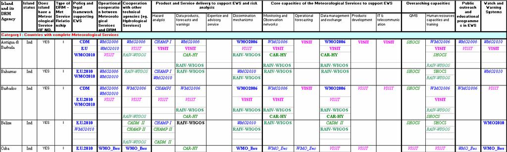
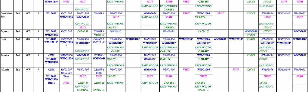
49 Table 3: Mapping of information provided in visits and assessments 48

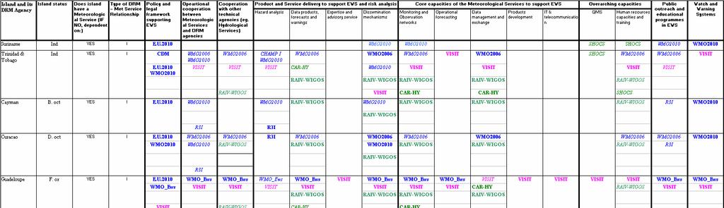
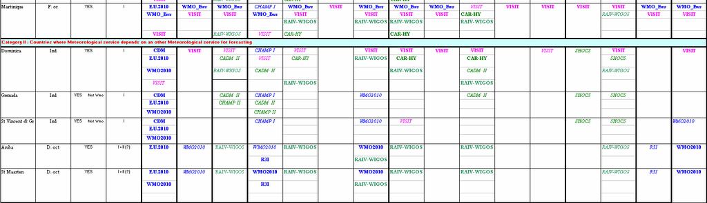
50 49


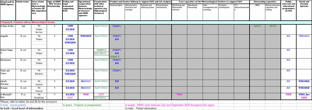
51 50
52 Table 4: Overview of the overall policies and legal frameworks supporting DRR and EWS in the different countries in the region 51
53 52


54 Table 5: Disaster Management Agencies in the Caribbean and their respective capacities 53


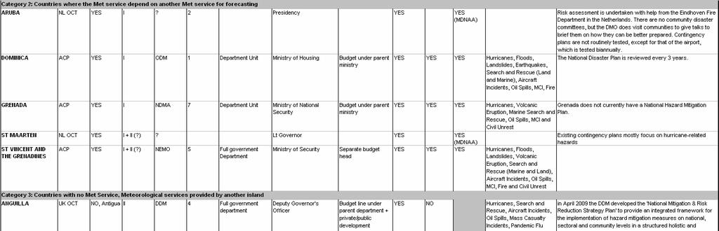
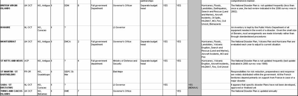
55 54
56 Table 6: Outline of the different relationships and dependencies between DRM agencies and Meteorological Services Country/ Territory and its DRM Agency Type of Regional grouping DRM Agency Does Country/ Territory have a Met Service? DRM Agency depends on Met Service of (if different from own): Met Service depends on support of the Met Service of: NMS Category 1: DRM Agency depends on the island s own Met Service, and the Met Service has full own capacity Belize ACP National Emergency Management Organization (NEMO) YES OTHER countries / territories that the Met Service has a mandate for (italic: mandate to support another Met Service / bold: mandate to support another DRM Agency directly): Responsible Hydrological Service Cuba ACP National Civil Defense (DCN) YES Instituto Nacional de Recursos Hidraulicos Dominican Republic ACP Civil Defense (DC) YES Instituto Nacional de Recursos Hidraulicos Guyana ACP Civil Defense Commission (CDC) Haiti ACP Direction de la Protection Civil (DPC) Jamaica ACP Office for Disaster Prevention and Emergency Management (ODPEM) St Lucia ACP National Emergency Management Organization (NEMO) Suriname ACP National Coordination Centre for Disaster Preparedness (NCCR) Martinique FR OR Service Interministériel Départemental de la Protection Civil Etat Major de la Zone Antilles (SIDPC EMZA) Cayman Islands UK OCT Hazard Management Cayman Islands (HMCI) Antigua & Barbuda ACP National Office of Disaster Services (NODS) Bahamas ACP National Emergency Management Agency (NEMA) YES Hydrometeorological Service YES Service National des Ressources en Eaux YES Water Resources Authority YES Water Resources Management Agency YES none YES DIREN Martinique YES CIMH YES St Kitts and Nevis, Anguilla, British Virgin Islands, Montserrat Antigua Public Utilities Authority YES Turks and Caicos Islands Water Sewage Company 55
57 Barbados ACP Department of Emergency Management (DEM) Trinidad & Tobago ACP Office for Disaster Preparedness and Management (ODPM) YES Dominica, St. Vincent and the Grenadines YES Grenada Water Resources Authority Guadeloupe FR OR SIDPC Guadelope YES St Martin/St Barthelemy DIREN Guadeloupe Curaçao NL OCT YES Aruba, St. Maarten, Bonaire, Saba/St Eustatius NMS Category 2: DRM Agency depends on the island s own Met Service, but the Met Service depends on another Met Service for forecasting Dominica ACP Office of Disaster Management (ODM) St Vincent & the Grenadines ACP National Emergency Management Organization (NEMO) Grenada ACP National Disaster Management Agency (NaDMA) CIMH No Hydroservice YES Barbados Met office and Dominican Water and Sewage Company YES Not WMO YES Not WMO Barbados Central Water and Sewage Authority Trinidad and Tobago National Water and Sewage Authority Aruba NL OCT YES Curaçao Curaçao No Hydroservice St Maarten NL OCT YES Curaçao Curaçao No Hydroservice NMS Category 3: DRM Agency depends on the Met Service of another island St Kitts and Nevis ACP National Emergency Management Agency (NEMA) Anguilla UK OCT Department of Disaster Management (DDM) British Virgin Islands UK OCT Department of Disaster Management (DDM) Montserrat UK OCT Disaster Management Coordination Agency (DMCA) Turks and Caicos Islands St Martin/St Barthelemy UK OCT FR OR Department for Disaster Management and Emergency (DDME) Service Interministériel Départemental de la Protection Civil St Martin NO Not WMO NO NO NO Antigua and Barbuda Antigua and Barbuda Antigua and Barbuda Antigua and Barbuda NO The Bahamas NO Guadeloupe Bonaire NL OCT NO Curaçao Saba/St Eustatius NL OCT NO Curaçao 56
58 Table 7: List of public meteorological websites per country Country/ Territory and its DRM Agency URL of the public WEB site for weather and warning information In country, NMHS WEB site Remote NHMS WEB site Shared WEB site Governement WEB site NMS Category 1: DRM Agency depends on the island s own Met Service, and the Met Service has full own capacity Belize Cuba YES Dominican Rep YES Guyana Haiti YES (Canada) Jamaica YES (Regional Server) St Lucia YES (Regional Server) Suriname Martinique YES (Guadeloupe) YES (FWI) Cayman YES Antigua & Barbuda YES YES Bahamas YES Barbados ther/barbados/index.php YES (CDEMA) Trinidad & Tobago YES YES Guadeloupe YES YES (FWI) Curaçao YES YES (DWI) NMS Category 2: DRM Agency depends on the island s own Met Service, but the Met Service depends on another Met Service for forecasting Dominica YES St Vincent & the Grenadines YES (Regional Server) Grenada YES (Regional Server) Aruba YES (Curaçao) St Maarten YES (Curaçao) NMS Category 3: DRM Agency depends on the Met Service of another island St Kitts and YES (Antigua Nevis and Barbuda) Anguilla YES (Antigua and Barbuda) British Virgin YES (Antigua Islands and Barbuda) Montserrat YES (Antigua and Barbuda) Turks and Caicos Islands St Martin/St YES Barthelemy (Guadeloupe) Bonaire YES (Curaçao) Saba/St YES Eustatius (Curaçao) YES (Curaçao) YES (DWI) YES (DWI) YES YES YES YES YES (FWI) Y (DWI) Y (DWI) 57
59 Table 8:Operational cooperation between Meteorological Services and DRM agencies Capacities NATIONAL LEVEL Gaps and needs In most countries/territories, contingency plans of DRM agencies (or at higher level) indicates the role of the Meteorological Service and the mechanisms of cooperation and coordination, however the level of detail varies from island to island; For several countries/territories, the Meteorological Service relies on SOPs, especially for tropical cyclone forecast and warnings; The mechanisms are well defined in countries/territories that have ISO certified QMS like Dominican Republic and the French Islands; Informal feedback mechanisms exist in most countries/territories; they are based on individual relationships, discussions and phone calls; Several countries/territories have systematic post event feedback proceses which have led to major improvements of the cooperation between the Meteorological Service and the DRM agency (Hurricane Ivan 2004 in Cayman and Grenada, Hurricane Lenny 1999 in the French Islands, Tropical Storm Debby 1994 and October 1996 floods in St-Lucia); Yearly exercises on weather related risk management are organised in several countries/territories (Cuba, Cayman Islands, French islands) to identify improvement areas, including the operational relationships between Meteorological Services and DRM agencies; Workshop, conferences or training are organised in some islands (Jamaica, Cuba, ) between DRM agencies and Meteorological Services and sometimes other technical institutions in order that each body understand the needs, the procedures and the challenges of the others; The Meteorological Services need to improve understanding of the Challenges and needs of the DRM agencies; Capacities and limitations of the Meteorological Services must be well known and understood by the DRM agencies with regards to their support in the MHEWS context; Need to enhanced the identification of key stakeholders in the MHEWS context; Need for training and workshops to enhance understanding of roles and capacities among Meteorological Services, DRM agencies and key EWS stakeholders; Need for strengthening control mechanisms and traceability for end to end delivery from Meteorological Services to DRM agencies; Need for strengthening the mechanisms for continual improvement processes through clear and framed feedback procedures and exercises involving all the DRM stakeholders and the Meteorological Service; Need for special SOPs in all the area mentioned above (key stakeholders identification, bilateral exchanges, feedback mechanisms) for countries/territories with type II relationships; Need to collect information from islands of good practice throughout the region to develop a list of expertise; 58
60 Table 9a: National product and service delivery of the Meteorological Services to support EWS Data products NATIONAL LEVEL Capacities In most countries/territories, data is delivered on demand to DRM agencies or stakeholders, sometimes under MOU (Trinidad and Tobago., French islands); Gaps and needs Need to enhance knowledge about users needs for the development of user centred products and services; Hazard analysis to support risk assessment Most of the time, raw data is delivered directly from the data base; In some cases, value is added through statistics or special formatting; Some countries/territories have information resources (paper based, on CD, etc) on hazard analysis s of tropical storm, storm surge, etc. that include return periods. These are normally low resolution resources; The Meteorological Service of Martinique can utilize high resolution topography and bathymetry data from Lidar surveys which enables better resolution and accuracy for risk mapping; The French islands have developed a methodology of hazard analysis which identified different danger thresholds which serve as the basic criteria for their watch and warnings; Need for specific system, tools or applications for data formatting, statistical data, diagrams, etc. Need for automated data server to give real time and non real time data access to institutions and other stakeholders; Meteorological Services are often not much involved in the national risk assessment process; Users needs with regards to hazard analysis are not well known; Need for strengthening the relationship among Meteorological Services, DRM agencies and stakeholders through trainings and workshops on hazard analysis and risk assessment; Need for developing/upgrading capacities for high resolution hazard analysis and information training and exchange methodology and tools; Need for strengthening observation networks for statistical computing and models 59
61 Capacities NATIONAL LEVEL verification; Gaps and needs Forecasts and warnings All countries/territories with a Meteorological Service provide routine forecasts and warning bulletins, when required, for their country/territory and for other countries/territories in the case of specific agreements; In all countries/territories with meteorological forecast office, forecast and warning products are available on their internet sites; RSMC Miami provides products on tropical cyclone forecasts and warnings which are utilized by forecast offices of the countries/territories; Some mixed text and graphics products are developed in some countries, however, graphics, maps or charts from US Web sites are utilized by many countries/territories; In most of the countries/territories, forecast and warning; Need to develop/upgrade/have access to modelling capacities to enable downscaling of hazard assessments; Need to have high resolution topography and coastal bathymetry; Need for training on the methodology on hazard analysis for the identification of different danger thresholds which serves as basic criteria for watch and warnings; Need for an integrated tool or workstation for end to end production, with flexibility and easy management at a national level; 60
62 NATIONAL LEVEL Capacities products are made on single PCs with normal office software. However, Antigua developed its own application and others use dedicated workstations like Metlab ( Cayman, Bahamas, Curaçao) or Smartmet (Trinidad, Jamaica) or Meteofactory (French islands); Gaps and needs EWS expertise and advisory service Cooperation with other technical agencies Dissemination mechanisms Principles An upgraded version of Smartmet is going to be tested soon in the pilot countries with training for Jamaica and Trinidad; In all the countries/territories with Meteorological Services, meteorologist has been identified to serve as experts with regard to DRM needs; In some countries/territories, in case of threat or meteorological crisis, a meteorologist sits at the crisis management committee to provide expertise to decision makers; Guyana and Belize have a combined Meteorological and Hydrological Service; Good relationships exist in Cuba and Dominican Republic (a hydrologist works at the Meteorological Service); In some countries/territories, NMHS is the sole institution to disseminate the warning information ( Curacao, Antigua, for example); in other countries/territories, DRM authorities are in charge of warning dissemination based on NMS primary information (Trinidad, Cuba for example) Sometimes, information is delivered from both side to different users and stakeholders ( FWI, Bahamas for Need to identify meteorologists in each Meteorological Service that can be utilized as a focal point for DRM matters; Need for DRM training for meteorologists serving as DRM focal points; There is little collaboration and coordination between the meteorological services and other technical agencies; Need to strengthen the relationship and the mechanisms with other technical institutions to improve product and service delivery; Need for enhancing harmonization and coordination between DRM and Meteorological services for watch and warning dissemination; Need for implementation at national level of a specific dissemination process for tsunami warnings in the context of the regional warning 61
63 example); Capacities NATIONAL LEVEL In some countries/territories (e.g.jamaica, FW) warning bulletins are disseminated to national DRM agencies as well as to the commune level through specific systems; system; Gaps and needs Means In all the countries/territories with Meteorological Services, Fax, and WEB are the primary dissemination methods. In most cases, they rely on PCs with internet access and specific FTP connections. Answering machines are a complement for public information (not always free of charge); Some countries/territories have started to develop mobile based (SMS) dissemination, thanks to private-public partnerships (Antigua, St-Lucia, Trinidad, French islands); The French Islands use a complete automatic dissemination platform that is directly plugged onto the production system; Some countries/territories started working on the implementation of the common alert protocol (CAP) in a pilot project framework (Anguilla for example); In addition to their basic dissemination, some countries/territories started to use virtual social networks like Facebook or twitter (Trinidad) to disseminate warning products; Public WEB sites : (See table 2: Public Web sites of the Meteorological Services) All forecasts and warnings for all the countries/territories (except for Turks and Caicos) are available on public WEB sites. Some are internally managed, others are hosted in other countries/territories Need for a multi-risk platform for dissemination with full redundancy (back up), automated procedures, control and traceability; Need to develop mobile based dissemination in close collaboration and partnership with private providers; Need for enhancing the use of EMWIN system on both Met services and DRM sides as well as the CAP; Need to study how virtual social networks can play a role for warning dissemination; EMWIN system seems to be used more on the reception side than on the dissemination side; further survey is needed; Public WEB sites The regional server for SIDS hosted in Curaçao ( NOAA-NWS programme) that host several national websites will be shut down soon due to financial reasons; Need to enhance national website policy for a better public visibility and to upgrade national capacities for website management; 62
64 Capacities NATIONAL LEVEL Gaps and needs Need to find an alternative solution for WEB server hosting, for countries/territories which do not have capacities to run their own WEB site; Capacity of website servers is limited causing the website to be unavailable due to high traffic during severe weather events; Need to strengthen the access capacities (bandwidth) and the possibility of mirror sites to allow accessibility at any time during an hazardous event, since the number of hits may be multiplied by factor 10 to 100; Need for better understanding of users needs in regard to weather forecasts and warnings on the WEB, especially NMS III islands with no Meteorological Service; Communication and media In all countries/territories, real time media ( TV and Radio) are considered to be the highest priority to disseminate warning information directly to the public; In some countries/territories (e.g. Bahamas, Cuba, FWI), i the meteorologist directly appears on TV or speaks live on radio in case of severe weather to deliver the main information with high credibility; Cuba has its own system to directly broadcast from the Meteorological service on the national TV channel. Cuba uses a specific software for TV to provide graphical illustrations or movies; In several countries/territories, Ham Radio and CB s are used Need for bilateral training and workshops between the Meteorological Service (especially forecasters) and the Media to improve information delivery; Need for a specific dedicated up to date software to broadcast severe weather information on TV with animated graphics, satellite and radar imagery, tropical cyclone tracks; 63
65 NATIONAL LEVEL Capacities (St-Vincent, Martinique, Bahamas ) as a secondary dissemination and communication means, sometimes under specific MOU or agreements with associations of Ham Radio or CB users; Gaps and needs 64
66 Table 9b: Product and service delivery of the Meteorological Services to support EWS REGIONAL ASPECT Capacities Gaps and needs Data products Currently there is only limited number of regional data products available to the meteorological services and EWS stakeholders;. Need for a regional capacity for the development and dissemination of regional data products (e.g. rainfall anomalies, heat waves); Hazard analysis to support risk assessment Forecasts and warnings There are several regional or international generic studies on tropical cyclone hazard which provide hazard atlas for several countries/territories (e.g. storm surge atlas); In most countries/territories, tropical cyclone forecast and guidance products are taken directly from RSMC Miami without modification; Need for a regional programme for development of a multihazard analysis with methodology and tools for the regional level as well as downscaled information from regional scale down to national level; Need to strengthen the relationship between Meteorological Services and DRM agencies and stakeholders in others islands which do not have Meteorological Services in order to involve the Meteorological Services in the risk assessment process through the provision of specific hazard analysis; Need for documenting available regional centers of expertise in hazard analysis for capacity building; Need for a mechanism for the exchange of risk modelling good practices; Need for a regional approach for the sharing of expertise, and tools of forecast and warning production systems; 65
67 Capacities Martinique issues regional marine forecasts and warnings for the Lesser Antilles ( 50W-70W / 10N 20N) in French and in English; REGIONAL ASPECT Gaps and needs EWS expertise and advisory service Cooperation with other technical agencies Dissemination mechanisms Principles During each threat over one of the CDEMA members country/territory, an EWS expert from CIMH join the CDEMA team to bring his expertise and advice for decision making; Procedures and agreements exist for dissemination back up, from an island to an other island, specially through the Hurricane Operational Plan reviewed every year under the RAIV Hurricane committee; Some countries/territories receive primary information from from the Pacific Tsunami Warning Centre (PTWC) in Hawaii; through GTS, or SMS; Need for a regional approach for the implementation of a dissemination system at national level with harmonization and standardization of the procedures and the technical requirements. It could be more efficient for upgrade, maintenance and training for trainers and also for back up procedures or/and dissemination redundancies; Need for enhancing and verification of mechanisms for dissemination back up between countries/territories which have specific mandates and agreements; Need for an assessment of wider use of the common alert protocol as an harmonized regional tool for warning dissemination; Means Need for a regional approach to improve the capacity in many countries/territories with regard to the development and sustainability of their national meteorological service websites; 66
68 Communication and media Capacities REGIONAL ASPECT Gaps and needs Need for a regional training mechanism where forecasters and media from different islands could improve their bilateral coordination as well as communication of severe weather and warnings to DRM stakeholders and the public; 67
69 Table 10a: Core capacities of the Meteorological Services to support EWS National aspects NATIONAL LEVEL Monitoring and observation networks Operational forecasting Capacities All the countries/territories with Meteorological services have their own observation networks; Some islands have a limited number of real-time automatic weather station (e.g. 1 in St-Vincent, 2 in Barbados, 2 in Antigua, 2 in Dominica) while others have a larger number (e.g. 40 in Martinique, over 80 in Cuba); In many countries/territories, several networks measuring the same type of data are managed by different institutions and stakeholders; Some countries/territories (eg. Jamaica, Martinique, St- Lucia) have implemented special observation networks coupled with automated system for flash flood alerts; The French islands manage a coastal waves riders observation network that enables accurate measurement of waves and swell; Some countries/territories have only tide gauges (eg. Trinidad and Tobago, St-Lucia); All of the forecasting offices have some level of forecasting infrastructure such as observations, satellite, radar, NWP, etc.. However, the level of infrastructure (e.g. workstations, networks access) varies from country to country; Some countries/territories have integrated workstations (e.g. Corobor, Synergie, Metlab) while others rely on products and services from various WEB sites (eg. NOAA, CIMH, Meteofrance); All the countries have access to NWP through GTS and/or Internet; however, the suite of products is limited due to bandwidth issues. In complement, some countries have access to FTP servers in USA or UK to download NWP; All the islands have access to regional NWP from the CIMH Gaps and needs All islands of NMS category III (except St. Martin and St. Barth) do not have observation networks; Need for increasing the spatial coverage of observation sites in most countries/territories; There is lack of coordination and cooperation for interoperability of the observation networks at national level; Need for better coordination between Meteorological services and other bodies which have meteorological networks to target optimization and efficiency; Need for additional resources and training for maintenance of observation sites and networks (e.g. staffing, staff training, funding, spare parts); Need for better climatological observation networks to support slow onset hazards like drought and heat waves and to work an climate change downscaling; Most countries/territories do not have a comprehensive and integrated forecasting system; None of the countries/territories have access to severe weather guidance system with downscaling capacities, including marine hazards forecasts; Need to access in real-time a higher number and variety of information from numerical models or satellites with more functionalities possibly through a sole dedicated system; Need for improving downscaling capacities from national threat to local potential impacts, including marine coastal risks as forecasts are currently made for the whole country (case of small islands) or the whole province (case of large countries); 68
70 NATIONAL LEVEL Capacities models (MM5 and WRF) through its website (display only); Cuba and the French islands use their own national modeling capacities to run regional models; Islands that are European Territories (OCTs and French ORs) have access to a wide variety of ECMWF products, including probabilistic and ensemble outputs. Non- European Territory islands only have limited access; The Flash Flood Guidance System (FFGS), developed by the Hydrological Research Centre (HRC) under the Hydrological programme of WMO, has been recently implemented for Haiti and Dominican Republic; Gaps and needs Need for strengthening capacities for downscaling regional information of monthly or seasonal forecast to national needs; Need for development or enhancement of forecaster cross training programmes between islands; Need to improve non tropical cyclone severe weather lead time for warning and forecast products for DRM agencies and stakeholders; Need for more qualified forecasters in many countries/territories; (e.g. Aruba and St-Vincent have only one forecaster and Dominica has two); Need for strengthening of ongoing training on new technologies, products and methodologies related to forecasting and monitoring, conducted by regional centres when possible, including radar (operational use), NWP, and marine issues; Data management and exchange In most of the countries, there are several data bases for environmental data. Some countries/territories are working on the establishment of a single national database; In many countries/territories, meteorological data is still manually collected and stored and transmitted; Need for enhancing feedback mechanisms from the forecasters to the regional or international centers providing NWP (e.g. CIMH, NOAA, ECMWF); Need to have a national GIS database of meteorological and hazard data, with quality control procedure and with harmonized protocols of exchange with the regional database; Need for strengthening the relationship between DRM stakeholders, Meteorological Services and Hydrological Services when they exist with regards to data exchange; Need for strengthening capacities in terms of human resources dedicated to climatological data base management; Need for strengthening data rescue procedures and capacities; Need to ensure and develop processes to include metada in the meteorological data base; 69
71 NATIONAL LEVEL Products development IT and telecommunication Operational relationship with other technical agencies Capacities Spanish and French islands have specific resources to working on product development. These resources include a dedicated staffed department which works under procedures that have been identified in a comprehensive QMS or set of SOPs;. Most meteorological products are developed for display on WEB sites; The three French departments have a coordination unit for product development and a unique server in Martinique; products that have been developed for one departement can be utilized for another; All the countries/territories rely on the RMTN GTS network; All the countries/territories highly depend on the internet exchange for WEB access and s with no back up solution; The French terrotories have dedicated lines and networks with Toulouse (France) and between the three departments ; Several countries/territories have specific agreements or MOU with providers for mobile telecommunication; There are 4 islands (Cuba, Dominican Republic, Guadeloupe and Martinique) with national hydrological institutions that have risk management in their mandate; In most of the other countries, the water resources authorities are in charge of some hydrological aspects including expertise and data networks; CIMH is the official institution for hydrology in Barbados; It also provides support to all the CMO members with regards to hydrology through regional advisors; Gaps and needs Most of the SDIS have only few capacities for products development, in term of human resources and software or workstation; Need to improve or implement integrated production systems to help with products development; Need for more training on both operational and software sides on specific production system (eg. Smartmet, MeteoFactory) in order to have flexibility for national adaptation and upgrade; Need to improve capacities for internet product development; Need to improve infrastructural capacities to support dissemination and data exchange at national and regional level to ensure DRM and public dissemination (including Internet) and monitoring networks exchanges are operational 24 hours a day, 7 days a week; Need to improve the capacities of Internet access (e.g. higher or flexible bandwidth, mirror sites); Need for developing public/private partnerships for mobile phone dissemination (SMS, voice messages) of warnings, advisories and data transmissions at a national or regional level (e.g. Carib- Hycos with Digicel); Meteorological and Hydrological services are often different institutions and thus, coordination between them, especially in real-time, is often a challenge.coordination is often made through DRM agencies for crisis management; Need for real-time coordination to have a timely input of hydrological expertise in the comprehensive forecast and warning process from the hydrological national institution or from a regional advisor (e.g. from CIMH); Need for tools or workstations which can integrate meteorological and hydrological data (radar, rain gauges, 70
72 NATIONAL LEVEL Capacities Works are in progress in the French department to implement a similar organization than in France trough a cellule de veille hydrologique with Meteorological and Hydrological specialists working together for real-time forecasts and warnings; Gaps and needs limnimeters) for monitoring and nowcasting; Need for improvement of access from Meteorological Service to Hydrological information when they exist ( for real-time purpose or batch processing; 71
73 Table 10b: Core capacities of the Meteorological Services to support EWS Regional aspects REGIONAL ASPECT Monitoring and observation networks Operational forecasting Capacities The Caribbean Radar Project (EU, CMO, MeteoFrance) has led to great improvements in terms of hazard monitoring in the region; Some countries/territories have access to the long range lightning network of the UK MetOffice or to some information on Web sites like World Wide Lightning Location Network; RSMC Miami plays a crucial operational role for analysis and forecasts over the north tropical Atlantic at a synoptic scale; CIMH also plays a crucial role to support forecasting capacities (e.g. regional numerical model) and to transfer knowledge and expertise to CMO members (regional training centre); There is a French forecasting coordination centre in Martinique to ensure real-time coordination and guidance for the French Antilles and French Guyana; Gaps and needs Need for better coordination among current regional projects that are providing meteorological observation equipment (e.g. Carib-Hycos, CADM); Need to strengthen the coastal marine observation networks through : - widen the existing French wave riders network and to complement the US Buoys - upgrade the number of tide gauges; Need to fill the gaps in regional radar information and to produce a complete mosaic for the Caribbean region based on the existing one. The first step could be by including radars from St-Maarten, Jamaica, Cuba, and to achieve the installation of the radar in the Cayman Islands (EU-CIG project); Need to share more hydro-meteorological data from radars (e.g. rain accumulation, radial wind); Need for a high resolution regional lightning network that would complement the existing low resolution long range networks; RSMC Miami coordinates with the island forecast offices only when a tropical cyclone is forecast to directly impact one of the islands that the forecast office is responsible for in terms of forecasts and warnings; CIMH initiated web conferences for real-time expertise and coordination through the visit view system; however, it is not an operational centre; Need of strengthening the real-time coordination between 72
74 REGIONAL ASPECT Capacities CIMH is the regional training centre for CMO member states; It also organizes regularly technical regional workshops with other partners ; In all the other countries/territories (except Haiti), forecasters are trained in their country (Cuba, Dominican Rep.) or in the mother country (France, Netherlands); Forecasters training (courses, workshops, secondment) is available to many Caribbean countries/territories from RSMC Miami and the National Weather Service of USA; Online training for tropical meteorology and forecasting from centres of excellence are available on the WEB (eg. COMET); Gaps and needs neighboring forecast offices; Need for additional foreign language training to enhance the capacities of exchange and coordination; Need for a regional centre or regional platform to support National Meteorological Service with routine guidance, consensus forecasts and real-time coordination, especially for severe weather forecasting, marine forecasting and monthly / seasonal forecasts; Need for increasing the variety and number of NWP (e.g. probabilistic products, dynamic parameters) and products for expertise (e.g. high resolution satellite imagery, radar products) that are available on the GTS; Need to strengthen regional training mechanisms, through courses, workshops, staff exchange (e.g. secondments) and e-learning; Need to enhance the role of the Caribbean Community Climate Change Centre (CCCCC) with regards to monthly or seasonal forecast for long lead hazards and climate change related risks; Data management and exchange Regional mechanisms for data exchange or sharing currently exist through CIMH which collects and manages data from CMO Members; Generally, data from official WMO synoptic stations are disseminated to the region on the GTS; Weather stations, other than WMO official stations, are often unknown to other countries/territories and regional bodies. It is a challenge for CIMH to get all the meteorological information from its members; Need to strengthen coordination and exchange of data among islands, countries and regional centers to improve real time and slow onset monitoring; Need for a standardized GIS Met and Hydro regional data base with protocols of exchange which is quality assured; The Carib-Hycos programme involving CIMH could address a 73
75 REGIONAL ASPECT Capacities Gaps and needs part of the issues being a good start of the implementation; Products development Most islands have difficulties identifying resources to work on product development; IT and telecommunication Operational relationship with other technical agencies In all the countries/territories, the Regional Meteorological Telecommunication Network (RMTN, part of GTS) is a crucial pillar for technical capacities like monitoring and forecasting; Very little hydrological information is available at the national level for exchange with regional (e.g. CIMH) and national agencies; Need for a regional product development programme with associated training that can be used at national level with flexibility; Need to anticipate potential changes for RMTN (related to ISCS/WAFS ) dissemination; Need for upgrade of the RMTN dissemination in terms of capacities (bandwidth, volume, speed) and data availability (e.g. more NWP products, radar information); Need to improve telecommunication back up procedures and agreements at a regional or sub-regional level; Need to establish partnership at regional level with regional providers of mobile services for SMS, GPRS, Voice messages for the dissemination of warnings and advisories at the regional level; Need to enhance the exchange mechanism of hydrological data at regional level through regional collection or bilateral exchange; Need for enhanced sub-regional or bilateral cooperation between Meteorological Services and Hydrological services from countries sharing the same river basin in the continental region (Guyanas, Suriname, Belize); 74
76 Table 11: Overarching capacities of the Meteorological Services to support EWS 1. Quality Management System Capacities The Dominican Republic and the French islands have a comprehensive QMS and are ISO certified; The Interregional Direction of Meteofrance has a QMS for all the French islands and French Guyana; In all the islands, Meteorological Service strongly relies on regional plans(e.g. from RAIV-Hurricane Committee), international documents (e.g. From WMO or ICAO) as framework for its activities; Most of the Meteorological Services have contingency plans to ensure continuity of service in case of emergency; There are contingency plans on DRM side which frame the basic activities of the Meteorological Services to support DRM in the context of MHEWS; NATIONAL LEVEL and REGIONAL ASPECTS Gaps and needs In several islands, activities are based on seldom SOPs that do not cover all the areas; Many of the islands do not have a comprehensive set of documents describing activities, procedures, operating modes, means involved and goals; some are focusing on specific tasks only; the oral tradition is very strong; Feedback from users and institutions (e.g. DRM agencies) exist but are often informal and difficult to trace; Thus, it is difficult to implement continual improvement mechanisms; Need for a regional programme for QMS implementation at national level providing harmonized comprehensive procedures and taking into account all the specificities of the islands; Need to have clearly defined operational procedures for Meteorological Services support of: i) other Meteorological Services ii) DRM agencies in other countries; 2. Human resources and training Several Meteorological Services are sufficiently staffed with regards to their activities (e.g. Cuba, Dominican Republic, Trinidad, Martinique & Guadeloupe); Need for a mechanism for sharing QMS best practices among the islands; Many islands do not have adequate number of qualified staff, especially meteorologists; Need for more qualified meteorologists in many islands, especially in the two country-islands, Dominica and St-Vincent & the 75
77 Capacities In the islands without Meteorological Service, there is often a focal point (e.g. air traffic controllers) that are responsible for meteorological issues; NATIONAL LEVEL and REGIONAL ASPECTS Grenadines; Gaps and needs Need for training of meteorologists in the area of product development and service delivery; Reminder on training aspect CIMH is the regional training centre for CMO member states; It also organizes regular technical regional workshops with partners; In all the islands (except Haiti), forecasters are trained in their country (Cuba, Dominican Rep.) or in the mother country (France, Netherlands); Forecasting training courses, workshops, secondment are available to many Caribbean countries by RSMC Miami and the National Weather Service of USA; On line training on tropical meteorology and forecasts from centres of excellence are available on the WEB (e.g. COMET); Need for specific training for the forecasters on DRM activities and challenges; Reminder on training needs Need for strengthening of ongoing training programmes on new technologies, products and methodologies related to forecasting and monitoring, conducted by regional centres when possible, including radar (operational use), NWP, and marine issues; Need for additional resources and training for the maintenance of observation sites and networks; Need for additional training on both operational and software sides on specific production system (e.g. Smartmet, MeteoFactory) in order to have capacities for national adaptation and upgrade; Need for development or enhancement of forecasting cross training programmes between islands; Need to strengthen regional training mechanisms, through courses, workshops, exchange, secondments and e-learning to ensure they are adapted to the islands needs with regards to forecasting needs; Need for foreign language training of meteorologists to enhance to ensure effective coordination; Need for bilateral training and workshops between Meteorological 76
78 Capacities NATIONAL LEVEL and REGIONAL ASPECTS Gaps and needs Services, DRM agencies and key stakeholders; Need for training on methodology and tools for hazard and risk analysis; Need for bilateral trainings and workshops between Meteorological Service (specially forecasters) and the media to improve the way information is delivered; 77
79 Table 12: Educational programmes in EWS Capacities NATIONAL LEVEL and REGIONAL ASPECT Gaps and needs In most countries/territories, school programmes, sometimes from kindergarten to university, include risk information especially on tropical cyclones, In some countries/territories, specific school programmes on meteorological hazards and risk have been developed in collaboration among the Meteorological Services, DRM agencies and education institutions (e.g. Cuba, Jamaica, Martinique, Trinidad and Tobago); In some countries/territories, teachers can be trained on hydrometeorological hazards and risks through specific training courses, workshop or conferences; Some international meteorological educational programmes (e.g. COMET) are available through online e-learning sites or on CD/DVD; Education targeted at the general population was highlighted as a major gap in the Caribbean region, especially in islands not often affected by tropical cyclones; Need for enhancement of training mechanisms and materials for of media, institutional trainers and teachers on meteorological hazards and their impacts; Need for a training mechanism and education materials that target specific vulnerable population (e.g. Women, children, isolated families, elderly, tourists) on meteorological hazards and their impacts; Need for better collaboration among meteorological service, DRM agencies for the development of educational programmes and information campaigns (e.g. hazard identification, preparedness methods) for the public; Need for identification of existing educational programmes at the national, regional levels; In some countries/territories, radio/tv campaigns on meteorological risk information are broadcast regularly, however these mainly focus on tropical cyclones; CDs or DVDs are available in some countries for public information through schools, institutional ongoing training, and conferences. These materials have been developed through collaboration among national or regional partners (e.g. CDEMA) or international organizations (e.g. IFRRC); 78
80 Capacities NATIONAL LEVEL and REGIONAL ASPECT Gaps and needs In many islands regional institutions like CDEMA or international institutions like IFRCC play a important role in public awareness, risk culture and preparedness; 79
81 Table 13a: Watch and Warning Systems (National Aspects) Capacities Almost all the countries/territories have adopted the same Watch Warning System (WWS) for tropical cyclones as RSMC Miami); In all the countries/territories, aeronautical hazards are managed under the IACO framework and are not integrated in comprehensive WWS for DRM; The meteorological services insure that aeronautical warnings are aligned with public and marine warnings; Trinidad and Tobago and the French islands have a standardized color-coded WWS for several hazards; NATIONAL LEVEL Gaps and needs Many hazards and their consequences are taken into account in term of forecasting and monitoring but not all of them are managed through a comprehensive WWS; ; in most islands, a comprehensive WWS exists only for tropical cyclones and sometimes for heavy rain; Some SOPs exist and the boundary between specific procedures (warnings bulletins, dissemination, phone calls) and real WWS is not very clear; Need for national adaptation of the regional WWS for tropical cyclone from RSMC Miami; Most countries/territories take into account primary hazards (e.g. heavy rain) in their WWS. But, there is a lack of consideration for related hazards like landslides or flash floods; Need for enhancement of national WWS to include multiple hazards (primary and secondary) such as coastal marine hazards (storm surge, long swell), drought, heavy rain and flooding, land slides, mudslides, etc.; Need for improvement of the downscaling of WWS to local levels; The risk of tsunami has often been reported as a specific case requiring specific WWS or procedures and thus, it remains as a main issue to be integrated in WWS; Need for development or integration of WWS for tsunami at a national level in the framework of the existing regional system with a special consideration of islands without Meteorological Services or with Meteorological Services that are not operational 24 x 7; Few islands use a thresholds based methodology in their WWS to manage hazards; In most cases WWS are based on the geographical threat zone of the main meteorological feature (Tropical cyclone or waves, cold front, ) and the lead time; 80
82 Capacities NATIONAL LEVEL Gaps and needs Need for studies to base WWS procedures on threshold derived from risk assessment, past events and robust environmental databases; Need for linking WWS information to probabilistic forecasts for all the relevant hazards to meet the needs of DRM agencies in term of progressive real time preparedness; Need for additional involvement of DRM agencies and stakeholders in the improvement of the WWS; Need for improvement of coordination and collaboration between the meteorological and hydrological services (e.g. heavy rainfall and possible hydrological consequences); In several countries/territories WWS are not well known on the public side, even though warnings bulletins are issued; Need for public education campaigns to enhance public understanding of WWS criteria; 81
83 Table 13b: Watch and Warning Systems (Regional Aspects) Capacities REGIONAL ASPECT Gaps and needs The only regional WWS for all the countries/territories of RAIV is specifically for named tropical cyclones and is managed by RSMC Miami; This regional WWS is comprised of a realtime coordination mechanism between RSMC Miami and countries/territories that are forecast to be directly impacted; The French islands have a sub-regional color coded-wws on the Lesser Antilles for tropical cyclones, heavy rain, thunderstorms, damaging waves and strong winds. Currently, it is coordinated only within the French Islands with input, during tropical cyclone events, from official WWS from RSMC Miami; Real time WWS coordination has been put in place since June 2010 between the French regional centre in Martinique and the CNM Haiti; The regional WWS of RSMC Miami is only for direct impact of named tropical cyclones. This WWS is not downscaled to localities where risks and vulnerabilities may be greater;. For hazards other than tropical cyclones, there is no regional harmonization and no real time coordination between the different forecast and warning offices. However, CIMH organizes conference calls to coordinate warnings for severe weather throughout the CMO members, but not on a 24 x 7 basis; Need for a regional or sub-regional harmonized multi-hazard WWS taking into account existing systems (e.g. RSMC Miami); Need for real time coordination in the region, at least between neighbouring islands, for multi-hazard WWS; Need for strengthening coordination between forecast warning centres and islands that depend on their WWS services; Need for a regional platform for WWS guidance, information exchange and coordination; Need for involvement of DRM agencies in the process of harmonization of WWS in the region; 82
84 LIST OF ACRONYMS ACP ACS ALBA AWS BCT CADM CAP CARICOM CCCCC CDB CDEMA CHAMP CIMH CMO COMET CRMI DRM DRR DWI ECMWF EMWIN ENSO FFGS FR OR FTP FWI GIS GTS ICAO IFRC IOC/ICG - CARIBE EWS IRD ISCS/WAFS IT JICA MHEWS MOU NL OCT NMHS NOAA NWP OAS OCT OR QMS R3I African, Caribbean and Pacific Group of States Association of Caribbean States Alternativa Bolivariana para las Américas Automatic Weather Station British Caribbean Territories Caribbean Disaster Management Project Common Alert Protocol Caribbean Community Caribbean Community Climate Change Center Caribbean Development Bank Caribbean Disaster Emergency Management Agency Caribbean Hazard Mitigation Capacity Building Programme Caribbean Institute for Meteorology and Hydrology Caribbean Meteorological Organization Cooperative Programme for Operational Meteorology, Education and Training Caribbean Risk Management Initiative Disaster Risk Management Disaster Risk Reduction Dutch West Indies European Center for Medium-range Weather Forecast Emergency Managers Weather Information Network El Nino Southern Oscillation Flash Flood Guidance System French Outermost Regions File Transfer Protocol French West Indies Geographic Information System Global Telecommunication System International Civil Aviation Organization International Federation of Red Cross and Crescents Societies Intergovernmental Oceanographic Commission / Intergovernmental Coordination Group for the Tsunami and other Coastal Hazards Warning System for the Caribbean Sea and Adjacent Regions Institut de Recherche et Developpement International Satelitte Communication System / World Area Forecast System Information Technology Japanese International Cooperation Agency Multi-Hazard Early Warning System Memorandum of Understanding Dutch Overseas Countries and Territories National Meteorological and Hydrological Service National Oceanographic and Atmospheric Administration Numerical Weather Products Organization of American States Overseas Countries and Territories Outermost Region Quality Management System Regional Risk Reduction Initiative 83
85 RAIV RMTN RSMC SCHAPI SHOCS SIDS SOP UCAR UN UNDP USAID UWI WMO WWS Regional Association IV Regional Meteorological Telecommunication Network Regional Specialized Meteorological Center Central d'hydrométéorologie et d'appui à la Prévision des Inondations Strengthening Hydrometeorological Operations and Services in the Caribbean SIDS Small Island Developing States Standard Operating Procedure University Cooperation for Atmospheric Research United Nations United Nations Development Programme United States Agency for International Development University of West Indies World Meteorological Organization Watch and Warning System 84
86 ANNEXES 85
 GDP/capita (PPP): US$12,200 (2008 est.")
87 6.4 ANNEX 1: DRR Country Profiles Anguilla ANGUILLA is part of the British Caribbean Territories and is situated in the Leeward Islands. Size: 91 km², extremely low-lying and rises only to 65m Population: 14,436 (2010 est.) GDP/capita (PPP): US$12,200 (2008 est.) GDP/sector: agriculture: 4%; industry: 18%; services: 78% ECONOMY AND FINANCES: The island has few natural resources and the economy largely depends on tourism, foreign banking, lobster fishing and remittances from emigrants. As an overseas territory of the UK, Anguilla has in the past relied on the UK for financial assistance. The Government of Anguilla has limited public financing and plans to upgrade the physical and economic infrastructure through deficit financing. VULNERABILITY TO NATURAL HAZARDS: Anguilla is vulnerable to tropical cyclones, tsunamis, floods, earthquake, coastal erosion, rising sea levels and sea penetrations and landslides. The low-lying topography and centrifugal drainage pattern of the numerous sinkholes increases the risk of Anguilla to high wind and flooding damage. Several areas of the coast are also prone to coastal erosion and landslides. Recent disasters include hurricanes Earl (2010), Omar (2008), Lenny (1999), Marilyn and Luis (1995), and Donna (1960), all of which generated considerable damage to infrastructure, which in turn impacted heavily on the economy of the island. INSTITUTIONAL ARRANGEMENTS OF DRM: The Department of Disaster Management (DDM) is the responsible organization. It has a staff of 7 and reports to the Deputy Governor and has competencies in the areas of Community Outreach, Preparedness & Education; Mitigation, Strategic Planning and Mapping (GIS); Emergency Communications, Warning Systems & Web Services. In April 2009 the DDM developed the National Mitigation & Risk Reduction Strategy Plan to provide an integrated framework for the implementation of hazard mitigation measures at national, sectoral and community levels in a structured holistic and comprehensive manner. Anguilla s National Warning System (ANWS) was designed and implemented during Alerting protocols were drafted collectively by the fire and police departments, Red Cross and other agencies. The system is in need of policy and protocols for use; thresholds of risk and associated alert levels; consideration for at risk populations e.g. people with sight/hearing impairments; weekly and monthly testing; integration into day to day life. METEOROLOGICAL AND HYDROLOGICAL SERVICES AND CAPACITIES: There is no NMHS in Anguilla. The country receives its meteorological information from Antigua and Barbuda (OECS arrangement). Minimal meteorological information is under the responsibility of air traffic controllers. The 86
88 public generally relies on outside cable weather stations for news and forecasts regarding storm systems. The closest EMWIN system is at the airport of Antigua. OTHER STAKEHOLDERS: As a British Overseas Territory, Anguilla has access to direct UK support and technical assistance through DFID. After Hurricane Omar, the country received grant funding from the Caribbean Development Bank (CDB) oriented to the reconstruction of infrastructure. Another stakeholder is the Ministry of Social Development, which has been promoting a set of initiatives related to DRM. The Anguilla Red Cross is the only NGO directly involved in DRM. COOPERATION WITH THE REGION: Anguilla is an associate member of CARICOM and the OECS, and a de facto full member of CDEMA and of the CMO/CIMH. It participates in several regional initiatives, such as the Caribbean Catastrophe Risk Insurance Facility (CCRIF), the Regional Risk Reduction Initiative (R3I), and the Regional Disaster Risk Management for Sustainable Tourism in the Caribbean. 87
 GDP/capita (PPP): US$17,800 (2009 est.) GDP/sector: agriculture: 3.8%; industry: 22%; services: 74.")
89 Antigua and Barbuda ANTIGUA AND BARBUDA is an independent country composed of several islands. It is located in the Lesser Antilles in the Eastern Caribbean. Size: 443 km² Population: 85,632 (2010 est.) GDP/capita (PPP): US$17,800 (2009 est.) GDP/sector: agriculture: 3.8%; industry: 22%; services: 74.3% ECONOMY AND FINANCES: The country s primary economic activities are tourism, construction and light manufacturing, with tourism alone accounting for nearly 60% of GDP. Antigua's economy was severely hit by the global economic crisis, suffering from the collapse of its largest financial institution and a steep decline in tourism, resulting in a significant increase in the country s national debt. VULNERABILITY TO NATURAL HAZARDS: Antigua and Barbuda are low-lying islands without mountains or rivers, with a significant area lying near or below sea level. The country is vulnerable to storm surge, damaging waves and coastal inundations, heavy rain (urban flooding) and droughts. The islands are on the tropical cyclone path and are affected almost annually. The last impact dates from the passage of Hurricane Omar in 2008, which caused coastal inundation and flooding from heavy rain. INSTITUTIONAL ARRANGEMENTS OF DRM: The responsible government agency is the National Office of Disaster Services (NODS). It reports to the Prime Minister s Office and has a staff of 13, four of whom are professionals. Projects are under responsibility of the different ministries, so funds are channeled through them. NODS maintains close relations with CDEMA. The institution has strengthened its coordination mechanisms and preparedness for the hurricane season period, but at the same time emphasized its institutional weakness, citing not only the deficit of equipment and resources, but also the cost involved in subcontracting to private enterprises. Antigua and Barbuda has a National Disaster Plan in place which defines roles and responsibilities in case of a disaster; preparedness measures; warning arrangements; and response operations. METEOROLOGICAL AND HYDROLOGICAL SERVICES AND CAPACITIES: The Antigua and Barbuda Meteorological Service is based at the international airport. The service maintains an observation network with 2 Automatic Weather Stations in Antigua, and 1 in Barbuda. There is no hydrological institution on the islands, mostly because there are no rivers. In addition to providing services to the Antigua and Barbuda government, the Met Service has the mandate to support Anguilla, the British Virgin Islands, Montserrat, and St. Kitts and Nevis, none of which have a Meteorological Service of its own. OTHER STAKEHOLDERS: A number of NGOs are affiliated with NODS, including the Red Cross, St. John s Ambulance Brigade, the Salvation Army and a number of service clubs and church organizations. The Red Cross is arguably the most involved, its activities focus mainly on community-level support. A number of public institutions have also been involved in the past, including the Antigua Public Utilities Authority (UPUA), which is responsible for telecommunications, energy and water. Past projects have typically been funded by USADI and US/OFDA, by Japan and by the European Commission (ECHO). COOPERATION WITH THE REGION: Antigua and Barbuda is part of the ACS, CARICOM, the OECS, CDEMA, CMO/CIMH and the CDB. It is also a member of the Eastern Caribbean Currency Union (ECCU), which is supervised by the Eastern Caribbean Central Bank. The country has close relations with Venezuela and is part of ALBA, through which it received US$50 million in
90 Aruba ARUBA belongs to the Dutch OCTs and is an autonomous territory of the Netherland Kingdom since January 1, It is located in the Lesser Antilles, just north of the Venezuelan coast. Size: 180 km² Population: 103,065 GDP/capita (PPP): US$21,800 (2004 est.) GDP/sector: agriculture: 0.4%; industry: 33.3%; services: 66.3% ECONOMY AND FINANCES: Tourism is one of the main pillars of Aruba s economy and the main source of employment for the population. Another important sector is offshore banking. Aruba receives some development assistance from the Dutch government each year, but this is gradually being reduced with the objective of making Aruba economically independent. Assistance usually takes the form of direct material or technical support. Aruba enjoys one of the highest standards of living in the Caribbean region and a low unemployment rate. The island s main trading partners are Venezuela, the US and the Netherlands. VULNERABILITY TO NATURAL HAZARDS: Aruba is not at a high risk of tropical cyclones. Nevertheless, the island was heavily affected by hurricanes Hazel (1954), Janet (1956), Lenny (1999) and Felix (2004), of which the last caused severe damage to infrastructure and the tourism sector. Other major hazards are earthquakes, droughts, floods, storm surges, tsunamis, fires, as well as oil spills or possible accidents in the oil refinery. INSTITUTIONAL ARRANGEMENTS OF DRM: Aruba is relatively self-sustained and has the capacity to help other islands in the region. The island has a Bureau for Crisis Management, which reports directly to the Presidency. Coordination is carried out through the Crisis Management Office, which has a clear mandate but only 2 permanent staff. Key organizations that are part of the Bureau are the Fire Department, the Police and the Health service. All have contingency plans for hurricanes, aerial and marine incidents. Risk assessment is undertaken with help from the Eindhoven Fire Department in the Netherlands. METEOROLOGICAL AND HYDROLOGICAL SERVICES AND CAPACITIES: The Aruba Meteorological Office has limited capacities. It employs one forecaster but generally relies on the Meteorological Service of the Netherlands Antilles and Aruba (MDNAA) located in Curaçao. There is no observation network and the island, just as the other islands of the former Netherlands Antilles, does not have a hydrological service. OTHER STAKEHOLDERS: The government of the Netherlands is an active stakeholder in DRM initiatives. Importantly, Aruba has a Royal Dutch Marines base on its territory, which has considerable resources and capacity for disaster response. The Bureau for Crisis Management regularly holds coordination meetings with the military command. The Dutch Red Cross has been implementing a prevention programme with resources provided by the Netherlands government, and have a system in place that allows them to mobilize and react rapidly. They keep emergency equipment and supplies and have a good relationship with the Crisis Management Office. COOPERATION WITH THE REGION: Aruba is an associate member of the ACS. It is involved in the Regional Risk Reduction Initiative (R3I) together with all the other Dutch OCTs. Exchange with other islands in the Caribbean is focused mainly on the former Netherlands Antilles. Aruba also maintains close 89
91 relations with Venezuela s Government, and depends on FUNVISIS for all technical matters related to seism Fundación Venezolana de Investigaciones Sismológicas is attached to the Ministry of Sciences and is providing support and services in all matters related to seismic monitoring and anti-seismic engineering. 90
: US$29,700 (2009 est.) GDP/sector: agriculture: 1.2%; industry: 14.7%; services: 84.")
92 The Bahamas WORKING PAPER: PRELIMINARY DRAFT OF ASSESSMENTS 22 OCTOBER 2010 THE BAHAMAS is a country made up of 29 islands, located to the north of Cuba. Size: 13,939 km² Population: 307,552 GDP/capita (PPP): US$29,700 (2009 est.) GDP/sector: agriculture: 1.2%; industry: 14.7%; services: 84.1% ECONOMY AND FINANCES: The Bahamas is one of the wealthiest Caribbean countries. Its economy is heavily dependent on tourism and offshore banking: Tourism together with tourismdriven construction and manufacturing accounts for approximately 60% of GDP and directly or indirectly employs half of the archipelago's labor force. The financial sector currently is smaller than it has been in the past because of the enactment of new and more strict financial regulations in 2000 that caused many international businesses to relocate elsewhere. Manufacturing and agriculture combined contribute approximately a tenth of GDP and show little growth, despite government incentives aimed at those sectors. VULNERABILITY TO NATURAL HAZARDS: The Bahamas is exposed to hurricanes, tropical storms, floods, coastal erosion, rising sea levels and sea infiltrations, drought and pollution. Major hurricanes that affected the Bahamas were Andrew (1992), Floyd (1999), Michelle (2001), Frances (2004) and Jeanne (2005). Especially Frances had a devastating impact on the archipelago. INSTITUTIONAL ARRANGEMENTS OF DRM: The National Emergency Management Agency (NEMA) is the organisation responsible for DRM. It groups 39 organizations, including the Royal Bahamas Police Force; Royal Bahamas Defence Force; Ministry of Health; Department of Environmental Health; Ministry of Tourism; Ministry of Social Services and Community Development; Ministry of Transport and Aviation; Ministry of Foreign Affairs; Bahamas Customs; H. M. Prison; Bahamas Electricity Corporation; Water and Sewerage Corporation; Bahamas Telecommunication Corporation; Public Hospitals Authority; Airport Authority; Port Authority; Bahamas Red Cross; The Salvation Army; Department of Local Government. They have regular monthly meetings to coordinate actions in case of disaster response, preparedness and coordination before hurricane season. NEMA reports directly to the Office of the Prime Minister. The organization s mandate is defined in the 2006 Disaster Preparedness and Response Act. METEOROLOGICAL AND HYDROLOGICAL SERVICES AND CAPACITIES: The Bahamas Meteorological Service is located in Nassau. It is responsible for all of the 40 inhabited islands of the Bahamas, and also provides forecasts and warnings to the Turks and Caicos Islands. OTHER STAKEHOLDERS: The local Red Cross office closely collaborates with NEMA. In emergency situations they provide emergency care staffed by volunteers, supplies, shelter management. They also permanently engage in actions aimed at public awareness of disaster management, working with communities to organize training activities, community risk maps, development plans, etc. The Red Cross has also been involved in a number of projects funded by DIPECHO in the last few years. The Health sector in the Bahamas also maintains close liaison with NEMA, though they have limited resources. USAID has been supporting initiatives focusing on contingency planning and coastal zone management, among others. COOPERATION WITH THE REGION: At regional level in DRM issues, the Bahamas benefits from a close cooperation with Jamaica, Turks and Caicos Islands, Cayman Islands, Belize and Barbados. The Bahamas is an associate member of the ACS, and an active member of CARICOM and CDEMA, via which it is participating in the CDM Regional Strategy. 91
 GDP/capita (PPP): US$17,700 (2009 est.")
93 Barbados WORKING PAPER: PRELIMINARY DRAFT OF ASSESSMENTS 22 OCTOBER 2010 BARBADOS is an island state located in the Lesser Antilles. Size: 431 km² Population: 284,589 (2010 est.) GDP/capita (PPP): US$17,700 (2009 est.) GDP/sector: agriculture: 6%; industry: 16%; services: 78% ECONOMY AND FINANCES: In recent years the economy has diversified into light industry and tourism with about three-quarters of GDP and 80% of exports being attributed to services. Offshore finance and information services are important foreign exchange earners. The public debt-to-gdp ratio rose to over 100% in 2009, largely because a sharp slowdown in tourism and financial services led to a wide budget deficit. VULNERABILITY TO NATURAL HAZARDS: Barbados has seen limited experience of disasters in the last 25 years. From 1980 to 2007, there were only 7 events (mostly tropical storms) killing a total of one person. On average less than 300 persons are affected by disasters each year. In spite of the relative benign experience, Barbados remains potentially exposed and vulnerable to severe earthquakes, tsunamis and tropical cyclones, as well as damaging waves and coastal inundations. With the highest point being 337m, the island is mostly flat and not exposed to torrents, though possibly at risk from urban inundation and landslides. INSTITUTIONAL ARRANGEMENTS OF DRM: The Department of Emergency Management (DEM) is responsible for the development and implementation of the Emergency Management Programme in Barbados. It has the responsibility for coordinating emergency management activities. The Department came into being on April 1, 2007 by the statutory legislation of the Emergency Management Act It replaces the Central Emergency Relief Organisation Secretariat which dated back to the 1940s when an organization for Hurricane Relief was formed under the authority and direction of the Governor. At that time the main emphasis was on relief. DEM is implementing a national Comprehensive Disaster Management programme which embodies the concept of all hazards: natural and man-made at all phases of the Disaster Continuum: Prevention and Mitigation, Preparedness, Response and Recovery as well as integration of all aspects disaster risk reduction. It has six professional posts and serves as secretariat and coordinator of the National Emergency Management System constituted of key government ministries and departments, the Private Sector, Non Governmental Organizations NGOs, Community Based Organizations CBOs and international and regional emergency management organizations. METEOROLOGICAL AND HYDROLOGICAL SERVICES AND CAPACITIES: Barbados has its own Meteorological Service located near the airport. It maintains an observation network with 2 AWS. The Met Service also provides support to St. Vincent and the Grenadines, and Dominica, both of which have their own Meteorological Service but do not have the capacity for forecasting. Barbados also hosts the CIMH, which is directly responsible for hydrology in Barbados. OTHER STAKEHOLDERS: Barbados is an important regional center because it accommodates a large number of institutions and agencies that work at the regional level, among which CDEMA, CDRU and the RSS, the Regional Response Mechanism (RRM) and a large number of donor regional offices, including those of the European Commission, the UK DFID, CIDA, UNDP, UNICEF, PAHO, the Inter-American Development Bank and the Caribbean Development Bank. A number of other organizations are active in national DRM, especially the Red Cross, ST. John s Ambulance Brigade and the Salvation Army. COOPERATION WITH THE REGION: Barbados is a member of the ACS, CARICOM, the OECS, CDEMA, the CMO/CIMH and the CDB. 92
 GDP/sector: agriculture: 29%; industry: 17%; services: 54% ECONOMY AND FINANCES: Tourism is the number one foreign exchange earner followed by exports of agricultural goods, such as marine")
94 Belize BELIZE is independent state in Central America, along the West Coast of the Caribbean Sea. Size: 22,966 km² Population: 307,899 (2010 est.) GDP/capita (PPP): US $8,300 (2009 est.) GDP/sector: agriculture: 29%; industry: 17%; services: 54% ECONOMY AND FINANCES: Tourism is the number one foreign exchange earner followed by exports of agricultural goods, such as marine products, citrus, sugar from cane, bananas, and garments. Oil discoveries made in 2006 have also contributed to economic growth. Exploration efforts continue and production has increased further in In 2007, the government restructured nearly all of its public external commercial debt, which helped reduce interest payments and relieve some of the country's liquidity concerns. A sizeable trade deficit and foreign debt continue to be a significant concern. VULNERABILITY TO NATURAL HAZARDS: Belize lies within the Hurricane Belt. In recent years, the country was affected by Hurricanes Mitch (1998), Keith (2000), Iris (2001), Emily (2005), Stan (2006), Dean (2007), Felix (2007), and Tropical Storm Arthur (2008). Belize is also subject to earthquakes, the last of which occurred in 2009 but caused only limited damage. Other potential hazards include urban or river flooding. INSTITUTIONAL ARRANGEMENTS OF DRM: NEMO is the responsible government agency. It was created in 2000 and has the sole authority on Disaster Management. Officially placed under the Office of the Prime Minister, NEMO is now part of the Ministry of Public Utilities. The agency has 21 permanent employees and operates at the National as well as on the District and Village level. NEMO carries out a number of technical activities itself, such as hazard mapping, mitigation-land use management, building codes for construction and others. METEOROLOGICAL AND HYDROLOGICAL SERVICES AND CAPACITIES: NEMO is closely coordinating with the Belize Meteorological Department. The Department recently installed 6 Automatic Weather Stations (AWS). Meteorological data is directly available to NEMO. The Met Service is also the responsible agency for hydrology and water resources, and has its own Hydrological Unit. OTHER STAKEHOLDERS: Belize hosts the Caribbean Community Climate Change Centre (CCCCC). In the field of DM, the Centre is planning a Regional Project for the Integration / Expansion of the Caribbean Sea Level Monitoring and EWS (Caribbean Integrated Monitoring System - CIMS). The Japanese development agency, JICA, is funding an AWS project along the Guatemalan border. Other donors in the country include OAS, CDB, IADB and the UNDP. COOPERATION WITH THE REGION: Belize is a member of ACS, OAS, CARICOM, CDEMA, CMO/CIMH and CDB. It has close bilateral ties to a number of countries in the Caribbean region, including Jamaica, Cuba, Trinidad and Tobago, and Barbados. 93
 GDP/capita (PPP): US$38,500 (2004 est.) GDP/sector: agriculture: 0.")

95 British Virgin Islands The BRITISH VIRGIN ISLANDS (BVI) is a British OCT consisting of the main islands of Tortola (capital city), Virgin Gorda, Anegada and Jost Van Dyke, along with over fifty other smaller islands and cays. The island group is located east of Puerto Rico. Size: 153 km² Population: 24,491 (2010 est.) GDP/capita (PPP): US$38,500 (2004 est.) GDP/sector: agriculture: 0.9%; industry: 10.7%; services: 88.3% US. ECONOMY AND FINANCES: Having the 12 th highest GDP per capita in the world, BVI boasts one of the most stable and prosperous economies in the Caribbean. The country is highly dependent on tourism, which generates an estimated 45% of the national income. Nearly 1 million tourists visit the islands each year, mostly from the VULNERABILITY TO NATURAL HAZARDS: The main natural hazards that have been identified for BVI are hurricanes and related weather systems, including flooding, wind damage, and coastal flooding. The islands are also at risk from the effects of earthquakes, including severe ground shaking, tsunami generated flooding and landslides, and from oil-related accidents. However, there have been few, mostly local disasters on BVI in recent years, resulting in only minor damage and no casualties. A study carried out by the BVI Department of Disaster Management concluded that the level of multi-risk hazard is moderate to very low. INSTITUTIONAL ARRANGEMENTS OF DRM: The responsible agency is the Department of Disaster Management (DDM), which has a permanent staff of 12 and, as in all British OCTs, reports to the Governor s Office. The agency has established a comprehensive National Disaster Plan, with legislation in place based on CDEMA model legislation. Emergency services, government departments as well as public utility companies are all involved in DRM processes. The Disaster Plan, however, does not appear to be updated frequently. The DDM also carries out specific activities to impose earthquake-resistant construction. METEOROLOGICAL AND HYDROLOGICAL SERVICES AND CAPACITIES: BVI does not have an independent hydrological / meteorological department. The DDM is responsible for meteorological monitoring, for which they rely on information from US-NOAA, transmitted through Puerto Rico, and information from the Meteorological Service of Antigua and Barbuda. OTHER STAKEHOLDERS: As other British OCTs, BVI can rely on the UK Rapid Response Team (RRT), as well as on support from the US base in Puerto Rico in case of a disaster. The UK DFID is closely involved in DRM, and a number of NGOs are part of the official DRM structure as well, the most important of which are the local Red Cross office and a number of service clubs and church organizations. COOPERATION WITH THE REGION: BVI is an associate member of CARICOM and the OECS, as well as a member of CDEMA, CMO/CIMH and the CDB. BVI itself is mostly self-sufficient, and cooperation with the rest of the Caribbean is for the most part relatively limited. BVI is currently involved in the Regional Risk Reduction Initiative (R3I) for OCTs, and in the Comprehensive Disaster Management Harmonized Implementation Programme (CDM HIP). Funding for this programme comes from CIDA/DFID and is under joint CDEMA/OECS coordination. 94
: US$43,800 (2004 est.) GDP/sector: agriculture: 1.4%; industry: 3.2%; services: 95.4% the highest standards of living in the world.")


96 Cayman Islands WORKING PAPER: PRELIMINARY DRAFT OF ASSESSMENTS 22 OCTOBER 2010 The CAYMAN ISLANDS is a British OCT situated in the Western Caribbean, just south of Cuba. Size: 264 km² Population: 60,456 GDP/capita (PPP): US$43,800 (2004 est.) GDP/sector: agriculture: 1.4%; industry: 3.2%; services: 95.4% the highest standards of living in the world. ECONOMY AND FINANCES: The economy is mostly based on offshore banking and luxury tourism. Tourism alone accounts for about 70% of GDP and 75% of foreign currency earnings. About 90% of the islands' food and consumer goods must be imported. The Cayman Islands enjoys one of VULNERABILITY TO NATURAL HAZARDS: The Cayman Islands are at risk of hurricanes, tropical storms and earthquakes. In 2008, the islands were severely affected by hurricane Paloma, which damaged several houses and some tourist resorts, and in 2004, hurricane Ivan directly affected the Cayman Islands and caused 2 casualties as well as considerable damage to buildings and infrastructure. Other recent hurricanes that hit the islands are Dean (2007), Michelle (2001), Gilbert (1988), and Katrina (1981). In December 2004, a 6.7 Richter scale earthquake occurred, though without causing significant damage. INSTITUTIONAL ARRANGEMENTS OF DRM: The Hazard Management Cayman Islands (HMCI) is the responsible agency for coordination between the relevant DRM agencies. HMCI is responsible for the National Emergency Operations Centre (NEOC) which is located at the Fire Station in George Town. The NEOC is activated to direct and coordinate the response to national threats. HMCI also has responsibility for maintaining the National Hazard Management plans for threats such as hurricanes and earthquakes. Many disaster reduction and preparedness activities and actions have been developed in recent years, including a regular revision and development of legislation related to risk reduction, modernization of the construction code, and evaluation of existing buildings. The Hurricane National Plan is reviewed and updated regularly. METEOROLOGICAL AND HYDROLOGICAL SERVICES AND CAPACITIES: Cayman Islands is the only British OCT that has its own Meteorological Office. It has the overall responsibility for hazard monitoring and forecasting, and maintains 2 human observation sites as well as 12 Automatic Weather Stations. There is a good national Early Warning System in place that is operated by the Meteorological Service. OTHER STAKEHOLDERS: In the Cayman Islands the Non-Government Organizations (NGOs), private companies and government agencies are not legally mandated to undertake public functions in the event of disastrous events. However, the HMCI has a Memorandum of Undertanding (MoU) with NGOs, private 95
97 and public companies such as Red Cross, Police, constructon companies etc., to provide specific services during a disaster. The EU has a history of funding projects and recovery efforts on the Cayman Islands. COOPERATION WITH THE REGION: The Cayman Islands are an associate member of CARICOM and a member of CMO/CIMH and CDB. Though they are not part of CDEMA, they have offered training services in WebEOC, a data management system, to other countries in the region. The islands are also part of the Regional Risk Reduction Initiative (R3I) and are involved in CCRIF, the Regional Disaster Risk Management for Sustainable Tourism in the Caribbean, and the Regional Weather Radar Warning System funded by the European Union. 96
 GDP/sector: agriculture: 4.3%; industry: 21.")
98 Cuba CUBA is the largest country in the Caribbean, situated 145km south of Florida. Size: 109,886 km² Population: 11,451,652 (2010 est.) GDP/capita (PPP): US$9,700 (2009 est.) GDP/sector: agriculture: 4.3%; industry: 21.6%; services: 74% ECONOMY AND FINANCES: The Cuban government has recently initiated a number of reforms to reduce government spending, increase economic efficiency and stimulate private sector initiatives. The country remains affected by the US economic embargo and has limited access to consumer goods. VULNERABILITY TO NATURAL HAZARDS: Cuba s exposure to natural and technological hazards is high. In the last ten years, Cuba was affected by 20 cyclonic events, 14 of them reaching the hurricane level, of which seven caused severe damage. Droughts, forest fires and marine pollution are all cited as major concerns. Earthquakes, although no severe one took place in recent history, are high on the priority list of the authorities for at least part of the country. Cuba boasts a high level of community preparedness, which has proven effective in sharply reducing the mortality rate caused by natural hazards. INSTITUTIONAL ARRANGEMENTS OF DRM: The National Civil Defense, since its creation in 1962, is the agency responsible for DRM. It is a powerful body closely linked to and supported by the highest authorities. It exercises considerable and direct authority on all private and state resources. Its scope of authority is broad and includes the implementation of long term developmental risk reduction measures. All external assistance projects in Risk Reduction are coordinated by the Civil Defense. Cuba has a strong policy of self reliance and maintains important stocks of material and resources at national and local level for immediate response to disasters. It decentralized, for instance, its electricity network to reduce its vulnerability. Disaster preparedness is an integral part of the educational curriculum (from Primary school to post graduate). Cuba is also one of the few countries with an academic two-year program leading to a Master in disaster management. METEOROLOGICAL AND HYDROLOGICAL SERVICES AND CAPACITIES: The main office of the National Meteorological Service is on the same site as the Hydrological Institution, located nearby the DRM agency. Overall staff amount to 1200 people distributed over the country. Each province has its own forecasting office with capacities including radar and regional websites. OTHER STAKEHOLDERS: The Cuba Red Cross is involved in community education prior to the disaster and to welfare assistance when and as requested by the Civil Defense. Cuba has partnerships with UNICEF and the WHO through its Latin American Centre for Disaster Medicine (CLAMED). Cuba s Medical Brigades, trained by CLAMED, are an important actor in disaster response and operate nationally as well as internationally. COOPERATION WITH THE REGION: Cuba is only a member of one regional organization, namely ACS. In part due to the country s economic isolation, there is only limited bilateral coordination on prevention and preparedness with other countries or territories in the region. Cuba regularly organizes an international congress on DRM on its territory and the country is very active in providing disaster response to neighboring countries, primarily in the form of medical support. At the same time, Cuba benefits from a number of international projects supported by various UN agencies present on the island (UNDP, UNICEF, FAO, etc.). 97
 GDP/capita (PPP): US$10,200 (2009 est.) GDP/sector: agriculture: 17.7%; industry: 32.8%; services: 49.")
99 Dominica WORKING PAPER: PRELIMINARY DRAFT OF ASSESSMENTS 22 OCTOBER 2010 DOMINICA is an island state in the Lesser Antilles. Size: 754 km² Population: 72,660 (2010 est.) GDP/capita (PPP): US$10,200 (2009 est.) GDP/sector: agriculture: 17.7%; industry: 32.8%; services: 49.5% ECONOMY AND FINANCES: Principal economic activities are fishing, forestry, tourism (hiking, cruise ships), and financial services. In 2003, the government began a comprehensive restructuring of the economy - including elimination of price controls, privatization of the state banana company, and tax increases - to address an economic and financial crisis and to meet IMF requirements. VULNERABILITY TO NATURAL HAZARDS: Dominica is at risk of a number of natural hazards, including tropical cyclones, flash floods, coastal flooding, river flooding, landslides and droughts. Recent major disasters include hurricane Dean (2007), which caused damage equivalent to 20% of the country s GDP. INSTITUTIONAL ARRANGEMENTS OF DRM: The Office of Disaster Management (ODM) is the government institution responsible for coordination of the Disaster Action Plan. The plan is reviewed every 3 years. The ODM reports to the Prime Minister s Office, its staff is composed of 5 people. The overall policy guiding emergency management is the 2006 Emergency Planning and Disaster Management Act, outlining the different stakeholders as well as their respective responsibilities in case a disaster occurs. The Act also clearly describes the role and responsibilities of the NMHS. METEOROLOGICAL AND HYDROLOGICAL SERVICES AND CAPACITIES: Dominica has a Meteorological Service. It does not, however, have any forecasting capacity, and depends on the Met Service of Barbados for its forecasts and warnings. An office with observation capacity is located at each of the island s two airports. The main office is located at the international airport. OTHER STAKEHOLDERS: In addition to different ministries and national and local service providers, the Dominica Red Cross plays an important role in DRM. It has in the past received project funding from DG ECHO, US OFDA and CIDA. Most of the Red Cross projects are focused on the community level. The OFDA office in Dominica, which also coordinates actions for Antigua and Barbuda and St. Vincent and the Grenadines, has been working on a long-term agricultural strategy that incorporates development and mitigation aspects. The ODM also receives technical assistance from the Japanese International Cooperation Agency (JICA), with indicated priorities being flood mitigation and warning systems. In the past, the World Bank has also been involved with assistance to projects. COOPERATION WITH THE REGION: Dominica takes part in ACS, CARICOM, OECS, CDEMA, CMO/CIMH and CDB. CDEMA especially is responsible for the coordination and funding of a lot of projects in Dominica. 98
 GDP/capita (PPP): US$8,300 (2009 est.) GDP/sector: agriculture: 11.7%; industry: 21.6%; services: 66.")
100 Dominican Republic The DOMINICAN REPUBLIC is the second largest Caribbean nation (after Cuba). It takes up the eastern part of the island of Hispaniola. Size: 48,442 km² Population: 9,650,054 (2010 est.) GDP/capita (PPP): US$8,300 (2009 est.) GDP/sector: agriculture: 11.7%; industry: 21.6%; services: 66.6% ECONOMY AND FINANCES: The Dominican Republic is the second largest economy in the Caribbean and is classified as an upper middle-income developing country. In recent years, the DR service sector has overtaken agriculture as the economy's largest employer, due to growth in tourism and free trade zones. The economy is largely dependent on the US, the destination for nearly 60% of exports. Remittances from the US amount to about a tenth of GDP, equivalent to almost half of exports and three-quarters of tourism receipts. VULNERABILITY TO NATURAL HAZARDS: The Dominican Republic is at a high risk of earthquakes, floods, damaging waves, storm surges and technological accidents. Recurrent tropical cyclones often bring very heavy rains, the damage from which amounts to 2-5% of GDP every year. Most affected areas are along the northern coast and in the downstream catchments of the Yaque del Norte and Yuna rivers. INSTITUTIONAL ARRANGEMENTS OF DRM: The National Civil Defense is the responsible agency. It has some 200 permanent employees, out of which 36 heads of Provincial Departments. Volunteers add up to about 4000 people. Permanence of people is very good, and some of the volunteers remain linked to CD for years. The Director of the CD is also chairman of the National Emergency Commission (CNE). The 2002 Law on Risk Management defines the role and tasks of the agency as well as the responsibilities of the different actors it encompasses. The law also describes the role of the NMHS. METEOROLOGICAL AND HYDROLOGICAL SERVICES AND CAPACITIES: The Dominican Republic has a Meteorological as well as a Hydrological Service. A hydrological advisor is also employed by the Met Office. The Meteorological Service is ISO certified for QMS. Both institutions are overseen by the General Directorate of Civil Aviation. OTHER STAKEHOLDERS: The Dominican Republic hosts a large amount of international agencies, and many different donors are active in the country. The EU is funding a number of post-hurricane recovery programs, the largest of which (PPD) is being executed by the UNDP. The World Bank and the IADB are both present as well, the first with the US$80 million Disaster Recovery Program and a US$5.5 million USD Program for post-noel reconstruction. IADB on its turn is funding a US$110 million USD program for post-jeanne reconstruction. Another important donor in the Dominican Republic is the Spanish Cooperation Agency AECID. Both the civil defense and the NMHS cooperate with a number of NGOs, including the Red Cross. COOPERATION WITH THE REGION: The Dominican Republic is part of the ACS and OAS. As its neighbor, the country has a history of active support to Haiti. 99
 1,628 km² (Guadeloupe) 53.")
 (St Martin) US$37,000 (2007) (St Barth.")


101 French West Indies The FRENCH WEST INDIES is a grouping of French overseas departments and collectivites, made up of Martinique, Guadeloupe, St Martin and St Barthélemy. Size: Population: 1,128 km² (Martinique) 1,628 km² (Guadeloupe) 53.2 km² (St Martin) 21 km² (St Barthélemy) 397,730 (Martinique) 405,500 (Guadeloupe) 35,925 (St Martin) 7,448 (St Barthélemy) GDP/capita (PPP): 19,607 (2008) (Martinique) US$21,780 (2006) (Guadeloupe) US$20,600 (2007) (St Martin) US$37,000 (2007) (St Barth.) GDP/sector: agriculture 15%; industry: 17%; services: 68% ECONOMY AND FINANCES: The economy is mostly oriented toward the tourism industry, with most tourists arriving from France. Most manufactured goods need to be imported, though agriculture remains a relatively large sector, especially in Guadeloupe and Martinique. Main goods are tropical produce such as sugar cane and bananas, which are mainly for export. VULNERABILITY TO NATURAL HAZARDS: Main natural hazards are cyclones, floods, landslides and earthquakes, tsunamis, and volcanic eruptions. Marine pollution is a concern addressed through joint planning and exercises among the islands, especially where fuel storages may form a potential threat. Recent disasters include the hurricanes Hugo (1989), Luis and Marylin (1995), Jose (1999), Lenny (1999), Dean (2007) and Omar (2008), all of which had an impact on one or more of the islands. Flash floods are common on Martinique and Guadeloupe, as are earthquakes. INSTITUTIONAL ARRANGEMENTS OF DRM: The French West Indies are part of the French Antilles Defense Zone under the command of the Etat Major in Martinique. Though St Martin and St Barthélemy have become autonomous communities and have gained some autonomy on DRM, they are still under the responsibility of the Etat Major. Their status also means that emergency assistance from France has to be requested, and that the islands itself are financially responsible. Responsibilities for risk reduction, preparedness and response are widely distributed within the government. All the islands depend primarily on support from France in case of a major disaster. METEOROLOGICAL AND HYDROLOGICAL SERVICES AND CAPACITIES: The Direction Interregionale de MeteoFrance aux Antilles-Guyane (DIRAG) is the official institution responsible for meteorological activities and operations throughout the French islands and French Guyana. DIRAG is based in Martinique and has operational bases and forecasting centres throughout the territory. The Met Service of Guadeloupe also supports the DRM agency in St-Martin. Hydrology and risk reduction and information is the responsibility of the Direction de l environnement, which has offices in Martinique, Guadeloupe and French Guyana. COOPERATION WITH THE REGION: The French West Indies have associate membership of ACS and, at least in the case of Guadeloupe, observer status in a number of CARIFORUM Commissions. The islands have a degree of external involvement through the management of the INTERREG IV process. Martinique and Guadeloupe have the largest response capacity and have in the past been very active with emergency interventions in particular in Haiti and Grenada after Hurricane Ivan, and in Haiti after the 2010 earthquake. 100
 GDP/capita (PPP): US$10,300 (2009 est.) GDP/sector: agriculture: 5.4%; industry: 18%; services: 76.")
102 Grenada WORKING PAPER: PRELIMINARY DRAFT OF ASSESSMENTS 22 OCTOBER 2010 GRENADA is an independent country situated in the Lesser Antilles. Size: 344 km² Population: 90,739 (2010 est.) GDP/capita (PPP): US$10,300 (2009 est.) GDP/sector: agriculture: 5.4%; industry: 18%; services: 76.6% ECONOMY AND FINANCES: Strong performances in construction and manufacturing, together with the development of tourism and an offshore financial industry, have in recent years been the driving force behind growth in national output. The country s main source of foreign exchange is tourism. Public debt-to-gdp is nearly 110%, mostly due to the recent high costs of post-hurricane reconstruction. VULNERABILITY TO NATURAL HAZARDS: A variety of natural hazards have been identified in Grenada, including tropical cyclones and related events, floods, droughts, fires, and landslides. Grenada was directly hit by hurricane Ivan in 2004 (causing US$1 billion in damage and 44 deaths) and then the following year by Emily. INSTITUTIONAL ARRANGEMENTS OF DRM: The National Disaster Management Agency (NaDMA) is the responsible government institution. It reports directly to the Prime Minister s Office. Staff is composed of 12 people, though not all are professionals. Its functions and structure are defined through the National Disaster Plan and the Emergency Powers Act. There is no legislation governing the NaDMA, and the country does not currently have a National Hazard Mitigation Plan. The islands are divided into 17 districts that each have a responsible District Disaster Committee. METEOROLOGICAL AND HYDROLOGICAL SERVICES AND CAPACITIES: The NMHS is an integral part of the National Emergency Advisory Council and provides warnings for floods, droughts and other weather-related events. Advisories and warnings are disseminated by the NMHS to NaDMA and the media via telephone, fax and live broadcasting. Relevant agencies are then informed by NaDMA. The Meteorological Service and the Early Warning System is financed primarily by the Grenada Airport Authority (GAA). The NMHS has also received support from the CMO and the World Bank for the development of the country s observation and communication network. The country receives support from Trinidad in terms of regional coordination for tropical cyclones. Grenada is not a WMO member. OTHER STAKEHOLDERS: NaDMA is working closely together with the Grenada Red Cross, which receives project funding from different donors, including CIDA, DG ECHO and US OFDA. All projects are aimed at the community level. Other donors active in Grenada include the Japan Social Development Fund and the World Bank. The UNDP as well is involved in projects on Grenada, at least one of which is being implemented by the Agency for Rural Transformation, a Grenadian NGO working on disaster preparedness. PAHO has provided technical assistance to Grenada for the drafting of a National Health Sector Disaster Management Plan in COOPERATION WITH THE REGION: Grenada is a member of ACS, OAS, CARICOM, the OECS, CDEMA, the CMO/CIMH and the CDB. It has a close relation with CDEMA, which has been involved in numerous projects in the country. 101
 GDP/sector: agriculture: 25%; industry: 24%; services: 51% coastal area.")
103 Guyana GUYANA is an independent country bordering Venezuela, Brazil and Suriname. Size: 214,969 km² Population: 752,940 (2010 est.) GDP/capita (PPP): US$6,500 (2009 est.) GDP/sector: agriculture: 25%; industry: 24%; services: 51% coastal area. ECONOMY AND FINANCES: The Guyanese economy is mostly dependent upon the export of six commodities - sugar, gold, bauxite, shrimp, timber, and rice which together represent nearly 60% of the country's GDP. Guyana's entrance into the CARICOM Single Market and Economy (CSME) in January 2006 has broadened the country's export market, primarily in the raw materials sector. 90% of the population and about 80% of GDP are concentrated in the country s VULNERABILITY TO NATURAL HAZARDS: Guyana is not exposed to hurricanes and tropical cyclones, though floods as a consequence of heavy storms and coastal inundation do occur, mostly in the country s densely populated, low-lying coastal region. Other hazards include salt intrusion and drought; urban and forest fires; oil spills and industrial hazards; and seismic / tsunami hazard. The last earthquake, with epicenter 190 km offshore Georgetown, occurred in November 2008 and caused only limited damage. INSTITUTIONAL ARRANGEMENTS OF DRM: The Civil Defense Commission (CDC), established in 1985, is the responsible agency. It currently falls under the responsibilities of the Office of the President and permanently employs about 15 people. In case of an emergency, CDC relies on the direct involvement of the country s Military Forces. The agency has developed a number of priorities, including the improvement of the national EWS; of consultation at the Central and Community level; of the existing legal framework; of internal organization, personnel training and technical staff; of coordination with external bodies for disaster prevention / relief operations, etc. METEOROLOGICAL AND HYDROLOGICAL SERVICES AND CAPACITIES: There is a single national institution for both meteorology and hydrology. This NMHS is responsible for monitoring, forecasting and warning for the Civil Defense Commission (CDC) while other technical agencies are in charge of dissemination and communication, preparedness and response and knowledge transfer. There is no Watch and Warning System and there are no criteria-based SOPs for warnings. OTHER STAKEHOLDERS: PAHO is an active DRM supporter in Guyana, in close cooperation with the Ministry of Health. The UNDP is coordinating a number of projects in cooperation with CDC, including a study on Early Warning Systems executed by the Guyana Lands and Surveys Commission. Donors include CIDA, UNDP, CDEMA, USAID / OFDA, US SOUTH COM, JICA, and IADB. COOPERATION WITH THE REGION: Guyana hosts the secretariat of CARICOM, and is also a member of ACS, OAS, CDEMA, CMO/CIMH and CDB. 102
 GDP/sector: agriculture: 28%; industry: 20%; services: 52% ECONOMY AND FINANCES: Haiti is the poorest country in the region, with 80% of the population living under the poverty line.")
104 Haiti HAITI is an independent country situated on the island of Hispaniola, to the west of the Dominican Republic. Size: 27,750 km² Population: 9,035,536 GDP/capita (PPP): US$1,300 (2009 est.) GDP/sector: agriculture: 28%; industry: 20%; services: 52% ECONOMY AND FINANCES: Haiti is the poorest country in the region, with 80% of the population living under the poverty line. Two-thirds of all Haitians depend on the agricultural sector, mainly small-scale subsistence farming, and remain vulnerable to damage from frequent natural disasters, exacerbated by the country's widespread deforestation. The government relies on formal international economic assistance for fiscal sustainability. VULNERABILITY TO NATURAL HAZARDS: Owing to its geographical position in an area prone to tropical cyclones, its high agricultural dependency, and the level of deforestation and general erosion, Haiti is very vulnerable to damage caused by hydro-meteorological hazards. This vulnerability is further exacerbated by poverty in the country, a continuous state of complex emergency and overall environmental degradation. The hazards that have the highest impact in terms of loss of life, number of people affected and economic losses are: floods, hurricanes/tropical storms, landslides or mudslides, earthquakes and droughts. Among the most significant recent events is the combined impact from Tropical Storms Fay and Gustav (2008) and Hurricanes Hanna and Ike (2008), which together left 793 people dead and destroyed 112,000 homes, causing damage to agriculture and road infrastructure to the extent of 15% of GDP. INSTITUTIONAL ARRANGEMENTS OF DRM: After 1998 Hurricane Georges, Haiti developed a National Disaster and Risk Management Plan which established the DRM agency, the Permanent Secretariat for Risks and Disasters Management (SPGRD). The agency brings together a network of participating institutions with functions and responsibilities in risk management. The Meteorological Service is an important part of this network, and the Director of the Met Service acts as one of the focal points of the SPGRD. The Secretariat was further strengthened after Hurricane Jeanne and after the 2008 hurricane season. METEOROLOGICAL AND HYDROLOGICAL SERVICES AND CAPACITIES: The National Meteorological Service is located at the Port-au-Prince airport. With 22 people, the institute is relatively well-staffed compared to other islands in the region. The Met Service infrastructure was severely damaged by the January 2010 earthquake. Reliability of the telecommunications system is reported to be an issue, and access to the internet is limited. The NMS does not have real-time observation capacity or essential raw data and information needed for the production of early warnings for hydro-meteorological hazards, forecasts and other operational products and services. OTHER STAKEHOLDERS: A long list of government institutions, international organizations and NGO s are active in Haiti, and many of them take part in Disaster Risk Reduction activities. The Finnish development agency has in the past donated 2 Automatic Weather Stations, and the EU has funded a project with the National Geospatial Information Center, under which 10 automatic meteorological stations were about to be delivered to the NMS just before the 2010 earthquake. The UN is present first and foremost through the MINUSTAH mission, which has considerable capacity for emergency response. As a result of the 2010 earthquake, the overall force levels of MINUSTAH to support the immediate recovery, reconstruction and stability efforts in the country were increased. COOPERATION WITH THE REGION: Haiti is a member of ACS, OAS, CARICOM, CDEMA and the CDB. 103

105 Jamaica JAMAICA is an island nation located to the south of Cuba. Size: 10,991 km² Population: 2,825,928 GDP/capita (PPP): US$8,400 (2009 est.) GDP/sector: agriculture: 6%; industry: 30.1%; services: 63.9% ECONOMY AND FINANCES: The country derives most of its foreign exchange from tourism, remittances, and bauxite/alumina. Remittances account for nearly 20% of GDP, but have declined 15% since the onset of the Global recession. Tourism revenues account for 20% of GDP. Public debt amounts to more than 120% of GDP, and is one of the highest in the world. VULNERABILITY TO NATURAL HAZARDS: Hurricanes and tropical storms constitute the most immediate and recurrent threat, including related hazards such as flooding and landslides. The island also experiences periodic drought, such as in 2000, when crop and livestock losses amounted to US$125 million. Jamaica is also notable for its seismic activity, with major historical earthquakes in 1958 and Landslides related to earthquakes have in the past resulted in deaths and damaged transportation infrastructure. In spite of this high vulnerability, major negative impacts are limited, thanks to the relatively advanced level of preparedness and response capacity. INSTITUTIONAL ARRANGEMENTS OF DRM: The responsible government institution is the Office for Disaster Prevention and Emergency Management (ODPEM). It is headed by a Board of Management, which is directly appointed by the Prime Minister, and in turn appoints the agency s Director General. The agency consists of five divisions: the Corporate Services Division, Information and Training Division, Mitigation, Planning and Research Division, Preparedness and Emergency Operations Division, Projects Implementation, and the Development and Monitoring Division. ODPEM actions are in compliance with the Jamaica National Disaster Plan Action, which is a detailed reference document to cope with the effects of natural and/or man-made disasters. The Plan also defines the responsibilities for coordination of emergency situations. OPDEM adopted the Comprehensive Disaster Management Strategy drafted by CDEMA. The legislative and policy framework consists of the 1993 Disaster Preparedness and Emergency Management Act, and the 2001 Hazard Mitigation Policy. METEOROLOGICAL AND HYDROLOGICAL SERVICES AND CAPACITIES: The NMHS is part of the DRM structure through the National Emergency Organization (NEO), which combines the different organizations and agencies involved. The National Meteorological Service forecasts weather and issues twice daily bulletins and news broadcasts. The Water Resources Authority collects hydrological data and is responsible for DRM for what concerns risks related to draughts or flooding. They support the ODPEM by providing systems for monitoring, archiving and disseminating data on key hazards. Early Warning Systems are in place for all major hazards. They are funded directly by the government and through bilateral assistance from international donors. OTHER STAKEHOLDERS: NGOs (including the local Red Cross) and service providers collaborate with OPDEM through the National Emergency Organization. Other important actors are the Disaster Preparedness Centre, the Jamaica military service and the Flood Preparedness Resource Centre. Active donors in the country include the European Union, USAID, CIDA, the IADB, UNDP and the World Bank. Especially the UNDP is involved in a large number of projects in Jamaica, for example with support for the development local vulnerability and risk assessments. COOPERATION WITH THE REGION: Jamaica takes part in ACS, OAS, CARICOM, CDEMA, CMO/CIMH and the CDB. The island is mostly self-sufficient and possesses significant DRM capacity and resources that could be useful for other islands in the region as well. Jamaica played an important logistical role in the international relief operation after the 2010 earthquake in Haiti. 104
: US$3,400 (2002 est.) GDP/sector: agriculture: 1.2%; industry: 23.1%; services: 75.")
 and by the eruption of the Soufriere Hills Volcano (1995 and 1997), which entirely destroyed the island s capital.")
106 Montserrat WORKING PAPER: PRELIMINARY DRAFT OF ASSESSMENTS 22 OCTOBER 2010 MONTSERRAT is a British Overseas Territory (OCT) located in the Lesser Antilles. Size: 102 km² Population: 5097 GDP/capita (PPP): US$3,400 (2002 est.) GDP/sector: agriculture: 1.2%; industry: 23.1%; services: 75.7% ECONOMY AND FINANCES: Montserrat has one of the lowest GDP/capita in the region. The island s economy was severely affected by Hurricane Hugo (1989) and by the eruption of the Soufriere Hills Volcano (1995 and 1997), which entirely destroyed the island s capital. As a result, economical activities have been reduced to selling and shipping of aggregate for construction. Life on Montserrat depends on external assistance and imports of goods for sale on the island. The UK has launched a three-year $122.8 million aid program to help reconstruct the economy. Half of the island is expected to remain uninhabitable for another decade. VULNERABILITY TO NATURAL HAZARDS: Montserrat is a unique case in the Caribbean because its largest natural hazard continues to be volcanic activity. Other major hazards are seismic activity, hurricanes, tropical storms, landslides (in the uninhabited zone) and inland localised flooding. The June 1997 eruption of the Soufriere Hills killed 19 people, and caused the capital to be evacuated and ultimately abandoned. The entire southern half of the island was devastated and designated as an exclusion zone. About two- thirds of the population of 11,000 was forced to relocate to the northern half of the island, to other Eastern Caribbean nations, the UK and the US. The collapse of the lava dome on 12 July, 2003 was the largest event in the entire eruption. It produced major pyroclastic flows that entered the sea, a pyroclastic surge that covered the northeastern flank of the volcano, a tsunami that reached Guadeloupe and a series of large explosions. INSTITUTIONAL ARRANGEMENTS OF DRM: The government agency responsible for DRM is the Disaster Management Coordination Agency (DMCA), which is part of the Governor s Office and plays a coordination role in the case a natural hazard occurs. The staff amounts to 8 people and volunteers. The DMCA has developed and implemented three different plans: the National Disaster Plan; the Hurricanes Plan; and the Volcano Plan. These plans are evaluated each year to adjust them to the current situation. The legal framework consists of the Disaster Preparedness and Response Act. The DRM framework is based on the CDEMA model and adjusted to the specific needs of Montserrat. METEOROLOGICAL AND HYDROLOGICAL SERVICES AND CAPACITIES: There is no real Meteorological Office. Meteorological services are provided by the airport authorities, and by the NMHS of Antigua. The airport has the authority to issue warnings on all meteorological hazards including flash floods, strong winds, thunderstorms, tropical cyclones, storm surges, coastal flooding, heat waves, marine hazards, and hydrometeorological hazards to aviation. The Montserrat Volcano Observatory issues warning on seismic and volcanic hazards. OTHER STAKEHOLDERS: Expert technical and financial assistance is provided by the UK DFID, the EU and CARICOM. The Red Cross is an active partner of the DMCA. COOPERATION WITH THE REGION: Montserrat is a member of CARICOM, OECS, CDEMA, CMO/CIMH and the CDB. 105


107 Netherlands Antilles The NETHERLANDS ANTILLES was a Dutch OCT consisting of five islands: Curacao and Bonaire (situated just off the Venezuelan coast) and Saba, Saint Eustatius and St Maarten, which are part of the Leeward Islands. The Netherlands Antilles were dissolved on 10/10/2010. Curacao and St Maarten gained more autonomy within the Kingdom of the Netherlands and therefore became a political entity similar to Aruba. Bonaire, Saba, and Sint Eustatius became part of the Netherlands. This recent change in political status is expected to affect the DRM structure on the islands. Size: 800 km² Population: 227,049 (2010 est.) GDP/capita (PPP): US$16,000 (2004 est.) GDP/sector: agriculture: 1%; industry: 15%; services: 84% ECONOMY AND FINANCES: Curacao is the largest and most populated island of the former Netherlands Antilles, and therefore also has the most extensive economic infrastructure. As on all the islands, tourism is one of the main economic activity. Curacao also has a large petroleum refinery, which is owned by the Venezuelan state oil company, and together with Bonaire and St Eustatius serves as a major oil transportation hub. The islands also function as an offshore financial center. The Netherlands Antilles received economic support from the Netherlands. VULNERABILITY TO NATURAL HAZARDS: All the islands are at risk of being affected by hurricanes and tropical storms, floods and tsunamis, and droughts. By their location, however, St Maarten, Saba and St Eustatius are considerably more exposed to tropical cyclones than the other islands. Earthquakes and indirect volcanic activity is considered to be of secondary importance. Curacao, St Eustatius and Bonaire are also at risk from oil spills. Past disasters include hurricanes Omar (2008), Felix (2002), Lenny (1999), Georges (1998), Marilyn (1995) and Luis (1995). INSTITUTIONAL ARRANGEMENTS OF DRM: All the islands have a similar DRM structure. The Lieutenant Governor is currently in charge of Disaster Risk Management for the entire territory, while the local Fire Department Chief acts as the Island Disaster Coordinator. A model Island Ordinance on Disaster Management is in place in the different islands and contains rules and regulations about preparations for and management of disasters, disaster management and responsibilities of the Island Territories; the tasks of the Executive Office (working mostly on preparedness) and the tasks of the Lt. Governor, who is in supreme command of disaster operations. The DRM structure consists of an operational level, a tactical level (emergency support functions) and a strategic level (coordinated by the Emergency Coordination Center). The Disaster Coordinator is charged with operational coordination of disaster management preparation. A disaster board that includes representatives from the nine ESF (Emergency Support Functions) advises the Lieutenant Governor. The nine ESF prepare and coordinate plans and procedures, and manage the training and practices within their particular fields. METEOROLOGICAL AND HYDROLOGICAL SERVICES AND CAPACITIES: The MDNAA is mandated by law to provide warnings for tropical cyclones, severe weather or geophysical phenomena. It also plays an advisory role in the local disaster management organizations on the different islands. St Maarten alone possesses a siren warning system, which in addition to radio and other media can be activated in case of a 106
108 hazard. The other islands use , the internet, radio and other media. There are plans to provide warning by SMS as well. The only island that has produced Hazard Risk Maps is St Maarten. OTHER STAKEHOLDERS: The Red Cross is a full part of the Disaster Board that advises the Lt Governor. Curacao has a US Southern Command Operations Base on its island and holds one of the main naval installations for the Royal Navy of the Netherlands in the Caribbean Sea. Both bases have considerable resources. The Royal Dutch Marines can be deployed in case of disaster through a request of the Lt Governor. The Dutch government is an active stakeholder and provides direct support through courses and technical training. COOPERATION WITH THE REGION: The Netherlands Antilles were an associate member of ACS. Interaction of the Dutch islands with the Anglophone Caribbean is mostly formal. DRM activities are generally self-financed with Dutch support, but financing in the past has been limited. The islands are part of the Regional Risk Reduction Initiative (R3I). 107
 GDP/sector: agriculture: 3.5%; industry: 25.8%; services: 70.7% ECONOMY AND FINANCES: The country s principal economic activities are agriculture, tourism and light manufacturing industries.")
109 St Kitts and Nevis SAINT KITTS AND NEVIS is a federal two-island nation in the Lesser Antilles. Size: 168 km² Population: 40,131 (2010 est.) GDP/capita (PPP): US$14,700 (2009 est.) GDP/sector: agriculture: 3.5%; industry: 25.8%; services: 70.7% ECONOMY AND FINANCES: The country s principal economic activities are agriculture, tourism and light manufacturing industries. The government has been working to diversify the economy and develop the tourist industry as well as the financial sector, but it is constrained by a high public debt burden equivalent to roughly 185% of GDP, largely attributable to public enterprise losses. VULNERABILITY TO NATURAL HAZARDS: St Kitts and Nevis is exposed to tropical cyclones and related hazards, as well as to heavy rain and damaging waves. The last hurricane to strike St. Kitts was Georges in INSTITUTIONAL ARRANGEMENTS OF DRM: The responsible agency is the National Emergency Management Agency (NEMA), which is a Department within the Ministry of National Security. The staff is composed of 7 members in St. Kitts and 4 in Nevis. NEMA s operations are part of the Government Annual Budget. NEMA has developed a National Disaster Plan but it has not been updated since Work is currently being done on a new plan with the support of CDEMA, and will reflect the priorities and needs outlined in the CDEMA model, namely to (i) provide information; (ii) provide a minimum level of assistance if it is needed; and (iii) provide resources and assistance if requirements are major. Due to the limited staff capacity, NEMA does not formulate or implement projects for risk reduction (prevention and mitigation). This responsibility lies with the Government Projects Division in the Ministry of National Security. METEOROLOGICAL AND HYDROLOGICAL SERVICES AND CAPACITIES: St. Kitts and Nevis is the only independent country in the region that does not have a Met Service. It is therefore not a WMO member and depends on Antigua for forecasts and warnings. There are is no observation network present on the island. OTHER STAKEHOLDERS: St Kitts and Nevis Red Cross office is working closely together with NEMA. They coordinate actions funded by donors, for example in a project funded by US / OFDA and the American Red Cross on DRM education in schools. The focus of Red Cross projects is mainly on capacity building at the community level, creating disaster committees in districts, etc. CDEMA and USAID/OFDA are frequently involved with technical assistance to projects. The Ministry of Health, Social and Community Development maintains a close relation with PAHO. Both address directly all issues related to disasters. The health DRR projects aim to create capacities to reduce the vulnerability of population and increase the sector s preparedness. Projects are funded through PAHO. COOPERATION WITH THE REGION: St Kitts and Nevis is a member of ACS, OAS, CARICOM, OECS, CDEMA, CMO/CIMH and the CDB. They hold annual meetings with St. Lucia, St. Vincent and the Grenadines, Grenada, Dominica, Antigua y Barbuda, Montserrat, Anguilla and the British Virgin Islands to exchange experiences in good practices and analyze DRR issues as part of the OECS framework. 108
: US$10,900 (2009 est.")
110 Saint Lucia WORKING PAPER: PRELIMINARY DRAFT OF ASSESSMENTS 22 OCTOBER 2010 SAINT LUCIA is a country located in the Lesser Antilles. Size: 616 km² Population: 173,765 GDP/capita (PPP): US$10,900 (2009 est.) GDP/sector: agriculture: 5%; industry: 15%; services: 80% ECONOMY AND FINANCES: Saint Lucia s principal economic activities are agriculture (mostly the production of bananas), tourism and light manufacturing industries. The island nation has been able to attract foreign business and investment, especially in its offshore banking and tourism industries, with a surge in foreign direct investment in 2006, attributed to the construction of several tourism projects. Although crops such as bananas, mangos, and avocados continue to be grown for export, tourism provides Saint Lucia's main source of income and the industry is the island's biggest employer. Tourism is the main source of foreign exchange, although tourism sector revenues declined with the global economic downturn as US and European travel dropped in VULNERABILITY TO NATURAL HAZARDS: Saint Lucia shares much of the hazards of the rest of the Lesser Antilles, namely hurricanes and tropical cyclones, river and coastal flooding, landslides, droughts, earthquakes and tsunamis. INSTITUTIONAL ARRANGEMENTS OF DRM: The government institution in charge of DRM is the National Emergency Management Organization (NEMO). It forms a part of the Office of the Prime Minister, and is composed of a staff of 5, of which three professionals. NEMO developed a Saint Lucia National Emergency Plan that was approved in For this it was working closely with the World Bank and the OECS. The agency is currently drafting a five-year institutional plan with the technical assistance of CDEMA. The relevant legislative framework is made up of the 2006 Disaster Management Act and the 1995 Emergency Powers (Disasters) Act. The Disaster Management Act provides for a MHEWS. NEMO is divided up in District Disaster Committees, a National Emergency Management Advisory Committee and a Secretariat. METEOROLOGICAL AND HYDROLOGICAL SERVICES AND CAPACITIES: The Saint Lucia Meteorological Service has three offices, of which two are at the country s airports and the third, the main office, is located in a government building in the capital. The forecasting office is at the international airport. The Director of Meteorological Services takes part in NEMO committees and is responsible for activities pertaining to meteorological hazards, droughts and tsunamis. The primary role of the Meteorological Service within the DRM structure is to give advice and provide information. An EWS is in place and dissemination takes place via radio, and SMS. In case of disaster, the monitoring agency is responsible for contacting NEMO directly. Hydrology is under the responsibility of the Water Resources Management Agency, which works in close collaboration with the Met service OTHER STAKEHOLDERS: The St. Lucia Red Cross works closely together with NEMO, and has a legal mandate that defines its role in DRM. Funds for national projects and initiatives are received through IFRC. Funding is provided mainly through ECHO and USAID/OFDA. The St. Lucia Government is also financing a number of Red Cross programs and projects directly. COOPERATION WITH THE REGION: St. Lucia is a member of ACS, OAS, CARICOM, OECS, CDEMA, CMO/CIMH and CDB. 109
. Size: 389 km² Population: 104,574 (2010 est.) GDP/capita (PPP): US$10,200 (2009 est.")
111 Saint Vincent and the Grenadines SAINT VINCENT AND THE GRENADINES is a nation located in the Lesser Antilles, composed of the main island (Saint Vincent) and the northern two-thirds of a grouping of smaller islands (the Grenadines). Size: 389 km² Population: 104,574 (2010 est.) GDP/capita (PPP): US$10,200 (2009 est.) GDP/sector: agriculture: 10%; industry: 26%; services: 64% ECONOMY AND FINANCES: The country s economic activities are agriculture (mostly bananas and other exotic fruits), light manufacturing industries and tourism. The government's ability to invest in social programs and respond to external shocks is constrained by its high debt burden - 25% of current revenues are directed towards debt servicing. Nevertheless, the current administration is investing in infrastructure projects to boost the tourism sector, including a new international airport that is expected to be completed in VULNERABILITY TO NATURAL HAZARDS: St Vincent and the Grenadines is vulnerable to flash floods, strong winds, thunderstorms and lightning, tropical cyclones, storm surges, coastal flooding, hydrological hazards to aviation and tsunamis. INSTITUTIONAL ARRANGEMENTS OF DRM: The responsible agency is the National Emergency Management Organization (NEMO). It is part of the National Security department in the Prime Minister s Office and employs a staff of 11, of whom three are professionals. The organization has developed a Disaster Management Plan for that addresses all related topics on institutional objectives and action lines that fall under DRM. The Plan was formulated and developed with technical assistance from the CDEMA. Funding for operational aspects is channelled directly through the national budget. Currently, the focus is on addressing recurring hazards such as forest fires, water shortages, etc. It also provides support to education projects aimed at training teachers in risk prevention. METEOROLOGICAL AND HYDROLOGICAL SERVICES AND CAPACITIES: The Meteorological Office of St. Vincent and the Grenadines receives forecasting information from the Barbados Meteorological Office. The primary role of the Meteorological Office is to give advice and provide information. There is one qualified forecaster and St. Vincent and the Grenadines is not a WMO member. OTHER STAKEHOLDERS: NEMO cooperates closely with the local Red Cross office, which is focusing on community-level preparedness and awareness, especially in relation to landslides and fires. COOPERATION WITH THE REGION: St. Vincent and the Grenadines is part of ACS, OAS, CARICOM, OECS, CDEMA, ALBA, CMO/CIMH and the CDB. 110
 GDP/capita (PPP): US$8,642 (2009 est.")
112 Suriname WORKING PAPER: PRELIMINARY DRAFT OF ASSESSMENTS 22 OCTOBER 2010 SURINAME is a country in South America, bordering Guyana, Brazil and French Guyana. Suriname is located 5 degrees north of the Equator. Size: 163,821 km² Population: 481,267 (2009 est.) GDP/capita (PPP): US$8,642 (2009 est.) GDP/sector: agriculture: 11%; industry: 24%; services: 65% ECONOMY AND FINANCES: The country s economy is mostly dependent on the export of aluminum oxide, which accounts for 70% of export earnings. Other export products include gold, crude oil, lumber, bananas and rice. The relationship of Suriname with the Netherlands remains important to the economy. The Netherlands give annual financial assistance to programs and projects to the extent of US$30-40 million. VULNERABILITY TO NATURAL HAZARDS: Being located just north of the Equator, Suriname is not subject to hurricanes and tropical cyclones. Potential hazards include floods (severe events in 2006 and 2008), heavy rains and winds, epidemics, and man-made disasters of which oil & chemical spills pose the most significant risk. Floods are usually a consequence of heavy storms and are concentrated in coastal lands during the rainy seasons. Salt intrusion is also reported in the coastal areas, although at a lesser extent than Guyana. There is a low level of risk for seismic hazards. INSTITUTIONAL ARRANGEMENTS OF DRM: The National Coordination Centre for Disaster Preparedness (NCCR) is the responsible government agency. The agency is in the process of developing a comprehensive contingency plan for existing hazards, and is cooperating with other institutions and international organizations to implement a first hydrological early warning network, composed by 5 semiautomatic stations. NCCR employs people on a permanent basis. METEOROLOGICAL AND HYDROLOGICAL SERVICES AND CAPACITIES: The Meteorological Office employs about 100 permanent staff, most of whom are field observers. The overall observation network is composed of 45 stations, of which only 5 AWS with satellite transmission. The Met Service does not dispose of a satellite receiver, so data are sent to NOAA / US, and then retrieved by internet. Hydrology is managed by the Ministry of Public Works Directorate of Civil Engineering Works Hydraulic Research Division (WLA). No exchange of data seems to be happening, except in emergencies. No meteorological radars are actually installed in Suriname. The Met Service does not currently make any significant contribution to disaster preparedness. OTHER STAKEHOLDERS: A number of international organizations and agencies are present in Suriname. The European Commission is funding a project entitled Humanitarian Aid for People affected by floods in Suriname through ECHO, and is also funding additional humanitarian operations under DIPECHO VI, with the cooperation of the SUR Red Cross. The United Nations Office for the Coordination of Humanitarian Affairs - OCHA, the Dutch Minister of Development Cooperation and the Bureau for Crisis Prevention and Recovery BCRP supported Suriname after the 2006 and 2008 floods. Other donors include IADB and CIDA. COOPERATION WITH THE REGION: Cooperation with the Caribbean community is relatively limited. Suriname mostly relies on the Netherlands and the US as its key partners. Suriname is, however, part of ACS, OAS, CARICOM and CDEMA. 111
 GDP/sector: agriculture: 0.5%; industry: 59.2%; services: 40.3% ECONOMY AND FINANCES: Economic growth has mainly been fueled by investments in liquefied natural gas (LNG), petrochemicals, and steel.")
113 Trinidad & Tobago TRINIDAD AND TOBAGO is a republic in the Southern Caribbean, just off the Venezuelan coast. Size: 5,131 km² Population: 1,229,953 (2010 est.) GDP/capita (PPP): US$21,300 (2009 est.) GDP/sector: agriculture: 0.5%; industry: 59.2%; services: 40.3% ECONOMY AND FINANCES: Economic growth has mainly been fueled by investments in liquefied natural gas (LNG), petrochemicals, and steel. Additional petrochemical, aluminum, and plastics projects are in various stages of planning. Trinidad and Tobago is the leading Caribbean producer of oil and gas, and its economy is largely dependent upon these resources but it also supplies manufactured goods, notably food products and beverages, as well as cement to the Caribbean region. Oil and gas account for about 40% of GDP and 80% of exports, but only 5% of employment. The country is also a regional financial center, and tourism is a growing sector, although it is not as important domestically as it is to many other Caribbean islands. The economy benefits from a growing trade surplus. VULNERABILITY TO NATURAL HAZARDS: Due to its location, the country is less at risk from natural hazards than many of the other Caribbean islands. Trinidad & Tobago is vulnerable especially to earthquakes, flash floods and land slides, with droughts also becoming a concern in recent years. Industrial hazards and a risk of oil spills, due the large oil industry on the islands, is perceived as a considerable risk. The risk of seismic activity was illustrated in 2005 by an earthquake just west of the capital, though there was no major damage. Tobago is slightly more vulnerable to meteorological hazards than Trinidad. INSTITUTIONAL ARRANGEMENTS OF DRM: DRM is the task of the Office for Disaster Preparedness and Management (ODPM) and the National Emergency Management Agency (NEMA). Both agencies report to the Ministry of National Security and are in effect headed by the same person. For humanitarian relations, however, ODPM reports to the Ministry of Health. The mandate of the organization is to implement pro-active measures to mitigate the impact of all hazards that threaten the people of Trinidad and Tobago and provide effective response and recovery in the aftermath of a disaster. This will be achieved in collaboration with our local, regional and international partners. The agency has a full-time staff of 50 and receives its budget (about US$ 5M a year) from the central government. METEOROLOGICAL AND HYDROLOGICAL SERVICES AND CAPACITIES: The Meteorological Service of Trinidad & Tobago has a national Met service with approximately 60 employees. On Trinidad, it is divided over two sites nearby the airport. The main office deals with climatology and radio sounding, while the office at the airport is responsible for observation and forecasting. The meteorological station in Tobago also has qualified observers. Trinidad and Tobago has the responsibility for warning coordination with Grenada with regards to tropical cyclones. The country also hosts the offices of the Caribbean Meteorological Organization (CMO). The organization s task is to coordinate the activities of the different Meteorological Organizations for the 16 CARICOM Countries (Area IV of WMO). OTHER STAKEHOLDERS: A number of other organizations have regional offices on Trinidad and Tobago. The IFRC has an office in Port of Spain that is responsible for the coordination of activities between its offices in 13 Caribbean Countries. The IFRC is particularly active, and coordinates the EU/ECHO funded Caribbean Disaster Management Strategic Framework (CDMF) , for a global amount of 2.0 Ml USD, as well as minor projects for rebuilding livelihoods on different islands after major hurricanes. The UNDP is an active stakeholder, for example through the coordination of an EU / IDB funded project for the implementation of a National Emergency Operation Centre on the island. The islands also host the headquarters of the Association of Caribbean States (ACS), which has DRM from natural hazards as one of its priorities. 112
114 COOPERATION WITH THE REGION: Trinidad and Tobago is a member of ACS, OAS, CARICOM, CDEMA, CMO/CIMH and the CDB. Cooperation with the region is strong, particularly with the Dutch and the British OCTs. The islands host a number of international and inter-caribbean conferences each year. At the same time, the hazards affecting the country are slightly different than for many of the other islands, which means that the priorities of Trinidad and Tobago are not always the same as those identified by other countries or territories. 113
 GDP/sector: NA ECONOMY AND FINANCES: The Turks and Caicos economy is based on tourism, offshore financial services, and fishing. Most capital goods and food for domestic consumption are imported.")
115 Turks and Caicos Islands The TURKS AND CAICOS ISLANDS is a British Overseas Territory situated north of Hispaniola. Size: 430 km² Population: 22,942 (2010 est.) GDP/capita (PPP): US$11,500 (2002 est.) GDP/sector: NA ECONOMY AND FINANCES: The Turks and Caicos economy is based on tourism, offshore financial services, and fishing. Most capital goods and food for domestic consumption are imported. The US is the leading source of tourists, accounting for about three-quarters of arrivals per year. Major sources of government revenue also include fees from offshore financial activities and customs receipts VULNERABILITY TO NATURAL HAZARDS: The Turks and Caicos Islands are exposed to various hazards and risks including tropical cyclones and related events (especially storm surge and damaging waves), floods and oil spills. The islands were affected by hurricanes Donna (1960) and Kate (1985), Tropical Storm Erin (1995), Hurricane Frances (2004) and in 2008 by Tropical Storm Hanna, which caused several deaths and severe damage to the country s infrastructure. INSTITUTIONAL ARRANGEMENTS OF DRM: The responsible government agency is the Department for Disaster Management and Emergency (DDME). The main office is located in Grand Turk and employs 7 people. DDME has developed a National Disaster Plan that is updated annually. Its priority actions include retrofitting of houses and buildings, the development of a modern communications system and public information and education. For Disaster recovery, a Recovery Task Force chaired by the Ministry of Finance has been established, as well as a Disaster Recovery Board that is chaired directly by the Governor. DDME also established a Disaster Information Management Group, though it has currently no operative mechanism. The agency has been working to implement the CDEMA-drafted CDM Strategy. The overarching legislative framework is set out in the Emergency Powers Ordinance and the Hurricane Relief Ordinance. METEOROLOGICAL AND HYDROLOGICAL SERVICES AND CAPACITIES: The Turks and Caicos Islands do not have an NMHS. Meteorological information is provided by the Bahamian Meteorological Office. The BMO is mandated under a WMO agreement to provide the Turks and Caicos Islands and the DDME with Hazard Warning Information. There is no Early Warning System in place, and there is no public web site for forecasts and warning information. OTHER STAKEHOLDERS: The islands receive direct support from the UK DFID. UNDP and the European Commission are present with, amongst others, the R3I initiative. CIDA is another significant donor. COOPERATION WITH THE REGION: The Turks and Caicos Islands are an associate member of ACS and CARICOM, and a member of CDEMA, CMO/CIMH and the CDB. The islands are part of the Regional Risk Reduction Initiative (R3I) and participate in the Caribbean Catastrophe Risk Insurance Facility (CCRIF). Other current cooperation projects include the Regional Disaster Risk Management for Sustainable Tourism in the Caribbean (IDB, CTO), Strengthening of the Search and Rescue Capability of the Caribbean Disaster Emergency Management Agency (UNDP), and Social Policy, Monitoring and Evaluation for Children's Rights (UNICEF). There is also a project for Water Security at the regional level which involves Jamaica and Trinidad. 114
World Meteorological Organization
 Appendix VI Presentation on disaster risk reduction brainstorming session (1) World Meteorological Organization WMO DRR Programme Dieter C. Schiessl Director, Weather and Disaster Risk Reduction Services
Technical Cooperation Workshop for Development of the Caribbean Regional Cooperation Programme in Multi-Hazard Early Warning System
 Technical Cooperation Workshop for Development of the Caribbean Regional Cooperation Programme in Multi-Hazard Early Warning System FINAL REPORT 14 January 2011 Accra Beach Hotel and Spa Rockley, Christ
ASSOCIATION OF CARIBBEAN STATES (ACS / AEC)
") ASSOCIATION OF CARIBBEAN STATES (ACS / AEC) 1 SHOCS (Strengthening Hydrometorological Operations and Services in Caribbean SIDS) The ACS/Finnish Government response to Hydrometorological risk in Caribbean
ASSOCIATION OF CARIBBEAN STATES (ACS / AEC) 1 SHOCS (Strengthening Hydrometorological Operations and Services in Caribbean SIDS) The ACS/Finnish Government response to Hydrometorological risk in Caribbean
Disaster Risk Assessment: Opportunities for GIS and data management with Open DRI
 Disaster Risk Assessment: Opportunities for GIS and data management with Open DRI Jacob Opadeyi Department of Geomatics Engineering and Land Management, The University of the West Indies, St. Augustine,
"Outcomes of the storm surge and waves workshop in Dominican Republic and the questionnaire"
 "Outcomes of the storm surge and waves workshop in Dominican Republic and the questionnaire" Strengthening Regional Cooperation to Support Forecasting with Multi Hazard Approach in RA IV Ritz Carlton Grand
Capacity Assessment of National Meteorological and Hydrological Services in Support of Disaster Risk Reduction CHAPTER 8 SOUTH-WEST PACIFIC
 CHAPTER 8 SOUTH-WEST PACIFIC WMO REGIONAL ASSOCIATION V 129 Analysis of the 2006 WMO Disaster Risk Reduction Country-level Survey 8 THE SOUTH-WEST PACIFIC (WMO Regional Association V) 8.1 Abstract Survey
Coastal Inundation Forecasting Demonstration Project CIFDP. Flood Forecasting Initiative-Advisory Group (FFI-AG 3), Geneva, 5-7 Dec, 2017
, Geneva, 5-7 Dec, 2017") Coastal Inundation Forecasting Demonstration Project CIFDP Flood Forecasting Initiative-Advisory Group (FFI-AG 3), Geneva, 5-7 Dec, 2017 Coastal Flooding & Vulnerable Populations Coastal populations are
Coastal Inundation Forecasting Demonstration Project CIFDP Flood Forecasting Initiative-Advisory Group (FFI-AG 3), Geneva, 5-7 Dec, 2017 Coastal Flooding & Vulnerable Populations Coastal populations are
STATUS OF HAZARD MAPS VULNERABILITY ASSESSMENTS AND DIGITAL MAPS
 JapanInternational Cooperation Agency STATUS OF HAZARD MAPS VULNERABILITY ASSESSMENTS AND DIGITAL MAPS ANGUILLA REPORT THE CARIBBEAN DISASTER EMERGENCY RESPONSE AGENCY () Table of Contents Page Preface
GEONETCast Future Plans at CIMH
 GEONETCast Future Plans at CIMH Operations, Training, Climate Monitoring and Disaster Preparedness WORLD METEOROLOGICAL ORGANIZATION COORDINATION GROUP ON SATELLITE DATA REQUIREMENTS FOR REGION III AND
Improving global coastal inundation forecasting WMO Panel, UR2014, London, 2 July 2014
 Improving global coastal inundation forecasting WMO Panel, UR2014, London, 2 July 2014 Cyclone Sidr, November 2007 Hurricane Katrina, 2005 Prof. Kevin Horsburgh Head of marine physics, UK National Oceanography
CapacityAssessmentofNational MeteorologicalandHydrological ServicesinSupportof DisasterRiskReduction
 CapacityAssessmentofNational MeteorologicalandHydrological ServicesinSupportof DisasterRiskReduction Analysisofthe2006WMO DisasterRiskReduction Country-levelSurvey Capacity Assessment of National Meteorological
JCOMM-CHy Coastal Inundation Forecasting Demonstration Project (CIFDP)
") WMO World Meteorological Organization Working together in weather, climate and water JCOMM-CHy Coastal Inundation Forecasting Demonstration Project (CIFDP) Coastal Flooding & Vulnerable Populations Coastal
WMO World Meteorological Organization Working together in weather, climate and water JCOMM-CHy Coastal Inundation Forecasting Demonstration Project (CIFDP) Coastal Flooding & Vulnerable Populations Coastal
World Meteorological Organization
 World Meteorological Organization Opportunities and Challenges for Development of Weather-based Insurance and Derivatives Markets in Developing Countries By Maryam Golnaraghi, Ph.D. Head of WMO Disaster
SEISMIC RISK ASSESSMENT IN ARMENIA
 SEISMIC RISK ASSESSMENT IN ARMENIA Hovhannes Khangeldyan Head of National Crisis Management Center Rescue Service Ministry of Emergency Situations of the Republic of Armenia Tokyo, 2016 ARMENIA: GEOGRAPHICAL
WMO Priorities and Perspectives on IPWG
 WMO Priorities and Perspectives on IPWG Stephan Bojinski WMO Space Programme IPWG-6, São José dos Campos, Brazil, 15-19 October 2012 1. Introduction to WMO Extended Abstract The World Meteorological Organization
WMO Public Weather Services: Enhanced Communication Skills for Improved Service Delivery. by S.W. Muchemi (WMO)
") WMO Public Weather Services: Enhanced Communication Skills for Improved Service Delivery by S.W. Muchemi (WMO) Functions of the Public Weather Services (PWS) programme of WMO To strengthen the capabilities
WMO Public Weather Services: Enhanced Communication Skills for Improved Service Delivery by S.W. Muchemi (WMO) Functions of the Public Weather Services (PWS) programme of WMO To strengthen the capabilities
ACTION PLAN FOR WORLD HERITAGE IN LATIN AMERICA AND THE CARIBBEAN ( )
") Annex ACTION PLAN FOR WORLD HERITAGE IN LATIN AMERICA AND THE CARIBBEAN (2014-2024) The current Regional Action Plan for Latin America and the Caribbean for 2014-2024 has been elaborated by the State Parties
Annex ACTION PLAN FOR WORLD HERITAGE IN LATIN AMERICA AND THE CARIBBEAN (2014-2024) The current Regional Action Plan for Latin America and the Caribbean for 2014-2024 has been elaborated by the State Parties
Coastal Inundation Forecasting Demonstration Project (CIFDP)
") WMO World Meteorological Organization Working together in weather, climate and water Coastal Inundation Forecasting Demonstration Project (CIFDP) WMO Technical Commission for Oceanography and Marine Meteorology
WMO World Meteorological Organization Working together in weather, climate and water Coastal Inundation Forecasting Demonstration Project (CIFDP) WMO Technical Commission for Oceanography and Marine Meteorology
Why data? Climate Monitoring, Sectoral Applications and More
 Why data? Climate Monitoring, Sectoral Applications and More Part 2 Adrian R. Trotman Chief, Applied Meteorology and Climatology Caribbean Institute for Meteorology and Hydrology CAMI Funded by the European
Executive Summary and Recommendations
 ANNEX I: EXECUTIVE SUMMARY AND RECOMMENDATIONS OF THE 12RMSD TWELFTH REGIONAL MEETING OF THE METEOROLOGICAL SERVICE DIRECTORS 30 -JUNE to 6 -JULY 2007 Rarotonga, Cook Islands Executive Summary and Recommendations
WMO. Early Warning System
 World Meteorological Organization Working together in weather, climate and water WMO Tropical Cyclone Early Warning System Koji Kuroiwa Tropical Cyclone Programme World Meteorological Organization For
INTERNATIONAL HYDROGRAPHIC ORGANIZATION MESO AMERICAN & CARIBBEAN SEA HYDROGRAPHIC COMMISSION
 INTERNATIONAL HYDROGRAPHIC ORGANIZATION MESO AMERICAN & CARIBBEAN SEA HYDROGRAPHIC COMMISSION CAPACITY BUILDING PLAN Programme document for the period 2010-2012 1. INTRODUCTION 1.1. Rationale It is estimated
Experiences on Data and Observational Requirements in the Caribbean
 Experiences on Data and Observational Requirements in the Caribbean UNFCCC Expert Workshop on Methods & Tools and on Data & Observations under the NWP on Impacts, Vulnerability & Adaptation to Climate
Strategic Framework on Geospatial Information and Services for Disasters Relevance for the Americas Region
 Strategic Framework on Geospatial Information and Services for Disasters Relevance for the Americas Region Seventh Session of the Committee of Experts on UN-GGIM Side Event --- UN Headquarters, New York
ACS PROJECT CONCEPT DOCUMENT (ACS PCD) - FORMAT FOR THE PRESENTATION OF ACS PROJECTS
 - FORMAT FOR THE PRESENTATION OF ACS PROJECTS") ASSOCIATION OF CARIBBEAN STATES ACS ACS PROJECT CONCEPT DOCUMENT (ACS PCD) - FORMAT FOR THE PRESENTATION OF ACS PROJECTS STRENGTHENING HYDROMETEOROLOGICAL OPERATIONS AND SERVICES IN THE CARIBBEAN SIDS,
ASSOCIATION OF CARIBBEAN STATES ACS ACS PROJECT CONCEPT DOCUMENT (ACS PCD) - FORMAT FOR THE PRESENTATION OF ACS PROJECTS STRENGTHENING HYDROMETEOROLOGICAL OPERATIONS AND SERVICES IN THE CARIBBEAN SIDS,
National Public Weather and Warning Services in the Swaziland Meteorological Service Dennis S.Mkhonta /
 National Public Weather and Warning Services in the Swaziland Meteorological Service Dennis S.Mkhonta dennis.mkhonta@gmail.com / dennis@swazimet.gov.sz Introduction Swaziland s geographical position exposes
Republic of Mozambique
 Republic of Mozambique Second Expert's Symposium on Multi-Hazard Early Warning Systems with focus on the Role of National Meteorological and Hydrological Services 5-7 May 2009, Toulouse France 1. Background
Overview of Early Warning Systems and the role of National Meteorological and Hydrological Services
 Overview of Early Warning Systems and the role of National Meteorological and Hydrological Services South Africa Second Experts Symposium on Multi-Hazard Early Warning Systems With focus on the Role of
UN-GGIM:Americas Regional Report
 UN-GGIM:Americas Regional Report 2016-2017 Seventh Session of UN-GGIM 2-4 August 2017, United Nations Headquarters, New York. Rolando Ocampo President of UN-GGIM: Americas Content Activities, Areas of
INDONESIA IMPACT BASED FORECAST PROGRAM
 INDONESIA IMPACT BASED FORECAST PROGRAM Seoul, 19-21 November 2018 The 2nd Regional Workshop on Impact-based Forecasts in Asia Indonesia Agency for Meteorology Climatology and Geophysics (BMKG) A. Fachri
17 th Session of RA IV
 17 th Session of RA IV Agenda Item 4.1: Disaster Risk Reduction, Resilience and Prevention, Focusing on Impact-Based Decision Support Services Doc 4.1.(6):Coastal Inundation Forecasting Demonstration Project
EARLY WARNING IN SOUTHERN AFRICA:
 EARLY WARNING IN SOUTHERN AFRICA: Enhancing the Meteorological Early Warning System Eugene Poolman South African Weather Service OUTLINE OF PRESENTATION Impact of Climate Change Meteorological Early Warning
Revealing the interaction between Society and Nature. DesInventar, disaster inventories for damage and loss assessment
 UNFCCC Regional expert meeting on a range approaches to address loss and damage associated with the adverse effects climate change, including impacts related to extreme weather events and slow onset events
Nineteenth SPREP Meeting
 Page 1 SECRETARIAT OF THE PACIFIC REGIONAL ENVIRONMENT PROGRAMME Nineteenth SPREP Meeting Pohnpei, Federated States of Micronesia 04 12 September 2008 Agenda Item 9.2.5: Regional Meteorological Services
By Lillian Ntshwarisang Department of Meteorological Services Phone:
 By Lillian Ntshwarisang Department of Meteorological Services Phone: +267 3612200 Email: lntshwarisang@gov.bw/ lntshwarisang@gmail.com Introduction Mandate of DMS Function of the Department Services to
Global Challenges - Partnering with Service Providers. World Meteorological Organization. J. Lengoasa WMO Deputy Secretary-General
 WMO World Meteorological Organization Working together in weather, climate and water Global Challenges - Partnering with Service Providers J. Lengoasa WMO Deputy Secretary-General jlengoasa@wmo.int http://www.wmo.int/pages/gfcs/gfcs_en.html
Progress on the Development of the Strategic Framework on Geospatial Information and Services for Disasters
 Progress on the Development of the Strategic Framework on Geospatial Information and Services for Disasters Dr. Peter N. Tiangco Administrator, NAMRIA, Philippines Co-chair, Working Group on Geospatial
World Meteorological Organization Working together in weather, climate and water
 WMO World Meteorological Organization Working together in weather, climate and water Strengthening Regional Cooperation to Support Forecasting with Multi-Hazard Approach in RA IV SWFDP concepts and lessons
South Asian Climate Outlook Forum (SASCOF-6)
") Sixth Session of South Asian Climate Outlook Forum (SASCOF-6) Dhaka, Bangladesh, 19-22 April 2015 Consensus Statement Summary Below normal rainfall is most likely during the 2015 southwest monsoon season
Sixth Session of South Asian Climate Outlook Forum (SASCOF-6) Dhaka, Bangladesh, 19-22 April 2015 Consensus Statement Summary Below normal rainfall is most likely during the 2015 southwest monsoon season
Weather Observing and Forecasting and the Hurricane Warning System in the Caribbean
 T.W. Sutherland: Weather Observing and Forecasting and the Hurricane Warning System in the Caribbean 6 ISSN 1000 7924 The Journal of the Association of Professional Engineers of Trinidad and Tobago Vol.42,
Press Release: First WMO Workshop on Operational Climate Prediction
 Press Release: First WMO Workshop on Operational Climate Prediction a) b) c) d) Photographs during the first WMO Workshop on Operational Climate Prediction: a) Group Photograph, b) Dr M. Rajeevan, Director,
RCOF Review [Regional Climate Outlook Forum for the Gulf of Guinea region of Africa - PRESAGG] Status Report
![RCOF Review [Regional Climate Outlook Forum for the Gulf of Guinea region of Africa - PRESAGG] Status Report](/thumbs/78/77466191.jpg "RCOF Review [Regional Climate Outlook Forum for the Gulf of Guinea region of Africa - PRESAGG] Status Report") RCOF Review 2017 [Regional Climate Outlook Forum for the Gulf of Guinea region of Africa - PRESAGG] Status Report Specific Climate features of concerned region This region typically covers the area below
RCOF Review 2017 [Regional Climate Outlook Forum for the Gulf of Guinea region of Africa - PRESAGG] Status Report Specific Climate features of concerned region This region typically covers the area below
Weather Information for Surface Transportation (WIST): Update on Weather Impacts and WIST Progress
: Update on Weather Impacts and WIST Progress") Weather Information for Surface Transportation (WIST): Update on Weather Impacts and WIST Progress Samuel P. Williamson Office of the Federal Coordinator for Meteorological Services and Supporting Research
Weather Information for Surface Transportation (WIST): Update on Weather Impacts and WIST Progress Samuel P. Williamson Office of the Federal Coordinator for Meteorological Services and Supporting Research
Tropical Storm Isaac. INFORMATION NOTE No. 3 AS OF 8:00 PM (AST) ON SEPTEMBER 12, Synopsis of Tropical Storm Isaac
 ON SEPTEMBER 12, Synopsis of Tropical Storm Isaac") Synopsis of Tropical Storm Isaac LOCATION: 260 MILES EAST NORTH EAST OF MARTINIQUE PRESENT MOVEMENT: WEST AT 20 MPH MAXIMUM SUSTAINED WINDS: 60 MPH MINIMUM CENTRAL PRESSURE: 1003 MB WATCHES AND WARNINGS
Synopsis of Tropical Storm Isaac LOCATION: 260 MILES EAST NORTH EAST OF MARTINIQUE PRESENT MOVEMENT: WEST AT 20 MPH MAXIMUM SUSTAINED WINDS: 60 MPH MINIMUM CENTRAL PRESSURE: 1003 MB WATCHES AND WARNINGS
WELCOME TO THE 2018 RA-IV WORKSHOP ON HURRICANE FORECASTING AND WARNING
 WELCOME TO THE 2018 RA-IV WORKSHOP ON HURRICANE FORECASTING AND WARNING Richard J. Pasch and Daniel P. Brown Senior Hurricane Specialists National Hurricane Center ORIENTATION Use of PCs NHC Facility Workshop
COORDINATION WITH OTHER ACTIVITIES OF THE WMO TROPICAL CYCLONE PROGRAMME. (Submitted by the WMO Secretariat) Summary and Purpose of Document
 Summary and Purpose of Document") ESCAP/WMO TYPHOON COMMITTEE FORTY-NINTH SESSION 21-24 FEBRUARY 2017 YOKOHAMA, JAPAN FOR PARTICIPANTS ONLY WRD/TC.49/16 13 February 2017 ENGLISH ONLY COORDINATION WITH OTHER ACTIVITIES OF THE WMO TROPICAL
ESCAP/WMO TYPHOON COMMITTEE FORTY-NINTH SESSION 21-24 FEBRUARY 2017 YOKOHAMA, JAPAN FOR PARTICIPANTS ONLY WRD/TC.49/16 13 February 2017 ENGLISH ONLY COORDINATION WITH OTHER ACTIVITIES OF THE WMO TROPICAL
Economic and Social Council
 United Nation E/C.20/2012/4/Add.1 Economic and Social Council Distr.: General 2 July 2012 Original: English Committee of Experts on Global Geospatial Information Management Second session New York, 13-15
Disaster Risk Management in India. Kamal Kishore New Delhi, 27 October 2016
 Disaster Risk Management in India Kamal Kishore New Delhi, 27 October 2016 Hazard, Exposure and Vulnerability Disaster Prevention Mitigation Hurricane Matthew: Cuba & Haiti Emergency Response Coordination
Brainstorming Session on Meteorological Services for Improved Humanitarian Emergency Contingency Planning and Response
 Brainstorming Session on Meteorological Services for Improved Humanitarian Emergency Contingency Planning and Response WMO Headquarters (Geneva, Switzerland) 17 April 2009 19 June, 2009 Table of Contents
The WMO Tropical Cyclone Programme(TCP)
") The WMO Tropical Cyclone Programme(TCP) Session 4: Insights into some WMO ProgrammeActivities to Support MHEWS at National, Regional and Global Levels UI-EAG MHEWS, 19-21 April 2016, Geneva Anne-Claire
The WMO Tropical Cyclone Programme(TCP) Session 4: Insights into some WMO ProgrammeActivities to Support MHEWS at National, Regional and Global Levels UI-EAG MHEWS, 19-21 April 2016, Geneva Anne-Claire
MODELLING FROST RISK IN APPLE TREE, IRAN. Mohammad Rahimi
 WMO Regional Seminar on strategic Capacity Development of National Meteorological and Hydrological Services in RA II (Opportunity and Challenges in 21th century) Tashkent, Uzbekistan, 3-4 December 2008
CARIBBEAN TOURISM CLIMATIC BULLETIN
 A Joint Bulletin of the CTO, the CHTA and the CIMH CARIBBEAN TOURISM CLIMATIC BULLETIN for Tourism Businesses and Policymakers Sept-Oct-Nov 2018 I Vol 2 I Issue 3 Photo Credit: Cayman Islands Department
The SHERPA* initiative within the CARIB RISK CLUSTER
 The SHERPA* initiative within the CARIB RISK CLUSTER * Synergie, Harmonisation et Echanges Régionaux pour la Prévision météo aux Antilles Jean-Noël DEGRACE, Météo-France Chef du Service Régional de Martinique
Strategic Framework on Geospatial Information and Services for Disasters
 Strategic Framework on Geospatial Information and Services for Disasters Case Studies for the Caribbean and the Philippines --- Kunming Forum on United Nations Global Geospatial Information Management
WMO. Key Elements of PWS and Effective EWS. Haleh Haleh Kootval Chief, PWS Programme
 WMO Key Elements of PWS and Effective EWS Haleh Haleh Kootval Chief, PWS Programme Workshop Objectives This workshop is all about Service Delivery and becoming excellent at it through: Sharing experiences
Proper Data Management Responsibilities to Meet the Global Ocean Observing System (GOOS) Requirements
 Requirements") Data Buoy Cooperation Panel XXVI Oban, Scotland, UK 27 September 2010 Proper Data Management Responsibilities to Meet the Global Ocean Observing System (GOOS) Requirements William Burnett Data Management
Data Buoy Cooperation Panel XXVI Oban, Scotland, UK 27 September 2010 Proper Data Management Responsibilities to Meet the Global Ocean Observing System (GOOS) Requirements William Burnett Data Management
2018/1 The integration of statistical and geospatial information. The Regional Committee of UN-GGIM: Americas:
 The following are the conclusions and recommendations of the Regional Committee of the United Nations on Global Geospatial Information Management for the Americas, during its Fifth Session, Thursday 8
Covered Area Rainfall Event (29-30 September 2016) Tropical Cyclone Matthew Excess Rainfall
 Tropical Cyclone Matthew Excess Rainfall") Covered Area Rainfall Event (29-30 September 2016) Tropical Cyclone Matthew Excess Rainfall Event Briefing Dominica 11 October 2016 Registered Office: c/o Sagicor Insurance Managers Ltd., 103 South Church
Covered Area Rainfall Event (29-30 September 2016) Tropical Cyclone Matthew Excess Rainfall Event Briefing Dominica 11 October 2016 Registered Office: c/o Sagicor Insurance Managers Ltd., 103 South Church
CONCEPT NOTE. UNESCO s International Science School 29 May - 1 June 2018, Havana, Cuba
 CONCEPT NOTE UNESCO s International Science School 29 May - 1 June 2018, Havana, Cuba Building resilient societies through the links between research, disaster risk reduction and climate change adaptation
Use of Climate information in Disaster Risk Management in Zimbabwe
 Use of Climate information in Disaster Risk Management in Zimbabwe WMO Regional Technical Meeting & User/CONOPS Workshop, 28 th October 2015 Lameck Betera Department of Civil Protection Institutional Arrangements
Dr. Steven Koch Director, NOAA National Severe Storms Laboratory Chair, WRN Workshop Executive Committee. Photo Credit: Associated Press
 Dr. Steven Koch Director, NOAA National Severe Storms Laboratory Chair, WRN Workshop Executive Committee 1 Photo Credit: Associated Press 1" 2" Much%Increased%Vulnerability%to% High6Impact%Weather% %even%before%2011!%
United States Multi-Hazard Early Warning System
 United States Multi-Hazard Early Warning System Saving Lives Through Partnership Lynn Maximuk National Weather Service Director, Central Region Kansas City, Missouri America s s Weather Enterprise: Protecting
TERMS OF REFERENCE CONSULTANCY TO DEVELOP CLIMATE PRODUCTS AND SERVICES FOR THE CARIBBEAN TOURISM INDUSTRY (FEASIBILITY STUDY)
") Appendix 2 TERMS OF REFERENCE CONSULTANCY TO DEVELOP CLIMATE PRODUCTS AND SERVICES FOR THE CARIBBEAN TOURISM INDUSTRY (FEASIBILITY STUDY) 1. BACKGROUND 1.01 The Caribbean tourism product depends largely
Appendix 2 TERMS OF REFERENCE CONSULTANCY TO DEVELOP CLIMATE PRODUCTS AND SERVICES FOR THE CARIBBEAN TOURISM INDUSTRY (FEASIBILITY STUDY) 1. BACKGROUND 1.01 The Caribbean tourism product depends largely
CARIBBEAN TOURISM CLIMATIC BULLETIN
 A Joint Bulletin of the CTO, the CHTA and the CIMH CARIBBEAN TOURISM CLIMATIC BULLETIN for Tourism Businesses and Policymakers May 2017 Vol I Issue 1 Photo Credit:pixabay.com Purpose This bulletin is a
[NEACOF] Status Report (Survey)
![[NEACOF] Status Report (Survey)](/thumbs/96/126988285.jpg "[NEACOF] Status Report (Survey)") [NEACOF] Status Report (Survey) Annotated Outline Specific Climate features of concerned region In North Eurasian region, wintertime temperature is mainly a result from interplay of advection of the warm
[NEACOF] Status Report (Survey) Annotated Outline Specific Climate features of concerned region In North Eurasian region, wintertime temperature is mainly a result from interplay of advection of the warm
An Environmental Profile of the Island of Jost Van Dyke, British Virgin Islands
 An Environmental Profile of the Island of Jost Van Dyke, British Virgin Islands Executive Summary including Little Jost Van Dyke, Sandy Cay, Green Cay and Sandy Spit This publication was made possible
Economic and Social Council
 United Nations Economic and Social Council Distr.: General 18 July 2016 Original: English Committee of Experts on Global Geospatial Information Management Sixth session New York, 3-5 August 2016 Item 2
Drought and Precipitation Monitoring in the Caribbean
 Drought and Precipitation Monitoring in the Caribbean SARI BLAKELEY, ADRIAN TROTMAN CARIBBEAN INSTITUTE FOR METEOROLOGY AND HYDROLOGY (CIMH) Caribbean l Water INTRODUCTION The Caribbean is highly susceptible
Strategic Planning of Tuvalu Meteorological Service
 WMO Regional Seminar on Enhancing Service Delivery by National Meteorological & Hydrological Services (NMHSs( NMHSs) ) in RA V Kuala Lumpur, Malaysia, 2 6 April 2007 Strategic Planning of Tuvalu Meteorological
EARLY WARNING SYSTEM AND THE ROLE OF METEOROLOGICAL AND HYDROLOGICAL SERVICE CROATIA
 EARLY WARNING SYSTEM AND THE ROLE OF METEOROLOGICAL AND HYDROLOGICAL SERVICE CROATIA Meteorological and Hydrological Service National Protection and Rescue Directorate B. Ivančan an-picek V. Stajčić Establishment
Climate Change Impacts and Adaptation for Coastal Transport Infrastructure in Caribbean SIDS
 UNCTAD National Workshop Saint Lucia 24 26 May 2017, Rodney Bay, Saint Lucia Climate Change Impacts and Adaptation for Coastal Transport Infrastructure in Caribbean SIDS Impacts of Natural Hazards on the
THE IMPACT OF EL NIÑO AND LA NIÑA ON SOUTHEAST ASIA
 THE IMPACT OF EL NIÑO AND LA NIÑA ON SOUTHEAST ASIA 21st-23rd February 2000 WORKSHOP SUMMARY Organized by the Indochina Global Change Network Funded by the Asia-Pacific Network for Global Change Research
Haiti and Dominican Republic Flash Flood Initial Planning Meeting
 Dr Rochelle Graham Climate Scientist Haiti and Dominican Republic Flash Flood Initial Planning Meeting September 7 th to 9 th, 2016 Hydrologic Research Center http://www.hrcwater.org Haiti and Dominican
WMO Global Data-Processing and Forecasting System Operational weather forecast product delivery relevant to SDSWS
 WMO Global Data-Processing and Forecasting System Operational weather forecast product delivery relevant to SDSWS Peter Chen World Weather Watch Department, WMO WMO/GEO Expert Meeting for an International
DRR-related mandates and relevant activities and projects of RA III
 DRR-related mandates and relevant activities and projects of RA III 2015 Meeting of the Disaster Risk Reduction Focal Points of WMO Regional Associations, Technical Commissions and Programmes (DRR FP RA-TC-TP)
Incorporation of the Caribbean to the Geocentric Reference System for the Americas SIRGAS
 Incorporation of the Caribbean to the Geocentric Reference System for the Americas SIRGAS W. Martínez M. V. Mackern V. Cioce R. Rodino S.R. De Freitas UN-GGIM: Americas Third Session, October 5 2016, Mexico
Climate Services in Seychelles
 Climate Services in Seychelles Vincent Amelie Seychelles Met. Services Email: v.amelie@meteo.gov.sc Regional Consultation on Climate Services in the Indian Ocean Islands, Ebène, Mauritius, 14-16 March
Lorna V Inniss, Ph.D SAGE Workshop, New York City
 Lorna V Inniss, Ph.D SAGE Workshop, New York City 2014-05-21 Why me? The globally recognized success of the Barbados ICZM programme has generated requests for technical assistance and CD from many Governments
Recent development of the National Hydro-Meteorological Service (NHMS) of Viet Nam for disaster risk reduction
 of Viet Nam for disaster risk reduction") Ministry of Natural Resources and Environment National Hydro-Meteorological Service Recent development of the National Hydro-Meteorological Service (NHMS) of Viet Nam for disaster risk reduction Tran Van
Ministry of Natural Resources and Environment National Hydro-Meteorological Service Recent development of the National Hydro-Meteorological Service (NHMS) of Viet Nam for disaster risk reduction Tran Van
CLIMATE CHANGE ADAPTATION BY MEANS OF PUBLIC PRIVATE PARTNERSHIP TO ESTABLISH EARLY WARNING SYSTEM
 CLIMATE CHANGE ADAPTATION BY MEANS OF PUBLIC PRIVATE PARTNERSHIP TO ESTABLISH EARLY WARNING SYSTEM By: Dr Mamadou Lamine BAH, National Director Direction Nationale de la Meteorologie (DNM), Guinea President,
5.2. IDENTIFICATION OF NATURAL HAZARDS OF CONCERN
 5.2. IDENTIFICATION OF NATURAL HAZARDS OF CONCERN To provide a strong foundation for mitigation strategies considered in Sections 6 and 9, County considered a full range of natural hazards that could impact
Effectiveness of Disaster Risk Reduction (DRR) programs funded by ECHO in the Caribbean
 programs funded by ECHO in the Caribbean") Effectiveness of Disaster Risk Reduction (DRR) programs funded by ECHO in the Caribbean Evidence collected after hurricanes Irma and Maria 1 Introduction The 2017 hurricane season has been exceptionally
Effectiveness of Disaster Risk Reduction (DRR) programs funded by ECHO in the Caribbean Evidence collected after hurricanes Irma and Maria 1 Introduction The 2017 hurricane season has been exceptionally
1990 Intergovernmental Panel on Climate Change Impacts Assessment
 1990 Intergovernmental Panel on Climate Change Impacts Assessment Although the variability of weather and associated shifts in the frequency and magnitude of climate events were not available from the
Economic and Social Council
 United Nations Economic and Social Council Distr.: General 2 July 2012 E/C.20/2012/10/Add.1 Original: English Committee of Experts on Global Geospatial Information Management Second session New York, 13-15
WMO/WWRP FDP: INCA CE
 WMO/WWRP FDP: INCA CE Yong Wang ZAMG, Austria This project is implemented through the CENTRAL EUROPE Programme co-financed by the ERDF INCA CE: implementation over Central Europe A Nowcasting Initiative
Georeferencing and Satellite Image Support: Lessons learned, Challenges and Opportunities
 Georeferencing and Satellite Image Support: Lessons learned, Challenges and Opportunities Shirish Ravan shirish.ravan@unoosa.org UN-SPIDER United Nations Office for Outer Space Affairs (UNOOSA) UN-SPIDER
PUBLIC EDUCATIONAL PACKAGES
 PUBLIC EDUCATIONAL PACKAGES A PUBLIC WEATHER SERVICE ACTIVITY Prepared by WMO Members and National Meteorological and Hydrological Services Brochures, documents, cassettes, films, slides and other media
Item 9.1 The Pacific Meteorological Desk Partnership (PMDP) Salesa Nihmei and Alex Montoro SPREP
 Salesa Nihmei and Alex Montoro SPREP") 1993 RMSD-1 Item 9.1 The Pacific Meteorological Desk Partnership (PMDP) Salesa Nihmei and Alex Montoro SPREP Content Who/what is the PMDP Partnerships The Pacific Met. Strategy Pacific Meteorological
1993 RMSD-1 Item 9.1 The Pacific Meteorological Desk Partnership (PMDP) Salesa Nihmei and Alex Montoro SPREP Content Who/what is the PMDP Partnerships The Pacific Met. Strategy Pacific Meteorological
National Disaster Management Centre (NDMC) Republic of Maldives. Location
 Republic of Maldives. Location") National Disaster Management Centre (NDMC) Republic of Maldives Location Country Profile 1,190 islands. 198 Inhabited Islands. Total land area 300 sq km Islands range b/w 0.2 5 sq km Population approx.
National Disaster Management Centre (NDMC) Republic of Maldives Location Country Profile 1,190 islands. 198 Inhabited Islands. Total land area 300 sq km Islands range b/w 0.2 5 sq km Population approx.
Public Disclosure Copy
 Public Disclosure Authorized EAST ASIA AND PACIFIC Vanuatu Social, Urban, Rural and Resilience Global Practice Global Practice Recipient Executed Activities Technical Assistance Loan FY 2013 Seq No: 7
Project Name: Implementation of Drought Early-Warning System over IRAN (DESIR)
") Project Name: Implementation of Drought Early-Warning System over IRAN (DESIR) IRIMO's Committee of GFCS, National Climate Center, Mashad November 2013 1 Contents Summary 3 List of abbreviations 5 Introduction
Project Name: Implementation of Drought Early-Warning System over IRAN (DESIR) IRIMO's Committee of GFCS, National Climate Center, Mashad November 2013 1 Contents Summary 3 List of abbreviations 5 Introduction
COMMERCIALISING WEATHER AND CLIMATE SERVICES:
 COMMERCIALISING WEATHER AND CLIMATE SERVICES: THE CASE OF UGANDA BY MICHAEL S.Z. NKALUBO Commissioner for Meteorology/PR of Uganda with WMO Uganda National Meteorological Authority Presentation Outline
APAC GUIDELINES FOR OPERATIONAL SIGMET COORDINATION
 Introduction APAC GUIDELINES FOR OPERATIONAL SIGMET COORDINATION 1. Inconsistencies in SIGMET information issued by different Meteorological Watch Offices (MWOs) on hazardous weather phenomenon straddling
Weather forecasts and warnings: Support for Impact based decision making
 Weather forecasts and warnings: Support for Impact based decision making Gerry Murphy, Met Éireann www.met.ie An Era of Change Climate and weather is changing Societal vulnerability is increasing The nature
Climate Change and Water: What s the future of Caribbean Agriculture?
 Climate Change and Water: What s the future of Caribbean Agriculture? Presented by: Adrian Trotman CAMI Project Manager Chief, Applied Meteorology and Climatology Caribbean Institute for Meteorology and
INCA CE: Integrating Nowcasting with crisis management and risk prevention in a transnational framework
 INCA CE: Integrating Nowcasting with crisis management and risk prevention in a transnational framework Yong Wang ZAMG, Austria This project is implemented through the CENTRAL EUROPE Programme co-financed
Current status of operations of Pacific Islands Climate Outlook Forum (PICOF) Alexander Montoro Technical Expert on Climate and Weather Services
 Alexander Montoro Technical Expert on Climate and Weather Services") Current status of operations of Pacific Islands Climate Outlook Forum (PICOF) Alexander Montoro Technical Expert on Climate and Weather Services Secretariat of the Pacific Regional Environment Programme
Current status of operations of Pacific Islands Climate Outlook Forum (PICOF) Alexander Montoro Technical Expert on Climate and Weather Services Secretariat of the Pacific Regional Environment Programme
GENERAL RECOMMENDATIONS. Session 7. Breakout discussion. discuss on regional and interregional. proposals 1. COLLABORATION BETWEEN PROGRAMMES
 Session 7 24 July 2016, 9.00-11.00 Breakout discussion on regional and interregional joint project proposals Mr Shahbaz Khan summarized the two days of presentations and exchanges and requested the participants
Caribbean Early Warning System Workshop
 Caribbean Early Warning System Workshop Hamonization in Existing EWS April 14-16, 2016 Presenter: Shawn Boyce Caribbean Institute for Meteorology and Hydrology Husbands, St. James Barbados Background Between
WMO Statement on the State of the Global Climate Preliminary conclusions for 2018 and WMO Greenhouse Bulletin
 WMO Statement on the State of the Global Climate Preliminary conclusions for 2018 and WMO Greenhouse Bulletin Dr Elena Manaenkova Deputy Secretary General World Meteorological Organisation Statement on