Early Trigonometry. Calculations. used to. Determine Distances Across Impassable Obstacles. during the early. Government Land Surveys
|
|
|
- Nicholas Crawford
- 6 years ago
- Views:
Transcription
1 Early Trigonometry Calculations used to Determine Distances Across Impassable Obstacles during the early Government Land Surveys 1858 Jerold F. Penry, LS
2 During the early government land surveys in Nebraska, the deputy surveyors occasionally had to determine the distance across bodies of water or areas that could not be measured by staying on a straight line. In the case of crossing rivers or lakes, when an offset line was not an option, trigonometry had to be used. It was also not always feasible to establish a right angle triangle to easily determine the required distance. Trigonometry involving oblique triangles was then used, but this required a higher degree of math. Usually, only the deputy surveyor was capable of doing such calculations. Without the aid of modern calculators to assist in the calculations, the surveyor carried a book of logarithms. Using logarithms required only having to perform addition and subtraction. The example that follows are notes taken by U. S. Deputy Surveyor Charles A. Manners while surveying the Base Line between the states of Kansas and Nebraska in In a stretch of three miles, the crew had to cross the Republican River four times. Normally this river would not have required the use of trigonometry, but during the time of the survey it was at flood stage and was 5 to 8 deep. The usual method in using trigonometry was to first establish a witness point on the near side of the non-navigable river where the instrument was then set up over this point. (A witness point is the correct term used instead of meander corner when the river was not navigable or meandered). The flagman was sent across the river where he established another witness point on the opposite bank. This second point was placed on the surveyed line. From the instrument point, a baseline was established either upstream or downstream along the bank where a temporary point was placed at the far end of the baseline. The baseline was accurately measured with the chain. While sighting the flagman on the opposite side of the river, the instrumentman turned the angle to the temporary point at the opposite end of the baseline. The instrumentman then moved to the temporary point at the far end of the baseline, sighted the flagman across the river, and turned the angle to the point on the near side of the river where he was initially set up. The crew now had two measured angles and one measured distance of the oblique triangle which was sufficient to determine the other unknown distances and angles through trigonometry using logarithm tables.
3 The following notes are the Original Government Field Notes of Charles A. Manners describing the four crossings of the Republican River. (The retyped notes follow these pages). Those notes in blue are for the example at the end.
4 1
5 2
6
7 3
8
9 4
10
![4 3 2 1 Topographic map of the Republican River at Superior, Nebraska. Along the South boundary of Sec. 32, T1N, [R6W]. West on a true line. Va. 11 55 E. 35.](/docs-images/78/77925975/images/11-0.jpg "46 [chains] Intersected the left bank of River, bearing S. 40 E. and N. 40 W. and Set Post in Mound with charred stake as per instructions for a Witness Point. ---------- Base Line.")
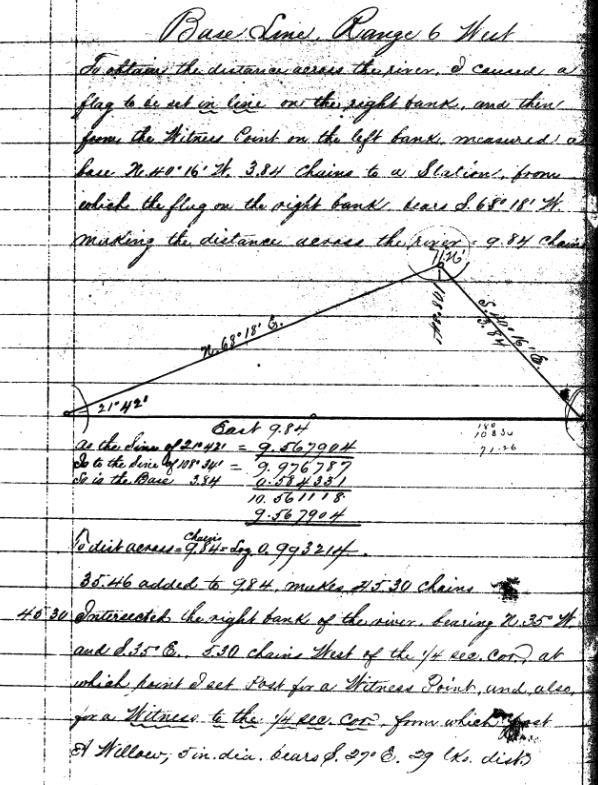
11 Topographic map of the Republican River at Superior, Nebraska. Along the South boundary of Sec. 32, T1N, [R6W]. West on a true line. Va E [chains] Intersected the left bank of River, bearing S. 40 E. and N. 40 W. and Set Post in Mound with charred stake as per instructions for a Witness Point Base Line. Range 6 West To obtain the distance across the river, I caused a flag to be set in line on the right bank and then from the Witness Point on the left bank measured a base N W., 3.84 chains to a Station from which the flag on the right bank bears S W., making the distance across the river = 9.84 chains. As the Sine of = Is to the Sine of = So is the Base [Diagram] To dist across = 9.84 chains = Log
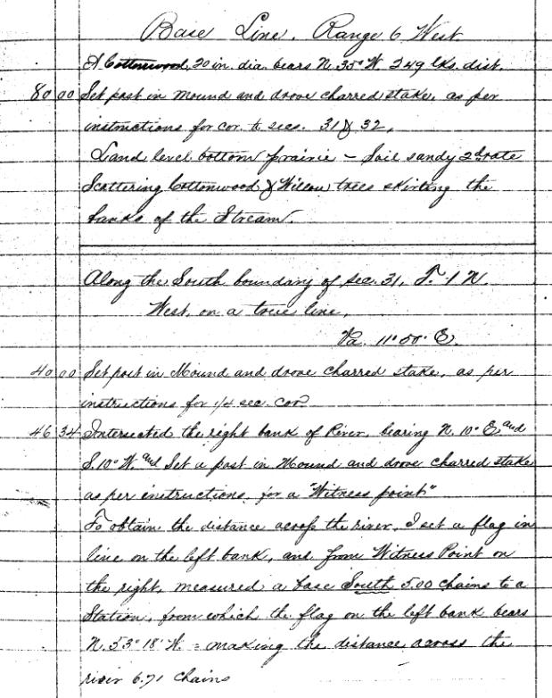
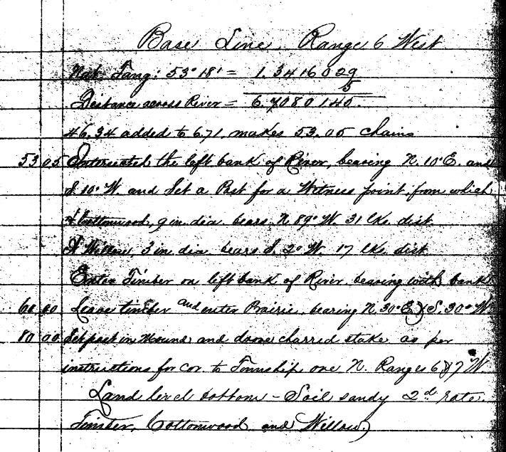
12 35.46 added to 9.84 makes chains [chains] Intersected the right bank of the river bearing N. 35 W. and S. 35 E., 5.30 chains West of the ¼ sec. cor. at which point I set Post for a Witness Point and also for a Witness to the ¼ sec. cor. from which post A Willow 5 in. dia. bears S. 27 E, 29 links distant Base Line. Range 6 West A Cottonwood 20 in. dia. bears N. 35 W., 249 links distant [chains] Set post in mound and drove charred stake, as per instructions for cor. to sections 31 & 32. Land level bottom prairie. Soil sandy 2nd rate. Scattering Cottonwood & Willow trees skirting the banks of the Stream. Along the South boundary of Sec. 31, T1N, [R6W]. West on a true line. Va East [chains] Set post in mound and drove charred stake, as per instructions for ¼ sec. cor [chains] Intersected the right bank of river bearing N. 10 E., and S. 10 W. and Set a post in Mound and drove charred stake as per instructions for a Witness point. To obtain the distance across the river, I set a flag in line on the left bank and from Witness Point on the right measured a base South 5.00 chains to a Station from which the flag on the left bank bears N W., making the distance across the river 6.71 chains Base Line. Range 6 West Nat. Tang: = Distance across river = added to 6.71 makes chains [chains] Intersected the left bank of River bearing N. 10 E. and S. 10 W. and Set a Post for Witness point from which A cottonwood, 9 in. dia. bears N. 89 W., 31 links distant. A willow 3 in. dia. bears S. 2 W., 17 links distant. Enter timber on left bank of River bearing with bank [chains] Leave timber and enter Prairie bearing N. 30 E. and S. 30 W [chains] Set post in mound and drove charred stake as per instructions for cor. to Township one North, Ranges 6 & 7 West. Land level bottom Soil sandy 2nd rate. Timber, Cottonwood and Willow
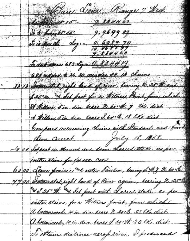
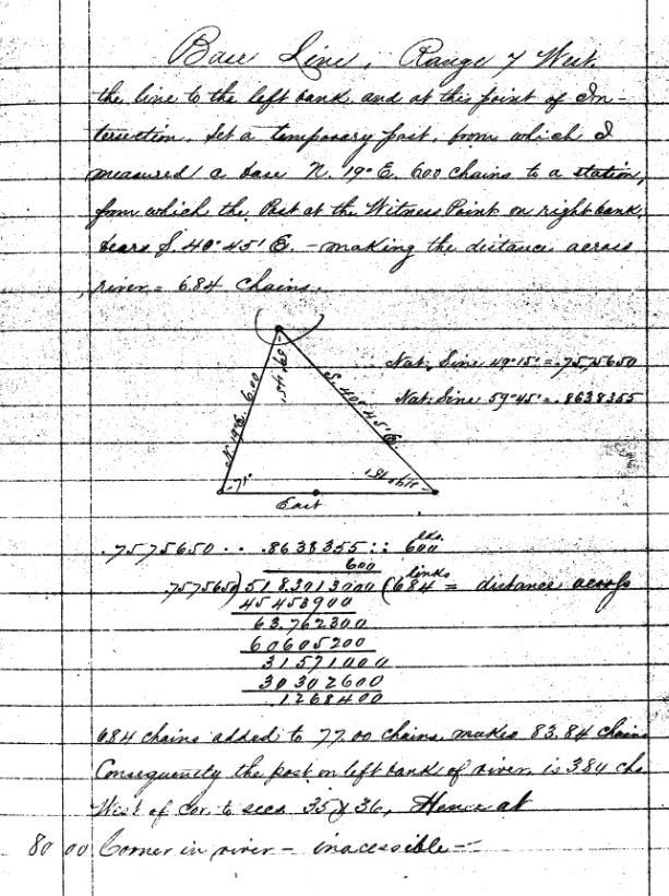
13 Base Line. Range 7 West Along the South boundary of Sec. 36, T1N [R7W]. West on a true line. Va E [chains] Intersected left bank of river bearing N. 25 W. and S. 25 E. and Set Post in Mound and drove charred stake as per instructions for a Witness Point. To attain distances across river, I set a flag in line on the right bank and then from the Witness Point on left bank of river, measured a base N. 22 W., 5.00 chains to a station from which the flag on right bank bears S W., making distance across on line 6.83 chains. [Diagram] Base Line. Range 7 West As Sine is = Is to Sine So is 5.00 ch. Log: = To dist across 6.83 Log = added to makes chains [chains] Intersected right bank of river bearing N. 25 W. and S. 25 W. and Set post for a Witness Point from which A Willow 5 in. dia. bears N. 60 W., 7 links distant. A Willow 5 in. dia. bears S. 64 E., 18 links distant. Compared measuring chains with Standard and found them correct. July 18, [chains] Set post in Mound and drove charred stake as per instructions for ¼ sec. cor [chains] Leave prairie and enter Timber, bearing S.W. & N. 60 E [chains] Intersected right bank of River again, bearing N. 25 E. and S. 25 W. and Set post with charred stake as per instructions for a Witness point, from which A Cottonwood 14 in. dia. bears N. 20 E., 28 links distant. A Cottonwood 10 in. dia. bears S. 20 W., 22 links distant. To obtain distance across river, I produced
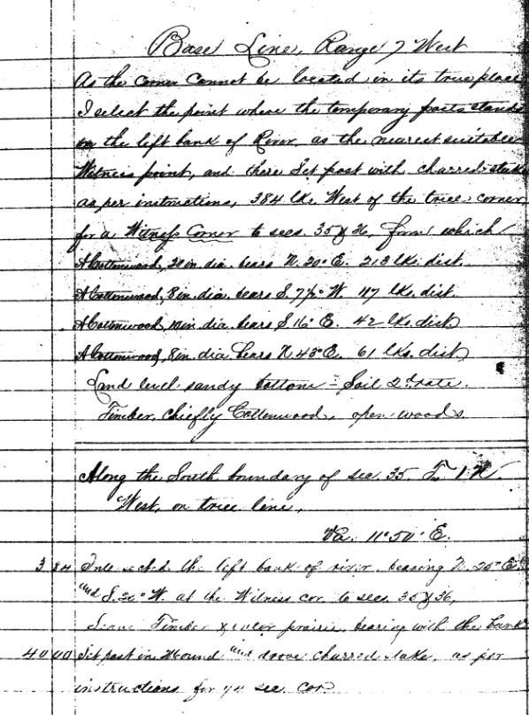
14 Base Line. Range 7 West the line to the left bank and at this point of Intersection, Set a temporary post from which I measured a base N. 19 E., 6.00 chains to a station, from which the Post at the Witness Point on right bank bears S E. making the distance across river = 6.84 chains. Nat. Sine = Nat. Sine = [Diagram] : : 600 links ) ( 684 links = distance across chains added to chains makes chains Consequently the post on left bank of river is 3.84 chains West of corner to sections 35 and 36, thence at [chains] Corner in river inaccessible Base Line. Range 7 West As the corner cannot be located in its true place, I select the point where the temporary post stands on the left bank of the River as the nearest suitable Witness point, and there Set post with charred stake as per instructions, 384 links West of the true corner for a Witness Corner to sections 35 & 36 from which A Cottonwood, 20 in. dia. bears N. 20 E., 213 links distant. A Cottonwood, 8 in. dia. bears S. 7 ½ W., 117 links distant. A Cottonwood 10 in. dia. Bears S. 16 E., 42 links distant. A Cottonwood, 8 in. dia. bears N. 43 E., 61 links distant. Land level, sandy bottom Soil 2nd rate. Timber chiefly Cottonwood, open woods. Along the South boundary of Sec. 35, T.1N. [R7W] West on true line. Va E [chains] Intersected the left bank of river bearing N. 20 E. and S. 20 W. at the witness corner to Sec s 35 & 36. Leave Timber and enter prairie bearing with the bank [chains] Set post in Mound and drove charred stake as per instructions for ¼ sec. cor.
 1")
 2")
15 SECTION 32 (1N-6W) 1 SECTION 31 (1N-6W) 2
 = THIRD LEG OF")
16 SECTION 36 (1N-7W) 3 = MEASURED BASE LINE = RIVER CROSSING (CALCULATED) = THIRD LEG OF TRIANGLE
17 River Crossing No Survey to the near bank of the river and set a point for a Witness Corner. Chaining is now at chains from the last section corner. 2. Occupy the Witness Point just established. 3. Send the flagman across the river and set a point on the opposite bank of the river for a Witness Corner by sighting across the river on the surveyed line. 4. Establish and measure a baseline along the near bank of the river from the first Witness Corner. Baseline measures to be 3.84 chains. 5. While occupying the Witness Corner on the near bank which is also the first end of the baseline, sight the Witness Corner on the opposite bank and turn the angle to the temporary point at the far end of the baseline. Angle = Move the instrument to and occupy the temporary point on the far end of the baseline. Sight the other end of the baseline that is also the Witness Point on the near bank. Turn the angle between the Witness Point on the near bank to the Witness Point on the opposite bank. Angle = (Supplementary angle = ) (Note: The supplementary angles have the same Log value). 7. Two measured angles and one measured line of a triangle are now known. 8. Compute the missing angle that is at the Witness Point at the opposite bank = (Or for a check turn the angle after crossing the river). 9. Obtain the logarithms from tables in the book. Sine from logarithm tables = Sine of (or the supplementary angle ) from logarithm tables = Base distance 3.84 from logarithm tables = = (Addition) = (Subtraction) Logarithm of = 9.84 chains (This is the distance across the river between the Witness Points) = chains. (This is the location of the Witness Corner on the opposite bank).
18

19 Logarithm for =

20 Logarithm for =

21 Logarithm for 384 =

22 Number for Logarithm = 9.84 (Falls between and , therefore use 984).
Displayed with permission The American Surveyor July/August Copyright 2007 Cheves Media
 Nebraska Deputy State Surveyor Gene A. Thomsen (left) and Cedar County Surveyor LaVern Schroeder finish setting the terminus monument into place, while Nebraska NGS Advisor Jim Richardson looks on. End
Map of the Northern Boundary of Iowa Astronomic Stations. Jackson, Monroe, Madison, Jefferson, Adams, Washington, Lee
 Map of the Northern Boundary of Iowa Astronomic Stations Jackson, Monroe, Madison, Jefferson, Adams, Washington, Lee Lee s Letter to Colonel Abert Deflections from a Given course Offsets from a Given Course
b. What is the length, width (ft), and direction of flow of Seafield Lake?
, and direction of flow of Seafield Lake?") FOR 274 Assignment 3 [50 points] Name: Section: This assignment should be completed and handed in to the assignment box in the Forest Resources office by noon on Monday 17th of September. Partial credit
FOR 274 Assignment 3 [50 points] Name: Section: This assignment should be completed and handed in to the assignment box in the Forest Resources office by noon on Monday 17th of September. Partial credit
WEST FROM WASHINGTON
 SEPTEMBER 2018 WEST FROM WASHINGTON Hemisphere GNSS A visit to headquarters Thought Leader Bloomberg out of touch Flood Info Ensure it s correct West from Washington Establishing the 25th and 27th Meridians
FOR 274 Assignment 3 [20 points] This assignment should be completed and handed at the start of lecture on Friday 16th September.
![FOR 274 Assignment 3 [20 points] This assignment should be completed and handed at the start of lecture on Friday 16th September.](/thumbs/90/101578770.jpg "FOR 274 Assignment 3 [20 points] This assignment should be completed and handed at the start of lecture on Friday 16th September.") FOR 274 Assignment 3 [20 points] Name: This assignment should be completed and handed at the start of lecture on Friday 16th September. 1. Convert the following bearings to azimuths: a. N35 W b. S22 E
FOR 274 Assignment 3 [20 points] Name: This assignment should be completed and handed at the start of lecture on Friday 16th September. 1. Convert the following bearings to azimuths: a. N35 W b. S22 E
NCEES FS Practice Exam
 NCEES FS Practice Exam Terrametra Resources Lynn Patten 1. One corner of a 60-ft. 120-ft. lot, otherwise rectangular, is a curve with a radius of 20 ft. and a central angle of 90. The area (ft. 2 ) of
D) sin A = D) tan A = D) cos B =
 sin A = D) tan A = D) cos B =") MULTIPLE CHOICE. Choose the one alternative that best completes the statement or answers the question. Evaluate the function requested. Write your answer as a fraction in lowest terms. 1) 1) Find sin A.
MULTIPLE CHOICE. Choose the one alternative that best completes the statement or answers the question. Evaluate the function requested. Write your answer as a fraction in lowest terms. 1) 1) Find sin A.
TSEGI WASH 50% DESIGN REPORT
 TSEGI WASH 50% DESIGN REPORT 2/28/2014 Daniel Larson, Leticia Delgado, Jessica Carnes I Table of Contents Acknowledgements... IV 1.0 Project Description... 1 1.1 Purpose... 1 Figure 1. Erosion of a Headcut...
Mt. Douglas Secondary
 Foundations of Math 11 Section 3.4 pplied Problems 151 3.4 pplied Problems The Law of Sines and the Law of Cosines are particularly useful for solving applied problems. Please remember when using the Law
Congruence Axioms. Data Required for Solving Oblique Triangles
 Math 335 Trigonometry Sec 7.1: Oblique Triangles and the Law of Sines In section 2.4, we solved right triangles. We now extend the concept to all triangles. Congruence Axioms Side-Angle-Side SAS Angle-Side-Angle
2. Pythagorean Theorem:
 Chapter 4 Applications of Trigonometric Functions 4.1 Right triangle trigonometry; Applications 1. A triangle in which one angle is a right angle (90 0 ) is called a. The side opposite the right angle
Math 2 Trigonometry. People often use the acronym SOHCAHTOA to help remember which is which. In the triangle below: = 15
 Math 2 Trigonometry 1 RATIOS OF SIDES OF A RIGHT TRIANGLE Trigonometry is all about the relationships of sides of right triangles. In order to organize these relationships, each side is named in relation
Trigonometric ratios:
 0 Trigonometric ratios: The six trigonometric ratios of A are: Sine Cosine Tangent sin A = opposite leg hypotenuse adjacent leg cos A = hypotenuse tan A = opposite adjacent leg leg and their inverses:
United Arab Emirates University
 United Arab Emirates University University Foundation Program - Math Program ALGEBRA - COLLEGE ALGEBRA - TRIGONOMETRY Practice Questions 1. What is 2x 1 if 4x + 8 = 6 + x? A. 2 B. C. D. 4 E. 2. What is
MATH Week 8. Ferenc Balogh Winter. Concordia University. Based on the textbook
 MATH 201 - Week 8 Ferenc Balogh Concordia University 2008 Winter Based on the textbook J. Stuart, L. Redlin, S. Watson, Precalculus - Mathematics for Calculus, 5th Edition, Thomson Solving Triangles Law
Vectors. An Introduction
 Vectors An Introduction There are two kinds of quantities Scalars are quantities that have magnitude only, such as position speed time mass Vectors are quantities that have both magnitude and direction,
Developing Spatial Awareness :-
 Developing Spatial Awareness :- We begin to exercise our geographic skill by examining he types of objects and features we encounter. Four different spatial objects in the real world: Point, Line, Areas
10/25/2017. Overview of the issue What is meandering What is an island Research and Analysis Conclusion
 Preston Dowell Deputy County Surveyor St Louis County MN dowellp@stlouiscountymn.gov Overview of the issue What is meandering What is an island Research and Analysis Conclusion 1 The county needed to represent
Earth and Space: Topographic Maps Satellite Images
 Earth and Space: Topographic Maps Satellite Images Earth and Space: Formative Assessment Activities for Earth and Space Topographic Maps Satellite Images Teacher Pages Purpose The purpose of this station
Math 521B Trigonometry Assignment
 Math 521B Trigonometry Assignment Multiple Choice Identify the choice that best completes the statement or answers the question. 1. What is the reference angle for 200 in standard position? A 100 C 20
ASTRONOMICAL NAVIGATION
 Basic terms ASTRONOMICAL NAVIGATION *astronomical navigation *compilation *astronomical tabels *celestial observations *solution of a sight * Sun/Moon/star sight *spherical trigonometry *PZX triangle *celestial
Trigonometric Functions. Copyright Cengage Learning. All rights reserved.
 4 Trigonometric Functions Copyright Cengage Learning. All rights reserved. 4.3 Right Triangle Trigonometry Copyright Cengage Learning. All rights reserved. What You Should Learn Evaluate trigonometric
Activities: Map and Compass
 Activities: Map and Compass Determining General Directions Modified with permission from Outdoor Living Skills Series: Map and Compass, Missouri Department of Conservation Overview: Students use the sun
10-7. The Law of Sines. Vocabulary. Solutions to cos = k When 0 < < 180. Solutions to sin = k When 0 < < 180. Lesson. Mental Math
 Chapter 10 Lesson 10-7 The Law of Sines Vocabulary solving a triangle BIG IDE Given S or S in a triangle, the Law of Sines enables you to fi nd the lengths of the remaining sides. One of the most important
PENNSYLVANIA DEPARTMENT OF TRANSPORTATION ENGINEERING DISTRICT 3-0
 PENNSYLVANIA DEPARTMENT OF TRANSPORTATION ENGINEERING DISTRICT 3-0 LYCOMING COUNTY S.R.15, SECTION C41 FINAL HYDROLOGIC AND HYDRAULIC REPORT STEAM VALLEY RUN STREAM RELOCATION DATE: June, 2006 REVISED:
APPENDIX A GLOSSARY. Appendix A.1
 APPENDIX A GLOSSARY Appendix A.1 Appendix A.2 Back Bearing A back bearing is measured from the object to your position. It is the exact opposite of a direct bearing. Base Line An imaginary line on the
JULY 2017 DRONES! Tale of Two Townships. Sixth Principal Meridian. Decided Guidance Cast Iron Monument. Part 3: Dissent. Boundary principles
 JULY 2017 DRONES! Sixth Principal Meridian Tale of Two Townships Decided Guidance Cast Iron Monument Boundary principles Part 3: Dissent CAST IRON MONUMENT of the 6 th P.M. Hidden from view among the trees
T.4 Applications of Right Angle Trigonometry
 424 section T4 T.4 Applications of Right Angle Trigonometry Solving Right Triangles Geometry of right triangles has many applications in the real world. It is often used by carpenters, surveyors, engineers,
: SINE, COSINE, & TANGENT RATIOS
 Geometry Notes Packet Name: 9.2 9.4: SINE, COSINE, & TANGENT RATIOS Trigonometric Ratios A ratio of the lengths of two sides of a right triangle. For any acute angle, there is a leg Opposite the angle
Introduction to the PLS
 Historical Surveying Instructions and Their Influence On Surveys Of The 3 rd and 4 th s, 4 th Principal Meridian John Dahl January 2009 Introduction to the PLS A Few Terms: GLO General Land Office PLS
Relative Motion. David Teichrob UBC Physics 2006
 Relative Motion David Teichrob UBC Physics 2006 What is Relative Motion? First of all the physics concept involved is KINEMATICS (the study of motion of objects - the relation among displacement, velocity,
Red River: The northern Border of Texas!
 From Palo Duro Canyon outside Amarillo Texas The prairie dog town fork of the Red River flows Headed cross the plains along the coast of Oklahoma To the Mississippi River and the Gulf of Mexico Red River
Natural Texas. Regions and Climates
 Natural Texas Regions and Climates Two Kinds: Physical geography Climate, vegetation, rivers, lakes, oceans, plateaus, plains, and mountain ranges Human geography Economic activities How we earn a living
Downloaded from APPLICATION OF TRIGONOMETRY
 MULTIPLE CHOICE QUESTIONS APPLICATION OF TRIGONOMETRY Write the correct answer for each of the following : 1. Write the altitude of the sun is at 60 o, then the height of the vertical tower that will cost
Prerequisite Skills. y x =
 Prerequisite Skills BLM 1 1... Solve Equations 1. Solve. 2x + 5 = 11 x 5 + 6 = 7 x 2 = 225 d) x 2 = 24 2 + 32 2 e) 60 2 + x 2 = 61 2 f) 13 2 12 2 = x 2 The Pythagorean Theorem 2. Find the measure of the
B. Topographic maps are also called. contour maps
 Topographic Maps Introduction A. Topographic maps are essential tools in geologic and engineering studies because they show the configuration of Earth's surface in remarkable detail and permit one to measure
Name Date Trigonometry of the Right Triangle Class Work Unless otherwise directed, leave answers as reduced fractions or round to the nearest tenth.
 Name Date Trigonometry of the Right Triangle Class Work Unless otherwise directed, leave answers as reduced fractions or round to the nearest tenth. 1. Evaluate the sin, cos, and tan of θ(theta). 2. Evaluate
GOING WITH THE FLOW (1 Hour)
") GOING WITH THE FLOW (1 Hour) Addresses NGSS Level of Difficulty: 3 Grade Range: 3-5 OVERVIEW In this activity, students use a stream table to model the processes of erosion and streambed formation. The
GOING WITH THE FLOW (1 Hour) Addresses NGSS Level of Difficulty: 3 Grade Range: 3-5 OVERVIEW In this activity, students use a stream table to model the processes of erosion and streambed formation. The
Trigonometry Unit 5. Reflect previous TEST mark, Overall mark now. Looking back, what can you improve upon?
 1 U n i t 5 11C Date: Name: Tentative TEST date Trigonometry Unit 5 Reflect previous TEST mark, Overall mark now. Looking back, what can you improve upon? Learning Goals/Success Criteria Use the following
Measuring Trees Activity
 What is a Clinometer? Measuring Trees Activity It is an instrument for measuring slope angle of a line of sight. It is included in some compasses. How to make a Clinometer? Materials Needed: piece of cardboard
Bank Erosion and Morphology of the Kaskaskia River
 Bank Erosion and Morphology of the Kaskaskia River US Army Corps Of Engineers St. Louis District Fayette County Soil and Water Conservation District Team Partners : Carlyle Lake Ecosystem Partnership Vicinity
Basic Principles of Surveying and Mathematics
 AMRC 2012 MODULE 1 Basic Principles of Surveying and Mathematics CONTENTS Overview... 1-1 Objectives... 1-1 Procedures... 1-1 1.1 Surveying Defined... 1-3 1.2 Types of Surveys... 1-5 1.3 Precision and
25 More Trigonometric Identities Worksheet
 5 More Trigonometric Identities Worksheet Concepts: Trigonometric Identities Addition and Subtraction Identities Cofunction Identities Double-Angle Identities Half-Angle Identities (Sections 7. & 7.3)
C) ) cos (cos-1 0.4) 5) A) 0.4 B) 2.7 C) 0.9 D) 3.5 C) - 4 5
 ) cos (cos-1 0.4) 5) A) 0.4 B) 2.7 C) 0.9 D) 3.5 C) - 4 5") Precalculus B Name Please do NOT write on this packet. Put all work and answers on a separate piece of paper. MULTIPLE CHOICE. Choose the one alternative that best completes the statement or answers the
Precalculus B Name Please do NOT write on this packet. Put all work and answers on a separate piece of paper. MULTIPLE CHOICE. Choose the one alternative that best completes the statement or answers the
Lab Topographic Maps. Name: Partner: Purpose. Background Information
 Lab Topographic Maps Name: Partner: Purpose The purpose of this lab is to familiarize you with graphic representations of the Earth s surface primarily maps. Simple line maps show the spatial relationship
Trigonometry of the Right Triangle Class Work
 Trigonometry of the Right Triangle Class Work Unless otherwise directed, leave answers as reduced fractions or round to the nearest tenth. 1. Evaluate the sin, cos, and tan of θ(theta). 2. Evaluate the
Contents. Objectives Velocity Addition CM Velocity 2 D Collisions totally inelastic elastic Recap. Contents
 Physics 121 for Majors totally in Class 16 totally in Velocity Addition and Collisions In Two Dimensions Last Class More on Work Potential Energy Conservation of Energy Power totally in Today s Class Adding
Chapter Review. Things to Know. Objectives. 564 CHAPTER 7 Applications of Trigonometric Functions. Section You should be able to Review Exercises
 564 CHPTER 7 pplications of Trigonometric Functions Chapter Review Things to Know Formulas Law of Sines (p. 5) Law of Cosines (p. 54) sin a = sin b = sin g a b c c = a + b - ab cos g b = a + c - ac cos
CHAPTER 24 THE SAILINGS
 CHAPTER 24 THE SAILINGS INTRODUCTION 2400. Introduction Dead reckoning involves the determination of one s present or future position by projecting the ship s course and distance run from a known position.
Create A Watershed Profile
 Name Date Follow the steps below with Chesapeake Bay FieldScope to create a watershed profile for your location. Part 1. Take a trip down your tributaries. Create A Watershed Profile 1. Find your field
 VALLIAMMAI ENGINEERING COLLEGE Department of Civil Engineering CE6304 SURVEYING I Questions Bank UNIT-I FUNDAMENTALS AND CHAIN SURVEYING Part A 1) Define surveying. 2) What are the types of surveying?
Topographic Maps Self-Instruction Lab (2016 edition) Geology 100 David Harbor s Section. 12 inches x 1 mile
 Geology 100 David Harbor s Section. 12 inches x 1 mile") Topographic Maps Name Self-Instruction Lab (2016 edition) Geology 100 David Harbor s Section Topographic maps are an important aid for a geologist, but maps are also useful for hikers, bicyclists, and
Topographic Maps Name Self-Instruction Lab (2016 edition) Geology 100 David Harbor s Section Topographic maps are an important aid for a geologist, but maps are also useful for hikers, bicyclists, and
MEASUREMENT: From the Lab to the Moon
 GSCI 1020 - Physical Science Laboratory Experiment #1 Name Partners Date Section MEASUREMENT: From the Lab to the Moon Equipment: Meter stick, ruler, calipers, vernier calipers, steel rod, ball, wood block,
10-1 L E S S O N M A S T E R. Name. Vocabulary. 1. Refer to the diagram at the right. Fill in the blank. a. The leg adjacent to is.
 L E S S O N M S T E R Vocabular 10 Questions on SPUR Objectives 1. Refer to the diagram at the right. Fill in the blank. a. The leg adjacent to is. b. The leg opposite is. c. The hpotenuse is. C 2. Fill
Chapter 6 Mapping and Online Tools
 Chapter 6 Mapping and Online Tools The stream site you monitor is just part of a much larger system. When analyzing stream health, it is important to take a holistic view by considering the entire watershed.
Electrical Theory. Mathematics Review. PJM State & Member Training Dept. PJM /22/2018
 Electrical Theory Mathematics Review PJM State & Member Training Dept. PJM 2018 Objectives By the end of this presentation the Learner should be able to: Use the basics of trigonometry to calculate the
Sec 1.1 CC Geometry History of Trigonometry Name:
 Sec. CC Geometry History of Trigonometry Name: The word trigonometry is of Greek origin and literally translates to Triangle Measurements. Some of the earliest trigonometric ratios recorded date back to
USING THE MILITARY LENSATIC COMPASS
 USING THE MILITARY LENSATIC COMPASS WARNING This presentation is intended as a quick summary, and not a comprehensive resource. If you want to learn Land Navigation in detail, either buy a book; or get
8-2 Vectors in the Coordinate Plane
 37. ROWING Nadia is rowing across a river at a speed of 5 miles per hour perpendicular to the shore. The river has a current of 3 miles per hour heading downstream. a. At what speed is she traveling? b.
Use of Government Land Office Surveys in Tribal GIS Land Management. Dustin Holt GIS Technician Choctaw Nation of Oklahoma
 Use of Government Land Office Surveys in Tribal GIS Land Management Dustin Holt GIS Technician Choctaw Nation of Oklahoma Ardmore Quadrangle - 1949 Different versions of the same map were printed in 1901,
Practice Test - Chapter 4
 Find the value of x. Round to the nearest tenth, if necessary. 1. An acute angle measure and the length of the hypotenuse are given, so the sine function can be used to find the length of the side opposite.
INTRODUCTION AND MATHMATICAL Concepts. 1. Which one of the following is an SI base unit? (a) gram (c) newton (e) kilogram
 gram (c) newton (e) kilogram") chapter INTRODUCTION AND MATHMATICAL Concepts Section 1.2 Units Section 1.3 The Role of Units in Problem Solving 1. Which one of the following is an SI base unit? (a) gram (c) newton (e) kilogram (b) slug
chapter INTRODUCTION AND MATHMATICAL Concepts Section 1.2 Units Section 1.3 The Role of Units in Problem Solving 1. Which one of the following is an SI base unit? (a) gram (c) newton (e) kilogram (b) slug
Which one of the following is an SI base unit? (a) gram (c) newton (e) kilogram
 gram (c) newton (e) kilogram") chapter INTRODUCTION AND MATHEMATICAL CONCEPTS Section 1. Units Section 1.3 The Role of Units in Problem Solving 1. Which one of the following is an SI base unit? (a) gram (c) newton (e) kilogram (b) slug
chapter INTRODUCTION AND MATHEMATICAL CONCEPTS Section 1. Units Section 1.3 The Role of Units in Problem Solving 1. Which one of the following is an SI base unit? (a) gram (c) newton (e) kilogram (b) slug
Changes in Texas Ecoregions
 Comment On Lesson Changes in Texas Ecoregions The state of Texas can be divided into 10 distinct areas based on unique combinations of vegetation, topography, landforms, wildlife, soil, rock, climate,
TEK: P.3E Use trigonometry in mathematical and real-world problems, including directional bearing
 Precalculus Notes 4.8 Applications of Trigonometry Solving Right Triangles TEK: P.3E Use trigonometry in mathematical and real-world problems, including directional bearing Page 1 link: http://www.schooltube.com/video/d0e919b807644adaa500
rises in the east High Noon sets in the west, 9:00 a.m. 12:00 p.m. 3:30 p.m. flagpole meter stick
 . Sec 3.5 Right Triangle Trigonometry Solving with Trigonometry The word trigonometry is of Greek origin and literally translates to Triangle Measurements. Some of the earliest trigonometric ratios recorded
Unit 5 ICM/AB Applications of the Derivative Fall Nov 10 Learn Velocity and Acceleration: HW p P ,103 p.
 Unit 5 ICM/AB Applications of the Derivative Fall 2016 Nov 4 Learn Optimization, New PS up on Optimization, HW pg. 216 3,5,17,19,21,23,25,27,29,33,39,41,49,50 a,b,54 Nov 7 Continue on HW from Nov 4 and
Similar Triangles, Pythagorean Theorem, and Congruent Triangles.
 ay 20 Teacher Page Similar Triangles, Pythagorean Theorem, and ongruent Triangles. Pythagorean Theorem Example 1: circle has a radius of 20 units. triangle is formed by connecting a point on the perimeter
Let be an acute angle. Use a calculator to approximate the measure of to the nearest tenth of a degree.
 Ch. 9 Test - Geo H. Let be an acute angle. Use a calculator to approximate the measure of to the nearest tenth of a degree. 1. 2. 3. a. about 58.0 c. about 1.0 b. about 49.4 d. about 32.0 a. about 52.2
Chapter 1 Homework - Elements of Real Estate Law
 Chapter 1 Homework - Elements of Real Estate Law The following questions are a small example of what you might expect to see on the Real Estate Law portion of the Cadastral Mapping exam. First try answering
Use a calculator to find the value of the expression in radian measure rounded to 2 decimal places. 1 8) cos-1 6
 cos-1 6") Math 180 - chapter 7 and 8.1-8. - New Edition - Spring 09 Name Find the value of the expression. 1) sin-1 0.5 ) tan-1-1 ) cos-1 (- ) 4) sin-1 Find the exact value of the expression. 5) sin [sin-1 (0.7)]
Math 180 - chapter 7 and 8.1-8. - New Edition - Spring 09 Name Find the value of the expression. 1) sin-1 0.5 ) tan-1-1 ) cos-1 (- ) 4) sin-1 Find the exact value of the expression. 5) sin [sin-1 (0.7)]
AGE 303 AGRICULTURAL LAND SURVEYING INTRODUCTION Land Surveying: It has to do with the determination of relative spatial location of points on or
 AGE 303 AGRICULTURAL LAND SURVEYING INTRODUCTION Land Surveying: It has to do with the determination of relative spatial location of points on or near the surface of the earth. It is the art of measuring
Tenmile Lakes Delta Building Study
 Tenmile Lakes Delta Building Study Since the late 1940 s, Tenmile Lakes has seen a sharp increase in sediment accumulation at the mouths of the tributaries that feed the lake. To monitor this sediment
Field Observations and One-Dimensional Flow Modeling of Summit Creek in Mack Park, Smithfield, Utah
 Intermountain Center for River Rehabilitation and Restoration, Utah State University 31 July 2018 Field Observations and One-Dimensional Flow Modeling of Summit Creek in Mack Park, Smithfield, Utah I.
MATHEMATICS NAVIGATION. Air and Marine AMERICAN BOOK COMPANY. Hunter College, New York A. D. BRADLEY
 MATHEMATICS OF Air and Marine NAVIGATION A. D. BRADLEY Assistant Prof essor of Matheinatics Hunter College, New York AMERICAN BOOK COMPANY NEW YORK CHICAGO CINCINNATI BOSTON ATLANTA DALLAS SAN FRANCISCO
INSTRUCTIONS NOTE: YOU MUST HIT R/S AFTER EVERY VARIABLE ENTERED TO PROMPT YOU FOR NEXT VARIABLE.
 INSTRUCTIONS NOTE: YOU MUST HIT R/S AFTER EVERY VARIABLE ENTERED TO PROMPT YOU FOR NEXT VARIABLE. XEQ A= TRIANGLES SIDE, SIDE, SIDE This program prompts you for three sides of a triangle and gives you
27. Running Water I (p ; )
") 27. Running Water I (p. 424-436; 440-444) Hydrosphere How much of the Earth s surface is covered by water? Earth's water is collectively called the and is stored in a number of so-called as follows: 1.
27. Running Water I (p. 424-436; 440-444) Hydrosphere How much of the Earth s surface is covered by water? Earth's water is collectively called the and is stored in a number of so-called as follows: 1.
Summary of Legal Descriptions
 Perimeter Descriptions Bounds Descriptions - perimeter descriptions without a direction of travel. Metes Descriptions - perimeter descriptions with a direction of travel described by a series of measurements.
UNCORRECTED PAGE PROOFS
 TOPIC 3 Motion in two dimensions 3.1 Overview 3.1.1 Module 1: Kinematics Motion on a Plane Inquiry question: How is the motion of an object that changes its direction of movement on a plane described?
Wonder as you Wander up the Carding Mill Valley
 Wonder as you Wander up the Carding Mill Valley Spot clues to the 600 million year old history of the Long Mynd. Consider how the Earth has evolved since the rock you are walking over first formed. Welcome
INTEGERS 2 1 = 1; 1 1 = 0; 0 1 = 1; 1 1 = 2
 Section 1: Integers MATH LEVEL 2 LESSON PLAN 2 INTEGERS 2015 Copyright Vinay Agarwala, Checked: 10/28/15 1. Integers are numbers that are given positive and negative signs to show their distance from zero
Section 9.2 Objective: Students will be able to define and work with irrational numbers.
 Lincoln Public Schools Math 8 McDougall Littell Middle School Math Course 3 Chapter 9 Items marked A, B, C are increasing in difficulty. Group A questions are the most basic while Group C are the most
9.4 Polar Coordinates
 9.4 Polar Coordinates Polar coordinates uses distance and direction to specify a location in a plane. The origin in a polar system is a fixed point from which a ray, O, is drawn and we call the ray the
Navigating for Scouts A Self-teaching Guide to Navigation with Map and Compass
 Don Burgess, November 2003 Materials topographic maps Navigating for Scouts A Self-teaching Guide to Navigation with Map and Compass metric ruler orienteering compass 30 M/5 Hamilton-Burlington 41 I/13
Algebra II Final Exam Semester II Practice Test
 Name: Class: Date: Algebra II Final Exam Semester II Practice Test 1. (10 points) A bacteria population starts at,03 and decreases at about 15% per day. Write a function representing the number of bacteria
Chapter 2: Trigonometry
 Chapter 2: Trigonometry Section 2.1 Chapter 2: Trigonometry Section 2.1: The Tangent Ratio Sides of a Right Triangle with Respect to a Reference Angle Given a right triangle, we generally label its sides
MILLS COUNTY, IOWA FARMLAND FOR SALE PRICE REDUCED
 MILLS COUNTY, IOWA FARMLAND FOR SALE PRICE REDUCED Owners: Riverdale Farm Corp. Acres: 302.59 Legal Description: Location: Description: See Attached From I-29/Highway 370 exit, 1 ¾ Miles west on Highway
Pre-Calc Trig ~1~ NJCTL.org. Unit Circle Class Work Find the exact value of the given expression. 7. Given the terminal point ( 3, 2 10.
 Unit Circle Class Work Find the exact value of the given expression. 1. cos π 3. sin 7π 3. sec π 3. tan 5π 6 5. cot 15π 6. csc 9π 7. Given the terminal point ( 3, 10 ) find tanθ 7 7 8. Given the terminal
Math 140 Study Guide. Find the exact values of the indicated trigonometric functions. Write fractions in lowest terms. 1)
") Math 40 Study Guide Find the exact values of the indicated trigonometric functions. Write fractions in lowest terms. ) 0 4) If csc q =, find cot q. A) C) B) 8 Find sin A and cos A. A) sin A = 3 ; cos A
Math 40 Study Guide Find the exact values of the indicated trigonometric functions. Write fractions in lowest terms. ) 0 4) If csc q =, find cot q. A) C) B) 8 Find sin A and cos A. A) sin A = 3 ; cos A
The Tacoma Mountaineers Wilderness Navigation
 The Tacoma Mountaineers Wilderness Navigation Navigation Fundamentals Navigation in mountainous terrain and wilderness areas requires a set of skills, of which using a map and compass is only one part.
Surveying Prof. Bharat Lohani Department of Civil Engineering Indian Institute of Technology, Kanpur. Module - 4 Lecture - 1 Compass Surveying
 Surveying Prof. Bharat Lohani Department of Civil Engineering Indian Institute of Technology, Kanpur Module - 4 Lecture - 1 Compass Surveying Welcome to this video lecture series on basic surveying and
AU-5029 GURU GHASIDAS VISHWAVIDYALAYA, BILASPUR (C.G.) INSTITUTE OF TECHNOLOGY DEPARTMENT OF CIVIL ENGINEERING B.TECH
 INSTITUTE OF TECHNOLOGY DEPARTMENT OF CIVIL ENGINEERING B.TECH") AU-5029 GURU GHASIDAS VISHWAVIDYALAYA, BILASPUR (C.G.) INSTITUTE OF TECHNOLOGY DEPARTMENT OF CIVIL ENGINEERING B.TECH 2 nd YEAR, III rd SEMESTER SUBJECT: SURVEYING-I COURSE CODE: 21CE02T Max Marks: 60
AU-5029 GURU GHASIDAS VISHWAVIDYALAYA, BILASPUR (C.G.) INSTITUTE OF TECHNOLOGY DEPARTMENT OF CIVIL ENGINEERING B.TECH 2 nd YEAR, III rd SEMESTER SUBJECT: SURVEYING-I COURSE CODE: 21CE02T Max Marks: 60
Physics 12. Chapter 1: Vector Analysis in Two Dimensions
 Physics 12 Chapter 1: Vector Analysis in Two Dimensions 1. Definitions When studying mechanics in Physics 11, we have realized that there are two major types of quantities that we can measure for the systems
Motion in Two Dimensions An Algebraic Approach
 . Motion in Two Dimensions An Algebraic Approach In ection.1 you learned how to solve motion problems in two dimensions by using vector scale diagrams. This method has some limitations. First, the method
A. Incorrect! Replacing is not a method for solving systems of equations.
 ACT Math and Science - Problem Drill 20: Systems of Equations No. 1 of 10 1. What methods were presented to solve systems of equations? (A) Graphing, replacing, and substitution. (B) Solving, replacing,
BELLWORK feet
 BELLWORK 1 A hot air balloon is being held in place by two people holding ropes and standing 35 feet apart. The angle formed between the ground and the rope held by each person is 40. Determine the length
LAB N - FLUVIAL PROCESSES AND LANDSCAPES
 LAB N - FLUVIAL PROCESSES AND LANDSCAPES Introduction The objective of this lab is to familiarize the student with the work of running water (streams and rivers) and the landforms that they create. Materials
Precalculus A - Final Exam Review Fall, 2014
 Name: Precalculus A - Final Exam Review Fall, 2014 Period: Find the measures of two angles, one positive and one negative, that are coterminal with the given angle. 1) 85 2) -166 3) 3 Convert the radian
Unit 3 Right Triangle Trigonometry - Classwork
 Unit 3 Right Triangle Trigonometry - Classwork We have spent time learning the definitions of trig functions and finding the trig functions of both quadrant and special angles. But what about other angles?
Unit 2 Math II - History of Trigonometry
 TSK # Unit Math II - History of Trigonometry The word trigonometry is of Greek origin and literally translates to Triangle Measurements. Some of the earliest trigonometric ratios recorded date back to