|
|
|
- Richard Owens
- 6 years ago
- Views:
Transcription

1 1
2
3
4
5
6
7
8
9
10
11
12
13
14
15
16
17 --- RocketRoute WX - rrwx.com - weather for pilots - 26 Apr UTC --- Document: 6443 Created: 15:05 04/26/2018 UTC Page: 01 Description: SIGMET Europe WSDN31 EKCH EKDK SIGMET 1 VALID / EKMI- EKDK KOBENHAVN FIR FRQ TS OBS AT 1220Z WI N5558 E N5502 E N5453 E N5547 E N5559 E N5558 E01213 TOP FL300 MOV E 25KT NC= WSDN31 EKCH EKDK SIGMET 1 VALID / EKMI- EKDK KOBENHAVN FIR FRQ TS OBS AT 1220Z WI N5558 E N5502 E N5453 E N5547 E N5559 E N5558 E01213 TOP FL300 MOV E 25KT NC=
18 WSFR34 LFPW LFMM SIGMET 1 VALID / LFPW- LFMM MARSEILLE FIR/UIR SEV TURB FCST WI N4200 E N4215 E N4330 E N4415 E N4200 E00400 SFC/FL060 STNR NC= WSFR34 LFPW LFMM SIGMET 1 VALID / LFPW- LFMM MARSEILLE FIR/UIR SEV TURB FCST WI N4200 E N4215 E N4330 E N4415 E N4200 E00400 SFC/FL060 STNR NC= WSGR31 LGAT LGGG SIGMET 1 VALID / LGAT- LGGG ATHINAI FIR EMBD TS OBS N OF N3800 AND W OF E02260 AND EMBD TS OBS N OF N4050 MAINLAND STNR NC= WSGR31 LGAT LGGG SIGMET 2 VALID / LGAT- LGGG ATHINAI FIR/UIR EMBD TS OBS N OF N3500 AND W OF E02300 AND EMBD TS OBS N OF N4050 MAINLAND STNR NC= WSGR31 LGAT LGGG SIGMET 1 VALID / LGAT- LGGG ATHINAI FIR EMBD TS OBS N OF N3800 AND W OF E02260 AND EMBD TS OBS N OF N4050 MAINLAND STNR NC= WSGR31 LGAT LGGG SIGMET 2 VALID / LGAT- LGGG ATHINAI FIR/UIR EMBD TS OBS N OF N3500 AND W OF E02300 AND EMBD TS OBS N OF N4050 MAINLAND STNR NC=
19 WSOS31 LOWW LOVV SIGMET 1 VALID / LOWW- LOVV WIEN FIR SQL TS OBS AT 1451Z WI N4640 E N4710 E N4655 E N4630 E N4640 E01230 TOP FL360 NC FCST AT 1630Z WI N4700 E N4635 E N4620 E N4630 E N4700 E01455=
20 WSRM31 LUKK LUUU SIGMET 1 VALID / LUKK- LUUU CHISINAU FIR EMBD TS FCST NW OF LINE N4725 E N4804 E02827 TOP FL350 MOV ENE 20KT INTSF= WSRM31 LUKK LUUU SIGMET 2 VALID / LUKK- LUUU CHISINAU FIR EMBD TSGR OBS AT 1450Z NW OF LINE N4725 E N4804 E02827 TOP FL360 MOV ENE 20KT INTSF= WSRM31 LUKK LUUU SIGMET 3 VALID / LUKK- LUUU CHISINAU FIR CNL SIGMET /261855= WSRM31 LUKK LUUU SIGMET 1 VALID / LUKK- LUUU CHISINAU FIR EMBD TS FCST NW OF LINE N4725 E N4804 E02827 TOP FL350 MOV ENE 20KT INTSF= WSRM31 LUKK LUUU SIGMET 2 VALID / LUKK- LUUU CHISINAU FIR EMBD TSGR OBS AT 1450Z NW OF LINE N4725 E N4804 E02827 TOP FL360 MOV ENE 20KT INTSF= WSRM31 LUKK LUUU SIGMET 3 VALID / LUKK- LUUU CHISINAU FIR CNL SIGMET /261855=
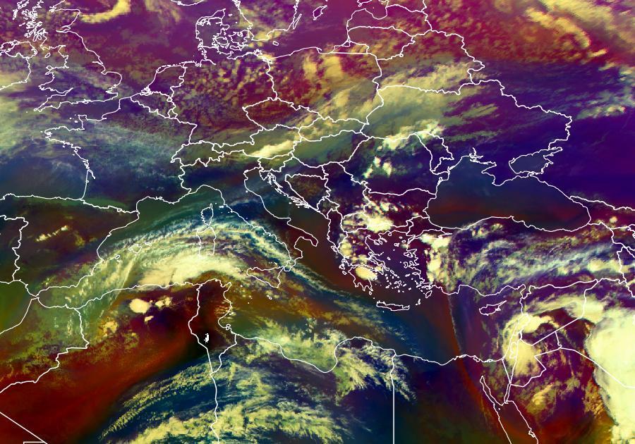
21 Document: 6444 Created: 15:05 04/26/2018 UTC Page: 01 Description: SIGMET Mediterranean Area
22 Document: 6875 Created: 15:05 04/26/2018 UTC Page: 01 Description: VOLC Ash Cloud Forecast London VAAC Document: 6880 Created: 15:05 04/26/2018 UTC Page: 01 Description: VOLC Ash Cloud Forecast Toulouse VAAC
23 EUROPE TAF UTC Germany France Benelux Austria Swiss Spain Portugal Italy Baltic Nordic Other Goto METARs United Kingdom - 26 Apr UTC ABERDEEN DYCE BELFAST ALDERGROVE BIGGIN HILL BOURNEMOUTH BRISTOL CARDIFF DONCASTER SHEFFIELD DURHAM TEES VALLEY EAST MIDLANDS EDINBURGH EXETER FARNBOROUGH GLASGOW GUERNSEY HUMBERSIDE INVERNESS JERSEY KIRKWALL LEEDS BRADFORD LIVERPOOL LONDON CITY LONDON GATWICK LONDON HEATHROW LONDON LUTON LONDON STANSTED LYDD MANCHESTER EGPD EGAA EGKB EGHH EGGD EGFF EGCN EGNV EGNX EGPH EGTE EGLF EGPF EGJB EGNJ EGPE EGJJ EGPA EGNM EGGP EGLC EGKK EGLL EGGW EGSS EGMD EGCC EUROPE TAF UTC 1
24 MANSTON NEWCASTLE NORWICH PRESTWICK SHOREHAM SOUTHAMPTON SOUTHEND WICK GIBRALTAR Goto METARs EGMH EGNT EGSH EGPK EGKA EGHI EGMC EGPC LXGB Germany - 26 Apr UTC BRANDENBURG BREMEN DRESDEN DUSSELDORF FRANKFURT HAHN FRANKFURT MAIN HAMBURG HANNOVER HERINGSDORF KARLSRUHE BADEN BADEN KASSEL CALDEN KOLN BONN LAAGE LEIPZIG HALLE LUBECK BLANKENSEE MUNCHEN MUNSTER OSNABRUCK NURNBERG PADERBORN LIPPSTADT SAARBRUCKEN STUTTGART SYLT TEGEL Goto METARs EDDB EDDW EDDC EDDL EDFH EDDF EDDH EDDV EDAH EDSB EDVK EDDK ETNL EDDP EDHL EDDM EDDG EDDN EDLP EDDR EDDS EDXW EDDT EUROPE TAF UTC 2
25 France - 26 Apr UTC AIX LES BAINS ANGLET AUVERGNE BALE MULHOUSE BELLEGARDE BIARD BLAGNAC BRETAGNE BRON CARPIQUET COTE D AZUR ENTZHEIM GARONS LANN BIHOUE LE BOURGET LESQUIN LE TOUQUET MEDITERRANEE MERIGNAC NANTES ATLANTIQUE NAPOLEON BONAPARTE PARIS CHARLES DE GAULLE PARIS ORLY PLEURTUIT PORETTA PROVENCE RIVESALTES SAINT EXUPERY ST JACQUES TILLE TOUSSUS LE NOBLE VAL DE LOIRE Goto METARs LFLB LFBZ LFLC LFSB LFBL LFBI LFBO LFRB LFLY LFRK LFMN LFST LFTW LFRH LFPB LFQQ LFAT LFMT LFBD LFRS LFKJ LFPG LFPO LFRD LFKB LFML LFMP LFLL LFRN LFOB LFPN LFOT Benelux - 26 Apr UTC EUROPE TAF UTC 3
26 BRUSSELS NATL BRUSSELS SOUTH DEURNE LIEGE OOSTENDE EINDHOVEN EELDE MAASTRICHT ROTTERDAM SCHIPHOL LUXEMBOURG Goto METARs EBBR EBCI EBAW EBLG EBOS EHEH EHGG EHBK EHRD EHAM ELLX Austria - 26 Apr UTC GRAZ INTL INNSBRUCK KLAGENFURT WORTHERSEE LINZ INTL SALZBURG VIENNA SCHWECHAT W NEUSTADT DIAMOND HQ ZELTWEG Goto METARs LOWG LOWI LOWK LOWL LOWS LOWW LOAN LOXZ Switzerland - 26 Apr UTC APLNACH BASEL BERN BUOCHS DUBENDORF EMMEN GALLEN-ALTENRHEIN GENEVA GRENCHEN LES EPLATURES LOCARNO LSMA LFSB LSZB LSZC LSMD LSME LSZR LSGG LSZG LSGC LSZL EUROPE TAF UTC 4
27 LUGANO MEIRINGEN PAYERNE SAMEDAN SION ZURICH-KLOTEN Goto METARs LSZA LSMM LSMP LSZS LSGS LSZH Espana - 26 Apr UTC ALICANTE ALMERIA AVILES BADAJOZ BARCELONA BILBAO GRANADA IBIZA JEREZ LEON MADRID MALAGA MENORCA MURCIA PALMA MALLORCA REUS SANTANDER SANTIAGO SEVILLA VALENCIA VALLADOLID VITORIA ZARAGOZA GRAN CANARIA LANZAROTE TENERIFE NORTE TENERIFE SUR LEAL LEAM LEAS LEBZ LEBL LEBB LEGR LEIB LEJR LELN LEMD LEMG LEMH LELC LEPA LERS LEXJ LEST LEZL LEVC LEVD LEVT LEZG GCLP GCRR GCXO GCTS EUROPE TAF UTC 5
28 Goto METARs Portugal - 26 Apr UTC FARO LISBOA MADEIRA PONTA DELGADA PORTO PORTO SANTO SANTA MARIA SINTRA MILITAR Goto METARs LPFR LPPT LPMA LPPD LPPR LPPS LPAZ LPST Italia - 26 Apr UTC ALGHERO BARI BERGAMO ORIO AL SERIO BOLOGNA CAPODICHINO CATANIA FONTANAROSSA CIAMPINO CROTONE ELMAS FALCONARA FIUMICINO GENOVA SESTRI LAMPEDUSA LINATE MALPENSA OLBIA COSTA SMERALDA PALERMO PESCARA PISA REGGIO CALABRIA TORINO URBE LIEA LIBD LIME LIPE LIRN LICC LIRA LIBC LIEE LIPY LIRF LIMJ LICD LIML LIMC LIEO LICJ LIBP LIRP LICR LIMF LIRU EUROPE TAF UTC 6
29 VENEZIA TESSERA Goto METARs LIPZ Baltic - 26 Apr UTC LENNART MERI TALLINN TARTU RIGA INTL LIEPAJA INTL KAUNAS INTL SIAULIAI INTL PALANGA INTL VILNIUS INTL KHRABROVO Goto METARs EETN EETU EVRA EVLA EYKA EYSA EYPA EYVI UMKK Nordic - 26 Apr UTC AALBORG AARHUS BILLUND BORNHOLM RONNE ESBJERG KARUP KASTRUP COPENHAGEN ODENSE ROSKILDE SKRYDSTRUP VAMDRUP ANGELHOLM ARE OSTERSUND GOTHENBURG CITY GOTHENBURG LANDVETTER HALMSTAD KALMAR KIRUNA EKYT EKAH EKBI EKRN EKEB EKKA EKCH EKOD EKRK EKSP EKVD ESTA ESNZ ESGP ESGG ESMT ESMQ ESNQ DENMARK SWEDEN EUROPE TAF UTC 7
30 LULEA MALMO SAAB STOCKHOLM ARLANDA STOCKHOLM BROMMA STOCKHOLM SKAVSTA UMEA VISBY ANDOYA ALTA ARO BARDUFOSS BODO EVENES FLESLAND FLORO GARDERMOEN KARMOY KJEVIK LANGNES LEIRIN LONGYEAR NARVIK/FRAMNES ROROS RYGGE SOLA VAERNES VIGRA HELSINKI TAMPERE PIRKKALA TURKU AKUREYRI EGILSSTADIR KEFLAVIK INTL ESPA ESMS ESSL ESSA ESSB ESKN ESNU ESSV ENAN ENAT ENHF ENDU ENBO ENEV ENBR ENFL ENGM ENHD ENCN ENTC ENFB ENSB ENNK ENRO ENRY ENZV ENVA ENAL EFET EFTP EFTU BIAR BIEG BIKF NORWAY FINLAND ICELAND EUROPE TAF UTC 8
31 REYKJAVIK ILULISSAT JAKOBSHAVN KANGERLUSSUAQ S.STROMF KULUSUK NARSARSUAQ NUUK GODTHAAB PITUFFIK THULE SISIMIUT HOLSTEINSBORG Goto METARs BIRK BGJN BGSF BGKK BGBW BGGH BGTL BGSS GREENLAND Other Airports - 26 Apr UTC DUBLIN SHANNON CORK IRELAND WEST LECHA WALESY BALICE PYRZOWICE MODLIN LAWICA WARSAW CHOPIN ELEFTHERIOS VENIZELOS NIKOS KAZANTZAKIS KOS MIKONOS DIAGORAS SOUDA SANTORINI MAKEDONIA ANTALYA ATATURK ADNAN MENDERES EIDW EINN EICK EIKN EPGD EPKK EPKT EPMO EPPO EPWA LGAV LGIR LGKO LGMK LGRP LGSA LGSR LGTS LTAI LTBA LTBJ IRELAND POLAND GREECE TURKEY EUROPE TAF UTC 9
32 DALAMAN LUQA INTL BEN GURION SDE DOV AL MASSIRA INTL MOHAMMED V INTL MENARA CAIRO INTL HURGHADA INTL LUXOR INTL SHARM EL SHEIKH INTL SOFIA LARNACA ZAGREB BUDAPEST LISZT FERENC LJUBLJANA RUZYNE HENRI COANDA BEOGRAD M R STEFANIK INTL BORYSPIL INTL PULKOVO MURMANSK KHRABROVO SHEREMETYEVO VNUKOVO LTBS LMML LLBG LLSD GMAD GMMN GMMX HECA HEGN HELX HESH LBSF LCLK LDZA LHBP LJLJ LKPR LROP LYBE LZIB UKBB ULLI ULMM UMKK UUEE UUWW MALTA ISRAEL MOROCCO EGYPT EAST EUROPE EUROPE TAF UTC 10
 BL blowing BLW below BR mist BTN between CAVOK +10KM NoCBs NoCloud")
33 ABBREVIATIONS - light + heavy / visual range follows A01 autosite - no precip sensor A02 autosite - precip sensor AC altocumulus ACC altocumulus castellanus ACSL altocumulus standing lenticular cloud AMD amended AS altastratus ASR altimeter setting region AUTO automated report BC patches BECMG becoming BKN broken (5-7 oktas) BL blowing BLW below BR mist BTN between CAVOK +10KM NoCBs NoCloud -5000ft CB cumulonimbus cloud CBMAM cumulonimbus mammatus cloud CC cloud-cloud lightning CCSL cirrocumulus standing lenticular cloud CG cloud-ground lightning CHI cloud-height indicator CHINO sky condition at 2nd location not avail CI cirrus CIG ceiling CIT near or over large towns ABBREVIATIONS 11
34 CLD cloud CLR clear CLRD cleared contamination CONS continuous COR correction CS cirrostratus CU cumulus D RVR visibility going down DP dew point DR low drifting DS duststorm DSNT distant DU widespread dust DUC dense upper cloud DZ drizzle E east EMBD embedded FC funnel cloud FCST forecast FEW few clouds (1-2 oktas) FG fog FL flight level FM from FROPA frontal passage FRQ frequent FT feet FU smoke FZ freezing FZRANO freezing rain sensor out G gust GR hail GS small hail HVY heavy HZ haze IC ice crystals, in-cloud lightning INTSF intensifying IRVR instrumented RVR ISOL isolated JTST jet stream KM kilometer KMH kilometer per hour ABBREVIATIONS 12
35 KT knots L left runway LAN inland or over land LAST last observation before break LCA locally LDG landing LST Local Standard Time LSQ line squall LTG lightning LV light and variable LWR lower M minus MB millibars METAR aviation routine weather MI shallow MOD moderate MON above or covering mountains MOV moved/moving/movement MPS meters per second MS minus MSL mean sea level MT mountains MTW mountain waves N north N/A not applicable NAT north atlantic NCD no cloud detected NDV no directional variation NSW no significant weather NE northeast NOSIG no significant change expected NOSPECI no SPECI reports are taken NW northwest NSC no significant cloud NSW no significant weather OCNL occasional OVC overcast (8 oktas) OHD overhead P greater than (plus) PE ice pellets PK WND peak wind ABBREVIATIONS 13
36 PNO precipitation amount not available PO dust/sand whirls (dust devils) PR partial PROP30 probability 30% PROP40 probability 40% PRESFR pressure falling rapidly PRESRR pressure rising rapidly PS plus PWINO precipitation identifier sensor not avail PY spray R right runway RA rain RMK remarks RR Rocket Route RVR Runway Visual Range RWY runway RVRNO RVR system not available S south SA sand SCSL stratocumulus standing lenticular cloud SCT scattered (3-4 oktas) SE southeast SEV severe SFC surface SG snow grains SH shower(s) SKC sky clear SLP sea-level pressure SLPNO sea-level pressure not available SM statute miles SN snow SNOCLO runway closed due to contamination SNINCR snow increasing rapidly SPECI an unscheduled report taken SQ squalls SS sandstorm STNR stationary SW southwest TAF terminal aerodrome forecast TKOF takeoff TCU towering cumulus ABBREVIATIONS 14
37 TL TOP TROP TS TSNO TWR U UP UTC V VA VC VIS VISNO VRB VSP VV W WG/SO WND WSPD WS WSHFT WX Z until cloud top tropopause thunderstorm thunderstorm information not available tower RVR visibility going up unknown precipitation tcoordinated Universal Time variable volcanic ash in the vicinity visibility visibility at secondary location not avail variable vertical speed vertical visibility west Working Group for Surface Observations wind wind speed wind shear wind shift weather zulu utc time RUNWAY REPORTS METAR Runway Reports may include runway reports which contain information about snow/water coverage and friction coefficient. A runway report consists of eight digits in five groups (R R R R E R C R e R e R B R B R ) with the following interpretation: R R R R Runway designator. The numerical identifier of the runway in question. 88 means all runways, 99 indicates repetition of previous report. If there are two parallel runways, the right one is indicated by adding 50 to its number. For example, runway 04L (or 04) is denoted by 04, whereas 54 means runway 04R. E R Type of deposit on runway. 0: Clear and dry 1: Damp RUNWAY REPORTS 15
38 2: Wet or puddles 3: Frost 4: Dry snow 5: Wet snow 6: Slush 7: Ice 8: Compacted snow 9: Frozen ridges /: Not reported C R Extent of deposit. 1: 1-10% 2: 11-25% 5: 26-50% 9: % e R e R Depth of deposit. 00: Less than 1mm : depth in mm 92: 10 cm 93: 15 cm 94: 20 cm 95: 25 cm 96: 30 cm 97: 35 cm 98: 40 cm 99: Runway not in use B R B R Friction coefficient or braking action : Friction coefficient times 100 Example 37 indicates a friction coefficient of : Poor braking action 92: Poor/medium braking action 93: Medium braking action 94: Medium/good braking action 95: Good braking action 99: Unreliable measurement //: Not given Note: CLRD may replace elements t, e and dd if the runway has been cleared of deposits. For example, 54CLRD95 means runway 04R cleared, braking action good. RUNWAY REPORTS 16
39 Military METAR Colour Codes Black Airfield closed for non-met reasons RED Red Cloud under 200ft, and/or Visibility under 800m AMB Amber Better than Red, but cloud under 300ft, and/or Visibility under 1600m YLO Yellow Better than Amber, but cloud under 700ft, and/or Visibility under 3700m. GRE Green Better than Yellow, but cloud under 1500ft, and/or Visibility under 5km WHT White Better than Green, but Cloud under 2500ft, and/or Visibility under 8km BLU Blue Cloud 2500ft or above and Visibility 8km or more Cloud in this case is the lowest cloudbase designated as SCATTERED or worse. NOTE use of any of these pages are your own responsibility Always double check with other sources. Military METAR Colour Codes 17
KEY TO DECODING THE U.S. METAR OBSERVATION REPORT
 KEY TO DECODING THE U.S. METAR OBSERVATION REPORT Example METAR Report METAR KABC 121755Z AUTO 21016G24KT 180V240 1SM R11/P6000FT -RA BR BKN015 0VC025 06/04 A2990 RMK A02 PK WND 20032/25 WSHFT 1715 VIS
 1 --- RocketRoute WX - rrwx.com - weather for pilots - 19 Jul 2018-1607 UTC --- Document: 6443 Created: 16:00 07/19/2018 UTC Page: 01 Description: SIGMET Europe WSBY31 UMMS 190500 UMMV SIGMET
TAF CCCC YYGGggZ YYHHHH dddff(f)gffkt VVVVSM [ww NNNhhh] [Wshhh/dddffKT] [TTTTT xxxx] repeated as needed
![TAF CCCC YYGGggZ YYHHHH dddff(f)gffkt VVVVSM [ww NNNhhh] [Wshhh/dddffKT] [TTTTT xxxx] repeated as needed](/thumbs/80/81003809.jpg "TAF CCCC YYGGggZ YYHHHH dddff(f)gffkt VVVVSM [ww NNNhhh] [Wshhh/dddffKT] [TTTTT xxxx] repeated as needed") Encoding TAFs Terminal Aerodome Forecast (TAF) Terminal forecasts for the world follow an internationally accepted format. The TAFs are issued four times daily for 24 hour periods beginning at 00Z, 06Z,
Encoding TAFs Terminal Aerodome Forecast (TAF) Terminal forecasts for the world follow an internationally accepted format. The TAFs are issued four times daily for 24 hour periods beginning at 00Z, 06Z,
Issue of SIGMET/AIRMET warning
 Issue of SIGMET/AIRMET warning 1 Presentation Objectives After this presentation session you will be able to: Warn for Hazardous weather phenomena using the correct ICAO coding with regards to SIGMET/AIRMET
Meteorology METARs. References: FTGU pages AWWS:
 Meteorology 5.09 METARs References: FTGU pages 160-163 AWWS: www.flightplanning.navcanada.ca 5.09 METARs MTPs: Weather Observing Stations METARs Weather Observing Stations Weather observation are taken
Meteorology METARs Weather Observing Stations. MTPs: 5.09 METARs References: FTGU pages AWWS:
 Meteorology 5.09 References: FTGU pages 160-163 AWWS: www.flightplanning.navcanada.ca MTPs: Weather Observing Stations 5.09 Weather Observing Stations Weather observation are taken every hour at selected
Aerodrome Forecast (TAF)
") AVIATION WEATHER PRODUCTS () Bureau of Meteorology Aviation Weather Services A is a coded statement of meteorological conditions expected at an and within a radius of five nautical miles of the reference
AVIATION WEATHER PRODUCTS () Bureau of Meteorology Aviation Weather Services A is a coded statement of meteorological conditions expected at an and within a radius of five nautical miles of the reference
Preflight Weather Analysis Lesson 4 Part 4 of 4
 Preflight Weather Analysis Lesson 4 Part 4 of 4 Presented by Find-it Fast Books Unlimited FREE Downloads of this course available at www.finditfastbooks.org 1 The slide sequence for Lesson 4 is a little
FLIGHT DOCUMENTATION Z VRB01KT CAVOK 17/15 Q1014 NOSIG=
 FLIGHT DOCUMENTATION 15-10-2018 19:10 KNMI F L I G H T D O C U M E N T A T I O N F TNCB KRALENDIJK/FLAMINGO --> EHAM AMSTERDAM/SCHIPHOL M E T A R 151855 151900 151905 151900 151900 RRL 151755 EHAM TNCB
Network Manager ATFCM Procedural Contingency Plan
 Network Manager ATFCM Procedural Contingency Plan Edition: Valid: Sunday 29 th March 2015 - Saturday 25 th October 2015 (inclusive) http://www.eurocontrol.int/network-operations 2015 The European Organisation
Aviation Weather Reports
 Aviation Weather Reports Aviation Weather Reports METAR: hourly weather report (issued on the hour every hour) SPECI: special weather observations issued at times other than on the hour, as a result of
 1 --- RocketRoute WX - rrwx.com - weather for pilots - 12 Jan 2019-0607 UTC --- Document: 6400 Created: 06:00 01/12/2019 UTC Page: 01 Description: SIGMET Region 1 (KBOS) Northeast US Document:
Aerodrome Reports and Forecasts
 Aerodrome Reports and Forecasts A Users Handbook to the Codes WMO-No. 782 Aerodrome Reports and Forecasts A Users Handbook to the Codes WMO-No. 782 Fifth edition November 2008 WMO-No. 782 World Meteorological
Network Manager ATFCM Procedural Contingency Plan
 Network Manager ATFCM Procedural Contingency Plan Edition: Valid: Sunday 25 th March 2018 - Saturday 27 th October 2018 (inclusive) http://www.eurocontrol.int/network-operations 2018 The European Organisation
TAF Decoder Courtesy of the Aviation Weather Center
 TAF Decoder Courtesy of the Aviation Weather Center A Terminal Aerodrome Forecast (TAF) is a concise statement of the expected meteorological conditions at an airport during a specified period (usually
Explanation and decode for code figures used in the Wokingham 0900 and 1500 GMT observations
 Appendix 2. Explanation and decode for code figures used in the Wokingham 0900 and 1500 GMT observations VV : Visibility. Code figures 00 to 50 are in km and tenths e.g. 01 = 0.1 km = 100 m, 33 = 3.3 km,
Issue of SIGMET/AIRMET warning part II
 Issue of SIGMET/AIRMET warning part II 1 SIGMET SIGMET is warning information and hence it is of highest priority amongst other types of meteorological information provided to the aviation users. This
METEOROLOGICAL AIRPORT REPORT
 1. Introduction 1.1. METAR IVAO TM Training Department Headquarters METEOROLOGICAL AIRPORT REPORT A METAR (Meteorological Airport Report) is a meteorological observation report (not a prediction) dedicated
9999= letters "blocks".
 METAR Learning Goals METAR/TAF Weather Report HECA 290925Z 04009KT 010V070 7000 DZRA FEW006 SCT010 BKN022 19/12 Q1008 BECMG 9999= What what what what?????? Wow, I don't understan nd this. All I see is
How to issue SIGMET. SIGMET Seminar for Asia/Pacific Region Bangkok, Thailand, July 2007
 How to issue SIGMET SIGMET Seminar for Asia/Pacific Region Bangkok, Thailand, 11-13 July 2007 Shikembaru, Toru 志堅原透 Japan Meteorological Agency (JMA) 日本気象庁 Japan Meteorological Agency 1 Contents of lecture
Wind direction measures in degrees Occasion described with codes, when is calm or variable wind. Explanation
 Introduction The searching results explanations of meteorological data Depending on the parameter, the instrumental measuring or visual observation method is used for the meteorological observations. Instrumentally
Work Package 1: Final Project Report Appendix E: The METAR data
 Work Package 1: Final Project Report Appendix E: The METAR data First Assessment of the operational Limitations, Benefits & Applicability for a List of package I AS applications FALBALA Project Drafted
THE METAR & TAF QUICK REFERENCE MANUAL. ebook Series Version 1.3. Copyright 2012 Find-it Fast Books
 THE METAR & TAF QUICK REFERENCE MANUAL ebook Series Version 1.3 Copyright 2012 Find-it Fast Books No part of this ebook, or in its entirety, may be reproduced or retransmitted by any electronic or mechanical
METEOROLOGY. 1 The average height of the tropopause at 50 N is about A 14 km B 16 km C 11 km D 8 km
 1 The average height of the tropopause at 50 N is about A 14 km B 16 km C 11 km D 8 km 2 In the lower part of the stratosphere the temperature A is almost constant B decreases with altitude C increases
GEN 3.5 METEOROLOGICAL SERVICES
 GEN-3.5-1 3.5.1 RESPONSIBLE SERVICE GEN 3.5 METEOROLOGICAL SERVICES The authority entrusted with the provision of aeronautical meteorological service is the Lithuanian Hydrometeorological Service. Lithuanian
MACIS documentation. a. Temporal resolution: For each month and the hole year
 MACIS documentation Wind: 1. Relative frequency of mean wind speed b. Treshold values: mean wind speed greater, greater equal, less, less equal 3, 5, 10, 12, 15 20, 22, 25 kt 2. Relative frequency of gusts
Atmospheric Pressure. Pressure Altimeter. Pressure Altimeter
 Atmospheric Pressure The : An instrument to measure altitude based on an aneroid barometer. It can be adjusted for changes in atmospheric pressure 1 2 Altimeter Setting Is not SLP, but close to it. If
Punctuality Statistics
 Punctuality Statistics Aberdeen, Belfast City (George Best), Belfast International, Birmingham, Bournemouth, Bristol, Cardiff Wales, Doncaster Sheffield, Durham Tees Valley, East Midlands International,
TAF and TREND Verification
 TAF and TREND Verification Guenter Mahringer and Horst Frey, Austro Control, Aviation MET Service Linz, A-4063 Hoersching, Austria. guenter.mahringer@austrocontrol.at The TAF Verification Concept A TAF
現在天候 (Present weather)(wmo 4501)
(wmo 4501)") 現在天候 (Present weather)(wmo 4501) Based on WMO 4501 for recording present weather ( 更新日 : 平成 19 年 5 月 9 日 ) L0 L1 L2 L3 L4 L5 L6 L7 L8 L9 Clear(No cloud at any level) Partly cloudy(scattered or broken)
現在天候 (Present weather)(wmo 4501) Based on WMO 4501 for recording present weather ( 更新日 : 平成 19 年 5 月 9 日 ) L0 L1 L2 L3 L4 L5 L6 L7 L8 L9 Clear(No cloud at any level) Partly cloudy(scattered or broken)
National Transportation Safety Board Office of Aviation Safety Washington, D.C December 10, 2012 WEATHER STUDY DCA13RA025
 A. ACCIDENT National Transportation Safety Board Office of Aviation Safety Washington, D.C. 20594-2000 December 10, 2012 WEATHER STUDY DCA13RA025 Location: Monterrey, Mexico Date: December 9, 2012 Time:
Effective: SPECI ALERTING
 AUSTRALIA AERONAUTICAL INFORMATION SERVICE AIRSERVICES AUSTRALIA GPO BOX 367, CANBERRA ACT 2601 Phone: 02 6268 4874 Email: aim.editorial@airservicesaustralia.com Effective: AERONAUTICAL INFORMATION CIRCULAR
GRAPHICAL NZ SIGWX Graphical New Zealand Significant Weather Chart
 GRAPHICAL NZ SIGWX Graphical New Zealand Significant Weather Chart USER GUIDE GRAPHICAL NZ SIGWX (Graphical New Zealand Significant Weather Chart) 1. Introduction 1.1 The GNZSIGWX Chart provides forecast
ESCI 241 Meteorology Lesson 9 Clouds and Fog
 References and Reading: MT Chapter 7 FORMATION OF CLOUDS ESCI 241 Meteorology Lesson 9 Clouds and Fog When air becomes saturated with water vapor, any excess water vapor condenses to form clouds The air
Flight Guide. Winter 2017/18. Summer November 2017 Edition* *Subject to variation
 Flight Guide November 2017 Edition* Winter 2017/18 Summer 2018 *Subject to variation Winter 2017/18 Flight Guide Day of departure Worldwide connections Austria Salzburg M T W T F S 16.12.17 31.03.18 LS
TERMINAL AERODROME FORECAST
 1. Introduction TERMINAL AERODROME FORECAST Basically, a Terminal Aerodrome Forecast (or Terminal Area Forecast, TAF) is a message with a defined format with the objective to report a weather forecast
IMPACT OF CLIMATE CHANGE ON AVIATION VULNERABILITY
 www.dlr.de/fl Chart 1 > Aviation Vulnerability > Kreuz INAIR Conference > November 8 th 2013 IMPACT OF CLIMATE CHANGE ON AVIATION VULNERABILITY Schmitz, Kreuz, Temme, Mühlhausen INAIR Conference Bratislava,
GEN 3.5 METEOROLOGICAL SERVICES
 AIP GEN 3.5-1 GEN 3.5 METEOROLOGICAL SERVICES 1. RESPONSIBLE SERVICE The meteorological services for civil aviation at Jordan are provided by the Jordanian Meteorological Department. Postal Address: Director
AERODROME METEOROLOGICAL OBSERVATION AND FORECAST STUDY GROUP (AMOFSG)
") AMOFSG/9-SN No. 31 22/8/11 AERODROME METEOROLOGICAL OBSERVATION AND FORECAST STUDY GROUP (AMOFSG) NINTH MEETING Montréal, 26 to 30 September 2011 Agenda Item 5: Observing and forecasting at the aerodrome
AMOFSG/9-SN No. 31 22/8/11 AERODROME METEOROLOGICAL OBSERVATION AND FORECAST STUDY GROUP (AMOFSG) NINTH MEETING Montréal, 26 to 30 September 2011 Agenda Item 5: Observing and forecasting at the aerodrome
data manipulation (2)
") Information Science in Action Week 06 data manipulation (2) College of Information Science and Engineering Ritsumeikan University last week: data manipulation (1) the evolution of protocols push vs. pull
Information Science in Action Week 06 data manipulation (2) College of Information Science and Engineering Ritsumeikan University last week: data manipulation (1) the evolution of protocols push vs. pull
The Role of Meteorological Forecast Verification in Aviation. Günter Mahringer, November 2012
 The Role of Meteorological Forecast Verification in Aviation Günter Mahringer, November 2012 Introduction Aviation Meteorology is internationally regulated. Services are standardized and harmonized by
5.04 Clouds and Fog. References: FTGU pages , 147. Meteorology
 5.04 Clouds and Fog References: FTGU pages 124-126, 147 Meteorology 5.04 Clouds and Fog MTPs: Cloud Classification Types and Recognition Associated Precipitation Fog Formation and Types Cloud Classification
Meteorology Clouds and Fog. Cloud Classification MTPs: Height. Shape. and. Clouds are classified by:
 Meteorology 5.04 Clouds and Fog References: FTGU pages 124-126, 147 5.04 Clouds and Fog MTPs: Cloud Classification Associated Precipitation Clouds are classified by: Cloud Classification Height Shape and
PRE-FLIGHT BULLETIN FLIGHT FOLDER PNX MS ESOE ISSUED BY FLIGHT PLANNING CENTRE SWEDEN
 PRE-FLIGHT BULLETIN FLIGHT FOLDER PNX MS ESOE ISSUED 20190116 0644 BY FLIGHT PLANNING CENTRE SWEDEN Page 1 of 8 Departure ESMS/MMX/MALMO METAR 160620Z 18005KT 2500 DZ SCT003 BKN005 OVC013 04/03 Q1000 REDZ
Atmospheric Moisture. Atmospheric Moisture:Clouds. Atmospheric Moisture:Clouds. Atmospheric Moisture:Clouds
 Sec A Atmospheric Moisture I. Measuring Relative Humidity A. A Psychrometer is an instrument for measuring relative humidity B. A common psychrometer uses two thermometers with a wet gauze wrapped over
WMO Aeronautical Meteorology Scientific Conference 2017
 Session 2 Integration, use cases, fitness for purpose and service delivery 2.2 Terminal Area and Impact-based forecast Data-driven influence model of weather condition in airport operational performance
ROYAL CANADIAN AIR CADETS PROFICIENCY LEVEL FOUR INSTRUCTIONAL GUIDE SECTION 5 EO C ANALYZE WEATHER INFORMATION PREPARATION
 ROYAL CANADIAN AIR CADETS PROFICIENCY LEVEL FOUR INSTRUCTIONAL GUIDE SECTION 5 EO C436.03 ANALYZE WEATHER INFORMATION Total Time: 90 min PREPARATION PRE-LESSON INSTRUCTIONS Resources needed for the delivery
GEMPAK Symbols, Lines, and Markers APPENDIX C. SYMBOLS, LINES, and MARKERS. Past Weather. Pressure tendency with change.
 APPENDIX C SYMBOLS, LINES, and MARKERS SYMBOLS The World Meteorological Organization (WMO) has established a standard set of symbols depicting descriptive reports of certain types of weather observations.
How the Bureau of Meteorology contributes to the integrated risk picture. Presented by Michael Berechree
 How the Bureau of Meteorology contributes to the integrated risk picture Presented by Michael Berechree Mission Meteorological Service The mission of the Bureau's Aviation Meteorological Service is to
Australian Aviation Weather Services for Air Traffic Management
 Australian Aviation Weather Services for Air Traffic Management Presentation to the ICAO ASIA/PAC Meteorology/Air Traffic Management Seminar 26 28 November 2013, Bangkok, Thailand Craig Deitch ATM Operational
2. A mountain breeze (katabatic wind) blows : DOWN THE SLOPE DURING THE NIGHT
 blows : DOWN THE SLOPE DURING THE NIGHT") MODEL E-EXAM (ATPL) NO.3 1. Among the ten groups of clouds, the following two are mentioned specifically in MET-reports and forecasts intended for aviation: CUMULONIMBUS AND TOWERING CUMULUS 2. A mountain
MODEL E-EXAM (ATPL) NO.3 1. Among the ten groups of clouds, the following two are mentioned specifically in MET-reports and forecasts intended for aviation: CUMULONIMBUS AND TOWERING CUMULUS 2. A mountain
AVIATION WEATHER STUDENT GUIDE
 NAVAL AIR TRAINING COMMAND NAS CORPUS CHRISTI, TEXAS CNATRA P-770 (New 07-15) AVIATION WEATHER STUDENT GUIDE PRIMARY 2015 AVIATION WEATHER STUDENT GUIDE PRIMARY P-770 iii THIS PAGE INTENTIONALLY LEFT
ERTH 465 Fall Laboratory Exercise 5. Surface Weather Observations (METARS) and Frontal Analysis (300 pts)
 and Frontal Analysis (300 pts)") ERTH 465 Fall 2017 Laboratory Exercise 5 Surface Weather Observations (METARS) and Frontal Analysis (300 pts) Insert in ringed-three hole binder. Point deductions for sloppy or late work. Due date: Tuesday
ERTH 465 Fall 2017 Laboratory Exercise 5 Surface Weather Observations (METARS) and Frontal Analysis (300 pts) Insert in ringed-three hole binder. Point deductions for sloppy or late work. Due date: Tuesday
The enduring fog and low cloud episode of 5-10 December 2015: Big Bubble Fog Trouble
 1. Overview The enduring fog and low cloud episode of 5-10 December 2015: Big Bubble Fog Trouble By Richard H. Grumm National Weather Service State College, PA An enduring low cloud and fog episode affected
PRE-FLIGHT BULLETIN FLIGHT FOLDER WZZ KN EYVI ISSUED BY FLIGHT PLANNING CENTRE SWEDEN
 PRE-FLIGHT BULLETIN FLIGHT FOLDER WZZ KN EYVI ISSUED 20181203 0509 BY FLIGHT PLANNING CENTRE SWEDEN Page 1 of 13 Departure ESKN/NYO/STOCKHOLM/SKAVSTA METAR 030450Z 16011KT 3100 RA OVC003 05/05 Q0993 RWY
PRE-FLIGHT BULLETIN FLIGHT FOLDER ICE SA BIKF ISSUED BY FLIGHT PLANNING CENTRE SWEDEN
 PRE-FLIGHT BULLETIN FLIGHT FOLDER ICE SA BIKF ISSUED 20190105 1019 BY FLIGHT PLANNING CENTRE SWEDEN Page 1 of 9 Departure ESSA/ARN/STOCKHOLM/ARLANDA METAR 051020Z 34008KT CAVOK 00/M01 Q1020 RWY 01L WET
Most types of clouds are found in the troposphere, and almost all weather occurs within this
 Meteorology Most types of clouds are found in the troposphere, and almost all weather occurs within this layer. Air pressure and the density of the air also decrease with altitude. That's why the cabins
STUDY UNIT SEVENTEEN GRAPHICAL AIRMAN S METEOROLOGICAL ADVISORY (G-AIRMET)
") STUDY UNIT SEVENTEEN GRAPHICAL AIRMAN S METEOROLOGICAL ADVISORY (G-AIRMET) 341 (10 pages of outline) 17.1 Product Description....................................................... 341 17.2 Issuance...............................................................
STUDY UNIT SEVENTEEN GRAPHICAL AIRMAN S METEOROLOGICAL ADVISORY (G-AIRMET) 341 (10 pages of outline) 17.1 Product Description....................................................... 341 17.2 Issuance...............................................................
Appendix X for CAP 437 Offshore Helicopter Landing Areas Guidance on Standards.
 Appendix X for CAP 437 Offshore Helicopter Landing Areas Guidance on Standards. Additional Guidance relating to the provision of Meteorological Information from Offshore Installations 1. Introduction This
National Climatic Data Center DATA DOCUMENTATION FOR. DATA SET 3280 (DSI-3280) Surface Airways Hourly. May 4, 2005
 Surface Airways Hourly. May 4, 2005") National Climatic Data Center DATA DOCUMENTATION FOR DATA SET 3280 (DSI-3280) Surface Airways Hourly May 4, 2005 National Climatic Data Center 151 Patton Ave. Asheville, NC 28801-5001 USA Table of Contents
National Climatic Data Center DATA DOCUMENTATION FOR DATA SET 3280 (DSI-3280) Surface Airways Hourly May 4, 2005 National Climatic Data Center 151 Patton Ave. Asheville, NC 28801-5001 USA Table of Contents
CHAPTER 9 - SPECIAL OBSERVATIONS
 CHAPTER 9 - AL OBSERVATIONS 9.1 Introduction This chapter explains the criteria for taking special observations (). 9.2 Special Observations s are taken whenever mandatory criteria are met, and at the
LAPL(A)/PPL(A) question bank FCL.215, FCL.120 Rev METEOROLOGY 050
/PPL(A) question bank FCL.215, FCL.120 Rev METEOROLOGY 050") METEOROLOGY 050 1 Below the tropopause, the ICAO Standard Atmosphere (ISA) assumes? A mean sea level pressure of 1013.25 hpa together with a mean sea level temperature of 15 C, decreasing by 1.98 C per
METEOROLOGY 050 1 Below the tropopause, the ICAO Standard Atmosphere (ISA) assumes? A mean sea level pressure of 1013.25 hpa together with a mean sea level temperature of 15 C, decreasing by 1.98 C per
AERODROME METEOROLOGICAL OBSERVATION AND FORECAST STUDY GROUP (AMOFSG)
") MOFSG/8-SN No. 31 22/12/09 EROROME METEOROLOGIL OSERVTION N FOREST STUY GROUP (MOFSG) EIGHTH MEETING Melbourne, ustralia, 15 to 18 February 2010 genda Item 5: Observing and forecasting at the aerodrome
MOFSG/8-SN No. 31 22/12/09 EROROME METEOROLOGIL OSERVTION N FOREST STUY GROUP (MOFSG) EIGHTH MEETING Melbourne, ustralia, 15 to 18 February 2010 genda Item 5: Observing and forecasting at the aerodrome
Subject No 8 - PPL Meteorology
 Subject No 8 - PPL Meteorology Notes: This syllabus is principally based on the meteorology as applicable to flying a single piston-engine General Aviation type aeroplane or helicopter, within New Zealand
GEN 3.5 METEOROLOGICAL SERVICES
 17 OCT 2013 GEN-3.5-1 17 OCT 2013 GEN 3.5 EOROLOGICAL SERVICES 3.5.1 RESPONSIBLE SERVICE The authority entrusted with the provision of aeronautical meteorological service is the Lithuanian Hydrometeorological
EMEA Rents and Yields MarketView
 Dec-94 Dec-95 Dec-96 Dec-97 Dec-98 Dec-99 Dec-00 Dec-01 Dec-02 Dec-03 Dec-04 Dec-05 Dec-06 Dec-07 Dec-08 Dec-09 Dec-10 Dec-11 Dec-12 Dec-94 Dec-95 Dec-96 Dec-97 Dec-98 Dec-99 Dec-00 Dec-01 Dec-02 Dec-03
The Informed Scheduler
 The Informed Scheduler Thursday, January 21, 2016 1:00 p.m. 2:30 p.m. PRESENTED BY: Vinton Brown, Flight Safety International James M. Kohler, Chief Pilot, DuPont Andrew M. Bourland, CAM, Chief Pilot,
LAPL/PPL question bank FCL.215, FCL.120 Rev METEOROLOGY 050
 LAPL/PPL question bank FCL.215, FCL.120 Rev. 1.7 11.10.2018 METEOROLOGY 050 1 Below the tropopause, the ICAO Standard Atmosphere (ISA) assumes? A mean sea level pressure of 1225g/m³ together with a mean
METEOROLOGY FOR PPL PILOTS
 METEOROLOGY FOR PPL PILOTS edition 2 Greg Reeve 1 Special thanks must go to Chris Webster, Meteorologist at MetService. His invaluable help in providing material and assisting with editing and peer reviewing
METEOROLOGICAL SERVICES
 AIP New Zealand GEN 3.5-1 GEN 3.5 METEOROLOGICAL SERVICES 1 RESPONSIBLE SERVICE 1.1 Civil Aviation Authority 1.1.1 The Civil Aviation Authority is the meteorological authority for New Zealand and is responsible
QLD-S NSW-E NSW-W VIC TAS. A HEADER giving details of the time of issue and the associated validity period.
 FLIGHT FORECASTS Flight Forecasts are issued on request for flights for which GAFs are not available. They are subject to the requirements of AIP GEN 3.5 para 3.1 and AIP GEN 3.5 para 10.3. Flight forecasts
Terminal aerodrome forecast verification in Austro Control using time windows and ranges of forecast conditions
 METEOROLOGICAL APPLICATIONS Meteorol. Appl. 15: 113 123 (2008) Published online in Wiley InterScience (www.interscience.wiley.com).62 Terminal aerodrome forecast verification in Austro Control using time
Air Traffic Control Weather Certification
 3 d Weather Squadron Air Traffic Control Weather Certification Mr B.J. Ortner, 3 WS/DOV Weather Forecaster Current as of: 8 June 2017 Overview Requirements/References RGAAF (KGRK) Observations HAAF (KHLR)
Aerodrome Weather Observer
 Aerodrome Weather Observer METARAWS/SPECIAWS Reporting and Recording Bureau of Meteorology Training Centre Commonwealth of Australia 2016 This work is copyright. Apart from any use as permitted under the
Decoding Observations and Terminal Aerodrome Forecasts. Weather Observer/Forecaster O-LD 18 th Weather Squadron Ft Polk, LA
 Decoding Observations and Terminal Aerodrome Forecasts Weather Observer/Forecaster O-LD 18 th Weather Squadron Ft Polk, LA Part I. Decoding Observations What types of data goes into a weather observation?
Global Surface Archives Documentation
 Global Surface Archives Documentation 1 July 2013 PO BOX 450211 GARLAND TX 75045 www.weathergraphics.com Global Surface Archives is a dataset containing hourly and special observations from official observation
Condensation: Dew, Fog, & Clouds. Chapter 5
 Condensation: Dew, Fog, & Clouds Chapter 5 The Formation of Dew & Frost Dew forms on objects near the ground surface when they cool below the dew point temperature. More likely on clear nights due to increased
Introduction to SIGMET. 28 June 2016 Japan Meteorological Agency
 Introduction to SIGMET 28 June 2016 Japan Meteorological Agency SIGMET Definition SIGMET information Information issued by a meteorological watch office concerning the occurrence or expected occurrence
NM PROCEDURAL CONTINGENCY PLAN. Network Manager
 Edition Number : Winter 2017-18 Edition Validity Date : 29/10/2017 DOCUMENT CHARACTERISTICS Document Title Document Subtitle (optional) Edition Number Edition Validity Date NM PROCEDURAL CONTINGENCY PLAN
Manual on Codes. Regional Codes and National Coding Practices Volume II edition Updated in 2017 WEATHER CLIMATE WATER. WMO-No.
 Manual on Codes Regional Codes and National Coding Practices Volume II 2011 edition Updated in 2017 WEATHER CLIMATE WATER WMO-No. 306 Manual on Codes Regional Codes and National Coding Practices Volume
Appendix. Atmosphere Investigation Data Work Sheet. Ozone Data Work Sheet. Atmospheric Haze Data Work Sheet. Clouds 7 Measurement Data Work Sheet
 Appendix Atmosphere Investigation Data Work Sheet Ozone Data Work Sheet Atmospheric Haze Data Work Sheet Clouds 7 Measurement Data Work Sheet GLOBE 2000 Appendix - 1 Atmosphere Atmosphere Investigation
Meteorology COMMERCIAL PILOT LICENCE AEROPLANE & HELICOPTER TRAINING AND EXAMINATION WORKBOOK WRITTEN BY PETER LIND
 Meteorology COMMERCIAL PILOT LICENCE AEROPLANE & HELICOPTER TRAINING AND EXAMINATION WORKBOOK WRITTEN BY PETER LIND DESIGNED FOR THE CIVIL AVIATION SAFETY AUTHORITY MANUAL OF STANDARDS online practice
MET 3502 Synoptic Meteorology. Lecture 5: Surface Weather Elements
 MET 3502 Synoptic Meteorology Lecture 5: Surface Weather Elements Surface Weather Elements Not observations of the surface, but Observations made by an observer (or instrument) at the surface Example:
DEPARTMENT OF GEOSCIENCES SAN FRANCISCO STATE UNIVERSITY. Metr Fall 2012 Test #1 200 pts. Part I. Surface Chart Interpretation.
 DEPARTMENT OF GEOSCIENCES SAN FRANCISCO STATE UNIVERSITY NAME Metr 356.01 Fall 2012 Test #1 200 pts Part I. Surface Chart Interpretation. Figure 1. Surface Chart for 1500Z 7 September 2007 1 1. Pressure
Syllabus details and associated Learning Objectives (A) and EIR METEOROLOGY
 and EIR METEOROLOGY") Syllabus details associated Learning Objectives 050 00 00 00 METEOROLOGY 050 01 00 00 THE ATMOSPHERE 050 01 02 00 Air temperature 050 01 02 04 Lapse rates LO Describe qualitatively quantitatively the temperature
Syllabus details associated Learning Objectives 050 00 00 00 METEOROLOGY 050 01 00 00 THE ATMOSPHERE 050 01 02 00 Air temperature 050 01 02 04 Lapse rates LO Describe qualitatively quantitatively the temperature
Meteorology. Types of Turbulence
 Meteorology 5.06 Turbulence, Visibility, and Fronts References: Air Command Weather Manual Chapters 7, 8, 10 and 11 FTGU pages 133, 138, 140-145, 147, 155 and 156 Aviation Weather Student Guide http://www.tpub.com/content/aviation2/p-303/index.htm
THUNDERSTORMS-RISK FACTORS IN AVIATION. CASE STUDY: AREA OF RESPONSABILITY OF THE BUCHAREST- OTOPENI AERODROME ON
 RISCURI ŞI CATASTROFE, NR. XIV, VOL. 17, NR.2/2015 THUNDERSTORMS-RISK FACTORS IN AVIATION. CASE STUDY: AREA OF RESPONSABILITY OF THE BUCHAREST- OTOPENI AERODROME ON 30.06.2009 C. L. ŞCHIOPU 1, NICOLETA
PRE-FLIGHT BULLETIN FLIGHT FOLDER ICE SA BIKF ISSUED BY FLIGHT PLANNING CENTRE SWEDEN
 PRE-FLIGHT BULLETIN FLIGHT FOLDER ICE SA BIKF ISSUED 20190309 1019 BY FLIGHT PLANNING CENTRE SWEDEN Page 1 of 10 Departure ESSA/ARN/STOCKHOLM/ARLANDA METAR 090950Z 23009KT 9999 BKN035 01/M02 Q0991 RWY
Allocation of percentage Marks Practical rd February, st March, th March nd March
 UNIVERSITY OF NAIROBI COLLEGE OF BIOLOGICAL AND PHYSICAL SCIENCES School of Physical Sciences Post Graduate Diploma in Aviation Meteorology Aviation Weather (SMR 525) Practical Manual for Academic Year
GRAPHICAL AREA FORECASTS (GAF) feet. Flight Information Region boundary QLD-S NSW-E VIC TAS
 feet. Flight Information Region boundary QLD-S NSW-E VIC TAS") GRAPHICAL AREA FORECASTS (GAF) Unlike at TAF, a Graphical Area Forecasts (GAFs) does not describe conditions expected at a particular location, it refers to a defined area and is intended for use in planning
GRAPHICAL AREA FORECASTS (GAF) Unlike at TAF, a Graphical Area Forecasts (GAFs) does not describe conditions expected at a particular location, it refers to a defined area and is intended for use in planning
WIND INTENSITY RECONSTRUCTION OVER ITALY THROUGH LAMPINET LIGHTNING DATA.
 WIND INTENSITY RECONSTRUCTION OVER ITALY THROUGH LAMPINET LIGHTNING DATA. Luigi De Leonibus¹, Daniele Biron¹, Massimiliano Sist², Demetrio Labate², Francesco Zauli¹, Davide Melfi¹. (1) Centro Nazionale
PRE-FLIGHT BULLETIN FLIGHT FOLDER JTG9766 ISSUED BY FLIGHT PLANNING CENTRE SWEDEN
 PRE-FLIGHT BULLETIN FLIGHT FOLDER JTG9766 ISSUED 20190120 0359 BY FLIGHT PLANNING CENTRE SWEDEN Page 1 of 7 Departure ESNU/UME/UMEA METAR 200350Z 35003KT 9999 BKN045 M18/M20 Q1007 RWY 14 ICE 26-50 PCT
Flight Dispatcher Aviation Meteorology Required Knowledge
 Flight Dispatcher Aviation Meteorology Required Knowledge 3.1 THE EARTH'S ATMOSPHERE 1 Properties 2 Vertical Structure 3 ICAO Standard Atmosphere 3.2 ATMOSPHERIC PRESSURE 1 Pressure Measurements 2 Station
CHAPTER THREE Mechanics of Frontal Systems
 Mechanics of Frontal Systems 300. INTRODUCTION The purpose of this chapter is to introduce the student to various frontal systems, including their formation, flight conditions, and associated weather patterns,
ATFCM PROCEDURAL CONTINGENCY PLAN. Winter 2018/2019 version 1.1
 Winter 2018/2019 version 1.1 Edition Number : Winter 2018/2019 v1.1 Edition Validity Date : 28/10/2018 DOCUMENT CHARACTERISTICS Document Title Document Subtitle (optional) Edition Number Edition Validity
FOLLOW-UP OF AMOFSG/8 ACTION AGREED (AC) Status on 12 April = completed
 Status on 12 April = completed") FOLLOW-UP OF AMOFSG/8 ACTION AGREED (AC) Status on 12 April 2011 = completed No. 8/1 Rationale for the use of the term "decision height" the Secretary investigates the rationale behind the need for information
FOLLOW-UP OF AMOFSG/8 ACTION AGREED (AC) Status on 12 April 2011 = completed No. 8/1 Rationale for the use of the term "decision height" the Secretary investigates the rationale behind the need for information
NATS 101 Section 13: Lecture 11. Clouds
 NATS 101 Section 13: Lecture 11 Clouds Cloud Classification Luke Howard (English naturalist) developed a system in 1803 that employed Latin words to describe clouds as they appear to a ground observer.
Chapter 12 Weather Charts & Briefings: PIREPS, Progs & METARS
 Chapter 12 Weather Charts & Briefings: PIREPS, Progs & METARS The Telephone Briefing 1. [12-4/1/9] When telephoning a weather briefing facility for preflight weather information, pilots should A. identify
Northavimet. User Guide. New LLF
 Northavimet User Guide New LLF 1 Table of Contents New LLF - Denmark and Sweden... 3 Low Level Forecast - "LLF"... 4 LLF Denmark/Sweden... 4 Purpose... 4 Areas... 4 Naming example... 6 Forecast parameters...
TAIWIN: Operational Concept Review
 TAIWIN: Operational Concept Review S.D. Green November 19, 2015 Overview Changes to FAR Parts 25 and 33 including FAR 25.1420 and Appendix O, will allow limited icing certification for transport category