Community Workshop: Get Prepared for El Niño. December 10, 2015 Berkeley Unified School District Boardroom
|
|
|
- Sherilyn Warren
- 6 years ago
- Views:
Transcription


1 Community Workshop: Get Prepared for El Niño December 10, 2015 Berkeley Unified School District Boardroom
2 A resilient community is prepared for a range of potential shocks and stresses. ACUTE SHOCKS Flooding Tornado Earthquake Heat wave Extreme Cold Hazardous materials accident Hurricane Severe storms and extreme rainfall Terrorism Disease outbreak Riot/civil unrest Infrastructure or building failure CITY CHRONIC STRESSES Drought Rising sea level Fuel poverty Homelessness & lack of affordable housing Changing demographics Lack of social cohesion Water and air pollution High unemployment Poverty/inequity Aging Infrastructure Shifting macroeconomic trends Crime & violence Food shortage

3 The City is advancing multi-benefit solutions to the challenge of flooding Green infrastructure Storm water capture and reuse Evaluating impacts of sea level rise and extreme precipitation Bio-swale at California and Allston

4 Berkeley Flooding High Tides, Heavy Rain, El Niño Kris May, Ph.D. P.E. AECOM
5 What Makes Berkeley Vulnerable? Heavy Rainfall High Bay Tides Low-lying Topography Clogged Storm Drains Overwhelmed Infrastructure then add El Niño

6 What is El Niño Oscillation of ocean and atmospheric conditions in the Pacific (~3 to 7 years) Unusually warm water along the Equatorial Pacific Intense rainfall and higher Bay water levels along our coastline

7 Ocean Niño Index Strongest El Niños on Record 1982/ / may break the record

8 How long will El Niño last?
9 El Niño NOAA predicts 95% chance El Niño will continue through the Winter (~March) El Niño will gradually weaken through Spring/Summer (~May/June) El Niño conditions bring heavy rainfall coupled with elevated Bay water levels

 18")


10 December 11, 2014 Heavy rainfall (i.e., 25-year) 18 inches of storm surge (i.e., 5-year) Baywide flooding in lowlying areas
11 Monthly Berkeley Rainfall December 2014

12 December 2014 Rainfall

13 December 2014 Wind Gusts


14 Water flows into Storm Drains

15 Storm Drains flow out to the Bay
16 When Storm Drains Can t Drain Storm drain outlets submerged at high tides Storm drain inlets are clogged Flooding occurs in low-lying areas
17 When Storm Drains Can t Drain Most infrastructure was designed and constructed to past conditions with lower Bay water levels
18 Bay Tide Levels High Tides have risen by 8 inches over the past ~100 years High Tides may rise by 12 to 24 inches by 2050 December 11 th storm had 18 inches of storm surge (18 inches above normal tide levels!) High tides could rise by 36 to 66 inches by 2100
")
19 High Tide (King Tide) Flooding
20 December 11, 2014 Heavy Rainfall High Bay Tides Low-lying Topography Clogged Storm Drains Overwhelmed Infrastructure

21 Ashby Avenue, Berkeley 20

22 Ashby Avenue, Berkeley

23 Mill Valley, CA

24 High Street, Oakland

25 Turn Around Don t Drown
26 What Makes Berkeley Vulnerable? Heavy Rainfall Clogged Storm Drains Overwhelmed Infrastructure High Bay Tides Low-lying Topography then add El Niño

27 Clogged Storm Drains


28 Clear Drains BEFORE it Rains


29 Urban Flooding Urban flooding is already a problem in Berkeley Urban flooding may be severe during El Niño with winter storm conditions Its going to get worse with climate change Our response this winter will better prepare us for the future


30 PUBLIC WORKS STORM PREPAREDNESS Phil Harrington & Kem Loong Department of Public Works, City of Berkeley


31 STORM DRAIN MAINTENANCE PROGRAM STREET SWEEPING AND LEAF REMOVAL STORM DRAIN INLET CLEANING STORM DRAIN CULVERT CLEANING


32 STORM DRAIN MAINTENANCE PROGRAM 7,000 STORM DRAINS CLEANED ANNUALLY 6,400 MILES SWEPT AND 2,000 TONS OF DEBRIS REMOVED FROM CITY STREETS


33 GREEN INFRASTRUCTURE MAINTENANCE VINE AND SPRUCE ALLSTON WAY AND CALIFORNIA


34 AQUATIC PARK LAGOON TIDE GATES Measures and regulates water releases through tidal gates to minimize flooding of Bolivar Street while maintaining depth for recreational boating uses.


35 HILGARD CULVERT TRASH RACK STORM PROJECTS PARK HILLS CULVERT 4 th STREET


36 STORM PROJECTS WOODHAVEN 9 th AND ALLSTON WAY


37 TRIM TREES STORM PREPARATION CHECK ROOF AND DRAINS MOVE CARS FOR STREET SWEEPING AND REMOVE LEAVES UNDER WHEELS


38 STORM PREPARATION BACK-UP SUMP PUMP SYSTEM GET YOUR SANDBAGS EARLY VOLUNTEER

39 RAIN GUTTERS OR ROOF DRAINS Drain roof drains away from property to street gutter or storm drain. Do not drain roof drains directly onto neighbors property or sanitary sewer system.
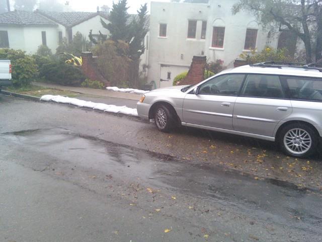
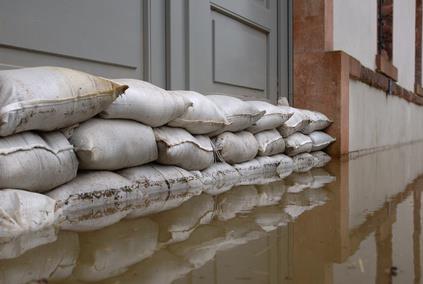
40 SANDBAGGING
 Consult a professional for advice on appropriate measures for your hillside Protect your property by planting ground cover on slopes.")
41 HILL SLIDE PREPAREDNESS AND AWARENESS Build an emergency kit and family communications plan Learn if you are in a debris flow zone ( cisco.php) Consult a professional for advice on appropriate measures for your hillside Protect your property by planting ground cover on slopes. Look for changes in landscape, changes in water runoff, land movement, small slides, or leaning trees Take notice if doors or windows jam for the first time.

42 Better Safe than Soggy Khin Chin, Office of Emergency Services, City of Berkeley


43 Prepare your family Prepare to shelter in place Don t get bored Phone chargers Your neighbors Who has special needs? / Buddy System Children, elderly, pets Copies of important documents Emergency Notification BENS, Radio 1610am, City website Photo: Petattack.com
44 Prepare your home Sandbags Plywood Clear rain gutters Keep rake handy Check homeowners insurance policy Use extreme caution entering flood damaged buildings Hidden damage, electrical systems, undermine foundation


45 Getting to work Safe Driving Photo: cragmont.org Pay attention to school announcements Alternative childcare Prepare your family and home Photo: abc7news.com

46 Driving safely Wet driving conditions debris, mud, downpours Windshield wipers Flashlight in Car Safety Kits in Car Fill up the gas

47 Turn Around, Don t Drown Do not drive around barricades NEVER drive through flooded roadways in of water can move vehicle. Stay out of flood waters, 6 inches of water can knock you off your feet Contamination Downed powerlines Photo: Jennifer Lazo
48 Power Outage Disaster preparedness kit Battery-powered radio Store extra batteries, lights (not candles), power banks for phones Operate generators outdoors, never inside Keep freezer and refrigerator closed Before the storm, fill up any open spaces in freezer with sturdy water bottles Know signs of hypothermia
49 311 Not Non-Emergency City Services Access City Services Report Problems Request Information 911 Emergency Services Current or imminent threat to life or property Non-Emergency Police or Fire calls


50 Community-wide effort Take care of debris on your property Leaves Tree trimming Household Hazardous Waste Volunteers Adopt a Drain CERT

51 Please share your questions and ideas.
52 Timothy Burroughs Asst. to City Manager/Chief Resilience Officer City of Berkeley
HURRICANE PREPAREDNESS GUIDE
 HURRICANE PREPAREDNESS GUIDE BE PREPARED! TABLE OF CONTENTS Basic Preparedness Tips... 3 Preparing Your Home... 4 What To Do... 5 Make a Hurricane Plan... 6 Important Information... 7 pacu.com 800.433.7228
Where Do Hurricanes Occur?
 Where Do Hurricanes Occur? How Often Do Hurricanes Hit the U.S.? Hurricane Return Periods Hurricane return periods are the frequency at which a certain intensity of hurricane can be expected within a
FEMA Hurricane Fact Sheet
 PIA Doc. No. 90191 FEMA Hurricane Fact Sheet The information contained within this Resource kit is provided by the Federal Emergency Management Agency and is provided as a PIA member service. To contact
New Pig Corporation newpig.com HOT-HOGS Page 1 of 10
 Develop a Disaster Preparedness Plan Assess your risks of natural and manmade disasters Purchase adequate insurance and ensure that you have the types of coverage you may need Keep employee contact information
While all thunderstorms are dangerous, the National Weather Service (NWS) defines a severe thunderstorm as one that:
 defines a severe thunderstorm as one that:") While all thunderstorms are dangerous, the National Weather Service (NWS) defines a severe thunderstorm as one that: Produces hail at least three-quarters of an inch in diameter. Has winds of 58 miles
While all thunderstorms are dangerous, the National Weather Service (NWS) defines a severe thunderstorm as one that: Produces hail at least three-quarters of an inch in diameter. Has winds of 58 miles
EL NIÑO COMMUNICATION TOOL KIT
 Corporate Communications EL NIÑO 2015-16 COMMUNICATION TOOL KIT Official County of Orange El Niño website: www.ocelnino.com Hashtag: #ocelnino Page 2 CONTENTS A. Tools for General Public Distribution Content
Procedures in the Event of a Natural Disaster
 Procedures in the Event of a Natural Disaster For your safety, please be sure to check with your neighbors and the chief of the ward in which you live about the appropriate procedures for different natural
Severe Thunderstorms
 Severe Thunderstorms Severe Thunderstorms Explain that, while all thunderstorms are dangerous, the National Weather Service (NWS) defines a severe thunderstorm as one that: Display Slide Th-0 Produces
Hurricanes ARE YOU READY? 33 FEDERAL EMERGENCY MANAGEMENT AGENCY
 ARE YOU READY? 33 Hurricanes A hurricane is a type of tropical cyclone, the generic term for a low pressure system that generally forms in the tropics. The ingredients for a hurricane include a pre-existing
COMMUNITY EMERGENCY RESPONSE TEAM FLOODS INTRODUCTION
 INTRODUCTION Floods are one of the most common hazards in the United States. A flood occurs any time a body of water rises to cover what is usually dry land. Flood effects can be local, impacting a neighborhood
Table G - 6. Mitigation Actions Identified for Implementation by the City of Kent ( ) (From Wilkin County Master Mitigation Action Chart)
 (From Wilkin County Master Mitigation Action Chart)") Table G - 6. Actions Identified by the () (From Master Action Chart) Multi-Hazard Plan, 2017 Action Comments 5 All-Hazards Local Planning & Regulations Update the Operations Plan on an annual basis. Work
Table G - 6. Actions Identified by the () (From Master Action Chart) Multi-Hazard Plan, 2017 Action Comments 5 All-Hazards Local Planning & Regulations Update the Operations Plan on an annual basis. Work
DISASTER PROCEDURES th AVE NE, Suite 100 Bellevue WA, Tel: (425)
") DISASTER PROCEDURES 2281 116 th AVE NE, Suite 100 Bellevue WA, 98004 Tel: (425)247-7495 Disaster Procedures Updated September, 2013 TABLE of CONTENTS 1. Power Outage 2. Terrorism 3. Tornado 4. Missing
DISASTER PROCEDURES 2281 116 th AVE NE, Suite 100 Bellevue WA, 98004 Tel: (425)247-7495 Disaster Procedures Updated September, 2013 TABLE of CONTENTS 1. Power Outage 2. Terrorism 3. Tornado 4. Missing
Key to the Emergency. Preparedness Prince. Preparedness. Princess. Pre-K - 2nd Grade
 Key to the Emergency Preparedness Castle Preparedness Prince & Preparedness Princess Pre-K - 2nd Grade PREPAREDNESS PRINCE & Preparedness Princess HERE TO TEACH YOU ALL ABOUT EMERGENCY PREPAREDNESS The
Hurricane Preparedness
 Hurricane Preparedness Hurricanes can be dangerous killers. A hurricane is a tropical storm with winds that have reached a constant speed of 74 mph or more. Hurricane winds blow in a large spiral around
How Power is Restored After a Severe Storm. Presented by Stacy Shaw, Safety Director & Nolan Hartzler, GIS Mapping Technician
 How Power is Restored After a Severe Storm Presented by Stacy Shaw, Safety Director & Nolan Hartzler, GIS Mapping Technician Hurricanes, ice storms, tornadoes One inch of ice on a single span of electric
Coastal Resiliency: Planning for Natural Variability and Recovering from Extreme Events
 Coastal Resiliency: Planning for Natural Variability and Recovering from Extreme Events Stephanie Showalter, J.D., M.S.E.L. Director, National Sea Grant Law Center University of Mississippi Coastal Hazards
Floods. Floods COMMUNITY EMERGENCY RESPONSE TEAM FLOODS CONTENT INSTRUCTOR GUIDANCE
 Floods Floods Introduce this topic by explaining that floods are one of the most common hazards in the United States. A flood occurs any time a body of water rises to cover what is usually dry land. Display
Whether you are driving or walking, if you come to a flooded road, Turn Around Don't Drown
 Whether you are driving or walking, if you come to a flooded road, Turn Around Don't Drown You will not know the depth of the water nor will you know the condition of the road under the water. Many people
Tornado. damage. thunderstorms and can cause a lot of. Tornadoes usually happen during. reaches from the sky to the ground.
 A strong rotating tunnel of air that reaches from the sky to the ground. Tornadoes usually happen during thunderstorms and can cause a lot of damage. Identify and prepare a wind safe room. or shelter (basement/cellar
Landslide Mitigation (BYUI)
") Landslide Mitigation (BYUI) The general principle behind landslide mitigation is stabilization. Slopes that are too steep are shallowed or strengthened. Loose rocks can be bolted or cemented into place.
Landslide Mitigation (BYUI) The general principle behind landslide mitigation is stabilization. Slopes that are too steep are shallowed or strengthened. Loose rocks can be bolted or cemented into place.
Identify levees and dams in your area and determine whether they pose a hazard to you.
 Courtesy of The Insurance Exchange Hurricanes are capable of producing winds in excess of 155 miles per hour and causing catastrophic damage to coastlines and several hundred miles inland. Additionally,
Hurricane Matthew Threats and Impacts Briefing for Eastern NC
 Hurricane Matthew Threats and Impacts Briefing for Eastern NC October 6 th, 2016 Date/Time Created: 10/6/2016, Noon EDT National Weather Service Newport/Morehead City, NC Hurricane Matthew Key Points Changes
Preparedness Safety Tips
 Preparedness Safety Tips Timely preparation can avert heavy personal, business and government expenditures. Experts agree that the following measures can be effective in dealing with the challenges of
Tornado Safety: 2013 Practical Steps for Weather-Related Emergencies
 Tornado Safety: 2013 Practical Steps for Weather-Related Emergencies Campbell County Public Safety One County, One Mission, One Call Away Tornado Preparedness Day March 12, 2013 As 62 tornadoes struck
What Are Disasters? The Rescue Kids Trio!
 The Rescue Kids Trio! What Are Disasters? This manual was made possible through funding by the Council of Local Authorities for International Relations. Disasters and emergency preparedness Emergency preparedness
Disaster Timeline Messages
 Disaster Timeline Messages Each disaster is unique and messaging should reflect the specific circumstances of the incident. The grid below can help guide key messages before, during and after disasters.
0 1 8 STORM SEASON GUIDE
 2 0 1 8 STORM SEASON GUIDE HURRICANE PREPAREDNESS 101 When it comes to hurricanes, there s no such thing as being too prepared. The key to weathering any storm is to have the right tools. This includes
Safety Issue: Types of weather emergencies and natural. Weather Emergencies
 Overview Safety Issue: Rapid and effective response to weather emergencies and other natural disasters whether during or after work hours takes forethought and careful planning. Types of weather emergencies
Hurricanes and coastal storms pose a risk because powerful winds and storm surges can:
 HURRICANES A hurricane is a violent area of low pressure forming in the tropical Atlantic Ocean from June to November. August and September are peak months. (Similar Western Pacific Ocean storms are called
Key Takeaways: - Rain: Coastal NC: ; isolated totals to 40 Central, Western, & Northeastern NC: 5-10 ; isolated totals to 20
 Key Takeaways: - Life-Threatening Impacts Will Extend Far From The Storm s Center: Despite the southward shift in track, widespread and extreme impacts from heavy rain, storm surge, and wind are still
Page G Crow Wing County Multi-Hazard Mitigation Plan, 2017
 Table G - 10. s Identified by the () (From Crow Wing County Master Chart) 1 5 All- Hazards All- Hazards Work to ensure that all Crow Wing County residents are aware of and sign-up for the County s Emergency
Marine Corps Base. Disaster Preparedness Activity Book
 Marine Corps Base Disaster Preparedness Activity Book Dear Parents and Educators News stories of disaster regularly make headlines around the globe. As you ve watched others deal with these emergencies,
Altus AFB Emergency Management. Emergency Preparedness. Building a Disaster Supply Kit
 Emergency Communication Plan When a disaster strikes, there is a chance that your family is not together. It is important to think about some of the following situations and make a plan just in case. Here
Timeframe. Crow Wing County, Baxter, Brainerd, Breezy Point, Crosby, Crosslake, Cuyuna, Deerwood, Emily, Fifty
 Table G - 13. s Identified for by the () (From Crow Wing County Master Chart) 1 5 9 All- Hazards All- Hazards Winter Work to ensure that all Crow Wing County residents are aware of and sign-up for the
Residents Emergency Response Checklist
 COMMUNITY RESILIENCE PLAN Residents Emergency Response Checklist A helpful guide in the event of extreme weather or bushfire events. < PREVIOUS I NEXT > 02 Purchasing an existing property or building a
City of Tarpon Springs Emergency Management. Hurricane Season 2017
 City of Tarpon Springs Emergency Management Hurricane Season 2017 September 1, 2016- We came close Hurricane Hermine First Hurricane to make landfall in Florida since 2005 Are you Ready? Prepare your Home
Joseph E. Boxhorn, Ph.D., Senior Planner Southeastern Wisconsin Regional Planning Commission #
 Joseph E. Boxhorn, Ph.D., Senior Planner Southeastern Wisconsin Regional Planning Commission # 228346 Chapter I Introduction and Background Chapter II Basic Study Area Inventory and Analysis Hazard
PUBLIC SAFETY POWER SHUTOFF POLICIES AND PROCEDURES
 PACIFIC GAS AND ELECTRIC COMPANY PUBLIC SAFETY POWER SHUTOFF POLICIES AND PROCEDURES SEPTEMBER 2018 1 PACIFIC GAS AND ELECTRIC COMPANY PUBLIC SAFETY POWER SHUTOFF POLICIES AND PROCEDURES SEPTEMBER 2018
COLORING & ACTIVITY BOOK
 COLORING & ACTIVITY BOOK Here are some important tips for hurricane season. Broward County wants you and your family to be during hurricane season June 1st through November 30th. Let s get started! 2 Hurricane
READY WRIGLEY PREPARES FOR HURRICANES
 READY WRIGLEY PREPARES FOR HURRICANES NAME: Note to Parents, Guardians, and Teachers The Centers for Disease Control and Prevention has created Ready Wrigley to provide parents, guardians, teachers, and
Wildfire Preparedness
 Wildfire Preparedness Wildfires are common disasters that can spread quickly, especially during dry conditions. More than 100,000 wildfires clear 4-5 million acres of land in the US every year. Wildfires
The Leader in Landscape Solutions
 The Leader in Landscape Solutions Emergency Action Plan Hurricane Preparedness Go To Mainscape.com For More Information! Purpose: To provide the Federation at Kings Point and their residents an informative
AHEAD OF THE STORM: Extreme Weather Resilience in the City of Toronto
 AHEAD OF THE STORM: Extreme Weather Resilience in the City of Toronto David MacLeod Toronto Environment and Energy Office Environmental Applied Science and Management Symposium 2013 March 21, 2013 Ahead
Hurricanes and Coastal Storms
 Hurricanes and Coastal Storms Hurricanes and Coastal Storms Display Slide Hu-0 What is the difference between a hurricane and a coastal storm? Allow the participants time to respond before displaying the
Joseph E. Boxhorn, Ph.D., Senior Planner Southeastern Wisconsin Regional Planning Commission #
 Joseph E. Boxhorn, Ph.D., Senior Planner Southeastern Wisconsin Regional Planning Commission # 228395 Chapter I Introduction and Background Chapter II Basic Study Area Inventory and Analysis Hazard
1879-LDG-E. Leader s Guide
 ERI Safety Videos Videos for Safety Meetings 1879-LDG-E SEVERE WEATHER ALERT: ARE YOU PREPARED? Leader s Guide 2003, ERI Safety Videos SEVERE WEATHER ALERT: ARE YOU PREPARED? This easy-to-use Leader s
COLORING PAGES. Follow Raindy the Raindrop as he travels from your house out to sea.
 COLORING PAGES www.hcfcd.org Follow Raindy the Raindrop as he travels from your house out to sea. Raindy the Raindrop falls from the sky and lands on your house or in your neighborhood. Once he s on the
Contents. Chapter 1 Introduction Chapter 2 Cyclones Chapter 3 Hurricanes Chapter 4 Tornadoes... 36
 Contents Chapter 1 Introduction.... 4 Chapter 2 Cyclones.... 14 Chapter 3 Hurricanes... 22 Chapter 4 Tornadoes.... 36 Chapter 5 The Perfect Storm... 52 Chapter 6 Hurricane Katrina... 62 Chapter 7 Joplin
September 13, 2018 MEDIA RELEASE. Waynesboro Department of Emergency Management Waynesboro Police Department Waynesboro Fire Department
 MEDIA RELEASE September 13, 2018 The City continues to prepare for and monitor the track and potential impacts of Hurricane Florence. Current guidance from the National Weather Service, the National Hurricane
CLIMATE READY BOSTON. Climate Projections Consensus ADAPTED FROM THE BOSTON RESEARCH ADVISORY GROUP REPORT MAY 2016
 CLIMATE READY BOSTON Sasaki Steering Committee Meeting, March 28 nd, 2016 Climate Projections Consensus ADAPTED FROM THE BOSTON RESEARCH ADVISORY GROUP REPORT MAY 2016 WHAT S IN STORE FOR BOSTON S CLIMATE?
Tornado Preparedness. Monthly Safety Meeting
 Tornado Preparedness Monthly Safety Meeting Introduction Tornadoes can occur anywhere and at any time during the year. In an average year, 800 tornadoes are reported throughout the nation. The most violent
EL NIÑO PRESENTED BY. Disaster Preparedness
 EL NIÑO 2015-2016 PRESENTED BY Disaster Preparedness I. The Science of El Niño a. National Weather Service NOAA II. LA County Office of Emergency Management a. County of Los Angeles Chief Executive Office
2014 Annual Mitigation Plan Review Meeting
 2014 Annual Mitigation Plan Review Meeting Highland County EMA MEETING OBJECTIVES Understand Your Natural Disaster Risk Review of Previous Plans Current Plan Status Future Activity Plan/Needs of Each Community
City of Madison Flooding Event AUGUST 20 TH, 2018-PRESENT
 City of Madison Flooding Event AUGUST 20 TH, 2018-PRESENT Presentation Overview Review of Flash Flooding and Flooding from High Lake Levels (August 20 th -Present) Lake Level Information Damages FEMA How
SEASONAL SMARTS DIGEST. AT HOME Winter 2015/2016
 SEASONAL SMARTS DIGEST AT HOME Winter 2015/2016 WELCOME TO THE FARMERS INSURANCE SEASONAL SMARTS DIGEST! The digest uses the previous three years of actual home-related claims from around the country to
IS YOUR BUSINESS PREPARED FOR A POWER OUTAGE?
 IS YOUR BUSINESS PREPARED FOR A POWER OUTAGE? Keeping your power on is our business Whether your business is large, small or somewhere in between, we understand that a power outage presents special challenges
Geospatial application in Kiribati
 Geospatial application in Kiribati ICC-21 ST RESAP (9 TH TO 13 TH OCTOBER, 2017) BANGKOK, THAILAND Outline Kiribati Profile Natural disasters in Kiribati Achievements Challenges/Issues Ways forward 1 Kiribati
Hurricane Preparedness and Awareness!
 Hurricane Preparedness and Awareness! Check these out Time to begin executing the evacuation plan What kind of damage are we talking about here? What Exactly Is a Hurricane? A hurricane can best be described
IN VEHICLES: Do not try to outrun a tornado. Abandon your vehicle and hide in a nearby ditch or depression and cover your head.
 TORNADO SAFETY TORNADO! The very word strikes fear in many people. While a tornado is perhaps nature's most destructive storm, deaths and injuries can be prevented. By following Tornado Safety Rules, lives
STEUBEN COUNTY, NEW YORK. Hazard Analysis Report
 STEUBEN COUNTY, NEW YORK Hazard Analysis Report Prepared by: April 1, 2014 Background On April 1, 2014 the Steuben County Office of Emergency Management conducted a hazard analysis using the automated
Hurricanes 1. Thunderclouds. cool, dry air falls. warm, moist air rises
 Hurricanes 1 Hurricanes are gigantic tropical storms that can be hundreds of kilometres wide. They bring along very strong winds and a lot of rainfall. They often cause flooding near the coasts and sea
Welcome to our Emergency Preparedness Activity Book!
 Welcome to our Emergency Preparedness Activity Book! Having children understand the importance of emergency preparedness and coping with emergencies is a key element of emergency preparedness for families.
Hurricanes. Environmental Geology Mr. Paul Lowrey. Stacey Singleton, Cassandra Combs, Dwight Stephenson, Matt Smithyman
 Environmental Geology Mr. Paul Lowrey Stacey Singleton, Cassandra Combs, Dwight Stephenson, Matt Smithyman Hurricanes EMPACTS Project, Spring 2017 Northwest Arkansas Community College, Bentonville, AR
El Niño Update Impacts on Florida
 Current Issues in Emergency Management (CIEM) Sessions 1 &2 October 12 th and 26 th, 2006 Florida Division of Emergency Management Tallahassee, Florida El Niño Update Impacts on Florida Bart Hagemeyer
Emergency Preparedness Questions
 Emergency Preparedness Questions 1. A family emergency plan should NOT include which of the following? a) Information about your children's school(s) b) The name and phone number of an out-of-town contact
FANNIN COUNTY A.R.E.S. and R.A.C.E.S. Reference Manual SKYWARN MISSION TO LOCATE POSSIBLE THREATS TO LIFE AND PROPERTY. And
 FANNIN COUNTY A.R.E.S. and R.A.C.E.S. STORM COWBOY Reference Manual SKYWARN MISSION TO LOCATE POSSIBLE THREATS TO LIFE AND PROPERTY And PROVIDE INFORMATION FROM WHICH WARNINGS CAN ISSUED TABLE OF CONTENTS
Asia. Africa. Antarctica. Europe. North America. AdventureHomeschool.com. South America. Australia
 North America Europe Asia Africa South America Australia Antarctica AdventureHomeschool.com Use the map on the 1 st page to determine the answers Storms that are 75 200 mph which form in the Atlantic Ocean
TORNADO/high winds *
 TORNADO/high winds * WATCH Bring people inside. Secure outside objects. Clear window ledges & wall hangings Close drapes Protect windows Assemble and check supplies Call in applicable staff Pre-Storm:
Guided Notes Weather. Part 2: Meteorology Air Masses Fronts Weather Maps Storms Storm Preparation
 Guided Notes Weather Part 2: Meteorology Air Masses Fronts Weather Maps Storms Storm Preparation The map below shows North America and its surrounding bodies of water. Country borders are shown. On the
Natural Disasters. in Florida. Severe Thunderstorms
 Natural Disasters in Florida SC.6.E.7.7 Investigate how natural disasters have affected human life in Florida. Severe Thunderstorms While the typical afternoon thunderstorm in Florida may not appear to
2013 Tornado and Severe Weather Awareness Drill
 2013 Tornado and Severe Weather Awareness Drill Scheduled for Thursday April 18, 2013 The 2013 Tornado Drill will consist of a mock tornado watch and a mock tornado warning for all of Wisconsin. This is
Flood Scenario Worksheet
 Flood Scenario Worksheet Scenario adapted from: http://www.epa.gov/watersecurity/tools/trainingcd/simple/source/scenario-8/ssc8-0.pdf Simple Tabletop Exercise, Interdependency Natural Disaster Scenario,
Key Concept Weather results from the movement of air masses that differ in temperature and humidity.
 Section 2 Fronts and Weather Key Concept Weather results from the movement of air masses that differ in temperature and humidity. What You Will Learn Differences in pressure, temperature, air movement,
HURRICANE SURVIVAL KIT
 HURRICANE SURVIVAL KIT DEFINITION-A hurricane is a very vast and powerful storm that originates in the tropics of the Atlantic Ocean. They become hurricanes when the sustained winds associated with it
City of Punta Gorda Community Emergency Management Plan 2013
 City of Punta Gorda Community Emergency Management Plan 2013 Hurricane Andrew- August 24, 1992 Category 5 hurricane. The second-most-destructive hurricane in U.S. history. The first named storm of the
Pre-Disaster Natural Hazard Mitigation Plan Guilford, Connecticut History of Hazard Mitigation Planning Authority Disaster Mitigation Act of 2000 (ame
 Pre-Disaster Natural Hazard Mitigation Plan Guilford, Connecticut History of Hazard Mitigation Planning Authority Disaster Mitigation Act of 2000 (amendments to Stafford Act of 1988) Presented by: David
PERSONAL DISASTER PREPAREDNESS
 PERSONAL DISASTER PREPAREDNESS WHY PREPARE? Saves Lives Protects Property Speeds Recovery Preparedness Minimizes Panic and Confusion Prepares for Recovery Earthquakes If you re prepared for Earthquakes,
Hurricane Basics and Preparedness. Jim Weyman Director, Central Pacific Hurricane Center Phone Office:
 Hurricane Basics and Preparedness Jim Weyman Director, Central Pacific Hurricane Center Phone Office: 973-5270 james.weyman@noaa.gov United States Hurricane/Typhoon Centers National Hurricane Center, Miami
SUBJECT: WINTER STORM PREPAREDNESS DATE: October 5, 2015
 COUNCIL AGENDA: 10/27/15 ITEM: 3.6 CITY OF fir SANjOSE CAPITAL OF SILICON VALLEY Memorandum TO: HONORABLE MAYOR AND CITY COUNCIL FROM: David Sykes SUBJECT: WINTER STORM PREPAREDNESS DATE: October 5, 2015
1,836 people die and 136,309 people are injured every year from icy roads in the US.
 Winter Driving The United States Department of Transportation (USDOT) Federal Highway Administration reports that 1,836 people die and 136,309 people are injured every year from icy roads in the US. 2
Volcanoes. Introduction
 Volcanoes Introduction Display Slide V-0 Explain that a volcano is a vent through which molten rock escapes to the Earth s surface. Unlike other mountains, which are pushed up from below, volcanoes are
Annex B Natural No-Notice Event
 Annex B Natural No-Notice Event Version: 1.0 Effective: 10/01/2015 Revision Date: 10/01/2015 Approved By: John Pitcher Purpose The purpose of Natural No-Notice Event Annex is to ensure the safety of BHCC
The FirstService Residential Hurricane Guide
 HURRICANE GUIDE Hurricane Season runs June 1 through November 30, bringing the possibility of strong and potentially damaging winds and storm surges to the hurricane-prone east and Gulf coasts. If you
SURVIVING THE STORM: A Severe Weather Safety Guide for West Texans
 SURVIVING THE STORM: A Severe Weather Safety Guide for West Texans National Weather Service Weather Forecast Office Midland, Texas www.weather.gov/midland Fundamental Definitions WATCH Conditions are favorable
2015 Hurricane Season BY: STORM TEAM 8 METEOROLOGIST JULIE PHILLIPS
 2015 Hurricane Season BY: STORM TEAM 8 METEOROLOGIST JULIE PHILLIPS FORECAST COLORADO STATE UNIVERSITY FORECAST IS CALLING FOR ONE OF THE LEAST ACTIVE SEASONS SINCE THE MID 20 TH CENTURY! THE OFFICIAL
Climate Adaptation Challenges for Boston s Water and Sewer Systems
 National Association of Flood & Stormwater Management Agencies Climate Adaptation Challenges for Boston s Water and Sewer Systems John P Sullivan P.E. October 15,2014 Boston 1630 Boston 1630-2012 Boston
Also, when Cascade volcanoes do erupt, high-speed avalanches of pyroclastic flows
 INTRODUCTION A volcano is a vent through which molten rock escapes to the Earth s surface. Unlike other mountains, which are pushed up from below, volcanoes are built by surface accumulation of their eruptive
Typhoon Preparation Tips
 Typhoon Preparation Tips The Pacific Ocean can generate some of the most intense storms in the world, and Guam s location makes it a target for typhoons. Here are some ways you can make yourself typhoon-ready.
2015 Plymouth Rock Assurance New Jersey Hurricane Preparedness Study
 2015 Plymouth Rock Assurance New Jersey Hurricane Preparedness Study About This Study Tropical storms and hurricanes directly and indirectly impact New Jersey and its 130 miles of Atlantic coastline. Although
Extreme Weather and Risks to Infrastructure. Heather Auld & Neil Comer Risk Sciences International
 Extreme Weather and Risks to Infrastructure Heather Auld & Neil Comer Risk Sciences International The Science is Valid and the Evidence grows Stronger AGREE Climate Change Disagree More Intense Rainfall
LOS ANGELES UNIFIED SCHOOL DISTRICT REFERENCE GUIDE
 TITLE: NUMBER: ISSUER: School Procedures During Inclement Weather Conditions REF-5706.2 Earl R. Perkins, Assistant Superintendent School Operations Thelma Meléndez de Santa Ana, Ph.D. Chief Executive Officer
Protecting Your Business This Winter Weather Season
 Protecting Your Business This Winter Weather Season Fred Schmude, StormWatch Manager, ImpactWeather Mark Norton, Senior Continuity Manager, Agility Recovery Today s session will be recorded. Links to the
New Jersey Department of Transportation Extreme Weather Asset Management Pilot Study
 New Jersey Department of Transportation Extreme Weather Asset Management Pilot Study Overview Prepared for: June 26, 2018 Introduction Overview of Pilot Study New Jersey s Climate New Jersey s Transportation
Catastrophic: Most buildings destroyed. Vegetation destroyed. Major roads cut off. Homes flooded.
 HURRICANE PREPAREDNESS INFORMATION PROVIDED BY THE GULF COAST CENTER 2007 HURRICANE SEASON Hurricane A hurricane is a type of tropical cyclone, the generic term for a low pressure system that generally
Town of Windsor. Department of Public Works
 Town of Windsor Department of Public Works 860.285.1855 TOWN OF WINDSOR PUBLIC WORKS SNOW REMOVAL PLAN In Windsor, as throughout the New England states, winter can bring a variety of weather conditions
Tornadoes pose a high risk because the low atmospheric pressure, combined with high wind velocity, can:
 Tornadoes are powerful, circular windstorms that may be accompanied by winds in excess of 200 miles per hour. Tornadoes typically develop during severe thunderstorms and may range in width from several
5.2 IDENTIFICATION OF HAZARDS OF CONCERN
 5.2 IDENTIFICATION OF HAZARDS OF CONCERN 2016 HMP Update Changes The 2011 HMP hazard identification was presented in Section 3. For the 2016 HMP update, the hazard identification is presented in subsection
Ground Water Protection Council 2017 Annual Forum Boston, Massachusetts. Ben Binder (303)
") Ground Water Protection Council 2017 Annual Forum Boston, Massachusetts Protecting Groundwater Sources from Flood Borne Contamination Ben Binder (303) 860-0600 Digital Design Group, Inc. The Problem Houston
Ground Water Protection Council 2017 Annual Forum Boston, Massachusetts Protecting Groundwater Sources from Flood Borne Contamination Ben Binder (303) 860-0600 Digital Design Group, Inc. The Problem Houston
ready get QUEENSLAND PREPARE YOUR EMERGENCY PLAN OUR LOCAL EMERGENCY CONTACTS
 STORM CYCLONE TSUNAMI FLOOD PREPARE YOUR EMERGENCY PLAN get ready QUEENSLAND www.qld.gov.au/getready Don t wait for a disaster to happen before you think about how you and your family are going to survive
Common Core Reading Passage
 Directions: Please read the following Common Core Reading passage and answer the questions that follow. Common Core Reading Passage Forecasting Severe Weather to Communities Helps Them Prepare By Alissa